Embed Size (px)
Citation preview
40 YEARS OF SLR IN INDIA (REMEMBERING THE PAST)
K. Elango, Senior Scientist (Retired), Manager, PRARE, SLR and GPS Systems, Deputy Project Director, IRNSS, Indian Space Research Organisation (ISRO), H-19, Tamil Nadu Housing Board Colony, Rasipuram Post, Namakkal District, TN-637408, INDIA. e-mail:[email protected]
Abstract: Based on the proposal submitted by ISRO in 1974, Government of India has approved in July 1975 the collaboration between Indian Space Research Organisation (ISRO) and Academy of Sciences - USSR (AS-USSR) in establishing a laser ranging station for scientific purposes at Kavalur, in India, as part of Inter-Cosmos Network, This station was named as Satellite Tracking and Ranging Station (STARS) and having first generation laser system, was operational by October 1976. This paper briefs the history of SLR in India/ISRO from 1976 till date (remembering the past golden memories). This includes the operational experience of SLR for more than a decade, satellites tracked, developments and up-gradation incorporated, international laser experts visited, support services provided to other systems, different Space Geodetic Technics planned at Bangalore, participation of ISRO scientists in the international workshops/seminars, ISRO initiative for Space Geodesy etc. This also reveals the ISRO’s plan of incorporation of retro-reflectors (Laser Retro Reflector Array – LARA) to Indian satellites like SROSS-1, IRS-P5 etc. for preliminary orbit determination. Attempts made by ISRO to procure/host laser stations like TLRS-4 from NASA, TIGO from BKG, Germany and laser stations from USSR are also mentioned. ISRO scientists participation in ILRS, ILRS present logo design, WPLTN are also mentioned. The current plan/status of CCRR payload to Indian navigational satellites (IRNSS) for POD is provided in detail. Establishment of two state of art laser stations in India (expected operational by 2015), geographically separated by 2000 km by ISRO, a long pending issue of filling the Indian Ocean laser station network gap by the international laser community for geodetic applications, is also briefed. Future advances/suggestions are also outlined.
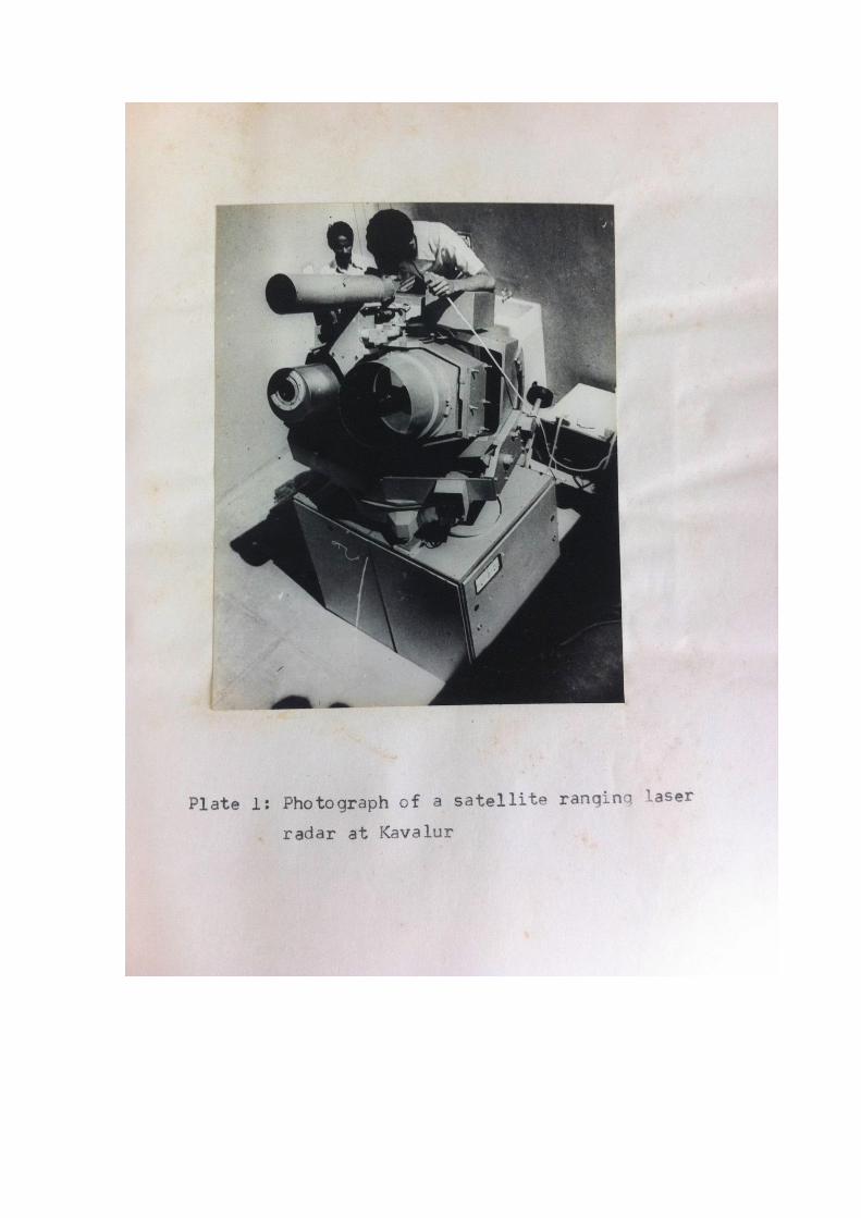
1. Introduction Indian Space Research Organisation (ISRO) has established an Optical Tracking Station in collaboration with Academy of Sciences, (AS-USSR) in 1976 at Kavalur (12 deg. 34’, 78 deg. .49’). This station was named as Satellite Tracking and Ranging Station (STARS) as was a part of Interkosmos Network (Hungary, East Germany, Poland, Czechoslovakia, Soviet Union and India). This Station was equipped with a first generation Laser Radar, Optical tracking Camera AFU-75, Timing equipment and accessories.
2. Operational experience on laser ranging to satellites The Station has tracked satellites equipped with retro reflectors for more than a decade, Accurate Time synchronization of Cesium Atomic clocks using Symphonie satellite, locating the positions of geostationary satellites using AFU-75 Camera, Improved the tracking capability of Laser Radar and Photographic Camera by incorporating three stage Image Intensifier and bring the image to a TV monitor, providing calibration support to other systems etc.
3. Satellites tracked The following Satellites were tracked by the Kavalur Station:
1. Beacon - B (Beacon Explorer) (10-10-1964 launch) 2 .Beacon - C (Beacon Explorer) 3. GEOS-A (Geodetic Earth Orbiting Satellite) 4. GEOS-B (Geodetic Earth Orbiting Satellite) 5. GEOS-C (Geodynamics Experimental Ocean Satellite)
6. Bulgaria-1300 7. STARLETTE (The Geodetic Satellite –July 1, 1974)
Visit of Mr Rajiv Gandhi, Prime Minister of India Mr. Rajiv Gandhi, the Prime minister of India visited STARS, Kavalur on 6
th January 1986 and seen
the Red Laser shots to the test targets and satellite, optical tracking systems and facilities and appreciated the scientists and engineers for the scientific work and tasks carried out..

Interkosmos AFU-75 Camera
4. International laser experts visited Following are some of the International Scientists/experts visited Kavalur Station in connection with scientific activities:
1. Prof. AG Massevitch, AS-USSR 2. Prof Tatevian, AS-USSR 3. Dr Kasmir Lapuska, Latvian State University, Riga 4. DR. Micheal R. Pearlman, SAO, USA 5. Shillack S, Polish Academy of Sciences, Poland 6. Abele.M, , Latvian State University, Riga 7. Prof Karel Hamal, Czech Technical University in Prague 8. Kielek,W, Warsaw University 9. Istanbul Kardos
5. Support Services provided to other systems Kavalur optical tracking station has provided Time synchronization to other atomic frequency standards, locating geostationary satellites’ position, calibration support to other tracking systems, simultaneous observations with other Interkosmos networks etc. The INSAT-1A satellite lost the earth lock because of an "unanticipated moon interference" on September 4 and was finally deactivated on September 6, 1982 The Satellite Tracking and Ranging Station (STARS) at Kavalur, Tamil Nadu, was, however, asked to hunt up the satellite.
6. Laser payloads (CCRR) to ISRO Satellites SROSS-1/TES Laser Retro Reflector Payloads were provided to the following Indian satellites for POD purposes:
SROSS-I (Stretched Rohini Satellite System)
TES (Technology Experimental Satellite)
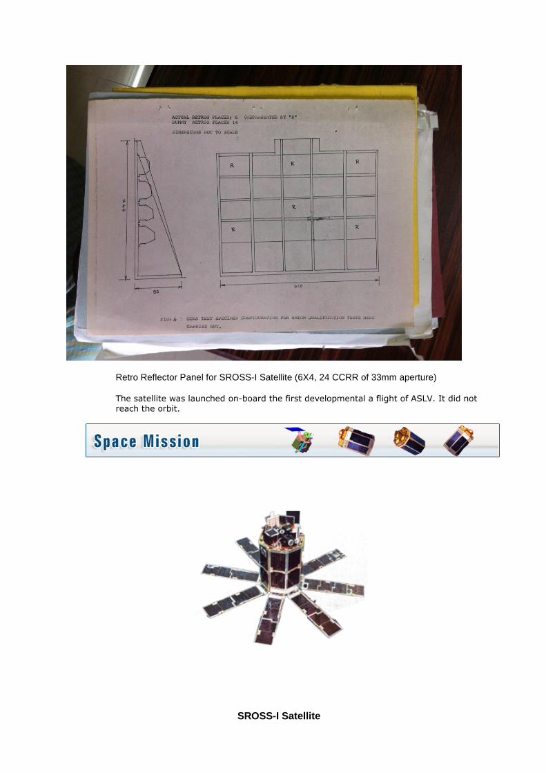
Retro Reflector Panel for SROSS-I Satellite (6X4, 24 CCRR of 33mm aperture) The satellite was launched on-board the first developmental a flight of ASLV. It did not reach the orbit.
SROSS-I Satellite

SROSS-1 Satellite Launch Date: 24-3-1987
Mission Experimental
Weight 150 kg
Onboard power 90 Watts
Communication S-band and VHF
Stabilization Three axis body stabilized (biased momentum) with a Momentum Wheel and Magnetic Torquer
Propulsion system
Monopropellant (Hydrazine based) Reaction control system
Payload Launch Vehicle Monitoring Platform(LVMP), Gamma Ray Burst (GRB) payload and Corner Cube Retro Reflector (CCRR) for laser tracking
Launch date March 24, 1987
Launch site SHAR Centre, Sriharikota, India
Launch vehicle Augmented Satellite Launch Vehicle (ASLV)
Orbital life Not realised
TECHNOLOGY EXPERIMENTAL SATELLITE (TES) 9 Corner Cubes of 33 mm Aperture on Conical Array – similar to ERS
(CCRR Planned, but not incorporated finally for technical reasons)

TES Satellite Similar to IRS-P3
TECHNOLOGY EXPERIMENT SATELLITE (TES) Launch Date: 22-10-2001
Launch date 22 October 2001
Launch site SHAR Centre Sriharikota India
Launch vehicle PSLV- C3
Orbit 572 kms Sun Synchronous
Payloads PAN
7. Different Space/Laser techniques planned at ISTRAC Campus, Bangalore
(i) SAO (Smithsonian Astrophysical Observatory) – ISRO, MOU in 1979 -1983 Initially, discussions on the Agreement between ISRO (Indian Space Research Organization) and SAO (Smithsonian Astrophysical Observatory)/GSFC in establishing a Laser Station and Satellite Geodesy in India have taken place.
(ii) GeoForchungZentrum (GFZ) – ISRO, MOU in 1990s Indian Space Research Organisation (ISRO) and GeoForchung Zentrum (GFZ), Germany, entered into a MOU on establishing a Precise Range and Range rate Equipment (PRARE) at ISTRAC
Campus, Bangalore in 1990s for scientific purpose. This unit was operational in 1994 and was tracking satellites with PRARE payload like Meteor, ERS-1 etc. Subsequently, the first P-code Global Positioning System (GPS) was installed at Bangalore to elevated Bangalore in the International Geodetic map (DORIS was also planned but could not be installed for technical reasons).
(iii) GSFC/NASA – ISRO MOU in 1998 Technical discussions were held couple of rounds both at ISRO, Bangalore and GSFC/NASA, Washington and site selection was carried out by NASA Scientists during February-March 1998 to shift TLRS-4 (Transportable Laser Ranging Station) from NASA site but could not materialise.
(iv) Visits by BKG, Germany – 1999 Site survey was carried out by the BKG (Federal Agency for Cartography and Geodesy), Germany in 1999 to locate their Geodetic Observatory TIGO (Transportable Integrated Geodetic Observatory), but placed Bangalore as their second choice and first moved to Chile.
(v) Indian Regional Navigational Satellite System (IRNSS) Laser payloads, CCRR were planned to incorporate in the navigation satellites and operationalized in 2013. Laser tracking stations identified in two locations in India are going to be operational shortly.
8. Participation of ISRO Scientists in laser workshops/ILRS/WPLTN The following presentations/participation were made by ISRO scientists during the international
workshops/conferences:
1. First SLR Workshop paper from India "Performance and Results of Satellite Ranging Laser Station at Kavalur, India in 1980-81",
Dixit, P. S., Rao, P. K., Elango .K. Gopalakrishnan, K., Rao, K. N., Schillak, S., Kielek, W., Abele, H., Presented in the 4th International Workshop on Laser Ranging Instrumentation held in during October 12 – 16, Austin, Texas-78712, USA
2. “Site Selection Criteria for locating a laser station at ISTRAC Campus, Bangalore,India” K.Elango, P.Soma, K.Ramesh Chandra & S.Rangarajan, ISTRAC/ISRO,Bangalore
Presented during the 11
th International workshop on laser Ranging held at Deggondorf, Germany.
3. "Laser Retro reflector Array (LARA) for IRS Mission (Poster Summary)", K.Elango, P.Soma, M.Pitchaimani, S.K.Shivakumar Presentation in the13th International
Workshop on Laser Ranging, Washington, DC, USA, October 7-11, 2002.

5. “Indian Interest on SLR” Elango, K., P. Soma, S.K. Shivakumar, submitted to 14th International Laser Ranging Workshop,
San Fernando, Spain, June 7-11, 2004.
5. “Laser Ranging to Indian Regional Navigational Satellite System (IRNSS)-(A Proposal)”
K. Elango, P. Soma & S.K. Shivakumar submitted to 15th International Laser Ranging Workshop,
Canberra 15-21, October 2006.
6. WPLTN (Western Pacific Laser Tracking Network)
As a member, Participated in the WPLTN splinter meeting held during the 13th International workshop on laser ranging at Washington D.C. in 2002 and provided inputs in the subsequent WPLTN meetings
7. “ISRO Initiatives for Space Geodesy and Geodynamics in India”
K. Elango, P. Soma, K. Rameshchandra, S. Rangarajan presented during the conference on “Towards an Integrated Global Geodetic Observing System” held at Munich, Germany – October 5 – 9, 1998 International Scientists visited/involved for the Space Geodesy and Geodynamics initiative at ISTRAC, Bangalore:
Prof Chris Reighber, GFZ, Germany
Prof John Bosworth, GSFC/NASA, USA
Prof. Mike Pearlman, SAO/ILRS, USA
Dr Tom Varghese, Honeywell USA
Dr Wolfgang Schlüter, BKG, Wettzel Fundamental Station, Germany
Dr Wolfgang Seemuller, DGFI, Munchen, Germany
Dr Roman Galas, GFZ, Germany
8. “Operational Experience with Bangalore PRARE Station” K. Elango, F.Flechtner ,April 21 – 25, 1997 during the EGS General Assembly, Vienna, Austria
9. “Simultaneous Clock Synchronisation Via Geostationary satellite”
K.Elango Et al. during the Interkosmos symposium on ” Utilisation of observations of artificial satellites of earth for the purpose of Geodesy” Varna, Bulgaria, 15 – 21 Sep 1980
10. “Clock Synchronisation experiments in India using LASSO/SIRIO-2 Facilities”
K.Elango, P.S.Dixit et al., December 1979 11. “Upgrading the Kavalur Laser radar with Image intensifier for tracking artificial satellites” K.Elango, M.S. Thesis at Indian Institute of Technology (IIT), Madras 1982 12. “Brief Report on Geological aspects for SLR Antenna Site at ISTRAC Campus, Bangalore” National Natural Resources Management System (NNRMS)
Earth Observation System (EOS), ISRO Head Quarters, Bangalore,1998
13. “Laser Radar for Satellite Geodesy”
Presented at the Indian National Science Academy (INSA) Laser Application Seminar at Indian Institute of Technology (IIT), Madras,13-15 August 1976
14. Project proposal on establishing “Satellite Tracking and Ranging Station (STARS)” Jointly by India – USSR (ISRO - Astro-Soviet), Space Applications Centre, Ahmedabad 25
th May 1976
15. “Time Synchronisation using US-NNSS Transit Satellites”
K.Elango, P.S.Dixit et. al. Paper presented at the International Symposium on Satellite Geodesy held at Budapest, Hungary during June 28-July 01, 1977”
16. “Precise Range and Rangerate Equipment” K.Elango, Paper published in National Academy of Science Letters Vol.21, No.1 & 2, Jan-Feb 1998.
17.” Different Types of Geodetic Monumentation for Space Geodesy” K.Elango 2002
18. “Site preparation and establishment of first Indian IGS station at Bangalore, India” K.Elango, ISTRAC/ISRO & Roman Galas, GFZ, Germany – May 1996
8. Different Space techniques planned at ISTRAC Campus, Bangalore The following Space Geodetic Techniques were planned at ISTRAC Campus, Bangalore:
1. Satellite Laser Ranging 2. Precise Range and Range rate Equipment (PRARE) 3. Global Positioning System (GPS) 4. Doppler Orbitography and Radiopositiong Integrated by Satellites (DORIS)- Not
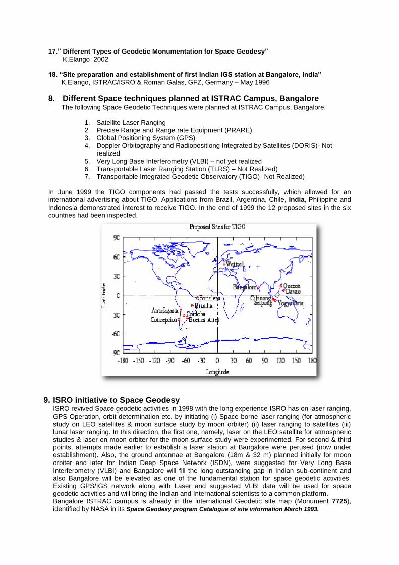
realized 5. Very Long Base Interferometry (VLBI) – not yet realized 6. Transportable Laser Ranging Station (TLRS) – Not Realized) 7. Transportable Integrated Geodetic Observatory (TIGO)- Not Realized)
In June 1999 the TIGO components had passed the tests successfully, which allowed for an international advertising about TIGO. Applications from Brazil, Argentina, Chile, India, Philippine and Indonesia demonstrated interest to receive TIGO. In the end of 1999 the 12 proposed sites in the six countries had been inspected.
9. ISRO initiative to Space Geodesy ISRO revived Space geodetic activities in 1998 with the long experience ISRO has on laser ranging, GPS Operation, orbit determination etc. by initiating (i) Space borne laser ranging (for atmospheric study on LEO satellites & moon surface study by moon orbiter) (ii) laser ranging to satellites (iii) lunar laser ranging. In this direction, the first one, namely, laser on the LEO satellite for atmospheric studies & laser on moon orbiter for the moon surface study were experimented. For second & third points, attempts made earlier to establish a laser station at Bangalore were perused (now under establishment). Also, the ground antennae at Bangalore (18m & 32 m) planned initially for moon orbiter and later for Indian Deep Space Network (ISDN), were suggested for Very Long Base Interferometry (VLBI) and Bangalore will fill the long outstanding gap in Indian sub-continent and also Bangalore will be elevated as one of the fundamental station for space geodetic activities. Existing GPS/IGS network along with Laser and suggested VLBI data will be used for space geodetic activities and will bring the Indian and International scientists to a common platform. Bangalore ISTRAC campus is already in the international Geodetic site map (Monument 7725), identified by NASA in its Space Geodesy program Catalogue of site information March 1993.
Eighth ILRS General Assembly The status of SLR activities in India was reported during the 8
th ILRS general assembly held at
Washington D.C. on October 2002 Activities in India (K. Elango). The Indian Space Research Organization (ISRO) has experience in operating the first generation laser system at Kavalur, India for more than a decade in the 1970's and 80's and would like to revive the SLR program in the country. ISRO would like to establish an SLR station in Bangalore; site selection has been completed. ISRO has plans to foster space geodesy in India by establishing a space geodesy centre. Anybody have an SLR system that they are willing to relocate to southern India?
10. International Laser Ranging Service (ILRS) Logo Contest ILRS logo contest was announced prior to the 11
th International workshop on laser ranging and
designs were invited. “The winning concept for the new ILRS logo was submitted jointly by K. Elango from India and Dr. Pino from Santiago de Cuba Station .Congratulations.” during the ILRS Governing Board Meeting held at Deggendorf, Germany on September 25, 1998
11. Indian Regional Navigational Satellite System (IRNSS)
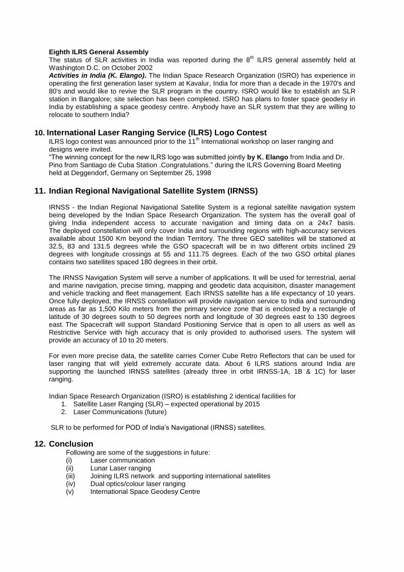
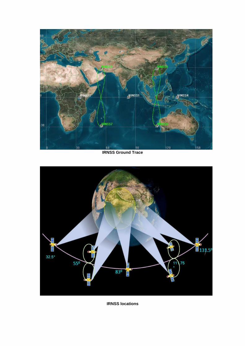
IRNSS - the Indian Regional Navigational Satellite System is a regional satellite navigation system being developed by the Indian Space Research Organization. The system has the overall goal of giving India independent access to accurate navigation and timing data on a 24x7 basis. The deployed constellation will only cover India and surrounding regions with high-accuracy services available about 1500 Km beyond the Indian Territory. The three GEO satellites will be stationed at 32.5, 83 and 131.5 degrees while the GSO spacecraft will be in two different orbits inclined 29 degrees with longitude crossings at 55 and 111.75 degrees. Each of the two GSO orbital planes contains two satellites spaced 180 degrees in their orbit. The IRNSS Navigation System will serve a number of applications. It will be used for terrestrial, aerial and marine navigation, precise timing, mapping and geodetic data acquisition, disaster management and vehicle tracking and fleet management. Each IRNSS satellite has a life expectancy of 10 years. Once fully deployed, the IRNSS constellation will provide navigation service to India and surrounding areas as far as 1,500 Kilo meters from the primary service zone that is enclosed by a rectangle of latitude of 30 degrees south to 50 degrees north and longitude of 30 degrees east to 130 degrees east. The Spacecraft will support Standard Positioning Service that is open to all users as well as Restrictive Service with high accuracy that is only provided to authorised users. The system will provide an accuracy of 10 to 20 meters. For even more precise data, the satellite carries Corner Cube Retro Reflectors that can be used for laser ranging that will yield extremely accurate data. About 6 ILRS stations around India are supporting the launched IRNSS satellites (already three in orbit IRNSS-1A, 1B & 1C) for laser ranging.
Indian Space Research Organization (ISRO) is establishing 2 identical facilities for
1. Satellite Laser Ranging (SLR) – expected operational by 2015 2. Laser Communications (future)
SLR to be performed for POD of India’s Navigational (IRNSS) satellites.
12. Conclusion Following are some of the suggestions in future: (i) Laser communication (ii) Lunar Laser ranging (iii) Joining ILRS network and supporting international satellites (iv) Dual optics/colour laser ranging (v) International Space Geodesy Centre
IRNSS Ground Trace
IRNSS locations

Illustration of the IRNSS coverage which includes an area of ~1500 km around the Indian land mass
IRNSS Control Centre
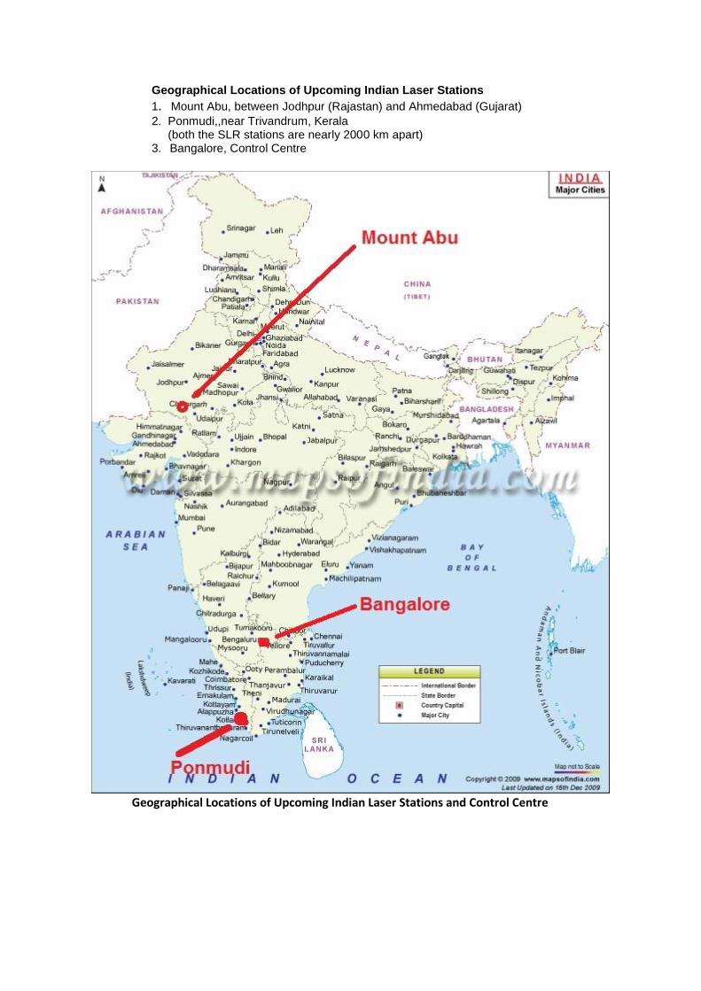
Geographical Locations of Upcoming Indian Laser Stations
1. Mount Abu, between Jodhpur (Rajastan) and Ahmedabad (Gujarat) 2. Ponmudi,,near Trivandrum, Kerala (both the SLR stations are nearly 2000 km apart) 3. Bangalore, Control Centre
Geographical Locations of Upcoming Indian Laser Stations and Control Centre
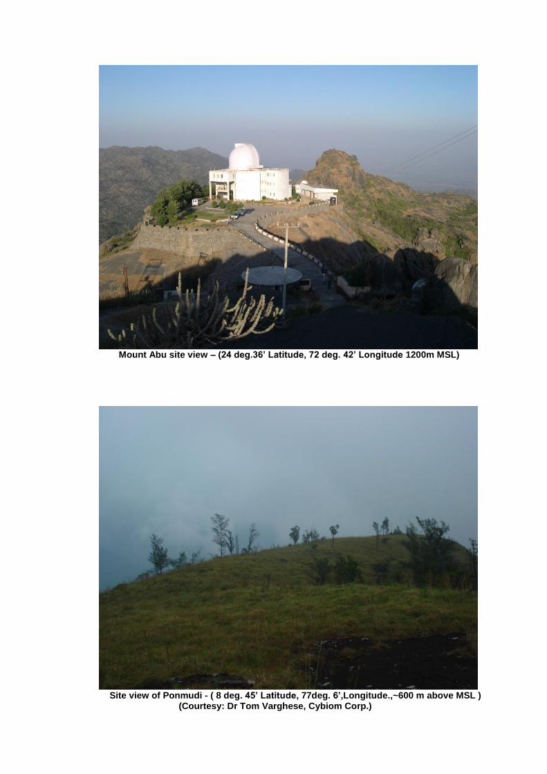
Mount Abu site view – (24 deg.36’ Latitude, 72 deg. 42’ Longitude 1200m MSL)
Site view of Ponmudi - ( 8 deg. 45’ Latitude, 77deg. 6’,Longitude.,~600 m above MSL ) (Courtesy: Dr Tom Varghese, Cybiom Corp.)