Embed Size (px)
Citation preview

LYNWOOD QUARRY EXTRACTION AREA MODIFICATION 3330_R05_ACHAA_V5
Predictive Model for the Granite Pit Area 65
4.0 Predictive Model for the Granite Pit Area The following predictive model for the Granite Pit Area is based on the implications drawn from the Aboriginal cultural, environmental and archaeological context discussed throughout Sections 3.1 to 3.3.
4.1 Sites Likely to Occur in the Granite Pit Area
For the Granite Pit Area it can be predicted that:
• artefact scatters and isolated finds will be the most likely site types (it is noted that two isolated finds and one artefact scatter are already known within the Granite Pit Area and one artefact scatter is known within the Approved Project Area where impact is proposed from haul road construction)
• artefact scatters and isolated find sites will occur in most landform contexts, however, they are most likely to be located in association with the tributaries of Lockyersleigh Creek, on benches near creeklines and on the spur crests
• artefact scatters and isolated finds with PAD are most likely to be located in association with the tributaries of Lockyersleigh Creek that carry flow from outside the Granite Pit Area, on benches near the creeklines and on the spur crests (if there is sufficient soil depth) and their associated low gradient slopes leading down to a watercourse that has at least semi-permanent water
• if a major camp site is located within the Granite Pit Area it is most likely to be located in an area with a reliable source of water and with access to sufficient plant and animal foods to sustain a small group of people for several days
• scarred trees are likely if mature trees remain
• the scarred trees are most likely to be located on spur crests and on midslopes.
4.2 Sites Not Likely to Occur in the Granite Pit Area
For the Granite Pit Area it can be predicted that:
• grinding grooves used for the sharpening of axes, hatchets, chisels and/or fire hardened wooden or bone spear points will not occur due to the lack of sandstone geology
• rockshelters with PAD or art are unlikely due to the nature of the geology
• stone arrangements and burials are extremely rare site types and are unlikely to be located
• grinding bowls are also extremely rare site types in the geology and are unlikely to be located
• carved trees associated with ceremony and burials are rare site types and unlikely to be located
• quarries for the extraction of stone for stone implement manufacture are unlikely due to the poor knapping quality of the local raw materials.
LYNWOOD QUARRY EXTRACTION AREA MODIFICATION 3330_R05_ACHAA_V5
Predictive Model for the Granite Pit Area 66
4.3 Site Contents
For the Granite Pit Area it can be predicted that:
• flakes, broken flakes and flaked pieces will be the dominant artefact types located within sites/PADs with smaller numbers of retouched flakes and cores. Implement types such as stone axes and hammerstones are unlikely
• quartz and silcrete will be the dominant raw materials used for artefact manufacture with other raw materials such as quartzite, chert, dolerite, hornfels, volcanic, petrified wood, chalcedony, ignimbrite, granite and aplite forming a minor proportion of any assemblages
• the source of the majority of the raw materials is likely to be at a distance from the Granite Pit Area with the exception of dolerite, aplite, ignimbrite and granite which would be available either within the Granite Pit Area (ignimbrite, aplite and granite) or in areas adjacent to the Granite Pit Area (dolerite). If the local raw materials (aplite, granite, ignimbrite) are found as outcrops in the Granite Pit Area it is unlikely that they will have been quarried and that any local material used would have just been picked up from the surface, flaked and used expediently.
4.4 Soil Profile Integrity
It can be predicted that due to 187 years of agricultural practices and erosion and downslope movement of the sandy soils that the majority of sites and areas of PAD (if any) located within the Granite Pit Area are unlikely to have soil profiles that retain stratigraphic integrity. Though some spatial integrity is possible in sites/PADs with relatively deep A1/A2 soil horizons.
4.5 Archaeological Terrain Units (ATUs)
ATUs are designated based on a combination of factors. For the Approved Project Area, OEH (then DECC) requested that the area be divided into ATUs specifically to form the basis of the subsurface testing program (Umwelt 2007a). The Approved Project Area was subsequently subdivided into ATUs based on:
• stream order
• geology and soils
• topography - landform element and gradient (following McDonald, Isbell, Speight, Walker and Hopkins (1990)
• Aboriginal cultural context (ethnography and Aboriginal oral history).
Thus the ATUs took into account both the environmental and Aboriginal cultural context of the Approved Project Area. The implications of these contexts for the Granite Pit Area have been discussed in Sections 3.1.3, 3.2.6 and 3.3.4.

LYNWOOD QUARRY EXTRACTION AREA MODIFICATION 3330_R05_ACHAA_V5
Predictive Model for the Granite Pit Area 67
4.5.1 Rationale for Use of Archaeological Terrain Units for the Granite Pit Area
It was assessed that the most appropriate way in which to design the survey strategy for the Granite Pit Area and to analyse the results of the survey, was to divide the area into ATUs so that direct comparisons could be made between the Granite Pit Area and the adjacent Approved Project Area. It was also proposed that this would enable any requisite subsurface testing program/salvage program post approval to be undertaken in a comparable manner and utilising a variation to the existing s.87/90 AHIP #1100264. In this way the Research Design and Methodology prepared for the Approved Project Area could also be used for the Granite Pit Area and earlier conclusions in relation to Aboriginal use of the landscape could be analysed, revised as required and built upon.
It is noted that the ATUs crossed by the proposed haul road within the Approved Project Area had been previously surveyed and subsurface tested and have been approved for impact (Umwelt 2005, 2008d, 2008e, 2013b). Thus these ATUs were not included in the current survey methodology, however, the known site in the area that was proposed for impact by haul road construction (MRN25) was visited and re-inspected (for details refer to Section 5.5).
4.5.2 Mapping Archaeological Terrain Units
Figure 4.1 shows the Granite Pit Area divided into ATUs using the same criteria as used for the Approved Project Area. A total of nine ATUs have been identified using topographic mapping with two metre contour intervals and later adjusted based on the results of the survey. For ease of comparison the same colour scheme has been used for the ATUs as used in the Approved Project Area (refer to Figure 3.6). As noted in Section 3.2.3 the Joaramin Ignimbrite and the Barralier Ignimbrite have been combined into the Bindook Porphyry Complex for comparability with the Bindook Porphyry ATUs from the Approved Project Area.
The ATUs include:
• 2BP – High Point on Rocky Spur Crest in Bindook Porphyry Complex
• 2LG - High Point on Rocky Spur Crest in Lockyersleigh Granite
• 4BP – Spur Crest in Bindook Porphyry Complex
• 4LG – Spur Crest in Lockyersleigh Granite
• 6BP – Gentle Slope in Bindook Porphyry Complex
• 6LG – Gentle Slope in Lockyersleigh Granite
• R6BP – Gentle Slope in Riparian Corridor in Bindook Porphyry Complex
• R6LG – Gentle Slope in Riparian Corridor in Lockyersleigh Granite
• R6DS – Gentle Slope in Riparian Corridor in Deep Sand.


LYNWOOD QUARRY EXTRACTION AREA MODIFICATION 3330_R05_ACHAA_V5
Predictive Model for the Granite Pit Area 69
4.6 Aboriginal Archaeological Sites Predicted within the Archaeological Terrain Units
Using the results of the ATU investigations in the Lynwood Quarry Approved Project Area the following predictions have been made for the ATUs. It is noted that even though a stone arrangement (MRN9) and a grinding bowl were found in the Approved Project Area, the extreme rarity of sites of this kind suggest that while possible, they are not likely to also be found within the Granite Pit Area.
4.6.1 ATU2BP and ATU2LG – High Point on Rocky Spur Crest
Only isolated finds and small to moderate artefact scatters are likely. PAD is unlikely unless rock outcrop prevents the downslope movement of artefacts and/or is of sufficient height to provide shelter from the wind or sun. Fragmented rock exposed on the surface may be used for expedient implement manufacture.
4.6.2 ATU4BP and ATU4LG – Spur Crest
Isolated finds and small to large artefact scatters are likely – especially on benches in proximity to a creekline. Some isolated finds and artefact scatters may have PAD if topsoil is of sufficient depth. It is also possible that scarred trees may occur where mature trees remain. Fragmented rock exposed on the surface may be used for expedient implement manufacture.
4.6.3 ATU6BP and ATU6LG – Gentle Slopes
Isolated finds are likely in any landform. Small to medium sized artefact scatters are likely up to 100 metres from creeklines. PAD is only likely on the lower slope and especially on benches. Scarred trees are likely on midslopes if mature trees remain but these will not be directly associated with artefacts or PAD.
4.6.4 ATUR6BP and ATUR6LG – Gentle Slope in Riparian Corridor
Isolated finds and small to large artefact scatters are likely for those areas where the creeklines carry flow from outside the Granite Pit Area. PADs are possible in these ATUs in areas of gentle gradient and on elevated benches.
4.6.5 ATUR6DS – Gentle Slope in Deep Sand
There is only one small area represented by this ATU and it is on a second order tributary of Lockyersleigh Creek in the north of the Granite Pit Area. There is a previously recorded small artefact scatter site in this location (LA31) and it is likely that this site will be associated with PAD incorporating moderately high numbers of subsurface artefacts.

LYNWOOD QUARRY EXTRACTION AREA MODIFICATION 3330_R05_ACHAA_V5
Survey Methodology and Results 70
5.0 Survey Methodology and Results This section of the report will provide details of the survey methodology which included a preliminary inspection during early planning and the intensive survey for the assessment with the registered Aboriginal parties. The survey methodology was prepared in consultation with the registered Aboriginal parties.
5.1 Methodology
5.2 Preliminary Inspection
The preliminary inspection methodology was prepared taking into account the following requirements:
• to survey an adequate sample of those areas proposed for impact for the quarry pit, bund, overburden emplacement area, water infrastructure and the haul road to inform the quarry design and early planning processes
• to locate and rerecord the condition of three previously recorded sites within the Granite Pit Area (LA31, LA32 and LA33)
• to ensure that the ATU mapping was accurate for the full survey.
Figure 5.1 shows the track logs from the preliminary inspection. The preliminary inspection was undertaken as a mix of pedestrian and driven transects. Sections of transects were driven where ground surface visibility was zero. Any exposures or areas of slightly higher ground surface visibility were inspected on foot. All transects related to the tributaries of Lockyersleigh Creek were walked. Both sides of the tributaries were walked. In addition, sections of transects were walked when they were located on tracks which afforded higher ground surface visibility.
Five new sites were recorded as a result of the preliminary inspection (refer to Figure 5.1 for site locations and Sections 5.4.1 and 5.5 for further details).
5.2.1 Participants in the Preliminary Inspection
Participants in the preliminary inspection were Jan Wilson and Kym McNamara (archaeologists) from Umwelt. The preliminary inspection was undertaken over the period 17 to 19 November 2014.
5.3 Full Survey
The survey methodology was prepared taking into account the following requirements:
• to survey an adequate sample of all of the ATUs present in the Granite Pit Area
• to survey an adequate sample of those areas proposed for impact for the quarry pit, bund, overburden emplacement area, water infrastructure and the haul road
• to afford the opportunity for the registered Aboriginal parties to visit the three sites previously recorded by Saunders within the Granite Pit Area and the additional five sites located during the preliminary inspection
• to revisit MRN25 to discuss site management
• to ensure that the registered Aboriginal parties were comfortable with the survey effort.


LYNWOOD QUARRY EXTRACTION AREA MODIFICATION 3330_R05_ACHAA_V5
Survey Methodology and Results 72
Figure 5.2 indicates the survey transects endorsed by the registered Aboriginal parties and subject to pedestrian survey over the period 29 June 2015 to 3 July 2015. In general each transect was walked with the survey participants at roughly 10 to 20 metre intervals. The riparian corridors were subject to pedestrian transects each side of the creekline and covering an area of approximately 50 metres from the banks of the creeklines. The Track transects covered the width of the track and approximately 5 metres either side of the track. The remainder of the survey transects were approximately 50 metres in width.
It is noted that the registered Aboriginal parties chose to survey the same transects as those surveyed during the preliminary inspection as it was possible to cover a broader area with a larger number of participants. Further survey transects were added to cover the tracks as these provided the best ground surface visibility and also to cover any areas perceived as gaps in the survey coverage by the registered Aboriginal parties or the archaeologists (e.g. Transects LCK8, ATU12 and ATU13).
All exposures were carefully inspected during the survey and details were recorded in relation to:
• landform
• gradient and aspect
• vegetation
• geology and soils
• occurrence of Aboriginal resources (food and medicine plants, prey animals, stone and water)
• average ground surface visibility
• extent of any exposures
• any information provided by the registered Aboriginal parties in relation to cultural values
• the nature of any site and/or PADS located
• the nature of any artefacts observed.
The remainder of the Granite Pit Area was also inspected by vehicle transects and all areas of visibility, mature trees and rock outcrop noted were inspected. The full survey track logs are shown on Figure 5.2.
It is noted that subsequent to the survey approximately 450 metres of the southern end of the Bund was removed from the design. Therefore, the transects surveyed in the bund assessed a larger area than will be impacted by the proposed bund.
All sites and artefacts located were recorded to OEH standards. The Aboriginal and cultural significance of the sites/artefacts was discussed with the registered Aboriginal parties participating in the survey and requirements for subsurface testing of sites, PADs and their associated ATUs was also discussed.
5.3.1 Participants in the Full Survey
Participants in the survey were Keiren McNally (GAHAI), Sharon Brown and Dawn Harris (GTCAC), Justin Boney (PLALC), Duncan Falk (PFC) and Jan Wilson and Kirwan Williams (Umwelt).

LYNWOOD QUARRY EXTRACTION AREA MODIFICATION 3330_R05_ACHAA_V5
Survey Methodology and Results 74
5.4 Results
5.4.1 Preliminary Inspection Results
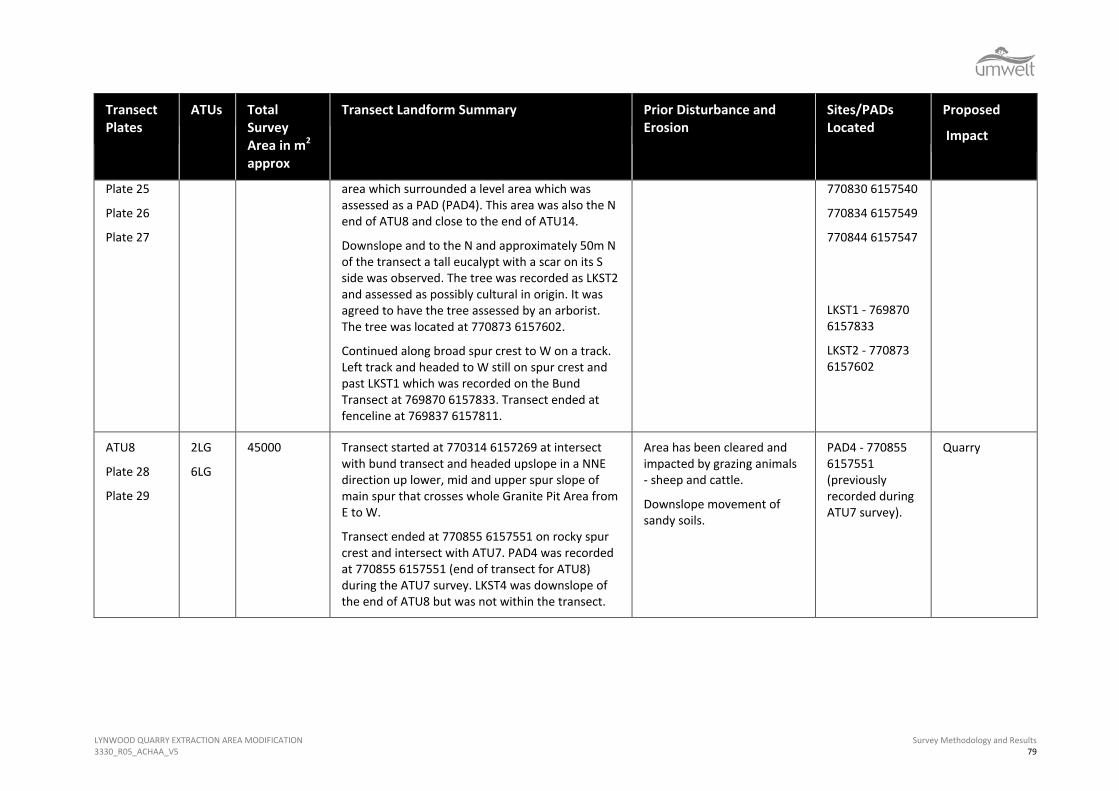
As a result of the preliminary inspection five new sites were recorded including two scarred trees (LKST1 and LKST2), one artefact scatter (LKAS1) and two isolated finds (LKIF1 and LKIF2) (refer to Section 5.5 for site details). The site locations are indicated on Figure 5.3. It was noted that ground surface visibility was extremely poor at the time.
Five PADs in five separate ATUs were also identified during the preliminary inspection as areas suitable for subsurface testing under the methodology previously used for the Approved Project Area under s.87/90 AHIP #1100264.
The previously recorded MRN25 and LA31 artefact scatter sites were also located, inspected and rerecorded. The locations of isolated find sites LA32 and LA33 were found and the areas inspected, however, the previously recorded artefacts could not be located. It was noted that the AMG coordinates on the site cards for sites LA31 and LA32 had been transposed and that the incorrect photograph was attached to the LA32 site card (the photograph actually showed the LA31 site area). The site descriptions were, however, correct. Information was provided to OEH by Umwelt on 15 June 2015 so that the AHIMS database could be corrected.
Details of the previously recorded sites and the sites located during the inspection are provided in Section 5.5.
5.4.2 Full Survey Results
Table 5.1 provides a summary of the survey transects undertaken for the Granite Pit Area and lists the relevant plates for each transect (refer to Figure 5.2). The detailed survey results and the plates are provided in Appendix F. Appendix F includes details of ground surface visibility and exposures. Within the Table 5.1 the ATU transects were those designed to sample the ATUs and the proposed quarry and overburden emplacement area. The LCK transects were those designed to cover all creekline/riparian corridors, the haul road and bund transects covered those infrastructure areas where it was assessed that the ATU and LCK transects did not supply adequate coverage. The Track transects followed existing formed and unformed tracks and often intersected other transects.
Figure 5.3 shows the location of the sites and the areas of PAD recorded during both the preliminary inspection in November 2014 and the full survey of the Granite Pit Area undertaken in June and July 2015. The figure also indicates the locations of the previously recorded sites.


LYNWOOD QUARRY EXTRACTION AREA MODIFICATION 3330_R05_ACHAA_V5
Survey Methodology and Results 76
Table 5.1 Summary of Survey Transects Granite Pit Area
Transect Plates
ATUs Total Survey Area in m2
approx
Transect Landform Summary Prior Disturbance and Erosion
Sites/PADs Located
Proposed
Impact
ATU1
Plate 1
Plate 2
4BP 4000 Transect started at N boundary of Granite Pit Area at the fenceline at 770978 6158066. The transect headed downslope, across a lower slope in a SSW direction. The transect covered the lower slope landform between two tributaries of Lockyersleigh Creek and ended at the confluence of the tributaries at 770874 6157968 intersecting with LCK1A and LCK1B.
Area has been cleared and impacted by grazing animals - sheep and cattle.
Downslope movement of sandy soils.
Scours along fence.
Scour at tributary
NA Dam Wall Construction – submersion by dam waters
ATU2
Plate 3
Plate 4
Plate 5
Plate 6
2LG
4BP
6BP
6LG
44150 Transect started at the N boundary of the Granite Pit Area at 770740 6158062 and headed downslope in a SW direction from a rocky spur crest, upper slope, midslope and lower slope. There was a bench on the lower slope that was recorded as a PAD (PAD5). The transect then crossed a tributary of Lockyersleigh Creek and headed up the lower, mid and upper slope of the major spur that trended from E to W across the Granite Pit Area. The transect then continued in a SW direction downslope across the upper mid and lower slopes of the spur and then along a low spur crest. Transect finished at 769885 6157410 at intersection with Transect LCK5A.
Area has been cleared and impacted by grazing animals - sheep and cattle.
Downslope movement of sandy soils.
Fencing.
Formed and unformed tracks.
PAD5 area/ATU4LG
770588 6157969
770608 6157975
770612 6158021
770596 6158032
770580 6158004
770573 6157995
770562 6157983
770571 6157977
Quarry

LYNWOOD QUARRY EXTRACTION AREA MODIFICATION 3330_R05_ACHAA_V5
Survey Methodology and Results 77
Transect Plates
ATUs Total Survey Area in m2
approx
Transect Landform Summary Prior Disturbance and Erosion
Sites/PADs Located
Proposed
Impact
ATU3
Plate 7
Plate 8
6LG 20000 Transect started at 770224 6157783 on N side of the major spur that trended from E to W across the Granite Pit Area and close to intersection with ATU7. The transect headed N and crossed the upper, mid and lower slope of the spur. Transect finished at corner post of fenceline on N boundary of Granite Pit Area at 770193 6158227.
Area has been cleared and impacted by grazing animals - sheep and cattle.
Downslope movement of sandy soils.
Fencing.
N/A Quarry
ATU4
Plate 9
Plate 10
6LG 20500 Transect started at 77067 6157840 from main spur crest and intersection with ATU7. Headed in a WNW direction and downslope across upper mid and lower slope. Transect ended at fenceline and N boundary of Granite Pit Area at 769975 61558261.
Area has been lightly cleared and impacted by grazing animals - sheep and cattle.
Downslope movement of sandy soils.
Dam construction
N/A Quarry and Bund
ATU5
Plate 11
Plate 12
4LG 6LG
12000 Transect started at 770546 6157658 on main spur crest at intersection with ATU7 heading across spur crest in a NNW direction then downslope across upper, mid and lower slope. Transect ended end at tributary of Lockyersleigh Creek at 770516 6157935.
Area has been cleared and impacted by grazing animals - sheep and cattle.
Slope wash/scouring.
Formed and unformed tracks
N/A Quarry
ATU6
Plate 13
Plate 14
Plate 15
Plate 16
4BP 6BP
24000 Transect started at 770800 6157918 on S side of tributary of Lockyersleigh Creek (LCK1A) heading in a SSE direction up and across the lower slope and onto a low spur crest. Exposure under tree at 770862 6157841 caused by slope wash. Seven stone artefacts (3 broken flakes, 1 retouched flake and 3 cores manufactured from silcrete, quartz, dolerite) observed within an area 4m x 4m downslope of the tree and approximately 100m
Area has been cleared and impacted by grazing animals - sheep and cattle.
Slope wash/scouring.
Downslope movement of sandy soils.
Formed track
LKAS1 - 770862 6157841
PAD3 area/ATU4BP
770932 6157783
770901 6157782
Quarry
Dam Wall
Inundation

LYNWOOD QUARRY EXTRACTION AREA MODIFICATION 3330_R05_ACHAA_V5
Survey Methodology and Results 78
Transect Plates
ATUs Total Survey Area in m2
approx
Transect Landform Summary Prior Disturbance and Erosion
Sites/PADs Located
Proposed
Impact
Plate 17
Plate 18
from tributary of Lockyersleigh Creek. Possibility of low numbers of artefacts subsurface. Lots of natural quartz exposed in this area. Site named LKAS1.
Crossed a bench and on the E side of the bench and approximately 40 metres from LKAS1 there was a second scour under a tree and an additional 7 artefacts (4 flakes, 1 broken flake, one retouched flake and 1 core manufactured from silcrete, quartz and chert) were exposed in an area approximately 5m by 4m. This scatter was recorded as part of LKAS1 with the bench area between recorded as PAD3.The area of PAD3 was approximately 40 metres by 40 metres.
Crossed broad drainage channel then headed up a steep 3 to 6 degree short midslope/upper slope to end at fenceline at 771004 6157802. The final 300 metres of the transect were outside the Granite Pit Area footprint.
770880 6157795
770866 6157819
770863 6157845
770886 6157835
770924 6157780
ATU7
Plate 19
Plate 20
Plate 21
Plate 22
Plate 23
Plate 24
2LG
4LG
4BP
6LG
75000 Transect started at the E boundary of the Granite Pit Area at fenceline at 771200 6157422 at the base of the upper slope and outside the Granite Pit Area disturbance footprint. Transect continued down slope and basically W and then followed crest of main spur that trends E to W. Spur crest starts at 771120 6157447. Continued transect heading W and downslope along the gently undulating spur crest.
Crossed a rocky spur crest at 770855 6157551. There were several small granite boulders in this
Scours around trees.
Area has been cleared and impacted by grazing animals - sheep and cattle.
Downslope movement of sandy soils.
Formed and unformed tracks.
PAD4 Area/ATU2LG
770852 6157541
770860 6157530
770848 6157526
770834 6167527
770826 6157535
Quarry and Bund
Vibration
LYNWOOD QUARRY EXTRACTION AREA MODIFICATION 3330_R05_ACHAA_V5
Survey Methodology and Results 79
Transect Plates
ATUs Total Survey Area in m2
approx
Transect Landform Summary Prior Disturbance and Erosion
Sites/PADs Located
Proposed
Impact
Plate 25
Plate 26
Plate 27
area which surrounded a level area which was assessed as a PAD (PAD4). This area was also the N end of ATU8 and close to the end of ATU14.
Downslope and to the N and approximately 50m N of the transect a tall eucalypt with a scar on its S side was observed. The tree was recorded as LKST2 and assessed as possibly cultural in origin. It was agreed to have the tree assessed by an arborist. The tree was located at 770873 6157602.
Continued along broad spur crest to W on a track. Left track and headed to W still on spur crest and past LKST1 which was recorded on the Bund Transect at 769870 6157833. Transect ended at fenceline at 769837 6157811.
770830 6157540
770834 6157549
770844 6157547
LKST1 - 769870 6157833
LKST2 - 770873 6157602
ATU8
Plate 28
Plate 29
2LG
6LG
45000 Transect started at 770314 6157269 at intersect with bund transect and headed upslope in a NNE direction up lower, mid and upper spur slope of main spur that crosses whole Granite Pit Area from E to W.
Transect ended at 770855 6157551 on rocky spur crest and intersect with ATU7. PAD4 was recorded at 770855 6157551 (end of transect for ATU8) during the ATU7 survey. LKST4 was downslope of the end of ATU8 but was not within the transect.
Area has been cleared and impacted by grazing animals - sheep and cattle.
Downslope movement of sandy soils.
PAD4 - 770855 6157551 (previously recorded during ATU7 survey).
Quarry

LYNWOOD QUARRY EXTRACTION AREA MODIFICATION 3330_R05_ACHAA_V5
Survey Methodology and Results 80
Transect Plates
ATUs Total Survey Area in m2
approx
Transect Landform Summary Prior Disturbance and Erosion
Sites/PADs Located
Proposed
Impact
ATU9
Plate 30
Plate 31
6LG 17500 Transect started at 770004 615328 at E boundary of Granite Pit Area heading ENE on gentle gradient slope between LCK5A and LCK5B. Moving upslope. Transect them moved slightly cross slope.
Transect ended at 770314 6157269 where it intersected with ATU8.
Area has been cleared and impacted by grazing animals - sheep and cattle.
Downslope movement of sandy soils.
Rabbit warren.
N/A Partial - Quarry
ATU10
Plate 32
Plate 33
Plate 34
Plate 35
Plate 36
4BP 60000 Transect started at 771089 6157193 at fenceline on upper midslope. At 771108 6157241 gradient increases as transect heads upslope across the lower upper slope.
At 771133 6157315 the slope levels out to a bench that was approximately 130m wide. The transect then continued across the lower upper slope.
At 771202 6157411 the N section of the transect ended on the upper slope at the intersection with ATU7 and the fenceline at the E boundary of the Granite Pit Area.
Second downslope stage of started at 771089 6157193 on midslope where N section started. Heading downslope. Intersecting with ATU11 at 770884 6155978 and then following spur crest to east of LCK6.
On the spur crest at 770476 6155801 there were multiple larger granite tors that provided shade from afternoon sun. PAD2 was identified in this area. Transect ended at Main Southern Railway on lower slope of spur at 770456 6156470.
Area has been cleared and impacted by grazing animals - sheep and cattle.
Multiple wombat burrows. Depth of granite soil/sand up to 0.3m exposed by burrowing.
Sheep and cattle tracks.
Downslope movement of sandy soils.
PAD2 Area/ATU4LG
770466 6156800
770468 6156813
770468 6156803
770490 6156798
Haul Road and Overburden Emplacement

LYNWOOD QUARRY EXTRACTION AREA MODIFICATION 3330_R05_ACHAA_V5
Survey Methodology and Results 81
Transect Plates
ATUs Total Survey Area in m2
approx
Transect Landform Summary Prior Disturbance and Erosion
Sites/PADs Located
Proposed
Impact
ATU11
Plate 37
Plate 38
6LG 36000 Transect started 770773 6156373 at Main Southern Railway heading upslope on lower slope. At 770776 6155467 crossed onto midslope. Crossed a small rocky crest on midslope at 770827 6156815.
End at 770884 6157109 on upper midslope at intersection with ATU10.
Construction of Main Southern Railway
Vegetation clearance.
Downslope movement of sandy soils.
Pipeline construction.
N/A Partially in Overburden Emplacement
ATU12
Plate 39
Plate 40
6LG 27500 Transect commenced at fence on Main Southern Railway on lower slope heading upslope (769987 6156624). Gradient 1 degree, aspect south. All trees cleared. Multiple small granite lichen covered tors in cleared grassland.
Continuing along small spur to the west of a tributary of Lockyersleigh Creek, gradient initially increases to 1-2 degrees upwards and then levels off again. Despite historic vegetation clearance relatively large numbers of mature Eucalypts encountered (none of which exhibited cultural scarring). Gradient then increases to 1-2 degrees downhill until a small drainage line at 770183 6156975.
Gradient increases again to 1-2 degrees upwards before levelling off again. Some granite outcroppings at the base of this slope were observed within the grassland. All were checked for artefacts but none were observed.
End at 770884 6157119 on upper midslope near fenceline
Construction of Main Southern Railway
Vegetation clearance.
Downslope movement of sandy soils.
N/A Partial Quarry, Overburden Emplacement

LYNWOOD QUARRY EXTRACTION AREA MODIFICATION 3330_R05_ACHAA_V5
Survey Methodology and Results 82
Transect Plates
ATUs Total Survey Area in m2
approx
Transect Landform Summary Prior Disturbance and Erosion
Sites/PADs Located
Proposed
Impact
ATU13
Plate 41
Plate 42
Plate 43
Plate 44
Plate 45
Plate 46
R6LG
6LG
40500 Transect begins at fenceline in NW corner of Granite Pit Area (770320 6158158). Heading upslope on eastern bank of Lockyersleigh Creek. Initially the transect progressed from the lower slope/footslope boundary opposite LA31 (refer to LCK1A) up a moderate slope towards a granite outcrop of large extent. Slope 1-2 degrees, some small rabbit burrows and scours among individual boulders (very orange, coarse sand).
Three artefacts (a quartz core and a two quartz broken flakes) were observed eroding from the eastern bank of the tributary of Lockyersleigh Creek at 770307 6158174. These were recorded as LA31E. A bench was crossed between the lower slope and midslope. A further 8 artefacts were recorded (cores, flakes, broken flakes and flaked pieces of quartz and quartzite around the base of outcropping granite tors at 770359 6158155. The artefacts were located in spoil from rabbit burrows and were recorded as part of LA31E. The bench area was assessed as PAD (PAD1E).
Upon descent back towards creek upon a slope of gentler gradient (but much better vegetated), an unsuccessful search was made for previously registered site LA32. A wide flattish area (fully cleared of vegetation) draining the saddle between two rocky spurs was traversed. Entire area covered 100% by thistle and grass.
Footslope of the second rocky spur passed below a second extensive outcrop of granite but very little visibility until large scour at 770878 6157986 20m x
Area has been cleared and impacted by grazing animals- sheep and cattle.
Sheep and cattle tracks.
Downslope movement of sandy soils.
770307 6158174
770359 6158155
LA31E
PAD1E/ATUR6LG and ATU6LG
770318 6158144
770344 6158095
770356 6158126
770366 6158144
770395 6158117
770468 6158051
LA32 Isolated find could not be located.
Partial Quarry, bund, water management infrastructure

LYNWOOD QUARRY EXTRACTION AREA MODIFICATION 3330_R05_ACHAA_V5
Survey Methodology and Results 83
Transect Plates
ATUs Total Survey Area in m2
approx
Transect Landform Summary Prior Disturbance and Erosion
Sites/PADs Located
Proposed
Impact
10m, thin, yellow silty sand. Followed northern bank of creek (cattle track and ant nest).Transect ended at fence 770766 6158107
LCK1A
Plate 47
Plate 48
Plate 49
Plate 50
Plate 51
Plate 52
Plate 53
Plate 54
Plate 56
Plate 57
R6BP R6LG
47500 (combined with W and S side)
Transect on E side then N side of tributary of Lockyersleigh Creek started at fenceline at 7703006158200 on a steep lower slope/footslope boundary (opposite LA31). The creekline was entrenched 3 to 5m deep and 3m wide and appeared to be spring fed at the start of the transect.
Crossed area of artefacts in bank of creek recorded as LA31E and below PAD1E.
At 770468 6158051 crossed previously recorded location of site LA32. The recorded location was 30m upslope of the creekline. The previously recorded isolated find could not be located.
Crossed a minor tributary at 770412 6157999. Crossed another minor tributary at 770493 6157985. From 770625 6157937 the creek channel became indiscernible. At 770669 6157905 the creek channel contained a number of small, shallow ponds and then went back to being indiscernible. There was a rocky spur to the north. At 770734 6157918 the creek channel goes back to chain of ponds morphology. At 770853 6157945 Creek channel is again entrenched to 3m, channel 4m wide and grassed with no water. There is an island in centre with creek in two channels at this point.
Area has been cleared and impacted by grazing animals- sheep and cattle.
Multiple wombat burrows in banks.
Creek bank scouring.
Sheep and cattle tracks.
Downslope movement of sandy soils.
770307 6158174
LA31W
770468 6158051
LA32 Isolated Find (not located)
Quarry, bund, water management infrastructure

LYNWOOD QUARRY EXTRACTION AREA MODIFICATION 3330_R05_ACHAA_V5
Survey Methodology and Results 84
Transect Plates
ATUs Total Survey Area in m2
approx
Transect Landform Summary Prior Disturbance and Erosion
Sites/PADs Located
Proposed
Impact
At 770868 6157972 crossed an eroded gully at the point where LCK1A meets LCK1B. At 770884 6157975 the steep banks of creekline scoured with multiple quartz pebbles exposed – not artefactual. Creek channel gradually becoming indiscernible as gradient increases to fenceline at N boundary of Granite Pit Area.
At 771110 6158029 transect ended at fenceline.
LCK1A
Plate 49
Plate 50
Plate 51
Plate 52
Plate 53
Plate 54
Plate 56
Plate 57
R6BPR6LG
47500 (combined with E and N side)
Started transect on W then S side of the tributary at 770200 6158200 in an area of deep orange sand. This was the area of the previously recorded artefact scatter site LA31 (discussed hereafter as LA31W). Eight artefacts were recorded exposed by wombat burrowing and in scours around trees over an area 200m along the creekline and 200m back from the creekline and within the orange sand. This area is identified as PAD (PAD1W). The artefacts were exposed on the lower slope, footslope and the steeper creek bank dropping down to the creekline (refer to Section 5.5 for site and artefact details). The creekline is deeply entrenched at this point.
Transect continued along the lower slope footslope with the creek channel becoming less distinct and in some areas indiscernible. At 7708483 6157971 the creek channel is again entrenched. At 770530 6157946 there was a 50m wide terrace beside the creek channel which continued to 770543 6157935 which was recorded as a possible PAD (PAD3). Track running to ENE of terrace – area 100m long
Area has been cleared and impacted by grazing animals- sheep and cattle.
Multiple wombat burrows in banks.
Depth of granite sand up to 2m exposed by wombat burrowing.
Sheep and cattle tracks.
Downslope movement of sandy soils.
Formed road.
Prior use of area for rubbish dump and removal of rubbish dump.
770293 6158151
LA31W
Artefact Scatter
PAD1W/ATUR6LG and ATU 6LG
770196 6158225
770212 6158108
770228 6158054
770301 6158034
770338 6158022
770262 6158126
770263 6158210
770593 6157907
LK1F2 Isolated Find (refer also to Track 3)
Quarry, bund, water management infrastructure

LYNWOOD QUARRY EXTRACTION AREA MODIFICATION 3330_R05_ACHAA_V5
Survey Methodology and Results 85
Transect Plates
ATUs Total Survey Area in m2
approx
Transect Landform Summary Prior Disturbance and Erosion
Sites/PADs Located
Proposed
Impact
and 2m wide inspected, at 770593 6157907 an isolated find LKIF2 (quartz core) was located exposed on the track (refer to Track 3 Transect for details).
At 770629 615629 creek channel becomes indiscernible.
At 770861 615792 Creek channel becomes entrenched again with remnant island in centre. Transect still crossing lower slope. At 770997 6157955 creek channel becomes broader and shallower.
Transect ended at fenceline at N boundary of Granite Pit Area at 771110 6158029.
LCK1B
Plate 58
R6BP 8000 Transect started at 770868 6157972 from intersection with LCK1A heading N and upstream across short lower, and midslope. Tributary confluence eroded but becomes shallow grassy channel away from confluence.
Transect ended at fenceline on N border of Granite Pit Area at 770886 6158077.
Area has been cleared and impacted by grazing animals- sheep and cattle.
Downslope movement of alluvium and colluvium.
N/A Partial - Quarry
LCK2
Plate 59
Plate 60
Plate 61
Plate 62
R6LG 7500 Transect started at 770103 6158037 heading N and downstream towards the fenceline on the lower slope. Creekline has broad grassy shallow channel.
Transect ended at 770094 6158248 on lower midslope. Two artefacts were located when moving between LCK2 and LCK3 transects. The site was recorded as LKAS6 and contained a broken silcrete flake and a granite grindstone.
Area has been cleared and impacted by grazing animals- sheep and cattle.
Downslope movement of sandy soils.
770067 6158242
LKAS6 (between LCK2 and LCK3)
Partial – Quarry
LKAS6 in vegetation buffer.

LYNWOOD QUARRY EXTRACTION AREA MODIFICATION 3330_R05_ACHAA_V5
Survey Methodology and Results 86
Transect Plates
ATUs Total Survey Area in m2
approx
Transect Landform Summary Prior Disturbance and Erosion
Sites/PADs Located
Proposed
Impact
LCK3
Plate 63
R6LG 4200 Transect started at 769883 6158284 near fenceline and heading S and upstream across lower slope and then midslope. Creekline has broad grassy shallow channel.
Transect ended at 769858 6158149 on midslope.
Area has been cleared and impacted by grazing animals- sheep and cattle.
Downslope movement of sandy soils.
N/A Partial - Bund
LCK4
Plate 64
R6LG 6500 Transect started at 769832 6158062 from fenceline on W boundary of Granite Pit Area and heading upstream. Crossed lower slope and midslope of low spur. Crossed dam and intersected with ATU4 at 769937 6158037.
Transect ended on midslope at 769974 6157996.
Area has been lightly cleared and impacted by grazing animals - sheep and cattle.
Downslope movement of sandy soils.
Dam construction
N/A Partial - Bund
LCK5A
Plate 66
R6LG 32000 Transect started at 769912 6157377 at WSW end of transect heading upstream across short midslope and upper slope between two spurs. Creekline has broad, grassy channel, ATU2 is to N and ATU 9 is to S.
Crossed dam at 770411 6157446. Lots of quartz pebbles exposed – not artefactual.
Transect ended on upper slope of low spur at 770351 6157418.
Area has been cleared and impacted by grazing animals- sheep and cattle.
Rabbit warrens.
Dam construction.
N/A Quarry and Bund

LYNWOOD QUARRY EXTRACTION AREA MODIFICATION 3330_R05_ACHAA_V5
Survey Methodology and Results 87
Transect Plates
ATUs Total Survey Area in m2
approx
Transect Landform Summary Prior Disturbance and Erosion
Sites/PADs Located
Proposed
Impact
LCK5B
Plate 67
Plate 68
Plate 69
Plate 70
R6LG 4000 Transect started at 770136 6157179 on short upper slope of low spur at SE end of transect heading downstream - tributary flowing to NW in a broad grassy channel. At 770131 6157194 crossed fence and moved onto midslope.
Two artefacts were observed in a minor scour at 770086 6157218 on the southern side of the tributary to the east of some large boulders which provided protection from the wind. The site was called LKAS5 and contained one broken dolerite flake and one silcrete flake.
Transect ended at 770055 6157260 on lower slope.
Area has been cleared and impacted by grazing animals- sheep and cattle.
Fencing
Downslope movement of sandy soils.
770086 6157218
LKAS5
Bund
LCK6
Plate 71
R6LG 40000 Transect started at 770689 6157107 on midslope heading SW downstream and downslope from graded track. The creek channel was wide and grassy and there were numerous short tributaries entering from the east and west that drained between localised low spurs.
A swampy area was encountered on the lower slope and within the tributary channel at 770215 6156759. In this area the water flow had been slowed by the construction of the Main Southern Railway downstream and colluvial and alluvial build up behind the railway had formed the swamp.
For the final 400m of the transect across the lower slope the creek channel became indistinguishable due to deposition of alluvial and colluvial sands behind the Main Southern Railway.
Transect ended at Main Southern Railway on lower
Area has been cleared and impacted by grazing animals- sheep and cattle.
Multiple wombat burrows in banks. Depth of granite sand up to 1m exposed by burrowing.
Sheep and cattle tracks.
Downslope movement of sandy soils.
N/A Overburden Emplacement

LYNWOOD QUARRY EXTRACTION AREA MODIFICATION 3330_R05_ACHAA_V5
Survey Methodology and Results 88
Transect Plates
ATUs Total Survey Area in m2
approx
Transect Landform Summary Prior Disturbance and Erosion
Sites/PADs Located
Proposed
Impact
slope at 770123 6156557. Construction of Main Southern Railway.
LCK7A
Plate 72
Plate 73
Plate 74
Plate 75
Plate 76
Plate 77
Plate 78
R6BP 30000 Transect started at 771009 6156910 on midslope heading downstream. The tributary channel was broad grassy and rocky.
Just to the west of the Transect was an area of approximately 40 wombat burrows. An isolated quartz retouched flake was located on wombat spoil within the burrows at 771002 6156845. The site was named LKIF3.
Crossed historic pipeline excavation at 770986 6156722.
Checked dam on lower slope no visibility, heavily grassed. Some minor creek bank scouring and sheep tracks on eastern side of tributary. A few shallow empty ponds in creek channel.
Tributary channel not discernible in its lower reaches at southern end of transect as heavily grassed and infilled with colluvial and alluvial deposits from slopes above and to the east that have backed back behind the Main Southern Railway in this area of low gradient.
One isolated find (LKIF1 - a quartz broken flake) was recorded behind a contour bank that had been exposed by wombat burrowing at 770979 6156573. No PAD assessed as likely in this area due to disturbance and as the artefact came from an area of recent colluvial deposition.
Area has been cleared and impacted by grazing animals- sheep and cattle.
Downslope movement of sandy soils.
Sheep tracks along both sides of the creekline.
Wombat burrows.
Dam construction.
Crossed by graded track at
Pipeline excavation.
Contour bank.
Construction of Main Southern Railway
770979 6156573
LKIF1
771002 6156845
LKIF3
N/A
Overburden emplacement

LYNWOOD QUARRY EXTRACTION AREA MODIFICATION 3330_R05_ACHAA_V5
Survey Methodology and Results 89
Transect Plates
ATUs Total Survey Area in m2
approx
Transect Landform Summary Prior Disturbance and Erosion
Sites/PADs Located
Proposed
Impact
Transect ended at 770895 6156345.
LCK7B
Plate 79
Plate 80
Plate 81
R6BP
6BP
12500 Transect started at 7701038 6156240 below dam in the Approved Project Area heading downstream in a WSW direction across the lower slope following the Lockyersleigh Creek tributary.
An artefact scatter was located 15m to the W of the dam wall and within a scour on the SE side of the creek (LKAS3). Four artefacts were observed – 1 quartz retouched flake, 1 quartz flake, 1 quartz broken flake and 1 dolerite flake. The transect crossed through a fence within the site area and continued downstream. Approximately 20 metres downstream it crossed a second fence into the Granite Pit Area at 7701029 6156249.
An area of PAD (PAD6) was noted at the confluence of LCK7B and LCK7A
Tributary channel not discernible for most of remainder of transect, grassed and infilled with colluvial and alluvial deposits from slopes above that have backed back behind the Main Southern Railway.
Transect ended on lower slope at Main Southern Railway 770774 6156360.
Dam Construction in Granite Pit Area
Area has been cleared and impacted by grazing animals- sheep and cattle.
Creek bank scouring.
Downslope movement of sandy soils.
Construction of Main Southern Railway.
Fencing.
771038 6156240
LKAS3
PAD6/ATUR6BP and 6BP
770999 6156317
770983 6156281
770958 6156245
770906 6156267
770945 6156293
770989 6156320
Water Management Infrastructure
LCK8
Plate 82
Plate 83
Plate 84
R6LG
6LG
40000 Transect started at 770707 6157870 at intersection with LCK1AS transect and followed tributary channel upslope across lower slope and midslope in an ESE direction.
Crossed Track 3 transect east of LKIF2 and LKAS4
Area has been cleared and impacted by grazing animals- sheep and cattle.
Downslope movement of sandy soils.
N/A Quarry

LYNWOOD QUARRY EXTRACTION AREA MODIFICATION 3330_R05_ACHAA_V5
Survey Methodology and Results 90
Transect Plates
ATUs Total Survey Area in m2
approx
Transect Landform Summary Prior Disturbance and Erosion
Sites/PADs Located
Proposed
Impact
Plate 85 and passed between sites LKAS1 (ATU6 transect) and LKAS2 (Track 3 transect).
At the start of the midslope crossed natural pond that had been excavated to form a dam at the intersection of LCK8 and a minor tributary at 770846 6157709. A natural depression at this point. There were several exposures around the dam.
On the midslope the tributary channel became much broader, grassy and indistinct. The transect passed to the NE of LKST2 and ended on the upper midslope at 770972 6157514.
Creek bank scouring.
Dam excavation.
Haul Road
Plate86
Plate 87
6LG 6BP
22500 Transect started at 771106 6156916 at fenceline between Approved Project Area and Granite Pit Area heading NW across midslope and upslope.
Transect ended on upper midslope at 770868 6157420.
Area has been cleared and impacted by grazing animals- sheep and cattle.
Stock tracks
Fencing
Wombat burrows
N/A within Granite Pit Area
MRN25 in Approved Project Area and outside of transect (refer to MRN25 below)
Haul Road
Bund
Plate 88
Plate 89
Plate 90
6LG 90000 Transect started at 770013 6156648 at southern end of bund on lower slope 50m N of Main Southern Railway. Heading NNE and upslope on lower slope and midslope.
At 770136 6157179 Crossed LCK5B tributary flowing to NW and then round dog leg at 769990 6157403 to cross LCK5A tributary flowing to SSW.
Construction of Main Southern Railway
Area has been cleared and impacted by grazing animals- sheep and cattle.
Downslope movement of
769879 6157833
Modified Tree LKST1
(refer to ATU7 transect)
Bund

LYNWOOD QUARRY EXTRACTION AREA MODIFICATION 3330_R05_ACHAA_V5
Survey Methodology and Results 91
Transect Plates
ATUs Total Survey Area in m2
approx
Transect Landform Summary Prior Disturbance and Erosion
Sites/PADs Located
Proposed
Impact
Headed upslope and then cross-slope on a rocky slope.
Crossed graded track on sour crest at 769879 6157833 and just before fenceline a modified tree (LKST1) was observed at 769879 6157833. The tree was located 8m SE of the fenceline and 10m NW of the track. The scar was recorded as a possible shield or gunyah roofing scar. The tree was a mature, live, eucalypt.
Crossed fence and headed downslope across upper mid and lower slope. Crossed a low rocky crest at 769885 6158074. The crest was just S of LCK4.
Continued downslope to fenceline crossed LCK3 and turned to the E finishing to W of LCK2 on fenceline at 769897 6158284.
sandy soils.
Wombat burrows.
Dam construction.
Graded track.
Track 1
Plate 91
33000 Transect commenced at Main Southern Railway 770588 6156433 on lower slope heading upslope. Gradient <1 degree, aspect south. All trees cleared. Small granite outcrop in centre of transect 770826 6156644. Track follows course of gas pipeline. End transect at 771052 6156758 at fence
Vegetation clearance
Pastoral activity
Vehicle movement
Wombat burrowing
N/A Quarry, Overburden Emplacement
Track 2
Plate 92
38500 Transect commenced at 771080 6156772 on lower slope heading across slope. Gradient <1 degree, aspect south-west. Trees mostly cleared. Crossed small drainage at 771037 6156840. Track traverses small sandy ridge above small drainage to the east before descending onto a small saddle between the sandy ridge to the south and a rocky spur to
Vegetation clearance
Pastoral activity
Vehicle movement
Wombat burrowing
N/A Quarry, Overburden Emplacement

LYNWOOD QUARRY EXTRACTION AREA MODIFICATION 3330_R05_ACHAA_V5
Survey Methodology and Results 92
Transect Plates
ATUs Total Survey Area in m2
approx
Transect Landform Summary Prior Disturbance and Erosion
Sites/PADs Located
Proposed
Impact
the north. The rocky spur displays numerous outcrops of granite to the south of the track. All slopes gentle gradient of <1 degree. Transect follows spur crest until intersection with another vehicle track at 770447 6157164 adjacent to fenceline to the north. End transect at 770447 6157164 at track intersection adjacent to fence.
Track 3
Plate 93
Plate 94
Plate 95
Plate 96
Plate 97
Plate 98
Plate 99
49000 Transect started from fenceline on upper slope at 770259 6157772. Transect progresses in a north-easterly direction down a gentle slope of <1 degree to where a small drainage line crosses the track and begins to follow the lower slope along the southern bank of a tributary of Lockyersleigh Creek parallel and occasionally within to LCK1AS transect.
Soils mostly shallow grey silty sand with conglomerate pebbles in proximity to the creek. Higher upslope at the beginning of transect soils coarse orange yellow sand.
At 770593 6157907 an isolated quartz core was encountered exposed on the road (LKIF2) which was also recorded on Transect LCK1As.
At 770666 6157889 two quartz cores approximately 2m apart were located exposed on the track (LKAS4).
The transect followed the lower slope landform and the tributary of Lockyersleigh Creek to end in the NE corner of the project area at 771221 6158006
Vegetation clearance
Pastoral activity
Vehicle movement
770593 6157907
LKIF2
770666 6157889
LKAS4
Quarry, Dam construction and
Inundation

LYNWOOD QUARRY EXTRACTION AREA MODIFICATION 3330_R05_ACHAA_V5
Survey Methodology and Results 93
Transect Plates
ATUs Total Survey Area in m2
approx
Transect Landform Summary Prior Disturbance and Erosion
Sites/PADs Located
Proposed
Impact
MRN25 and PAD
Plate 100
Plate 101
Plate 102
4BP N/A MRN25 was inspected on both the first and last day of the survey. MRN25 was surveyed as part of the Approved Project Area and has been previously subsurface tested (refer to Section 5.5.2 for details).
Area has been cleared and impacted by grazing animals- sheep and cattle.
Wombat burrows
MRN25 and PAD area/ATU4BP
771340 6156606
771377 6156589
771410 6156568
771380 6156527
771360 6156489
771355 6156453
771307 6156483
771276 6156510
771303 6156552
Haul Road

LYNWOOD QUARRY EXTRACTION AREA MODIFICATION 3330_R05_ACHAA_V5
Survey Methodology and Results 94
From Table 5.1 and Figure 5.3 it can be noted that:
• there was a total of 14 pedestrian transects across the ATUs, eight pedestrian transects associated with each side of the tributaries of Lockyersleigh Creek and three transects that followed existing tracks across multiple ATUs. The track transects provided far better ground surface visibility
• in general ground surface visibility was poor across the Granite Pit Area due to thick grass cover
• there were isolated mature eucalypts and patches of mature eucalypts across the Granite Pit Area, however, in general it had been heavily cleared and subject to downslope movement of the sandy soils
• rabbit and wombat warrens were common across the Granite Pit Area which while causing ground disturbance also allowed for the exposure of artefacts which would otherwise have not been visible
• a total of five isolated finds were recorded in the Granite Pit Area. Two of these were the previously recorded LA32 and LA33 (Saunders 2005). The artefacts previously recorded at these two isolated find locations could not be found despite relatively good visibility in the areas inspected
• a total of nine artefact scatters were recorded in the Granite Pit Area including the previously recorded LA31 site and the MRN25 site (that will be impacted by the proposed haul road for the Granite Pit)
• a total of six PADs were identified and recorded across the Granite Pit Area. Two of the PADs (PAD1 (incorporating PAD1E and PAD1W) and PAD3 and the PAD) were within site areas assessed as likely to have further subsurface archaeological material (LA31 and LKAS1 and MRN25), three PADs were within proximity of a site/sites and assessed as likely to have subsurface archaeological material (PAD4, PAD5 and PAD6) and one was in a location chosen for its Aboriginal cultural values, outlook and likelihood of subsurface archaeological material (PAD2)
• a seventh PAD was identified in association with the MRN25 site within the Approved Project Area and within the disturbance footprint for the haul road for the Granite Pit
• there were two scarred trees recorded and their cultural origin has been confirmed by an arborist (UTM 2015)
• the majority of the isolated finds and artefact scatters were located in association with the tributaries of Lockyersleigh Creek that flowed from outside the Granite Pit Area and which were more reliable water sources (e.g. the tributary in the north and the tributary in the south-east of the Granite Pit Area)
• the most extensive artefact scatter and PAD area was at the previously recorded LA31 site in the north of the Granite Pit Area. However, during the survey it was found that the site area was far more extensive than previously recorded by Saunders in 2005 and that artefacts were more abundant. The site/PAD area extended to the north and south of the Saunders site recording and onto the eastern side of the tributary
• the second most extensive site and PAD area was the MRN25 artefact scatter which while being in the Approved Project Area will be impacted by haul road construction for the modification. It is noted that the area of MRN25 is based on prior subsurface testing results (Umwelt 2009b)
• of the five isolated finds three will be impacted by the proposed modification (LKIF2, LKIF3 and LA32). LKIF1 and LA33 are outside the Granite Pit Area disturbance footprint

LYNWOOD QUARRY EXTRACTION AREA MODIFICATION 3330_R05_ACHAA_V5
Survey Methodology and Results 95
• of the nine artefact scatters seven will be impacted by the proposed modification (LKAS1, LKAS2, LKAS3, LKAS4, LA31W, LA31E and MRN25). LKAS5 and LKAS6 are outside the Granite Pit Area disturbance footprint
• all seven PADs will be impacted by the proposed modification
• both of the scarred trees will be impacted by the proposed modification
• the main raw materials used for artefact manufacture were quartz, silcrete, dolerite, quartzite and chert. There was also a single granite grindstone
• quartz pebbles and reef quartz that was not artefactual, were exposed across the area by erosion.
Please refer to Section 5.5 for detailed site and PAD descriptions.
5.4.3 Effective Coverage
Table 5.2 provides data in relation to the effective coverage of the survey. Effective coverage is a general estimate of the actual ground surface visible at the time of the survey (i.e. ground surface exposed to a level where archaeological material should be evident if present).
Table 5.2 Effective Coverage – Granite Pit Area
Transect Total Area Surveyed (m2)
General Ground surface visibility %
General Ground Surface Visibility (m2)
Area of Additional
Exposure
(m2)
Total Area available for detection (m2)
% of Area available for site detection
ATU1 4000 0 0 10 10 0.25
ATU2 44150 0 to S of tributary (630m approx.)
0 to 20 N of tributary (250m approx.)
2500 223 2723 6.2
ATU3 20000 0 0 0 0 0
ATU4 20500 2.5 513 155 668 3.3
ATU5 12000 0 (140m)
5 (100m)
250 180 430 2.1
ATU6 24000 0 (50m)
5 (430m)
1075 160 1235 5.1

LYNWOOD QUARRY EXTRACTION AREA MODIFICATION 3330_R05_ACHAA_V5
Survey Methodology and Results 96
Transect Total Area Surveyed (m2)
General Ground surface visibility %
General Ground Surface Visibility (m2)
Area of Additional
Exposure
(m2)
Total Area available for detection (m2)
% of Area available for site detection
ATU7 75000 0 (1150m)
5 (300m)
20 (50m)
1250 1453 2703 3.6
ATU8 45000 0 (850m)
20 (50m)
0 0 0 0
ATU9 17500 0 0 3 3 0.01
ATU10 60000 0 0 219 219 0.4
ATU11 36000 0 0 309 309 0.8
ATU12 27500 0 0 38.5 38.5 0.14
ATU13 40500 5 2025 134.4 2159.4 5.3
LCK1A 47500 Average 5 2375 1300 3675 7.7
LCK1B 8000 0 0 18 18 0.2
LCK2 7500 2 150 0 150 2
LCK3 4200 10 420 0 420 10
LCK4 6500 0 0 125 125 1.9
LCK5A 32000 0 0 322 322 1
LCK5B 4000 0 0 1 1 0.03
LCK6 40000 0 0 988 988 2.5
LCK7A 30000 0 0 346 346 1.2
LCK7B 12500 0 0 0 0 0
LCK8 40000 2.5 1000 109 1109 2.8
Haul Road 22500 0 0 60 60 0.3
Bund 90000 0 (1300m)
5 (500m)
1250 519 1769 2
Track 1 3250 40 1300 1067.4 2367.4 72.8

LYNWOOD QUARRY EXTRACTION AREA MODIFICATION 3330_R05_ACHAA_V5
Survey Methodology and Results 97
Transect Total Area Surveyed (m2)
General Ground surface visibility %
General Ground Surface Visibility (m2)
Area of Additional
Exposure
(m2)
Total Area available for detection (m2)
% of Area available for site detection
Track 2 3300 40 1320 1732.5 3052.5 92.5
Track 3 5000 50 2500 0 2500 50
Total 782,400 N/A 17928 9472.8 27400.8 3.5
Table 5.2 indicates that of 782,400m2 surveyed, ground surface visibility conducive to exposing archaeological material within the Granite Pit Area (excluding the MRN25 area) was only present for 27,400m2. Therefore, the overall effective survey coverage was 3.5 per cent which is relatively low. Visibility was, however, highly variable ranging from 0 per cent in the grasslands to 50 per cent on tracks. Therefore, where ground surface visibility was low (off tracks), the assessment of PAD relied heavily on the predictive model (refer to Section 4.0).
5.4.4 Definition - Potential Archaeological Deposit (PAD)
The detection and identification of archaeological material is closely related to levels of exposure and visibility, that is, archaeological material that is obscured by vegetation or is beneath the ground surface will not be recorded during an archaeological survey. For the purposes of archaeological assessment and cultural heritage management, the likelihood that artefacts may be present below the ground surface has important archaeological and legislative implications for any proposed development impact. In terms of the archaeological assessment, it is also necessary to consider whether areas with subsurface archaeological material should be identified as PAD.
The term ‘potential archaeological deposit’ (PAD) can be defined in a number of different ways. However, the primary archaeological importance of subsurface deposits is the possibility that they will provide information that can be used to interpret changes in the archaeological record through time and space. Consequently, for the purpose of this assessment, an area was only designated as a PAD if it met one or more of the following criteria:
1. it should be likely that the PAD will contain sufficient archaeological material to allow for statistically viable detailed analysis and comparison of the artefact assemblage both within and between sites; and/or
2. the PAD should not have been significantly disturbed and should retain a degree of archaeological integrity; and/or
3. it is predicted that the PAD may contain materials that can be dated, either in relative or absolute terms.
Table 5.1 identifies six areas assessed as having the likelihood of retaining PAD and the site/PAD area associated with MRN25 which has already been subsurface tested and is known to have PAD. These areas are highlighted on Figure 5.3. The areas have been identified as PADs as it is assessed that they met the criteria listed above.

LYNWOOD QUARRY EXTRACTION AREA MODIFICATION 3330_R05_ACHAA_V5
Survey Methodology and Results 98
It is also assessed that low numbers of widely dispersed artefacts are possible in highly disturbed contexts across the entire Granite Pit Area disturbance footprint, however, these areas do not meet the criteria above and have not been assessed as PAD.
5.5 Site Descriptions
OEH site cards for existing sites have been included in Appendix G and the data recorded in relation to the newly recorded sites is located within Appendix H. Site and PAD locations are shown on Figures 5.3 and 5.4.
5.5.1 Isolated Finds
5.5.1.1 LKIF1
LKIF1 was located on the lower slope on the western bank of a north-south flowing, first order tributary of Lockyersleigh Creek and close to a confluence with another tributary. The aspect of the site was to the south-west and the gradient was 1 degree. The site contained a broken quartz flake located on spoil from a wombat burrow in an area of spoil/exposure 10 metres by 5 metres. The site was located behind a contour bank in an area that had been infilled with colluvial deposits. It is not known if the artefact was dug up by the wombat from the colluvium or the natural soil profile. The site area had been disturbed by contour bank construction and wombat burrowing. The site was not assessed to be associated with PAD (refer to Plates 77 and 78).
LKIF1 is outside the Granite Pit Area disturbance footprint at MGA 770979 6156573.
LKIF1 is in ATUR6BP.
5.5.1.2 LKIF2
LKIF2 was located on a track on a lower slope adjacent to a tributary of Lockyersleigh Creek. The site was located on southern side of the creek. The aspect of the site was to the north-west and the gradient was 1 degree. The outlook of the site was towards the tributary. The site contained a small quartz core exposed on the surface of the track. The site was not assessed to be associated with PAD (refer to Plates 96 and 97).
LKIF2 is within the proposed quarry footprint for the Granite Pit Area at MGA 770593 6157907.
LKIF2 is within ATUR6LG.
5.5.1.3 LKIF3
LKIF3 was located on the midslope 60 metres to the west of a minor tributary of Lockyersleigh Creek. The aspect of the site was to the south and gradient was 2 degrees. The site contained a quartz retouched flake that had been exposed in an area of extensive wombat burrows. Despite an intensive search no further artefacts were located in the area subject to wombat burrowing. The site was not assessed to be associated with PAD (refer to Plate 73).
LKIF3 is within the proposed overburden emplacement area for the Granite Pit Area at MGA 771002 6158051.
LKIF3 is within ATU6BP.


LYNWOOD QUARRY EXTRACTION AREA MODIFICATION 3330_R05_ACHAA_V5
Survey Methodology and Results 100
5.5.1.4 LA32
As discussed in Section 3.3.2, LA32 was recorded by Saunders (2005) as an isolated quartz flake, located on a low gradient lower slope, 220 metres south-east of LA31 and on the opposite side (north-eastern side) of the tributary to LA31. Despite the area being inspected during the preliminary and full survey the quartz flake was not located. The site was area not assessed to be associated with PAD.
LA32 is within the proposed quarry footprint for the Granite Pit Area at MGA 770468 6158051.
LA32 is within ATU4LG.
5.5.1.5 LA33
As discussed in Section 3.3.2, LA33 was recorded as an isolated quartzite flake located on a low gradient basal slope (at the base of the upper slope and just west of a fenceline) in the north-eastern corner of the Granite Pit Area. Despite the area being inspected during the preliminary and full survey the quartzite flake was not located. The site area was not assessed to be associated with PAD.
LA33 is outside the Granite Pit Area disturbance footprint at MGA 771199 6157727.
LA33 is in ATU4BP.
5.5.2 Artefact Scatters with PADs
5.5.2.1 LA31 (East and West and PAD1E and PAD1W)
As discussed in Section 3.3.2, LA31 was recorded by Saunders in 2005. At that time the site was recorded as as a low density artefact scatter located on a low-gradient, northerly facing slope above a tributary of Lockyersleigh Creek. The artefacts were distributed across an area of 50 metres by 20 metres and within deep orange sands that had been excavated by wombats. The artefacts recorded by Saunders consisted of five flakes and a flaked piece manufactured from quartz, quartzite and chert.
During the survey for the Granite Pit Area the LA31 site was revisited and it was noted that the artefacts were located on a north-easterly facing lower slope, footslope and the steeper bank dropping down to the tributary of Lockyersleigh Creek. Gradient was 1 to 3 degrees.
Eight artefacts were recorded exposed by wombat burrowing and in scours around trees over an area 200 metres along the creekline and up to 200 metres to the west of the creekline (and just through the a north-south fenceline running from the northern boundary of the Granite Pit Area). The area between and encompassing the artefacts was recorded as PAD1W. The exposed artefacts included 4 flakes, 1 broken flake and 3 cores manufactured from silcrete and quartz (refer to Plates 50 to 55).
Three artefacts (a quartz core and two quartz broken flakes) were also observed eroding from the eastern bank of the tributary of Lockyersleigh Creek. These artefacts were recorded as LA31E to distinguish them from the artefacts on the western side of the creekline which were subsequently recorded as LA31W. A bench was crossed between the lower slope and midslope on the eastern side of the tributary. A further 8 artefacts (4 cores, 2 flakes, 1 broken flake and 1 flaked piece of silcrete, quartz and quartzite) were recorded around the base of an outcropping granite tor. The artefacts were located in spoil from rabbit burrows and were recorded as part of LA31E. The bench area was assessed as PAD (PAD1E) (refer to Plates 42 to 46).

LYNWOOD QUARRY EXTRACTION AREA MODIFICATION 3330_R05_ACHAA_V5
Survey Methodology and Results 101
It was noted that there was a spring in the tributary channel in the area between LA31E and LA31W. The tributary channel had a number of ponds within the area encompassed by the extensive site and these contained Typha sp. (bulrush) an Aboriginal food plant which was used by Aboriginal people as a staple carbohydrate source (refer to Plate 41).
Figure 5.3 shows the extent of the site (LA31E and LA31W) and PAD1 (PAD1E and PAD1W). PAD1W was assessed as a PAD as it is highly likely to have moderate to high numbers of artefacts in a subsurface context. While the area associated with the extensive wombat burrows will have subsurface artefacts it is assessed that most of these have been subject to downslope movement from the level area of footslope above. Continuous wombat burrowing and wombat burrow collapse has acted to bury and re-expose the artefacts which in turn is moving them down the relatively steep creek bank. Thus the area of wombat burrowing would not be suitable for subsurface testing/salvage. However, the area to the west including the top of the bank, the footslope and lower slope would be an area suitable for testing/salvage.
In relation to the PAD1E area this has not been subject to wombat burrowing and rabbit burrowing is restricted to its perimeter. It is assessed as highly likely that this area will have moderate numbers of subsurface artefacts.
It is noted that the northern boundary of PAD1W is the northern boundary of the Granite Pit Area and that the PAD is highly likely to extend through this fenceline. PAD1E is, however, thought to be restricted to the area shown on Figure 5.4.
The area of LA31E/PAD1E is encompassed by the following MGA coordinates:
• 770318 6158144
• 770344 6158095
• 770356 6158126
• 770366 6158144
• 770395 6158117
The area of LA31W/PAD1W is encompassed by the following MGA coordinates:
• 770196 6158225
• 770212 6158108
• 770228 6158054
• 770301 6158034
• 770338 6158022
• 770262 6158126
• 770263 6158210

LYNWOOD QUARRY EXTRACTION AREA MODIFICATION 3330_R05_ACHAA_V5
Survey Methodology and Results 102
LA31W/PAD1W and LA31E and PAD1E are partially within the Granite Pit Area quarry disturbance footprint. Also proposed within this area are proposed water management works and the amenity bund.
LA31W and PAD1W are within ATUR6DS and extend into ATU6LG.
LA31E and PAD1E are within ATUR6LG and extend into ATU6LG.
5.5.2.2 MRN25
Though MRN25 is located within the Approved Disturbance Footprint for the Approved Operations and has been approved for impact, the current s.87/90 AHIP #1100264 only allows for the burial of the site which differs from the proposed for impact from the construction of the haul road from the Approved Project Area and into the Granite Pit Area. Thus the changes to the nature of the impact will need to be covered by the proposed variation to s.87/90 AHIP #1100264 which is the rationale for discussing the site within this assessment.
MRN25 is located on a low spur crest and slope, in the north-western corner of the Approved Project Area and in proximity to an upper tributary of Lockyersleigh Creek which drains to the south-west and into the Granite Pit Area. At the time of its location in 2004, MRN25 was recorded as having 10 flakes (chert and quartz) exposed over an area 50 metres by 30 metres (Umwelt 2006). The artefacts were located on top of spoil excavated from an extensive field of wombat burrows which covered an area of 100 square metres (refer to Appendix G for 2014 monitoring report for the site).
As part of the subsurface testing and salvage program for Lynwood Quarry (and prior to agreement for burial of the site) a surface collection was undertaken of MRN25 (on 7 March 2008) under s.90 AHIP (#1077225). Only three artefacts were located on the surface: a quartz broken flake, a quartz core and a basalt core. The three artefacts were spread across the site. None of the surface artefacts collected were those observed in 2004, and all of the initially recorded flakes had been obscured by vegetation or reburied by wombat burrow collapse/fresh wombat burrow spoil (Umwelt 2009b).
The subsurface testing of MRN25 was undertaken over the period 7 March to 18 March 2008 under s.90 AHIP (#1077225). Thirty, 50 centimetre squares were excavated. The squares extended across the whole of the landform unit. A total of 337 artefacts were recovered from the 30 squares excavated. MRN25 was to be subject to further subsurface salvage of those areas that had high artefact numbers and retained spatial integrity prior to site impact, however, Holcim Australia modified plans for the overburden emplacement area to allow the site to be covered by geofabric and buried to conserve any further artefactual material in-situ. As noted in Section 3.3.2 site burial is currently approved under AHIP #1100264 (Umwelt 2013b).
On 29 June 2015, as part of the survey program for the Granite Pit Area the site was reinspected. A total of five recently exposed artefacts were observed including a chert flake, two broken quartz flakes, a silcrete flake and a bipolar quartzite flake (refer to Plates 100 to 102).
The area of MRN25 and associated PAD is encompassed by the following MGA coordinates:
• 771340 6156606
• 771377 6156589
• 771410 6156568
• 771380 6156527
• 771360 6156489

LYNWOOD QUARRY EXTRACTION AREA MODIFICATION 3330_R05_ACHAA_V5
Survey Methodology and Results 103
• 771355 6156453
• 771307 6156483
• 771276 6156510
• 771303 6156552
Thus MRN25 has been demonstrated to have PAD and no further subsurface testing is required. Salvage of the site is required, however, if ground surface disturbance cannot be avoided.
MRN25 is in ATU4BP.
5.5.2.3 LKAS1 (PAD3)
The LKAS1 site consisted of two exposures with artefacts separated by an area of bench approximately 40 metres by 40 metres assessed to be PAD (PAD3). The initial artefacts were located in an exposure caused by slopewash under a tree at the break of slope on the edge of a spur crest approximately 100 metres south of a tributary of Lockyersleigh Creek. The aspect was to the west-north-west and the gradient 3 degrees. Seven artefacts (3 broken flakes, 1 retouched flake and 3 cores manufactured from silcrete, quartz and dolerite) were recorded within the scour area (4m x 4m) downslope of the tree.
Directly adjacent to the artefact exposure was a level bench approximately 40 metres wide. On the south-eastern side of the bench at the break of slope there was a second scour under a tree and an additional seven artefacts (4 flakes, 1 broken flake, one retouched flake and 1 core manufactured from silcrete, quartz and chert) were exposed in an area approximately 5 metres by 4 metres. This scatter was also recorded as LKAS1 with the bench area between recorded as PAD3 (refer to Plates 14 to 18)
The area was assessed as PAD as even though it had been cleared, it did not appear to have been subject to a great deal of topsoil loss and should at least retain the majority of the A2 soil horizon (at least 15 centimetres). The bench area was surrounded by rocky outcrops which had acted to retain the topsoil which had not been impacted by wombat or rabbit burrows. The distribution of the exposed artefacts indicated that the bench area was highly likely to retain at least a moderate density of subsurface artefacts.
The bench area was protected from the extremely cold south-westerly winds by the main spurline that crosses the project area from east to west, suggesting it may have been a camp site used in colder months.
The area of LKAS1/PAD3 is encompassed by the following MGA coordinates:
• 770932 6157783
• 770901 6157782
• 770880 6157795
• 770866 6157819
• 770863 6157845
• 770886 6157835
• 770924 6157780

LYNWOOD QUARRY EXTRACTION AREA MODIFICATION 3330_R05_ACHAA_V5
Survey Methodology and Results 104
PAD3 is assessed as an area that would be suitable for subsurface testing.
LKAS1 is within the Granite Pit Area quarry footprint and may be also be impacted by the construction of a dam in this area.
LKAS1 is on a bench in ATU4BP.
5.5.3 Artefact Scatters without PAD
5.5.3.1 LKAS2
LKAS2 was located on the lower slope approximately 60 metres south of a tributary of Lockyersleigh Creek. The site contained one quartz flake, one quartz broken flake and one quartz bipolar flake. The artefacts were exposed in a small area on spoil from a single rabbit burrow just outside an area that appears to have been used as a garden plot at some time in the recent past. The whole of the area surrounding the artefact location is a rabbit warren. The area was inspected, however, no further artefacts were located. The lack of any further artefacts exposed by the rabbit burrows suggests that there is unlikely to be large numbers of subsurface artefacts in this area. The high degree of ground disturbance also suggested that this area should not be assessed as PAD (refer to Plates 98 and 99).
LKAS2 is within the Granite Pit Area quarry footprint at MGA 770765 6157842.
LKAS2 is in ATU6BP.
5.5.3.2 LKAS3
LKAS3 was located 15 metres to the west of a dam wall and within a scour on the south-eastern side of a tributary of Lockyersleigh Creek that drains from the Approved Project Area into the Granite Pit Area. The dam is located on the western boundary of the Approved Project Area and the dam wall has stopped the flow of water down the tributary. The site contained four artefacts including one quartz retouched flake, one quartz flake, one quartz broken flake and one dolerite flake. The aspect of the site was to the south-west and gradient along the creekline was 1 to 2 degrees. Gradient on either side of the creekline was slightly higher. Scours on the opposite side of the creekline were inspected however there were no artefacts observed. The adjoining slopes were also inspected and it was found that they retained only a basal A2 soil profile. Thus the site was assessed as not having associated PAD (however PAD6 was located 100 metres downstream at a tributary confluence).
LKAS3 is within an area proposed for water management works within the Granite Pit Area at MGA 771038 6157218.
LKAS3 is in ATUR6BP.
5.5.3.3 LKAS4
LKAS4 was located on an unformed track (Track 3) on the lower slope approximately 20 metres from the southern bank of a tributary of Lockyersleigh Creek. The site contained two quartz cores that had been exposed on the surface of the track. No further artefacts were observed exposed along the track in this area. Due to the high levels of disturbance and excellent ground surface visibility and the lack of further artefacts it was assessed that the site was not associated with PAD (refer to Plates 94 and 95).
LKAS4 is within an area Granite Pit Area quarry disturbance footprint at MGA 770666 6157889.
LKAS4 is in ATUR6LG.

LYNWOOD QUARRY EXTRACTION AREA MODIFICATION 3330_R05_ACHAA_V5
Survey Methodology and Results 105
5.5.3.4 LKAS5
LKAS5 was located in a small scour on the southern side of an ephemeral tributary of Lockyersleigh Creek and to the east of some large granite tors which provided some protection from the wind. The site aspect was to the north-east and the gradient at the site location was 2 degrees. The site contained one broken dolerite flake and one silcrete flake. There was limited ground surface visibility in the area. It was assessed that while there may be low numbers of widely dispersed subsurface artefacts in this area, that the area around the site did not meet the criteria for it to be assessed as PAD (refer to Plates 68 to 70).
LKAS5 is an area proposed as a vegetation buffer zone and outside the Granite Pit Area disturbance footprint at MGA 77086 6157218.
LKAS5 is in ATUR6LG.
5.5.3.5 LKAS6
LKAS6 was located on a cattle track on the upper section of the lower slope and approximately 50 metres west of a minor tributary of Lockyersleigh Creek and 270 metres south of a spring fed tributary of Lockyersleigh Creek. LKAS6 was approximately 300 metres west of the western extent of LA31W/PAD1W. LKAS6 was located within 5 metres of the northern boundary of the Granite Pit Area and contained a broken silcrete flake and a granite grindstone (refer to Plates 60 to 63). The grindstone was large and heavy and not suitable for a top grindstone. The wear and polish on the grindstone suggested that it had been used to sharpen the edge of a stone implement such as an axe, hatchet or chisel rather than for food processing. If this is the case it would have been necessary to have used some of the locally available sand to act as an abrasive agent.
It was assessed that LKAS6 was probably the southern extremity of a large area of overlapping camp sites that extend along the spring fed section of the tributary of Lockyersleigh Creek in this area (including LA31E and LA31W and areas downstream to the west and outside the Granite Pit Area). While it was assessed that the LKAS6 site area was likely to have further artefacts in a subsurface context it was thought that they would only be low numbers of widely dispersed artefacts with the main part of the camp site and area of PAD to the north and outside the Granite Pit Area.
LKAS6 is located within a proposed vegetation buffer for the Granite Pit Area and thus is outside the disturbance footprint at 770067 6158242.
LKAS6 is in ATU6LG.
5.6 Potential Archaeological Deposits
As noted in Section 5.4.2 there were four PADs recorded that were not directly associated with sites. These are discussed below.
5.6.1.1 PAD2
PAD2 was recorded on a low rocky spur crest approximately 100 metres east of an ephemeral tributary of Lockyersleigh Creek. Ground surface visibility was zero in this area. The area was assessed as PAD from an archaeological perspective as it retained a relatively deep and undisturbed A2 soil horizon, was of low gradient and suitable as a camp site, was in an area that provided an expansive view to the east, west and south and was located near a very distinctive landmark in the form of several balancing granite tors. From an Aboriginal cultural perspective the registered Aboriginal parties assessed the area as PAD for similar reasons (refer to Plates 33 and 34).

LYNWOOD QUARRY EXTRACTION AREA MODIFICATION 3330_R05_ACHAA_V5
Survey Methodology and Results 106
The area of PAD2 is encompassed by the following MGA coordinates:
• 770466 6156800
• 770468 6156813
• 770448 6156803
PAD2 was assessed as an area suitable for subsurface testing.
PAD2 is within the area proposed as an overburden emplacement area for the Granite Pit Area.
PAD2 is on a low rocky spur crest within ATU2LG.
5.6.1.2 PAD4
PAD 4 was recorded on the high rocky spur crest that extends from the east to the west of the Granite Pit Area. PAD4 was located approximately 20 metres upslope and to the south of LKST2. The area was assessed as PAD from an archaeological perspective as it retained a relatively deep and undisturbed A2 soil horizon, was of negligible gradient and suitable as a summer camp site (too cold in winter), was in an area that provided an expansive 360 degree view, was associated with LKST2 and was surrounded by several granite tors that enclosed the PAD providing some level of privacy. A large number of very large dead and fallen trees within and surrounding the granite tors indicated that in the past the area would also have been well shaded. From an Aboriginal cultural perspective the registered Aboriginal parties assessed the area as PAD for similar reasons (refer to Plates 21, 22 and 29).
The area PAD4 is encompassed by the following MGA coordinates:
• 770852 6157541
• 770860 6157530
• 770848 6157526
• 770834 6167527
• 770826 6157535
• 770830 6157540
• 770834 6157549
• 770844 6157547
PAD4 was assessed as an area suitable for subsurface testing.
PAD4 is within the area proposed for the quarry within the Granite Pit Area.
PAD4 is within ATU2LG but is at a much higher altitude than PAD2.

LYNWOOD QUARRY EXTRACTION AREA MODIFICATION 3330_R05_ACHAA_V5
Survey Methodology and Results 107
5.6.1.3 PAD5
PAD5 was recorded on a bench on a lower spur slope to the north of a tributary of Lockyersleigh Creek and approximately 250 metres east of LA31E/PAD1E. The area was assessed as PAD as it was of negligible gradient, was located in association with a spring fed creek, was located in an area with ponds containing Typha sp., a starchy carbohydrate source for Aboriginal hunter-gatherers and as it retained a relatively deep and undisturbed A2 soil horizon. From an Aboriginal cultural perspective the registered Aboriginal parties assessed the area as PAD for similar reasons (refer to Plate 4).
The area of PAD5 is encompassed by the following MGA coordinates:
• 770588 6157969
• 770608 6157975
• 770612 6158021
• 770596 6158032
• 770580 6158004
• 770573 6157995
• 770562 6157983
PAD5 was assessed as an area suitable for subsurface testing.
PAD5 is within the area proposed for the quarry within the Granite Pit Area.
PAD5 is within ATU4LG.
5.6.1.4 PAD6
PAD6 was recorded within an area of elevated, low gradient, lower slope encompassed within the confluence of two tributaries of Lockyersleigh Creek. One of these tributaries was a more reliable water source as it flowed from outside the Granite Pit Area and related to a much larger catchment area than the majority of the watercourses within the Granite Pit Area. PAD6 was located approximately 100 metres downstream of LKAS3 and in an area with zero ground surface visibility. The area was assessed as PAD as sites are often located in this landscape context, it appeared relatively undisturbed and retained a relatively deep (20 centimetres) A2 soil horizon (refer to Plate 81).
The area of PAD6 is encompassed by the following MGA coordinates.
• 770983 6156284
• 770999 6156317
• 770989 6156320
• 770945 6156615
• 770925 6156293
• 770941 6156281

LYNWOOD QUARRY EXTRACTION AREA MODIFICATION 3330_R05_ACHAA_V5
Survey Methodology and Results 108
PAD6 is located within an area proposed for water management within the Granite Pit Area.
PAD6 is in ATU6BP and ATU6BP.
5.6.2 Scarred Trees
5.6.2.1 LKST1
LKST1 was located on a spur crest and on the western side of a track and on eastern side of the fence that marks the western boundary of the Granite Pit Area. The cultural origin of the scar on the tree was confirmed by an arborist on 10 June 2015 (UTM 2015 – refer to Appendix I for full report).
The tree is a brittle gum (Eucalyptus mannifera) and is approximately 200 years in age. The scar is large and ovoid in shape. The scar is approximately 150 years in age and the tree and scar were assessed as in fair condition (UTM 2015). The scar dimensions were recorded as follows:
• length 172 cms
• width top – 59 cms
• width centre – 72 cms
• width bottom – 49.5 cms
• height above ground – 30 cms
• depth of scar – 8 cms average
• callous regrowth – 23 cms minimum, 44 cms maximum
• scar aspect south-south-east.
The removal of such a large scar has resulted in the death of the roots on the southern side of the tree and the tree whilst still alive has fallen to the west where it has been supported by two standing trees. The lean on the tree is 21 degrees. The tree also has branches which touch the ground and along with the neighbouring trees this is helping to keep the tree from falling over. The tree has numerous dead branches (refer to Plates 25 to 27).
The size and shape of the scar on the tree suggests the bark was removed for use as roofing on a shelter (gunyah). It was noted by GTCAC that scars on trees were often direction markers and that the scar on this tree faced towards the MRN9 Stone Arrangement (ceremonial) site located within the CHMZ within the Approved Project Area.
The remnant topsoil in the area of LKST1 was thin and there were no artefacts located on the adjacent track that provided 100 per cent visibility for 50 metres in either direction beyond the tree. Therefore it was assessed that the tree was not associated with PAD.
LKST1 is located within an area proposed for the bund and just outside the western quarry limits within the Granite Pit Area at MGA 769870 6157833. The bund cannot be redesigned to avoid impact to LKST1, without affecting its ability to protect neighbouring properties from light and noise. Additionally, LKST1 will be impacted adversely by vibration from quarry blasting in the later years of quarry development.
LKST1 is in ATU4LG.
LYNWOOD QUARRY EXTRACTION AREA MODIFICATION 3330_R05_ACHAA_V5
Survey Methodology and Results 109
5.6.2.2 LKST2
LKST2 was located on the upper slope of the main spurline that crosses the Granite Pit Area from east to west. The tree was located on the northern side of the spur and approximately 20 metres below the crest. The cultural origin of the scar on the tree was confirmed by an arborist on 10 June 2015 (UTM 2015 – refer to Appendix I for full report. Note the tree is described as LKST4 in the UTM report).
The tree is a brittle gum (Eucalyptus mannifera) and is approximately 250 to 300 years in age. The scar is elliptical in shape. The scar is approximately 150 to 200 years in age and the tree and scar were assessed as in fair condition (UTM 2015). The exposed scar face was noted to be quite spongy and the tree sounded hollow when knocked. The scar dimensions were recorded as follows:
• length 46 cms
• width top – 10 cms
• width centre – 16 cms
• width bottom – 9 cms
• height above ground – 110 cms
• depth of scar – 14 cms average
• callous regrowth – 25 cms minimum, 51 cms maximum
• scar aspect.
The size and shape of the scar on the tree suggests the bark and heartwood was removed for use as a shield of wooden container (coolamon). It was noted by GTCAC that scars on trees were often direction markers and that the scar on this tree faced towards the MRN9 Stone Arrangement (ceremonial) site located within the CHMZ within the Approved Project Area (refer to Plates 22 and 23).
The remnant topsoil in the area of LKST2 was thin and the gradient too steep to suggest use as a camp site. Therefore it was assessed that the tree was not associated with PAD. There was an area on the spur crest upslope of the tree, however, that was assessed as PAD (PAD4).
LKST2 is located within an area proposed for the quarry within the Granite Pit Area at MGA 770873 6157602. LKST2 will also be impacted by vibration during quarry blasting prior to being impacted by the quarry.
LKST2 is in ATU4LG.
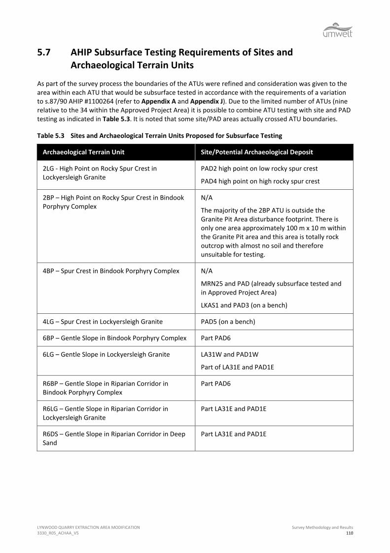
LYNWOOD QUARRY EXTRACTION AREA MODIFICATION 3330_R05_ACHAA_V5
Survey Methodology and Results 110
5.7 AHIP Subsurface Testing Requirements of Sites and Archaeological Terrain Units
As part of the survey process the boundaries of the ATUs were refined and consideration was given to the area within each ATU that would be subsurface tested in accordance with the requirements of a variation to s.87/90 AHIP #1100264 (refer to Appendix A and Appendix J). Due to the limited number of ATUs (nine relative to the 34 within the Approved Project Area) it is possible to combine ATU testing with site and PAD testing as indicated in Table 5.3. It is noted that some site/PAD areas actually crossed ATU boundaries.
Table 5.3 Sites and Archaeological Terrain Units Proposed for Subsurface Testing
Archaeological Terrain Unit Site/Potential Archaeological Deposit
2LG - High Point on Rocky Spur Crest in Lockyersleigh Granite
PAD2 high point on low rocky spur crest
PAD4 high point on high rocky spur crest
2BP – High Point on Rocky Spur Crest in Bindook Porphyry Complex
N/A
The majority of the 2BP ATU is outside the Granite Pit Area disturbance footprint. There is only one area approximately 100 m x 10 m within the Granite Pit area and this area is totally rock outcrop with almost no soil and therefore unsuitable for testing.
4BP – Spur Crest in Bindook Porphyry Complex N/A
MRN25 and PAD (already subsurface tested and in Approved Project Area)
LKAS1 and PAD3 (on a bench)
4LG – Spur Crest in Lockyersleigh Granite PAD5 (on a bench)
6BP – Gentle Slope in Bindook Porphyry Complex Part PAD6
6LG – Gentle Slope in Lockyersleigh Granite LA31W and PAD1W
Part of LA31E and PAD1E
R6BP – Gentle Slope in Riparian Corridor in Bindook Porphyry Complex
Part PAD6
R6LG – Gentle Slope in Riparian Corridor in Lockyersleigh Granite
Part LA31E and PAD1E
R6DS – Gentle Slope in Riparian Corridor in Deep Sand
Part LA31E and PAD1E

LYNWOOD QUARRY EXTRACTION AREA MODIFICATION 3330_R05_ACHAA_V5
Survey Methodology and Results 111
Those sites not listed in Table 5.3 were assessed as unsuitable for subsurface testing due to their location within an area of dense wombat burrows (LKIF1, LKIF3), rabbit burrows (LKAS2), were on tracks where no topsoil was retained (LKIF2, LKAS4), could not be located and were within proximity to an area to be subsurface tested (LA32), or were outside the area to be impacted (LKAS5, LKAS6, LA33). In the case of the scarred trees (LKST1 and LKST2) neither was assessed as in an area likely to retain PAD due to topsoil loss and disturbance.
It is noted that ATU2LG has two PADs listed. In this case the PAD areas whilst being in the same terrain unit are distinctly different. PAD2 is on a low north-south trending rocky spur crest in the south of the Granite Pit Area while PAD4 is on a high east-west trending rocky spur crest in the north of the Granite Pit Area. Similarly there are two site/PAD areas listed for ATU4BP. MRN25 and PAD is within the Approved Project Area and has already been subsurface tested while LKAS1 and PAD3 is in the Granite Pit Area.
During the survey process and at a meeting held at the Lynwood Office Complex on 3 July 2015 the subsurface testing of the sites, PADs and ATUs was discussed with the participating registered Aboriginal parties. Endorsement of the subsurface testing program set out above was provided by all registered Aboriginal party participants.
5.8 Results of the Survey in Terms of the Predictive Model
In Section 4.0 predictions were provided in relation to the site types likely to be located within the Granite Pit Area, the likely site contents and site integrity and also those sites that were unlikely to be located. The predictions presented were based on the known environmental and cultural context of the Granite Pit Area. The purpose of the predictive model was to assist with designing the survey methodology so that it included inspections of all landforms/ATUs predicted to have sites and also those that were predicted not to have sites. This section of the report will test the predictions and refine them where necessary.
5.8.1 Sites Likely to Occur in the Granite Pit Area
For the Granite Pit Area it was predicted that:
• artefact scatters and isolated finds will be the most likely site types – this prediction was verified
• artefact scatters and isolated find sites will occur in most landform contexts, however, they are most likely to be located in association with the tributaries of Lockyersleigh Creek, on benches in proximity to the creeklines and on the spur crests – this prediction was verified though poor visibility on benches and spur crests indicates that sites in those landforms may be under-represented by the results and further verification is required through subsurface testing
• artefact scatters and isolated finds with PAD are most likely to be located in association with the tributaries of Lockyersleigh Creek that carry flow from outside the Granite Pit Area, benches in proximity to the creeklines and on the spur crests (if there is sufficient soil depth) and their associated low gradient slopes leading down to a watercourse that has at least semi-permanent water - this prediction was verified though poor visibility on benches and spur crests indicates that sites in those landforms may be under-represented by the results and further verification is required through subsurface testing
• if a major camp site is located within the Granite Pit Area it is most likely to be located in an area with a reliable source of water and with access to sufficient plant and animal foods to sustain a small group of people for several days – it is assessed that site LA31E and LA31W would fulfil the criteria for a major camp site, however, subsurface testing of the associated PAD1E and PAD1W is required for verification
LYNWOOD QUARRY EXTRACTION AREA MODIFICATION 3330_R05_ACHAA_V5
Survey Methodology and Results 112
• scarred trees are likely if mature trees remain- this prediction was verified
• the scarred trees are most likely to be located on spur crests and on midslopes - this prediction was partially verified with LKSTI located on a spur crest and LKST2 located on an upper slope just below the spur crest.
5.9 Sites Not Likely to Occur in the Granite Pit Area
For the Granite Pit Area it was predicted that:
• grinding grooves used for the sharpening of axes, hatchets, chisels and/or fire hardened spear points will not occur due to the lack of sandstone geology - this prediction was verified, however, a portable granite grindstone was located in LKAS6
• rockshelters with PAD or art are unlikely due to the nature of the geology - this prediction was verified
• stone arrangements and burials are extremely rare site types and are unlikely to be located - this prediction was verified
• grinding bowls are also extremely rare site types in the geology and are unlikely to be located - this prediction was verified, however, a portable granite grindstone was located in LKAS6
• carved trees associated with ceremony and burials are rare site types and unlikely to be located - this prediction was verified
• quarries for the extraction of stone for stone implement manufacture are unlikely due to the poor knapping quality of the local raw materials - this prediction was verified, however, it was noted that both quartz pebbles and fragmented reef quartz was exposed by erosion and tree throw across the area of the Lockyersleigh Granite and that this was occasionally being used for knapping.
5.10 Site Contents
For the Granite Pit Area it was predicted that:
• flakes, broken flakes and flaked pieces will be the dominant artefact types located within sites/PADs with smaller numbers of retouched flakes and cores. Implement types such as stone axes and hammerstones are unlikely – this prediction was partially verified. There were far more cores (all quartz) recorded than expected, however, it is likely that this result has been biased by the poor ground surface visibility which makes, cores , and quartz cores particularly easier to see than other artefacts such as flakes, broken flakes and flaked pieces. There were no axes or hammerstone recorded and there was also one portable grindstone located in site LKAS6
• quartz and silcrete will be the dominant raw materials used for artefact manufacture with other raw materials such as quartzite, chert, dolerite, hornfels, volcanic, petrified wood, chalcedony, ignimbrite, granite and aplite forming a minor proportion of any assemblages - – this prediction was partially verified in that quartz and silcrete were dominant and dolerite, chert and granite artefacts were recorded in small numbers. However, hornfels, volcanic, petrified wood, chalcedony, ignimbrite and aplite artefacts were not recorded in the surface assemblages

LYNWOOD QUARRY EXTRACTION AREA MODIFICATION 3330_R05_ACHAA_V5
Survey Methodology and Results 113
• the source of the majority of the raw materials is likely to be at a distance from the Granite Pit Area with the exception of dolerite, aplite, ignimbrite and granite which would be available either within the Granite Pit Area (ignimbrite, aplite and granite) or in areas adjacent to the Granite Pit Area (dolerite). If the local raw materials (aplite, granite, ignimbrite) are found as outcrops in the Granite Pit Area it is unlikely that they will have been quarried intensively and that any local material used would have just been picked up from the surface, flaked and used expediently – this prediction was partially verified in that there was no evidence of quarrying of the granite or the ignimbrite (Bindook Porphyry Complex) outcrops in the Granite Pit Area. A small granite cobble had been used as a grindstone and quartz pebbles and reef quartz was noted exposed on the surface and appeared to have been used expediently within the Granite Pit Area.
5.11 Soil Profile Integrity
It was predicted that due to 187 years of agricultural practices and erosion and downslope movement of the sandy soils that the majority of sites and areas of PAD (if any) located within the Granite Pit Area would be unlikely to have soil profiles that retained stratigraphic integrity. Though some spatial integrity was suggested as possible in sites/PADs with relatively deep A1/A2 soil horizons.
This prediction has been partially verified in that there were no landforms/sites/PADs identified that would be likely to retain stratigraphic integrity due to European land-use practices and natural geomorphic processes. A total of six areas of PAD were identified where it was assessed that there may be the possibility of some spatial integrity at depth, however, this will require subsurface testing for verification. It is also noted that there were no landforms observed that are likely to retain an intact A1 soil profile. Where the soil profile was exposed there was a very recent organic soil horizon over an A2 soil profile which varied in its level of intactness.

LYNWOOD QUARRY EXTRACTION AREA MODIFICATION 3330_R05_ACHAA_V5
Significance Assessment 114
6.0 Significance Assessment Cultural heritage significance is a measure of the relative value or importance of heritage sites. Significance is assessed according to principles outlined originally in Australia in the Burra Charter (1979), which was adapted from the UNESCO sponsored ICOMOS (International Council for Monuments and Sites) Venice Charter. The assessment of significance assists in the determination of appropriate cultural heritage management procedures for Aboriginal archaeological sites/artefacts that may be threatened by development activities. Assessing the significance of Aboriginal archaeological sites is an extremely complicated process that must take into account the interests of many parties.
The Burra Charter defines cultural significance as the ‘aesthetic, historic, scientific or social value for past, present or future generations’ of a place. In NSW Aboriginal cultural heritage is typically assessed according to its social and scientific significance. There are a number of relevant criteria to be considered when assessing significance and these are defined below.
6.1 Aboriginal Cultural Significance
In assessing Aboriginal heritage, social significance is primarily equated with the significance placed on cultural (and sometimes natural) heritage by Aboriginal people and is often referred to as Aboriginal cultural significance. Aboriginal people value their heritage for a range of reasons, some of which are unique and some of which may be shared with non-Aboriginal people. Thus, Aboriginal people may consider a site containing archaeological material important for reasons related to its archaeological value but may also see the site as a tangible aspect of their culture that provides a direct link to Aboriginal people in the past. In contrast, sites, places or landscapes may be of significance to Aboriginal people for reasons not linked to the presence of tangible archaeological materials such as the presence of places of spiritual importance, significant resources, important natural features and associations with other sites.
As Aboriginal cultural significance relates to the values of a site, place or landscape to Aboriginal people, it must be determined by Aboriginal people. Initial discussions related to Aboriginal cultural significance were undertaken with the registered Aboriginal parties before and during the survey period and this information was recorded and was provided the registered Aboriginal parties for review in the draft copy of this report.
The draft report was provided to all the registered Aboriginal parties on 3 September 2015. At that time it was requested that a response be provided regarding:
• whether any of the Aboriginal artefacts/sites located during the survey were of particular Aboriginal cultural value (understanding that all artefacts and sites have Aboriginal cultural value)
• whether there were places of cultural value to Aboriginal people known before the survey or recognised during the survey and what these were
• the overall Aboriginal cultural heritage significance of the Granite Pit Area
• requested information in relation to appropriate management recommendations for cultural heritage within the Granite Pit Area.
Comments received from the registered Aboriginal parties in relation to Aboriginal cultural significance during the survey are summarised below.
LYNWOOD QUARRY EXTRACTION AREA MODIFICATION 3330_R05_ACHAA_V5
Significance Assessment 115
Sharon Brown and Dawn Harris from GTCAC commented that the whole of the Granite Pit Area was highly significant to the Gundungurra People and that this significance was related to the tangible evidence of the use of the area by their ancestors (the artefacts and the scarred trees) and also the perceived links between the sites in the Granite Pit Area and the MRN9 Stone Arrangement (ceremonial) site within the Approved Project Area. Sharon Brown commented that each of the remaining sites had increasing significance due to the cumulative impacts to sites in the area by development. While all of the sites were assessed as having high Aboriginal cultural significance by the GTCAC it was noted that the two scarred trees (LKST1 and LKST2) and the LA31E/PAD1E and LA31W/PAD1W combined site area and the LKAS1/PAD3 area had very high Aboriginal cultural significance.
It was further noted by Sharon Brown and Dawn Harris that the Granite Pit Area was highly significant to the GTCAC as part of Gundungurra Country and that as Gundungurra People they had an inherited obligation for care for Country.
The representatives of GAHAI, PLALC and PFC also noted that all of the sites/PADs located were of high Aboriginal cultural heritage significance. The LA31E/PAD1E and LA31W/PAD1W combined site area and LKAS1/PAD3 were assessed as being of very high significance as were LKST1 and LKST2.
Table 6.1 Aboriginal Cultural Significance
Registered Aboriginal Party Date Received Response
GAHAI 2/10/2015 GAHAI report that the whole of the proposed Lynwood Quarry Modification Extraction Area is of high significance and confirmed that they agreed with the Aboriginal cultural significance assessment in the draft report.
GTCAC 14/8/2015 GAHAI report that the whole of the proposed Lynwood Quarry Modification Extraction Area is of high significance and confirmed that they agreed with the Aboriginal cultural significance assessment in the draft report.
PFC 23/9/2015 Supported the Aboriginal cultural significance assessment in the draft report.
PLALC 22/10/2015 PLALC report that the area proposed for the Granite Pit contains many important sites and that the report was accurate in presenting the Aboriginal cultural significance as discussed during the survey.

LYNWOOD QUARRY EXTRACTION AREA MODIFICATION 3330_R05_ACHAA_V5
Significance Assessment 116
6.2 Archaeological Significance
The Burra Charter defines the archaeological significance of an Aboriginal site, object or place according to its potential to address research questions and provide greater insight into Aboriginal society and chronological changes in how Aboriginal people utilised the landscape and its resources (Australian ICOMOS Incorporated 2000:12). The major concepts underlying archaeological significance relate to the rarity and representativeness of a site, its integrity, intactness, identifiable connectedness to other sites and overall research potential. Each of these concepts is relatively self-explanatory; however the concept of representativeness warrants further discussion. Representativeness is closely linked with rarity and relates to the degree to which a site encapsulates the typical aspects of sites of its type at a local, regional and, in some cases, national level. In simple terms, representative value should be considered in terms of whether a site embodies the essential characteristics of sites of that type in the locality and region and whether sites of that type remain extant in a context that would allow for their continued conservation. The criteria for the assessment of archaeological significance are provided below.
6.2.1 Archaeological Significance Assessment Criteria
The criteria applied to the assessment of archaeological significance within this report are listed in Table 6.2. It is noted that these are the same criteria used for assessing archaeological significance for the Approved Project Area. This was assessed as appropriate for comparative purposes.

LYNWOOD QUARRY EXTRACTION AREA MODIFICATION 3330_R05_ACHAA_V5
Significance Assessment 117
Table 6.2 Criteria Used in Evaluating Archaeological Significance
Criterion Low (Score of 1)
Moderate (Score of 2)
High (Score of 3)
Rarity The location of the site within the landscape, its type, integrity, contents and/or potential for subsurface artefacts, are common within the local and regional context.
The location of the site within the landscape, its type, integrity, contents and/or potential for subsurface artefacts, are common within the regional context but not the local context.
The location of the site within the landscape, its type, integrity, contents and/or potential for subsurface artefacts, are rare within the local and regional context.
Representativeness This site, when viewed in relation to its type, contents, integrity and location in the landscape, is common within a local and regional context and sites of similar nature (or in better condition) are already set aside for conservation within the region.
This site, when viewed in relation to its type, contents, integrity and location in the landscape, is uncommon within a local context but common in a regional context and sites of similar nature (or in better condition) are already set aside for conservation within the region.
This site, when viewed in relation to its type, contents, integrity and location in the landscape, is uncommon within a local and regional context and sites of similar nature (or in better condition) are not already set aside for conservation within the locality or region.
Integrity Stratigraphic integrity of the site has clearly been destroyed due to major disturbance/loss of topsoil. The level of disturbance is likely to have removed all spatial and stratigraphic integrity (and thus any ability to supply information related to the chronology of use of the site).
The site appears to have been subject to moderate levels of disturbance, however, there is a moderate possibility that useful spatial information can still be obtained from subsurface investigation of the site, even if it is unlikely that any stratigraphic integrity survives (and thus any ability to supply information related to the chronology of use of the site).
The site appears relatively undisturbed and there is a high possibility that useful spatial information can still be obtained from subsurface investigation of the site, even if it is still unlikely that any useful chronological evidence survives (and thus any ability to supply information related to the chronology of use of the site).
(In cases where both spatial and chronological evidence is likely to survive the site will gain additional significance from high scores for rarity and representativeness if there are no similar sites known outside the disturbance area).

LYNWOOD QUARRY EXTRACTION AREA MODIFICATION 3330_R05_ACHAA_V5
Significance Assessment 118
Criterion Low (Score of 1)
Moderate (Score of 2)
High (Score of 3)
Connectedness There is no evidence to suggest that the site is connected to other sites in the local area or the region through:
• their chronology (rarely known);
• their site type (e.g. connectedness could be argued between an axe quarry, a nearby set of axe grinding grooves and an adjacent site exhibiting evidence of axe reduction);
• by the use of an unusual raw material, knapping technique/reduction strategy;
• similar designs/motifs in the case of art sites and engravings; and/or
• information provided by Aboriginal oral history.
There is some evidence to suggest that the site is connected to other sites in the local area or the region through:
• their chronology (rarely known);
• their site type (e.g. connectedness could be argued between an axe quarry, a nearby set of axe grinding grooves and an adjacent site exhibiting evidence of axe reduction);
• by the use of an unusual raw material, knapping technique/reduction strategy;
• similar designs/motifs in the case of art sites and engravings; and/or
• information provided by Aboriginal oral history.
There is good evidence to support the theory that the site is connected to other sites in the local area or the region through:
• their chronology (rarely known);
• their site type (e.g. connectedness could be argued between an axe quarry, a nearby set of axe grinding grooves and an adjacent site exhibiting evidence of axe reduction);
• by the use of an unusual raw material, knapping technique/reduction strategy;
• similar designs/motifs in the case of art sites and engravings; and/or
• information provided by Aboriginal oral history.

LYNWOOD QUARRY EXTRACTION AREA MODIFICATION 3330_R05_ACHAA_V5
Significance Assessment 119
Criterion Low (Score of 1)
Moderate (Score of 2)
High (Score of 3)
Complexity The site does not exhibit and is not predicted to contain either of the following in a subsurface context:
• a complex assemblage of stone artefacts in terms of artefact types and/or raw materials (including use of local and imported raw materials) and/or knapping techniques/reduction strategies; and/or
• features such as hearths or heat treatment pits, activity areas.
The site exhibits or can be predicted to contain one of the following in a subsurface context:
• a complex assemblage of stone artefacts in terms of artefact types and/or raw materials and/or knapping techniques/reduction strategies and/or use of local and imported raw materials; and/or
• features such as hearths or heat treatment pits, activity areas.
The site exhibits or can be predicted to contain both of the following in a subsurface context:
• a complex assemblage of stone artefacts in terms of artefact types and/or raw materials and/or knapping techniques/reduction strategies and/or use of local and imported raw materials; and
• features such as hearths or heat treatment pits, activity areas.
PAD The site does not have or has only a low potential to contain subsurface archaeological material that has stratigraphic integrity or is of a nature that suggests its subsurface investigation would assist with answering questions of contemporary archaeological interest or that indicate it should be preserved for its future research potential.
The site has a moderate potential to contain subsurface archaeological material that has stratigraphic integrity or is of a nature that its subsurface investigation would assist with answering questions of contemporary archaeological interest or that indicate it should be preserved for its future research potential.
The site has a high potential to contain subsurface archaeological material that has stratigraphic integrity or is of a nature that its subsurface investigation would assist with answering questions of contemporary archaeological interest or that indicate it should be preserved for its future research potential.

LYNWOOD QUARRY EXTRACTION AREA MODIFICATION 3330_R05_ACHAA_V5
Significance Assessment 120
6.2.2 Ranking of Criteria for Evaluating Archaeological Significance
Table 6.3 indicates how the sites within the Granite Pit Area were evaluated in relation to each of the six criteria to assess their overall archaeological research potential. The sites were afforded a numerical value for each significance criterion so that an overall significance assessment could be quantified. The values for each criterion were scored as follows:
• low significance was afforded a score of 1
• moderate significance was afforded a score of 2
• high significance was afforded a score of 3.
Overall significance was scored as follows:
• low significance 12-15
• low to moderate significance 16-19
• moderate significance 20-23
• moderate to high significance 24-27
• high significance 27+.
If a site was assessed to have low local significance (when compared to other sites known locally) for any criterion then this aspect of the site was also deemed to be low at the regional level. If, however, the site was assessed as having moderate or high archaeological significance on a local scale, it was then assessed against other sites known from the literature in the broader region. In most cases this resulted in the site having lower significance on a regional level.
In relation to representativeness, a site was only assessed as having low representativeness value if a similar site or sites were known to be set aside for conservation in the local area. Where similar sites were conserved but only for the life of a nearby project, representativeness value was assessed as moderate. Where no similar sites were known to be conserved the site was given high representatives value (this was also applicable where a site was recommended for conservation but then the project did not proceed).
The PADs (without associated sites) have also been assessed for their potential archaeological significance.
For the purpose of this assessment the archaeological significance of the known sites will be used to inform the archaeological significance of the ATUs associated PADs and for those PADs not related to sites, the assessed potential significance has been presented. In both cases the PADs will require subsurface testing to confirm or refute their assessed archaeological significance.
Site and PAD locations and their assessed archaeological significance are shown on Figure 6.1.


LYNWOOD QUARRY EXTRACTION AREA MODIFICATION 3330_R05_ACHAA_V5
Significance Assessment 122
Table 6.3 Summary of Archaeological Site Significance
Site Rarity Representativeness Integrity Connectedness Complexity PAD Score Significance
Local Regional Local Regional Local Regional Local Regional Local Regional Local Regional
LA31E including PAD1E
New site
2 1 2 1 2 1 3 3 2 2 3 3 25 Moderate to High
LA31W including PAD1W
#51-6-0386
2 1 2 1 2 1 3 3 2 2 3 3 25 Moderate to High
MRN25 and PAD #51-6-0266
2 1 2 1 2 1 3 3 2 2 3 3 25 Moderate to High
LKAS1 and PAD3 New Site
2 1 2 1 2 1 2 1 2 1 3 2 20 Moderate
LKAS2 1 1 1 1 1 1 1 1 1 1 1 1 12 Low
LKAS3 1 1 1 1 1 1 1 1 1 1 1 1 12 Low
LKAS4 1 1 1 1 1 1 1 1 1 1 1 1 12 Low
LKAS5 2 1 1 1 1 1 1 1 1 1 1 1 13 Low
LKAS6 2 1 2 1 1 1 1 1 1 1 1 1 14 Low
LA32 #51-6-0387
1 1 1 1 1 1 1 1 1 1 1 1 12 Low

LYNWOOD QUARRY EXTRACTION AREA MODIFICATION 3330_R05_ACHAA_V5
Significance Assessment 123
Site Rarity Representativeness Integrity Connectedness Complexity PAD Score Significance
Local Regional Local Regional Local Regional Local Regional Local Regional Local Regional
LA33 #51-6-0388
1 1 1 1 1 1 1 1 1 1 1 1 12 Low
LKIF1 New Site
1 1 1 1 1 1 1 1 1 1 1 1 12 Low
LKIF2 New Site
1 1 1 1 1 1 1 1 1 1 1 1 12 Low
LKIF3
New site
1 1 1 1 1 1 1 1 1 1 1 1 12 Low
LKST1 New Site
2 2 2 2 3 3 2 2 1 1 1 1 22 Moderate
LKST2 New Site
2 2 2 2 3 3 2 2 1 1 1 1 22 Moderate
PAD2* 2 1 2 1 2 1 2 1 2 1 3 1 19 Low to Moderate
PAD4* 2 1 2 1 2 1 2 1 2 1 3 2 20 Moderate
PAD5* 2 1 2 1 2 1 2 1 2 1 3 1 19 Low to Moderate
PAD6* 2 1 2 1 2 1 2 1 2 1 3 1 19 Low to Moderate

LYNWOOD QUARRY EXTRACTION AREA MODIFICATION 3330_R05_ACHAA_V5
Significance Assessment 124
6.2.3 Discussion and Justification of Archaeological Significance Assessment
6.2.3.1 High Archaeological Significance
No sites/PADs were assessed as having high archaeological significance. This was related to a number of reasons including the following:
• none of the sites located were assessed as rare site types
• similar sites were being conserved in the Approved Project Area in the CHMZ or for the 30 year life of the quarry
• no sites were identified with the potential for stratigraphic integrity.
6.2.3.2 Moderate to High Archaeological Significance
MRN25 and PAD, LA31W/PAD1W and LA31E/PAD1E were assessed as having moderate to high archaeological significance for the following reasons:
• sites with similar potential for moderate to high numbers of artefacts in a subsurface context are not in long term conservation in the local area
• sites with similar potential for a complex subsurface assemblage are not in long term conservation in the local area
• sites assessed as likely to have some spatial integrity are not in long term conservation in the local area;
• it is assessed that all of these site are highly likely to have been camp sites related to Aboriginal people coming to the area to attend ceremony at the MRN9 stone arrangement site and thus there is a high level of connectedness on a local and regional level
• it is assessed that PAD1W and PAD1E meet the criteria as PADs as set out in Section 5.4.4
• subsurface testing has shown that the MRN25 area meets the criteria as being for PAD as set out in Section 5.4.4.
6.2.3.3 Moderate Archaeological Significance
LKAS1 (including PAD3) was assessed as having moderate archaeological significance for the following reasons:
• sites/PADs in a similar landform context (a bench on a spur crest) are not in long term conservation in the local area
• sites/PADs with similar potential for moderate numbers of artefacts in a subsurface context are not conserved in long term in the local area
• sites/PADs with similar potential for a moderately complex subsurface assemblage are not in long term conservation in the local area
• sites/PADs assessed as likely to have some spatial integrity are not in long term conservation in the local area.

LYNWOOD QUARRY EXTRACTION AREA MODIFICATION 3330_R05_ACHAA_V5
Significance Assessment 125
PAD4 was assessed as having the potential for similar values as LKAS1/PAD3.
LKST1 and LKST2 were also assessed to have moderate archaeological significance for the following reasons:
• scarred trees are becoming rarer, however, five scarred trees are currently in long-term conservation within the CHMZ in the Approved Project Area, thus reducing their significance slightly
• the GTCAC stated connectedness between the scarred trees and the MRN9 Stone Arrangement (ceremonial) site. Both scars face toward the MRN9 site supporting the GTCAC’s opinion with tangible evidence
• the moderate level of integrity of the scars and the trees
• the lack of PAD in their proximity, which reduces their significance slightly from an archaeological perspective.
6.2.3.4 Low to Moderate Archaeological Significance
PAD2, PAD5 and PAD6 were assessed as having the potential for at least low to moderate archaeological significance for the following reasons:
• PADs in similar landform contexts are not in long term conservation in the local area
• the PAD areas are relatively undisturbed in the context of the Granite Pit Area (i.e. no rabbit or wombat warrens, no severe slopewash as they are of negligible gradient)
• the PAD areas retain sufficient A2 soil horizon to retain cultural material and some spatial integrity
• the PAD areas are in landforms predicted to have camp sites.
6.2.3.5 Low Archaeological Significance
LA32, LA33, LKIFI, LKIF2, LKIF3, LKIF4, LKAS2, LKAS3, LKAS4 and LKAS5 were assessed as having low archaeological significance for most or all of the following reasons:
• artefact scatters and isolated finds are the most common site types in the area
• similar site types are conserved locally in the Approved Project Area CHMZ and for the life of the quarry within the Approved Project Area
• the sites do not exhibit complexity and do not have the potential for complex assemblages in a subsurface context
• the site areas are heavily disturbed and do not retain any integrity and were not assessed as having associated PAD
• the sites do not reflect any recognisable connectedness to other known sites.

LYNWOOD QUARRY EXTRACTION AREA MODIFICATION 3330_R05_ACHAA_V5
Impact Assessment 126
7.0 Impact Assessment This section presents information in relation to impact assessment for the sites and PADs in the form required by the DECCW (2010b) Code of Practice for Archaeological Investigation of Aboriginal Objects in New South Wales. This is a requirement that must be met to support the application to OEH for a variation to s.87/90 AHIP #1100264 to include the Granite Pit Area and the sites, PADs and ATUs it contains.
7.1 Impact Details
Table 7.1 supplies information in relation to the Aboriginal cultural and archaeological significance of the sites, PADS (and their associated ATUs) within the Granite Pit Area and discusses the potential impacts if the works proposed as part of the Modification Project are approved. Figure 5.3 shows the location of the sites and PADs relative to the ATUs and Figure 5.4 shows the location of the sites and PADs relative to the Granite Pit Area disturbance footprint.
From the tables and figures it can be observed that:
• almost all of the area of the Lockyersleigh Granite ATUs within the Granite Pit Area will be impacted in a manner that will cause the destruction/partial destruction of any sites or PADs they may contain
• only small areas of the Lockyersleigh Granite ATUs will not be impacted directly by proposed works including small areas of ATUs R6DS, 4LG, 6LG and R6LG that are on the far northern and far western perimeter of the Granite Pit Area
• only two of the known sites (LCKAS5 in R6LG and LCKAS6 in 6LG) can be managed for their conservation within these areas under the current quarry plan
• the small area mapped as Deep Sands (DS) in the Lockyersleigh Granite within the Granite Pit Area will be partially impacted (LA31W/PAD1W area) under the proposed quarry plan
• it is possible that parts of LA31E/PAD1E and LA31W/PAD1W could be conserved on the northern perimeter of the Granite Pit Area, however, this would be difficult to manage due to the proximity to the quarry pit boundary, the bund and due to proposed water management infrastructure in this area
• all of ATU 2LG will be impacted
• almost all of the area of the Bindook Porphyry Complex ATUs are outside of Granite Pit Area disturbance footprint
• only small areas of the Bindook Porphyry Complex ATUs will be impacted directly by proposed works including a tiny area of ATU 2BP (no sites or PADs), small areas of ATUs R6BP and 6BP in the south-east proposed for water management infrastructure which will impact LKAS3 and PAD6; an area of 6BP in the north-west proposed for the quarry and a dam and inundation from the dam, which will impact LKAS1/PAD3; and the haul road which will impact ATU 4BP in the area of MRN25 which is outside the Granite Pit Area
• three of the five isolated finds will be impacted (LKIF2, LKIF3 and LA32).

LYNWOOD QUARRY EXTRACTION AREA MODIFICATION 3330_R05_ACHAA_V5
Impact Assessment 127
Table 7.1 Potential Impacts of the Granite Pit Area Project on Archaeological Sites/PADS
Site/AHIMS # ATU Aboriginal Cultural Significance
Archaeological Significance
Type of Harm Degree of Harm Consequence of Harm
LA31E including PAD1E #51-6-0782
R6LG and 6LG Very High Moderate to High Quarrying, bund and water management
Partial removal of site
Partial destruction of site
LA31W including PAD1W #51-6-0783
R6DS and 6LG Very High Moderate to High Quarrying, bund and water management
Partial removal of site
Partial destruction of site
MRN25 and PAD #51-6-0266
4BP High Moderate to High Construction of haul road and water management
Removal of site Site destruction
LKAS1 and PAD3 #51-6-0784
4BP Very High Moderate Quarrying and dam construction
Removal of site and PAD
Site and PAD destruction
LKAS2 #51-6-0785
6BP High Low Quarrying Removal of site Site destruction
LKAS3 #51-6-0779
R6BP High Low Water management
Removal of site Site destruction
LKAS4 #51-6-0778
R6LG High Low Quarrying Removal of site Site destruction
LKAS5 #51-6-0780
R6LG High Low N/A N/A N/A

LYNWOOD QUARRY EXTRACTION AREA MODIFICATION 3330_R05_ACHAA_V5
Impact Assessment 128
Site/AHIMS # ATU Aboriginal Cultural Significance
Archaeological Significance
Type of Harm Degree of Harm Consequence of Harm
LKAS6 #51-6-0781
6LG High Low N/A N/A N/A
LA32 #51-6-0387
6LG High Low Quarrying and water management
Removal of site Destruction of site
LA33 #51-6-0388
4BP High Low N/A N/A N/A
LKIF1 #51-6-0769
R6BP High Low N/A N/A N/A
LKIF2 #51-6-0770
R6LG High Low Quarrying Removal of site Site destruction
LKIF3 #51-6-0771
6BP High Low Clearance of topsoil ahead of overburden emplacement
Removal of site Site destruction
LKST1 #51-6-0772
2LG Very High Moderate Bund construction
Removal of tree to allow bund construction – death of tree
Site destruction
LKST2 #51-6-0773
2LG Very High Moderate Quarrying and vibration from blasting
Death of tree if vibration causes the tree to fall. Removal of tree by quarrying
Site destruction

LYNWOOD QUARRY EXTRACTION AREA MODIFICATION 3330_R05_ACHAA_V5
Impact Assessment 129
Site/AHIMS # ATU Aboriginal Cultural Significance
Archaeological Significance
Type of Harm Degree of Harm Consequence of Harm
PAD2 #51-6-0774
2LG High Low to Moderate Clearance of topsoil ahead of overburden emplacement
Removal of PAD PAD destruction
PAD4 #51-6-0775
2LG High Moderate Quarrying Removal of PAD PAD destruction
PAD5 #51-6-0776
4LG High Low to Moderate Quarrying and water management
Removal of PAD PAD destruction
PAD6 #51-6-0777
R6BP and 6BP High Low to Moderate Water management
Removal of PAD PAD destruction

LYNWOOD QUARRY EXTRACTION AREA MODIFICATION 3330_R05_ACHAA_V5
Impact Assessment 130
• two of the isolated finds are outside the Granite Pit Area disturbance footprint (LKIF1, LA33) and can be managed for their conservation
• seven of the nine artefact scatters (LKAS1, LKAS2, LKAS3, LKAS4, LA31E, LA31W, MRN25) will be impacted and five of the impacted artefact scatter sites will be totally destroyed (LKAS1, LKAS2, LKAS3, LKAS4, MRN25) under the current quarry plan
• two of the artefact scatters (LKAS5, LKAS6) are outside the Granite Pit Area disturbance footprint and can be managed for their conservation
• one of the scarred trees (LKST1) is within the bund footprint and will be destroyed during bund construction unless it is removed
• one of the scarred trees (LKST2) is within the quarry footprint and will be impacted by blast vibration early in the quarry plan and eventually will be impacted and destroyed by quarrying unless it is removed
• all seven PADs will be impacted (it is noted that areas outside of the disturbance footprint of the Granite Pit Area but within the Granite Pit Area were assessed for PAD but none was identified due to high levels of topsoil loss and/or disturbance except that associated with MRN25 which is counted here)
• all of the sites of moderate to high (LA31E, LA31W and MRN25) and moderate (LKAS1, LKST1 and LKST2) archaeological significance within the Granite Pit Area disturbance footprint including the proposed haul road will be impacted
• all of the sites/PADs of very high Aboriginal cultural significance (LA31E/PAD1E, LA31W/PAD1W, LKAS1/PAD3, LKST1 and LKST2) within the Granite Pit Area will be impacted.
7.2 Summary of Impacts
Overall impact of varying extent is proposed for 60 per cent of the isolated finds, 78 per cent of the artefact scatters and 100 per cent of the scarred trees and 100 per cent of the PADs within the Granite Pit Area (including MRN25 and PAD in the Approved Project area). Impact of varying extent is proposed for 100 per cent of the sites of moderate to high and moderate archaeological significance and of very high Aboriginal significance.
Overall impact of approximately 90 per cent of the Lockyersleigh Granite ATUs and 20 per cent of the Bindook Porphyry Complex ATUs is proposed within the Granite Pit Area.
7.3 Methods Available for Mitigation/Management of Impacts
A number of methods are available to mitigate/manage impacts to the Aboriginal sites, PADs (and their associated ATUs). Available mitigation/management options must be assessed for their appropriateness from an Aboriginal cultural and archaeological perspective, keeping in mind the feasibility of the project being considered for approval. Examples of mitigation options considered by quarries in the past include:
• revision of the quarry plan to avoid impact to sites/PADs and their associated ATUs of moderate to high and high archaeological significance (research potential) and very high Aboriginal cultural significance

LYNWOOD QUARRY EXTRACTION AREA MODIFICATION 3330_R05_ACHAA_V5
Impact Assessment 131
• offsetting the potential for loss of sites/PADs and their associated ATUs through a conservation outcome subject to consultation with the registered Aboriginal stakeholders and assessed as appropriate by DP&E and OEH and from an archaeological perspective and
• appropriate subsurface testing of sites/PADs and their associated ATUs prior to impact and appropriate salvage of sites (e.g. surface collection of artefacts, subsurface salvage of sites/PADs identified though subsurface testing to have sufficient research value to require further investigation) and the analysis of the results to build on the knowledge of the Aboriginal use of the landscape in that area
• removal of the scarred trees and their active management, in consultation with the registered Aboriginal stakeholders, to provide for their ongoing conservation in an area approved by DP&E and OEH from an archaeological perspective
• the staging of subsurface testing of sites and PADs and their subsequent salvage (as required) post approval so that if plans change in relation to the area to be quarried (and subsequently the area required for overburden emplacement), that sites and PADs and their associated ATUs that will no longer be impacted by the development will not have been destroyed through archaeological investigation.
Section 8.0 will assess the most appropriate mitigation/management methods for the sites/PADs and their associated ATUs within the Granite Pit Area taking into account the current management of sites/PADs and their associated ATUs within the Approved Project Area. This is appropriate as the current ACHAA seeks to modify the existing quarry approval and to vary the existing s.87/90 AHIP #1100264 to encompass the Granite Pit Area and thus to manage both areas in compliance with the conditions of s.87/90 AHIP #1100264 and the supporting AHMP (Umwelt 2011a).

LYNWOOD QUARRY EXTRACTION AREA MODIFICATION 3330_R05_ACHAA_V5
Management Options 132
8.0 Management Options
8.1 Conservation
8.1.1 Current Conservation Program – Approved Project Area
An important aspect of the management of Aboriginal archaeological sites and ATUs within the Approved Project Area is the conservation of a representative sample of site types within the various ATUs present in that project area. Table 8.1 sets out those sites and ATUs within the Approved Project Area that:
• will not be impacted by the approved disturbance footprint
• will be impacted/partially impacted by the approved disturbance footprint
• will be managed in-situ for their conservation throughout the 30 year life of the quarry
• will be conserved within a CHMZ (refer to Figure 3.1 and Figure 3.6).
Table 8.1 Lynwood Quarry Approved Project Area - Impact, Conservation and Management Outcomes
ATU ATU Impacted/Partially Impacted
Known Sites Impacted
To be Conserved In-situ
To be Conserved in CHMZ
1DS Partial impact MRN60 (IF) N/A N/A
1BP Partial impact MRN63 (IF) N/A N/A
2BP Partial impact MRN61 (AS) N/A N/A
3DS Partial impact MRN62 (AS) N/A N/A
3BP Partial impact N/A N/A N/A
S3BP Partial impact N/A N/A N/A
4DS Partial impact MRN26(IF) MRN27(AS)
MRN28(AS) MRN48(AS)
N/A N/A

LYNWOOD QUARRY EXTRACTION AREA MODIFICATION 3330_R05_ACHAA_V5
Management Options 133
ATU ATU Impacted/Partially Impacted
Known Sites Impacted
To be Conserved In-situ
To be Conserved in CHMZ
4BP Partial impact MRN35(IF) MRN54(AS)
MRN77 (AS)
Marulan T1 S3 (AS)
Marulan T1 S4 (IF)
Marulan T1 S5 (AS)
Marulan T1 S6 (IF)
Marulan T1 S7 (G)
Marulan T1 S8 (AS)
Marulan T1 S9 (IF)
MRN4 (AS) MRN20 (AS)
MRN23 (ST) MRN24 (IF)
MRN25(AS) MRN34 (AS) MRN50 (AS) MRN74 (ST)
MRN84 (AS)
MRN8 (ST) MRN10 (ST) MRN11 (ST)
MRN22 (AS)
MRN75 (ST)
MRN76 (ST)
4AD Partial impact N/A N/A N/A
4PA Partial impact N/A Marulan T1 S2 (AS) N/A
4SD Total impact MRN64 (AS) N/A N/A
S4DS Not impacted N/A MRN30 (IF) N/A
S4BP Partial impact MRN5/MQ2 (AS) IF1 (IF) IF3 (IF) N/A
5DS Partial impact N/A N/A N/A
5BP Partial impact N/A MRN49 (ST) MRN51 (ST) N/A
6DS Partial impact MRN65 (AS) N/A N/A
6AD Partial impact MRN68 (AS) N/A N/A
6BP Partial impact MRN33(AS) MRN36(AS) MRN37(IF) MRN52(IF)
MRN53(AS) MRN57(AS)
MRN58(AS) MRN59(IF)
MRN80 (AS) MRN81 (IF)
Marulan T1 S1 (IF)
Marulan T5 S1 (IF)
Marulan T5 S2 (IF)
Marulan T6 S1 (IF)
Marulan T6 S2 (IF)
Marulan T6 S3 (IF)
Marulan T6 S4 (IF)
IF2 (IF) MQ1 (AS)
MRN6 (AS) MRN19 (IF)
MRN9 (SA) MRN12 (AS)
MRN21 (IF)
MRN83 (IF)
6PA Partial impact N/A MRN18 (IF) MRN55(AS) N/A

LYNWOOD QUARRY EXTRACTION AREA MODIFICATION 3330_R05_ACHAA_V5
Management Options 134
ATU ATU Impacted/Partially Impacted
Known Sites Impacted
To be Conserved In-situ
To be Conserved in CHMZ
6MG Partial impact MRN73 (AS) N/A N/A
6A Minor impact N/A N/A N/A
7BP Minor impact MRN66(AS) N/A N/A
7PA Minor Impact MRN78(AS) MRN41 (AS) MRN42 (AS)
MRN43 (AS)
N/A
7PAE Not Impacted N/A MRN69 (AS) N/A
7MG Not impacted N/A N/A N/A
7A Minor impact MRN70 (AS) MRN82 (AS) N/A
7AD Total Impact MRN79 (AS) N/A N/A
R6AD Total impact MRN67 (AS) N/A N/A
R7AD Total impact N/A N/A N/A
R7MG Minor impact MRN71 (AS) MRN2 (AS) MRN3 (AS) N/A
R6PA Minor impact N/A MRN16 (IF) MRN17 (AS)
MRN56 (AS)
N/A
R7PA Not impacted N/A MRN39 (AS) MRN40 (AS)
MRN44 (AS)
N/A
R6BP Minor impact MRN7 (AS) MRN15 (AS) MRN13 (AS) MRN14 (AS
R7BP Minor impact MRN72 (AS) MRN38 (IF) MRN1 (AS) MRN45 (AS) MRN46 (AS)
N/A
Total
34 ATUs
100 sites
3 not impacted
7 minor impact
19 partial impact
4 total impact
Total 23
8 Isolated Finds
26 Artefact Scatters
Total 34
19 Isolated Finds
30 Artefact Scatters
1 In-situ Boulder used as Grindstone
4 Scarred Trees
Total 54
2 Isolated Finds
4 Artefact Scatters
1 Stone Arrangement
5 Scarred Trees
Total 12
Key: IF = Isolated Find SA = Stone Arrangement AS = Artefact Scatter ST = Scarred Tree G = In-situ boulder used as grindstone
LYNWOOD QUARRY EXTRACTION AREA MODIFICATION 3330_R05_ACHAA_V5
Management Options 135
From Table 8.1 and Figure 3.6 it can be noted that of the 34 ATUs identified within the Approved Project Area:
• 4 (4SD, R6AD, R7AD, 7AD) will be/have been impacted in total or will have only small areas remaining in association with active quarrying and infrastructure5
• 18 will be/have been partially impacted (i.e. only parts of the ATU will be impacted and/or at least one similar ATU will be conserved outside the disturbance footprint and within the broader Project Area and/or the CHMZ)
• 8 will be/have been subject to only minor impact (i.e. part of an ATU is crossed by a road or is peripheral to an disturbance area and other similar ATUs fall outside the disturbance footprint)
• 4 will not be impacted (S4DS, 7MG, R7PA, R7PAE).
From Table 8.1 and Figure 3.6 it can be noted that of the 100 known sites within the Approved Project Area:
• 34 will be/have been impacted by the currently approved Lynwood Quarry disturbance footprint including works associated with the Country Energy infrastructure related to the Marulan Electricity Supply Upgrade
• 54 sites have been conserved in-situ and will continue to be managed for conservation during the 30 year life of the quarry
• 12 sites have been set aside for their long term conservation within the CHMZ.
8.1.2 Proposed Additional Conservation Measures – Granite Pit Area
8.1.2.1 Archaeological Terrain Units
As indicated in Table 8.1 nearly all of the ATUs within the Bindook Porphyry Complex currently proposed for partial impact within the Granite Pit Area are currently being conserved either in the Approved Project Area CHMZ (4BP, 6BP and R6BP) or for the 30 year life of the quarry within the Approved Project Area (2BP, 4BP, 6BP and R6BP). Holcim Australia proposes to set aside additional areas of each of these ATUs (with the exception of ATU 2BP), plus ATUR7BP (Riparian Corridor in an area of very gentle gradient) and the sites and PADs they contain in an extended CHMZ within the Approved Project Area to offset the additional impacts to these ATUs within the Granite Pit Area (refer to Section 8.1.2.2 for further details).
Table 8.1 also indicates that none of the ATUs associated with the Lockyersleigh Granite (2LG, 4LG, 6LG, R6LG) or in the Deep Sands (R6DS) in the Lockyersleigh Granite are being conserved within the Approved Project Area as the appropriate geology is not present. Thus there is currently no conservation outcome for the ATUs in the Lockyersleigh Granite and Deep Sands in the Lockyersleigh Granite, though it is noted that the Lockyersleigh Granite does extend outside the Granite Pit Area to the north, south and west and into areas that are currently used for agricultural purposes.
5 In relation to the three ATUs that will be totally or almost totally impacted, it should be noted that they only occur as restricted areas within the Approved Project Area and that these ATUs do re-occur outside the Approved Project Area.

LYNWOOD QUARRY EXTRACTION AREA MODIFICATION 3330_R05_ACHAA_V5
Management Options 136
It is further noted that while Saunders (2005) recommended the conservation of two isolated finds, six artefact scatters and one scarred tree within what would be ATU R6LG and 6LG, to date no conservation outcomes appear to have been implemented for these ATUs. Therefore, based on the lack of ATUs currently conserved in the Lockyersleigh Granite and the knowledge that they do currently exist and are not being impacted by development (other than ongoing agricultural processes), and on the inability of Holcim Australia to offset these ATUs, Holcim Australia has committed to:
• the fencing and signage of the sites and PADs within the Lockyersleigh Granite ATUs, monitoring in accordance with a variation to s.87/90 AHIP #1100264 and their active management until 12 months prior to their impact
• the subsurface testing and salvage (as required) of the sites and PADs within the Lockyersleigh Granite ATUs commencing 12 months prior to their proposed impact
• the long term conservation of additional ATUs and additional areas of ATUs within an extended CHMZ within the Approved Project Area as discussed above (refer to Section 8.1.2.2 for details).
8.1.2.2 Aboriginal Sites and PADs
From Table 8.1, it can be seen that two isolated finds, four artefact scatters, a stone arrangement and five scarred trees are currently conserved within the existing Approved Project Area CHMZ and thus have been afforded long term conservation. In addition, 19 isolated finds, 30 artefact scatters, one in-situ grinding bowl and four scarred trees are being managed for their conservation for the 30 year life of the quarry. Thus, a representative sample of the site types located within the Granite Pit Area and proposed for impact are already being conserved in the Approved Project Area, however, in the case of MRN25 and associated PAD and LA31E/PAD1E and LA31W/PAD1W and LKAS3/PAD3, no sites/PADs of similar size, complexity, integrity or research potential are being conserved within the Approved Project Area CHMZ. Therefore, an additional conservation outcome is proposed by Holcim Australia in order to offset the loss of these sites if the quarry plans cannot be modified to conserve them. As the modification of the quarry plan to allow the in-situ conservation of the sites is not seen as feasible due to the difficulty of managing accidental impact over the life of the quarry when they are in such close proximity to the disturbance footprint, an offset for their loss is proposed.
As discussed in Section 3.3.3.13 the results of the analysis of all of the ATUs and sites subsurface tested and salvaged and the artefacts recovered and recorded in-situ within the Approved Project Area found that Aboriginal people had been entering the area from the north-west, west and the south (Umwelt 2013). It was assessed that the main focus of Aboriginal occupation of the Approved Project Area was by Aboriginal people coming to the area to attend ceremony at the MRN9 Stone Arrangement site. A number of main camp sites were identified around the periphery of the Approved Project Area including MRN25 and a large area incorporating a number of smaller sites that were assessed as representing the exposed evidence of an extensive site in association with a section of Joarimin Creek in the central east of the Approved Project Area (currently being managed for their conservation but not conserved long term and within an ecological conservation corridor – the Joarimin Creek Conservation Corridor).
It was predicted by Umwelt (2013) that another major camp site was likely to be located to the north-west in what is now proposed as the Granite Pit Area. It is assessed that the LA31E/PAD1E and LA31W/PAD1W areas are most likely a camp site associated with a clan of the Gundungurra approaching from the north-west to attend ceremony at the MRN9 Stone Arrangement site. It is suggested that while a smaller group continued on to the ceremony the main body of the group remained in this area which supplied reliable water (spring fed creek), prey species and a reliable starchy plant food resource (Typha sp.) from the spring fed ponds in the creek.

LYNWOOD QUARRY EXTRACTION AREA MODIFICATION 3330_R05_ACHAA_V5
Management Options 137
As previously discussed, if the quarry is to proceed it is not assessed as feasible to protect MRN25 or the LA31E/PAD1E and LA31W/PAD1W site and PAD areas. Similarly protection of the LKAS1/PAD3 area would restrict the area available for quarrying and would impact on the currently proposed location of a dam designed to capture the flow of the northern tributary of Lockyersleigh Creek. The movement of this dam downstream is not feasible due to the broadening of the valley. Thus a conservation outcome is proposed by Holcim Australia to partially offset their loss. In addition, the sites/PADs are proposed to be subsurface tested (not applicable to MRN25 as it has already been subsurface tested) and salvaged. The artefacts recovered are proposed to be recorded and analysed and the data interpreted in light of the analysis of the results from the Approved Project Area salvage program to build on the knowledge of the use of this landscape by Aboriginal people. The recovery of this information was acceptable to the registered Aboriginal parties to partially offset the loss of these sites, as long as similar sites could be offset elsewhere. Similarly this outcome was acceptable from an archaeological perspective.
As it is not possible to offset sites/PAD/ATUs within the Granite Pit Area that would act as an offset for impact to MRN25, LA31E/PAD1E, LA31W/PAD1W, LKAS1/PAD3 and the other sites proposed for impact within the Granite Pit Area it was assessed as appropriate to increase the area of the CHMZ in the Approved Project Area to incorporate the sites and PADs within the current Joarimin Creek Conservation Area (an area of approximately 1500 metres by 500 metres – and which incorporates a major camp site complex) and a corridor approximately 250 metres wide either side of the tributary of Joarimin Creek that will join the camp site complex to the CHMZ and incorporate it into the CHMZ. Figure 8.1 shows the area of the proposed offset which it is proposed will be set aside by Holcim Australia as a CHMZ. The incorporation of this area into the CHMZ provides long term conservation of an additional 21 sites including three isolated finds, 17 artefact scatters, one boulder with a grinding bowl and five large areas previously identified as PAD. Overall the expanded CHMZ will incorporate 33 sites including a stone arrangement, five scarred trees, a grinding bowl, five isolated finds, 21 artefact scatters and five extensive areas of PAD.
The CHMZ is kept locked and is a protected area where access is not permitted to Holcim Australia employees without permission. The CHMZ is, however, available for access by the registered Aboriginal parties for visits and for teaching purposes. The CHMZ is also available for access for archaeological research purposes with approval of the registered Aboriginal parties on the Lynwood Aboriginal Heritage Management Committee. The Lynwood Aboriginal Heritage Management Committee includes representatives from GAHAI, GTCAC and PLALC and the committee is actively engaged in all aspects of CHMZ management.
This offset option was discussed with the registered Aboriginal parties participating in the survey on the 29 June 2015 and again on the 3 July 2015. It was agreed by all registered Aboriginal party participants at the July 2015 meeting that this conservation outcome would offset the loss of the isolated find and artefact scatter sites in the Granite Pit Area providing that adequate testing and salvage (as relevant) was still undertaken for the sites to be impacted. Holcim Australia has committed to this outcome.
In addition it is proposed to conserve for the remaining 23 year life of the Modification Project the LKIF1 and LA33 isolated find sites and the LKAS5 and LKAS6 artefact scatter sites. Holcim Australia has committed to this outcome and the sites will be fenced with appropriate signage and added to the annual site monitoring program.
Discussions were held with the registered Aboriginal parties during the survey and at the meeting on 3 July 2015 at the Lynwood Quarry Office Complex in relation to the removal of the scarred sections of LKST1 and LKST2 and their placement at the Holcim Australia site office complex with the MRN74 scarred tree. The participating registered Aboriginal parties endorsed the removal of the scarred section of the trees provided that they were actively conserved and that they were protected from the elements by a roof. The registered Aboriginal parties assessed that this was the best outcome for the ongoing conservation of the scarred sections of the trees.


LYNWOOD QUARRY EXTRACTION AREA MODIFICATION 3330_R05_ACHAA_V5
Management Options 139
In relation to both LKST1 and LKST2, discussion was undertaken on 10 June 2015 with an arborist, who is a scarred tree removal specialist to ascertain the feasibility of the removal of the scarred sections of the trees and their ongoing conservation at the Lynwood Office Complex. Danny Draper (UTM 10 June 2015) assessed that removal of the trees without damaging the scars was feasible.
8.2 Management Options
There are various management options available for the sites, PADS and ATUs within the Granite Pit Area. The options include:
• Site/PAD and associated ATU destruction without further investigation or salvage – this option is not assessed as acceptable in terms of the loss of Aboriginal cultural and archaeological values.
• Surface collection of sites without any further investigation in the form of subsurface testing or subsurface salvage) – this option is only acceptable for those sites assessed as having low archaeological potential as they are highly disturbed and are unlikely to have a subsurface assemblage (if any) of size or complexity that their investigation will add to our knowledge of how Aboriginal people were using the landscape.
• Surface collection and subsurface testing and salvage (as required) of sites/PADS and their associated ATUs – this option is assessed as appropriate for those sites and PADs assessed as having the potential to retain at least some spatial integrity and are likely to have a subsurface assemblage of size or complexity that their investigation will add to our knowledge of how Aboriginal people were using the landscape.
• Conservation of sites/PADS and their associated ATUs – this outcome is currently only feasible for four sites that fall outside the Granite Pit Area disturbance footprint.
• Conservation of all sites/PADs and their associated ATUs assessed as of moderate or moderate to high archaeological significance and research potential – this option is assessed as only feasible if the quarry plans are modified to avoid impact to the sites/PADs and their associated ATUs.
• Conservation of all sites/PADS by fencing, signage and monitoring until a minimum of 12 months prior to their impact and then remove, collect, subsurface test, salvage as required under the variation to s.87/90 AHIP #1100264 – this option is assessed as appropriate for all sites/PADs within the disturbance footprint of the Granite Pit.
8.3 Preferred Management Outcomes
Table 8.2 summarises the preferred management outcomes for the sites and PADs and associated ATUs within the Granite Pit Area. These management outcomes were those assessed by the registered Aboriginal parties, Holcim Australia and Umwelt archaeologists (during the meeting held at the Lynwood Office Complex on 3 July 2015) as being the most appropriate and providing the best outcomes for the conservation of Aboriginal cultural and archaeological values while still allowing for quarry feasibility.
It is reiterated that the site and PAD testing proposed will also act to cover the ATUs within the Granite Pit Area and thus additional ATU subsurface testing is not required.

LYNWOOD QUARRY EXTRACTION AREA MODIFICATION 3330_R05_ACHAA_V5
Management Options 140
Table 8.2 Preferred Management Outcomes
Site ATU Preferred Management Outcomes
LA31E including PAD1E
#51-6-0782
R6LG and 6LG
If the works related to water management and bund construction do not result in early impact to the site/PAD area, fence the site and PAD area until 12 months prior to impact. Monitor the site condition as required under the variation to s.87/90 AHIP #1100264.
Prior to impact subsurface test the site/PAD/ATU area and undertake salvage (if required) following further consultation with OEH and the registered Aboriginal parties and as required by the variation to s.87/90 AHIP #1100264. Analyse artefacts and prepare a report that adds to the information presented in Umwelt 2013.
Offset loss by the long term conservation of site/sites/ATUs of similar Aboriginal cultural and archaeological value.
LA31W including PAD1W
#51-6-0783
R6DS and 6LG
If the works related to water management and bund construction do not result in early impact to the site/PAD area, fence the site and PAD area until 12 months prior to impact. Monitor the site condition as required under the variation to s.87/90 AHIP #1100264.
Prior to impact subsurface test the site/PAD/ATU area and undertake salvage (if required) following further consultation with OEH and the registered Aboriginal parties and as required by the variation to s.87/90 AHIP #1100264. Analyse artefacts and prepare a report that adds to the information presented in Umwelt 2013.
Offset loss by the long term conservation of site/sites/ATUs of similar Aboriginal cultural and archaeological value.
MRN25 and PAD #51-6-0266
4BP This site is already fenced and signed and has been subsurface tested and is subject to annual monitoring under the existing s.87/90 AHIP #1100264. This site will be impacted in the early quarry development program.
Prior to impact undertake salvage of the site/ATU as required by the variation to s.87/90 AHIP #1100264. Analyse artefacts and prepare a report that adds to the information presented in Umwelt 2013.
Offset loss by the long term conservation of site/sites/ATUs of similar Aboriginal cultural and archaeological value.

LYNWOOD QUARRY EXTRACTION AREA MODIFICATION 3330_R05_ACHAA_V5
Management Options 141
Site ATU Preferred Management Outcomes
LKAS1 and PAD3
#51-6-0784
4BP (bench on spur)
If not impacted by early works associated with the quarry and proposed dam fence the site and PAD area until 12 months prior to impact. Monitor the site condition as required under the variation to s.87/90 AHIP #1100264.
Subsurface test the site/PAD/ATU area and undertake salvage (if required) following further consultation with OEH and the registered Aboriginal parties and as required by the variation to s.87/90 AHIP #1100264. Analyse artefacts and prepare a report that adds to the information presented in Umwelt 2013.
Offset loss by the long term conservation of site/sites/ATUs of similar Aboriginal cultural and archaeological value.
LKAS2
#51-6-0785
6BP If not impacted by early works associated with the quarry and fence the site area until 12 months prior to impact. Monitor the site condition as required under the variation to s.87/90 AHIP #1100264.
Surface Collection only. Analyse artefacts and prepare a report that adds to the information presented in Umwelt 2013.
Offset loss by the long term conservation of site/sites/ATUs of similar Aboriginal cultural and archaeological value.
LKAS3
#51-6-0779
R6BP If not impacted by early works associated with the water infrastructure, fence the site area until 12 months prior to impact. Monitor the site condition as required under the variation to s.87/90 AHIP #1100264.
Prior to impact surface collection only. Analyse artefacts and prepare a report that adds to the information presented in Umwelt 2013.
Offset loss by the long term conservation of site/sites/ATUs of similar Aboriginal cultural and archaeological value.
LKAS4
#51-6-0778
R6LG If not impacted by early works associated with the quarry, fence the site area until 12 months prior to impact. Monitor the site condition as required under the variation to s.87/90 AHIP #1100264.
Prior to impact surface collection only. Analyse artefacts and prepare a report that adds to the information presented in Umwelt 2013.
Offset loss by the long term conservation of site/sites/ATUs of similar Aboriginal cultural and archaeological value.
LKAS5
#51-6-0780
R6LG Fence, sign and monitor as required under the variation to s.87/90 AHIP #1100264.
Conserve in-situ.
LYNWOOD QUARRY EXTRACTION AREA MODIFICATION 3330_R05_ACHAA_V5
Management Options 142
Site ATU Preferred Management Outcomes
LKAS6
#51-6-0781
6LG Fence, sign and monitor as required under the variation to s.87/90 AHIP #1100264.
Conserve in-situ.
LA32
#51-6-0387
4LG If the works related to water management do not result in early impact to the site area, fence the site until 12 months prior to impact. Monitor the site condition as required under the variation to s.87/90 AHIP #1100264.
Prior to impact surface collection only. Analyse artefact (if located) and prepare a report that adds to the information presented in Umwelt 2013.
Offset loss by the long term conservation of a site/sites/ATU of similar Aboriginal cultural and archaeological value.
LA33
#51-6-0388
4BP Fence, sign and monitor as required under the variation to s.87/90 AHIP #1100264.
Conserve in-situ.
LKIF1
#51-6-0769
R6BP Fence, sign and monitor as required under the variation to s.87/90 AHIP #1100264.
Conserve in-situ.
LKIF2
#51-6-0770
R6LG If not impacted by early works associated with the quarry, fence the site area until 12 months prior to impact. Monitor the site condition as required under the variation to s.87/90 AHIP #1100264.
Prior to impact surface collection only. Analyse artefact and prepare a report that adds to the information presented in Umwelt 2013.
Offset loss by the long term conservation of site/sites/ATUs of similar Aboriginal cultural and archaeological value.
LKIF3
#51-6-0771
6BP If not impacted by early works associated with the overburden emplacement area, fence the site area until 12 months prior to impact. Monitor the site condition as required under the variation to s.87/90 AHIP #1100264.
Prior to impact surface collection only. Analyse artefact and prepare a report that adds to the information presented in Umwelt 2013.
Offset loss by the long term conservation of site/sites/ATUs of similar Aboriginal cultural and archaeological value.

LYNWOOD QUARRY EXTRACTION AREA MODIFICATION 3330_R05_ACHAA_V5
Management Options 143
Site ATU Preferred Management Outcomes
LKST1
#51-6-0772
4LG If the works related to bund construction do not result in early impact to the site area, fence the site until 12 months prior to impact. Monitor the site condition as required under the variation to s.87/90 AHIP #1100264.
Prior to impact the scarred section of the tree will be removed by an expert arborist using a methodology endorsed by OEH and in consultation with the registered Aboriginal parties and transported to the Lynwood Office Complex and placed with the MRN74 scarred tree in a roofed enclosure where it will be subject to ongoing management for its conservation.
Offset loss by the long term conservation of site/sites of similar Aboriginal cultural and archaeological value.
LKST2
#51-6-0773
4LG If the works related to quarrying do not result in early impact to the site area, fence the site until 12 months prior to impact. Monitor the site condition as required under the variation to s.87/90 AHIP #1100264.
Prior to impact the scarred section of the tree will be removed by an expert arborist using a methodology endorsed by OEH and in consultation with the registered Aboriginal parties and transported to the Lynwood Office Complex and placed with the MRN74 scarred tree in a roofed enclosure where it will be subject to ongoing management for its conservation.
Offset loss by the long term conservation of site/sites of similar Aboriginal cultural and archaeological value.
PAD2
#51-6-0774
2LG If not impacted by early works associated with the overburden emplacement area, fence the PAD area until 12 months prior to impact. Monitor the PAD condition as required under the variation to s.87/90 AHIP #1100264.
Prior to impact subsurface test the PAD/ATU area and undertake salvage (if required) following further consultation with OEH and the registered Aboriginal parties and as required by the variation to s.87/90 AHIP #1100264. Analyse artefacts and prepare a report that adds to the information presented in Umwelt 2013.
Offset loss by the long term conservation of a PAD/ATU of similar Aboriginal cultural and archaeological value.

LYNWOOD QUARRY EXTRACTION AREA MODIFICATION 3330_R05_ACHAA_V5
Management Options 144
Site ATU Preferred Management Outcomes
PAD4
#51-6-0775
2LG If not impacted by early works associated with the quarry, fence the PAD area until 12 months prior to impact. Monitor the PAD condition as required under the variation to s.87/90 AHIP #1100264.
Prior to impact subsurface test the PAD/ATU area and undertake salvage (if required) following further consultation with OEH and the registered Aboriginal parties and as required by the variation to s.87/90 AHIP #1100264. Analyse artefacts and prepare a report that adds to the information presented in Umwelt 2013.
Offset loss by the long term conservation of a PAD/ATU of similar Aboriginal cultural and archaeological value.
PAD5
#51-6-0776
4LG If not impacted by early works associated with the quarry and water management, fence the PAD area until 12 months prior to impact. Monitor the PAD condition as required under the variation to s.87/90 AHIP #1100264.
Prior to impact subsurface test the PAD/ATU area and undertake salvage (if required) following further consultation with OEH and the registered Aboriginal parties and as required by the variation to s.87/90 AHIP #1100264. Analyse artefacts and prepare a report that adds to the information presented in Umwelt 2013.
Offset loss by the long term conservation of a PAD/ATU of similar Aboriginal cultural and archaeological value.
PAD6
#51-6-0777
R6BP and 6BP
If not impacted by early works associated with the water management, fence the PAD area until 12 months prior to impact. Monitor the PAD condition as required under the variation to s.87/90 AHIP #1100264.
Prior to impact subsurface test the PAD/ATU area and undertake salvage (if required) following further consultation with OEH and the registered Aboriginal parties and as required by the variation to s.87/90 AHIP #1100264. Analyse artefacts and prepare a report that adds to the information presented in Umwelt 2013.
Offset loss by the long term conservation of a PAD/ATU of similar Aboriginal cultural and archaeological value.

LYNWOOD QUARRY EXTRACTION AREA MODIFICATION 3330_R05_ACHAA_V5
Management Options 145
8.4 Do the Management Options Proposed Address Intergenerational Equity?
Ecologically sustainable development is defined as:
‘Development that meets the needs of the present without compromising the ability of future generations to meet their own needs’ (EPBC Act 1999 -http://www.austlii.edu.au/au/legis/cth/consol_act/epabca1999588/s3a.html).
Intergenerational equity is defined as:
The present generation should ensure the health, diversity and productivity of the environment is maintained or enhanced for the benefit of future generations (EPBC Act 1999 - http://www.austlii.edu.au/au/legis/cth/consol_act/epabca1999588/s3a.html).
In both cases, the focus is on the long term time scale – generations and longer into the future. The management challenge is to achieve short term objectives (i.e. meet the needs of current generations, meet current production targets, meet current State policy and planning targets), but maintain confidence that similar opportunities, resources and environmental conditions will be available for future generations to manage.
Intergenerational Equity incorporates physical (natural), social and economic aspects of the environment, as filtered through cultural perspectives. In a cultural context and for the Granite Pit Area, Intergenerational Equity therefore requires that Gundungurra cultural assets (be they sites, artefacts, PADS, ATUs, or capacity to maintain cultural identity and attachment to place) will still be present and will maintain integrity in the future.
While landscapes and Aboriginal peoples wants and needs change over time, a continuing theme is that Aboriginal peoples seek to maintain a sense of identity and attachment to places within the landscape that are known/important to them. Cultural concepts of Intergenerational Equity incorporate (but are not restricted to):
• cultural values: past, contemporary and future
• sense of cultural identity (in this case what it means to be a Gundungurra person or an Aboriginal person who associates with Gundungurra Country)
• attachment to the Gundungurra traditional landscape
• the connection of culture and country – the dependence of cultural continuity on a ‘healthy’ natural landscape where biodiversity, watercourse health, land surface integrity etc are maintained or improved
• capacity to use cultural identity as a valid reason to influence approaches to land use, planning and management
• protection of a diverse and accessible suite of physical evidence of cultural connectedness to the landscape, through sites, artefacts and landscape features of cultural value
• ongoing awareness and passing on, within the community, of traditional knowledge (stories, resources, methods, rights, obligations and ceremonies)
• Aboriginal community wellbeing, as indicated by feelings of involvement/engagement, respect, trust and cooperation.

LYNWOOD QUARRY EXTRACTION AREA MODIFICATION 3330_R05_ACHAA_V5
Management Options 146
8.4.1 Does the management approach proposed for the project give effect to these cultural concepts of Intergenerational Equity?
Please note that some revisions may be required to this section following receipt of comments from the broader membership of the registered Aboriginal parties on the draft report.
Cultural values: past, contemporary and future
The assessment process has provided all registered Aboriginal party participants with the opportunity to provide information in relation to the contemporary and past cultural value of the Granite Pit Area and to identify those resources and landscape values that are/have been important to them through the survey and assessment process and from their oral history. Past and contemporary cultural values have been incorporated into the significance assessment and have been used to justify/support the various preferred management options presented in Section 8.2. Cultural values of the future have been addressed (as far as possible) through a variety of management outcomes aimed towards ensuring the conservation of a representative sample of sites/PADs/ATUs into the future. Where this has not been possible without adversely affecting the quarry plan extensive archaeological investigations have been proposed which will ensure that information is provided to the Gundungurra about how their ancestors used the area in the past. The archaeological investigations will provide the Gundungurra, Aboriginal parties with an interest in the area and the broader Australian population with information about the day to day lives and the Aboriginal people that occupied the sites and also with tangible evidence in the form of archaeological material for use for future teaching purposes.
Cultural practice has been viewed in relation to the provision of access to the extended CHMZ for the registered Aboriginal parties in order to continue the use of an area of cultural importance as an important teaching place. In this regard the AHMP for the Approved Project Area (Umwelt 2011a - will be revised to cover the Granite Pit Area) and ongoing site monitoring will support ongoing participation, visitation, management and Aboriginal practice.
Sense of cultural identity (in this case what it means to be a Gundungurra person or an Aboriginal person with association with Gundungurra Country)
Participating registered Aboriginal parties have been encouraged to provide information in relation to their sense of cultural identity and how this may be impacted by damage/destruction of Aboriginal archaeological sites/PADs/ATUs. Information provided has been used to assess site/PAD/ATU significance and to provide management outcomes that will allow Gundungurra descendants to maintain the same sense of cultural identity when they visit the expanded CHMZ within the Approved Project Area and as they participate in the site salvage and/or management process.
Attachment to the Gundungurra traditional landscape
Sharon Brown and Dawn Harris from GTCAC provided a heartfelt assessment of their attachment to the landscape of the Granite Pit Area and the Approved Project Area during the survey and the preparation of this report. This attachment to the landscape was taken into account when preparing the management strategy which aims to ensure that a representative sample of sites/PADs/ATUs is conserved for the contemporary and future Gundungurra Peoples and Aboriginal people that live in Gundungurra Country.

LYNWOOD QUARRY EXTRACTION AREA MODIFICATION 3330_R05_ACHAA_V5
Management Options 147
The connection of culture and country – the dependence of cultural continuity on a ‘healthy’ natural landscape where biodiversity, watercourse health, land surface integrity etc are maintained or improved
During the survey period and throughout the history of consultation for this project the registered Aboriginal parties have spoken of the importance of keeping Country healthy. A great deal was said of the impacts to sites, places and resources that have occurred due to historic and contemporary agricultural practices. It has been found that by implementing the procedures and protocols within the Lynwood Quarry AHMP (Umwelt 2007, 20011a) for the Approved Project Area that revegetation is occurring, erosion is decreasing and that the sites being conserved are in better condition than when part of an active farm landscape. Setting aside a greater area for long term conservation will enable even better management of Aboriginal cultural heritage and archaeological values for contemporary and future generations of Gundungurra Peoples within the Approved Project Area. It is similarly felt that those sites (LKA5, LKAS6, LKIF1, LA33) that will remain in the Granite Pit Area will have better management than is currently the case. This is an opportunity that would not have been available had the land remained part of a working farm.
Capacity to use cultural identity as a valid reason to influence approaches to land use, planning and management
It is proposed that by participation in this assessment process and by having full input into the management outcomes that the registered Aboriginal parties have had the opportunity to influence Holcim Australia’s approach to land use planning and management, so that it is more culturally appropriate. This opportunity will continue to be available through participation in the tasks required by the revised AHMP which will include the enlarged CHMZ and continue the ongoing management of sites in the Granite Pit Area that are outside the disturbance footprint and those within the disturbance footprint until such as time as they are impacted while also continuing to the manage the sites being managed in-situ for their conservation within the broader Approved Project Area.
Protection of a diverse and accessible suite of physical evidence of cultural connectedness to the landscape, through sites, artefacts and landscapes of cultural value
It is proposed that Holcim Australia’s proposed conservation management strategy presented within Sections 8.1 and 8.2 of this report (prepared in consultation with the registered Aboriginal parties) will protect a ‘suite of physical evidence of cultural connectedness to the landscape’ through culturally appropriate management of sites/PADs/ATUs. Holcim Australia will continue to supply access to the extended CHMZ and site monitoring will continue as set out in the AHMP (Umwelt 2007, 2011a). The AHMP will be revised to incorporate all new management requirements arising from the approval of the Granite Pit Area.
Ongoing awareness and passing on, within the community, of traditional knowledge (stories, resources, methods, rights, obligations and ceremonies)
It is proposed that this will be enabled through access for teaching purposes to the sites/PADs/ATUs that are being conserved within the Approved Project Area and within the extended CHMZ and through ongoing involvement of the registered Aboriginal parties in the management of this resource.
Aboriginal community wellbeing, as indicated by feelings of involvement/engagement, respect, trust and cooperation
This is being achieved through the involvement of the registered Aboriginal parties in the management of the cultural sites and values within the Approved Project Area and is proposed to continue for the Granite Pit Area. As an outcome of the working relationship that has already developed between Holcim Australia and the registered Aboriginal parties, greater mutual respect, trust and cooperation have been developed. It is noted that Holcim Australia has already had an open day where registered Aboriginal party

LYNWOOD QUARRY EXTRACTION AREA MODIFICATION 3330_R05_ACHAA_V5
Management Options 148
representatives were involved in providing information to local visitors in relation to the cultural resource of the Marulan area and that this was successful in engaging the broader public in learning Aboriginal cultural heritage and in greater respect for Aboriginal perspectives.
8.4.2 Summary Intergenerational Equity
In summary, it is assessed that the preferred management outcomes proposed in Section 8.2, when added to the existing Approved Project Area conservation strategy as discussed in Section 8.1, meet the requirements of Intergenerational Equity.
8.5 Has Cumulative Impact Been Considered?
Cumulative impact to the Aboriginal cultural heritage and archaeological resource in the general Marulan area is considered within this section of the ACHAA from a number of perspectives including:
• impacts on sites and conservation outcomes related to local development (including the Granite Pit Area and the Approved Project Area)
• ongoing impacts from local agricultural activities outside areas of local development
• ongoing impacts from natural and feral biological agents (wombats and rabbits) and natural geomorphological process.
The Granite Pit Area and the Approved Project Area are located within a landscape that is predominantly used for agricultural purposes with impacts of limited area from urban development, rural residential subdivision, infrastructure and quarrying. In areas of steeper gradient much of the land is held within State Conservation Areas and National Parks. In overall terms the impacts to the landscape from the quarrying activities proposed within the Granite Pit Area will be limited to a small area within a landscape still predominantly used for agricultural purposes.
It is noted that agricultural activities are harmful to, and cause the destruction of, Aboriginal sites and PADs. While not as observably destructive to sites and PADs as the proposed quarrying activities, agricultural activities do not act to conserve sites and PADs or even allow for the location and recording of sites and PADs within privately owned land. Thus not developing agricultural land does not necessarily imply that sites and PADs are being conserved in those areas. It is noted that the only areas where sites are currently being actively conserved in a similar landscape to the Granite Pit Area is in relation to the Lynwood Quarry Approved Project Area and the Peppertree Quarry approximately 7.5 kilometres to the south-east of the Granite Pit Area (refer to Table 2 in Appendix E).
In addition to the impacts on sites and PADs by agricultural processes are the impacts related to biological agents such as wombats and rabbits whose burrowing activities are highly destructive of site and PAD integrity. While landholders may seek to manage these impacts they do so in a way that is destructive of sites and PADs (e.g. ripping) which only adds to the destruction of site and PAD integrity.
Natural geomorphological processes, such as slope wash and creek bank scouring and collapse, act to disturb/destroy sites and PADs. These processes are enhanced by agricultural activities such as land clearance and overstocking.
In light of the discussion above, in the Marulan area the only places where Aboriginal sites and PADs and the landscapes in which they are located are known to be being actively conserved, is in conservation zones in association with the Approved Project Area and the Peppertree Quarry.

LYNWOOD QUARRY EXTRACTION AREA MODIFICATION 3330_R05_ACHAA_V5
Management Options 149
Overall, it is assessed that the development of the Granite Pit Area as a quarry will do little to add to the cumulative impact on Aboriginal sites and PADs in an area predominantly used for agricultural processes which act to destroy/damage sites and PADs. Furthermore, the additional long term conservation of sites and PADs within the Approved Project Area proposed as an offset for impact to sites and PADs and their associated ATUs within the Granite Pit Area, will ensure the ongoing preservation of a representative sample of sites and PADs and their associated ATUs, an outcome not assessed as possible by simply leaving the land for continued use for agricultural purposes.

LYNWOOD QUARRY EXTRACTION AREA MODIFICATION 3330_R05_ACHAA_V5
Management Strategy 150
9.0 Management Strategy It is noted that the following management recommendations may require revision following the receipt of responses from the broader registered Aboriginal party membership following their review of the draft ACHAA.
The following management strategy has been prepared taking into account:
• the outcome of ongoing consultation with the registered Aboriginal parties in relation to the Aboriginal cultural significance of the Granite Pit Area and its environs (refer to Section 2.0, Section 6.1, Section 7.0, Section 8.0 and Appendix B)
• the results of the survey (refer to Section 5.0)
• an assessment of the Aboriginal cultural and archaeological significance of the sites/PADs and associated ATUs proposed for impact by the modification (refer to Section 6.0)
• an evaluation of the impacts of the works proposed within the Granite Pit Area (refer to Section 7.0)
• an understanding of the current Lynwood Quarry Project Area Aboriginal cultural heritage and archaeological conservation strategy and how this could be revised/extended to offset impacts to sites/PADs and their associated ATUs within the Granite Pit Area (refer to Section 8.1)
• an evaluation of available management/mitigation options from an Aboriginal cultural and archaeological perspective and the assessment of the preferred management outcomes (refer to Sections 8.2 and 8.3)
• consideration of Intergenerational Equity and cumulative impact (refer to Sections 8.4 and 8.5).
9.1 General Recommendations
The following general recommendations will be implemented by Holcim Australia as part of the Modification Project. These general recommendations have been endorsed by all four registered Aboriginal parties.
1. Holcim Australia to apply to the OEH for a variation to existing s.87/90 AHIP #1100264 to include the subsurface testing and salvage (as required) of the known sites and PADs, and subsequent impact to the known sites and PADs by works within the Granite Pit Area disturbance footprint.
2. Holcim Australia to apply for a variation to Care Permit #2761 (related to s.87/90 AHIP #1100264 and approved by OEH on 20 May 2009) to allow ongoing Care of any artefactual material recovered from the Granite Pit Area (refer to Section 9.3 for details).
3. Holcim Australia to provide for all subsurface testing, salvage, artefact analysis and reporting to be undertaken in accordance with the Research Design and Methodology previously endorsed by the registered Aboriginal parties and OEH and in compliance with the variation to s.87/90 AHIP #1100264 (refer to Section 9.4 and Appendix J for details).
4. Holcim Australia to set aside the extended CHMZ within the Approved Project Area as shown on Figure 8.1.

LYNWOOD QUARRY EXTRACTION AREA MODIFICATION 3330_R05_ACHAA_V5
Management Strategy 151
5. Holcim Australia to stage the subsurface testing and salvage program and scarred tree removal program for the Granite Pit Area so that these management measures are not implemented until 12 months prior to any proposed impact.
6. Holcim Australia to revise the existing AHMP (Umwelt 2011a) to include all the relevant management outcomes for known sites and PADs within the Granite Pit Area and to update the management outcomes for the known sites and PADs within the extended CHMZ in compliance with the variation to s.87/90 AHIP #1100264 (refer to Section 9.4).
7. Holcim Australia to make all relevant personnel and contractors aware of the requirements of s.87/90 AHIP #1100264 and the revised AHMP.
8. All Holcim Australia personnel and contractors working in the Granite Pit Area will undertake the Holcim Australia Aboriginal Cultural Heritage Awareness Training package that forms part of the Holcim Australia induction procedure.
9. All Holcim Australia personnel and contractors working in the Granite Pit Area will be made aware of the requirement to retain all works inside the approved and fenced disturbance boundary.
10. In compliance with the revised AHMP and s.87/90 AHIP #1100264, in the event that previously unknown artefactual material is uncovered during quarry development/quarry operations, ground disturbance works should cease and OEH and the registered Aboriginal parties should be contacted so that appropriate management strategies can be identified. Work may recommence at a distance approved by OEH and in consultation with the registered Aboriginal parties.
11. In the event that any skeletal material of possible human origin is uncovered during the proposed works, ground disturbance works should cease to allow management in accordance with the Skeletal Remains – Guidelines for the Management of Human Skeletal Remains under the Heritage Act 1977 (NSW Heritage Office 1998) and the NPW Act (1974). This would first involve notification of local police and, for potential Aboriginal remains, the OEH Enviro Line and registered Aboriginal parties; followed by an inspection by a physical or forensic anthropologist/archaeologist to determine the ancestry and antiquity of the remains, on which basis appropriate management strategies will be identified. Work may recommence at a distance approved by the OEH and in consultation with the registered Aboriginal parties
9.2 Specific Recommendations
The management strategy includes specific recommendations relating to each of the sites, PADs and associated ATUs within the Granite Pit Area. These specific recommendations have been endorsed by all four registered Aboriginal parties.
Figure 9.1 indicates the locations of Aboriginal sites and areas identified as PADs, which have been colour coded to indicate the proposed management recommendations. Table 9.1 provides the specific management recommendations and lists these relevant to the sites/PADs.


LYNWOOD QUARRY EXTRACTION AREA MODIFICATION 3330_R05_ACHAA_V5
Management Strategy 153
Table 9.1 Specific Management Recommendations
Management Recommendation Sites/PADs/ATUs
Fence the site and PAD area until 12 months prior to impact. Monitor the site condition as required under the variation to s.87/90 AHIP #1100264.
Prior to impact subsurface test the site/PAD/ATU area and undertake salvage (if required) following further consultation with OEH and the registered Aboriginal parties and as required by the variation to s.87/90 AHIP #1100264. Analyse artefacts and prepare a report that adds to the information presented in Umwelt 2013.
Offset loss by the long term conservation of site/sites/ATU of similar Aboriginal cultural and archaeological value.
#51-6-0782 LA31E including PAD1E
(ATU R6LG and 6LG)
#51-6-0783 LA31W including PAD1W
(ATU R6DS and ATU 6LG)
#51-6-0784 LKAS1 and PAD3 (ATU 4BP)
Prior to impact undertake salvage of the site/ATU as required by the variation to s.87/90 AHIP #1100264. Analyse artefacts and prepare a report that adds to the information presented in Umwelt 2013.
Offset loss by the long term conservation of site/sites/ATUs of similar Aboriginal cultural and archaeological value.
#51-6-0299 MRN25 and PAD (ATU 4BP)
Fence the site area until 12 months prior to impact. Monitor the site condition as required under the variation to s.87/90 AHIP #1100264.
Surface Collection only. Analyse artefacts and prepare a report that adds to the information presented in Umwelt 2013.
Offset loss by the long term conservation of site/sites/ATUs of similar Aboriginal cultural and archaeological value.
#51-6-0769 LKIF2 (ATU R6LG)
#51-6-0771 LKIF3 (ATU 6BP)
#51-6-0785 LKAS2 (ATU 6BP)
#51-6-0779 LKAS3 (ATU R6BP)
#51-6-0778 LKAS4 (ATU R6LG)
#51-6-0387 LA32 (ATU4LG)
Fence, sign and monitor as required under the variation to s.87/90 AHIP #1100264.
Conserve in-situ.
#51-6-0769 LKIF1 (ATU R6BP)
#51-6-0780 LKAS5 (ATU R6LG)
#51-6-0781 LKAS6 (ATU 6LG)
#51-6-0388 LA33 (ATU 4BP)

LYNWOOD QUARRY EXTRACTION AREA MODIFICATION 3330_R05_ACHAA_V5
Management Strategy 154
Management Recommendation Sites/PADs/ATUs
Fence the site until 12 months prior to impact. Monitor the site condition as required under the variation to s.87/90 AHIP #1100264.
Prior to impact the scarred section of the tree will be removed by an expert arborist using a methodology endorsed by OEH and developed in consultation with the registered Aboriginal parties and Holcim Australia and transported to the Lynwood Office Complex and placed with the MRN74 scarred tree in a roofed enclosure where it will be subject to ongoing management for its conservation.
Offset loss by the long term conservation of site/sites of similar Aboriginal cultural and archaeological value.
#51-6-0772 LKST1 (ATU 4LG)
#51-6-0773 LKST2 (ATU 4LG)
Fence the PAD area until 12 months prior to impact. Monitor the PAD condition as required under the variation to s.87/90 AHIP #1100264.
Prior to impact subsurface test the PAD/ATU area and undertake salvage (if required) following further consultation with OEH and the registered Aboriginal parties and as required by the variation to s.87/90 AHIP #1100264. Analyse artefacts and prepare a report that adds to the information presented in Umwelt 2013.
Offset loss by the long term conservation of a PAD/ATU of similar Aboriginal cultural and archaeological value.
#51-6-0774 PAD2
(ATU 2LG – low spur)
#51-6-0775 PAD4
(ATU 2LG - high spur)
#51-6-0776 PAD5
(ATU 4LG)
#51-6-0777 PAD6
(ATU R6BP and 6BP)
9.3 Care and Control
It is proposed that the care and control of all ‘Aboriginal objects’ (stone artefacts) recovered from the Granite Pit Area disturbance footprint will be undertaken in compliance with a variation to existing ‘Care’ Permit #2761 (related to s.87/90 AHIP #1100264 approved 20 May 2009). In line with the existing Care Permit until such time as the final artefact analysis and reporting are completed the artefacts recovered as part of the Granite Pit Area investigation will be temporarily stored in a secure location by the archaeologists undertaking the artefact analysis as per Schedule D of s.87/90 AHIP #1100264.
Following completion of all artefact analyses and reporting and in compliance with the existing Care Permit the artefacts will be returned to the Lynwood Office Complex within the Approved Project Area for ongoing safekeeping within a secure environment. Some artefactual material may be placed on display in a securely locked cabinet in consultation with the registered Aboriginal parties.
LYNWOOD QUARRY EXTRACTION AREA MODIFICATION 3330_R05_ACHAA_V5
Management Strategy 155
9.4 Revisions to the Aboriginal Heritage Management Plan
The current Lynwood Quarry AHMP (Umwelt 2011a) will require revision following Holcim Australia obtaining approval for the Modification Project. The current AHMP is based on the conditions of s.87/90 AHIP #1100264 and has been approved by DP&E and OEH. The revisions will include adding the Granite Pit Area and the management recommendations specific to that area. The AHMP incorporates the following management protocols and procedures:
• the requirement for a Management Committee incorporating representatives from the registered Aboriginal parties
• the requirement from Aboriginal Cultural Heritage Training for all Holcim Australia personnel and contractors
• subsurface testing and salvage requirements
• care of artefactual material
• fencing and signage for sites, PADs and the CHMZ
• removal of stock
• bushfire hazard reduction management
• feral animal and noxious weed control
• access for Aboriginal people for teaching purposes
• site/PAD monitoring
• management of previously unknown site/objects and skeletal material
• annual environmental management reporting
• regular AHMP review.
Following approval of the modification of the above requirements will be applicable to the Granite Pit Area.
9.5 Research Design and Methodology and Reporting
As discussed in Section 3.3.3.13, all subsurface testing, salvage and artefact analysis has been undertaken throughout the life of the Approved Project Area using a consistent Research Design and Methodology (Umwelt 2007c, 2008d, 2008f, 2009a) and reporting process (Umwelt 2008a, 2008e, 2009b 2013). It is proposed that all post approval archaeological investigations for the Granite Pit Area will be undertaken using the same research design and methodology with the aim of obtaining comparable results that can be used to continue to refine interpretations of Aboriginal use of the Marulan landscape and to continue to refine answers to the research questions set by the registered Aboriginal parties and endorsed by OEH. Details of the Research Design and Methodology and reporting process are included in Appendix J.
In compliance with s.87/90 AHIP #1100264, following each subsurface testing program component (which may relate to one or several sites/PADs), Holcim Australia, in consultation with the registered Aboriginal parties, will have a suitably qualified archaeologist prepare a report on the outcomes of the subsurface

LYNWOOD QUARRY EXTRACTION AREA MODIFICATION 3330_R05_ACHAA_V5
Management Strategy 156
testing. In addition to reporting on the outcomes of the subsurface testing this report will set out the requirements for further subsurface salvage (as required). This report will be provided to OEH and no further salvage and/or site/PAD impact by works will be undertaken until OEH has approved the salvage methodology and/or impact by works without further salvage.
Reports will also be provided to OEH following the surface collection of sites and the removal of the LKST1 and LKST2 scarred trees.
Aboriginal Site Impact Recording forms will be provided to OEH following site collection, scarred tree removal and following subsurface testing and salvage of sites/PADs.
At the conclusion of the archaeological investigations across the whole of the Granite Pit Area, Holcim Australia will provide the funding for a report that will analyse the results of the surface collections, subsurface testing and salvage program and which will build on the information gained from the archaeological investigations within the Approved Project Area and from other archaeological investigations in the Marulan area that have been completed and reported at that time.

LYNWOOD QUARRY EXTRACTION AREA MODIFICATION 3330_R05_ACHAA_V5
References 157
10.0 References About Lockyersleigh http://www.lockyersleigh.com.au/lockyersleigh_content.html accessed 30 October 2014
Australia ICOMOS. 1999. The Burra Charter: The Australia ICOMOS Charter for Places of Cultural Significance.
Baylie W. H. 1843. On the Aborigines of the Goulburn District: Their Superstitions, Manners and Habits. AIATSIS PBAY 9466. pp. 86-92.
Boot, P.G. 2002. Didthul, Bhundoo, Gulaga and Wadbilliga: An Archaeological Study of the Aboriginals of the New South Wales South Coast Hinterland. PhD Thesis. ANU. December 2002.
Collins, D. 1798-1802. An account of the English colony of New South Wales: with remarks on the dispositions, customs, manners etc. of the native inhabitants of that country. 2 Volumes. Cadell and Davies, London.
Darling, R. A. 1826. Governor Darling to Earl Bathurst Despatch No 34 per Ship Toward Castle Government House, 23 May 1826.
Dearling C. 1997. Cultural Heritage Survey: Proposed Mushroom Substrate Production Facility, Marulan, NSW. A report to Perram and Partners Pty. Ltd.
Department of Environment and Conservation. 2004. Interim Community Consultation Requirements for Applicants. Released December 2004.
Eades, D. 1976. The Dharawal and Dhurga Languages of the New South Wales South Coast. A.I.A.S. Canberra.
Eddie, M. 1985. Marulan: A Unique Heritage. Canberra Printing and Publishing Company.
Environment Protection and Biodiversity Conservation Act 1999 – Sect 3A. Accessed November 2014.
http://www.austlii.edu.au/au/legis/cth/consol_act/epabca1999588/s3a.html
ERM, 2004. Lots 1 and 3 Simpson and Wilson Drive, Marulan- Heritage Study. A report for Tailored Properties. April 2004.
ERM, 2006, Aboriginal Cultural Heritage Assessment Marulan South Continuation of Operations. A report to Blue Circle Southern Cement. April 2006.
Flood, J. 1980. The Moth Hunters: Aboriginal Prehistory of the Australian Alps. AIATSIS, Canberra.
Gott, B. 1983. Murnong – Microseris scapigera. A study of staple foods of Victorian Aborigines. Australian Aboriginal Studies 1983. pp. 2-17.
Holdaway, S. and Stern, N. 2004. A Record in Stone: The Study of Australia’s Flaked Stone Artefacts. Museum Victoria.
http://www.lockyersleigh.com.au/lockyersleigh_content.html

LYNWOOD QUARRY EXTRACTION AREA MODIFICATION 3330_R05_ACHAA_V5
References 158
http://www.austlii.edu.au/au/legis/cth/consol_act/epabca1999588/s3a.html
Kearnes, W. 1822. Journal of a tour to the coast about nine miles to the southward of Batemans Bay, 1822. In papers of Charles Throsby 1822-24. ms. (A1941) Mitchell Library, Sydney.
Koettig, M. 1981. Hoddles Crossing to Alpine. A report to the Dept. of Main Roads.
Lance, A, and Koettig, M 1986. An Aboriginal Resources Planning Study for the City of Goulburn, New South Wales. A report to Goulburn City Council. January 1986.
Low, T 1989. Bush Tucker: Australia’s Wild Food Harvest. Angus and Robertson, Sydney.
MacAlister, C. 1907. Old Pioneering Days in the Sunny South. Goulburn.
McDonald, R. C., Isbell, R. F., Speight, J. G, Walker, J. and Hopkins, M. S. 1990. Australian Soil and Land Survey Field Handbook. Inkata Press. Sydney.
McIntyre S, 1993, Archaeological Investigation of Sensitive Areas Along the Marulan to Goulburn 132kV Transmission Line. A report prepared for Pacific Power Services.
Meehan, J. 1818. Journal describing an expedition from Sydney to Jarvis Bay (Fiche 3276; SZ1046 pp.1-77)
Navin, K. 1990 Archaeological Survey of a Proposed Hard Rock Quarry Site near Marulan, NSW. Report to Quarry Technology Pty Ltd.
Navin Officer Heritage Consultants (Officer K), 1997. Cultural Heritage Survey: Proposed Mushroom Substrate Production Facility, Marulan, NSW: Supplementary Report, Archaeological Interpretation of Mushroom Ring Features. A report to T.W. Perram and Partners Pty Ltd. December 1997.
New South Wales Calendar and General Post Office Directory. 1832 (Sydney 1832). p. 99.
Packard, P. 1986. Archaeological Sites in Sand Deposits on the Southern Tablelands. A report to NPWS of NSW. April 1986.
Paton, R. 1990. Archaeological excavations at Site G17, Goulburn, NSW. Report to RTA.
Rich, E. 1988. Wingecarribee River Proposed Management Project: Archaeological Survey for Aboriginal and Historic Sites. Report to the NSW Water Board.
Saunders, P. 2005. Aboriginal Archaeological Assessment Proposed Rural Subdivision 'Lockyersleigh' Lots 24, 25, 41, 42 and 43 Parish of Billyrambijia, NSW. Report prepared for R.J. Kell and Co. August 2005.
Sefton, C. 1995 Archaeological Survey of the Marulan Water Supply Augmentation. Report to Department of Public Works, South Coast Region.
Smith, J. 1992. Aborigines of the Goulburn District. Goulburn and District Historical Society.
Stewart, K and Percival, B 1997. Bush Foods of New South Wales. A Botanic Record and an Aboriginal Oral History. Royal Botanic Gardens. Sydney.
Throsby, C. 1818. Account of 1818 Journey to Kangaroo Valley and Jervis Bay. Field Book. Mitchell Library, Sydney.
LYNWOOD QUARRY EXTRACTION AREA MODIFICATION 3330_R05_ACHAA_V5
References 159
Throsby-Smith, C. 1820. Extract from a journal kept by C. Throsby-Smith. December 1820. Throsby Papers, Mitchell Library, Sydney.
Tindale, N. B. 1974. Aboriginal tribes of Australia: Their Terrain, Environmental Controls, Distribution Limits and Proper Names. Australian National University Press, Canberra.
Urban Tree Management Australia (Pty Ltd) 2015. Arboriculture Assessment of Scarred trees at Lynwood, Hume Highway, Marulan NSW. Unpublished report prepared for Umwelt Pty Ltd.
Umwelt (Australia) Pty Limited. 2005. Environmental Impact Statement – Proposed Lynwood Quarry, Marulan. Appendix 11, Aboriginal Archaeology Assessment. A report prepared for Readymix Holdings Pty Ltd. May 2005.
Umwelt (Australia) Pty Limited. 2007a. Review of Environmental Factors for Proposed Electrical Transmission Lines, Marulan, NSW. A report prepared for Country Energy. February 2007.
Umwelt (Australia) Pty Limited. 2007b. Aboriginal Archaeological Assessment of Transmission Line Easements and a Proposed Substation Location near, Marulan, NSW. Appendix F. Review of Environmental Factors for Proposed Electrical Transmission Lines, Marulan, NSW. A report prepared for Country Energy. February 2007.
Umwelt (Australia) Pty Limited 2007c. Research Design and Methodology for Section 87 Subsurface Testing and Section 90 Collection for the Development Impact Area, Lynwood Quarry, Marulan. Report to the Department of Environment and Climate Change on behalf of Rinker Australia Pty Limited. July 2007.
Umwelt (Australia) Pty Limited 2007d. Lynwood Quarry, Marulan Aboriginal Heritage Management Plan. Report to the Department of Environment and Climate Change on behalf of Rinker Australia Pty Limited. July 2007.
Umwelt (Australia) Pty Limited. 2008a. Stage 1 Report - Lynwood Quarry Project Area Marulan, NSW Section 87 Subsurface Testing and Section 90 Salvage under Aboriginal Heritage Impact Permits #1077225 and #1077294. January 2008.
Umwelt (Australia) Pty Limited. 2008b. Review of Environmental Factors for Project Amendments, to Electrical Transmission Line Project, Marulan, NSW. A report prepared for Country Energy. March 2008.
Umwelt (Australia) Pty Limited. 2008c. Aboriginal Archaeological Assessment for a Review of Environmental Factors for Project Amendments to Electrical Transmission Line Project, Marulan, NSW. A report prepared for Country Energy. March 2008.
Umwelt (Australia) Pty Limited. 2008d. Documentation to Accompany a s87/90 Aboriginal Heritage Impact Permit for Works within the Lynwood Quarry Project Area, Marulan, NSW. A report prepared for Country Energy. March 2008.
Umwelt (Australia) Pty Limited. 2008e. Stage 2 Report. Lynwood Quarry Project Area, Marulan, NSW Section 87 Subsurface Testing and Section 87/90 Salvage under Aboriginal Heritage Impact Permits #1077225 and #1077294. A report prepared for CEMEX Australia. July 2008.
Umwelt (Australia) Pty Limited. 2008f. Documentation to Accompany a s87/90 Aboriginal Heritage Impact Permit for Works within the Lynwood Quarry Project Area, Marulan, NSW. A report prepared for CEMEX Australia. September 2008.

LYNWOOD QUARRY EXTRACTION AREA MODIFICATION 3330_R05_ACHAA_V5
References 160
Umwelt (Australia) Pty Limited. 2009a. Documentation to Accompany an s87 Aboriginal Heritage Impact Permit for Further Subsurface Testing of Archaeological Terrain Units Works he Lynwood Quarry Project Area, Marulan, NSW. A report prepared for CEMEX Australia. February 2009.
Umwelt (Australia) Pty Limited. 2009b. Stage 2 Report - Lynwood Quarry Project Area Marulan, NSW: Results of Subsurface Testing of Archaeological Terrain Units under s.87/90 AHIP #1100264. A report prepared for CEMEX Australia. August 2009.
Umwelt (Australia) Pty Limited. 2010. Aboriginal Cultural and Archaeological Assessment – Proposed Minor Modifications to Lynwood Quarry, Marulan. A report prepared for Holcim Australia (Australia) Pty Limited. October 2010.
Umwelt (Australia) Pty Limited. 2011a. Caring for Country Lynwood Quarry, Marulan. Aboriginal Heritage Management Plan. Revision 2. A report prepared for Holcim Australia (Australia) Pty Limited. June 2011.
Umwelt (Australia) Pty Limited. 2011b. Preliminary Results of Subsurface testing of PAD5 and Monitoring of Works in PADs 2, 3 and 4 in Compliance with AHIP #1100264. A report prepared for Holcim Australia (Australia) Pty Limited. August 2011.
Umwelt (Australia) Pty Limited. 2012. Lynwood Quarry Project, Marulan, NSW. Aboriginal Heritage Site Monitoring 2007 and 2011. A report prepared for Holcim Australia (Australia) Pty Limited. August 2012.
Umwelt (Australia) Pty Limited. 2013a. Lynwood Quarry Project, Marulan, NSW. Aboriginal Heritage Site Monitoring 2012. A report prepared for Holcim Australia (Australia) Pty Limited. March 2013.
Umwelt (Australia) Pty Limited. 2013b. Stage 3 Report. Lynwood Quarry Project Area, Marulan, NSW. Integrated Results of Section 87 Subsurface Testing and Section 87/90 Salvage under Aboriginal Heritage Impact Permits #1077225, #1077294, #1089392 and #1100264. A report in preparation for Holcim Australia (Australia) Pty Limited. August 2013.
Umwelt (Australia) Pty Limited. 2014. Lynwood Quarry Project, Marulan, NSW. Aboriginal Heritage Site Monitoring 2013. A report prepared for Holcim Australia (Australia) Pty Limited. September 2014.
Williams D.,2004, An Archaeological Survey of a Proposed Pyrotechnics Facility, Lots 11 and 12 DP 1056566,Marulan South, near Marulan, NSW. A report for Foti Pyrotechnics Pty Ltd. December 2004.
Wild, J. 1820. Letters to Charles Throsby. Ms. (1941) Throsby Papers, Mitchell Library, Sydney.
Wyatt, R. 1941. The History of Goulburn. The Municipality of Goulburn, Goulburn.
Zola, N and B. Gott 1992. Koorie Plants Koorie People. Traditional Aboriginal Food, Fibre and Healing Plants of Victoria. Koorie Heritage Trust, Melbourne, Victoria.

APPENDIX A Aboriginal Heritage Impact Permit
#1100264


APPENDIX B Aboriginal Party Consultation

LYNWOOD QUARRY EXTRACTION AREA MODIFICATION 3330_R05_ACHAA_V5
Appendix B 1
Date Registered Aboriginal Party
Consultation Type/Details
5-6-2015 GAHAI
GTCAC
PLALC
PFC
Phone call to discuss Project and to explain the nature of the project, the consultation process and proposed survey dates.
15-6-2015 GAHAI
GTCAC
PLALC
PFC
Letter outlining the proposed Modification Project, proposed assessment and survey methodology.
23-6-2015 PLALC PLALC provide letter of support for the proposed assessment and survey methodology
22-6-2015 PFC PFC provide letter of support for the proposed assessment and survey methodology
27-6-2015 GAHAI GAHAI provide letter of support for the proposed assessment and survey methodology
27-6-2015 GTCAC GTCAC provide letter of support for the proposed assessment and survey methodology
29-6-2015 GAHAI
GTCAC
PLALC
PFC
Meeting at Lynwood Quarry Office complex to discuss nature of the Modification, the proposal to vary s.87/90 AHIP (#1100264) and to stage subsurface testing and salvage post approval and to initiate the survey.
29-6-2015
to
3-7-2015
GAHAI
GTCAC
PLALC
PFC
Field survey. During the field survey the registered Aboriginal parties were encouraged to discuss Aboriginal cultural value of the landscape and sites/objects located. Management options for the sites/objects located and possible management recommendations.
3-7-2015 GAHAI
GTCAC
PLALC
PFC
Meeting at Lynwood Quarry Office complex to discuss the results of the survey, Aboriginal cultural value of the landscape and sites/objects located. Management options for the sites/objects located and possible management recommendations.
Also the proposal to vary s.87/90 AHIP (#1100264) and to stage subsurface testing and salvage post approval was reiterated and was endorsed by all participants.

LYNWOOD QUARRY EXTRACTION AREA MODIFICATION 3330_R05_ACHAA_V5
Appendix B 2
Date Registered Aboriginal Party
Consultation Type/Details
3-9-2015 GAHAI
GTCAC
PLALC
PFC
Draft report provided for review by all registered Aboriginal parties. Registered Aboriginal parties were asked to provide a response in relation to;
• had they been consulted adequately and that they had been heard and their opinions reported and addressed in the ACHAA;
• did they wish to provide further information the registered Aboriginal parties may wish to provide in relation to Aboriginal cultural values of the Modifications Project Area and the sites/PADs it contained; and
• did they endorse the management recommendations provided in the report.
The registered Aboriginal parties were also asked to provide any further information they felt was appropriate to inform the ACHAA. As in earlier reports prepared for the Lynwood Quarry project the registered Aboriginal parties were also provided the opportunity to include a Statement of Aboriginal Cultural Significance for inclusion in the ACHAA.
A 28 day comment period provided.
16-9-2015 GTCAC Provided report and response to Draft Report supporting all management recommendations
22-9-2015 GAHAI
PLALC
PFC
Email to the registered Aboriginal parties offering any assistance they may need with the draft report review.
23-9-2015 PFC Provided response to Draft Report supporting all management recommendations
30-9-2015 GAHAI
PLALC
Reminder email
30-9-2015 PLALC Email received noting that Delise Freeman was on long service leave but would be in touch later in week.
1-10-2015 PLALC Email from Delise Freeman indicating that she could not locate the draft report.
1-10-2015 PLALC Draft report provided to PLALC by sharefile.

LYNWOOD QUARRY EXTRACTION AREA MODIFICATION 3330_R05_ACHAA_V5
Appendix B 3
Date Registered Aboriginal Party
Consultation Type/Details
2-10-2015 GAHAI Provided response to Draft Report supporting all management recommendations
9-10-2015 PLALC Email to PLALC extending timeframe to 16-10-2015
16-10-2015 PLALC Email reminder and offer of assistance with the draft report review process.
19-10-2015 PLALC Email from PLALC noting that Delise Freeman was unwell and would not be back at work for a number of weeks.
21-10-2015 PLALC Call to PLALC and agreement that Justin Boney – Sites Officer would prepare letter. Extension of time until the 23-10-15
20-10-15 PLALC Provided response to Draft Report supporting all management recommendations

APPENDIX C Native Title Search Results

Native TitleVision
Selection information
Indigenous land use agreementsName Gundungurra Area
AgreementTribunal No NI2014/001Status ILUA registeredLodged 13/10/2014Notified 26/11/2014Registered 27/02/2015Type Area AgreementApplicant Elsie Stockwell and
Mervyn Trindall on their behalf and on behalf of the Gundungurra People
Area Sq Km 6941.0703Sea Agreement NRegister Extract Register extract
Disclaimer
While the Native Title Registrar (Registrar) has exercised due care in ensuring the accuracy of the information provided, it is provided for general information only and on the understanding that neither the Native Title Registrar nor the Commonwealth of Australia (Commonwealth) is providing professional advice.Appropriate professional advice relevant to your circumstances should be sought rather than relying on the information provided. In addition, you must exercise your own judgment and carefully evaluate the information provided for accuracy, currency, completeness and relevance for the purpose for which itis to be used.
As the interpretation of any particular native title determination area provided is based upon the best information available to the Registrar at the time of creation, any effective analysis must include reference to both the relevant determination of native title made by the Federal Court of Australia and the entry made in relation to that determination on the National Native Title Register maintained by the Registrar.
Spatial data used has been sourced from the relevant custodians in each jurisdiction - Commonwealth: Geoscience Australia, NNTT; ACT/ NSW: DPI; NT: DLPE, DME; QLD: DNRM; SA: DSD, DPTI; TAS: DIER; VIC: DEPI; WA: DAA, DMP, Landgate, Planning WA; National: PSMA Australia.
Map created: 15/06/2015Map Extent:
Bottom left: 149.751297059046,-34.849250816028Top right: 150.219449055794,-34.51914884434
Copyright © Commonwealth of Australia

Extract from Register of Indigenous
Land Use AgreementsNNTT number
Short name
NI2014/001
Gundungurra Area Agreement
Date registered 27/02/2015
ILUA type Area Agreement
State/territory New South Wales
Local government region Blue Mountains City Council, City of Lithgow, Goulburn
Mulwaree Council, Oberon Council, Penrith City Council,
Upper Lachlan Shire Council, Wingecarribee Shire Council,
Wollondilly Shire Council
Description of the area covered by the agreement
1.1 "Agreement Area" means the whole of the area that falls within the outer boundary of the line
depicted on the map, and which is described in the technical description, at Schedule A of this
Deed.
[a map and description of the Agreement Area is contained in Schedule A of the agreement . A
copy of Schedule A is attached to this register extract .
The following general description of the agreement area has been provided by the National Native
Title Tribunal to assist people to understand the location of the agreement area . It is provided for
information only and should not be considered part of the Register of ILUAs:
The agreement covers about 6942 sq km, approximately 8 km south of Lithgow and approx. 18
km north of Goulburn].
Applicant
Parties to agreement
Party name Elsie Stockwell and Mervyn Trindall on their behalf and on behalf of
the Gundungurra People
c/- Eddy Neumann Lawyers
Level 1
255 Castlereagh St
Contact address
Sydney New South Wales 2000
National Native Title Tribunal
Extract from Register of Indigenous Land Use Agreements NI2014/001
Version created: 27/02/2015 1:43 PM Further information: National Native Title Tribunal 1800 640 501
Page 1 of 4

Party name Gundungurra Tribal Council Aboriginal Corporation
Other Parties
c/- Eddy Neumann Lawyers
Level 1
255 Castlereagh St
Contact address
Sydney New South Wales 2000
Party name Gundungurra Aboriginal Heritage Association Inc.
c/- Benetatos White Solicitors & Attorneys
89 Lurline St
Contact address
Katoomba New South Wales 2780
Party name Attorney General of New South Wales
GPO Box 7060Contact address
Sydney New South Wales 2001
Party name Deputy Premier of New South Wales
GPO Box 7060Contact address
Sydney New South Wales 2001
Party name Minister for the Environment of New South Wales
PO Box 1967Contact address
Hurstville New South Wales 1481
Party name Office of Environment and Heritage
PO Box 1967Contact address
Hurstville New South Wales 1481
Party name Sydney Catchment Authority
Level 4
2-6 Station Street
Contact address
Penrith New South Wales 2751
Party name Forestry Corporation of New South Wales
c/- Crown Solicitor for the State of New South Wales
GPO Box 25
Contact address
Sydney New South Wales 2001
National Native Title Tribunal
Extract from Register of Indigenous Land Use Agreements NI2014/001
Version created: 27/02/2015 1:43 PM Further information: National Native Title Tribunal 1800 640 501
Page 2 of 4

Party name Blue Mountains City Council
Locked Bag 1005Contact address
Katoomba New South Wales 2780
Period in which the agreement will operate
Start date
End date
20/06/2014
not specified
4.1 The Parties agree that all clauses within this Deed shall commence on the date of making
this Deed unless otherwise stated in the clause.
4.2 If, for whatever reason, details of this Deed are not entered on the Register of Indigenous
Land Use Agreements within a period of twenty-four (24) calendar months from the date of
making of this Deed (or such further period as the State Minister and the applicants agree in
writing), the Deed shall expire and cease to have any effect.
5.1 The Parties agree that the term of this Deed shall have continuing effect until one of the
following events occurs:
(a) it expires in accordance with subclause 4.2;
(b) it is terminated in accordance with clause 18 or clause 20;
(c) it is terminated by the agreement in writing of all the Parties.
Statements of the kind mentioned in ss. 24EB(1) or 24EBA(1) or (4)
14.6 The Applicants, the Gundungurra Corporation and the Gundungurra Association consent
to the undertaking by the State or BMCC of Class 2 Post Registration Acts, being those acts
that fall within the classes of acts set out in clause 14.7.
14.7 The Parties agree that the following classes of Post Registration Acts lawfully undertaken
in the Agreement Area comprise Class 2 Post Registration Acts:
(a) the compulsory acquisition of all interests including native title rights and interests where
the Right to Negotiate does not apply;
(b) the grant of a lease or licence other than a lease or licence to which subdivisions G, H, and
I of the NTA applies;
(c) construction or establishment of Public Works;
(d) preparation, adoption and implementation of a plan of management for any part of the
Agreement Area.
14.17 It is the parties' intention that the consent by the Applicants, the Gundungurra
Corporation and the Gundungurra Association in subclause 14.6 includes agreement that
subdivision P (the right to negotiate) Division 3 Part 2 of the NTA is not intended to apply to any
Class 2 Post Registration Act.
14.18 The Parties agree that the following classes of Post Registration Acts lawfully
undertaken or any interest (including a lease, licence, permit or authority) granted to undertake
any of the following classes of Post Registration Acts in the Agreement Area comprise Class 3
Post Registration Acts:
(a) an act done in good faith in the Agreement Area so long as the act 's impact on native title is
no greater than the impact that any act that could have been done under or in accordance with
the previous reservation of the Agreement Area would have had, or an act done under or in
accordance with the current reservation;
(b) grant of an easement or right of way;
(c) construction, maintenance and repair of signage and plaques;
(d) fire suppression and fire prevention management activities, including hazard reduction
burning and temporary closure within the Agreement Area for fire suppression or fire prevention
purposes;
(e) environmental assessment or protection activities including research, survey and
National Native Title Tribunal
Extract from Register of Indigenous Land Use Agreements NI2014/001
Version created: 27/02/2015 1:43 PM Further information: National Native Title Tribunal 1800 640 501
Page 3 of 4

monitoring of species, clearing or spraying of noxious or introduced species, regeneration,
rehabilitation, actions in relation to a biosecurity incident and acts carried out in accordance
with plans with objectives including any of these acts;
(f) excavation or clearing necessary for public health and safety;
(g) construction of a track or other access;
(h) maintenance of existing roads, tracks, boardwalks, platforms, bridges and fire trails
including gravel extraction, grading, sediment control, gravelling, tree lopping and clearing;
(i) construction, maintenance and repair of fences and gates;
(j) maintenance, operation and repair of Public Works;
(k) maintenance, cleaning, operation and repair of existing Public Works;
(I) replacement of existing Public Works with similar or upgraded works within the same area
of the existing Public Works or with a minor realignment;
(m) removal of existing Public Works;
(n) any urgent management activities that are required or desirable for public health and
safety;
(o) renewal or re-grant of existing interests which confer rights or interests substantially the
same as rights or interests which have previously affected the area covered by the renewal or
re-grant;
(p) re-establishment of timber plantations as Forestry Corporation of New South Wales
Forestry Corporation of New South Wales is authorised to do under the Plantations and
Reafforestation Act 1999 (NSW);
(q) any accepted normal management practices in plantation and native forests management,
including land preparation such as post harvest burning, planting, weed control, road
construction, road maintenance, thinning, harvesting, transport and sale of logs;
(r) any other act described in section 24KA of the NTA;
(s) any other act that is similar to any one or more of the acts in the above paragraphs or any
other act relating to the care, control and management of the Agreement Area;
(t) the exercise by the SCA of its statutory functions as set out in the Sydney Water
Catchment Management Act 1998, and
(u) the exercise by BMCC of its statutory functions under the Local Government Act 1993 and
the Crown Lands Act 1989 so far as they relate to its role as reserve trust manager.
14.19 The Parties consent to the undertaking of Class 3 Post Registration Acts and the
Applicants, the Gundungurra Corporation and the Gundungurra Association agree they shall
have no procedural rights in relation to the undertaking of the Class 3 Post Registration Acts.
The Parties agree that the Non Extinguishment Principle applies to Class 3 Post Registration
Acts.
15.1 The Parties agree that any Public Works constructed or established within the
Agreement Area and prior to the date this Deed is Registered, are valid to the extent of any
invalidity that may exist by reason of the existence of native title.
Attachments to the entry
NI2014-001 Gundungurra ILUA technical description.pdf
NI2014-001 Gundungurra ILUA map.pdf
National Native Title Tribunal
Extract from Register of Indigenous Land Use Agreements NI2014/001
Version created: 27/02/2015 1:43 PM Further information: National Native Title Tribunal 1800 640 501
Page 4 of 4


Register of Indigenous Land Use Agreements Details
Register of Indigenous Land Use Agreements Details.htm[2/09/2015 2:58:20 PM]
HOME GLOSSARY EXTERNAL LINK
ABOUT US FUTURE ACTS INDIGENOUS LAND USE AGREEMENTS NATIVE TITLE CLAIMS ASSISTANCE SEARCH T
Search Register of Native Title Claims
Search National Native Title Register
Search Register of Indigenous Land Use Agreements
Search Applications and Determinations
Search Future Act Applications and Determinations
Accessibility Copyright and disclaimer Privacy Online Security
Register of Indigenous Land Use Agreements Details
Back to search results
NI2014/001 - Gundungurra Area Agreement
Tribunal file no. NI2014/001
ILUA name Gundungurra Area Agreement
ILUA type Area Agreement
Representative A/TSI body area(s) NTSCORP Limited
State or Territory New South Wales
Primary subject matter Native Title Settlement
Other subject matter(s) Consultation protocol
Date registered 27/02/2015
Register extract
Register extract ILUARegisterExport.pdf

Operations East, Sydney Office
Level 16, Law Courts Building, Queens Square Sydney NSW 2000 GPO Box 9973 Sydney NSW 2000
Telephone (02) 9227 4000 Facsimile (02) 9227 4030
Freecall 1800 640 501 www.nntt.gov.au Shared country, shared future.
29 June 2015
Kirwan Williams
Archaeologist
Umwelt (Australia) Pty Ltd
75 York Street
Teralba NSW 2284
Our Reference: 0748/15MO
Your Reference: 3330D
Dear Mr Williams
Native Title Search Results for Goulburn/Mulwaree Local Government Area
Thank you for your search request of 24 June 2015 in relation to the above area.
Search Results
The results provided are based on the information you supplied and are derived from a search of
the following Tribunal databases:
Register Type NNTT Reference Numbers
Schedule of Applications (unregistered
claimant applications)
Nil.
Register of Native Title Claims Nil.
National Native Title Register Nil.
Register of Indigenous Land Use Agreements NI2014/001
Notified Indigenous Land Use Agreements Nil.
Please note that there may be a delay between a native title determination application being
lodged in the Federal Court and its transfer to the Tribunal. As a result, some native title
determination applications recently filed in the Federal Court may not appear on the Tribunal’s
databases.
The search results are based on analysis against external boundaries of applications only. Native
title applications commonly contain exclusions clauses which remove areas from within the
external boundary. To determine whether the areas described are in fact subject to claim, you

Page 2
need to refer to “Area covered by claim” section of the relevant Register Extract or Application
Summary and any maps attached.
Search results and the existence of native title
Please note that the enclosed information from the Register of Native Title Claims and/or the
Schedule of Applications is not confirmation of the existence of native title in this area. This
cannot be confirmed until the Federal Court makes a determination that native title does or does
not exist in relation to the area. Such determinations are registered on the National Native Title
Register.
Tribunal accepts no liability for reliance placed on enclosed information
The enclosed information has been provided in good faith. Use of this information is at your sole
risk. The National Native Title Tribunal makes no representative, either express or implied, as to
the accuracy or suitability of the information enclosed for any particular purpose and accepts no
liability for use of the information or reliance placed on it.
If you have any further queries, please contact me on 1800 640 501.
Yours sincerely
Melissa O'Malley | RECEPTIONIST/CLIENT SERVICES OFFICER
National Native Title Tribunal | Sydney Office
Level 16, Federal Law Courts Building, Queens Square, Sydney, New South Wales 2000
Telephone (02) 9227 4000 | Facsimile (02) 9227 4030 | Email melissa.o'[email protected] Freecall 1800 640 501 | www.nntt.gov.au
Shared country, shared future.

Searching the NNTT Registers in New South Wales
Search service
On request the National Native Title Tribunal
may search its public registers for you. A search
may assist you in finding out whether any
native title applications (claims),
determinations or agreements exist over a
particular area of land or water.
In New South Wales native title cannot exist
on privately owned land including family
homes or farms.
What information can a search provide?
A search can confirm whether any applications,
agreements or determinations are registered in
a local government area. Relevant information,
including register extracts and application
summaries, will be provided.
In NSW because we cannot search the registers
in relation to individual parcels of land we
search by local government area.
Most native title applications do not identify
each parcel of land claimed. They have an
external boundary and then identify the areas
not claimed within the boundary by reference
to types of land tenure e.g., freehold,
agricultural leasehold, public works.
What if the search shows no current
applications?
If there is no application covering the local
government area this only indicates that at the
time of the search either the Federal Court had
not received any claims in relation to the local
government area or the Tribunal had not yet
been notified of any new native title claims.
It does not mean that native title does not exist
in the area.
Native title may exist over an area of land or
waters whether or not a claim for native title
has been made.
Where the information is found
The information you are seeking is held in three
registers and on an applications database.
National Native Title Register
The National Native Title Register contains
determinations of native title by the High Court,
Federal Court and other courts.
Register of Native Title Claims
The Register of Native Title Claims contains
applications for native title that have passed a
registration test.
Registered claims attract rights, including the
right to negotiate about some types of proposed
developments.
Register of Indigenous Land Use Agreements
The Register of Indigenous Land Use
Agreements contains agreements made with
people who hold or assert native title in an area.
The register identifies development activities
that have been agreed by the parties.
Schedule of Native Title Applications
The Schedule of Native Title Applications
contains a description of the location, content
and status of a native title claim.
This information may be different to the
information on the Register of Native Title
Claims, e.g., because an amendment has not yet
been tested.
How do I request a native title search?
Download the Search Request Form from the
Tribunal’s website at -
http://www.nntt.gov.au/assistance/Pages/Search
es-and-providing-Register-information.aspx
Email to: [email protected]
Post to: GPO Box 9973 Sydney NSW 2001
For additional enquiries: 02 9227 4000