Embed Size (px)
Citation preview

4-1
4.0 ENVIRONMENTAL IMPACT ANALYSIS
4.1 GEOLOGY
Existing Resources 4.1.1
Geologic Setting 4.1.1.1
The proposed LX Project is located entirely in the Kanawha Section of the Appalachian Plateaus physiographic province. The Appalachian Plateaus consist primarily of Pennsylvanian and Permian layered deposits, with Quaternary Alluvium overlying most geologic formations (USGS, 2015a). Elevations along the project range from 455 feet to 1,500 feet above mean sea level (USGS, 2015b). Topography in the project area ranges from relatively flat-lying rocks and rolling hills to steep slopes, with a local relief of up to several hundred feet (West Virginia Geological and Economic Survey [WVGES], 2004a; Greene County Government, 2013; ODNR, 2014a).
The proposed RXE Project Grayson CS is located in the region known as the Eastern Kentucky Coal Field (Kentucky Geological Survey [KGS], 2012a), in an area of Quaternary alluvium composed of sand, silt, clay, and gravel created by floodplain deposits of present day streams. The thickness of the alluvium ranges from 0 to 60 feet (Whittington and Ferm, 1967). The proposed RXE Project Means CS is located within the Lexington Plains Section of the Interior Low Plateaus physiographic province (USGS, 2015a), in a region known as The Knobs, that consists of hundreds of isolated, steep-sloping, cone-shaped hills (KGS, 2012b). The nearest knob, Kashs Knob, is approximately one-quarter mile north of the proposed compressor station site (USGS, 1975). The USDA Soil Conservation Survey (SCS) County soil survey information indicates there are restrictive layers (potentially shallow bedrock) within the upper five feet of the ground surface at both CS locations (USDA SCS, 1974 and 1983). A more detailed discussion of shallow bedrock is included in section 4.2.2.2.
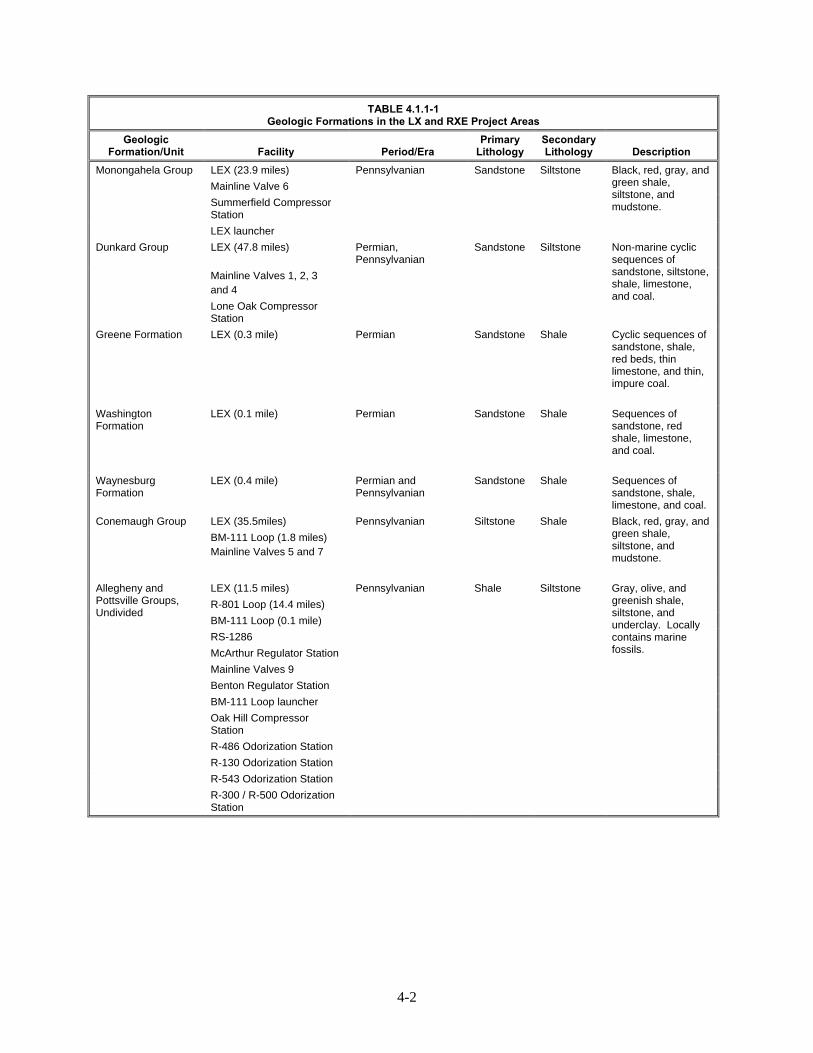
Table 4.1.1-1 provides a summary of the geologic formations crossed by the LX Project facilities, and the location by MP of each geologic formation crossed is presented in appendix F. A summary of shallow bedrock areas crossed by the LX Project is provided in appendix G.
4-2
TABLE 4.1.1-1 Geologic Formations in the LX and RXE Project Areas
Geologic Formation/Unit Facility Period/Era
Primary Lithology
Secondary Lithology Description
Monongahela Group LEX (23.9 miles) Pennsylvanian Sandstone Siltstone Black, red, gray, and green shale, siltstone, and mudstone.
Mainline Valve 6
Summerfield Compressor Station
LEX launcher
Dunkard Group LEX (47.8 miles) Permian, Pennsylvanian
Sandstone Siltstone Non-marine cyclic sequences of sandstone, siltstone, shale, limestone, and coal.
Mainline Valves 1, 2, 3 and 4
Lone Oak Compressor Station
Greene Formation LEX (0.3 mile) Permian Sandstone Shale Cyclic sequences of sandstone, shale, red beds, thin limestone, and thin, impure coal.
Washington Formation
LEX (0.1 mile) Permian Sandstone Shale Sequences of sandstone, red shale, limestone, and coal.
Waynesburg Formation
LEX (0.4 mile) Permian and Pennsylvanian
Sandstone Shale Sequences of sandstone, shale, limestone, and coal.
Conemaugh Group LEX (35.5miles) Pennsylvanian Siltstone Shale Black, red, gray, and green shale, siltstone, and mudstone.
BM-111 Loop (1.8 miles) Mainline Valves 5 and 7
Allegheny and Pottsville Groups, Undivided
LEX (11.5 miles) Pennsylvanian Shale Siltstone Gray, olive, and greenish shale, siltstone, and underclay. Locally contains marine fossils.
R-801 Loop (14.4 miles)
BM-111 Loop (0.1 mile)
RS-1286
McArthur Regulator Station
Mainline Valves 9
Benton Regulator Station
BM-111 Loop launcher
Oak Hill Compressor Station
R-486 Odorization Station
R-130 Odorization Station
R-543 Odorization Station
R-300 / R-500 Odorization Station

4-3
TABLE 4.1.1-1 (cont’d) Geologic Formations in the LX and RXE Project Areas
Geologic Formation/Unit Facility Period/Era
Primary Lithology
Secondary Lithology Description
Maxville Limestone: Rushville, Logan, and Cuyahoga Formations, Undivided
LEX (7.1 miles) LEX1 (0.6 mile) R-801 Loop (6.8 miles) K-260 Regulator Station Mainline Valve 8
Mississippian Shale Siltstone Gray, yellow, brown shale, siltstone, and sandstone.
Black Hand Sandstone Member of Cuyahoga Formation
LEX (4.9 miles) R-801 Loop (3.0 miles) LEX1 (0.6 mile) R-System Regulator Station Crawford Compressor Station Benton Compressor Station
Mississippian Sandstone Conglo- merate
Yellow-gray to white sandstone and conglomerate that grade laterally into shale and siltstone.
Quaternary Alluvium LEX (<0.1 mile) BM-111 Loop (0.9 mile)
Quaternary Alluvium N/A Alluvial deposits of sand, gravel, silt, and clay.
Ceredo Compressor Station
Grayson Compressor Station
Nancy and Farmers Member of Lower Mississippian Borden Formation
Means Compressor Station Mississippian Shale Siltstone Olive and gray shales and siltstone, including discontinuous iron-impregnated beds of siltstone. Dark-reddish- and yellowish-brown, iron-rich, siliceous, and calcareous concretions, occur sporadically in both shale and siltstone.
____________________
Source: USGS, 2005a-g.
Mineral Resources 4.1.1.2
The primary nonfuel mineral resource in Kentucky, Ohio, Pennsylvania, and West Virginia is crushed stone. Other prevalent mineral resources include Portland cement, lime, construction and sand (USGS, 2011) and clay, specifically in Carter County, Kentucky (USGS, 2015b). No active quarries are located within 0.2 mile of the LX and RXE Project areas (PADEP, 2015; Pennsylvania Department of Conservation and Natural Resources [PADCNR], 2015a; KGS, 2001; USGS, 2003 and 2015b).
No mine spoil areas are located within 0.5 mile of the project areas (West Virginia GIS Technical Center, 1996; Freidhof; 2015; Pennsylvania Spatial Data Clearinghouse [PASDA], 2015c). However, based on data provided by local mining companies and review of publicly available online resources, 41 underground mines are identified within 0.25 mile of the LX Project area in Ohio and West Virginia (KGS, 2001; ODNR, 2014c; PASDA, 2015d; West Virginia Office of Miners’ Health Safety and Training, 2011; WVDEP, 2014). Of the 41 mines, 17 are identified as underground coal mines, 3 as longwall coal mines, 19 as surface coal mines, 1 as a surface gravel mine and 1 as a surface limestone

4-4
mine. Seven of the 41 mines identified are being actively mined or are planned for future mining, including three longwall mines and four surface mines. Additionally, Columbia Gas is currently negotiating with two mining companies regarding the purchase of material rights for a surface gravel mine and surface coal mine along the proposed LEX crossing.
Coal is a major resource for Kentucky, which has two separate major coalfields: the western Kentucky coalfield and the eastern Kentucky coalfield. Although, the RXE Project’s Grayson CS is located in the eastern Kentucky coalfield, there are no mines within five miles of the proposed site (Kentucky Mine Mapping Information System, 2015).
Appendix I presents the location (by MP) of each future, active, and abandoned mine crossed or located within 0.2 mile of the LX and RXE Project areas.
Columbia Gas conducted geotechnical investigations at the proposed Lone Oak, Summerfield, and Oak Hill CS sites as well as at the existing Ceredo CS to characterize subsurface conditions for use in the development of facility foundation design and construction considerations. The proposed Summerfield CS occurs over land characterized by reclaimed abandoned coal mines of past and potential future mining activities. However, based on analysis of the results of the geotechnical investigation performed for the Summerfield CS, undisturbed stable soils occur beyond the expected depth of foundations.
Based on a review of publicly available resources and discussions with mining companies, Columbia Gas has identified a potential area near the proposed Lone Oak CS in which future longwall mining activities may occur. Columbia Gas coordinated with the associated mining company to determine when future mining activities would occur at the Lone Oak CS. Longwall mining activities are tentatively scheduled to occur in the area between 2023 and 2025; however, impacts at the Lone Oak CS as a result of mining activity are not anticipated. Columbia Gas and the associated mining company are developing a commercial solution for impacts associated with construction or operation of the Lone Oak CS and mining.
A total of 64 oil and gas wells were identified within the LX Project area in Ohio, Pennsylvania, and West Virginia, including 11 active wells and 51 inactive wells and 2 historic wells (appendix H) (WVDEP, 2014; 2011; PASDA 2015a, 2015b; ODNR, 2014b). The data provided in appendix H was obtained through publicly available state records, and the location and distances from the proposed construction workspace limits presented in the appendix may not be exact. Once Columbia Gas is able to conduct its final engineering and civil surveys, these locations would be marked, mitigated and/or avoided. Given the uncertainty of the locations of oil and gas wells within the LX Project workspace at this time, we recommend that:
Prior to construction, Columbia Gas should file with the Secretary the results of civil surveys identifying the location of any conventional or unconventional oil and gas well locations (including permitted, drilled, producing and abandoned oil and gas wells) within the LX Project footprint, as well as identify measures to minimize hazards for any wells located within 100 feet of the proposed LX Project pipelines.
In the RXE Project area in Kentucky, 158 oil and gas wells were identified within 5 miles of the Means CS, but none within 1 mile. The majority of the wells (124 of the 158 wells) within 5 miles of the Means CS are gas wells. Of the remaining wells, 29 are dry and/or abandoned wells, 4 are newly permitted wells, and one is a water supply well (KGS, 2015a). Similarly, 102 wells within 5 miles of the Grayson CS, but none within 1 mile. Within 5 miles of the Grayson CS there are 38 gas wells, 34 dry

4-5
and/or abandoned wells, 5 newly permitted wells, 2 combined oil and gas producing wells, 12 oil wells, and 11 terminated wells, for which the permit has been cancelled or has expired (KGS, 2015a).
In addition to aboveground storage tanks, natural gas may be stored in deep underground reservoirs. There are three primary types of underground reservoirs that may be used for the storage of natural gas, including depleted reservoirs in oil/gas fields, converted aquifers, and converted salt cavern formations (U.S. Energy Information Administration [EIA], 2004). No underground natural gas storage reservoirs are located within 0.5 mile of the proposed Project areas; the closest underground gas storage reservoir is located 0.9 mile northwest of LEX MP 107.9 (U.S. EIA, 2014).
Geologic Hazards 4.1.1.3
Geologic hazards are natural physical conditions that can, when active, result in damage to land or structures, or injuries to people. The following potential geologic or other natural hazards are discussed below in relation to the proposed LX and RXE Projects: seismic hazards, landslides, and subsidence.
Seismicity
Seismic hazards include earthquakes, surface faulting, and soil liquefaction. According to the USGS Seismic Hazards maps for the U.S., the LX Project is situated in an area of very low seismic probability. Based on historical seismic activity in the area, the USGS (2014a) estimates that a 500-year earthquake, an earthquake with a 10 percent probability of occurring within any 50-year interval, would result in peak ground accelerations of zero to one percent gravity (g) in Marshall County (West Virginia), Greene County (Pennsylvania), and Monroe County (Ohio). A 500-year earthquake is estimated to result in peak ground accelerations of one to two percent in Wayne County (West Virginia), as well as in Noble, Muskingum, Morgan, Perry, Fairfield, Hocking, Vinton, Jackson, and Lawrence Counties (Ohio) (USGS, 2014a). Damage to buildings and other structures is not likely to occur at ground accelerations of less than 10 percent g (USGS, 2007).
A significant earthquake is defined by the USGS as an earthquake that causes death, property damage, or geological effects, or that was experienced by populations near the epicenter (USGS, 2010). A total of six earthquakes have had epicenters within counties crossed by the LX Project in Ohio: two earthquakes had epicenters originating in Perry County; three earthquakes originated in Fairfield County; and one earthquake originated in Lawrence County, approximately 20 miles from the project area (ODNR, 2014d; USGS, 2014b). However, only one of these earthquakes, a June 1952 event in Perry County, was significant. All other earthquakes that have originated within counties crossed by the LX Project in Ohio were minor and did not result in any significant damage (ODNR, 2012). No recorded earthquakes have originated in the counties crossed by the LX Project within West Virginia and Pennsylvania (USGS, 2014c; PADCNR, 2015b). There are no known active faults in West Virginia, Pennsylvania, or Ohio, and no earthquakes recorded in the states have ever been linked to a fault (USGS, 2014d).
The proposed RXE Project sites in Kentucky are located near two Special Zones, as designated by the USGS. Special Zones are used to account for local variability in seismicity characteristics within a zone (Petersen et al., 2008). The USGS (2014) estimates that the 500-year earthquake would result in peak ground accelerations of 3 to 5 percent gravity based on historical seismic activity in the area. However, as previously mentioned, damage to buildings and other structures is not likely to occur at ground accelerations of less than 10 percent gravity (Petersen et al., 2014). The USGS also provides mapping that displays the probability of an earthquake of a specific magnitude over a specified timeframe. The probability of an earthquake of magnitude greater than 5.0 occurring in the next 50 years within approximately 30 miles of either of the proposed Grayson and Means CSs is between 1 and 2
4-6
percent. This mapping does not consider potentially induced seismicity or earthquakes occurring after 2006 (USGS, 2009).
In 1980, a magnitude 5.1 earthquake occurring in Bath County, the strongest in the history of Kentucky, was felt over all or parts of 15 States and in Ontario, Canada. Damage occurred in Indiana, Kentucky, and Ohio. Property damage was estimated at $1 million at Maysville, about 50 kilometers north of the epicenter, in Mason County, resulting in damage to 37 commercial structures and 269 private residences. Cracks formed in the ground about 12 kilometers from the epicenter (USGS). Earthquakes occurring in Greenup, Carter, and Mason counties, Kentucky within the last 100 years have included a magnitude 3.6 in 1979, 3.5 in 1983, 2.2 in 2013, and 2.1 in 2014 (Greenup County); magnitude 1.6 in 2015 (Carter County); magnitude 2.1 in 2013, and 2.5 in 2015 (Mason County) (USGS, Search Earthquake Archives). In the last six months, three earthquakes with magnitudes less than 2.5 have occurred in Carter, Greenup, and Mason Counties, Kentucky (i.e. within 30 miles of the Grayson CS and Means CS sites). These earthquakes had magnitudes of 1.6, 2.1, and 2.5 and occurred in January 2015, December 2014, and May 2015, respectively (The Center for Earthquake Research and Information (CERI) at the University of Memphis, 2015). However, no adverse impacts are anticipated on either compressor station site from seismic activity, due to the nature of the underlying, generally competent bedrock, low probability of significant earthquake activity, and low seismic risk at these sites.
Soil liquefaction is a condition that typically occurs when loose, saturated soil is subjected to vibration or shockwaves, typically from a seismic event. During liquefaction, pore water inhibits grain-to-grain contact, and reduces the strength of the soil such that soil may act like a viscous liquid with the ability to move and flow. Soil liquefaction can lead to landslides of slopes and extreme deformation of building foundations and buried pipelines. The low probability of a significant seismic event occurring within the LX or RXE Project areas makes the occurrence of soil liquefaction unlikely.
Landslides
Landslides occur when loose soils and sediments located on steep slopes become saturated, usually from a flood event. Several factors contribute to triggering landslides, including human induced and natural vibrations, but the most significant triggers are heavy rains, clay soil, and steep slopes (USGS, 1982). The bedrock of Mississippian, Pennsylvanian, and Permian ages located in the LX Project area is prone to slope failure. The most slide-prone rocks are red mudstones, also called “red beds”, of Pennsylvanian and Permian age. These rocks tend to lose strength when they become wet, forming rotational slumps or earthflows (USGS, 2013; Ohio Emergency Management Agency, 2011).
The USGS Landslide Overview Map of the Conterminous United States generally identifies the extent of areas characterized by low, medium, and high susceptibility to landslides based on several criteria, including but not limited to past landslide events, geologic conditions, and slopes. These characterizations generally represent the most detailed information available. However, given the lack of precise or insufficient information and the wide array of factors which contribute to landslide events, these susceptibility characterizations and identified extents are approximate (USGS, 2013).
According to the USGS Landslide Overview Map of the Conterminous United States, the following counties in which the LX Project and associated facilities are located, are characterized with areas of high landslide susceptibility:
Greene County, Pennsylvania (USGS, 1978) (although no landslide events have been documented in these areas since 1978);
Fairfield, Hocking, Jackson, Lawrence, Monroe, Morgan, Muskingum, Noble, Perry, and Vinton Counties, Ohio (although these counties have a low to moderate incidence of landslide events according to the Ohio Emergency Management Agency, 2011); and

4-7
Marshall and Wayne Counties, West Virginia (USGS, 1982) (although according to estimates provided by the Division of Homeland Security and Emergency Management’s West Virginia Statewide Standard Hazard Mitigation Plan 2013 Update, these counties have a low incidence of landslide events).
Columbia Gas used the Federal Emergency Management Agency’s (FEMA) Multi-Hazard Identification and Risk Assessment document reports to determine the probability of future landslide incidences for counties located in southeastern Ohio. Hocking, Monroe, Morgan, Noble, and Vinton Counties average 180 to 200 landslides annually, whereas Jackson and Lawrence Counties have an annual average of 12 landslides (Ohio Emergency Management Agency, 2011). The remaining counties affected by the LX Project within Ohio have a low incidence of landslides and were not included in the probability report. Rock fall is an additional hazard in eastern Ohio due to the presence of massive cliff-forming sandstones, steep slopes, and to the rapidity with which such failures occur (ODNR, 1986).
In Kentucky, the majority of landslides occur in colluvial soils or along soils that meet underlying bedrock (Crawford, 2014). The RXE Project sites are located in topography that is nearly level to gently undulating and is not susceptible to debris flows or landslides (KGS, 2015a).
Columbia Gas and Columbia Gulf assessed the geological landscape for potential landslide areas during its route selection process for the LX and RXE Projects. Seventeen minor route deviations were incorporated into the proposed route to avoid site-specific features (e.g., topography, landowner concerns, sensitive habitat, or structures). Columbia Gas incorporated the deviations to minimize the risks associated with construction on steep side slopes and to avoid difficult and rugged terrain primarily characterized by severe elevation changes and rocky outcrops.
To minimize the risk of landslides during construction in areas with steep slopes, Columbia Gas would install temporary ECDs to control erosion and sedimentation, such as interceptor diversions, and sediment filter devices (filter socks and silt fences) following the initial ground disturbance. Some areas may require ECDs be installed prior to or directly after vegetation clearance. Where required, Columbia Gas would also install sediment barriers (e.g., silt fence or filter socks) at the base of slopes adjacent to road crossings, waterbody crossings, wetlands, and other areas, to prevent siltation into waterbodies and wetlands downslope of the construction area. Temporary ECDs would be maintained until the LX Project areas have been successfully revegetated.
The risk of slips or landslide events is further exaggerated by the presence of water, which promotes erosion and increases the weight of soils. Columbia Gas would therefore implement typical mitigation procedures and control measures to prevent water from accumulating in areas with steep slopes, including:
shoring;
benching;
installation of jute netting or erosion control blankets;
slope and trench breakers;
subsurface gravel or cobble drains;
French drains; and
installation of culverts and drainage ditches to divert water away from the construction right-of-way.
During construction, the EI and construction crews would be responsible for identifying potential landslide conditions.

4-8
In order to minimize the potential for future slip or landslide events during operation of the LX Project facilities, Columbia may install permanent ECDs in addition to performing regular restoration and revegetation activities. Permanent ECDs would be installed in accordance with revegetation measures outlined in the ECSs and specific landowner requests. Columbia Gas and Columbia Gulf would monitor the effectiveness of revegetation and permanent ECDs during the long-term operation and maintenance of theie Project’s facilities.
Subsidence
Land subsidence is the sinking of the Earth’s surface, either gradually or suddenly, due to the subsurface movements of materials such as water or soil. Karst terrain results from the dissolution of highly soluble bedrock such as limestone and dolomite, creating features such as subsurface channels, caves and sinkholes. Areas with karst terrain and/or subsurface mining activities are more susceptible to subsidence events.
Based on a review of publicly available resources, no historic subsidence events have occurred within 1 mile of the LX Project area in West Virginia and Pennsylvania (USGS, 2014e). Seven subsidence events have been documented within 1 mile of the LX Project area in Ohio, as presented in table 4.1.1-2 (Riley, 2015). Further, the LX Project is not located in areas of karst terrain.
TABLE 4.1.1-2 Subsidence Events Recorded Within 1 mile of the LX Project
Milepost/Facility County, State Year of Occurrence Distance and Direction from
Project Area (miles)
Pipeline Facilities
LEX
107.7 Perry, OH 2004 1.0 NW
R-801 Loop
15.7 Vinton, OH 2001 1.0 W
Existing Columbia Pipeline System
R-130 Odorization Site Jackson, OH 1988 0.8 N
Jackson, OH 2000 1.0 E
Jackson, OH 2002 0.9 E
Jackson, OH 2002 1.0 E
Jackson, OH 2008 0.9 E
Pipe Yard 36 Muskingum, OH 1997 0.4 E
Both karst subsidence and mining subsidence hazards exist in Kentucky. It has been estimated
that about 55 percent of Kentucky is underlain by rocks with potential to develop karst terrain and about 38 percent of the state has at least some karst development (KGS, 2013). However, neither the Grayson CS nor Means CS sites are located where karst terrain is present, or where significant subsidence events are likely to occur (KGS, 2015a; Paylor and Currens, 2002).
Subsidence may occur as a result of longwall mining operations, which could result in stress and associated damages to buried pipelines. As previously mentioned, Columbia Gas would continue to coordinate with the mining companies to identify additional measures that would maintain the pipeline integrity and ensure safe operation of the LX Project facilities while not interfering with mining activities. Columbia Gas has developed a Longwall Mining Plan for construction and operation of the LX Project facilities in areas of inactive, active, or future longwall mining to avoid, minimize, and/or mitigate for potential impacts associated with subsidence (appendix J). We reviewed this plan and find it is

4-9
acceptable. This plan outlines measures to avoid, monitor, and/or reduce pipeline stress caused by subsidence, such as:
excavating the pipeline trench prior to or following mining activities to remove pressures on the mine being transferred from overlying soil;
delaying backfilling of the trench and restoration of disturbed areas to accommodate mining schedules until after mining and subsidence has occurred;
using thicker-walled pipe; and
installing strain gauges on the pipeline.
Paleontological Resources 4.1.1.4
Paleontological resources, including plant, invertebrates, and vertebrate fossils, may be found in a variety of geologic formations. Potential impacts on paleontological resources associated with the projects may occur as a result of construction activities such as trenching the pipeline ditch, excavation, use of heavy equipment, and addition of foundations.
The LX Project area is comprised of primarily Pennsylvanian and Mississippian aged rocks where ferns and marine fossils are common. Fossil deposits in rocks of Pennsylvanian and Permian age would consist of plant species such as lycopod trees, sphenopsid vines, ferns, and horsetails. Thin layers of limestone may contain marine fossils (Ashton, 2015; The Paleontology Portal, 2003). West Virginia does not have any documented, sensitive fossil resources, and there is no state protection for fossils (Ashton, 2015). Pennsylvania’s exposed metamorphic and igneous rocks of Precambrian age, which stratigraphically underlie the younger Mississippian-Pennsylvanian age sedimentary rocks, lack fossil resources (The Paleontology Portal, 2003). Ohio has no state protected or sensitive fossils, and no fossil collection sites (Angle, 2015). Therefore, we do not anticipate that construction of the LX Project would uncover significant paleontological resources.
In Kentucky, the Grayson CS site is located on Quaternary alluvium, and as such, its construction is unlikely to encounter fossils. However, the Means CS site is located on Mississippian strata, which is likely to contain marine invertebrate fossils. The Borden Formation at the Means CS location is listed by the KGS as having important fossil-bearing strata (KGS, 2015b), however the only fossil recognized in the Nancy Member of the Borden Formation is sparse zoophycos (Weir, 1976). Therefore, we do not anticipate any significant discoveries of paleontological resources during construction of either compressor station in Kentucky. While we do not anticipate that construction of the RXE Project would uncover significant paleontological resources, there is the potential for unanticipated discovery of fossils during project construction activities especially in areas of shallow bedrock or where bedrock removal is necessary. Columbia Gulf would contact the KGS in the event of an unanticipated discovery of a significant paleontological resource at the Means CS site.
General Impacts and Mitigation 4.1.2
General Construction Activities 4.1.2.1
The primary effect of project construction on geologic resources would be disturbance to steep topographic features found along the pipeline right-of-way. The likelihood of slips or landslide events increases as a result of vegetation clearance and contour grading in areas with steep slopes. In addition, areas requiring side slope construction may be more susceptible to slips or landslide events, as extra space would be needed to provide for safe and efficient construction of the pipeline, resulting in further vegetation clearance and contour grading. A total of 18.4 miles of the proposed LX pipeline routes (approximately 11 percent) is characterized by slopes greater than 30 percent. Several minor route

4-10
deviations were incorporated to minimize the risks associated with construction on steep side slopes and to avoid difficult and rugged terrain primarily characterized by severe elevation changes and rocky outcrops. Although side slope terrain was avoided to the maximum extent practicable, severe side slopes may still be encountered. While eight subsidence events have been documented within 1 mile of the LX Project area in Ohio, no historic subsidence events have occurred within 1 mile of the LX Project area in West Virginia and Pennsylvania. Neither the RXE Project Grayson CS nor Means CS sites are located where karst terrain is present, or where significant subsidence events are likely to occur.
In addition to the avoidance measures discussed above, Columbia Gas and Columbia Gulf would use both temporary and permanent erosion and sediment control devices to minimize or avoid the risk of landslides during construction in areas with steep slopes, in accordance with their ECSs. In consideration of the proposed mitigation and monitoring measures, construction and operation of the LX and RXE Project facilities are not anticipated to affect or be affected by significant landslide or slip events.
Seven of the coal mines identified within 0.2 mile of the LX Project area are being actively mined or are planned for future mining, including three longwall mines and four surface mines. In these areas, Columbia Gas would coordinate with the appropriate mining companies regarding the construction schedule across active surface mines and longwall mines to allow the completion of mining activities prior to construction (to the extent practicable).
By implementing the measures outlined in the Longwall Mining Plan, Columbia Gas would ensure the safety and stability of the proposed pipeline and greatly minimize or avoid potential landslide and subsidence hazards due to future longwall mining operations. Therefore, significant adverse impacts on the proposed LX Project facilities or on the future planned longwall mining activities are not anticipated.
Columbia Gas identified a potential area in the vicinity of the proposed Lone Oak CS in which future longwall mining activities may occur. Columbia Gas coordinated with the associated mining company to determine when future mining activities would occur at the Lone Oak CS. Longwall mining activities are tentatively scheduled to occur in the area between 2023 and 2025; however, impacts at the Lone Oak CS as a result of mining activity are not anticipated. Columbia Gas and the associated mining company are developing a commercial solution for impacts associated with construction or operation of the Lone Oak CS and mining. However, should the proposed Lone Oak CS occur within the coal seam boundary, Columbia Gas would adjust the siting of the facility to avoid areas of potential subsidence. Further, major compressor equipment and associated piping, as well as non-gas related structures, would be reconfigured to provide a minimum buffer of 300 feet from the mine boundary. In addition to minor re-siting and equipment configurations, Columbia Gas would implement other precautionary measures such as, installation of foundations at shallow depths to reduce friction with surrounding soils and/or use of compressible backfill materials (e.g., expanded polystyrene foam, void form, or other proprietary materials) in areas located adjacent to foundation walls.
The proposed Summerfield CS occurs on land characterized by reclaimed abandoned coal mines of past and potential future mining activities. However, based on the analysis of the geotechnical investigation performed for the Summerfield CS, undisturbed stable soils occur beyond the expected depth of foundations. Therefore, the Summerfield CS facility would not be expected to be adversely affected by effects associated with past mining activities.
Columbia Gas conducted geotechnical studies at strategic locations along the proposed LX Project, including within proposed HDD areas. Based on analysis of the results of the geotechnical studies, the HDDs are not anticipated to fail. In the event that a particular drill is unsuccessful, Columbia Gas would implement its Horizontal Directional Drill Contingency Plan.

4-11
No underground natural gas storage reservoirs are located within 0.5 mile of the LX or RXE Project areas therefore impacts on underground gas storage reservoirs are not anticipated to occur as a result of construction or operation of the project facilities.
Although fossils are relatively common in the project areas, and the Borden Formation at the Means CS location is listed by the KGS as having important fossil-bearing strata, no significant impacts on paleontological resources are anticipated during construction in any of the project areas.
Blasting and Rock Removal 4.1.2.2
Blasting may be required in the LX Project to excavate the trench in areas where bedrock is encountered at depths that interfere with conventional excavation or rock trenching methods. Potential blasting areas are those that have shallow depth to bedrock (less than 5 feet). Approximately 45 percent of the LX Project area is characterized by shallow bedrock (a total of 95.0 miles crossed by the proposed pipelines and a total of 41.6 acres associated with construction of the aboveground facilities). Potential blasting locations were identified using available mapping and soils data. In the event that bedrock is encountered during construction, the technique used for bedrock removal will depend on factors such as strength and hardness of the rock. Appendix G provides a summary of areas characterized by shallow bedrock crossed by the LX Project pipeline. No blasting is identified for the RXE Project.
If consolidated rock is encountered during construction, Columbia Gas’ preferred procedure would be to fracture and excavate the bedrock using standard construction equipment. Columbia Gas and Columbia Gulf would use blasting of bedrock only as a last resort if hard bedrock is encountered that is not easily removed by conventional excavation methods. If blasting is necessary, Columbia Gas’ blasting contractors would adhere to the procedures and safety measures outlined in their Blasting Plan. This plan contains measures such as the following:
contractor submission of site-specific blasting plans for Columbia Gas’ approval 10 working days prior to execution of blasting activity that include dates and hours of blasting, and distance and orientation to nearest aboveground and underground structures, as well as a schedule identifying when blasting would occur within each waterbody greater than 10 feet wide, or within any designated coldwater fishery;
use of blasting mats or padding to prevent scattering of loose or fly rock onto adjacent property and to prevent damage to nearby structures and overhead utilities;
notification of all occupants of nearby buildings, stores, residences, places of business, places of public gathering, and farmers at least 48 hours in advance of blasting;
an independent contractor would be employed to perform pre- and post-blast structural inspections and, if necessary, seismographic monitoring if blasting is necessary within 150 feet of residential or commercial buildings;
pre- and post-blast inspections may be performed at locations where blasting is proposed within 150 feet of water wells to ensure that the volume/quality of potable water wells is maintained, in accordance with landowner negotiations. In the unlikely event that blasting activities temporarily impair potable well water, Columbia Gas would provide alternative sources of water or otherwise mitigate the impairment through discussions and agreements with the well owner;
no blast would be fired without a positive signal from the person in charge who will have made certain that all surplus explosives are in a safe place, all persons, vehicles, and /or boats are at a safe distance (and vehicular and/or pedestrian traffic is stopped near the blast site), and adequate warning has been given to nearby homeowners and local agencies.

4-12
In-stream blasting could injure or kill aquatic organisms close to blasting activities. Temporary and minor impacts on aquatic resources from blasting activities are discussed in section 4.6.2.8. While blasting is not anticipated for the LX and RXE Projects, in the unlikely event that Columbia Gas encounters bedrock that cannot be excavated using conventional methods, blasting may be required. If it becomes necessary to blast in waterbodies, Columbia Gas would consult with federal and state conservation authorities to determine what protective measures should be taken to minimize damage to fish and other aquatic life. As outlined in the Blasting Plan and ECS, Columbia Gas would provide notification to FERC no later than 14 days prior to any in-stream blasting activities and would notify FERC of any changes to the schedule no more than 48 hours prior to blasting. Additionally, Columbia Gas would adhere to all applicable federal, state, and local blasting notification requirements.
Encountered Oil and Gas Wells 4.1.2.3
If an oil or gas well is encountered, Columbia Gas would determine an appropriate buffer and construction procedure around the well based on site-specific conditions and coordination with the owner of the well. Additionally, Columbia Gas would implement other measures during construction of the LX Project to reduce likelihood of impacts, such as:
flagging wells within the construction right-of-way;
reducing the construction workspace, if necessary, to keep a safe buffer between stockpiled spoil and equipment and the well; and
attempting to adjust the pipeline centerline to prevent excavation of the pipe trench from interfering with the integrity of the well.
If an oil or gas well is unexpectedly impacted during construction, Columbia Gas would stop work immediately, contain any spilled product (see the Spill Prevention, Control, and Countermeasures Plan contained within the ECS), secure the area, and notify FERC as well as the appropriate state and/or local agency. Although not anticipated, should an oil or gas well be damaged by construction of the LX Project, Columbia Gas would compensate the owner for the repair or replacement of the well. If an oil well is encountered during construction, and it is determined to have the potential to reach any waters of the U.S., Columbia Gas would immediately notify the appropriate regional office of the EPA through the National Response Center.
Conclusion 4.1.3
The primary effect of the proposed LX and RXE Projects on geologic resources would be the disturbance to steep topographic features, the excavation of consolidated or shallow bedrock during the construction of the pipeline and aboveground facilities, and the establishment of temporary contractor yards and access roads, affecting the local geologic resource within discrete areas of the project footprints.
A number of mines were identified within or near the LX Project areas. Columbia Gas would coordinate with the appropriate mining companies regarding the construction schedule across active surface mines and longwall mines to allow the completion of mining activities prior to construction (to the extent practicable). In addition, oil and gas wells have been identified within or near the LX Project areas. These sites would be field verified through civil surveys prior to the start of construction.
Based on the avoidance, minimization and mitigation measures developed by Columbia Gas and Columbia Gulf, including measures outlined in the project-specific ECS, Longwall Mining Plan and Blasting Plan, we conclude that construction and operation of the Projects would not have any significant adverse effects on geologic resources.

4-13
4.2 SOILS
Existing Resources 4.2.1
The scope of the proposed LX and RXE Projects span 16 counties, including three in Kentucky, nine- in Ohio, two- in Pennsylvania, and two- in West Virginia. The LX and RXE Projects involve soil series and detail soil units within the Central Allegheny Plateau, Western Allegheny Plateau and Kentucky Bluegrass major land resource areas (NRCS, 2006, 2015b).
Columbia Gas further evaluated the soils within the footprints of the proposed LX and RXE Projects to identify major soil characteristics that could affect construction or increase the potential for construction-related soil effects. The soil characteristics evaluated were hydric properties, compaction-potential, erosion potential, depth to shallow bedrock, and revegetation potential. Appendix G lists the characteristics of each detail soil unit within the LX Project areas, as well as the total miles of each soil unit that the pipelines cross and the acres impacted by construction of the aboveground facilities.
Erosion 4.2.1.1
Erosion is a continuing process that can be accelerated by human disturbances. Factors that can influence the degree of erosion include soil texture, structure, length and percent slope, vegetative cover, as well as rainfall or wind intensity. Soils most susceptible to erosion by water are typified by bare or sparse vegetative cover, non-cohesive soil particles with low infiltration rates, and moderate to steep slopes. Wind erosion processes are less affected by slope angles. Highly erodible land, as designated by the NRCS, includes both water and wind as agents of erosion (NRCS, 2014a).
Erosion potential of soils within the LX and RXE Project areas was identified based on NRCS designations of land capability class and subclass. The majority of lands within each project areas has low or moderate erosion potential.
Hydric Soils and Compaction Potential 4.2.1.2
Hydric soils are defined as soils that are formed under conditions of saturation, flooding, or ponding long enough during the growing season to develop anaerobic conditions in the upper part (COE, 1987). Soils that are artificially drained or protected from flooding (e.g., by levees) are still considered hydric if the soil, in its undisturbed state, would meet the definition of hydric. Generally, hydric soils are those that are poorly or very poorly drained. Due to extended periods of saturation, hydric soils can be prone to compaction and rutting. Approximately 14 percent of soils within the LX Project area are classified as hydric . No soils within the RXE Project area are classified as hydric.
Stony-Rocky Soils and Shallow Bedrock 4.2.1.3
Soils with textural classifications including stony, cobbly, gravelly, shale, slate, and droughty in any layer, or with surface layer stones larger than 3 inches found in more than 15 percent of an area, may be characterized as stony or rocky soil. Shallow bedrock is considered prevalent where the depth to bedrock is less than 5 feet below the ground surface.
About 45 percent of the soils within the footprint of the LX Project pipelines have shallow bedrock. However, only one of these soil types, the Homewood-Westmoreland silt loam (15 to 25 percent slopes), contains rock fragments greater than 3 inches. This soil is crossed by the LEX pipeline for less than 0.2 mile in Perry County, Ohio. In addition, three soil series within the Grayson CS site (Carter County, Kentucky) and the Means CS site (Menifee and Montgomery Counties, Kentucky) potentially have shallow bedrock.

4-14
The introduction of stones or rocks to surface soil layers through project construction activities may reduce soil moisture-holding capacity, resulting in a reduction of soil productivity. Additionally, some construction equipment may be damaged by contact with large rocks and stones or shallow bedrock.
Poor Revegetation Potential 4.2.1.4
Approximately 45 percent of the soils within the LX Project area have low revegetation potential. Soils with low revegetation potential typically have the following characteristics:
high compaction and/or erosion potential;
slopes greater than 8 percent;
generally not classified as prime farmland; and/or
usually hydric in nature.
Successful restoration and revegetation of project workspaces are important for protecting the underlying soil from potential damage and minimizing erosion during operation.
Prime Farmland 4.2.1.5
The USDA defines prime farmland as land that is best suited to food, feed, fiber, and oilseed crops (NRCS, 2014c). This designation includes cultivated land, pasture, woodland, or other lands that are either used for food or fiber crops, or are available for these uses. Urbanized land and open water are excluded from prime farmland designation. Prime farmland typically has the following characteristics:
contains few or no rocks;
permeable to water and air;
not excessively erodible or saturated with water for long periods; and
not subject to frequent, prolonged flooding during the growing season.
Farmland is designated as prime where 50 percent or more of the components in the map unit composition are prime; of statewide importance where less than 50 percent of the components in the map unit are prime but a combination of lands of prime or statewide importance is 50 percent or more of the map unit composition. Prime farmland is designated as of local importance where less than 50 percent of the components in the map unit are of prime or statewide importance but the total of land of prime, statewide, and/or local importance is 50 percent or more of the map unit composition. All other soil map units are shown as not prime farmland unless they are designated as unique (NRCS, 2015a).
Unique farmland is identified as land other than prime farmland that is used for the production of specific high-value food and fiber crops, such as citrus, tree nuts, olives, cranberries, and other fruits and vegetables. It has the unique combination of soil quality, growing season, moisture supply, temperature, humidity, air drainage, elevation, and aspect needed for the soil to economically produce sustainable high yields of these crops when properly managed (NRCS, 2014c). The criteria for defining and delineating farmland of statewide importance are determined by the appropriate state agencies. Generally, this land includes areas of soils that nearly meet the requirements for prime farmland, and that economically produce high yields of crops when treated and managed according to acceptable farming methods (NRCS, 2014c).
Soils that do not meet the above criteria may be considered prime farmland if the limiting factor is mitigated (e.g., artificial drainage). Farmland that does not meet the criteria for prime or unique farmland may still be considered farmland of statewide importance, local importance, or prime farmland
4-15
if special procedures are implemented to protect crops during the growing season, for the production of food, feed, fiber, forage, and oilseed crops.
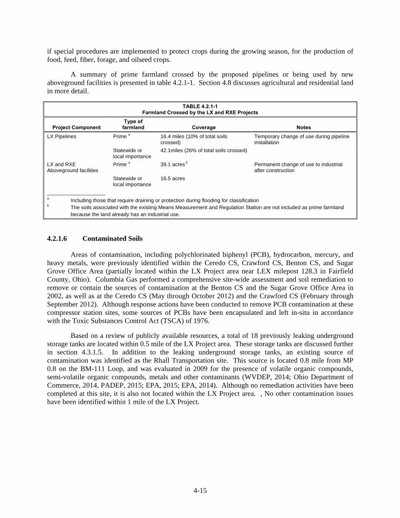
A summary of prime farmland crossed by the proposed pipelines or being used by new aboveground facilities is presented in table 4.2.1-1. Section 4.8 discusses agricultural and residential land in more detail.
TABLE 4.2.1-1 Farmland Crossed by the LX and RXE Projects
Project Component Type of
farmland Coverage Notes
LX Pipelines Prime a 16.4 miles (10% of total soils crossed)
Temporary change of use during pipeline installation
Statewide or local importance
42.1miles (26% of total soils crossed)
LX and RXE Aboveground facilities
Prime a 39.1 acres b Permanent change of use to industrial after construction
Statewide or local importance
16.5 acres
____________________ a Including those that require draining or protection during flooding for classification b The soils associated with the existing Means Measurement and Regulation Station are not included as prime farmland because the land already has an industrial use.
Contaminated Soils 4.2.1.6
Areas of contamination, including polychlorinated biphenyl (PCB), hydrocarbon, mercury, and heavy metals, were previously identified within the Ceredo CS, Crawford CS, Benton CS, and Sugar Grove Office Area (partially located within the LX Project area near LEX milepost 128.3 in Fairfield County, Ohio). Columbia Gas performed a comprehensive site-wide assessment and soil remediation to remove or contain the sources of contamination at the Benton CS and the Sugar Grove Office Area in 2002, as well as at the Ceredo CS (May through October 2012) and the Crawford CS (February through September 2012). Although response actions have been conducted to remove PCB contamination at these compressor station sites, some sources of PCBs have been encapsulated and left in-situ in accordance with the Toxic Substances Control Act (TSCA) of 1976.
Based on a review of publicly available resources, a total of 18 previously leaking underground storage tanks are located within 0.5 mile of the LX Project area. These storage tanks are discussed further in section 4.3.1.5. In addition to the leaking underground storage tanks, an existing source of contamination was identified as the Rhall Transportation site. This source is located 0.8 mile from MP 0.8 on the BM-111 Loop, and was evaluated in 2009 for the presence of volatile organic compounds, semi-volatile organic compounds, metals and other contaminants (WVDEP, 2014; Ohio Department of Commerce, 2014, PADEP, 2015; EPA, 2015; EPA, 2014). Although no remediation activities have been completed at this site, it is also not located within the LX Project area. , No other contamination issues have been identified within 1 mile of the LX Project.
4-16
General Impacts and Mitigation 4.2.2
Construction Activities 4.2.2.1
Construction activities, such as clearing and grading, trenching, backfilling, and grading during restoration, have the potential to adversely affect soils and revegetation potential within the LX and RXE Project areas. Potential impacts from these activities include:
soil loss due to water or wind erosion, especially on steep slopes or areas with fine sandy soils;
reduction of soil quality by mixing topsoil with subsoil from lack of topsoil conservation or from rutting by equipment;
reduction of soil quality by bringing excess rock to the surface;
soil compaction due to traffic by heavy equipment;
poor revegetation due to steep slopes, low fertility, or other soil conditions;
disruption of surface and subsurface drainage systems; and
remobilization of existing soil contamination.
To minimize or avoid impacts on soils during construction and operation of the LX and RXE Projects, Columbia Gas and Columbia Gulf would follow construction methods and mitigation measures outlined in their ECSs. The ECS incorporates measures from FERC’s Plan and Procedures as well as from federal, state, and local requirements, including:
West Virginia Erosion and Sediment Control Best Management Practice Manual (WVDEP, 2006);
PADEP’s Erosion and Sediment Pollution Control Program Manual (PADEP, 2012); and
ODNR’s Pipeline Standard and Construction Specifications (ODNR, 2013).
Winter Construction 4.2.2.2
Winter construction techniques are required in some parts of the U.S. that experience extended periods of freezing conditions or heavy snowfall events. Winter construction techniques typically include snow management, working with frozen soils, and managing hydrostatic discharge water under freezing conditions. These techniques also include the application of temporary erosion and sediment control measures to protect against accelerated erosion during spring melt and heavy spring rains. These temporary controls would be maintained during project construction and reinstalled as necessary until permanent ECDs are constructed and/or permanent stabilization has occurred. In the event that winter construction conditions are encountered, Columbia Gas would follow measures in its Winter Construction Plan, within the ECSs. Key components of the plan include:
snow management and storage to improve driving conditions and allow safe access to the construction right-of-way;
removing snow in a manner to minimize damage to vegetation or soils, as much as possible;
restoring damage resulting from snow removal in a timely manner;
installation of temporary erosion and sediment control measures; and
clearing trenches of snow, to the greatest extent practical.
Approximately 16 percent of the soils within the LX Project area are classified as hydric. Soil compaction and rutting could occur if construction activities, particularly the operation of heavy

4-17
equipment, take place when soils are saturated. Columbia Gas would minimize rutting and compaction of hydric soils during construction through the implementation of the proposed wetland construction crossing techniques described in section 4.4, such as the use of timber mats, and the approved BMPs provided in the ECS. Other methods may also be used as necessary depending on conditions. High groundwater levels that accompany hydric soils could also create a buoyancy hazard for the pipeline. Columbia Gas would use special construction techniques, such as concrete coating and other weighting methods, along these sections of the LX pipelines.
Soil Handling 4.2.2.3
During construction activities, the topsoil from all actively cultivated and rotated cropland and improved pasture associated with the LX Project pipelines would be stripped from the entire construction right-of-way, or from directly over the trench, and segregated from the subsoil in accordance with the FERC Plan. In addition, topsoil would be stripped from over the pipeline trench and the adjacent subsoil storage area in residential and wetland areas, unless the landowner or land management agency requests otherwise.
In accordance with its ECS, Columbia Gas would remove the topsoil layer down to a minimum depth of 12 inches in cultivated or rotated agricultural lands and pastures, residential areas, hayfields, and other areas at the landowner’s or land mapping agency’s request. Segregated topsoil would be returned following backfilling of the subsoil, ensuring preservation of topsoil within the construction area. Following the completion of construction, agricultural areas disturbed by the installation of the LX pipelines would be allowed to return to pre-construction uses; therefore, construction activities in these areas would not adversely affect prime farmland (see 4.2.1.5). Land, including prime farmland, used for the construction of the project aboveground facilities would be permanently converted to industrial use.
The introduction of stones or rocks to surface soil layers may reduce soil moisture-holding capacity and overall soil fertility, resulting in a reduction of soil productivity. Additionally, some construction equipment may be damaged by contact with large rocks and stones or shallow bedrock. Shallow bedrock is defined as bedrock within 60 inches of the ground surface. Approximately 45 percent of the soils within the LX Project area have shallow bedrock.
There would be a potential to introduce subsurface stone and rock into surface soils during construction in this area, but due to the short distance of the project within this soil, and given that stones and rock fragments would be likely already present at the surface, it would not be anticipated that construction would change the soil composition. In accordance with its ECS, Columbia Gas would remove any large excess stone and rock from surface soils within the project areas so that rock contents within the soils would be no higher than similar soils in adjacent locations, unless otherwise requested by a landowner. In order to prevent damage to the pipeline protective coating, all excavated materials would be thoroughly examined, and rocks greater than 4 inches in diameter would be removed prior to backfilling of the trench. In areas where stony/rocky soils or shallow bedrock interfere with conventional excavation or rock trenching methods, blasting may be required to excavate the trench. Blasting details are provided in section 4.1.2.2.
Within agricultural lands crossed by the LX and RXE Projects, Columbia Gas and Columbia Gulf would negotiate with and reimburse landowners for any damages to their product or loss of yields as a result of the project construction activities. Columbia Gas and Columbia Gulf would continue to monitor and correct problems with topsoil replacement, soil compaction, rocks, drainage, and irrigation systems resulting from construction until restoration is determined successful. Restoration would be considered successful if the surface condition of the areas disturbed during construction, including the topsoil and the horizon of the upper subsoil, is similar to adjacent undisturbed lands, construction debris is removed, revegetation is successful, and proper drainage has been restored.

4-18
Soil Restoration and Revegetation 4.2.2.4
Successful restoration and revegetation of the LX and RXE Project workspaces are important for maintaining productivity and protecting the underlying soil from potential damage. Soil fertility and erosion are generally the two main factors that would limit the regrowth of vegetation, but these can be mitigated through the application of fertilizers and/or seeding nets. Restoration and revegetation growth specifications will follow measures outlined in the ECSs. Columbia Gas and Columbia Gulf would apply soil amendments as needed in areas with low to moderate revegetation potential in order to create a favorable environment for the re-establishment of vegetation.
Documents and guidance specific to Kentucky, Ohio, Pennsylvania and West Virginia to obtain recommendations for seed mixtures and soil amendments for restoration of disturbed areas following construction activities. The ECSs contain seed mixtures and application rates for reseeding disturbed areas, which were established in accordance with requirements and recommendations from the ODNR’s Rainwater and Land Development (ODNR, 2006), PADCNR’s Seeding Mixtures For Areas Disturbed by Natural Gas Activities (PADCNR, 2015), and the WVDEP’s West Virginia Erosion and Sediment Control Field Manual (WVDEP, 2012).
Revegetation of residential and agricultural lands would be conducted in accordance with landowner requests as well as state and local recommendations. In agricultural areas, revegetation would be considered successful if crop yields are similar to adjacent undisturbed portions of the same field. In all other areas, revegetation would be considered successful if, upon visual survey, the density and cover of non-nuisance vegetation are similar in density and cover to adjacent undisturbed lands.
Installation of Erosion Controls and Stabilization 4.2.2.5
Clearing, grading, and equipment movement has the potential to accelerate the erosion process and, without adequate protection, result in discharge of sediment to waterbodies and wetlands. Soil loss due to erosion could also reduce soil fertility and impair revegetation. To minimize or avoid potential soil erosion and sedimentation impacts, Columbia Gas and Columbia Gulf would use construction procedures and mitigation measures contained within their ECSs, such as:
installing temporary ECDs including interceptor diversions and sediment filter devices (e.g., filter socks and silt fence) following initial ground disturbance;
installing temporary trench breakers immediately following trench excavation;
using jute netting or erosion control blankets on steep slopes to help prevent erosion;
segregating and protecting topsoil from subsoils during trenching;
postponing work in excessively wet conditions in upland soils;
using low ground-weight equipment or soil stabilization materials such as timber mats when soils are saturated or standing water is present;
completing final grading, topsoil replacement and installation of permanent erosion control structures within 20 days after backfilling the trench; and
inspecting the right-of-way and maintaining erosion and sediment controls as necessary until final stabilization is achieved.

4-19
Temporary ECDs would be maintained until the project areas have been successfully revegetated, in accordance with restoration procedures from Columbia Gas’ and Columbia Gulf’s ECSs, including:
restoring pre-construction contours;
installing permanent ECDs such as permanent slope breakers, riprap, rock outlet protection, trench breakers, or French drains;
removing excess rocks from the right-of-way surface; and
revegetating the right-of-way as soon as possible following final grading.
Columbia Gas and Columbia Gulf would install permanent ECDs in accordance with revegetation measures outlined in the ECS specific landowner requests. Columbia Gas would monitor the project right-of-way to assess the effectiveness of revegetation and permanent ECDs during the long-term operation and maintenance of the project facilities.
Columbia Gas would continue to coordinate with applicable state agencies to develop mitigation measures for construction activities along steep slopes characterized by soils with increased erosion potential, including Erosion Sediment Control Plans for construction and restoration in Greene County Conservation District.
Remobilization of Existing Contamination 4.2.2.6
Some discrete sites of existing soil contamination have been identified in the LX Project area (section 4.2.1.6). Although Columbia Gas has performed comprehensive assessments and soil remediation at the key sites, some sources of PCBs have been encapsulated and left in place in accordance with the TSCA. Therefore, Columbia Gas has developed Soil Management Plans for each of the compressor stations associated with the LX Project and the Sugar Grove Office Area, as well as Risk Management Plans for the Crawford CS and Ceredo CS that outline procedures to be followed for the management of PCBs left in place and to maintain compliance with TSCA requirements.
Based on a review of publicly available resources, one additional existing sources of contamination are located within 1 mile of the LX Project area in Wayne County, West Virginia. In addition to reviewing publicly available information, Columbia Gas would attempt to identify areas of historic and existing contamination through discussions with landowners and visual inspection of project workspaces prior to the start of construction to the extent practicable. Therefore, the LX Project is not expected to affect or be affected by any existing contaminated soils. In the event that contaminated media is discovered during construction, Columbia Gas would adhere to their Plan for the Unanticipated Discovery of Contaminated Environmental Media (as part of its ECS) that outlines the steps to be followed in the event that contaminated sediments or soils, as identified by evidence of subsoil discoloration, odor, sheen, or other such indicators, are encountered during construction.
No PCB contamination issues have been identified within the RXE Project area. The RXE Project is not expected to impact or be impacted by PCB contamination. Columbia Gulf would follow all applicable federal, state, and local regulations and measures identified in its ECS in the event that contaminated media is discovered during construction.
Fuel Handling and Storage 4.2.2.7
During construction, contamination from accidental spills or leaks of fuels, lubricants, or coolant from construction equipment could adversely affect soils. Columbia Gas and Columbia Gulf has developed SPCC Plans (as part of their ECSs) that specifies cleanup procedures in the event of soil contamination from spills or leaks. Columbia Gas and Columbia Gulf and their contractors will

4-20
implement the ECSs to prevent accidental spills of any material that may contaminate soils. If necessary, additional measures would be implemented to ensure that inadvertent spills are contained, cleaned up, and disposed of in an appropriate manner.
Conclusion 4.2.3
Construction activities such as clearing, grading, trench excavation, backfilling, and the movement of construction equipment would affect soil resources during the construction of the pipeline and aboveground facilities, and the establishment of temporary contractor yards and access roads. Clearing removes protective cover and exposes the soil to the effects of wind and rain, which increases the potential for erosion and sedimentation of sensitive areas. Grading, spoil storage, and equipment traffic can compact soil, reducing porosity and increasing runoff potential. Excess rock or fill material brought to the surface during trenching activities could hinder restoration of the right-of-way.
To minimize or avoid impacts on soils during construction and operation of the LX Project, Columbia Gas would implement soil mitigation procedures outlined in their ECS and guidance provided by WVDEP, PADEP, PADCNR, and ODNR.
Columbia Gas and Columbia Gulf would minimize adverse impacts on land, including agricultural, prime farmland and residential areas, by implementing the BMPs identified in their ECSs. Columbia Gas and Columbia Gulf would coordinate with the applicable agencies and landowners in these areas to ensure the proper restoration of any impacted agricultural or residential areas, including replacement of segregated topsoil, stone removal, and to ensure compliance with reseeding recommendations. Columbia Gas and Columbia Gulf would protect active pastureland during construction through the installation of temporary fencing, the use of alternative locations for livestock to cross the construction right-of-way, and/or developing grazing deferment plans, as negotiated with the landowner.
In consideration of the above, we conclude that construction and operation of the project facilities would not have significant adverse effects on soil resources.
4.3 WATER RESOURCES
Groundwater Resources 4.3.1
Existing Groundwater Resources 4.3.1.1
Regional aquifers in the LX Project area in Ohio, Pennsylvania, and West Virginia originate from Pennsylvanian and Mississippian principal aquifers (USGS, 1995, 1997). Groundwater resources in Pennsylvanian aquifers within the vicinity of the project area range from approximately 40 to 260 feet below mean sea level (msl) (USGS, 1995, 1997, 2014b, 2014c; ODNR, 2015). The water quality of Pennsylvanian aquifers generally decreases with depth. Total dissolved solid concentrations range from approximately 322 to 500 milligrams per liter (mg/l) (USGS, 1995). Primary uses of groundwater withdrawn from Pennsylvanian aquifers within the project area include industrial and public supply. In Greene County, Pennsylvania, primary uses include thermoelectric uses and public supply (USGS, 2005).
Groundwater resources in Mississippian aquifers within the vicinity of the LX Project area range from approximately 180 to 290 feet below msl (USGS, 1995; ODNR, 2015). The water quality of Mississippian aquifers generally contains hard water. Total dissolved solid concentrations average approximately 500 mg/l (Ohio State University, 2015). The primary source of potable water in Fairfield and Hocking Counties, Ohio comes from Mississippian aquifers with public supply as the primary use (ODNR, 2005; USGS, 2005).
4-21
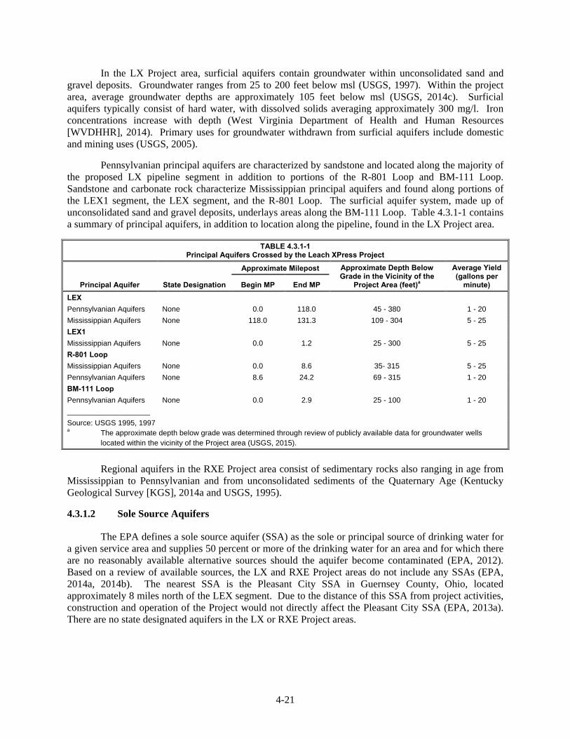
In the LX Project area, surficial aquifers contain groundwater within unconsolidated sand and gravel deposits. Groundwater ranges from 25 to 200 feet below msl (USGS, 1997). Within the project area, average groundwater depths are approximately 105 feet below msl (USGS, 2014c). Surficial aquifers typically consist of hard water, with dissolved solids averaging approximately 300 mg/l. Iron concentrations increase with depth (West Virginia Department of Health and Human Resources [WVDHHR], 2014). Primary uses for groundwater withdrawn from surficial aquifers include domestic and mining uses (USGS, 2005).
Pennsylvanian principal aquifers are characterized by sandstone and located along the majority of the proposed LX pipeline segment in addition to portions of the R-801 Loop and BM-111 Loop. Sandstone and carbonate rock characterize Mississippian principal aquifers and found along portions of the LEX1 segment, the LEX segment, and the R-801 Loop. The surficial aquifer system, made up of unconsolidated sand and gravel deposits, underlays areas along the BM-111 Loop. Table 4.3.1-1 contains a summary of principal aquifers, in addition to location along the pipeline, found in the LX Project area.
TABLE 4.3.1-1 Principal Aquifers Crossed by the Leach XPress Project
Principal Aquifer State Designation
Approximate Milepost Approximate Depth Below Grade in the Vicinity of the
Project Area (feet)a
Average Yield (gallons per
minute) Begin MP End MP
LEX
Pennsylvanian Aquifers None 0.0 118.0 45 - 380 1 - 20
Mississippian Aquifers None 118.0 131.3 109 - 304 5 - 25
LEX1
Mississippian Aquifers None 0.0 1.2 25 - 300 5 - 25
R-801 Loop
Mississippian Aquifers None 0.0 8.6 35- 315 5 - 25
Pennsylvanian Aquifers None 8.6 24.2 69 - 315 1 - 20
BM-111 Loop
Pennsylvanian Aquifers None 0.0 2.9 25 - 100 1 - 20
____________________
Source: USGS 1995, 1997 a The approximate depth below grade was determined through review of publicly available data for groundwater wells located within the vicinity of the Project area (USGS, 2015).
Regional aquifers in the RXE Project area consist of sedimentary rocks also ranging in age from
Mississippian to Pennsylvanian and from unconsolidated sediments of the Quaternary Age (Kentucky Geological Survey [KGS], 2014a and USGS, 1995).
Sole Source Aquifers 4.3.1.2
The EPA defines a sole source aquifer (SSA) as the sole or principal source of drinking water for a given service area and supplies 50 percent or more of the drinking water for an area and for which there are no reasonably available alternative sources should the aquifer become contaminated (EPA, 2012). Based on a review of available sources, the LX and RXE Project areas do not include any SSAs (EPA, 2014a, 2014b). The nearest SSA is the Pleasant City SSA in Guernsey County, Ohio, located approximately 8 miles north of the LEX segment. Due to the distance of this SSA from project activities, construction and operation of the Project would not directly affect the Pleasant City SSA (EPA, 2013a). There are no state designated aquifers in the LX or RXE Project areas.
4-22
Wellhead and Aquifer Protection Areas 4.3.1.3
Under the Safe Drinking Water Act, each state is required to develop and implement a Wellhead Protection Program in order to identify the land and recharge areas contributing to public supply wells, and prevent the contamination of drinking water supplies. The Act also requires the development of a broader-based Source Water Assessment Program, which includes the assessment of potential contamination to both groundwater and surface water through a watershed approach. Wellhead protection areas (WHPA) are defined as designated surface and subsurface zones surrounding public water supply wells or wellfields.
Ohio
In Ohio, OEPA manages the wellhead protection program, part of the Source Water Protection program. OEPA designates areas surrounding public water systems, including groundwater and surface water sources, as Drinking Water Source Protection Areas (DWSPA). Identifying WHPAs and DWSPAs helps prevent contaminants from entering the groundwater table and compromising the quality of public drinking water (EPA, 1994). For each public water system, Drinking Water Source Protection involves two phases; assessment and protection. Assessment determines the area around the public water systems wells or intakes that will be the focus of protection and then all facilities or activities within that area that could potentially release contaminants are listed. The likelihood of water becoming contaminated is determined based upon location of intakes, inventory of potential contaminants, and geologic features. Protection refers to the activities undertaken by the public water supplier to protect the areas. OEPA encourages municipal public water suppliers to develop Drinking water Source Protection Plans. Columbia Gas reviewed data provided by the OEPA and identified 15 DWSPAs for public water systems associated with groundwater sources located within 0.5 mile of the LX Project (OEPA, 2014a). Five DWSPAs occur within the project workspace including Sugar Grove Village, Wellston, Bremen Village, Lancaster City, and McArthur Village.
In addition to groundwater DWSPAs, the OEPA also establishes DWSPAs for public water systems with surface water sources. LX crosses the Upper Ohio River DWSPA from MP 42.5 to MP 47.8 and MP 62.9 to MP 65.9. LX also crosses the Muskingum River DWSPA from MP 47.8 to MP 54.6 and from MP 59.4 to MP 62.9 (OEPA, 2014a). We further discuss public watersheds in section 4.3.2.2.
Kentucky
A public review of the Kentucky Division of Water (KDOW) Watersheds Viewer indicated that no WHPAs are located within the vicinity of the RXE facilities (KDOW, 2011a).
Pennsylvania
A public review of Pennsylvania’s E-mapper indicated that no WHPAs are within 0.5 mile of the project in Pennsylvania (Snider, 2015; PADEP, 2009).
West Virginia
A public review of WVDHHR indicated that no WHPAs are within 0.5 mile of the project in West Virginia (Shaver, 2014; Mitchell, 2014).
Water Supply Wells and Springs 4.3.1.4
Columbia Gas and Columbia Gulf consulted with agencies, performed desktop evaluations, and conducted field surveys to identify groundwater wells within the project areas. The LX Project pipeline
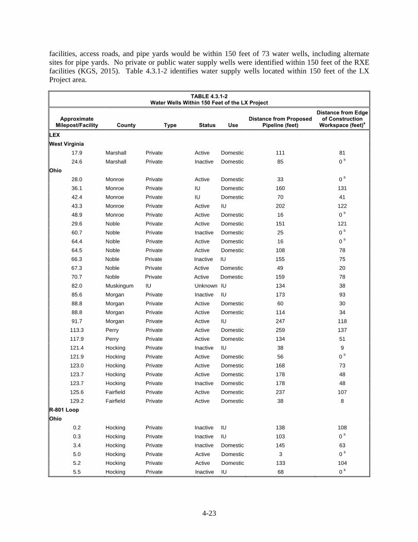
4-23
facilities, access roads, and pipe yards would be within 150 feet of 73 water wells, including alternate sites for pipe yards. No private or public water supply wells were identified within 150 feet of the RXE facilities (KGS, 2015). Table 4.3.1-2 identifies water supply wells located within 150 feet of the LX Project area.
TABLE 4.3.1-2 Water Wells Within 150 Feet of the LX Project
Approximate Milepost/Facility County Type Status Use
Distance from Proposed Pipeline (feet)
Distance from Edge of Construction
Workspace (feet)a
LEX
West Virginia
17.9 Marshall Private Active Domestic 111 81
24.6 Marshall Private Inactive Domestic 85 0 b
Ohio
28.0 Monroe Private Active Domestic 33 0 b
36.1 Monroe Private IU Domestic 160 131
42.4 Monroe Private IU Domestic 70 41
43.3 Monroe Private Active IU 202 122
48.9 Monroe Private Active Domestic 16 0 b
29.6 Noble Private Active Domestic 151 121
60.7 Noble Private Inactive Domestic 25 0 b
64.4 Noble Private Active Domestic 16 0 b
64.5 Noble Private Active Domestic 108 78
66.3 Noble Private Inactive IU 155 75
67.3 Noble Private Active Domestic 49 20
70.7 Noble Private Active Domestic 159 78
82.0 Muskingum IU Unknown IU 134 38
85.6 Morgan Private Inactive IU 173 93
88.8 Morgan Private Active Domestic 60 30
88.8 Morgan Private Active Domestic 114 34
91.7 Morgan Private Active IU 247 118
113.3 Perry Private Active Domestic 259 137
117.9 Perry Private Active Domestic 134 51
121.4 Hocking Private Inactive IU 38 9
121.9 Hocking Private Active Domestic 56 0 b
123.0 Hocking Private Active Domestic 168 73
123.7 Hocking Private Active Domestic 178 48
123.7 Hocking Private Inactive Domestic 178 48
125.6 Fairfield Private Active Domestic 237 107
129.2 Fairfield Private Active Domestic 38 8
R-801 Loop
Ohio
0.2 Hocking Private Inactive IU 138 108
0.3 Hocking Private Inactive IU 103 0 b
3.4 Hocking Private Inactive Domestic 145 63
5.0 Hocking Private Active Domestic 3 0 b
5.2 Hocking Private Active Domestic 133 104
5.5 Hocking Private Inactive IU 68 0 b

4-24
TABLE 4.3.1-2 (cont’d) Water Wells Within 150 Feet of the LX Project
Approximate Milepost/Facility County Type Status Use
Distance from Proposed Pipeline (feet)
Distance from Edge of Construction
Workspace (feet)a
6.4 Hocking Private Inactive Domestic 49 0 b
7.4 Hocking Private Active Domestic 224 144
9.5 Hocking Private Active Public Water Supply
74 0 b
16.6 Vinton Private Inactive Domestic 108 0 b
16.9 Vinton Private Active Domestic 34 5
17.0 Vinton Private Inactive IU 183 104
R-501 Abandonment
4.4 Hocking Private Active IU 87 59
4.4 Hocking Private Unknown Domestic 116 123
5.4 Hocking Private Active Domestic 83 63
5.4 Hocking Private Unknown IU 96 110
Lone Oak Compressor Station, West Virginia
N/A Marshall Private d IU IU N/A 0 b
Crawford Compressor Station, Ohio
N/A Fairfield Private Active Domestic N/A 0 b
N/A Fairfield Columbia owned Active Industrial N/A 0 b
N/A Fairfield Columbia owned Active Industrial N/A 0 b
N/A Fairfield Columbia owned Active Industrial N/A 0 b
N/A Fairfield Columbia owned Active Industrial N/A 0 b
N/A Fairfield Columbia owned Active Industrial N/A 0 b
N/A Fairfield Columbia owned Active Industrial N/A 0 b
N/A Fairfield Columbia owned Active Industrial N/A 0 b
N/A Fairfield Columbia owned Active Industrial N/A 124
Benton Compressor Station, Ohio
N/A Hocking Private (owned by Columbia)
Active Industrial N/A c 0 b
Access Roads and Contractor/Staging/Pipe Yards
LEX
Ohio
Pipe Yard 35 (MP 25.8c)
Monroe Private Inactive IU N/A 0 c
TAR-40 (MP 48.9) Monroe Private Active IU N/A 97
TAR-60 (MP 66.1c) Noble Private Active IU N/A 145
TAR-65 (MP 127.9) Noble Private Active IU N/A 142
Pipe Yard 16 (MP 89.3)
Morgan Private Active IU N/A c 0 b
Pipe Yard 28 (MP 89.2)
Morgan Private Active IU N/A c 43
Pipe Yard 11 (alt) (MP 120.2 c)
Fairfield Private Active Domestic N/A c 0 b
R-801 Loop
TAR-52 (MP 2.4) Hocking Private Active Public N/A 2
TAR-52 (MP 2.4) Hocking Private Active IU N/A 122
TAR-134 (MP 9.4) Hocking Private Inactive Domestic N/A 31
PAR-179 (MP 14.2) Hocking Private Inactive IU N/A 132

4-25
TABLE 4.3.1-2 (cont’d) Water Wells Within 150 Feet of the LX Project
Approximate Milepost/Facility County Type Status Use
Distance from Proposed Pipeline (feet)
Distance from Edge of Construction
Workspace (feet)a
6.4 Hocking Private Inactive Domestic 49 0 b
7.4 Hocking Private Active Domestic 224 144
9.5 Hocking Private Active Public Water Supply
74 0 b
Pipe Yard 41 (MP 0.1) Hocking Private Active IU N/A 99
Pipe Yard 41 (MP 0.1) Hocking Private Active IU N/A 88
TAR-137 (MP 24.1) Vinton Private Active Domestic N/A 20
Pipe Yard 21 (alternate) (MP 22.8c)
Vinton Private Active Domestic N/A 0 b
Pipe Yard 21 (alternate) (MP 22.8)
Vinton Private Active Domestic N/A 51
R-501 Abandonment
TAR-98 (MP 8.9) Hocking Private Active IU N/A 129
TAR-98 (MP 8.9) Hocking Private Active Domestic N/A 125
TAR-113 (MP 23.8) Hocking Private Active Domestic N/A 104
____________________
IU –Information Unavailable N/A –Not Applicable a Distance from the project to the water well is measured from the center point of the well to the edge of the nearest temporary workspace, additional temporary workspace, contractor/staging/pipe yards, access roads, or aboveground facility boundary. b Private water well occurs within the proposed project workspace. c Facility or contractor/staging/pipe yard located offline; milepost provided is associated with nearest workspace boundary. d Water well and associated property on which it occurs were acquired by Columbia Gas for the operation of the proposed
compressor station
Springs are water resources that are formed when flowing groundwater is intersected by a surface
feature, such as a valley, at or below the water table. A full aquifer allows water to flow onto the land surface creating a spring (USGS, 2005). Columbia Gas and Columbia Gulf reviewed publically available resources and data obtained during civil surveys, in addition to landowner interviews, to identify the springs located in the LX and RXE Project area (Beck, 2015). Springs identified in the LX Project area are listed in table 4.3.1-3. No springs were identified in the RXE Project area.
Based on the information in the table below, we have identified the milepost locations where the springs are in the vicinity of the proposed project locations. However, the distances of the spring locations relative to the delineated construction areas in certain areas were unavailable. Distances between the edge of the construction workspace and the identified spring were maximized to the extent possible to prevent impacts on spring hydrology.

4-26
TABLE 4.3.1-3 Springs Along the LX Project Area
Approximate Milepost Distance from Edge of Construction Workspace Begin MP End MP Tract ID County, State
LEX
0.2 0.7 PA-GR-002.000 Greene County, PA 563
4.2 4.3 WV-MA-019A.000 Marshall County, WV IU
4.7 4.7 WV-MA-023B.000 Marshall County, WV IU
7.3 7.4 WV-MA-038A.000 Marshall County, WV IU
31.5 32.0 OH-MO-043.000 Monroe County, OH 30
35.8 36.0 OH-MO-073.00 Monroe County, OH IU
53.3 53.4 OH-NO-001.003 Noble County, OH IU
53.4 53.4 OH-NO-001.004 Noble County, OH IU
53.4 53.6 OH-NO-001.005 Noble County, OH IU
63.8 64.3 OH-NO-158.000 Noble County, OH 1,451
69.6 69.6 OH-NO-255.000 Noble County, OH IU
69.6 70.1 OH-NO-256.000 Noble County, OH IU
79.5 80.3 OH-MU-023.000 Muskingum County, OH IU
81.1 81.3 OH-MU-041.000 Muskingum County, OH 0
86.2 86.7 OH-MN-017.000 Morgan County, OH IU
88.7 89.0 OH-MN-035.000 Monroe County, OH IU
89.0 89.0 OH-MN-037.000 Morgan County, OH IU
90.6 91.2 OH-MN-085.000 Morgan County, OH IU
91.2 91.2 OH-MN-092.000 Morgan County, OH IU
91.2 91.4 OH-MN-091.000 Morgan County, OH IU
93.4 93.8 OH-MN-118.001 Morgan County, OH IU
114.3 114.3 OH-PE-163.000 Perry County, OH IU
114.4 114.5 OH-PE-161.000 Perry County, OH IU
124.5 124.6 OH-HO-053A.000 Hocking County, OH IU
124.6 124.7 OH-HO-054A.000 Hocking County, OH IU
R-801 Loop
4.7 4.8 OH-165-000.000 Hocking County, OH IU
5.0 5.0 OH-HO-175.000 Hocking County, OH IU
6.3 6.6 OH-HO-197.000 Hocking County, OH IU
____________________
IU – Information unavailable
Contaminated Groundwater 4.3.1.5
The LX and RXE Projects and associated facilities would not disturb any sites of known groundwater contamination (Dasher, 2014; PADEP, 2015a, 2015b; Ohio Department of Commerce, 2014; EPA 2015). However, 18 previously leaking underground storage tanks have been identified within 0.5 mile of the project facilities, 12 of which have been successfully remediated and listed as approved (WVDEP, 2016; PADEP, 2015a; Ohio Department of Commerce, 2016). The sources of contamination associated with five of the remaining storage tanks have been cleaned up, but official approval of these remediation activities has not been granted. Clean-up activities for the remaining storage tank has not been initiated; however, no ground disturbance is anticipated as it is located 0.2 mile south of Pipe Yard 26.One of the 18 identified sites occurs within the workspace of Pipe Yard 36, but this area would be used for staging/storing equipment and no ground disturbance in this area is anticipated.
4-27
Columbia Gas has not identified any potential issues relative to contaminated groundwater during construction and operation of the LX and Project facilities. Stop work would occur if Columbia Gas encounters any groundwater with a distinct odor or unusual visual appearance during construction. Appropriate state and federal agencies would be contacted and Columbia Gas would proceed in accordance with federal, state, and local regulations and guidance.
Groundwater General Impact and Mitigation 4.3.1.6
Construction of the pipeline facilities, including aboveground facilities, temporary workspace, access roads, and contractor yards, could potentially affect the overland water flow and recharge of shallow aquifers. The majority of construction activities would involve shallow, temporary, and localized excavation. However, impacts on shallow aquifers could result from construction activities such as vegetative clearing, soil compaction, trench excavation, blasting, and dewatering. These activities would have temporary, minor effects on local vegetation and wetland hydrology.
Clearing
To establish the construction workspace, Columbia Gas would implement clearing and grading techniques. These techniques involve removal of vegetation which would filter water during infiltration and recharge of shallow aquifers. Vegetative clearing would only occur where necessary, and vegetation would be allowed to reestablish after construction in accordance with the FERC Plan and described in Columbia Gas’ ECSs.
Columbia Gas would mark and locate groundwater wells and springs within the project workspace prior to initiating clearing and grading activities. Coordination with the spring or well owner would take place prior to construction to determine appropriate construction measures. An appropriate buffer and construction procedure would be determined around any well or spring encountered during clearing activities. Columbia Gas would provide a temporary source of water to affected individuals and/or compensate for damages or restore the water supply should adverse impacts on a groundwater well or spring result from construction activities.
Trench Excavation and Dewatering
Under standard conditions, Columbia Gas would trench to a depth of approximately 6.5 to 7.0 feet. Trench excavation could temporarily affect perched groundwater from shallow aquifers or confining units near the surface. During excavation, presence of a high water table could require dewatering of the trench. Disturbances to groundwater from trench excavation would likely be negligible since minor disturbances would be highly localized and temporary.
Trenches would not remain open for more than 30 days in any areas unless authorized by the on-site inspector. Trench breakers would reduce water velocity and erosion of the trench bottom. Water pumped from trench or bore pits would be pumped into a heavily vegetated upland area to allow the water to filter back into the ground.
Soil Mixing and Compaction
Improper soil segregation techniques can affect subsurface hydrology and water table elevations during excavation. Soil compaction, due to the passage of heavy machinery, has the potential to alter water tables. Soil mixing and soil compaction typically reduce the absorptive or retentive abilities of soils in aquifer recharge areas, adversely affecting shallow aquifers that rely on precipitation seeping into the ground. Section 4.2.2.3 through section 4.2.2.7 provides additional information related to soil handling.
4-28
Columbia Gas would return soil horizons to near their original state in wetland and agricultural areas by using topsoil and subsoil segregation techniques. This would limit soil compaction to localized areas. Topsoil and subsoils would be tested for compaction at regular intervals in agricultural and residential areas disturbed by construction activities. Decompaction of soils within the project areas, excluding permanent aboveground facility foundations, would take place prior to project completion. Surrounding groundwater resources or groundwater quality would not be significantly affected by soil mixing and compaction.
Fuel Handling and Storage
Spills or leaks of hazardous liquids could potentially result in long-term impacts on groundwater resources, specifically in areas highly susceptible to surface contamination. The type of underlying bedrock, depth to bedrock, depth to the water table, and characteristics of soils and surficial deposits determine groundwater susceptibility to surface contamination.
Fuel storage, equipment refueling, and equipment maintenance have the potential to cause spill-related impacts from the construction of the LX and RXE Projects. Columbia Gas would regulate fuel storage and refueling activities and require immediate cleanup should a spill or leak occur consistent with the SPCC Plan. These measures would avoid or greatly reduce potential impacts resulting from spills and leaks of hazardous liquids. To minimize the potential impacts on groundwater and water wells due to spills or leaks, measures outlined in Columbia Gas’ ECSs in addition to the Plan and Procedures would be implemented such as:
properly training of all project inspectors and contractor personnel;
assigning at least one EI to each of the various project components;
locating fuel storage areas at least 200 feet from active private water wells and at least 400 feet from municipal water wells unless using an operational fuel storage area established on Columbia property;
cleaning-up all spills immediately after a release is contained and ensure immediate action is taken to minimize the impact of the spill, including proper notification to the EI; and
performing regular inspection of all construction equipment to ensure equipment is in good operating order and would travel only on approved access roads.
Blasting
Construction of the LX Project may require blasting in certain designated areas. Section 4.1.2.2 provides specific information regarding blasting and locations of areas designated for blasting. Blasting could affect groundwater quality by temporarily changing groundwater levels and increasing groundwater turbidity near the construction right-of-way. Rock particles and sedimentation would most likely settle out quickly. Alternative construction may be used; however, blasting may achieve the necessary trench depth in areas where alternative techniques are ineffective or inefficient. Columbia Gas has developed an acceptable Blasting Plan to minimize impacts on the surrounding environment resulting from blasting. Columbia Gas would adhere to all applicable federal, state, and local blasting notification requirements. Additional details regarding blasting are outlined in section 4.1.2.2.
Water Supply Well and Spring Testing
Columbia Gas would conduct pre-and post-construction testing of water wells and springs found within 150 feet of the LX Project construction workspace, at the landowner’s request. Columbia Gas would obtain pre-and post-construction samples from each water well and would test for both water quality and quantity parameters. These samples would be tested for concentration of constituents, volatile

4-29
organic compounds, total petroleum hydrocarbons, and compounds used in blasting charges. After sampling events, Columbia Gas would contact the landowner with results. Columbia Gas would compensate the landowner for the repair of the well, installation of a new well, or otherwise arrange for provision of suitable water supplies should significant differences arise in the results of sampling events that cannot be attributed to naturally occurring events.
Groundwater Conclusion 4.3.1.7
Permanent impacts on groundwater are not expected as a result of LX Project construction and operation. Disturbances resulting from construction or operation of the Project would be shallow, temporary and localized excavation. Columbia Gas would employ erosion controls, restore the natural ground contours, and revegetate the right-of-way. Implementation of the Projects’ ECS, SPCC Plan, and the appropriate protective measures of the FERC Plan and Procedures would further reduce impacts on groundwater resources. Temporary, minor, and localized impacts could result during trenching activities in areas of shallow groundwater (less than 10 feet below the ground surface) crossed by the pipeline. The potential for hazardous waste spills poses the greatest impact on groundwater resources in the project area. Columbia Gas’ measures to prevent spills are summarized in the SPCC Plan included in their ECSs. With the implementation of the measures discussed above, the depth of the aquifers, and the relatively shallow nature of construction, we have concluded that construction and operation of the Project would not significantly affect aquifers and groundwater resources.
Surface Water Resources 4.3.2
Existing Surface Water Resources 4.3.2.1
Columbia Gas identified surface water resources in the LX project area during field surveys conducted in the summer and fall of 2014, and spring of 2015. The LX Project would be located within nine watersheds. Watershed descriptions and approximate locations near the LX Project are provided in table 4.3.2-1.
The RXE Project would be located within three watersheds. The Grayson CS would be located within the Lower Stinson Creek – Little Sandy River Watershed (HUC 050901040305). The Means CS would be located within the Headwaters Slate Creek (HUC 051001010701) and Spruce Creek – Slate Creek (HUC 051001010702) watersheds.
Appendix K-1 lists the 1,083 waterbodies that would be crossed by the LX Project and includes the MP location, feature name, waterbody name, state water quality classification, fisheries classification, FERC classification, flow regime, approximate waterbody width, pipeline crossing length, and proposed method of crossing. Table 4.3.2-2 lists the five waterbodies affected by the RXE Project and includes the identification number, waterbody name/description, length, width, flow regime, designated uses, and fishery type.

4-30
TABLE 4.3.2-1
Watersheds Crossed by the LX Project
Facility Milepost/Location County, State Watershed
Pipeline Facilities
LEX 0.0- 24.4 Marshall, WV; Greene, PA Upper Ohio-Wheeling HUC 05030106
24.4 –47.8 Monroe and Noble, OH Little Muskingum-Middle Island HUC 05030201 54.5 RR-7 –59.4
62.9 –72.6
47.8 – 54.5 RR-7 Monroe and Noble, OH Wills HUC 05040005 59.4 – 62.9
72.6 – 107.8 Noble, Muskingum, Morgan, and Perry, OH
Muskingum HUC 05040004 108.0 – 108.1
108.8 – 108.9
107.8 – 108.0 Perry, Fairfield, and Hocking, OH Hocking HUC 05030204 108.1 – 108.8
108.9 – 131.3
LEX1 0.0 – 1.2 Hocking, OH Hocking HUC 05030204
R-801 Loop 0.0 – 6.3 Hocking and Fairfield, OH Hocking HUC 05030204
6.3 – 14.3 Fairfield and Vinton, OH Lower Scioto HUC 05060002
14.2 – 24.2 Vinton, OH Raccoon-Symmes HUC 05090101
BM-111 Loop 0.0 - 0.4 Lawrence, OH Raccoon-Symmes HUC 05090101
0.4 - 2.9 Wayne, OH Twelvepole HUC 05090102
R-501 Abandonment 0.0 - 10.5 Fairfield and Hocking, OH Hocking HUC 05030204
10.5 – 18.3 Hocking and Vinton, OH Lower Scioto HUC 05060002
18.28 - 28.23 Vinton, OH Raccoon-Symmes HUC 05090101
Aboveground Facilities
LEX
LEX launcher facility 0.0 Marshall, WV Upper Ohio-Wheeling HUC 05030106
Lone Oak Compressor Station
7.4 Marshall, WV Upper Ohio-Wheeling HUC 05030106
Summerfield Compressor Station
57.1 Noble, OH Little Muskingum Middle-Island HUC 05030201
Mainline Valves 3.1; 18.6 RR-4 Marshall, WV Upper Ohio-Wheeling HUC 05030106
31.7; 65.6 Monroe and Noble, OH Little Muskingum Middle-Island HUC 05030201
49.3 Monroe, OH Wills HUC 05040005
84.26; 104.2 Muskingum, and Perry, OH
Muskingum HUC 05040004
122.0 Hocking, OH Hocking HUC 05030204
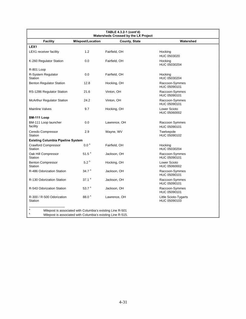
4-31
TABLE 4.3.2-1 (cont’d) Watersheds Crossed by the LX Project
Facility Milepost/Location County, State Watershed
LEX1
LEX1 receiver facility 1.2 Fairfield, OH Hocking HUC 0503020
K-260 Regulator Station 0.0 Fairfield, OH Hocking HUC 05030204
R-801 Loop
R-System Regulator Station
0.0 Fairfield, OH Hocking HUC 05030204
Benton Regulator Station 12.8 Hocking, OH Raccoon-Symmes HUC 05090101
RS-1286 Regulator Station 21.6 Vinton, OH Raccoon-Symmes HUC 05090101
McArthur Regulator Station 24.2 Vinton, OH Raccoon-Symmes HUC 05090101
Mainline Valves 9.7 Hocking, OH Lower Scioto HUC 05060002
BM-111 Loop
BM-111 Loop launcher facility
0.0 Lawrence, OH Raccoon Symmes HUC 05090101
Ceredo Compressor Station
2.9 Wayne, WV Twelvepole HUC 05090102
Existing Columbia Pipeline System
Crawford Compressor Station
0.0 a Fairfield, OH Hocking HUC 05030204
Oak Hill Compressor Station
51.5 a Jackson, OH Raccoon-Symmes HUC 05090101
Benton Compressor Station
5.2 b Hocking, OH Lower Scioto HUC 05060002
R-486 Odorization Station 34.7 a Jackson, OH Raccoon-Symmes HUC 05090101
R-130 Odorization Station 37.1 a Jackson, OH Raccoon-Symmes HUC 05090101
R-543 Odorization Station 53.7 a Jackson, OH Raccoon-Symmes HUC 05090101
R-300 / R-500 Odorization Station
88.0 a Lawrence, OH Little Scioto-Tygarts HUC 05090103
____________________ a Milepost is associated with Columbia’s existing Line R-501 b Milepost is associated with Columbia’s existing Line R-515.

4-32
TABLE 4.3.2-2
Waterbodies Affected by the RXE Project
Waterbody ID Description Length (ft) Width (ft)a Flow Regime
State Designated
Usesb Fishery Type
Grayson Compressor Station - Carter County
S039 Unnamed tributary to Beckwith Branch
603 5 Intermittent PCR, SCR, DWS
WAHc
S040 Unnamed tributary to Beckwith Branch
41 2 Ephemeral PCR, SCR, DWS
WAHc
S041 Unnamed tributary to Beckwith Branch
448 3 Intermittent PCR, SCR, DWS
WAHc
Means Compressor Station – Menifee County
NAd NAd NAd NAd NAd NAd NAd
Means Compressor Station – Montgomery County
S013 Unnamed tributary to the Licking River
816 3 Ephemeral PCR, SCR, DWS
WAHc
S014 Unnamed tributary to the Licking River
528 1 Ephemeral PCR, SCR, DWS
WAHc
____________________ a Crossing width equal to OHWM b Kentucky State Designation of Uses as defined by KAR 10:026. PCR – Primary Contact Recreation SCR – Secondary Contact Recreation DWS – Domestic Water Supply (applicable at existing points of public water supply intake) c Warm Water Aquatic Habitat d NA – Not applicable; no waterbodies located within project boundaries
Pipeline Facilities
Ohio
Pipeline facilities in Ohio would cross 716 minor waterbodies, 65 intermediate waterbodies, and 5 major waterbodies, for a total of 786 crossings. Of these, 388 waterbodies are classified as ephemeral, 279 as intermittent, 112 as perennial, and 7 as open water.
West Virginia
Pipeline facilities in West Virginia would cross 161 minor waterbodies, 14 intermediate waterbodies, and 5 major waterbodies, for a total of 180 crossings. Of these, 78 waterbodies are classified as ephemeral, 67 as intermittent, and 35 as perennial.
Pennsylvania
Pipeline facilities in Pennsylvania would cross 14 minor waterbodies, 3 intermediate waterbodies, and no major waterbodies. Of these, 8 are classified as ephemeral, 5 as intermittent, and 4 waterbodies are classified as perennial.

4-33
Aboveground Facilities
Aboveground facilities would affect seven minor waterbodies in Ohio (five ephemeral and two intermittent) and eight minor waterbodies in West Virginia (five ephemeral and three intermittent) associated with the LX Project. There would be no aboveground facility impacts on waterbodies in Pennsylvania associated with the LX Project. In Kentucky, 5 tributaries could be affected by the RXE Project.
Access Roads
Proposed access roads would cause impacts on 57 minor waterbodies and 9 intermediate waterbodies in Ohio (21 ephemeral, 28 intermittent, and 17 perennial). In West Virginia, proposed access roads would affect seven minor waterbodies (four ephemeral, two intermittent, and one perennial), and one major waterbody (perennial). Access roads would affect one minor/intermittent waterbody in Pennsylvania.
Contractor Yards and Anode Beds
Contractor yards would temporarily affect eight minor waterbodies (five ephemeral and three intermittent) in Ohio. Two manmade ponds (open water) in Ohio are located within the project workspace and are classified as major waterbodies; however, the ponds would be avoided during construction activities. Two minor/ephemeral waterbodies would also be temporarily affected in West Virginia as a result of contractor yards. Contractor yards would not impact waterbodies in Pennsylvania. In addition, one minor/ephemeral waterbody in Ohio and another minor/intermittent waterbody in West Virginia could be affected by anode beds.
Public Watersheds 4.3.2.2
Landowners in Marshall County, West Virginia and Greene County, Pennsylvania rely on groundwater as the primary source of drinking water in the immediate project area. Wayne County, West Virginia uses surface water as the primary source of drinking water. Columbia Gas used publicly available data to identify surface intakes for public water supplies. No surface intakes for public water supplies are located within 3 miles of the project area in Marshall and Wayne Counties, West Virginia, and Greene County, Pennsylvania (Foster, 2015; Seifert, 2015; Lagos, 2015; Farris, 2015; Farley, 2015; Flint, 2015; Williams, 2015; West, 2015; Public Service Commission of West Virginia, 2014; Department of Economic Development for Greene County, 2008).
The WVDHHR established source water protection areas and zones of critical concern surrounding surface water intakes for public water supplies on surface waterbodies that are considered highly susceptible to potential contamination. Zones of critical concern boundaries are drawn according to an estimated 5-hour time of travel of water in streams to the public water supply intake location. WVDEP has further established zones of peripheral concern, which extend beyond the zones of critical concern and are based on an additional 5-hour surface water travel time for a total zone of 10 hours from the public water supply intake location.
The LEX portion of the pipeline crosses the zones of concern and zones of peripheral concern associated with two public water supplies (Covestro public water supply and the Sistersville Municipal Water public water supply). Associated surface water intakes for these two public water supplies are located 5.6 and 18.7 miles, respectively, from the LX Project area (McGee, 2016; Surface, 2016).
Two public water supplies totaling four individual surface water intakes, are located 3 miles downstream of the LX Project area, as shown in table 4.3.2-3 (OEPA, 2014a). Water intakes associated

4-34
with the Woodsfield Village public water supply are located downstream of 18 tributaries crossed by the project in Monroe County, Ohio. Caldwell Lake, in Noble County, Ohio, includes six tributaries crossed by the project. Columbia Gas has agreed to notify the operator of each public waters supply prior to initiating construction activities for the Caldwell Village public water supply and the Woodsfield Village public waters supply (Smith, 2015; Weber, 2015; Robinson, 2015).
The nearest intake for surface water withdrawal associated with the RXE Project in Kentucky would be located on the Little Sandy River. However, this intake would be 4 miles away and is upstream of the proposed Grayson CS. No public water supply intakes were identified within 3 miles of the proposed Means CS.
TABLE 4.3.2-3 Surface Water Intakes for Public Water Supplies Within 3 Miles Downstream of the LX Project
Public Water System Name (Location)
Surface Water Intake Source
Milepost of Tributary Crossed by the Project
Approximate Distance from Project (miles)
LEX
Woodsfield Village (Monroe County, OH)
Woodsfield Reservoir 2 42.7 0.8
Woodsfield Reservoir 1 42.7 1.4
Sunfish Creek 43.5 2.0
43.6 2.0
43.7 2.1
43.8 2.1
44.0 2.2
44.2 2.3
44.4 2.5
44.6 2.6
44.7 2.7
45.2 3.0
Caldwell Village (Noble County, OH)
Caldwell Lake 65.1 0.2
65.2 0.2
65.4 0.2
65.5 0.2
65.7 0.2
65.8 0.3
Water Classifications 4.3.2.3
Section 303(d) of the CWA requires states to identify waters that do not attain their designated use(s) or meet the state water quality standards. Waters that fail to meet their designated beneficial use are considered as impaired and listed under a state’s 303(d) list of impaired waters. According to the EPA, the LX Project would cross a total of 128 waterbodies classified as 303(d) listed impaired waters in West Virginia and Ohio (appendix K-2) (EPA, 2013b). No 303(d) listed impaired waters were identified as being impacted by the RXE Project.
The EPA Water Quality Planning and Management Regulation also requires states to develop a total maximum daily load (TMDL) for those waters (40 CFR 30). TMDLs represent the maximum amount of a given pollutant that a waterbody may contain while still retaining its designated use. The following state-listed regulations are outlined below.

4-35
Ohio
OEPA characterizes waterbodies according to designated use. The Ohio Administrative Code 3745-1 classifies waterbodies as: aquatic life habitat (warmwater, limited warmwater, exceptional warmwater, modified warmwater, seasonal salmonid, coldwater [coldwater habitat, inland trout streams and coldwater habitat, native fauna], and limited resource water [acid mine drainage, small drainage way maintenance, and other specified conditions]), nuisance prevention, water supply (public, agricultural, and industrial), and recreational (bathing waters, primary contact [Class A, Class B, and Class C], and secondary contact).
Kentucky
Kentucky defines six surface water designated uses including warm water aquatic habitat, cold water aquatic habitat, primary contact recreation, secondary contact recreation, domestic water supply, and outstanding source resource waters (Kentucky Administrative Regulations [KAR], 2014a). Title 401 of the KAR provides a list of surface water use designations for waterbodies in Kentucky. Surface waters not identified on the list are designated for the uses of warm water aquatic habitat, primary contact recreation, secondary contact recreation, and domestic water supply.
Pennsylvania
PADEP characterizes surface waters by protected uses according to the Pennsylvania Water Quality Standards (25 Pa. Code §93.4). Aquatic life use includes coldwater fishes, warmwater fishes, migratory fishes, and trout stocking. Water supply use consists of potable water supply, industrial water supply, livestock water supply, wildlife water supply, and irrigation. Recreation and fish consumption use includes boating, fishing, water contact sports, and esthetics. Special protection use characterizes high quality waters and exceptional value waters. Navigation is categorized as other use (PADEP, 2015c).
West Virginia
WVDEP characterizes surface waters by designated use. Under the 47 Code of State Rules 2, surface waters are characterized by designated use:
Category A includes public water supply;
Category B characterizes aquatic life including warmwater fisheries (B1), trout waters (B2), and wetlands (B4);
Category C is water contact recreation;
Category D characterizes agriculture and wildlife uses including irrigation (D1), livestock watering (D2), and wildlife (D3); and
Category E characterizes water supply industrial, water transport, cooling, and power, including water transport (E1), cooling water (E2), power production (E3), and industrial uses (E4) (WVDEP, 2015b).
Waterbodies in West Virginia are further classified according to level of protection required to maintain the water’s designated and/or high quality use (47 CSR 2). Tier 1 surface waters maintain and protect existing uses of a waterbody and the water quality conditions necessary to support such uses. Tier 1 waterbodies include those listed as impaired on the state’s 303(d) list as it pertains to the specific pollutant listed. Surface waters listed as Tier 2 maintain and protect “high quality” waters or waterbodies where the level of water exceeds levels necessary to support recreation and wildlife and the propagation and maintenance of fish and other aquatic life. Waterbodies not listed as impaired on the state’s 303(d)
4-36
list are considered Tier 2 waterbodies. A Tier 3 classification maintains and protects water quality in outstanding national resource waters (WVDEP, 2015b).
Sensitive Waterbodies 4.3.2.4
Sensitive waterbodies include, but are not limited to:
National Wild and Scenic Rivers;
Section 10 Navigable waters;
those listed on the National Park Service’s (NPS) Nationwide Rivers Inventory; and
waterbodies on a state river inventory.
Table 4.3.2-4 lists sensitive surface waters crossed by the LX Project based on water quality parameters. The LX and RXE Projects would not cross any federally listed Wild and Scenic Rivers, West Virginia designated Outstanding National Resource Waters, Ohio designated Scenic Rivers and outstanding state waters, or Pennsylvania-designated Scenic Rivers and special protection waters. We have not identified any sensitive waterbodies in the RXE Project area. The LX Project crosses three high quality streams in Marshall County that have significant importance to WVDEP, as monitoring sites on them have been identified as Reference Sites for use in assessing Aquatic Life Designated use attainment. These sites are used to establish expectations for healthy benthic macroinvertebrate communities in the Western Allegheny Plateau Ecoregion and are French Run (of Grave Creek); Long Run (of Fish Creek); and Henderson Hollow (of Long Run)17.
The LX Project would cross six Ohio-designated superior high quality waters: Piney Fork, Muskingum River, Turkey Run, Hocking River, Queer Creek, and the Ohio River. The LX Project would also cross three Ohio state-designated state resource waters: Little Blackjack Branch, Blackjack Branch, and Elk Fork. Superior high quality waters and state resource waters in Ohio are waterbodies that possess exceptional ecological value. Exceptional ecological value is determined based on the presence of threatened or endangered species or suitable habitat and/or a high level of biological integrity (OEPA, 2014b). Crossings of these waterbodies would comply with requirements under the OEPA’s Section 401 Water Quality Certification.
In West Virginia, the LX Project would cross four West Virginia state-designated high quality waters: Fish Creek, Grave Creek, Ohio River, and Twelvepole Creek (Brooks, 2015). WVDNR recommends trenchless crossing methods during fish spawning season (April 1 to June 30) and dry open-cut crossing methods outside of fish spawning season. Columbia Gas intends to use the dry open-cut construction method for one crossing of Twelvepole Creek and at Grave Creek. Activities associated with crossing West Virginia state-designated high quality waters would be covered under the WVDNR Stream Activity Permits for Marshall and Wayne Counties, West Virginia. Columbia Gas intends to request a waiver from the fish spawning season timing restriction prior to construction. To ensure compliance with agency recommendations and permits, we recommend that:
Prior to construction, Columbia Gas should construct through project waterbodies using the time windows in section V.B.1. of the FERC Procedures, unless expressly permitted in writing by the appropriate state agency that alternate time windows are granted.
17 http://www.dep.wv.gov/WWE/watershed/wqmonitoring/Documents/SOP%20Doc/WABSOP/WABRerence.pdf
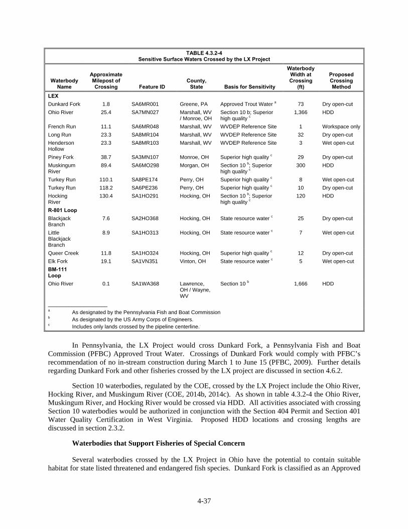
4-37
TABLE 4.3.2-4 Sensitive Surface Waters Crossed by the LX Project
Waterbody Name
Approximate Milepost of Crossing Feature ID
County, State Basis for Sensitivity
Waterbody Width at Crossing
(ft)
Proposed Crossing Method
LEX
Dunkard Fork 1.8 SA6MR001 Greene, PA Approved Trout Water a 73 Dry open-cut
Ohio River 25.4 SA7MN027 Marshall, WV / Monroe, OH
Section 10 b; Superior high quality c
1,366 HDD
French Run 11.1 SA6MR048 Marshall, WV WVDEP Reference Site 1 Workspace only
Long Run 23.3 SA8MR104 Marshall, WV WVDEP Reference Site 32 Dry open-cut
Henderson Hollow
23.3 SA8MR103 Marshall, WV WVDEP Reference Site 3 Wet open-cut
Piney Fork 38.7 SA3MN107 Monroe, OH Superior high quality c 29 Dry open-cut
Muskingum River
89.4 SA6MO298 Morgan, OH Section 10 b; Superior high quality c
300 HDD
Turkey Run 110.1 SA8PE174 Perry, OH Superior high quality c 8 Wet open-cut
Turkey Run 118.2 SA6PE236 Perry, OH Superior high quality c 10 Dry open-cut
Hocking River
130.4 SA1HO291 Hocking, OH Section 10 b; Superior high quality c
120 HDD
R-801 Loop
Blackjack Branch
7.6 SA2HO368 Hocking, OH State resource water c 25 Dry open-cut
Little Blackjack Branch
8.9 SA1HO313 Hocking, OH State resource water c 7 Wet open-cut
Queer Creek 11.8 SA1HO324 Hocking, OH Superior high quality c 12 Dry open-cut
Elk Fork 19.1 SA1VN351 Vinton, OH State resource water c 5 Wet open-cut
BM-111 Loop
Ohio River 0.1 SA1WA368 Lawrence, OH / Wayne, WV
Section 10 b 1,666 HDD
____________________ a As designated by the Pennsylvania Fish and Boat Commission b As designated by the US Army Corps of Engineers. c Includes only lands crossed by the pipeline centerline..
In Pennsylvania, the LX Project would cross Dunkard Fork, a Pennsylvania Fish and Boat
Commission (PFBC) Approved Trout Water. Crossings of Dunkard Fork would comply with PFBC’s recommendation of no in-stream construction during March 1 to June 15 (PFBC, 2009). Further details regarding Dunkard Fork and other fisheries crossed by the LX project are discussed in section 4.6.2.
Section 10 waterbodies, regulated by the COE, crossed by the LX Project include the Ohio River, Hocking River, and Muskingum River (COE, 2014b, 2014c). As shown in table 4.3.2-4 the Ohio River, Muskingum River, and Hocking River would be crossed via HDD. All activities associated with crossing Section 10 waterbodies would be authorized in conjunction with the Section 404 Permit and Section 401 Water Quality Certification in West Virginia. Proposed HDD locations and crossing lengths are discussed in section 2.3.2.
Waterbodies that Support Fisheries of Special Concern
Several waterbodies crossed by the LX Project in Ohio have the potential to contain suitable habitat for state listed threatened and endangered fish species. Dunkard Fork is classified as an Approved
4-38
Trout Water by PFBC. Information regarding fisheries of special concern is discussed further in section 4.6.2.2.
Impaired Streams
The LX Project would cross 128 waterbodies in West Virginia and Ohio that are classified as 303(d) listed impaired waters. These waterbodies are listed in appendix K-2 and indicate the source of impairment for each waterbody. No 303(d) listed impaired waters were identified as being impacted by the RXE Project. Based on consultations with state agencies, no specialized construction procedures are required or recommended for crossing 303(d) impaired waters (Cochran, 2015; Joseph, 2015).
Flood Hazard Zones
The LX Project would cross several FEMA identified flood hazard zones, as shown in table 4.3.2-5. According to FEMA, zones A and AE have a 1 percent annual chance of a flood event. These areas are known as the base flood or 100-year floodplain. The proposed Oak Hill CS suction/discharge lines are partially located within the 100-year floodplain, and the existing Benton CS is entirely located within the 100-year floodplain.
Flash flooding is possible within floodplains during or after large and/or sudden rain events. The LX Project could be impacted by flash floods in areas where the project crosses or is in close proximity to streams or rivers, or that are located within the 100-year floodplain (A and AE zones) mapped by FEMA (2014). Flooding could increase the buoyancy of the pipelines, causing them to rise toward the land surface where they may be exposed. In areas where pipe buoyancy is a concern the pipe would be weighted with concrete coating prior to installation. The Grayson CS associated with the RXE Project occurs within the 100-year floodplain, and the Means CS does not. Columbia Gas’ and Columbia Gulf’s ECSs outline measures to protect from flooding during construction, and all structures would be constructed in accordance with federal and state building codes.

4-39
TABLE 4.3.2-5 Areas Within the 100-year Floodplain Crossed by the LX Project
Facility Begin MP End MP Floodzone
Pipeline Facilities
LEX 21.3 21.3 Zone AE
25.3 RR-5 25.9 RR-5 Zone AE
66.9 67.0 Zone AE
89.4 89.6 Zone AE
89.7 89.7 Zone AE
119.9 120.2 Zone AE
122.1 122.5 Zone AE
123.1 123.6 Zone AE
124.1 124.2 Zone AE
130.2 130.6 Zone AE
130.7 130.7 Zone AE
1.7 1.8 Zone A
16.1 16.1 Zone A
42.0 42.0 Zone A
50.9 RR-6 51.0 RR-6 Zone A
51.0 RR-6 51.1 RR-6 Zone A
61.9 62.0 Zone A
69.3 69.4 Zone A
79.3 79.3 Zone A
79.5 79.7 Zone A
81.6 81.6 Zone A
82.0 82.1 Zone A
102.7 102.8 Zone A
118.1 118.2 Zone A
LEX1 0.8 0.9 Zone AE
R-801 Loop 0.1 0.2 Zone A
BM-111 Loop 0.1 0.4 Zone AE
0.5 0.7 Zone AE
2.5 2.8 Zone AE
R-501 Abandonment 0.0 0.7 Zone AE
1.2 1.2 Zone AE
1.3 3.4 Zone AE
4.2 4.3 Zone A
Aboveground Facilities
Oak Hill Compressor Station Suction/discharge lines
N/A N/A Zone A
Benton Compressor Station N/A N/A Zone A
Crawford Compressor Station regulator and valve facility
N/A N/A Zone AE
____________________
Source: FEMA, 2014
Waterbody Construction Procedures 4.3.2.5
As discussed above, construction of the LX Project would cross 1,083 waterbodies, and 5 waterbodies could be affected by the RXE Project. Columbia Gas and Columbia Gulf would cross all waterbodies according to federal and state-designated timing windows, unless a waiver is granted, as is discussed in section 4.6.2.3. The WVDEP indicates that it does not object to the proposed waterbody

4-40
crossing methods for waterbodies in its state. However, it does recommend that all restoration activities utilize natural stream design techniques.
Columbia Gas would use the open-cut crossing method at the majority of waterbody crossings. Alternate methods, such as dam and pump, and flume, may be used depending on site-specific conditions at the time of construction. Section 2.3.2.2 describes the open-cut crossing method and alternative methods in further detail. In addition, Columbia Gas would use the HDD crossing method at 17 waterbodies using 5 HDDs, as described in section 2.3.2.3.
Waterbodies in 309 locations along the proposed pipeline route would be within construction workspaces, but not crossed by the pipeline (appendix K). Additionally, waterbodies along the proposed pipeline route would have timber matting installed prior to construction. In some waterbodies, Columbia Gas has indicated that existing infrastructure and natural conditions make it impractical to implement crossing methods discussed in Columbia Gas’ ECS and the FERC Procedures. Columbia Gas has identified areas and justifications for additional temporary workspace within 50 feet of waterbodies. These would include hydrostatic water withdrawal in waterbodies, placement of horizontal directional drill boxes near waterbodies, horizontal directional drill stringing areas near waterbodies, placement of excavated soils near waterbodies, road crossings, and the need to provide for safe and efficient construction due to slope conditions. These locations are identified in appendix E. Based on our review, we have determined that the requested modifications are justified. Columbia Gas would follow general and specific construction measures, in addition to following protective measures outlined in the ECS, FERC Plan, and FERC Procedures to minimize impacts on public watersheds and reservoirs.
Hydrostatic Testing 4.3.2.6
To comply with DOT regulations, Columbia Gas and Columbia Gulf would perform hydrostatic testing of the new pipeline segments and aboveground facilities prior to placing them in service. This method involves filling the pipe with water, pressurizing it for a minimum of eight hours, and checking it for pressure losses due to pipeline leakage. Columbia Gas proposes to withdraw approximately 42 million gallons of test water from four local surface waters for pipeline facilities and approximately 1 million gallons of test water from municipal and possible existing water sources for aboveground facilities, as depicted in table 4.3.2-6 and table 4.3.2-7. The RXE Project would use municipal sources for water withdrawals. Columbia Gas and Columbia Gulf would be required to obtain permits from the municipalities for water use prior to withdrawing the water. These permits would confirm that the municipalities have required capacity to supply Columbia Gas with hydrostatic test waters. Therefore, we recommend that:
Prior to the end of the draft EIS comment period, Columbia Gas should provide evidence confirming that the water use capacity requirements can be met by the municipality during hydrostatic testing activates.
Surface waterbodies and municipal water resources would provide water sources for all water withdrawals. Columbia Gas would withdraw water in a manner that would not reduce water flow to a point that would impair flow or impact fisheries and recreational uses. Measures to avoid impacts on local fisheries and aquatic life are discussed in section 4.6.2.3.
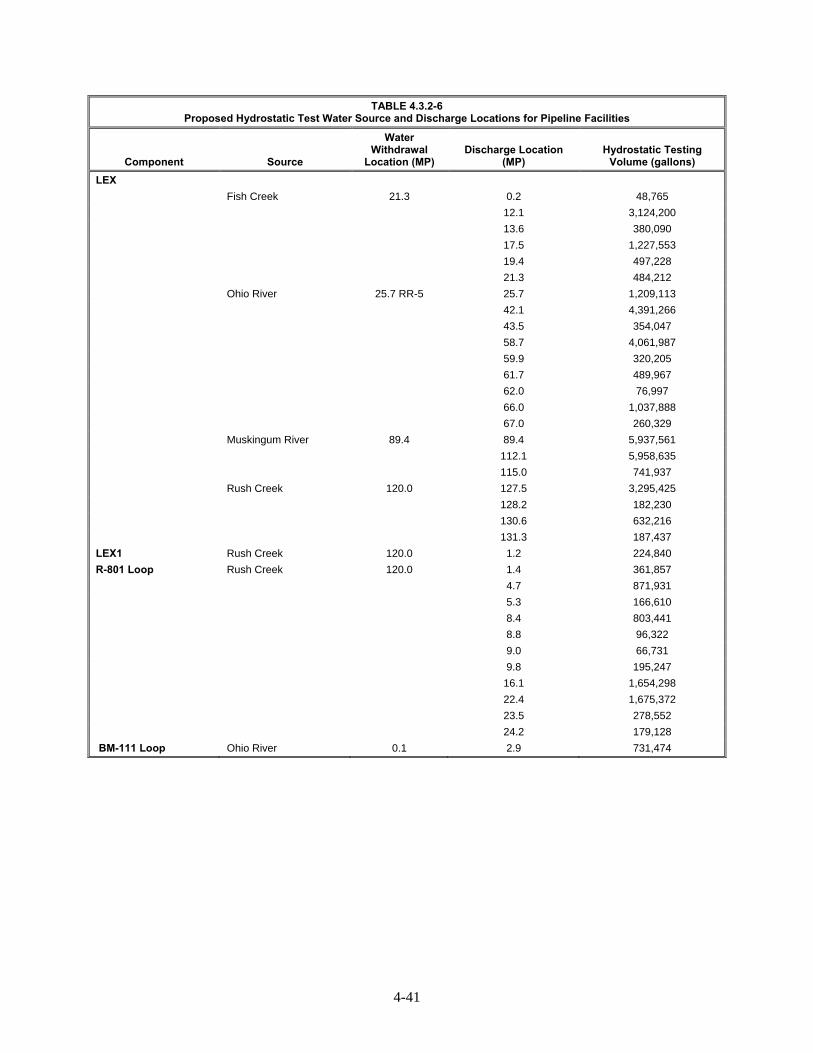
4-41
TABLE 4.3.2-6 Proposed Hydrostatic Test Water Source and Discharge Locations for Pipeline Facilities
Component Source
Water Withdrawal
Location (MP) Discharge Location
(MP) Hydrostatic Testing
Volume (gallons)
LEX
Fish Creek 21.3 0.2 48,765
12.1 3,124,200
13.6 380,090
17.5 1,227,553
19.4 497,228
21.3 484,212
Ohio River 25.7 RR-5 25.7 1,209,113
42.1 4,391,266
43.5 354,047
58.7 4,061,987
59.9 320,205
61.7 489,967
62.0 76,997
66.0 1,037,888
67.0 260,329
Muskingum River 89.4 89.4 5,937,561
112.1 5,958,635
115.0 741,937
Rush Creek 120.0 127.5 3,295,425
128.2 182,230
130.6 632,216
131.3 187,437
LEX1 Rush Creek 120.0 1.2 224,840
R-801 Loop Rush Creek 120.0 1.4 361,857
4.7 871,931
5.3 166,610
8.4 803,441
8.8 96,322
9.0 66,731
9.8 195,247
16.1 1,654,298
22.4 1,675,372
23.5 278,552
24.2 179,128
BM-111 Loop Ohio River 0.1 2.9 731,474

4-42
TABLE 4.3.2-7 Proposed Hydrostatic Test Water Source and Discharge Locations for Aboveground Facilities
Component Source Water Withdrawal
Location (MP) On-Site Discharge
Location (MP) Hydrostatic Testing
Volume (gallons)
LEX
Lone Oak Compressor Station Municipal N/A On-site (7.4) 265,184
Summerfield Compressor Station Municipal N/A On-site (57.1) 68,932
Launcher and Receiver Facilities Various N/A Various 21,388
Mainline Valves Various N/A Various 11,909
LEX1
K-260 Regulator Station Municipal N/A On-site (0.0) 14,349
Launcher and Receiver Facilities Various N/A Various 7,426
R-801 Loop
R-System Regulator Station Municipal N/A On-site (0.0) 26,357
Benton Regulator Station Municipal N/A On-site (12.8) 1,526
RS-1286 Regulator Station Municipal N/A On-site (21.6) 95
McArthur Regulator Station Municipal N/A On-site (24.2) 62,248
Launcher and Receiver Facilities Various N/A Various 16,041
Mainline Valves Various N/A Various 1,701
BM-111 Loop
Ceredo Compressor Station Possible Existing Water System
2.8 On-site (2.9) 386,041
Launcher and Receiver Facilities Various N/A Various 10,694
Existing Columbia Pipeline System
Crawford Compressor Station Existing Water System
0.0 b On-site (0.0 b) 23,605
Benton Compressor Station Bypass Municipal N/A On-site (5.2 c) 5,569
Oak Hill Compressor Station Municipal N/A On-site (51.5 b) 336,371
____________________ a Distance is measured from the pipeline centerline. b Milepost is associated with Columbia’s existing Line R-515.
Following testing and after depressurization of the section, water would pass through an energy-dissipating device prior to release into a well-vegetated, upland area or discharged into a truck and hauled to a separate disposal location. This would minimize the potential for erosion and is in accordance with the FERC Procedures. No significant water quality impacts are anticipated as a result of the withdrawal and discharge from hydrostatic testing. Columbia Gas and Columbia Gulf would construct project facilities with new steel pipe free from chemicals and lubricants. Water withdrawal and discharge would follow all applicable federal, state, and local permit requirements.
General Impacts and Mitigation 4.3.2.7
Construction of pipeline facilities would likely result in minor, temporary impacts on surface waterbodies crossed. Various crossing methods, such as wet open-cut and HDD, would limit impacts to surface waterbodies. Dry open-cut methods could be used if there is adequate flow at the time of crossing.

4-43
In-stream construction activities or construction activities along banks and slopes adjacent to the waterbody could cause impacts on nearby waterbodies and aquatic resources. These activities include trenching; trench dewatering; backfilling; and operation, storage, or refueling of heavy machinery. Potential impacts on surface water resources include modification of aquatic habitat, increased sedimentation and turbidity, decreased dissolved oxygen concentrations, inadvertent release of chemical and nutrient pollutants from sediments, and introduction of chemical contaminants such as fuel or lubricants. To limit sedimentation and turbidity, stream bank disturbance, and duration of in-stream construction, Columbia Gas and Columbia Gulf would conduct construction activities at stream crossing during low-flow periods.
Only minimal permanent impacts on waterbodies are anticipated as a result of construction and operation of the LX Project. Approximately 63 feet of one minor, intermittent waterbody would be permanently filled as a result of modifications within the existing Ceredo CS. Additionally, five streams would be permanently impacted by the construction of new or replacement of existing permanent culvers along three proposed permanent access roads. A new permanent culvert would also be constructed within an ephemeral waterbody of the Oak Hill CS tie-in facility. Restoration of waterbodies to previous physical conditions or better would occur following construction. During operation, Columbia Gas would work cooperatively with appropriate government agencies in an effort to minimize impacts of permanent easement maintenance in waterbodies. Specific impacts from construction activities and the proposed mitigation measures are discussed further below.
Stream Bank Erosion
Clearing and grading of vegetation during construction could increase the potential for erosion along stream banks. Movement of heavy equipment in the construction area could increase soil compaction which could accelerate erosion and transportation of sediment into waterbodies. When necessary and where possible, Columbia Gas would use equipment bridges, mats, and pads to minimize erosion and soil compaction impacts on stream banks. Measures outlined in Columbia Gas’ ECS as well as the FERC Procedures would be implemented to further reduce impacts. After construction, Columbia Gas would restore vegetated areas disturbed by construction to pre-construction conditions and install temporary or permanent erosion control devices to protect from future erosion.
Turbidity and Sedimentation
Increased turbidity and sedimentation in surface waters could result from in-stream construction activities, trench dewatering, and stormwater runoff. Increases in suspended sediments could raise the biochemical oxygen demand, thereby reducing levels of dissolved oxygen in localized areas. Increases in suspended sediments also have the potential to temporarily alter chemical and physical characteristics of the water column, such as color and clarity. Measures to avoid impacts on local fisheries and aquatic life due to increased turbidity and sedimentation are discussed in section 4.6.2.3.
Movement of construction equipment and vehicular traffic across waterbodies could increase turbidity and sedimentation impacts on waterbodies. To minimize this impact, Columbia Gas would install temporary equipment bridges for access along the construction right-of-way. Equipment bridges, such as timber mats or portable prefabricated bridges, would be designed to accommodate normal to high stream flow. Maintenance of equipment bridges would prevent restriction of water flow during construction.

4-44
During construction, sedimentation from spoil has the potential to enter the waterbody. To further minimize impacts resulting from sedimentation, Columbia Gas would install silt fence and/or filter socks to border spoil piles near waterbodies. After placement of the pipe, excavated material would be immediately replaced and stream banks and stream beds would be restored to pre-construction contours to the maximum extent practicable. To minimize impacts, Columbia Gas would limit in-stream construction activities to 24 to 48 hours. Revegetation along stream banks and riparian areas would occur in accordance with the FERC Plan and Procedures and Columbia Gas’ ECS.
Trench Dewatering
Water from groundwater seepage or precipitation may accumulate in open trenches during construction. If this occurs, accumulated water would be pumped into vegetated upland areas, away from nearby waterbodies. In order to reduce impacts on waterbodies resulting from runoff and trench dewatering, water pumped out of trenches would be discharged through hay/straw bale structures and/or filter bags.
Potential Spills
Spills of fuels, lubricants, or solvents could contaminate surface waters. To minimize or avoid the potential hazard, proper storage, containment, and handling procedures would be implemented, as outlined in Columbia Gas’ SPCC Plan. The Plan includes the actions to be taken should a spill occur. These measures are similar to groundwater fuel handling and storage impacts detailed above (section 4.3.1.7).
To further prevent the risk of spills, Columbia Gas would follow measures outlined in the FERC Procedures. Hazardous materials, chemicals, lubricating oils, and fuels used during construction would be stored no less than 100 feet from surface waterbodies and heavy equipment refueling or parking would occur at least 100 feet from surface waterbodies. Extra precautions include continual monitoring of fuel transfer, secondary containment structures, and use of spill kit readiness.
Contaminant Suspension and Mitigation
Rural and urban areas have the potential to contribute to sediment contamination. Contamination from rural areas includes agricultural fields containing fertilizers and pesticides and leachate from feed lots and sanitary fields. Urban area contamination includes stormwater runoff, wastewater discharges, erosion, or leachate from industrial sites such as textiles, petroleum refining, wastewater treatment plants, and landfills. Project construction has the potential to disturb and suspend existing sediments in surface waterbodies. This would temporarily degrade water quality and redistribute contaminants downstream, potentially affecting aquatic and benthic species and downstream uses.
Disturbed workspaces have the potential to release sediment into the stream. Columbia Gas would install erosion control devices, such as temporary diversion or silt fences. After pipeline installation, breakers installed would allow the restriction of water flow between excavated trenches and waterbodies. Once in-stream construction and restoration is complete, Columbia Gas would remove surplus materials and equipment. All trash, litter, and debris would be collected for disposal in an approved solid waste disposal facility.
The LX Project has the potential to impact sensitive, contaminated, or public use waterbodies such as 303(d) listed waterbodies, DWSPAs, Dunkard Fork (Approved Trout Water), and Ohio’s superior high quality waters and state resources. As detailed in the ECS, Columbia Gas would use best management practices to minimize impacts on these waterbodies. Construction of the project facilities at all stream crossings would follow BMPs developed in accordance with requirements and
4-45
recommendations from the OEPA, PADEP, and WVDEP. BMPs would be developed specifically for Dunkard Fork in a Project specific Erosion and Sedimentation Control Plan, which would be developed in accordance with PADEP, and the Greene County Conservation District as described in Section 4.2.2.5, would minimize impacts on this waterbody. Columbia Gas would perform in-stream construction activities outside of the March 1 to June 15 window. The LX Project would likely not affect any sensitive, contaminated, or public use waterbodies.
The LX Project would cross Section 10 waterbodies, which are navigable rivers, including the Ohio River, Muskingum River, and Hocking River. These waterbodies are covered under a Section 10 permit, obtained in conjunction with the 404 and permits and 401 Certification. Columbia Gas would cross these rivers via HDD, thereby avoiding direct impacts. Use of methods outlined in Columbia Gas’ ECS and the protective measures in the FERC Procedures, as well as BMPs included in the site-specific construction and mitigation plans for each major waterbody crossing, would minimize impacts on the Ohio River, Muskingum River, and Hocking River.
Hydrostatic Test Water Withdrawal and Discharge
New steel pipe free of chemicals or lubricants would be used to construct the LX Project facilities. Control measures would be implemented to avoid the introduction and/or spread of aquatic invasive species. As per recommendations from WVDEP, water withdrawn from the Ohio River would either discharge back into the Ohio River or undergo treatment with a WVDEP-recommended biocide prior to discharge. Excluding potential WVDEP-recommended biocides, additives would not be added to the hydrostatic test water. Due to these measures, in addition to following measures in the Procedures, hydrostatic test water withdrawal would not likely significantly affect water resources.
Surface Water Conclusions 4.3.2.8
No long-term impacts are anticipated on waterbodies as a result of construction of the LX Project. Columbia Gas would not permanently affect the designated water uses by burying the pipeline beneath the bed of all waterbodies, implementing erosion and sedimentation controls, and restoring streambanks and streambed contours as close as practical to pre-construction conditions. Additional measures outlined in the ECS would aid in the effective avoidance or minimization of impacts on surface waterbodies. Impacts associated with hydrostatic testing on public and municipal water supplies would be minimized through control measures established by Columbia Gas in accordance with state recommendations. Accidental spills during construction and operation would be avoided through implementation of the SPCC Plan. Due to the measures discussed above, we conclude impacts on waterbodies would be adequately minimized during construction of the LX Project.
Operation of the LX Project would likely result in minimal impacts on waterbodies as streams would be restored to pre-construction conditions. Columbia Gas would also minimize impacts of permanent easement maintenance by working cooperatively with appropriate agencies. Therefore, we conclude that operation of the project would have minimal impacts on waterbodies.
Based on the avoidance and minimization measures described above including measures outlined in the project-specific ECS, as well as our recommendations, we conclude that construction and operation of the project would not have any significant impacts on surface water resources.

4-46
4.4 WETLANDS
Wetlands are areas that are permanently inundated or saturated by surface groundwater at a frequency and duration sufficient to support hydric vegetation and soils (Cowardin et al., 1979). Examples of wetlands include swamps, marshes, and bogs. Wetlands provide food and habitat for wildlife, as well as serving many other important biological, physical, and chemical functions.
In the LX and RXE Project areas, wetlands are regulated at the federal (COE) and state (ODNR, PADEP, WVDNR, WVDEP, and KYDEP) levels. The COE regulates discharge of fill or dredge material into waters of the United States, such as wetlands, under Section 404 of the CWA. Section 401 of the CWA requires states to certify that proposed dredging or filling of waters of the United States meets state water quality standards.
Existing Wetland Resources 4.4.1
For the LX Project, Columbia Gas identified and delineated wetlands along the project area during field surveys in 2014 and 2015. Wetlands boundaries were determined and delineated using the methods described in the Regional Supplement to the Corps of Engineers Wetland Delineation Manual: Eastern Mountains and Piedmont Region (Version 2.0) (COE, 2012) and routine determination guidelines provided in the COE Wetland Delineation Manual (Technical Report Y-87-1) (COE, 1987). Wetlands crossed or otherwise affected by the LX Project are listed in appendix L. For areas where Columbia Gas was denied survey access, publicly available NWI mapping was used to approximate the locations and boundaries of wetlands within the project area. Columbia Gas used a survey corridor of 400 feet centered on the proposed centerline, except when co-located with another pipeline. In this situation, Columbia Gas surveyed 50 feet on the co-located side of the centerline and 350 feet on the workspace side of the centerline. A 100-foot-wide survey corridor was centered on proposed access roads. Additional information on the existing conditions of wetlands surveyed is available in Resource Reports and permitting conducted with cooperating agencies in FERC Docket No. CP15-514-000.
Wetland Types 4.4.1.1
Wetland types are categorized based on the NWI classification hierarchy described by Cowardin et al. (1979). Wetlands in the LX Project area are classified as palustrine (freshwater wetland) and are defined by the dominant vegetative layer present (forested, scrub-shrub, emergent) as described below.
Palustrine forested (PFO) wetlands are dominated by trees and shrubs at least 20 feet in height with no more than 30 percent canopy cover. Forested wetlands contain a heavy overstory with a diverse, dense understory of woody and herbaceous species. Tree species identified in the LX Project area include pin oak, black willow, green ash, and red maple.
Palustrine scrub-shrub (PSS) wetlands contain greater than 30 percent cover of woody vegetation less than 20 feet in height (Cowardin et al., 1979). Species identified in the LX Project area of PSS wetlands include black willow, green ash, buttonbush, and jewelweed. Palustrine emergent (PEM) wetlands are characterized by non-woody vegetation conditioned to grow in wet soils. Common species located in the LX Project area of PEM wetlands include rice cut grass, reed canary grass, green bulrush, deertongue, and shallow sedge.
Columbia Gas submitted a district-specific wetland report to the Pittsburgh District COE and the Huntington District COE in November 2015. Of the 3,208.7-acre survey area, a total of 22.4 acres of wetlands are in the Pittsburgh District. Within the 7,461.3-acre survey area within the Huntington District, 115.2 acres of wetlands were identified. Appendix L identifies the feature ID, location,

4-47
hydrologic unit code, NWI classification, crossing method, crossing length, and acreage of each wetland that the LX Project would affect.
For the RXE Project, Columbia Gulf identified one wetland within the survey area at the Means CS site. However, this wetland is not within the proposed workspace and would not be impacted. No wetlands were identified at the Grayson CS site.
Construction of pipeline facilities would affect 15.2 acres of wetlands with 1.3 acres of operational impacts. This includes 13.8 acres of wetlands in Ohio, 1.3 acres of wetlands in West Virginia, and 0.1 acre of wetlands in Pennsylvania that would be affected during construction.
Construction of the Benton Regulator Station along the R-801 Loop would temporarily affect less than 0.1 acre of one PEM wetland. Construction of the Benton CS would temporarily affect 0.2 acre of PEM wetland. The Lone Oak CS in West Virginia would result in the temporary loss of 0.2 acre of PEM wetland impacts during construction.
Although several wetlands would occur within contractor yards as indicated in appendix L, all wetlands would be avoided during construction; therefore, no impacts to wetlands are anticipated as a result of contractor yards.
Construction of LX Project access roads would temporarily affect 23 wetlands for a total of 0.5 acre affected. Access roads associated with LEX would affect 16 wetlands for a total of 0.2 acre, access roads associated with the R-801 Loop would affect one wetland with less than 0.1 acre, and access roads associated with R-501 Abandonment would affect 6 wetlands for a total of 0.2 acre. Temporary access roads would be used during the construction phase of the project. Permanent access roads have been designed to avoid direct impacts on wetlands
Wetland Construction Procedures 4.4.2
A total of 301wetlands would be affected by the LX Project, described in appendix L. In Ohio, the LX Project, including aboveground facilities, access roads, and contractor yards, would cross 257 wetlands, including 20 forested, 21 scrub-shrub, and 216 emergent wetlands. In West Virginia, the LX Project would cross 32 wetlands, including 6 forested, 1 scrub-shrub, and 32 emergent wetlands. The LX Project would cross five emergent wetlands in Pennsylvania.
In the RXE Project area, Columbia Gulf delineated one emergent wetland within the 64-acre survey area at the Means CS site, but this wetland is located approximately 300 feet away from the workspace and would not be affected by the Project. No wetlands were delineated at the Grayson CS site. We do not anticipate temporary or permanent impacts to wetlands during construction or operation of the aboveground facilities at either compressor station site; however, Columbia Gas and Columbia Gulf would employ measures outlined in their ECSs to protect potential downstream wetlands.
Columbia Gas would use conventional pipeline construction methods to cross wetlands in the LX Project area. Soil stability and saturation at the time of construction determines the type of crossing method used. Construction through unsaturated wetlands would be similar to construction through upland areas. Primary measures to minimize impacts on wetlands include:
segregating topsoil over the trenchline in unsaturated wetlands;
restoring wetland contours to original conditions; and
conducting post-construction monitoring to ensure proper wetland restoration.
In areas of saturated wetlands, Columbia Gas would install temporary work surfaces of timber or travel pads adjacent to the pipeline trench. Appropriately stabilized wetlands may be used for

4-48
construction right-of-way access. When the wetland cannot be appropriately stabilized, access roads in upland areas would be used for all construction equipment that is not needed to install the wetland crossing. In some areas of inundated lowland or saturated wetland areas, installation of the pipe would float through an open trench via the push/float method. This would limit the need for grubbing and grading activities over the trench line or working side of the construction right-of-way.
Use of low-ground-weight construction equipment would prevent mixing of topsoil and subsoil or rutting from equipment. An alternative method includes using timber matting, in good condition, for equipment crossing. All equipment mats and timber matting would be removed during restoration of the wetland. Columbia would not use tree stumps, rock, gravel, or soil imported from outside the wetland or brush to stabilize the construction workspace or as equipment pads in wetlands.
A 50-foot distance would separate the wetland edge and staging areas, except where the adjacent upland consists of actively cultivated or rotated cropland or other disturbed land. This distance would be limited to the minimum necessary to construct the crossing. If topographic conditions do not allow a 50-foot setback, at least 10 feet must separate the area from the wetland edge, with prior approval from the EI.
Some construction through wetlands for temporary access roads are anticipated. Erosion control devices, such as matting would be used to protect wetlands. Access roads that traverse through wetlands would require FERC approval and state permitting authorization prior to construction.
Necessity of blasting in wetlands would be determined during pre-planning of crossing wetlands with standing water or saturated soils. Inconclusive evaluations would require testing of wetlands for consolidated rock prior to trenching. If the wetland contains consolidated rock, Columbia Gas would follow measures outlined in their Blasting Plan, as discussed in section 4.1.2.2.
Water removed during trench dewatering would be filtered and discharged through a sediment trap and/or filter bag and/or a series of terra tubes, sediment logs or flocculent logs or into a heavily vegetated area outside the wetland. This would prevent heavily silt-laden water from entering directly into a wetland. The dewatering structure would be removed as soon as possible after completion of dewatering activities. Backfill would consist of spoil from the trench. After backfilling, the conserved topsoil layer would be returned to the surface and sediment filter devices would be promptly installed.
To prevent alteration in wetland hydrology, trench line barriers would be installed and/or Columbia Gas would seal the trench bottom as necessary. Columbia Gas would install permanent interceptor diversion and trench line barriers at the base of the slopes near the boundary between the wetland and adjacent upland areas. Trench barriers would be located immediately upslope of the interceptor diversion.
General Impacts and Mitigation 4.4.3
Table 4.4.3-1 and table 4.4.3-2 below summarize impacts of the proposed LX Project on wetlands. Construction would affect a total of 15.2 acres of wetlands. This includes about 1.4 acres of forested wetlands, 0.8 acre of scrub-shrub wetlands, and 12.9 acres of emergent wetlands.

4-49
TABLE 4.4.3-1 Summary of Wetlands Resources Impacted by the LX Project Pipeline Facilities
State Wetland
Typea
Number of Wetlands Impacted
Construction Impacts (acres)
10-foot Right-of-way Operational Impacts
(acres)b
30-foot Right-of-way Operation Impacts
(acres)c
LEX
West Virginia PEM 26 1.1 0.0 0.0
PSS 1 <0.1 <0.1 <0.1
PFO 2 0.1 <0.1 0.1
Pennsylvania PEM 3 0.1 0.0 0.0
Ohio PEM 181 11.0 0.0 0.0
PSS 18 0.7 0.1 0.1
PFO 20 1.2 0.2 0.7
LEX Subtotal 251 14.3 0.4 0.9
LEX1
Ohio PEM 1 <0.1 0.0 0.0
PSS 1 0.1 0.0 0.0
LEX1 Subtotal 2 0.1 0.0 0.0
R-801 Loop
Ohio PEM 14 0.7 0.0 0.0
R-801 Loop Subtotal 14 0.7 0.0 0.0
BM-111 Loop
West Virginia PEM 2 <0.1 0.0 0.0
PFO 3 0.1 <0.1 0.1
BM-111 Loop Subtotal 5 0.1 <0.1 0.1
R-501 Abandonment
Ohio PEM 2 0.1 0.0 0.0
R-501 Abandonment Subtotal 2 0.1 0.0 0.0
Pipeline Facilities Total 274 15.2 0.4 1.0
____________________ a Cowardin Wetland Types: PEM - Palustrine emergent; PSS - Palustrine shrub-scrub; PFO - Palustrine forested b Operational impacts in this column are based on a 10-foot-wide area in PFO and PSS wetlands that would be converted
to other wetland types due to pipeline maintenance. c Operation impacts in this column are based on a 10-foot-wide operation impact on PSS wetlands that would be
converted to herbaceous wetlands due to pipeline maintenance. Operation impacts on PFO in this column reflect potential for selective thinning of trees within 15 feet of the pipeline that have roots that could compromise the integrity of the pipeline coating.

4-50
TABLE 4.4.3-2 Summary of Wetlands Resources Impacted by the LX Project Aboveground Facilities, Access Roads, and Contractor
Yards
State Wetland Typea Number of Wetlands
Impacted Construction
Impacts (acres) Operational
Impacts (acres)b
Aboveground Facilities
Lone Oak Compressor Station
West Virginia PEM 2 0.2 0.0
Lone Oak Compressor Station Subtotal
2 0.2 0.0
Benton Regulator Station
Ohio PEM 1 <0.1 0.0
Benton Regulator Station Subtotal 1 <0.1 0.0
Benton Compressor Station
Ohio PEM 1 0.2 0.0
Benton Compressor Station Subtotal 1 0.2 0.0
Aboveground Facilities Total 4 0.4 0.0
Access Roads
LEX
West Virginia PEM 2 0.0 0.0
PFO 1 <0.1 0.0
Pennsylvania PEM 2 0.0 0.0
Ohio PEM 9 0.2 0.0
PSS 2 <0.1 0.0
PFO 0 0.0 0.0
LEX Subtotal 16 0.2 0.0
R-801 Loop
Ohio PEM 1 0.0 <0.1
R-801 Loop Subtotal 1 0.0 <0.1
R-501 Abandonment
Ohio R-501 Abandonment Subtotal
PEM 6 0.2 0.0
6 0.2 0.0
Access Roads Total 23 0.5 <0.1
Contractor Yardsc
TOTAL 27
____________________ a Cowardin Wetland Types: PEM - Palustrine emergent; PSS - Palustrine shrub-scrub; PFO - Palustrine forested b Operation impacts in this column reflect permanent wetland loss due to fill. c Several wetlands occur within contractor/staging/pipe yards; however, all wetlands would be avoided during
construction, and no impacts are anticipated.
The effects of construction in wetlands would be greatest during and immediately following
construction. The primary impact of construction would be the temporary removal or alteration of wetland vegetation. In emergent wetlands, the impact of construction would be relatively short term because herbaceous vegetation would regenerate quickly. In forested wetlands, the impact from construction would be temporary but long-term and may take 20 years or longer for the wetland forests on the temporary right-of-way to regenerate. Other impacts that could result from construction include temporary changes to wetland hydrology and water quality. Removal of wetland vegetation during construction would alter the capacity of wetlands to function as suitable habitat or as flood and erosion control buffers. The temporary stockpiling of soil and movement of equipment in wetlands could also compact and furrow wetland soils, which could alter the natural hydrologic patterns, inhibit seed germination, or increase seedling mortality. As mentioned above, Columbia Gulf does not anticipate

4-51
temporary or permanent impacts to wetlands during construction or operation of the aboveground facilities associated with the RXE Project.
Operation of the LX Project would result in the permanent conversion of 0.2 acre of PEM wetlands to industrial use for the life of the Lone Oak CS and would require mitigation on federal and state levels. For operation of the pipeline, Columbia Gas would maintain a 10-foot-wide cleared right-of-way along the center of the pipeline. Selective tree removal would occur within a 30-foot-wide corridor where trees exist that could affect the integrity of the pipeline in scrub-shrub and forested wetland areas. This maintenance would periodically disturb wetland vegetation but would not significantly affect wetland ecological functions such as sediment/toxicant retention, nutrient removal/transformation, flood attenuation, groundwater recharge/discharge, and wildlife habitat. About 1.1 acre of forested wetlands would be converted permanently to emergent or scrub-shrub wetlands for the operation of the LX Project.
To minimize impacts on wetlands, Columbia Gas would place erosion controls along the downslope edge of the construction right-of-way and surrounding additional temporary workspace. Frequent maintenance of these erosion controls would limit disturbed soils and sediment from entering undisturbed wetland areas. To minimize long-term sedimentation in wetland areas, permanent erosion controls (terraces, interceptor diversion devices, riprap, and vegetative cover) would be placed on adjacent upland areas.
Inadvertent mixing of topsoil and subsoil can lead to altered soil characteristics. Columbia Gas would remove and conserve topsoil from directly over the trench to prevent topsoil mixing in unsaturated wetlands.
Columbia Gas would minimize compaction by using low ground pressure equipment. Construction activities may also temporarily install timber equipment mats to lower compaction potential. To further reduce the potential for compaction, topsoil would be segregated in unsaturated wetland features. During restoration, frequent testing of soils would occur to assess compaction. Columbia Gas would decompact soils as necessary within the travel lane of the construction right-of-way.
Potential spills during construction could impact and contaminate wetlands found in the LX Project area. To minimize this risk, at least 100 feet would be maintained between wetland boundaries and hazardous materials, chemicals, lubricating oils, and fuels during construction. Parked equipment and refueling would occur at least 100 feet away from wetland boundaries. Columbia Gas would implement continual monitoring of fuel transfer, secondary containment structures, use of spill kit readiness, and other extra precautions if necessary.
Installation and operation of the pipeline has the potential to divert drainage and blockage of water through a wetland, creating long-term impacts on wetland habitat type and quality. In order to maintain the hydrologic characteristic of the wetland, cross-drainage would be used in areas where permanent changes in surface and subsurface hydrology could occur. Columbia Gas would install trench plugs at the entrance and exit of the pipeline to prevent wetland drainage along the pipeline. Breached confining layers would be restored during backfilling, as applicable. All contours would be restored to pre-construction levels.
Columbia Gas is continuing to consult with the corresponding agencies to determine the appropriate mitigation and compensation for wetland impacts, as further discussed in section 4.4.5. Restoration of wetland areas would be monitored for three years following construction. Successful revegetation would occur if native vegetative cover is at least 80 percent of the total area. If revegetation is unsuccessful, a remedial vegetation plan would be developed and implemented per the FERC Procedures.
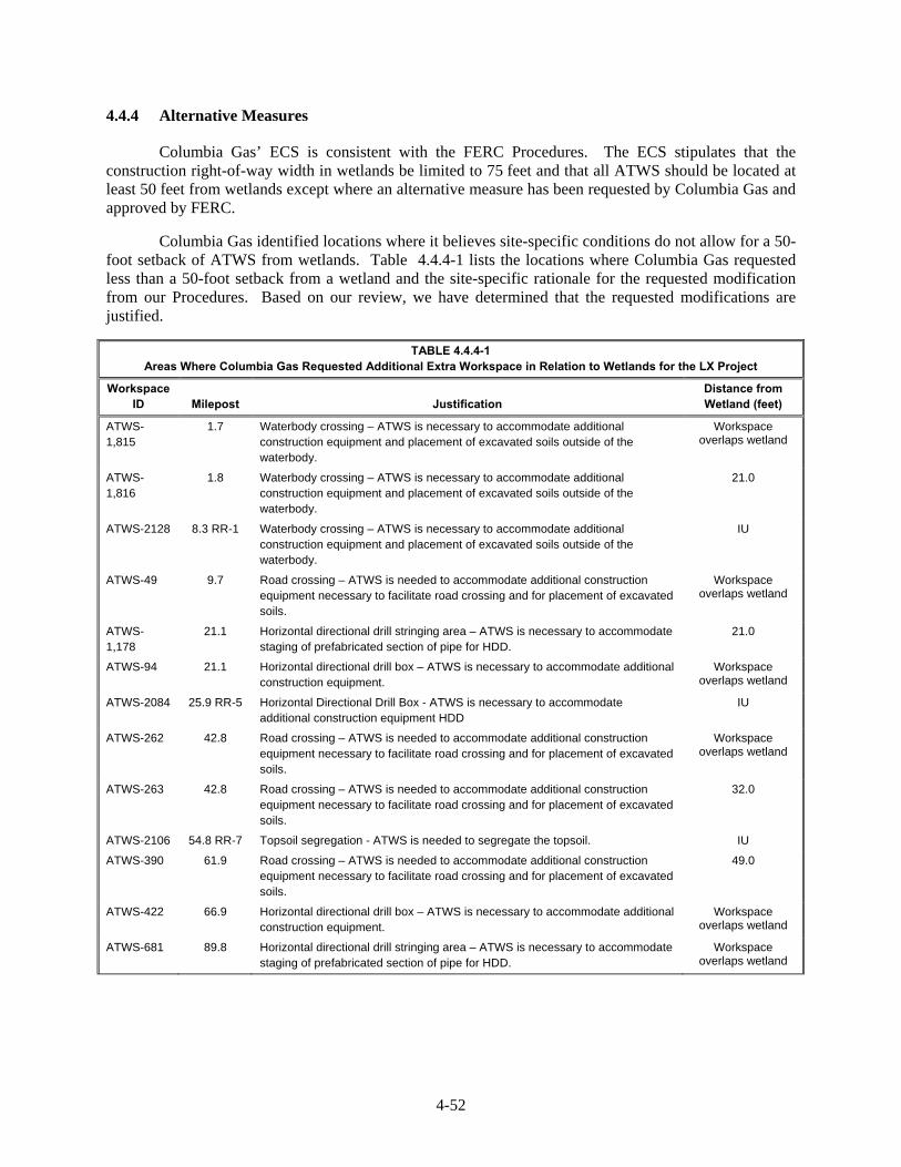
4-52
Alternative Measures 4.4.4
Columbia Gas’ ECS is consistent with the FERC Procedures. The ECS stipulates that the construction right-of-way width in wetlands be limited to 75 feet and that all ATWS should be located at least 50 feet from wetlands except where an alternative measure has been requested by Columbia Gas and approved by FERC.
Columbia Gas identified locations where it believes site-specific conditions do not allow for a 50-foot setback of ATWS from wetlands. Table 4.4.4-1 lists the locations where Columbia Gas requested less than a 50-foot setback from a wetland and the site-specific rationale for the requested modification from our Procedures. Based on our review, we have determined that the requested modifications are justified.
TABLE 4.4.4-1 Areas Where Columbia Gas Requested Additional Extra Workspace in Relation to Wetlands for the LX Project
Workspace ID Milepost Justification
Distance from Wetland (feet)
ATWS-1,815
1.7 Waterbody crossing – ATWS is necessary to accommodate additional construction equipment and placement of excavated soils outside of the waterbody.
Workspace overlaps wetland
ATWS-1,816
1.8 Waterbody crossing – ATWS is necessary to accommodate additional construction equipment and placement of excavated soils outside of the waterbody.
21.0
ATWS-2128 8.3 RR-1 Waterbody crossing – ATWS is necessary to accommodate additional construction equipment and placement of excavated soils outside of the waterbody.
IU
ATWS-49 9.7 Road crossing – ATWS is needed to accommodate additional construction equipment necessary to facilitate road crossing and for placement of excavated soils.
Workspace overlaps wetland
ATWS-1,178
21.1 Horizontal directional drill stringing area – ATWS is necessary to accommodate staging of prefabricated section of pipe for HDD.
21.0
ATWS-94 21.1 Horizontal directional drill box – ATWS is necessary to accommodate additional construction equipment.
Workspace overlaps wetland
ATWS-2084 25.9 RR-5 Horizontal Directional Drill Box - ATWS is necessary to accommodate additional construction equipment HDD
IU
ATWS-262 42.8 Road crossing – ATWS is needed to accommodate additional construction equipment necessary to facilitate road crossing and for placement of excavated soils.
Workspace overlaps wetland
ATWS-263 42.8 Road crossing – ATWS is needed to accommodate additional construction equipment necessary to facilitate road crossing and for placement of excavated soils.
32.0
ATWS-2106 54.8 RR-7 Topsoil segregation - ATWS is needed to segregate the topsoil. IU
ATWS-390 61.9 Road crossing – ATWS is needed to accommodate additional construction equipment necessary to facilitate road crossing and for placement of excavated soils.
49.0
ATWS-422 66.9 Horizontal directional drill box – ATWS is necessary to accommodate additional construction equipment.
Workspace overlaps wetland
ATWS-681 89.8 Horizontal directional drill stringing area – ATWS is necessary to accommodate staging of prefabricated section of pipe for HDD.
Workspace overlaps wetland

4-53
TABLE 4.4.4-1 (cont’d)
Areas Where Columbia Gas Requested Additional Extra Workspace in Relation to Wetlands for the LX Project
Workspace ID Milepost Justification
Distance from Wetland (feet)
ATWS-1,537
108.9 Road crossing – ATWS is needed to accommodate additional construction equipment necessary to facilitate road crossing and for placement of excavated soils.
26.0
ATWS-747 108.9 Road crossing – ATWS is needed to accommodate additional construction equipment necessary to facilitate road crossing and for placement of excavated soils.
Workspace overlaps wetland
ATWS-764 111.4 Waterbody crossing and major Point of Inflection – ATWS is needed to accommodate additional construction equipment necessary to facilitate major Point of Inflection and for placement of excavated soils outside of the waterbody.
33.0
ATWS-772 112.3 Road crossing – ATWS is needed to accommodate additional construction equipment necessary to facilitate road crossing and for placement of excavated soils.
21.0
ATWS-773 112.3 Road crossing – ATWS is needed to accommodate additional construction equipment necessary to facilitate road crossing and for placement of excavated soils.
Workspace overlaps wetland
ATWS-814 120.1 Horizontal directional drill box – ATWS is necessary to accommodate additional construction equipment.
0.7
ATWS-859 130.2 Horizontal directional drill box – ATWS is necessary to accommodate additional construction equipment.
Workspace overlaps wetland
____________________
IU – information unavailable
Compensatory Mitigation 4.4.5
The FERC Procedures require monitoring of wetland restoration for three years following construction. The corresponding permitting agencies would regulate monitoring of restored wetlands in accordance to their specific protocols. Most wetland impacts are anticipated to be temporary and wetlands would revert to pre-existing conditions after construction is complete. However, 0.2 acre of wetlands would be converted to industrial land for the Lone Oak CS and 1.1 acre of forested land would be permanently maintained as either PEM or PSS wetlands during operation of the pipeline. A wetland compensation plan is being developed to address measure to reduce project footprint impacts on wetlands, including development of invasive species management, restoration, monitoring and potential compensation beyond the project’s footprint. Since consultations with state or federal agencies on development of a wetland compensation plan is ongoing, we recommend that:
Prior to construction, Columbia Gas should provide its final wetland compensation plan, developed in consultation with the appropriate agencies.
Conclusion 4.4.6
As discussed above, the LX Project would result in mostly temporary impacts on wetlands. The implementation of the mitigation measures outlined in the ECSs would minimize impacts and help ensure the successful restoration of wetlands disturbed by temporary workspace. Given the current information Columbia Gas and Columbia Gulf have provided at the time of this draft EIS and our own research, we conclude that impacts on wetlands would be minor and would be further offset by the implementation of any compensatory mitigation developed in consultation with the agencies. While limited long-term

4-54
impacts on wetlands would occur, with Columbia Gas’ and Columbia Gulf’s implementation of the mitigation, and adherence to state agency and COE permit requirements, we conclude the impacts would be reduced to less than significant levels.
4.5 VEGETATION
Existing Vegetation Conditions 4.5.1
The LX Project area is entirely within the Eastern Broadleaf Forest (Oceanic) Province. This province has a wide variety of forest types including the Appalachian oak forest, mixed mesophytic forest, and mixed oak forest. A majority of the LX Project is within the Southern Unglaciated Allegheny Plateau section, characterized by high hills with narrow valleys and steep ridges. A small portion of the LX Project, in Fairfield County, Ohio, is within the Western Glaciated Allegheny Plateau section, characterized by rounded hills with broad valleys and ridges (USDA, 2014a).
The Grayson CS, as part of the RXE Project, is located within the Eastern Broadleaf Forest (Oceanic) Province described above. Within this province, the Grayson CS is located in the Western Allegheny Plateau, specifically within the Ohio/Kentucky Carboniferous Plateau. This area contains woodland, pastureland, and cropland with mixed deciduous-evergreen forests characterized by oaks and pines. Agriculture, logging, coal mining, and oil production have diminished the quality of streams within this area (Woods et al., 2002).
The Means CS is within the Eastern Broadleaf Forest (Continental) Ecosystem Province, dominated by broadleaf deciduous forest with both oak and hickory species in abundance. The Means CS is located on the boundary between the Western Allegheny Plateau, characterized above, and Interior Plateau Ecoregions. Within these regions, the Means CS is located in the Knobs-Lower Scioto Dissected Plateau and Outer Bluegrass sections. The Knobs-Lower Scioto Dissected Plateau is characterized by rounded hills, ridges, and narrow valleys with oak and oak-pine forests. The Outer Bluegrass section is characterized by rolling and steep hills containing sinkholes, springs, entrenched rivers, and intermittent and perennial streams. This section contains widespread pastureland and cropland with dissected wooded areas (Woods et al., 2002).
The LX Project crosses five major cover types characterized by dominant vegetation and habitat value: agricultural, open land, wetlands, forest, and open water. Additionally, the RXE Project crosses four major cover types including agricultural, open land, water, and forested/woodland. Water resources are further discussed in section 4.3. Developed land, discussed in section 4.8, includes industrial and residential areas which are generally devoid of native vegetation and suitable habitat. Agricultural land includes improved pasture species and some areas of actively cultivated row crops providing minor to moderate habitat. Open land consists of non-forested, non-agricultural areas including existing utility easements and unimproved pastures. Wetlands are discussed in section 4.4. Table 4.5.1-1 contains a list of representative species commonly occurring in each land use type.

4-55
TABLE 4.5.1-1 Land Cover Types and Representative Species Occurring in the LX Project Area
Land Cover Representative Species
West Virginia
Upland Forests American beech (Fagus grandifolia), sugar maple (Acer saccharum), slippery elm (Ulmus rubra), red maple (Acer rubrum), black walnut (Juglans nigra), white ash (Fraxinus americana)
Agricultural Lands - Active hayfields, cultivated land, specialty crops
Hay, alfalfa, corn, soy beans
Open Uplands Kentucky bluegrass (Poa pratensis), meadow fescue (Festuca pratensis), reed canary grass (Phalaris arundicra), broomsedge bluestem (Andropogon virginicus)
Forested Wetlands Sugar maple, white ash, American tulip tree (Liriodendron tulipifera), American elm (Ulmus americana), Northern spicebush (Lindera benzoin)
Emergent Wetlands Shallow sedge (Carex lurida), Woolgrass (Scirpus cyperinus), Dark-green bulrush (Scripus atrovirens), Fowl mannagrass (Glyceria striata), Pennsylvania smartweed (Persicaria pennsylvanica), Broadleaf cattail (Typha latifolia), Lamp juncus (Juncus effuses), Yellow nutsedge (Cyperus esculentus), Bluejoint (Calamagrostis canadensis), Canadian clearweed (Pilea pumila), Fox sedge (Carex vulpinoidea)
Scrub-Shrub Wetlands Buttonbush (Cephalanthus occidnetalis), black willow (Salix nigra), twinsisters (Lonicera tatarica), Amur honeysuckle (Lonicera maackii), sweet woodreed (Cinna arundinacea), rice cutgrass (Leersia oryzoides)
Pennsylvania
Upland Forests Black cherry (Prunus serotina), osage orange (Maclura pomifera), black walnut, American elm, twinsisters, multiflora rose (Rosa multiflora)
Agricultural Lands - Active hayfields, cultivated land, specialty crops
Alfalfa, soybeans, corn, hay
Open Uplands Red fescue (Festuca rubra), orchardgrass (Dactylis glomerata), Canada goldenrod (Solidago canadensis), spreading dogbane (Apocynum androsaemifolium), white clover (Trifolium repens), Kentucky bluegrass
Forested Wetlands American elm, shallow sedge (Carex lurida), sensitive fern (Onoclea sensibilis), giant goldenrod (Solidago gigantea), wingstem (Verbesena altermiflora), broadleaf cattail (Typha latifolia)
Emergent Wetlands Fox sedge (Carex lurida), small white oldfield aster (Symphyotrichum racemosum), sweet flag (Acorus calamus), broadleaf cattail, harvestlice (Agrimonia pariflora), common boneset (Eupatroium perfoliatum), fowl mannagrass (Glyceria striata)
Scrub-Shrub Wetlands Black willow, creeping Jenny (Lysimachia nummularia)
Ohio
Upland Forest American beech, black cherry, red maple, American tulip tree, white oak (Quercus alba), American elm, shagbark hickory (Carya ovata), American basswood (Tilia americana)
Agricultural Lands - Cultivated land, specialty crops
Soybeans, corn, winter wheat, alfalfa
Open Uplands Meadow fescue, Kentucky bluegrass, Canada goldenrod, late goldenrod (Solidago altissima), white snakeroot (Ageratina altissima), American hophornbeam (Ostrya virginiana)
Forested Wetlands Silver maple (Acer saccharinum), American elm, pin oak (Quercus palustris), red maple, swamp white oak (Quercus bicolor), green ash (Fraxinus pennsylvanica), black willow, cattail sedge (Carex typhina), reed canarygrass, arrow-leaf tearthumb (Persicaria sagittata)
Emergent Wetlands Reed canarygrass, woolgrass (Scirpus cyperinus), fox sedge (Carex vulpinodea), black bent (Agrostis gigantea), swamp smartweed (Persicaria hydropiperiodes), wingstem (Verbesena alterniflora), blunt spikerush (Eleocharis obtusa), fowl bluegrass (Poa palustris), lamp juncus (Juncus effuses)
Scrub-Shrub Wetlands American elm, black willow, American elderberry (Sambucus canadensis), box elder (Acer negundo), stiff dogwood (Cornus foemina), watercress (Nasurtium officinale), common jewelweed (Impatiens capensis), harvestlice, dark-green bulrush (Scirpus atrovirens)

4-56
Project Facilities and Extra Workspaces 4.5.2
Construction of the LX Project would mostly affect forested, agricultural, and open land habitats, with less disturbance on developed lands and wetland habitats. Maintenance of the right-of-way for operation of the LX Project would permanently convert forested habitat to open land, while agricultural, emergent wetlands and open land habitats would be maintained in their current vegetation types. Further detail on other land use types are discussed in sections 4.5.6 and 4.8.1.
Aboveground Facilities
Construction of LX aboveground facilities would affect agricultural land and forested vegetative types as well as developed and open lands. Operation of aboveground facilities would cause the greatest impact on agricultural and forested land, causing lesser impacts on other habitat types.
Construction of RXE aboveground facilities (Grayson CS, Means CS, and Means M&R Station) would cause the greatest impacts on agricultural and open land habitat types. Operation of the three aboveground facilities would permanently affect agricultural and open land habitat types with minor impacts on forested/woodland areas. These impacts are discussed further in sections 4.5.6 and 4.8.
Contractor Yards
Columbia Gas is evaluating the potential sites for the contractor yards and has identified 29 preferred sites and 10 alternate sites; however, to provide the most wide-ranging assessment of potential impacts, Columbia Gas has included both the preferred and alternative contractor yards in the LX Project land requirement/land use impact calculations. The vegetation types at these facilities are mostly agricultural and open land, with minor amounts of forested and wetland habitat.
Access Roads
Columbia Gas anticipates using both temporary and permanent access roads affecting 94.9 acres during construction and 10.9 acres during operation of the LX Project and aboveground facilities. Columbia Gas would use 130 temporary access roads and 6 permanent access roads to accommodate access to the rectifiers associated with each of the cathodic protection units proposed for installation along LEX and the R-801 Loop. The permanent access roads would be newly constructed. When possible, construction of roads would occur on existing roads. Operational use of the permanent access roads would result in the permanent conversion of certain undeveloped habitat types to developed land. Columbia Gulf anticipates using existing roads to access the proposed RXE Project facilities.
Cathodic Protection Units
Columbia Gas plans to use buried cathodic protection units along the pipeline, specifically along the LEX and R-801 Loop segments and the compressor and regulator stations. These units would be installed either belowground or within facility boundaries.
Vegetation Communities of Special Concern or Value 4.5.3
Consultations with federal and state resource agencies to identify sensitive or protected vegetation types, natural areas, or unique plant communities in the LX Project area are discussed below. LX Project activities would occur near one nature preserve and one metro park. Information on these areas is included in section 4.6. Information on federally or state-listed plant species, including species of concern, is discussed in section 4.7. Temporary workspace associated with the R-501 Abandonment is near the Wayne National Forest but is not within the forest boundaries. No impacts on the Wayne

4-57
National Forest would occur as a result of the LX Project. Additionally, no adverse impacts on the Hocking State Forest are anticipated, as the R-801 Loop would not cross the forest boundary. The LEX component of the LX Project would cross the Sunfish Creek State Forest. Columbia Gas has submitted a formal application, including an Environmental Assessment, to the ODNR for review and approval. Should this application be accepted, Columbia Gas would be granted a 25-year lease agreement for the permanent pipeline easement within the Sunfish Creek State Forest. Consultations with ODNR regarding impacts, permitting, and regulatory requirements are ongoing for impacts on and restoration of wildlife habitat in the Sunfish Creek State Forest.
No other protected vegetation types, natural areas, or unique plant communities were identified in the LX Project area. Desktop research did not show any state wilderness areas, wildlife preserves, sanctuaries, state game refuges, wildlife management areas, National Wildlife Refuges, and other significant habitat areas within the RXE Project area. The closest sensitive resources to the Means CS and the Grayson CS are the Daniel Boone National Forest and the Grayson Lake Wildlife Management Area (WMA), respectively. Construction and operation of the RXE Project would not affect these two areas.
Interior Forest Habitat 4.5.4
Interior forest habitat is not managed as a federally or state-regulated sensitive area, but does provide habitat for a variety of wildlife species including providing food resources, brooding habitat, and protection from disturbance and predation. Clearing or fragmentation of interior forests creates more edge habitat and smaller contiguous forested tracts, which can affect availability and quality of feeding and nesting habitat for certain species as well as isolate species populations (Rosenberg et al., 1999). Interior forest has a higher habitat value for some wildlife species, may take decades to establish, and is generally considered more rare in the environment compared to edge forest, which has a lower habitat value for many species and can be created immediately with disturbance (Landowner Resource Center, 2000; Sprague et al., 2006).
The LX Project would affect 1,380.6 acres of upland forests and 1.1 acres of wetland forest during construction. Approximately 40% of the proposed pipelines would be collocated with existing Columbia Gas rights-of-way. We determined that approximately 13.1 miles of new greenfield edge habitat would be created as a result of construction of the proposed LX Project (including pipeline, access roads, above ground facilities, and contractor yards). .Although breeding habitat for interior forest birds varies significantly, ranging in size from 3 to 6,200 forested acres, in general forest tracts of 100 acres or larger (Jones et al., 2001) represent adequate forest interior dwelling bird habitat.
Impacts to interior forest habitat were calculated using NAD83 UTM-17N and ESRI hosted Bing ortho imagery. The acres of impacted interior forest blocks were calculated and we determined that approximately 1,142.9 acres of interior forest block habitat would be impacted by the proposed LX Project. Table 4.5.4-1 below provides a breakdown of those impacts by county.

4-58
TABLE 4.5.4-1 Interior Forest Impacts by County from the LX Project
County State Interior Forest Impact (acres)
Greene PA 21.2.
Monroe OH 224.8
Noble OH 128.7
Muskingum OH 30.8
Morgan OH 102.5
Perry OH 99.7
Fairfield OH 40.5
Hocking OH 103.4
Vinton OH 129.4
Marshall WV 251.0
Wayne WV 11.1
In order to minimize and reduce impacts on sensitive habitat, Columbia Gas would implement a
number of measures to reduce adverse effects of construction and operation on forest species, including interior forest species:
LX Project facilities have been routed to avoid sensitive environmental resources, where possible;
approximately 40 percent of new pipelines would be co-located with existing Columbia Gas’ rights-of-way or paralleling existing utility corridors;
construction and operation right-of-way widths and temporary land requirements for installation would be limited to the minimum necessary, e.g.75 feet in forested wetlands;
avoidance of forested areas, especially contiguous forested areas to the extent possible;
providing mitigation for impacts on sensitive environmental resources, including compensatory mitigation for impacts on migratory bird and listed species habitat;(see section 4.6.1.3) and,
following the measures outlined in the Project’s Plans and Procedures during construction and operation of the Project.
In addition to the direct impacts on interior forest tracts by the proposed clearing during construction and maintenance operations, indirect impacts also would occur on interior forest tracts. Newly created edge habitats would be established by maintenance of the permanent right-of-way and the indirect impacts could extend for 300 feet on each side (600 feet total) of the new right-of-way into remaining interior forest blocks. The actual indirect impacts could be less or more depending upon the size, shape, and post-construction status of the remaining adjacent forested areas in relation to the permanent right-of-way. These adjacent areas could remain classified as forest interior blocks with some indirect impacts or their classification as forest interior could be changed altogether based on a reduction in block size. While the indirectly affected lands adjacent to the right-of-way would remain forested, they would have reduced habitat value compared to pre-construction conditions. The creation of edge habitat could increase the risk of establishment of invasive species and other impacts on wildlife species. In section 4.5.5 measures to control invasive species are discussed, and section 4.6.1.4 describes potential impacts of edge habitat on wildlife.
Although Columbia Gas routed the pipeline adjacent to existing disturbance and outside of forested areas to the extent practicable, impacts on the upland forest habitat and migratory birds and other wildlife that use this habitat account for 43 percent of the vegetation impacts. Section 4.6.1.3 describes

4-59
Columbia Gas’ and Columbia Gulf’s potential impacts on migratory birds. In addition, permanent clearing of the right-of-way may result in effectively disconnected forested tracts (Jones et al., 2001).
Noxious Weeds and Other Invasive Plant Species 4.5.5
Invasive species have the potential to out-compete native plants, specifically in areas disturbed during and immediately following construction activities. Removing existing vegetation and disturbing soils during construction could create conditions conducive to the establishment or spread of noxious weeds, particularly where new corridors are established in previously forested areas. Columbia Gas would implement several management strategies within the construction corridor and temporary workspaces to minimize the introduction and/or spread of invasive species. Columbia Gas would follow general measures outlined in the ECS as well as additional management and control measures such as:
minimizing sediment movement and associated movement of invasive species seed;
limiting the amount of time bare soil is exposed to prevent invasive species establishment;
segregating topsoil in wetland construction where conditions allow to maintain the existing seedbank;
stabilizing soil with annual or winter rye to quickly establish vegetative cover; and
monitoring the construction corridor and other disturbed areas for 3 years after construction to ensure that revegetation was successful and invasive species have not established.
While general measures for minimizing the spread of invasive species are included in the ECS, specific management and control measures in the form of an Invasive Species Management Plan developed in consultation with the appropriate agencies would serve to address site-specific concerns regarding invasive species management. In a letter dated January 21, 2015, FWS requested prevention of non-native invasive plant establishment in order to maintain high quality habitats.
General Impacts and Mitigation 4.5.6
Construction of the LX Project, including construction right-of-way, extra workspace, aboveground facilities, contractor yards, and access roads would impact areas of forested and wetland habitat, including forested wetlands. Table 4.5.6-1 and table 4.5.6-2 summarize both construction and operational impacts on vegetation types for the LX Project. Table 4.5.6-3 summarizes construction and operational impacts on vegetation types for the RXE Project. Construction impacts on vegetation resources are classified based on the duration and significance of impacts. Temporary impacts generally occur during construction with vegetation returning to preconstruction conditions almost immediately after construction, whereas short-term impacts are those that require up to 3 years to return to preconstruction conditions. Long-term impacts require more than 3 years to revegetate, but conditions would return to their preconstruction state during the life of the project. Permanent impacts are those that modify vegetation resources to the extent that they would not return to preconstruction conditions during the life of the project. Compensatory mitigation related to interior forest related to migratory birds is further discussed in section 4.6.1.3
Pipeline Facilities 4.5.6.1
Primary impacts on vegetation would occur in forested, open land, and agricultural areas along the LX Project route. Vegetation types affected during construction of pipeline facilities would include 1,343.5 acres of upland forest, 941.4 acres of agriculture, 582.6 acres of open lands, and 19.7 acres of wetlands. Primary impacts would result from cutting, clearing, and/or removal of existing vegetation within the proposed right-of-way. Areas cleared for construction would result in long-term impacts in forested areas. Impacts on habitat types as a result of construction and operation of pipeline facilities and their associated access roads, additional temporary work space, contractor yards, and cathodic protection units are outlined in table 4.5.6-1.

4-60
TABLE 4.5.6-1 Summary of LX Pipeline Facility Habitat Impacts (acres)
Facility
Forest Agricultural Open Land Developed Wetland Open Water Project Total
Const. a Op. b Const. a Op. b Const. a Op. b Const. a Op. b Const. a Op. b, c Const. a Op. b Const. a Op. b
Pipeline Facilities
LEX
Pipeline 994.9 421.6 550.6 250.2 217.3 107.9 15.0 8.4 15.3 9.4 3.1 2.7 1796.2 800.1
ATWS 100.4 0.0 79.5 0.0 18.9 0.0 3.0 0.0 0.4 0.0 0.0 0.0 202.2 0.0
Access Roads 3.5 0.1 16.4 0.1 16.9 0.2 12.5 1.4 0.2 0.0 0.0 0.0 49.4 1.7
Contractor Yards 6.6 0.0 174.2 0.0 145.8 0.0 68.6 0.0 1.5 0.0 0.3 0.0 397.1 0.0
Cathodic Protection 0.8 0.8 0.6 0.6 0.5 0.5 0.1 0.1 0.0 0.0 0.0 0.0 1.9 1.9
LEX Subtotal 1106.3 422.5 821.2 250.8 399.4 108.6 99.2 9.8 17.5 9.4 3.4 2.7 2446.9 803.7
LEX1
Pipeline 6.9 3.1 5.1 2.4 3.6 1.8 0.0 0.0 0.1 0.1 0.0 0.0 15.7 7.3
ATWS 0.2 0.0 0.7 0.0 0.2 0.0 0.0 0.0 0.0 0.0 0.0 0.0 1.1 0.0
Contractor Yards 0.0 0.0 5.9 0.0 0.7 0.0 2.7 0.0 <0.1 0.0 0.0 0.0 9.3 0.0
LEX1 Subtotal 7.0 3.1 11.7 2.4 4.5 1.8 2.7 0.0 0.1 0.1 0.0 0.0 26.0 7.3
R-801 Loop
Pipeline 184.8 60.6 57.2 18.5 69.2 17.3 6.6 1.6 0.6 0.3 0.0 0.0 318.4 98.4
ATWS 20.2 0.0 5.4 0.0 3.0 0.0 0.7 0.0 0.0 0.0 0.0 0.0 29.3 0.0
Access Roads 1.5 <0.1 5.1 0.0 5.4 <0.1 5.3 <0.1 0.0 0.0 0.0 0.0 17.3 <0.1
Contractor Yards 0.3 0.0 31.2 0.0 77.3 0.0 1.6 0.0 0.3 0.0 0.0 0.0 110.7 0.0
Cathodic Protection 0.3 0.3 0.0 0.0 0.2 0.2 <0.1 <0.1 0.0 0.0 0.0 0.0 0.5 0.5
R-801 Loop Subtotal 207.0 60.9 98.9 18.5 155.2 17.5 14.2 1.6 0.9 0.3 0.0 0.0 476.2 98.8
BM-111 Loop
Pipeline 16.9 8.8 1.2 0.5 5.3 2.7 3.0 1.2 1.0 0.9 2.5 2.3 29.8 16.4
ATWS 3.7 0.0 1.2 0.0 1.2 0.0 0.3 0.0 0.0 0.0 0.0 0.0 6.4 0.0
Access Roads 0.1 0.0 0.0 0.0 0.2 0.0 0.2 0.0 0.0 0.0 0.0 0.0 0.5 0.0
BM-111 Loop Subtotal 20.7 8.8 2.3 0.5 6.7 2.7 3.4 1.2 1.0 0.9 2.5 2.3 36.6 16.4
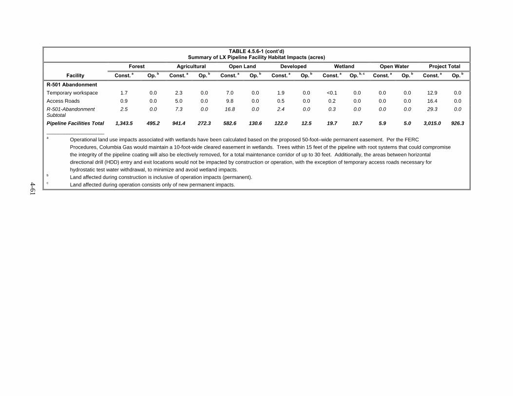
4-61
TABLE 4.5.6-1 (cont’d) Summary of LX Pipeline Facility Habitat Impacts (acres)
Facility
Forest Agricultural Open Land Developed Wetland Open Water Project Total
Const. a Op. b Const. a Op. b Const. a Op. b Const. a Op. b Const. a Op. b, c Const. a Op. b Const. a Op. b
R-501 Abandonment
Temporary workspace 1.7 0.0 2.3 0.0 7.0 0.0 1.9 0.0 <0.1 0.0 0.0 0.0 12.9 0.0
Access Roads 0.9 0.0 5.0 0.0 9.8 0.0 0.5 0.0 0.2 0.0 0.0 0.0 16.4 0.0
R-501-Abandonment Subtotal
2.5 0.0 7.3 0.0 16.8 0.0 2.4 0.0 0.3 0.0 0.0 0.0 29.3 0.0
Pipeline Facilities Total 1,343.5 495.2 941.4 272.3 582.6 130.6 122.0 12.5 19.7 10.7 5.9 5.0 3,015.0 926.3
____________________ a Operational land use impacts associated with wetlands have been calculated based on the proposed 50-foot–wide permanent easement. Per the FERC
Procedures, Columbia Gas would maintain a 10-foot-wide cleared easement in wetlands. Trees within 15 feet of the pipeline with root systems that could compromise
the integrity of the pipeline coating will also be electively removed, for a total maintenance corridor of up to 30 feet. Additionally, the areas between horizontal
directional drill (HDD) entry and exit locations would not be impacted by construction or operation, with the exception of temporary access roads necessary for
hydrostatic test water withdrawal, to minimize and avoid wetland impacts. b Land affected during construction is inclusive of operation impacts (permanent). c Land affected during operation consists only of new permanent impacts.

4-62
Clearing of vegetation in the project area could lead to increased erosion rates. Higher rates of erosion could lead to soil loss. This would reduce soil fertility and potentially lead to a lower rate of revegetation. Columbia Gas would follow soil mitigation procedures and erosion controls guidelines set forth by the WVDEP and ODNR.
Most impacts on agricultural lands would be temporary to short-term because these areas are disturbed annually to produce crops and would typically return to their previous condition shortly following construction, cleanup, and restoration. Impacts on agricultural lands would be minimized though adherence to the ECS. No restoration activities would occur in agricultural lands between the beginning of the spring thaw through May 15, unless otherwise requested by the landowner. Restoration would be coordinated with the landowner’s planting schedule. Columbia Gas would remove excess rock from at least the top 12 inches of soil to the extent practicable. Regular testing of topsoil and subsoil for compaction would be conducted in areas disturbed by construction activity. Additionally, Columbia Gas would plow severely compacted agricultural areas with a paraplow or other deep tillage implement or make arrangements with the landowner to plant and plow under a “green manure” crop. This would decrease soil bulk density and improve soil structure. To minimize grazing disturbance on revegetated areas, Columbia Gas would coordinate with willing landowners, grazing permittees, and land management agencies. Revegetation efforts would continue until the land is successfully restored.
Lands currently dominated by herbaceous growth would revegetate quickly, often within one growing season after seeding and otherwise typically within 3 years, depending on a number of factors. Cleared scrub-shrub vegetation would likely require 3 to 5 years to regain their woody composition.
Maintenance of the right-of-way for operation of the LX Project would permanently convert 495.2 acres of forested habitat to open land, while agricultural, emergent wetlands and open land habitats would be maintained in their current vegetation types. Forested land would be cleared for pipeline facilities, including pipelines and associated access roads, additional temporary work space, contractor yards, and cathodic protection units. The greatest impact would be in forested areas. Construction in forested lands would remove the tree canopy over the entire width of the construction right-of-way, which would change the structure and environment of the underlying and adjacent areas. Regrowth of forested vegetation in temporary workspace areas would be a long-term effect of the Project. Forested lands within the maintained right-of-way would be permanently converted to an herbaceous cover type. The indirectly affected lands adjacent to the right-of-way would remain forested; however, they would have reduced habitat value compared to preconstruction conditions. The creation of edge habitat could increase the risk of invasive species and other impacts on wildlife species. The regrowth of shrubs and trees within the temporary workspaces would reduce the edge effect on forested land and provide connectivity between adjacent forested tracts to some extent (Tewksbury et al., 2002), but it may take decades before these areas resemble the forest vegetation that was present before construction.
Soils that were previously shaded by the tree canopy would receive increased amounts of light, which could lead to drier soils and higher soil temperatures. Trees on the edge of the right-of-way might be subject to mechanical damage to trunks and branches and root impacts from soil disturbance and compaction, all of which could result in the decreased health and viability of some trees and root systems.
Columbia Gas would follow the measures in the ECP and would use EPA approved herbicides only, following existing regulations and label instructions. Herbicides would not be used within 100 feet of a waterbody or wetland except as specified by the appropriate land management or state agency. Additionally, Columbia Gas would use measures outlined in the Plan to reestablish affected areas. Following construction, reseeding of permanent vegetation would occur within the recommended seeding dates. Restoration would be considered successful if the right-of-way surface is similar to adjacent undisturbed lands, construction debris is removed, revegetation is successful, and proper drainage has been restored. Columbia Gas would follow guidelines established by state agencies for seed mixes.

4-63
Guidelines for restoration in Ohio and West Virginia have been established by the ODNR and the WVDEP, respectively. In Pennsylvania, the PADNCR established guidelines for restoration in areas disturbed by oil and gas activity. Columbia Gas would use the Rainwater and Land Development guidelines (ODNR, 2006), Seeding Mixtures for Areas Disturbed by Natural Gas Activities (PADCNR, 2015) and the West Virginia Erosion and Sediment Control Field Manual (WVDEP, 2006) for reseeding and revegetation efforts throughout the project area. Temporary seeding measures would follow in accordance with standards set by Ohio, Pennsylvania, and West Virginia. These measures would only be used when conditions for permanent seeding are not ideal. Columbia Gas would also use measures contained in the FERC Plan and the ECS as a basis for reseeding.
Temporary sediment barriers would be used to minimize potential for sedimentation into sensitive resources. These would be kept in place until revegetation is successful.
During operation of the Project, Columbia Gas would maintain a 10-foot-wide vegetative cover on the cleared right-of-way, in accordance with the Plan. A 50-foot-wide easement would be established every 3 years. No clearing activities would occur between April 1 and August 31, per recommendations from FWS. Within wetlands, Columbia Gas would maintain a 10-foot-wide permanent easement. These restrictions would occur in all areas along the pipeline except for the requested deviations from the FERC Procedures. Cutting of trees would occur within 15 feet of the pipeline if roots would compromise the reliability of the pipeline. Clearing would not occur between HDD entry and exit locations. Maintenance activities and other permanent impacts would affect various habitat types, specifically causing impacts on upland forest and wetland habitats. Impacts would convert all land types to an herbaceous state. Columbia Gas routed the pipeline to minimize vegetation impacts as much as possible. In addition to measures outlined in the ECS, Plan, and Procedures, Columbia Gas would provide additional project specific measures.
Several stakeholders expressed concerns about impacts on hardwood forests and effects that loss of vegetation would have on erosion in these areas. Agencies recommended applying a seed mix that contains native pollinator species to benefit honey bees, monarch butterflies, and other pollinators. Agencies also recommended measures to avoid the spread of invasive species. Columbia Gas plans to address concerns and recommendations in their project specific revegetation plan included in the ECS. Because we have not yet had the opportunity to review the seed mixes proposed for revegetation for the project, we recommend that:
Prior to the end of the draft EIS comment period, Columbia Gas should file with the Secretary, for review and written approval of the Director of OEP, a revised project specific ECS that accommodates the agencies requests to apply seed mixes that contain native pollinator plant species so as to benefit pollinating insect, bird and bat species.
Aboveground Facilities
Construction and modification of the three new compressor stations and their associated components as part of the LX Project would temporarily and permanently impact various habitat types, as demonstrated in table 4.5.6-2. All current land use at the compressor stations would convert to industrial use after construction, including 20.5 acres of forest and less than 0.1 acre of wetland. Permanent conversion would total 48.7 acres. Forested land within the suction/discharge easement would be converted to open land. Additionally, the proposed modifications at the Crawford CS would not require an expansion at the existing facility and proposed modifications at the Ceredo CS would require a minor expansion at the facility fence lines resulting in impacts on 1.3 acre forested and 0.8 acre open land during construction. These modifications would result in minor environmental effects in these locations and be mitigated. No permanent impacts are anticipated.

4-64
TABLE 4.5.6-2 Summary of LX Aboveground Facility Habitat Impacts (acres)
Facility
Forest Agricultural Open Land Developed Wetland Open Water Project Total
Const. a Op. b Const. a Op. b Const. a Op. b Const. a Op. b Const. a Op. b, c Const. a Op. b Const. a Op. b
LEX
Launcher 0.0 0.0 0.0 0.0 0.3 0.2 0.5 0.4 0.0 0.0 0.0 0.0 0.8 0.6
Mainline Valves 0.1 0.1 0.4 0.4 0.1 0.1 0.0 0.0 0.0 0.0 0.0 0.0 0.5 0.5
Lone Oak Compressor Station
26.0 15.4 0.0 0.0 9.7 7.3 0.8 0.5 0.2 0.0 0.0 0.0 36.7 23.2
Summerfield Compressor Station
0.0 0.0 6.8 4.6 0.0 0.0 0.0 0.0 0.0 0.0 0.0 0.0 6.8 4.6
Access Roads 0.3 0.3 0.7 0.7 0.3 0.3 1.3 1.3 0.0 0.0 0.0 0.0 2.5 2.5
LEX1
Receiver 0.0 0.0 2.1 1.0 0.0 0.0 0.0 0.0 0.0 0.0 0.0 0.0 2.1 1.0
K-260 Regulator Station
3.9 1.1 1.2 0.0 1.7 0.1 2.7 0.0 0.0 0.0 0.0 0.0 9.4 1.2
Incoming Line 0.1 0.1 0.0 0.0 0.1 0.1 0.0 0.0 0.0 0.0 0.0 0.0 0.2 0.2
Tie-in Valve <0.1 <0.1 0.0 0.0 <0.1 <0.1 0.0 0.0 0.0 0.0 0.0 0.0 <0.1 <0.1
Access Roads 0.7 0.7 0.9 0.9 0.8 0.8 1.6 1.6 0.0 0.0 0.0 0.0 4.0 4.0
R-801 Loop
R-System Regulator Station
0.1 0.0 0.0 0.0 4.6 2.2 0.5 <0.1 0.0 0.0 0.0 0.0 5.2 2.3
Incoming Line 0.0 0.0 0.0 0.0 0.4 0.4 <0.1 <0.1 0.0 0.0 0.0 0.0 0.4 0.4
Tie-in Facility 0.0 0.0 0.0 0.0 0.2 0.2 0.0 0.0 0.0 0.0 0.0 0.0 0.2 0.2
Benton Regulator Station
1.5 0.6 0.0 0.0 0.9 0.5 <0.1 <0.1 <0.1 0.0 0.0 0.0 2.4 1.1
RS-1286 Regulator Station d
0.0 0.0 <0.1 <0.1 <0.1 <0.1 0.1 0.1 0.0 0.0 0.0 0.0 0.2 0.1
McArthur Regulator Station
2.3 1.5 0.0 0.0 0.5 0.4 0.0 0.0 0.0 0.0 0.0 0.0 2.8 1.9
Mainline Valve 0.1 0.1 0.0 0.0 0.0 0.0 0.0 0.0 0.0 0.0 0.0 0.0 0.1 0.1
Access Roads 0.4 0.4 0.0 0.0 0.5 0.5 0.4 0.4 <0.1 <0.1 0.0 0.0 1.4 1.4
BM-111 Loop
Launcher 0.0 0.0 0.0 0.0 0.0 0.0 0.8 0.8 0.0 0.0 0.0 0.0 0.8 0.8
Ceredo Compressor Station d
1.3 0.0 0.0 0.0 0.8 0.8 14.2 2.1 0.0 0.0 0.0 0.0 16.4 2.9
Access Road 0.0 0.0 0.0 0.0 0.0 0.0 <0.1 <0.1 0.0 0.0 0.0 0.0 <0.1 <0.1
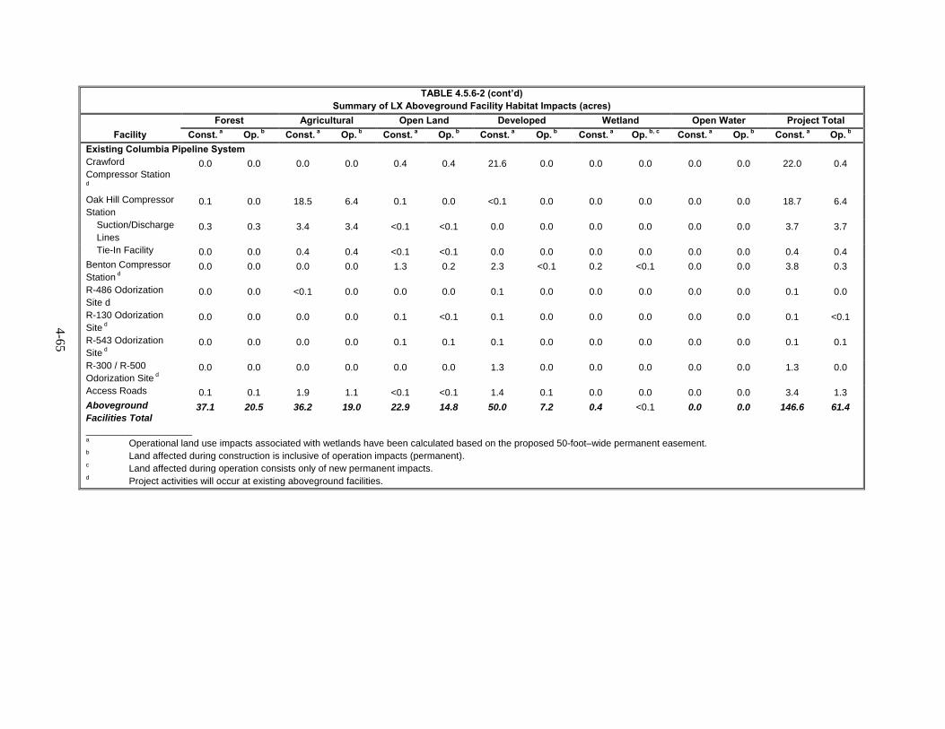
4-65
TABLE 4.5.6-2 (cont’d) Summary of LX Aboveground Facility Habitat Impacts (acres)
Facility
Forest Agricultural Open Land Developed Wetland Open Water Project Total
Const. a Op. b Const. a Op. b Const. a Op. b Const. a Op. b Const. a Op. b, c Const. a Op. b Const. a Op. b
Existing Columbia Pipeline System Crawford Compressor Station
d
0.0 0.0 0.0 0.0 0.4 0.4 21.6 0.0 0.0 0.0 0.0 0.0 22.0 0.4
Oak Hill Compressor Station
0.1 0.0 18.5 6.4 0.1 0.0 <0.1 0.0 0.0 0.0 0.0 0.0 18.7 6.4
Suction/Discharge Lines
0.3 0.3 3.4 3.4 <0.1 <0.1 0.0 0.0 0.0 0.0 0.0 0.0 3.7 3.7
Tie-In Facility 0.0 0.0 0.4 0.4 <0.1 <0.1 0.0 0.0 0.0 0.0 0.0 0.0 0.4 0.4 Benton Compressor Station d
0.0 0.0 0.0 0.0 1.3 0.2 2.3 <0.1 0.2 <0.1 0.0 0.0 3.8 0.3
R-486 Odorization Site d
0.0 0.0 <0.1 0.0 0.0 0.0 0.1 0.0 0.0 0.0 0.0 0.0 0.1 0.0
R-130 Odorization Site d
0.0 0.0 0.0 0.0 0.1 <0.1 0.1 0.0 0.0 0.0 0.0 0.0 0.1 <0.1
R-543 Odorization Site d
0.0 0.0 0.0 0.0 0.1 0.1 0.1 0.0 0.0 0.0 0.0 0.0 0.1 0.1
R-300 / R-500 Odorization Site d
0.0 0.0 0.0 0.0 0.0 0.0 1.3 0.0 0.0 0.0 0.0 0.0 1.3 0.0
Access Roads 0.1 0.1 1.9 1.1 <0.1 <0.1 1.4 0.1 0.0 0.0 0.0 0.0 3.4 1.3 Aboveground Facilities Total
37.1 20.5 36.2 19.0 22.9 14.8 50.0 7.2 0.4 <0.1 0.0 0.0 146.6 61.4
____________________ a Operational land use impacts associated with wetlands have been calculated based on the proposed 50-foot–wide permanent easement. b Land affected during construction is inclusive of operation impacts (permanent). c Land affected during operation consists only of new permanent impacts. d Project activities will occur at existing aboveground facilities.
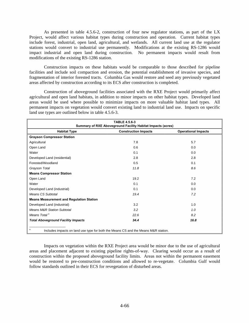
4-66
As presented in table 4.5.6-2, construction of four new regulator stations, as part of the LX Project, would affect various habitat types during construction and operation. Current habitat types include forest, industrial, open land, agricultural, and wetlands. All current land use at the regulator stations would convert to industrial use permanently. Modifications at the existing RS-1286 would impact industrial and open land during construction. No permanent impacts would result from modifications of the existing RS-1286 station.
Construction impacts on these habitats would be comparable to those described for pipeline facilities and include soil compaction and erosion, the potential establishment of invasive species, and fragmentation of interior forested tracts. Columbia Gas would restore and seed any previously vegetated areas affected by construction according to its ECS after construction is completed.
Construction of aboveground facilities associated with the RXE Project would primarily affect agricultural and open land habitats, in addition to minor impacts on other habitat types. Developed land areas would be used where possible to minimize impacts on more valuable habitat land types. All permanent impacts on vegetation would convert existing land to industrial land use. Impacts on specific land use types are outlined below in table 4.5.6-3.
TABLE 4.5.6-3 Summary of RXE Aboveground Facility Habitat Impacts (acres)
Habitat Type Construction Impacts Operational Impacts
Grayson Compressor Station
Agricultural 7.8 5.7
Open Land 0.6 0.0
Water 0.1 0.0
Developed Land (residential) 2.8 2.8
Forested/Woodland 0.5 0.1
Grayson Total 11.8 8.6
Means Compressor Station
Open Land 19.2 7.2
Water 0.1 0.0
Developed Land (industrial) 0.1 0.0
Means CS Subtotal 19.4 7.2
Means Measurement and Regulation Station
Developed Land (industrial) 3.2 1.0
Means M&R Station Subtotal 3.2 1.0
Means Total a 22.6 8.2
Total Aboveground Facility Impacts 34.4 16.8
____________________ a Includes impacts on land use type for both the Means CS and the Means M&R station.
Impacts on vegetation within the RXE Project area would be minor due to the use of agricultural areas and placement adjacent to existing pipeline rights-of-way. Clearing would occur as a result of construction within the proposed aboveground facility limits. Areas not within the permanent easement would be restored to pre-construction conditions and allowed to re-vegetate. Columbia Gulf would follow standards outlined in their ECS for revegetation of disturbed areas.

4-67
Contractor Yards 4.5.6.2
Columbia would use temporary contractor yards to facilitate construction of project components and has identified preferred sites and alternate sites. A total of 517.1 acres within contractor yard construction workspace would be temporarily affected. It is anticipated that approximately 17 contractor yards would be required for construction of the LX Project. Contractor yards would affect approximately 211.3 acres of agricultural land, 223.8 acres of open land, 6.9 acres of forest, and 1.8 acres of wetland. Following construction, areas designated for contractor yard use would revert to pre-construction conditions unless otherwise indicated by the landowner. Impacts from contractor yard construction on vegetation would be similar to those described for pipeline and aboveground facilities.
Access Roads 4.5.6.3
Aboveground facilities would use permanent and temporary access roads creating temporary and permanent impacts on land use types. Construction of these roads, temporary and permanent, would affect various land types, including, but not limited to, 34.0 acres of open land and 30.0 acres of agricultural land. Approximately 7.3 acres of forested land would be affected during construction and 1.5 acres would be affected by permanent access roads. Construction impacts on vegetation would be similar to impacts listed above for the proposed pipeline, including the potential for soil compaction and erosion and the introduction and establishment of invasive species. Construction could require tree clearing and if necessary, trees would be felled into the construction work area of the access road. After construction, Columbia Gas would restore impacted areas to pre-construction conditions following protective measures established in the ECS and FERC Procedures. Additional impacts from access road construction on vegetation would be similar to those described for pipeline and aboveground facilities.
Conclusion 4.5.7
Temporary and minor impacts would result due to construction of the LX and RXE Projects. Based on our review of the potential impacts on vegetation as described above, we conclude that the primary impact from construction and operation of the LX Project would be on forested lands and the RXE Project would primarily affect agricultural land. Forested impacts from the construction of the LX Project would be significant; however, due to the prevalence of forested habitats within the project area and eventual regrowth of prior forested areas outside of the permanent right-of-way, in addition to Columbia Gas’ mitigation and routing, we conclude that the permanent conversion of forested lands would be reduced to less than significant levels. Additional measures outlined in the Columbia Gas and Columbia Gulf’s corresponding ECSs would further minimize impacts to forested lands and other vegetation types.
4.6 WILDLIFE AND AQUATIC RESOURCES
Wildlife 4.6.1
Existing Wildlife Resources 4.6.1.1
The proposed LX and RXE Projects would cross terrestrial and wetland habitats that support a diversity of wildlife species. Wildlife habitats along the proposed route are representative of the local vegetation communities presented in section 4.5 (forest, open land, agricultural, industrial, wetlands, residential, and open water).
Hardwood forests characterize the forested land, providing food resources, nesting habitat, and cover for a variety of birds and mammals. Open land is characterized by existing utility easements and open areas which provide cover as well as foraging and nesting habitat for a variety of mammals, birds,

4-68
reptiles, and amphibians. Agricultural land consists of improved pastures and areas of actively cultivated row crops. The agricultural land provides forage and nesting habitat for a variety of birds, mammals, and reptiles. Industrial land includes developed land not characterized as residential with sparse vegetative cover providing minimal habitat for birds and mammals. Wetlands include palustrine emergent wetlands, palustrine scrub-shrub wetlands, and palustrine forested wetlands providing cover, forage, and nesting habitat for a variety of reptiles, amphibians, mammals, and birds. Residential land consists of developed land that includes single and multiple family dwellings and generally lacks vegetation and suitable wildlife habitat. Open water includes major lakes, ponds, or rivers, including the Ohio and Muskingum Rivers, with bankside vegetation providing habitat for mammals, birds, fish, and amphibians. Representative wildlife species potentially found in the LX Project area is provided in table 4.6.1-1.
TABLE 4.6.1-1 Wildlife Species Potentially Occurring in the LX Project Area
Land Cover Wildlife Species
Upland Forest
White-tailed deer, gray fox, flying squirrel, eastern chipmunk, wild turkey, black-capped chickadee, downy woodpecker, eastern screech owl, and five-lined skink
Open Upland Woodchuck, eastern mole, least shrew, eastern cottontail rabbit, American kestrel, American goldfinch, field sparrow, American toad, eastern fence lizard, and garter snake
Agricultural Land Woodchuck, white-footed mouse, mourning dove, American crow, house finch, barn swallow, and garter snake
Developed Land Raccoon, eastern cottontail rabbit, mourning dove, house finch, American robin, and northern mockingbird
Wetland American toad, spring peeper, green frog, garter snake, midland painted turtle, snapping turtle, red-winged blackbird, American wigeon, great blue heron, swamp sparrow, and raccoon
Open Water Beaver, great blue heron, osprey, belted kingfisher, bullfrog, largemouth bass, smallmouth bass, channel catfish, creek chub, and white sucker
Project Facilities
Construction of the LX Project, including pipelines and aboveground facilities, would impact a total of 1,380.6 acres of forest, 20.1 acres of wetlands (of which 1.4 acres would be forested wetland). Impacts of individual project components (the pipeline, aboveground facilities, contractor yards, and access roads) on vegetation types are provided in section 4.5.
Sensitive or Managed Wildlife Habitats 4.6.1.2
Sensitive wildlife habitats associated with wildlife management areas and federally listed, state-listed, and special-status species such as migratory birds would be crossed by the LX and RXE Projects (see section 4.7).
The project consisting of both LX and RXE Projects would not cross any National Park System Units, including national parks and preserves (KDFWR, 2014c:FWS, 2015a; NPS, 2014a). The project would not cross any National Wildlife Refuges or National Wilderness Areas. No protected or sensitive areas containing habitat for unique, sensitive, or protected plant and/or wildlife were identified within West Virginia or Pennsylvania. Consultation with FWS, in a letter dated February 12, 2015 also determined that the LX Project does not cross any federal wilderness areas, wildlife refuges, or designated critical habitat in the Ohio portion of the LX Project. In a letter from WVDNR dated April 22, 2015, the LX Project area would cross portions of Dunkard Fork WMA.

4-69
Ohio
The LX Project would directly cross Sunfish Creek State Forest in Ohio. The LX Project would also be within 0.2 mile of Rhododendron Cove State Nature Preserve and its two associated components (Kleinmaier Rhododendron Hollow and Whakeena), Bartley Preserve, Clear Creek Metro Park, Monroe Lake WMA, and Arethusa Springs Park. Temporary workspace associated with the R-501 Abandonment is located 0.4 mile from the Wayne National Forest in Vinton County, Ohio at its closest point (MP 20.9), and the R-801 Loop is located less than 0.1 mile, at its closest point (MP 8.1), west of the Hocking State Forest in Vinton County, Ohio.
Sunfish Creek State Forest
The Sunfish Creek State Forest is managed by the ODNR and consists of 637 acres of forest used for recreational purposes such as hiking and hunting (ODNR, 2015b). The LEX section of LX Project crosses the Sunfish Creek State Forest in Monroe County, Ohio from MP 26.1 RR-5 to 26.5 RR-5. Columbia Gas has submitted a formal application, including an Environmental Assessment, to ODNR for review and approval. After approval, Columbia Gas would be granted a 25-year lease agreement for the permanent pipeline easement within the forest. Consultations with ODNR regarding impacts, permitting, and regulatory requirements are ongoing concerning the impacts on and restoration of wildlife habitat in the Sunfish Creek State Forest. Therefore, we recommend that:
Prior to construction, Columbia Gas should file with the Secretary documentation of its correspondence with ODNR and any avoidance or mitigations measures developed to cross the Sunfish Creek State Forest.
Hocking Canal
The ODNR manages the Hocking Canal, which would be crossed by the LEX component of the LX Project at MP 130.4 in Hocking County, Ohio. ODNR recommends crossing the canal via HDD. Columbia Gas revised and resubmitted its application and associated Environmental Assessment for the LX Project activities within the Sunfish Creek State Forest to also include information associated with the proposed crossing of the Hocking Canal. Columbia Gas would provide additional consultations with the ODNR to the Secretary.
Rhododendron Cove State Nature Preserve
The Rhododendron Cove State Nature Preserve, including the Kleinmaier Rhododendron Hollow Component and Wahkeena Component, in Fairfield County are managed by ODNR, the Appalachia Ohio Alliance, and the Fairfield County Historical Parks, respectively. The nature preserve and associated components are adjacent to temporary workspace associated with the Crawford CS. This preserve supports known populations of state protected and state sensitive plant species as identified in Section 4.7; however, project activities would be approximately 175 feet from documented populations. The Wahkeena Component is 0.2 mile east from the Crawford CS temporary workspace. No permanent impacts are anticipated at the nature preserve or associated components due to the distance of project activities from sensitive species and the restriction of project activities within the existing fence line.
Clear Creek Metro Park
LEX MP 130.2 in Hocking County is 0.7 mile west from the Clear Creek Metro Park. The park is the state’s largest state nature preserve and is managed by Columbus/Franklin County Metro Parks Program. The park contains hemlock-hardwood forest and Appalachian oak forest communities in
4-70
addition to providing habitat for the black vulture, hermit thrush, and tiger spiketail. No impacts are anticipated due to the distance of the nature preserve from LX Project activities.
Hocking State Forest
The Hocking State Forest, in Hocking County, Ohio, contains over 9,000 acres of land. The forest is managed by the Ohio State Parks division of the ODNR. At its closest point, the R-801 Loop is 0.02 mile west of the Hocking State Forest in Vinton County, Ohio. We do not anticipate any adverse impacts because the LX Project would not cross the forest boundary and is more than one mile from the nearest recreational area. The construction right-of-way would parallel the existing R-501 Line, minimizing impacts and reducing the amount of tree clearing required. No permanent impacts are anticipated. Forests would revegetate after construction and Columbia Gas would follow measures outlined in the Plan and their ECS.
West Virginia
A letter from WVDNR indicated that the alignment of the LX Project would cross portions of Dunkard Fork WMA. The Dunkard Fork WMA is a public hunting and fishing area. The Project has the potential to affect wildlife in this area and WVDNR recommended coordination with the District Wildlife Biologist to minimize impacts in this area (WVDNR, 2015). Columbia Gas is continuing consultations with WVDNR to minimize impacts.
Kentucky
A database search did not identify significant habitat areas that will be affected by RXE for federal and state wilderness areas, wildlife preserves, sanctuaries, state game refuges, wildlife management areas, National Wildlife Refuges, and other designated fish and wildlife use (KDFWR, 2014c; FWS, 2015a; Wilderness.net, 2015). At this time, no conservation easements have been identified as being directly affected by the construction and operation of RXE. The closest protected resource to the Means CS would be the Daniel Boone National Forest, located approximately 3 miles to the south and west (KDFWR, 2014c). The closest protected resource to the Grayson CS would be the Grayson Lake Wildlife Management Area, located approximately 8 miles to the southwest.
Migratory Birds 4.6.1.3
Migratory birds are species that nest in the United States and Canada during the summer, and then migrate south to the tropical regions of Mexico, Central and South America, and the Caribbean for the non-breeding season. Migratory birds are protected under the MBTA (16 U.S. Code 703-711). Executive Order 13186 (EO 13186) (66 Federal Register 3853) directs federal agencies to identify where unintentional take is likely to have a measurable negative effect on migratory bird populations and to avoid or minimize adverse impacts on migratory birds through enhanced collaboration with the FWS.
EO 13186 states that emphasis should be placed on species of concern, priority habitats, and key risk factors, and that particular focus should be given to addressing population-level impacts. Additionally, bald and golden eagles are protected under the BGEPA (16USC 668-668d). On March 30, 2011, the FWS and Commission entered into a Memorandum of Understanding (MOU) between the Federal Energy Regulatory Commission and the U.S. Department of the Interior United States Fish and Wildlife Service Regarding Implementation of Executive Order 13186, "Responsibilities of Federal Agencies to Protect Migratory Birds." This voluntary memorandum focuses on migratory birds and strengthening migratory bird conservation through enhanced collaboration between FERC and FWS. It does not waive legal requirements under the MBTA, BGEPA, ESA, or any other statues and does not authorize the take of migratory birds. The MOU recognizes that “it is in the interests of [FERC and FWS]

4-71
that potential impacts, direct and indirect, are thoroughly assessed and unavoidable impacts are appropriately mitigated.” In accordance with the MOU’s definition of mitigation, which includes “compensating for the impact by replacing or providing substitute resources or environments,” where impacts cannot be avoided or fully minimized, compensatory mitigation is appropriate to fully mitigate for removed habitat that was used by either migratory birds or listed species.
FWS established the Birds of Conservation Concern (BCC) designation in response to a 1998 amendment to the Fish and Wildlife Conservation Act. The BCC allows for protection of migratory birds that, without additional conservation actions, would become candidate species under the ESA (FWS, 2008). BCC species are listed at three different scales: Bird Conservation Regions, FWS Region, and National. The projects are in Bird Conservation Region 24 & 28 (Central Hardwoods & Appalachian Mountains region of the United States). Table 4.6.1-2 lists the BCC’s in the LX Project area, and table 4.6.1-3 lists the BCC’s in the RXE Project area. The species listed on these tables potentially have breeding habitat that is known or expected to occur in the LX and RXE Project areas.
TABLE 4.6.1-2 Birds of Conservation Concern Potentially Occurring in the LX Project Area
Common Name Scientific Name
Bald eagle Haliaeetus leucocephalus
Peregrine falcon Falco peregrinus
Upland sandpiper Bartramia longicauda
Northern saw-whet owl Aegolius acadicus
Whip-poor-will Caprimugus vociferous
Red-headed woodpecker Melanerpes erythrocephalus
Yellow-bellied sapsucker Sphyrapicus varius
Olive-sided flycatcher Contopus cooperi
Loggerhead shrike Lanius ludovicianus
Black-capped chickadee Poecile atricapillus
Bewick’s wren Thryomanes bewickii
Sedge wren Cistothorus platensis
Wood thrush Hylocichla mustelina
Blue-winged warbler Vermivora cyanoptera
Golden-winged warbler Vermivora chrysoptera
Prairie warbler Dendroica discolor
Cerulean warbler Dendroica cerula
Worm-eating warbler Helmitheros vermivorus
Swainson’s warbler Limnothlypis swainsonii
Louisiana waterthursh Parkesia motacilla
Kentucky warbler Oporomis formosus
Canada warbler Cardellina Canadensis
Henslow’s sparrow Ammodramus henslowii
Rusty blackbird Euphagus carolinus
Red crossbill Loxia curvirostra
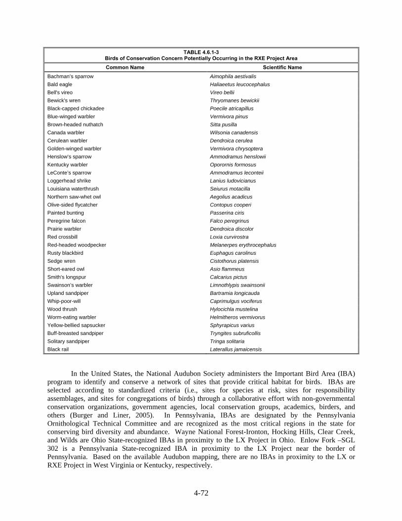
4-72
TABLE 4.6.1-3 Birds of Conservation Concern Potentially Occurring in the RXE Project Area
Common Name Scientific Name
Bachman’s sparrow Aimophila aestivalis
Bald eagle Haliaeetus leucocephalus
Bell's vireo Vireo bellii
Bewick's wren Thryomanes bewickii
Black-capped chickadee Poecile atricapillus
Blue-winged warbler Vermivora pinus
Brown-headed nuthatch Sitta pusilla
Canada warbler Wilsonia canadensis
Cerulean warbler Dendroica cerulea
Golden-winged warbler Vermivora chrysoptera
Henslow’s sparrow Ammodramus henslowii
Kentucky warbler Oporornis formosus
LeConte’s sparrow Ammodramus leconteii
Loggerhead shrike Lanius ludovicianus
Louisiana waterthrush Seiurus motacilla
Northern saw-whet owl Aegolius acadicus
Olive-sided flycatcher Contopus cooperi
Painted bunting Passerina ciris
Peregrine falcon Falco peregrinus
Prairie warbler Dendroica discolor
Red crossbill Loxia curvirostra
Red-headed woodpecker Melanerpes erythrocephalus
Rusty blackbird Euphagus carolinus
Sedge wren Cistothorus platensis
Short-eared owl Asio flammeus
Smith's longspur Calcarius pictus
Swainson’s warbler Limnothlypis swainsonii
Upland sandpiper Bartramia longicauda
Whip-poor-will Caprimulgus vociferus
Wood thrush Hylocichla mustelina
Worm-eating warbler Helmitheros vermivorus
Yellow-bellied sapsucker Sphyrapicus varius
Buff-breasted sandpiper Tryngites subruficollis
Solitary sandpiper Tringa solitaria
Black rail Laterallus jamaicensis
In the United States, the National Audubon Society administers the Important Bird Area (IBA) program to identify and conserve a network of sites that provide critical habitat for birds. IBAs are selected according to standardized criteria (i.e., sites for species at risk, sites for responsibility assemblages, and sites for congregations of birds) through a collaborative effort with non-governmental conservation organizations, government agencies, local conservation groups, academics, birders, and others (Burger and Liner, 2005). In Pennsylvania, IBAs are designated by the Pennsylvania Ornithological Technical Committee and are recognized as the most critical regions in the state for conserving bird diversity and abundance. Wayne National Forest-Ironton, Hocking Hills, Clear Creek, and Wilds are Ohio State-recognized IBAs in proximity to the LX Project in Ohio. Enlow Fork –SGL 302 is a Pennsylvania State-recognized IBA in proximity to the LX Project near the border of Pennsylvania. Based on the available Audubon mapping, there are no IBAs in proximity to the LX or RXE Project in West Virginia or Kentucky, respectively.
4-73
The migratory bird nesting period begins in mid-April and lasts through early-August. To minimize impacts during this period, Columbia Gas would conduct clearing activities from September 1 to March 31 and comply with state and federal regulations such as:
avoid fragmenting large, contiguous tracts of wildlife habitat;
maintain contiguous habitat corridors;
concentrate construction activities, infrastructure, and manmade structures on already altered lands;
co-locate activities in or immediately adjacent to already-disturbed areas; and
cluster development features where possible (Lewis, 2015).
The loss of approximately 1,380.6 acre of upland forest and 1.1 acres of forested wetlands associated with pipeline and aboveground facility construction would present a long-term impact for migratory birds that depend on forests. Vegetation clearing and other construction activities could affect egg and young survival. Bird displacement could affect bird migration, nesting, foraging, and mating behaviors. Behavior changes could increase the amount of stress, injury, and mortality experienced by migratory birds. Construction would also reduce the amount of habitat available for foraging and predator protection and would temporarily displace birds into adjacent habitats, which could increase the competition for food and other resources. This in turn could increase stress, susceptibility to predation, and negatively impact reproductive success.
Additionally, increased human presence and noise from construction activities could disturb actively nesting birds. Impacts would not be significant for non-nesting birds, as these individuals would temporarily relocate to avoid construction activities. However, construction activity near active nests during incubation or brood rearing could result in nest abandonment; overheating, chilling, or desiccation of unattended eggs or young causing nestling mortality; premature fledging; and/or ejection of eggs or young from the nest.
Migratory birds, including BCC-listed birds, could also be affected during project operation, which would permanently convert upland forest and forested wetland to an herbaceous state. The reduction in forest habitat could result in increased competition, parasitic bird species, edge effects, and fragmentation resulting from right-of-way maintenance activities.
Species using the project area in the fall or winter would likely avoid the project area during construction, relocating to nearby habitats. Temporary displacement to less suitable habitat could occur as a result.
Columbia Gas would avoid, minimize, rectify, or reduce potential environmental impacts through project routing, design, and siting adjacent to existing utility easements to the extent practicable to minimize impacts on wetlands, waterbodies, and forests that provide suitable habitat for migratory birds. Columbia Gas has agreed to follow protective measures outlined in the ECS and the FERC Plan during construction of the LX Project. However, the FWS indicated in a letter dated February 12, 2015 that the LX Project has the potential for avian mortality of migratory birds and will result in habitat destruction and alteration within project boundaries and that Columbia Gas should prepare a plan to address.
FWS provided three recommendations to avoid and minimize impacts on migratory birds. FWS recommended avoiding clearing during the nesting season and to carry out clearing of natural or semi-natural habitats between September 1 and March 31 to minimize impacts on migratory birds. Additionally, they recommended minimizing habitat fragmentation by avoiding large contiguous tracts of wildlife habitat and co-locating project facilities adjacent to previously disturbed or maintained areas such as existing easements. Furthermore, FWS is currently seeking compensatory mitigation and if accepted
4-74
would be incorporated into a Migratory Bird Conservation Plan. The FWS is a cooperating agency in the review of this proposal. As such, as this consultation is ongoing, Columbia Gas has not yet provided a draft of its Migratory Bird Conservation Plan for the FWS’s and our review, we recommend that:
Prior to construction, Columbia Gas and Columbia Gulf should each file with the Secretary its Final Migratory Bird Conservation Plan, developed in consultation with the FWS, including the FWS recommended vegetation restriction.
General Impacts and Mitigation 4.6.1.4
Pipeline Facilities
Construction of the pipeline and extra workspace would affect a total of 2,160.6 acres of vegetated habitat. Following construction, Columbia Gas would implement its ECS to minimize temporary and permanent effects on wildlife and to promote stabilization and revegetation of disturbed areas. During operations, 987.7 acres of vegetated habitat within the permanent right-of-way would convert to an early successional stage, which Columbia Gas would maintain by mowing. This maintenance would result in the conversion of 515.6 acres of upland forest and 1.4 acre of forested wetlands to herbaceous and scrub-shrub habitat. Land cover and acreage associated with the construction of the pipeline facilities and associated extra workspace and access roads are described in further in section 4.8.
Several stakeholders expressed concerns about impacts on wildlife, such as habitat loss and fragmentation of habitat. Agencies have also suggested evaluating impacts resulting from an altered landscape such as wildlife habitat, forest fragmentation, and the change in predator abundance, and the attraction of competitive or parasitic wildlife species to the project area.
Construction of the pipeline facilities could negatively affect common wildlife species and general wildlife habitat within the immediate vicinity of the pipeline route. Noise and ground disturbance generated by pipeline construction activities may temporarily affect wildlife behavior in their immediate vicinity. Noise would potentially cause wildlife to disperse to other neighboring habitats; however, the stresses associated with wildlife dispersal are not anticipated to result in any measureable effects on any species at the individual or population level.
Other disturbance effects, including direct mortality, could occur due to clearing, grading, trench excavation, and the movement of equipment on the right-of-way and access roads. This would affect less mobile species, including those that hide within burrows along the route, to a greater degree than those that could quickly flee the project area. Therefore, we do not expect that significant direct mortality of wildlife would occur as a result of construction activities.
Removal of vegetation within forested land could cause long-term displacement of some local wildlife populations. Although forested areas would be restored similar to other areas, forested habitat would be converted to successional stages of open herbaceous and scrub-shrub habitat either permanently (as on the permanent right-of-way) or for several years to decades until a mature forest community redevelops on the temporary workspaces. Some wildlife species that rely on forested habitat for foraging, breeding, and nesting would be negatively affected by the long-term loss of forest cover. Other species that prefer open land and scrub-shrub habitat would benefit from the permanent or temporary habitat conversion. Edge effects or forest fragmentation would increase in certain locations due to project construction, reducing the amount of habitat available for interior forest species (i.e. movement and dispersal corridors). With habitat conversion and forest fragmentation, there is also a risk of intrusion by invasive or noxious species.

4-75
Increased predation could also occur during construction and operation of the pipeline due to the removal of vegetation and loss of cover, which would increase the visibility of prey species. While individual mortality rates could increase, the project would not likely have any population-level impact due to these effects.
The duration of effects on wildlife using other habitats such as agricultural lands and other open lands (including existing rights-of-way) would be shorter than in forested areas. Following construction, vegetation, similar to that existing before construction, would typically become reestablished within months to a few years. It is expected that wildlife would quickly return to the vicinity of the rights-of-way, using them as corridors for travel, refuge, foraging, and nesting.
The degree of impact would depend on the type of habitat affected, the timing of clearing and construction activities, and the rate of recovery for the disturbed area. Impacts on migratory bird habitats are discussed above. Columbia Gas would use a 110-foot wide construction right-of-way in uplands, except between LEX MP 0.0 to MP 40.0. Steep slope conditions exist at this part of the LX Project area and require a construction right-of-way of 125 feet for safety and efficiency during construction. A 30-foot-wide cleared corridor would be maintained following construction, allowing areas outside the permanent easement to return to pre-construction conditions. Columbia Gas would minimize these impacts by reducing the construction right-of-way in forested areas to 100 feet when possible.
Most of RXE is located on open or agricultural lands. Migratory bird species that prefer open, disturbed areas could utilize nearby existing easements for foraging and would be able to displace to similar adjacent habitats during construction activities. During field surveys, no migratory bird nests were identified. The RXE Project would have potential impact on migratory bird species which can be greatly reduced with appropriate clearing dates and compensatory mitigation for habitat loss as recommended in the final recommendation at the end of section 4.6.1.3. Those actions, coupled with minimized environmental impacts resulting from the project’s design and on implementation of the provisions of the ECS and FERC Plan and Procedures should result in acceptable impacts to migratory bird species. Columbia Gulf is continuing consultations with FWS to minimize the impact on migratory birds within the maintained right-of-way and develop project-specific conservation measures and BMPs to protect BCC and their habitats in the RXE vicinity. Therefore, we recommended that Columbia Gas develop a Migratory Bird Conservation Plan in consultation with the FWS, including avoidance and compensatory mitigation measures.
Construction debris would be removed unless an agency determines that it is beneficial for habitat restoration. In the event that rookeries or raptor nests are located within the RXE area prior to or during construction, Columbia Gulf will consult with FWS and KDFWR to develop measures to avoid impacts to these features.
Release or spills of potentially hazardous materials could occur as a result of project construction, negatively impacting surrounding wildlife. Fuel spills would be controlled by regulating fuel storage and refueling activities and requiring immediate cleanup should a spill occur. Columbia Gas would adhere to measures outlined in the ECS and FERC Procedures to minimize the impact of spills on wildlife.
Trenching activities could create potential trap areas for wildlife in the LX Project area. Areas designated for trenching would also be more susceptible to erosion. This could result in the discharge of sediment to waterbodies and wetlands, negatively impacting habitat and wildlife found in these areas. Temporary trench breakers would be installed immediately after trench excavation to prevent erosion to the greatest extent possible.
Blasting may be necessary along the pipeline route in areas of shallow depth to bedrock. Columbia Gas is continuing to evaluate areas designated for blasting. Blasting needs would be
4-76
determined at the time of crossing. Columbia Gas would obtain any state or federal agency approval prior to blasting activities and would conduct blasting in a cautious manner to avoid injury or damage to wildlife. Columbia Gas has developed an acceptable blasting plan which would limit potential impacts, as described in section 4.1.
Columbia Gas would follow measures outlined in the Procedures, including limiting the size of extra work areas needed to construct the waterbody crossing, to minimize impacts on wildlife found in riparian zones. Additional measures would include revegetating the area with native woody plant species or with conservation grasses and legumes. A riparian strip of at least 25-feet-wide, as measured from the waterbody’s mean high water mark, would be allowed to grow.
The pipeline routes have been designed to minimize impacts on sensitive wildlife habitat whenever possible. Columbia Gas plans to further minimize impacts on wildlife habitat by using the measures contained it the ECS, FERC’s Plan and Procedures, and any additional mitigation measures required. Actions to minimize impacts include:
maintaining a 30-foot wide permanent right-of-way width in upland areas;
no clearing between April 15 and August 1, as well as adherence to seasonal clearing restrictions where required, as discussed in section 4.7;
requested alternate measures to the FERC Procedures (discussed in appendix E); and
soil amendments in areas with low revegetation potential.
Aboveground Facilities
Construction and modification of the aboveground facilities including compressor stations, regulator stations, and launcher and receiver facilities would impact 18.9 acres of forest during construction and 14.8 acres of permanent forest impacts for operation, with an additional 0.01-acre of forested wetland during construction, with no permanent forested wetland impacts for operation. Temporary impacts on wildlife would be similar to those described above for pipeline facilities. Wildlife would most likely be permanently displaced from these areas due to lack of suitable habitat and proper vegetation. Several stakeholders expressed concerns about noise impacts on wildlife, specifically from venting of gases at the compressor stations. The increase in ambient noise in the immediate vicinity of these facilities during both construction and operation could also result in a decrease in wildlife use of adjacent habitat. Changes in ambient noise levels are further discussed in section 4.11.2 along with proposed measures to limit noise exposure during both construction and operation of the LX and RXE Projects.
Contractor Yards
The proposed 17 contractor yards would temporarily affect 517.1 acres of land, consisting of 6.9 acres of forest, 223.8 acres of open land, 211.3 acres of agricultural land, 73.0 acres of developed land, 1.8 acres of wetland, and 0.3 acre of open water. Following construction, Columbia Gas would restore and reseed any previously vegetated areas that are affected, and restore contours to pre-construction conditions unless otherwise indicated by the landowner. Use of these areas would temporarily displace wildlife species; however, displaced wildlife would return to these areas following restoration. Therefore, no permanent impacts on wildlife would result from the use of the contractor yards.
Access Roads
Columbia Gas would use a total of 130 temporary access roads during construction and 6 permanent access roads during construction and operation of the pipeline facilities, including the R-501
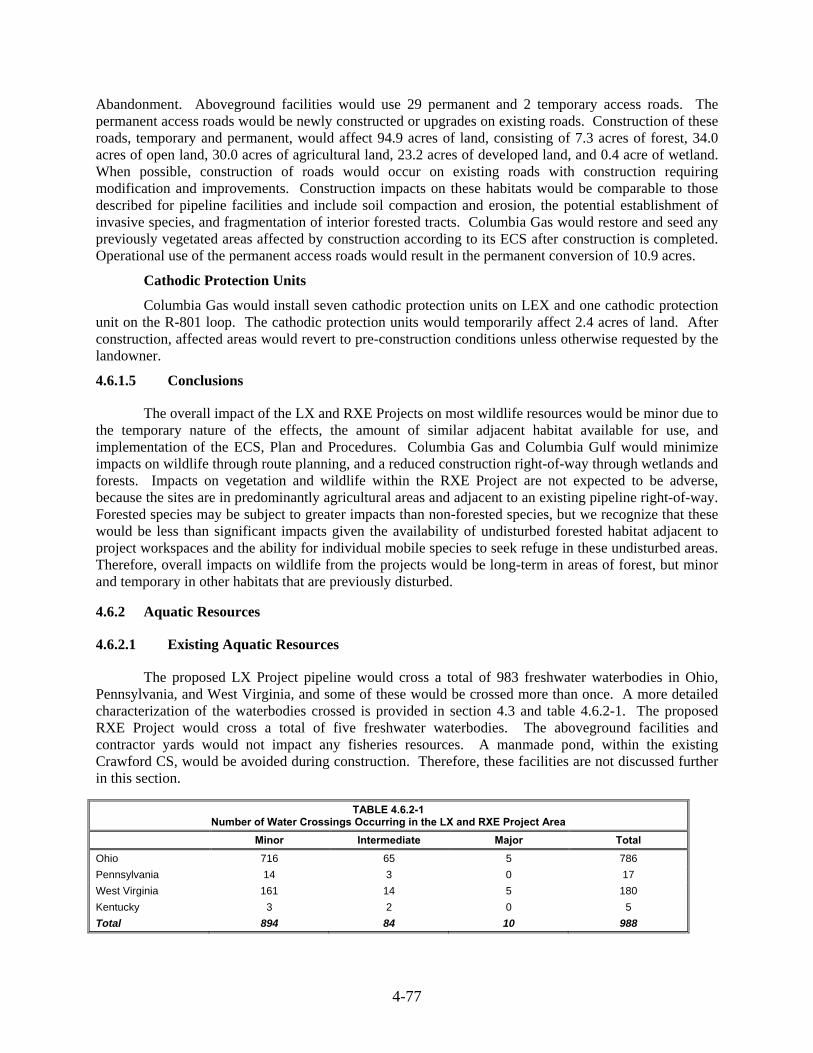
4-77
Abandonment. Aboveground facilities would use 29 permanent and 2 temporary access roads. The permanent access roads would be newly constructed or upgrades on existing roads. Construction of these roads, temporary and permanent, would affect 94.9 acres of land, consisting of 7.3 acres of forest, 34.0 acres of open land, 30.0 acres of agricultural land, 23.2 acres of developed land, and 0.4 acre of wetland. When possible, construction of roads would occur on existing roads with construction requiring modification and improvements. Construction impacts on these habitats would be comparable to those described for pipeline facilities and include soil compaction and erosion, the potential establishment of invasive species, and fragmentation of interior forested tracts. Columbia Gas would restore and seed any previously vegetated areas affected by construction according to its ECS after construction is completed. Operational use of the permanent access roads would result in the permanent conversion of 10.9 acres.
Cathodic Protection Units
Columbia Gas would install seven cathodic protection units on LEX and one cathodic protection unit on the R-801 loop. The cathodic protection units would temporarily affect 2.4 acres of land. After construction, affected areas would revert to pre-construction conditions unless otherwise requested by the landowner.
Conclusions 4.6.1.5
The overall impact of the LX and RXE Projects on most wildlife resources would be minor due to the temporary nature of the effects, the amount of similar adjacent habitat available for use, and implementation of the ECS, Plan and Procedures. Columbia Gas and Columbia Gulf would minimize impacts on wildlife through route planning, and a reduced construction right-of-way through wetlands and forests. Impacts on vegetation and wildlife within the RXE Project are not expected to be adverse, because the sites are in predominantly agricultural areas and adjacent to an existing pipeline right-of-way. Forested species may be subject to greater impacts than non-forested species, but we recognize that these would be less than significant impacts given the availability of undisturbed forested habitat adjacent to project workspaces and the ability for individual mobile species to seek refuge in these undisturbed areas. Therefore, overall impacts on wildlife from the projects would be long-term in areas of forest, but minor and temporary in other habitats that are previously disturbed.
Aquatic Resources 4.6.2
Existing Aquatic Resources 4.6.2.1
The proposed LX Project pipeline would cross a total of 983 freshwater waterbodies in Ohio, Pennsylvania, and West Virginia, and some of these would be crossed more than once. A more detailed characterization of the waterbodies crossed is provided in section 4.3 and table 4.6.2-1. The proposed RXE Project would cross a total of five freshwater waterbodies. The aboveground facilities and contractor yards would not impact any fisheries resources. A manmade pond, within the existing Crawford CS, would be avoided during construction. Therefore, these facilities are not discussed further in this section.
TABLE 4.6.2-1 Number of Water Crossings Occurring in the LX and RXE Project Area
Minor Intermediate Major Total
Ohio 716 65 5 786
Pennsylvania 14 3 0 17
West Virginia 161 14 5 180
Kentucky 3 2 0 5
Total 894 84 10 988

4-78
Ohio
As discussed in section 4.3, the ODNR classifies waterbodies according to designated use. The Ohio Administrative Code 3745-1 classifies waterbodies as: aquatic life habitat (warmwater, limited warmwater, exceptional warmwater, modified warmwater, seasonal salmonid, coldwater [coldwater habitat, inland trout streams and coldwater habitat, native fauna], and limited resource water [acid mine drainage, small drainage way maintenance, and other specified conditions]), nuisance prevention, water supply (public, agricultural, and industrial), and recreational (bathing waters, primary contact [Class A, Class B, and Class C], and secondary contact).
Sunfish Creek, East Fork Queer Creek, Piney Fork, Muskingum River, Turkey Run, Pine Creek, and Queer Creek are Ohio state-designated superior high quality waters. Superior high quality waters are waterbodies that possess exceptional ecological value. Ohio classifies the Ohio River, Hocking River, and Muskingum River as section 10 waterbodies. Activities associated with crossing Ohio state-designated superior high quality waters would be covered under the OPEA’s Section 401 Water Quality Certification. The Section 404 Permit covers activities associated with crossing Section 10 waterbodies. The LX Project would not affect commercial fisheries in Ohio. The Muskingum River, a recreational fishery, would be crossed via HDD, minimizing impacts on fisheries.
Pennsylvania
As discussed in section 4.3, the PADEP characterizes surface waters by protected uses according to the Pennsylvania Water Quality Standards (25 Pa. Code §93.4). Aquatic life use includes coldwater fishes, warm water fishes, migratory fishes, and trout stocking. Water supply use consists of potable water supply, industrial water supply, livestock water supply, wildlife water supply, and irrigation. Recreation and fish consumption use includes boating, fishing, water contact sports, and esthetics. Special protection use characterizes high quality waters and exceptional value waters. Navigation is categorized as other use. The LX Project would cross three streams designated as warmwater streams. Dunkard Fork is designated as an approved trout water by PFBC and contains stocked trout populations. (PADEP, 2015c).
West Virginia
The WVDEP characterizes surface waters by designated use. Under the 47 Code of State Rules 2, surface waters are classified by category. Category A includes public water supply. Category B characterizes aquatic life include warmwater fisheries (B1), trout waters (B2), and wetlands (B4). Category C includes water contact recreation. Category D characterizes agriculture and wildlife uses including irrigation (D1), livestock watering (D2), and wildlife (D3). Category E includes water supply industrial, water transport, cooling, and power, consisting of water transport (E1), cooling water (E2), power production (E3), and industrial (E4). Waterbodies are further classified according to level of protection required to maintain the water’s designated and/or high quality use (47 Code of State Rules 2). Tier 1 surface waters maintain and protect existing uses of a waterbody and the water quality conditions necessary to support such uses. Tier 1 waterbodies include those listed as impaired on the state’s 303(d) list as it pertains to the specific pollutant listed. Surface waters listed as Tier 2 maintain and protect “high quality” waters or waterbodies where the level of water exceeds levels necessary to support recreation and wildlife and the propagation and maintenance of fish and other aquatic life. Waterbodies not listed as impaired on the state’s 303(d) list are considered Tier 2 waterbodies. A Tier 3 classification maintains and protects water quality in outstanding national resource waters (WVDEP, 2015b).
The LX Project crosses 128 waterbodies listed as 303(d) impaired waters. The LX Project would not affect commercial fisheries in West Virginia. Impacts on Wheeling Creek, a recreational fishery, would be temporary and localized and would likely not affect local fisheries.

4-79
Kentucky
Fisheries classifications are broken into two categories in the Commonwealth of Kentucky, coldwater aquatic habitat and warm water aquatic habitat. Coldwater aquatic habitat, also known as cold water fisheries, supports self-sustaining trout populations year-round, as well as other native aquatic species (Kentucky Division of Water [KDOW], 2011). There are no streams classified as coldwater habitat located within the RXE areas. In addition, there are no waters open to commercial fishing impacted by RXE (301 Kentucky Administrative Regulations 1:150) Kentucky designates some waters as special use, including cold-water habitat, exceptional waters, outstanding state resource waters, outstanding national resource waters, state wild rivers, reference reach waters, and federal wild and scenic rivers (KDOW, 2011). Based on a review of the KDOW special waters database, special use waters are not located at the Grayson or Means Compressor Station sites. In addition, no wild and scenic Rivers are present within the RXE Project (National Wild and Scenic Rivers System, 2015).
Waterbodies would not be affected by the construction or operation of the aboveground facilities at the Means CS, other than what is required for temporary access during construction, and the waterbodies will be crossed by means of temporary bridges or culverts. Permanent culverts or bridges may be installed to allow for permanent access to the facilities over S014/S013 at the Means CS. At the Grayson CS, Columbia Gulf is proposing to relocate S041, an ephemeral channel, permanently to the south to accommodate design restrictions. No permanent fill would occur in the waterbody resources, and the stream relocation would occur to avoid any impacts to downstream uses. As dictated by Columbia Gulf’s ECS, erosion and sediment controls would be placed on the downslope side of the construction workspace to minimize sedimentation into surface waters.
With the exception of the stream relocation, all impacts on waterbodies located within the RXE Project footprint would be temporary. The majority of identified waterbodies are ephemeral or intermittent ditches utilized for agricultural production and stormwater drainage.
Fisheries of Special Concern 4.6.2.2
Columbia Gas and Columbia Gulf consulted FWS, WVDEP, WVDNR, PFBC, OEPA, ODNR, and the Kentucky State Nature Preserves Commission (KSNPC) to identify surface waterbodies that support fisheries of special concern, including fisheries of exceptional recreational value and waterbodies providing habitat for a protected species or those that are assigned special fishery management regulations. The ODNR identified several waterbodies that could contain suitable habitat for state listed threatened and endangered fish species, further discussed in section 4.7. The PFBC identified Dunkard Fork as an Approved Trout Water. To minimize impacts, PFBC recommends no in-stream construction between March 1 and June 15 (PFBC, 2009). Therefore, Columbia Gas has incorporated this recommendation into their ECS and this is discussed in more detail in section 4.7 below.
The LX Project crosses four West Virginia state-designated high quality waters (Fish Creek, Grave Creek, Ohio River, and Twelvepole Creek) that provide significant or irreplaceable resources for fish, wildlife, and recreation (Brooks, 2015; WVDNR, 2001). WVDNR recommends trenchless crossing methods during fish spawning season (April 1 to June 30) in order to minimize impacts on high quality waters. Dry open-cut methods are advised for crossings occurring outside the fish spawning season. Columbia Gas anticipates using HDD method to cross the Ohio River, Fish Creek, and one crossing of Twelvepole Creek. Columbia Gas would request a waiver from the fish spawning season timing restriction prior to construction.
Additionally, the OEPA identified 43 streams crossed by the LX Project with the potential to have a coldwater habitat existing aquatic life use designation. Consultations with OEPA indicated that
4-80
Columbia Gas would be permitted to assume these streams contain coldwater habitat in place of conducting site-specific surveys for permitting purposes
No other fisheries of special concern were identified by agencies within the LX Project area in Ohio, Pennsylvania, and West Virginia. According to the National Marine Fisheries Service (NMFS), the LX Project would not cross any essential fish habitat (NMFS, 2014). Although fisheries of special concern are given additional considerations based on the value of their resources, general impacts on each of them would be similar to those for general fisheries.
Kentucky
A review of online resources with the FWS and agency consultations with the KSNPC did not identify special concern habitat within the RXE Project area. In a response from the KSNPC, one threatened fish species (Northern brook lamprey [Ichthyomyzon fossor]) and one fish species of special concern (Trout-perch [Percopsis omiscomaycus]) were identified within the Grayson CS. Further information on threatened and endangered species can be found in section 4.7.
General Impacts and Mitigation 4.6.2.3
Columbia Gas proposes to cross a majority of the waterbodies in the LX Project area using a wet open-cut method. All other waterbodies would be crossed by dry open-cut and HDD. Dam and pump methods may be used if there is visible flow at the time of crossing. Details regarding waterbody crossings and alternative methods for proposed trenchless crossings are described in section 4.3.2.
Appendix K details the proposed crossing method for each waterbody potentially impacted by the LX Project. Temporary impacts on fisheries could result from increased sedimentation and turbidity, temperature changes, modification of aquatic habitat, entrainment of fish, or water pollution from accidental spills. Trenchless methods generally would not result in direct impacts on the waterbody. Columbia Gas would conduct stream construction activities during low-flow period to minimize effects on aquatic resources.
Agencies proposed recommendations to Columbia Gas to avoid impacts during the spawning season, impacts on trout waters and the spread of aquatic disease organisms. Several measures were recommended by the agencies, including implementing preventative measures, avoiding construction in warmwater streams between April and June, and avoiding construction in trout waters and adjacent tributaries between September 15 and March 31. Columbia Gas plans to submit a request for a waiver with WVDNR and ODNR from this timing restriction, prior to construction. Requesting this waiver is considered an alternate measure from the FERC Procedures, and requires the review and written approval of the Director of OEP. We have recommended in section 4.3.2.4 that Columbia Gas abide by the recommended time windows, unless expressly permitted in writing by the appropriate state agency that the alternate time windows are granted.
Columbia Gas would use specific measures described in its ECS to minimize impacts on fishery resources, as summarized below. Columbia Gas is continuing consultations with corresponding agencies to determine project-specific measures to be incorporated into a project-specific ECS.
The main objective of any waterbody crossing is to construct the pipeline in a manner, which minimizes erosion and subsequent sedimentation into the waterbody and minimize disruption to aquatic life and habitat. Therefore, Columbia Gas’ ECS includes the following measures:
constructing crossings as close as possible to right angles with the waterbody channel;
4-81
adequate downstream flow rates would be maintained at all times to protect aquatic life and prevent the interruption of existing downstream uses;
each waterbody crossing would be treated as a separate construction entity, such that trenching, pipe installation, backfilling and temporary stabilization or final restoration are completed in the minimum number of consecutive calendar days possible;
unless expressly permitted or further restricted by the appropriate federal or state agency in writing on a site-specific basis, in-stream work, except that required to install or remove equipment bridges, must occur during the following time windows:
o Coldwater Fisheries - June 1 through September 30 o Coolwater and Warmwater Fisheries - June 1 through November 30
locate ATWS at least 50 feet away from the water’s edge, except where the adjacent upland consists of actively cultivated or rotated cropland or other disturbed land.
achieve final grade and restore waterbody, its banks, and 50-foot buffers within 24 hours of backfilling.
revegetation in riparian areas would include seed mixtures with native species of conservation grasses, legumes, and woody species, similar in density to adjacent undisturbed lands. Liquid mulch binders would not be used within 100 feet of waterbodies.
use dry-crossing methods for waterbodies up to 30 feet wide that are state-designated as either coldwater or significant coolwater or warmwater fisheries;
use dry-crossing methods on federally-designated critical habitat;
provide a schedule identifying when blasting would occur in any coldwater fishery; and
continue consultations with federal and state conservation authorities to determine what measures are needed to protect aquatic wildlife potentially present in the blasting area.
Conventional Open Cut Method 4.6.2.4
The open-cut method would involve the excavation of the pipeline trench across the waterbody, installation of a prefabricated segment of pipeline, and backfilling of the trench with native material. Columbia Gas would use the dry open-cut method at Grave Creek, Piney Fork, Turkey Run, Blackjack Branch, Little Blackjack Branch, Queer Creek, Elk Fork, and one crossing of Twelvepole Creek (BM-111 Loop MP 2.6).
Open-cut construction would result in increased turbidity and sedimentation in the crossing vicinity, potentially decreasing the dissolved oxygen, thereby potentially suffocating the eggs and larvae of fish and invertebrates. Sedimentation could displace the more mobile species and potentially smother benthic invertebrates, decreasing prey availability for fish. These effects could degrade the quality of the habitat, making it unsuitable for spawning and rearing activities. Generally, the open-cut crossing method is the quickest way to cross a waterbody, which allows for some impacts to be very short in duration. Impacts from open-cut construction would be temporary and limited to the crossing location and areas immediately downstream. Impacts would normally be limited to a few days, and generally no longer than 1 month after construction ends, depending on conditions at the crossing, the type and amount of suspended sediment, and other factors. BMPs would be used to further minimize sedimentation in the stream during construction until revegetation is successful.
Columbia Gas would mitigate potential impacts from open-cut crossing methods by following measures outlined in the FERC Procedures and the ECS. Flow would be maintained at all times. Typical backfill cover requirements would be met, contours would be restored within the waterbody, and banks would be stabilized by seeding or the installation of erosion control matting, if necessary. To minimize impacts on water quality and aquatic life, the pipeline trench would be excavated immediately prior to

4-82
pipe installation, limiting the period of construction within the waterbody. Waterbody crossings of 10 feet or less would be completed within 24 hours. Waterbody crossings of 10 feet or more would be completed within 48 hours. The final 1-foot of fill in the backfilled trench would use clean gravel or native cobbles in coldwater fisheries. To prevent sediment from reentering the waterbody, excavated materials would be stored no less than 10 feet from the edge of the waterbody. Temporary sediment barriers, such as silt fences, would be used.
Dam and Pump Crossing Method 4.6.2.5
The dam and pump crossing method is similar to the open-cut method but allows the trench to remain dry during pipe installation. The dam and pump method would be used in areas where sensitive species are not a concern. Sandbags or plastic sheeting would be used as temporary dams and installed upstream and downstream of the proposed waterbody crossing. After dam installation, appropriately sized pumps would be used to dewater and transport the stream flow around the construction work area and trench. Intake screens installed at pipe inlets would prevent entrainment of aquatic life. Energy-dissipating devices installed at the pump discharge points would minimize erosion and stream bed scour. Unless otherwise approved in writing by the state agency, waterbodies classified as coldwater, coolwater, or warmwater fisheries would be crossed by the dam and pump method. Columbia Gas would adhere to measures outlined in the ECS to minimize potential impacts from the dam and pump crossing method.
Flume Crossing Method 4.6.2.6
The flume crossing method directs water flow through one or more flume pipes placed over the excavation area. This method allows pipeline installation under dry conditions without significantly disrupting water flow and minimizing downstream turbidity.
Horizontal Directional Drill Crossings 4.6.2.7
The HDD method is typically used at large or sensitive waterbody crossings, major roadways, significant cultural resources, or other sensitive areas. By not excavating a trench, this method would minimize impacts on native aquatic species. The HDD method would be used at five waterbodies along the LEX pipeline (Fish Creek, Ohio River [north], Muskingum River, and Rush Creek) and the BM-111 Loop (Ohio River [south]). Columbia Gas would drill a hole significantly below the conventional pipeline depth and pull the pipeline through the pre-drilled hole.
Drilling entry and exit points and workspaces are locations with an increased likelihood of inadvertent releases of drilling fluids and are typically located away from the waterbodies crossed to minimize potential impacts. Although drilling mud consists of non-toxic materials, it may leak through unidentified fractures below the surface, either along the path of the HDD or in adjacent areas. The majority of inadvertent releases occur close to the HDD entry or exit points; however, drilling mud could also be released into a waterbody and settle on the stream bed, temporarily inundating the habitats used by these species. Benthic and less mobile resources as well as spawning and nursery habitat could be impacted from the settling of drilling mud. In addition, increased sedimentation and turbidity within waterbodies could impact predator/prey interactions and reproductive success. During the HDD process, Columbia Gas would conduct visual and pedestrian inspections along the drill path and continuously monitor drilling mud pressures and return flows. As detailed in the HDD Plan, if drilling mud is released into a waterbody, Columbia Gas would take immediate action to control any inadvertent releases, clean up the affected area, and make adjustments to minimize or prevent recurrence, in accordance with its Horizontal Directional Drill Contingency Plan.

4-83
Blasting 4.6.2.8
Blasting would only be used during construction of the LX Project if bedrock is encountered at depths interfering with conventional excavation or rock trenching methods. Columbia Gas would use the project-specific Blasting Plan, provided in the ECS, for any blasting activities. Prior to blasting in designated coldwater fisheries or habitats for threatened and endangered species, Columbia Gas would submit the Blasting Plan and schedule to FERC. Columbia Gas plans to follow applicable federal, state, and local blasting notification requirements, including submitting a Letter of Permission to the ODNR Division of Wildlife prior to any in-stream blasting in Ohio. Columbia Gas would notify FERC of all blasting activities 14 days prior and would give 48 hours’ notice to FERC on any changes in the blasting schedule. In order to ensure that FERC has a revised Blasting Plan containing Columbia Gas’ proposed schedule for streams requiring blasting, we recommended that Columbia Gas submit an updated Blasting Plan includes a list of streams it intends to cross using blasting, along with a schedule, if applicable.
Hydrostatic Test Water Withdrawal and Discharge 4.6.2.9
Columbia Gas and Columbia Gulf would comply with DOT regulations when performing hydrostatic testing of new pipeline segments and aboveground facilities. Water would be withdrawn from municipal water sources and/or surface waterbodies not determined to be state designated high quality streams or exceptional value waters, waterbodies providing habitat for federally listed threatened or endangered species, or streams used as a public water supply. These sources would only be used when other water sources are not readily available. Permits would be obtained from state or local agencies, and water flow would be maintained to minimize the impact to water flow, fish, and recreational uses during the process.
To minimize erosion, the measures contained in the FERC Procedures would be implemented. Columbia Gas would use a dual-action dissipation method. All water withdrawal and discharge would be in compliance with applicable federal, state, and local permit requirements. The permits would detail discharge timing, volume, and locations. Columbia Gas would also use control measures to minimize the risk of invasive species introduction and spread, including returning hydrostatic test water to its source or using biocides. Following testing, each test section would be depressurized, and the water would pass through an energy dissipation device before being discharged. The energy dissipation device would be placed in a well-vegetated, open area. This arrangement would allow dual-action dissipation as the water is dispersed by the dissipation device itself and then from the vegetated area. This method would minimize the potential for stream scour and complies with applicable federal and state regulations and the FERC Procedures. With implementation of the measures described above, we conclude that hydrostatic testing would not significantly affect aquatic resources.
Spill Prevention Control and Countermeasures 4.6.2.10
During construction, hazardous materials could potentially spill, affecting aquatic species in the LX Project area. Impacts would depend on the type of spill and the dispersal characteristics of the waterbody. Release of fuels, lubricants, or solvents into waterbodies would negatively impact aquatic species. Minimization and mitigation procedures related to water quality are discussed in section 4.3. Columbia Gas plans to use measures outlined in the ECS and SPCC Plan to minimize impacts on aquatic wildlife. Specifically, heavy equipment would be stationed at least 100 feet from waterbodies during refueling or when parked. Adherence to these measures would minimize potential impacts from spills on aquatic resources.

4-84
Conclusion 4.6.2.11
Temporary and minor impacts on fisheries and aquatic resources could occur as a result of the LX and RXE Projects. To further minimize impacts on fisheries, Columbia Gas and Columbia Gulf would follow measures outlined in the ECS and protective measures found in the Plan and Procedures, which specify time windows for construction, appropriate additional temporary workspace setbacks, spoil setbacks, equipment bridges, erosion and sedimentation control requirements, and restoration requirements. By implementing these measures and agency recommendations, no long-term, permanent effects on coldwater fisheries or fisheries of special concern would occur. With adherence to these measures and our recommendations, we conclude that impacts on fisheries and aquatic resources would be adequately minimized.
4.7 SPECIAL STATUS SPECIES
Special status species are those species for which state or federal agencies afford an additional level of protection by law, regulation, or policy. For the purposes of this environmental analysis, special status species of plants and animals include species officially listed by the states of Kentucky, Ohio, Pennsylvania, or West Virginia or the federal government as endangered or threatened (as per the ESA), or species of special concern.
The ESA requires each federal agency to ensure that any actions authorized, funded, or carried out by the agency do not jeopardize the continued existence of a federally listed endangered or threatened species, or result in the destruction or adverse modification of the designated critical habitat of a federally listed species. As the lead federal agency, FERC is required to consult with the FWS to determine whether federally listed endangered or threatened species or designated critical habitat are found in the vicinity of a proposed project, and to determine the proposed action's potential effect on those species or critical habitats.
For actions involving major construction activities with the potential to adversely affect listed species or designated critical habitat, FERC must prepare a biological assessment for those federally listed species that may be affected and report its findings to the FWS. If it is determined that the action would adversely affect a federally listed species, FERC must submit a request for formal consultation to comply with Section 7 of the ESA. In response, the FWS would issue a biological opinion as to whether the federal action would likely jeopardize the continued existence of a listed species, or result in the destruction or adverse modification of designated critical habitat. Because the LX and RXE Projects may affect federally listed species, in compliance with Section 7 of the ESA, FERC requests that the FWS consider the EIS, along with various survey reports prepared by Columbia Gas and Columbia Gulf, as the biological assessment for the LX and RXE Projects.
NiSource, in cooperation with the FWS, National Park Service, U.S. Forest Service, and FERC developed a Multiple Species Habitat Conservation Plan (MSHCP) compliant with Section 10 of the ESA to streamline consultations under Section 7 of the ESA related to construction, operation, and maintenance of their natural gas pipelines and ancillary facilities (NiSource, 2013). An amendment to the MSHCP to include the northern long-eared bat (NLEB) was approved by the FWS on May 1, 2015, which provides a detailed analysis of impacts, calculates incidental take, and provides mitigation for potential impacts on this species within MSHCP covered lands. The FWS also issued an Incidental Take Permit, in addition to a series of one-time consultation letters for Columbia Gas ‘and Columbia Gulf’s activities within designated MSHCP covered lands. Covered lands include a 1-mile wide linear corridor of Columbia Gas’ existing pipeline facilities and 12 counties where storage fields are located. Columbia Gas would use the MSHCP for the portion of the Project located within the covered lands, which includes all Project activities in Kentucky, Pennsylvania, West Virginia and limited areas in

4-85
Ohio18. Within covered lands, Columbia Gas and Columbia Gulf would implement avoidance and minimization measures (AMMs)19 for species identified in the MSHCP. Where we determine that the proposed activities are consistent with the MSHCP, programmatic biological opinion and/or resource agency concurrence letters, no further consultation is required. For non-MSHCP species (i.e., species listed within covered lands but not authorized for incidental take under the MSHCP), Columbia Gulf would implement BMPs similar to the AMMs, and additional Section 7 consultation may or may not be required. In addition, consultations with the FWS in compliance with Section 7 of the ESA is required for Project areas that are not covered under the MSHCP (i.e., non-covered lands).
In addition to federal law, Ohio, Pennsylvania, West Virginia, and Kentucky have passed laws to protect state-listed threatened and endangered species. The state-specific regulations include the Ohio ESA (Revised Code §1518.01-1518.99; 1531.25, 1531.99); the Pennsylvania ESA (Pennsylvania Code §58 75.1-75.4), and the Kentucky Administrative Regulations (301 KAR 3:061). West Virginia provides protection for all freshwater mussels under West Virginia §20-2-4 and CSR 58-605.11.
Species Identification 4.7.1
Various sources of available data were reviewed to identified federally and state listed species and other special status species that could potentially be present in the Project area, including letters of request to federal and state resource agencies for technical assistance, informal consultations, review of NiSource’s MSHCP database, and field surveys. Further detail regarding agency correspondence, consultations and field surveys are provided in the following subsection. An overview of field survey timing and methodology is provided below.
Columbia Gas conducted habitat evaluations from June 2014 to October 2014 and spring, summer and fall 2015 within a defined survey corridor to identify potential areas of special status species habitat along the LX Project route. The original survey area was typically a 400-foot-wide corridor centered on the proposed pipeline except where co-located with an existing utility easement. When co-located with an existing utility easement, the corridor was adjusted to 100 feet on the co-located side of the centerline and 300 feet on the workspace side of centerline. A 50-foot-wide corridor was centered on proposed access roads.
Columbia Gulf conducted wetland and waterbody surveys in October 2014 and February and May 2015 that included the overall habitat evaluation of RXE sites, including observation and documentation of vegetation communities and wildlife. This information was used to characterize habitats and determine if potential threatened and endangered species habitat may be present within the RXE Project area.
Based on consultations with the federal and state agencies and our own research, we identified 19 federally-listed species and 36 state-listed species in the general area of the LX and RXE Project areas. The potential effects of the LX and RXE Projects on these species are discussed below.
18 Refer to appendix M for the MSHCP Coverage Overview Map. Columbia Gas’ Threatened and Endangered Species
Report is provided in Appendix 3C of the March 18, 2016 Supplemental Information Filing available on the FERC’s eLibrary website at, http://ferc.gov/docs-filing/elibrary.asp, by searching Docket No. CP15-514, Accession No. 20160318-5002, titled “11_Att_3_RR_03_Mar_2016_App_3A-3C.PDF”,
19 Detailed information regarding AMMs is available in the FWS website at, http://www.fws.gov/midwest/endangered/permits/hcp/nisource/pdf/HCPandNonHCPsppBMPsGuidebook12MARCH14.pdf

4-86
Federally Listed Species and Species Proposed for Listing 4.7.2
The MSHCP database was reviewed to identify federally threatened and endangered species within the Project area. In addition, Columbia Gas and Columbia Gulf, acting as FERC's non-federal representatives for the purpose of complying with Section 7(a)(2) of the ESA, initiated informal consultation with FWS on September 23, 2014. Columbia Gas submitted consultation letters to three FWS offices in the LX Project area, including the West Virginia field office, Pennsylvania field office and the Ohio Ecological Services field office. Columbia Gulf consulted the FWS Environmental Conservation Online System to identify federally listed species in the RXE Project area.
We reviewed information submitted by the applicants, including informal consultations, field surveys, and the MSHCP. In addition, we performed our own research and consulted with the agencies regarding federally listed species. We identified 19 federally listed species that may be present in the LX Project and RXE Project areas.
Of these 19 species, three are MSHCP species associated entirely with covered lands, five are MSCHP species associated with both covered and non-covered lands, nine are non-MSHCP species, and two species are not addressed by the MSHCP, as listed below:
gray bat, Virginia big-eared bat, and American burying beetle are MSHCP species associated entirely with covered lands;
Indiana bat, northern long-eared bat, and the fanshell, sheepnose and clubshell mussels are MSHCP species associated with both covered and non-covered lands;
Eastern massasauga and the pink mucket, rabbitsfoot, snuffbox, and rayed bean mussels are non-MSHCP likely to adversely affect species;
Northern monkshood, running buffalo clover, and small whorled pogonia are non-MSHCP not likely to adversely affect species;
White-haired goldenrod is a non-MSHCP no effect species; and
Eastern small-footed myotis and Rafinesque’s big-eared bat are not addressed as part of the MSHCP.
Fourteen of the 19 federally listed species were identified as occurring in the LX Project area. Nine of these species have the potential to occur on both MSHCP covered and non-covered lands, and detailed impact evaluations were undertaken for these species. The remaining five species are associated entirely with MSHCP-covered lands and were eliminated from extensive analysis because it was determined that suitable habitat for these species is not present in the project area. Species eliminated from extensive analysis include the American burying beetle, rabbitsfoot mussel, eastern massasauga, northern monkshood, and small whorled pogonia. Although extensive analysis was not undertaken due to a lack of suitable habitat, a Tiered consultation with FWS is required for eastern massasauga and rabbitsfoot mussel, per the MSHCP Biological Opinion for these non-MSHCP species, with determination of “likely to adversely affect”.
A total of nine federally listed species were identified as occurring in the RXE Project area. Of the species listed in table 4.7.2-1, five are associated solely with the RXE project, including the gray bat, Virginia big-eared bat, eastern small-footed myotis, Rafinesque’s big-eared bat, and the white-haired goldenrod. The remaining four species, the Indiana bat, northern long-eared bat, snuffbox mussel, and running buffalo clover, are listed in both the RXE and LX Project areas. The RXE Project activities would be located entirely within MSHCP-covered lands, and consultation for the identified federally listed species is complete. We have included the signed MSHCP Interagency Endangered Species Act

4-87
Consultation Checklists for the LX Project and the RXE Project in appendix M-2 and appendix M-4, respectively.
Our determination of effect for each species is summarized in table 4.7.2-1 and described in the species-specific discussions below. A more detailed summary of our determination of effect for each species based on MSHCP coverage is provided in appendix M-1.
TABLE 4.7.2-1 Federally Listed Species Potentially Occurring in the LX and RXE Project Areas
Common Name Scientific Name Federal Statusa State Status Determination of Effect
Mammals
Eastern Small-footed Myotis
Myotis leibii SC KY-T No effect.
Gray Bat Myotis grisescens E Not likely to adversely affect.
Indiana Bat Myotis soldalis E KY-E; OH-E; WV-E; PA-E
Not likely to adversely affect.
Northern Long-Eared Bat
Myotis septentrionalis T KY-E; OH-PE; WV-PE Not likely to adversely affect.
Rafinesque’s Big-eared Bat
Corynorhinus rafinesquii SC KY-S No effect.
Virginia Big-Eared Bat
Corynorhinus townsendii virginianus
E KY-E Not likely to adversely affect.
Reptiles
Eastern Massasauga Sistrurus catenatus pT OH-E Not likely to adversely affect.
Mollusks
Fanshell Cyprogenia stegaria E KY-E; OH-E; WV-E Not likely to adversely affect.
Pink Mucket Lampsilis abrupta E OH-E; WV-E Not likely to adversely affect.
Rabbitsfoot Quadrula cylindricacylindrica T OH-E Not likely to adversely affect.
Sheepnose Plethobasus cyphyus E OH-E; WV-E Not likely to adversely affect.
Snuffbox Epioblasma triquetra E KY-E; OH-E; WV-E Not likely to adversely affect.
Clubshell Pleurobema clava E OH-E, WV-E, PA-E Not likely to adversely affect
Rayed bean Villosa fabalis E OH-E, WV-E Not likely to adversely affect
Invertebrates
American Burying Beetle
Nicrophorus americanus E OH-E No effect.
Vascular Plants
Northern Monkshood Aconitum noveboracense T OH-T Not likely to adversely affect.
Running Buffalo Clover
Trifolium stoloniferum E OH-E; WV-E Pending
Small Whorled Pogonia
Isotria medeoloides T OH-T; WV-T Pending
White-Haired Goldenrod
Solidago albopilosa T Noeffect.
____________________
Source: NatureServe, 2014; FWS 2014a, 2014b; FWS-WV, 2015; FWS-OH, 2015 a E = endangered; PE = proposed as endangered; T = threatened; pT = proposed as threatened, C= Candidate; SC =
species of management concern; S = Species of concern; KY = Kentucky; OH = Ohio; WV = West Virginia; PA = Pennsylvania

4-88
Mammals 4.7.2.1
Six species of listed bats could be present within the LX and RXE Project areas (see table 4.7.2-1) as further discussed below.
Eastern Small-footed Myotis
The eastern small-footed myotis is not addressed by the MSHCP. This species is federally listed as a species of management concern and state listed as a threatened species in Kentucky. These bats use a wide variety of habitats for roosting. They occur in caves, mines, protected sites along cliff lines, abandoned buildings, and are occasionally found roosting under rocks on the ground or on the floors of caves. Summer habitat is currently unknown, but may be similar sites.
Within the vicinity of the RXE Project there is the potential for suitable eastern small-footed myotis habitat. In a letter dated June 22, 2015, the KSNPC reported hibernacula and maternity records for eastern small-footed myotis within 5 to 10 miles of the RXE Project area. The KSNPC recommended a thorough survey for the species be conducted if suitable habitat would be disturbed. In order to avoid impacts on bats, bottomland forests and riparian corridors, particularly near caves, should not be disturbed. Desktop analysis and field habitat assessments conducted in October 2014 and February and May 2015 did not identify any suitable habitat in the project area. Therefore, we conclude that the RXE Project would not affect the eastern small-footed myotis and would not threaten the population viability of the species.
Gray Bat
The gray bat is a MSHCP species and federally listed as an endangered species. The gray bat is a year-round cave obligate species, roosting in caves during both hibernation and summer. Foraging habitat is correlated with rivers, streams, lakes, or reservoirs. Forest corridors are used to travel between caves and foraging areas.
The RXE Project area is included under MSHCP covered lands has the potential to include suitable foraging habitat, specifically in Kentucky. In a letter dated September 11, 2015, the FWS recommended that Columbia Gulf survey the project area for caves, rock shelters, and underground mines, to identify any gray bat habitats that may exist on-site and to avoid impacts to those sites pending a gray bat habitat suitability analysis by the regional FWS office. However, based on a review of the MSHCP GIS database, due to the project location and lack of gray bat habitat along the RXE Project route, we determined that the RXE Project is not likely to adversely affect this species. As the species is a covered species in covered lands, consultation is complete and we have included the signed MSHCP Interagency Endangered Species Act Consultation Checklist in appendix M-4.
Indiana Bat
The Indiana bat is a MSHCP species, federally listed as an endangered species and state listed as an endangered species in Kentucky, Ohio, Pennsylvania, and West Virginia. In winter, Indiana bats hibernate in caves or abandoned mines from November to March. In the summer, they inhabit and use hardwood forests for foraging and roosting. Typical tree species include bitternut hickory, oak, elm, pine, American sycamore, and eastern cottonwood (FWS, 2007a).
Loose tree bark on dead or dying trees within wooded areas is the preferred habitat for roosting. Females roost in groups and prefer roost sites with a diameter at breast height of 10.8 to 25.7 inches. Males roost alone or in small groups with a diameter at breast height of at least 3 inches (Luensmann 2005; FWS, 2007a). Primary roost sites are typically located in forest edges or in canopy gaps. Shaded

4-89
portions of interior forest can also offer suitable habitat for roosting. Foraging occurs in semi-open forested habitats, forested edges, and riparian areas on terrestrial and aquatic flying insects (Luensmann, 2005).
Primary threats on the Indiana bat include white-nose syndrome and habitat loss due to land development. Habitat loss has adversely modified Indiana bat suitable roosting and foraging habitat. This has caused a decline in reproductive success for the species.
Columbia Gas’ and Columbia Gulf’s projects are within the known range of the Indiana bat in Kentucky, Ohio, Pennsylvania, and West Virginia, including both MSHCP covered and non-covered lands. Portions of the combined project areas also contain mature hardwood forests and suitable roosting and foraging habitat. Portions of the LX Project in Hocking, Fairfield and Vinton Counties, Ohio contain known spring stating and fall swarming sites.
Within MSHCP covered lands, Columbia Gas and Columbia Gulf would implement all required AMMs provided in the MSHCP for the Indiana bat, including adherence to applicable FWS-recommended tree clearing windows. In addition, the incidental take of the Indiana bat in covered lands has been addressed as part of the MSHCP and the applicants would provide compensatory mitigation for unavoidable impacts in accordance with the MSHCP. We have included the signed MSHCP Interagency Endangered Species Act Consultation Checklist in appendix M and consultation for Indiana bat within covered lands is complete.
In addition, portions of the project facilities occur outside of the covered lands, including approximately 87.7 miles of the LX Project, the Summerfield CS, various contractor/staging/pipe yards, and several access roads, located within Belmont, Guernsey, Monroe, Morgan, Muskingum, Noble, Perry, and Vinton counties, OH. In these non-covered lands, we assume presence and Columbia Gas would adhere to winter clearing windows, as coordinated with the FWS during informal consultation for this species. Based on FWS recommendations, Columbia Gas has committed to conducting tree clearing for the LX Project within non-covered lands between October 1 and March 31. In addition, the March 2016 Supplemental Filing indicated that spring staging and fall swarming sites are present in Vinton County, Ohio (a portion of which is non-covered land). Through further informal consultation, the FWS may determine that this habitat would require additional mitigation measures or timing restrictions.
Based on adherence to FWS and our recommendations, we have determined that the Project is not likely to adversely affect Indiana bat on non-covered lands. Within non-covered lands, consultation is ongoing, and consultation with the FWS would be completed prior to construction.
Northern Long-Eared Bat
The NLEB is a MSHCP species, federally-listed as threatened and state listed as endangered in Kentucky. This species hibernates in caves and mines over the winter, preferring places with large passages and entrances, constant temperatures, and high humidity with no air currents. Summer roosting habitats include cavities and crevices of both live and dead trees. This species has also been known to roost in man-made structures such as barns and sheds. Both male and females prefer trees with a diameter at breast height of greater than or equal to three inches. The northern long-eared bat forages at dusk on insects in forested hillsides and ridges (FWS, 2015).
The northern long-eared bat is found throughout the LX and RXE Project areas, including both MSHCP covered and non-covered lands. The LX Project area contains suitable summertime roosting and foraging habitats. The project area may also contain suitable winter habitat, including caves and mine portals. Construction and operation of the pipeline could impact bat species through direct mortality if

4-90
clearing affected occupied roost trees, or indirectly through habitat loss and disruption. Some project-related impacts could occur in Kentucky, West Virginia, Ohio, and Pennsylvania.
Based on the relative similarities between the Indiana bat and the NLEB, NiSource modified the Indiana bat AMMs from the MSHCP and applied them within the range of the NLEB within covered lands. In accordance with the MSHCP, in areas where the Indiana bat and NLEB co-occur, the Indiana bat AMMs would take precedence. The Indiana bat and NLEB co-occur throughout all Project areas; therefore, all required Indiana bat AMMs would be implemented for the NLEB. In addition, the incidental take of the NLEB in covered lands has been addressed as part of the MSHCP. An amendment to the MSHCP, approved by FWS on May 1, 2015, documents the analysis of impacts, incidental take and mitigation for the NLEB. We have included the signed MSHCP Interagency Endangered Species Act Consultation Checklist in appendix M and consultation for NLEB within covered lands is complete.
For LX Project activities within non-covered lands, Columbia Gas would assume presence of NLEB. Based on FWS recommendations, Columbia Gas has committed to conducting tree clearing within non-covered lands between October 1 and March 31 to minimize impacts on the NLEB. Therefore, we have determined that the Project is not likely to adversely affect NLEB on non-covered lands where all tree clearing would be conducted within the FWS-recommended window. Within non-covered lands, consultation is ongoing, and consultation with the FWS would be completed prior to construction.
Rafinesque’s Big-eared Bat
Rafinesque’s big-eared bat is not addressed by the MSHCP. This species is federally-listed as a species of management concern and state-listed as a species of concern in Kentucky. This species uses a variety of sites for roosting including caves, protected sites along cliff lines, large, hollow trees, old mine portals, abandoned tunnels, cisterns, and old or seldom used buildings.
Within the vicinity of the RXE Project there is the potential for suitable Rafinesque’s big-eared bat habitat. In a letter dated June 22, 2015, the KSNPC reported hibernacula and maternity records for Rafinesque’s big-eared bat within five to ten miles of the RXE Project area. The KSNPC recommended a thorough survey for the species be conducted if suitable habitat would be disturbed. In order to avoid impacts to bats, bottomland forests and riparian corridors, particularly near caves, should not be disturbed. After desktop analysis and field habitat assessments conducted in October 2014 and February and May 2015, we have concluded that suitable habitat is not present Therefore, we conclude that the RXE Project would not affect Rafinesque’s big-eared bat and would not threaten the population viability of the species.
Virginia Big-Eared Bat
The Virginia big-eared bat is a MSHCP species, federally listed as endangered and state listed as endangered in Kentucky. This species roosts and hibernates in caves in the Appalachian Mountain region. The total population exceeds 10,000 and has increased in recent years. This species occurs only in 15 caves, of which 5 contain the bulk of the population. The Virginia big-eared bat is a medium sized bat weighing less than 0.5 ounce. Hibernation occurs in caves that provide cold but above freezing temperatures. Like the northern long-eared bat, the Virginia big-eared bat exhibits delayed fertilization and gives birth to a single pup in May or June. Females form maternity colonies in warm caves where they rear their young. Virginia big-eared bats forage in a variety of habitats including old fields, hay fields, and forested areas and tend to return to the same feeding area night after night.

4-91
The RXE Project area has the potential to include suitable Virginia big-eared bat habitat. In a letter dated June 22, 2015, the KSNPC reported hibernacula and maternity records for Virginia big-eared bat within five to ten miles of the RXE Project area. The KSNPC recommended a thorough survey for the species be conducted if suitable habitat would be disturbed. In order to avoid impacts on bats, bottomland forests and riparian corridors, particularly near caves, should not be disturbed. Desktop analysis and field habitat assessments conducted in October 2014 and February and May 2015 concluded that suitable habitat for this species is not present in the RXE Project area. Therefore, we have determined that the RXE Project would not likely adversely affect this species. The Kentucky FWS Field Office stated their concurrence with these findings. We have included the signed MSHCP Interagency Endangered Species Act Consultation Checklist in appendix M and consultation for the Virginia big-eared bat is complete.
Conclusions on Special Status Bat Species
We determined that suitable habitat for the eastern small-footed myotis, gray bat, Rafinesque’s big-eared bat, and the Virginia big-eared bat is not present within the LX and RXE Project areas, and the proposed projects would have no effect or would not likely adversely affect these species.
As recommended by the agencies and the Commission for the Indiana bat an NLEB, Columbia Gas and Columbia Gulf would follow the required MSHCP AMMs for covered lands. In addition, Columbia Gas would restrict tree clearing activities within non-covered lands to between October 1 and March 31, or as determined through further informal consultation with FWS. Section 7 consultation must be completed before commencement of construction activities can be authorized by FERC. Therefore, we recommend that:
Columbia Gas should not begin construction of the LX Project until:
o FERC staff completes any necessary ESA Section 7 consultation with the FWS; and
o Columbia Gas has received written notification from the Director of OEP that construction and/or use of mitigation (including implementation of conservation measures) may begin.
Reptiles 4.7.2.2
One species of federally listed reptile could occur within the LX and RXE Project areas (see table 4.7.2-1) as further discussed below.
Eastern Massasauga
The eastern massasauga rattlesnake is a non-MSHCP species, currently federally-listed as a species of concern; however, it is proposed as a federal threatened species. The final rule for listing of this species is expected in September 2016. The eastern massasauga is listed as endangered, threatened, or a species of concern by every state and province in which it lives. Within the LX Project area it is found in Ohio, where it is state-listed as endangered. They live in wet areas (prairies, marshes, etc.) and may use adjacent uplands during part of the year. This species relies on broad-leafed plants, emergent plants, and sedges for cover, avoiding areas of open water. Massasaugas hibernate alone in crayfish burrows, logs and tree roots, or small mammal burrows. They typically hunt small rodents, snakes, frogs, salamanders, toads, and young birds (ODNR, 2015m).
Under the MSHCP, the eastern massasauga is identified as a likely to adversely affect species and further consultation is required per the MSHCP. In a letter dated November 13, 2014, the ODNR
4-92
indicated that due to the location and type of habitat present along the LX Project route, the LX Project is not likely to adversely affect this species. Based on the habitat present in the LX Project area and the protective measures proposed by Columbia Gas, we have determined that population level effects for the eastern massasauga are unlikely and/or would not contribute to a trend toward federal listing of the species.
Mussels 4.7.2.3
Seven species of federally listed mussels could occur within the LX and RXE Project areas (see table 4.7.2-1), specifically in the Muskingum River in Morgan County, Ohio and the Ohio River in Lawrence County, Ohio, and Wayne and Marshall Counties, West Virginia.
Pink Mucket
The pink mucket is a non-MSHCP species, federally listed as endangered and state listed as endangered in Ohio and West Virginia. It is a freshwater mussel that prefers a habitat of mud and sand in shallow riffles and shoals swept free of silt in major rivers and tributaries (NatureServe, 2015).
Suitable habitat for the pink mucket is present within the LX Project area at the Muskingum River (Morgan County, Ohio) and Ohio River crossings (Marshall County, West Virginia / Monroe County, Ohio and Lawrence County, Ohio / Wayne County, West Virginia). The first Ohio River crossing associated with the LX Project occurs in both covered and non-covered lands within Marshall County, West Virginia and Monroe County, Ohio, respectively, with the river divided by the state line. However, this species was not identified as occurring in these areas during informal project correspondence with the FWS or listed in the MSHCP database for Monroe County, Ohio. The second Ohio River crossing occurs in covered lands within Lawrence County, Ohio and Wayne County, West Virginia, with the river divided by the state line. The LX Project crosses the Muskingum River within Morgan County, Ohio in non-covered lands. In addition, the WVDNR identified five waterbodies crossed by the Project in West Virginia as potentially containing sensitive freshwater mussel species. Therefore, per WVDNR recommendations, Columbia Gas conducted surveys for mussels in these waterbodies in May, June, and July 2015. No federally listed mussel species were identified within the survey areas.
With the exception of water withdrawal for hydrostatic testing, in-stream work is not proposed at either of the Ohio River crossings or the Muskingum River. Based on recommendations from the FWS, impacts on the pink mucket can be minimized by crossing the Ohio and Muskingum rivers via HDD. To further minimize impacts on listed mussel species in the event of inadvertent release during drilling, Columbia Gas proposes to implement its project-specific Horizontal Directional Drill Contingency Plan. In addition, Columbia Gas would implement all applicable BMPs during hydrostatic test water withdrawal and discharge.
Per the MSHCP Biological Opinion, the pink mucket is identified as a likely to adversely affect species and Tiered Consultation is required with the FWS. Based on Columbia Gas’ commitment to implement HDD at these rivers,, and with implementation of measures contained in Columbia Gas’ Horizontal Directional Drill Contingency Plan in the event of inadvertent spills, and its BMPs, we have determined that the LX Project is not likely to adversely affect the pink mucket. Consultation with FWS is ongoing, and consultation with the FWS would be completed prior to construction.
Rayed Bean
The rayed bean is a non-MSHCP species, federally listed as endangered and state listed as endangered in Ohio, and West Virginia. The rayed bean typically resides in small headwater creeks with sand or gravel substrate but has also been known to occur in larger rivers. This species can be found in or

4-93
near shoal or riffle areas and typically prefers habitat within or adjacent to vegetation, as this mussel often buries itself among the roots (NatureServe, 2015).
Suitable habitat for the rayed bean is present within the LX Project area at the Muskingum River (Morgan County, Ohio) and Ohio River crossings (Marshall County, West Virginia / Monroe County, Ohio and Lawrence County, Ohio / Wayne County, West Virginia). The first Ohio River crossing associated with the Project occurs in both covered and non-covered lands within Marshall County and Monroe County respectively, with the river divided by the state line. However, this species was not identified during informal project correspondence with the FWS or listed in the MSHCP database for Monroe County, OH. The second Ohio River crossing occurs in covered lands within Lawrence County, Ohio and Wayne County, West Virginia, with the river divided by the state line. The LX Project crosses the Muskingum River within Morgan County, Ohio in non-covered lands. In addition, the WVDNR identified five waterbodies crossed by the Project in West Virginia as potentially containing sensitive freshwater mussel species. Therefore, per WVDNR recommendations, Columbia Gas conducted surveys for mussels in these waterbodies in May, June, and July 2015. No federally listed mussel species were identified within the survey areas.
With the exception of water withdrawal for hydrostatic testing, in-stream work is not proposed at either of the Ohio River crossings or the Muskingum River. Impacts on the rayed bean can be minimized by crossing the Ohio and Muskingum rivers via HDD. To further minimize impacts on listed mussel species in the event of inadvertent release during drilling, Columbia Gas would implement measures contained in its project-specific Horizontal Directional Drill Contingency Plan. In addition, Columbia Gas would implement all applicable BMPs during hydrostatic test water withdrawal and discharge.
Per the MSHCP Biological Opinion, the rayed bean is identified as a likely to adversely affect species and Tiered Consultation is required with the FWS. Based on Columbia Gas’ commitment to implement HDD at these crossings, and implementation of its Horizontal Directional Drill Contingency Plan and BMPs, we have determined that the LX Project is not likely to adversely affect the rayed bean. Consultation with FWS is ongoing, and consultation with the FWS would be completed prior to construction.
Fanshell
The fanshell is a MSHCP species, federally-listed as endangered mussel and state-listed as endangered in Kentucky, Ohio, and West Virginia. This mussel is found in medium to large rivers with moderate current. It prefers a sand or gravel substrate in deep water (NatureServe, 2015).
Suitable habitat for the fanshell is present within the LX Project area at the Muskingum River (Morgan County, Ohio) and Ohio River crossings. However, the fanshell was not identified during informal project correspondence with the FWS or listed in the MSHCP database for Monroe County, Ohio. The second Ohio River crossing occurs in covered lands within Lawrence County, Ohio and Wayne County, West Virginia, with the river divided by the state line. The Project crosses the Muskingum River within Monroe County in non-covered lands.
With the exception of water withdrawal for hydrostatic testing, in-stream work is not proposed at either of the Ohio River crossings or the Muskingum River crossing. Impacts on the fanshell can be minimized by crossing the Ohio and Muskingum rivers via HDD. To further minimize impacts on listed mussel species in the event of inadvertent release during drilling, Columbia Gas would implement the measures in its project-specific Horizontal Directional Drill Contingency Plan.
In covered lands, Columbia Gas would implement all required AMMs during HDD and hydrostatic test water withdrawal and discharge and would provide compensatory mitigation for

4-94
unavoidable impacts, in accordance with the MSHCP. We have included the signed MSHCP Interagency Endangered Species Act Consultation Checklist in appendix M and consultation for the fanshell within covered lands is complete. For LX Project activities within non-covered lands, Columbia Gas would implement FWS recommendations and BMPs and adhere to their Horizontal Directional Drill Contingency Plan. Therefore, we have determined that the LX Project is not likely to adversely affect the fanshell in non-covered lands. Consultation with FWS is ongoing, and consultation with the FWS would be completed prior to construction.
Snuffbox
The snuffbox mussel is a non-MSHCP species, federally-listed as endangered and state-listed as endangered in Kentucky, Ohio, and West Virginia. This species prefers habitat in small- to medium-sized creeks containing a swift current. Populations can also be found in larger rivers. They prefer sand, gravel, or cobble substrate. Reproduction requires attachment of larvae to a fish host (NatureServe, 2015).
Suitable habitat for the snuffbox is present within the LX Project area at the Muskingum River (Morgan County, Ohio) and Ohio River crossings. However, this species was not identified during informal project correspondence with the FWS or listed in the MSHCP database for Monroe County, Ohio. The second Ohio River crossing occurs in covered lands within Lawrence County, Ohio and Wayne County, West Virginia, with the river divided by the state line. The LX Project crosses the Muskingum River within Morgan County, Ohio in non-covered lands. In addition, the WVDNR identified five waterbodies crossed by the Project in West Virginia as potentially containing sensitive freshwater mussel species, including Fish creek which is known to support the snuffbox mussel.. Therefore, per WVDNR recommendations, Columbia conducted surveys for mussels in these waterbodies in May, June, and July 2015. No federally listed mussel species were identified within the survey areas.
With the exception of water withdrawal for hydrostatic testing, in-stream work is not proposed at either of the Ohio River crossings or the Muskingum River. Impacts on the snuffbox can be minimized by crossing the Ohio and Muskingum rivers via HDD. To further minimize impacts on listed mussel species, in the event of inadvertent release during drilling, Columbia Gas would implement measures in its Project-specific Horizontal Directional Drill Contingency Plan, and would implement all applicable BMPs during hydrostatic test water withdrawal and discharge.
Per the MSHCP Biological Opinion, the snuffbox is identified as a likely to adversely affect species and Tiered Consultation is required with the FWS. Based on Columbia Gas’ commitment to cross affected rivers via HDD, and with implementation of measures contained in the Horizontal Directional Drill Contingency Plan and BMPs, we have determined that the LX Project is not likely to adversely affect the snuffbox. Consultation with FWS is ongoing, and consultation with the FWS would be completed prior to construction.
Sheepnose
The sheepnose mussel is a MSHCP species, federally-listed as endangered and state-listed as endangered in Ohio and West Virginia. Habitat includes shallow areas of larger streams and rivers with moderate to swift currents. They prefer sand and gravel substrate but tolerate mud, cobble, and boulder substrate. In large rivers, they are found in deep runs (NatureServe, 2015).
Suitable habitat for the sheepnose is present within the LX Project area at the Muskingum River and Ohio River crossings. The first Ohio River crossing associated with the Project occurs in both covered and non-covered lands within Marshall County, West Virginia and Monroe County, Ohio,

4-95
respectively, with the river divided by the state line. However, the sheepnose was not identified during informal project correspondence with the FWS or listed in the MSHCP database for Monroe County, Ohio. The second Ohio River crossing occurs in covered lands within Lawrence County, Ohio and Wayne County, West Virginia, with the river divided by the state line. The Project crosses the Muskingum River within Monroe County in non-covered lands.
With the exception of water withdrawal for hydrostatic testing, in-stream work is not proposed at either of the Ohio River crossings or the Muskingum River crossing. Impacts on the sheepnose can be minimized by crossing the Ohio and Muskingum rivers via HDD. To further minimize impacts on listed mussel species, in the event of an inadvertent release during drilling, Columbia would implement its project-specific Horizontal Directional Drill Contingency Plan.
In covered lands, Columbia Gas would implement all required AMMs during HDD and hydrostatic test water withdrawal and discharge and would provide compensatory mitigation for unavoidable impacts, in accordance with the MSHCP. We have included the signed MSHCP Interagency Endangered Species Act Consultation Checklist in appendix M and consultation for the sheepnose mussel within covered lands is complete.
For LX Project activities within non-covered lands, Columbia Gas would implement FWS recommendations and BMPs and adhere to their Horizontal Directional Drill Contingency Plan. Therefore, we have determined that the LX Project is not likely to adversely affect the sheepnose mussel in non-covered lands. Consultation with FWS is ongoing, and consultation with the FWS would be completed prior to construction.
Clubshell
The clubshell mussel is a MSHCP species, federally-listed as endangered and state-listed as endangered in Ohio, Pennsylvania and West Virginia. The clubshell usually occurs in relatively small streams to medium-sized rivers. This mussel inhabits coarse sand and fine gravel substrates in shallow riffles and runs with moderate current, and is commonly found at depths of less than 3 feet. The clubshell is limited to a few populations distributed within a highly restricted range, although population numbers can be high in localized areas (NatureServe, 2015)Suitable habitat for the clubshell is present within the LX Project area at the Muskingum River and Ohio River crossings. The first Ohio River crossing associated with the Project occurs in both covered and non-covered lands within Marshall County, West Virginia and Monroe County, Ohio respectively, with the river divided by the state line. However, the clubshell was not identified during informal project correspondence with the FWS or listed in the MSHCP database for Monroe County, Ohio. The second Ohio River crossing occurs in covered lands within Lawrence County, Ohio and Wayne County, West Virginia, with the river divided by the state line. The Project crosses the Muskingum River within Monroe County in non-covered lands.
With the exception of water withdrawal for hydrostatic testing, in-stream work is not proposed at either of the Ohio River crossings or the Muskingum River crossing. Impacts on the clubshell can be minimized by crossing the Ohio and Muskingum Rivers via HDD. To further minimize impacts on listed mussel species, in the event of inadvertent release during drilling, Columbia Gas would implement its project-specific Horizontal Directional Drill Contingency Plan. In covered lands, Columbia Gas would implement all required AMMs during HDD and hydrostatic test water withdrawal and discharge and would provide compensatory mitigation for unavoidable impacts, in accordance with the MSHCP. We have included the signed MSHCP Interagency Endangered Species Act Consultation Checklist in appendix M and consultation for the clubshell mussel within covered lands is complete.
4-96
For LX Project activities within non-covered lands, Columbia Gas would implement FWS recommendations and BMPs and adhere to their Horizontal Directional Drill Contingency Plan. Therefore, we have determined that the LX Project is not likely to adversely affect the clubshell mussel in non-covered lands. Consultation with FWS is ongoing, and consultation with the FWS would be completed prior to construction.
Rabbitsfoot
The rabbitsfoot is a non-MSHCP species, federally listed as endangered and Ohio listed as endangered. Populations are known to occur in the Muskingum River in Ohio. The rabbitsfoot mollusk inhabits waterways that contain moderate to swift currents up to 10 feet deep. This species prefers sandy or gravel substrate and occasionally occupy small streams on gravel bars close to fast moving currents. The Muskingum River is not crossed by the Project in any of the counties in which the rabbitsfoot is known to occur; therefore, suitable habitat is not present in the Project area.
Per the MSHCP Biological Opinion, the rabbitsfoot is identified as a likely to adversely affect species and Tiered Consultation is required with the FWS. Based on Columbia Gas’ commitment to drill the Muskingum River, and implement the Horizontal Directional Drill Contingency Plan and BMPs, we have determined that the LX Project is not likely to adversely affect the rabbitsfoot. Consultation with FWS is ongoing, and consultation with the FWS would be completed prior to construction.
Mussel Mitigation
The primary mitigation measure Columbia Gas would employ is using the HDD method to cross waterbodies that may contain federally listed mussels. Using HDD, direct impacts on mussels would be avoided. However, the HDD method does have the potential to impact aquatic species due to the inadvertent release of drilling mud during ongoing HDD activities.
The FWS is concerned with the potential for the inadvertent release of drilling mud within the Muskingum and Ohio Rivers and resulting negative impacts on water quality and wildlife habitat. To avoid such a situation, the FWS recommended that geotechnical data be carefully examined prior to finalizing drilling plans to ensure that the inadvertent release of drilling mud is not likely. Columbia Gas conducted geotechnical studies at locations along the proposed Project, including within proposed HDD areas (see discussion in section 4.1.2.1). Based on analysis of the results of the geotechnical studies20, the HDDs are not anticipated to fail. However, in the event that a particular drill is unsuccessful, Columbia Gas would implement its Horizontal Directional Drill Contingency Plan which addresses cleanup and response actions that would be implemented. These measures should further minimize, to the extent practicable, the likelihood of adverse impacts on federally-listed mussel species from HDD operations.
Insects 4.7.2.1
One species of federally listed insect could occur within the LX and RXE Project areas (see table 4.7.2-1).
20 Columbia Gas’ Results of Geotechnical Engineering Studies for the Lone Oak, Summerfield, Oak Hill, and Ceredo
Compressor Stations for the LX Project is available on the FERC’s eLibrary website at, respectively, http://ferc.gov/docs-filing/elibrary.asp, by searching Docket No. CP15-514, Accession No. 20151023-5090, titled “20151023_CP15-514-000-44_VolI_RR06_App6G.PDF”.

4-97
American Burying Beetle
The American burying beetle is a MSHCP species, federally listed as endangered and state listed in Ohio as endangered. Habitat for this species includes grasslands and open areas of oak hickory forests. During warmer months, the beetles use carrion as a habitat and use soil during winter months (ODNR, 2015r). In a letter dated November 13, 2014, the ODNR indicated that suitable habitat for the American burying beetle is not present in the LX Project area. Therefore, we have determined that the project is not likely to adversely affect on the American burying beetle.
Plants 4.7.2.2
Three species of federally listed plants could occur within the LX and RXE Project areas (see table 4.7.2-1) as further discussed below.
Northern Monkshood
The northern monkshood is non-MSHCP species, federally-listed as threatened and state-listed as threatened in Ohio. This species is typically found on shaded to partially shaded cliffs, talus slopes, or cool streamside sites (FWS, 2014c). The only known population near the LX Project occurs in Crane Hollow State Nature Preserve. This population is approximately 2.3 miles from the LX Project area. Reroutes of the LX Project to avoid cliffs and talus slopes have eliminated potential project-related impacts on this species. Under the MSHCP, this species is identified as a not likely to adversely affect species. Based on the avoidance of northern monkshood habitat within covered lands, we have determined that the LX Project is not likely to adversely affect the northern monkshood. Consultation for this species is complete.
Running Buffalo Clover
The running buffalo clover is a non-MSHCP species, federally listed as endangered. This species grows in disturbed areas of partial to filtered sunlight (FWS, 2011). Based on a review of the MSHCP database, this species has the potential to occur along the LX Project area in Lawrence and Hocking County, Ohio (NatureServe, 2015), and the Project facilities within both counties are located entirely within covered lands. In addition, FWS has identified running buffalo clover as potentially occurring in Hocking and Vinton Counties, Ohio in the Project area. With the exception of five contractor/staging/pipe yards, all of the Project facilities within Vinton County, Ohio occur within covered lands. Because running buffalo clover has not been identified by the FWS as potentially occurring within the project area in Lawrence County, Ohio during previous correspondence, we have concluded that suitable habitat for this species is not present within the LX Project area.
Per FWS recommendations, Columbia Gas conducted species-specific surveys in Hocking and Vinton Counties for the running buffalo clover in May and June 2015. No populations or individuals were identified within the survey area. However, since completion of the species-specific surveys, Columbia Gas incorporated route deviations that have not been surveyed. Due to seasonal survey restrictions, species-specific surveys for running buffalo clover within the areas not yet surveyed will be conducted during the flowering period in 2016. Under the MSHCP, running buffalo clover is listed as a not likely to affect species. Therefore, if running buffalo clover is identified during 2016 flowering period surveys, Columbia Gas would implement all applicable BMPs required in the MSHCP to avoid impacts on the species in covered lands. Consultation under the MSHCP is pending the completion of additional surveys on covered lands. Therefore, we recommend that:

4-98
Columbia Gas should not begin construction of the LX Project in Ohio until:
o surveys for running buffalo clover have been completed;
o FERC staff completes any necessary ESA Section 7 consultation with the FWS; and
o Columbia Gas has received written notification from the Director of OEP that construction and/or use of mitigation (including implementation of conservation measures) may begin.
For the five contractor yards located outside of the covered lands in Vinton County, surveys are complete as the project workspace in these locations has not been modified since surveys were conducted. Because no populations or individuals were identified within the survey area, we have determined that the LX Project is not likely to adversely affect the running buffalo clover on non-covered lands. Consultation with FWS is ongoing, and consultation with the FWS would be completed prior to construction.
Small Whorled Pogonia
The small whorled pogonia is a non-MSHCP species, federally listed as threatened. This species grows in older hardwood forests that have an open understory. Occasionally it grows in softwood forests, such as hemlock. It prefers acidic soils with a thick layer of dead leaves, often on slopes near small streams. It produces one to two flowers from mid-May to mid-June. Threats to the small whorled pogonia include habitat loss and degradation and collection for commercial or personal use (FWS, 2014c).
The LX Project is within range of small whorled pogonia in Hocking County, Ohio and Greene County, Pennsylvania and the project facilities within both counties occur entirely within covered lands. However, small whorled pogonia has not been identified by the FWS Pennsylvania Field Office as potentially occurring within the project area in Greene County during previous informal project correspondence. Therefore, we have concluded that suitable habitat for this species is not present within the LX Project area in Greene County.
Currently, the only known small whorled pogonia populations in Ohio occur within Hocking and Scioto Counties. Per FWS recommendations, Columbia Gas conducted species-specific surveys in Hocking County for the small whorled pogonia in May 2015. No populations or individuals were identified within the survey area. However, since completion of the species-specific surveys, Columbia Gas incorporated route deviations that have not been surveyed. Due to seasonal survey restrictions, species-specific surveys for small whorled pogonia within the areas not yet surveyed will be conducted during the flowering period in 2016. Under the MSHCP, small whorled pogonia is listed as a not likely to adversely affect species. If small whorled pogonia is identified during subsequent surveys in May 2016, Columbia Gas would implement all applicable BMPs required in the MSHCP to minimize impacts on the species. Consultation under the MSHCP is pending the completion of additional surveys on covered lands. Therefore, we recommend that:
Columbia Gas should not begin construction of the LX Project in Ohio until:
o surveys for small whorled pogonia have been completed;
o FERC staff completes any necessary ESA Section 7 consultation with the FWS; and
o Columbia Gas has received written notification from the Director of OEP that construction and/or use of mitigation (including implementation of conservation measures) may begin.

4-99
White-Haired Goldenrod
The White-Haired Goldenrod is a non-MSHCP species, federally-listed as threatened. It is endemic to a single river gorge in Kentucky and restricted within this narrow range to sheltered, cave-like “rock house” habitats, which tend to receive intensive recreational use. Many populations have been significantly reduced or extirpated by trampling. Under the MSHCP, this species is identified as a no effect species and BMPs for this species are included in the MSHCP. However, the MSHCP GIS database indicated that potential habitat is not present along the RXE Project route. Therefore, we have determined that the RXE Project would have no effect on this species. Consultation for this species is complete.
State-Listed Species 4.7.3
Information regarding state listed threatened and endangered species or other species of concern was obtained from the WVDNR on October 1, 2014 and from the ODNR on November 13, 2014. Pennsylvania state listed species were identified through the Pennsylvania Natural Diversity Index Environmental Resource Tool and from correspondence with PGC on March 27, 2015 and PDCNR on April 1, 2015. Additionally, Columbia Gas has consulted with the West Virginia Natural Resources Conservation Service (NRCS), and Ohio NRCS. Consultation with ODNR indicated potential impacts on special status species within the LX Project area. WVDNR indicated no known records of rare, threatened, or endangered species occurring in the LX Project area. Consultations with PADCNR indicated potential impacts on special status plants within the LX Project area.
Columbia Gulf sent a request to the KSNPC for information regarding endangered, threatened, or special concern plants and animals or exemplary natural communities that occur near the RXE Project area. A response dated June 22, 2015 was received identifying nine threatened and endangered species and four species of special concern as occurring within Carter, Menifee, or Montgomery Counties. Additional consultation letters were submitted to the Kentucky Division of Forestry and Kentucky Department of Fish and Wildlife Resources (KDFWR).
The state-listed threatened or endangered species and species of special concern identified as potentially present in the combined LX and RXE Project areas are provided on table 4.7.3-1. Eleven of these species, the Indiana bat, northern long-eared bat, eastern Massasauga, pink mucket, fanshell, snuffbox, sheepnose, rabbitsfoot, rayed bean, clubshell and American burying beetle, are federally listed or proposed and are discussed in section 4.7.2 above.

4-100
TABLE 4.7.3-1 State Listed Species Potentially Occurring in the LX and RXE Project Areas
Common Name Scientific Name Federal Statusa State Status Determination of Effect
Mammals
Indiana Bat Myotis soldalis E KY-E; OH-E; WV-E
Not likely to adversely affect.
Northern Long-Eared Bat Myotis septentrionalis
T KY-E; OH-PE; WV-PE
Not likely to adversely affect.
Eastern Small-footed Myotis Myotis leibii SC KY-T No effect.
Rafinesque’s Big-eared Bat Corynorhinus rafinesquii
SC KY-S No effect.
Virginia Big-Eared Bat Corynorhinus townsendii virginianus
E KY-E Not likely to adversely affect.
Black Bear Ursus americanus OH-E Not likely to adversely affect.
Birds
Upland Sandpiper Bartramia longicauda OH-E Not likely to adversely affect.
Northern Harrier Circus cyaneus OH-E Not likely to adversely affect.
Vesper Sparrow Pooecetes gramineus
KY-E No effect.
Sharp-shinned Hawk Accipiter striatus KY-S No effect.
Reptiles
Eastern Massasauga Sistrurus catenatus pT OH-E Not likely to adversely affect.
Kirtland’s Snake Clonophis kirtlandii OH-T No effect.
Timber Rattlesnake Crotalus horridus horridus
OH-E No effect.
Amphibians
Eastern Spadefoot Toad Scaphiopus holbrookii
OH-E No effect.
Eastern Hellbender Cryptobranchus alleganiensis
KY-E; OH-E Not likely to adversely affect.
Green Salamander Aneides aeneus OH-E Not likely to adversely affect.
Mussels
Butterfly Ellipsaria lineolate OH-E Not likely to adversely affect.
Creek Heelsplitter Lasmigona compressa
KY-E No effect.
Fanshell Cyprogenia stegaria E OH-E; WV-E Not likely to adversely affect.
Fawnsfoot Truncilla donaciformis
OH-T Not likely to adversely affect.
Little Spectaclecase Villosa lienosa KY-S; OH-E Not likely to adversely affect.
Long-Solid Fusconaia maculate maculate
OH-E Not likely to adversely affect.
Monkeyface Quadrula metanevra OH-E Not likely to adversely affect.
Ohio Pigtoe Pleurobema cordatum
OH-E Not likely to adversely affect.
Pink Mucket Lampsilis abrupta E OH-E; WV-E Not likely to adversely affect.
Pyramid Pigtoe Pleurobema rubrum OH-E Not likely to adversely affect.
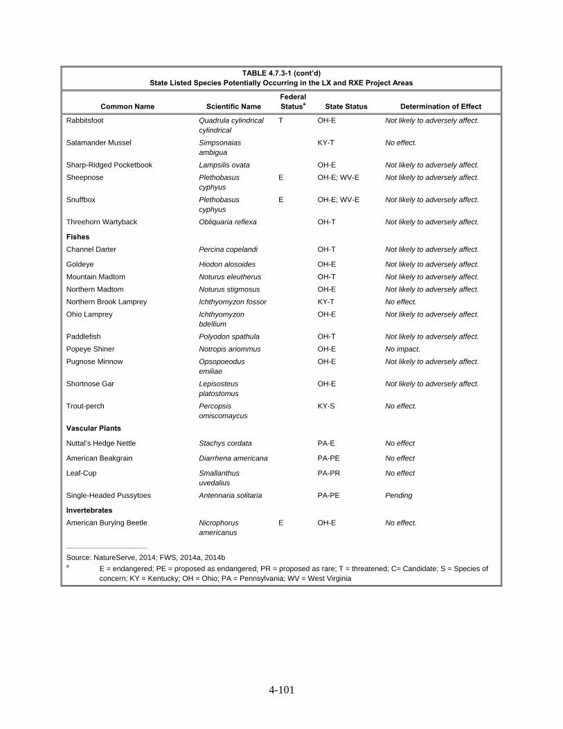
4-101
TABLE 4.7.3-1 (cont’d) State Listed Species Potentially Occurring in the LX and RXE Project Areas
Common Name Scientific Name Federal Statusa State Status Determination of Effect
Rabbitsfoot Quadrula cylindrical cylindrical
T OH-E Not likely to adversely affect.
Salamander Mussel Simpsonaias ambigua
KY-T No effect.
Sharp-Ridged Pocketbook Lampsilis ovata OH-E Not likely to adversely affect.
Sheepnose Plethobasus cyphyus
E OH-E; WV-E Not likely to adversely affect.
Snuffbox Plethobasus cyphyus
E OH-E; WV-E Not likely to adversely affect.
Threehorn Wartyback Obliquaria reflexa OH-T Not likely to adversely affect.
Fishes
Channel Darter Percina copelandi OH-T Not likely to adversely affect.
Goldeye Hiodon alosoides OH-E Not likely to adversely affect.
Mountain Madtom Noturus eleutherus OH-T Not likely to adversely affect.
Northern Madtom Noturus stigmosus OH-E Not likely to adversely affect.
Northern Brook Lamprey Ichthyomyzon fossor KY-T No effect.
Ohio Lamprey Ichthyomyzon bdellium
OH-E Not likely to adversely affect.
Paddlefish Polyodon spathula OH-T Not likely to adversely affect.
Popeye Shiner Notropis ariommus OH-E No impact.
Pugnose Minnow Opsopoeodus emiliae
OH-E Not likely to adversely affect.
Shortnose Gar Lepisosteus platostomus
OH-E Not likely to adversely affect.
Trout-perch Percopsis omiscomaycus
KY-S No effect.
Vascular Plants
Nuttal’s Hedge Nettle Stachys cordata PA-E No effect
American Beakgrain Diarrhena americana PA-PE No effect
Leaf-Cup Smallanthus uvedalius
PA-PR No effect
Single-Headed Pussytoes Antennaria solitaria PA-PE Pending
Invertebrates
American Burying Beetle Nicrophorus americanus
E OH-E No effect.
____________________
Source: NatureServe, 2014; FWS, 2014a, 2014b a E = endangered; PE = proposed as endangered; PR = proposed as rare; T = threatened; C= Candidate; S = Species of
concern; KY = Kentucky; OH = Ohio; PA = Pennsylvania; WV = West Virginia

4-102
Mammals 4.7.3.1
One species of state listed mammal could occur within the LX and RXE Project areas (see table 4.7.2-1).
Black Bear
The black bear is a state-listed endangered species in Ohio. Black bears inhabit wooded areas ranging from swamps and wetlands to dry upland hardwood and coniferous forests. Bears prefer wooded cover with a thick understory. The black bear uses fallen trees, hollow logs, tree cavities, and dense ground cover for denning. The species forge on a variety of fruits, grasses, and meats. This species is known to occur in Ashtabula County, Ohio and suitable habitat may be present in the LX Project area (NatureServe, 2015). Consultations with ODNR indicate that this species is highly mobile and would likely avoid the LX Project area; therefore, LX Project activities are not likely to adversely affect the black bear.
Reptiles 4.7.3.2
Two species of state listed reptile could occur within the LX and RXE Project areas (see table 4.7.2-1). Columbia conducted surveys for each of these species as discussed below.
Kirtland’s Snake
The Kirtland’s snake is a state-listed threatened species in Ohio. Typical habitat includes wetlands and wet meadows. This species is known to occur in western and southwestern Ohio and suitable habitat may be present sporadically throughout the LX Project area. The Kirtland’s snake feeds on earthworms and slugs (ODNR, 2015l). Habitat suitability surveys conducted in April 2015 identified suitable habitat for this species in the LX Project area. Presence/absence surveys were conducted in these areas in July and October 2015. During these surveys, no individuals of this species were documented; therefore, the LX Project would have no effect on the Kirtland’s snake.
Timber Rattlesnake
The timber rattlesnake is an Ohio-listed endangered species and a federally-listed species of concern. This species prefers wooded habitats with sunlit gaps in the canopy. Overwintering occurs in deep rock crevices. The timber rattlesnake feeds on mice, rats, chipmunks, and squirrels (ODNR, 2015n). Habitat suitability surveys conducted in April 2015 identified suitable habitat for this species in the LX Project area. Presence/absence surveys were conducted in these areas in July and October 2015. During these surveys, no individuals of this species were documented; therefore, the LX Project would have no effect on the Timber rattlesnake.
Amphibians 4.7.3.3
The eastern spadefoot toad is an Ohio-listed endangered species. Habitat for the eastern spadefoot toad includes areas of sandy soils associated with river valleys. Breeding occurs in these habitats, as well as in flooded agricultural fields or other water-holding depressions. This species is known to occur in southeastern Ohio (ODNR, 2014q). Habitat suitability surveys conducted in April 2015 identified suitable habitat in the LX Project area. Presence/absence surveys were conducted in these areas in June and July 2015. The results of these surveys would be submitted to ODNR with Columbia’s concurrence request in November 2016. During these surveys, no individuals of this species were identified; therefore, the LX Project would have no effect on the eastern spadefoot toad.

4-103
The eastern hellbender is an Ohio-listed endangered species and federally-listed species of concern. They prefer large, swift flowing perennial streams with large rocks for hiding. The eastern hellbender is known to occur in Muskingum and Vinton counties; however, counties crossed by the LX Project area do not contain suitable habitat. Therefore, the LX Project is not likely to adversely affect this species (ODNR, 2015o).
The green salamander is an Ohio-listed endangered species. The green salamander forages on small insects. Habitat for the green salamander includes deep moist cracks in limestone cliffs during the day and cliff faces at night (ODNR, 2015p), but can reside under fallen or standing trees providing damp habitat under loose bark and in cracks (NatureServe, 2015). This species is known to occur in Lawrence County, Ohio but no suitable habitat is located in the LX Project area for this county. Therefore, the LX Project is not likely to adversely affect this species.
Mussels 4.7.3.4
In a letter dated November 13, 2014, ODNR indicated that the LX Project must avoid impacts on any freshwater native mussel species. Additionally, ODNR identified a number of state-listed threatened or endangered mussel species that could occur in the LX Project area and those are listed in table 4.7.4-2.
To minimize impacts on freshwater mussel species, Columbia Gas must adhere to measures outlined in the Ohio Mussel Survey Protocol. All Group 2, 3, and 4 streams require a mussel survey. Group 1 streams and unlisted streams with a watershed of 100 square miles or larger above the point of impact would be assessed using the Reconnaissance Survey for Unionid Mussels. All open cut perennial streams that drain to an area greater than 10 square miles would require a mussel survey unless crossed via bore or HDD. Prior to any in-stream work, Columbia Gas must verify that no mussel impacts would occur. Mussel relocation by a professional malacologist is required if mussels are found in the stream and impacts cannot be avoided.
WVDNR identified five waterbodies crossed by the LX Project in West Virginia may contain sensitive freshwater mussel species, including the Ohio River, Fish Creek, Grave Creek, Dunkard Fork, and Twelvepole Creek. Columbia Gas conducted surveys for freshwater mussels in Fish Creek, Grave Creek, Dunkard Fork, and Twelvepole Creek in May, June, and July 2015. Surveys conducted in Fish Creek in July 2015 indicated that freshwater mussels are present at the pipeline crossing location and relocations prior to construction would be necessary. The access road crossing of Fish Creek, however, did not identify any mussels and no further action is recommended in this area. Surveys of Grave Creek, Dunkard Fork, and Twelvepole Creek were conducted in May and June 2015. No live mussels were identified within the survey area in Dunkard Fork or Grave Creek and LX Project activities in these areas are not likely to adversely affect mussels. Live mussels were identified in Twelvepole Creek. To minimize impacts on mussels within Twelvepole Creek during construction, Columbia Gas would relocate individuals prior to initiating in-stream activities. The Ohio River would be crossed via HDD, thereby avoiding impacts on mussels that may be present at the time of crossing. All surveys and relocations would be conducted in accordance with WVDNR-approved protocols for freshwater mussels. Columbia Gas submitted the results of these surveys to WVDNR and FWS for review and approval on October 19, 2015. Consultations with WVDNR to determine the potential impacts of LX Project activities on state-listed mussels are ongoing, pending the completion of surveys.
In Ohio state-listed mussel reconnaissance surveys were conducted in May 2015. The results of the reconnaissance survey were submitted to ODNR on August 26, 2015. Of the 11 sites that were surveyed, four contained live mussels, three could not be surveyed via reconnaissance methods due to waterbody depth, and four did not contain live mussels. Group 1 surveys would be conducted prior to construction at the seven sites that contained live mussels or could not be surveyed using reconnaissance methods. All live mussels identified during these preconstruction surveys would be relocated upstream;

4-104
thereby avoiding impacts associated with in-stream LX Project activities. The results of these surveys will be submitted to ODNR with Columbia Gas’ concurrence request in November 2016. As a result, the LX Project is not likely to adversely affect freshwater mussel species in Ohio. Since state-listed mussel surveys are not yet complete in Ohio and West Virginia, we recommend that:
Prior to constructing in water in Ohio and West Virginia, Columbia Gas should continue consultations with the applicable state agencies to identify any additional mitigation measures for state-protected mussel species and the need for additional surveys in Ohio and West Virginia. The results of such consultations and any state recommended mitigation measures should be filed with the Secretary.
Consultations with KDFWR identified two state-listed endangered or threatened mussels that could potentially occur in the RXE Project area (creek heelsplitter and the salamander mussel). However, the RXE Project would not directly impact the waterbodies where these species are found. Therefore, we have determined that the project would have no effect on these mussels.
Fish 4.7.3.5
Consultations with ODNR identified nine listed threatened or endangered fish that could potentially occur in the LX Project area (Ohio lamprey, shortnose gar, goldeye, pugnose minnow, popeye shiner, northern madtom, channel darter, paddlefish, and mountain madtom). The Ohio, Hocking, and Muskingum Rivers would be crossed via the HDD method and LX Project activities would not likely impact species located in these rivers, specifically the Ohio lamprey, shortnose gar, goldeye, channel darter, paddlefish, and mountain madtom (ODNR, 2014b).
The only known population of popeye shiner in Ohio occurs in Scioto Bush Creek, which would not be crossed by the LX Project; therefore, no impacts on the popeye shiner are expected (ODNR, 2014b).
The pugnose minnow prefers clear water streams containing aquatic vegetation with a substrate of organic debris or sand (ODNR, 2014b). Suitable habitat may be found in the project area in the Ohio, Muskingum, and Hocking Rivers. Columbia Gas would cross the Ohio and Muskingum Rivers via the HDD method, thereby not likely impacting the pugnose minnow. To further minimize impacts, the ODNR recommended no in-stream construction between March 15 and June 30; however, a waiver may be granted for the construction time period to extend construction outside the recommended time frame.
The northern madtom is found in deep swift riffles of large rivers in and around cobbles and boulders, specifically in the Muskingum, Scioto, and Little Miami River drainages (ODNR, 2014b). Known populations of northern madtom are in the Muskingum River. The project would cross the Muskingum River via the HDD method; therefore, LX Project activities are not likely to adversely affect the northern madtom.
Consultations with KDFWR identified two listed threatened or species of concern fish that could potentially occur in the RXE Project area (northern brook lamprey and trout-perch). However, the waterbodies these species are found in would not be directly impacted by the RXE Project; therefore, no effect on these fish are anticipated as a result of the RXE Project.
Vascular Plants 4.7.3.6
Consultations with PDCNR identified four species of special concern that could potentially occur in the LX Project area:, American beakgrain, leaf-cup, Nuttal’s hedge-nettle, and single-headed
4-105
pussytoes. PADCNR requested Columbia Gas perform surveys for these species of concern. Initial species-specific surveys conducted in July and August 2015 did not identify any populations or individuals;
The American beakgrain is currently not listed in Pennsylvania but is proposed endangered. It is locally documented on a woody slope and prefers rich woods. The American beakgrain produces a flower and fruits between July and mid-September (Bowen 2015). Concurrence with the determination that the Project will have no effect on American beakgrain was issued by PADCNR on January 6, 2016.
The leaf-cup is currently not listed in Pennsylvania but is proposed as rare. This species is locally documented in an open right-of-way. This species prefers ravines, thickets, roadsides, and river or stream banks. The leaf-cup flowers between July and September (Bowen, 2015). Concurrence with the determination that the Project will have no effect on leaf-cup was issued by PADCNR on January 6, 2016.
Nuttall’s hedge-nettle is a Pennsylvania-listed endangered species. This species is found on mesic wooded roadside slopes and prefers wooded mountain slopes. The flowering period for Nuttal’s hedge nettle is between June and July (Bowen, 2015). Concurrence with the determination that the Project will have no effect on Nuttall’s hedge nettle was issued by PADCNR on January 6, 2016.
The single-headed pussytoes has a current undetermined status in Pennsylvania but is proposed endangered. It is locally documented on a wooded slope and prefers rich woods. This species flowers from April to late May (Bowen, 2015). Consultations with PADCNR are ongoing for singleheaded pussytoes, pending the completion of surveys. Therefore, we recommend:
Prior to construction in Pennsylvania, Columbia Gas should file with the Secretary survey results and any mitigation measures developed in consultation with the PADCNR for single-headed pussytoes.
Birds 4.7.3.7
As discussed in Section 4.6.1.3, most native migratory birds are protected under the Migratory Bird Treaty Act (MBTA) originally passed in 1918. Executive Order 13186 (2001) directs federal agencies to consider the effects of agency actions on migratory birds, with emphasis on bird species of concern. Through consultations with the protected species agencies and research, we have identified four state-listed species (upland sandpiper, northern harrier, vesper sparrow, and sharp-shinned hawk) in the general area of the LX Project and RXE Project (table 4.7.4-2). The potential effects of the LX Project and RXE Project on these species are discussed below.
Upland Sandpiper
The upland sandpiper is a state-listed endangered bird species in Ohio. This species prefers nesting in dry grasslands, including native grasslands, pasture, hayfields, and seeded grasslands (FWS, 2014c). This species builds nests on the ground consisting of tall grass and broad-leafed weeds to conceal the nest. The upland sandpiper does not prefer mudflats or other wet areas and does not commonly breed in Ohio. These birds forage in grasses for insects and seeds (National Audubon Society, 2015). This species is known to occur in Ohio and suitable habitat may be present in the LX Project area. Columbia Gas would conduct clearing outside of the nesting season. Disturbance from construction would most likely deter upland sandpipers from nesting in the LX Project area. Therefore, LX Project activities are not likely to adversely affect this species.
4-106
Northern Harrier
The northern harrier is a state-listed endangered bird species in Ohio. This species builds nests in large marshes and grasslands. Breeding occurs in wetland areas containing thick vegetation. Nests are made on the ground in large, undisturbed wetlands and grasslands with low, dense vegetation in the summer months. In the winter, this species occurs in areas of low vegetation, such as pasturelands, croplands, dry plains, grasslands, estuaries, open floodplains, and marshes (Cornell Lab of Ornithology, 2015). This species is known to occur in Ohio year-round and suitable habitat may be present in the LX Project area. Columbia Gas would conduct clearing activities outside of the nesting season. This species is highly mobile and would likely relocate to similar adjacent habitats during the non-nesting season. Therefore, LX Project activities would not likely adversely affect the northern harrier.
Vesper Sparrow
The vesper sparrow is a state-listed endangered bird species in Kentucky. This species is found in plains, prairie, dry shrub lands, savanna, weedy pastures, fields, sagebrush, arid scrub, and woodland clearings. Breeding occurs along fencerows between agricultural fields. Nests are made on the ground, often in a small depression near a clump of grass (NatureServe, 2015). This species in known to occur in Kentucky; however, there is no suitable habitat near the RXE Project area. Therefore, no effects on the vesper sparrow are anticipated as a result of the RXE Project.
Sharp-shinned Hawk
The sharp-shinned hawk is a state-listed species of concern in Kentucky. This species is found in Forest and open woodland, coniferous, mixed, or deciduous, primarily in coniferous. It migrates through various habitats, mainly along ridges, lakeshores, and coastlines. Nests generally seem to be in a stand of dense conifers near a forest opening (NatureServe, 2015). This species in known to occur in Kentucky; however, there is no suitable habitat near the RXE Project area. Therefore, no effects on the sharp-skinned hawk are anticipated as a result of the project.
Bald Eagle 4.7.3.8
Bald eagles while no longer listed as threatened or endangered under Federal regulations remain protected under the federal Bald and Golden Eagle Act, Migratory Bird Act, and Lacey Act and certain state regulations. These regulations generally prohibit activities that would disturb, molest or result in the take of bald eagles, their parts, nest or eggs.
There are no known active bald eagle nests within the LX Project limits. The open water associated with the water bodies and open land can provide foraging habitat for bald eagles. Project implementation while resulting in a loss of open land would not likely have a significant negative effect on bald eagles. Columbia Gas would coordinate with FWS and appropriate state agencies to avoid adversely affecting bald eagles.
Conclusion 4.7.4
Columbia Gulf began implementing the MSHCP in January 2014 and would implement the appropriate avoidance and minimization measures per the MHSCP, such as clearing or cutting trees in the winter. The RXE Project activities would be located entirely within MSHCP-covered lands, and consultation for the identified federally listed species is complete. We have included the signed MSHCP Interagency Endangered Species Act Consultation Checklist in appendix M-4.

4-107
Where we determined that the proposed activities are consistent with the MSHCP, programmatic biological opinion and/or resource agency concurrence letters, no further consultation is required. For non-MSHCP species, Columbia Gas would implement BMPs similar to the AMMs, and additional Section 7 consultation is requested. In addition, consultations with the FWS in compliance with Section 7 of the ESA are required for Project areas that are not covered under the MSHCP (i.e., non-covered lands). We have determined that the LX Project is not likely to adversely affect most species in the LX Project area, and are recommending addition surveys for the running buffalo clover and small whorled pogonia, prior to construction, in order to complete consultation for these species.
The LX Project would have no effect on 8 state listed species, and the Project is not likely to adversely affect 29 state listed species. Columbia Gas continues consultations for the single-headed pussy toes. Additionally, Columbia Gas modified the LX route (South Fork crossing MP 50.9 RR-6) in several locations which would require additional mussel surveys prior start of construction. RXE would have no effect or is not likely to adversely affect any of the federal- and state-listed species identified as potentially occurring in Carter, Menifee, and Montgomery counties in Kentucky.
4.8 LAND USE, RECREATION, SPECIAL INTEREST AREAS, AND VISUAL RESOURCES
This section discusses the land requirements for construction and operation of the LX and RXE Projects, the current use of those lands, and an evaluation of the project-related effects. As described in section 2.0, the LX Project consists of nearly 160 miles of new natural gas pipelines across 11 counties in Ohio, 2 counties in West Virginia, and 1 county in Pennsylvania. The LX Project also includes abandonment in place of more than 28 miles of existing natural gas pipeline; construction or modification of 34 aboveground facilities, including compressor, regulator, and odorization stations, mainline valve sites, and launcher/ receiver facilities; and construction of 20 permanent access roads. Construction of the LX Project would require temporary access roads, as well as contractor, staging, and pipe yards.
The RXE Project includes the installation of two new compressor stations on the existing transmission system for delivery of gas. These aboveground facilities would occupy land in portions of three counties in northeastern Kentucky.
Land Use 4.8.1
Seven general land use types would be affected by the LX and RXE Projects. Table 4.8.1-1 summarizes the acreage of each land use type that would be affected by the LX Project, while table 4.8.1-2 summarizes land use types affected by the RXE Project. The definitions of each land use type are as follows:
agricultural land: actively cultivated or specialty crops, including hayfields;
industrial/commercial: manufacturing or industrial plants, paved areas, landfills, and commercial or retail facilities, and sand/gravel pits or quarries;
open land: open fields, grazed lands, existing unpaved utility rights-of-way, herbaceous and scrub-shrub uplands, non-forested lands, and non-paved roads;
open water: waterbody crossings greater than 100 feet;
wetlands: emergent wetlands, scrub-shrub wetlands, and forested wetlands;
forest/woodland: upland forest lands; and
residential: existing developed residential areas and planned residential developments, including large developments, residentially zoned areas that have been developed, and short segments of the route at road crossings with homes near the route alignment.

4-108
TABLE 4.8.1-1 Acreage Affected by Construction and Operation of the LX Projectd
Facilitiesa/ County
Forest Open Land Agricultural Industrial Residential Wetland Open Water Total
Const. Op. Const. Op. Const. Op. Const. Op. Const. Op. Const. Op. Const. Op. Const. Op.
Pipeline Facilities (Including Permanent and Temporary Right-of-Way and Cathodic Protection)
West Virginia
Marshall 224.2 87.2 28.7 13.1 102.7 44.1 1.8 1.0 1.1 0.4 1.1 0.6 1.4 1.3 361.1 147.6
Wayne 16.9 8.8 5.1 2.6 1.2 0.5 0.6 0.6 0.9 0.4 1.0 0.9 2.4 2.3 28.1 16.1
Pennsylvania
Greene 20.3 8.0 3.0 1.4 2.2 0.9 0.2 0.1 0.0 0.0 0.1 0.1 <0.1 <0.1 25.9 10.6
Ohio
Fairfield 61.3 28.3 9.0 4.5 15.2 7.8 0.3 0.2 <0.1 0.0 0.3 0.1 0.0 0.0 86.1 40.8
Hocking 153.3 56.8 50.9 16.0 72.9 27.8 2.5 1.3 0.8 0.3 4.7 3.2 0.4 0.3 285.5 105.7
Lawrence 0.0 0.0 0.2 0.2 0.0 0.0 1.5 0.2 0.0 0.0 0.0 0.0 0.1 0.1 1.7 0.4
Monroe 223.8 87.9 41.7 24.5 118.5 52.7 3.5 1.9 0.1 <0.1 2.2 1.5 0.3 0.3 390.1 168.7
Morgan 92.0 42.1 26.3 12.6 39.8 19.1 0.8 0.4 0.2 0.1 1.7 1.1 0.6 0.6 161.3 75.9
Muskingum 55.2 23.4 27.7 13.5 32.4 16.0 0.7 0.5 0.1 0.0 0.5 0.2 0.1 0.0 116.6 53.6
Noble 152.8 69.2 55.9 25.7 88.2 41.3 3.0 1.8 0.9 0.4 2.6 1.6 0.3 0.2 303.6 140.2
Perry 129.9 59.1 19.0 9.3 122.6 55.7 1.6 1.0 <0.1 <0.1 2.7 1.5 <0.1 <0.1 275.7 126.5
Vinton 74.8 24.3 28.8 7.2 19.1 6.3 3.8 0.7 0.1 0.0 0.2 0.1 <0.1 0.0 126.8 38.6
Pipeline Facilities Subtotal
1,204.5 495.1 296.2 130.4 614.6 272.1 20.2 9.6 4.3 1.6 17.0 10.7 5.5 5.0 2,162.4 924.5
Additional Temporary Workspace (ATWS)
West Virginia
Marshall 27.8 0.0 3.2 0.0 16.4 0.0 0.4 0.0 0.2 0.0 0.2 0.0 0.0 0.0 48.1 0.0
Wayne 3.7 0.0 1.2 0.0 1.2 0.0 <0.1 0.0 0.2 0.0 0.0 0.0 0.0 0.0 6.4 0.0
Pennsylvania
Greene 1.9 0.0 0.8 0.0 0.3 0.0 <0.1 0.0 0.0 0.0 <0.1 0.0 0.0 0.0 3.0 0.0
Ohio
Fairfield 4.6 0.0 0.6 0.0 1.6 0.0 0.3 0.0 0.1 0.0 0.0 0.0 0.0 0.0 7.4 0.0
Hocking 16.2 0.0 7.0 0.0 12.0 0.0 1.0 0.0 1.0 0.0 <0.1 0.0 0.0 0.0 37.4 0.0
Monroe 31.2 0.0 2.1 0.0 17.1 0.0 0.9 0.0 0.0 0.0 0.1 0.0 0.0 0.0 51.3 0.0
Morgan 10.4 0.0 1.9 0.0 6.2 0.0 0.1 0.0 0.1 0.0 <0.1 0.0 0.0 0.0 18.7 0.0
Muskingum 4.0 0.0 1.9 0.0 3.4 0.0 0.2 0.0 <0.1 0.0 0.0 0.0 0.0 0.0 9.4 0.0
Noble 9.4 0.0 5.7 0.0 11.6 0.0 0.5 0.0 0.0 0.0 <0.1 0.0 0.0 0.0 27.3 0.0

4-109
TABLE 4.8.1-1 (cont’d) Acreage Affected by Construction and Operation of the LX Projectd
Facilitiesa/ County
Forest Open Land Agricultural Industrial Residential Wetland Open Water Total
Const. Op. Const. Op. Const. Op. Const. Op. Const. Op. Const. Op. Const. Op. Const. Op.
Perry 8.6 0.0 2.0 0.0 18.0 0.0 0.2 0.0 <0.1 0.0 0.2 0.0 0.0 0.0 29.0 0.0
Vinton 8.1 0.0 3.9 0.0 1.3 0.0 0.5 0.0 0.2 0.0 <0.1 0.0 0.0 0.0 13.9 0.0
ATWS Subtotal 126.2 0.0 30.2 0.0 89.0 0.0 4.1 0.0 1.8 0.0 0.4 0.0 0.0 0.0 251.9 0.0
Access Roadsb
West Virginia
Marshall 0.6 0.1 2.5 0.2 7.9 0.1 8.4 1.3 0.3 0.1 <0.1 0.0 0.0 0.0 19.8 1.7
Wayne 0.1 0.0 0.1 0.0 0.0 0.0 0.0 0.0 0.0 0.0 0.0 0.0 0.0 0.0 0.2 0.0
Pennsylvania
Greene 0.1 0.0 0.7 0.0 0.1 0.0 <0.1 0.0 0.0 0.0 <0.1 0.0 0.0 0.0 0.9 0.0
Ohio
Fairfield 0.9 0.7 1.3 0.8 2.2 0.9 1.4 1.3 0.3 0.3 0.0 0.0 0.0 0.0 6.1 4.0
Hocking 1.3 <0.1 12.1 0.2 5.5 0.0 1.6 0.4 0.4 0.0 0.3 0.0 0.0 0.0 21.2 0.6
Jackson 0.1 0.1 <0.1 <0.1 1.9 1.1 1.4 0.1 0.0 0.0 0.0 0.0 0.0 0.0 3.4 1.3
Lawrence 0.0 0.0 0.1 0.0 0.0 0.0 0.2 0.0 0.0 0.0 0.0 0.0 0.0 0.0 0.3 0.0
Monroe 0.6 0.1 2.5 0.2 7.9 0.1 8.4 1.3 0.3 0.1 <0.1 0.0 0.0 0.0 19.8 1.7
Morgan <0.1 <0.1 <0.1 <0.1 0.1 0.1 0.3 0.3 0.0 0.0 0.0 0.0 0.0 0.0 0.5 0.5
Muskingum 0.6 <0.1 7.1 0.0 1.0 0.0 0.3 <0.1 0.0 0.0 0.0 0.0 0.0 0.0 9.0 <0.1
Noble 1.0 0.0 1.4 0.0 0.6 0.0 <0.1 0.0 0.0 0.0 <0.1 0.0 0.0 0.0 3.0 0.0
Perry 0.0 0.0 <0.1 <0.1 0.0 0.0 0.3 0.0 0.0 0.0 0.0 0.0 0.0 0.0 0.3 <0.1
Vinton 0.4 0.2 1.1 0.3 1.5 0.4 3.8 1.1 0.1 0.0 0.1 0.0 0.0 0.0 6.9 2.0
Access Roads Subtotal
7.3 1.4 34.0 1.8 29.8 2.6 22.1 4.6 1.2 0.3 0.4 0.0 0.0 0.0 94.9 10.8
Contractor Yards
West Virginia
Marshall 4.2 0.0 13.5 0.0 6.7 0.0 9.3 0.0 0.0 0.0 0.0 0.0 0.0 0.0 33.7 0.0
Ohio
Belmont 0.0 0.0 42.6 0.0 23.0 0.0 0.0 0.0 0.0 0.0 0.0 0.0 0.0 0.0 65.6 0.0
Fairfield 0.0 0.0 0.7 0.0 11.0 0.0 3.4 0.0 0.0 0.0 <0.1 0.0 0.0 0.0 15.2 0.0
Guernsey 0.0 0.0 0.0 0.0 55.0 0.0 0.0 0.0 0.0 0.0 0.6 0.0 0.0 0.0 55.6 0.0
Hocking 0.3 0.0 15.3 0.0 12.2 0.0 1.6 0.0 0.0 0.0 0.1 0.0 0.0 0.0 29.4 0.0
Monroe 0.3 0.0 0.0 0.0 38.9 0.0 22.4 0.0 0.0 0.0 <0.1 0.0 0.0 0.0 61.6 0.0
Morgan 0.7 0.0 1.3 0.0 18.5 0.0 9.0 0.0 0.0 0.0 0.0 0.0 0.0 0.0 29.4 0.0
Muskingum 0.0 0.0 80.4 0.0 0.0 0.0 11.7 0.0 0.0 0.0 0.5 0.0 0.3 0.0 92.9 0.0
Noble 1.2 0.0 0.2 0.0 27.0 0.0 15.6 0.0 0.0 0.0 0.3 0.0 0.0 0.0 44.3 0.0
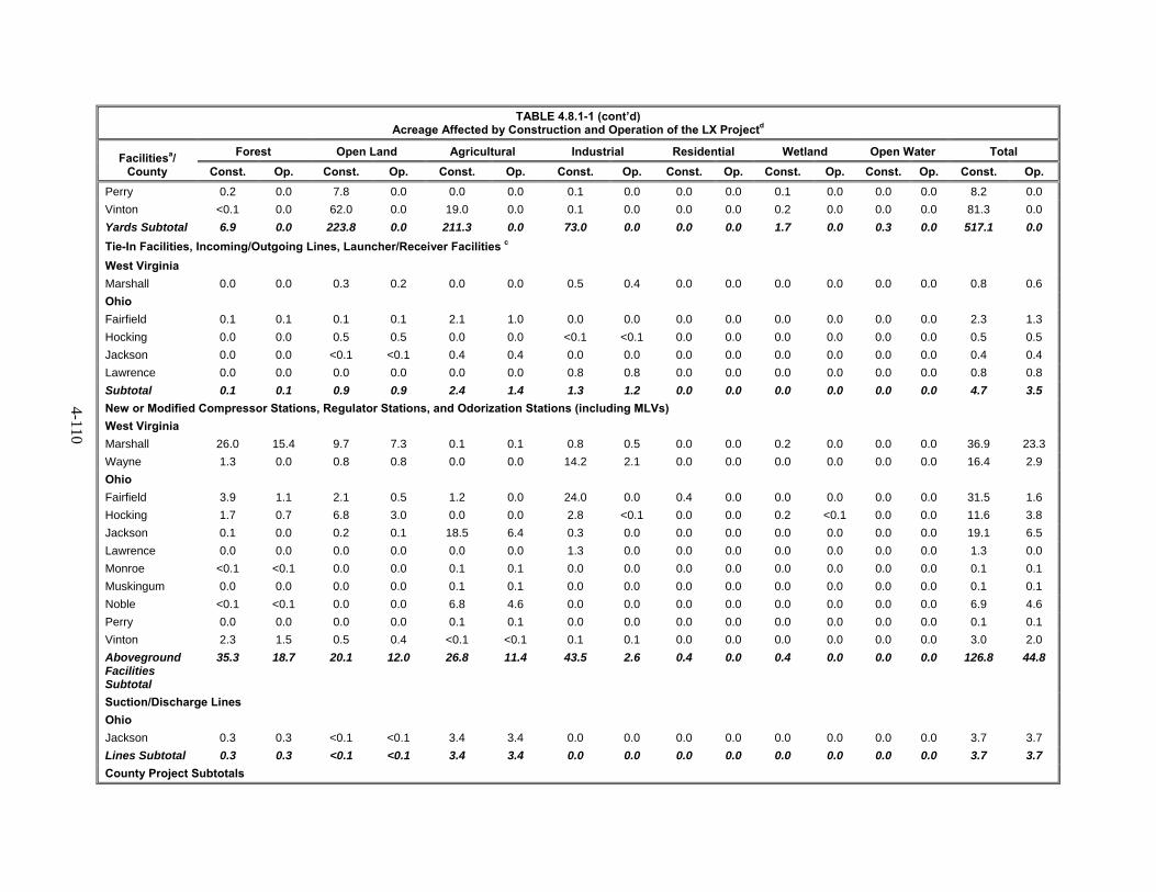
4-110
TABLE 4.8.1-1 (cont’d) Acreage Affected by Construction and Operation of the LX Projectd
Facilitiesa/ County
Forest Open Land Agricultural Industrial Residential Wetland Open Water Total
Const. Op. Const. Op. Const. Op. Const. Op. Const. Op. Const. Op. Const. Op. Const. Op.
Perry 0.2 0.0 7.8 0.0 0.0 0.0 0.1 0.0 0.0 0.0 0.1 0.0 0.0 0.0 8.2 0.0
Vinton <0.1 0.0 62.0 0.0 19.0 0.0 0.1 0.0 0.0 0.0 0.2 0.0 0.0 0.0 81.3 0.0
Yards Subtotal 6.9 0.0 223.8 0.0 211.3 0.0 73.0 0.0 0.0 0.0 1.7 0.0 0.3 0.0 517.1 0.0
Tie-In Facilities, Incoming/Outgoing Lines, Launcher/Receiver Facilities c
West Virginia
Marshall 0.0 0.0 0.3 0.2 0.0 0.0 0.5 0.4 0.0 0.0 0.0 0.0 0.0 0.0 0.8 0.6
Ohio
Fairfield 0.1 0.1 0.1 0.1 2.1 1.0 0.0 0.0 0.0 0.0 0.0 0.0 0.0 0.0 2.3 1.3
Hocking 0.0 0.0 0.5 0.5 0.0 0.0 <0.1 <0.1 0.0 0.0 0.0 0.0 0.0 0.0 0.5 0.5
Jackson 0.0 0.0 <0.1 <0.1 0.4 0.4 0.0 0.0 0.0 0.0 0.0 0.0 0.0 0.0 0.4 0.4
Lawrence 0.0 0.0 0.0 0.0 0.0 0.0 0.8 0.8 0.0 0.0 0.0 0.0 0.0 0.0 0.8 0.8
Subtotal 0.1 0.1 0.9 0.9 2.4 1.4 1.3 1.2 0.0 0.0 0.0 0.0 0.0 0.0 4.7 3.5
New or Modified Compressor Stations, Regulator Stations, and Odorization Stations (including MLVs)
West Virginia
Marshall 26.0 15.4 9.7 7.3 0.1 0.1 0.8 0.5 0.0 0.0 0.2 0.0 0.0 0.0 36.9 23.3
Wayne 1.3 0.0 0.8 0.8 0.0 0.0 14.2 2.1 0.0 0.0 0.0 0.0 0.0 0.0 16.4 2.9
Ohio
Fairfield 3.9 1.1 2.1 0.5 1.2 0.0 24.0 0.0 0.4 0.0 0.0 0.0 0.0 0.0 31.5 1.6
Hocking 1.7 0.7 6.8 3.0 0.0 0.0 2.8 <0.1 0.0 0.0 0.2 <0.1 0.0 0.0 11.6 3.8
Jackson 0.1 0.0 0.2 0.1 18.5 6.4 0.3 0.0 0.0 0.0 0.0 0.0 0.0 0.0 19.1 6.5
Lawrence 0.0 0.0 0.0 0.0 0.0 0.0 1.3 0.0 0.0 0.0 0.0 0.0 0.0 0.0 1.3 0.0
Monroe <0.1 <0.1 0.0 0.0 0.1 0.1 0.0 0.0 0.0 0.0 0.0 0.0 0.0 0.0 0.1 0.1
Muskingum 0.0 0.0 0.0 0.0 0.1 0.1 0.0 0.0 0.0 0.0 0.0 0.0 0.0 0.0 0.1 0.1
Noble <0.1 <0.1 0.0 0.0 6.8 4.6 0.0 0.0 0.0 0.0 0.0 0.0 0.0 0.0 6.9 4.6
Perry 0.0 0.0 0.0 0.0 0.1 0.1 0.0 0.0 0.0 0.0 0.0 0.0 0.0 0.0 0.1 0.1
Vinton 2.3 1.5 0.5 0.4 <0.1 <0.1 0.1 0.1 0.0 0.0 0.0 0.0 0.0 0.0 3.0 2.0
Aboveground Facilities Subtotal
35.3 18.7 20.1 12.0 26.8 11.4 43.5 2.6 0.4 0.0 0.4 0.0 0.0 0.0 126.8 44.8
Suction/Discharge Lines
Ohio
Jackson 0.3 0.3 <0.1 <0.1 3.4 3.4 0.0 0.0 0.0 0.0 0.0 0.0 0.0 0.0 3.7 3.7
Lines Subtotal 0.3 0.3 <0.1 <0.1 3.4 3.4 0.0 0.0 0.0 0.0 0.0 0.0 0.0 0.0 3.7 3.7
County Project Subtotals

4-111
TABLE 4.8.1-1 (cont’d) Acreage Affected by Construction and Operation of the LX Projectd
Facilitiesa/ County
Forest Open Land Agricultural Industrial Residential Wetland Open Water Total
Const. Op. Const. Op. Const. Op. Const. Op. Const. Op. Const. Op. Const. Op. Const. Op.
West Virginia
Marshall 282.9 102.7 57.9 20.8 133.9 44.4 21.5 3.5 1.6 0.4 1.5 0.6 1.4 1.3 500.7 173.7
Wayne 22.1 8.8 7.3 3.4 2.3 0.5 14.9 2.7 1.1 0.4 1.0 0.9 2.4 2.3 51.1 19.0
Subtotal West Virginia
304.9 111.5 65.2 24.2 136.3 44.9 36.4 6.2 2.7 0.8 2.4 1.5 3.8 3.6 551.8 192.7
Pennsylvania
Greene 22.4 8.0 4.5 1.4 2.5 0.9 0.3 0.1 0.0 0.0 0.1 0.1 <0.1 <0.1 29.8 10.6
Subtotal Pennsylvania
22.4 8.0 4.5 1.4 2.5 0.9 0.3 0.1 0.0 0.0 0.1 0.1 <0.1 <0.1 29.8 10.6
Ohio
Belmont 0.0 0.0 42.6 0.0 23.0 0.0 0.0 0.0 0.0 0.0 0.0 0.0 0.0 0.0 65.6 0.0
Fairfield 70.9 30.1 13.9 5.9 33.3 9.7 29.4 1.5 0.9 0.3 0.3 0.1 0.0 0.0 148.6 47.7
Guernsey 0.0 0.0 0.0 0.0 55.0 0.0 0.0 0.0 0.0 0.0 0.6 0.0 0.0 0.0 55.6 0.0
Hocking 172.8 57.6 92.6 19.7 102.6 27.8 9.6 1.8 2.3 0.3 5.3 3.2 0.4 0.3 385.6 110.6
Jackson 0.5 0.3 0.3 0.2 24.2 11.4 1.7 0.1 0.0 0.0 0.0 0.0 0.0 0.0 26.6 11.9
Lawrence 0.0 0.0 0.3 0.2 0.0 0.0 3.7 1.0 0.0 0.0 0.0 0.0 0.1 0.1 4.0 1.2
Monroe 255.9 87.9 50.8 24.5 175.6 52.8 27.0 1.9 0.1 0.0 2.3 1.5 0.3 0.3 512.0 168.8
Morgan 104.1 42.1 30.9 12.6 65.1 19.1 9.8 0.4 0.2 0.1 1.7 1.1 0.6 0.6 212.4 75.9
Muskingum 59.3 23.4 109.9 13.5 35.8 16.1 12.8 0.5 0.1 0.0 1.0 0.2 0.4 0.0 219.2 53.6
Noble 163.8 69.4 62.9 26.0 135.2 46.3 22.8 3.0 1.0 0.4 3.0 1.6 0.3 0.2 389.0 147.1
Perry 139.2 59.1 31.2 9.3 144.5 55.7 2.0 1.0 0.2 <0.1 2.9 1.5 <0.1 <0.1 32<0.1 126.6
Vinton 86.9 26.2 100.3 8.0 44.4 6.4 8.9 0.7 0.3 0.0 0.4 0.1 0.0 0.0 241.2 41.3
Subtotal Ohio 1053.3 396.1 535.7 119.7 838.7 245.2 127.7 11.8 5.0 1.1 17.5 9.2 2.0 1.4 2,259.9 784.7
LX PROJECT TOTAL
1,380.6 515.6 605.4 145.4 977.6 291.2 164.2 17.8 7.8 1.9 20.1 10.7 5.9 5.0 3,161.6 987.7
____________________
a Impacts associated with MLVs and cathodic protection are included in the pipeline facility impacts. Tie-in facility and tie-in valve impacts are associated with aboveground facilities.
b Includes access roads associated with pipeline facilities as well as aboveground facilities (i.e., Compressor Stations, Odorization Sites, etc.) c Impacts associated with launcher and receiver facilities are only listed for cases where these facilities are not collocated with other aboveground facilities.
Subtotals and totals may not add up due to rounding.
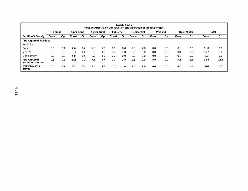
4-112
TABLE 4.8.1-2 Acreage Affected by Construction and Operation of the RXE Project
Facilitiesa/ County
Forest Open Land Agricultural Industrial Residential Wetland Open Water Total
Const. Op. Const. Op. Const. Op. Const. Op. Const. Op. Const. Op. Const. Op. Const. Op.
Aboveground Facilities
Kentucky
Carter 0.5 0.1 0.6 0.0 7.8 5.7 0.0 0.0 2.8 2.8 0.0 0.0 0.1 0.0 11.8 8.6
Menifee 0.0 0.0 12.4 6.6 0.0 0.0 3.3 1.0 0.0 0.0 0.0 0.0 0.0 0.0 15.7 7.6
Montgomery 0.0 0.0 6.8 0.6 0.0 0.0 0.0 0.0 0.0 0.0 0.0 0.0 0.1 0.0 6.9 0.6
Aboveground Facilities Subtotal
0.5 0.1 19.8 7.2 7.8 5.7 3.3 1.0 2.8 2.8 0.0 0.0 0.2 0.0 34.4 16.8
RXE PROJECT TOTAL
0.5 0.1 19.8 7.2 7.8 5.7 3.3 1.0 2.8 2.8 0.0 0.0 0.2 0.0 34.4 16.8

4-113
Environmental Setting 4.8.1.1
Construction of the LX Project would affect a total of 3,161.6 acres, while operations would affect approximately 987.7 acres. Table 4.8.1.1-1 shows the existing land uses affected by the LX Project during both construction and operation. Right-of-way alone (including permanent and temporary right-of-way and ATWS) would account for approximately 76.6 percent of all affected land during the construction phase, and approximately 95.0 percent of all affected land during the operations phase.
The primary land use types affected during LX Project construction would be forest (43.7 percent of all affected land), agriculture (30.9 percent), and open land (19.1 percent). Industrial, wetlands, residential, and open water would comprise the remaining land affected during construction.
Construction of the RXE Project would affect a total of 34.4 acres during construction. Table 4.8.1.1-2 shows the existing land uses affected by the RXE Project during both construction and operation. The primary land use types affected by the RXE Project would be open land (57.6 percent of all affected land during construction) and agriculture (22.7 percent). Industrial, residential, forest, and open water would comprise the remaining area affected by construction of the RXE Project.
Following construction, lands outside of the permanent right-of way, aboveground facilities (for both LX and RXE Project components), and permanent access roads would be allowed to revert to their original land use type. Operation of the LX Project would permanently affect approximately 987.7 acres. The primary land use types affected during project operation include forested (52.2 percent) and agriculture (30.9 percent). Open land, industrial, wetlands, residential, and open water would comprise the remaining land affected only during operations.
Operation of the RXE Project would permanently affect approximately 16.8 acres. The primary land use types affected during RXE Project operation include open land (46.4 percent) and agriculture (33.9 percent). Residential, industrial, and forest would comprise the remaining land affected by operation of the RXE Project.
Pipeline Facilities 4.8.1.2
Information in this section refers only to the LX Project. The LX Project consists of approximately 160.7 miles pipeline (132.4 miles for LEX, 24.2 miles for the R-801 Loop, and 2.9 miles for the BM-111 Loop), as well as 1.2 miles of new 30-inch-diameter pipe (LEX1), and abandonment in-place of 28.2 miles of the existing 20-inch R-501 Line. Table 4.8.1.1-1 summarizes the types of land crossed by the LX Project.
Predominant land uses along the pipeline corridors are forested, agricultural land, open land, and wetlands. The remaining land is comprised of residential, commercial/industrial (including roadways), and open water. Residences and other structures within 50 feet of the construction workspace are discussed in section 4.8.3.1.
In general, land use-related impacts associated with the LX Project would include the disturbance of existing uses within the right-of-way during construction, and a new permanent right-of-way for operation of the pipeline. Columbia Gas would use a 110-foot-wide construction right-of-way, consisting of 50 feet of permanent right-of-way and 60 feet of temporary construction workspace. In wetland areas, Columbia Gas would use a 75-foot-wide construction right-of-way (including a 50-foot-wide permanent right-of-way) except where a modification has been requested and found acceptable (section 4.4.4). Between LEX MPs 0.0 and 39.0, Columbia Gas would use a 125-foot-wide construction right-of-way (including a 50-foot-wide permanent right-of-way) for added safety in steep terrain.
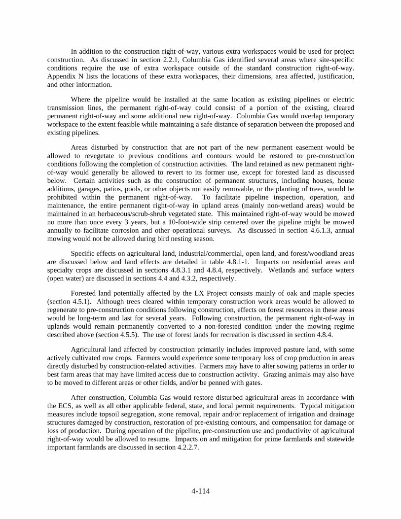
4-114
In addition to the construction right-of-way, various extra workspaces would be used for project construction. As discussed in section 2.2.1, Columbia Gas identified several areas where site-specific conditions require the use of extra workspace outside of the standard construction right-of-way. Appendix N lists the locations of these extra workspaces, their dimensions, area affected, justification, and other information.
Where the pipeline would be installed at the same location as existing pipelines or electric transmission lines, the permanent right-of-way could consist of a portion of the existing, cleared permanent right-of-way and some additional new right-of-way. Columbia Gas would overlap temporary workspace to the extent feasible while maintaining a safe distance of separation between the proposed and existing pipelines.
Areas disturbed by construction that are not part of the new permanent easement would be allowed to revegetate to previous conditions and contours would be restored to pre-construction conditions following the completion of construction activities. The land retained as new permanent right-of-way would generally be allowed to revert to its former use, except for forested land as discussed below. Certain activities such as the construction of permanent structures, including houses, house additions, garages, patios, pools, or other objects not easily removable, or the planting of trees, would be prohibited within the permanent right-of-way. To facilitate pipeline inspection, operation, and maintenance, the entire permanent right-of-way in upland areas (mainly non-wetland areas) would be maintained in an herbaceous/scrub-shrub vegetated state. This maintained right-of-way would be mowed no more than once every 3 years, but a 10-foot-wide strip centered over the pipeline might be mowed annually to facilitate corrosion and other operational surveys. As discussed in section 4.6.1.3, annual mowing would not be allowed during bird nesting season.
Specific effects on agricultural land, industrial/commercial, open land, and forest/woodland areas are discussed below and land effects are detailed in table 4.8.1-1. Impacts on residential areas and specialty crops are discussed in sections 4.8.3.1 and 4.8.4, respectively. Wetlands and surface waters (open water) are discussed in sections 4.4 and 4.3.2, respectively.
Forested land potentially affected by the LX Project consists mainly of oak and maple species (section 4.5.1). Although trees cleared within temporary construction work areas would be allowed to regenerate to pre-construction conditions following construction, effects on forest resources in these areas would be long-term and last for several years. Following construction, the permanent right-of-way in uplands would remain permanently converted to a non-forested condition under the mowing regime described above (section 4.5.5). The use of forest lands for recreation is discussed in section 4.8.4.
Agricultural land affected by construction primarily includes improved pasture land, with some actively cultivated row crops. Farmers would experience some temporary loss of crop production in areas directly disturbed by construction-related activities. Farmers may have to alter sowing patterns in order to best farm areas that may have limited access due to construction activity. Grazing animals may also have to be moved to different areas or other fields, and/or be penned with gates.
After construction, Columbia Gas would restore disturbed agricultural areas in accordance with the ECS, as well as all other applicable federal, state, and local permit requirements. Typical mitigation measures include topsoil segregation, stone removal, repair and/or replacement of irrigation and drainage structures damaged by construction, restoration of pre-existing contours, and compensation for damage or loss of production. During operation of the pipeline, pre-construction use and productivity of agricultural right-of-way would be allowed to resume. Impacts on and mitigation for prime farmlands and statewide important farmlands are discussed in section 4.2.2.7.

4-115
Open lands affected by the LX Project include open fields, existing utility rights-of-way, herbaceous and scrub-shrub uplands, other non-forested lands, and non-paved roads. Construction-related impacts on open land would include the removal of vegetation and disturbance of soils. Following construction, most open land uses would return to their former condition using state-approved seed mixtures.
Industrial/commercial land uses could be temporarily affected during construction of the LX Project pipeline by increased dust from exposed soils, construction noise, and traffic congestion. Columbia Gas would minimize impacts on commercial land uses by coordinating driveway crossings with business owners to provide access across the construction right-of-way.
Aboveground Facilities 4.8.1.3
LX Project
Columbia Gas proposes to construct 12 new aboveground facilities and modify 3 existing aboveground facilities. All of these facilities would be adjacent to the permanent pipeline right-of-way (including segments of the existing R-System pipeline) or within existing aboveground facility footprints. In addition, Columbia Gas proposes to construct 13 new launcher and receiver facilities within the footprint of existing aboveground facilities and 9 new mainline valve assemblies, within the permanent right-of-way along the pipeline, and are included in the discussion of pipeline facilities in section 4.8.1.2. Figure 2.1-1 shows the location of these aboveground facilities.
Facilities that would require new areas of land disturbance (temporary or permanent) include:
three new compressor stations (the Lone Oak CS and Summerfield CS along LEX, and Oak Hill CS along the existing Columbia system), with new suction and discharge lines at two of these facilities (Lone Oak and Oak Hill);
four new regulator stations (K-260 RS, R-System RS, Benton RS, and McArthur RS);
five new odorization stations (Benton CS OS, R-486 OS, R-130 OS, R-543 OS, R-300/R-500 OS) along Columbia’s existing pipeline system;
modifications to two existing compressor stations (Ceredo CS along the BM-111 Loop and Crawford CS along the existing Columbia System); and
modifications to one existing regulator station (RS-1286).
The acreages and impacts discussed in the remainder of this section apply only to the aboveground facilities listed above.
A total of approximately 146.6 acres of land would be disturbed by construction of these aboveground facilities. Of this total, approximately 61.4 acres would be permanently retained for operation. Table 4.8.1-3 summarizes the land requirements and land uses for the aboveground facilities, except for MLVs, which are addressed as part of pipeline facilities in section 4.8.1.2, and access roads, which are addressed in section 4.8.1.5.
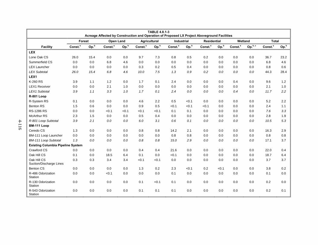
4-116
TABLE 4.8.1-3 Acreage Affected by Construction and Operation of Proposed LX Project Aboveground Facilities
Facility
Forest Open Land Agricultural Industrial Residential Wetland Total
Const.a Op.b Const.a Op.b Const.a Op.b Const.a Op.b Const.a Op.b Const.a Op.b, c Const.a Op.b
LEX
Lone Oak CS 26.0 15.4 0.0 0.0 9.7 7.3 0.8 0.5 0.2 0.0 0.0 0.0 36.7 23.2
Summerfield CS 0.0 0.0 6.8 4.6 0.0 0.0 0.0 0.0 0.0 0.0 0.0 0.0 6.8 4.6
LEX Launcher 0.0 0.0 0.0 0.0 0.3 0.2 0.5 0.4 0.0 0.0 0.0 0.0 0.8 0.6
LEX Subtotal 26.0 15.4 6.8 4.6 10.0 7.5 1.3 0.9 0.2 0.0 0.0 0.0 44.3 28.4
LEX1
K-260 RS 3.9 1.1 1.2 0.0 1.7 0.1 2.4 0.0 0.0 0.0 0.4 0.0 9.6 1.2
LEX1 Receiver 0.0 0.0 2.1 1.0 0.0 0.0 0.0 0.0 0.0 0.0 0.0 0.0 2.1 1.0
LEX1 Subtotal 3.9 1.1 3.3 1.0 1.7 0.1 2.4 0.0 0.0 0.0 0.4 0.0 11.7 2.2
R-801 Loop
R-System RS 0.1 0.0 0.0 0.0 4.6 2.2 0.5 <0.1 0.0 0.0 0.0 0.0 5.2 2.2
Benton RS 1.5 0.6 0.0 0.0 0.9 0.5 <0.1 <0.1 <0.1 0.0 0.0 0.0 2.4 1.1
RS-1286 RS 0.0 0.0 <0.1 <0.1 <0.1 <0.1 0.1 0.1 0.0 0.0 0.0 0.0 7.6 3.3
McArthur RS 2.3 1.5 0.0 0.0 0.5 0.4 0.0 0.0 0.0 0.0 0.0 0.0 2.8 1.9
R-801 Loop Subtotal 3.9 2.1 0.0 0.0 6.0 3.1 0.6 0.1 0.0 0.0 0.0 0.0 10.5 5.3
BM-111 Loop
Ceredo CS 1.3 0.0 0.0 0.0 0.8 0.8 14.2 2.1 0.0 0.0 0.0 0.0 16.3 2.9
BM-111 Loop Launcher 0.0 0.0 0.0 0.0 0.0 0.0 0.8 0.8 0.0 0.0 0.0 0.0 0.8 0.8
BM-111 Loop Subtotal 1.3 0.0 0.0 0.0 0.8 0.8 15.0 2.9 0.0 0.0 0.0 0.0 17.1 3.7
Existing Columbia Pipeline System
Crawford CS 0.0 0.0 0.0 0.0 0.4 0.4 21.6 0.0 0.0 0.0 0.0 0.0 22.0 0.4
Oak Hill CS 0.1 0.0 18.5 6.4 0.1 0.0 <0.1 0.0 0.0 0.0 0.0 0.0 18.7 6.4
Oak Hill CS Suction/Discharge Lines
0.3 0.3 3.4 3.4 <0.1 <0.1 0.0 0.0 0.0 0.0 0.0 0.0 3.7 3.7
Benton CS 0.0 0.0 0.0 0.0 1.3 0.2 2.3 <0.1 0.2 <0.1 0.0 0.0 3.8 0.2
R-486 Odorization Station
0.0 0.0 <0.1 0.0 0.0 0.0 0.1 0.0 0.0 0.0 0.0 0.0 0.1 0.0
R-130 Odorization Station
0.0 0.0 0.0 0.0 0.1 <0.1 0.1 0.0 0.0 0.0 0.0 0.0 0.2 0.0
R-543 Odorization Station
0.0 0.0 0.0 0.0 0.1 0.1 0.1 0.0 0.0 0.0 0.0 0.0 0.2 0.1

4-117
TABLE 4.8.1-3 (cont’d) Acreage Affected by Construction and Operation of Proposed LX Aboveground Facilities
Facility
Forest Open Land Agricultural Industrial Residential Wetland Total
Const.a Op.b Const.a Op.b Const.a Op.b Const.a Op.b Const.a Op.b Const.a Op.b, c Const.a Op.b
R-300/R-500 Odorization Station
0.0 0.0 0.0 0.0 0.0 0.0 1.3 0.0 0.0 0.0 0.0 0.0 1.3 0.0
Existing System Subtotal 0.4 0.3 21.9 9.8 2.0 0.7 25.5 0.0 0.2 0.0 0.0 0.0 50.0 10.8
Total, Aboveground Facilities
35.5 18.9 32.0 15.4 20.5 12.2 44.8 3.9 0.4 0.0 0.4 0.0 133.6 50.5
____________________ a Land affected during construction is inclusive of operation impacts (permanent). b Land affected during operation consists only of new permanent impacts. c Operational land use impacts associated with wetlands have been calculated based on the proposed 50-foot–wide permanent easement. Per the FERC Procedures, Columbia would maintain a 10-foot-wide cleared easement in wetlands. Trees within 15 feet of the pipeline with root systems that could compromise the integrity of the pipeline coating would also be selectively removed, for a total maintenance corridor of up to 30 feet. Additionally, the areas between horizontal directional drill (HDD) entry and exit locations would not be affected by construction or operation, with the exception of temporary access roads necessary for hydrostatic test water withdrawal, to minimize and avoid wetland impacts. d There would be no impacts to open water.

4-118
Construction of aboveground facilities would affect approximately 49.4 acres of industrial land, 36.2 acres of agricultural land, 37.1 acres of forest, and 22.9 acres of open land, with minimal effects on residential lands, wetlands, or open water. The operational footprint of aboveground facilities would permanently affect approximately 20.5 acres of forest, 19.0 acres of agricultural land, 14.8 acres of open land, and 7.0 acres of industrial land.
Following construction, affected land outside of permanent aboveground facility footprints would be restored to previous land uses, in accordance with Columbia Gas’ ECS. This would include planting trees in former forested areas and using approved seed mixes in former open lands.
RXE Project
Columbia Gulf proposes to construct and operate two new compressor stations and to modify one existing aboveground facility on its existing natural gas transmission system in northeastern Kentucky. These facilities include the new Grayson CS in Carter County, Kentucky, the new Means CS in Menifee and Montgomery Counties, Kentucky, and modifications to the existing Means Measurement and Regulation Station in Menifee County, Kentucky. Table 4.8.1-4 summarizes the land requirements and land uses for these aboveground facilities.
Project Contractor Yards 4.8.1.4
Columbia Gas identified 39 potential sites for contractor yards, of which it estimates only about 17 would be used. The use of 39 potential sites would temporarily affect approximately 517.1 acres. The most commonly used land use type would be open land for approximately 230.1 acres. Additional effects on other land types are shown in table 4.8.1-5. Residences and businesses near the contractor yards would experience temporary noise, dust, and traffic impacts during construction. Following construction, areas used for staging would revert to pre-construction conditions, and no permanent impacts would result from contractor yards.

4-119
TABLE 4.8.1-4 Acreage Affected by Construction and Operation of Proposed RXE Aboveground Facilities
Facility Forest Open Land Agricultural Industrial Residential Open Water Totalc
Const.a Op.b Const.a Op.b Const.a Op.b Const.a Op.b Const.a Op.b Const.a Op.b, c Const.a Op.b
Grayson CS 0.5 0.1 0.6 0.0 7.8 5.7 0.0 0.0 2.8 2.8 0.1 0.0 11.8 8.6
Means CS 0.0 0.0 19.2 7.2 0.0 0.0 0.1 0.0 0.0 0.0 0.1 0.0 19.4 7.2
Means Measurement and Regulation Station
0.0 0.0 0.0 0.0 0.0 0.0 3.2 1.0 0.0 0.0 0.0 0.0 3.2 1.0
RXE Total 0.5 0.1 19.8 7.2 7.8 5.7 3.3 1.0 2.8 2.8 0.2 0.0 34.4 16.8
____________________ a Land affected during construction is inclusive of operation impacts (permanent). b Land affected during operation consists only of new permanent impacts. c There would be no impacts to wetlands.

4-120
TABLE 4.8.1-5 Acreage Affected by Proposed Contractor Yards (Construction Phase Only) for the LX Project
State/ County Forest
Open Land Agricultural Industrial Residential Wetland Open Water Total
West Virginia
Marshall 4.2 13.5 6.7 9.3 0.0 0.0 0.0 33.7
Ohio
Belmont 0.0 42.6 23.0 0.0 0.0 0.0 0.0 65.6
Fairfield 0.0 0.7 11.0 3.4 0.0 <0.1 0.0 15.2
Guernsey 0.0 0.0 55.0 0.0 0.0 0.6 0.0 55.6
Hocking 0.3 15.3 12.2 1.6 0.0 0.1 0.0 29.4
Monroe 0.3 0.0 38.9 22.4 0.0 <0.1 0.0 61.6
Morgan 0.7 1.3 18.5 9.0 0.0 0.0 0.0 29.4
Muskingum 0.0 80.4 0.0 11.7 0.0 0.5 0.3 92.9
Noble 1.2 0.2 27.0 15.6 0.0 0.3 0.0 44.3
Perry 0.2 7.8 0.0 0.1 0.0 0.1 0.0 8.2
Vinton <0.1 62.0 19.0 0.1 0.0 0.2 0.0 81.3
Total 2.7 210.3 204.6 63.7 0.0 1.7 0.3 483.4
Columbia Gulf would use the proposed temporary work areas within the facility boundary for all construction staging, equipment, and material storage. No additional contractor yards, staging or laydown areas, or rail yards are proposed as part of the RXE Project.
Access Roads 4.8.1.5
In addition to public roads, Columbia Gas proposes to construct130 temporary access roads for pipelines and 6 temporary access roads. Columbia Gas would use 2 permanent access roads for pipelines and 29 permanent access roads for aboveground facilities. During construction, temporary and permanent access roads for pipeline facilities and aboveground facilities would affect about 94.9 total acres. Permanent access roads would affect approximately 10.8 acres during operations. Following construction, all temporary roads would be restored to pre-construction conditions and reseeded according to Columbia Gas’ ECS. Table 4.8.1-6 identifies the land use effects of these access roads. Columbia Gas’ proposed access roads are discussed further in sections 2.2.4 and 4.8.6.4.
Columbia Gulf would use existing access roads to access the proposed facilities. To access the Grayson CS, Columbia Gulf would use Beckwith Branch Road. Columbia Gulf would use Hawkins Branch road to access the Means CS. Road improvements are being evaluated and Columbia Gulf would notify FERC if additional temporary or permanent improvements were needed.
Columbia Gas submitted a supplemental filing in March 2016 that proposed two new access roads and additional temporary workspace needed for the construction of the K-260 RS. Our review indicates that these additional workspace and access roads would affect 2.1 more acres of forested land (an additional 53 percent) from that of the originally proposed access roads. In order to assess the additional impacts on various land use types, specifically forested lands, at the K-260 RS, we recommend that:
Prior to the end of the draft EIS comment period, Columbia Gas should file with the Secretary further justification for the additional workspaces along the proposed access roads and the addition of a second permanent access road at the K-260 site.

4-121
TABLE 4.8.1-6 Acreage Affected by Construction a and Operation b of Proposed LX Project Access Roads
Facility (Access Roads Serving)
Forest Open Land Agricultural Industrial Residential Wetland Open Water Project Total
Const. Op. Const. Op. Const. Op. Const. Op. Const. Op. Const. Op. Const. Op. Const. Op.
Pipeline Facilities
LEX 3.5 0.1 16.4 0.1 16.9 0.2 11.9 1.3 0.2 0.0 0.5 0.1 0.0 0.0 49.4 1.7
LEX1 0.0 0.0 0.0 0.0 0.0 0.0 0.0 0.0 0.0 0.0 0.0 0.0 0.0 0.0 0.0 0.0
R-801 Loop 1.5 <0.1 5.1 0.0 5.4 <0.1 5.2 <0.1 0.0 0.0 0.1 0.0 0.0 0.0 17.3 <0.1
BM-111 Loop 0.1 0.0 0.0 0.0 0.2 0.0 0.2 0.0 0.0 0.0 0.0 0.0 0.0 0.0 0.5 0.0
R-501 Abandonment 0.9 0.0 5.0 0.0 9.8 0.0 0.2 0.0 0.2 0.0 0.3 0.0 0.0 0.0 16.4 0.0
Pipeline Facilities Subtotal
6.0 0.1 26.5 0.1 32.3 0.2 17.5 1.3 0.4 0.0 0.9 0.1 0.0 0.0 83.6 1.7
Aboveground Facilities
LEX 0.3 0.3 0.7 0.7 0.3 0.3 1.3 1.3 0.0 0.0 0.0 0.0 0.0 0.0 2.5 2.5
LEX1 0.7 0.7 0.9 0.9 0.8 0.8 1.3 1.3 0.0 0.0 0.3 0.3 0.0 0.0 4.0 4.0
R-801 Loop 0.4 0.4 0.0 0.0 0.5 0.5 0.4 0.4 <0.1 <0.1 0.0 0.0 0.0 0.0 1.4 1.4
BM-111 Loop 0.0 0.0 0.0 0.0 0.0 0.0 <0.1 <0.1 0.0 0.0 0.0 0.0 0.0 0.0 <0.1 <0.1
Existing Columbia Pipeline System
0.1 0.1 1.9 1.1 <0.1 <0.1 1.4 0.1 0.0 0.0 0.0 0.0 0.0 0.0 3.4 1.3
Aboveground Facilities Subtotal
1.5 1.5 3.5 2.7 1.6 1.6 4.4 3.1 0.0 0.0 0.3 0.3 0.0 0.0 11.3 9.2
Project Total 7.5 1.6 30.0 2.8 33.9 1.8 21.9 4.4 0.4 0.0 1.2 0.4 0.0 0.0 94.9 10.9
____________________ a Construction impacts include temporary and permanent access roads. b Operational impacts include permanent access roads maintained for the life of the LX Project.

4-122
Columbia Gas and Columbia Gulf are currently reviewing all identified access roads in various states of finish, including two-track paths, dirt covered, graveled and paved. Road improvements necessary to handle proposed construction loads are currently being evaluated. The new access roads already identified have been surveyed or would be surveyed for environmental resources such as cultural and biological resources. Columbia Gas and Columbia Gulf would file any newly information regarding improvement of roads necessary for construction with the Secretary, for the review and written approval by the Director of OEP, prior to construction.
Landownership and Easement Requirements 4.8.2
Pipeline operators must obtain easements from existing landowners to construct and operate authorized facilities, or acquire the land on which the facilities would be located. Easements can be temporary, granting the operator the use of the land during construction (e.g., extra workspaces, temporary access roads, contractor yards), or permanent, granting the operator the right to operate and maintain the facilities once constructed. Columbia Gas would need to acquire new easements or acquire the necessary land to construct and operate the new pipeline. These new easements would convey both temporary (for construction) and permanent (no greater than 50-feet-wide for operation) rights-of-way to Columbia Gas.
An easement agreement between a company and a landowner typically specifies compensation for losses resulting from construction, including losses of non-renewable and other resources, damages to property during construction, and restrictions on existing uses that would not be permitted on the permanent right-of-way. Compensation would be fully determined through negotiations between Columbia Gas or Columbia Gulf and the landowner.
If an easement cannot be negotiated with a landowner and if the LX and RXE Projects are approved by the Commission, Columbia Gas and Columbia Gulf may use the right of eminent domain to acquire the property necessary to construct and operate its Projects. This right would apply to all project-related workspace covered by an approval, including the temporary and permanent rights-of-way, aboveground facility sites, contractor yards, access roads, and extra workspaces. Columbia Gas and Columbia Gulf would still be required to compensate the landowner for the right-of-way and damages incurred during construction. However, the level of compensation would be determined by a court according to federal or state law.
Existing Residences, Commercial and Industrial Facilities, and Planned Developments 4.8.3
As currently designed, LX Project construction would affect approximately 7.8 acres of residential land, all of which would be associated with pipeline facilities. The LX project would also affect approximately 164.2 acres of industrial land, including 114.8 acres associated with the pipelines and 49.4acres associated with aboveground facilities. Following construction, 1.7 acres of residential land and 10.9 acres of industrial land would be within the permanent pipeline right-of-way and would be subject to restrictions on certain activities, such as planting large trees or the placement of certain structures. An additional 7.0 acres of industrial land and 0.3 acres of residential land would be within the boundaries of LX Project aboveground facilities. The remaining residential land and industrial land would not be subject to any restrictions.
RXE Project construction would permanently affect 2.8 acres of residential land, all within the Grayson CS construction workspace. Three residences and six other unoccupied structures are located within the construction workspace for the Grayson CS. Columbia Gulf has purchased these residences; they are currently vacated, and would be removed prior to construction. The existing Means M&R Station consists of 3.2 acres of industrial land. This area would be used as workspace during construction of the Means CS.

4-123
All residential and industrial lands affected by LX and RXE Project construction would be restored to preconstruction conditions to the extent possible. In restoring properties, Columbia Gas and Columbia Gulf would adhere to their ECSs and any specific requirements identified by landowners and agreed to during negotiations. In most cases, property owners would be able to use the permanent right-of-way as they did before construction, as long as the use does not conflict with project operation and the terms of the landowner’s negotiated easement agreement. No planned residential or commercial developments were identified within the LX project area. No future developments have been identified within 0.5 mile of the LX project to date.
Existing Residences and Commercial and Industrial Facilities 4.8.3.1
Multiple residences, businesses, and other structures, such as barns, sheds, or garages, occur within 50 feet of any proposed LX Project construction work area. Columbia Gas’ construction work area for the LX Project would be within 50 feet of 43 residential structures, of which 3 structures are vacant; 5 businesses; and 69 other structures. Of these structures, 23 residences, 5 businesses, and 40 other structures are within 25 feet of the construction work area. No residential, commercial or industrial structures would be located within 50 feet of the construction work area for the RXE Project.
Of these structures, residences within 50 feet of the construction work area would be most likely to experience the effects of LX Project construction and operation. In general, as the distance to the construction work area increases, the impacts on residences decrease. In residential areas, the two greatest impacts associated with construction and operation of a pipeline are temporary disturbances during construction and the encumbrance of a permanent right-of-way, which would prevent the construction of permanent structures within the right-of-way, as well as certain other limitations or restrictions.
Columbia Gas and Columbia Gulf would notify affected residents a minimum of two weeks in advance of construction activities. Potential impacts on residences within 50 feet of the work areas would be minimized by:
conducting construction activities during daytime whenever feasible;
installing temporary safety fencing for at least 100 feet on either side of the residence and maintaining it while the trench is open;
coverage of open trenches with steel plates during non-construction hours;
avoiding removal of trees;
avoiding interruption of utility service wherever possible, and notifying affected landowners if such interruptions are necessary;
revegetation of affected lands as soon as feasible;
maintaining traffic flow and vehicle access, and clearance of debris from roads; and
use of specialized construction techniques (e.g., stovepipe or drag section techniques), as needed.
Columbia Gas is continuing to prepare site-specific plans for all residences within 50 feet of construction work areas of the LX Project pending completion of civil surveys. Plans provided to date that show the residences within 50 feet of the construction workspace are provided in appendix O.
Table 4.8.3-1 lists residences, businesses, and other structures, such as barns, sheds, or garages, within 50 feet of any proposed LX Project construction work area by MP, and indicates the distance and orientation of each from the work areas.

4-124
TABLE 4.8.3-1 Structures Within 50 Feet of the Construction Workspace for the LX Project
Structure Type Milepost/Facility
Distance from Edge of Construction Workspace
(feet) Distance from Proposed Pipeline Centerline (feet)
Pipeline Facilities
LEX
Shed 8.0 RR-1 46 180
Residence 8.0 RR-1 44 139
Unoccupied residence 8.0 RR-1 0 0 a
Shed 8.0 RR-1 42 92
Shed 8.0 RR-1 4 54
Shed 10.3 28 58
Tank 10.8 34 75
Residence 13.3 27 153
Barn 13.3 0 45
Barn 14.2 RR-2 0 22
Shed 14.2 RR-2 0 0 b
Residence 14.7 RR-2 44 139
Building 17.0 RR-3 26 121
Building 17.0 RR-3 46 141
Shed 20.2 47 77
Shed 29.2 27 57
Residence 31.8 38 68
Residence 43.3 42 87
Trough 45.5 45 75
Residence 47.3 50 93
Barn 48.9 10 58
Shed 49.2 13 75
Shed 51.1 10 90
Residence 51.5 10 120
Shed 51.5 0 0 b
Barn 59.7 6 86
Residence 60.7 5 30
Residence 67.6 28 58
Business 80.1 14 94
Garage 80.2 7 79
Residence 82.9 10 80
Barn 101.5 23 53
Tank 101.5 14 94
Residence 102.8 47 178
Mobile residence 104.3 18 148
Shed 105.5 27 57
Residence 112.3 44 124
Barn 116.7 0 76
Barn 127.9 21 101
Shed 128.0 35 130
Garage 128.0 37 187
Shed 128.0 38 191
Residence 128.0 35 110
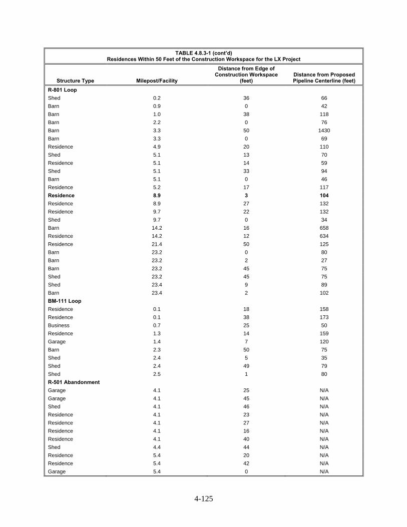
4-125
TABLE 4.8.3-1 (cont’d) Residences Within 50 Feet of the Construction Workspace for the LX Project
Structure Type Milepost/Facility
Distance from Edge of Construction Workspace
(feet) Distance from Proposed Pipeline Centerline (feet)
R-801 Loop
Shed 0.2 36 66
Barn 0.9 0 42
Barn 1.0 38 118
Barn 2.2 0 76
Barn 3.3 50 1430
Barn 3.3 0 69
Residence 4.9 20 110
Shed 5.1 13 70
Residence 5.1 14 59
Shed 5.1 33 94
Barn 5.1 0 46
Residence 5.2 17 117
Residence 8.9 3 104
Residence 8.9 27 132
Residence 9.7 22 132
Shed 9.7 0 34
Barn 14.2 16 658
Residence 14.2 12 634
Residence 21.4 50 125
Barn 23.2 0 80
Barn 23.2 2 27
Barn 23.2 45 75
Shed 23.2 45 75
Shed 23.4 9 89
Barn 23.4 2 102
BM-111 Loop
Residence 0.1 18 158
Residence 0.1 38 173
Business 0.7 25 50
Residence 1.3 14 159
Garage 1.4 7 120
Barn 2.3 50 75
Shed 2.4 5 35
Shed 2.4 49 79
Shed 2.5 1 80
R-501 Abandonment
Garage 4.1 25 N/A
Garage 4.1 45 N/A
Shed 4.1 46 N/A
Residence 4.1 23 N/A
Residence 4.1 27 N/A
Residence 4.1 16 N/A
Residence 4.1 40 N/A
Shed 4.4 44 N/A
Residence 5.4 20 N/A
Residence 5.4 42 N/A
Garage 5.4 0 N/A

4-126
TABLE 4.8.3-1 (cont’d) Residences Within 50 Feet of the Construction Workspace for the LX Project
Structure Type Milepost/Facility
Distance from Edge of Construction Workspace
(feet) Distance from Proposed Pipeline Centerline (feet)
Shed 5.9 27 N/A
Barn 20.3 38 N/A
Residence 20.9 23 N/A
Shed 21.0 44 N/A
Garage 27.2 11 N/A
Residence 27.2 24 N/A
Garage 27.3 14 N/A
Aboveground Facilities
LEX
Unoccupied residence LEX launcher 0 N/A
Barn LEX launcher 0 N/A
Unoccupied residence Lone Oak CS 0 N/A
Barn Lone Oak CS 0 N/A
BM-111 Loop
Shed BM-111 Loop launcher 0 N/A
Shed BM-111 Loop launcher 0 N/A
Unoccupied office building
BM-111 Loop launcher 0 N/A
Unoccupied office building
BM-111 Loop launcher 0 N/A
Unoccupied office building
BM-111 Loop launcher 0 N/A
Unoccupied residence BM-111 Loop launcher 0 N/A
Shed BM-111 Loop launcher 3 N/A
Shed BM-111 Loop launcher 11 N/A
Shed BM-111 Loop launcher 13 N/A
Residence BM-111 Loop launcher 17 N/A
Residence BM-111 Loop launcher 17 N/A
Residence BM-111 Loop launcher 18 N/A
Shed BM-111 Loop launcher 25 N/A
Residence BM-111 Loop launcher 38 N/A
Residence BM-111 Loop launcher 40 N/A
Residence BM-111 Loop launcher 43 N/A
Residence BM-111 Loop launcher 44 N/A
Shed Ceredo CS Ceredo CS
31 N/A
Shed 45 N/A
Existing Columbia Pipeline System
Shed R-130 Odorization Site 31 N/A
Barn R-130 Odorization Site 48 N/A
____________________ a Residence occurs within project workspace, but was irreparably damaged by fire. Columbia Gas has received
documented consent from the landowner regarding the proposed pipeline right-of-way through this area and a signed letter of no objection for demolition of the structure.
b Structure is crossed by the proposed pipeline and will be permanently relocated or demolished for construction and operation of the Project. Negotiations with the landowner are ongoing.
Four of the residences displayed in appendix O and table 4.8.3-1, while not within the
construction workspace, would be within 10 feet of the workspace due to the construction constraints along those portions of the LX Project’s route. Because of the increased potential for construction of the
4-127
LX Project to disrupt these residences and to ensure that property owners have adequate input to a construction activity occurring so close to their homes, we recommend that:
Prior to construction, Columbia Gas should file with the Secretary, for the review and written approval of the Director of OEP, evidence of landowner concurrence with the site-specific residential construction plans for all locations identified by MP in table 4.8.3-1 of the EIS where LX Project construction work areas would be within 10 feet of a residence.
Columbia Gas identified four residences that were within 10 feet of the construction workspace along the LX Project. Columbia Gas has not provided landowner concurrence for these residences, we are requesting that Columbia Gas file written documentation of an agreement between the landowner and Columbia Gas or adopt a variation for each residence. We encourage landowners with 10 feet of the construction workspace to provide comments on this draft EIS.
Our experience has shown that when project sponsors maintain communication with landowners during construction and restoration phases, issues in and near residential areas can be effectively managed and resolved. Columbia Gas and Columbia Gulf have developed an environmental complaint resolution procedure that they would implement during project construction and restoration. Columbia Gas and Columbia Gulf would work to notify affected landowners or complainants (even if they are not the landowner) within 24 hours of receiving a complaint. If contact is not possible within 48 hours, the complainant has the option to call Columbia Gas’ and Columbia Gulf’s Operations Center in Charleston, West Virginia. If either of these methods for contacting and resolving complaints is unsatisfactory to the complainant, FERC’s Dispute Resolution Service Helpline may be called. All complaints and follow-up correspondence to Columbia Gas and Columbia Gulf or FERC would be documented, and any action required to resolve the issue would be discussed with the affected landowner and/or complainant. Columbia Gas and Columbia Gulf have yet to identify the company representative responsible for contacting regarding the landowner complaint and resolution procedures.
Commercial structures in proximity to the LX Project could also experience short-term disruptions to businesses as a result of in-street construction, detours, or restricted access due to lane closures. These impacts and corresponding mitigation measures are discussed further in section 4.9.4. Implementation of Columbia Gas' general construction methods for working near residences and commercial areas, such as boring of public roadways, avoidance of road closures, development of site-specific plans, and the complaint resolution procedure would minimize disruption to residential and commercial areas to the extent practicable.
Operational impacts associated with the LX Project would be limited to approximately 1.5 acres of residential lands and the 13.4 acres of commercial/industrial land within the permanent right-of-way and aboveground facilities, which would have restricted use. Specifically, no trees over 15 feet tall or permanent structures would be allowed within the permanent right-of-way. Affected industrial land not already within the boundaries of aboveground facilities would be permanently converted to pipeline-related industrial uses.
Trees and herbaceous vegetation within the construction right-of-way would be cleared. Columbia Gas would restore trees and vegetation in the construction right-of-way according to protective measures within the FERC Plan. The permanent right-of-way would be periodically mowed, and tree growth would be prevented for the life of the LX Project. In the construction right-of-way, trees and herbaceous vegetation would be allowed to re-grow; however, larger trees likely would not grow to maturity within the construction right-of-way for decades.

4-128
Planned Developments 4.8.3.2
Columbia Gas and Columbia Gulf contacted local and county officials in the affected municipalities of West Virginia, Pennsylvania, Ohio, and Kentucky in 2014 and 2015 to identify planned residential, commercial, or industrial developments near the projects. No such planned developments were identified.
Recreation and Special Interest Areas 4.8.4
The LX Project would not cross or come within 0.2 mile of any National Park System unit (including National Wild, Scenic, and/or Recreational Rivers), Indian Reservation, National Forest, National Wildlife Refuge, National Wilderness Area, or National Landmark (NPS, 2014a, 2014b, 2014c; U.S. Forest Service, 2014; U.S. Fish and Wildlife Service, 2014). The LX Project does not cross any rivers in the National Wild and Scenic Rivers System (National Wild and Scenic Rivers System, 2009). The RXE Project does not cross or come within 0.2 miles of any public or private recreational or special interest areas.
The LX Project would directly cross public recreation and special interest areas, including one scenic byway, one state forest, three recreational trails, one wildlife management area, and one outdoor recreation areas. The LX Project would also be within 0.2 mile of private recreation and special interest areas, including one nature preserve and its two associated components, an additional nature preserve, one public park, one historic canal, one conservation preserve, and two state parks.
One of the primary concerns when crossing recreation and special interest areas is the impact of construction on the purpose for which the recreational or special interest area was established (e.g., the recreational activities, public access, and human and natural resources the area aims to protect). Construction and operation could alter visual aesthetics by removing existing vegetation and disturbing soils. Construction could pose a nuisance to recreational users given the expected generation of dust, noise, and increased vehicular traffic. Construction could interfere with or diminish the quality of the recreational experience through its disturbance of environments important to wildlife movements, hunting, hiking or aquatic activities.
In general, impacts on recreational and special interest areas would be temporary and limited to the period of active construction, which typically would only last a few days to several weeks in any one area. These impacts would be minimized by implementation of the measures contained in Columbia Gas’ and Columbia Gulf’s ECSs. Following construction, most open land uses would be able to continue. Columbia Gas is continuing to consult with the owners and managing agencies of recreation and special interest areas regarding the need for specific construction mitigation measures.
Temporary workspace associated with the R-501 Abandonment is located 0.4 mile from the Wayne National Forest in Vinton County, Ohio at its closest point (MP 20.9), and the R-801 Loop is located less than 0.1 mile, at its closest point (MP 8.1), west of the Hocking State Forest in Vinton County, Ohio. Table 4.8.4-1 provides information about the affected recreational and special interest areas. Further discussion of these areas is provided below.
The two crossings of the North Country National Scenic Trail would occur in locations where the trail follows public roads. One of the five proposed Buckeye Trail crossings is at a public road, while the remaining four would be located at off-road trail segments. The Buckeye Trail Association, a non-profit group, manages both the Buckeye Trail and the affected portion of the North Country National Scenic Trail. The Warrior Trail crossing would occur at a public road and would be accomplished via conventional bore. Columbia would maintain traffic flow along on-road trail segments.
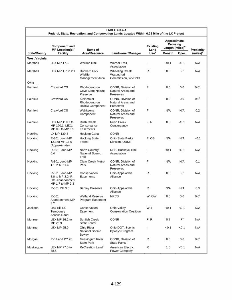
4-129
TABLE 4.8.4-1 Federal, State, Recreation, and Conservation Lands Located Within 0.25 Mile of the LX Project
State/County
Component and MP Location(s)/
Facility Name of
Area/Resource Landowner/Manager
Existing Land Usea
Approximate Crossing
Length (miles)b Proximity (miles)c Constr. Oper.
West Virginia
Marshall LEX MP 17.6 Warrior Trail Warrior Trail Association
I <0.1 <0.1 N/A
Marshall LEX MP 1.7 to 2.1 Dunkard Fork Wildlife Management Area
Wheeling Creek Watershed Commission, WVDNR
R 0.5 Pe N/A
Ohio
Fairfield Crawford CS Rhododendron Cove State Nature Preserve
ODNR, Division of Natural Areas and Preserves
F 0.0 0.0 0.0d
Fairfield Crawford CS Kleinmaier Rhododendron Hollow Component
ODNR, Division of Natural Areas and Preserves
F 0.0 0.0 0.0d
Fairfield Crawford CS Wahkeena Component
ODNR, Division of Natural Areas and Preserves
F N/A N/A 0.2
Fairfield LEX MP 119.7 to MP 120.1; LEX1 MP 0.3 to MP 0.5
Rush Creek Conservancy Easements
Rush Creek Conservancy
F, R 0.5 <0.1 N/A
Hocking LX MP 130.4 Hocking Canal ODNR
Hocking R-801 Loop MP 12.8 to MP 15.5 (Approximate)
Hocking State Forest
Ohio State Parks Division, ODNR
F, OS N/A N/A <0.1
Hocking R-801 Loop MP 6.4
North Country National Scenic Trail
NPS, Buckeye Trail Association
I <0.1 <0.1 N/A
Hocking R-801 Loop MP 1.1 to MP 1.4
Clear Creek Metro Park
ODNR, Division of Natural Areas and Preserves
F N/A N/A 0.1
Hocking R-801 Loop MP 3.0 to MP 3.2; R-501 Abandonment MP 1.7 to MP 2.3
Conservation Easements
Ohio Appalachia Alliance
R 0.8 Pe N/A
Hocking R-801 MP 3.8 Bartley Preserve Ohio Appalachia Alliance
R N/A N/A 0.3
Hocking R-501 Abandonment MP 3.2
Wetland Reserve Program Easement
NRCS W, OW 0.0 0.0 0.0d
Jackson Oak Hill CS Temporary Access Road
Conservation Easement
Ohio Valley Conservation Coalition
W, F <0.1 <0.1 N/A
Monroe LEX MP 26.2 to MP 26.9
Sunfish Creek State Forest
ODNR F, R 0.7 Pe N/A
Monroe LEX MP 25.9 Ohio River National Scenic Byway
Ohio DOT, Scenic Byways Program
I <0.1 <0.1 N/A
Morgan PY 7 and PY 28 Muskingum River State Park
ODNR, Division of State Parks
R 0.0 0.0 0.0d
Muskingum LEX MP 77.5 to 78.5
ReCreation Land f American Electric Power Company
R 1.0 <0.1 N/A

4-130
TABLE 4.8.4-1 (cont’d) Federal, State, Recreation, and Conservation Lands Located Within 0.25 Mile of the LX Project
State/County
Component and MP Location(s)/
Facility Name of
Area/Resource Landowner/Manager
Existing Land Usea
Approximate Crossing
Length (miles)b Proximity (miles)c Constr. Oper.
Noble LEX MPS 69.5, 72.4, 72.4, 72.69, 73.3
Buckeye Trail Buckeye Trail Association
R <0.1 <0.1 N/A
Noble LEX MP 66.5 North Country National Scenic Trail
NPS, Buckeye Trail Association
I <0.1 <0.1 N/A
Noble LEX MP 71.1 to MP 75.2
ReCreation Land f American Electric Power Company
R 4.1 <0.1 N/A
Perry LEX MP 102.5 to MP 102.5
CRP Property USDA Farm Service Agency, Private
A <0.1 <0.1 N/A
Perry LEX MP 106.5 Arethusa Springs Park
Village of New Lexington
OL N/A N/A 0.1
____________________ a I = Industrial/commercial (including public roads); OL = Open Land; OW = Open Water; W = Wetland; F = Forest/Woodland; R = Outdoor Recreation; A = Agricultural; NA – Not Applicable b Impacts based on a 110-foot-wide construction right-of-way except for 125-foot-wide construction right-of-way for LEX MP 0.0 to 39.2; operational impacts are based on a 50-foot-wide right-of-way. c For areas within 0.25 mile of, but not crossed by the Project. d Located adjacent to, but not within resource. e Impacts on these lands are pending agency recommended mitigation measures. f Columbia Gas describes Reclamation lands as reclaimed abandoned mines currently managed as outdoor recreation areas.
A Supplemental Filing was made just prior to going to print in which Columbia Gas expanded the project area. Due to the lateness of the filing, our review of this information is incomplete and the analyses presented in this table may not be reflective of these changes.
As listed in table 4.8.4-1, two Ohio state nature preserves would be within 0.2 mile of the
Crawford CS, one Ohio state nature preserve would be within 0.2 mile of the R-801 Loop, and a municipal park in New Lexington, Ohio would be within 0.2 mile of the LEX pipeline. The LX Project would not cross or directly affect these areas. The Project would cross the Dunkard Fork Wildlife Management area in Marshall County, West Virginia. Additionally, the pipeline would cross a portion of the Hocking Canal in Hocking County, Ohio.
State Forests 4.8.4.1
At its closest point, the R-801 Loop is less than 0.1 mile west of the Hocking State Forest in Vinton County, Ohio. Columbia Gas anticipates no adverse impacts because the LX Project would not cross the forest boundary and is more than one mile from the nearest recreational area.
LEX crosses the Sunfish Creek State Forest in Monroe County, Ohio from MP 26.1 RR-5 to MP 26.5 RR-5. Columbia Gas has submitted a formal application, including an Environmental Assessment, to ODNR for review and approval. After approval, Columbia Gas would be granted a 25-year lease agreement for the permanent pipeline easement within the forest. In order to properly review all necessary approvals, we have recommended in Section 4.5.3 that Columbia Gas provide documentation of all correspondence with ODNR (including the formal application and Environmental Assessment) prior to the end of the draft EIS comment period.
Organic Farm Lands and Specialty Crops 4.8.4.2
The LX Project would not cross any organic farm lands or specialty crop areas.

4-131
Conservation and Other Special Land Uses 4.8.4.3
As shown in table 4.8.3-1, the LX Project would cross one parcel enrolled in the CRP program, three conservation easements owned by Rush Creek Conservancy, two conservation easements owned by the Ohio Appalachia Alliance, and one easement owned by the Ohio Valley Conservation Coalition. The Project would also occur within 0.3 mile of one state forest and one easement within the Wetland Reserve Program.
The USDA Farm Services Administration (FSA) administers the CRP by paying a stipend to landowners who voluntarily remove land from active agricultural production (USDA, 2015). CRP land affected by the Project would be restored to pre-construction conditions, in accordance with FERC Plan and landowner agreements.
The LEX pipeline section would cross easements owned by the Ohio Appalachia Alliance in Hocking County, Ohio from MPs 130.5 to 130.6, while temporary construction workspace associated with the R-801 Loop would cross similar easements in Hocking County near MP 3.2. Columbia Gas has coordinated with the Appalachia Ohio Alliance to develop the currently proposed LEX route across these easements and would continue to consult with their representatives regarding BMPs and mitigation measures to be implemented during construction activities in these areas. Additionally, all land temporarily disturbed by construction of the LX Project would be restored to pre-construction conditions through revegetation activities, in accordance with the protective measures contained in the ECS and FERC Plan.
Hazardous Waste Sites 4.8.5
Areas of contamination for the LX Project, including polychlorinated biphenyl (PCB), hydrocarbon, mercury, and heavy metals, were previously identified within the Ceredo CS, Crawford CS, and Benton CS. Columbia Gas performed a comprehensive site-wide assessment and soil remediation to remove or contain the sources of contamination at the Benton CS in 2002 as well as at the Ceredo CS and the Crawford CS from May through October 2012 and from February through September 2012, respectively. A total of 11 previously leaking underground storage tanks have also been identified within 0.5 mile of the LX Project area. Information on contaminated soil, groundwater, and sediments at these sites is provided in sections 4.2.2, 4.3.1.6, and 4.3.3. No contaminated sites occur within 1 mile of the RXE Project.
In the event of the discovery of unanticipated contamination along the pipeline route, Columbia Gas would follow its Plan for the Unanticipated Discovery of Contaminated Environmental Media (part of its ECS).
Visual Resources 4.8.6
“Visual resources” refers to the composite of basic terrain features, geologic features, hydrologic features, vegetation patterns, and anthropogenic features that influence the visual appeal of an area for residents or visitors. The LX Project would cross state and privately owned lands, including less than one mile of state forest. The LX Project would also cross one National Scenic Byway, but would not cross any federal lands, or national or state designated wild or scenic rivers.
Pipelines 4.8.6.1
Visual resources along the pipeline routes are a function of geology, climate, and historical processes, and include topographic relief, vegetation, water, wildlife, land use, and human uses and development. Approximately 41 percent of the new pipelines would be installed within or parallel to
4-132
existing pipeline and/or utility rights-of-way. As a result, the visual resources along this portion of the LX Project have been previously affected by other similar activities.
The area crossed by the pipeline is a mix of forest lands, open lands, agriculture, and other uses, as discussed in section 3.8.1.2. Columbia Gas proposes to generally use a 110-foot-wide construction right-of-way, consisting of 50 feet of permanent right-of-way and 60 feet of temporary construction workspace for the pipelines. As discussed in section 3.8.1, the construction right-of-way would generally be narrowed to 75 feet in wetlands and widened to 125 feet in the steeper terrain between LEX MPs 0.0 and 39.0. In the forested portions of the construction right-of-way, trees would be allowed to re-grow; however, larger trees likely would not grow to maturity within the construction right-of-way for decades.
Aboveground Facilities 4.8.6.2
The LX and RXE Projects’ aboveground facilities would be installed at locations with aesthetics and topography similar to that described for the pipeline. As described in section 4.8.1.3, aboveground new facilities for both the LX and RXE Project components would primarily affect areas characterized as agricultural, industrial, open land, and forest.
MLVs along the LX Project operational right-of-way would be enclosed by an approximate 50-foot by 50-foot fenced gravel area. Ten of thirteen launchers and receivers would be constructed within the boundaries of existing aboveground facilities, thereby minimizing impacts on visual resources.
Other aboveground facilities, discussed in section 4.8.1.3, would be new industrial facilities. The Lone Oak CS, Oak Hill CS, R-System RS, Grayson CS, and Means CS, would be less than 0.25 mile from the nearest residence. The Lone Oak CS, R-System RS, and Grayson CS would be screened by trees, while the Oak Hill CS and Grayson CS would not be screened. Other regulator stations would generally be screened from view by vegetation. While the use of the existing Means Meter Station Site for its construction and operation of the proposed Means CS would not be inconsistent with other land uses in the immediate area, it would pose new permanent visual impacts on the view shed of nine nearby residences. In response to our question asking if Columbia Gulf would install visual barriers for these residences, Columbia Gulf replied it would agree to construct a visual barrier if requested and required by agreements or negotiations or required as a noise mitigation measure. However, we believe that visual screening of the proposed Means CS would be a long-term benefit to nearby residences, almost all of which would be located within 100 to 1000 feet. Therefore, we recommend that:
Prior to construction, Columbia Gulf should file with the Secretary a visual screening plan for the proposed Means Compressor Station for review and written approval by the Director of OEP.
Contractor Yards 4.8.6.3
The contractor yards would be on lands classified as forest, open land, agriculture, open water, one PFO wetland, and developed land. Following construction, the disturbed areas would be allowed to revegetate and contours would be restored to pre-construction conditions, unless otherwise dictated by the landowner.
Access Roads 4.8.6.4
Columbia Gas would construct temporary and permanent access roads as a part of pipeline and aboveground facility construction, as described in section 4.8.1.5. Access roads would be maintained at a width of either 10 or 25 feet. Most of these roads are currently paved, graveled, or have dirt surfaces, and would require minor improvements. Such improvements would not substantially change visual
4-133
conditions in the LX Project area. Construction of the LX Project would require some tree clearing for access roads, in addition to grading and graveling, affecting 94.9 acres.
After construction, roads used for temporary access would be returned to pre-construction conditions, unless another arrangement is mutually agreed upon with the landowner. The permanent access roads retained for operation would require 10.8 acres of land. In general, permanent roads would not substantially change visual conditions in the LX or RXE Project areas. Columbia Gulf does not propose to construct any access roads as part of the RXE Project and would use existing roads.
Scenic Byways 4.8.6.5
The LEX pipeline route crosses the Ohio River National Scenic Byway at MP 25.4 in Monroe County, Ohio. To avoid disruption of the roadway and traffic flow, Columbia Gas proposes to use the HDD construction technique to cross the byway, resulting in minimal potential visual impacts. During construction, some activity may be seen from the roadway. This impact would be temporary, occurring only during construction activities associated with the HDD. Any additional mitigation measures required would be addressed through the permitting process with the Ohio DOT.
Agricultural Lands and Open Lands 4.8.6.6
About 40 percent of the pipeline route would be within or adjacent to existing rights-of-way for pipelines, electric transmission lines, or roads. Visual impacts associated with pipeline construction in agricultural and open land areas along the route would be temporary, due to the presence of construction equipment and post-construction visual scarring. In agricultural land, visual scarring would remain within the right-of-way until new crops are planted. After replanting, remaining visual impact from pipeline construction would be minor, but visual evidence of construction may last for a few years. Visual impacts at new aboveground facilities in agricultural or open lands would be permanent.
Forested Land 4.8.6.7
The LX Project would affect 1,380.6 acres of forested land during construction, of which, 515.6 acres would be within the permanent right-of-way or within boundaries of aboveground facilities. The RXE Project would affect 0.5 acre of forested land during construction, of which 0.1 acre would be within the boundary of the Grayson CS. Trees within the construction right-of-way would be cleared. Columbia Gas would restore trees and vegetation in the construction right-of-way according to the FERC Plan. The permanent right-of-way would be periodically mowed, and tree growth would be prevented for the life of the LX Project. In the construction right-of-way, trees would be allowed to re-grow; however, larger trees likely would not grow to maturity within the construction right-of-way for decades. Removal of trees along both the permanent and construction rights-of-way in otherwise forested areas would leave a corridor that would persist for the duration of pipeline operation and that would be visible from vantage points in the LX Project area, particularly roads and trails that cross the pipeline corridor, or locations that offer expansive views of the landscape in the vicinity of the Projects.
Conclusion 4.8.7
Based on our review of potential impacts, the primary land use affected from construction and operation of the LX Project would be long-term impacts on forested land. Implementation of measures in Columbia Gas’ and Columbia Gulf’s ECSs would minimize impacts on forest to less than significant levels. Visual impacts resulting from the Projects would also be localized within the project areas.

4-134
4.9 SOCIOECONOMICS
The socioeconomic conditions and impacts associated with the proposed pipelines, abandonment, compressor stations, regulator stations, odorization stations and bi-directional launcher and/or receiver facilities are discussed below. The primary socioeconomic impacts of the LX Project include influx of construction workers, and temporary impacts on housing from this influx. Secondary effects include impacts on traffic conditions, public services, and tax revenue.
Population and Employment 4.9.1
Table 4.9.1-1 provides information about selected existing socioeconomic conditions in areas affected by the proposed LX and RXE Projects. The Projects would be in southern Ohio, western Pennsylvania, western West Virginia, and northern Kentucky.
TABLE 4.9.1-1 Existing Socioeconomic Conditions in the LX and RXE Project Areas
Geography Population
2014a
Population Density 2010b
Per Capita Income 2013
(dollars)
Civilian Labor Force,
2014
Unemploy-ment Rate
2014 (percent)
Top Three Industries a
LX Ohio 11,560,380 282 $26,046 5,848,381 5.8 A, B, C Fairfield County 148,067 290 $27,031 75186 4.7 A, C, B Sugar Grove Village 411 1,473 $16,902 249 12.3 A, D, E Hocking County 29,111 70 $21,037 13,665 5.7 A, B, C Rockbridge CDP 226 481.8 $10,072 111 n/a C, F, D Jackson 32,952 79 $19,405 14,846 11.8 A, B, C Oak Hill Village 1,777 1,359 $18,477 741 7.4 A, F ,B Lawrence County 62,100 138 $21,365 26,621 4.6 A, B, C Monroe County 14,590 32 $21,487 6,136 8.4 A, C, F Morgan County 14,977 36 $21,027 6,376 4.8 A, B, C Muskingum County 85,947 130 $20,775 40,881 5.8 A, C, B Noble County 14,561 37 $18,853 4,821 4.1 A, B, C Summerfield Village 235 684 $23,671 80 19.0 A, C, F Perry County 36,000 88 $19,372 16,454 6.4 A, B, C Vinton County 13,319 33 $18,101 5,808 6.7 A, B, F McArthur Village 1,883 1,262 $19,058 830 7.9 A, B, F Pennsylvania 12,758,729 284 $28,502 6,502,948 8.6 A, B, C Greene County 38,171 67 $21,819 16,021 3.2 A, G, C West Virginia 1,853,881 77 $22,966 820,262 4.4 A, C, D Marshall County 32,716 108 $24,329 14,578 4.2 A, C, D Moundsville City 8,960 3,205 $28,909 3,951 5.4 A, C, D Wayne County 41,735 84 $19,497 16,714 9.5 A, C, B RXE Kentucky 4,413,457 110 $23,741 2,063,756 5.5 A, B, C Carter County 27,439 68 $19,536 11,571 12.1 A, C, B Grayson City 4,148 1,633 $18,872 1,996 7.0 A, C, D Menifee County 6,287 31 $16,464 2,490 16.6 A, B, C Montgomery County 27,474 134 $21,057 12,209 13.2 B, A, C ____________________ Incorporated Places and CDPs included only for new, not abandoned facilities Sources: U.S. Census Bureau 2014; U.S. Census Bureau 2015 CDP = Census Designated Place n/a - not available a. A = Educational services, and health care and social assistance; B = Manufacturing; C = Retail Trade; D = Arts, entertainment, and recreation, and accommodation and food services; E = Public Administration; F = Construction; G = Agriculture, forestry, fishing and hunting, and mining;

4-135
The project areas are generally rural with county population densities lower than those of the respective states. The total population of the counties and other communities that would be affected by the proposed projects is approximately 643,000 (table 4.9.1-1). Per capita incomes are generally lower than those of the respective states. Unemployment rates in 2014 varied widely from a low of 3 percent to a high of 19 percent. The major occupations in the project areas include educational, health, and social services, retail, and manufacturing.
Construction of the LX Project pipelines would temporarily increase the population in the general vicinity of the project. Table 4.9.1-2 lists the size of the estimated construction workforce for the projects by spread and facility. The LX construction workforce would be comprised of five spreads of 250 to 600 workers each for an estimated peak workforce of 3,075 during the approximately 12 month long construction period. Construction of the RXE Project would require a peak workforce of 140 workers and take about 9 months to complete. Combined, this number of workers would represent an estimated 0.5 percent increase in the projects area population. A peak total workforce of 600 workers may be present within a single county during periods of coinciding construction spreads.
Columbia Gas expects the LX Project construction workforce would consist of personnel hired locally as well as from outside the LX Project area and would include pipeline construction specialists, supervisory personnel, and inspectors who will temporarily relocate to the LX Project area. Columbia Gas expects that most of the company and contractor labor will be non-local workers. Columbia Gas intends to hire local workers to the extent practicable including local unemployed and local low income workers. Columbia Gulf expects the RXE construction workforce would consist of personnel hired from outside the RXE area and would include compressor station construction specialists, supervisory personnel, and inspectors, who would temporarily relocate to the area. The result of LX and RXE Projects would be a temporary, but positive impact on employment for counties within the project areas.
In addition to direct hires, the LX Project would be expected to provide a number of temporary indirect and induced jobs as purchases are made by non-local workers on items such as food, clothing, lodging, gasoline, and entertainment. The jobs would have a temporary, stimulatory effect on the local economy (section 4.9.6). A study commissioned by Columbia Gas to examine the economic benefits found that the projects would generate approximately 3,700 indirect and induced jobs in Ohio and West Virginia in 2017 with approximately $250 million in labor income21 (Kleinhenz & Associates, 2014).
Population impacts are expected to be temporary and minor in the LX and RXE Project areas. The LX Project pipeline effects on the total population would include the influx of non-local construction workers and any family members accompanying them. Assuming the construction workforce comprises a maximum of 3,215 individuals and approximately 75 percent of the total workforce would be non-local; there would be an influx of about 2,400 workers into the area due to the project. The influx may be higher, however, if workers bring family members with them. The U.S. Census Bureau (2014) reports the average household size as 2.6 persons. Assuming that half these workers bring family members with them the population in the area could increase by an additional 1,900 people during construction for a total of approximately 4,300. Given the population of the project area (approximately 643,000) and distribution of the construction workforce, the addition of 4,300 people would not be a significant change.
Columbia Gas and Columbia Gulf estimate that they would hire new full-time, local employees to operate and maintain the facilities as follows: 15 to 20 for the LX facilities and 8 for the RXE compressor stations. The addition of up to 28 households would not be a significant change for the local population. Columbia Gas and Columbia Gulf intend to hire local workers to the extent practicable including local unemployed and local low income workers.
21 Indirect impacts are changes in spending by suppliers whose goods and services are used in the Project. Induced
impacts result from changes in the directly and indirectly affected industry sectors.
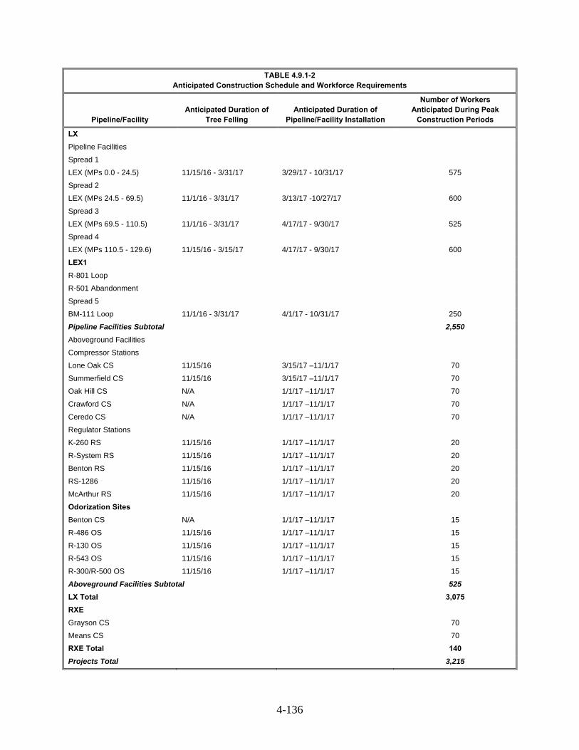
4-136
TABLE 4.9.1-2 Anticipated Construction Schedule and Workforce Requirements
Pipeline/Facility Anticipated Duration of
Tree Felling Anticipated Duration of
Pipeline/Facility Installation
Number of Workers Anticipated During Peak
Construction Periods
LX
Pipeline Facilities
Spread 1
LEX (MPs 0.0 - 24.5) 11/15/16 - 3/31/17 3/29/17 - 10/31/17 575
Spread 2
LEX (MPs 24.5 - 69.5) 11/1/16 - 3/31/17 3/13/17 -10/27/17 600
Spread 3
LEX (MPs 69.5 - 110.5) 11/1/16 - 3/31/17 4/17/17 - 9/30/17 525
Spread 4
LEX (MPs 110.5 - 129.6) 11/15/16 - 3/15/17 4/17/17 - 9/30/17 600
LEX1
R-801 Loop
R-501 Abandonment
Spread 5
BM-111 Loop 11/1/16 - 3/31/17 4/1/17 - 10/31/17 250
Pipeline Facilities Subtotal 2,550
Aboveground Facilities
Compressor Stations
Lone Oak CS 11/15/16 3/15/17 –11/1/17 70
Summerfield CS 11/15/16 3/15/17 –11/1/17 70
Oak Hill CS N/A 1/1/17 –11/1/17 70
Crawford CS N/A 1/1/17 –11/1/17 70
Ceredo CS N/A 1/1/17 –11/1/17 70
Regulator Stations
K-260 RS 11/15/16 1/1/17 –11/1/17 20
R-System RS 11/15/16 1/1/17 –11/1/17 20
Benton RS 11/15/16 1/1/17 –11/1/17 20
RS-1286 11/15/16 1/1/17 –11/1/17 20
McArthur RS 11/15/16 1/1/17 –11/1/17 20
Odorization Sites
Benton CS N/A 1/1/17 –11/1/17 15
R-486 OS 11/15/16 1/1/17 –11/1/17 15
R-130 OS 11/15/16 1/1/17 –11/1/17 15
R-543 OS 11/15/16 1/1/17 –11/1/17 15
R-300/R-500 OS 11/15/16 1/1/17 –11/1/17 15
Aboveground Facilities Subtotal 525
LX Total 3,075
RXE
Grayson CS 70
Means CS 70
RXE Total 140
Projects Total 3,215

4-137
Housing 4.9.2
Housing statistics for the counties affected by the proposed project are presented in table 4.9.2-1. Based on a five-year average (2010-2014), the number of vacant housing units across the 16 potentially affected counties ranged from a high of approximately 4,500 vacant units in Fairfield County, Ohio to a low of approximately 1,100 vacant units in Noble County, Ohio (U.S. Census Bureau 2013). Rental vacancy rates varied from 3.0 percent in Carter County, Kentucky to 16 percent in Menifee County, Ohio.
Temporary housing availability varies within the counties and communities near the proposed facilities. Temporary housing is available in the form of daily, weekly, and monthly rentals in approximately 60 motels and hotels as well as recreational vehicle parks (see table 4.9.2-1). Other temporary housing such as bed and breakfast facilities, apartments, and vacation properties, would also be available. Therefore, the actual availability of temporary housing would be greater than presented in table 4.9.2-1.
TABLE 4.9.2-1 Housing by County in the LX and RXE Project Areas
State/County
Total Housing
Unitsa
Renter Occupied
Unitsa
Rental Vacancy
Rate (percent)a
Vacant Housing Unitsa
Units for Seasonal,
Recreational, or Occasional
Use b
Number of RV
Parks b
Number of Hotels
and Motels c
LX
Ohio
Fairfield 59,107 15,428 5.6 4,526 719 5 7
Hocking 13,367 2,903 6.6 1,941 936 7 3
Jackson 14,574 4,115 4.2 1,370 277 2 6
Lawrence 27,474 6,123 6.9 3,852 284 4 2
Monroe 7,525 1,369 7.7 1,469 686 1 2
Morgan 7,858 1,393 8.9 1,802 1,158 5 3
Muskingum 37,906 11,076 8.1 3,746 528 10 12
Noble 6,037 886 6.9 1,121 763 1 1
Perry 15,162 3,608 6.2 1,525 374 2 1
Vinton 6,240 1,289 12.2 1,103 486 2 0
Pennsylvania
Greene 16,440 3,864 6.0 2,057 414 4 7
West Virginia
Marshall 15,866 3,156 9.0 2,019 507 4 5
Wayne 19,235 3,745 10.0 2,478 258 3 2
RXE
Kentucky
Carter 12,287 2,365 3.0 1,762 327 3 5
Menifee 3,890 567 16.1 1,486 873 2
Montgomery 11,711 3,597 7.2 1,423 89 0 4
____________________ a. U.S. Census Bureau 2014 b. U.S. Census Bureau 2015 c Good Sam Club, 2014; Google Maps, 2015
Construction of the projects could temporarily decrease the availability of housing in the area.
The projects could have a short-term positive impact on the area rental industry through increased demand and higher rates of occupancy; however, no significant impacts on the local housing markets are expected. Assuming that the local construction workers do not require housing, a total of about 3,000

4-138
housing units may be required during peak construction activities. Given the vacancy rates (4.2 percent to 8.3 percent) and the number of vacant housing units in the counties that would be affected by the project (approximately 36,000 among all 16 affected counties), construction crews should not encounter difficulty in finding temporary housing. At a maximum, the workforce would use about 9 percent of the vacant housing units. While some of the construction activity would be conducted during the tourism season, sufficient temporary housing is still likely to be available, though may be more difficult to find and/or more expensive to secure.
The estimated 15 to 28 new long-term employees required for operation of the projects would have no measurable impact on housing in the project areas.
Public Services 4.9.3
A wide range of public services and facilities is present in communities in the projects areas including law enforcement, emergency services, fire departments, and community and medical services (see table 4.9.3-1). Community medical services typically provide short term or continuing general health care services and can respond to minor or routine medical needs. Emergency medical services include facilities able to respond to injuries or illnesses that require immediate medical attention and include hospitals equipped with trauma centers and 24-hour emergency clinics.
TABLE 4.9.3-1 Existing Public Services and Facilities by County in the LX and RXE Project Areas
State/County Community
Medical Services a Emergency Medical
Services a Police Services Fire Services
LX
Ohio
Fairfield 7 7 14 25
Hocking 1 1 3 9
Jackson 3 3 5 8
Lawrence 2 4 6 16
Monroe 1 1 6 17
Morgan 2 0 2 6
Muskingum 2 2 6 19
Noble 2 0 2 5
Perry 1 0 10 10
Vinton 1 0 3 5
Pennsylvania
Greene 12 5 5 16
West Virginia
Marshall 1 1 7 15
Wayne 1 1 8 8
RXE
Kentucky
Carter 0 0 2 3
Menifee 0 0 2 1
Montgomery 1 1 2 4
____________________
Source: Google Earth, 2014., U.S. Census, 2007
Based on the number of public services and facilities, there appears to be adequate public service
infrastructure in the project vicinity to accommodate the temporary needs of the peak total workforce of 600 workers that may be present within a single county during periods of coinciding construction spreads.

4-139
Columbia Gas and Columbia Gulf states that the projects would fully adhere to regulatory requirements pertaining to safety and that these safety regulations would be reinforced by Columbia Gas’ and Columbia Gulf’s comprehensive and strictly enforced corporate practices. In the event of an accident, there could be need for police, fire, and/or medical services, depending on the type of emergency; however, the anticipated demand for these services is not expected to exceed the existing capabilities of the emergency service infrastructure. Short-term impacts on certain other public services are possible, which would include the need for localized police assistance or certified flaggers to control traffic flow during construction activities. Additional discussion of traffic and public service assistance necessary to support traffic controls is provided in section 4.9.4.
No schools are within 100 feet of the proposed pipeline route. The closest school to the LX Project facilities is Berne Union High School in the Village of Sugar Grove, Fairfield County Ohio, approximately 0.4 miles from LEX1. Based on the duration of the construction schedule, it is unlikely that families of workers would relocate to the area, since this would require temporarily switching students to a new school, and presumably back to their previous school the following year. Therefore, we conclude that a small number of construction workers would choose to relocate their families. Those students that are relocated would reside throughout the LX Project area and would be dispersed among multiple schools and school districts. Based on the number of schools in the pipeline LX Project area, there appears to be adequate education infrastructure in the vicinity of the proposed pipeline to accommodate any temporary educational needs of the non-local construction workers and their families.
In summary, there are ample public services available in the area to meet the needs of the projects. Additional discussion on the safety measures that would be implemented for the projects is provided in section 4.12.
The estimated 15 to 28 new long-term employees required for operation of the LX Project would have a permanent but negligible impact on public services in the LX Project areas.
Transportation and Traffic 4.9.4
Principal roadways providing access to the projects’ area include I-70 and I-64. However, the majority of the projects would be in rural areas, and most of the roads impacted by the LX Project would be county or private roads. Table 4.9.4-1 lists the major roads that would be used by project traffic, in addition to proposed access roads.
Construction of the projects could affect transportation and traffic across and within roadways and railroads due to increased vehicle traffic associated with the commuting of the construction workforce to the work area as well as the movement of construction vehicles and delivery of equipment and materials. We received a comment that in past, the contractors for pipeline projects in this area stop traffic to load/unload instead of using off-road staging areas. The commenter requests that at least one lane be kept open for unimpeded traffic by the residents.
Columbia Gas and Columbia Gulf anticipate that workers for both projects would carpool to the worksites in order to keep traffic to a minimum. Columbia Gas and Columbia Gulf would establish parking areas for construction workers as necessary. Once equipment and materials reach the construction workspace, the majority of construction traffic would be confined to those spaces.
Columbia Gas states they would minimize the amount of heavy traffic, including oversize/overweight loads, during the peak travel times of the day, and during the school year. It also states it would work with the local school districts to minimize heavy traffic during school bus pick up and drop off times in the vicinity of the projects.
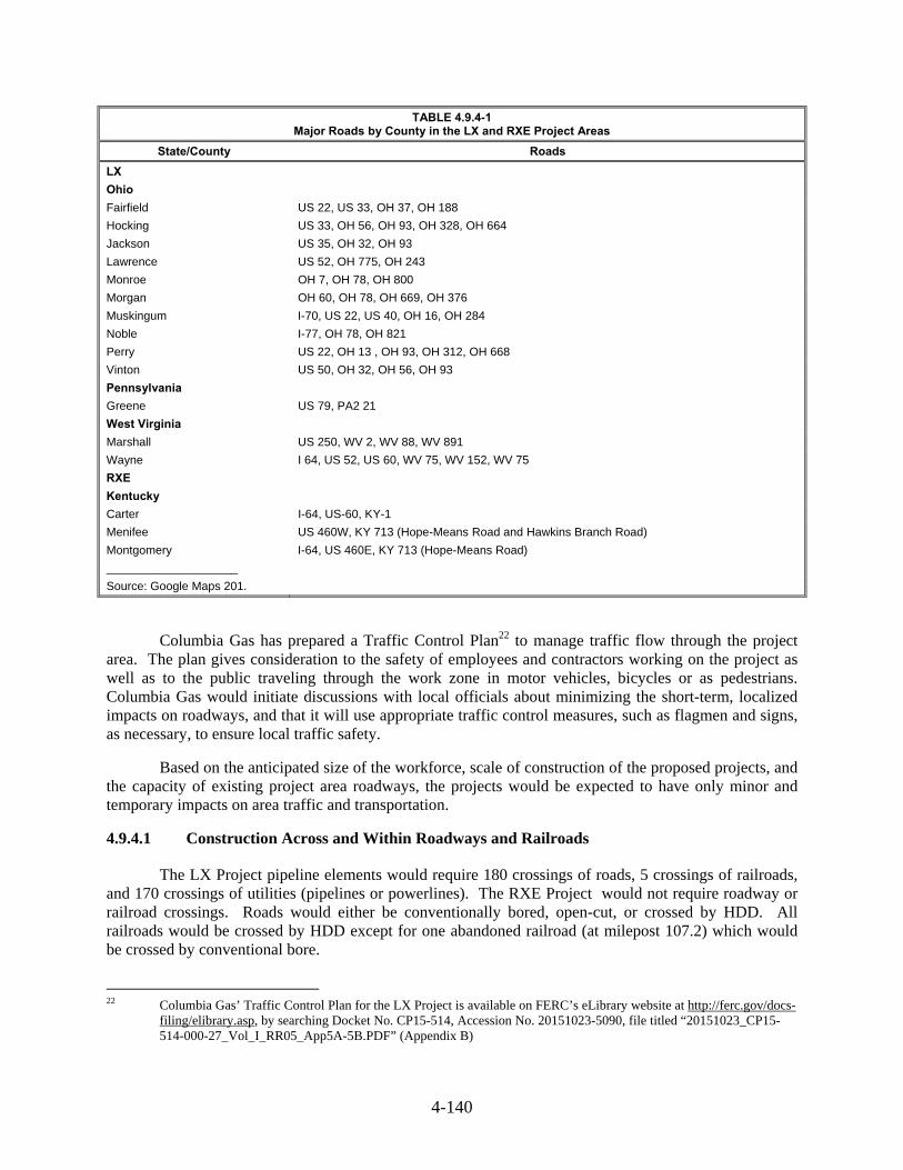
4-140
TABLE 4.9.4-1 Major Roads by County in the LX and RXE Project Areas
State/County Roads
LX
Ohio
Fairfield US 22, US 33, OH 37, OH 188
Hocking US 33, OH 56, OH 93, OH 328, OH 664
Jackson US 35, OH 32, OH 93
Lawrence US 52, OH 775, OH 243
Monroe OH 7, OH 78, OH 800
Morgan OH 60, OH 78, OH 669, OH 376
Muskingum I-70, US 22, US 40, OH 16, OH 284
Noble I-77, OH 78, OH 821
Perry US 22, OH 13 , OH 93, OH 312, OH 668
Vinton US 50, OH 32, OH 56, OH 93
Pennsylvania
Greene US 79, PA2 21
West Virginia
Marshall US 250, WV 2, WV 88, WV 891
Wayne I 64, US 52, US 60, WV 75, WV 152, WV 75
RXE
Kentucky
Carter I-64, US-60, KY-1
Menifee US 460W, KY 713 (Hope-Means Road and Hawkins Branch Road)
Montgomery I-64, US 460E, KY 713 (Hope-Means Road)
____________________
Source: Google Maps 201.
Columbia Gas has prepared a Traffic Control Plan22 to manage traffic flow through the project area. The plan gives consideration to the safety of employees and contractors working on the project as well as to the public traveling through the work zone in motor vehicles, bicycles or as pedestrians. Columbia Gas would initiate discussions with local officials about minimizing the short-term, localized impacts on roadways, and that it will use appropriate traffic control measures, such as flagmen and signs, as necessary, to ensure local traffic safety.
Based on the anticipated size of the workforce, scale of construction of the proposed projects, and the capacity of existing project area roadways, the projects would be expected to have only minor and temporary impacts on area traffic and transportation.
Construction Across and Within Roadways and Railroads 4.9.4.1
The LX Project pipeline elements would require 180 crossings of roads, 5 crossings of railroads, and 170 crossings of utilities (pipelines or powerlines). The RXE Project would not require roadway or railroad crossings. Roads would either be conventionally bored, open-cut, or crossed by HDD. All railroads would be crossed by HDD except for one abandoned railroad (at milepost 107.2) which would be crossed by conventional bore.
22 Columbia Gas’ Traffic Control Plan for the LX Project is available on FERC’s eLibrary website at http://ferc.gov/docs-
filing/elibrary.asp, by searching Docket No. CP15-514, Accession No. 20151023-5090, file titled “20151023_CP15-514-000-27_Vol_I_RR05_App5A-5B.PDF” (Appendix B)

4-141
Potential impacts associated with crossings include disruption of traffic flows, disturbance of existing underground utilities such as water and sewer lines, and hindrance of emergency vehicle access. Any impacts would be temporary. Columbia Gas would be responsible for obtaining crossing permits from the applicable federal, state, and local agencies, which would dictate specific requirements for the day-to-day construction activities and methods at each crossing, and bonding. Columbia Gas has committed to coordinating with the applicable federal, state, or local authority to develop a plan to repair any damaged road to pre-construction conditions. Based on Columbia Gas' proposed avoidance and mitigation measures, we expect the impacts from construction across and within roadways and railroads to be minor and temporary.
Property Values 4.9.5
We received comments concerning compensation for loss of resources, and concern of use of easement agreements to use properties. A specific comment asked the Commission to consider the value of pasture land especially in southeastern Ohio and West Virginia where in some counties the value of pastureland is greater than crop land and many small farms in the region focus on animal husbandry as the major portion of on-farm income.
Columbia Gas has committed to mitigate for impacts on agricultural producers by compensating landowners affected by the LX Project for lost crop production, and to compensate for construction related damages, such as those associated with residential areas, crops, and pasture. As stated is section 4.8.1.2, areas disturbed by construction would be allowed to revegetate to previous conditions and contours would be restored to pre-construction conditions following the completion of construction activities. Restoration of the pasture land would, therefore, minimize the potential impacts on the value of the property. If the LX and RXE Projects require temporary or permanent use of land affecting property owner income, normal practice is for local appraisers to review the placement of the pipeline or facilities, and conduct appraisals on an individual property basis as a basis for compensation. As such, we conclude that impacts on property values, especially with regard to pasture land, would not be significant.
Economy and Tax 4.9.6
Construction and operation of the LX and RXE Projects would positively benefit local communities through increased sales and property tax revenues, increased construction payroll, local material purchased, and use of local vendors.
Table 4.9.6-1 provides data regarding construction expenditures for the proposed LX and RXE Projects and estimated property taxes that would be paid upon completion of the Projects. Columbia Gas anticipates construction payroll would total approximately $568 million, including approximately $427 million in Ohio and approximately $141 million in West Virginia23. Columbia Gulf estimates construction payroll for RXE at $3.5 million. Material costs are estimated at approximately $924 million for LX and approximately $1.7 million for RXE24.
Columbia Gas estimates that additional money would be spent locally on construction equipment and materials such as cement, asphalt, concrete block, gasoline, steel wire, and truck transportation services. Additional items required for construction would be purchased locally. Approximately 50 percent of pipeline construction workers would be non-local hires, who would most likely temporarily
23 Columbia Gas did not estimate economic impacts in Pennsylvania. Based on the extent of the project in Pennsylvania,
these impacts would be small. 24 Estimated local purchases only.

4-142
relocate to the pipeline project area. Workers would spend payroll earnings locally, increasing local sales tax revenue totaling approximately $50 million for the affected counties.
TABLE 4.9.6-1 Socioeconomic Impact from Construction and Operation of the LX and RXE Projects
State/County
Construction Expenditures ($millions) Property Taxes ($millions (annual, upon completion) Labor Materialsa
LXc
Ohio $ 426.5 $ 694.9
Fairfield $ 3.7
Hocking $ 5.9
Jackson $ 2.5
Lawrence <$ 0.1
Monroe $ 6.0
Morgan $ 2.9
Muskingum $ 2.2
Noble $ 6.2
Perry $ 5.2
Vinton $ 2.1
West Virginia $ 141.1 $ 229.9
Marshall $ 2.3
Wayne $ 1.6
Total LX $ 567.6 $ 924.8
Grand Total LX $1,492.5 $ 40.6
Kentucky (RXE) $ 3.5 $1.7 b
To be determined
Grand Total LX and RXE $1,496 $ 40.6
___________________ a Includes other expenditures such as right of way and property owner compensation. b Estimated local purchases only. c Pennsylvania not included, see text.
Sources: Kleinhenz & Associates, 2014, Columbia Gas and Columbia Gulf, 2015.
While most of the materials for project construction would be purchased from national vendors,
common supplies (e.g., stone and concrete) would likely be purchased from vendors in the Project areas. Construction of the Projects would also result in increased state and local sales tax revenues associated with the purchase of some construction materials, as well as goods and services, by the construction workforce.
As noted above in section 4.9.1, in addition to direct hires, the LX Project pipeline would be expected to provide a number of temporary indirect and induced jobs as purchases are made by non-local workers on items such as food, clothing, lodging, gasoline, and entertainment. A study commissioned by Columbia Gas to examine the economic benefits of the proposed LX Project found that the project would generate approximately 3,700 indirect and induced jobs in Ohio and West Virginia in 2017 with approximately $250 million in labor income (Kleinhenz & Associates, 2014). Over the five year construction period, the study found that economic output would total approximately $2.3 billion.
We do not expect the LX and RXE Projects to have any long-term negative economic impact. The pipeline would be installed underground, and any surface impacts, such as damaged roads, would be repaired. Once installed, the pipeline would not impede normal surface traffic or access to businesses, and most pre-construction property uses would be allowed.

4-143
The long-term positive economic impacts from the proposed pipeline include an increase in annual property taxes ranging from approximately $6 thousand per year in Lawrence County, Ohio to $6.2 million in Noble County, Ohio. Columbia Gas estimates total annual property taxes at approximately $41 million including $36.7 million in Ohio and $3.9 million in West Virginia. This increase in property taxes paid would benefit the local governments and their budgets annually for the life of the projects. Columbia Gas would be responsible for paying any increased property tax resulting from operation of the LX Project. The landowner would not bear responsibility for increased property taxes resulting from installation or operation of the pipeline.
Environmental Justice 4.9.7
Executive Order 12898 (EO 12898) on Environmental Justice recognizes the importance of using NEPA process to identify and address, as appropriate, any disproportionately high and adverse health or environmental effects of federal programs, policies, and activities on minority populations and low-income populations. Consistent with EO 12898, the CEQ called on federal agencies to actively scrutinize the following issues with respect to environmental justice (CEQ 1997):
the racial and economic composition of affected communities;
health related issues that may amplify project effects on minority or low-income individuals; and
public participation strategies, including community or tribal participation in the process.
The EPA's Environmental Justice Policies focus on enhancing opportunities for residents to participate in decision making. The EPA (2011) states that Environmental Justice involves meaningful involvement so that: "(1) potentially affected community residents have an opportunity to participate in decisions about a proposed activity that will affect their environment and/or health; (2) the public's contributions can influence the regulatory agency's decision; (3) the concerns of all participants involved will be considered in the decision-making process; and (4) the decision makers seek out and facilitate the involvement of those potentially affected."
As discussed in section 2, Columbia Gas and Columbia Gulf have provided many opportunities for public input and comments about the proposed LX and RXE Projects. Columbia Gas and Columbia Gulf met with multiple different stakeholders during the initial developmental stage of the route including local residents and affected landowners. Multiple open house meetings were also held in the LX Project and RXE Project areas for the affected communities and local authorities. The companies also established and maintain a website to share information about the Projects with the public.
Minority populations, defined as African-Americans, Hispanic, Asian, and Native American persons comprise less than 10 percent of the population in each of the counties, incorporated places or CDPs that would be crossed by the LX Project. To further assess whether the minority population in the affected region is substantially greater than the minority population in surrounding areas, we compared county-level demographics to the respective statewide proportions. The proportion of individual minority populations is approximately less than respective state-level statistics in all of the counties affected by the LX and RXE Projects (table 4.9.7-1). These statistics indicate that a disproportionate effect on minority populations is unlikely, according to the guidance set forth by the CEQ.
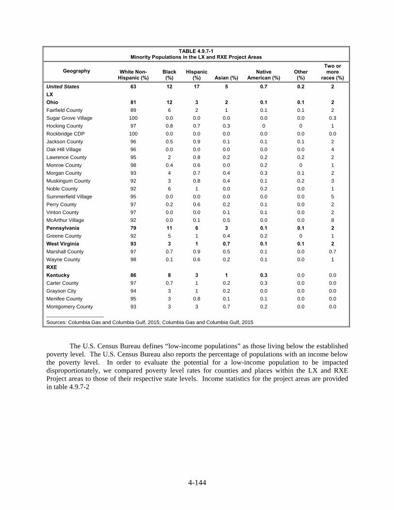
4-144
TABLE 4.9.7-1 Minority Populations in the LX and RXE Project Areas
Geography
White Non- Hispanic (%)
Black (%)
Hispanic (%) Asian (%)
Native American (%)
Other (%)
Two or more
races (%)
United States 63 12 17 5 0.7 0.2 2
LX
Ohio 81 12 3 2 0.1 0.1 2
Fairfield County 89 6 2 1 0.1 0.1 2
Sugar Grove Village 100 0.0 0.0 0.0 0.0 0.0 0.3
Hocking County 97 0.8 0.7 0.3 0 0 1
Rockbridge CDP 100 0.0 0.0 0.0 0.0 0.0 0.0
Jackson County 96 0.5 0.9 0.1 0.1 0.1 2
Oak Hill Village 96 0.0 0.0 0.0 0.0 0.0 4
Lawrence County 95 2 0.8 0.2 0.2 0.2 2
Monroe County 98 0.4 0.6 0.0 0.2 0 1
Morgan County 93 4 0.7 0.4 0.3 0.1 2
Muskingum County 92 3 0.8 0.4 0.1 0.2 3
Noble County 92 6 1 0.0 0.2 0.0 1
Summerfield Village 95 0.0 0.0 0.0 0.0 0.0 5
Perry County 97 0.2 0.6 0.2 0.1 0.0 2
Vinton County 97 0.0 0.0 0.1 0.1 0.0 2
McArthur Village 92 0.0 0.1 0.5 0.0 0.0 8
Pennsylvania 79 11 6 3 0.1 0.1 2
Greene County 92 5 1 0.4 0.2 0 1
West Virginia 93 3 1 0.7 0.1 0.1 2
Marshall County 97 0.7 0.9 0.5 0.1 0.0 0.7
Wayne County 98 0.1 0.6 0.2 0.1 0.0 1
RXE
Kentucky 86 8 3 1 0.3 0.0 0.0
Carter County 97 0.7 1 0.2 0.3 0.0 0.0
Grayson City 94 3 1 0.2 0.0 0.0 0.0
Menifee County 95 3 0.8 0.1 0.1 0.0 0.0
Montgomery County 93 3 3 0.7 0.2 0.0 0.0
____________________
Sources: Columbia Gas and Columbia Gulf, 2015; Columbia Gas and Columbia Gulf, 2015
The U.S. Census Bureau defines “low-income populations” as those living below the established poverty level. The U.S. Census Bureau also reports the percentage of populations with an income below the poverty level. In order to evaluate the potential for a low-income population to be impacted disproportionately, we compared poverty level rates for counties and places within the LX and RXE Project areas to those of their respective state levels. Income statistics for the project areas are provided in table 4.9.7-2
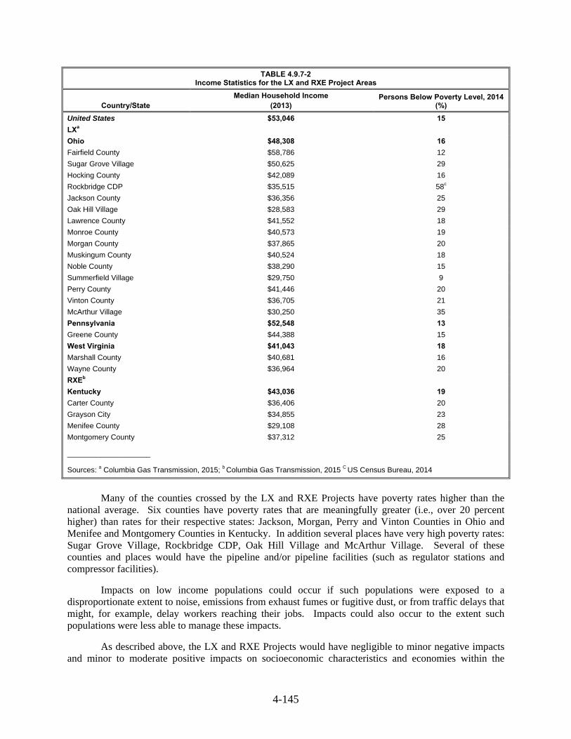
4-145
TABLE 4.9.7-2 Income Statistics for the LX and RXE Project Areas
Country/State Median Household Income
(2013) Persons Below Poverty Level, 2014
(%)
United States $53,046 15
LXa
Ohio $48,308 16
Fairfield County $58,786 12
Sugar Grove Village $50,625 29
Hocking County $42,089 16
Rockbridge CDP $35,515 58c
Jackson County $36,356 25
Oak Hill Village $28,583 29
Lawrence County $41,552 18
Monroe County $40,573 19
Morgan County $37,865 20
Muskingum County $40,524 18
Noble County $38,290 15
Summerfield Village $29,750 9
Perry County $41,446 20
Vinton County $36,705 21
McArthur Village $30,250 35
Pennsylvania $52,548 13
Greene County $44,388 15
West Virginia $41,043 18
Marshall County $40,681 16
Wayne County $36,964 20
RXEb
Kentucky $43,036 19
Carter County $36,406 20
Grayson City $34,855 23
Menifee County $29,108 28
Montgomery County $37,312 25
____________________
Sources: a Columbia Gas Transmission, 2015; b Columbia Gas Transmission, 2015 C US Census Bureau, 2014
Many of the counties crossed by the LX and RXE Projects have poverty rates higher than the
national average. Six counties have poverty rates that are meaningfully greater (i.e., over 20 percent higher) than rates for their respective states: Jackson, Morgan, Perry and Vinton Counties in Ohio and Menifee and Montgomery Counties in Kentucky. In addition several places have very high poverty rates: Sugar Grove Village, Rockbridge CDP, Oak Hill Village and McArthur Village. Several of these counties and places would have the pipeline and/or pipeline facilities (such as regulator stations and compressor facilities).
Impacts on low income populations could occur if such populations were exposed to a disproportionate extent to noise, emissions from exhaust fumes or fugitive dust, or from traffic delays that might, for example, delay workers reaching their jobs. Impacts could also occur to the extent such populations were less able to manage these impacts.
As described above, the LX and RXE Projects would have negligible to minor negative impacts and minor to moderate positive impacts on socioeconomic characteristics and economies within the

4-146
projects area. As discussed throughout this EIS, potentially negative environmental effects associated with the Projects would be minimized and/or mitigated, as applicable. Although the economic composition of the counties and places traversed by the proposed projects shows some deviations from state-level statistics, there is no evidence that the Projects would cause a disproportionate share of adverse environmental or socioeconomic impacts on any racial, ethnic, or socioeconomic group.
The primary health issues related to the proposed Projects would be the temporary increases in dust, equipment emissions, noise, and traffic from project construction. These impacts would occur along the entire pipeline route and in areas with a variety of socioeconomic backgrounds. Columbia Gas would implement a series of measures to minimize such impacts including proven construction related practices to control fugitive dust outlined in the Fugitive Dust Control Plan (4.11.1.3), equipment emissions will meet the standards for mobile sources established by the EPA non-road source emission regulations and imposed on equipment manufacturers. Noise control measures would be implemented during project construction and operation to ensure that noise attributable to the new aboveground facilities would be either less than 55 dBA Ldn at nearby NSAs, or where the noise currently attributable to a particular station is greater than 55 dBA Ldn the noise attributable to the station modifications would cause no perceptible change to station noise levels. Traffic Management Plans have also been developed for the Project as described in section 4.9.4.
Based on the identified estimated emissions from operation of the proposed operation of the proposed project facilities and review of the modeling analysis, the LX and RXE Projects would result in continued compliance with the NAAQS, which are protective of human health, including children, the elderly, and sensitive populations (see section 4.11.1.4). The project facilities would also be designed, constructed, operated and maintained in accordance with or to exceed PHMSA’s minimum federal safety standards in 49 CFR 192. These regulations, which are intended to protect the public and to prevent natural gas facility accidents and failures, apply to all areas along the proposed pipeline routes regardless of the presence or absence of minority or low income populations.
We expect that any impacts on low income populations would be minor and temporary provided Columbia Gas and Columbia Gulf manage noise, air quality, and traffic pursuant to its proposed construction and operation procedures.
4.10 CULTURAL RESOURCES
Section 106 of the NHPA requires FERC to take into account the effects of its undertakings (including the issuance of Certificates) on historic properties and to provide the Advisory Council of Historic Preservation (ACHP) an opportunity to comment on the undertaking. Columbia Gas and Columbia Gulf, as non-federal parties, are assisting FERC in meeting its obligations under Section 106 by providing information, analyses, and recommendations as authorized by 36 CFR 800.2(a)(3). To meet consultation procedures for NEPA, FERC issued NOIs to federal, state, and local agencies, and federally recognized Indian tribes (Tribes) on January 13, 2015 (Docket No. PF14-23-000) and on September 4, 2015 (Docket Nos. CP15-514 and CP15-539). The NOIs contained a paragraph about section 106 of the NHPA, and stated that we use the notice to initiate consultations with State Historic Preservation Offices (SHPOs)25, and to solicit their views and those of other government agencies, interested Tribes, and the public on the projects’ potential effects on historic properties.
25 The SHPO is represented by the Ohio History Connection in Ohio, West Virginia Division of Culture and History in
West Virginia, Kentucky Heritage Council in Kentucky and the Pennsylvania Historical and Museum Commission – Bureau for Historic Preservation in Pennsylvania.

4-147
Ohio (LX Project) 4.10.1
Results of Cultural Resource Investigations in Ohio 4.10.1.1
From 2014 to 2016, Columbia Gas conducted Phase I archaeological surveys of the LX Project’s area of potential effects (APE) for archaeological resources in Ohio, which totals 7,237.5 acres26 and consists of a 400-foot wide survey corridor (300 foot wide for the R-801 Loop), a 100-foot wide corridor for access roads, and the total acreage for associated facilities. The surveys identified 100 archaeological sites, which range in date from the Middle Archaic period (6000-3500 BC), through the Early and Middle Woodland periods (600 BC-AD 500), to the 19th and 20th centuries. Of the 100 sites, 76 have been determined or were recommended not eligible for listing in the NRHP. Another 21 sites are of undetermined eligibility, but all but two of these sites (33MG224 and 33MG225) would be avoided by reroutes or workspace modifications. The remaining three sites have been determined eligible for listing in the NRHP. One of these sites would be avoided by a reroute, but the other two sites could not be avoided (33VI227 and 33VI781). Columbia Gas has committed to the following measures to mitigate impacts to archaeological sites in Ohio:
Monitoring of 33VI227 and 33VI781 during construction;
Protection of 33MG224 by matting (for temporary access road); and
Avoidance of 33MG224 and 33MG225 by HDD (for pipeline).
Columbia Gas has not filed mitigation plans for these sites or completed the archaeological surveys in Ohio. Pending areas consist of 2.6 miles of pipeline (128.0 acres), 2.1 miles of access roads (25.8 acres), 2.3 acres of temporary workspace along the pipeline abandonment, and 0.9 acres of workspace at compressor station sites.
In 2014 and 2015, Columbia Gas conducted architectural reconnaissance surveys of the LX Project’s APE for historic aboveground resources in Ohio, which was defined as a 0.5-mile radius around any proposed permanent aboveground facility that has the potential to visually diminish or alter the setting of a historic property, and on a case-by-case basis for roads. The surveys identified 149 historic aboveground resources, all of which date to the 19th and/or 20th centuries. One of the resources is listed in the NRHP (Frederick Kindleberger Stone House and Stone Barn, MOE0002104), 46 have been determined or were recommended as not eligible, and the remaining 102 are of undetermined eligibility. The surveys identified no resources with the potential for direct impacts (i.e., physical alteration or demolition) from the LX Project. Columbia Gas recommends further investigation of Site 103 (late 19th century dwelling), Site 136 (early 20th century dwelling and late 20th century barn), and Site 140 (ca. 1830 dwelling and ca. 1960 outbuildings) to assess indirect (i.e., visual) impacts, but recommends no indirect impacts and thus no adverse effects on the remaining 146 resources. Columbia Gas has not filed a report assessing indirect impacts to Site 103, Site 136, and Site 140.
Ohio SHPO Consultation 4.10.1.2
On May 5, 2014, Columbia Gas submitted a cultural resources survey research design for the LX Project to the Ohio SHPO. On September 23, 2015, Columbia Gas provided the Ohio SHPO with information about the LX Project. Initial archaeological survey and architectural reconnaissance reports were submitted to the Ohio SHPO on February 18, 2015. The Ohio SHPO concurred with the archaeological survey report and its recommendations (for 63 archaeological sites) on February 28, 2015. The Ohio SHPO concurred with the architectural reconnaissance report and its recommendations (for 124 26 The APE for archaeological resources is larger than the land affected during construction as indicated in Section 2
because the survey corridors agreed to with the SHPO are wider.

4-148
resources) on March 24, 2015, but requested that the 34 resources identified for potential impacts be evaluated for NRHP eligibility, and that an assessment of effects be conducted for resources recommended as NRHP eligible. A supplemental archaeological survey report and an addendum architectural reconnaissance report were submitted to the Ohio SHPO on October 16, 2015. The latter report recommends no adverse effects on 33 of the 34 resources mentioned above, and an NRHP evaluation of the remaining resource (Site 103). The Ohio SHPO provided comments on the supplemental archaeological survey report on January 8, 2016, and a revised report was submitted to the Ohio SHPO on February 16, 2016. The Ohio SHPO requested a summary before reviewing the addendum architectural reconnaissance report, which was submitted to the Ohio SHPO on January 21, 2016. Ohio SHPO concurrence with these reports has not been filed. A second supplemental archaeological survey report was submitted to the Ohio SHPO on March 16, 2016. Ohio SHPO comments on this report have not been filed.
West Virginia (LX Project) 4.10.2
Results of Cultural Resource Investigations in West Virginia 4.10.2.1
From 2014 to 2016, Columbia Gas conducted Phase I archaeological surveys of the LX Project’s APE for archaeological resources in West Virginia, which totals 1,502.827 acres and consists of a 400-foot wide survey corridor, a 100-foot wide corridor for access roads, and the total acreage for associated facilities. The surveys identified two archaeological sites and three historic cemeteries. All five sites are of undetermined eligibility, but all but one of these (46MR238) would be avoided by reroutes or workspace modifications. Columbia Gas has committed to the following measures to mitigate impacts to archaeological sites in West Virginia:
Avoidance of 46MR238 by HDD.
Columbia Gas has not filed the avoidance plan for this site or completed the archaeological surveys in West Virginia. Pending areas consist of 1.6 miles of pipeline (75.2 acres), 0.1 miles of access roads (0.7 acres), 4.0 acres of pipe yards, and 1.2 acres of workspace at Lone Oak CS.
In 2014 and 2015, Columbia Gas conducted architectural reconnaissance surveys of the APE for historic aboveground resources in West Virginia, which was defined as a 0.5-mile radius around any proposed permanent aboveground facility that has the potential to diminish or alter the setting of a historic property, and on a case-by-case basis for access roads. The surveys identified 16 historic aboveground resources that date to the 19th and/or 20th centuries. Columbia Gas recommends 14 of the resources, as well as the Ceredo CS in Wayne County, as not eligible for listing in the NRHP. Columbia Gas recommends the two remaining resources as undetermined, but recommends no adverse effects from the LX Project.
West Virginia SHPO Consultation 4.10.2.2
On May 5, 2014, Columbia Gas submitted a cultural resources survey research design for the LX Project to the West Virginia SHPO. On September 23, 2015, Columbia Gas provided the West Virginia SHPO with information on the LX Project. Initial archaeological survey and architectural reconnaissance reports were submitted to the West Virginia SHPO on February 18, 2015. The West Virginia SHPO concurred with the archaeological survey report and its recommendations (for 2 archaeological sites) on March 20, 2015. The West Virginia SHPO concurred with the architectural reconnaissance report and its recommendations (for 1 resource) on March 20, 2015, but requested that a Historic Property Inventory 27 The APE for archaeological resources is larger than the land affected during construction as indicted in Section 2
because the survey corridors agreed to with the SHPO are wider.

4-149
form be submitted for the resource (currently designated as FS 1). A supplemental archaeological survey report and an addendum architectural reconnaissance report were submitted to the West Virginia SHPO on October 16, 2015. The West Virginia SHPO concurred with the reports and their recommendations on November 30, 2015. A second supplemental archaeological survey report was submitted to the West Virginia SHPO on March 16, 2016. West Virginia SHPO comments on this report have not been filed.
Pennsylvania (LX Project) 4.10.3
Results of Cultural Resource Investigations in Pennsylvania 4.10.3.1
In 2015, Columbia Gas conducted a Phase I archaeological survey of the LX Project’s APE for archaeological resources in Pennsylvania, which totals 88.5 acres28 and consists of a 400-foot wide pipeline corridor and a 100-foot wide corridor for access roads. The survey identified one previously recorded archaeological site dating to the undefined pre-contact and historic periods in the project area. No archaeological resources were encountered during the field investigation, however, including in subsurface excavations conducted within the portion of the previously recorded site that intersects the project area. Data from previous investigations suggest that the site was incorrectly mapped and is actually located just south of the project area.
Pennsylvania SHPO Consultation 4.10.3.2
On April 13, 2015, Columbia Gas submitted a Project Review Form to the Pennsylvania SHPO. On May 8, 2015, the Pennsylvania SHPO responded that a Phase I archaeological survey should be performed and requested additional information before determining the necessity of an architectural reconnaissance survey. Columbia Gas provided the additional information on June 2, 2015, and the Pennsylvania SHPO responded that the proposed LX Project would not affect historic aboveground resources in a letter dated July 8, 2015. Columbia Gas provided project redesign information on August 17, 2015, and the Pennsylvania SHPO reiterated their previous response that the proposed LX Project would not affect historic aboveground resources in a letter dated September 9, 2015. The archaeological survey report was submitted to the Pennsylvania SHPO on October 16, 2015. Pennsylvania SHPO comments on the report have not been filed.
Kentucky (RXE Project) 4.10.4
Results of Cultural Resource Investigations in Kentucky 4.10.4.1
In October 2014 and February 2015, Columbia Gulf conducted a cultural resources survey of the RXE Project in Kentucky. The APE for archaeological resources totals 33.829 acres and consists of the Means CS (20.9 acres) and the Grayson CS Site 6 (12.9 acres). The APE for historic aboveground resources was defined as the geographic area from which any permanent infrastructure has the potential to visually diminish or alter the setting of a historic property. The archaeological survey of the Grayson CS identified two archaeological sites. Both sites were recommended not eligible for listing in the NRHP. The archaeological survey of the Means CS identified three previously recorded and no new archaeological sites. One of the sites has been recommended not eligible for listing in the NRHP. The other two sites have been recommended as undetermined (15MF490 and 15MF492). Columbia Gulf has committed to the following measures to mitigate impacts to archaeological sites in Kentucky:
28 The APE for archaeological resources is larger than the land affected during construction as indicted in Section 2
because the survey corridors agreed to with the SHPO are wider. 29 Slightly larger than the land affected during construction as indicated in Section 2, which is 32.2 acres.
4-150
Avoidance or Phase II archaeological evaluation of 15MF490 and 15MF492.
Columbia Gulf has not filed avoidance plans or archaeological evaluation reports for these two sites. The architectural reconnaissance survey identified no historic aboveground resources within the APE of the Means CS or the Grayson CS Site 6.
Kentucky SHPO Consultation 4.10.4.2
On October 1, 2014, Columbia Gulf submitted a cultural resources survey research design for the RXE Project to the Kentucky SHPO. A cultural resources survey report was submitted to the Kentucky SHPO on July 15, 2015. Kentucky SHPO comments on the report have not been filed.
Tribal Consultation 4.10.5
On May 8, 2014, Columbia Gas sent notification letters for the proposed LX Project to the following 25 federally recognized Indian tribes (Tribes): Absentee-Shawnee Tribe of Oklahoma; Catawba Indian Nation; Cayuga Nation; Cherokee Nation; Citizen Potawatomi Nation of Oklahoma; Delaware Nation; Delaware Tribe of Indians; Eastern Band of Cherokee Indians; Eastern Shawnee Tribe of Oklahoma; Forest County Potawatomi Community, Wisconsin; Miami Tribe of Oklahoma; Oneida Indian Nation; Oneida Tribe of Indians of Wisconsin; Onondaga Nation; Ottawa Tribe of Oklahoma; Peoria Tribe of Oklahoma; Seneca Nation of Indians; Seneca-Cayuga Tribe of Oklahoma; Shawnee Tribe of Oklahoma; St. Regis Mohawk Tribe; Tonawanda Band of Seneca Indians; Turtle Mountain Band of Chippewa Indians of North Dakota; Tuscarora Nation; United Keetoowah Band of Cherokee Indians; and Wyandotte Nation. The letters were sent to inform each tribe about the LX Project and to request that they communicate any potential concerns they might have with respect to potential impacts on cultural resources, including traditional cultural properties.
Due to deviations in the LX Project, update letters were sent on March 27, 2015 to the following 14 previously contacted tribes: Absentee-Shawnee Tribe of Oklahoma; Cayuga Nation; Delaware Nation; Delaware Tribe of Indians; Eastern Shawnee Tribe of Oklahoma; Oneida Indian Nation; Oneida Nation of Wisconsin; Onondaga Nation; Seneca Nation of Indians; Seneca-Cayuga Tribe of Oklahoma; Shawnee Tribe of Oklahoma; St. Regis Mohawk Tribe; Tonawanda Seneca Nation; and Tuscarora Nation. In addition, a Project notification letter was sent on March 27, 2015 to the Stockbridge-Munsee Band of the Mohican Nation, Wisconsin.
The Delaware Tribe of Indians responded in a letter dated June 27, 2014 in which they requested to participate as a consulting party. They also requested an archaeological survey, a copy of the final archaeological survey report, that construction not begin until they review the report and provide written comments, and that they be notified if any human remains are discovered. Copies of the archaeological survey reports were sent to the tribe on October 19, 2015. The Catawba Indian Nation responded in a letter dated July 22, 2015 that they have no immediate concerns within the boundaries of the proposed project areas, but requested that they be notified if any unanticipated discovery is encountered during construction. No other responses have been filed.
On June 6, 2015, FERC sent consultation letters to the following 19 Tribes to request their comments on the proposed LX Project: Absentee-Shawnee Tribe of Oklahoma; Cayuga Nation; Delaware Nation; Delaware Tribe of Indians; Eastern Shawnee Tribe of Oklahoma; Miami Tribe of Oklahoma; Oneida Indian Nation; Oneida Tribe of Indians of Wisconsin; Onondaga Nation; Ottawa Tribe of Oklahoma; Peoria Tribe of Oklahoma; Seneca Nation of Indians; Seneca-Cayuga Tribe of Oklahoma; Shawnee Tribe of Oklahoma; St. Regis Mohawk Tribe; Stockbridge-Munsee Band of the Mohican Nation; Tonawanda Band of Seneca Indians; Tuscarora Nation; and Wyandotte Nation. The letters are provided in appendix Q. None of the tribes responded.

4-151
On June 30, 2015, Columbia Gulf sent notification letters for the proposed RXE Project to the following Tribes: Delaware Nation; Eastern Bank of Cherokee Indians of North Carolina; Miami Tribe of Oklahoma; Peoria Tribe of Indians of Oklahoma; and United Keetoowah Band of Cherokee Indians in Oklahoma. The letters were to inform each tribe about the RXE Project and to request that they communicate any potential concerns they might have with respect to cultural resources, including traditional cultural properties. No responses have been filed.
Unanticipated Discovery Plans 4.10.6
For the LX Project, Columbia Gas filed “Unanticipated Discoveries and Emergency Procedures” for the unanticipated discovery of cultural resources or human remains during construction in Ohio, Pennsylvania, and West Virginia. The plans were submitted to the Ohio and West Virginia SHPOs on January 16, 2015, and to the Pennsylvania SHPO, on April 13, 2015. The West Virginia SHPO concurred with the plan on February 3, 2015, and the Pennsylvania SHPO concurred on May 8, 2015. No other comments have been filed. FERC staff finds the plans acceptable.
For the RXE Project, Columbia Gulf filed a “Procedure Guiding the Discovery of Unanticipated Cultural Resources and Human Remains.” Columbia Gulf has not filed documentation that the plan has been submitted to the Kentucky SHPO. However, FERC staff finds the plan acceptable.
General Impacts and Mitigation 4.10.7
Compliance with Section 106 of the NHPA has not been completed for the Projects. To ensure that FERC’s responsibilities under the NHPA and its implementing regulations are met, we recommend that:
Columbia Gas and Columbia Gulf should not begin construction of facilities and/or use of (all) staging, storage, or temporary work areas and new or to-be improved access roads in Ohio, West Virginia, Pennsylvania, or Kentucky until:
o Columbia Gas and Columbia Gulf file with the Secretary:
cultural resource identification survey reports for any previously unreported areas in Ohio, Pennsylvania, and West Virginia;
evaluation studies, as necessary, to provide NRHP-eligibility recommendations for historic aboveground resources Site 103, Site 136, and Site 140 in Ohio and archaeological sites 15MF490 and 15MF492 in Kentucky;
any other reports, evaluation studies, or plans (monitoring, avoidance, etc.) not yet submitted; and
comments on survey reports, UDPs, and any other studies or plans from the Ohio, West Virginia, Pennsylvania, and Kentucky SHPOs and any other consulting parties;
o The ACHP is afforded an opportunity to comment if historic properties would be adversely affected; and
o FERC staff reviews and the Director of OEP approves the cultural resources reports and plans, and notifies Columbia Gas and Columbia Gulf in writing that treatment plans/mitigation measures may be implemented and/or construction may proceed.

4-152
All material filed with the Commission containing location, character, and ownership information about cultural resources must have a cover and any relevant pages therein clearly labeled with the following in bold lettering: "CONTAINS PRIVILEGED INFORMATION - DO NOT RELEASE."
4.11 AIR QUALITY AND NOISE
Air Quality 4.11.1
Air quality would be affected by construction and operation of the proposed LX and RXE Projects. Though air emissions would be generated by operation of equipment during construction of the projects’ facilities, most air emissions associated with the projects would result from the long-term operation of the compressor stations. This section of the EIS addresses the potential effects on air quality resulting from emissions from construction and operation of the proposed projects, and describes the applicable regulatory requirements.
Existing Air Quality 4.11.1.1
The regional climate of the LX and RXE Project areas, including northwest and southwest West Virginia, southwest Pennsylvania, southeast Ohio, and northeast Kentucky, is generally warm during summer, cold during winter, and precipitation is generally well distributed throughout the year. Based on climatological data measured in McConnelsville, Ohio, which is located near the center of the affected LX Project region, the annual mean temperature is 52 °F with an annual mean daily minimum of 40 °F and an annual mean daily maximum of 63 °F. Climatological data measured in Grayson and Mount Sterling, Kentucky, which are representative of the climatic conditions of the RXE Project area, identifies the annual mean temperature of 53 °F with an annual mean daily minimum of 41 °F and an annual mean daily maximum of 66 °F.
Ambient Air Quality Standards
The CAA was enacted by Congress to protect the public from the adverse effects of air pollution. The EPA has developed National Ambient Air Quality Standards (NAAQS) to protect human health and welfare. The CAA identifies two types of NAAQS, primary and secondary. Primary standards set limits to protect human health, including the health of “sensitive” populations, such as children, the elderly, and those with chronic respiratory problems. Secondary standards set limits designed to protect public welfare, including economic interests, such as protection from damage to animals, crops, vegetation, and buildings, and protection against decreased visibility.
NAAQS have been developed for six criteria air pollutants, including sulfur dioxide (SO2), nitrogen dioxide (NO2), carbon monoxide (CO), particulate matter (PM), ozone (O3), and lead (Pb). The PM standard includes two categories, PM with a diameter of 10 microns or less (PM10) and PM with a diameter of 2.5 microns or less (PM2.5). Ozone, unlike the other substances for which NAAQS have been established, is not emitted directly into the air from emission sources. It is, however, formed near ground level as a result of a chemical reaction between oxides of nitrogen (NOX) and volatile organic compounds (VOCs) in the presence of sunlight. As a result, emissions of NOX and VOCs are regulated by the EPA as they are considered “precursors” to the formation of ozone. The current NAAQS are listed on EPA's website at http://www3.epa.gov/ttn/naaqs/criteria.html. The KYDEP, WVDEP, OEPA, and PADEP have all adopted the NAAQS, as promulgated by the EPA.
The EPA also defines air pollution to include a mix of six long-lived and directly emitted greenhouse gases (GHGs), finding that the presence of these GHGs in the atmosphere may endanger public health and welfare through climate change. As with any fossil fuel-fired project or activity, the

4-153
proposed LX and RXE Projects would contribute GHG emissions. The primary GHGs that would be produced by the proposed projects include carbon dioxide (CO2), methane (CH4), and nitrous oxide (N2O). Emissions of GHGs are typically quantified and regulated in units of carbon dioxide equivalents (CO2e). The CO2e takes into account the global warming potential (GWP) of each GHG. The GWP is a ratio relative to CO2 of a particular GHG’s ability to absorb solar radiation as well its residence time within the atmosphere. Thus, CO2 has a GWP of 1, CH4 has a GWP of 25, and N2O has a GWP of 298.30 To obtain the CO2e quantity, the mass of the particular GHG is multiplied by the corresponding GWP. The CO2e value for each of the GHG compounds is summed to obtain the total CO2e GHG emissions.
Air Quality Control Regions and Attainment Status
Air quality control regions (AQCR) are areas established by EPA and local agencies, in accordance with section 107 of the CAA, for air quality planning purposes in which State Implementation Plans describe how NAAQS would be achieved and maintained. The AQCRs are intra- and interstate regions such as large metropolitan areas where improvement of the air quality in one portion of the AQCR requires emission reductions throughout the AQCR. Each AQCR, or portion thereof, is designated based on compliance with the NAAQS. Areas are designated attainment, unclassifiable, nonattainment, or maintenance on a pollutant-by-pollutant basis. Areas in compliance, or below the NAAQS, are designated as attainment, while areas not in compliance, or above the NAAQS, are designated as a nonattainment. Areas that were designated nonattainment but have since demonstrated compliance with the NAAQS are designated as “maintenance” for that pollutant. Maintenance areas may be subject to more stringent regulatory requirements to ensure continued attainment of the NAAQS pollutant. Areas that lack sufficient data to determine attainment status are designated unclassifiable and treated as attainment areas.
The entirety of the LX Project is designated attainment or unclassifiable for all criteria air pollutants, except as indicated below:
Fairfield County, Ohio, is a marginal nonattainment area for the 2008 8-hour ozone standard.
The Clay, Franklin, and Washington tax districts within Marshall County, West Virginia, are designated as nonattainment for SO2.
Marshall and Wayne Counties, West Virginia, and Fairfield and Lawrence Counties, Ohio, are maintenance areas for the 1997 PM2.5 standard.
The LX facilities located within the nonattainment areas or maintenance areas identified above include the following:
The Crawford CS and portions of LEX and LEX1 are located within the Fairfield County ozone nonattainment area and PM2.5 maintenance area.
Portions of LEX are located within the Marshall County SO2 nonattainment area.
The Lone Oak CS and portions of LEX are located within the Marshall County PM2.5 maintenance area.
The Ceredo CS and portions of the BM-111 Loop are located within the Wayne County PM2.5 maintenance area.
30 These GWPs are based on a 100-year time period. We have selected their use over other published GWPs and other
timeframes because these are the GWPs EPA has established for reporting of GHG emissions and air permitting requirements. This allows for a consistent comparison with these regulatory requirements.

4-154
Portions of the BM-111 Loop and R-300/R-5000 OS are located within the Lawrence County PM2.5 maintenance area.
All RXE Project facilities located in Kentucky are in areas classified as attainment/unclassifiable for all pollutants and averaging periods, and are not maintenance areas for any pollutants.
Air Quality Monitoring and Existing Air Quality
The EPA and state and local agencies have established a network of ambient air quality monitors located throughout each state serving a variety of purposes, but mainly to determine the air quality conditions in representative areas. Monitoring data obtained from the EPA AirData network (EPA, 2008) for 2011-2014 were reviewed to characterize ambient air quality related to regulated criteria pollutants in the vicinity of the LX and RXE Project areas.
Air Regulatory Requirements 4.11.1.2
The proposed project would be subject to a variety of federal, state, and local regulations pertaining to the construction or operation of air emission sources. KYDEP, WVDEP, OEPA, and PADEP have the primary jurisdiction over air emissions produced by the proposed RXE Project in Kentucky, West Virginia, Ohio, and Pennsylvania, respectively. Each state agency enforces its own regulations as well as EPA’s federal requirements.
The CAA is the basic federal statute governing air pollution in the United States. The provisions of the CAA that are applicable to the LX and RXE Projects are discussed below.
Air Permitting
New Source Review (NSR) is a pre-construction permitting program designed to protect air quality when air pollutant emissions are increased either through the modification of existing sources or through the construction of a new source of air pollution. In areas with good air quality, NSR ensures that the new emissions do not degrade the air quality, which is achieved through the implementation of the Prevention of Significant Deterioration (PSD) permitting program for major sources or state permit programs for minor sources. In areas with poor air quality, Nonattainment NSR ensures that the new emissions do not inhibit progress toward cleaner air. In addition, NSR ensures that any large, new, or modified industrial source uses air pollution control technology.
Based on the operating emissions presented in tables 4.11.1-1 through 4.11.1-5, a major source NSR permit would not be required for any of the new CSs. Further, the modifications at the Ceredo CS or Crawford CS are not subject to any NSR permitting requirements, as the revisions to the existing CSs would not cause an increase in operational emissions. For the installation and operation of the new CSs, minor NSR permits must be obtained from the state or local permitting authority, as follows:
Lone Oak CS – WVDEP Minor NSR Permit to Construct that authorizes construction and initial operation.
Summerfield CS – OEPA Permit-to-Install and Operate that authorizes both construction and operation.
Oak Hill CS – OEPA Permit-to-Install that authorizes construction and initial operation.
Grayson CS – KYDEP Initial Operating Permit that authorizes both construction and operation.
Means CS – KYDEP State-Origin Permit that authorizes both construction and operation.

4-155
All initial permit applications were submitted for the LX and RXE Projects described above.
Title V is an operating permit program run by each state. Based on the potential emission rates shown in tables 4.11.1-1 through 4.11.1-5, the following CSs would be subject to Title V permitting for the LX and RXE Projects: Lone Oak, Oak Hill, Grayson, and Ceredo Compressor Stations. Columbia Gas and Columbia Gulf would need to obtain or modify a Title V permit for each of these facilities within 12 months of commencing operation.
TABLE 4.11.1-1 Potential Emission Rates Associated with the Lone Oak Compressor Station (tpy)
Emission Source NOX CO VOC SO2 PM2.5 / PM10 Formaldehyde
Total HAP
GHG (CO2e)
Turbine #1 a 31.2 46.6 3.8 0.4 3.8 0.4 0.6 66,609
Turbine #2 a 31.2 46.6 3.8 0.4 3.8 0.4 0.6 66,609
Turbine #3 a 31.2 46.6 3.8 0.4 3.8 0.4 0.6 66,609
Emergency Generator 1.3 0.8 <0.1 <0.1 <0.1 0.1 0.2 266
Fuel Gas Heater 0.4 0.4 <0.1 <0.1 0.0 <0.1 0.0 513
Catalytic Space Heaters 1.2 1.0 0.1 <0.1 0.1 <0.1 0.0 1,477
Storage Tanks -- -- <0.1 -- -- -- -- 0.0
Condensate Loading -- -- <0.1 -- -- -- -- 0.0
Equipment Leaks -- -- 0.6 -- -- -- -- 387
Natural Gas Venting -- -- 9.3 -- -- -- -- 6,025
Facility-Wide Totals 96.7 142.1 20.7 1.2 11.4 1.3 2.0 208,108
____________________ a Emission rate of the Solar Mars 100 turbines are for normal operation at 0 °F.
TABLE 4.11.1-2 Potential Emission Rates Associated with the Summerfield Compressor Station (tpy)
Emission Source NOX CO VOC SO2 PM2.5 / PM10 Formaldehyde
Total HAP
GHG (CO2e)
Turbine #1a 26.8 39.3 1.9 0.2 2.0 0.2 0.3 34,654
Turbine #2 a 26.8 39.3 1.9 0.2 2.0 0.2 0.3 34,654
Emergency Generator 1.3 0.8 <0.1 <0.1 0.0 0.1 0.2 266
Fuel Gas Heater 0.2 0.2 <0.1 <0.1 0.0 <0.1 <0.1 256
Catalytic Space Heaters 1.2 1.0 0.1 <0.1 0.1 <0.1 <0.1 1,477
Storage Tanks -- -- <0.1 -- -- -- -- 0.0
Condensate Loading -- -- <0.1 -- -- -- -- 0.0
Equipment Leaks -- -- 0.4 -- -- -- -- 258
Natural Gas Venting -- -- 7.9 -- -- -- -- 5,100
Facility-Wide Totals 56.3 80.7 11.9 0.4 4.0 0.5 0.8 76,407
____________________ a Emission rate of the Solar Taurus 60 turbines are for normal operation at 0 °F.

4-156
TABLE 4.11.1-3 Potential Emission Rates Associated with the Oak Hill Compressor Station (tpy)
Emission Source NOX CO VOC SO2 PM2.5 / PM10 Formaldehyde
Total HAP
GHG (CO2e)
Turbine #1 a 31.9 47.3 3.8 0.4 3.8 0.4 0.6 68,118
Turbine #2 a 31.9 47.3 3.8 0.4 3.8 0.4 0.6 68,118
Turbine #3 a 31.9 47.3 3.8 0.4 3.8 0.4 0.6 68,118
Emergency Generator 1.3 0.8 <0.1 <0.1 <0.1 0.1 0.2 266
Fuel Gas Heater 0.3 0.3 <0.1 <0.1 <0.1 <0.1 <0.1 385
Catalytic Space Heaters 1.2 1.0 0.1 <0.1 0.1 <0.1 <0.1 1,477
Storage Tanks -- -- <0.1 -- -- -- -- 0.0
Condensate Loading -- -- <0.1 -- -- -- -- 0.0
Equipment Leaks -- -- 0.6 -- -- -- -- 387
Natural Gas Venting -- -- 9.3 -- -- -- -- 6,025
Facility-Wide Totals 98.7 144.1 20.9 1.3 11.7 1.4 2.0 212,506
____________________ a Emission rate of the Solar Mars 100 turbines are for normal operation at 0 °F.
TABLE 4.11.1-4
Potential Emission Rates Associated with the Grayson Compressor Station (tpy)
Emission Source NOX CO VOC SO2 PM2.5 / PM10 Formaldehyde
Total HAP
GHG (CO2e)
Mars 100 Turbine #1a 31.9 55.2 3.9 0.4 3.9 0.4 0.6 68,340
Mars 100 Turbine #2a 31.9 55.2 3.9 0.4 3.9 0.4 0.6 68,340
Titan 130 Turbine 38.7 69.6 4.8 0.5 4.7 0.5 0.7 82,806
Emergency Generator 1.0 0.6 <0.1 <0.1 <0.1 0.1 0.1 200
Heat Exchanger 0.5 0.4 <0.1 <0.1 <0.1 <0.1 <0.1 564
Catalytic Heaters 1.2 1.0 0.1 <0.1 0.1 <0.1 <0.1 1,477
Equipment Leaks -- -- 0.6 -- -- -- -- 387
Venting -- -- 11.1 -- -- -- -- 7,189
Facility-Wide Totals 105.0 182.0 23.8 1.4 12.5 1.4 2.1 228,914
____________________ a Annual PTE for turbines includes 50 hours per year of low load operation and 20 hours per year of low temperature
operation (both non-SoLoNOx operation) and 50 startup/shutdown cycles per year (totaling 17 hours/year).

4-157
TABLE 4.11.1-5 Potential Emission Rates Associated with the Means Compressor Station (tpy)
Emission Source NOX CO VOC SO2 PM2.5 / PM10 Formaldehyde
Total HAP
GHG (CO2e)
Taurus 70 Turbine #1a 22.1 45.7 2.7 0.3 2.5 0.3 0.4 44,981
Taurus 70 Turbine #2a 22.1 45.7 2.7 0.3 2.5 0.3 0.4 44,981
Emergency Generator 1.0 0.6 <0.1 <0.1 <0.1 0.1 0.1 200
Heat Exchanger 0.5 0.4 <0.1 <0.1 <0.1 <0.1 <0.1 564
Catalytic Heaters 1.2 1.0 0.1 <0.1 0.1 <0.1 <0.1 1,477
Equipment Leaks -- -- 0.4 -- -- -- -- 258
Venting -- -- 16.6 -- -- -- -- 10,743
Facility-Wide Totals 47.0 93.5 22.2 0.6 5.2 0.6 0.9 102,946
____________________ a Annual PTE for turbines includes 50 hours per year of low load operation and 240 hours per year of low temperature
operation (both non- SoLoNOx operation) and 100 startup/shutdown cycles per year (totaling 33 hours/year).
Mandatory Green House Gas Reporting Rule (40 CFR 98)
The final Mandatory GHG Reporting Rule requires applicable sources of GHG emissions to report their actual GHG operating emissions if they exceed 25,000 metric tons of CO2e in 1 year. This rule is not a permit and does not limit or control emissions. Although this rule does not apply to construction emissions, GHG construction emission estimates are provided, as CO2e, for accounting and disclosure purposes in section 4.11.1.3. Operational GHG emission estimates for the LX and RXE Projects are presented, as CO2e, in tables 4.11.1-1 through 4.11.1-5. Based on the emission estimates presented, GHG emissions from operation of each LX and RXE compressor station has the potential to exceed the 25,000 metric tons per year (tpy) reporting threshold. Therefore, if the actual emissions during operations from any of the compressor stations are equal to or greater than 25,000 metric tpy, Columbia Gas and Columbia Gulf would need to report GHG emissions for that facility.
New Source Performance Standards (40 CFR 60)
The EPA promulgates New Source Performance Standards (NSPS) to establish pollutant emission limits and monitoring, reporting, and recordkeeping requirements for various emission sources based on source type and size. These regulations apply to new, modified, or reconstructed sources. NSPS Subpart JJJJ (Standards of Performance for Stationary Spark Ignition Internal Combustion Engines) sets emission standards for NOX, CO, and VOC. The emission standards of Subpart JJJJ would apply to the emergency generators at the LX and RXE Projects. Columbia Gas and Columbia Gulf would comply with the emission standards. NSPS Subpart KKKK (Standards of Performance for Stationary Combustion Turbines) sets emission limits for NOx and SO2. The combustion turbines at the Lone Oak CS, Summerfield CS, Oak Hill CS, Grayson CS, and Means CS would be subject to Subpart KKKK and Columbia Gas and Columbia Gulf would demonstrate compliance with the NOx emission limits through annual performance tests. Columbia Gas and Columbia Gulf would demonstrate compliance with the SO2 limits through the use of pipeline quality natural gas. The LX and RXE Projects would not trigger any additional NSPS at the existing facilities.
4-158
National Emission Standards for Hazardous Air Pollutants (40 CFR 61 and 63)
The CAA Amendments established a list of 189 hazardous air pollutants (HAPs), resulting in the promulgation of National Emission Standards for Hazardous Air Pollutants (NESHAP). The NESHAPs regulate HAP emissions from major sources of HAP emissions and specific source categories by setting emission limits, monitoring, testing, record keeping, and notification requirements. Subpart ZZZZ (National Emissions Standards for Hazardous Air Pollutants for Stationary Reciprocating Internal Combustion Engines) would apply to the emergency electrical power generators at the LX and RXE Projects. Columbia Gas and Columbia Gulf would be subject to all applicable Subpart ZZZZ monitoring, recordkeeping, and reporting requirements and/or would comply with NESHAPs Subpart ZZZZ by complying with NSPS Subpart JJJJ requirements for the compressor stations. The LX and RXE Projects would not trigger any additional NESHAPs at the existing facilities.
General Conformity (40 CFR 93, Subpart B)
The General Conformity Rule was developed to ensure that federal actions in nonattainment and maintenance areas do not impede states’ attainment of the NAAQS. The lead federal agency must conduct a conformity determination if a federal action’s construction and operational activities is likely to result in generating direct and indirect emissions that would exceed the General Conformity Applicability threshold levels (de minimis) of the pollutant(s) for which an air basin is designated nonattainment or maintenance. Conforming activities or actions should not, through additional air pollutant emissions:
cause or contribute to new violations of the NAAQS in any area;
increase the frequency or severity of any existing violation of any NAAQS; or
delay timely attainment of any NAAQS or interim emission reductions.
The General Conformity Rule entails both an applicability analysis and a subsequent conformity
determination, if applicable. According to the General Conformity regulations, emissions from sources that are subject to any NSR permitting and/or licensing (major or minor) are exempt and are deemed to have conformed. A General Conformity Determination must be completed when the total direct and indirect emissions of a project would equal or exceed the specified pollutant thresholds on a calendar year basis for each nonattainment or maintenance area.
Columbia Gas and Columbia Gulf are required to obtain minor NSR permits for the operational emissions of the compressor stations, which are the only Project facilities to have operational emissions of the pollutants, including precursors, for which an air basin is designated nonattainment or maintenance. Therefore, the operational emissions are exempt from applicability, and the General Conformity applicability analysis must compare only the direct and indirect emissions associated with construction activities to the applicability threshold levels.
Table 4.11.1-6 identifies the nonattainment and maintenance areas for the LX and RXE Projects and the associated construction emissions compared to the applicability threshold levels. Detailed emission calculations for the construction activities identified in table 4.11.1-6 were filed on the record on October 2015. As presented in table 4.11.1-6, emissions during construction of the LX and RXE Projects would not exceed General Conformity applicability thresholds for any nonattainment or maintenance area, and a general conformity determination is not required.
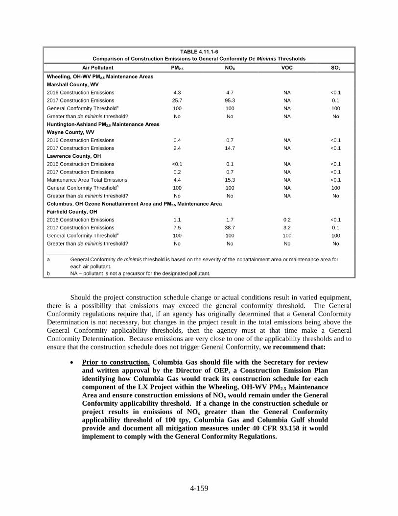
4-159
TABLE 4.11.1-6 Comparison of Construction Emissions to General Conformity De Minimis Thresholds
Air Pollutant PM2.5 NOX VOC SO2
Wheeling, OH-WV PM2.5 Maintenance Areas
Marshall County, WV
2016 Construction Emissions 4.3 4.7 NA <0.1
2017 Construction Emissions 25.7 95.3 NA 0.1
General Conformity Thresholda 100 100 NA 100
Greater than de minimis threshold? No No NA No
Huntington-Ashland PM2.5 Maintenance Areas
Wayne County, WV
2016 Construction Emissions 0.4 0.7 NA <0.1
2017 Construction Emissions 2.4 14.7 NA <0.1
Lawrence County, OH
2016 Construction Emissions <0.1 0.1 NA <0.1
2017 Construction Emissions 0.2 0.7 NA <0.1
Maintenance Area Total Emissions 4.4 15.3 NA <0.1
General Conformity Thresholda 100 100 NA 100
Greater than de minimis threshold? No No NA No
Columbus, OH Ozone Nonattainment Area and PM2.5 Maintenance Area
Fairfield County, OH
2016 Construction Emissions 1.1 1.7 0.2 <0.1
2017 Construction Emissions 7.5 38.7 3.2 0.1
General Conformity Thresholda 100 100 100 100
Greater than de minimis threshold? No No No No
____________________
a General Conformity de minimis threshold is based on the severity of the nonattainment area or maintenance area for each air pollutant. b NA – pollutant is not a precursor for the designated pollutant.
Should the project construction schedule change or actual conditions result in varied equipment, there is a possibility that emissions may exceed the general conformity threshold. The General Conformity regulations require that, if an agency has originally determined that a General Conformity Determination is not necessary, but changes in the project result in the total emissions being above the General Conformity applicability thresholds, then the agency must at that time make a General Conformity Determination. Because emissions are very close to one of the applicability thresholds and to ensure that the construction schedule does not trigger General Conformity, we recommend that:
Prior to construction, Columbia Gas should file with the Secretary for review and written approval by the Director of OEP, a Construction Emission Plan identifying how Columbia Gas would track its construction schedule for each component of the LX Project within the Wheeling, OH-WV PM2.5 Maintenance Area and ensure construction emissions of NOx would remain under the General Conformity applicability threshold. If a change in the construction schedule or project results in emissions of NOx greater than the General Conformity applicability threshold of 100 tpy, Columbia Gas and Columbia Gulf should provide and document all mitigation measures under 40 CFR 93.158 it would implement to comply with the General Conformity Regulations.
4-160
State Air Quality Requirements
The construction and operation of the LX and RXE Projects would be subject to additional state air regulations, including but not limited to those described below.
Kentucky
401 KAR 59:015 (New Source Standards for New Indirect Heat Exchangers) sets forth emission standards for particulate matter, SO2, and opacity for new heaters. The proposed units are inherently compliant with the requirements by means of combusting only pipeline quality natural gas and exempt from the opacity and SO2 monitors for the same reasons.
West Virginia
45 CSR 2 (Particulate Air Pollution Control – Combustion in Indirect Heat Exchangers) establishes smoke and PM limits on fuel burning equipment. The proposed sources of emissions at the Lone Oak CS are inherently compliant with this requirement by combusting only pipeline quality natural gas.
45 CSR 10 (SO2 Emission Control) prevents SO2 pollution. As previously discussed, the turbines will be subject to NSPS Subpart KKKK, which limits fuel sulfur content in compliance with this regulation. The combustion of natural gas produces inherently low SO2 emissions, which ensures that the emergency generators and heaters also will be in compliance with this regulation.
45 CSR 10 (SO2 Emission Control) prevents SO2 pollution. As previously discussed, the turbines will be subject to NSPS Subpart KKKK, which limits fuel sulfur content in compliance with this regulation. The combustion of natural gas produces inherently low SO2 emissions, which ensures that the emergency generators and heaters also will be in compliance with this regulation.
Pennsylvania
25 PA Code Chapter 123 (Standards For Contaminants) specifies limits on opacity, fugitive emissions, PM, and SO2. Project facilities located in Pennsylvania do not include stationary combustion sources; therefore, project facilities would only be subject to the fugitive emission limits, which will be satisfied by operating in accordance with the Fugitive Dust Control Plan, as discussed below.
Pennsylvania Diesel Powered Motor Vehicle Idling Act include air quality regulations controlling emissions from mobile sources, including those used for construction activities. Compliance with these requirements will be achieved through implementation of vehicle idling reduction policies.
Ohio
OAC-3745-17 (PM Emissions) establishes PM limitations. The proposed sources are inherently compliant with this requirement by combusting only pipeline quality natural gas.
OAC-3745-18 (SO2 Emissions) limits SO2 emissions from fuel burning equipment. However, natural gas-fired fuel-burning equipment, stationary combustion turbines, and internal combustion engines are exempt from these SO2 emission limitations.
4-161
Construction Emissions, Mitigations, and Impacts 4.11.1.3
Construction of the proposed LX and RXE Projects would result in temporary increases of pollutant emissions from the use of diesel- and gas-fueled equipment, as well as temporary increases in fugitive dust emissions from earth/roadway surface disturbance. Equipment associated with the construction of the proposed LX and RXE Projects would include large earth-moving equipment (e.g., bulldozers, track hoes), skid loaders, trucks, and other mobile sources. These may be powered by diesel or gasoline engines and would be sources of NOX, CO, VOC, PM10, PM2.5, small amounts of SO2, and trace amounts of HAPs. Indirect emissions would be generated from delivery vehicles and vehicles associated with construction workers traveling to and from work sites.
Combustion emissions from construction equipment would be minimized because the engines on construction equipment must meet the standards for mobile sources established by the EPA non-road source emission regulations and imposed on equipment manufacturers. Emissions also would be controlled by purchasing commercial gasoline and diesel fuel products, specifications of which are controlled by federal and state air pollution control regulations applicable to fuel suppliers and distributors. Vehicle emissions also would be controlled through on-site management practices, in accordance with the applicable federal state requirements, such as state inspection and maintenance program rules (e.g., OAC Chapter 3745-26) and Pennsylvania’s Heavy-Duty Diesel Emissions Control Program (25 PA Code Chapter 126, Subchapter E).
Emissions of NOX, CO, VOC, PM10, PM2.5, SO2, GHGs, and HAPs from construction equipment engines were calculated based on the proposed non-road and on-road equipment and their use levels. Diesel and gasoline on-road vehicle emission factors used the EPA’s Motor Vehicle Emission Simulator (EPA MOVES 2013) model, while diesel and gasoline non-road equipment engine emission factors used the EPA’s NONROAD model. Emission factors using Tier 2 diesel engine standards were assumed to apply to construction equipment engines during the construction period and do not reflect the anticipated phasing-in of more stringent emissions standards. Ultra-low sulfur diesel use was assumed for both the non-road and on-road diesel vehicles.
Fugitive dust would occur from land clearing, grading, excavation, and vehicle traffic on both paved and unpaved roads. The volume of fugitive dust generated would be dependent upon the area disturbed and the type of construction activity, along with the soil’s silt and moisture content, wind speed, and the nature of vehicular/equipment traffic. Fugitive dust emissions from construction operations are positively correlated with the silt content of the soil, as well as construction vehicle weight and speed, and negatively correlated with soil moisture content. Fugitive dust emissions generally would be greater during dry summer and autumn months and in fine-textured soils.
Columbia Gas developed an adequate Fugitive Dust Control Plan, including mitigation measures that would be employed during construction activities to prevent and control fugitive PM (dust) emissions. The site supervisors would be responsible for implementing these measures, which may include, but are not limited to, the following:
use of water or chemicals for control of dust during construction operations, road grading or land clearing;
application of asphalt, oil, water or suitable dust suppressants on unpaved roads, material stockpiles and other surfaces;
paving and maintenance of roadways;
street cleaning to remove soil or other material from paved streets onto which it has been transported by trucking or earth moving equipment, erosion by water, or other means;

4-162
proper maintenance of equipment;
covering open-bodied trucks while transporting materials;
minimizing soil disturbance;
use of off-site parking and shuttle buses to minimize traffic (if necessary); and
implementation of vehicle idling reduction policies.
Dust suppression measures would be proactively implemented as necessary to protect persons (general public and workforce) and property from air pollution and nuisances caused by the generation of fugitive PM (dust) emissions. The decision to implement dust suppression is generally not based on a specific threshold (e.g., numeric value of suspended particulate concentration). Instead, dust suppression measures may be implemented based on a visual determination of need, atmospheric conditions (persistence of dry, windy conditions), and compliance with a local ordinance for control of fugitive dust emissions. In general, dust suppression measures would be implemented as necessary to mitigate fugitive dust emissions that would come off the construction sites. However, Columbia Gas currently anticipates using water from a municipal source to control fugitive dust during construction of the LX Project, which is estimated to require approximately 22,500 gallons of water per day along each of the five pipeline spreads for a period of approximately 184 days (total of approximately 20,700,000 gallons).
Fugitive dust emissions from soil disturbance due to construction activities would be intermittent, generally low-level releases, and would consist of larger dust particles that are expected to settle out of the atmosphere within close proximity to their release point. For this reason, long-range transport of fugitive particulate emissions from soil disturbance is not anticipated. As a result of these factors, construction equipment emissions and fugitive dust emissions from soil disturbance would not cause exceedances of ambient air quality standards.
Table 4.11.1-7 provides a summary of total emission estimates for construction of the LX and RXE Projects during calendar years 2016 and 2017 (duration of construction varies by project component).

4-163
TABLE 4.11.1-7 Summary of Potential Construction Emissions from the Proposed LX and RXE Projects (tons)a
Activity and Location NOX CO VOCb PM10 PM2.5 SO2 GHGc HAPs
d
Pipeline Facilities Construction
Ohio
LEX 434.1 205.9 26.0 716.7 121.8 0.6 57,783.6 1.8
LEX 1 13.2 27.5 1.7 5.3 1.4 0.0 2,424.8 0.1
R-801 Loop 135.2 50.8 7.5 201.9 34.5 0.2 17,555.3 0.5
BM-111 Loop 15.4 5.8 0.9 15.3 2.8 0.0 1,998.2 0.1
Ohio Subtotal 597.9 290.1 36.1 939.1 160.4 0.8 79,761.9 2.4
Pennsylvania
LEX 7.2 4.4 0.5 12.5 2.1 0.0 1,007.4 0.0
Pennsylvania Subtotal 7.2 4.4 0.5 12.5 2.1 0.0 1,007.4 0.0
West Virginia
LEX 97.9 59.2 7.1 170.5 29.1 0.1 13,619.4 0.4
BM-111 Loop 0.6 0.2 0.0 0.6 0.1 0.0 72.7 0.0
West Virginia Subtotal 98.5 59.4 7.1 171.0 29.2 0.1 13,692.1 0.4
PIPELINE FACILITIES SUBTOTAL 703.6 353.9 43.7 1,122.6 191.7 0.9 94,461.3 2.9
Aboveground Facilities Construction
Kentucky
Grayson and Means CS 2.9 5.5 0.0 27.7 5.0 0.4 493.0 0.0
Kentucky Subtotal 2.9 5.5 0.0 27.7 5.0 0.4 493.0 0.0
Ohio
Oak Hill CS 2.0 6.3 0.4 8.7 1.5 0.0 420.2 0.0
Summerfield CS 2.0 6.3 0.4 3.7 0.8 0.0 420.2 0.0
Regulator Stations 2.6 7.7 0.5 6.9 1.4 0.0 516.3 0.0
Odorization Stations 1.0 1.9 0.2 1.5 0.4 0.0 166.2 0.0
Ohio Subtotal 7.6 22.2 1.4 20.7 4.0 0.0 1,522.8 0.1
West Virginia
Lone Oak CS 2.0 6.3 0.4 4.6 0.9 0.0 420.2 0.0
West Virginia Subtotal 2.0 6.3 0.4 4.6 0.9 0.0 420.2 0.0
ABOVEGROUND FACILITIES SUBTOTAL 12.5 34.0 1.8 53.0 9.9 0.4 2,436.0 0.1
TOTAL 716.2 387.9 45.5 1,175.6 201.6 1.4 96,897.3 3.0
____________________ a Includes construction equipment or nonroad engine exhaust (tailpipe) emissions, on-road vehicle engine exhaust
(tailpipe) emissions, paved and unpaved vehicle travel fugitive dust (non-tailpipe) emissions, and construction activity fugitive dust (non-tailpipe) emissions.
b VOC – non-methane/ethane volatile organic compounds c GHG – as carbon dioxide equivalents (CO2e) d HAPs – as aggregated total HAPs
Operation Emissions, Mitigation, and Impacts 4.11.1.4
Emissions generated during operation of the proposed LX and RXE Projects include primarily NOX, CO, GHG, and PM emissions, with lesser amounts of SO2, VOC, and HAP emissions. Operation emissions were calculated based on manufacturer data, emission factors obtained from the EPA’s Compilation of Air Pollutant Emission Factors (AP-42), and engineering mass balance calculations. Tables 4.11.1-1 through 4.11.1-5, previously presented, summarize the annual potential emission rates of criteria pollutants, formaldehyde, total HAP, and GHGs associated with the proposed Lone Oak CS, Summerfield CS, Oak Hill CS, Grayson CS, and Means CS, respectively. The annual PTE listed in these tables include emissions attributable to non-SoLoNOx turbine operation such as low load operation (less
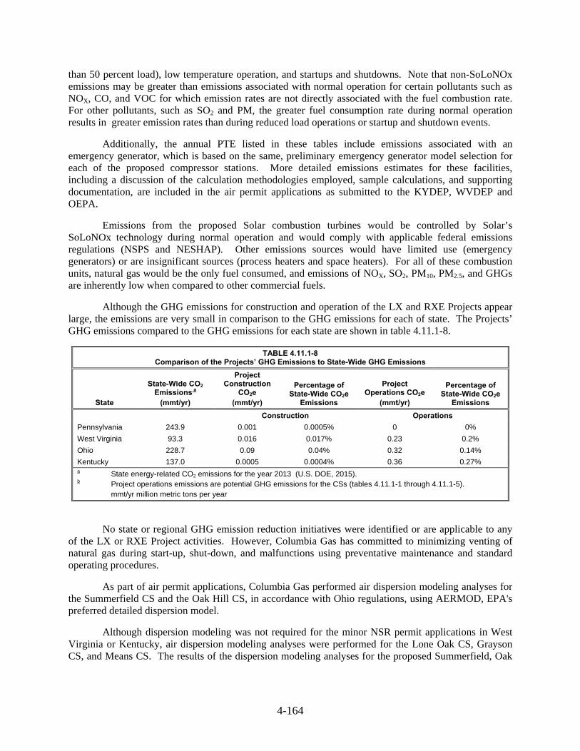
4-164
than 50 percent load), low temperature operation, and startups and shutdowns. Note that non-SoLoNOx emissions may be greater than emissions associated with normal operation for certain pollutants such as NOX, CO, and VOC for which emission rates are not directly associated with the fuel combustion rate. For other pollutants, such as SO2 and PM, the greater fuel consumption rate during normal operation results in greater emission rates than during reduced load operations or startup and shutdown events.
Additionally, the annual PTE listed in these tables include emissions associated with an emergency generator, which is based on the same, preliminary emergency generator model selection for each of the proposed compressor stations. More detailed emissions estimates for these facilities, including a discussion of the calculation methodologies employed, sample calculations, and supporting documentation, are included in the air permit applications as submitted to the KYDEP, WVDEP and OEPA.
Emissions from the proposed Solar combustion turbines would be controlled by Solar’s SoLoNOx technology during normal operation and would comply with applicable federal emissions regulations (NSPS and NESHAP). Other emissions sources would have limited use (emergency generators) or are insignificant sources (process heaters and space heaters). For all of these combustion units, natural gas would be the only fuel consumed, and emissions of NOX, SO2, PM10, PM2.5, and GHGs are inherently low when compared to other commercial fuels.
Although the GHG emissions for construction and operation of the LX and RXE Projects appear large, the emissions are very small in comparison to the GHG emissions for each of state. The Projects’ GHG emissions compared to the GHG emissions for each state are shown in table 4.11.1-8.
TABLE 4.11.1-8 Comparison of the Projects’ GHG Emissions to State-Wide GHG Emissions
State
State-Wide CO2 Emissions a
(mmt/yr)
Project Construction
CO2e (mmt/yr)
Percentage of State-Wide CO2e
Emissions
Project Operations CO2e
(mmt/yr)
Percentage of State-Wide CO2e
Emissions
Construction Operations
Pennsylvania 243.9 0.001 0.0005% 0 0%
West Virginia 93.3 0.016 0.017% 0.23 0.2%
Ohio 228.7 0.09 0.04% 0.32 0.14%
Kentucky 137.0 0.0005 0.0004% 0.36 0.27% a State energy-related CO2 emissions for the year 2013 (U.S. DOE, 2015). b Project operations emissions are potential GHG emissions for the CSs (tables 4.11.1-1 through 4.11.1-5). mmt/yr million metric tons per year
No state or regional GHG emission reduction initiatives were identified or are applicable to any of the LX or RXE Project activities. However, Columbia Gas has committed to minimizing venting of natural gas during start-up, shut-down, and malfunctions using preventative maintenance and standard operating procedures.
As part of air permit applications, Columbia Gas performed air dispersion modeling analyses for the Summerfield CS and the Oak Hill CS, in accordance with Ohio regulations, using AERMOD, EPA's preferred detailed dispersion model.
Although dispersion modeling was not required for the minor NSR permit applications in West Virginia or Kentucky, air dispersion modeling analyses were performed for the Lone Oak CS, Grayson CS, and Means CS. The results of the dispersion modeling analyses for the proposed Summerfield, Oak

4-165
Hill, Lone Oak, Grayson, and Means compressor stations are summarized below and detailed in the air permit applications for each of these facilities, as needed.
For each new compressor station, AERMOD was run using five years of recent meteorological data. The meteorological data was processed through the AERMET meteorological preprocessor and the AERMAP terrain processor was used to generate receptor elevations consistent with the terrain surrounding each proposed compressor station.
Structures can influence modeling results because of building-induced downwash, which can increase predicted concentrations at receptors located in proximity to the stacks (e.g., fence line receptors). USEPA’s Building Profile Input Program for PRIME (BPIPPRM dated 04274) was used to simulate the influence of downwash effects from structures located near emission sources by generating an AERMOD input file with the proper direction-specific building downwash parameters. The proposed locations of the combustion turbines and building structures at each compressor station were used as input to BPIPPRM, along with the combustion turbine stack heights and building heights.
Table 4.11.1-9 provides the current ambient monitored data, the Project impact, the combined concentration, and a comparison with the NAAQS for the Lone Oak CS, Summerfield CS, Oak Hill CS, Grayson CS, and Means CS. Results demonstrate that the LX and RXE Projects' compressor stations would not exceed the NAAQS and the project areas would continue to remain protective of human health and public welfare for all listed pollutants.

4-166
TABLE 4.11.1-9
Air Dispersion Modeling Results for LX and RXE Compressor Stations in Comparison to the NAAQS
Pollutant
Averaging
Period
Project Impact
(μg/m3)
Background
(μg/m3)
Total
(μg/m3)
NAAQS
(μg/m3)
Lone Oak Compressor Station
NO2 1-hour 36.2 66.4 102.6 188
CO 1-hour 185.5 1,259.0 1,445.0 40,000
8-hour 70.6 1,145.0 1,215.0 10,000
PM10 24-hour 2.9 47.0 49.8 150
PM2.5 24-hour 1.8 23.2 25.0 35
annual 0.1 111 11.2 12
SO2 1-hour 41.3 108.2 149.5 196
24-hour 24.6 34.0 58.6 365
Summerfield Compressor Station
NO2 1-hour 72.0 66.4 138.4 188
CO 1-hour 190.3 1,259.0 1,450.0 40,000
8-hour 161.2 1,145.0 1,306.0 10,000
PM10 24-hour 3.2 47.0 50.2 150
PM2.5 24-hour 2.6 17.0 19.6 35
annual 0.4 8.5 8.9 12
SO2 1-hour 53.9 108.2 162.1 196
24-hour 21.6 34.0 55.6 365
Oak Hill Compressor Station
NO2 1-hour 73.9 56.4 130.3 188
CO 1-hour 229.0 2,976.0 3,205.0 40,000
8-hour 196.0 1,832.0 2,028.0 10,000
PM10 24-hour 7.2 35.0 42.2 150
PM2.5 24-hour 4.0 19.7 23.7 35
annual 0.8 9.7 10.5 12
SO2 1-hour 114.1 37.5 151.6 196
24-hour 62.0 26.2 88.2 365
Grayson Compressor Station
NO2 1-hour 38.0 57.7 95.6 188
CO 1-hour 175.0 1,717.0 1,892.0 40,000
8-hour 117.0 1,145.0 1,262.0 10,000
PM10 24-hour 3.2 23.0 26.2 150
PM2.5 24-hour 2.5 20.7 23.2 35
Annual 0.2 10.2 10.3 12
SO2 1-hour 3.2 41.9 45.1 196
Means Compressor Station
NO2 1-hour 63.9 80.2 144.0 188
CO 1-hour 145.0 1,717.0 1,863.0 40,000
8-hour 66.0 1,145.0 1,211.0 10,000
PM10 24-hour 1.7 23.0 24.7 150
PM2.5 24-hour 1.3 17.3 18.6 35
Annual 0.1 8.8 8.9 12
SO2 1-hour 5.4 34.9 40.3 196
4-167
Noise 4.11.2
The LX and RXE Projects would contribute to increased noise levels during both construction and operation. The magnitude and frequency of environmental noise varies considerably during the day, week, season, and is based on weather conditions as well as seasonal vegetative cover, along with the types of activities occurring. Two standard measures that relate the time-varying quality of environmental noise to its known effect on people are the 24-hour equivalent sound level (Leq) and day-night sound level (Ldn). The Leq is the level of steady sound with the same total (equivalent) energy as the time-varying sound of interest, averaged over a 24-hour period. The Ldn is the Leq plus 10 decibels (dB) on the A-weighted scale (dBA) added to account for people’s greater sensitivity to nighttime sound levels (typically considered between the hours of 10:00 PM and 7:00 AM). The A-weighted scale is used to assess noise impacts, as human hearing is less sensitive to low and high frequencies than mid-range frequencies. The human ear’s threshold of perception for noise change is considered to be 3 dB; a change of 6 dB is clearly noticeable to the human ear, and a change of 10 dB is perceived as a doubling of noise (i.e., twice as loud).
Noise Regulatory Requirements 4.11.2.1
Federal Noise Regulations
The EPA published Information on Levels of Environmental Noise Requisite to Protect Public Health and Welfare with an Adequate Margin on Safety in 1974, which evaluated the effects of environmental noise on public health and safety. The EPA determined an Ldn of 55 dBA is the threshold that would prevent outdoor activity interference or annoyance from continuous noise. We have adopted this criterion for new compression and associated facilities, and it is used here to assess the potential noise impact during operation of the LX and RXE Projects at noise sensitive areas (NSAs) such as residences, schools, hospitals, or religious facilities. Ldn of 55 dBA corresponds to a continuous Leq sound level of 48.6 dBA.
State and Local Noise Regulations
No applicable state, county, or local noise regulations have been identified for the Projects.
Construction Noise Impacts and Mitigation 4.11.2.2
Noise would be generated during construction of the LX and RXE Projects. Construction would consist of multiple work crews at various locations along the pipeline route. Each crew’s work rate would vary based on specific activities, but would be limited to short durations over a period of three to four weeks at any one location based on the nature of right-of-way construction sequencing. Construction equipment would be operated on an as-needed basis and receptors near the construction areas may experience an increase in perceptible noise, but the effect would be temporary and local. It is anticipated that the highest level of construction-related noise would occur during site earthwork activities, such as site grading and clearing, when the largest amount of construction equipment would be operating.
Controlled blasting during pipeline construction activities would be conducted in accordance with the measures outlined in section 2.3.2.10 and further detailed in the project -specific Blasting Plan. The amount of explosives per borehole would be limited by the proximity of existing structures and utilities. Instantaneous sound levels from typical blasting activities would be greater than conventional pipeline construction activities at a distance of 50 feet. In comparison with other construction noise, the sound resulting from blasting would be brief and infrequent.
4-168
Columbia Gas and Columbia Gulf acknowledge that construction noise may be periodically audible at nearby NSAs; however, long-term impacts are not anticipated and typical construction of the pipelines and aboveground facilities would be predominantly scheduled during daylight hours. An exception to daytime construction may be certain HDD activities, which have been proposed at seven locations. HDD activities would use a wide variety of equipment, with the majority of equipment at the HDD entry point. Noise levels at the HDD exit points are generally lower than at the entry points. The length of activity at each HDD site would range from a few weeks to a few months.
Columbia Gas conducted ambient surveys in April 2015to establish baseline noise conditions near the seven HDD entry and exit points. The closest NSAs within 0.5 mile of each HDD entry and exit site, along with the calculated ambient Ldn sound levels collected during the noise survey are presented in table 4.11.2-1. This table also includes the estimated noise contribution from HDD activities at the NSAs and the effect of noise control. Additional NSAs may exist further from each HDD site; however, the noise impacts would be lower than those presented in the table due to additional noise attenuation.
All engines used for the HDD activities would be fitted with residential-grade exhaust silencers to reduce noise. The noise levels attributable to the HDD activities at Fish Creek Exit, Ohio River #1 Entry, Highway I-77 Exit, Muskingum River Entry and Exit, and Rush Creek Entry and Exit locations would meet our noise criteria of an Ldn of 55 dBA with the general mitigation measures proposed. Without any site-specific mitigation measures (i.e. additional mitigation measures), the noise levels attributable to the HDD activities at Fish Creek Entry, Highway I-77 Entry, Highway I-33 Entry and Exit, and Ohio River #2 Entry and Exit locations would exceed our noise criteria of an Ldn of 55 dBA. Therefore, in addition to the general mitigation measures, Columbia Gas has proposed site-specific mitigation measures (temporary barriers during construction) as outlined in table 4.11.2-1 for these locations. We conclude that the addition of the site-specific mitigation measures would reduce the noise from HDD activity to below an Ldn of 55 dBA at all HDD locations, except for Ohio River #2 Entry location. Therefore, we recommend that:
Prior to the end of the draft EIS comment period, Columbia Gas should file with the Secretary, for review and written approval by the Director of OEP, a revised HDD noise mitigation analysis for the Ohio River #2 Entry location. The revised plan should identify additional mitigation measures that Columbia Gas commits to implementing and the resulting projected noise level at the NSAs with implementation of the mitigation measures.
and
Columbia Gas should file in the weekly construction status reports the following for each HDD entry and exit site:
o the noise measurements from the nearest NSA for each drill entry/exit site, obtained at the start of drilling operations;
o the noise mitigation that Columbia Gas implements at the start of drilling operations; and
o any additional mitigation measures that Columbia Gas would implement if the initial noise measurements exceeded an Ldn of 55 dBA at the nearest NSA and/or increased noise is over ambient conditions greater than 10 decibels

4-169
TABLE 4.11.2-1
Calculated HDD Noise Levels at the Nearest NSAs for the LX Project
HDD Site
Nearest NSA
(All Residences)
Distance and Direction of NSA to
Drill Site (feet)
Ambient Sound Level (Ldn)
dBA
Estimated Sound Level (Ldn) of the
HDD
dBA
Estimated Total Sound Level (HDD Ldn + Ambient
Ldn) a, b
dBA
Potential Increase
above Ambient
dB
Fish Creek Entry NSA #1 750 N 41.2 52.0 c 52.3 c 11.1
Fish Creek Exit NSA #2 775 S 41.2 52.4 52.7 11.5
Ohio River #1 Entry
Ohio River #1 Exit
NSA #1
NSA #2
1,350 N
No NSAs within 0.5 mile.
55.2
N/A
53.1
N/A
57.3
N/A
2.1
N/A
Highway I-77 Entry
Highway I-77 Exit
NSA #1
NSA #2
950 NE
1,325 W
61.5
43.5
49.6 c
41.8
61.8 c
45.7
0.3
2.3
Muskingum River Entry
Muskingum River Exit
NSA #1
NSA #2
1,125 S
800 NE
45.2
43.5
52.0
47.0
52.9
48.6
7.7
5.0
Rush Creek Entry
Rush Creek Exit
NSA #1
NSA #2
1,500 S to SW
1,750 SE
35.5
39.2
45.2
32.2
45.7
40.0
10.2
0.8
Highway I-33 Entry
Highway I-33 Exit
NSA #1
NSA #2
800 SW
225 W
60.6
56.0
49.0 c
51.8 c
60.9 c
57.4 c
0.3
1.4
Ohio River #2 Entry
Ohio River #2 Exit
NSA #1
NSA #2
150 NW
225 E
52.0
52.4
66.9 c
51.8 c
67.1 c
55.1 c
15.1
2.7
____________________
HDD = horizontal directional drill
NSA = noise sensitive area
Ldn = Day-night sound level
dBA = A-weighted decibel; dB = decibel
N/A = not applicable a Includes the noise generated by the HDD plus ambient sound levels measured at the NSA. b Includes the effect of a residential-grade exhaust silencer that will be employed on equipment engines as a general noise
control measure for all HDD sites. c Includes the effect of the anticipated additional noise control measures for the drill at the following HDD sites: Fish Creek
Entry: Install a 16-foot high partial barrier on the north and south-southwestern sides of the entry point to reduce HDD noise at the nearest NSAs; Highway I-77 Entry: Install a 16-foot high partial barrier on the north and east sides of the entry point to reduce HDD noise at the nearest NSAs; Highway I-33 Entry: Install a 12-foot high partial barrier on the southwest, south, and southeast sides of the entry point to reduce HDD noise at the nearest NSAs; Highway I-33 Exit: Install a 16-foot high partial barrier on the southwest, south, and southeast sides of the entry point to reduce HDD noise at the nearest NSAs; Ohio River #2 Entry: Install a 16-foot high perimeter site barrier to reduce HDD noise at the nearest NSAs that surround the entry point; Ohio River #2 Exit: Install a 16-foot high perimeter site barrier to reduce HDD noise at the nearest NSAs that surround the entry point.
Construction of the LX Project aboveground facilities would also generate noise from earthwork (e.g., site grading and clearing) and installation of the facility site foundations and equipment. The most prevalent noise-generating equipment during construction of the aboveground facilities would be from internal combustion engines of construction equipment (up to 85 dBA at 50 feet). Site earthwork would result in the highest construction noise due to multiple pieces of equipment operating simultaneously. The noise levels experienced at NSAs would depend on the type of equipment used, the mode of operation of the equipment, the length of time the equipment is in use, the amount of equipment used simultaneously, and the distance between the noise generation source and the receptor. Columbia Gas would limit construction at aboveground facilities to daylight hours to prevent nighttime noise impacts.
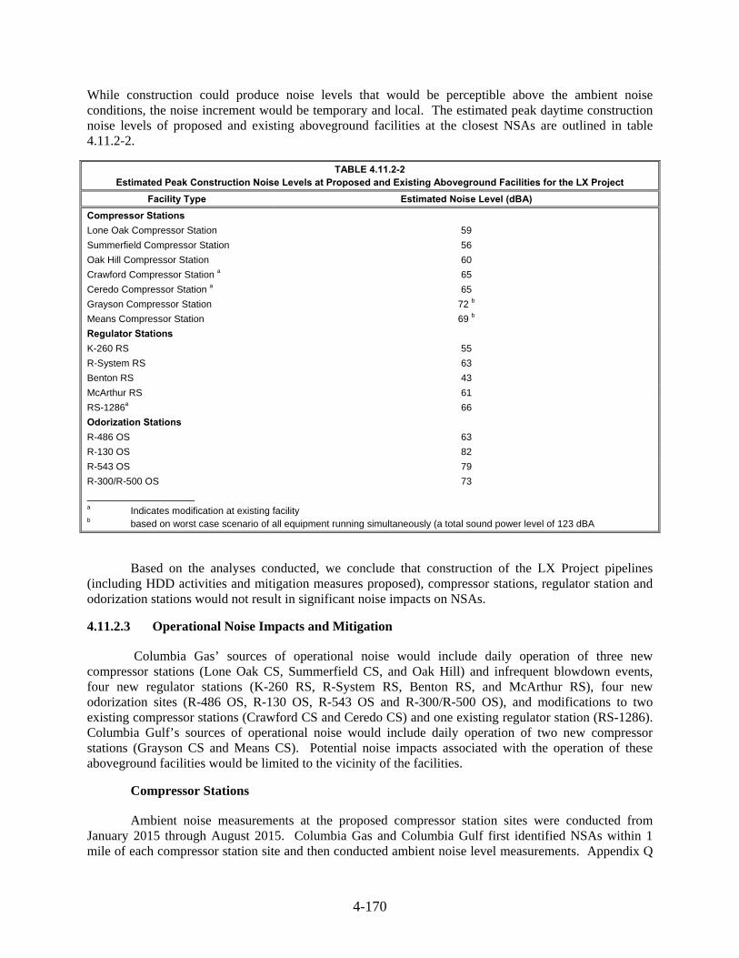
4-170
While construction could produce noise levels that would be perceptible above the ambient noise conditions, the noise increment would be temporary and local. The estimated peak daytime construction noise levels of proposed and existing aboveground facilities at the closest NSAs are outlined in table 4.11.2-2.
TABLE 4.11.2-2 Estimated Peak Construction Noise Levels at Proposed and Existing Aboveground Facilities for the LX Project
Facility Type Estimated Noise Level (dBA)
Compressor Stations
Lone Oak Compressor Station 59
Summerfield Compressor Station 56
Oak Hill Compressor Station 60
Crawford Compressor Station a 65
Ceredo Compressor Station a 65
Grayson Compressor Station 72 b
Means Compressor Station 69 b
Regulator Stations
K-260 RS 55
R-System RS 63
Benton RS 43
McArthur RS 61
RS-1286a 66
Odorization Stations
R-486 OS 63
R-130 OS 82
R-543 OS 79
R-300/R-500 OS 73
____________________ a Indicates modification at existing facility b based on worst case scenario of all equipment running simultaneously (a total sound power level of 123 dBA
Based on the analyses conducted, we conclude that construction of the LX Project pipelines (including HDD activities and mitigation measures proposed), compressor stations, regulator station and odorization stations would not result in significant noise impacts on NSAs.
Operational Noise Impacts and Mitigation 4.11.2.3
Columbia Gas’ sources of operational noise would include daily operation of three new compressor stations (Lone Oak CS, Summerfield CS, and Oak Hill) and infrequent blowdown events, four new regulator stations (K-260 RS, R-System RS, Benton RS, and McArthur RS), four new odorization sites (R-486 OS, R-130 OS, R-543 OS and R-300/R-500 OS), and modifications to two existing compressor stations (Crawford CS and Ceredo CS) and one existing regulator station (RS-1286). Columbia Gulf’s sources of operational noise would include daily operation of two new compressor stations (Grayson CS and Means CS). Potential noise impacts associated with the operation of these aboveground facilities would be limited to the vicinity of the facilities.
Compressor Stations
Ambient noise measurements at the proposed compressor station sites were conducted from January 2015 through August 2015. Columbia Gas and Columbia Gulf first identified NSAs within 1 mile of each compressor station site and then conducted ambient noise level measurements. Appendix Q

4-171
includes figures depicting the location of the NSAs relative to corresponding compressor stations. An acoustical analysis was conducted to estimate the operational noise levels at the nearest NSAs from each new and modified compressor station. Noise generating equipment at Columbia Gas’ and Columbia Gulf’s compressor stations would include engines, gas aftercoolers, utility coolers, fuel gas regulation skids, discharge and suction piping, blowdown vents, engine air intakes, engine exhaust systems, and compressor and engine casings.
Table 4.11.2-3 shows the distance and direction of all NSAs within 1 mile of each compressor station, calculated ambient Ldn based on measured daytime and nighttime Leq, and predicted compressor station operating noise levels at the NSAs within 1 mile. The operational noise analysis includes Columbia Gas’ and Columbia Gulf’s use of its identified mitigation measures, including:
acoustically treated compressor building walls, roofs, and doors;
adequate silencer on compressor building ventilation, exhaust, and intake; and
acoustical pipe insulation on discharge piping (gas cooler header).
Columbia Gas would implement the following noise control measures to reduce noise impacts from proposed meter building and associated facilities at the existing Crawford CS:
acoustically treated meter building walls, roofs, and doors;
acoustical louvers for meter building ventilation air inlets; and
acoustical sound baffle for the building ridge vent.
TABLE 4.11.2-3 Calculated Operational Noise Levels for New and Existing Compressor Stations
NSA
Distance and Direction of NSA to
Compressor Station Site (feet)
Ambient Sound Level,
Ldn (dBA)
Estimated Sound Level (Ldn) of each
Station a
(dBA)
Estimated Total Sound Level (Station Ldn + Ambient Ldn)
b
(dBA)
Potential Increase Above Ambient
(dB)
Lone Oak Compressor Station (New)
NSA #1 (Residences) NSA #2 (Residence) NSA #3 (Residences)
1,100 W 1,400 NW
2,100 S to SW
56.8 58.7 44.0
48.2 57.4 58.9 46.1
0.6 0.2 2.1
45.5
41.9
Summerfield Compressor Station (New)
NSA #1 (Residence) NSA #2 (Residences) NSA #3 (Residences)
1,700 NW 3,300 SW 2,600 W
39.4 34.6 35.3
43.0
35.3 38.1
44.5
38.0 39.9
5.1 3.4 4.7
Oak Hill Compressor Station (New)
NSA #1 (Residences) NSA #2 (Residences) NSA #3 (Residence) NSA #4 (Residence)
1,100 N to NW 1,900 SW 3,200 S
3,800 SE
35.4 32.1 36.7 33.2
47.7
42.3 36.9 35.2
48.0
42.7 39.9 37.3
12.6 10.6 3.2 4.1
Crawford Compressor Station (Existing - Additional Regulator Building and Related Facilities)
NSA #1 (Residences) NSA #2 (Residences) NSA #3 (Residences) NSA #4 (Residence) NSA #5 (Residence)
250 NE 500 SW 1,600 S 1,600 E 700 NW
61.5 51.8 59.2 58.1 51.8
43.0
32.4 25.8 25.9 34.2
61.5
51.8 59.2 58.1 51.8
0.0 0.0 0.0 0.0 0.0

4-172
TABLE 4.11.2-3 (cont’d) Calculated Operational Noise Levels for New and Existing Compressor Stations
NSA
Distance and Direction of NSA to
Compressor Station Site (feet)
Ambient Sound Level,
Ldn (dBA)
Estimated Sound Level (Ldn) of each
Station a
(dBA)
Estimated Total Sound Level (Station Ldn + Ambient Ldn)
b
(dBA)
Potential Increase above Ambient
(dB)
Ceredo Compressor Station (Existing - Additional Compression)
NSA #1 (Residences) NSA #1A (Residences) NSA #2 (Residences) NSA #3 (Residences) NSA #4 (Residence)
725 SE 800 ESE 1,275 S
1,500 NNW 1,350 NNE
75.3 70.4 65.1 60.8 60.9
50.4
48.0 41.5 38.1 39.5
73.5
67.2 62.9 57.7 57.9
1.8 3.2 2.2 3.1 3.0
Grayson Compressor Station (New)
NSA #1 (Church) NSA #2 (Residences) NSA #3 (Residences) NSA #4 (Residence) NSA #5 (Residence) NSA #6 (Residence)
760 SSE 1,450 SSW 3,220 SW 1,580 N 4,000 E
3,400 SE
60.3 58.3 59.0 51.1 52.4 53.0
52.4
36.0 39.7 34.9 28.1 26.3
61.0
58.3 59.1 51.2 52.4 53.0
0.7 0.0 0.1 0.1 0.0 0.0
Means Compressor Station (New)
NSA #1 (Residences) NSA #2 (Residences) NSA #3 (Residences) NSA #4 (Residence)
760 NE 1,340 NNW 2,270 SW 1,780 SE
58.0 58.0 59.6 55.6
52.2
44.0 39.8 43.0
59.0
58.2 59.6 55.8
1.0 0.2 0.0 0.2
___________________
NSA = noise sensitive area Ldn = day-night sound level dBA = A-weighted decibel dB = decibel a Includes the effect of the anticipated noise control measures for the compressor units. b Includes the noise generated by each compressor station plus ambient sound levels measured at the NSA. c Includes the existing compressor station noise level plus the noise level of the compressor station after the installation of
the new compressor units and decommissioning of an existing compressor unit at nearby NSAs. Most of the estimated total sound level (Station + Ambient Ldn) at nearest NSAs to Ceredo CS are less than the ambient sound level because of the decommissioning of an existing compressor unit.
As shown in table 4.11.2-3, noise levels from each new and modified compressor station are projected to be below the FERC criterion of 55 dBA Ldn at the closest NSAs. Also, noise level increases would be undetectable at NSAs for all compressor stations, except the new Summerfield and Oak Hill CSs and modified Ceredo CS. Operation of the Summerfield, Oak Hill, and Ceredo CSs would result in a perceptible increase in noise levels at some NSAs, but total noise levels would remain below our 55 dBA Ldn criterion, except at the modified Ceredo CS (due to the high noise levels of the existing compressor units). However, to ensure that the actual noise levels produced as a result of the LX and RXE Projects compressor stations are not significant, we recommend that:
Columbia Gas and Columbia Gulf should file a noise survey with the Secretary no later than 60 days after placing the Lone Oak, Summerfield, Oak Hill, Grayson, and Means Compressor Stations in service. If a full load condition noise survey of the entire station is not possible, Columbia Gas and Columbia Gulf should instead file an interim survey at the maximum possible horsepower load and file the full load survey within 6 months. If the noise attributable to the operation of all of the equipment at any compressor station under interim or full horsepower load conditions exceeds 55 dBA Ldn at any nearby NSAs, Columbia

4-173
Gas and Columbia Gulf should file a report on what changes are needed and should install the additional noise controls to meet the level within 1 year of the in-service date. Columbia Gas and Columbia Gulf should confirm compliance with the 55 dBA Ldn requirement by filing a second noise survey with the Secretary no later than 60 days after it installs the additional noise controls.
and
Columbia Gas should file noise surveys with the Secretary no later than 60 days after placing the authorized units at the Crawford and Ceredo Compressor Stations in service. If a full load condition noise survey of the entire station is not possible, Columbia Gas should file an interim survey at the maximum possible horsepower load and file the full load surveys within 6 months. If the noise attributable to the operation of the modified compressor station at full or interim power load conditions exceeds existing noise levels at any nearby NSAs that are currently at or above an Ldn of 55 dBA, or exceeds 55 dBA Ldn at any nearby NSAs that are currently below 55 dBA Ldn, Columbia Gas should file a report on what changes are needed and should install the additional noise controls to meet the level within 1 year of the in-service date. Columbia Gas should confirm compliance with the above requirement by filing a second noise survey with the Secretary no later than 60 days after it installs the additional noise controls.
The site noise sources that could cause perceptible vibration (such as turbine exhaust noise) would be adequately mitigated; therefore, there would not be any perceptible increase in vibration at any NSA during operation of the LX or RXE Project compressor stations.
In addition to the operational noise discussed above, blowdown events would also generate noise impacts. The duration of a blowdown depends on factors such as the extent of the maintenance activity and the gas pressure, and would generally last between 20 minutes and 2 hours. The maximum estimated noise attributable to a blowdown event at the closest NSA to each new compressor station as well as additional compression at Ceredo CS is as follows:
Lone Oak CS – 44 dBA;
Summerfield CS – 45 dBA;
Oak Hill CS – 44 dBA;
Ceredo CS – 47 dBA;
Grayson CS – 63 dBA; and,
Means CS – 68 dBA.
Planned blowdown events could allow for slower gas release and be scheduled for daytime hours, thus reducing the noise impacts. Unplanned pipeline blowdowns occur only in emergency situations. Unplanned events could occur at any time, but are typically infrequent and of short duration.
Regulator Stations
Columbia Gas first identified NSAs within a 0.5 mile of each regulator station site and then conducted ambient noise level measurements. Ambient noise measurements for regulator stations were conducted in January 2015. Appendix Q contains the figures depicting the location of the NSAs relative to corresponding new and modified regulator station locations.

4-174
An acoustical assessment was conducted by evaluating sound levels produced by a typical regulator station operating at a level with the highest potential for noise at the nearest NSAs. Columbia Gas would implement the following noise control to reduce noise impacts from proposed regulator building and associated facilities at new and existing regulator stations:
acoustically treated regulator building walls, roofs, and doors;
adequate silencer on regulator building ventilation, exhaust, and intake;
Globe syle control valves with noise attenuating trim;
Low noise’ box-type water bath heater assembly designed to meet a maximum sound level of 55 dBA at 50 feet from the heater perimeter at maximum operating conditions; and
Buried aboveground piping (to the extent possible) and if necessary, acoustical lagging for aboveground piping would be installed in the event piping noise becomes problematic.
Columbia Gas calculated the maximum noise level for the new and modified regulator stations using the site layout, specification for each noise source, and an acoustical design goal of 55 dBA Ldn (or 48.6 dBA Leq) at the nearest NSA. Table 4.11.2-4 summarizes the ambient sound level in the vicinity of each regulator station, the estimated sound level at the closest NSAs contributed by each station, including the effect of the anticipated noise control measures described above, and the potential increase in sound level above the ambient sound levels during project operations.
TABLE 4.11.2-4 Calculated Operation Noise Levels for New and Existing Regulator Stations
NSA
Distance and Direction of NSA to Regulator Station
Site (feet)
Ambient Sound Level
(Ldn) (dBA)
Estimated Sound Level (Ldn) of each
Station a
(dBA)
Estimated Total Sound Level (Station Ldn + Ambient Ldn)
b
(dBA)
Potential Increase above Ambient
(dB)
K-260 Regulator Station (New)
NSA #1 (Residences) 1,300 W 51.9 42.3 52.4 0.5
NSA #2 (Residences) 1,900 S 49.7 37.9 49.9 0.2
R-System Regulator Station (New)
NSA #1 (Residence) 500 N 50.6 52.7 52.7 4.2
NSA #2 (Residence) 1,400 W 50.6 41.8 41.8 0.5
NSA #3 (Residence) 1,700 E 51.6 39.5 39.5 0.3
Benton Regulator Station (New)
NSA #1 (Residence) 2,900 W 33.0 32.1 35.6 2.6
McArthur Regulator Station (New)
NSA #1 (Residence) 650 S 40.3 50.1 50.5 10.2
NSA #2 (Residences) 1,550 W 35.4 40.6 41.7 6.3
NSA #3 (Residences) 1,600 E 47.5 40.2 48.3 0.8
RS-1286 Regulator Station (Existing)
NSA #1 (Residence) 350 W to SW 42.8 50.8 51.4 8.6
NSA #2 (Residence) 400 SE 42.8 49.5 50.3 7.5
NSA #3 (Residence) 750 N to NE 42.8 43.3 46.1 3.3
____________________
NSA = noise sensitive area Ldn = day-night sound level dBA = A-weighted decibel dB = decibel a Includes the effect of the anticipated noise control measures for each regulator station. b Includes the noise generated by each regulator station plus ambient sound levels measured at the NSA.

4-175
As shown in table 4.11.2-4, the noise attributable to the four new regulator stations and modifications to one existing regulator station would be lower than our 55 dBA Ldn requirement at the closest NSAs.
Odorization Stations
Columbia Gas first identified NSAs within a 0.5 mile of each odorization sites and then conducted ambient noise level measurements. Ambient noise measurements for odorization stations were conducted in January of 2015. Appendix Q contains the figures depicting the location of the NSAs relative to corresponding odorization locations.
An acoustical assessment was conducted by evaluating sound levels produced by a typical odorization station operating at a level with the highest potential for noise at the nearest NSA. However, an acoustical assessment associated with the proposed odorization modifications at the existing Benton CS was not conducted, as no new sources of operational noise would occur at this site. Columbia Gas would implement the following noise control to reduce noise impacts from proposed odorization skid and associated facilities at new odorization sites:
Standard double poly control enclosure on odorization skid instead of the optional stainless steel enclosure which is less effective in containing venting noise associated with the internal small pneumatic diaphragm pump;
Buried aboveground piping (to the extent possible) and if necessary, acoustical lagging for aboveground piping would be installed in the event piping noise becomes problematic; and
Absorptive barriers in the project design in the event that noise from the new odorization skid becomes problematic for the adjacent NSAs.
Columbia Gas calculated the maximum noise level for the new odorization stations using the site layout, specification for each noise source, and an acoustical design goal of 55 dBA Ldn (or 48.6 dBA Leq) at the nearest NSA.
Table 4.11.2-5 provides the results of the calculated daily operational noise levels for the new odorization stations. The table summarizes the ambient sound level near each odorization station, the estimated sound level at the closest NSAs contributed by each station, including the effect of the anticipated noise control measures described above, and the potential increase in sound level above the ambient sound levels during project operations.
As shown in table 4.11.2-5, the noise attributable to the four new odorization stations would be lower than our 55 dBA Ldn requirement at the closest NSAs. Also, noise level increases would be undetectable at NSAs for all odorization stations, except the R-130 Odorization Station. Noise increase from operation of the R-130 Odorization Station would be perceived as twice as loud at its closest NSA, but total noise levels would remain below our 55 dBA Ldn criterion.

4-176
4.12 RELIABILITY AND SAFETY
The transportation of natural gas by pipeline involves some incremental risk to the public due to the potential for accidental release of natural gas. The greatest hazard is a fire or explosion following a major pipeline rupture.
Methane, the primary component of natural gas, is colorless, odorless, and tasteless. It is not toxic, but is classified as a simple asphyxiate, possessing a slight inhalation hazard. If breathed in high concentration, oxygen deficiency can result in serious injury or death. Methane is inactive biologically and essentially nontoxic. It is not listed in the International Agency for Research on Cancer, National Toxicology Program, or by the Occupational Safety and Health Administration as a carcinogen or potential carcinogen.
Methane has an auto-ignition temperature of 1,000 °F and is flammable at concentrations between 5 percent and 15 percent in the air. Unconfined mixtures of methane in air are not explosive; however, it may ignite if there is an ignition source. However, a flammable concentration within an enclosed space in the presence of an ignition source can explode. It is buoyant at atmospheric temperatures and disperses rapidly in air.
Safety Standards 4.12.1
The DOT is mandated to provide pipeline safety under Title 49, USC Chapter 601. PHMSA’s Office of Pipeline Safety administers the national regulatory program to ensure the safe transportation of natural gas and other hazardous materials by pipeline. It develops safety regulations and other approaches to risk management that ensure safety in the design, construction, testing, operation, maintenance, and emergency response of pipeline facilities. Many of the regulations are written as performance standards that set the level of safety to be attained and allow the pipeline operator to use various technologies to achieve the required safety standard.
TABLE 4.11.2-5 Calculated Operation Noise Levels for New Odorization Stations
NSA
Distance and Direction of NSA to
Odorization Station (feet)
Ambient Sound Level (Ldn) (dBA)
Estimated Sound Level (Ldn) of each
Odorization Stationa (dBA)
Estimated Total Sound Level
(Odorization Site Ldn + Ambient Ldn)
b (dBA)
Potential Increase above Ambient (dB)
R-486 Odorization Station
NSA #1 (Residence) 500 W to NW 35.3 36.7 39.1 3.8
R-130 Odorization Station
NSA #1 (Residences) 100 NW and E 40.7 51.8 52.1 11.4
R-543 Odorization Station
NSA #1 (Residences) 150 W and NE 49.1 48.1 51.7 2.6
R-300/R-500 Odorization Station
NSA #1 (Residence) 300 NW 48.8 44.7 50.2 1.4
____________________
NSA = noise sensitive area Ldn = day-night sound level dBA = A-weighted decibel dB = decibel a Includes the effect of the anticipated noise control measures for each odorization site. b Includes the noise generated by each regulator site plus ambient sound levels measured at the NSA.

4-177
PHMSA ensures that people and the environment are protected from the risk of pipeline incidents. This work is shared with state agency partners and others at the federal, state, and local level. The DOT provides for a state agency to assume all aspects of the safety program for intrastate facilities by adopting and enforcing the federal standards. A state may also act as the DOT’s agent to inspect interstate facilities within its boundaries. Ohio, and West Virginia perform inspections on interstate natural gas pipeline facilities. DOT federal inspectors perform inspections on interstate natural gas pipeline facilities in Pennsylvania and Kentucky. The DOT is also responsible for enforcement action in all of the LX and RXE Project states.
The DOT pipeline standards are published in 49 CFR Parts 190-199. Part 192 specifically addresses natural gas pipeline safety issues. Under a Memorandum of Understanding on Natural Gas Transportation Facilities dated January 15, 1993, between the DOT and FERC, the DOT is recognized as having the exclusive authority to promulgate federal safety standards used in the transportation of natural gas. Section 157.14(a)(9)(vi) of FERC’s regulations require that an applicant certify that it will design, install, inspect, test, construct, operate, replace, and maintain the facility for which a Certificate is requested in accordance with federal safety standards and plans for maintenance and inspection, or should certify that it has been granted a waiver of the requirements of the safety standards by the DOT in accordance with Section 3(e) of the Natural Gas Pipeline Safety Act. FERC accepts this certification and does not impose additional safety standards other than the DOT standards. If the Commission becomes aware of an existing or potential safety problem, there is a provision in the memorandum to promptly alert the DOT. The memorandum also provides instructions for referring complaints and inquiries made by state and local governments and the general public involving safety matters related to pipelines under the Commission’s jurisdiction.
FERC also participates as a member of the DOT’s Technical Pipeline Safety Standards Committee, which determines if proposed safety regulations are reasonable, feasible, and practicable.
The pipeline and aboveground facilities associated with the LX and RXE Projects would be designed, constructed, operated, and maintained in accordance with or to exceed the DOT Minimum Federal Safety Standards in 49 CFR 192. These regulations, which are intended to protect the public and to prevent natural gas facility accidents and failures, include specifications for material selection and qualification; minimum design requirements; and protection of the pipeline from internal, external, and atmospheric corrosion.
The DOT defines area classifications based on population density in the vicinity of the pipeline, and specifies more rigorous safety requirements for populated areas. Pipe wall thickness and pipeline design pressures, hydrostatic test pressures, MAOP, inspection and testing of welds, and frequency of pipeline patrols and leak surveys must also conform to higher standards in more populated areas. The class locations unit is an area that extends 220 yards on either side of the centerline of any continuous 1-mile length of pipeline. The four area classifications are defined below:
Class 1 - Location with 10 or fewer buildings intended for human occupancy;
Class 2 - Location with more than 10 but less than 46 buildings intended for human occupancy;
Class 3 - Location with 46 or more buildings intended for human occupancy or where the pipeline lies within 100 yards of any building, or small well-defined outside area occupied by 20 or more people on at least 5 days a week for 10 weeks in any 12-month period; and
Class 4 - Location where buildings with four or more stories aboveground are prevalent.

4-178
In accordance with federal standards, class locations representing more populated areas require higher safety factors in pipeline design, testing, and operation. Pipelines constructed on land in Class 1 locations must be installed with a minimum depth of cover of 30 inches in normal soil and 18 inches in consolidated rock. Class 2, 3, and 4 locations, as well as drainage ditches of public roads and railroad crossings, require a minimum cover of 36 inches in normal soil and 24 inches in consolidated rock. All pipelines installed in navigable rivers, streams, and harbors must have a minimum cover of 48 inches in soil or 24 inches in consolidated rock. Class locations also specify the maximum distance to sectionalized block valves (that is 10.0 miles in Class 1, 7.5 miles in Class 2, 4.0 miles in Class 3, and 2.5 miles in Class 4).
Preliminary class locations for the LX Project have been developed based on the relationship of the pipelines centerline to other nearby structures and manmade features. Table 4.12.1-1 shows the area classifications for the LX Project. About 88 percent of the proposed pipeline route would cross Class 1 locations, about 11 percent of the route would cross Class 2 locations, and only 1 percent of the route would cross Class 3 locations. No Class 4 areas would be crossed by the LX Project.
If Columbia Gas’ LX Project is approved, the regulations require that the pipeline be designed, at a minimum, to the appropriate class location standards and that the spacing between the mainline valves meets the DOT requirements.
During operation of a pipeline, if a subsequent increase in population density adjacent to the right-of-way indicates a change in class location for the pipeline, Columbia Gas would be required to reduce the MAOP or replace the segment with pipe of sufficient grade and wall thickness, if required, to comply with the DOT regulations for the new class location.
The Pipeline Safety Improvement Act of 2002 also requires operators to develop and follow a written integrity management program that contains all the elements described in 49 CFR 192.911 and addresses the risks on each transmission pipeline segment. Specifically, the law establishes an integrity management program that applies to all high consequence areas (HCA).
The DOT published rules that define HCAs where a gas pipeline accident could do considerable harm to people and their property and requires an integrity management program to minimize the potential for an accident. This definition satisfies, in part, the Congressional mandate for the DOT to prescribe standards that establish criteria for identifying each gas pipeline facility in a high-density population area.
The HCAs may be defined in one of two ways. In the first method, an HCA includes:
current Class 3 and 4 locations;
any area in Class 1 or 2 locations where the potential impact radius is greater than 660 feet and there are 20 or more buildings intended for human occupancy within the potential impact circle31; or
any area in Class 1 or 2 locations where the potential impact circle includes an identified site.
An identified site is an outside area or open structure that is occupied by 20 or more persons on at least 50 days in any 12-month period; a building that is occupied by 20 or more persons on at least 5 days a week for any 10 weeks in any 12-month period; or a facility that is occupied by persons who are confined, are of impaired mobility, or would be difficult to evacuate.
31 The potential impact circle is a circle of radius equal to the potential impact radius.
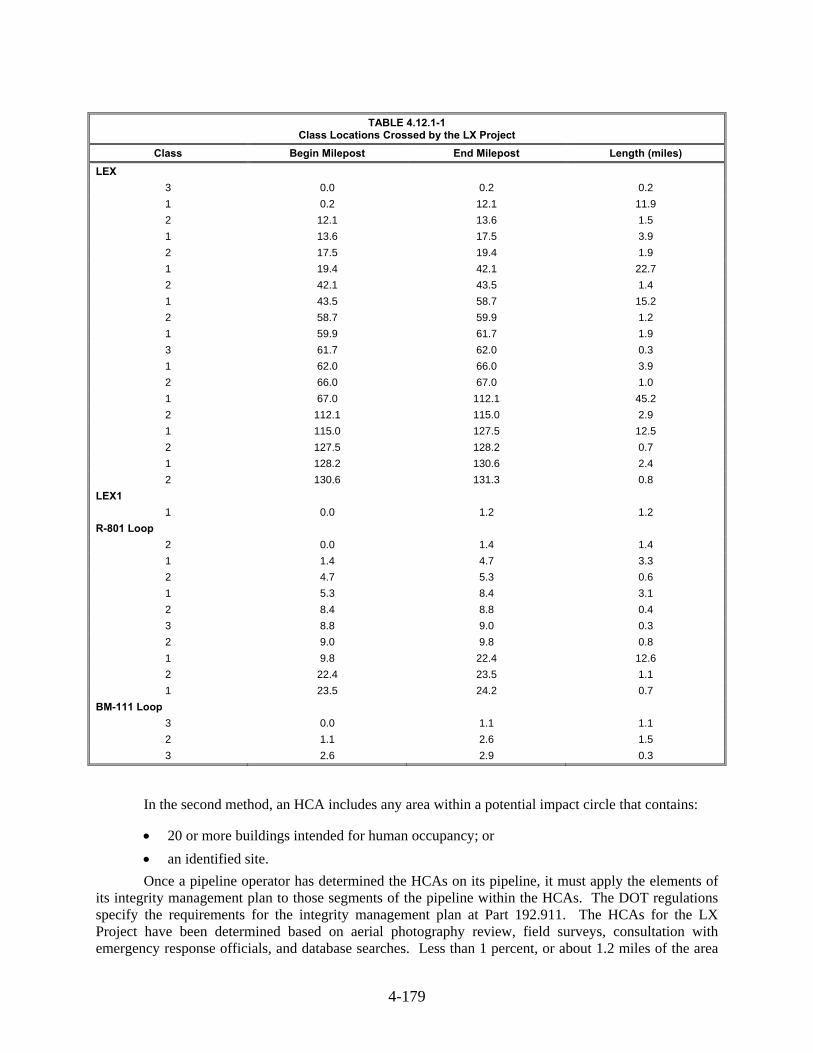
4-179
In the second method, an HCA includes any area within a potential impact circle that contains:
20 or more buildings intended for human occupancy; or
an identified site.
Once a pipeline operator has determined the HCAs on its pipeline, it must apply the elements of its integrity management plan to those segments of the pipeline within the HCAs. The DOT regulations specify the requirements for the integrity management plan at Part 192.911. The HCAs for the LX Project have been determined based on aerial photography review, field surveys, consultation with emergency response officials, and database searches. Less than 1 percent, or about 1.2 miles of the area
TABLE 4.12.1-1 Class Locations Crossed by the LX Project
Class Begin Milepost End Milepost Length (miles)
LEX
3 0.0 0.2 0.2
1 0.2 12.1 11.9
2 12.1 13.6 1.5
1 13.6 17.5 3.9
2 17.5 19.4 1.9
1 19.4 42.1 22.7
2 42.1 43.5 1.4
1 43.5 58.7 15.2
2 58.7 59.9 1.2
1 59.9 61.7 1.9
3 61.7 62.0 0.3
1 62.0 66.0 3.9
2 66.0 67.0 1.0
1 67.0 112.1 45.2
2 112.1 115.0 2.9
1 115.0 127.5 12.5
2 127.5 128.2 0.7
1 128.2 130.6 2.4
2 130.6 131.3 0.8
LEX1
1 0.0 1.2 1.2
R-801 Loop
2 0.0 1.4 1.4
1 1.4 4.7 3.3
2 4.7 5.3 0.6
1 5.3 8.4 3.1
2 8.4 8.8 0.4
3 8.8 9.0 0.3
2 9.0 9.8 0.8
1 9.8 22.4 12.6
2 22.4 23.5 1.1
1 23.5 24.2 0.7
BM-111 Loop
3 0.0 1.1 1.1
2 1.1 2.6 1.5
3 2.6 2.9 0.3

4-180
along the proposed route for the LX Project would be classified as HCA. The locations of these areas are presented in table 4.12.1-2.
TABLE 4.12.1-2 High Consequence Areas Crossed by the LX Project
Milepost Distance from Project (feet) Description Begin End
LEX
0.0 0.1 0 Industrial facility
61.7 62.1 240 Church
R-801 Loop
8.7 9.1 223 Campground/lodges
BM-111 Loop
0.0 0.3 0 Heavily populated area
The pipeline integrity management rule for HCAs requires inspection of the pipeline every 7 years.
After construction, and as required by the DOT regulations, the pipeline facilities would be marked at line-of-sight intervals and at crossings of roads, railroads, and other key points. The markers would indicate the presence of the pipeline and provide a telephone number and address where a company representative could be reached in the event of an emergency or before any excavation in the area of the pipeline by a third-party. Columbia Gas and Columbia Gulf would also participate in the “Call Before You Dig” and “One Call” programs and other related pre-excavation notification organizations in the states in which they operate. Columbia Gas and Columbia Gulf would develop and employ an integrity management plan for the LX and RXE Projects. Columbia Gas would also follow a Continuing Pipeline Surveillance Plan, which specifies procedures for performing routine surveillance of the pipeline.
The DOT prescribes the minimum standards for operating and maintaining pipeline facilities, including the requirement to establish a written plan governing these activities. Each pipeline operator must establish an emergency plan that includes procedures to minimize the hazards in a natural gas pipeline emergency. Key elements of the plan would include procedures for:
receiving, identifying, and classifying emergency events such as gas leakage, fires, explosions, and natural disasters;
establishing and maintaining communications with local fire, police, and public officials, and coordinating emergency response;
emergency shutdown of system and safe restoration of service;
making personnel, equipment, tools, and materials available at the scene of an emergency; and
protecting people first and then property, and making them safe from actual or potential hazards.
Columbia Gas would prepare an emergency response plan that would provide procedures to be followed in the event of an emergency that would meet the requirements of 49 CFR 192.615. The plan would include the procedures for communicating with emergency services departments, prompt responses for each type of emergency, logistics, emergency shut down and pressure reduction, emergency service department notification, and service restoration.
4-181
Compressor stations associated with the LX and RXE Projects would be designed in accordance with the standards specified in 49 CFR 192.163, which includes the following requirements:
All buildings containing pressurized gas piping greater than two inches in diameter and/or gas handling equipment for non-domestic purposes must be constructed of noncombustible materials;
The main compressor building must be located at a safe distance from adjacent properties;
Each operating floor of a main compressor building and each fence around a compressor station must have at least two separated and unobstructed exits; and
Electrical equipment and wiring must conform to the National Electric Code (NEC) National Fire Protection Act (NFPA) 70.
Pipeline Accident Data 4.12.2
The DOT requires all operators of natural gas transmission pipelines to notify the DOT of any significant incidents and to submit a report within 30 days. Significant incidents are defined as any leaks that:
cause a death or personal injury requiring hospitalization; or
involve property damage of more than $50,000 in 1984 dollars.32
During the 20-year period from 1996 through 2015, a total of 1,310 significant incidents were reported on the more than 300,000 total miles of natural gas transmission pipelines nationwide.
Additional insight into the nature of service incidents may be found by examining the primary factors that caused the failures. Table 4.12.2-1 provides a distribution of the causal factors, as well as the number of each incident by cause.
The dominant incident cause of pipeline incidents are corrosion and pipeline material, weld, or equipment failure, and excavation constituting 66.7 percent of all significant incidents. The pipelines included in the data set in table 4.12.2-1 vary widely in terms of age, pipe diameter, and level of corrosion control. Each variable influences the incident frequency that may be expected for a specific segment of pipeline. The frequency of significant incidents is strongly dependent on pipeline age. Older pipelines have a higher frequency of corrosion incidents, since corrosion is a time-dependent process.
Table 4.12.2-2 provides a distribution of state-specific significant incident data for the past 20 years where the projects would be located. This data shows that over the past 20 years there have been a total of 26 significant incidents in Kentucky, 25 in Ohio, 40 in Pennsylvania, and 18 in West Virginia. One fatality and 12 injuries were recorded for these 109 significant incidents in these four states.
The use of both an external protective coating and a cathodic protection system, required on all pipelines installed after July 1971, significantly reduces the corrosion rate compared to unprotected or partially protected pipe.
32 $50,000 in 1984 dollars is approximately $112,955.73 as of May 2015 (U.S. Department of Labor, Bureau of Labor
Statistics, 2015).

4-182
TABLE 4.12.2-1 Natural Gas Transmission Pipeline Significant Incidents by Cause (1996-2015) a
Cause Number of Incidents Percentage
Pipeline material, weld, or equipment failure 354 27.0
Corrosion 311 23.7
Excavation 210 16.0
All other causes b 165 12.6
Natural forces c 146 11.1
Outside force d 84 6.4
Incorrect operation 40 3.1
Total 1,310 100
____________________ a All data gathered from PHMSA’s Oracle BI Interactive Dashboard website for Significant Transmission Pipeline Incidents,
https://hip.phmsa.dot.gov/analyticsSOAP/saw.dll?Portalpages&NQUser=PDM_WEB_USER&NQPassword=Public_Web_User1&PortalPath=%2Fshared%2FPDM%20Public%20Website%2F_portal%2FSC%20Incident%20Trend&Page=Significant&Action=Navigate&col1=%22PHP%20-%20Geo%20Location%22.%22State%20Name%22&val1=%22%22 (DOT, 2016a). Accessed on 2/17/2016.
b All other causes include miscellaneous, unspecified, or unknown causes. c Natural force damage includes earth movement, heavy rain, floods, landslides, mudslides, lightning, temperature, high
winds, and other natural force damage. d Outside force damage includes previous mechanical damage, electrical arcing, static electricity, fire/explosion,
fishing/maritime activity, intentional damage, and vehicle damage (not associated with excavation).
TABLE 4.12.2-2 Natural Gas Transmission Pipeline Significant Incidents by State (1996-2015) a
State Number of Incidents Causes
Kentucky 26 Material /Weld/Equipment Failure, Corrosion, Excavation Damage, Natural Force Damage, Outside Force, Other
Ohio 25 Material /Weld/Equipment Failure, Corrosion, Excavation Damage, Natural Force Damage, Outside Force, Incorrect Operation
Pennsylvania 40 Material /Weld/Equipment Failure, Corrosion, Excavation Damage, Natural Force Damage, Outside Force, Incorrect Operation, Other
West Virginia 18 Material /Weld/Equipment Failure, Corrosion, Excavation Damage, Natural Force Damage, Outside Force, Incorrect Operation, Other
Total 109
____________________ a All data gathered from PHMSA’s Oracle BI Interactive Dashboard website for Significant Transmission Pipeline Incidents,
https://hip.phmsa.dot.gov/analyticsSOAP/saw.dll?Portalpages&NQUser=PDM_WEB_USER&NQPassword=Public_Web_User1&PortalPath=%2Fshared%2FPDM%20Public%20Website%2F_portal%2FSC%20Incident%20Trend&Page=Significant&Action=Navigate&col1=%22PHP%20-%20Geo%20Location%22.%22State%20Name%22&val1=%22%22 (DOT, 2016a). Accessed on 2/17/2016.
Outside forces, including excavations and natural events were the cause of 33.5 percent of significant pipeline incidents nationwide from 1996 to 2015. Table 4.12.3-3 provides a breakdown of outside force incidents by cause. These mostly result from the encroachment of mechanical equipment such as bulldozers and backhoes; earth movements due to soil settlement, washouts, or geologic hazards; weather effects such as winds, storms, and thermal strains; and willful damage.

4-183
TABLE 4.12.3-3 Excavation, Natural Forces, and Outside Force Incidents by Cause (1996-2015) a
Cause
Number of Excavation, Natural Forces, and Outside
Force Incidents Percentage of All Incidents b,c
Third party excavation damage 172 13.1 Heavy rain, floods, mudslides, landslides 74 5.7 Vehicle (not engaged with excavation) 49 3.7 Earth movement, earthquakes, subsidence 32 2.4 Lightning, temperature, high winds 27 2.1 Operator/contractor excavation damage 25 1.9 Unspecified excavation damage/previous damage 13 1.0 Other or unspecified natural forces 13 1.0 Fire/explosion 9 0.7 Fishing or maritime activity 9 0.7 Other outside force 9 0.7 Previous mechanical damage 6 0.5 Electrical arcing from other equipment/facility 1 0.1 Intentional damage 1 0.1 Total 440 33.5 ____________________ a All data gathered from PHMSA’s Oracle BI Interactive Dashboard website for Significant Transmission Pipeline Incidents,
https://hip.phmsa.dot.gov/analyticsSOAP/saw.dll?Portalpages&NQUser=PDM_WEB_USER&NQPassword=Public_Web_User1&PortalPath=%2Fshared%2FPDM%20Public%20Website%2F_portal%2FSC%20Incident%20Trend&Page=Significant&Action=Navigate&col1=%22PHP%20-%20Geo%20Location%22.%22State%20Name%22&val1=%22%22 (DOT, 2016a). Accessed on 2/17/2016.
b Percentage of all incidents was calculated as a percentage of the total number of incidents natural gas transmission pipeline significant incidents (i.e., all causes) presented in table 4.12.3-1
c Due to rounding, column does not equal 33.6 percent.
Impact on Public Safety 4.12.3
The service incident data summarized in table 4.12.2-1 include pipeline failures of all magnitudes with widely varying consequences.
Table 4.12.3-1 presents the annual injuries and fatalities that occurred on natural gas transmission lines between 2011 and 2015. The data has been separated into employees and nonemployees to better identify a fatality rate experienced by the general public. Fatalities among the public averaged 1.2 per year over the 5-year period from 2011–2015.
TABLE 4.12.4-1 Injuries and Fatalities – Natural Gas Transmission Pipelines a
Year
Injuries Fatalities
Employees Public Employees Public
2011 1 0 0 0
2012 3 4 0 0
2013 0 2 0 0
2014 1 0 1 0
2015 12 2 6 0
____________________ a All data gathered from PHMSA Pipeline Incident Flagged Files website on March 6, 2015
http://phmsa.dot.gov/pipeline/library/data-stats/flagged-data-files (U. S. DOT, 2015).
The majority of fatalities from pipelines involve local distribution pipelines (not included in table 4.12.4-2). These are natural gas pipelines that are not regulated by FERC and that distribute natural gas to homes and businesses after transportation through interstate natural gas transmission pipelines. In

4-184
general, these distribution lines are smaller diameter pipes, often made of plastic or cast iron rather than welded steel, and tend to be older pipelines that are more susceptible to damage. In addition, distribution systems do not have large rights-of-way and pipeline markers common to the FERC-regulated natural gas transmission pipelines.
The nationwide totals of accidental fatalities from various manmade and natural hazards are listed in table 4.12.4-2 in order to provide a relative measure of the industry-wide safety of natural gas transmission pipelines. Direct comparisons between accident categories should be made cautiously, however, because individual exposures to hazards are not uniform among all categories. Furthermore, the fatality rate is more than 25 times lower than the fatalities from natural hazards such as lightning, tornados, floods, earthquakes, etc.
TABLE 4.12.4-2 Nationwide Accidental Fatalities by Cause
Type of Accident Annual Number of Deaths
Motor vehicle a 35,369
Poisoning a 38,851
Falls a 30,208
Drowning a 3,391
Fire, smoke inhalation, burns a 2,760
Floods b 81
Tornado b 72
Lightning b 49
Hurricane b 47
Natural gas distribution lines c 13
Natural gas transmission pipelines c 2
____________________ a Accident data presented for motor vehicle, poisoning, falls, drowning, fire, smoke inhalation, and burns represent the
annual accidental deaths recorded in 2013 (Centers for Disease Control and Prevention, 2013; Deaths: Final Data for 2013; http://www.cdc.gov/nchs/data/nvsr/nvsr64/nvsr64_02.pdf. Accessed 2/17/2016.)
b Accident data presented for floods, tornados, lightning, and hurricanes represent the 30 year average of accidental deaths between 1985 and 2014 (NOAA, 2016. National Weather Service, Office of Climate, Water and Weather Services, National Hazard Statistics, 30 year average (1985-2014); Available at: http://www.nws.noaa.gov/om/hazstats.shtml. Accessed 2/17/2016.)
c Accident data presented for natural gas distribution lines and transmission pipelines represent the 20-year average between 1996 and 2015 (U.S. Department of Transportation, 2016. Pipeline and Hazardous Materials Safety Administration, Pipeline Significant Incident 20 Year Trend: 20-Year Average (1996-2015); Available at: http://opsweb.phmsa.dot.gov/primis_pdm/significant_inc_trend.asp. Accessed 2/17/2016.)
The available data show that natural gas transmission pipelines continue to be a safe, reliable means of energy transportation. From 1996 to 2015, there was a national average of 65.4 significant incidents, 9.1 injuries and 2.3 fatalities per year. For the four states involved in the LX and RXE Projects, over the past 20 years there was an average of 5.5 incidents and 0.6 injuries per year with only 1 fatality over that time period, well below the national average. The number of significant incidents over the more than 300,000 miles of natural gas transmission lines indicates the risk is low for an incident at any given location. The operation of the Projects would represent a slight increase in risk to the nearby public.
4.13 CUMULATIVE IMPACTS
In accordance with NEPA, we considered the cumulative impacts of Columbia Gas’ and Columbia Gulf’s LX and RXE Projects and other projects or actions in the area. Cumulative impacts represent the incremental effects of a proposed action when added to impacts associated with past, present, or reasonably foreseeable future projects, regardless of what agency or person undertakes such other actions. Although the individual impact of each separate Project may be minor, the additive or

4-185
synergistic effects of multiple projects could be significant. The direct and indirect impacts of the LX Project and the RXE Project on environmental resources are discussed in other sections of this EIS.
The purpose of this analysis is to identify and describe cumulative impacts that would potentially result from implementation of the LX and RXE Projects. This cumulative impacts analysis uses an approach consistent with the methodology set forth in relevant guidance (CEQ, 1997b, 2005; EPA, 1999). Under these guidelines, inclusion of actions within the analysis is based on identifying commonalities of impacts from other actions to potential impacts that would result from the projects. In order to avoid unnecessary discussions of insignificant impacts and projects, and to adequately address and accomplish the purposes of this analysis, the cumulative impacts analysis for the proposed Projects was conducted using the following guidelines:
A project must impact a resource category potentially affected by the proposed LX and RXE Projects. For the most part, these projects are located in the same general area that would be directly affected by construction of the proposed Projects. The effects of more distant projects are in most cases not assessed, because their impacts would tend to be localized and not contribute significantly to the impacts of the proposed Projects. Potential cumulative impacts on air quality and watersheds, however, were considered on a broader, more regional basis.
The distance into the past and future that other projects could cumulatively impact the area of the proposed LX and RXE Projects is based on whether the impacts are short-term, long-term, or permanent. The majority of the impacts relating to the proposed projects would occur during the construction phase. Columbia Gas proposes to begin construction of the LX Project in November 2016 and Columbia Gulf proposes to begin construction in the 4th Quarter of 2016 for the RXE Project to meet the planned in-service date of November 2017 for both projects.
Where a potential for cumulative impacts exists, those impacts are quantified to the extent practicable; however, in some cases the potential impact can only be described qualitatively. This is particularly the case for projects that are in the planning stages; are contingent on economic conditions, availability of financing, and/or the issuance of permits; or for which there is a lack of comprehensive information available.
The following cumulative analysis considered projects meeting one or more of the criteria listed below. These criteria define the projects’ regions of influence used in this analysis to describe the general area for which the proposed projects could potentially contribute to cumulative impacts. The region of influence varies with the resource discussed. Specifically, this includes:
geological and soil resources within the proposed projects’ footprint; projects within the proposed projects’ boundaries of the same eight-digit hydrologic unit code watersheds affecting water resources and aquatic resources;
projects located within 0.5 mile of the proposed Projects’ areas that may also impact wildlife, vegetation, and land use;
socioeconomic conditions in counties within the proposed projects’ construction areas and where non-local workers are expected to reside during construction and operations personnel are expected to reside permanently;
projects located within 0.5 mile of the proposed Projects’ construction workspaces that may affect short-term air quality, and projects located within 4 kilometers (2.5 miles) of the Projects’ aboveground facilities proposing additional natural gas compressor engines that may affect long-term air quality; and
4-186
projects occurring 0.5 mile or less from facilities creating operational noise associated with the proposed projects.
In addition, up to an additional 15 miles into the adjacent counties were evaluated for portions of the proposed projects near a county border.
We have identified three types of projects that could potentially cause a cumulative impact when considered with the proposed projects. These include: (1) infrastructure; (2) FERC jurisdictional and non-jurisdictional linear pipeline projects; and (3) major residential, commercial, and industrial development projects within counties affected by the Projects (see table 4.13-1). We identified these projects through scoping and independent research, as well as information provided by Columbia Gas and Columbia Gulf. These projects are listed in table 4.13-1.
In addition, although we do not examine the impacts associated with shale development activities to the same extent as the proposed LX and RXE Projects in this draft EIS, we consider the general development of shale resources in proximity to the proposed projects within the context of cumulative impacts. A more specific analysis of these activities is outside the scope of this analysis because the exact location, scale, and timing of future facilities are unknown.
Of the projects listed in table 4.13-1, the greatest potential for cumulative impacts is with projects occurring within the resource-specific regions of influence listed above. These projects include a number of other Columbia Gas and Columbia Gulf projects, as well as other FERC-jurisdictional projects. Further description of these projects is provided below.
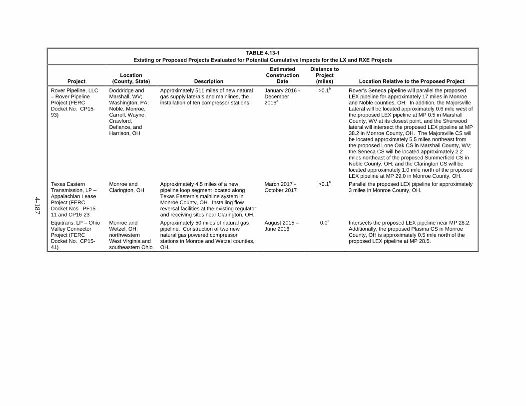
4-187
TABLE 4.13-1 Existing or Proposed Projects Evaluated for Potential Cumulative Impacts for the LX and RXE Projects
Project Location
(County, State) Description
Estimated Construction
Date
Distance to Project (miles) Location Relative to the Proposed Project
Rover Pipeline, LLC – Rover Pipeline Project (FERC Docket No. CP15-93)
Doddridge and Marshall, WV; Washington, PA; Noble, Monroe, Carroll, Wayne, Crawford, Defiance, and Harrison, OH
Approximately 511 miles of new natural gas supply laterals and mainlines, the installation of ten compressor stations
January 2016 - December 2016a
>0.1b Rover’s Seneca pipeline will parallel the proposed LEX pipeline for approximately 17 miles in Monroe and Noble counties, OH. In addition, the Majorsville Lateral will be located approximately 0.6 mile west of the proposed LEX pipeline at MP 0.5 in Marshall County, WV at its closest point, and the Sherwood lateral will intersect the proposed LEX pipeline at MP 38.2 in Monroe County, OH. The Majorsville CS will be located approximately 5.5 miles northeast from the proposed Lone Oak CS in Marshall County, WV; the Seneca CS will be located approximately 2.2 miles northeast of the proposed Summerfield CS in Noble County, OH; and the Clarington CS will be located approximately 1.0 mile north of the proposed LEX pipeline at MP 29.0 in Monroe County, OH.
Texas Eastern Transmission, LP – Appalachian Lease Project (FERC Docket Nos. PF15-11 and CP16-23
Monroe and Clarington, OH
Approximately 4.5 miles of a new pipeline loop segment located along Texas Eastern’s mainline system in Monroe County, OH. Installing flow reversal facilities at the existing regulator and receiving sites near Clarington, OH.
March 2017 - October 2017
>0.1b Parallel the proposed LEX pipeline for approximately 3 miles in Monroe County, OH.
Equitrans, LP – Ohio Valley Connector Project (FERC Docket No. CP15-41)
Monroe and Wetzel, OH; northwestern West Virginia and southeastern Ohio
Approximately 50 miles of natural gas pipeline. Construction of two new natural gas powered compressor stations in Monroe and Wetzel counties, OH.
August 2015 – June 2016
0.0c Intersects the proposed LEX pipeline near MP 28.2. Additionally, the proposed Plasma CS in Monroe County, OH is approximately 0.5 mile north of the proposed LEX pipeline at MP 28.5.
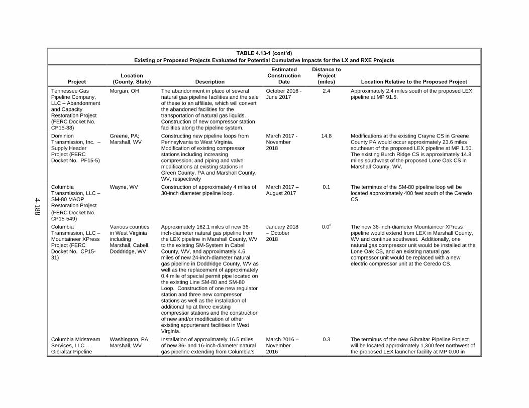
4-188
TABLE 4.13-1 (cont’d) Existing or Proposed Projects Evaluated for Potential Cumulative Impacts for the LX and RXE Projects
Project Location
(County, State) Description
Estimated Construction
Date
Distance to Project (miles) Location Relative to the Proposed Project
Tennessee Gas Pipeline Company, LLC – Abandonment and Capacity Restoration Project (FERC Docket No. CP15-88)
Morgan, OH The abandonment in place of several natural gas pipeline facilities and the sale of these to an affiliate, which will convert the abandoned facilities for the transportation of natural gas liquids. Construction of new compressor station facilities along the pipeline system.
October 2016 - June 2017
2.4 Approximately 2.4 miles south of the proposed LEX pipeline at MP 91.5.
Dominion Transmission, Inc. – Supply Header Project (FERC Docket No. PF15-5)
Greene, PA; Marshall, WV
Constructing new pipeline loops from Pennsylvania to West Virginia. Modification of existing compressor stations including increasing compression; and piping and valve modifications at existing stations in Green County, PA and Marshall County, WV, respectively
March 2017 - November 2018
14.8 Modifications at the existing Crayne CS in Greene County PA would occur approximately 23.6 miles southeast of the proposed LEX pipeline at MP 1.50. The existing Burch Ridge CS is approximately 14.8 miles southwest of the proposed Lone Oak CS in Marshall County, WV.
Columbia Transmission, LLC – SM-80 MAOP Restoration Project (FERC Docket No. CP15-549)
Wayne, WV Construction of approximately 4 miles of 30-inch diameter pipeline loop.
March 2017 – August 2017
0.1 The terminus of the SM-80 pipeline loop will be located approximately 400 feet south of the Ceredo CS
Columbia Transmission, LLC – Mountaineer XPress Project (FERC Docket No. CP15-31)
Various counties in West Virginia including Marshall, Cabell, Doddridge, WV
Approximately 162.1 miles of new 36-inch-diameter natural gas pipeline from the LEX pipeline in Marshall County, WV to the existing SM-System in Cabell County, WV, and approximately 4.6 miles of new 24-inch-diameter natural gas pipeline in Doddridge County, WV as well as the replacement of approximately 0.4 mile of special permit pipe located on the existing Line SM-80 and SM-80 Loop. Construction of one new regulator station and three new compressor stations as well as the installation of additional hp at three existing compressor stations and the construction of new and/or modification of other existing appurtenant facilities in West Virginia.
January 2018 – October 2018
0.0c The new 36-inch-diameter Mountaineer XPress pipeline would extend from LEX in Marshall County, WV and continue southwest. Additionally, one natural gas compressor unit would be installed at the Lone Oak CS, and an existing natural gas compressor unit would be replaced with a new electric compressor unit at the Ceredo CS.
Columbia Midstream Services, LLC – Gibraltar Pipeline
Washington, PA; Marshall, WV
Installation of approximately 16.5 miles of new 36- and 16-inch-diameter natural gas pipeline extending from Columbia’s
March 2016 – November 2016
0.3 The terminus of the new Gibraltar Pipeline Project will be located approximately 1,300 feet northwest of the proposed LEX launcher facility at MP 0.00 in

4-189
TABLE 4.13-1 (cont’d) Existing or Proposed Projects Evaluated for Potential Cumulative Impacts for the LX and RXE Projects
Project Location
(County, State) Description
Estimated Construction
Date
Distance to Project (miles) Location Relative to the Proposed Project
Project existing Claysville Meter Tie-in facility in Washington County, PA to its existing Line 1528 Tie-in facility at the Majorsville CS in Marshall County, WV. In addition, new over pressure protection will be installed at the existing Line 1528 Tie-in.
Marshall County, WV.
Columbia Gas Transmission, LLC – Tri-County Bare Steel Replacement Project (FERC Docket No. CP15-95)
Allegheny, Washington, and Greene, PA
Replacement of 34 miles of 20-inch diameter natural gas pipeline with 37.5 miles of 20-inch diameter pipe in three segments. In addition, replacement of 7 mainline valves, abandonment/removal of one MLV and 37 taps, and construction of 2 new pig launchers/receivers.
2016-2017 >15 miles Segment 1 in Greene County, Pennsylvania is the closest proposed facility to the project and includes replacement of approximately 14 miles with 14.9 miles from Hero Valve to Waynesburg Compressor Station in Greened County.
Moundsville Power, LLC – Moundsville Power Plant
Marshall WV 549-megawatt natural gas power plant 2015 – 2018 11.7 Proposed facility would be approximately 11.7 miles northwest of Lone Oak CS in Marshall County, WV.
Pennsylvania DOT – Highway 33 Interchange Project
Fairfield, OH A new highway interchange is being constructed for Highway 33 in the Village of Carroll
2015 – 2017 14.0 The new highway interchange would be approximately 14 miles northwest of the existing Crawford CS.
Heron Crossing Subdivision
Fairfield, OH A new subdivision consisting of more than 180 single family homes is proposed for construction in Fairfield County, OH.
2016d 21.0 The Heron Crossing Subdivision will be located along Refugee Road approximately 21 miles northwest of LEX1 MP 1.00.
Columbia Gulf Transmission, LLC – Gulf XPress Project
Rowan, Garad, and Metcalfe, KY; Davidson and Wayne, TN; Union and Grenada, MS
Construction of seven new compressor stations on the mainline pipeline system. Could include installation of additional hp at the Grayson CS.
2017 – 2018 0.0e Additional hp would be installed at the Grayson CS, a component of RXE.
____________________ a Estimated construction schedule is associated with only those facilities located within the identified cumulative impact area. b Project parallels the Leach XPress Project c Project intersects or extends from the Leach XPress Project d Construction of the Heron Crossing Subdivision is anticipated to initiate in 2016; however, the duration and extent of the construction is dependent on market conditions and is not known at this time. e Project intersects or extends from the Rayne XPress Expansion Project
4-190
Columbia Gas and Columbia Gulf Projects 4.13.1
Columbia Gas is currently developing four additional projects which are located in the vicinity of portions of the proposed LX Project facilities. These projects include the SM-80 MAOP Restoration Project (FERC Docket No. CP15-549), Mountaineer XPress Project (FERC Docket No. PF15-31), Gibraltar Pipeline Project, and the Tri-County Bare Steel Replacement Project (FERC Docket No. CP15-95).
The SM-80 MAOP Restoration Project consists of the construction of in-place abandonment of about 3.3 miles of the existing 30-inch-diameter SM-80 pipeline system and the replacement of about 3.9 miles of new 30-inch-diameter pipeline loop and associated ancillary facilities in Wayne County, West Virginia, near the Ceredo CS. Construction of the SM-80 MAOP Restoration Project is anticipated to begin in October 2016 in order to meet a planned in-service date of April 2017.
The Mountaineer XPress Project consists of the installation of about 162.1 miles of new 36-inch-diameter natural gas pipeline extending from LEX in Marshall County, West Virginia to the existing SM-System in Cabell County, West Virginia; about 4.6 miles of new 24-inch-diameter natural gas lateral pipeline in Doddridge County, West Virginia; as well as the replacement of about 0.4 mile of special permit pipe located on the existing Line SM-80 and SM-80 Loop in Cabell County, West Virginia. The project also consists of the construction of one new regulator station and three new compressor stations; the installation of additional hp at three existing (at the time of construction) compressor stations, including the Lone Oak CS and the Ceredo CS; and the construction of new and/or modification of other existing appurtenant facilities in West Virginia. Construction of the Mountaineer XPress Project is anticipated to begin in November 2017 in order to meet a planned in-service date of November 1, 2018.
The Gibraltar Pipeline Project consists of the installation of about 16.5 miles of new 36- and 16-inch-diameter natural gas pipeline extending from Range Resource Corporation’s existing Claysville Meter Tie-in facility in Washington County, Pennsylvania to Columbia Gas’ existing Line 1528 Tie-in facility at the Majorsville CS in Marshall County, West Virginia. The project also consists of the installation of over pressure protection at the existing Line 1528 Tie-in facility. Tree clearing associated with the Gibraltar Pipeline Project is anticipated to occur in February and March 2016. However, ground disturbing construction activities are not anticipated to begin until April 2016, and would be completed by the end of the year.
The Tri-County Bare Steel Replacement Project proposes to construct a new replacement pipeline segment along its existing Line 1570 pipeline system. The replacement pipeline would replace approximately 34 miles of 20-inch-diameter natural gas pipeline with 37.5 miles of new 20-inch diameter pipe in three segments in Allegheny, Washington, and Greene Counties, Pennsylvania. About 25.8 miles, or 76 percent of the Project, would replace the existing pipeline in the same location or offset the existing Line 1570 (or Line 1983) by about 25 feet. In addition, Columbia would replace 7 mainline valves (MLVs), abandon/remove one MLV, abandon/remove 37 taps, and construct 2 new bi-directional pig launchers/receivers.
Columbia Gulf is currently developing one additional project which is located in the vicinity of portions of the proposed RXE Project facilities, referred to as the Gulf XPress Project. The Gulf XPress Project, as currently planned, would consist of the construction of seven new compressor stations on Columbia Gulf’s mainline pipeline system. The Gulf XPress Project could also include the installation of additional horsepower at the Grayson CS, which would be constructed as part of the RXE Project. Columbia Gulf’s preliminary engineering review indicates that the new compressor stations would be located in Rowan County, Kentucky; Garrard County, Kentucky; Metcalfe County, Kentucky; Davidson County, Tennessee; Wayne County, Tennessee; Union County, Mississippi; and Grenada County, Mississippi. The anticipated FERC filing date for the Gulf XPress Project is the 2nd Quarter of

4-191
2016 and construction is expected to begin during the 4th Quarter 2017 in order to meet a planned in service date of November 2018.
Other FERC-Jurisdictional Projects 4.13.2
Rover Pipeline LLC proposed by Energy Transfer Partners consists of 511 miles of supply laterals and 42 inch mainlines, compressor stations and other facilities located in the vicinity of portions of the LX Project facilities in Monroe and Noble County, Ohio. This project would carry Marcellus and Utica shale gas from West Virginia, Pennsylvania, and Ohio to an interconnect with Vector Pipeline in Michigan. The project is currently pending before the Commission, and the applicant’s planned construction schedule is anticipated to begin in summer 2016.
The Appalachian Lease Project proposed by Texas Eastern Transmission, LP consists of approximately 4.4 miles of new 36-inch-diameter pipeline loop in Texas Eastern Zone M2, connecting pipeline, and two new compressor stations in the vicinity of the LX Project pipeline in Monroe County, Ohio. The project is designed to provide pipeline capacity to deliver production from the Appalachian Basin to NEXUS Gas Transmission, LLC proposed pipeline facilities. The project is currently pending before the Commission. Construction of this project is proposed to begin in March 2017.
Ohio Valley Connector Project proposed by Equitrans, LP (EQT) consists of construction of 37.0 miles of 16- to 30-inch-diameter natural gas pipeline and two new compressor stations in the vicinity of the Columbia Gas pipeline in Monroe County, Ohio. The project will transfer natural gas from the central Appalachian Basin into the existing pipeline systems of Rockies Express Pipeline, LLC (REX) and Texas Eastern Transmission, LP (TETCO). The project was recently approved by the Commission. Construction of the Ohio Valley Connector project began in January 2016.
Shale Formation Development 4.13.3
Background
Several shale formations occur in the Project area, including the well-known Marcellus and Utica Shales. The Marcellus Shale is an approximately 385-million-year-old, organic-rich shale formation that exists beneath 145,313 square miles of Pennsylvania, southern New York, eastern Ohio, and northern West Virginia. The Utica Shale is an older formation at approximately 460 million-years-old and is over twice the size of the Marcellus Shale. The Utica Shale largely overlaps the range of Marcellus Shale at greater depths, but extends farther west into Ohio and farther north into New York. Where the Utica and Marcellus Shales overlap, the Marcellus Shale has been the first target of development since it occurs at shallower depths and is therefore easier to drill. Marcellus Shale development has focused on the formation in Pennsylvania, West Virginia, and New York, while the Utica Shale formation is a larger focus in Ohio because the Marcellus Shale is only located along the eastern edge of the state.
The USGS has estimated that the Marcellus Shale contains about 84 trillion cubic feet of technically recoverable natural gas (Coleman et al., 2011). An additional 38 trillion cubic feet of recoverable natural gas was estimated to be locked within the Utica Shale according to USGS estimates (Schenk et al., 2012). For comparison, in 2012, the United States consumed approximately 25.5 trillion cubic feet of natural gas (EIA, 2015a); thus, the Marcellus and Utica Shales represents a significant natural gas deposit in close proximity to the high population centers of the northeastern United States. The Marcellus region, primarily Pennsylvania and West Virginia, has seen a dramatic increase in production rising from rates of approximately 2 Bcf/d in 2010 to 15 Bcf/d by 2015 (EIA, 2015a). By comparison the harder to reach Utica Shale formation has seen production rates rise from 250 mcf/d to 2 Bcf/d in the same time period (EIA, 2015a).
4-192
The EIA maintains records of energy production and usage on a national and state level. Those records document the rise in the production rates in the states where the LX Project would be located. Although it does not identify the source of the shale gas, be it Marcellus or Utica Shale, the EIA does identify natural gas developed by “Shale Gas Wells” as a whole (EIA, 2015b). Natural gas from shale gas wells in West Virginia accounted for 547 bcf of production in 2013, which was an increase from the 344 bcf produced in the state in 2012. Pennsylvania produced 3,048 bcf from its shale gas wells in 2013, which was an increase from 2,042 bcf produced in 2012. Ohio, where gas development occurs primarily within the Utica Shale has not seen the same level in comparison to the Marcellus Shale. It produced 88 bcf in 2013, which was still a dramatic increase from the 12 bcf produced in the previous year.
Natural gas production from shale resources involves the drilling and completion of wells and construction of gathering systems and consequent rights-of-way. We received comments concerning the development of natural gas reserves in the Marcellus and Utica Shale. Development of shale natural gas resources is not the subject of this EIS. Production and gathering activities, and the pipelines and facilities used for these activities, are not regulated by FERC but are overseen by the affected region’s state and local agencies with jurisdiction over the management and extraction of the Marcellus and Utica Shale gas resources. FERC’s authority under the NGA review requirements relate only to natural gas facilities that are involved in interstate commerce. Thus, the facilities associated with the production of natural gas are not under FERC-jurisdiction.
Each of the states that contain Marcellus and Utica shale gas resource development have specific offices within their respective environmental departments that handle the permitting as well as and enforcement of applicable laws. In each of the states, there are specific branches of local government tasked with permitting of gas resources which includes:
In Pennsylvania – PADEP’s Bureau of Oil and Gas Management;
In West Virginia – WVDEP’s Office of Oil and Gas;
In Ohio – OHDNR’s Division of Oil & Gas Resources; and
Each organization has developed BMPs for the construction and operation of upstream oil and gas production facilities as part of their permitting process. These BMPs include erosion and sediment control practices; setback requirements from springs, wetlands, and waterbodies; wetland and waterbody crossing procedures; access road construction practices; soil amendment procedures; and right-of-way restoration measures.
Natural Gas Production 4.13.4
As stated above, natural gas production from shale resources involves improvement or construction of roads, preparation of a well pad, drilling and completion of wells, and construction of gathering systems and consequent rights-of-way. Multiple FERC non-jurisdictional intrastate natural gas wells and gathering/interconnection systems are either proposed, under construction, or have been constructed in the vicinity of the proposed LX and RXE Projects. It is likely that development activities would continue through the construction of the proposed projects, but the exact extent of such drilling is unknown. Construction activities associated with these development activities would be similar to the construction activities associated with interstate natural gas transmission facilities, although land requirements would typically be less for these FERC non-jurisdictional facilities due to the smaller and more localized extent of activities and installation of smaller diameter pipe.
Our review of publicly available data identified more than 250 existing and planned natural wells that have been permitted since 2000 within 0.5 mile of the LX Project in Ohio, West Virginia, and Pennsylvania (ODNR, 2016; PASDA, 2016; PASDA, 2016a; WVDEP, 2016; WVDEP 2016a).

4-193
However, for a number of the identified wells available records indicate that permits have expired, and there is no information that indicates these wells were constructed. Columbia Gas would field verify the locations of oil and gas wells within the LX Project workspaces through civil surveys prior to the start of construction.
Indirect effects of shale formation development activities may include growth-inducing effects and other effects related to induced changes in the pattern of land use, population density or growth rate, and related effects on air and water and other natural systems, including ecosystems (40 CFR 1508.8(b)). Typically, the growth-inducing potential of a project would be considered adverse if it fosters growth or a concentration of population above what is assumed in local and regional land use plans, or in projections made by regional planning authorities. Growth impacts could also occur if a project provides infrastructure or service capacity to accommodate growth levels beyond those permitted by local or regional plans and policies. The purpose of the proposed projects is to meet market demand for the transportation of natural gas supplies from the production region to areas of higher demand, premium markets. The project area is already served by various natural gas transmission lines so the Project would not extend public service to areas currently unserved by natural gas transmission lines. However, LDCs may build additional lines to serve new customers, but it is highly speculative to assume where the new lines would go and predict any resulting impacts. Further, economic activity is already taking place. The demand for energy and the proposed projects are a result of, rather than a precursor to, development in this region. Therefore, the Project would not result in adverse growth-inducing effects.
Potential Cumulative Impacts of the Proposed Action 4.13.5
The potential impacts that we consider as part of our cumulative review pertain to geology and soils; water resources; vegetation; wildlife; fisheries and aquatic resources; land use, recreation, special interest, and visual resources; socioeconomics; cultural resources; air quality and noise; and reliability and safety. In the following analysis, we discuss the potential cumulative impacts associated with the projects mentioned above and their contribution to impacts on sensitive resources in conjunction with Columbia Gas’ and Columbia Gulf’s LX and RXE Projects.
Geology and Soils 4.13.5.1
Cumulative effects on geology and soils crossed by the proposed projects would be limited primarily to the combined impacts of projects located within the same construction footprint as the proposed projects and recently completed or concurrent construction activities along the same route as the proposed projects. The primary effects of the proposed LX and RXE Projects on geologic and soil resources would be temporary, but direct. However, the direct effects would be highly localized and limited primarily to the period of construction. The construction of some of the projects listed in table 4.13-1, such as the Rover Pipeline Project, Appalachian Lease Project, Abandonment and Capacity Restoration Project, Ohio Valley Connector Project, SM-8- MAOP Restoration Project, Mountaineer XPress Project, Gibraltar Pipeline Project, and Gulf XPress Project, as well as shale development activities, could coincide with the schedule for the proposed projects as well as overlap with, or occur in close proximity to the proposed projects. Excavation, grading and blasting (if required) associated with these projects would also have temporary, but direct impacts on near-surface geology and soils, although like the proposed projects, the duration and effect of these projects would be minimized by the implementation of erosion control and restoration measures and blasting mitigation measures (if required). The potential for cumulative soil impacts resulting from one or more of these projects is low and primarily temporary because construction of other pipeline facilities would generally not result in loss of soils. Other FERC-regulated projects would be held to the same restoration and mitigation standards as the proposed projects. In addition, we expect these projects would be required by the state permitting agencies to adhere to BMPs similar to those proposed by Columbia Gas and Columbia Gulf. Therefore, it

4-194
is unlikely any construction areas would be left unrestored following construction completion, thereby minimizing exposure of soils to erosive forces.
Columbia Gas has contracted geotechnical experts to conduct desktop and field assessments of the project area to identify areas where the greatest risks of slip and landslide events exist. In addition, Columbia Gas and Columbia Gulf would follow measures contained in their ECS as well as the recommendations from applicable local, state, and federal agencies to take the necessary precautions to avoid and mitigate geology and soil impacts. In addition, if approved by FERC, the other projects above would be required to adhere to the measures contained in the FERC Plan, which minimize impacts on soils. Non-jurisdictional project-related facilities would likely follow BMPs similar to those proposed by Columbia Gas and Columbia Gulf. Therefore, we conclude that the proposed projects are not expected to significantly contribute to potential cumulative impacts on geology and soils.
Water Resources 4.13.5.2
Groundwater
The proposed LX Project and RXE Project would not withdraw groundwater for construction or operation and, no water wells located within 150 feet of the projects’ areas would be impacted by the proposed projects’ activities. Disturbances from construction and operation of the proposed projects would be temporary and localized.
Any of the projects listed in table 4.13-1, as well as shale development activities that are within the same watershed(s) as the proposed projects and involve ground disturbance or excavation could result in cumulative impacts on groundwater resources. These include the Rover Pipeline Project, Appalachian Lease Project, Abandonment and Capacity Restoration Project, Ohio Valley Connector Project, SM-80 MAOP Restoration Project, Mountaineer XPress Project, the Gibraltar Pipeline Project, the Gulf XPress Project, and a number of natural gas well and gathering system projects. The major construction activities that could affect groundwater include the clearing of vegetation, excavation and dewatering of trenches and bore pits, soil mixing and compaction, heavy equipment and associated fuel usage, and hazardous material handling. Implementation of proper storage, containment, and handling procedures would minimize the chance of such releases. The proposed projects’ SPCC Plans address the preventative and mitigate measures that would be implemented to avoid or minimize the potential impacts of hazardous material spills during construction. As such, impacts from the proposed projects are expected to be short-term and minor. Each of the major projects listed above would be required to obtain water use and discharge permits and would implement their various SPCC Plans as mandated by federal and state agencies.
For these reasons, we anticipate that the proposed projects would not significantly contribute to cumulative impacts on groundwater.
Waterbodies and Wetlands
Projects that occur in the same watersheds as the proposed projects and that could be under construction during the same time as the proposed projects could result in impacts on waterbodies and wetlands. As stated previously these projects include the Rover Pipeline Project, Appalachian Lease Project, Abandonment and Capacity Restoration Project, Ohio Valley Connector Project, SM-80 MAOP Restoration Project, Mountaineer XPress Project, the Gibraltar Pipeline Project, the Gulf XPress Project, and shale development activities. Thus, there is the potential that cumulative impacts could result if the proposed projects were constructed during the same time period as these other projects.
4-195
Generally, impacts resulting from pipeline construction across waterbodies are localized and short-term. Cumulative impacts would only occur in the event that more than one project impacts the same waterbody within a similar period of time. The LX Project would require 1,083 waterbody crossings. These include 170 perennial waterbody crossings, 390 intermittent waterbody crossings, 516 ephemeral waterbody crossings, and 7 open water crossings. The RXE Project would affect a total of 5 waterbodies, including 2 intermittent waterbodies and 3 ephemeral waterbodies. The majority of these would be crossed using the open-cut method; however, 24 waterbodies would be crossed using 7 HDDs.
The greatest potential for cumulative impacts associated with construction and operation of the proposed projects would be in Monroe County, Ohio, where there is a concentration of proximal and overlapping activity with other projects in the region of influence. In Monroe County, there would be a total of 156 waterbody crossings by the LX Project, 80 waterbody crossings by the Rover Pipeline Project, 14 waterbody crossings by the Appalachian Lease Project, and 20 waterbody crossings by the Ohio Valley Connector Project. Specifically, the LX Project and the Rover Pipeline Project would cross tributaries and/or main branches of the following waterbodies: Paine Run, Ackerson Run, Sunfish Creek, East Fork, Piney Fork, Death Creek, Grassy Creek, Baker Fork, Wheeler Run, and South Fork. The LX Project, as well as the Ohio Valley Connector and the Appalachian Lease Projects would cross tributaries and/or main branches of Stillhouse Run. In addition, the Ohio Valley Connector Project would cross Johnson Run and its tributaries, and the Appalachian Lease Project would cross Paine Run and its tributaries, which are also crossed by the LX Project. Therefore, cumulative impacts to these waterbodies may occur associated with construction of these projects. However, impacts on these surface waters would be temporary and short-term, ending shortly after the completion of construction activities.
Siting of well pads related to shale resource development typically avoids wetland impacts, and construction impacts related to upstream gathering lines and interconnections would be similar to the construction activities associated with interstate natural gas transmission facilities, although impacts would be smaller and more localized due to installation of smaller diameter pipe. A more specific analysis of upstream facility impacts was not conducted in the cumulative impact assessment because the exact location, scale, and timing of future facilities are unknown.
In addition to the temporary impacts discussed above, construction of aboveground facilities would result in some permanent waterbody impacts. Columbia Gas is consulting with COE, WVDEP, and OEPA to determine appropriate mitigation for permanent waterbody impacts.
Columbia Gas would hydrostatically test new pipeline segments and appropriate aboveground facility components in accordance with PHMSA pipeline safety regulations in 49 CFR 192 prior to placing the pipeline facilities into service. Water for pipeline facility testing would primarily be obtained from surface water sources. Water for aboveground facility testing would primarily be obtained from municipal sources, and some would be appropriated from pipeline hydrostatic test water sources. To our knowledge, the only overlapping water source for the proposed project and the other projects identified in the region of influence would be the Ohio River; however, specific withdrawal locations do not appear to overlap. Hydrostatic test water withdrawal would follow the measures outlined in the Procedures. Further, withdrawals and discharges from surface water sources would be performed in accordance with applicable state permits and approvals and would not impair flow or impact fisheries and recreational uses. Similarly, water allocation for shale development activities would be regulated by applicable regional, state, and local agencies. Therefore, long-term impacts on surface water sources would not be anticipated as a result of hydrostatic testing activities, and we expect the cumulative impacts of the projects in the region of influence on surface water resources to be minor.
The majority of wetland impacts associated with the proposed projects would be short-term impacts on emergent wetlands. However, project construction would also result in long-term construction impacts and permanent operational impacts from clearing and maintenance activities associated with
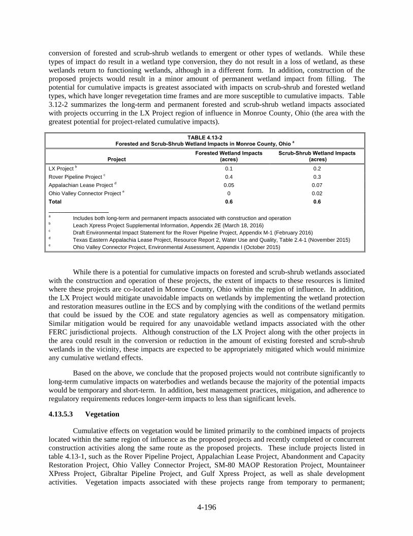
4-196
conversion of forested and scrub-shrub wetlands to emergent or other types of wetlands. While these types of impact do result in a wetland type conversion, they do not result in a loss of wetland, as these wetlands return to functioning wetlands, although in a different form. In addition, construction of the proposed projects would result in a minor amount of permanent wetland impact from filling. The potential for cumulative impacts is greatest associated with impacts on scrub-shrub and forested wetland types, which have longer revegetation time frames and are more susceptible to cumulative impacts. Table 3.12-2 summarizes the long-term and permanent forested and scrub-shrub wetland impacts associated with projects occurring in the LX Project region of influence in Monroe County, Ohio (the area with the greatest potential for project-related cumulative impacts).
TABLE 4.13-2 Forested and Scrub-Shrub Wetland Impacts in Monroe County, Ohio a
Project Forested Wetland Impacts
(acres) Scrub-Shrub Wetland Impacts
(acres)
LX Project b 0.1 0.2
Rover Pipeline Project c 0.4 0.3
Appalachian Lease Project d 0.05 0.07
Ohio Valley Connector Project e 0 0.02
Total 0.6 0.6
____________________ a Includes both long-term and permanent impacts associated with construction and operation b Leach Xpress Project Supplemental Information, Appendix 2E (March 18, 2016) c Draft Environmental Impact Statement for the Rover Pipeline Project, Appendix M-1 (February 2016) d Texas Eastern Appalachia Lease Project, Resource Report 2, Water Use and Quality, Table 2.4-1 (November 2015) e Ohio Valley Connector Project, Environmental Assessment, Appendix I (October 2015)
While there is a potential for cumulative impacts on forested and scrub-shrub wetlands associated with the construction and operation of these projects, the extent of impacts to these resources is limited where these projects are co-located in Monroe County, Ohio within the region of influence. In addition, the LX Project would mitigate unavoidable impacts on wetlands by implementing the wetland protection and restoration measures outline in the ECS and by complying with the conditions of the wetland permits that could be issued by the COE and state regulatory agencies as well as compensatory mitigation. Similar mitigation would be required for any unavoidable wetland impacts associated with the other FERC jurisdictional projects. Although construction of the LX Project along with the other projects in the area could result in the conversion or reduction in the amount of existing forested and scrub-shrub wetlands in the vicinity, these impacts are expected to be appropriately mitigated which would minimize any cumulative wetland effects.
Based on the above, we conclude that the proposed projects would not contribute significantly to long-term cumulative impacts on waterbodies and wetlands because the majority of the potential impacts would be temporary and short-term. In addition, best management practices, mitigation, and adherence to regulatory requirements reduces longer-term impacts to less than significant levels.
Vegetation 4.13.5.3
Cumulative effects on vegetation would be limited primarily to the combined impacts of projects located within the same region of influence as the proposed projects and recently completed or concurrent construction activities along the same route as the proposed projects. These include projects listed in table 4.13-1, such as the Rover Pipeline Project, Appalachian Lease Project, Abandonment and Capacity Restoration Project, Ohio Valley Connector Project, SM-80 MAOP Restoration Project, Mountaineer XPress Project, Gibraltar Pipeline Project, and Gulf Xpress Project, as well as shale development activities. Vegetation impacts associated with these projects range from temporary to permanent;

4-197
however, the greatest potential for cumulative impacts on vegetation is where the proposed projects and other nearby projects would have long-term or permanent impacts within the region of influence (e.g., 0.5 mile).
Clearing and grading of pipeline rights-of-way, contractor yards, and temporary access roads for the proposed projects and other nearby projects would result in vegetation impacts ranging from temporary to permanent. Impacts on agricultural areas, open lands and other herbaceous areas would be temporary, as these areas would be restored quickly following construction. Longer-term impacts would occur where forested areas are cleared for temporary workspaces because these areas could take decades to return to pre-construction conditions. Permanent impacts would occur where forested lands are cleared for establishment and maintenance of permanent rights-of-way or access roads. We have concluded that the LX Project would have significant impact on forest resources.
The greatest potential for cumulative impacts associated with construction and operation of the proposed projects would be in Monroe County, Ohio, where there is a concentration of proximal and overlapping activity with other projects in the region of influence. In Monroe County, the proposed project would result in long-term impacts to 255.9 acres of forested land and permanent impacts to 87.9 acres of forested land associated with construction and operation, respectively. We previously concluded (FERC, 2016) that the Rover Pipeline Project would significantly impact forested resources within its project area. In Monroe County, Ohio, the Seneca Lateral of the Rover Pipeline Project parallels the LX project for about 17 miles and would result in long-term impacts to 272.8 acres and permanent impacts to 94.1 acres of forested land, respectively. Both the Ohio Valley Connector Project and the Appalachian Lease Project would impact forested land; however, impacts associated with these projects are limited within the project’s region of influence. In addition, based on the location of wells within 0.5 mile of the LX Project in Monroe County, Ohio (permitted since 2000) and a review of 2015 aerial photography [Google Earth, 2016]) about 15 of these wells may have impacted forest resources. While the siting of the proposed projects and the other pipeline projects listed above within and adjacent to existing rights-of-way, where possible, minimizes forest fragmentation and additional impacts to forested lands, we acknowledge that these types of impacts widen the right-of-way corridor and move the edge effects into new areas of forest. Therefore, cumulative impacts on forest resources could occur in this area.
Construction of new aboveground facilities for the proposed projects would result in some permanent impacts on forested lands. However, the extent of permanent impacts associated with new aboveground facility construction is limited. The limited extent of impacts, in combination with the distance of these facilities from other projects’ construction activities in the region of influence, minimizes the potential for cumulative vegetation impacts.
Columbia Gas and Columbia Gulf would be required to restore vegetation in temporarily disturbed areas, and the other FERC-jurisdictional projects in the region of influence would be held to the same restoration standards as the proposed projects. The non-jurisdictional project-related facilities would likely be held to similar best management practice standards by state permitting agencies. Further, the Rover Pipeline Project would develop and implement a Forest Mitigation Plan in coordination with the FWS to minimize and offset impacts on forests, which would further reduce the potential for cumulative impacts to occur.
Potential cumulative impacts on forested areas from construction and operation of the projects discussed above, together with the proposed projects would not be inconsequential. However, siting of pipeline projects within and adjacent to existing rights-of-way, where possible, along with implementation of best management practices, Columbia Gas’ ECS and FERC’s Plan and Procedures, adequately minimizes and mitigates impacts on forested lands to the extent possible. The overall impact of these projects with the proposed mitigation, and our recommendations made throughout this EIS, would reduce overall cumulative impacts to less than significant levels.

4-198
Wildlife 4.13.5.4
Cumulative effects on wildlife would occur where projects are constructed in the same general timeframe and location or which represent permanent or long term loss of habitat types important to wildlife. Within the region of influence, such projects could include the Rover Pipeline Project, Appalachian Lease Project, Abandonment and Capacity Restoration Project, Ohio Valley Connector Project, SM-80 MAOP Restoration Project, Gibraltar Pipeline Project, Mountaineer XPress Project, and Gulf Xpress Project, as well as shale development activities. Construction activities such as right-of-way and other workspace clearing and grading would result in loss of vegetation cover and soil disturbance, alteration of wildlife habitat, displacement of wildlife species from the construction zone and adjacent areas, mortality of less mobile species, and other potential indirect effects as a result of noise created by construction and human activity in the area. Overall impacts would be greatest where projects are constructed in the same timeframe and area as the proposed projects or that have long-term or permanent impacts on the same or similar habitat types. Accordingly, the greatest potential for cumulative impacts associated with construction and operation of the proposed projects would be in Monroe County, Ohio, where there is a concentration of proximal and overlapping activity with other projects in the region of influence, and there is the potential for cumulative impacts on forested areas.
In general, displaced wildlife is expected to return to disturbed areas following the completion of construction activities, with the exception of areas permanently affected by aboveground facility construction and operation. Clearing and grading of pipeline rights-of-way, contractor yards, and temporary access roads for the proposed projects and other nearby projects would result in a loss of wildlife habitat. The effect of workspace clearing on forest-dwelling wildlife species would be greater than on open habitat wildlife species. As discussed above, forests could take decades to return to pre-construction condition in areas used for temporary workspace, and would be permanently prevented from re-establishing on the operational right-of-way. This may result in the cumulative loss of individuals of small mammal species, amphibians, reptiles, nesting birds, and non-mobile species. However, the siting of the proposed projects and the other pipeline projects listed above within and adjacent to existing rights-of-way, where possible, reduces habitat fragmentation. In addition, given the availability of undisturbed habitats adjacent to project workspaces, it is expected that individual mobile species would seek refuge in these undisturbed areas during construction and return to restored areas after construction is completed.
Construction of aboveground facilities for the proposed projects would result in some permanent impacts on wildlife habitat. Temporary impacts on wildlife associated with construction activities would be similar to those described above, and permanent operational impacts would result in displacement of wildlife from these areas due to lack of suitable habitat and proper vegetation. In addition, the increase in ambient noise in the immediate vicinity of these facilities during both construction and operation, could also result in a decrease in wildlife use of adjacent habitat. However, the limited extent of permanent impacts on wildlife habitat associated with aboveground facility construction, in combination with the distance of proposed aboveground facilities from one another and the localized region of influence (i.e., 0.5 miles), minimizes the potential for cumulative wildlife impacts.
The majority of wildlife impacts from the proposed projects and other nearby projects would be minor and temporary, and permanent impacts are limited in areal and geographic extent. Forested species may be subject to greater impacts than non-forested species, but we recognize that these would represent less than significant impacts given the availability of undisturbed forested habitat adjacent to project workspaces and the ability for individual mobile species to seek refuge in these undisturbed areas. While some adverse impacts on wildlife would occur as a result of construction and operation of the proposed projects, cumulative impacts are expected to be minimal for individual wildlife species relative to existing populations in the region of influence.

4-199
Fisheries and Aquatic Resources 4.13.5.5
Cumulative impacts on fisheries and aquatic resources could occur if other projects are constructed within the same segment of a waterbody and have similar construction timeframes as the proposed LX Project or RXE Project, or that could result in permanent or long-term impact on the same or similar habitat types. As stated previously, the Rover Pipeline Project, Appalachian Lease Project, Abandonment and Capacity Restoration Project, Ohio Valley Connector Project, SM-80 MAOP Restoration Project, Mountaineer XPress Project, the Gibraltar Pipeline Project, and the Gulf XPress Project, as well as shale development activities occur in the same watersheds as the proposed projects. Thus, there is the potential that cumulative impacts on fisheries could occur if construction of these projects affects the same waterbodies as the proposed projects in a similar timeframe. These impacts may include sedimentation and turbidity; habitat alteration; stream bank erosion; fuel and chemical spills; water depletions; entrainment or entrapment due to water withdrawals or construction crossing operations; blasting; and operational pipeline failure.
Fisheries and aquatic resource impacts resulting from construction and operation of these projects are expected to be localized and short-term, consistent with the waterbody impacts discussed previously. The greatest potential for cumulative impacts associated with construction and operation of the proposed projects would be in Monroe County, Ohio, where there is a concentration of proximal and overlapping activity with other projects in the region of influence. The majority of waterbodies that would be crossed by the proposed project in Monroe County are intermittent or ephemeral. Perennial waterbodies that would be crossed include both warmwater and coldwater fisheries. Only one waterbody that would be crossed in Monroe County by the LX Project is designated as a sensitive surface water. This waterbody is Piney Fork and is designated as a superior high quality stream. Of the other projects identified above, only the Rover Pipeline Project would also cross Piney Fork.
The proposed projects would minimize fisheries impacts through adherence to timing restrictions for construction, as well as implementation of appropriate setbacks, erosion and sediment control measures, best management practices and restoration requirements as specified in the ECS. In addition, the other FERC-regulated projects would be designed to minimize impacts on waterbodies, and therefore fisheries, to the extent possible. Any impacts on waterbodies that could not be avoided would be minimized through implementation of best management and restoration practices in accordance with the respective federal, state, and local regulatory requirements.
Therefore, we conclude that the fishery impacts discussed above are not expected to be cumulatively significant because of the limited overlap of construction activities affecting the same sensitive resources, the temporary nature of impacts, and the avoidance and mitigation measures that would be implemented. Further, operation of the proposed LX Project and RXE Project would not result in any additional impacts unless maintenance activities occur in or near streams.
Special Status Species 4.13.5.6
The species discussed in section 4.7 of this EIS could potentially be affected by construction and operation of other projects occurring within the same area as the proposed projects. Columbia Gas and Columbia Gulf, and all other companies’ projects are required to consult with the appropriate Federal, state, and local agencies to evaluate the types of species that may be found in the area of the projects, identify potential impacts from construction and operation of the projects to any species identified, and implement measures to avoid, minimize, or mitigate impacts on special status species and their habitat. Habitat and population assessments are still ongoing for some identified species within the LX Project area. Habitat and population assessments have been completed for identified species within the RXE Project area. Based on implementation of the MSHCP, surveys completed to-date, projected impacts, and proposed mitigation measures, we have determined that project activities were determined to have no

4-200
effect, not impact, not likely impact, or not likely to adversely affect Federally- and state-listed endangered and threatened species.
All federal undertakings, including the projects listed in table 4.13-1, are required by law to coordinate with the FWS, which will take into account regional activity and changing baseline conditions in determining the extent of impacts on a federally listed or proposed species. Consultation with the FWS is pending, and final consultation would be required prior to the start of construction of the proposed projects. Non-federal projects are also required to adhere to the ESA, although the FWS has a different mechanism for evaluation and minimizing impacts. Consequently, we conclude that past and present projects in combination with the proposed projects would have minor cumulative impacts on special status species.
Land Use, Recreation, Special Interest Areas, and Visual Resources 4.13.5.7
Projects with new permanent aboveground components, such as buildings, residential projects, roads, and aboveground electrical transmission lines would generally have greater impacts on land use than the operational impacts of a pipeline, which would be buried and thus allow for most uses of the land following construction. Therefore, with the exception of new aboveground facilities and permanent (operational) rights-of-way, pipeline projects typically only have temporary impacts on land use and would not significantly contribute to cumulative impacts.
The projects listed in table 4.13-1 would disturb thousands of additional acres of land affecting a variety of land uses. This analysis focuses on potential cumulative land use impacts by projects located within 0.50 mile of the proposed projects or immediately adjacent to the proposed construction workspaces. Of the projects listed in table 4.13-1, those with the greatest potential for cumulative impacts with the LX Project include the Rover Pipeline Project, Appalachian Lease Project, Abandonment and Capacity Restoration Project, Ohio Valley Connector Project, SM-80 MAOP Restoration Project, Gibraltar Pipeline Project, and Mountaineer XPress Project, as well as shale development activities. The Gulf XPress Project is the only project that could contribute cumulative impacts to the RXE Project.
Impacts on agricultural land and other non-forested land use types would be temporary, as most land uses would be allowed to revert to prior uses following construction. However, long-term impacts on forested lands would result from clearing activities. Any impacts would be minimized or mitigated to the greatest extent practicable through the use of resource-specific construction plans (for example, Columbia Gas’ and Columbia Gulf’s ECSs, FERC Plan and Procedures) and consultation with state agencies, Federal agencies, and landowners. It is anticipated that other projects in the region of influence would be required to implement similar construction and restoration best management practices to minimize impacts on land use. FERC-jurisdictional projects would be required to adhere to the measures contained in our Plan to minimize impacts on land use.
Columbia Gas’ and Columbia Gulf’s projects, if built at the same time as other foreseeable future projects, could result in cumulative impacts on recreation and special-interest areas if other projects affect the same areas or feature at the same time. At this time, we have not determined that any of the projects listed in table 4.13-1 or shale development activities would cumulatively impact any of the recreation and special-use areas crossed by the LX Project (as described further in section 4.8.4 of this EIS). However, if one or more of these other projects was constructed at the same time as the LX Project, then temporary cumulative impacts could occur and recreational users could experience a decreased quality of recreational activities.
The visual character of the existing landscape is defined by historic and current land uses such as agriculture, residential, industrial, and undeveloped land. The visual qualities of the landscape are further influenced by existing linear installations such as highways, railroads, pipelines, and electrical

4-201
transmission and distribution lines. Within this context, the Rover Pipeline Project, Appalachian Lease Project, the Ohio Valley Connector Project, and shale development, in combination with the LX Project, would have the greatest potential to cumulatively impact visual resources in Monroe County, Ohio. The proposed construction and/or modifications of aboveground facilities would primarily affect agricultural land, industrial, open land, and forest. Disturbed areas not permanently converted to industrial use would be revegetated as appropriate. Existing vegetation around some of the aboveground facilities would shield surrounding areas from visual impacts, while other facilities would not be screened Columbia Gas and Columbia Gulf would provide visual screening of aboveground facilities on a site-by-site basis, depending on existing topography and vegetation. In addition, we recommended in section 4.8.6.2 that Columbia Gulf develop a visual screening plan for the proposed Means Compressor Station.
We conclude that the proposed LX and RXE Projects’ contributions to cumulative impacts on land use, recreation, special interest areas, and visual resources would predominantly be limited to the construction phase and would be temporary and minor. Further, while permanent visual impacts associated with operational rights-of-way and new aboveground facilities may be locally noticed, generally they would be consistent with the existing visual character of the area.
Socioeconomics 4.13.5.8
Present and reasonably foreseeable future projects and activities could cumulatively impact socioeconomic conditions in the region of influence for the projects. The socioeconomic issues considered in the area of the proposed projects include employment, housing, public services, transportation, property values, economy and tax revenues, and environmental justice.
Employment
The projects considered in this section would have cumulative effects on employment during construction if more than one project is built at the same time. Columbia Gas estimated that the pipeline portion of the LX Project would employ additional workers for each spread of the pipeline and each of the compressor stations, regulator stations, and odorization stations therefore creating new jobs in and around the project area. Total new jobs for the project are anticipated to number approximately 3,325. Local hires could include surveyors, welders, equipment operators, and general laborers. Due to the relatively low populations within the project area, if multiple similar projects are built at the same time, the demand for workers could exceed the local supply of appropriately skilled labor.
A small number of new permanent employees would be hired to operate the proposed facilities and would not have a measurable impact on the economy or employment. As no new permanent employees would be added as a result of operations of the Gulf XPress Project, no cumulative impacts are expected to occur from the RXE Project.
Temporary Housing
Temporary housing would be required for construction workers not drawn from the local area. Given the current vacancy rates, the number of rental housing units in the area, and the number of hotel/motel rooms available in the vicinity of the projects, construction workers should not have difficulty in finding temporary housing. If construction occurs concurrently with other projects, particularly during peak tourist periods, temporary housing would still be available but may be slightly more difficult to find and/or more expensive to secure. Regardless, these effects would be temporary, lasting only for the duration of construction, and there would be no long-term cumulative impact on housing.
4-202
Infrastructure and Public Service
The cumulative impact of the proposed LX Project, RXE Project, the other projects listed in table 4.13-1 and shale development on infrastructure and public services would depend on the number of projects under construction at one time. The small incremental demands of several projects occurring at the same time could become difficult for police, fire, and emergency service personnel to address. However, the problem would be temporary, occurring only for the duration of construction.
In addition, increased use of local roadways from multiple projects could accelerate degradation of roadways and require early replacement of road surfaces. Columbia Gas and Columbia Gulf would coordinate with local agencies to ensure that truck weights are within acceptable standards for the roadways that would be travelled. No long-term cumulative effect on infrastructure and public services is anticipated.
Transportation and Traffic
Construction of the proposed project could result in temporary impacts on road traffic in some areas and could contribute to cumulative traffic, parking, and transit impacts if other projects are scheduled to take place at the same time and in the same area. The local road and highway system in the vicinity of the proposed projects is readily accessible by interstate highways, U.S. highways, state highways, secondary state highways, county roads, and private roads. However, the majority of Columbia Gas and Columbia Gulf’s projects are located in rural areas and most of the roads impacted by the project would be county or private roads.
The addition of traffic associated with construction personnel commuting to and from the projects could also contribute to cumulative regional traffic congestion. However, any contribution of the proposed project to cumulative traffic impacts would be temporary and short-term. Parking lots would be constructed, and Columbia Gas and Columbia Gulf anticipates that many of its workers would travel to project workspaces via carpools. It is unlikely that other projects listed in table 4.13-1 and shale development activities would have similar commuting schedules or reach peak traffic conditions simultaneously.
Columbia Gas and Columbia Gulf stated that they would further minimize impacts associated traffic through coordination with local authorities to minimize heavy construction traffic during peak travel times, and to minimize traffic impacts during school drop-off and pick-up times. It is anticipated that other projects would develop similar procedures.
We conclude that the proposed LX Project would not contribute to any long-term cumulative impact on the transportation infrastructure, because only a small number of new permanent employees would be required to operate Columbia Gas’ project. Additionally, the proposed RXE Project would not contribute to long-term cumulative impacts on transportation infrastructure due to construction and operation of the Gulf XPress Project because only a small number of new permanent employees would be required to operate the RXE Project.
Economy
Permanent jobs created by construction of the LX Project and other potential projects that would be constructed and operated in the area of influence could lead to increased local spending by non-local workers. Addition of permanent jobs could also lead to long-term permanent spending in local areas. This would likely result in a minor positive cumulative impact on the local economy. No cumulative impacts resulting from construction and operation of the RXE Project are anticipated because the number of permanent jobs added is minimal.
4-203
Cultural Resources 4.13.5.9
Cumulative impacts on cultural resources would only occur if other projects were to impact the same historic properties impacted by the proposed projects. Where direct impacts on significant cultural resources are unavoidable, mitigation (e.g., recovery of data and curation of materials) would occur before construction. Non-federal actions would need to comply with any mitigation measures required by the affected states. Columbia Gas and Columbia Gulf developed project-specific plans to address unanticipated discoveries of cultural resources and human remains in the event they are discovered during construction. Therefore, the proposed projects may incrementally add to the cumulative effects of other projects that may occur at the same time. However, this incremental increase would not be significant.
Air Quality and Noise 4.13.5.10
Air Quality
Construction of the LX Project and the projects listed in table 4.13-1, as well as shale development activities would involve the use of heavy equipment that would generate air emissions (including fugitive dust), and noise. The majority of these impacts, with the exception of those associated with compressor stations, would be minimized, as the construction activities would occur over a large geographical area and would be moving regularly. The majority of emissions associated with Columbia Gas’ and Columbia Gulf’s projects would be temporary, resulting from construction activities, and minimized by mitigation measures such as using properly maintained vehicles and controlling pollutants with commercial gasoline and diesel fuel products.
Construction air emissions would be temporary and highly localized. Therefore, the region of influence for cumulative short-term air quality impacts is defined as 0.5 mile from the construction work areas. Operation of the Projects’ CSs would result in long-term air quality impacts. Therefore, the region of influence for cumulative long-term air impacts was defined based on the project-specific area within which air emissions resulting from operation of a compressor station would exceed a “significant impact level”, as defined by the National Ambient Air Quality Standards (NAAQS). Based on this approach, the region of influence was determined to be 4 kilometers (2.49 miles) for the Lone Oak CS in Marshall County, West Virginia; Summerfield CS in Noble County, Ohio; and Oak Hill CS in Jackson County, Ohio.
Of the projects listed in table 4.13-1, those with the greatest potential for cumulative impacts include the Rover Pipeline Project, Appalachian Lease Project, Ohio Valley Connector Project, SM-80 MAOP Restoration Project, Gibraltar Pipeline Project, and Mountaineer XPress Project for construction related emissions. Construction vehicles have the potential to release tailpipe emissions and construction activities have the potential to stir up fugitive dust near ground level. This would result in maximum impacts in proximity to the sources. The Appalachian Lease Project and SM-80 MAOP Restoration Project could have potentially overlapping construction schedules as the LX Project. The Appalachian Lease Project parallels the LX Project for approximately 3 miles, limiting construction emissions to a small area relative to the length of the proposed pipeline. The SM-80 MAOP Restoration Project, located south of the Ceredo CS, consists of approximately 4 miles of pipeline looping, resulting in minor and localized construction emissions.

4-204
Minor and temporary cumulative impacts would result from construction related emissions due to concurrent construction of the projects would decrease as the distance from the source increases. The construction equipment emissions from all cumulative projects would result in short-term emissions that would be highly localized, temporary, and intermittent. Further the proposed Projects and other FERC jurisdictional projects would include mitigation measures to reduce fugitive dust and identify compliance with federal and state air regulations. Emissions generated during construction of the LX Project and surrounding projects in the region of influence would not have a significant cumulative impact on the air quality in the region.
The Seneca CS, associated with the Rover Pipeline Project, is located within the cumulative impact area for operation emissions associated with the Summerfield CS, part of the LX Project, in Noble County, Ohio. Potential emissions associated with the Rover Pipeline Project’s new Seneca CS are not expected to exceed the PSD major threshold for any pollutant. Both projects fall under FERC-jurisdiction and OEPA regulations. Aggregate potential emissions from both proposed compressor stations are well below PSD major source levels. Columbia Gas reviewed publicly available information to evaluate potential operational emissions of criteria pollutants and HAPs associated with the facilities identified within the cumulative impact area (table 4.13.2-1). Based on this analysis, we have determined that anticipated cumulative impacts on air quality within this region as a result of concurrent operation of the identified facilities would likely be minor.
Modifications to the Ceredo CS, as part of the Mountaineer XPress Project, would consist of the installation of an electric motor driven compressor unit and turbine, resulting in no operation emissions. The addition of a natural gas compression unit at the Lone Oak CS associated with the Mountaineer XPress Project could result in cumulative impacts on air quality. Potential emissions from this addition are not anticipated to exceed the PSD major source threshold for any pollutants. The Mountaineer XPress Project would be subject to compliance with the NAAQS and would obtain all necessary permits prior to construction and operation of the modified compressor station. Operation of the modified Lone Oak CS would not have a significant cumulative impact on air quality in the region.
The Lone Oak CS, Summerfield CS, and Seneca CS, associated with the LX Project, would be located in areas designated as attainment/unclassifiable (considered attainment) for all criteria pollutants. Operation of the proposed Lone Oak CS, Mountaineer XPress Project’s modified Lone Oak CS, and Rover Pipeline Project’s new Seneca CS are not expected to cause a new NAAQS violation or significantly contribute to a NAAQS violation. Therefore, we conclude that cumulative impacts resulting from the operation of the proposed compressor stations identified above would be minimized.
Cumulative impact analysis for the RXE Project includes all projects identified within the affected counties (Menifee, Carter, and Montgomery Counties, Kentucky). Ambient impacts are greatest near the source and within approximately 1.5 miles; projects outside this radius were determined to have negligible contributes to cumulative impacts on air quality. RXE would be completed prior to construction of the Gulf XPress Project. Additionally, modifications at the Grayson CS, as part of the Gulf XPress Project, would be subject to regulations under the NAAQS and would obtain all necessary permits prior to construction and operation. Therefore, cumulative impacts resulting from this project would be minimal.
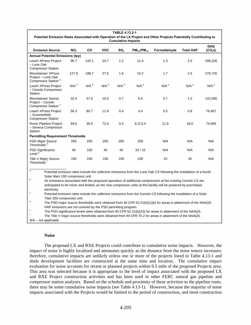
4-205
TABLE 4.13.2-1 Potential Emission Rates Associated with Operation of the LX Project and Other Projects Potentially Contributing to
Cumulative Impacts
Emission Source NOx CO VOC SO2 PM2.5/PM10 Formaldehyde Total HAP GHG
(CO2e)
Annual Potential Emissions (tpy)
Leach XPress Project – Lone Oak Compressor Station
96.7 142.1 20.7 1.2 11.4 1.3 2.0 208,108
Mountaineer XPress Project – Lone Oak Compressor Station a
127.9 188.7 27.5 1.6 15.2 1.7 2.5 276,725
Leach XPress Project – Ceredo Compressor Station
N/A b N/A b N/A b N/A b N/A b N/A b N/A b N/A b
Mountaineer Xpress Project – Ceredo Compressor Station c
32.4 57.0 19.3 0.7 6.4 0.7 1.0 122,595
Leach XPress Project – Summerfield Compressor Station
56.3 80.7 11.9 0.4 4.0 0.5 0.8 76,407
Rover Pipeline Project – Seneca Compressor Station
94.6 35.5 72.6 0.5 6.3/ 6.4 11.9 18.0 74,969
Permitting Requirement Thresholds
PSD Major Source Thresholds d
250 250 250 250 250 N/A N/A N/A
PSD Significance Level e
40 100 40 40 10 / 15 N/A N/A N/A
Title V Major Source Thresholds f
100 100 100 100 100 10 25 N/A
____________________
a Potential emission rates include the collective emissions from the Lone Oak CS following the installation of a fourth Solar Mars 100 compressor unit. b Air emissions associated with the proposed operation of additional compression at the existing Ceredo CS are anticipated to be minor and limited, as the new compressor units at this facility will be powered by purchased electricity. c Potential emission rates include the collective emissions from the Ceredo CS following the installation of a Solar Titan 250 compressor unit. d The PSD major source thresholds were obtained from 40 CFR 52.21(b)(1)(b) for areas in attainment of the NAAQS. HAP emissions are not covered by the PSD permitting program. e The PSD significance levels were obtained from 40 CFR 52.21(b)(23) for areas in attainment of the NAAQS. f The Title V major source thresholds were obtained from 40 CFR 70.2 for areas in attainment of the NAAQS. N/A – not applicable
Noise
The proposed LX and RXE Projects could contribute to cumulative noise impacts. However, the impact of noise is highly localized and attenuates quickly as the distance from the noise source increases; therefore, cumulative impacts are unlikely unless one or more of the projects listed in Table 4.13-1 and shale development facilities are constructed at the same time and location. The cumulative impact evaluation for noise accounts for recent or planned projects within 0.5 mile of the proposed Projects area. This area was selected because it is appropriate to the level of impact associated with the proposed LX and RXE Project construction activities and has been used in other FERC natural gas pipeline and compressor station analyses. Based on the schedule and proximity of these activities to the pipeline route, there may be some cumulative noise impacts (see Table 4.13-1). However, because the majority of noise impacts associated with the Projects would be limited to the period of construction, and most construction

4-206
activities would occur during daytime hours and be intermittent rather than continuous, the proposed contribution from the LX and RXE Projects to cumulative noise impacts would primarily be for only short periods of time when the construction activities are occurring at a given location.
Operation of the CSs would contribute long-term, localized noise impacts within 1 mile of each station. Potential noise impacts associated with past and present actions did not require further analysis as a part of the cumulative impacts assessment because any impacts from those actions have been documented in the baseline sound surveys conducted at the LX and RXE project sites from January 2015 through August 2015. Therefore, the contribution of the LX and RXE projects in addition to these actions is included in the pre-construction noise studies for each of the new and/or modified above ground facilities (compressor stations, regulator stations, and odorization stations). The following is a summary of the cumulative noise impact evaluation.
Table 4.13-1 indicates the following projects would include the installation of new natural gas powered CS(s) or additional compression to existing facilities within 1 mile of the LX or RXE Project CSs (noise sources from the planned projects that are beyond a 1-mile radius are not listed):
Columbia Gas Transmission, LLC - Mountaineer XPress Project:- one natural gas compressor unit would be installed at the Lone Oak CS, and an existing natural gas compressor unit would be replaced with a new electric compressor unit at the Ceredo CS (both are components of LX); and
Columbia Gulf Transmission, LLC - Gulf XPress Project: - additional horsepower would be installed at the Grayson CS (a component of RXE).
Operation of the projects listed above may result in cumulative noise impacts. However, implementation of best-management practices, engineering controls, and the mitigation proposed for the LX and RXE projects in Section 4.11.2.3, Operational Noise Impacts and Mitigation, would minimize noise impacts for the proposed project. In addition, construction and operation of other FERC-jurisdictional projects would be required to adhere to similar noise requirements and mitigations measures as the Project. This would mean that when the impacts of the proposed LX and RXE projects are added to the impacts from other identified projects, the cumulative impacts would be minimal.
Climate Change 4.13.5.11
Climate change is the change in climate over time, whether due to natural variability or as a result of human activity, and cannot be represented by single annual events or individual anomalies. For example, a single large flood event or particularly hot summer are not indications of climate change, while a series of floods or warm years that statistically change the average precipitation or temperature over years or decades may indicate climate change.
The Intergovernmental Panel on Climate Change (IPCC) is the leading international, multi-governmental scientific body for the assessment of climate change. The United States is a member of the IPCC and participates in the IPCC working groups to develop reports. The leading U.S. scientific body on climate change is the U.S. Global Change Research Program (USGCRP). Thirteen federal departments and agencies33 participate in the USGCRP, which began as a presidential initiative in 1989 and was mandated by Congress in the Global Change Research Act of 1990.
33 The following departments comprise the USGCRP: EPA, DOE, U.S. Department of Commerce, U.S. Department of
Defense, USDA, U.S. Department of the Interior, U.S. Department of State, PHMSA, Department of Health and Human Services, National Aeronautics and Space Administration, National Science Foundation, Smithsonian Institution, and Agency for International Development.

4-207
The IPCC and USGCRP have recognized that:
globally, GHGs have been accumulating in the atmosphere since the beginning of the industrial era (circa 1750);
combustion of fossil fuels (coal, petroleum, and natural gas), combined with agriculture and clearing of forests is primarily responsible for this accumulation of GHG;
these anthropogenic GHG emissions are the primary contributing factor to climate change; and
impacts extend beyond atmospheric climate change alone, and include changes to water resources, transportation, agriculture, ecosystems, and human health.
In May 2014, the USGCRP issued a report, Climate Change Impacts in the United States, summarizing the impacts that climate change has already had on the United States and what projected impacts climate change may have in the future (USGCRP, 2014). The report includes a breakdown of overall impacts by resource and impacts described for various regions of the United States. Although climate change is a global concern, for this cumulative analysis, we will focus on the potential cumulative impacts of climate change in the LX and RXE Project areas.
The USGCRP’s report notes the following observations of environmental impacts with a high or very high level of confidence that may be attributed to climate change in the Midwest region:
average temperatures have risen about 1.5 °F between 1900 and 2010 and are projected to increase another 4 to 5 °F over the next several decades;
an increase in health risks due to projected additional heat stress and poor air quality;
the agricultural crop growing season has lengthened since 1950 and is projected to continue lengthening due to the earlier occurrence of the last spring freeze, potentially increasing crop production in the short-term;
increased temperature stress, wetter springs, and the continued occurrence of springtime cold air outbreaks are projected may reduce crop yields overall in the long-term (particularly corn and soybeans);
a change in range and/or elevation is projected for many tree species with potential declines in paper birch, quaking aspen, balsam fir, and black spruce and increases in oaks and pines;
tree species in flat terrain may have difficultly migrating the long distances needed to reach temperatures suitable for the species, resulting in some potential decline in forests;
increased insect outbreaks, forest fire, and drought may result in increased tree mortality and the reduction in beneficial carbon sinks;
annual precipitation has increased by about 20 percent over the past century, particularly from increased high intensity rainfall events, and this trend is projected to continue;
surface water temperatures in the Great Lakes have increased several degrees between 1968 and 2002, and are projected to increase by about 7 to 12 degrees by the end of the century; and
increased surface water temperatures, increased precipitation, and longer growing seasons are projected to result in an increase in blue-green and toxic algae in the Great Leaks, harming fish and reducing water quality.