Embed Size (px)
Citation preview
Environmental Management Framework for the Olifants and Letaba River Catchment Areas : Draft Report on the
Status Quo, Opportunities, Constraints and the Desired State : July 2009
____________________________________________________________________________________________
84
4. THE BIOLOGICAL ENVIRONMENT
4.1 VEGETATION
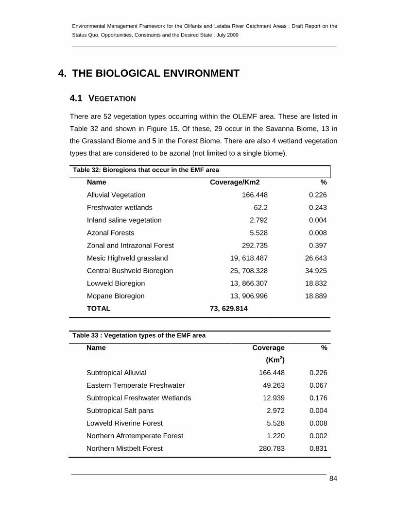
There are 52 vegetation types occurring within the OLEMF area. These are listed in
Table 32 and shown in Figure 15. Of these, 29 occur in the Savanna Biome, 13 in
the Grassland Biome and 5 in the Forest Biome. There are also 4 wetland vegetation
types that are considered to be azonal (not limited to a single biome).
Table 32: Bioregions that occur in the EMF area
Name Coverage/Km2 %
Alluvial Vegetation 166.448 0.226
Freshwater wetlands 62.2 0.243
Inland saline vegetation 2.792 0.004
Azonal Forests 5.528 0.008
Zonal and Intrazonal Forest 292.735 0.397
Mesic Highveld grassland 19, 618.487 26.643
Central Bushveld Bioregion 25, 708.328 34.925
Lowveld Bioregion 13, 866.307 18.832
Mopane Bioregion 13, 906.996 18.889
TOTAL 73, 629.814
Table 33 : Vegetation types of the EMF area
Name Coverage
(Km 2)
%
Subtropical Alluvial 166.448 0.226
Eastern Temperate Freshwater 49.263 0.067
Subtropical Freshwater Wetlands 12.939 0.176
Subtropical Salt pans 2.972 0.004
Lowveld Riverine Forest 5.528 0.008
Northern Afrotemperate Forest 1.220 0.002
Northern Mistbelt Forest 280.783 0.831

Environmental Management Framework for the Olifants and Letaba River Catchment Areas : Draft Report on the
Status Quo, Opportunities, Constraints and the Desired State : July 2009
____________________________________________________________________________________________
85
Sand Forest 6.736 0.009
Ironwood Dry Forest 3.986 0.005
Rand highveld Grassland 6, 027.493 8.186
Eastern Highveld Grassland 6, 264.644 8.508
Lydenburg Montane Grassland 2, 122.306 2.882
Sekhukhune Montane Grassland 1, 381.194 1.876
Leolo Summit Sourveld 20.344 0.028
Lydenburg Thornveld 1, 207.783 1.640
Northern Escarpment Dolomite Grassland 449.866 0.611
Northern Escarpment Quartzite Sourveld 654.765 0.889
Northern Escarpment Afromontane Fynbos 8.108 0.011
Woodbush Granite Grassland 331.682 0.450
Wolkberg Dolomite Grassland 260.845 0.354
Strydpoort Summit Sourveld 184.877 0.251
Soweto Highveld Grassland 704.580 0.957
Central Sandy Bushveld 7 906.648 10.738
Loskop Mountain in Bushveld 2, 044.407 2.777
Loskop Thornveld 759.911 1.032
Springbokvlakte 5, 341.311 7.254
Makhado Sweet Bushveld 370.419 0.503
Polokwane Plateau Bushveld 1147.280 1.558
Mamabolo Mountain Bushveld 395.141 0.537
Poung Dolomite Mountain Bushveld 846.795 1.150
Ohrigstad Mountain Bushveld 1, 998.128 2.714
Sekhukhune Plains Bushveld 2, 522.240 3.425
Sekhukhune Mountain Bushveld 2, 316.118 3.146
Marikana Thornveld 1.456 0.002
Gold Reef Mountain Bushveld 58.474 0.079
Makuleke Sandy Bushveld 512.620 0.696
Northern Libombo Bushveld 548.704 0.745
Nwambyia-Pumbe Sandy Bushveld 94.438 0.1283

Environmental Management Framework for the Olifants and Letaba River Catchment Areas : Draft Report on the
Status Quo, Opportunities, Constraints and the Desired State : July 2009
____________________________________________________________________________________________
86
Granite Lowveld 8, 470.518 11.504
Tshokwane-Hlane Basalt Lowveld 463.240 0.629
Gabbro Grassy Bushveld 219.909 0.299
Gravelotte Rocky Bushveld 309.489 0.420
Tzaneen Sour Bushveld 3, 123. 146 4.242
Legogote Sour Bushveld 124.243 0.169
Limpopo Ridge Bushveld 0.463 0.0006
Cathedral Mopane Bushveld 180.633 0.245
Mopane Basalt Shrubland 2, 761.235 3.750
Tsende Mopaneveld 5, 274.542 7.164
Lowveld Rugged Mopaneveld 3, 154.105 4.284
Phalaborwa-Timbavati Mopaneveld 2, 225.556 3.023
Mopane Gabbro Shrubland 310.462 0.422
TOTAL 73, 29.814
Abbreviated descriptions of the vegetation types are included below.

Environmental Management Framework for the Olifants and Letaba River Catchment Areas : Draft Report on the
Status Quo, Opportunities, Constraints and the Desired State : July 2009
____________________________________________________________________________________________
87
Figure 15: Vegetation

Environmental Management Framework for the Olifants and Letaba River Catchment Areas : Draft Report on the
Status Quo, Opportunities, Constraints and the Desired State : July 2009
____________________________________________________________________________________________
88
4.1.1 Cathedral Mopane Bushveld (SVmp3)
The vegetation type is a moderately closed savanna. Savanna is characterised by
extensive cover of grasses with scattered trees. There are tall shrubs in the
understorey. The upper canopy is seldom closed and the vegetation occurs on flats
or gentle slopes.
4.1.2 Central Sandy Bushveld (SVcb 12)
This vegetation occurs in low areas, sometimes between mountains and sandy
plains. It supports tall, deciduous26 woodlands. It contains two endemic species a
grass and a herb. Rural communities heavily populate much of the area in the broad
arc south of the Springbokvlakte. Several alien plants are widely scattered but often
at low densities.
4.1.3 Eastern Highveld Grassland (Gm12)
This vegetation type occurs on slightly to moderately undulating27 planes, including
some low hills and pan depressions. The vegetation is short dense grassland
dominated by the usual highveld grass composition. There are small, scattered rocky
outcrops with, wiry sour grasses and some woody species. Some 44% transformed
primarily by cultivation, plantations, mines, urbanisation and by building of dams. No
serious alien invasions are reported.
4.1.4 Eastern Temperate Fresh Water Wetlands (AZf 3)
This vegetation type occurs on flat landscapes or shallow depressions filled with
water bodies. It supports aquatic vegetation as well as vegetation adapted for growth
in damp or wet environment of the temporary flooded grasslands. There are five
species endemic to this area.
26 Deciduous means a plant, which sheds its leaves each year. 27 Undulating means moving up and down like waves or forming a series of regular curves.

Environmental Management Framework for the Olifants and Letaba River Catchment Areas : Draft Report on the
Status Quo, Opportunities, Constraints and the Desired State : July 2009
____________________________________________________________________________________________
89
4.1.5 Gabbro Grassy Bushveld (SVI 6)
This vegetation type is an open savanna with a dense grass cover. There are a few
scattered trees and shrubs. Sparser grass cover is encountered on shallow soils.
Very little is transformed and erosion is low.
4.1.6 Gold Reef Mountain Bushveld (SVcb 9)
The vegetation occurs on rocky hills and ridges often west-east trending with more
dense woody vegetation often on the south-facing slopes associated with distinct
floristic differences. Tree cover elsewhere is variable. Tree and shrub layers are often
continuous. Grasses are dominant on the lower layers. Some areas have dense
stands of alien plants. There are two endemic plant species, including one Aloe
species, which occur in this area.
4.1.7 Granite Lowveld (SVI 3)
The vegetation type represents tall shrubland with few trees to moderately dense
low woodland on the deep sandy uplands. Dense thicket to open savanna occurs in
the bottomlands. More than 20% is already transformed, mainly by cultivation and
by settlement development. Erosion is very low to moderate.
4.1.8 Gravelotte Rocky Bushveld (SVI 7)
The vegetation consists of open deciduous to semi-deciduous woodland on rocky
slopes and steep sided hills composed predominantly of hard rock and rising abruptly
above a plain. The vegetation contrasts strongly with the surrounding plains, and is
not conserved in statutory conservation areas. Conservation of this unit is promoted
due to the land use of game and cattle ranching and due to its low agronomic
potential. Erosion is very low to moderate. This area contains one endemic small
tree species.
4.1.9 Ironwood Dry Forest (FOz 9)
This vegetation type occurs on moderate to steep mountain slopes (up to 22°),
forming dense forests (sometimes called ‘thicket’) dominated by Lebombo Ironwood
which may build a closed canopy reaching up to 10 m. The adjacent bushveld

Environmental Management Framework for the Olifants and Letaba River Catchment Areas : Draft Report on the
Status Quo, Opportunities, Constraints and the Desired State : July 2009
____________________________________________________________________________________________
90
communities are often sharply demarcated from the forest. There is a tall shrub
species endemic to this area.
4.1.10 Legogote Sour Bushveld (SVI 9)
The vegetation type occurs on gently to moderately sloping upper pediment slopes28
with dense woodland including many medium to large shrubs Short thicket occurs
on less rocky sites. Exposed granite outcrops have low vegetation cover. It has
been greatly transformed, mainly by plantations and also cultivated areas and urban
development. There are scattered alien plants throughout the area and one
endemic Aloe species.
4.1.11 Leolo Summit Sourveld (Gm 20)
The vegetation occurs on summit plateaus on major mountain ranges with steep
slopes. Large boulders and stones cover the shallow soils on the hillsides and
plateau. Dense, sour grassland occurs on the high-altitude upper slopes and summit
of the mountain; scattered clumps of trees and shrubs occur in sheltered, rocky
habitats on the plateau. There are seventeen species of endemic importance that
grow within this area.
Although sparsely populated, very little of the Grassland Biome on the Leolo
Mountains has remained undisturbed due to the extensive subsistence agriculture.
Threatened by the mining of granite for dimension stone. Although the moist summit
of the Leolo Mountains has important value as a water source to the surrounding
arid valleys, it has never been regarded as a conservation priority. Erosion is very
high.
4.1.12 Limpopo Ridge Bushveld (SVmp 2)
The vegetation occurs on extremely irregular plains with ridges and hills. Moderately
open savanna with poorly developed ground layer. These are particularly striking
landscapes with rock walls and passages within areas of sandstone of the Clarens
28 Pediment slope means a broad gently sloping bedrock surface with low relief that is situated at the base of a steeper slope and is usually thinly covered with alluvial gravel and sand.

Environmental Management Framework for the Olifants and Letaba River Catchment Areas : Draft Report on the
Status Quo, Opportunities, Constraints and the Desired State : July 2009
____________________________________________________________________________________________
91
Formation (e.g. within the Mapungubwe National Park). Very little is transformed,
mainly for cultivation and mining.
4.1.13 Loskop Mountain Bushveld (SVcb 13)
The vegetation occurs on low mountains and ridges with open tree savanna on
lower-lying areas and a denser broad-leaved tree savanna on lower slopes and
midslopes. Grasses dominate the herbaceous layer is. Cultivation and urban and
built-up areas transform a small percentage of the vegetation. Erosion is mostly very
low to low. There are two species endemic to this area.
4.1.14 Loskop Thornveld (SVcb 14)
The vegetation type occurs in valleys and plains of parts of the upper Olifants River
catchment. Open, deciduous to semi-deciduous, tall, thorny woodland. About a
quarter of the area is already transformed, mainly for agricultural crops requiring
irrigation. Winter crops are the most common. Alien plants have invaded various
parts of this area.
4.1.15 Lowveld Riverine Forest (FOa 1)
It is tall forests fringing larger rivers (gallery forests) and water pans. These forests
are dense and tall, structured into several tree layers and with a well-developed
dense shrub layer. An unknown portion has been irreversibly transformed by
clearing for cultivation. Aliens species are serious invaders in places. Agricultural
malpractices upstream, building of dams and excessive water extraction for
agriculture and mining as well as local exploitation for timber and non-timber forest
products are serious threats to this vegetation.
4.1.16 Lowveld Rugged Mopaneveld (SVmp 6)
It occurs on irregular plains sometimes steep with slopes and prominent hills. It is
usually composed of dense shrubs with occasional trees and a sparse ground layer.
About 20% already transformed mainly by cultivation and some built up areas. This
vegetation occurring outside the conserved areas is under pressure from high-

Environmental Management Framework for the Olifants and Letaba River Catchment Areas : Draft Report on the
Status Quo, Opportunities, Constraints and the Desired State : July 2009
____________________________________________________________________________________________
92
density rural human populations and associated urban sprawl and agricultural
activities.
4.1.17 Lydenburg Montane Grasslands (Gm 18)
The vegetation occurs on high-altitude plateaus, undulating plains, mountain peaks
and slopes, hills and deep valleys, supporting predominantly very low grasslands on
the high-lying areas. Height of the grass increases on the lower slopes. The
grassland is very rich in broad-leaved herb species. Level of transformation is
relatively high with mostly alien plantations and cultivated lands.
4.1.18 Lydenburg Thornveld (Gm 21)
The vegetation occurs at lower levels at the foot of the mountains and on undulating
plains. This is open, frost-hardy woodland. Structurally it comprises closed grasslands
which is almost always wooded, sometimes densely so in rocky areas and less so in
frost-ridden valleys. Part of it has been transformed, mainly by dryland and irrigated
cultivation. Rainfall is generally too low for plantations. There are three endemic
species growing in this area.
4.1.19 Makhado Sweet Bushveld (SVcb 20)
The vegetation type occurs on slightly to moderately undulating plains sloping
generally down to the north with some hills in the southwest. It is a short and shrubby
bushveld with a poorly developed grass layer. Part of the area has densly populated
rural communities. Erosion is low to high. There is one endemic species in this area.
4.1.20 Makuleke Sandy Bushveld (SVI 1)
It occurs on variable landscapes from low mountains, slightly to extremely irregular
plains to hills. Tree savanna (or tall shrubs in places) occurs on the deep sands, and
a moderate to dense ground layer. On stony soils the tree savanna and ground layer
and dominated by different species than on the deep sands. Partly transformed,
mostly through cultivation. Erosion is moderate to high in places. This area has three
endemic species.

Environmental Management Framework for the Olifants and Letaba River Catchment Areas : Draft Report on the
Status Quo, Opportunities, Constraints and the Desired State : July 2009
____________________________________________________________________________________________
93
4.1.21 Mamabolo Mountain Bushveld (SVcb 24)
It occurs on low mountains, lower slopes of Strydpoort and Makapan ranges, and on
rocky hills. Slopes are moderate to steep, and very rocky, covered by small trees and
shrubs. Rock slabs or domes are sparsely vegetated, and then mostly with a mixture
of xerophytic29 or resurrection plants, with several succulents. Land uses include
grazing wood harvesting and medicinal plant collecting. There are alien species
growing in the area. Two endemic succulent shrubs grow in this area.
4.1.22 Marikana Thornveld (SVcb 6)
An open Acacia karroo woodland, occurring in valleys and slightly undulating plains,
and some lowland hills. Shrubs are more dense along drainage lines, and rocky
outcrops or in other places protected from fire. Considerably impacted, with 48%
transformed, mainly cultivated and urban or built up areas. Near Pretoria, industrial
development is a greater threat of land transformation. Alien invasive plants occur
localised in high densities, especially along the drainage lines.
4.1.23 Mopane Basalt Shrubland (SVmp 4)
It occurs mainly on plains and slightly undulating plains with medium-low (1-2 m)
shrubs dominated overwhelmingly by a mulistemed shrub form of Mopane Tree forms
of Mopane are rare. The grass layer is well developed. Vegetation consists of three
main variations depending on topographical position. Conserved in the Kruger
National Park.
4.1.24 Mopane Gabbro Shrubland (SVmp 8)
The vegetation occurs on slightly irregular to slightly undulating landscape with
numerous outcrops of gabbro30. Mainly a low shrub layer with two main structural
variations: a shrubveld with practically no trees and a shrubveld with a few larger
shrubs and trees. Species diversity is the highest in the latter variation. The ground
layer of both variations is dense.
29 Xerophytic means a plant adapted to living in a dry arid habitat. 30 Gabbro means a usually coarse-grained igneous rock composed chiefly of calcic plagioclase and pyroxene.

Environmental Management Framework for the Olifants and Letaba River Catchment Areas : Draft Report on the
Status Quo, Opportunities, Constraints and the Desired State : July 2009
____________________________________________________________________________________________
94
4.1.25 Northern Afrotemperate Forest (FOz 2)
It is low, relatively species-poor forests of afromontane31 origin and some of them still
showing clear afromontane character. Occasional hot fires encroaching from the
surrounding savanna woodlands, uncontrolled timber extraction, medicinal-plant
harvesting, and grazing in forest can be viewed as the current major threats. There
are four endemic species growing in this area.
4.1.26 Northern Escarpment Afromontane Fynbos (Gm 24)
The dominant structural form of the vegetaion type is shrubland comprised of shrubs
with thick leathery evergreen foliage that retains water and herbs, many with stress
tolerant fungal growth forms. It occurs in fragmented patches of high-lying quartzite
ridges that experience frequent mist. Terrain is very rocky and fires are very rare. The
landscape is rugged and soils shallow, therefore very little transformation has
occurred.
4.1.27 Northern Escarpment Dolomite Grassland (Gm 22)
It is a very species-rich grasslands that occur along the Escarpment dolomite belt.
The grasslands are characterised by a very diverse shrub layer, which varies in
height and density. The herbaceous component becomes more dense northwards as
the climate becomes drier. More than half has been transformed mainly by
plantations and cultivated lands. Very little is currently protected.
4.1.28 Northern Escarpment Quartzite Sourveld (Gm 23)
The landscape where the vegetation occurs is characteristically very rugged, with
steep east-facing cliffs. This escarpment is intersected in some areas with large east-
flowing rivers. It is a short, closed grassland rich in broad-leaved herb species with
scattered trees and shrubs. This area is very rocky and occurs on weather-resistant
quartzite. The nutrient-poor soils lead to lower biomass, which, together with the
rocky landscape, results in a reduced frequency and intensity of fires. Mainly
31 Afromontane means the plant and animal species common to the mountains of Africa.

Environmental Management Framework for the Olifants and Letaba River Catchment Areas : Draft Report on the
Status Quo, Opportunities, Constraints and the Desired State : July 2009
____________________________________________________________________________________________
95
plantations have transformed a large portion of this area. There are seventy
endemically important species growing in this area, including an Aloe and Protea.
4.1.29 Northern Lebombo Bushveld (SVI 16)
It is open bushveld on rocky slopes and ridges of a linear range of hills reaching
about 100 m (and higher in places) above its surrounding basalt plains towards the
west. Tree succulents are typical on steep, stony slopes. There has been virtually no
transformation.
4.1.30 Nothern Mistbelt Forest (FOz 4)
It consists of tall, evergreen afrotemperate mistbelt forests occurring primarily in east-
facing fire refugia where they form small fragmented patches. The herb layer supports
a number of dominating herbs and so called ‘soft shrubs’, geophytic herbs and ferns.
Encroaching subsistence agriculture, firewood collection in communal areas, and
selective harvesting of bark are viewed as serious threats.
4.1.31 Nwambyia-Pumbe Sandy Bushveld (SVI 2)
It occurs on flats with several small pans embedded. The absence of well-defined
drainage channels is conspicuous. Moderately open tall shrubland with few trees.
Three endemic species of plants grow in this area.
4.1.32 Ohrigstad Mountain Bushveld (SVcb 26)
It is an open to dense woody layer, with associated woody and herbaceous shrubs
and closed to open grass layer. The vegetation occurs on moderate to steep slopes
on mountainsides and sometimes deeply incised valleys; also fairly flat terrain in a
few places. Aliens are scattered throughout the area. Erosion is variable. There are
five endemic species in this area.
4.1.33 Phalaborwa-Timbavati Mopaneveld (SVmp 7)
It is an open tree savanna on undulating plains with the sandy uplands dominated by
different trees than the clayey bottomlands. The field layer is usually well developed.
A feature is the large number of termite mounds on the uplands.

Environmental Management Framework for the Olifants and Letaba River Catchment Areas : Draft Report on the
Status Quo, Opportunities, Constraints and the Desired State : July 2009
____________________________________________________________________________________________
96
4.1.34 Polokwane Plateau Bushveld (SVcb 23)
It occurs on moderately undulating plains with a short open tree layer and with a well-
developed grass layer to grass plains with occasional trees at higher altitudes. Hills
and low mountains of Mamabolo Mountain Bushveld are embedded within this unit.
Dense concentration of rural human settlements is found. In some regions
populations of alien species are of concern.
4.1.35 Poung Dolomite Mountain Bushveld (SVcb 25)
It is open to closed woodland with well-developed shrub layers and occur on low to
high mountain slopes on various slope angles, aspects and altitude, especially along
the western extension. There are approximately twenty important endemic species
growing in this area.
4.1.36 Rand Highveld Grassland (Gm 11)
The vegetation type occurs on a highly variable landscape with extensive sloping
plains and a series of ridges slightly elevated over undulating surrounding plains. The
vegetation is species-rich, wiry, sour grassland alternating with low, sour shrubland
on rocky outcrops and steeper slopes. There is a high diversity of herbs. Rocky hills
and ridges carry sparse (savannoid) woodlands accompanied by a rich suite of
shrubs. Poorly conserved, only small patches protected. Almost half has been
transformed mostly by cultivation, plantations, urbanisation or dam-building. There
are thirteen endemic species growing in this area.
4.1.37 Sand Forest (FOz 8)
Dense thickets of 5-6 m up to forests with the canopy reaching 15 m with a well
developed shrub layer and a very poorly developed ground layer. Epiphytic orchids
and lichens festoon all the tall trees. It is critically endangered due to its vulnerability
and economic pressure. An unknown portion was lost through clearing for
subsistence agriculture and grazing. Uncontrolled extraction of wood for fuel and
woodcraft is a problem. Twenty-seven species that grow in this area are of endemic
importance.

Environmental Management Framework for the Olifants and Letaba River Catchment Areas : Draft Report on the
Status Quo, Opportunities, Constraints and the Desired State : July 2009
____________________________________________________________________________________________
97
4.1.38 Sekhukhune Montane Grassland (GM 19)
It occurs on major chains of hills that transect the area and have a north-south
orientation, creating moderately steep slopes with predominantly eastern and western
aspects. Large norite32 boulders and stones cover the shallow soils on the hillsides.
Dense, sour grassland occur on slopes of mountains and undulating hills, with
scattered clumps of trees and shrubs in sheltered habitats. Dense, tall grassland is
found on the plains and encroachment by indigenous or invasion by alien small-
leaved tree species is common in places. Approximately 30% of this area is under
commercial or subsistence cultivation. Vast areas are mined for vanadium using strip
mining. There is no formal conservation in the area.
4.1.39 Sekhukhune Mountain Bushveld (SVcb 28)
It is dry, open to closed small-leaved and broad-leaved savanna on hills and
mountain slopes. Open bushveld often associated with soils containing a group of dark-
colored minerals, composed chiefly of magnesium and iron on southern aspects. Bushveld
on this type of soil contain a high diversity of species influenced by the soil rather than by
the climate. Bushveld of mountain slopes generally taller than in the valleys, with a
well-developed herb layer. Bushveld of valleys and dry northern aspects usually
dense, like thicket, with a herb layer comprising many shortlived perennials. Dry
habitats contain a number of species with xerophytic adaptations, such as succulence
and underground storage organs. Both man-made and natural erosion dongas occur
on footslopes of clays rich in heavy metals. An increasing area along the Dwars River
Subsuite is under pressure from mining activities and its associated urbanisation.
There are thirteen endemic species growing in this area.
4.1.40 Sekhukhune Plains Bushveld (SVcb 27)
It occurs mainly on semi-arid plains and open valleys between chains of hills and
small mountains running parallel to the escarpment. Predominantly short, open to
close thornveld with an abundance of Aloe species and other succulents. Heavily
degraded in places and overexploited by man for cultivation, mining and urbanisation.
32 Norite means a granular crystalline rock consisting essentially of a triclinic feldspar (as labradorite) and hypersthene.

Environmental Management Framework for the Olifants and Letaba River Catchment Areas : Draft Report on the
Status Quo, Opportunities, Constraints and the Desired State : July 2009
____________________________________________________________________________________________
98
Both man-made and natural erosion dongas occur in areas containing clays rich in
heavy metals. Encroachment by indigenous small-leaved trees and invasion by alien
species is common throughout the area. There is a high level of degradation of much
of the remaining vegetation by unsustainable harvesting and utilisation. There are
twelve endemically important species growing in this area.
4.1.41 Soweto Highveld Grassland (Gm 8)
It occurs on gently to moderately undulating landscape on the Highveld plateau,
supporting short to medium-high, dense, tufted grassland. In places not disturbed,
only scattered small wetlands, narrow stream alluvia, pans and occasional ridges or
rocky outcrops interrupt the continuous grassland cover. Only a handful of patches
statutorily conserved or privately conserved. Almost half of the area already
transformed by cultivation, urban sprawl, mining and building of road infrastructure.
Dams have flooded some areas.
4.1.42 Springbokvlakte Thornveld (SVcb 15)
An open to dense, low thorn savanna dominated by Acacia species or shrubby
grassland with a very low shrub layer. Occurs on flat to slightly undulating plains. Very
scattered alien plants over wide areas. There is one central bushveld endemic
species growing in this area.
4.1.43 Strydpoort Summit Sourveld (Gm 27)
It consists of short to tall grasslands along rocky summits and mountain slopes. The
landscape has a very broken topography with incised valleys. The slopes are steep
and rocky, and sparsely wooded. Transformation levels are very low. There are ten
endemically important species growing in this area, including Aloes and Proteas.
4.1.44 Subtropical Alluvial Vegetation (AZa 7)
It occurs on flat alluvial33 riverine terraces supporting and intricate complex of large
vegetation (channel of flowing rivers and river-fed pans), marginal reed belts (in
sheltered oxbows and along very slow-flowing water courses) as well as extensive
33 Alluvial means made of clay, sand, or dirt washed by flowing water.

Environmental Management Framework for the Olifants and Letaba River Catchment Areas : Draft Report on the
Status Quo, Opportunities, Constraints and the Desired State : July 2009
____________________________________________________________________________________________
99
flooded grasslands, short lived herblands and riverine thickets. Much of the area has
been transformed for cultivation, urban development and road building. Alien woody
species commonly occur in this vegetation.
4.1.45 Subtropical Freshwater Wetlands (AZf 6)
It occurs on flat topography supporting low beds dominated by reeds, sedges and
rushes, waterlogged meadows dominated by grasses. Found typically along edges of
often seasonal pools in depressions formed by the erosion or deposition of weathered
surface materials by wind, as well as fringing alluvial backwater pans or artificial
dams. So far only about 4% has been transformed (largely for cultivation), but the
pressure of local grazing a urban sprawl will result in the demise of many subtropical
fresh water habitats. Disturbance leads to invasion by alien plants. There are sixteen
important endemic species growing in the southern most distribution limit of this area.
4.1.46 Subtropical Salt Pans (AZi 11)
It occurs in shallow depressions, often found on old alluvial terraces of rivers,
surrounded by zones of bank reeds or low herblands and in more perennial pans also
filled with a dense carpet of macrphytic floating vegetation. Aliens plants invade
edges of some pans. Alien species are dominant in some Lowveld pans when filled
with water.
4.1.47 Tsende Mopaneveld (SVmp 5)
It occurs on slightly undulating plains with medium-high shrubby savanna, with some
trees and dense ground layer. In the northwest parts the tree cover is greater and,
together with the southern and northeastern outliers of the unit, these flatter
landscapes include several trees. Some 63% statutorily conserved, almost all in the
Kruger National Park.
4.1.48 Tshokwane-Hlane Basalt Lowveld (SVI 5)
It usually occurs on fairly flat plains with open tree savanna with a moderately
developed shrub layer and a dense herbaceous layer. On some sloping areas with

Environmental Management Framework for the Olifants and Letaba River Catchment Areas : Draft Report on the
Status Quo, Opportunities, Constraints and the Desired State : July 2009
____________________________________________________________________________________________
100
shallower soils, trees are stunted. About 64% statutorily conserved, mainly in the
Kruger National Park. One endemic species grows in this area.
4.1.49 Tzaneen Sour Bushveld (SVI 8)
Deciduous, tall open bushveld (parkland) with a well-developed, tall grass layer,
occurring on low to high mountains with undulating plains mainly at the base of, and
on the lower to middle slopes of the northeastern escarpment. Very little currently
conserved. Mainly cultivation and plantations transform about 41%. Scattered alien
plants include occur throughout the area. The subtropical climate is conductive to the
spread of certain alien plants. Erosion is variable.
4.1.50 Wolkberg Dolomite Grassland (Gm 26)
It occurs on a series of broad mountain ridges, broad elevated plateaus and adjacent
slopes covered with species-rich short closed grasslands rich in forbs34. About half of
this unit is formally protected within the Bewaarkloof and Lekgalameetse Nature
Reserves and well as the Wolkberg Wilderness Area. There are at least ten
endemically important species growing on this area, including a Protea.
4.1.51 Woodbush Granite Grassland (Gm 25)
It consists of mountainous plateaus covered by grassland, showing increased low-
shrub density on steep south- and east-facing slopes. Only about 10% of this area is
still in its natural state. There are no conservation areas protecting patches of this
unit. Major land transformation is mainly due to forestry. Alien plants frequently grow
in this area. The vegetation is subject to bush encroachment (from both scrub forest
and sour bushveld) exacerbated by exclusion of fire.
34 Forb speices means a broad-leaved herb other than a grass.
Environmental Management Framework for the Olifants and Letaba River Catchment Areas : Draft Report on the
Status Quo, Opportunities, Constraints and the Desired State : July 2009
____________________________________________________________________________________________
101
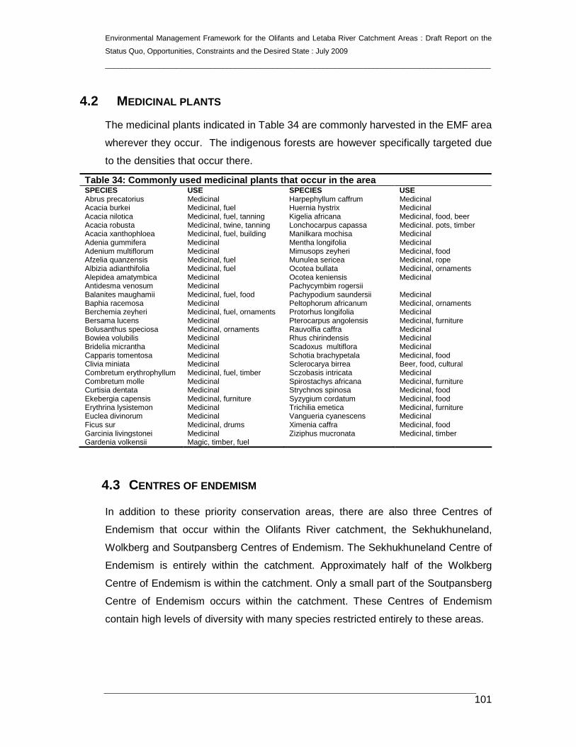
4.2 MEDICINAL PLANTS
The medicinal plants indicated in Table 34 are commonly harvested in the EMF area
wherever they occur. The indigenous forests are however specifically targeted due
to the densities that occur there.
Table 34: Commonly used medicinal plants that occur in the area SPECIES USE SPECIES USE Abrus precatorius Medicinal Harpephyllum caffrum Medicinal Acacia burkei Medicinal, fuel Huernia hystrix Medicinal Acacia nilotica Medicinal, fuel, tanning Kigelia africana Medicinal, food, beer Acacia robusta Medicinal, twine, tanning Lonchocarpus capassa Medicinal. pots, timber Acacia xanthophloea Medicinal, fuel, building Manilkara mochisa Medicinal Adenia gummifera Medicinal Mentha longifolia Medicinal Adenium multiflorum Medicinal Mimusops zeyheri Medicinal, food Afzelia quanzensis Medicinal, fuel Munulea sericea Medicinal, rope Albizia adianthifolia Medicinal, fuel Ocotea bullata Medicinal, ornaments Alepidea amatymbica Medicinal Ocotea keniensis Medicinal Antidesma venosum Medicinal Pachycymbim rogersii Balanites maughamii Medicinal, fuel, food Pachypodium saundersii Medicinal Baphia racemosa Medicinal Peltophorum africanum Medicinal, ornaments Berchemia zeyheri Medicinal, fuel, ornaments Protorhus longifolia Medicinal Bersama lucens Medicinal Pterocarpus angolensis Medicinal, furniture Bolusanthus speciosa Medicinal, ornaments Rauvolfia caffra Medicinal Bowiea volubilis Medicinal Rhus chirindensis Medicinal Bridelia micrantha Medicinal Scadoxus multiflora Medicinal Capparis tomentosa Medicinal Schotia brachypetala Medicinal, food Clivia miniata Medicinal Sclerocarya birrea Beer, food, cultural Combretum erythrophyllum Medicinal, fuel, timber Sczobasis intricata Medicinal Combretum molle Medicinal Spirostachys africana Medicinal, furniture Curtisia dentata Medicinal Strychnos spinosa Medicinal, food Ekebergia capensis Medicinal, furniture Syzygium cordatum Medicinal, food Erythrina lysistemon Medicinal Trichilia emetica Medicinal, furniture Euclea divinorum Medicinal Vangueria cyanescens Medicinal Ficus sur Medicinal, drums Ximenia caffra Medicinal, food Garcinia livingstonei Medicinal Ziziphus mucronata Medicinal, timber Gardenia volkensii Magic, timber, fuel
4.3 CENTRES OF ENDEMISM
In addition to these priority conservation areas, there are also three Centres of
Endemism that occur within the Olifants River catchment, the Sekhukhuneland,
Wolkberg and Soutpansberg Centres of Endemism. The Sekhukhuneland Centre of
Endemism is entirely within the catchment. Approximately half of the Wolkberg
Centre of Endemism is within the catchment. Only a small part of the Soutpansberg
Centre of Endemism occurs within the catchment. These Centres of Endemism
contain high levels of diversity with many species restricted entirely to these areas.

Environmental Management Framework for the Olifants and Letaba River Catchment Areas : Draft Report on the
Status Quo, Opportunities, Constraints and the Desired State : July 2009
____________________________________________________________________________________________
102
4.3.1 Wolkberg Centre Endemism
The exact size of the Wolkberg Centre flora is unknown, but the area is extremely
floristically rich. More than 40 species ore endemic/near endemic to the dolomites
and more than 90 to the quartz- and shale-derived substrates. These figures are
conservative, with more taxa likely to be added as knowledge of the flora improves.
The three families with the largest number of endemics on the quartzitic and related
rock types are the Asteraceae, Iridaceae and Liliaceae. The asteraceous genus
Helichrysum with 10 species being the most prolific in producing endemics.
Gladiolus has more than ten species endemic to the region as a whole. The
Liliaceae is the family with the largest number of dolomite endemics to the region as
a whole, followed by the Euphorbiaceae, Lamiaceae and Acanthaceae. For mosses,
the Wolkberg Centre is one of the main southern African centres of diversity and a
secondary centre of endemism.
Significantly, nearly all the endemics (notably the quartzitic ones) are grassland
species. Most of the taxa endemic to the Wolkberg Centre appear to be
palaeoendemics.
The Wolkberg Centre, especially the arid dolomite areas, shares many species with
the adjacent Sekhukhuneland Centre, several of which are endemic to the
combined region.
The high-rainfall grasslands of the Wolkberg Centre are seriously threatened by
mainly commercial afforestation. It is ironic that efforts to conserve the flora of the
Wolkberg Centre have hitherto focused mainly on the protection of the patches of
floristically poor Afromontane Forest, the endemic-rich grasslands are being allowed
to be destroyed at an alarming rate, particularly by the timber industry. The little
grassland that remains is also being threatened by invader alien plants (mainly from
plantations) as well as lack of frequent burning, particularly in plantation areas.
Frequent fires are essential for maintaining grassland structure and phytodiversity.
Less than 1% of the montane grasslands, the vegetation type richest in Wolkberg
Centre endemics, is conserved.
The Wolkberg Centre remains botanically poorly explored and new species are still
being discovered, even in relatively well-collected areas.

Environmental Management Framework for the Olifants and Letaba River Catchment Areas : Draft Report on the
Status Quo, Opportunities, Constraints and the Desired State : July 2009
____________________________________________________________________________________________
103
4.3.2 Sekhukhuneland Centre Endemism
The vegetation of the Sekhukhuneland Centre has never been studied in detail. It is
usually mapped as Mixed Bushveld. However, floristically the bushveld of
Sekhukhuneland Centre is quite unique and certainly deserves recognition as a
separate type. The Kirkia wilmsii, a species that is relatively rare in other parts of the
Mixed Bushveld is a characteristic tree of this area. Vegetation differences between
the north- and south-facing aspects of the mountains are often striking. Intriguing
vegetation anomalies associated with heavily eroded soils are present throughout
the region.
The flora of the Sekhukhuneland Centre is still poorly known, with many apparently
endemic species awaiting formal description. Families particularly rich in
Sekhukhuneland Centre endemics include the Anacardiaceae, Euphorbiaceae,
Liliaceae, Lamiaceae and Vitaceae. A still-to-be-described monoptypic genus of the
Alliaceae is endemic also. The area around Burgersfort is reputed to have the
highest concentration of Aloe species in the world.
There is only one official nature reserve in the Sekhukhuneland Centre, namely
Potlake Nature Reserve. Owing to the ruggedness of the terrain, however, the
mountainous parts of the Sekhukhuneland Centre are still fairly intact. Overgrazing
by domestic livestock has seriously degraded the vegetation in the densely
populated areas. Population pressure is also impacting negatively on the flora of the
Steelpoort River Valley.
The Leolo Mountains harbour relic patches of Afromontane Forest, Fynbos-type
vegetation and several Sekhukhuneland Centre endemics. There are also some
rare wetlands in the summit area.
There is a great need for closer taxonomic scrutiny of the taxa in the
Sekhukhuneland Centre to ensure the appropriate labelling of ecotypes and
endemic species. Botanically the Sekhukhuneland Centre remains one of the least
known parts of the former Transvaal.
There are a number of forest patches along the escarpment within the catchment.
These are considered to be sensitive and are also protected by law.
Other areas considered sensitive, but for which there is no detailed information
currently in map format include wetlands and Red List plant species. There are also

Environmental Management Framework for the Olifants and Letaba River Catchment Areas : Draft Report on the
Status Quo, Opportunities, Constraints and the Desired State : July 2009
____________________________________________________________________________________________
104
various parts of the catchment that occur within protected areas. The distribution of
protected areas relative to the catchment is shown in Figure 17.
4.4 THREATENED ECOSYSTEMS
Four vegetation types are listed as Critically Endangered, eight as Endangered and
eleven as Vulnerable.
Table 35: Conservation status of vegetation in the EMF area Vegetation type Biome Cons.
target Protected Remain Conservation
status Cathedral Mopane Bushveld
Savanna Biome 19% 100% 99.6% Least threatened
Central Sandy Bushveld
Savanna Biome 19% 2.4% (+2.2%) 75.9% Vulnerable
Eastern Highveld Grassland
Grassland Biome
24% 0.3% 56% Endangered
Eastern Temperate Freshwater Wetlands
Azonal Vegetation
24% 4.6% 85.1% Least threatened
Gabbro Grassy Bushveld
Savanna Biome 19% 95.9% (+3.7%) 99.6% Least threatened
Gold Reef Mountain Bushveld
Savanna Biome 24% 22.1% (+1.2%) 84.6% Least threatened
Granite Lowveld SavannaBiome 19% 17.5% (+17.3%) 79.2% Vulnerable Gravelotte Rocky Bushveld
Savanna Biome 19% 0% (+6.9%) 85.5% Least threatened
Ironwood Dry Forest Forests 100% 77.8% 99.9% Critically endangered Legogote Sour Bushveld
Savanna Biome 19% 1.6% (+2.3%) 50.4% Endangered
Leolo Summit Sourveld
Grassland Biome
24% See text Vulnerable
Limpopo Ridge Bushveld
Savanna Biome 19% 18.1% (+1.8%) 99.1% Least threatened
Loskop Mountain Bushveld
Savanna Biome 24% 14.5% (+1.9%) 97.6% Least threatened
Loskop Thornveld Savanna Biome 19% 11.3% 75.8% Vulnerable Lowveld Riverine Forest
Forests 100% 50% (+3%) 97.6% Critically endangered
Lowveld Rugged Mopaneveld
Savanna Biome 19% 34.4% (+5.6%) 80.2% Least threatened
Lydenburg Montane Grassland
Grassland Biome
24% 2.5% (+5.9%) 77.7% Vulnerable
Lydenburg Thornveld Grassland Biome
24% 1.9% 78.7% Vulnerable
Makhado Sweet Bushveld
Savanna Biome 19% 0.8% 72.8% Vulnerable
Makuleke Sandy Bushveld
Savanna Biome 19% 31.5% 73.3% Vulnerable
Mamabolo Mountain Bushveld
Savanna Biome 24% 7.6% 93.9% Least threatened
Marikana Thornveld Savanna Biome 19% 0.7% (+1.5%) 52.1% Endangered Mopane Basalt Savanna Biome 19% 100% 99.6% Least threatened

Environmental Management Framework for the Olifants and Letaba River Catchment Areas : Draft Report on the
Status Quo, Opportunities, Constraints and the Desired State : July 2009
____________________________________________________________________________________________
105
Shrubland Mopane Gabbro Shrubland
Savanna Biome 19% 100% 99.7% Least threatened
Northern Afrotemperate Forest
Forests 31% 28.8% (+2.8%) 98.5% Least threatened
Northern Escarpment Afromontane Fynbos
Grassland Biome
27% 56.1% (+5.8%) 99.3% Least threatened
Northern Escarpment Dolomite Grassland
Grassland Biome
27% 2.1% (+8.5%) 47.7% Endangered
Northern Escarpment Quartzite Sourveld
Grassland Biome
27% 15.3% (+9.2%) 61.6% Vulnerable
Northern Lebombo Bushveld
Savanna Biome 24% 98.8% 99.8% Least threatened
Northern Mistbelt Forest
Forests 30% 10% (+25.2%) 83.7% Least threatened
Nwambyia-Pumbe Sandy Bushveld
Savanna Biome 19% 98.7% 99.6% Least threatened
Ohrigstad Mountain Bushveld
Savanna Biome 24% 7.6% (+4.2%) 90.7% Least threatened
Phalaborwa-Timbavati Mopaneveld
Savanna Biome 19% See text 95.1% Least threatened
Polokwane Plateau Bushveld
Savanna Biome 19% 1.4% (+0.7%) 83.2% See text
Poung Dolomite Mountain Bushveld
Savanna Biome 24% 9.9% (+6.2%) 94.1% Least threatened
Rand Highveld Grassland
Grassland Biome
24% 0.9% 58.5% Endangered
Sand Forest Forests 100% 42.1% 98.5% Critically endangered Sekhukhune Montane Grassland
Grassland Biome
24% 72% Vulnerable
Sekhukhune Mountain Bushveld
Savanna Biome 24% (+0.4%) 86.3% Least threatened
Sekhukhune Plains Bushveld
Savanna Biome 19% 0.8% (+1%) 74.5% Vulnerable
Soweto Highveld Grassland
Grassland Biome
24% 0.2% 52.7% Endangered
Springbokvlakte Thornveld
Savanna Biome 19% 1% (+2.6%) 50.7% Endangered
Strydpoort Summit Sourveld
Grassland Biome
24% 17.2% (+1.7%) 99.4% Least threatened
Subtropical Alluvial Vegetation
Azonal Vegetation
31% See text 84.5% Least threatened
Subtropical Freshwater Wetlands
Azonal Vegetation
24% 40%-50% (+10.5%)
96.4% Least threatened
Subtropical Salt Pans Azonal Vegetation
24% 42% 89.5% Least threatened
Tsende Mopaneveld Savanna Biome 19% 63.3% (+4.8%) 88.4% Least threatened Tshokwane-Hlane Basalt Lowveld
Savanna Biome 19% 64.4% (+3.4%) 83.5% Least threatened
Tzaneen Sour Bushveld
Savanna Biome 19% 1.3% (+2.1%) 59.2% Endangered
Wolkberg Dolomite Grassland
Grassland Biome
27% 48.6% (+6.2%) 96.7% Least threatened
Woodbush Granite Grassland 27% 0% (+14.9%) See text Critically endangered

Environmental Management Framework for the Olifants and Letaba River Catchment Areas : Draft Report on the
Status Quo, Opportunities, Constraints and the Desired State : July 2009
____________________________________________________________________________________________
106
Grassland Biome
Figure 16a: Threatened ecosystems and centers of en demism (SANBI info)

Environmental Management Framework for the Olifants and Letaba River Catchment Areas : Draft Report on the
Status Quo, Opportunities, Constraints and the Desired State : July 2009
____________________________________________________________________________________________
107
Figure 16b: Threatened ecosystems and centers of en demism (including the
Mpumalanga Biodiversity Conservation Plan informati on)

Environmental Management Framework for the Olifants and Letaba River Catchment Areas : Draft Report on the
Status Quo, Opportunities, Constraints and the Desired State : July 2009
____________________________________________________________________________________________
108
4.5 CONSERVATION AND CONSERVATION TARGETS
Based on the conservation status of vegetation types, SANBI have identified areas
of high conservation priority. The intention of this priority map is to indicate areas in
need of immediate conservation effort. There may be other areas that have been
afforded high levels of protection which are also high in diversity or are sensitive and
deserve continued future protection.
The Park Interface Zones shows the areas outside a park within which landuse
changes could affect a national Park. The zones, in combination with guidelines, will
serve as a basis for a.) identifying the focus areas in which park management and
scientists should respond to EIA’s, b.) helping to identify the sort of impacts that
would be important at a particular site, and most importantly c.) serving as the basis
for integrating long term protection of a national park into the spatial development
plans of municipalities (SDF/IDP) and other local authorities. In terms of EIA
response, the zones serve largely to raise red-flags and do not remove the need for
carefully considering the exact impact of a proposed development. In particular, they
do not address activities with broad regional aesthetic or biodiversity impacts.
Mapungubwe National Park has three Park Interface Zone, categories (Map 6). The
first two are mutually exclusive, but the final visual/aesthetic category can overlay
the others.
4.5.1 Priority natural areas (park expantion areas)
This zone aims to ensure the long term persistence of biodiversity, within and
around the park, by identifying the key areas upon which the long term survival of
the park depends. This includes areas important to both biodiversity pattern
(especially reasonably intact high priority natural habitats) and processes (ecological
linkages, catchments, intact hydrological systems, etc.). This does not imply any loss
of existing rights (e.g. current agricultural activities or legal extractive biodiversity use
such as fishing) within the area, but rather aims to ensure the parks survival in a
living landscape.
Priority natural areas include areas identified for future park expansion as well as
reasonably natural areas of high biodiversity value which are critical for the long-
term persistence of biodiversity within the park. These include adjacent natural areas

Environmental Management Framework for the Olifants and Letaba River Catchment Areas : Draft Report on the
Status Quo, Opportunities, Constraints and the Desired State : July 2009
____________________________________________________________________________________________
109
(especially high priority habitats) which function as an ecologically integrated unit
with the park, as well as areas critical for maintaining ecological links and
connectivity with the broader landscape.
Inappropriate developments and negative land use changes (such as additional
ploughing of natural veld, development beyond existing transformation footprints,
urban expansion, intensification of landuse through golf estates etc) should be
opposed within this area. Developments with site specific impacts (e.g. a lodge on a
game farm) should be favourably viewed if they contribute to ensuring conservation
friendly land use within a broader area. Guidelines applicable for the Catchment
Protection Section would also apply to these areas.
4.5.2 Catchment protection areas
These are areas important for maintaining key hydrological processes (surface and
groundwater) within the park.
Within these areas inappropriate development such as dam construction, loss of
riparian vegetation, and excessive aquifer exploitation should be opposed. In
addition, the control of alien vegetation, the control of soil erosion, and appropriate
land care (e.g. appropriate stocking rates) should be promoted.
4.5.3 Viewshed protection areas
These are areas where developments could impact on the aesthetic quality of a
visitors experience in a park. This zone is particularly concerned with visual impacts
(both day and night), but could also include sound pollution.
Within these areas any development proposals should be carefully screened to
ensure that they do not impact excessively on the aesthetics of the park. The areas
identified are only broadly indicative of sensitive areas, as at a fine scale many areas
within this zone would be perfectly suited for development. In addition, major
projects with large scale regional impacts may have to be considered, even if they
are outside the Viewshed Protection Area.
4.5.4 Kruger to canyons biosphere reserve
The primary objectives of biosphere reserves are:

Environmental Management Framework for the Olifants and Letaba River Catchment Areas : Draft Report on the
Status Quo, Opportunities, Constraints and the Desired State : July 2009
____________________________________________________________________________________________
110
• The conservation of biological diversity;
• sustainable use of its components; and
• fair and equitable sharing of benefits arising from the utilization of genetic
resources (in accordance with the Convention on Biological Diversity).
Furthermore, a biosphere reserve is intended to fulfill three functions namely:
• Conservation - to preserve genetic resources, species, ecosystems and
• landscapes;
• development - to foster sustainable economic and human development; and
• logistic support - to support demonstration projects, environmental education
and training as well as research and monitoring related to local, national and
global issues of conservation and sustainable development.
A biosphere reserve is organised into the following three elements:
• Core areas - securely protected sites for conserving biological diversity,
monitoring minimally disturbed ecosystems, and undertaking non-destructive
research and other low-impact uses;
• buffer zones - surrounds or adjoins the core areas, and is used for co-operative
activities compatible with sound ecological practices, including environmental
education, recreation, ecotourism and applied and basic research; and
• transition areas - may contain a variety of agricultural activities, settlements and
other land uses.
In addition, biosphere reserves are placed to provide the means for people to attain
a balanced relationship with the natural world, to contribute to the needs of society,
and to show a way to a more sustainable future.
Biosphere reserves should be used to develop alternative means of livelihoods and
to conduct research, but in such a way that benefits should be shared with all
stakeholders. Activities in biosphere reserves should therefore create some direct
benefits to the people that live within the designated area.

Environmental Management Framework for the Olifants and Letaba River Catchment Areas : Draft Report on the
Status Quo, Opportunities, Constraints and the Desired State : July 2009
____________________________________________________________________________________________
111
Figure 17: Protected areas and conservation plannin g