Embed Size (px)
Citation preview

4th International Symposium on Flood Defence,6th – 8th May 2008, Toronto, Canada
Efficiency of distributed flood mitigation measures at
watershed scale
S.Chennua, J.-M.Grésillona, J.-B.Faurea, E.Lebloisa,
C.Poularda, D.Dartusb
a Cemagref, Lyon, France
b IMFT, Toulouse, France
24th International symposium on flood defence, 6 - 8 May 2008, Toronto
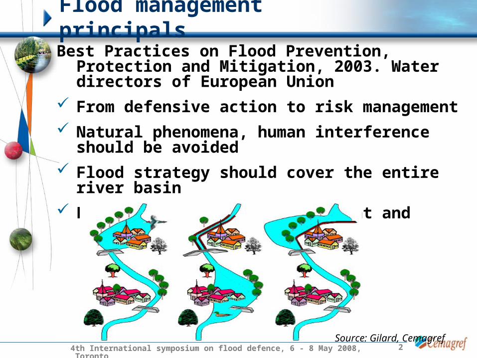
Best Practices on Flood Prevention, Protection and Mitigation, 2003. Water directors of European Union
From defensive action to risk management
Natural phenomena, human interference should be avoided
Flood strategy should cover the entire river basin
Promote coordinated development and management actions
Flood management principals
Source: Gilard, Cemagref

34th International symposium on flood defence, 6 - 8 May 2008, Toronto
What is the best strategy to protect dispersed zones of interest ?
Watershed scale : Complex structure
Drainage network, topography
Dispersed zones of interest
Uncoordinated flood defence transfers the problem from one region to another
Test and identify efficient flood mitigation strategies at watershed scale via modelling
Appropriate strategy :
1. Retaining 2. Storing 3. Draining
Flood management principals

44th International symposium on flood defence, 6 - 8 May 2008, Toronto
1. Approach
• Models
• Watershed
2. Application
• Calibration of models
• Construction of hydrological regime
• Dispersed mitigation measures
3. Results and discussions
4. Conclusions
Outline
54th International symposium on flood defence, 6 - 8 May 2008, Toronto
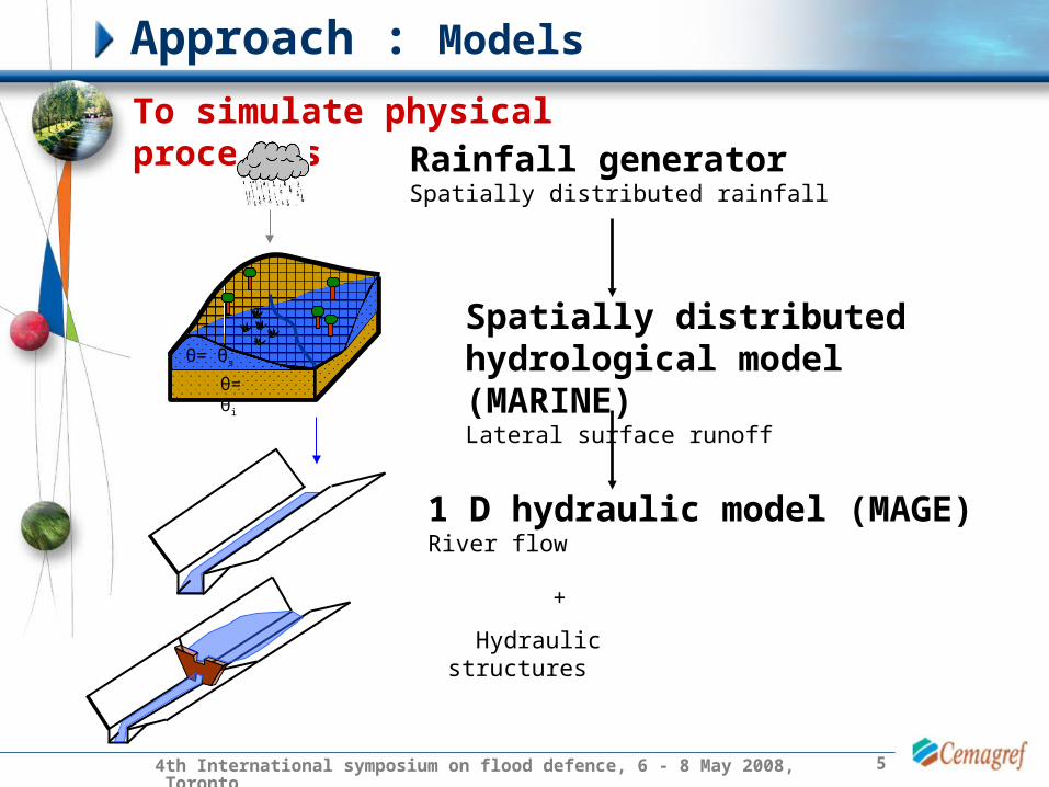
Approach : Models
To simulate physical processesRainfall generatorSpatially distributed rainfall
Spatially distributed hydrological model (MARINE)Lateral surface runoff
θ= θs
θ= θi
1 D hydraulic model (MAGE)River flow
+
Hydraulic structures

64th International symposium on flood defence, 6 - 8 May 2008, Toronto
Approach : Yzeron watershed
• 150 km², Altitude: 82 m – 915 m
• Tributaries: Yzeron and Charbonnières
• Densely populated at the downstream
• 5 discharge stations and 8 rain gauges

74th International symposium on flood defence, 6 - 8 May 2008, Toronto
Approximately 9000 rainfall events ( = 1000 years data)
~
Application : Calibration
Turning Bands Method (Mantoglou and Wilson, 1982)
Output : Spatially distributed rainfall fields respecting the statistical characteristics of local rainfall
Stochastic Rainfall generator : Cemagref, Lyon (Leblois, 2004)
Input : 12 years rainfall records from 5 rain gauges
In mm0
1 – 30
31 – 60
61 – 90
91 – 120
> 120
Example of a cumulated 24 hours rainfall event
Simulated events : • 3 hour time step• 72 hours• 500 m X 500 m grid

84th International symposium on flood defence, 6 - 8 May 2008, Toronto
MARINE : Event based spatially distributed model
IMFT, Toulouse (Estupina-Borrell, V., 2004)
Input : Topography, Drainage network, Land use, Soil texture and Soil depth, Soil humidity
Observed rainfall : uniformly distributed during calibration
Green-Ampt infiltration model (1911) and kinematic
wave theory for overland flow (Henderson and
Wooding, 1964)
Lateral surface runoffs along the watershed slope
Application : Calibration
Hydraulic model : route river flow

94th International symposium on flood defence, 6 - 8 May 2008, Toronto
MAGE : 1 D hydraulic model ,Cemagref, Lyon (Giraud, F.M. et al. 1997)
Input : Topography of drainage network, Roughness coefficient + Simulated lateral surface runoffs
Routes the simulated lateral surface runoffs along the drainage network to the outlet of the watershed
Application : Calibration
Shallow water Saint Venant (1870) and Manning – Strickler (1923) head loss equations
Calibrated November 1990 event

104th International symposium on flood defence, 6 - 8 May 2008, Toronto
Application : Calibration
TimeDis
char
ge
(m3 /
s)
Inflow design flood
But at watershed scale : Rainfall heterogeneity, Initial saturation condition, Drainage network
Hydrological regime scale
Simulated spatial rainfall fall inputs to construct a reference regime (Qref)

114th International symposium on flood defence, 6 - 8 May 2008, Toronto
Application : Construction of hydrological regime
4 control points representing zones of interest
Charbonnières amont
Craponne
Taffignon
Charbonnières aval
Reference regime (Qref = no dams) from stochastic rainfall scenarios of the rainfall simulator
Qref
T (yr)
Q (
m3 /
s)
T (yr)
Q (
m3 /
s)
T (yr)Q
(m
3 /s)
T (yr)
Q (
m3 /
s)
Introduction of dry dams for flood peak attenuation(Qdam)
Qdam

124th International symposium on flood defence, 6 - 8 May 2008, Toronto
Application : Dispersed mitigation measures
• Inflow design hydrograph : 10 yr, 50 yr, 100 yr …….
Outlet
Spillway
Normal flow
Dry dams
High flow
Qdam
• Outlet dimension: When the dam is full, outflow discharge(Qdam)
– Q2 (m3/s), Q10 (m3/s)…….
Qdam
Dry dam

134th International symposium on flood defence, 6 - 8 May 2008, Toronto
Application : Dispersed mitigation measures
Constant volume & equal weight for each placement
Outlet dimension : Qdam = 2 yrs return period (m3/s)
= storage volume of individual damsΣ 16 v i= Σ 1
3v i= Σ 12v i
~ ~
Upstream dams
Intermediate dams
Downstream dams

144th International symposium on flood defence, 6 - 8 May 2008, Toronto
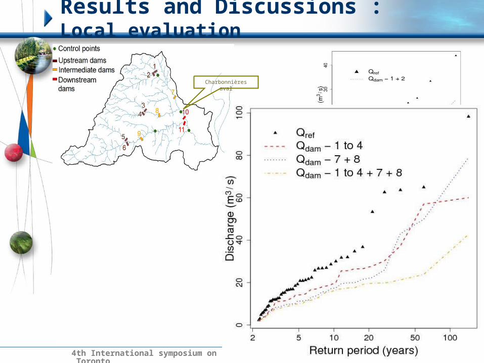
Results and Discussions : Local evaluationCharbonnières amont
154th International symposium on flood defence, 6 - 8 May 2008, Toronto
Results and Discussions : Local evaluation
Charbonnières aval

164th International symposium on flood defence, 6 - 8 May 2008, Toronto
Results and Discussions : Local evaluation
Craponne

174th International symposium on flood defence, 6 - 8 May 2008, Toronto
Results and Discussions : Local evaluation
Taffignon

184th International symposium on flood defence, 6 - 8 May 2008, Toronto
Results and Discussions : Spatial evaluation
Mitigation factor :M = (Qref - Qdam) / Qref * li / L
Dry dams
1 to 6(Upstream)
7 to 9 (Intermediate
)
10 to 11 (Downstream)
1 to 11 (All dams)
Mitigation factor
0.0225 0.0088 0.0039 0.0348
• Maximum mitigation assured in the presence of all the dams (high storage volume)
• Upstream dams protect a large region compared the intermediate and downstream dams
• Downstream dams protect only a limited reach length
For a rare event (100 years return period)

194th International symposium on flood defence, 6 - 8 May 2008, Toronto
Conclusions
Dispersed flood management strategy to protect dispersed zones of interest
Importance of working at regime scale and not just test one design flood
Well defined efficiency range of mitigation strategy beyond which no attenuation is possible
Upstream mitigation measures protect a large region compared to downstream measures
For the given event the upstream dry dams assured a major contribution to flood mitigation

204th International symposium on flood defence, 6 - 8 May 2008, Toronto
Thank you for your attention


![3D Modeling and Watershed Delineation of Flood …sciaeon.org/articles/3D-Modeling-and-Watershed...3D flood mapping is effective for risk management [6]. (Jain, Saraf, Goswami, & Ahmad,](https://img.dokumen.tips/doc/110x75/5f7644c45d055073f7396a08/3d-modeling-and-watershed-delineation-of-flood-3d-flood-mapping-is-effective.jpg)

![Flood Risk Review Meeting: [Watershed Name]](https://img.dokumen.tips/doc/110x75/5681615f550346895dd0eac4/flood-risk-review-meeting-watershed-name-56cb8e5ebc6c2.jpg)


