Embed Size (px)
Citation preview
4. RETAIL PLAN

4. RETAIL PLAN

MXD INFILL DEVELOPMENT CONCEPT PLAN177
177
Retail will play an important role in helping to define the success of the Concept Plan by enlivening the streetscape and establishing the Project’s relationship with the surrounding community. The ground floors of all proposed buildings will be designed to accommodate functional active use space, which may include retail where appropriate. Further, buildings that are not part of the Concept Plan include 105 Broadway and 150 Broadway, which are contemplated in this plan as future potential retail in order to offer additional context to envision Broadway as a retail corridor.
The following goals will be pursued when designing the retail program:
• Locating retail in visible well-traveled areas that will help ensure its viability.
• Examining the broader market mix of current and proposed retail in Kendall Square to ensure that potential retailers are complementary of existing offerings
• Identifying retailers that can serve the diverse, 24/7 needs that come with a mixture of residential and commercial development from convenience and consumer service retail to place making dining offerings
• Selecting retailers with a viable business model and material operational experience
• Creating a retail program consistent with the requirements of Article 14
In order to realize the goals above, the Project as a whole needs to be designed to ensure retail is viable by directing major pedestrian and bicycle access corridors to and past proposed retail locations. This important design guideline will help reinforce the City’s chosen retail corridors along Broadway and Main Street, and create a dynamic and enlivened streetscape.
Further, the potential program needs to reflect the existing and newly proposed retail in other projects in Kendall Square to minimize programmatic redun-dancy and potential market conflicts. For example, it is commonly agreed that Kendall Square would benefit from a grocery store or pharmacy. As of the date of this amended submission, it is understood that the MIT NOMA SOMA project has secured a grocery store and is actively pursuing a pharmacy. Accordingly, the Concept Plan does not contemplate a grocery store or phar-macy at this time, as it would directly conflict and potentially impair the future success of the planned MIT grocery and pharmacy.
4.0 INTRODUCTIONCHAPTER UPDATESThe following section summarizes minor refinements to this Chapter since the Approved Concept Plan.
Existing Retail: The existing retail analysis has been updated to reflect the completion of the 88 Ames Street residential project, which will bring addi-tional retail opportunities, including but not limited to quick casual restaurants, coffee shops, a bank, and service retail that may potentially include a barber or florist.
Future Retail: As a component of the Project Change, Commercial Building B proposes to replace and reconstruct approximately 42,300 square feet of retail GFA, all or the majority of which will be located on the ground level, and one level above ground. A portion may remain at one level below ground. The Project Change will therefore not only result in a net increase of enhanced retail GFA as compared to the Approved Concept Plan, but all or the majority of the reconstructed retail space at 325 Main Street will be located above grade, making the retail space more attractive to potential tenants, and better activating the public realm and the existing retail corridor along Main Street and the Kendall Plaza. Refer to Section 4.2.6 for additional details on future retail associated with Commercial Building B at 325 Main Street.
Street Activation Approach: From a street activation standpoint, the ground and second floors of Commercial Building B will benefit from their frontage along both Main Street and Kendall Plaza as well as the close proximity to the MBTA Station, all of which contribute to the high volume of pedestrian traffic around the site. In addition, new or reimagined pedestrian connections to the Kendall Square Rooftop Garden and Pioneer Way will contribute to a vibrant public realm. Refer to Section 4.2.5 for a summary of the proposed street activation approach for Commercial Building B.

4. RETAIL PLAN178
The Kendall Square retail market is composed of a diverse mix of offerings, the majority of which are food and beverage establishments. In addition, the majority of the retailers in the area are local or independent, as opposed to national chains. The existing retail in and around Kendall Square can be divided into uniquely defined zones offering a different mix of tenants and retail experiences. This context will help inform the retail planning within the Project. Refer to Figure 4.1, District Existing Retail.
1. MAIN STREET
The area along Main Street in proximity to the Kendall Square MBTA Red Line stop is primarily composed of the MIT COOP, small service retailers as well as a mix of restaurant, bars and fast casual offerings split between local retailers and national chains. The restaurants are defined by a diversity of culinary offerings that serve the local neighborhood and visitors alike. In addition, Kendall Square features both boutique and national hotels. The MIT COOP bookstore currently located on the ground floor and basement levels of the 325 Main Street building will be temporarily relocated to 80 Broadway in early 2019 to accommodate the building’s redevelopment and will return once the new building is complete, at a reduced size reflective of the evolution of the space requirements of the textbook industry.
2. AMES STREET RETAIL
Ames Street retail should be considered as a new, lateral extension of Main Street retail. The completion of 88 Ames Street will bring additional quick casual restaurants, coffee shops, a bank, and service retail that may poten-tially include a barber or florist, that are additive to the offerings of Sebastians Cafe, Dumpling Daughter, Vester, and MeadHall, which exist today.
3. THIRD STREET AND BROAD CANAL WAY
This developing retail area features a mix of restaurants with abundant outdoor seating situated along a landscaped plaza.
4. ONE KENDALL SQUARE
The area around the mixed use One Kendall Square project includes a movie theater, mix of restaurants and a brew pub.
2
One Broadway, 14th Floor Cambridge, MA 02142
www.graffitosp.com (617) 401-2871
• heavy daytime density of 102,544 people within a 1-mile radius3 • 105 restaurants, shops and services in the immediate district • walk score of 81 and a bike score of 98 meaning consumers easily move through
the neighborhood and largely find what they want4
Although the metrics listed above are generally positive, Kendall Square remains a predominantly commercial district with 77% of responders to Cambridge Community Development Department Customer Intercept Survey from 2011 coming to Kendall Square primarily for work and visitors typically staying in the district for less than an hour. Vibrant mixed-use neighborhoods often attract and keep visitors far longer. An independent study by Graffito SP in 2015 identified approximately 105 unique, and mostly local, restaurants, shops and services in Kendall Square. As the below graphics illustrate, the retail storefronts in the neighborhood are heavily skewed towards local restaurants and bars. Furthermore, a limited supply of retail space reflects a low vacancy and increasing rents, mostly at key nodes like the Kendall/MIT T-Station. CHAIN VS. LOCAL MIX OF USES Kendall Square is predominantly restaurants and services because it lacks a strong residential base. Nights and weekends can be very slow. Consumers do not associate Kendall Square with a shopping district like Harvard Square or Central Square. The retail environment here developed out of necessity; people have to eat and wish to socialize out of the office. In addition, consumer-shopping habits have changed with more purchases made online than ever before. The next evolution of Kendall Square includes a more diverse grouping of neighborhood amenities likes a grocery store and pharmacy, as well as entertainment options like bowling, music, etc. that draw night and weekend traffic.
3 United States. Cambridge Economic Development Division. Kendall Square: Market Profile. Cambridge: Community Development Department, 2015. Print. 4 "Kendall Square Neighborhood in Cambridge." Walk Score. N.p., 2015. Web. 22 Dec. 2015.
*The graphics and analysis above are provided by Graffito SP
4.1 EXISTING RETAIL
5. CAMBRIDGESIDE GALLERIA (SEE FIG 4.3)
The nearby Cambridgeside Galleria is a traditional anchored retail mall with established national chains offering apparel, electronics, consumer goods and fast casual dining.

4
3
2
1
One Kendall Square
MXD INFILL DEVELOPMENT CONCEPT PLAN179
179
Binney St
Main St
Broadway
Fulk
erso
n S
t
Six
th S
t
Fifth
St
Third
St
Rogers St
Linskey Way
Athenaeum St
Potter St
Munroe StAm
es S
t
Sec
ond
St
Gal
ileo
Gal
ilei W
ay
MIT
MXD BoundaryKSURP Boundary
Existing Retail Retail Under Construction
Existing Retail Under Reconstruction *The graphics and analysis above are provided by Graffito SP
DISTRICT EXISTING RETAIL FIGURE 4.1

4. RETAIL PLAN180
For clarity, the following potential retail spaces are not formally part of the Concept Plan. Both spaces are currently leased to long term tenants with no plans to convert their ground floors to retail uses. However, in the interest of long term planning and context, they are presented as potential future retail spaces to help further the understanding of how Broadway could evolve into a more active retail corridor..
3. 105 BROADWAY
The ground floor space shown at 105 Broadway on the Future Retail Exhibit offers context for where potential retail and active uses could be located. While 105 Broadway benefits from pedestrian traffic along Broadway and the 6th Street connector, the potential future retail would be elevated above the street. The challenges of visibility and code compliant access would have to be addressed in future design.
4. 150 BROADWAY
The potential future retail space at 150 Broadway benefits from visibility along both Broadway and Galileo Galilei Way as well as immediate access to the Danny Lewin Park. Similar to 105 Broadway the finished floor elevations would be located above the street elevation presenting access and visibility chal-lenges that would need to be addressed.
The following descriptions of potential retail and active use space attempts to offer context to the future retail program for long range planning purposes. The market conditions, retail concepts and needs of the Cambridge community will evolve between the time of this submission and the delivery of physical, ready to lease, retail space. Refer to Figure 4.2, Future Retail Plan.
1. COMMERCIAL BUILDING A (145 BROADWAY)
145 Broadway contains two active use spaces that could accommodate retail uses. The larger, approximately 7,000 GFA space is located on the corner of Broadway and Galileo with potential entrances and visibility on both streets. The space could be maintained as one retail suite or subdivided into two or more smaller retail suites offering a range of flexible configurations. The space will be designed with the necessary infrastructure to include a restaurant or bar, as well as dry good uses to allow for programmatic flexibility. Potential uses could include restaurant and/or bars including casual dining options, consumer service retail and dry goods. The eastern side of the building con-tains one, smaller retail space consisting of approximately 1,700 GFA facing Broadway park. This space will benefit from proximity and connection to the proposed park and potential uses could include, but are not limited to, a café or coffee shop, fast casual restaurant space and convenience retail potentially including a sundry store, barber shop or salon.
2. COMMERCIAL BUILDING B (325 MAIN STREET)
The redeveloped 325 Main Street building contains approximately 42,300 GFA of retail square footage, all or the majority of which will be located on the ground and second floors that could be subdivided in a variety of ways. A portion of the retail square footage may remain at one level below ground. With approximately half of the available square footage located on the ground and second levels, the frontage along both Main Street and the Kendall Plaza will be activated and offer opportunities for multiple retail entrances as well as retailers of varying size and type. One or more two-story retail spaces may be possible and, given the proximity to the Kendall Plaza, the use of outdoor connections such as outdoor seating and/or operable walls may be viable during the warmer months. An existing pedestrian connection from Kendall Plaza to Pioneer Way will be maintained through the ground floor, but could be reimagined if the retail programming followed a more “market-like” permeable model increasingly seen in urban areas. Potential uses could include restau-rants, entertainment/sporting venues and/or bars, including fast casual dining options, as well as consumer service retail and dry goods. The MIT COOP
4.2 FUTURE RETAIL PLAN4.2.1 TARGET RETAIL OPPORTUNITIES BY BUILDING:
4.2.2 POTENTIAL FUTURE RETAIL
bookstore currently located on the ground floor and basement levels of the 325 Main Street building will be temporarily relocated to 80 Broadway in early 2019 to accommodate the building’s redevelopment and will return once the new building is complete, at a reduced size reflective of the evolution of the space requirements of the textbook industry. Refer to Figure 4.2, Future Retail

43
2
1
MXD INFILL DEVELOPMENT CONCEPT PLAN181
181
Binney St
Broadway
Fulk
erso
n S
t
Six
th S
t
Fifth
St
Third
St
Rogers St
Linskey Way
Athenaeum St
Potter St
Munroe St
Ames
St
Sec
ond
St
Gal
ileo
Gal
ilei W
ay
MIT
One Kendall Square
Main St
Existing Retail Retail Under Construction
Future Potential RetailProposed Retail Proposed Retail By others
MXD BoundaryKSURP Boundary
FUTURE RETAIL PLAN FIGURE 4.2

4. RETAIL PLAN182
4.2.3 IMPLEMENTATION AND POINT OF CONTACT
The Applicant initially designates Michael Tilford, Project Manager Devel-opment, as the point of contact for monitoring and implementation of retail planning. He can be reached at [email protected]
4.2.4 INCENTIVES FOR LOCAL RETAIL
In an effort to ensure the goals outlined above and the requirements outlined in Article 14 for local and independent retailers, the Applicant may consider certain economic incentives depending on market conditions and the loca-tion of the space. The following economic incentives may be explored and included in a lease with a desirable local or independent retailer:
• Rent that is set below the market rent for national chains
• Flexible initial lease durations and extension options
• Tenant Improvement allowances
• Using a percentage of sales structure as part of the total rent
4.2.5 MONITORING
The Applicant will initially meet annually with the CRA and at least twice each year after the issuance of a building permit to discuss the retail market, new retail concepts, emerging local and independent retailers, and general leasing activity.
4.2.6 STREET ACTIVATION APPROACHCOMMERCIAL BUILDING A (145 BROADWAY) STREET ACTIVATION
The ground floor of 145 Broadway Street is designed with an emphasis on capitalizing on the close relationship the building has with the proposed Broadway Park, in addition to taking advantage of the relatively high volume of pedestrian traffic along the major public street conditions provided by Broadway Street and Galileo Galilei Way. The following items highlight the street activation approach:
• Ground level plaza to continue the public realm from Broadway Park along Broadway Street, wrapping around the corner to Galileo Galilei Way.
• Presence of the plaza will allow for the active use indoor program to spill outdoors.
• Presence of the plaza will allow for high visibility for the active use program.
• Active use space at the corner of Broadway and Galileo Galilei Way, with entry points along Galileo Galilei Way, will anchor the ground floor activity, activating the street corner.
• Service and loading is accessed along the northern side of the site, accessed from West Service Road, hidden away from major pedestrian paths and ground floor activity along Broadway.
• Use of transparency to maximize the visual connection between pedestri-ans and the active use spaces.
*ALL RENDERINGS ARE CONCEPTUAL, AND FOR DEMONSTRATIVE PURPOSES ONLY

MXD INFILL DEVELOPMENT CONCEPT PLAN183
183
LOOKING NORTHEAST TOWARDS ACTIVE USE ALONG GALILEO GALILEI WAY AND BROADWAY
LOOKING NORTHEST TOWARDS ACTIVE USE ALONG BROADWAY
ACTIVE USE ALONG BROADWAY, GALILEO GALILEI WAY AND BROADWAY PARK LOOKING NORTHWEST TOWARDS ACTIVE USE ALONG BROADWAY PARK

4. RETAIL PLAN184
RESIDENTIAL BUILDING NORTH (BLUE GARAGE) STREET ACTIVATION
The ground floor of Residential Building North has been designed to activate the streetscape fronting Binney Park through an active lobby as well as space dedicated to active use or retail. The following items highlight the street acti-vation approach:
• Presence of Binney Park will afford high visibility for the active use program.
• Binney Park will allow for the active use indoor program to spill outdoors.
• Service and loading function will occur along East Service Road, away from major pedestrian paths and ground floor activity along Binney Street.
• Use of transparency to maximize the visual connection between pedestrians and the active use spaces.
*ALL RENDERINGS ARE CONCEPTUAL, AND FOR DEMONSTRATIVE PURPOSES ONLY

MXD INFILL DEVELOPMENT CONCEPT PLAN185
185
LOOKING SOUTHEAST TOWARDS ACTIVE USE ALONG BINNEY PARK
ACTIVE USE ALONG BINNEY PARK

4. RETAIL PLAN186
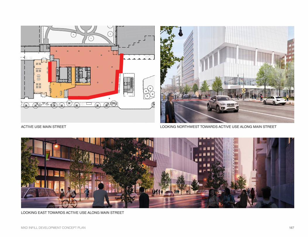
COMMERCIAL BUILDING B (325 MAIN STREET) STREET ACTIVATION
From a street activation standpoint, Commercial Building B will benefit from its frontage along both Main Street and Kendall Plaza, as well as the adjacency of the MBTA Station, all of which contribute to the high volume of pedestrian traffic around the Site. More direct and visually open retail frontage is antici-pated on the ground and second floors along Main Street and Kendall Plaza. In addition, new or reimagined pedestrian connections to the Kendall Square Rooftop Garden and Pioneer Way will contribute to a vibrant public realm. The following items highlight the street activation approach:
• Adjacency to Main Street and the Kendall Plaza will allow for high visibility for the active use program.
• Adjacency to the Kendall Plaza may allow the active use indoor program to “spill” outdoors visually or physically, potentially through outdoor seating and/or operable walls during warm seasons. Service and loading function will occur along East Service Road, away from major pedestrian paths and ground floor activity along Binney Street.
• Creation of a vertical connection from the Kendall Plaza to the Kendall Square Rooftop Garden will create activation and visual interest on the Plaza as well as provide a new and unique pedestrian connection between these public open spaces and new opportunities for public programming.
• Continued provision of a pedestrian connection from Kendall Plaza to Pioneer Way will contribute to permeability through the site and mainte-nance of important neighborhood connections.
• Location of the commercial building lobby at the western edge of the site ensures pedestrian activity along Main Street to and from the MBTA Station.
• Service and loading continues to be accessed below grade, away from major pedestrian paths and ground floor activity along Main Street.
• Use of transparency to maximize the visual connection between pedestri-ans and the active use spaces.
*ALL RENDERINGS ARE CONCEPTUAL, AND FOR DEMONSTRATIVE PURPOSES ONLYRETAIL - PRECEDENT IMAGES
MXD INFILL DEVELOPMENT CONCEPT PLAN187
187
LOOKING EAST TOWARDS ACTIVE USE ALONG MAIN STREET
ACTIVE USE MAIN STREET LOOKING NORTHWEST TOWARDS ACTIVE USE ALONG MAIN STREET

4. RETAIL PLAN188
BROADWAY
BROADWAY
POTENTIAL ACTIVE USE AT 105 BROADWAY
FUTURE ACTIVE USE AT 150 BROADWAY
105 BROADWAY & 150 BROADWAY STREET ACTIVATION
In addition to the proposed active use programming mentioned in previous sections, additional spaces in 105 Broadway and 150 Broadway were taken into consideration for a holistic view of the future of the retail environment. The inclusion of these two additional spaces as active use spaces will only serve to augment the vision of Broadway as an active retail corridor. These spaces are not included as part of this submission.
105 BROADWAY
• Potential opportunity to “book-end” public realm of the Broadway Park with an active use space, should this become viable at some point in the future.
• Close relationship to 6th Street Connector and outdoor space provided and the proposed active use space in 250 Binney Street Building.
• Opportunity to activate the corner of project parcel (at Broadway and 6th Street Connector).
150 BROADWAY
• Opportunity to create an active use and retail corridor “gateway” from corner of Galileo Galilei and Broadway.
• High visibility location being on two major public streets.

MXD INFILL DEVELOPMENT CONCEPT PLAN189
189
Main Street
EXAMPLE OF BIFOLD DOOR IN OPEN SETTING
CONCEPTUAL USE LAYOUT: POP UP CAFE255 MAIN STREET (IN PLANNING STAGES) STREET ACTIVATION
255 Main Street contains a void space consisting of approximately 1,000 GFA situated behind existing venting louvers that were formerly part of MBTA infra-structure. While the space benefits from its prominent location on Main Street, it is also shallower than a typical retail suite. Potential uses could include, but are not limited to, fast casual dining, gift shop or consumer service retail. This space will contribute to the innovation space requirements.
• Active use space on Main Street with outdoor seating that is adaptable to a variety of functions.
• Use of Awning or movable facade to reinforce tenant identity and program flexibility.
• Take advantage of existing pedestrian volumes and traffic.
*ALL RENDERINGS ARE CONCEPTUAL, AND FOR DEMONSTRATIVE PURPOSES ONLY

4
One Broadway, 14th Floor Cambridge, MA 02142
www.graffitosp.com (617) 401-2871
2. physical use – the complexities and expense of repositioning a retail asset can be significant, especially going from shop to restaurant
3. delivery condition – the overall condition of the Premises (i.e. utilities, conditioning, venting, etc.), can dramatically change the economics of a retail deal
4. size of the Premises – smaller spaces, especially near transit, often command higher prices because of higher demand and lower investment by tenant
note: rentable and useable square footage is often the same for retail tenants and discrepancies or lack of communication often cause issues
5. landlord investment – base building work and tenant improvement allowance, which ranges from $0-$150 per square foot in Kendall Square depending on the location and delivery conditions
6. union labor requirements – 25-30% cost increase to build union versus non-union has a huge impact on small independent operators and their ability to fund new projects
7. experienced operator – finding an operator who is proven and has an existing concept is always preferred, but overall underwriting of the Tenant and their ability to operate a business is key
8. overall deal economics – the above issues all impact one another and certain issues are more important to certain business owners based on prior experience
The Kendall Square retail market is rapidly emerging with retail corridors on Third Street, Broad Canal Way and Binney Street only activated in the past five years. Available retail space has largely been a product of new construction with the absorption of tens of thousands of square feet of new product over the past decade. GSP created a simple heat map of rents below showing the active retail corridors in Kendall Square and their corresponding rent ranges.
3
One Broadway, 14th Floor Cambridge, MA 02142
www.graffitosp.com (617) 401-2871
Diagram courtesy of CBT Architects
III. DEMOGRAPHICS The Kendall Square trade area is relatively small, but boasts a highly desirable demographic for retailers and restaurateurs seeking to establish their businesses here. The archetypal consumer living, working and visiting Kendall Square is young Caucasians, well-educated, employed, flush with disposable income and very conscious about where (and what) they spend their money on. According to the American Community Survey “ACS,” the most accurate and up-to-date census data from 2015, Kendall Square has the following demographic profile: Radius 1/2-Mile 1-Mile Residential Population 4,610 57,874 Avg. Household Income $91,251 $113,022 Median Age 31.2 31.5
Bachelor’s Degree (or higher) 79.7% 76.7% The City of Cambridge recently compiled much of the above data into a “Market Profile,” which they release annually for each commercial district in the City including Kendall Square. The major statistic not captured by the ACS census data is the daytime population, which is significant and worth noting. There are approximately 34,577 people within a half-mile radius of Kendall Square, which is represented in the above diagram as a 10-minute walk. Mostly workers, this subgroup makes up the majority of population patronizing the local businesses in the district. IV. ECONOMICS Modeling retail economics is generally far more challenging than traditional commercial deals because there are many variables to consider, such as:
1. location – proximity to public transit can heavily sway the price of real estate as you’ll notice in the below rent heat map
4. RETAIL PLAN190
4.3 ECONOMIC FEASIBILITY
KENDALL SQUARE BASE RENTS
2015 CENSUS DATA OF KENDALL SQUARE
With proximity to MIT and densely populated surrounding neighborhoods, existing Kendall Square retailers benefit from strong market fundamentals, proximity to diverse population groups and major infrastructure including:
• 22,000 students faculty and staff at MIT.
• Over 1,700 apartment homes within a 5 minute walk from Main Street.
• The Kendall MBTA Redline station.
• An average household income of $113,022 within a 1 mile radius.
• A residential population of 57,874 within 1 mile.
• A robust and diverse group of employers.
• A Walk Score of 81 and a bike score of 89 indicating broad and uninhibited circulation around the area.
While the local market has promising contributing elements, retail activity is largely concentrated on Main Street, Binney and Third Street and Broad Canal Way.
The retail surrounding the eastern portion of the Project immediately adjacent to Kendall Plaza is well established and offers the potential for a mixture of uses or single use that may complement both existing retail or retail planned for the NOMA and SOMA projects. See the previous description of 325 Main Street retail.
RETAIL MARKET OVERVIEW
*The graphics above were provided by Graffito SP
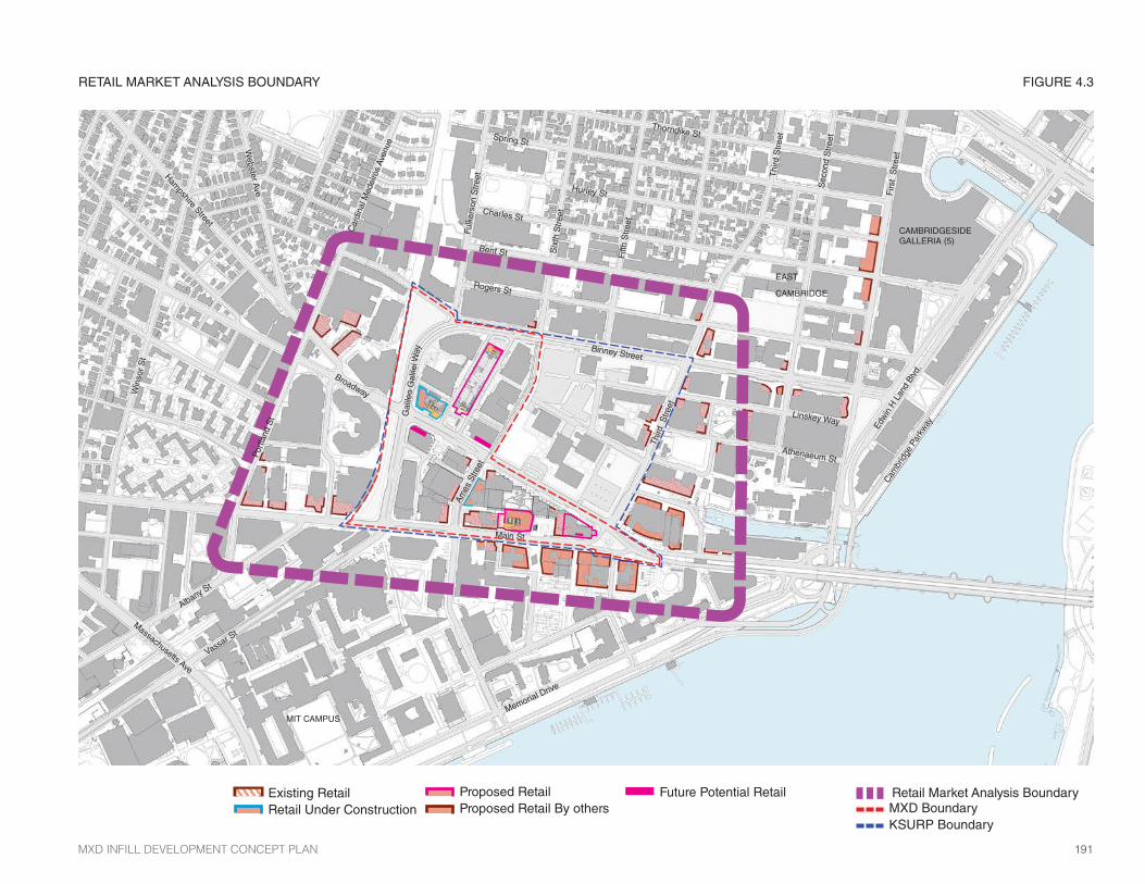
RETAIL MARKET ANALYSIS BOUNDARY FIGURE 4.3
MXD BoundaryKSURP Boundary
Retail Market Analysis Boundary
EAST
CAMBRIDGE
Vassar S
t
Albany St
Memorial Drive
Main St
Win
sor
St
Broadway
Hampshire Street
Webster A
ve
Car
dina
l Med
eiro
s Av
enue
Binney Street
Fulk
erso
n S
tree
t
Six
th S
tree
t
Fifth
Str
eet
Thi
rd S
tree
t
Third
Stre
et
Bent St
Charles St
Hurley St
Spring St
Thorndike St
Rogers St
Athenaeum St
Linskey Way
Ames
Stre
et
Firs
t S
tree
t
Edw
in H
Lan
d Bl
vd.
Cam
brid
ge P
arkw
ay
Sec
ond
Str
eet
Port
land
St
MIT CAMPUS
Gal
ileo
Gal
ilei W
ay
Massachusetts Ave
CAMBRIDGESIDE GALLERIA (5)
MXD INFILL DEVELOPMENT CONCEPT PLAN191
191
Existing Retail Retail Under Construction
Future Potential RetailProposed Retail Proposed Retail By others


5. TRANSPORTATION

5. TRANSPORTATION

5.0 INTRODUCTIONThis section describes the existing and proposed transportation conditions surrounding the Project Site and presents an overview of the Transportation Analyses conducted to assess potential traffic impacts associated with the Project Change. The original Transportation Impact Study (TIS) was submitted to the City of Cambridge Traffic, Parking, and Transportation (TP&T) Department on June 23, 2016 and certified as complete and reliable on July 14, 2016. In January 2017, VHB submitted an update to the transportation analysis that reflected changes in the proposed development program, which were documented by TP&T in a memo to the Planning Board dated January 11, 2017, in support of the Board’s approval of the Special Permit for the KSURP Project. The Notice of Decision (PB #315) approving the Original Concept plan was voted on January 17, 2017, and recorded with the City Clerk’s Office on March 20, 2017. Another TIS technical memorandum (“Tech Memo”) was submitted to the City’s TP&T Department on July 16th, 2018, providing an updated trip generation analysis and comparison, as well as an updated parking analysis, to reflect the current development program as documented in Section 1.4.
Refer to Appendix B for a copy of the TIS Certification, Special Permit TP&T Approval and most recent TIS Tech Update Memo from July 16th, 2018.
CHAPTER UPDATESThe following section summarizes minor refinements to this Chapter since the Approved Concept Plan.
• Bicycle Parking: The Project will deliver up to 685 covered and secure long-term bicycle parking spaces (52 space increase) and up to 122 short-term bicycle parking spaces (20 space increase)
• Vehicle Parking: The project will deliver up to 413 new vehicle parking spaces within the vicinity of the project throughout a combination of structured and valet/managed parking solutions (396 space decrease as compared to the Approved Concept Plan). A shared parking analysis was developed for the City’s TP&T staff, based on actual garage usage and information. The analysis indicates that the new parking supplied will provide enough parking to meet demand during the majority of the time, and with the implementation of the Traffic Demand Management (TDM) strategies outlined in this chapter, it is anticipated that parking supply will sufficiently serve the parking demand in the area.
MXD INFILL DEVELOPMENT CONCEPT PLAN 195

5. TRANSPORTATION196
5.1 CERTIFIED TIS OVERVIEW
As required by Section 14.32.2.1(5) of the zoning ordinance, a TIS was prepared for the Project in conformance with Section IV, “Guidelines for Presenting Information to the Planning Board” of the City of Cambridge “Transportation Impact Study Guidelines,” Sixth Revision dated November 28, 2011. The TIS responds to the Scoping Letter dated May 19, 2016 issued by the TP&T Department in response to a Request for Scoping dated April 19, 2016. A copy of the full TIS, including the City’s scoping letter (which is included in the TIS technical appendix) is provided in Appendix B. The TIS document consists of three components, as follows:
• Introduction and Project Overview, describing the framework in which the transportation component of this Project was evaluated;
• Transportation Impact Study, presenting the technical information and analysis results as required under the guidelines; and
• Planning Board Special Permit Criteria, summarizing the evaluation of the Project as defined under the guidelines.
The TIS includes inventories of physical and operational conditions in the study area including roadways, intersections, crosswalks, sidewalks, on-street and off-street parking, transit facilities, and land uses. Transportation data is presented, including automatic traffic recorder counts, intersection turning movement counts, pedestrian and bicycle counts, vehicle crash data, and transit service data. Traffic volumes were evaluated for a 2016 Theoretical Existing Condition, a 2016 Build Condition, and a 2021 Build Scenario Loading that include future background growth and other developments, as well as Project trips, and off-site roadway improvements. The required TIS Summary Sheets and Planning Board Criteria Performance Summary are included in Appendix B. The TIS analysis identified impacts that the Project will have on the transportation network and is used by the City to identify possible mitigation to offset these impacts. Applicant, the CRA and the City are continuing the process of developing and discussing the mitigation program associated with this Project. The TIS identified policies and programs that could potentially be implemented as Project mitigation.
A TIS technical memorandum (“Tech Memo”) was submitted to the City’s TP&T Department on July 16th, 2018, providing an updated trip generation analysis and comparison, as well as an updated parking analysis, to reflect the current development program as documented in Section 1.4. Refer to Appendix B of the Concept Plan Amendment for a copy of the full Tech Memo.
MXD INFILL DEVELOPMENT CONCEPT PLAN 197
5.2 KENDALL SQUARE TRANSIT ENHANCEMENT PROGRAM
The CRA and Applicant remain focused, as they have been throughout the development of Kendall Center, on preserving and enhancing the favorable transportation mode split in Kendall Square that has played such an important role in the successful redevelopment of the KSURP area. It is acknowledged and well-documented that approximately 70 percent of all trip making in Kendall Square utilizes transit, walking, biking, shuttle and carpool. This remarkable factor is at the core of the opportunity for the Project. The impor-tance of preserving and enhancing this condition cannot be overstated and is central to the CRA’s plans for expansion of the KSURP.
The CRA and Applicant, in conjunction with the City and State are committed to developing an expanded program of transportation enhancements designed to both preserve the favorable mode share balance in Kendall Square and provide additional improvements to support local efforts to further reduce the vehicle trips generated as a result of the Project and the broader Kendall Square area. The Kendall Square Transit Enhancement Program (KSTEP) has been developed in conjunction with the many stakeholders engaged in transportation planning and operations in Kendall Square, including the MBTA, MassDOT, and others.
The CRA and Applicant have engaged in multiple discussions with MassDOT and the MBTA regarding the Project, its impacts, and potential transportation mitigation and enhancements in the Kendall Square area. A range of issues have been identified and potential improvement opportunities considered for inclusion in the KSTEP. The KSTEP was designed to enhance access to and mobility around Kendall Square, which the CRA believes is critical to the long-term economic success of the area. The KSTEP focuses on major transportation initiatives that will improve the existing transit options, as shown in Figure 5.1, and services in Kendall Square. They include a range of projects, programs, and services directed at improving and enhancing transit and related options for people working, living, and visiting the Kendall Square area. The KSTEP focuses on enhancements to transit. Transit and transit-related improvements options to be considered include both capital and operational investments that result in service level improvements and capacity expansion in Kendall Square.
(KSTEP) TDM PLANThe CRA and Applicant recognize that implementation of the KSTEP requires detailed consideration and analysis of the enhancement alternatives as well as careful coordination with the stakeholders and service providers. The CRA believes that this analysis can be undertaken by a Working Group, which would include the CRA, Applicant, the MBTA, MassDOT and other stake-holders as may be designated. The analysis will be designed to coordinate with the City’s Transit Strategic Plan, which is focused on improving transit capacity and quality throughout the City. The CRA, in coordination with the City, will work with MassDOT and the MBTA to develop the elements of the KSTEP, which can be refined supplemented over time as the Working Group completes it work.
The KSTEP is supported by immediate and long-term funding commitments facilitated by the CRA and Applicant in connection with the approvals for the Project. It is the expectation of the CRA that consultations with the MBTA, MassDOT, and the City will continue to examine a range of potential transit improvements for Kendall Square to be included in the KSTEP and on the appropriate mechanism(s) for making commitments for these improvements and incorporating the program elements into the transportation planning processes at the City and state level. The CRA recognizes the extensive demands and limited resources available to MassDOT and the MBTA for service improvements throughout the system.
The CRA has developed a Memorandum of Understanding (MOU) with MassDOT and the MBTA, together with Applicant and the City, as a mecha-nism to identify and implement appropriate transit improvements consistent with the KSTEP. The MOU was signed by the stakeholders on May 9, 2017.
As provided in the MOU, the funding for the KSTEP Fund will be provided through an Initial Payment in the sum of six million dollars ($6,000,000). The Working Group shall meet to decide on recommendations for initial funding allocations, as set forth in the MOU. Within a year of the Initial Payment to the KSTEP Fund the Working Group shall recommend longer term funding alloca-tions for enhanced transit services in Kendall Square, potentially leveraging additional resources from an expanding KSTEP Fund or from other sources for more significant service enhancements in the future.
5. TRANSPORTATION198

Potential transit mitigation projects and program options being considered include:
• MBTA Red Line Kendall Station Improvements Immediate operating and capital improvements to the existing transit infrastructure at Kendall Station, including station capacity and egress, Kendall Square transit information, communications and way-finding, Red Line ticketing, climate change adaptation/resiliency, bus and bicycle connectivity, and overall station functionality and appearance.
• Kendall Station / Kendall Square Connection Enhancements Capital support for improving existing or new ground transportation via non-MBTA shuttles and/or MBTA buses or Bus Rapid Transit (BRT) aimed at facilitating access to and from Kendall Square.
• MBTA Red Line Service Modernization and Improvements Signal, track and other technology improvements designed to increase capacity and reliability especially at peak-of-the-peak including enhanc-ing headways (time between service) and other improvements that will positively impact the quality of transit service and the customer experi-ence.
• Long-Range Feasibility Investigations Planning for and potential capital investment toward new public transit services.
PROPOSED MBTA BUS AND EZRIDE SHUTTLE IMPROVEMENTS
The CRA and Applicant understand the importance of the bus system within the Kendall Square area, including both the MBTA and the EZRide Shuttle systems. As indicated in the TIS analysis, bus operations will be affected by Project-generated traffic, particularly the EZRide Shuttle. The CRA will work with the MBTA, City, and Charles River TMA to evaluate potential bus opera-tions improvements in the KSURP area, including:
Studying and partially funding the increase in EZRide service. The CRA will work with the Charles River TMA to devise a plan as to how EZRide can best serve the community in the future and provide support to the expansion of
EZRide service including, but not limited to:
• Decreasing headways
• Increasing bus fleet
• Optimizing bus routes
Discussing, with the City, the implementation of the proposed local roadway intersection signal improvements, discussed and analyzed in the SEIR which will decrease delay at specific intersections that MBTA buses pass through. The bus routes anticipated to experience reductions in delay include Routes 64, 68, 85 and EZRide at the intersections of Broadway at Galileo Galilei Way and Main Street at Galileo Galilei Way/Vassar Street, respectively.
Discussing with the City, MBTA and MassDOT as part of the MOU process, the study and possible implementation of the following bus mitigation measures along the bus routes serving the area:
• Bus Priority Signals
• Bus Lanes
• Bus Shelter Improvements
• Implementing the extension of bus routes from Central Square to Kendall Square.
The August 25, 2014 draft report, Central Square Access and Circulation Study Existing Conditions Analysis (Task 1), indicates that there is a potential need for a bus connection between Central Square and Kendall Square. Many passengers riding buses that terminate at Central Square use the Red Line to make their last connection to Kendall Square. With the extension of MBTA bus route(s) to Kendall Square demand could be shifted away from the Red Line and a vital second connection would be made between Central Square and Kendall Square. The study was completed, and a report compiled July 2015 to address the bus issues within Central Square. While the near-term and longer-term recommendations do not discuss, in-depth, the possibility of extending one or two bus lines to Kendall Square, from the Existing Conditions Analysis Study, this connection is vital. The CRA is interested in exploring and discussing the possibility of providing another Central Square/Kendall Square connection through an MBTA bus route.
MXD INFILL DEVELOPMENT CONCEPT PLAN 199

EXISTING PUBLIC TRANSPORTATION FIGURE 5.1
0 375 750 ft
NMBTA Bus Route
EZ Ride Route
MBTA Red Line
5. TRANSPORTATION200
#
EZ
5.3 ACCESS AND CIRCULATION
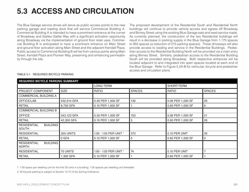
TABLE 5-1 REQUIRED BICYCLE PARKING
REQUIRED BICYCLE PARKING SUMMARY
LONG-TERM SHORT-TERM
PROJECT COMPONENT SIZE RATIO SPACES RATIO SPACES
COMMERCIAL BUILDING A
OFFICE/LAB 432,914 GFA 0.30 PER 1,000 SF 130 0.06 PER 1,000 SF 26
RETAIL 8,700 GFA 0.10 PER 1,000 SF 1 0.60 PER 1,000 SF 6
COMMERCIAL BUILDING B
OFFICE 343,123 GFA 0.30 PER 1,000 SF 103 0.06 PER 1,000 SF 21
RETAIL 42,300 GFA 0.10 PER 1,000 SF 5 0.60 PER 1,000 SF 26
RESIDENTIAL BUILDING SOUTH
RESIDENTIAL 355 UNITS 1.00 - 1.05 PER UNIT 1 372 0.10 PER UNIT 35
RETAIL 0 GFA 0.10 PER 1,000 SF 0 0.60 PER 1,000 SF 0
RESIDENTIAL BUILDING NORTH
RESIDENTIAL 70 UNITS 1.00 - 1.05 PER UNIT 1 74 0.10 PER UNIT 7
RETAIL 1,300 GFA 0.10 PER 1,000 SF 1 0.60 PER 1,000 SF 1
1. 1.00 space per dwelling unit for the first 20 units in a building; 1.05 spaces per dwelling unit thereafter.
2. All bicycle parking is subject to Section 14.72 of the Zoning Ordinance
The Blue Garage service drives will serve as public access points to the new parking garage and loading dock that will service Commercial Building A. Commercial Building A is intended to have a prominent entrance at the corner of Broadway and Galileo Galilei Way with a significant activation opportunity along Broadway via the implementation of ground floor retail uses. Commer-cial Building B is anticipated to have a prominent entrance on Main Street and ground floor activation along Main Street and the adjacent Kendall Plaza. Public access to Commercial Building B will be from various points along Main Street, Kendall Plaza and Pioneer Way, preserving and enhancing permeabil-ity through the site.
The proposed development of the Residential South and Residential North buildings will continue to provide vehicle access and egress off Broadway and Binney Street using the existing Blue Garage east and west service roads. As currently planned, the construction of the two Residential buildings will result in a decrease in parking supply in the Blue Garage from 1,170 spaces to 955 spaces (a reduction of 215 parking spaces). These driveways will also provide access to loading and service in the Residential Buildings. Pedes-trian access to the Residential Building North will be provided via a main entry along Binney Street. Similarly, pedestrian access to the Residential Building South will be provided along Broadway. Both respective entrances will be located adjacent to and integrated into open spaces located at each end of the Blue Garage. Refer to Figure 5.2A-B for vehicular, bicycle and pedestrian access and circulation plans.
MXD INFILL DEVELOPMENT CONCEPT PLAN 201

Residential LobbyCondo / Apartment TBD
Vehicular CirculationGarage Access
Potential Entrance (per use type)
Active UseLobbyPublic Lobby
E
E
Entrance (per use type)
VEHICULAR, BICYCLE, PEDESTRIAN ACCESS AND CIRCULATION PLAN
N
FIGURE 5.2 A
E
E
E
EE
EE
E
E
5. TRANSPORTATION202
Broadway
Binney
Gal
ileo
Gal
ilei W
ay

* Vertical CirculationVertical Circulation Route
Potential Circulation RouteCirculation RouteInternal Circulation Route
***
FIGURE 5.2 B
E
E
E E E
E
MXD INFILL DEVELOPMENT CONCEPT PLAN 203
N
Potential pedestrian connection to Broadway through a passage between the Green Garage and or portion of Marriott Hotel pending approval and coordination with abutters (See Fig 5.4)
Main Street
Am
es S
treet
Broadway

Residential LobbyCondo / Apartment TBD
EAST SERVICE DRIVE ENTRY WEST SERVICE DRIVE ENTRY
PEDESTRIAN ENTRIES AND WAYFINDING AT BLUE GARAGE
Vehicular Circulation EntryVehicular Circulation Exit
PUBLIC PARKING PEDESTRIAN ENTRIES (BLUE GARAGE) FIGURE 5.3
1
1 2 3 4
2
3
4
BR
OA
DW
AY
BIN
NE
Y
Parking elevatorParking elevator for residentsPedestrian Entry
LobbyActive Use
5. TRANSPORTATION204

eG
eJ eJ
eK eK
PARKINGOFFICE
EXIST. GARAGE EXITWITH ROLL-UP GRILLE
LINE OF BUILDINGABOVE
e12 e13 e14
EXISTING
RAM
P DO
WN
GARAGE ENTRANCE WITH ROLL-UP GRILLE
EXISTING ISLAND
5'-0" TYP
ENEW PARKING OFFICE ANDEXCHANGE WINDOW - REFERTO TYPICAL SECTION FORDETAILING
E PAINTED DESIGNATED PATHOF TRAVEL
EOVERHEAD CROSSWALKWARNING LIGHTING -EXTERIOR RATED 4'-0"LINEAR AMBER LENSED LEDPENDANT FIXTURESSUSPENDED W/ S.S.CABLING, TYP.
E DETECTABLE WARNING MAT,CAST IN SIDEWALK
E PROVIDE POWER ANDTELE/DATA LINES TO NEWOFFICE
EOVERHEAD CROSSWALKWARNING LIGHTING -EXTERIOR RATED 4'-0"LINEAR AMBER LENSED LEDPENDANT FIXTURES w/ SSSUSPENSION CABLES
E DETECTABLE WARNING MAT,CAST IN SIDEWALK
E WALLS REPAINTED
E FULL GLASS DOOR
EREMOVE 2 EXISTING CABINETHEATERS, CHAIR RAIL &PATCH GWB - NEW CABINETUNIT HEATER IN CEILING
E FULL GLASS DOOR
E WALKOFF MATS
E NEW ACT IN EXISTING GRID
4'-0" 4'-0"BEAM ABOVE
ERELOCATE ONE OF THEPARKINGCONTROLSSALVAGED FROMAMES STREET EXIT
E RELOCATE PARKINGCONTROL AND OFFICEEQUIPMENT TO NEW OFFICE
7'-6"
4'-9"
EDERO FIXIT REPAIR STAND W/AIR KIT 3 AND WHEEL CATCHIN BLACK POWDER COATFINISH
E BOLLARDS ALONG DRIVEPATH AT FIXIT STATION ANDWALK PATH
eD
eG
eJ
eK
e3 e4 e5 e6 e7 e8 e9 e10 e11 e12 e13 e14
AE-1022
AE-1013
SIMILAR FORALL LEVELS
AT LEVELS 2 - 5INSTALL GUARDRAILS ACROSS ENTIRE FACADE
AE-1015 INSTALL
GUARDRAILS (TYP)
eG
eJ
eK
e3 e4 e5 e6 e7 e8
PROTECT EXPOSED ROOFINGAT TERRACE
E
E
INSPECT & REPAIR EXISTINGROOFING AT TERRACE -VERIFY DRAINAGE PATHSARE IN WORKING ORDER
COLCOL
3'-6"
ENEW VEHICULAR ANDPEDESTRAN CABLE RAIL -REFER TO CABLE RAILDESIGN NOTE
E DEMOLISHED MASONRYSCREEN WALL (TYP)
ENABLING NOTESENABLING SCOPE IS DESCRIBED AND DETAILED ON AE-101 & AE-102 ANDHIGHLIGHTED WITH A GREEN OVAL "E" SYMBOL - REFERENCE MEP/FPDRAWINGS WITH A SIMILAR SYMBOL FOR RELATED ENABLING SCOPE.
1. FOR DEMOLITION SCOPE REFER TO AD-101 AND AD-102 OVERALL PLANS
2. FOR DESIGN OF FINAL CONDITION REFER TO A-101 - A-104
3. DESIGN TEMPORARY FALL PROTECTION AND BARRIERS BY MA REGISTEREDSTRUCTURAL ENGINEER.
4. TEMPORARY PARKING STALL AND CIRCULATION STRIPING BETWEENCOLUMN LINES e3 AND e4
E
CABLE RAIL NOTES1. ENGAGE A PROFESSIONAL ENGINEER TO DESIGN CABLE RAIL SYSTEM,
INCLUDING BUT NOT LIMITED TO: GALVANIZED STEEL CLIPS, ANGLES,CONNECTIONS, CABLES, EMBEDMENTS, AND WELDMENTS TO COMPLY WITHLOAD REQUIREMENTS OF THE CODE SECTION REFERENCED BELOW.
2. THE LOWER THREE CABLES (LOWER THAN 2'-9”) OF THE RAILING SERVE ASTHE VEHICULAR BARRIER SYSTEM AND SHALL COMPLY WITH SECTION 1607.7.3OF THE 2009 INTERNATIONAL BUILDING CODE.
3. THE CABLES OF THE RAILING SERVE AS PEDESTRIAN FALL PROTECTION ANDSHALL COMPLY WITH SECTION 1607.7.3 OF THE 2009 INTERNATIONAL BUILDINGCODE.
4. THE CABLE RAILS AND CONNECTIONS SHALL NOT ENCROACH UPON TRAFFICOR PARKING WIDTHS WITHOUT PRIOR APPROVAL.
5. THE EXTENT OF THE CABLE RAIL SYSTEM IS INDICATED BY DASHED LINEWORKON THE PARKING FLOOR PLANS.
6. THE CONTRACTOR SHALL COORDINATE CONNECTIONS TO THE STRUCTUREAND DETERMINE EMBEDMENT/WELDMENT REQUIREMENTS. WHEREMECHANICAL FASTENERS ARE USED IN LIEU OF EMBEDMENTS, THECONTRACTOR'S PROFESSIONAL ENGINEER SHALL EVALUATE THE IMPACT TOTHE REINFORCING ON THE SUPPORTING CONCRETE STRUCTURE- WHENAPPLICABLE.
7. THE PRECAST BUILDING CLADDING MAY NOT BE USED AS PART OF THEVEHICULAR BARRIER SYSTEM.
8. THE INTENT OF THIS SCOPE AS DESIGN-BUILD IS TO ALLOW THE CONTRACTORTHE FLEXIBILITY TO DEFINE WHERE EMBEDMENTS/WELDMENTS ARE USED.THE ENGINEERED SYSTEM CALCULATIONS, DESIGN AND DETAILS SHALL BESUBMITTED FOR REVIEW.
9. PROVIDE SUPPLEMENTAL ELEMENTS AS NECESSARY TO ACCOMMODATETENSION LOADS OF NEW CABLE RAILS. DO NOT ASSUME THAT EXISTINGSTRUCTURE WILL ACCOMMODATE LOADS IMPOSED BY NEW CABLE RAILS,VERIFY STRUCTURAL INTEGRITY IN THE FIELD.
e14
EPROVIDE 44"X24" OPENINGFOR DUCTWORK, CENTEROPENING ON FILIGREE JOINTCLOSEST TO eK LINE
2'-0"
3'-8"
1'-0"
1'-0"
FILIGREEPANEL JOINT
© 2014 Stantec
ISSUANCES
Job No.
Checked By:
Drawing Scale:
311 SUMMER STREET BOSTON, MA 02210 617.234.3100
800 BOYLSTON STREETAT THE PRUDENTIAL CENTER
BOSTON, MA 02199
As indicated
3/14
/201
6 1:
29:0
6 P
M
AE-101
GARAGEENABLING PLAN -
EAST ENTRY
218420721
Checker
88 AMES STREET, CAMBRIDGE MAAMES STREET RESIDENCES
1/8" = 1'-0"3 ENABLING PLAN - GARAGE GROUND LEVEL EAST 1" = 20'-0"1 ENABLING KEY PLAN - EAST GARAGE
1" = 20'-0"2 ENABLING PLAN - EAST GARAGE ROOF
1/4" = 1'-0"5 ENABLING ELEVATION - GARAGE FACADE DETAIL
1/8" = 1'-0"6 ENABLING PLAN - GARAGE LEVEL 2 EAST
2
DETAIL DELETED
3
No. Description Date1 DESIGN DEVELOPMENT 11/09/20152 STRUCTURAL ADDENDUM #1 01/29/20163 CONSTRUCTION DOCUMENTS 03/15/2016
NOTE DELETED3
33
CURRENT AND POTENTIAL PEDESTRIAN ROUTES (GREEN GARAGE/ MARRIOTT HOTEL)CURRENT PARKING ACCESS THROUGH MARRIOTT HOTEL
5
6
5
6
FIGURE 5.4
Location depends on plans for Volpe connection
MXD INFILL DEVELOPMENT CONCEPT PLAN 205
Potential pedestrian connection to Broadway through a passage between the Green Garage and or portion of Marriott Hotel, pending approval and coordination with abutters and structural review.
Existing Pedestrian Route through Marriott Hotel(Easement could be relocated to alternative route)
Existing Garage Access
Newly installed Green Garage Pedestrian Path(Includes pedestrian warning lights and traffic control)

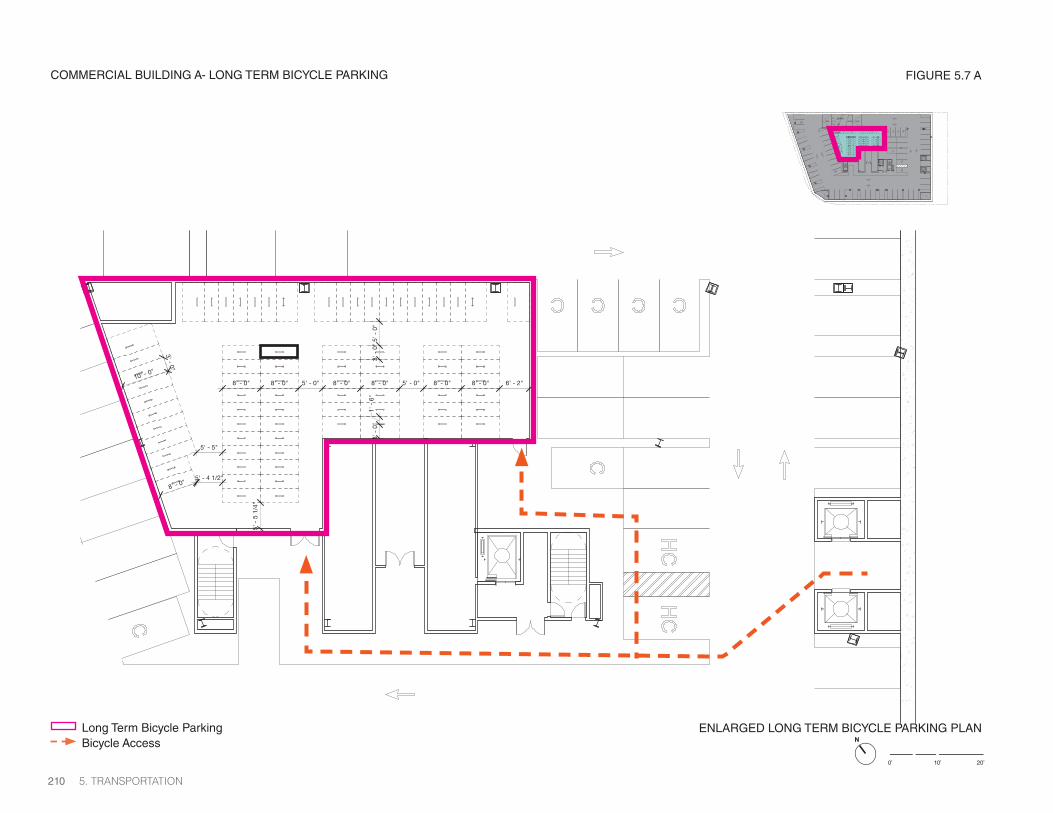
5.3.1 BICYCLE ACCOMMODATIONSThe bicycle parking associated with the Project has been determined by applying the ratios established by the City of Cambridge Bicycle Parking Guide. The ratios and number of bicycle parking spaces being provided by the Project are shown in Table 5-2. Figures 5.5, 5.6A-B and Figures 5.7A-D depict conceptual bicycle parking plans and layouts.
The Project will provide approximately 685 covered and secure long-term bicycle spaces within the vicinity of the Project components. As some of the individual buildings are still in the design phase, preliminary bicycle parking layouts are provided for Commercial Building B and the Residential South and Residential North Buildings in Figures 5.a-c. The Project intends to provide a variety of long-term bicycle parking options to accommodate all types of users. For employees looking to ride their bike every day, the convenience of having a bicycle parking spot inside their office building might be very import-ant. These spaces are provided within the below grade parking structures at Commercial Buildings A and B. Additionally, spaces will be available within the Blue Garage where a secure shared bicycle area is provided. Residents will also have varying needs and wants for bicycle storage. Residents who use their bicycle daily will have the convenience of storing their bicycle at grade level within the Blue Garage in existing facilities and new areas within close proximity of their particular building. Other residents may want to store their bicycle in a more remote location such as one of the top floors of the parking garage. The variety of long-term bicycle parking options will accommodate a variety of users.
Approximately 122 short-term spaces will be accommodated throughout the site, focusing on the areas near retail and lobby entrances on Main Street and Broadway and along the 6th Street Connector and various access point off of the pathway. Different options for the locations of the short-term bicycle parking will be discussed with the City to allow for parking spaces to be further from the building entrance points than zoning allows in order to preserve important open space in Broadway Park. All bicycle racks, short- and long-term will be compliant with required standards.
5. TRANSPORTATION206

Bluebikes Existing LocationsBluebikes Proposed Potential Locations
Main St
Broadway
Fulk
erso
n S
t
Six
th S
t
Fifth
St
Third
St
Rogers St
Linskey Way
Athenaeum St
Potter St
Munroe St
Ames
St
Sec
ond
St
Gal
ileo
Gal
ilei W
ayBinney St
Existing Short Term Bike ParkingProposed Short Term Bike Parking
Existing Long Term Bike ParkingProposed Long Term Bike ParkingWithin Parking Structure
* *
*
*
MXD DISTRICT BIKE PARKING LOCATION PLAN
*
FIGURE 5.5
MXD INFILL DEVELOPMENT CONCEPT PLAN 207

BIKE PARKING LOCATIONS
N
FIGURE 5.6 A
5. TRANSPORTATION208
Bluebikes Proposed Potential Locations
Bluebikes Existing LocationsExisting Bike LocationProposed Bike Location
Broadway
Binney
Gal
ileo
Gal
ilei W
ay

FIGURE 5.6 B
MXD INFILL DEVELOPMENT CONCEPT PLAN 209
Bluebikes Proposed Potential Locations
Bluebikes Existing LocationsExisting Bike LocationProposed Bike Location
Main Street
Am
es S
treet
Broadway
10% 14% 10%
UP
DOWN
ENLARGED LONG TERM BICYCLE PARKING PLAN
8' - 0" 8' - 0" 5' - 0" 8' - 0" 8' - 0" 5' - 0" 8' - 0" 8' - 0" 6' - 2"
5' - 5"
5' - 4 1/2"
3' -
0"
5' -
0"
5' -
5 1
/4"
3' -
0"
1' -
6"
10' - 0"
3' - 0"
8' - 0"
COMMERCIAL BUILDING A- LONG TERM BICYCLE PARKING
0’ 10’ 20’
NLong Term Bicycle ParkingBicycle Access
FIGURE 5.7 A
5. TRANSPORTATION210

0’ 10’ 20’
ENLARGED LONG TERM BICYCLE PARKING PLANLong Term Bicycle ParkingBicycle Access N
COMMERCIAL BUILDING B - LONG TERM BIKE PARKING
5’
FIGURE 5.7 B
3’
3’
8’
10’
MXD INFILL DEVELOPMENT CONCEPT PLAN 211

ENLARGED LONG TERM BICYCLE PARKING PLANLong Term Bicycle ParkingBicycle Access
2016 Solomon Cordwell Buenz
0’ 10’ 20’
N
RESIDENTIAL BUILDING SOUTH + NORTH - LONG TERM BIKE PARKING FIGURE 5.7 C
5’
5’
6’ 6’
5. TRANSPORTATION212

2016 Solomon Cordwell Buenz
0’ 10’ 20’
ENLARGED LONG TERM BICYCLE PARKING PLANLong Term Bicycle ParkingBicycle Access N
2016 Solomon Cordwell Buenz
5’
5’
5’
RESIDENTIAL BUILDING SOUTH + NORTH - LONG TERM BIKE PARKING
15’
10’
12’
FIGURE 5.7 D
3’
8’
MXD INFILL DEVELOPMENT CONCEPT PLAN 213

5.4 TRAFFIC DEMAND MANAGEMENT PLANThe proposed TDM measures aim to reduce drive-alone trips, or single occupancy vehicles (SOVs), by encouraging employees, residents and visitors to use alternative modes of transportation. The proposed TDM plan for the Project includes consideration of enhanced TDM measures outlined in the K2 Final Report 2013, where applicable and feasible, the commitments made through the SEIR and NPC, as well as Project-specific measures, with the goal of surpassing SOV of 41 percent for office and 32 percent for residential. While current data and survey of KSURP tenants suggest the existing area meets and surpasses the office goal with only 34 percent of employees driving, the new goal will be to maintain this low driving rate as additional office and residential land uses are built in the area. Overall, the goal of the proposed TDM Plan is to reduce the use SOVs by encouraging carpooling and vanpooling, bicycle commuting and walking, and increased use of the Kendall Square public transportation system by employees and residents.
• Provide funding for the KSTEP Fund
• 100% Design and Reconstruction of Binney Street and Galileo Galilei Way between Sixth Street and Broadway, including improvements including improvements at the intersection of Galileo Galilei Way/Broadway and respective approaches of Galileo Galilei Way.
• 100% Design and Reconstruction of Broadway between Ames Street and Galileo Galilei Way
• Finance the purchase and installation of BlueBike Stations (aka Hubway Stations):
• A.) Two (2) 19 dock Bluebike stations; or
• B.) One (1) 27 dock Bluebike and expand the existing Binney Street station to a 27-dock station.
• The City and BP shall identify mutually acceptable location(s) for the BlueBike station(s).
• Pay ongoing annual operations and maintenance fees to the City for the BlueBike Station(s).
• Improve the Sixth Street Connector Pathway by providing separated pedestrian and bicycle facilities while maintaining the mature trees along the existing pathway.
• Provide real-time transit screens in the public plaza framed by the Marriott Hotel and 50 Broadway, and 255 and 325 Broadway on Parcel 4. Transit screens shall also be provided in lobbies of new commercial buildings.
• MBTA Red Line Station on North Side of Main Street. The Applicant should construct no more than $400,000 in improvements to the MBTA Red Line Outbound Station on the north side of Main Street. The CRA has been con-ducting an annual traffic study and analysis of Kendall Square for the past 20 years, since implementation as compliance with the 1994 Section 61 Findings. The CRA plans to update the scope of the monitoring program to reflect the evolution of Cambridge’s transportation priorities in a complex multi-modal urban environment such as Kendall Square. The improved study shall utilize the most up to date development square footage and traffic projections as well as more holistically consider additional data on bicycles, pedestrians, travel behavior and transit service, as it becomes available.
Changes that may be considered in a new scope of work to be developed by the CRA in the near future may include, but are not limited to the following:
• Obtain and utilize basic data on ridership at the MBTA Kendall Square/MIT station for both subway and bus services.
• Include boarding information from EZRide shuttle and other bus services in the area, as data becomes available.
• Update the tenant questionnaire to be more specific on the mode split – differentiating the type of bus (MBTA, EZRide) or new systems, such as Bridge™ and Uber.
• Differentiate between transient and monthly parkers in the garage data collection process.
• Evaluate new bicycle count locations in response to installation of new bicycle facilities.
• Evaluate the annual traffic data collected by other parties and investigate collaborative reporting over a broader geographic scope.
• Utilize emerging pedestrian, bicycle, and traffic counting technologies as they become feasible and fully comparable to existing dataset.
The plans will include items such as, traffic signal equipment and timing, real-time vehicle/bike count stations, continuous separated bike lanes (cycle tracks), safety improvements to approaches to the major cross streets and potential bus priority treatments. The Binney/Galilei Way/Broadway signal improvements may include new mast arms, signal controllers, audible pedestrian signals (APS), vehicle detection (loops or other technology) and real-time vehicle and bike count station to include vehicles and bikes traveling north, south, east and west.
5. TRANSPORTATION214

TDM measures specific to the residential component, are identified below:
• Make available a minimum of 10 car-sharing parking spaces in the Blue (North) Garage for a vehicle-sharing company. As demand dictates additional car-sharing vehicles will be added over time. Provide additional designated car-sharing parking spaces within and/or nearby by KSURP parking garages, if deemed feasible. (These are designated and priority spaces for car-sharing users arriving for short-periods of time which is different than car-sharing spaces that “live” in the parking garages.
• Provide electric vehicle (EV) charging stations (1 EV space per 100 auto parking spaces, i.e. 10 EV spaces in the Blue Garage) and preferential parking to alternative fuel vehicles, as dictated by the market.
• Offer each adult member of each household (up to 2) upon move-in a Charlie Card valued at the cost of a 50% bus/subway pass (subject to fare increases) for 3 consecutive months. This benefit will end after 3 months for the household and begins anew upon unit turnover.
• Offer each adult member of each household (up to 2) upon move-in a 1- year Gold-Level Bluebike membership. This benefit will end after one year for the household and begins anew upon unit turnover.
• Provide air pumps and other bike tools in the bicycle storage room.
• Join the Charles River Transportation Management Association (TMA)
• Provide free EZRide Shuttle sticker for each adult member of each house-hold each year.
• Charge parking (market rate) separately from the residential rent, in order to remind tenants how much they pay for parking. The Permittee shall provide the summary of on-site parking fees to the TP&T.
• Either install a real-time multimodal transportation display screen to help people decide which mode to choose for each trip (transit, carsharing vehicle, BlueBike bike share, etc.), or establish a transportation information center located in an area that is central, visible, convenient, and equally accessible to all residents and visitors. The center will feature information on:
• Available pedestrian and bicycle facilities in the vicinity of the site
• MBTA maps, schedules, and fares
• Area shuttle map and schedule, if one exists
• “Getting Around in Cambridge” map and other CitySmart materials (available at the Cambridge Community Development office)
• Location of bicycle parking
• BlueBike regional bikeshare system
• Carsharing
• Ride-matching
• Other pertinent transportation information
• Designate a Transportation Coordinator (TC) for each residential building or the site to manage the TDM program. The TC will also oversee the marketing and promotion of transportation options to all residents at the site in a variety of ways:
• Posting information in a prominent location in the building and on the Project’s website, social media, and property newsletters.
• Responding to individual requests for information in person and via phone and email.
• Performing annual transportation surveys.
• Require the TC to compile and distribute up-to-date information explaining all transportation options to all new residents as part of their New Resident Packet. The packets will contain information on both the range of options available to any building manager programs to support the use of these options and will include:
• Available pedestrian and bicycle facilities in the vicinity of the site
• MBTA maps, schedules, and fares
• Area shuttle map and schedule, if one exists
• “Getting Around in Cambridge” map and other CitySmart materials
• Location of bicycle parking
• BlueBike regional bikeshare system
• Carsharing
• Ride-matching
• Other pertinent transportation information
• Require that the TC will be on-site during a minimum of two (2) hours per week and will be available during other times to residents via email and telephone. Email and phone information for the TC will be posted in the transportation information center.
• The Permittee shall commit to a transportation monitoring program and mitigation measures whose effectiveness is commensurate with the triggers established in the Recommended Transportation Monitoring Program.
MXD INFILL DEVELOPMENT CONCEPT PLAN 215

5.4.1 PROPOSED TRAFFIC MONITORINGThe CRA has been conducting an annual traffic study and analysis of Kendall Square for the past 20 years, since implementation as compliance with the 1994 Section 61 Findings. The CRA plans to update the scope of the moni-toring program to reflect the evolution of Cambridge’s transportation priorities in a complex multi-modal urban environment such as Kendall Square. The improved study shall utilize the most up to date development square footage and traffic projections as well as more holistically consider additional data on bicycles, pedestrians, travel behavior and transit service, as it becomes available.
Changes that may be considered in a new scope of work to be developed by the CRA in the near future may include, but are not limited to the following:
• Obtain and utilize basic data on ridership at the MBTA Kendall Square/MIT station for both subway and bus services.
• Include boarding information from EZRide shuttle and other bus services in the area, as data becomes available.
• Update the tenant questionnaire to be more specific on the mode split – differentiating the type of bus (MBTA, EZRide) or new systems, such as Bridge™ and Uber.
• Differentiate between transient and monthly parkers in the garage data collection process.
• Evaluate new bicycle count locations in response to installation of new bicycle facilities.
• Evaluate the annual traffic data collected by other parties and investigate collaborative reporting over a broader geographic scope.
• Utilize emerging pedestrian, bicycle, and traffic counting technologies as they become feasible and fully comparable to existing dataset.
5. TRANSPORTATION216

5.5 PARKING
The Project will add up to an additional 413 parking spaces to the KSURP area, through a combination of structured and valet/managed parking solutions. As currently planned, the two proposed residential buildings will include the elimination of approximately 215 parking spaces within the Blue Garage, to support the construction of those facilities (including adequate lobbies and cores that can intercept the ground plane while maintaining existing adjacent open space). The net elimination of the 215 parking spaces is a direct result of eliminating approximately 246 existing parking spaces due to construction of the two residential buildings, and adding approximately 31 spaces on level 6 upon construction of the Residential Building North. Commercial Building A is currently being constructed with 350 parking spaces, and as part of this update the Proponent is seeking approval to add 107 spaces (457 spaces total) to this garage through efficient self parking and provision of managed/valet parking spaces. Parking for Commercial Building B will be provided through the existing four garages managed by the Applicant. No parking will be constructed on-site at Commercial Building B. In total, the Project adds up to 413 new parking spaces incrementally to the existing 2,708 spaces, for a total future parking supply of 3,121 spaces to support planned changes in building program. Figure 5.8 and Table 5-2 summarizes the existing and future parking supply in the area.
A shared vehicle parking analysis was conducted for the TIS to understand the Project’s ability to share new parking spaces and possibly reduce the overall number of spaces built. In addition, the analysis was expanded to include the entire KSURP development to understand the shared parking ability this area has. As indicated above, the KSURP currently supplies 2,708 parking spaces in three garages, and with the construction of the Project, 413
vehicle spaces will be added to the KSURP area. This brings the number of total parking spaces to approximately 3,121 spaces. This new total supply is below the original maximum approved 4,300 vehicle parking spaces under the 1977 FEIR and the revised 3,545 spaces under Amendment No. 3.
The shared parking analysis was conducted using two different methodolo-gies for two different shared parking scenarios. The first methodology follows a similar methodology to the one presented in the KSURP SEIR and updates the existing parking demand with current May 2016 data and follows a holistic parking strategy. The second methodology follows the standard practices suggested by the Urban Land Institute’s Shared Parking report, second edition (2015, latest available report), as requested in the Scoping Letter. The two scenarios include a concentration on a shared parking demand based just on the Project, while the second scenario encompasses the entire KSURP development. Detailed descriptions and tables for these analyses are pre-sented in the TIS, Appendix B.
Furthermore, as part of the more recent Project Change, an updated parking analysis was developed for the City’s TP&T staff, based on actual garage utilization information and usage. The updated analyses indicate that the new parking being supplied, together with the existing parking, will provide enough parking to meet demand, throughout the vast majority of the year. In a small number of instances, the parking demand could potentially exceed the available parking by up to 86 spaces, for a very short duration mid-day during peak months only, however with the implementation of the outlined TDM strategies, it is anticipated that parking supply will sufficiently serve the parking demand of the Project.
Project Component/Garage Existing Parking Proposed New Parking for Project Future Parking
135 Broadway Residences/Blue Garage 1,170 (-215) 955
Yellow Garage 734 +151 885
Green Garage 804 +20 824
145 Broadway Office Building 0 +457 457
325 Main Street Commercial Building 0 0 0
Total 2,708 +413 3,121
TABLE 5-2 FUTURE PARKING SUPPLY IN THE KSURP AREA
MXD INFILL DEVELOPMENT CONCEPT PLAN 217
The analysis also indicated that the overall parking demand within the KSURP area will be able to provide enough parking for the area residents, tenants and visitors with the proposed TDM measures and close monitoring of each garage.
Emerging technologies are also anticipated to disrupt urban mobility and future parking demand. Mobility tech companies such as nuTonomy have brought a fleet of autonomous vehicles (AVs) to the City of Boston Seaport District, and Lyft predicts a full fleet of shared-autonomous vehicles (SAVs) within a five-year timeframe. Additionally, in April 2018, the City of Cambridge voted to begin AV testing on city streets. A functioning SVA fleet will fundamentally change trip-making behaviors within dense urban areas like Kendall Square for work trips and recreational trips. Autonomous vehicles, particularly SAV’s, are expected to reduce future parking demand by enabling families that would typically purchase more than one vehicle to share a single vehicle throughout the day. SAV’s can eliminate this need altogether by providing subscription service for mobility on demand. As such, SAVs can change an individual or family’s decision to purchase a vehicle in the first place. The Project’s commercial office, residential and retail uses will also benefit from AVs and SAVs. Parking demand for these uses could be significantly reduced given the improved access to the MBTA’s transit network. Further, AV’s can alter the size and shape of parking facilities. AVs can drop their riders off at the curb, they can park themselves in parking stalls of reduced width, requiring no accommodation for door swing. In addition, autonomous vehicles will be able to stack within parking facilities and arrange themselves in the most efficient arrangements.
5.5.1 LONG-TERM PARKING MONITORING PROGRAM
All parking facilities are monitored daily to ensure monthly cardholders are parking in the appropriate garages and transient parkers are dispersed efficiently among the three garages. Tenants of the area are provided a limited number of parking passes, as outlined in each individual lease, and are charged the full monthly cardholder price. Other employees or visitors without monthly passes are subject to the daily rates, up to $40.00 per day.
New tenants of the Project will negotiate the number of parking permits (without exceeding the zoning maximum of 0.90 spaces per 1,000 KSF) and the specified amount will be within the individual lease. All new monthly parking passes will be charged the full monthly rate. This will encourage more employees to take alternative modes of transportation and reduce the number of monthly parkers parking in the area on a regular basis.Residential parkers will be provided the opportunity to buy a monthly parking pass at full price. This will encourage a low auto-ownership rate and could further reduce the demand for parking in the area.
A portion of the existing parking demand is from transient users. It is assumed that these users are comprised of employees who do not buy a monthly pass, visitors to area businesses and retail customers. These specific users would therefore be classified as infrequent users of the garage.
PRICING STRATEGY
Currently the Kendall Center garages have a time-sensitive pricing strategy that discourages driving and parking in the area. A monthly cardholder pays up to $400.00 per month for a space within the Kendall Center garages and a transient parker pays up to $40.00 per day. It should be noted that the three garages have some of the highest parking rates in the immediate area with other garages having all-day parking for $23.00 to $30.00.
Due to the increasing parking demand within the area, Applicant and other stakeholders are in discussions about implementing new pricing strategies to further discourage vehicle trips to the area. It is the intent of the draft MOU, documented in the KSURP NPC filed on June 30, 2016, to continue to include a proactive parking strategy to discourage vehicle trips to the area as well as help offset other mitigation costs outlined in the MOU.
5. TRANSPORTATION218

FIGURE 5.8 PARKING FACILITIES
Binney St
Existing Parking Facilities -Blue GarageExisting Parking Facilities -Green GarageExisting Parking Facilities -Yellow Garage
Main St
Broadway
Fulk
erso
n S
t
Six
th S
t
Fifth
St
Third
St
Rogers St
Linskey Way
Athenaeum St
Potter St
Munroe St
Ames
St
Sec
ond
St
Gal
ileo
Gal
ilei W
ay
Parking Facilities Under ConstructionPrior Approved Parking
MXD BoundaryKSURP Boundary
Project Component/Garage Existing Parking
Future Parking
Blue Garage (North Garage) 1,170 955Yellow Garage (West garage) 734 885Green Garage (East Garage) 804 824145 Broadway 0 457250 Binney Street 0 0Total 2,708 3,121
MXD INFILL DEVELOPMENT CONCEPT PLAN 219

N
Parking EntranceLoading Dock
5. TRANSPORTATION220
5.6 SERVICE AND LOADING PROPOSED SERVICE AND LOADING PLAN 145 BROADWAY / RESIDENTIAL BUILDINGS NORTH AND SOUTH FIGURE 5.9 A
All service and loading will be conducted within the Project site, accessed from existing service drives between Broadway and Binney Street.
Broadway
Binney
Gal
ileo
Gal
ilei W
ay

MXD INFILL DEVELOPMENT CONCEPT PLAN 221
N
325 Loading BaysLoading Bays (others)
PROPOSED SERVICE AND LOADING PLAN 325 MAIN STREET FIGURE 5.9 B
All service and loading will be conducted within the Project site, accessed from existing service entry from Broadway Street
LLT
Main Street
Am
es S
treet
Broadway
LOADING LOADINGTRASH

5. TRANSPORTATION222

MXD INFILL DEVELOPMENT CONCEPT PLAN 223
5.7 PROPOSED PEDESTRIAN ACCESS, SAFETY, AND STREETSCAPE IMPROVEMENTS As discussed previously, the KSURP area provides excellent pedestrian accommodations, including sidewalks on all study area roadways and crosswalks at all study area intersections. The City is ahead of many other communities in utilizing pedestrian countdown timers with Leading Pedestrian Interval (LPI) programming and many of the signalized intersections within the District have pedestrian countdown timers with such technology.
Both the CRA and Applicant are committed to creating a cohesive integrated network of open spaces and connecting pathways while improving pedestrian safety, access and circulation within the KSURP area. The CRA and Applicant will work in conjunction with the City to identify areas of improvement. Measures could include the following:
• Provide additional pedestrian countdown timers at study area inter-sections.
• Implement LPI programming at study area intersection.
• Improve the Sixth Street Connector by increasing driver awareness of the pedestrian crossing with advanced warning signs. In addition, this connection should be studied in connection with the Sixth Street Con-nector Pathway improvements, possibly improving upon or enhancing the existing HAWK system or other pedestrian crossing systems. The Project proposes to redesign the Sixth Street Connector Pathway to provide separated pedestrian and bicycle facilities while maintaining the mature trees along the existing pathway.
• Review all pedestrian crossings within the KSURP boundaries to assess their potential for sidewalks “bulb-outs”, raised crossings, pedestrian refuge islands, Rectangular Rapid Flashing Beacons (RRFB’s), re-aligned non-apex ramps and/or other treatments to enhance the comfort and visibility of crosswalks.
• Enhance the Main Street streetscape in front of the proposed Commer-cial Building B.
• Enhance the Broadway streetscape from Ames Street to Galileo Galilei Way.
• Provide a new pedestrian connection between Kendall Plaza and the Kendall Square Rooftop Garden.
• Improve pedestrian safety by enhancing lighting along sidewalks and pathways for safer pedestrian accommodations.
• Enhance open spaces with multiple outdoor connections to buildings within the KSURP area.
The CRA has generated a redesign concept for Binney Street and Galileo Galilei Way between Third Street and Broadway, including a cycle track along Galileo Galilei Way and the Grand Junction Multi-Use Path. Applicant is also committed to improving the Sixth Street Connector by providing separate bicycle and pedestrian facilities included a grade separated cycle track to be aligned with the future cycle track on Ames Street. Additionally, in close coordination with the City, Applicant, and Other Developers, the CRA will also explore opportunities to create a full-service bike station within the area.
Through the City’s design review and planning board meeting process, the CRA, Applicant and the City will agree upon mitigation for the Project. This process has begun with the certification of the TIS on July 14, 2016, the Notice of Decision recording PB#315 in March 2017, and will continue through review of the Concept Plan Amendment and subsequent design review of each Project component.