Embed Size (px)
Citation preview

RLHF Journal Vol.17 (2013)
1
4. Craig Mill, Eaglesham Robin and Susan Hunter
Craig Mill is a water powered grain mill, situated on the western edge of Renfrewshire. The mill survives in unusually good condition, with an external iron water wheel, internal mill gearing, and a large masonry dam on the White Cart Water. The site also includes a narrow single-arch masonry bridge, only wide enough for pedestrians spanning the river. It is traditionally supposed to be a ‘pack horse bridge’. During the spring and summer of 2009, a survey was carried out of Craig Mill as part of ongoing surveys of farms in Eaglesham parish. This article provides a summary of the full 100-page report on the mill and site, which was published with funding from RLHF 1.
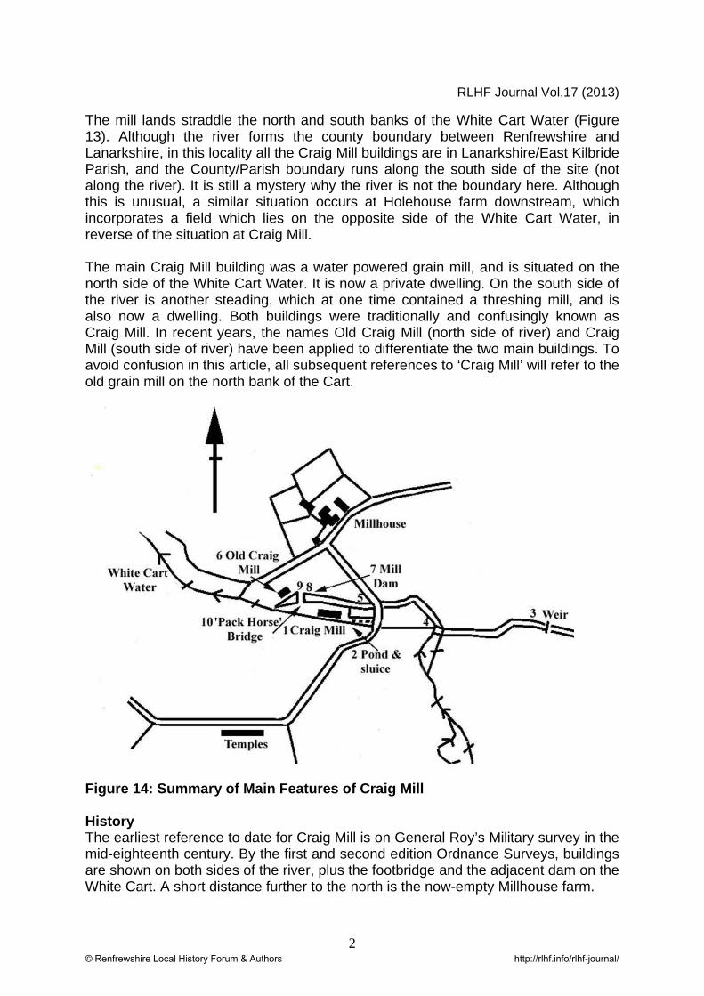
Figure 13: Location Plan of Craig Mill
1 S. & R. Hunter, “Craig Mill & Old Craig Mill, East Kilbride Parish, South Lanarkshire: An Archaeological Survey”, ACFA Occasional Paper No.104 (2010).
© Renfrewshire Local History Forum & Authors http://rlhf.info/rlhf-journal/
RLHF Journal Vol.17 (2013)
2
The mill lands straddle the north and south banks of the White Cart Water (Figure 13). Although the river forms the county boundary between Renfrewshire and Lanarkshire, in this locality all the Craig Mill buildings are in Lanarkshire/East Kilbride Parish, and the County/Parish boundary runs along the south side of the site (not along the river). It is still a mystery why the river is not the boundary here. Although this is unusual, a similar situation occurs at Holehouse farm downstream, which incorporates a field which lies on the opposite side of the White Cart Water, in reverse of the situation at Craig Mill. The main Craig Mill building was a water powered grain mill, and is situated on the north side of the White Cart Water. It is now a private dwelling. On the south side of the river is another steading, which at one time contained a threshing mill, and is also now a dwelling. Both buildings were traditionally and confusingly known as Craig Mill. In recent years, the names Old Craig Mill (north side of river) and Craig Mill (south side of river) have been applied to differentiate the two main buildings. To avoid confusion in this article, all subsequent references to ‘Craig Mill’ will refer to the old grain mill on the north bank of the Cart.
Figure 14: Summary of Main Features of Craig Mill History The earliest reference to date for Craig Mill is on General Roy’s Military survey in the mid-eighteenth century. By the first and second edition Ordnance Surveys, buildings are shown on both sides of the river, plus the footbridge and the adjacent dam on the White Cart. A short distance further to the north is the now-empty Millhouse farm.
© Renfrewshire Local History Forum & Authors http://rlhf.info/rlhf-journal/

RLHF Journal Vol.17 (2013)
3
By 1912, the Ordnance Survey denotes Craig Mill as disused. Despite this, the mill was back in operation after this. The miller was James Stewart, who took possession in 1926. His father and grandfather were previously millers at Lenzie Mill in Cumbernauld. The building on the south side of the river became the family residence, while Craig Mill was the working mill. The mill was used for milling corn for cattle until the 1970s. John Stewart and his wife Florence purchased the mill in 1974. In 1975 the new owner of Craig Mill applied for planning permission to turn the mill into a family home. The present owners purchased it in 1984. 1. Former Threshing Mill (South side of White Cart) This long one/two storey building is constructed of whitewashed rubble, with a timber pitched and slated roof. In the past, the building contained a threshing mill, now the garage at the eastern end of the steading. Next was the hayshed, byre and hen house, piggery and goat stall, which are now all part of the family house. The western end of the building was the farmhouse. Evidence on this site also supports a former water powered mill (distinct from Craig Mill in the north side of the White Cart). An area of wet boggy ground lying behind the building, on the southern side of the boundary fence, in farmland of the adjacent Temples Farm, was once a pond. This was fed by a lade which was old and important enough to form the county boundary. A dam smaller than the main surviving Craig Mill dam was situated further up river on the Shield Burn, above the burn’s confluence with the White Cart. The water rights of Craig Mill extended up the Shield Burn as far as Cockrunning Mill. Downstream of the buildings, a sluice was previously removed by John Stewart, and a culvert heads from the pond back towards the White Cart. Despite the evidence, the earliest mill on this site for which any detail survives is the threshing mill which was installed in the 1920s or 1930s by John Stewart, and powered by a Ford motor engine. 2. Former Grain Mill: Craig Mill Exterior of Grain Mill Old Craig Mill is three stories high and constructed of grey sandstone, with a timber pitched and slated roof. The eastern (upstream) side of the building has signs of at least three phases of building, evident in a variety of stonework and blocked up openings, probably dating from the seventeenth century or earlier. The mill was latterly powered by two waterwheels, set close together on the mill wall, on the same lade. According to John Hume’s description and photos in the 1960s, the upstream waterwheel was constructed of timber, but has since been removed. The downstream waterwheel survives, and is an iron wheel 4.2m in diameter x 1.1m wide (Figure 15). It consists of a cast-iron horizontal shaft, a hub and six spoke arms supporting an iron rim. Slots cast in the rim carried timber paddles or buckets, of which only fragments remain. The rim and spoke arms are bolted together in parts. The wheel has various repairs and additions, probably by a local blacksmith.
© Renfrewshire Local History Forum & Authors http://rlhf.info/rlhf-journal/

RLHF Journal Vol.17 (2013)
4
Figure 15: Mill and Surviving Iron Water Wheel, Craig Mill Both the wheels were overshot, and driven from an elevated timber lade or ‘trouse’ which extended from a sluice in the dam. The trouse no longer survives, but thanks to John Hume’s photos we know that it ran along the mill wall, carried by supports, including three stone corbels which still protrude from the mill wall 2. The water from the trouse fell onto the wheels, then into the wheel pit, and drained down a surviving stone culvert from the downstream end of the wheel pit, back to the river. Various curved score-marks on the mill wall indicate where the upstream wheel stood and indicate that it was the same diameter as the surviving wheel. The upstream water wheel was replaced in 1948 by a turbine (photographed in the 1960s) which drove a generator inside the mill, providing electricity to the buildings on both sides of the river. After the removal of this wheel, a wooden shed was built over the wheelpit and the pit was covered with timber. The mill is likely to have been adapted and changed several times, but in its final version had four pairs of millstones, three pairs driven by the upstream waterwheel and one by the surviving downstream iron wheel. From evidence scattered around the mill grounds, at least some of the millstone consisted of eight outer pieces of stone and a central piece held together with an iron rhynd. When the waterwheels were in operation in the early twentieth century, the water was firstly piped from a sluice in the dam, and initially ran along a stone-lined lade. It then ran along the elevated wooden trouse. To control the speed of the water running along the lade, there was a flap hinged with a chain, to release water before it reached the waterwheel. This ran down a chute into the tail race.
2 Various photos of the mill, mainly by John Hume in the 1960s, are available on the RCAHMS ‘Canmore’ website, and appear in the full report.
© Renfrewshire Local History Forum & Authors http://rlhf.info/rlhf-journal/
RLHF Journal Vol.17 (2013)
5
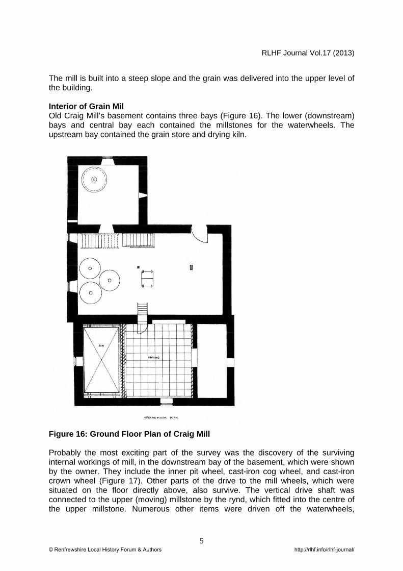
The mill is built into a steep slope and the grain was delivered into the upper level of the building. Interior of Grain Mil Old Craig Mill’s basement contains three bays (Figure 16). The lower (downstream) bays and central bay each contained the millstones for the waterwheels. The upstream bay contained the grain store and drying kiln.
Figure 16: Ground Floor Plan of Craig Mill Probably the most exciting part of the survey was the discovery of the surviving internal workings of mill, in the downstream bay of the basement, which were shown by the owner. They include the inner pit wheel, cast-iron cog wheel, and cast-iron crown wheel (Figure 17). Other parts of the drive to the mill wheels, which were situated on the floor directly above, also survive. The vertical drive shaft was connected to the upper (moving) millstone by the rynd, which fitted into the centre of the upper millstone. Numerous other items were driven off the waterwheels,
© Renfrewshire Local History Forum & Authors http://rlhf.info/rlhf-journal/

RLHF Journal Vol.17 (2013)
6
including the hoist which lifted the bags of grain, equipment and various other components through trap doors in the flooring. The mixer which mixed the grain, the bruiser and the cake breaker were also run off the waterwheel. The mill stones above the surviving mill gearing have been removed.
Figure 17: Craig Mill Gearing The central bay at the upstream waterwheel, contained the upper millstones, latterly replaced by the turbine, mentioned above. In the upstream bay of the basement are surviving elements of the furnace and corn drying kiln. On the southern side is an arched fire box for heating the furnace constructed of firebricks, with surviving iron fire-ribs. Charcoal was poured from a bunker on the floor above into this section allowing fuel to be scooped out with a shovel and put into the fire box. Above the furnace, on the second floor, was the drying area. This was constructed of cast iron plates, perforated with small holes, on which grain was spread out to a depth of approximately four inches. The heat percolated from the fire box below to dry the milled grain. 3. The Mill Dam The large masonry dam servicing Old Craig Mill lies just upstream of the mill. As well as providing a head of water to drive the millwheels, its also stored water for the mill. The dam is approximately 6 metres wide at its crest, providing a fall of about 3
© Renfrewshire Local History Forum & Authors http://rlhf.info/rlhf-journal/

RLHF Journal Vol.17 (2013)
7
metres. A natural waterfall below the dam doubles the fall to 6m. The dam is constructed of large partly-dressed boulders and puddle clay, with large sandstone blocks at the top. Upstream of the mill, beside the dam, is the sluice. This is controlled by a wedge shaped cast-iron valve, controlled by a cast-iron handwheel at ground level. The pipe then runs under a parapet which was built for the protection of the lade and mill against flooding. Extending from the stonework of the parapet is a fireclay pipe. Originally the fireclay pipe was joined to further pipes which allowed the dam to be drained, to allow the Stewart family to undertake regular clearance of the silt which accumulated behind the dam.
Figure 18: Craig Mill Dam (left) and Bridge (right) 4. The ‘Pack Horse Bridge’ The so-called single arch ‘Pack Horse Bridge’ spans the river immediately downstream of the dam. It provides access from the former threshing mill buildings on the south side of the river, to Craig Mill, near the start of its lade. The width of the bridge inside the parapets is less than a metre. This is too narrow to be used by carts, and could only be used by pedestrians and livestock. The construction of the bridge suggests that it was built no earlier than the nineteenth century. The bridge arch consists of 22 well-built dressed sandstone voussoirs. At each end, the arch sits on larger dressed sandstone footings, which sit on natural rock at the top of the waterfall. Unfortunately the bridge has partly collapsed at either end, making it unsafe to cross. A crack passes along the centre of the arch and it may not be long before the whole bridge collapses. A smiddy once stood to the west of the parapet, north of the bridge. This was used
© Renfrewshire Local History Forum & Authors http://rlhf.info/rlhf-journal/

RLHF Journal Vol.17 (2013)
8
for mending mill machinery and for making tools and parts for the mill. Acknowledgements The authors acknowledge the kindness of Mr and Mrs Stewart and Mr Stewart’s sister Mrs Clark who gave permission to use many family photographs and papers in our publication. Mr Stewart was a mine of information on the working of mill, having had first-hand experience. Of the photographs it would be unfair to publish these without the permission of the owner. The authors gratefully acknowledge funding from Renfrewshire Local History Forum, which allowed the printing of the full publication on Craig Mill.
© Renfrewshire Local History Forum & Authors http://rlhf.info/rlhf-journal/