Embed Size (px)
Citation preview
LOGISTICAL REPORT FOR
ICON RESOURCES LTD.
3D INDUCED POLARIZATION SURVEY ON THE
PROFESSOR PROJECT
Zeehan, Tasmania
363000E, 5349000N,
AGD 66, Zone 55.
SURVEY CONDUCTED BY SJ GEOPHYSICS LTD.
APRIL 2007
REPORT WRITTEN BY
AARON SNIDER
SJ GEOPHYSICS LTD.APRIL 2007

3D-IP Logistical Report: Professor Project, Icon Resources Ltd.
TABLE OF CONTENTS
1.Introduction..................................................................................................................................1
2.Location and Line Information.................................................................................................... 1
3.Field Work and Instrumentation.................................................................................................. 4
3.1.Field Logistics...................................................................................................................... 4 3.2.Survey Parameters and Instrumentation...............................................................................5
4.Geophysical Techniques.............................................................................................................. 6
4.1.IP Method.............................................................................................................................6 4.2.3D-IP Method.......................................................................................................................7 4.3.Inversion Programs...............................................................................................................7
Appendix 1: Instrument Specifications...........................................................................................9
5 Appendix 2 : 3D-IP Summary Table....................................................................................... 10
ILLUSTRATION INDEX
Figure 1: Professor Project location in Tasmania................................................................ 3
Figure 2: Professor 3dIP gridlines- Rx=red, Tx=blue..........................................................3
SJ Geophysics Ltd. / S.J.V. Consultants Ltd. 11762-94th Ave., Delta, BC Canada iTel: (604) 582-1100 Fax: (604) 589-7466 E-mail: [email protected]

3D-IP Logistical Report: Professor Project, Icon Resources Ltd.
1. INTRODUCTION
A three-dimensional Induced Polarization (3D-IP) survey was conducted on Icon Resources
Ltd.'s Professor project. The exploration lease is located between Zeehan and Strahan on both
sides of highway B27 in western Tasmania.
The property is located over a series of folded sedimentary units, dipping at approximately 45
degrees to the northwest. The target is a planar, strataform body of sulphide mineralization
associated with zinc occurences located on the contact between the Gordon Limestone and
Moina sandstone units. Previous exploration has included geological mapping, soil sampling,
airborne magnetics and drilling. The purpose of the survey is to locate deep occurences of
sulphides which are thought to be associated with the zinc deposits.
The ground geophysical program was surveyed by SJ Geophysics Ltd. during April 2007.
Initial data processing and some quality control were performed on site by the field crew, and the
initial coarse inversion was submitted before the geophysicist returned to Canada. The final
modeling was completed at the SJ Geophysics office in Vancouver, Canada.
This logistical report summarizes the operational aspects of the survey and the survey
methodologies used. This report does not discuss any interpretation of the results of the
geophysical survey.
2. LOCATION AND LINE INFORMATION
The Professor tenement consists of several adjoining exploration leases located along
highway B27 about 20km south of Zeehan and 30km north of Strahan, Tasmania. Crew meals
and cabin accommodations were at the Cecil Hotel and Miners Cottages in Zeehan. Figure 1
shows the general location of project region.
The IP survey was conducted over a portion of this property, the central portions of the lines
running through a broad valley, with the ends of most lines extending up onto more resistant
plateaus. The surveyed area included the “Grieves South”, “Grieves Siding” and “Baura”
showings. Vegetation varies from open buttongrass to thick scrub and dense rainforest. The
valley floor was covered in quaternary sediments but outcrops are numerous along the edges of
the plateaus. Numerous creeks run through the property with water levels varying with the
SJ Geophysics Ltd. / S.J.V. Consultants Ltd. 11762-94th Ave., Delta, BC Canada 1Tel: (604) 582-1100 Fax: (604) 589-7466 E-mail: [email protected]
3D-IP Logistical Report: Professor Project, Icon Resources Ltd.
amount of rainfall.
The total area surveyed was approximately 2.4km by 3.2km along 17 lines oriented east-west,
as shown in Figure 2. The central portion of the grid was extended to cover an additional area of
0.8km by 2.5km.
The initial 9 transmitter lines were approximately 2400m long with station spacing of 100m.
The 8 receiver lines were 1600m with 100m stations. Lines 47600N and 47800N were
shortened by 1000m due to a narrowing of the target rock unit. At the end of the survey, lines
9200N to 8400N were extended to the west by 2000-3000m.
The grid was put in by chain and compass concurrent with the IP surveying. Due to the last-
minute nature of the survey, line cutting was minimal, and thus some lines were deliberately
skewed to avoid sections of extremely dense scrub. GPS and clinometer data was recorded for
all stations.
SJ Geophysics Ltd. / S.J.V. Consultants Ltd. 11762-94th Ave., Delta, BC Canada 2Tel: (604) 582-1100 Fax: (604) 589-7466 E-mail: [email protected]

3D-IP Logistical Report: Professor Project, Icon Resources Ltd.
Figure 1: Professor Project location in Tasmania
Figure 2: Professor 3D-IP gridlines- Rx=red, Tx=blue
SJ Geophysics Ltd. / S.J.V. Consultants Ltd. 11762-94th Ave., Delta, BC Canada 3Tel: (604) 582-1100 Fax: (604) 589-7466 E-mail: [email protected]

3D-IP Logistical Report: Professor Project, Icon Resources Ltd.
3. FIELD WORK AND INSTRUMENTATION
3.1. FIELD LOGISTICS
The SJ Geophysics Ltd. crew consisted of two SJ Geophysics employees: Aaron Snider
(Geophysicist) and Gary Cooper (Geophysical Technician). Icon's Bronwyn Kimber (Project
Geologist) organized logistical issues, line cutting and aided the IP survey for the duration of the
project. Nick Truchanas was available to help with the survey for the duration, while Matt
Munro, Simon Mackenzie, Shawn Barber, and Emma Watt were available for the first two
weeks. Steve and Alex Northey were available after April 11. In addition numerous local
helpers from Zeehan and Queenstown came and went throughout the survey with varying degrees
of commitment. Icon Resources director John Bishop was on site periodically throughout the
survey along with other Icon representatives.
Garry mobilized from Bangkok, Thailand to Sydney on March 29 where he picked up the IP
equipment and vehicle and proceeded to drive to the ferry in Melbourne. Aaron mobilized from
Vancouver, Canada on March 30 and arrived in Hobart on April 1 where he was met by Garry.
After picking up some supplies in Hobart the following morning, the SJ crew picked up John
Bishop and drove to Zeehan. The rest of the IP crew mobilized earlier that morning and began
pegging the first lines. April 3 was spent chaining lines 50000N, 49800N, and 49600N, testing
equipment and setting up wires. Recording began on the following day and proceeded
southwards over the next nine days to line 47600N. This set of recordings required a transmitter
site move due to communications and amount of wire on the ground. After this, the entire survey
was moved to the north end of the grid, specifically lines 50000N to 50800N. The eastern
remote (E1) was used for this portion of the grid as well, but a new western remote was needed
(W2). On April 15 the entire survey was once again packed up and moved to record extensions
on lines 49200N to 48400N, which took 5 days. On April 20, the crew removed all wire, cable
and equipment from the grid and demobilized to Hobart the following day, after which Aaron
spent 2 days in Icon's Hobart office processing data and preparing the inversions while Garry
drove the truck and equipment back to Sydney.
Access to the grid was excellent with a sealed highway (B27) running through the middle of
SJ Geophysics Ltd. / S.J.V. Consultants Ltd. 11762-94th Ave., Delta, BC Canada 4Tel: (604) 582-1100 Fax: (604) 589-7466 E-mail: [email protected]

3D-IP Logistical Report: Professor Project, Icon Resources Ltd.
the property. However, this presented challenges to the survey as receiver cables had to be
extended and ran through culverts to avoid the relatively heavy road traffic. Other than highway
B27 and one small mining track, the rest of the grid was not accessible by vehicle and all
equipment and wire had to be brought in by hand. The most challenging logistical problem was
the lack of properly cut lines: requiring crew members to assist with the lines otherwise slated for
IP and the difficulty in traversing the dense bush while carrying equipment and cables. Aside
from the poor reliability of local helpers, crew members worked very well together.
Due to the questionable weather windows at this time of the year, Icon opted to survey the
grid in order of priority of targets. Because of this some efficiency was lost due to moving the
equipment and wire from one end of the grid to the other.
3.2. SURVEY PARAMETERS AND INSTRUMENTATION
A modified pole-dipole 3D-IP configuration array was used with 16 dipoles of 100m and
200m separations. The IP data was collected using SJ Geophysics' SJ-24 Full Waveform
receiver. The current was injected with a 2 seconds on, 2 seconds off duty cycle into the ground
via a transmitter. A GDD 3.6kW voltage-regulated transmitter was used for the duration of the
survey.
For the production phase, the 3D configuration consists of two current lines being recorded
into the receiver line. The current lines were located on either side of the receiver line, and
subsequent lines were surveyed with a single current line overlap.
The potential array was implemented using specialized 8 conductor IP cables configured with
100m takeouts for the potential electrodes. At each current station, electrodes consisted of two
1.0m stainless steel rods, 15mm in diameter. For the potential line, the electrodes consisted of
stainless steel 'pins, 50cm long and 10mm in diameter, which were hammered into the ground.
Five IP remote stations were used, as shown in Figure 2, located off the east and west ends of
the associated survey lines. In an effort to achieve better depth penetration and cleaner data, the
eastern remotes were used when surveying the western side of the lines and vice versa. Gradient
shots were also taken using a eastern and western remote as the two current injection locations.
The remote current locations consisted of three to four 1m stainless steel rods, 15mm in
SJ Geophysics Ltd. / S.J.V. Consultants Ltd. 11762-94th Ave., Delta, BC Canada 5Tel: (604) 582-1100 Fax: (604) 589-7466 E-mail: [email protected]
3D-IP Logistical Report: Professor Project, Icon Resources Ltd.
diameter. The exact locations of the remote currents were acquired by GPS for use in the
geophysical calculations.
4. GEOPHYSICAL TECHNIQUES
4.1. IP METHOD
The time domain IP technique energizes the ground surface with an alternating square wave
pulse via a pair of current electrodes. On most surveys, such as this one, the IP/Resistivity
measurements are made on a regular grid of stations along survey lines.
After the transmitter (Tx) pulse has been transmitted into the ground via the current
electrodes, the IP effect is measured as a time diminishing voltage at the receiver electrodes. The
IP effect is a measure of the amount of IP polarizable materials in the subsurface rock. Under
ideal circumstances, IP changeability responses are a measure of the amount of disseminated
metallic sulfides in the subsurface rocks.
Unfortunately, there are other rock materials that give rise to IP effects, including some
graphitic rocks, clays and some metamorphic rocks (serpentinite for example). So from a
geological point of view, IP responses are almost never uniquely interpretable. Because of the
non-uniqueness of geophysical measurements it is always prudent to incorporate other data sets
to assist in interpretation.
Also, from the IP measurements the apparent (bulk) resistivity of the ground is calculated
from the input current and the measured primary voltage. IP/resistivity measurements are
generally considered to be repeatable to within about five percent. However, they will exceed
that if field conditions change due to variable water content or variable electrode contact.
IP/resistivity measurements are influenced, to a large degree, by the rock materials nearest the
surface (or, more precisely, nearest the measuring electrodes), and the interpretation of the
traditional pseudosection presentation of IP data in the past has often been uncertain. This is
because stronger responses that are located near surface could mask a weaker one that is located
at depth.
SJ Geophysics Ltd. / S.J.V. Consultants Ltd. 11762-94th Ave., Delta, BC Canada 6Tel: (604) 582-1100 Fax: (604) 589-7466 E-mail: [email protected]

3D-IP Logistical Report: Professor Project, Icon Resources Ltd.
4.2. 3D-IP METHOD
Three dimensional IP surveys are designed to take advantage of the interpretational
functionality offered by 3-D inversion techniques. Unlike conventional IP, the electrode arrays
are no longer restricted to in-line geometry. Typically, current electrodes and receiver electrodes
are located on adjacent lines. Under these conditions, multiple current locations can be applied to
a single receiver electrode array and data acquisition rates can be significantly improved over
conventional surveys.
In a common 3D-IP configuration, a receiver array is established, end-to-end along a survey
line while current electrodes are located on two adjacent lines. The survey typically starts at one
end of the line and proceeds to the other end. A typical 12 dipole array normally consists of four
200m dipole, followed by eight 100m dipoles. In some areas these spacings are modified to
compensate for local conditions such as inaccessible sites, streams, and overall conductivity of
ground. Current electrodes are advanced along the adjacent lines at 100m increments. Receiver
arrays are typically established on every second line (200m apart).
4.3. INVERSION PROGRAMS
“Inversion” programs have recently become available that allow a more definitive
interpretation, although the process remains subjective. The purpose of the inversion process is
to convert surface IP/Resistivity measurements into a realistic “Interpreted Depth Section.”
However, note that the term is left in quotation marks. The use of the inversion routine is a
subjective one because the input into the inversion routine calls for a number of user selectable
variables whose adjustment can greatly influence the output. The output from the inversion
routines do assist in providing a more reliable interpretation of IP/Resistivity data, however, they
are relatively new to the exploration industry and are, to some degree, still in the experimental
stage.
The inversion programs are generally applied iteratively to evaluate the output with regard to
what is geologically known, to estimate the depth of detection, and to determine the viability of
specific measurements.
SJ Geophysics Ltd. / S.J.V. Consultants Ltd. 11762-94th Ave., Delta, BC Canada 7Tel: (604) 582-1100 Fax: (604) 589-7466 E-mail: [email protected]

3D-IP Logistical Report: Professor Project, Icon Resources Ltd.
The Inversion Program (DCINV3D) used by the SJ Geophysical Group was developed by a
consortium of major mining companies under the auspices of the UBC-Geophysical Inversion
Facility. It solves two inverse problems. The DC potentials are first inverted to recover the
spatial distribution of electrical resistivity, and, secondly, the chargeability data (IP) are inverted
to recover the spatial distribution of IP polarizable particles in the rocks.
The interpreted depth section maps represent the cross sectional distribution of polarizable
materials, in the case of IP effect, and the cross sectional distribution of the resistivity, in the case
of the resistivity parameter.
SJ Geophysics Ltd. / S.J.V. Consultants Ltd. 11762-94th Ave., Delta, BC Canada 8Tel: (604) 582-1100 Fax: (604) 589-7466 E-mail: [email protected]

3D-IP Logistical Report: Professor Project, Icon Resources Ltd.
APPENDIX 1: INSTRUMENT SPECIFICATIONS
SJ-24 Full Waveform Digital IP ReceiverTechnical:
Input impedance: 10 MohmInput overvoltage protection: up to 1000VExternal memory: Unlimited readingsNumber of dipoles: 4 to 16 +, expandable.Synchronization: Software signal post-processing user selectableCommon mode rejection: More than 100 dB (for Rs =0)Self potential (Sp): Range:-5V to + 5V
Resolution: 0.1 mVProprietary intelligent stacking process rejecting strong non-linear SP drifts
Primary voltage: Range: 1µV – 10V (24bit)Resolution: 1µVAccuracy: typ. <1.0%
Chargeability: Resolution: 1µV/V Accuracy: typ. <1.0%
General (4 dipole unit):Dimensions: 18x16x9 cmWeight: 1.1 KgBattery: 12V ExternalOperating temperature range: -20oC to 40oC
GDD Tx II IP TransmitterInput voltage: 120V / 60 Hz or 240V / 50Hz (optional)Output power: 3.6 kW maximum.Output voltage: 150 to 2200 VoltsOutput current: 5 ma to 10Amperes Time domain: 1,2,4,8 second on/off cycle.Operating temp. range: -400 to +650 CDisplay: Digital LCD read to 0.001ADimensions (h w d): 34 x 21 x 39 cmWeight: 20kg.
SJ Geophysics Ltd. / S.J.V. Consultants Ltd. 11762-94th Ave., Delta, BC Canada 9Tel: (604) 582-1100 Fax: (604) 589-7466 E-mail: [email protected]
3D-IP Logistical Report: Professor Project, Icon Resources Ltd.
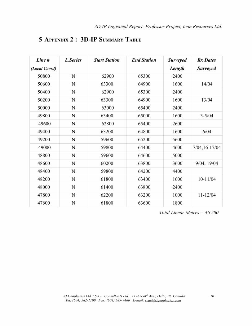
5 APPENDIX 2 : 3D-IP SUMMARY TABLE
Line #
(Local Coord)
L.Series Start Station End Station Surveyed
Length
Rx Dates
Surveyed50800 N 62900 65300 240050600 N 63300 64900 1600 14/0450400 N 62900 65300 240050200 N 63300 64900 1600 13/0450000 N 63000 65400 240049800 N 63400 65000 1600 3-5/0449600 N 62800 65400 260049400 N 63200 64800 1600 6/0449200 N 59600 65200 560049000 N 59800 64400 4600 7/04,16-17/0448800 N 59600 64600 500048600 N 60200 63800 3600 9/04, 19/0448400 N 59800 64200 440048200 N 61800 63400 1600 10-11/0448000 N 61400 63800 240047800 N 62200 63200 1000 11-12/0447600 N 61800 63600 1800
Total Linear Metres = 46 200
SJ Geophysics Ltd. / S.J.V. Consultants Ltd. 11762-94th Ave., Delta, BC Canada 10Tel: (604) 582-1100 Fax: (604) 589-7466 E-mail: [email protected]