Embed Size (px)
Citation preview

3.8 Noise and Vibration
Link Light Rail Operations and Maintenance Satellite FacilityFinal Environmental Impact Statement
3.8‐1 September 2015
3.8 Noise and Vibration
This section includes background information on noise and vibration and a summary of noise and
vibration impacts identified, as well as potential mitigation measures.
3.8.1 Introduction to Resources and Regulatory Requirements
3.8.1.1 Noise
What we hear as sound is a series of continuous air pressure fluctuations superimposed on the
atmospheric pressure that surrounds us. The amplitude of fluctuation is related to the energy
carried in a sound wave; the greater the amplitude, the greater the energy and the louder the
sound. Sound‐pressure levels are quantified by the fundamental descriptor used in acoustics, the
sound pressure level, in decibels (dB). When sounds are unpleasant, unwanted, or disturbingly loud,
we tend to classify them as noise.
The number of fluctuation cycles or pressure waves per second of a particular sound is the
frequency of the sound. The human ear is less sensitive to higher and lower frequencies than to
mid‐range frequencies. Therefore, sound‐level meters used to measure environmental noise
generally incorporate a weighting system that filters out higher and lower frequencies in a manner
similar to the human ear. This system produces noise measurements that approximate the normal
human perception of noise. Measurements made with this weighting system are termed A‐weighted
and are specified as A‐weighted decibel (dBA) readings. Community noise is usually characterized in
terms of the A‐weighted sound level.
When sounds exceed 110 dBA, there is a potential for hearing damage, even with relatively short
exposures. In quiet suburban areas far from major freeways, the noise levels during the late night
hours will drop to about 30 dBA. Outdoor noise levels lower than this only occur in isolated areas
where there is a minimum of natural noises such as leaves blowing in the wind, crickets, or flowing
water.
Several noise descriptors are used that take into account the variability of noise over time. The
equivalent sound level (Leq) is the level of a constant sound for a specified period of time that has
the same sound energy as an actual fluctuating noise over the same period of time. It is an energy
average sound level. The day‐night sound level (Ldn) is the equivalent sound level for a 24‐hour
period with an additional 10 dBA added to nighttime sound levels occurring between 10:00 p.m. and
7:00 a.m. Another descriptor, the statistical sound level, is the sound level that is equaled or
exceeded for a specified percentage of a given measurement period. For example, L25 is the
notation for the noise level within a measurement interval that is equaled or exceeded 25% of the
time. The minimum noise level during a measurement period is denoted Lmin. The maximum noise
levels that occur during an event, such as the passing of a heavy truck or the flyover of an airplane, is
denoted Lmax.

3.8 Noise and Vibration
Link Light Rail Operations and Maintenance Satellite FacilityFinal Environmental Impact Statement
3.8‐2 September 2015
Figure 3.8‐1 defines typical community noise levels in terms of Ldn. Most urban and suburban
neighborhoods will be in the range of Ldn 50 to 70 dBA. An Ldn of 70 dBA is a relatively noisy
environment that might be found at buildings on a busy surface street, close to a freeway or near a
busy airport. In recent times, many urban developments have combined retail, light commercial and
other nonresidential uses with residential uses in a mixed‐use environment. Because of these
mixed‐use developments, ambient noise levels in some urban environments may be slightly higher
than the levels provided in Figure 3.8‐1.
Figure 3.8‐1. Typical Day‐Night Sound Levels
The following list contains some general rules for community noise:
A 3‐dB change is the minimum most people will notice in most environments.
Under free‐field conditions, where there are no reflections or additional attenuations, a point
sound source is known to decrease at a rate of 6 dB for each doubling of distance. For example,
a sound level of 70 dB at a distance of 100 feet would decrease to 64 dB at 200 feet.
Sounds such as sirens, bells, and horns are more noticeable than broadband noise sources, such
as traffic.
A 10‐dB increase in sound level is perceived as an approximate doubling of the loudness of the
sound and represents a substantial change in loudness.
An important factor to recognize is that noise is measured on a decibel scale, and combining two
noises is not achieved by simple addition. For example, combining two 60‐dBA noises does not
give 120 dBA (which is near the pain threshold), but yields 63 dBA which is lower than the
volume at which most people listen to their televisions.

3.8 Noise and Vibration
Link Light Rail Operations and Maintenance Satellite FacilityFinal Environmental Impact Statement
3.8‐3 September 2015
3.8.1.2 Regulatory Noise Requirements and Impact Criteria
Several different noise criteria were evaluated for applicability to the noise and vibration analysis for
the proposed project. These include the Transit Noise and Vibration Impact Assessment (FTA
guidance manual) (Federal Transit Administration 2006) along with local criteria from the Bellevue
City Code 9.18 (BCC) and Lynnwood Municipal Code 10.12 (LMC). Applicable noise and vibration
criteria and methods used for the noise studies are discussed in the following sections.
3.8.1.3 FTA Noise Criteria
Transit noise impacts for this project are determined based on the criteria defined in the FTA
guidance manual. The FTA noise impact criteria are based on documented research on community
reaction to noise. The criteria are based on a sliding scale that uses the existing noise levels as a
basis for setting actual impact levels. Although more transit noise is allowed in neighborhoods with
high levels of existing noise, as the existing noise levels increase, a smaller increase in the total noise
exposure is allowed when compared to areas with lower existing noise levels. The FTA noise impact
criteria also group noise‐sensitive land uses into three categories:
Category 1. Tracts of land where quiet is an essential element in their intended purpose. This
category includes lands set aside for serenity and quiet, and such land uses as outdoor
amphitheaters and concert pavilions, as well as National Historic Landmarks with significant
outdoor use. Also included are recording studios and concert halls. Category 1 land use is
evaluated using the exterior peak hour Leq.
Category 2. Residences and buildings where people normally sleep. This category includes
homes, hospitals and hotels where a nighttime sensitivity to noise is assumed to be of utmost
importance. Category 2 land use is evaluated using the exterior 24‐hour Ldn.
Category 3. Institutional land uses with primarily daytime and evening use. This category
includes schools, libraries, theaters, and churches where it is important to avoid interference
with such activities as speech, meditation, and concentration on reading material. Places for
meditation or study associated with cemeteries, monuments, museums, campgrounds, and
recreational facilities are also considered to be in this category. Certain historical sites and parks
are also included. Category 3 land use is evaluated using the exterior peak hour Leq.
The criteria do not apply to most commercial or industrial uses because, in general, the activities
within these buildings are compatible with higher noise levels. They do apply to business uses which
depend on quiet as an important part of operations, such as sound and motion picture recording
studios.
FTA assumes that parks are a special case, and how they are used and where they are located
should be considered when considering whether or not a particular park, or an area within a park, is
considered noise‐sensitive. All parks along the project corridor were evaluated for consideration
under the FTA criteria. Based on park location, uses, and existing noise levels, Scriber Creek Park was
evaluated under FTA Category 3 criteria. The park’s hours of operation are considered when
performing the noise analysis per FTA criteria. The Ldn is used to characterize noise exposure for

3.8 Noise and Vibration
Link Light Rail Operations and Maintenance Satellite FacilityFinal Environmental Impact Statement
3.8‐4 September 2015
residential areas (Category 2). For other noise‐sensitive land uses, such as outdoor amphitheaters,
parks, and school buildings (Categories 1 and 3), the maximum 1‐hour Leq during the facility’s
operating period is used. There are no noise impact criteria for most commercial and industrial land
uses. There are two levels of impact included in the FTA criteria: severe and moderate, interpreted
as follows:
Severe Impact. Project‐generated noise in the severe impact range can be expected to cause a
large percentage of people to be highly annoyed by the new noise and represents the most
compelling need for mitigation. Noise mitigation will normally be specified for severe impact
areas unless there are truly extenuating circumstances that prevent it.
Moderate Impact. In this range of noise impact, the change in the cumulative noise level is
noticeable to most people but may not be sufficient to cause strong, adverse reactions from the
community. In this transitional area, other project‐specific factors must be considered to
determine the magnitude of the impact and the need for mitigation. These factors include the
existing level, the projected level of increase over existing noise levels, the types and numbers of
noise‐sensitive land uses affected, the noise sensitivity of the properties, the effectiveness of
the mitigation measures, community views, and the cost of mitigating noise to more acceptable
levels.
The FTA noise impact criteria are summarized in graphical form in Figure 3.8‐2, which shows how
the combination of existing noise exposure and additional noise exposure from a transit project can
cause either a moderate or severe impact. The future noise exposure would be the combination of
the existing noise exposure and the additional noise exposure caused by the transit project.
Figure 3.8‐2. FTA Noise Impact Criteria

3.8 Noise and Vibration
Link Light Rail Operations and Maintenance Satellite FacilityFinal Environmental Impact Statement
3.8‐5 September 2015
FTA Construction Noise
Although FTA does not specify standardized criteria for construction noise, it does provide guidance
on reasonable Leq noise levels based on an 8‐hour Leq (Leq(8)) for land use type and time of day. For
residential land uses, FTA recommends that noise levels not exceed 80 dBA Leq(8) during daytime
hours or 70 dBA during nighttime hours. For commercial uses, that recommendation is increased to
85 dBA Leq(8) during both daytime and nighttime hours. Industrial land uses have daytime and
nighttime recommended construction noise limits of 90 dBA Leq(8).
3.8.1.4 Local Noise Ordinances
Under FTA regulations, local (state, county, and city) noise laws, regulations, and ordinances must
be considered for ancillary facilities and construction. The Washington State Department of Ecology
(Ecology) has adopted Maximum Environmental Noise Levels for residential, commercial, industrial,
and construction areas, which states:
The department conceives the function of noise abatement and control to be primarily the role of local government and intends actively to encourage local government to adopt measures for noise abatement and control. Wherever such measures are made effective and are being actively enforced, the department does not intend to engage directly in enforcement activities (WAC 173‐60‐110).
As a result, only the noise abatement and control ordinances for the Cities of Bellevue and
Lynnwood are used for this noise analysis.
City of Bellevue
The City of Bellevue primarily regulates noise pursuant to Chapter 9.18 of BCC, Noise Control. The
City of Bellevue defines three environmental designations for noise abatement (EDNA) based on the
land use districts listed in the City of Bellevue Land Use Code (BCC 9.18.025). The land use districts
classified under each EDNA are listed in Table 3.8‐1 by their designated code.
Table 3.8‐1. City of Bellevue EDNA Land Use Designations
Property Producing Noise (EDNA) Land Use Districts
Class A R‐1, R‐1.8, R‐2.5, R‐3.5, R‐4, R‐5, R‐7.5, R‐10, R‐15, R‐20, R‐30
Class B PO, O, OLB, OLB‐OS, NB, CB, DNTN‐O‐1, DNTN‐O‐2, DNTN‐MU, DNTN‐R, DNTN‐OB, DNTN‐OLB, F1, F2, F3, MI, BR‐R, BR‐MO, BR‐MO‐1, BR‐OR, BR‐OR‐1, BR‐OR‐2, BR‐RC‐1, BR‐RC‐2, BR‐RC‐3, BR‐CR, BR‐ORT
Class C LI, GC, BR‐GC
Chapter 9.18 also defines the maximum permissible environmental noise level from one EDNA to
another EDNA (BCC 9.18.030), as shown in Table 3.8‐2. The property‐line noise limits in Table 3.8‐2
are reduced by 10 dBA for receiving properties in Class A EDNAs from 10:00 p.m. to 7:00 a.m. to
reflect nighttime sensitivity to noise.

3.8 Noise and Vibration
Link Light Rail Operations and Maintenance Satellite FacilityFinal Environmental Impact Statement
3.8‐6 September 2015
Table 3.8‐2. City of Bellevue Maximum Permissible Noise Limits
Property Producing Noise (EDNA)
Maximum Allowable Sound Level (dBA) Property Receiving Noise EDNA
Class A (Residential) Class B (Commercial) Class C (Industrial)
Class A 55 57 60
Class B 57 60 65
Class C 60 65 70
Sounds created by bells, chimes, and carillons not operating continuously for more than 5 minutes in
any 1 hour are exempt from the maximum permissible environmental noise level limitations
between the hours of 7:00 a.m. and 10:00 p.m. on weekdays and 9:00 a.m. and 10:00 p.m. on
weekends if the receiving property is located in a Class A EDNA.
Sounds created by construction and emanating from construction sites are also exempt from the
maximum permissible environmental noise level limitations described above between 7:00 a.m. and
6:00 p.m. on weekdays, and 9:00 a.m. and 6:00 p.m. on Saturdays that are not legal holidays.
Construction during nighttime hours (between 6:00 p.m. and 7:00 a.m. on weekdays, and between
6:00 p.m. and 9:00 a.m. on Saturdays) or on Sundays or legal holidays is required to meet the City’s
noise level limitations, as given in Table 3.8‐2, unless a construction noise permit for expanded
hours is received from the City. The City of Bellevue also has a 5‐dB penalty for impulsive or pure
tone noise sources for any receiving property.
City of Lynnwood
The City of Lynnwood noise control ordinance contains three EDNA based on the land use zoning
classifications described in Title 21 of the LMC (LMC 10.12.400.B). The land use districts classified
under each EDNA are listed in Table 3.8‐3 by their designated code.
Table 3.8‐3. City of Lynnwood EDNA Land Use Designations
Property Producing Noise (EDNA) Land Use Districts
Class A RS‐8, RS‐7, RS‐4, P‐1, RML, RMM, RMH, MHP
Class B B‐2, B‐3, PCD, B‐1, CG, PRC, CC‐C, CC‐W, CC‐N, MU, CDM, HMU
Class C BTP, LI
LMC 10.12.500 defines the maximum permissible environmental noise level from one EDNA to
another EDNA, as shown in Table 3.8‐4.

3.8 Noise and Vibration
Link Light Rail Operations and Maintenance Satellite FacilityFinal Environmental Impact Statement
3.8‐7 September 2015
Table 3.8‐4. City of Lynnwood Maximum Permissible Noise Limits
Property Producing Noise (EDNA)
Maximum Allowable Sound Level (dBA) Property Receiving Noise EDNA
Class A Class B Class C
Class A 55 57 60
Class B 57 60 65
Class C 60 65 70
The property‐line noise limits in Table 3.8‐4 are reduced by 10 dBA for receiving properties in Class A
EDNAs from 10:00 p.m. to 7:00 a.m. to reflect nighttime sensitivity to noise. In addition, the City
may require applicants for city permits to document that the proposed project would not exceed
noise standards or violate nuisance regulations pertaining to noise, and provide recommendations
from such a consultant as to how noise can be minimized. The responsible official may condition or
deny projects that would violate state and local standards.” Sounds that are exempt at all times
from the maximum permissible sound levels include sounds created by warning devices not
operating continuously for more than 5 minutes, or bells, chimes, and carillons
(LMC 10.12.500(F)(4)).
Noise from construction activity is exempt on every day of the week from the City of Lynnwood
environmental noise level requirements at all times in Class B and C EDNAs and between 7:00 am
and 10:00 pm in Class A EDNAs. The City may require installation of the best available noise
abatement technology consistent with economic feasibility.
The LMC does not address construction noise variances.
3.8.1.5 Vibration
Groundborne vibration consists of oscillatory waves that propagate from the source through the
ground to adjacent buildings. On steel‐wheel/steel‐rail train systems, groundborne vibration is
created by the interaction of the steel wheels rolling on the steel rails. Although the vibration is
sometimes noticeable outdoors, it is almost exclusively an indoor problem. Trains operating in the
OMSF yard would not produce sufficient vibration to cause even minor cosmetic damage to
nearby buildings. The primary concern is that the vibration and radiated noise can be intrusive
and annoying to building occupants. The building vibration caused by groundborne vibration may
be perceived as motion of building surfaces; rattling of windows, items on shelves, or pictures
hanging on walls; or as a low‐frequency rumbling noise, which is referred to as groundborne
noise. Factors that influence the amplitudes of groundborne vibration include vehicle suspension
parameters, condition of the wheels and rails, type of track, track support system, type of building
foundation, and the properties of the soil and rock layers through which the vibration propagates.
Train vibration is virtually always characterized in terms of the root‐mean‐square (RMS)
amplitude. RMS is a widely used but sometimes confusing method of characterizing vibration and
other oscillating phenomena. It represents the average energy over a short time interval; typically,

3.8 Noise and Vibration
Link Light Rail Operations and Maintenance Satellite FacilityFinal Environmental Impact Statement
3.8‐8 September 2015
a one second interval is used to evaluate human response to vibration. RMS vibration velocity is
considered the best available measure of potential human annoyance from groundborne
vibration.
Figure 3.8‐3 gives a general idea of human and building response to different levels of vibration.
Existing background building vibration is usually in the range of 40 to 50 velocity decibels (VdB),
which is well below the range of human perception. Although the perceptibility threshold is about
65 VdB, humans are not bothered unless the RMS vibration velocity level exceeds 70 to 75 VdB. This
is a typical level 50 feet from a rapid transit or light rail system. Buses and trucks rarely create
vibration that exceeds 70 VdB unless there are large bumps or potholes in the road.
Figure 3.8‐3. Typical RMS Vibration Levels
Vibration Criteria
FTA has developed impact criteria for acceptable levels of groundborne noise and vibration.
Groundborne noise is associated with subterranean transit projects and is therefore not a concern
for the proposed project. Experience with groundborne vibration from rail systems and other
common vibration sources suggest the following:
Groundborne vibration from transit trains should be characterized in terms of the RMS vibration
velocity amplitude.
The threshold of vibration perception for most humans is around 65 VdB. Levels in the 70 to
75 VdB range are often noticeable but acceptable, and levels greater than 80 VdB are often
considered unacceptable.
For an operations and maintenance facility, which has train movement throughout the day, evening
and nighttime hours, the FTA limit for acceptable levels of residential groundborne vibration is
72 VdB.

3.8 Noise and Vibration
Link Light Rail Operations and Maintenance Satellite FacilityFinal Environmental Impact Statement
3.8‐9 September 2015
FTA assigns sensitive land uses to the following three categories:
Vibration Category 1: High Sensitivity. This category includes buildings where low ambient
vibration is essential for the interior operations in the building. Vibration levels may be below
the level of human perception. Typical land uses covered by Category 1 are vibration‐sensitive
research and manufacturing facilities, hospitals with vibration‐sensitive equipment, and
university research operations. The degree of sensitivity to vibration will depend on the specific
equipment that will be affected by the vibration. Equipment such as electron microscopes and
high‐resolution lithographic equipment can be very sensitive to vibration, and even normal
optical microscopes will sometimes be difficult to use when vibration is well below the human
annoyance level.
Vibration Category 2: Residential. This category includes residences and buildings where people
normally sleep, including private dwellings, hospitals, and hotels where nighttime sensitivity is
assumed to be of utmost importance.
Vibration Category 3: Institutional. This category includes land uses with primarily daytime use
including schools, churches, and other institutions and quiet offices that do not have vibration‐
sensitive equipment. Offices in buildings primarily for industrial use are not included in this
category.
Table 3.8‐5 summarizes the FTA impact criteria for groundborne vibration and illustrates that some
land use activities are more sensitive to vibration than others.
Table 3.8‐5. FTA Vibration Impact Criteria for Frequenta Events
Land Use Category Category Comment Groundborne Vibration(VdB re 1 micro in/sec)
1 Low interior vibration is essential 65
2 Residential and sleep 72
3 Institutional and daytime 75
‐‐b Concert hall, TV/recording studio 65
‐‐ b Auditorium 72
‐‐ b Theatre 72
‐‐ b Office use for detailed analysis 84
Source: Federal Transit Administration 2006. a Frequent is defined as greater than or equal to 70 events per day. b Special buildings and office spaces do not fall into any specific FTA land use categories.
Vdb = velocity decibels; in/sec = inches per second
3.8.2 Methods
The noise and vibration study area includes all structures within 225 feet for areas with intervening
buildings, extending out to 350 feet in areas with an unobstructed line‐of‐sight to the OMSF (Federal
Transit Administration 2006).
3.8 Noise and Vibration
Link Light Rail Operations and Maintenance Satellite FacilityFinal Environmental Impact Statement
3.8‐10 September 2015
Under FTA criteria, noise impacts are a function of the existing noise levels; therefore, ambient noise
monitoring was used to establish the noise environment at residential land uses near the site.
Impacts under the local noise control ordinances are determined using property line noise limits
that are based on the zoning designations and associated EDNA classifications established by city
code.
3.8.2.1 Construction Noise and Vibration
The noise and vibration analysis for project construction follows the FTA guidance manual. The
analysis reviews the types of equipment normally used for this type of project and the expected
noise levels at nearby noise sensitive properties.
3.8.2.2 Operational Noise
The methods of analysis and the assumptions used are summarized below. Complete details on the
noise sources and analysis methodology are provided in Appendix E.2, Noise and Vibration Technical
Report.
Noise and vibration from OMSF operations were modeled using the methods described in the FTA
guidance manual. The operational noise impact assessment includes the analysis of noise from
general maintenance operations, train cleaning, the arrival and departure of trains at the OMSF,
vehicle movement in the yard, and ancillary equipment including a power substation. A light rail
vehicle (LRV) wash system would be enclosed with openings on each end for LRV access. The LRV
wash system would typically be used for 50 to 60 minutes per day. This is based on the wash cycle
for a four‐car train taking approximately 10 minutes and approximately four to five four‐car trains
washed each day (approximately 25% of the fleet stored at the OMSF). Based on measurements of
similar wash facilities, and information from wash blower manufacturers, the sound pressure level
at a distance of 50 feet from the end of the wash bays is 74 dBA.
Noise from general maintenance activities inside the shop building would include use of hand tools,
continuous operation of compressors and other mechanical equipment, and intermittent operation
of equipment such as overhead cranes, vehicle lifts, and the wheel trues. For this analysis, it was
assumed that bay doors would be left open for ventilation, making this a worst‐case analysis, and
the typical hourly sound level would be 69 dBA Leq at 50 feet outside of the work bays.
Onsite LRV circulation is limited to the speed limit of 8 miles per hour (mph). Assuming the worst
case by using the maximum capacity of 96 vehicles moving around the yard at 8 mph in a single
hour, the LRV movement around the facility, and through the LRV maintenance building and LRV
storage area, would produce an hourly Leq of 60 dBA at 50 feet. Noise from 10 trains (40 vehicles)
using the access track to the mainline for revenue service was also included in the noise analysis for
the same 1‐hour period. A crossover located on the access track near Seattle Children’s Hospital:
Bellevue Clinic and Surgery Center would typically add 2 to 10 dB to the noise from the train,
depending on the train speed and type of crossover. Because of the slow speed (10 mph) on the
access tracks, a conservative 5‐dBA increase in noise was assumed from the crossover, which is 2 to
3.8 Noise and Vibration
Link Light Rail Operations and Maintenance Satellite FacilityFinal Environmental Impact Statement
3.8‐11 September 2015
3 dB higher than is likely to occur. Other noise‐producing sources would include switches, a traction
power substation, and OMSF personnel and suppliers accessing the site. The analysis uses reference
noise levels for operation of a maintenance base taken from the FTA guidance manual and assumes
the OMSF would operate 24 hours per day.
Due to the low speed of 8 mph for LRV operations in the OMSF, wheel squeal noise would not be
noticeable. Any wheel squeal on the curves into and out of the storage tracks would be resolved
with lubrication or other means. Therefore, wheel squeal was not included in the noise model for
the OMSF.
3.8.2.3 Operational Vibration
Light rail vibration was predicted using information from the vibration sections of the East Link
Project Final EIS (Sound Transit 2011) and the Vibration Technical Report of the Lynnwood Link
Extension Final EIS (Sound Transit 2015). Based on these documents and including track type
adjustments for ballast and tie, direct fixation and aerial guideway alignment types, vibration
impacts could only occur at FTA Category 2 structures located within 100 feet of the Preferred
Alternative, BNSF Modified Alternative, and SR 520 Alternative site tracks, as well as the BNSF
Storage Tracks component of the Lynnwood Alternative. Vibration impacts could only occur at FTA
Category 2 structures located within 70 feet of the Lynnwood Alternative site tracks. The differing
impact distance for these build alternatives is due to the different vibration propagation
characteristics of the soils at the different sites.
For Category 1 sites, such as the Seattle Children’s Hospital: Bellevue Clinic and Surgery Center,
vibration levels were also predicted using the East Link Final EIS vibration analysis and data from
propagation measurements taken near the hospital during the East Link Project. Predicted vibration
levels above 60 VdB at the hospital are considered to be an impact. Track type and special trackwork
were reflected in this analysis.
3.8.3 Affected Environment
This section provides a summary of the existing land use and noise environment near the build
alternative sites.
3.8.3.1 Preferred Alternative
Parcels comprising the Preferred Alternative site are zoned as Bel‐Red Office‐Residential Node 2(BR‐
OR‐2) and Bel‐Red Residential (BR‐R); these are categorized as Class B EDNA per BCC 9.18.025. Areas
west of the Eastside Rail Corridor within the Preferred Alternative site are designated Bel‐Red
Medical Office (BR‐MO), also categorized as Class B EDNA per BCC 9.18.025. The single parcel
comprising the BNSF Storage Tracks is zoned BR‐OR‐2, a Class B EDNA per BCC 9.18.025. Land use
north and east of the Preferred Alternative site is commercial and industrial. West of the site, along
116th Avenue NE, land use includes the Seattle Children’s Hospital: Bellevue Clinic and Surgery
Center, several commercial and office spaces, and several single‐family residences. The Seattle

3.8 Noise and Vibration
Link Light Rail Operations and Maintenance Satellite FacilityFinal Environmental Impact Statement
3.8‐12 September 2015
Children’s Hospital: Bellevue Clinic and Surgery Center contains equipment that is sensitive to
vibration. It also has a planned expansion to the east of the existing building, which will include new
medical facilities and additional parking.
Within the Bel‐Red subarea, the Spring District is a mixed‐use transit‐oriented development (TOD)
project that has an approved 15‐year Master Development Plan. The Spring District is located north
of NE 12th Street, between NE 20th and NE 24th Avenues. It will include office space, retail, housing,
hotels, parks, and a new road system with the necessary infrastructure. Construction of the hotel is
planned for 2022 through 2024 (Phase 4). Construction of residential structures nearest to 120th
Avenue NE and 124th Avenue NE is planned for 2024 to 2026 (Phase 5) and 2026–2028 (Phase 6).
The two Spring District residential structures and hotel nearest to the Preferred Alternative site are
shown in Figure 3.8‐4. There are no parks or recreational resources proposed as part of the Spring
District.
Existing noise levels near the Preferred Alternative site are dominated by traffic noise from I‐405, SR
520, NE 12th Street, 116th Avenue NE and other arterial roadways in addition to the commercial
and industrial activities. Noise levels range from high of 70 dBA Ldn near State Route 520 (SR 520),
reducing to 58 dBA Ldn at single‐family residences west of 116th Avenue NE. Figure 3.8‐4 shows the
Preferred Alternative site, along with the access tracks, monitoring locations, measured noise levels,
and area land use.
3.8.3.2 BNSF Modified Alternative and BNSF Storage Tracks
The BNSF Modified Alternative and BNSF Storage Tracks component of the Lynnwood Alternative
are both located in the same general area as the Preferred Alternative site; therefore, nearby
permitted developments, as well as existing noise levels, are the same as those described above.
Figure 3.8‐5 shows the BNSF Modified Alternative site, along with the access tracks, monitoring
locations, measured noise levels, and area land use.
3.8.3.3 SR 520 Alternative
Parcels comprising the SR 520 Alternative site are zoned Bel‐Red General Commercial (BR‐GC) and
categorized as Class C EDNA per BCC 9.18.025.
There are no residences within 700 feet of the SR 520 Alternative site boundaries. Noise levels near
the site are dominated by traffic on SR 520, NE 20th Street, 130th Avenue NE, along with noise from
existing commercial and light industrial activities. Noise levels in this area varied from 71 dBA Leq
during peak hours to 60 dBA Leq during nighttime hours, for a 24‐hour Ldn of 70 to 72 dBA.
Figure 3.8‐6 shows the SR 520 Alternative site, access tracks, monitoring locations, measured noise
levels, and area land use.

Figure 3.8-4: Preferred Alternative—Land Use and Monitoring LocationsSound Transit Link Light Rail OMSF Draft EIS
Gra
phic
s …
003
29.1
2 (9
-9-2
015)
Source: Michael Minor & Associates 2015. Approximate Scale (Feet)
0 200 400 800

Figure 3.8-5: BNSF Modi�ed Alternative—Land Use and Monitoring LocationsSound Transit Link Light Rail OMSF Draft EIS
Gra
phic
s …
003
29.1
2 (9
-9-2
015)
Source: Michael Minor & Associates 2015.Approximate Scale (Feet)
0 200 400 800

Figure 3.8-6: SR 520 Alternative—Land Use and Monitoring LocationsSound Transit Link Light Rail OMSF Draft EIS
Gra
phic
s …
003
29.1
2 (9
-9-2
015)
Source: Michael Minor & Associates 2015.Approximate Scale (Feet)
0 250 500 1000

3.8 Noise and Vibration
Link Light Rail Operations and Maintenance Satellite FacilityFinal Environmental Impact Statement
3.8‐16 September 2015
3.8.3.4 Lynnwood Alternative
Parcels comprising the Lynnwood Alternative site are zoned as Business/Technical Park (BTP) and
Light Industrial (LI); these are categorized as Class C EDNA per LMC 10.12.400. Land use near the
Lynnwood Alternative site is residential along the west side of 52nd Avenue W. East of 52nd Avenue
W, adjacent to Interstate 5 (I‐5), there is one single‐family residence and then land uses transition to
commercial and industrial. East of 52nd Avenue W are several vacant parcels, state and private
office buildings, and Scriber Creek Park. Based on the park location, uses and existing noise levels,
Scriber Creek Park was evaluated under the FTA Category 3 criteria.
Existing noise levels near the Lynnwood Alternative site range from 72 dBA Ldn near I‐5 reducing to
57 to 65 dBA Ldn toward the north end of the alternative site. Existing noise levels near Scriber
Creek Park, the Park Five Apartments, and the Cedar Creek Condominiums range from 58 to 62 dBA
Leq during peak hours, with Ldn noise levels ranging from 57 to 64 dBA. Figure 3.8‐7 shows the
Lynnwood Alternative site, access tracks, monitoring locations, measured noise levels, and area land
use near the site.
3.8.4 Environmental Impacts
This section provides a summary of the noise and vibration impacts expected during construction
and operation of the OMSF. Complete details are provided in Appendix E.2, Noise and Vibration
Technical Report.
3.8.4.1 No Build Alternative
Under the No Build Alternative, noise and vibration levels would continue to be dominated by traffic
on nearby major highways, commercial and industrial activities and local traffic on nearby arterial
roadways.
3.8.4.2 Impacts Common to All Build Alternatives
Construction Noise and Vibration
Noise would be generated by heavy equipment. Table 8.3‐6 shows typical construction equipment
for this type of project. Construction activities would occur within approximately 200 to 400 feet
from noise‐sensitive properties under the Preferred Alternative and BNSF Modified Alternative, as
well as for the BNSF Storage Tracks component of the Lynnwood Alternative. Under the SR 520
Alternative, the nearest residences are over 700 feet away, north of SR 520. Construction activities
would occur approximately 100 to 200 feet from the nearest residences under the Lynnwood
Alternative (Lynnwood site only). Table 3.8‐6 provides a summary of the equipment used for the
two major phases of construction. The Leq(8) is an 8‐hour Leq that assumes that construction
equipment is operating under full load for 4 hours of the 8‐hour period, with general background
construction noise levels during the other 4 hours.

Figure 3.8-7: Lynnwood Alternative—Land Use and Monitoring LocationsSound Transit Link Light Rail OMSF Draft EIS
Gra
phic
s …
003
29.1
2 (9
-9-2
015)
Source: Michael Minor & Associates 2015.Approximate Scale (Feet)
0 200 400 800

3.8 Noise and Vibration
Link Light Rail Operations and Maintenance Satellite FacilityFinal Environmental Impact Statement
3.8‐18 September 2015
Table 3.8‐6. Typical Construction Activities and Maximum Noise Levels at 100 Feet
Construction Phase Typical Equipment
Noise Levels (Lmax) at 100 feet in dBA
Noise Levels (Leq(8)) at 100 feet in dBA
Clearing, grubbing earthwork and preparation
Air compressor, back hoe, generator, concrete saws, concrete breakers, jack hammers, haul trucks, loaders and utility trucks
85–89 78–82
Building Construction, track installation and Paving
Paver, crane, concrete pumps, haul trucks, concrete mixer, air compressor, back hoe, generator, tractor trailer, jack hammer, pneumatic tools, utility trucks and welders
81–86 74–79
Source: U.S. Department of Transportation 1977.
dBA = a‐weighted decibels; Lmax = Maximum noise levels during periods of high activity; Leq(8) = 8‐hour Leq for comparison to the FTA guidelines
Once the major construction is completed, some additional supporting construction activities would
be required, including installation of rails and overhead power systems, shop and LRV wash facility
components along with finishing activities, e.g., stripping of parking and travel routes and lighting
systems. These less intensive activities are not expected to produce noise levels above 68 to 72 dBA
at 100 feet.
As noted previously, construction noise is exempt from the City of Bellevue noise ordinance level
between 7:00 a.m. and 6:00 p.m. on weekdays and 9:00 a.m. and 6:00 p.m. on Saturdays that are
not legal holidays. Construction noise is exempt from the City of Lynnwood noise ordinance
between 7:00 a.m. and 10:00 p.m. in Class A EDNAs and at all times everywhere else. Any
construction activities outside of these hours are required to meet the local noise ordinance
requirements unless a noise variance is received from the City.
There is a potential for pile driving at all of the build alternative sites. Average maximum noise levels
from pile driving typically ranges from 98 to 105 dBA Lmax at 50 feet. Due to the high noise levels,
pile driving is typically limited to daytime hours, and any pile driving would be required to meet the
applicable construction noise regulations.
Construction‐related vibration would be essentially the same under all build alternatives. General
construction activities can result in short‐term increased vibration levels at nearby structures.
Project‐related vibration sources would include soil compactors, dozers, excavators, haul trucks,
flatbed tractor‐trailers, backhoes, cranes, and jackhammers. Maximum vibration levels would be
expected from vibratory rollers and pile driving. The vibration sources associated with the proposed
project, even though they could be noticeable to residents when construction is close by, are not
expected to cause any structural damage.
3.8 Noise and Vibration
Link Light Rail Operations and Maintenance Satellite FacilityFinal Environmental Impact Statement
3.8‐19 September 2015
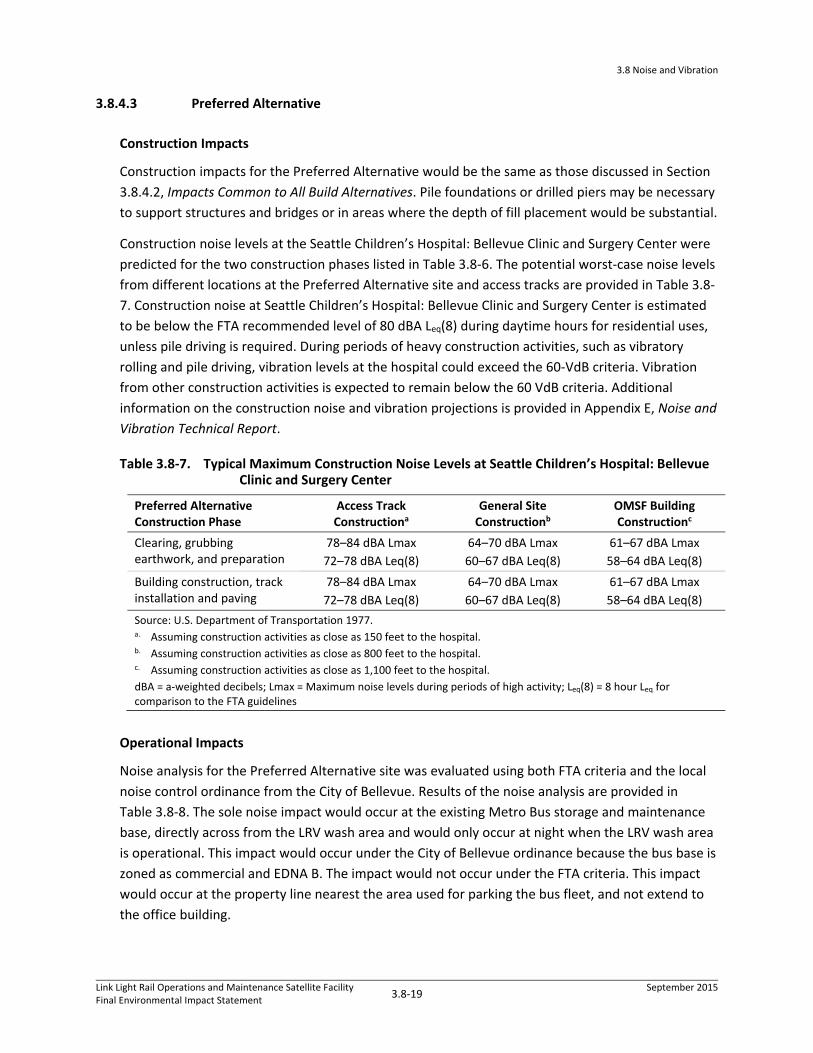
3.8.4.3 Preferred Alternative
Construction Impacts
Construction impacts for the Preferred Alternative would be the same as those discussed in Section
3.8.4.2, Impacts Common to All Build Alternatives. Pile foundations or drilled piers may be necessary
to support structures and bridges or in areas where the depth of fill placement would be substantial.
Construction noise levels at the Seattle Children’s Hospital: Bellevue Clinic and Surgery Center were
predicted for the two construction phases listed in Table 3.8‐6. The potential worst‐case noise levels
from different locations at the Preferred Alternative site and access tracks are provided in Table 3.8‐
7. Construction noise at Seattle Children’s Hospital: Bellevue Clinic and Surgery Center is estimated
to be below the FTA recommended level of 80 dBA Leq(8) during daytime hours for residential uses,
unless pile driving is required. During periods of heavy construction activities, such as vibratory
rolling and pile driving, vibration levels at the hospital could exceed the 60‐VdB criteria. Vibration
from other construction activities is expected to remain below the 60 VdB criteria. Additional
information on the construction noise and vibration projections is provided in Appendix E, Noise and
Vibration Technical Report.
Table 3.8‐7. Typical Maximum Construction Noise Levels at Seattle Children’s Hospital: Bellevue Clinic and Surgery Center
Preferred Alternative Construction Phase
Access Track Constructiona
General Site Constructionb
OMSF Building Constructionc
Clearing, grubbing earthwork, and preparation
78–84 dBA Lmax
72–78 dBA Leq(8)
64–70 dBA Lmax
60–67 dBA Leq(8)
61–67 dBA Lmax
58–64 dBA Leq(8)
Building construction, track installation and paving
78–84 dBA Lmax
72–78 dBA Leq(8)
64–70 dBA Lmax
60–67 dBA Leq(8)
61–67 dBA Lmax
58–64 dBA Leq(8)
Source: U.S. Department of Transportation 1977. a. Assuming construction activities as close as 150 feet to the hospital. b. Assuming construction activities as close as 800 feet to the hospital. c. Assuming construction activities as close as 1,100 feet to the hospital.
dBA = a‐weighted decibels; Lmax = Maximum noise levels during periods of high activity; Leq(8) = 8 hour Leq for comparison to the FTA guidelines
Operational Impacts
Noise analysis for the Preferred Alternative site was evaluated using both FTA criteria and the local
noise control ordinance from the City of Bellevue. Results of the noise analysis are provided in
Table 3.8‐8. The sole noise impact would occur at the existing Metro Bus storage and maintenance
base, directly across from the LRV wash area and would only occur at night when the LRV wash area
is operational. This impact would occur under the City of Bellevue ordinance because the bus base is
zoned as commercial and EDNA B. The impact would not occur under the FTA criteria. This impact
would occur at the property line nearest the area used for parking the bus fleet, and not extend to
the office building.

3.8 Noise and Vibration
Link Light Rail Operations and Maintenance Satellite FacilityFinal Environmental Impact Statement
3.8‐20 September 2015
Table 3.8‐8. Noise Impact Analysis Results for Preferred Alternative
Addressa
Bellevue Analysis
(Peak Hour Leqb dBA)
FTA Analysis
(24‐hour Ldn or peak‐hour Leq dBA)
Impact Type and Criteria Exceededf Day Night
Criteria
Day
(Night) Existingc Projectd FTA
Criteriae
Children’s Hospital 1500 116th Ave NE
52 52 60
(60)
65 46 61 None
Medical Offices
1600 116th Ave NE
52 52 60
(60)
N/A N/A N/A None
Public Safety Training Center
1838 116th Ave NE
55 55 60
(60)
N/A N/A N/A None
Construction Industry Council Offices
1930 116th Ave NE
56 57 60
(60)
N/A N/A N/A None
Redeemed Christian Church
1277 120th Avenue NE
41 44 60
(60)
65 44 66 None
All Saint’s Episcopal Church 1307 120th Ave NE
41 44 60
(60)
65 44 66 None
King County Transit Bus Maintenance Base (industrial use east of OMSF) – North
50 65 60
(60)
N/A N/A N/A One commercial facility with nighttime Bellevue code impact from LRV wash
King County Transit Bus Maintenance Base (industrial use east of OMSF) – South
54 57 60
(60)
N/A N/A N/A None
Safeway Distribution Center (industrial use east of OMSF)
48 51 60
(60)
N/A N/A N/A None
Spring District Hotel Near Station
46 48 60
(60)
65 45 61 None
Spring District Multifamily Structure 1
41 45 60
(60)
65 42 61 None
Spring District Multifamily Structure 2
40 45 60
(60)
65 42 61 None

3.8 Noise and Vibration
Link Light Rail Operations and Maintenance Satellite Facility Final Environmental Impact Statement
3.8-21 September 2015
Table 3.8-8. Noise Impact Analysis Results for Preferred Alternative (Cont.)
Note: Va lues in bold text meet or exceed the applicable noise impact criteria.a Address of representative parcel used in modeling. b Bel levue noise cri teria for EDNA Class B next to another EDNA Class B property i s 60 dBA Leq during peak hour. The
nighttime cri teria is the same as daytime for EDNA Class B. Any location where maximum permissible sound level exceeds 60 dBA Leq i s in bold.
c Exis ting Ldn (Category 2) or peak-hour Leq (Category 3). d Noise levels from OMSF operations (Ldn for Category 2 or peak-hour Leq for Category 3). e FTA moderate impact cri teria for 24-hour Ldn for Category 2 land uses. f Number and type of noise impacts – a ll impacts occur at night when the LRV wash is operating and only under the
Ci ty of Bel levue noise control ordinance.
N/A = not applicable; dBA = decibels with A-Weighting; FTA = Federal Transit Administration
The Seattle Children’s Hospital: Bellevue Clinic and Surgery Center—which has planned
improvements to expand east toward the Preferred Alternative site—is the nearest existing noise-
sensitive use to the site. The new building would be approximately 300 feet southwest of the
Preferred Alternative site, and 175 feet west of the access tracks and crossover. Using FTA
Category 2 and BCC EDNA Class B, the analysis concluded that there would be no noise impacts
under either noise criteria because of the large distances between the Seattle Children’s Hospital:
Bellevue Clinic and Surgery Center and major noise sources at the site . The hospital is also more
than 1,400 feet from the LRV wash area and more than 1,100 feet from the maintenance building.
Light rail on the access tracks would be approximately 175 feet from the hospital. Because of the
slow speeds, noise from the all-electric trains is well below both FTA and Bellevue noise criteria
(Figure 3.8-8).
Proposed residential buildings in the Spring District would be 525 to 850 feet from the Preferred
Alternative site, and the nearest proposed hotel would be approximately 230 feet from the site.
Noise impacts would not occur at any structures in this new development under FTA noise criteria or
City of Bellevue noise ordinance. The two nearby churches would be over 450 feet away from the
access tracks and over 1,000 feet from all other OMSF noise sources (2,000 feet from the LRV wash
system). No noise impacts would occur at the churches under either the FTA noise criteria or the
City of Bellevue noise ordinance.
The distance from Preferred Alternative site and access tracks to the Seattle Children’s Hospital:
Bellevue Clinic and Surgery Center, which is the closest vibration-sensitive use, would be
approximately 175 feet. Because of the sensitive equipment in the hospital, it was evaluated as an
FTA category 1 land use, with a maximum 1/3 octave band criteria of 60 VdB. An LRV traveling at 10
to 15 mph with a standard crossover would produce composite vibration level of 53 VdB and a
maximum one-third-octave band level of 46 VdB at 31.5 hertz at the hospital. Although there would
be a crossover along this alignment, the LRVs’ slow speed and distance from the hospital are enough
to reduce the vibration levels below the FTA criteria. No vibration impacts are projected.

Figure 3.8-8: Preferred Alternative—Potential Noise ImpactsSound Transit Link Light Rail OMSF Draft EIS
Gra
phic
s …
003
29.1
2 (9
-9-2
015)
Source: Michael Minor & Associates 2015. Approximate Scale (Feet)
0 200 400 800

3.8 Noise and Vibration
Link Light Rail Operations and Maintenance Satellite FacilityFinal Environmental Impact Statement
3.8‐23 September 2015
3.8.4.5 BNSF Modified Alternative
Construction Impacts
Construction impacts for the BNSF Modified Alternative would be the same as those discussed in
Section 3.8.4.2, Impacts Common to All Build Alternatives and Section 3.8.4.3, Preferred Alternative.
Operational Impacts
No noise impacts would occur at the BNSF Modified Alternative site under either the FTA or the City
of Bellevue criteria, due to the distance between the noise sources at the site and the nearby
properties. There are no vibration impacts projected for this alternative at any nearby properties
under the FTA criteria, including the Seattle Children’s Hospital: Bellevue Clinic and Surgery Center,
as all properties would be more than 100 feet from the tracks.
3.8.4.6 SR 520 Alternative
Construction Impacts
Construction impacts for the SR 520 Alternative would be the same as those discussed in Section
3.8.4.2, Impacts Common to All Build Alternatives. Pile foundations may be necessary to support
structures where fill placement of substantial depth would occur or where the light rail access lines
would cross over underground oil pipelines.
Operational Impacts
Under the SR 520 Alternative, there would be no residences or other FTA Category 2 or Category 3
uses within 700 feet of the SR 520 Alternative site; therefore, there would be no noise impacts
under FTA noise criteria or the City of Bellevue noise criteria.
No vibration impacts are predicted under this alternative due to the distance from the tracks to the
nearest structures.
3.8.4.7 Lynnwood Alternative
Construction Impacts
Construction impacts for the Lynnwood Alternative would be the same as those discussed in Section
3.8.4.2, Impacts Common to All Build Alternatives. Pile foundations or drilled piers would most likely
be required in the northern and eastern parts of the site.

3.8 Noise and Vibration
Link Light Rail Operations and Maintenance Satellite FacilityFinal Environmental Impact Statement
3.8‐24 September 2015
Operational Impacts
The Lynnwood Alternative evaluated for the OMSF would include lead track connecting to
Lynnwood Link Extension Alternative, which was evaluated in the Lynnwood Link Extension Final EIS
(Sound Transit 2015).
Under the Lynnwood Alternative, there would be no noise or vibration impacts under the FTA
criteria. There would be 19 residential EDNA noise impacts under the City of Lynnwood noise control
ordinance (LMC 10.12). Eighteen noise impacts would occur at single‐family residences along 52nd
Avenue W that are located near to the LRV wash system, with one additional noise impact at the
Cedar Valley Grange, which is a community center with primarily daytime use. However, because
the Cedar Valley Grange is located in a residential zone, in accordance with the City of Lynnwood
ordinance this property was evaluated as a residence.
This facility is not predicted to have noise impacts during normal daytime operational hours, only
under nighttime hours when the LRV wash system is in operation. Noise impacts would be related to
the noise emanating from the LRV wash system and maintenance bays and, to a lesser extent, from
trains moving in the northern end of the site. No noise impacts are predicted at Scriber Creek Park
due to the distance from noise‐producing sources, and the fact that the park is only for daytime use.
The locations of the 19 impacts are shown in Figure 3.8‐9; Table 3.8‐9 provides the noise levels at
these locations.
Under the Lynnwood Alternative, the BNSF Storage Tracks would be installed and maintained along
the BNSF right‐of‐way in Bellevue. The tracks would be used to store trains overnight in preparation
for the morning commute. LRVs being stored at the BNSF Storage Tracks would be restricted to the
speed for auxiliary tracks of 10 mph, as compared to the 8‐mph operational speed limit within the
OMSF. In addition, the LRV operator would also be required to sound the low bell during initial
movement back to service. The combination of noise from the slow‐moving LRVs and bells was not
predicted to result in any noise impacts due to the distance between the receivers and the storage
tracks, which is greater than 175 feet.
The distance from the OMSF tracks on the Lynnwood Alternative site to the nearest residences
would be over 130 feet. Because vibration impacts could only occur within 70 feet of the Lynnwood
Alternative site, no vibration impacts are predicted under this alternative. Similarly, because of the
distance from the BNSF Storage Tracks to the Seattle Children’s Hospital: Bellevue Clinic and Surgery
Center, no vibration impacts are projected.
3.8.5 Indirect and Cumulative Impacts
The cumulative impacts analysis assumes that noise mitigation measures proposed for the East Link
Extension, Lynnwood Link Extension, and the OMSF Preferred Alternative would be implemented.
Details on the noise mitigation measures for the OMSF Preferred Alternative are presented in
Section 3.8.6, Potential Mitigation Measures.

Figure 3.8-9: Lynnwood Alternative—Potential Noise ImpactsSound Transit Link Light Rail OMSF Draft EIS
Gra
phic
s …
003
29.1
2 (9
-9-2
015)
Source: Michael Minor & Associates 2015.Approximate Scale (Feet)
0 200 400 800

3.8 Noise and Vibration
Link Light Rail Operations and Maintenance Satellite FacilityFinal Environmental Impact Statement
3.8‐26 September 2015
Table 3.8‐9. Noise Impact Analysis Results for Lynnwood Alternative
Addressa
City of Lynnwood Analysis
Peak Hour Leqb (dBA)
FTA Analysis
(24‐hour Ldn or peak‐hour Leq dBA)
Number and Type of Impactsf Day Night
Criteria
Day
(Night) Existingc Projectd FTA Criteriae
5211 208th St SW 46 50 60
(50)
64 47 61 None
20706 52nd Ave W 50 53 60
(50)
64 50 61 Lynnwood nighttime code impact at single family home
20628 52nd Ave W 51 54 60
(50)
64 51 61 Lynnwood nighttime code impact at single family home
20624 52nd Ave W 51 55 60
(50)
64 51 61 Lynnwood nighttime code impact at single family home
20618 52nd Ave W 51 55 60
(50)
64 52 61 Lynnwood nighttime code impact at single family home
5210 206th St SW 51 57 60
(50)
64 54 61 Lynnwood nighttime code impact at single family home
20526 52nd Ave W (Cedar Valley Grange)
54 61 60
(50)
64 58 61 Lynnwood nighttime code impact at Public Space Analyzed as a single family home
20504 52nd Ave W 54 59 60
(50)
64 56 61 Lynnwood nighttime code impact at single family home
20430 52nd Ave W 54 57 60
(50)
64 54 61 Lynnwood nighttime code impact at single family home
20416 52nd Ave W 52 54 60
(50)
64 52 61 Lynnwood nighttime code impact at single family home
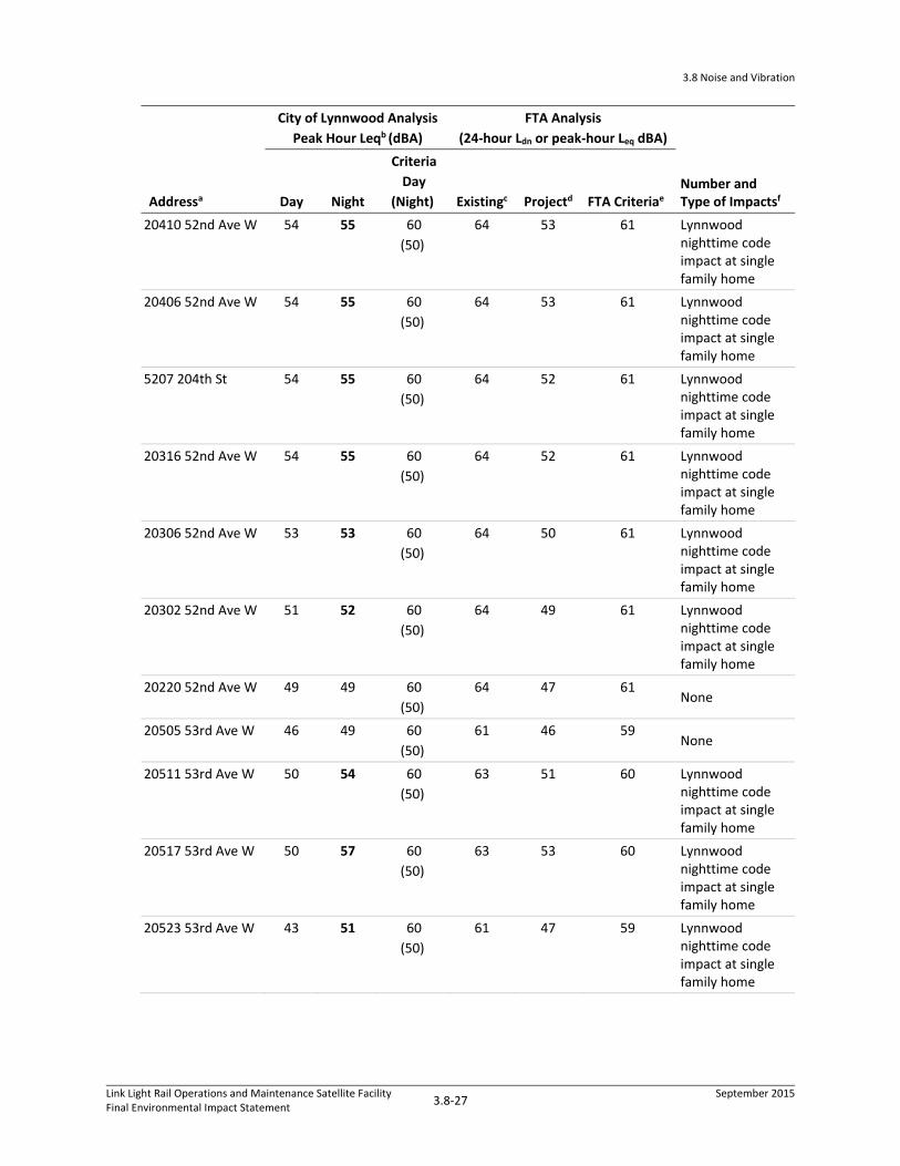
3.8 Noise and Vibration
Link Light Rail Operations and Maintenance Satellite FacilityFinal Environmental Impact Statement
3.8‐27 September 2015
Addressa
City of Lynnwood Analysis
Peak Hour Leqb (dBA)
FTA Analysis
(24‐hour Ldn or peak‐hour Leq dBA)
Number and Type of Impactsf Day Night
Criteria
Day
(Night) Existingc Projectd FTA Criteriae
20410 52nd Ave W 54 55 60
(50)
64 53 61 Lynnwood nighttime code impact at single family home
20406 52nd Ave W 54 55 60
(50)
64 53 61 Lynnwood nighttime code impact at single family home
5207 204th St 54 55 60
(50)
64 52 61 Lynnwood nighttime code impact at single family home
20316 52nd Ave W 54 55 60
(50)
64 52 61 Lynnwood nighttime code impact at single family home
20306 52nd Ave W 53 53 60
(50)
64 50 61 Lynnwood nighttime code impact at single family home
20302 52nd Ave W 51 52 60
(50)
64 49 61 Lynnwood nighttime code impact at single family home
20220 52nd Ave W 49 49 60
(50)
64 47 61 None
20505 53rd Ave W 46 49 60
(50)
61 46 59 None
20511 53rd Ave W 50 54 60
(50)
63 51 60 Lynnwood nighttime code impact at single family home
20517 53rd Ave W 50 57 60
(50)
63 53 60 Lynnwood nighttime code impact at single family home
20523 53rd Ave W 43 51 60
(50)
61 47 59 Lynnwood nighttime code impact at single family home

3.8 Noise and Vibration
Link Light Rail Operations and Maintenance Satellite FacilityFinal Environmental Impact Statement
3.8‐28 September 2015
Addressa
City of Lynnwood Analysis
Peak Hour Leqb (dBA)
FTA Analysis
(24‐hour Ldn or peak‐hour Leq dBA)
Number and Type of Impactsf Day Night
Criteria
Day
(Night) Existingc Projectd FTA Criteriae
20601 53rd Ave W 45 52 60
(50)
61 48 59 Lynnwood nighttime code impact at single family home
20609 53rd Ave W 44 44 60
(50)
61 46 59 None
Scriber Creek Park 47 47 60
(50)
62 44 64 None
Note: Values in bold text meet or exceed the applicable noise impact criteria.
a Address of representative parcel used in modeling. b Lynnwood noise criteria for EDNA Class C (industrial) next to an ENDA Class A (residential) property is 60 dBA Leq
and 50 dBA Leq (nighttime). Details are provided in Section 3.8.1.4, City of Lynnwood Noise Regulations. Scriber Creek Park nighttime noise levels provided for comparison purposes – the park is not open at night.
c Existing Ldn (Category 2) or peak‐hour Leq (Category 3). d Noise levels from OMSF operations (Ldn for Category 2 or peak‐hour Leq for Category 3). e FTA moderate impact criteria for 24‐hour Ldn for Category 2 land uses. f Number and type of noise impacts—all impacts occur at night when the LRV wash is operating and only under the
City of Lynnwood noise control ordinance.
dBA = decibels with A‐Weighting; FTA = Federal Transit Administration
3.8.5.1 Preferred Alternative
Conceptual future development scenarios at the Preferred Alternative site were developed. The
potential development scenarios represent a conceptual capacity analysis, which was based on
available space and zoning at the Preferred Alternative site. The site layout for the Preferred
Alternative would allow up to five parcels to be available for potential future development, with
roadway access to 120th Avenue NE.
The potential development scenarios include multiuse buildings with residential, commercial, and
retail uses. Noise associated with these types of developments include increased traffic, noise from
ventilation and air conditioning units, maintenance of the new facilities, deliveries, and general
activities associated with residential, commercial, and retail land uses. Construction of new buildings
would also contribute to the noise environment temporarily.
Under the Preferred Alternative, cumulative noise levels for properties near this alternative site
would be similar to the noise levels given for the proposed OMSF project alone. Depending on the
location of the receiver, there is potential for slightly increased noise from TOD‐related activities.
Conversely, some sites, which may receive some structural shielding, could see slight reductions in
the overall noise levels. In addition, operational noise levels along the selected East Link alignment
would be the same as those provided in the East Link Project Final EIS (Sound Transit 2011), as
updated during East Link final design and permitting. The updated noise analysis prepared as part of

3.8 Noise and Vibration
Link Light Rail Operations and Maintenance Satellite FacilityFinal Environmental Impact Statement
3.8‐29 September 2015
East Link permitting with the City of Bellevue accounts for early‐morning deployment of trains from
the OMSF and return trips after revenue service ends. The current operating plan for early‐morning
nonrevenue service trips would be the same regardless of which OMSF build alternative is selected.
Because the location of the East Link project is several hundred feet from all of the OMSF build
alternative sites, noise from the light rail would not add to the projected noise from the OMSF.
Therefore, no cumulative noise impacts are projected under this alternative.
Under the Preferred Alternative, cumulative construction noise generated at properties near this
alternative site is expected to be the same as the stand‐alone OMSF project. There is potential for
other local construction projects to overlap with the construction of the OMSF project; however,
worst‐case construction noise levels predicted would also account for any other nearby construction
project. In most cases, however, because construction noise would be localized, it would not
contribute to a cumulative noise impact.
3.8.5.2 BNSF Modified Alternative and SR 520 Alternative
Similar to the Preferred Alternative, noise associated with any TOD at the BNSF Modified site would
result in increased noise from traffic, ventilation and air conditioning units, maintenance of the new
facilities, deliveries, and general activities associated with residential, commercial, and retail land
uses. Construction of new buildings would also contribute to the noise environment temporarily.
The potential for redevelopment at the SR520 Alternative site would be limited due to the lack of
available surplus lands.
Under the BNSF Modified Alternative and SR 520 Alternative, cumulative noise levels would be the
same for properties near these build alternative sites as noise levels given for the proposed OMSF
project alone. In addition, operational noise levels along the selected East Link alignment would be
the same as those provided in the East Link Project Final EIS (Sound Transit 2011). Because the
location of the East Link project is several hundred feet from all of the OMSF build alternative sites,
noise from the light rail would not add to the projected noise from the OMSF. Therefore, no
cumulative noise impacts are projected under these alternatives.
Cumulative construction noise generated at properties near these build alternative sites is expected to
be the same as the stand alone OMSF project. There is a potential for other local construction projects
to overlap with the construction of the OMSF project; however, worst‐case construction noise levels
predicted would also account for any other nearby construction project. In most cases, however,
because construction noise would be localized, it would not contribute to a cumulative noise impact.

3.8 Noise and Vibration
Link Light Rail Operations and Maintenance Satellite FacilityFinal Environmental Impact Statement
3.8‐30 September 2015
3.8.5.3 Lynnwood Alternative
Any future development at the surplus lands at the Lynnwood Alternative site would have the
potential to increase noise during construction and operation. An increase in noise from traffic,
ventilation and air conditioning units, and maintenance of the new facilities, deliveries, and
general activities associated with commercial and light industrial uses may occur during operation.
Under the Lynnwood Alternative, cumulative noise levels would be the same as given for the
OMSF alone for properties near this alternative site along 52nd Avenue W, and noise levels along
the Lynnwood Link Extension alignment would be the same as those provided in the Lynnwood
Link Extension Final EIS (Sound Transit 2015). Because of the location of the Lynnwood Link
Extension selected project alignment, there would also be no increase in noise levels at residences
affected by the Lynnwood Link Extension Alternative with the addition of the OMSF Lynnwood
Alternative.
Cumulative construction noise generated at the properties associated with the Lynnwood Link
Extension would be expected to be the same as the stand alone proposed OMSF project. There is a
potential for some other local construction projects to overlap with the construction of this project.
This would only happen if other unrelated construction projects occur simultaneously with this
project. However, because the project’s construction noise analysis assumes the worst‐case noise
levels, the overall maximum noise levels at any one property would remain the same.
3.8.6 Potential Mitigation Measures
This section describes noise and vibration measures that could be used to mitigate impacts of the
proposed project. Mitigation is provided for the impacts related to the short‐term project
construction and long‐term operational impacts.
3.8.6.1 Construction Noise
Under its Link Noise Mitigation Policy (Sound Transit 2004), Sound Transit would seek to limit
construction noise levels and impacts and would meet applicable noise regulations and ordinances.
Typical mitigation measures that could be applied are discussed below. Contractors would be
required to meet the City Bellevue and Lynnwood’s noise ordinance criteria.
Several noise‐mitigation measures could be implemented to reduce construction noise levels to
within the required limits. Sound Transit would, as practical, limit construction activities that
produce the highest noise levels during daytime hours, or when disturbance to sensitive receivers
would be minimized. For operation of construction equipment that could exceed allowable noise
limits during nighttime hours (between 10:00 p.m. and 7:00 a.m.) or on Sundays or legal holidays,
Sound Transit would obtain the appropriate noise variance from the City of Bellevue or Lynnwood.

3.8 Noise and Vibration
Link Light Rail Operations and Maintenance Satellite FacilityFinal Environmental Impact Statement
3.8‐31 September 2015
Construction noise control mitigation would include the following measures, as necessary, to meet
required noise limits:
Use low‐noise emission equipment.
Use broadband backup warning devices on all vehicles.
Implement noise‐deadening measures for truck loading and operations.
Conduct monitoring and maintenance of equipment to meet noise limits.
Use acoustic enclosures, shields, or shrouds for equipment and facilities.
Install high‐grade engine exhaust silencers and engine‐casing sound insulation.
Minimize the use of generators.
Prohibit impact pile driving during nighttime hours.
Use movable noise barriers at the source of the construction activity.
3.8.6.2 Construction Vibration
Building damage from construction vibration is not anticipated for the proposed project due to the
type of construction and distance between the site and any nearby properties. Sound Transit would
coordinate with Seattle Children’s Hospital: Bellevue Clinic and Surgery Center prior to construction
of the Preferred Alternative, BNSF Modified Alternative, or BNSF Storage Tracks component of the
Lynnwood Alternative to confirm the type and location of vibration‐sensitive equipment within the
building. If necessary, mitigation measures would be developed by Sound Transit, such as
construction vibration monitoring with a notification system and coordination of the construction
schedule with the hospital.
3.8.6.3 Operational Noise and Vibration
This section presents noise and vibration mitigation measures based on Sound Transit’s Link Noise
Mitigation Policy (Sound Transit 2004) and the FTA Guidance. Under this policy, mitigation measures
are considered for all noise impacts, both moderate and severe. During final design if additional
noise and vibration analysis demonstrates that the relevant noise criterion could be achieved by a
less‐costly means, or that the noise or vibration impact at that location would not occur even
without mitigation, then the mitigation measure would be eliminated or modified as needed.
Conversely, if any additional noise impacts are identified during final design or after operations
begin, then Sound Transit would provide mitigation that is necessary and appropriate under Sound
Transit policies and FTA and local noise standards.
Preferred Alternative
The only potential impact resulting from the Preferred Alternative would be where the LRV wash
area nighttime noise level is 5 dBA above the City code criteria of 60 dBA at the King County Transit
Bus Maintenance Base property line.

3.8 Noise and Vibration
Link Light Rail Operations and Maintenance Satellite FacilityFinal Environmental Impact Statement
3.8‐32 September 2015
Sound Transit would reduce noise levels by 5 to 12 dB, by either one of the following:
Extending the length of the wash facility to enclose the blowers within the wash bays.
Installing a noise barrier along the east side of the wash area, length to be determined, covering
the end of the wash bays. The noise barrier could be integrated into the wash building design.
The final noise mitigation solution would be determined during the final design process, after the
building design and location of the blowers are finalized and additional information can be obtained
from car wash manufacturers, who may be able to provide alternative‐noise reducing measures for
the blowers that could be used in place of those proposed in this EIS. Figure 3.8‐10 shows the
approximate location of the mitigation options.
No vibration impacts would occur under the Preferred Alternative; therefore, no mitigation would
be required.
BNSF Modified Alternative
No noise or vibration impacts would occur under the BNSF Modified Alternative; therefore, no
mitigation would be required.
SR 520 Alternative
No noise or vibration impacts would occur under the SR 520 Alternative; therefore, no mitigation
would be required.
Lynnwood Alternative
Noise impacts under the Lynnwood Alternative would require an acoustical noise wall along 52nd
Avenue W on the west side of the facility. Table 3.8‐10 provides the noise levels for the sites with
impacts with and without the proposed noise mitigation measures. The potential location of
proposed mitigation is shown in Figure 3.8‐11. With the proposed mitigation, all impacts would be
eliminated.
No vibration impacts would occur under the Lynnwood Alternative; therefore, no mitigation would
be required.

Figure 3.8-10: Preferred Alternative—Noise Mitigation MeasuresSound Transit Link Light Rail OMSF Draft EIS
Gra
phic
s …
003
29.1
2 (9
-9-2
015)
Source: Michael Minor & Associates 2015. Approximate Scale (Feet)
0 200 400 800

3.8 Noise and Vibration
Link Light Rail Operations and Maintenance Satellite FacilityFinal Environmental Impact Statement
3.8‐34 September 2015
Table 3.8‐10. Noise Impacts and Mitigation for the Lynnwood Alternative per City of Lynnwood Code
Addressa
City of Lynnwood Analysis
Project Noise
(Leq in dBA)b Noise
Impactsc
City of Lynnwood Analysis
Project w/ Mitigation
(Leq in dBA)d
Impacts w/
Mitigatione Mitigation Methodsf
5211 208th St SW 50 0 38 0 Acoustical noise wall
20706 52nd Ave W 53 1 42 0 Acoustical noise wall
20628 52nd Ave W 54 1 43 0 Acoustical noise wall
20624 52nd Ave W 55 1 43 0 Acoustical noise wall
20618 52nd Ave W 55 1 44 0 Acoustical noise wall
5210 206th St SW 57 1 45 0 Acoustical noise wall
20526 52nd Ave W (Cedar Valley Grange)
61 1 49 0 Acoustical noise wall
20504 52nd Ave W 59 1 47 0 Acoustical noise wall
20430 52nd Ave W 57 1 46 0 Acoustical noise wall
20416 52nd Ave W 54 1 43 0 Acoustical noise wall
20410 52nd Ave W 55 1 45 0 Acoustical noise wall
20406 52nd Ave W 55 1 45 0 Acoustical noise wall
5207 204th St 55 1 45 0 Acoustical noise wall
20316 52nd Ave W 55 1 44 0 Acoustical noise wall
20306 52nd Ave W 53 1 43 0 Acoustical noise wall
20302 52nd Ave W 52 1 41 0 Acoustical noise wall
20220 52nd Ave W 49 0 39 0 Acoustical noise wall
20505 53rd Ave W 49 0 38 0 Acoustical noise wall
20511 53rd Ave W 54 1 43 0 Acoustical noise wall
20517 53rd Ave W 57 1 45 0 Acoustical noise wall
20523 53rd Ave W 51 1 38 0 Acoustical noise wall
20601 53rd Ave W 45 1 39 0 Acoustical noise wall
20609 53rd Ave W 44 0 37 0 Acoustical noise wall a. Sites shown in Figure 3.8‐11. a. Lynnwood criteria for EDNA Class A (residential) noise levels is 60 dBA Leq (daytime) and 50 dBA Leq (nighttime). b. Number of homes with noise levels above the criteria. c. Project noise levels with proposed noise mitigation measures. d. Number of homes with noise levels above the criteria with noise mitigation measures. e. Type of mitigation proposed for the impact.
dBA = a‐weighted decibels; N/A = not applicable

Figure 3.8-11: Lynnwood Alternative—Noise Mitigation MeasuresSound Transit Link Light Rail OMSF Draft EIS
Gra
phic
s …
003
29.1
2 (9
-9-2
015)
Source: Michael Minor & Associates 2015.Approximate Scale (Feet)
0 200 400 800


3.9 Ecosystems
Link Light Rail Operations and Maintenance Satellite FacilityFinal Environmental Impact Statement
3.9‐1 September 2015
3.9 Ecosystems
This section addresses the ecosystem components—aquatic resources, vegetation and wildlife, and
wetlands—in the vicinity of the build alternatives. Appendix E.3, Ecosystems Technical Report, of this
Final EIS provides more details, and provides detailed graphics illustrating the extent of aquatic
resources, vegetation and wildlife habitats, and wetlands in the affected environment, as well as
detailed graphics illustrating the environmental impacts of the build alternatives.
3.9.1 Introduction to Resources and Regulatory Requirements
An ecosystem is the interaction between plants, animals, microorganisms, and the physical
environment in which they live. Ecosystems are made up of living organisms, including humans, and
the environment they inhabit.
Components of ecosystems are protected by federal, state, and local regulations. Such regulations
govern planning, land use, and management activities that have the potential to affect ecosystem
resources in the study area. The following federal, state, and local laws, regulations, and agency
jurisdiction and management guidance documents pertain to aquatic resources; vegetation and
wildlife habitat; priority, threatened, and endangered species; and wetlands:
Critical areas ordinances (CAOs) for the
Cities of Bellevue and Lynnwood pursuant
to the Washington Growth Management Act
(Revised Code of Washington [RCW] 36.70A)
Endangered Species Act (ESA)
Executive Orders 89‐10, 90‐40, and 11990
Migratory Bird Treaty Act (MBTA)
Bald and Golden Eagle Protection Act
Local Agency Shoreline Master Programs
(SMPs)
Magnuson‐Stevens Fishery Conservation
and Management Act (MSA)
National Environmental Policy Act (NEPA)
Sections 404, 402, and 401 of the Clean
Water Act (CWA)
Washington State Water Pollution Control
Act
Shoreline Management Act (SMA)
State Environmental Policy Act (SEPA)
Washington Administrative Code (WAC) 222‐
110
Washington Department of Fish and Wildlife
(WDFW) Priority Habitats and Species (PHS)
Management Recommendations
Sound Transit would comply with the requirements of all laws and regulations related to ecosystem
resources through the permit application and approval process.
3.9.2 Methods
The study areas for ecosystems include all aquatic resources, vegetation and wildlife, and wetlands
according to the following criteria and within the following boundaries. Wetlands are considered
separate ecosystem resources from aquatic resources and vegetation because they perform
different ecological functions and are typically described not only based on their type of vegetation,
but also on their hydrologic and water‐quality functions.

3.9 Ecosystems
Link Light Rail Operations and Maintenance Satellite FacilityFinal Environmental Impact Statement
3.9‐2 September 2015
Aquatic Resources. The aquatic resources study area was defined as any stream, river, pond,
lake, drainage ditch or associated stream buffer/riparian habitat occurring in and within 200 feet
of the build alternative sites and extending 100 feet upstream to 300 feet downstream from
where the sites cross a stream or other water course. None of the stream reaches in the aquatic
resources study area are regularly accessible to anadromous salmonids, although occasional use
has been documented and is possible depending on stream flow conditions.
Streams in the aquatic resources study area are classified according to existing conditions using
the State of Washington Interim Water Typing Criteria (WAC 222‐16‐031), and the King County,
City of Lynnwood, and City of Bellevue classification systems, as detailed in Appendix E.3. All of
these stream reaches have limited fish use and poor or fair fish habitat conditions, typically due
to urban development.
Once the stream type was determined, the appropriate buffer was added. However, the
functional extent of stream buffers is compromised in many areas by high‐intensity land use and
development (e.g., buildings, parking lots, railroad tracks and ballast, and roads) immediately
adjacent to the streams. In such cases, the standard buffer width was trimmed at the edge of
such developed areas to denote the functional buffer. None of the build alternatives is
anticipated to result in an intensification of land use within these already developed buffer
areas. Therefore, stream buffer impacts were determined based on the overlap between the
construction limits of each build alternative and the functional extent of the stream buffer
Sound Transit quantitatively evaluated potential impacts of the build alternatives on aquatic
resources by overlaying the limits of each build alternative, including the location and size of
storm drain pipes and stormwater treatment/detention ponds, on the areas of aquatic habitat
within the study area. Sound Transit also reviewed proposed construction areas and
construction methods to determine areas where erosion, dust, and vegetation
disturbance/removal could directly or indirectly affect aquatic resources in the study area.
Vegetation and Wildlife. Sound Transit identified six vegetation categories or cover types
appropriate for the nature of the build alternative sites, including three forested categories
based on dominant tree type (coniferous, deciduous, or mixed) and one category for developed
portions of each site containing little to no vegetation (developed).
Sound Transit searched WDFW’s PHS database (2015) for priority species and DNR’s Natural
Heritage Inventory (NHI) database of rare plants and native communities (2015) within 0.5 mile
of the four build alternative sites. No priority plant species have been recorded in the study
area. No federal or state threatened or endangered species are known to exist in the study area
based on recorded observations listed in these databases, reconnaissance site observations, and
observed habitat conditions. The particular suitability of each alternative site for priority wildlife
species is addressed in Appendix E.3.
The study area was defined as all vegetation and wildlife habitat in the build alternative sites
and additional adjacent vegetation or habitat as appropriate to the species or habitat type (e.g.,
forested areas occurring partially within and partially outside the build alternative sites was

3.9 Ecosystems
Link Light Rail Operations and Maintenance Satellite FacilityFinal Environmental Impact Statement
3.9‐3 September 2015
treated as a single patch of habitat that could be affected). Habitat for individual wildlife species
was assessed as biologically appropriate for that species to meet regulatory requirements
specific to the species (e.g., bald eagle nesting or breeding locations within 1 mile). Vegetation
areas were classified and mapped regardless of subsequent upland/wetland designation. As a
result, vegetation classifications may include areas of wetland vegetation and, therefore, may
overlap with areas also categorized as wetlands. Any such overlap is described and each wetland
was specifically differentiated.
Potential impacts on vegetation and wildlife habitat were quantitatively determined by
evaluating the acreage of major vegetation types that would be permanently or temporarily
affected by each build alternative. Impacts were also determined qualitatively, based on factors
such as the regional significance of the habitat, its value (such as a site’s role as a wildlife
movement corridor), the degree of fragmentation and loss of the habitat following project
implementation, overall habitat quality, and the potential for enhancing or restoring unique
plant communities or wildlife habitat or connectivity.
Temporary construction and permanent operational impacts on wildlife, including disturbances
from increases in human access, noise, and artificial light were also evaluated. The potential for
the introduction and/or removal of noxious and/or invasive species as a result of the proposed
project was also evaluated.
Wetlands and Waters of the U.S. Wetlands and potential wetlands and waters of the U.S. were
identified during a field reconnaissance effort, from field delineation where property access was
granted (as described in Appendix E.3), and from data collected in the wetland study area during
delineation work completed as part of the Lynnwood Link Extension Final EIS (Sound Transit 2015)
and East Link Project Final EIS (Sound Transit 2011; Anchor QEA 2014). Potential wetlands are
areas identified as part of the Lynnwood Link Extension Final EIS (Sound Transit 2015), but were
not readily observable and could not be accessed in the field to verify site conditions. Sound
Transit has described two potential waters of the U.S. (i.e. jurisdictional ditches) on the BNSF
Modified Alternative site based on the configuration and description of these features as
presented in the East Link Project Final Wetland, Stream, and Jurisdictional Ditch Delineation
Report (South Bellevue to Overlake) (Anchor QEA 2014)
Wetlands are classified in terms of the level of wildlife/biological habitat, hydrologic, and water
quality function they provide, with Category 1 (I) offering the highest function and Category 4
(IV) offering the lowest. A detailed summary of each wetland’s characteristics and level of
function based on the rating forms is presented in Appendix E.3.
The study area included all wetlands occurring in the build alternative sites and within 200 feet
of either side of the sites. Also included are wetlands that are partly within or that cross through
the sites and wetland study area. Portions of wetlands that extend beyond the wetland study
area and potential wetland areas outside of the field reconnaissance survey area were identified
and described based on visual observation from public areas during the field reconnaissance;

3.9 Ecosystems
Link Light Rail Operations and Maintenance Satellite FacilityFinal Environmental Impact Statement
3.9‐4 September 2015
current local, state, and federal wetland maps; critical area reports; and aerial photograph
examination.
Appropriate wetland buffers were added to the mapped configuration of each wetland. As with
streams, the standard buffer width was trimmed at the edge of developed areas to denote the
functional buffer and only the functional (i.e., nondeveloped) buffer of each wetland is depicted
and was considered during the assessment of potential impacts. In instances where stream and
wetland buffers overlap (e.g., along Scriber Creek and the West Tributary of Kelsey Creek), the
widest extent of the functional buffer is shown and was considered during the assessment of
potential impacts.
Vegetation in the study areas was classified following a Sound Transit system that is based on the
King County (1987) Wildlife Habitat Profile (Sound Transit 1999, 2011). Under this system,
vegetation is given a wildlife habitat value rating of high, moderate, or low. These ratings should
only be viewed relative to one another in the study areas, relative to this Final EIS, and not across
the landscape as a whole.
Impacts were determined through geographic information system (GIS) analysis of the configuration
of the build alternatives relative to the extent of vegetation and its associated wildlife habitat value,
and relative to the delineated or reconnaissance boundary of the wetlands and streams, and their
associated functional buffers.
Direct impacts reflect direct removal/fill of an aquatic resource or wetland’s area and the
consequent loss of specific functions (e.g., water quality improvement, stormwater detention and
erosion reduction, and wildlife habitat), including loss of buffer functions such as screening from
disturbance, wildlife habitat, and erosion or sedimentation protection. Indirect impacts reflect the
effect of direct impacts on the remaining area of an aquatic resource or wetland on the remaining
portion of the aquatic resource or wetland. Such indirect impacts could result from consequent
impacts on the hydrologic characteristics of the resource (e.g., the depth and duration of seasonally
ponded surface water), or to the portion of the resource able to support tree and shrub vegetation
(such as could occur beneath an elevated section of track), or as a result of isolation of the resource
from other wetlands or areas of valuable upland habitat that contribute to its wildlife habitat
functions (such as could occur in areas with a concentration of multiple sections of tracks or other
facilities).
3.9.3 Affected Environment
3.9.3.1 Preferred Alternative
Aquatic Resources
The Preferred Alternative site lies primarily in the West Tributary of Kelsey Creek drainage, with a
small portion of the southern end of the site associated with the interim trail in the Eastside Rail
Corridor crossing into the Sturtevant Creek drainage. The West Tributary of Kelsey Creek and its
associated headwater wetland occur adjacent to the northern end of the Preferred Alternative site.

3.9 Ecosystems
Link Light Rail Operations and Maintenance Satellite FacilityFinal Environmental Impact Statement
3.9‐5 September 2015
In contrast to the Lynnwood Alternative, there has been substantial encroachment into riparian
areas in this portion of the study area as a result of development, limiting the functional stream
buffer to the width of the remaining vegetation. The portion of the West Tributary upstream of Bel‐
Red Road is classified as non‐fish‐bearing by the City of Bellevue (2012b), meaning no fish are likely
to occur within 1 stream mile under present conditions. However, planned restoration actions
associated with the Bel‐Red Subarea redevelopment project (City of Bellevue 2007) include habitat
improvements and removal of passage barriers in the West Tributary, indicating that the study area
could be accessible to fish at some point in the future (Paulsen pers. comm.).
Although there is no commercial fishing in the aquatic resources study area, either by tribal or
nontribal fishers, the aquatic resources encompassed by this alternative are part of the
Cedar/Sammamish/Lake Washington watershed which produces salmon targeted by Muckleshoot
tribal fisheries. The subject streams are not used for recreational fishing.
Vegetation and Wildlife
The Preferred Alternative site is commercially developed (83%), with small patches of forest
(approximately 2 acres total) distributed throughout the site. It is likely used by common urban
wildlife species and common migratory bird species. The main habitat features in the vegetation and
wildlife study area are two palustrine forested wetlands one Category III wetland (E2‐1) located at the
northwestern corner of the site and one Category II wetland (E2‐4) located adjacent to (but outside of)
the northern end of the site. The Category II wetland has moderately high habitat function and forms
part of the headwaters of the West Tributary of Kelsey Creek, which then flows east between
commercially developed areas. Snags in these wetlands may support foraging by pileated woodpeckers,
making them likely to be considered by Bellevue to be habitat for a species of local importance. No
federal or state threatened or endangered species are known to exist in the Preferred Alternative
study area, but the study area does support several state priority bird species in addition to the
pileated woodpecker. The site lies within 0.8 mile of a known peregrine falcon eyrie (nest) that is
periodically used in downtown Bellevue and may be part of the foraging territory used by the
falcons. It also lies approximately 2 miles from two different bald eagle nests and a great blue heron
rookery. The habitats within and adjacent to the site could be used for foraging by great blue
herons, but are unlikely to be used for perching or foraging by bald eagles. The site also lies within
approximately 0.3 mile (although on the other side of Interstate 405 [I‐405]) of an osprey nest in
Hidden Valley Sports Park, but the site does not contain aquatic foraging habitat for ospreys.
Ospreys are considered a species of local importance in Bellevue.
Wetlands
Four small, depressional Category III wetlands (E2‐1, E2‐2, E2‐6, and E2‐7) were identified east of the
Eastside Rail Corridor. The same area is also the central portion of the BNSF Modified Alternative
site, as described below. The wetlands are all located in confined depressions, separated from each
other by railroad tracks, and support small areas of either forested or emergent vegetation. In
addition, ten wetlands and three ditches were identified within 200 feet of the Preferred Alternative
site and the interim trail. Adjacent wetlands include the Category II forested wetland (E2‐4) adjacent

3.9 Ecosystems
Link Light Rail Operations and Maintenance Satellite FacilityFinal Environmental Impact Statement
3.9‐6 September 2015
to the northern end of the site and its downstream component (wetland E2‐3) adjacent to the eastern
side of the site. Wetland E2‐4 forms part of the headwaters of the West Tributary of Kelsey Creek as
described above. Most of the other adjacent wetlands are located along the sides of the railroad
tracks in confined depressions or on shallow slopes adjacent to the railroad tracks. The adjacent
jurisdictional ditches are as described for the BNSF Modified Alternative.
3.9.3.2 BNSF Modified Alternative
Aquatic Resources
Aquatic resources for the BNSF Modified Alternative are the same as those for the Preferred
Alternative.
Vegetation and Wildlife
The BNSF Modified Alternative site includes most of the area encompassed within the Preferred
Alternative site and contains 6 acres of mostly deciduous forest. About 2 acres of this forest also
falls within the Preferred Alternative site; the additional 4 acres are situated along the slope west of
the railroad tracks. The forested slope west of the railroad tracks provides habitat value for species
such as gray squirrel and other small mammals (e.g., mice, rats, and voles), songbirds, raptors, and
possibly the Pacific chorus frog (Pseudacris regilla) due to its interspersion of vegetation types and
ponded areas alongside the railroad tracks. Existing conditions for wildlife are otherwise the same as
for the Preferred Alternative. In total, the BNSF Modified Alternative is 77% developed. No federal
or state threatened or endangered species are currently known to be present in the BNSF Modified
Alternative study area.
Wetlands
Six wetlands and two ditches were identified in the BNSF Modified Alternative site and three
wetlands were identified within 200 feet of the site. Four of the wetlands (E2‐1, E2‐2, E2‐6, and E2‐
7) in the BNSF Modified Alternative site and the three wetlands adjacent to the site (E2‐3, E2‐4, and
E2‐5) are the same as those identified to be in or adjacent to the Preferred Alternative site. Two
wetlands (E2‐1a and E2‐1b) identified as adjacent to the interim trail component of the Preferred
Alternative site are also within the western extent of the BNSF Modified Alternative site. Both are
long, generally narrow Category III wetlands located along the eastern edge of the western portion
of the site, adjacent to the Eastside Rail Corridor. The wetlands within the BNSF Modified Alternative
site total approximate 1.47 acres and support depressional palustrine forested, scrub‐shrub, and
emergent wetland vegetation. Portions of these wetlands are also within or adjacent to the BNSF
Storage Tracks component of the Lynnwood Alternative.
Three jurisdictional ditches are present in or adjacent to the BNSF Modified Alternative site. All are
associated with Wetland E1‐1a and E1‐1b and convey water outside the wetland study area through
linear, channelized swales. The southern portion of Wetland E1‐1a appears to drain south via
Jurisdictional Ditch #1 to the Sturtevant Creek subbasin. Jurisdictional Ditch #2 connects the
wetlands. Jurisdictional Ditch #3 conveys water north out of Wetland E1‐1b to the West Tributary of

3.9 Ecosystems
Link Light Rail Operations and Maintenance Satellite FacilityFinal Environmental Impact Statement
3.9‐7 September 2015
the Kelsey Creek subbasin. These features may be considered Waters of the United States (i.e., not
wetlands or streams, but drainage features that convey water to a wetland or stream) because of
their characteristics and their connection between the wetlands, the stormwater system, and
downstream waterbodies.
3.9.3.3 SR 520 Alternative
Aquatic Resources
The SR 520 Alternative site is bisected by Goff Creek, which alternates between piped drainage
infrastructure and a manicured surface channel as it flows through the site. No natural riparian
habitat is present along the creek in the study area; the stream buffer consists of pavement, a riprap
retaining wall and ornamental vegetation, or mowed grass and emergent vegetation associated with
Wetland E3‐2 (described below). Salmonids occur in Goff Creek below a blocking culvert under Bel‐
Red Road, about 0.4 mile downstream of the site. Only cutthroat trout are known to occur upstream
of this culvert. The channel segment within the site is separated from other suitable habitats by
numerous passage barriers, and habitat conditions are generally unsuitable for fish use. Still, Goff
Creek could provide rearing habitat for some resident fish and potentially anadromous fish in the
future if the planned habitat improvements and removal of downstream fish passage barriers
associated with the Bel‐Red Subarea redevelopment plan are implemented.
Vegetation and Wildlife
The SR 520 Alternative site is 92% developed, providing habitat in small, scattered patches for highly
adaptable urban wildlife species and common migratory birds. The mixed and deciduous forest
habitat that exists in the site totals approximately 0.5 acre. The understory is dominated by
nonnative Himalayan blackberry (Rubus armeniacus), a species that limits habitat value for native
wildlife. There is a large patch of undeveloped, forested habitat to the immediate north of the site,
but it is separated from the site by SR 520, which forms a wildlife movement barrier. The SR 520 site
lies within 1.6 miles of a known peregrine falcon eyrie (nest) that is periodically used in downtown
Bellevue and may be part of the foraging territory used by the falcons. No federal or state
threatened or endangered species are known to exist in the study area for the SR 520 Alternative.
Wetlands
Three wetlands and two ditches were identified in the 520 Alternative site and two wetlands were
identified within 200 feet of the site. Two of the wetlands (E3‐4 and E3‐5) are small, forested, Category
III wetlands located along the northern edge (but outside of) the site. Water from these wetlands flows
through the riprap retaining wall along the southern toe of the slope and onto the paved parking
area and into storm drains; the western end of Wetland E3‐1 also flows directly into Goff Creek.
Wetland E3‐1 is a small Category IV forested wetland created by seasonal seeps along the slope that
forms the northern edge of the site. Wetland E3‐2 is a small Category IV wetland within the site
associated with the channel of Goff Creek as it flows adjacent to NE 20th Street, and is bounded by
paved sidewalks and road prisms. Wetland E3‐3 is a small Category III wetland confined within a
stormwater ditch located at the toe of the northern edge of NE 20th Street, and is bounded by

3.9 Ecosystems
Link Light Rail Operations and Maintenance Satellite FacilityFinal Environmental Impact Statement
3.9‐8 September 2015
vertical concrete walls. The buffer and edges of this wetland appear to have been intentionally
planted, given the variety, spacing, size of the shrubs and the presence of tie‐backs on some of the
larger shrubs and small trees, and the presence of Native Growth Protection Easement (NGPE) signs
around the edge of the wetland. The wetland flows into a storm drain and appears to connect with
Goff Creek. Wetlands E3‐2 and E3‐3 are illustrated as “wetland/stream buffer” on figures within the
East Link Project Final EIS (Sound Transit 2011). Wetland E3‐5 continues east outside of the wetland
study area and flows to the Valley Creek drainage; it was identified as “Wetland WR11 West of
140th Avenue NE” in the East Link Project Final EIS (Sound Transit 2011).
Two ditches on the site convey water through linear, channelized swales into the stormwater
system. They may be considered Waters of the United States (i.e., not wetlands or streams, but
drainage features that convey water to a wetland or stream) because of their characteristics and the
connection between the stormwater system and Goff Creek.
3.9.3.4 Lynnwood Alternative
Aquatic Resources
The Lynnwood Alternative site is located in the Scriber Creek drainage of the Swamp Creek subbasin,
which discharges into the Sammamish River and then into the north end of Lake Washington. These
streams are part of the Cedar/Sammamish/Lake Washington watershed which produces salmon
targeted by Muckleshoot tribal fisheries. The subject streams are not used for recreational fishing or
for commercial fishing by tribal or nontribal fishers. The site abuts a section of Scriber Creek that
flows through the large Scriber Creek wetland (Wetland N1‐1 as described herein). Scriber Creek
loses its defined channel as it flows through the wetland and becomes effectively contiguous with it.
As a consequence, the stream, its riparian buffer, and the associated 100‐year floodplain overlap
Wetland N1‐1 and its associated buffer as described below under Wetlands. The only fish species
known or likely to occur in the portion of Scriber Creek within the aquatic resources study area are
cutthroat trout, coho salmon, and non‐salmonid resident fish species. Pacific and river lamprey may
also occur in Scriber Creek, but no information documenting their occurrence in the aquatic
resources study area has been identified.
The BNSF Storage Tracks component of the Lynnwood Alternative lies primarily in the West
Tributary of Kelsey Creek drainage in Bellevue, with a small portion of the southern end of the site in
the Sturtevant Creek drainage. These portions of these streams in closest proximity to the aquatic
study area are classified as non‐fish‐bearing by the City of Bellevue (2012). No streams occur in the
aquatic resources study area for the BNSF Storage Tracks. No fish species are known to occur within
at least 1 stream mile of this component of the aquatic resources study area.
Vegetation and Wildlife
Less than half of the Lynnwood Alternative site is developed (approximately 47.5%). The remainder
provides vegetation types associated with the wetlands along Scriber Creek, primarily along the
northern and eastern portions of the site. The Lynnwood Alternative site includes 9 acres of
deciduous and coniferous forest vegetation.

3.9 Ecosystems
Link Light Rail Operations and Maintenance Satellite FacilityFinal Environmental Impact Statement
3.9‐9 September 2015
Wetland N1‐1, the Scriber Creek wetland (described below) is approximately 17 acres (Sound Transit
2015), and is designated as critical habitat by the City of Lynnwood and as a priority habitat by
WDFW (2015). Habitat features include snags with pileated woodpecker (Dryocopus pileatus)
activity, willow with signs of beaver (Castor canadensis) activity, and multistoried vegetation
comprised largely of native species. Several larger trees on site, predominantly Douglas‐fir
(Pseudotsuga menziesii), most likely qualify as “significant trees” under LMC 17.15. Two priority
wildlife species (the peregrine falcon and the bald eagle) could utilize habitat near the site.
Peregrine falcons with offspring and bald eagles have been observed by local residents hunting
around the open water habitats of Sprague Ponds, just northwest of the Lynnwood Alternative site.
In addition, a resident family of river otters (Lontra canadensis) has been anecdotally reported to
use the wetland.
The Lynnwood Alternative site is likely used by all of the common, adaptable migratory bird species
typically found in urban Snohomish County. It provides a larger extent and more diverse mix of
habitats than the other alternative sites and thus can support additional fairly common migratory
birds.
Approximately 80% of the BNSF Storage Tracks site in Bellevue is developed. This area supports
small, generally isolated areas of vegetation which includes approximately 1 acre of forested
wetland habitat. Existing conditions for wildlife are the same as for the Preferred Alternative and
BNSF Modified Alternative sites (as described above). No federal or state threatened or endangered
species are known to exist in the Lynnwood Alternative study area.
Wetlands
Three wetlands (N1‐1, N1‐2, and N1‐3) and two potential wetlands (PWLY1 and PWLY2) were
identified in the Lynnwood Alternative site. Additionally, two wetlands (WLY6 and WL8) and one
potential wetland (PWLY5) were identified within 200 feet of the site. All of the wetlands and potential
wetlands are small, depressional Category III wetlands with limited functions, except for
Wetland N1‐1, the approximate 17‐acre, Category II wetland located in the northern and eastern
portion of the Lynnwood Alternative site associated with Scriber Creek. It is locally referred to as the
Scriber Creek Wetland in the City’s comprehensive plan and considered one of the “major” wetlands
in the City of Lynnwood (City of Lynnwood 2011). This wetland is also described in the Lynnwood
Link Extension Final EIS and Final Ecosystems Technical Report (Sound Transit 2015) as Wetland
WLY4. The wetland contains three vegetation classes and occupies a broad depression associated with
Scriber Creek and the diffuse flow of the creek through the wetland. The buffers of the two western
arms of the wetland appear to have been planted with native trees and shrubs, and are signed with
Native Growth Protection Area (NGPA) signs. Wetland buffers are generally vegetated, but typically
narrow, with extensive development limiting buffer widths and vegetation density around the
perimeter of the wetland.
Six wetlands and two ditches were identified within or adjacent to the BNSF Storage Tracks. These
are described under the Preferred Alternative and BNSF Modified Alternative.

3.9 Ecosystems
Link Light Rail Operations and Maintenance Satellite FacilityFinal Environmental Impact Statement
3.9‐10 September 2015
3.9.4 Environmental Impacts
A summary of impacts of the build alternatives on ecosystems are presented in Tables 3.9‐1 through
3.9‐3.
Table 3.9‐1. Impacts on Aquatic Resources
Build Alternative Aquatic Resource Stream
Impacts
(linear feet)
Functional
Stream
Buffer
Impacts (acres)
Impacts within 100‐Year Floodplain
Preferred Alternative West Tributary of Kelsey Cr. 0 0 0
Sturtevant Creek N/A
BNSF Modified Alternative West Tributary of Kelsey Cr. 0 0 0
Sturtevant Creek N/A
SR 520 Alternative Goff Creek 700 0.64 0
Lynnwood Alternative Scriber Creek 0 1.4a 2.12 acres ~1,000 cya
BNSF Storage Tracks West Tributary of Kelsey Cr. 0 0 0
Lynnwood Link Extension (elevated guideways to OMSF)
Scriber Creek 147b 0.50a,b 380 feet of floodplain crossed; placement of 3 pairs of support columnsb
a Scriber Creek flows diffusely through the Scriber Creek wetland (Wetland N1‐1 herein; Lynnwood Link’s Wetland WLY4), making the stream, wetland, and floodplain a contiguous surface water feature. Thus the stream, floodplain, and wetland overlap, as do the functional wetland and stream buffers.
b The Lynnwood Link Extension elevated guideways that connect to the OMSF would cross Scriber Creek/ Scriber Creek wetland. Impacts from the elevated guideways are as per the Lynnwood Link FEIS (Sound Transit 2015).
N/A = not applicable; cy = cubic yards
Table 3.9‐2. Impacts on Vegetation and Wildlife
Build Alternative
Acres
w/in
Project
Limitsa
Permanent Operational Impacts (acres)
Vegetation Removed by Class Removed
Vegetation UMVC UMVD UMVM UMV USV
Preferred Alternative 31c 0 1 0 <1 3 4
BNSF Modified Alternative 39 0 4 <1 <1 2 6
SR 520 Alternative 26 0 <1 <1 0 2 2
Lynnwood Alternative
OMSF and Lynnwood Link
Extension elevated
guideways
40 3b 3.5b <1b 3.5 b 2b 12b

3.9 Ecosystems
Link Light Rail Operations and Maintenance Satellite FacilityFinal Environmental Impact Statement
3.9‐11 September 2015
Build Alternative
Acres
w/in
Project
Limitsa
Permanent Operational Impacts (acres)
Vegetation Removed by Class Removed
Vegetation UMVC UMVD UMVM UMV USV
BNSF Storage Tracks 15 0 <1 <1 <1 <1 <1
a Includes all site parcels plus any construction footprints outside of these parcels could impact vegetation in these areas. Thus, acres within project limits may be larger than affected parcel acres described in Chapter 2, Alternatives Considered.
b Includes impacts from the Lynnwood Link project, which anticipates 0.52 acre of impacts on UMVD and 0.03 acre of impact on UMV vegetation in Wetlands N1‐1 and N1‐2 (referred to in Lynnwood Link as Wetlands WLY4 and WLY7, respectively) and 0.49‐acre impacts on UMV vegetation in these wetlands’ buffers. Permanent impacts on vegetation from the elevated tracks into the facility would likely be confined to the footprint of the three pairs of support columns for the elevated guideway, which would be located within the UMVD vegetation of Wetland N1‐1/WLY4.
c Total area for the Preferred Alternative includes the area within the alignment of the interim trail, as well as the area of the parcels which could be affected by the proposed project.
UMVC = urban mostly vegetated – coniferous forest; UMVD = Urban mostly vegetated – deciduous forest; UMVM = Urban mostly vegetated – mixed forest; UMV = Urban moderately vegetated; USV = Urban sparsely vegetated.
Table 3.9‐3. Impacts on Jurisdictional Ditches, Wetlands, and Wetland Buffers
Build Alternative
Direct Impacts Jurisdictional Ditch Impacts (linear feet/acres)
Permanent Wetland Impacts (acres)
Wetland Buffer Impacts (acres)
Preferred Alternative 0.0/0.0 0.48 0.42
BNSF Modified Alternative 412/0.03 1.12 1.32
SR 520 Alternative 246/0.02 0.39 0.29
Lynnwood Alternative
OMSF and Lynnwood Link Extension elevated guidewaysa
0.0 2.46 2.09
BNSF Storage Tracks 63/0.01 0.08 0.32
Lynnwood Alternative Total 63/0.01 2.54 2.41 a Wetland impacts from Lynnwood Link Extension elevated guideways as per Lynnwood Link Final EIS
(Sound Transit 2015). Impacts from elevated guideways would occur to Wetlands N1‐1 and N1‐2 (referred to in Lynnwood Link as Wetlands WLY4 and WLY7, respectively), but impacts from at‐grade and elevated guideways were not distinguished from each other in Lynnwood Link’s documentation. Due to the15‐foot height of the elevated guideways above the ground, permanent wetland impacts from the elevated guideways would likely be limited to the footprint of the three pairs of support columns.

3.9 Ecosystems
Link Light Rail Operations and Maintenance Satellite FacilityFinal Environmental Impact Statement
3.9‐12 September 2015
3.9.4.1 No Build Alternative
The No Build Alternative would not directly impact aquatic resources, vegetation, wildlife,
threatened or endangered or priority species, or wetlands. However, ongoing development may
affect these resources. The Lynnwood Alternative site is partially developed and the Edmonds
School District plans to build a district support center at this location, which would increase
impervious area on the site, affecting approximately 7,000 square feet of wetland and affecting
stream buffers and vegetation. Proposed replanting and construction BMPs would likely avoid,
minimize, and mitigate for these potential impacts (Shockey/Brent, Inc. 2007). Urbanized land use is
likely to continue on the currently developed western portion of the site for the foreseeable future.
Local improvements related to stormwater treatment and management could result if new
development is constructed in the build alternative sites. Such new development would be subject
to stormwater permitting and would be required to implement stormwater treatment and
management to standards similar to those anticipated for the proposed project.
3.9.4.2 Impacts Common to All Build Alternatives
Construction Impacts
Sound Transit would restore all upland or wetland/riparian vegetation that is temporarily disturbed
outside of the build alternative sites (i.e., within the construction access areas and related rights‐of‐
way) immediately after construction is completed by replanting disturbed areas with appropriate
native vegetation, immediately following construction. Vegetation would likely become
reestablished within a year or two at most sites. However, the length of time required for replanted
areas to effectively replace preproject functions would vary depending on the type, age, and
diversity of the plant community in such temporarily affected areas.
Land necessary for construction of the elevated guideways, which would provide access between
the proposed project and Lynnwood Link Extension or East Link would be temporarily disturbed
during construction, and such areas similarly restored following construction. All uplands and
wetlands in the construction areas would be disturbed during construction and all vegetation would
be temporarily removed. Short‐term turbidity impacts on streams and wetlands may also occur if
sedimentation were to result from vegetation removal. The duration of the temporary construction
impacts would vary with the nature of the activity and the types of BMPs implemented. Recovery
time would also vary depending on the affected habitat type, for example recovery of forested
uplands and wetlands typically takes longer than recovery of herbaceous areas.
Construction impacts would be temporary and limited to the period during and immediately
following construction when soils would be disturbed and directly exposed to the erosive effects of
rainfall and surface water runoff. In addition to the potential impacts of erosion and sediment
loading, the use of heavy construction equipment could increase the potential for leakage of fuel,
oil, coolants, or hydraulic fluids. These impacts may include temporary loss of habitat, temporary
reduction of wetland functions, and temporary contamination of surface waters. BMPs and related
stormwater construction plans to be implemented during construction would minimize the potential
3.9 Ecosystems
Link Light Rail Operations and Maintenance Satellite FacilityFinal Environmental Impact Statement
3.9‐13 September 2015
for soil erosion and sedimentation and the release of pollutants to receiving surface waters or
groundwater (Chapter 3.10, Water Resources). Construction impacts would also be avoided and
minimized through implementation of the stream‐protection measures as articulated in the
proposed project’s HPA from WDFW and any conservation measures required of the proposed
project for Endangered Species Act compliance, including diverting streamflow around the
construction area and limiting the construction period to the allowable work window, a period of
the year identified in the HPA when aquatic species would be minimally affected.
Construction activities would have temporary impacts on wildlife from vegetation clearing, which
could disrupt wildlife breeding, feeding, and travel functions. Project construction would increase
noise and light levels and human activity temporarily, which could displace wildlife into potentially
less‐suitable habitats. Short‐term displacement of migratory birds using vegetation within the
construction footprint, as well as pileated woodpeckers should they be foraging on snags in uplands
or wetlands near the construction, could also occur. If clearing were conducted during the breeding
and nesting seasons, it could affect migratory bird nesting sites.
Some wildlife species would eventually return to areas that are revegetated after construction;
however, reestablishing native vegetation would require 2 to 4 years for herbaceous areas and more
years for multilayered vegetation types. Individual animals could be affected as construction activity
occurs. No federal or state threatened or endangered species would be affected during construction
because none are known to exist at any of the build alternative sites. Wetland functions could be
temporarily reduced by construction activities from reductions in habitat quality, as well as
vegetation clearing which can reduce the ability of the wetland to slow down water and remove
sediment and contaminants.
Potential temporary construction impacts would be evaluated in detail during the permitting phase
and would be controlled by the types of construction activities and by the implementation of BMPs
during construction. These BMPs would be designed to accommodate site‐specific characteristics
such as widths of wetland and stream buffers and effectively avoid or minimize temporary
construction impacts (as well as permanent operational impacts) on all ecosystem resources. These
practices are described in detail in Appendix E.3.
Potential BMPs include the following measures:
Delineation of construction limits for vegetated and habitat areas that may be disturbed during
construction.
Development of a Temporary Erosion and Sediment Control (TESC) plan, including BMPs such as
silt fences; protective ground covers such as straw, plastic sheeting, or jute mats; and straw
bales in drainage features.
Development of a Construction Stormwater Pollution Prevention Plan, including a TESC; SPCC
Plan; Concrete Containment and Disposal Plan; Dewatering Plan; and a Fugitive Dust Plan.

3.9 Ecosystems
Link Light Rail Operations and Maintenance Satellite FacilityFinal Environmental Impact Statement
3.9‐14 September 2015
Use of tracked equipment rather than tire‐based equipment in areas that are sensitive to
adverse effects from soil compaction. Temporary work bridges would be used in wetlands or
near streams.
Restoration of areas temporarily affected by construction to pre‐construction conditions or
better through replanting or reseeding and implementation of a revegetation plan that
emphasizes the use of native species as appropriate.
Preventing turbid water produced during the course of construction from discharging to fish‐
bearing waters or wetlands. Turbid wastewater may be routed to temporary or permanent
detention facilities, or to upland areas that provide adequate rates of infiltration.
Conducting vegetation clearing outside of general migratory bird breeding season, which is
typically from March 15 through August 31.
BMPs to avoid or reduce the potential for nesting by migratory birds during construction or for
nesting birds to be disturbed by construction; such as removing nesting substrate prior to the
typical breeding season, surveying for active nests before construction, and maintaining a no‐
activity buffer around any active nests established before construction.
Operational Impacts
All vegetation, wetlands, and aquatic resources would be removed from the area containing OMSF
infrastructure. Consequently, any habitat value of these areas and all wetland functions would be
eliminated. However, all direct and indirect stream, wetland and buffer impacts would be mitigated
according to local, state, and federal regulations, as described in Section 3.9.6.2, Compensatory
Mitigation.
Adverse long‐term impacts may include loss of vegetation and wildlife habitat, filling of wetlands,
increased stormwater runoff, and degraded surface water quality. However, the proposed project
would meet current stormwater management regulations, which would provide a beneficial effect
in areas that were developed prior to modern stormwater treatment requirements. The proposed
project would result in overall improvements in streamflows, through the requirement to meet
predevelopment conditions for streamflows. Stormwater would be treated to enhanced treatment
levels to remove heavy metals. Substantial permanent impacts on water quality, and therefore
aquatic species, would not be expected. While wildlife habitat would be permanently eliminated
and habitat value of adjacent areas of vegetation could decline due to the noise and activity
inherent in the operation of the OMSF, no adverse effect on essential fish habitat protected by the
Magnuson‐Stevens Act is expected. No federal or state threatened or endangered species or
designated critical habitat would be affected because none are known to exist at any of the build
alternative sites.
Exterior lighting on the OMSF could affect nocturnal wildlife behavior along the outer edges of
adjacent wetland and upland habitats. Compliance with applicable local lighting standards and BMPs
to screen the lights and direct them downward toward the OMSF, away from the night sky and
nearby residential and natural areas, would minimize the impacts of lighting.

3.9 Ecosystems
Link Light Rail Operations and Maintenance Satellite FacilityFinal Environmental Impact Statement
3.9‐15 September 2015
Permanent wetland and buffer impacts would result from direct removal/fill. All wetlands identified
are expected to be jurisdictional and, thus, regulated by the local jurisdictions, the Washington State
Department of Ecology, and the U.S. Army Corps of Engineers (Corps). Impacts on jurisdictional
ditches would be regulated by the Corps. Thus, Sound Transit would seek Clean Water Act Section
404 and 401 permits from the Corps and Ecology for wetland and jurisdictional ditch impacts and
from the local jurisdiction for impacts on their regulated critical areas (i.e., streams, wetlands,
buffers, and fish and wildlife habitat conservation areas).
3.9.4.3 Preferred Alternative
Construction Impacts
Aquatic Resources. No construction impacts would occur on the functional stream buffer of the
West Tributary of Kelsey Creek (as it emanates from and flows through Wetland E2‐4) as a result
of the Preferred Alternative (Figure 3.9‐1). Given the anticipated effectiveness of construction
BMPs, construction activities under this alternative would have a low risk of adverse impacts on
aquatic species, including resident fish. There is no salmonid spawning or rearing habitat within
about 0.4 mile of the construction site; therefore, there would be no adverse impacts on these
habitats.
Vegetation and Wildlife. Not much vegetation would be removed from outside the Preferred
Alternative site for construction. Vegetation could be removed from surplus land and/or
portions of the City of Bellevue‐owned parcel immediately south of the site if these areas were
used for construction staging. Construction would increase noise and artificial light levels and
human activity temporarily, but the impact is expected to be minimal and affect only scattered
individual wildlife utilizing the limited habitats of the site. There would be no impacts on the
peregrine falcon eyrie at Bellevue Tower, should it become active again, or on the osprey nest at
Hidden Valley Sports Park. Construction noise could temporarily displace pileated woodpeckers
transiting over the site to forage in Wetlands E2‐3 or E2‐4.
Wetlands and Jurisdictional Ditches. Construction could result in the temporary loss of wetland
or wetland buffer habitat. Implementation of appropriate BMPs would limit temporary
construction impacts. All temporarily disturbed wetland and wetland buffer vegetation would
be revegetated with native vegetation following construction. The short‐term impact would be a
change in the wetland vegetation type where trees or large shrubs are removed during
construction, which would have temporary impacts on wildlife habitat functions in these
wetlands. Temporarily disturbed areas would slowly regain function, although it would be
decades before these areas would provide mature forested or scrub‐shrub functions.

É É
É É
É É
É É
É É
É É
É É
É É
É É
É É
É É É É É É É
É É É É É É É
É É É É É É É
É É É É É É É
É É É É É É É
É É É É É É É
É É É É É É É
É É É É É É É
É É É É É É É
É É É É É É É
É É É É É É É
É É É É É É É
É É É É É É É
É É É É É É É
É É É É É É É
É É
É É
É É
É É
É É É É
É É
É É
É É É É É É É É É É É É É É É É
É É É É É É É É É É É É É É É É
É É É É É É É É É É É É É É É É
É É É É É É É É É É É É É É É É
É É É É É É É É É É É É É É É É
É É É É É É É É É É É É É É É É
É É É É É É É É É É É É É É É É
É É É É É É É É É É É É É É É É
É É É É É É É É É É É É É É É É
É É É É É É É É É É É É É É É É
É É É É
É É É É
É É É É
É É É É
É É É É
É É É É
É É É É
É É
É É
É É
É É
É É
É É
É É
É É
É É
É É
É É
É É
É É
É É
É É É É É
É É É É É
É É É É É
É É É É É
É É É É É
É É É É É
É É É É É
É É É É É É É É É É É É É É É É É
É É É É É É É É É É É É É É É É É
É É É É É É É É É É É É É É É É É
É É É É É É É É É É É É É É É É É
É É É É É É É É É É É É É É É É É
É É É É É É É É É É É É É É É É É
É É É É É É É É É É É É É É É É É
É É É É É É É É É É É É É É É É É
É É É É É É É É É É É É É É É É É
120th Ave NE
DITCH 2
DITCH 3
E2-4
E2-1
E1-1A
E2-5
E2-6
E2-3
E2-2
E1-1B
E2-7
Pa
th:
K:\P
roje
cts_
3\H
uitt
_Z
olla
rs\0
03
29_1
2_S
T_
Lig
htR
ail\
ma
pdoc
\EIS
_F
igu
res\
CH
3\3
-9_
Eco
syst
ems\
Fig
_3
_9_1
_Pre
ferr
ed.
mxd
; U
ser:
349
38;
Dat
e: 7
/20
/201
5
±É É É
É É É
É É É
!(#*
")
Figure 3.9-1:

3.9 Ecosystems
Link Light Rail Operations and Maintenance Satellite FacilityFinal Environmental Impact Statement
3.9‐17 September 2015
Operational Impacts
Aquatic Resources. No operational impacts on the functional stream buffer of the West
Tributary of Kelsey Creek would result from this alternative (Figure 3.9‐1). The Preferred
Alternative would increase impervious area by 21% and PGIS by 20%, but retrofitting the
existing stormwater treatment and control measures on the site to meet current regulatory
standards will increase stormwater treatment capability sufficiently to at least maintain, if not
improve, downstream water quality in the West Tributary of Kelsey Creek, while expanded flow
control capacity would improve streamflow characteristics compared to existing conditions. The
proposed flow control improvements are expected to offset the equivalent of 1% of impervious
surface area effects for the entire West Tributary of Kelsey Creek drainage.
Vegetation and Wildlife. Less than 2 acres of mostly upland coniferous and deciduous forest
habitat would be removed permanently for the Preferred Alternative (Figure 3.9‐1). The
proposed project would increase the percent of the site that is developed from 83% to 96%. This
habitat is currently used by songbirds, small mammals, and other species, and would be lost.
Permanent impacts on wildlife are expected to be minimal and there would be no impacts on
the peregrine falcon eyrie at Bellevue Tower, should it become active again, or on the osprey
nest at Hidden Valley Sports Park.
Wetlands and Jurisdictional Ditches. Impacts on Wetlands E2‐1, E2‐2, E2‐6, E2‐7, and North Lake
Wetland would occur under the Preferred Alternative, totaling approximately 0.48 acre of
permanent wetland impact and approximately 0.42 acre of wetland buffer impact (Figure 3.9‐1).
This includes the complete fill of Wetlands E2‐2, E2‐6, and E2‐7 within the site, direct and
indirect impacts affecting all of the North Lake wetland along the interim trail, and the partial fill
of Wetland E2‐1. Impacts would result in a consequent loss of the limited wildlife habitat
functions provided by these wetlands, but would not affect snag recruitment or foraging
habitat for pileated woodpeckers in Wetlands E2‐3 or E2‐4. The Preferred Alternative would
not affect the wetlands or ditches along the western side of the BNSF tracks.
3.9.4.4 BNSF Modified Alternative
Construction Impacts
Aquatic Resources. The potential construction impacts on aquatic resources under this
alternative would be similar to those discussed for the Preferred Alternative.
Vegetation and Wildlife. The potential construction impacts on vegetation and wildlife
resources under this alternative would be similar to those discussed for the Preferred
Alternative.
Wetlands and Jurisdictional Ditches. The potential construction impacts on wetlands under this
alternative would be similar to those discussed for the Preferred Alternative, with additional
temporary impacts on Wetland E1‐1a. Implementation of BMPs described in Appendix E.3
would avoid or minimize temporary construction impacts on any portion of the wetlands not
permanently affected.
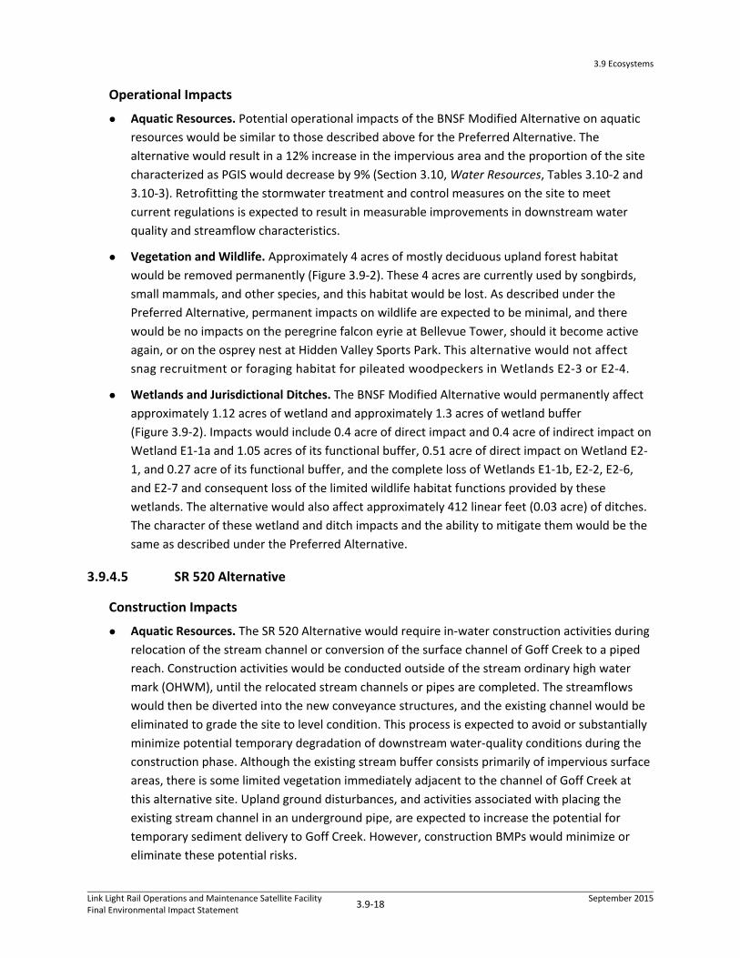
3.9 Ecosystems
Link Light Rail Operations and Maintenance Satellite FacilityFinal Environmental Impact Statement
3.9‐18 September 2015
Operational Impacts
Aquatic Resources. Potential operational impacts of the BNSF Modified Alternative on aquatic
resources would be similar to those described above for the Preferred Alternative. The
alternative would result in a 12% increase in the impervious area and the proportion of the site
characterized as PGIS would decrease by 9% (Section 3.10, Water Resources, Tables 3.10‐2 and
3.10‐3). Retrofitting the stormwater treatment and control measures on the site to meet
current regulations is expected to result in measurable improvements in downstream water
quality and streamflow characteristics.
Vegetation and Wildlife. Approximately 4 acres of mostly deciduous upland forest habitat
would be removed permanently (Figure 3.9‐2). These 4 acres are currently used by songbirds,
small mammals, and other species, and this habitat would be lost. As described under the
Preferred Alternative, permanent impacts on wildlife are expected to be minimal, and there
would be no impacts on the peregrine falcon eyrie at Bellevue Tower, should it become active
again, or on the osprey nest at Hidden Valley Sports Park. This alternative would not affect
snag recruitment or foraging habitat for pileated woodpeckers in Wetlands E2‐3 or E2‐4.
Wetlands and Jurisdictional Ditches. The BNSF Modified Alternative would permanently affect
approximately 1.12 acres of wetland and approximately 1.3 acres of wetland buffer
(Figure 3.9‐2). Impacts would include 0.4 acre of direct impact and 0.4 acre of indirect impact on
Wetland E1‐1a and 1.05 acres of its functional buffer, 0.51 acre of direct impact on Wetland E2‐
1, and 0.27 acre of its functional buffer, and the complete loss of Wetlands E1‐1b, E2‐2, E2‐6,
and E2‐7 and consequent loss of the limited wildlife habitat functions provided by these
wetlands. The alternative would also affect approximately 412 linear feet (0.03 acre) of ditches.
The character of these wetland and ditch impacts and the ability to mitigate them would be the
same as described under the Preferred Alternative.
3.9.4.5 SR 520 Alternative
Construction Impacts
Aquatic Resources. The SR 520 Alternative would require in‐water construction activities during
relocation of the stream channel or conversion of the surface channel of Goff Creek to a piped
reach. Construction activities would be conducted outside of the stream ordinary high water
mark (OHWM), until the relocated stream channels or pipes are completed. The streamflows
would then be diverted into the new conveyance structures, and the existing channel would be
eliminated to grade the site to level condition. This process is expected to avoid or substantially
minimize potential temporary degradation of downstream water‐quality conditions during the
construction phase. Although the existing stream buffer consists primarily of impervious surface
areas, there is some limited vegetation immediately adjacent to the channel of Goff Creek at
this alternative site. Upland ground disturbances, and activities associated with placing the
existing stream channel in an underground pipe, are expected to increase the potential for
temporary sediment delivery to Goff Creek. However, construction BMPs would minimize or
eliminate these potential risks.

É É
É É
É É
É É
É É
É É
É É
É É
É É
É É É É É É É
É É É É É É É
É É É É É É É
É É É É É É É
É É É É É É É
É É É É É É É
É É É É É É É
É É É É É É É
É É É É É É É
É É É É É É É
É É É É É É É
É É É É É É É
É É É É É É É
É É É É É É É
É É É É É É É
É É
É É
É É
É É
É É
É É
É É
É É
É É É É É É É É É É É É É É É É
É É É É É É É É É É É É É É É É
É É É É É É É É É É É É É É É É
É É É É É É É É É É É É É É É É
É É É É É É É É É É É É É É É É
É É É É É É É É É É É É É É É É
É É É É É É É É É É É É É É É É
É É É É É É É É É É É É É É É É
É É É É É É É É É É É É É É É É
É É É É É É É É É É É É É É É É
É É É É
É É É É
É É É É
É É É É
É É É É
É É É É
É É É É
É É
É É
É É
É É
É É
É É
É É
É É
É É
É É
É É
É É
É É
É É
É É
É É É É É
É É É É É
É É É É É
É É É É É
É É É É É
É É É É É
É É É É É É É É É É É É É É É É É
É É É É É É É É É É É É É É É É É
É É É É É É É É É É É É É É É É É
É É É É É É É É É É É É É É É É É
É É É É É É É É É É É É É É É É É
É É É É É É É É É É É É É É É É É
É É É É É É É É É É É É É É É É É
É É É É É É É É É É É É É É É É É
116th Ave NE
120th Ave NE
DITCH 2
DITCH 3
E2-4
E2-1
E1-1A
E2-5
E2-6
E2-3
E2-2
E1-1B
E2-7
Pa
th:
K:\
Pro
ject
s_3
\Hu
itt_
Zo
llars
\00
32
9_
12
_S
T_
Lig
htR
ail\
ma
pd
oc\
EIS
_F
igu
res
\CH
3\3
-9_
Ec
osy
ste
ms\
Fig
_3
_9
_2
_B
NS
F_
Mo
d.m
xd;
Us
er:
30
48
1;
Da
te:
4/2
0/2
01
5
±É É É
É É É
!(#*
")
Figure 3.9-2:

3.9 Ecosystems
Link Light Rail Operations and Maintenance Satellite FacilityFinal Environmental Impact Statement
3.9‐20 September 2015
Vegetation and Wildlife. Short‐term vegetation disturbance outside the project footprint is
expected to be minimal to none. Temporarily disturbed vegetation would be replanted, with an
opportunity to increase native vegetation cover and decrease invasive species cover.
Construction noise associated with this alternative would have the least impact on wildlife
compared to the other build alternatives, given the current level of noise and development
already on site. There would be no impacts on the peregrine falcon eyrie at Bellevue Tower,
should it become active again, or on the osprey nest at Hidden Valley Sports Park.
Wetlands and Jurisdictional Ditches. Project construction activities include some temporary
clearing of wetland vegetation, which could result in the temporary loss of wetland or wetland
buffer habitat. Appropriate BMPs would likely minimize construction impacts, and all
temporarily disturbed wetland and wetland buffer vegetation would be revegetated with native
vegetation following construction.
Operational Impacts
Aquatic Resources. The SR 520 Alternative would permanently replace approximately 700 feet
of open stream channel of Goff Creek, with a similar length of underground pipe, which would
permanently degrade aquatic habitat functions provided by this segment of Goff Creek, and
would affect approximately 0.64 acre of stream buffer habitat, 0.21 acre of which is also
wetland buffer (Figure 3.9‐3). This section of stream is highly modified, surrounded by
commercial development, and isolated from upstream and downstream habitats. Fish use is
limited and temporary due to the generally poor stream and riparian habitat conditions and
numerous passage barriers. If the SR 520 Alternative were “slenderized’ and moved slightly east,
as envisioned in the Urban Land Institute (ULI) Advisory Services Panel report, there could be
opportunities for daylighting Goff Creek as it crosses the alternative site.
The resulting direct impacts on fish and other living aquatic resources would be limited because
this habitat is degraded, provides limited habitat suitability for native fish species, and is blocked
from areas farther downstream in the Goff Creek and Kelsey Creek watersheds. However, the
existing open channel provides other important stream functions, including groundwater inputs
that support base flows and moderate water temperatures in downstream reaches, and the
transportation of nutrients and organic material from upstream to downstream habitats,
supporting the aquatic food chain.
While the SR 520 Alternative would result in a 33% increase in the impervious area, the
proportion of the site characterized as PGIS would decrease by 18% (Section 3.10, Water
Resources, Tables 3.10‐2 and 3.10‐3). It would retrofit the entire site with modern stormwater
detention and treatment consistent with current regulatory standards, which would likely
improve water quality conditions in downstream receiving waters relative to current conditions.
The 700 feet of open channel in the SR 520 Alternative site represents about 36% of the total
length of open channel habitat available between SR 520 and the accessible anadromous fish
habitat in Goff Creek downstream of Bel‐Red Road. Anadromous fish access to reaches
upstream of Bel‐Red Road could be restored in the future. The City of Bellevue has plans to

3.9 Ecosystems
Link Light Rail Operations and Maintenance Satellite FacilityFinal Environmental Impact Statement
3.9‐21 September 2015
daylight large sections of Goff Creek (City of Bellevue 2012a) downstream of the site. In
addition, the Goff Creek culvert underneath SR 520 is subject to the terms of the federal court
injunction, requiring the State of Washington to restore fish passage for anadromous species.
The loss of the open channel habitat in the SR 520 Alternative site footprint would likely be
considered an adverse impact on aquatic resources in Goff Creek by WDFW.
Vegetation and Wildlife. Due to the limited amount of high‐quality habitat and the highly
developed nature of the SR 520 Alternative site, this alternative would have the least impact on
vegetation and wildlife habitat of the four build alternatives. Approximately 0.5 acre of
deciduous and mixed forest (mostly forested wetland) and 2 acres of landscaping would be
permanently removed (Figure 3.9‐3). A couple of snags that provide foraging habitat for
woodpeckers would be lost. Some large trees that may provide perching and roosting habitat
for raptors would be lost. The majority of this habitat exists in a linear corridor between SR 520
and commercial development and the understory is thick with Himalayan blackberry. Although
this area is mapped as high‐value as forested habitat, the habitat value is diminished by small
patch size, lack of corridors, noise, and human disturbance. There is no connectivity to larger
habitat patches and the highway and other roads make dispersal of amphibians and most small
mammals to and from this site unlikely.
Wetlands and Jurisdictional Ditches. Wetland impacts associated with the SR 520 Alternative
would occur on three of the five wetlands in this alternative site (Figure 3.9‐3). This alternative
would also substantially modify two ditches in the site, totaling approximately 246 linear feet. It
would result in 0.4 acre of direct wetland impact and 0.3 acre of wetland buffer impact. This
would include the filling of Wetland E3‐2 (0.2 acre) which currently provides a limited floodplain
for Goff Creek, and Wetland E3‐3 (0.1 acre), which drains through pipes to Goff Creek and
impacts on the western end of Wetland E3‐5, which continues east outside of the wetland study
area. Each of the three affected wetlands provide small patches of wildlife habitat, as well as
water quality and hydrologic functions.
3.9.4.6 Lynnwood Alternative
Construction Impacts
Aquatic Resources. Some construction activities would occur in the adjacent wetland, creek,
and 100‐year floodplain of Scriber Creek. The Scriber Creek wetland, creek, and its surrounding
floodplain are a contiguous surface water feature. Therefore, the impacts on wetlands as
described below, would also apply to the creek and floodplain. However, the implementation of
appropriate BMPs, as described in Appendix E.3, would minimize construction impacts.

É É É É É É É
É É É É É É É
É É É É É É É
É É É É É É É
É É É É É É É
É
É
É
É
É
É
ÉÉ É É É É É É É É É É É É É
É É É É É É É É É É É É É É
É É É É É É É É É É É É É É
É É É É É
É É É É É
É É É É É É É É É É É É É É É É É É
É É É É É É É É É É É É É É É É É É
É É É É É É É É É É É É É É É É É É
520
520
NE 20th St
136t
h Pl
NE
E3-5
Goff Creek
Unnamed Tributaryof Kelsey Creek
E3-1
E3-2E3-3
E3-4
Ditch
Ditch
Pa
th:
K:\
Pro
ject
s_3
\Hu
itt_
Zo
llars
\00
32
9_
12
_S
T_
Lig
htR
ail\
ma
pd
oc
\EIS
_F
igu
res
\CH
3\3
-9_
Eco
syst
em
s\F
ig_
3_
9_
3_
SR
52
0.m
xd;
Use
r: 3
04
81
; D
ate
: 4
/20
/20
15
±É É É
É É É
É É É
É É É
É É É
!(#*
")
Figure 3.9-3:

3.9 Ecosystems
Link Light Rail Operations and Maintenance Satellite FacilityFinal Environmental Impact Statement
3.9‐23 September 2015
Construction of the support columns for the elevated guideways entering the facility from
Lynnwood Link could affect aquatic habitat and could affect juvenile salmonids that rear in the
wetland habitats contiguous with the creek. Construction impacts, including the placement of fill
into the Scriber Creek floodplain, are addressed in Section 3.10, Water Resources. BMPs and
conservation measures necessary for permit compliance would avoid or minimize temporary
impacts during construction, such as turbidity, on any portions of the stream buffer that are not
permanently affected by the project footprint.
Minimal effects on water resources are expected from constructing the BNSF Storage Tracks in
Bellevue (Kelsey Creek basin) due to the lack of surface water features within the site, and the
implementation of BMPs.
Vegetation and Wildlife. Short‐term vegetation disturbance outside the footprint of the OMSF
is expected to be minimal. Construction impacts would occur to forested and scrub‐shrub
vegetation in the southeastern corner of Wetland N1‐1 during construction of the anticipated
three pairs of support columns for the elevated guideways (Figure 3.9‐4a)
Construction access would require vegetation clearing along the route of the elevated
guideways in order to construct the support columns. Construction activity, light, and noise near
the center of this portion of the wetland would temporarily disturb wildlife by bringing noise
and disturbance deeper into the wetland, affecting interior habitats and temporarily displacing
wildlife species to the edges of the wetland or other areas of adjacent habitat. Construction
noise could temporarily displace pileated woodpeckers foraging in the wetland. However, these
impacts are expected to be minimal and not affect wildlife at a species level.
Temporarily disturbed vegetation on the BNSF Storage Tracks site in Bellevue would be
replanted, with an opportunity to increase native vegetation cover and decrease invasive
species cover. Construction noise associated with this component of the alternative would have
much less impact on wildlife compared to the Lynnwood component of this alternative, given
the current level of noise and development already on site.
Wetlands and Jurisdictional Ditches. Portions of Wetlands N1‐1, N1‐2, N1‐3, and PWLY1 would
be temporarily disturbed during construction temporarily reducing the density, diversity, and
size of trees and shrubs in the disturbed areas. BMPs would avoid or minimize temporary impacts
on any portions of these wetlands that are not permanently affected by the project footprint. All
temporarily disturbed wetland and wetland buffer vegetation would be revegetated with native
vegetation following construction. The short‐term impact would be a change in the wetland
vegetation type where trees or large shrubs were removed during construction. Temporarily
disturbed areas would regain function, although it would be decades before these areas would
provide mature forested or scrub‐shrub functions. In the BNSF Storage Tracks site, temporary
impacts on portions of Wetland E1‐1a could occur along the base of the western hillslope and the
western side of the tracks.

É É
É É
É É
É É É
É É É
É É É
É É É
É É
É É
É É É É É É É É É É É É É É É É É É É É É É É É É É É É É É
É É É É É É É É É É É É É É É É É É É É É É É É É É É É É É
É É É É É É É É É É É É É É É É É É É É É É É É É É É É É É
É É É É É É É É É É É É É É É É É É É É É É É É É É É É É É
É É É É É É É É É É É É É É É É É É É É É É É É É É É É É É
É É É É É É É É É É É É É É É É É É É É É É É É É É É É É É
É É É É É É É É É É É É É É É É É É É É É É É É É É É É É É
É É É É É É É É É É É É É É É É É É É É É É É É É É É É É É
É É É É É É É É É É É É É É É É É É É É É É É É É É É É É É
É É É É É É É É É É É É É É É É É É É É É É É É É É É É É É
É É É É É É É É É É É É É É É É É É É É É É É É É É É É É É
É É É É É É É É É É É É É É É É É É É É É É É É É É É É É É
É É É É É É É É É É É É É É É É É É É É É É É É É É É É É É
É É É É É É É É É É É É É É É É É É É É É É É É É É É É É É
É É É É É É É É É É É É É É É É É É É É É É É É É É É É É É
É É É É É É É É É É É É É É É É É É É É É É É É É É É É É É
É É É É É É É É É É É É É É É É É É É É É É É É É É É É É É
É É É É É É É É É É É É É É É É É É É É É É É É É É É É É É
É É É É
É É É É
É É É É
É É É É
É É É É É É É É É É É É É É É É
É É É É É É É É É É É É É É É É
É É É É É É É É É É É É É É É É
É É É É É É É É É É É É É É É É
É É É É É É É É É É É É É É É É
É É É É É É É É É É É É É É É É
É É É É É É É É É É É É É É É É
É É É É É É É É É É É É É É É É
É É É É É É É É É É É É É É É É
É É É É É É É É É É É É É É É É
É É É É É É É É É É É É É É É É
É É É É É É É É É É É É É É É É
É É É É É É É É É É É É É É É É
É É É É É É É É É É É É É É É É
É É É É É É É É É É É É É É É É
É É É É É É É É É É É É É É É É
É É É É É É É É É É É É É É É É
É É É É É É É É É É É É É É É É
É É É
É É É
É É É
É É
É É
É É É
É É É
É É É
É É É É É É É
É É É É É É É
É É É É É É É
É É É É É É É
É É É É É
É É É É É
É É É É É
§̈¦5
48th Ave W
50th Ave W
52nd Ave W
In t er urba n Trai l
Int er urba n Trai l
Cedar
Val l
ey R
d
204t h St SW
200t h St SW
206t h St SW
46th Ave W
202n d St SW
Scriber Creek
Scriber Creek
PWLY1PWLY2
WLY6
PWLY5
N1-1
N1-3
N1-2
Figure 3.9-4a:
Pa
th:
K:\
Pro
ject
s_3
\Hu
itt_
Zo
llars
\00
32
9_
12
_S
T_
Lig
htR
ail\
ma
pd
oc\
EIS
_F
igu
res
\CH
3\3
-9_
Ec
osy
ste
ms\
Fig
_3
_9
_4
a_
Lyn
nw
oo
d.m
xd;
Use
r: 3
04
81
; D
ate
: 4
/20
/20
15
±
É É
É É
!(
#*

3.9 Ecosystems
Link Light Rail Operations and Maintenance Satellite FacilityFinal Environmental Impact Statement
3.9‐25 September 2015
Construction activity, light, and noise could temporarily displace pileated woodpeckers
transiting over the site to forage in Wetlands E2‐3 or E2‐4. Implementation of appropriate BMPs
would avoid or minimize temporary impacts during construction activities on any portions of the
wetlands that are not permanently affected by the project footprint.
Operational Impacts
Aquatic Resources. The Lynnwood Alternative would permanently convert 2.12 acres of
wetland habitat contiguous with Scriber Creek into developed uplands/support columns for the
elevated guideways. This would require placement of approximately 1,000 cubic yards of fill
material to elevate this footprint above the 100 year floodplain of Scriber Creek. The overhead
lead track structure would shade a 147‐linear foot segment of Scriber Creek and its three pairs
of track support columns would permanently remove forested vegetation from the
wetland/floodplain (Figure 3.9‐4a). Shading would have an insignificant effect on riparian
vegetation and aquatic habitat function because the daily amount of shading in any given area
would be limited in duration due to the relatively narrow profile of the structure, its 15‐foot
height over the ground surface, and its north/south orientation.
The alternative would increase impervious surface by 35% but the proportion of the site
characterized as pollution generating impervious surface (PGIS) would decrease by 25% (Section
3.10, Water Quality, Tables 3.10‐2 and 3.10‐3). New stormwater detention and treatment
facilities would include stormwater ponds and underground vaults, sized to provide sufficient
detention and treatment to offset any increase in impervious surface area. Approximately 1.4
acres of functional stream buffer would be permanently affected. This would preclude the
development of mature forested vegetation, thereby limiting the future recruitment of large
woody debris into this portion of Scriber Creek.
The alternative is not expected to measurably affect fish species or downstream aquatic habitat
conditions in Scriber Creek because of the limited extent and location of potential effects. It
would not preclude any improvements for fish passage at the culvert underneath I‐5 required
under the federal court injunction against the State of Washington or other actions intended to
improve aquatic habitat conditions in the future.
No streams or stream buffers would be affected by the BNSF Storage Tracks.
Vegetation and Wildlife. The Lynnwood Alternative would have the most impact on vegetation
of the build alternatives. Approximately 7 acres of forested habitat would be permanently
removed from the Lynnwood Alternative site, 2.4 acres of which would be forested wetland
habitat in Wetlands N1‐1 and PWLY2 (Figure 3.9‐4a). Impacts would occur mainly to the western
portion of the forested wetland habitat in Wetland N1‐1 and would include a decrease in upland
forest and wetland habitat patch size, a possible decrease in snags, and decreased snag‐
recruitment potential (i.e., fewer live trees that can eventually become snags). Loss of snags
could affect foraging suitability of Wetland N1‐1 for pileated woodpeckers. Permanent impacts
on vegetation from the anticipated three pairs of support columns would be confined to the
footprint of the columns as the elevated guideways would be over 15 feet above the ground as
3.9 Ecosystems
Link Light Rail Operations and Maintenance Satellite FacilityFinal Environmental Impact Statement
3.9‐26 September 2015
they cross the southern corner of the site. This alternative would result in the complete loss of
Wetland PWLY2 (0.3‐acre impact) and Wetland N1‐3 (0.1‐acre impact), which provide limited
wildlife habitat functions due to their small size.
Operation of the BNSF Storage Tracks would affect approximately 0.2 acre of forested habitat,
some of which is forested wetland habitat along the railroad tracks (Figure 3.9‐4b). Given the
highly (80%) developed character of the BNSF Storage Tracks site and the small amount of high‐
quality habitat currently present, impacts from operation of the proposed project are expected
to be minimal.
Wetlands and Jurisdictional Ditches. The Lynnwood Alternative (including the BNSF Storage
Tracks component) would result in the largest total wetland impacts (2.54 acres) and the largest
total impacts on forested wetlands (nearly all of the 2.54 total acres of impact) of the build
alternatives. In Lynnwood, this alternative would result in 2.12 acres of permanent impact on
the forested western side of Wetland N1‐1 (reducing the wetland size by 8%) and would place
three pairs of support columns for the elevated guideways across the southern corner of the
wetland, impacting 0.52 acre of the wetland. These impacts would occur across the area where
Scriber Creek’s diffuse flow consolidates to a defined channel as it flows out of the wetland
(Figure 3.9‐4a). Due to the 15‐foot height of the elevated guideways above the ground,
permanent wetland impacts from the elevated guideways would likely be limited to the
footprint of the three pairs of support columns. Impacts would affect the wetland’s ability to
perform water quality and hydrologic functions, and would reduce the amount of habitat
provided for wildlife.
This alternative would affect the areas that appear to be previous mitigation, which could
complicate a determination of mitigation for impacts. The NGPA recording certificate for the
southernmost portion of the wetland’s two western arms specifically prohibits future
development and requires any boundary adjustments to the NGPA be approved by the City of
Lynnwood through a formal platting process. This alternative would affect this NGPA and trigger
such a process for approval of any modification to the NGPA boundary to allow impacts on this
portion of Wetland N1‐1.
This alternative would also fill Wetland PWLY2 (0.3‐acre impact) and Wetland N1‐3 (0.1‐acre
impact) and impact the southeastern side of Wetland N1‐2 (0.03 acre impact). It would affect
approximately 2.1 acres of wetland buffer in Lynnwood: 1.7 acres of Wetland N1‐1 buffer, 0.2
acre of the functional buffer of Wetland N1‐2 and of Wetland N1‐3. Impacts would reduce
forested and shrub wetland habitats, as well as potentially surface‐flow paths and the ability to
store floodwaters associated the with the Scriber Creek floodplain. Wetlands and wetland
buffers under the elevated guideway would also be affected through the conversion of
forest‐dominated wetlands to shrub‐dominated wetlands and buffers under and along each side
of the elevated guideways as a result of maintenance to prevent trees and branches from
interfering with operation of the light rail.

É É
É É
É É
É É
É É
É É
É É
É É
É É
É É É É É É É
É É É É É É É
É É É É É É É
É É É É É É É
É É É É É É É
É É É É É É É
É É É É É É É
É É É É É É É
É É É É É É É
É É É É É É É
É É É É É É É
É É É É É É É
É É É É É É É
É É É É É É É
É É
É É
É É
É É
É É
É É
É É
É É
É É É É É É É É É É É É É É É É
É É É É É É É É É É É É É É É É
É É É É É É É É É É É É É É É É
É É É É É É É É É É É É É É É É
É É É É É É É É É É É É É É É É
É É É É É É É É É É É É É É É É
É É É É É É É É É É É É É É É É
É É É É É É É É É É É É É É É É
É É É É É É É É É É É É É É É É
É É É É É É É É É É É É É É É É
É É É É
É É É É
É É É É
É É É É
É É É É
É É É É
É É É É
É É
É É
É É
É É
É É
É É
É É
É É
É É
É É
É É
É É
É É
É É
É É
É É É É É
É É É É É
É É É É É
É É É É É
É É É É É
É É É É É
É É É É É É É É É É É É É É É É É
É É É É É É É É É É É É É É É É É
É É É É É É É É É É É É É É É É É
É É É É É É É É É É É É É É É É É
É É É É É É É É É É É É É É É É É
É É É É É É É É É É É É É É É É É
É É É É É É É É É É É É É É É É É
É É É É É É É É É É É É É É É É É
É É É É É É É É É É É É É É É É É
120th Ave NE
DITCH 2
DITCH 3
E2-4
E2-1
E1-1A
E2-5
E2-6
E2-3
E2-2
E1-1B
E2-7
Pa
th:
K:\
Pro
ject
s_3
\Hu
itt_
Zo
llars
\00
32
9_
12
_S
T_
Lig
htR
ail\
ma
pd
oc\
EIS
_F
igu
res
\CH
3\3
-9_
Ec
osy
ste
ms\
Fig
_3
_9
_4
b_
Sto
rag
e_
Tra
cks
.mxd
; U
se
r: 3
04
81
; D
ate
: 4
/20
/20
15
±É É É
É É É
!(#*
")
Figure 3.9-4b:

3.9 Ecosystems
Link Light Rail Operations and Maintenance Satellite FacilityFinal Environmental Impact Statement
3.9‐28 September 2015
Operation of the BNSF Storage Tracks would affect approximately 0.08 acre of wetlands in
Bellevue (Wetlands E1‐1b, E2‐2, E2‐6, and E2‐7) including the complete loss of Wetland E1‐1b
and Wetland E2‐7 (Figure 3.9‐4b). Approximately 0.3 acre of functional wetland buffer would
also be affected. Operation of this alternative would also affect approximately 63 linear feet
(less than 0.01 acre) of ditches. Wetlands associated with the BNSF Storage Tracks have a
limited ability to provide wildlife habitat, water quality, and hydrologic functions due to the
surrounding development, which has reduced their size and fragmented their connections.
Impacts would affect primarily the wetland’s ability to perform water quality and hydrologic
functions, while further reducing the habitat that these wetlands currently provide for wildlife.
Operation of the BNSF Storage Tracks would not affect snag recruitment or foraging habitat
for pileated woodpeckers in Wetlands E2‐1, E2‐3 or E2‐4.
3.9.5 Indirect and Cumulative Impacts
Indirect wetland impacts may occur on the remaining portion of a wetland due to the effect of
direct impacts occurring on a large portion of the wetland. Permanent wetland and buffer impacts
could result indirectly from grading or placing fill into large portions of wetlands and/or buffers.
Indirect impacts can affect a wetland’s hydrologic characteristics (e.g., its capacity to hold water and
ability to slow water flow) as well as its wildlife habitat functions. For the Preferred Alternative, 0.01
acre of wetland fill would indirectly affect the hydrological characteristics of the North Lake
Wetland’s remaining 0.03 acre. The Lynnwood Alternative would indirectly affect the unfilled sliver
of Wetland N1‐3 (<0.1 acre) and a small portion (0.1 acre) of Wetland N1‐1. The BNSF Modified
Alternative would indirectly affect more than half (0.4 acre) of Wetland E1‐1a (Figure 3.9‐2).
The Preferred Alternative would also result in indirect impacts on ecosystems resources due to the
potential redevelopment of surplus land described in Chapter 2, Alternatives Considered, and the
introduction to Chapter 3. Indirect impacts from Phase 1 redevelopment would include removal of a
portion of the mature coniferous and deciduous trees and understory vegetation from the southeast
corner of the site fronting 120th Avenue NE. This indirect impact would be partially offset by nearly
1 acre of landscaped frontage on the eastern edge of the site along 120th Avenue NE by Sound
Transit. If 120th Avenue NE were realigned to the east and Phase 2 development parcels were
developed with buildings, vegetation in the landscaped frontage would be removed.
Redevelopment would convert existing PGIS into non‐PGIS and retrofit existing stormwater
infrastructure to current standards. The OMSF could result in these improvements occurring sooner
than they would in the absence of the proposed project.
Indirect impacts from Phase 2 redevelopment could include reducing the landscape frontage along
120th Avenue NE and daylighting the currently culverted portion of the West Tributary that lies
under the current alignment of 120th Avenue NE. These indirect impacts would increase aquatic
habitat and improve riparian vegetation conditions. The installation of predominately native
vegetation along the daylighted creek would also help increase the extent and quality of habitat
connectivity along the West Tributary of Kelsey Creek for fish and wildlife

3.9 Ecosystems
Link Light Rail Operations and Maintenance Satellite FacilityFinal Environmental Impact Statement
3.9‐29 September 2015
Similar indirect impacts from potential TOD could occur for the BNSF Modified Alternative. The SR
520 Alternative does not include surplus lands to allow for TOD. The Lynnwood Alternative could
allow for TOD on surplus lands on the eastern portion of the site, which would result in similar
indirect impacts as developing the OMSF on the western part of the site. Such indirect impacts
would include removal of scattered areas of low quality vegetation and associated wildlife habitat
and filling of wetlands.
Cumulative impacts for ecosystem resources were considered within a broader study area to
capture how the impacts of reasonably foreseeable future projects—when coupled with the
proposed project and past projects—may interact to affect the function of ecosystems at a larger
scale than site‐specific alternatives. The existence and extent of areas dominated by native plants
that could provide wildlife habitat and support wildlife corridors for mobile species, foraging areas
for avian and mammal species, and breeding habitats were qualitatively considered at the scale of
the Scriber Creek and West Tributary of Kelsey Creek subbasin scale. Stream habitat accessibility and
quality were similarly considered at the subbasin scale for qualitative impacts on aquatic resources
and fish species. Landscape connectivity within these subbasins was considered for impacts on
wetlands based on the degree to which they provide water quality, hydrologic, and habitat functions
to their watersheds.
In addition to impacts in the Scriber Creek subbasin from the elevated guideways, Lynnwood Link
would also have an estimated 0.5 acre of impact on the North Branch of Thornton Creek and 0.5
acre of impact on McAleer Creek, both of which are tributary streams to Lake Washington (as is
Scriber Creek, via Swamp Creek) (Sound Transit 2015). Vegetation impacts and consequent loss of
wildlife habitat as a result of the Lynnwood Link Extension would include2 acres of impact in the
Thornton Creek subbasin, 11 acres in the McAleer Creek subbasin, and the 2 acres in the Scriber
Creek subbasin due to the elevated guideways connecting the Lynnwood Link tracks to the OMSF.
The OMSF Lynnwood Alternative’s approximate 7 acres of forested vegetation and wildlife habitat
impact, 2.46 acres of permanent wetland impact, 2.09 acres of wetland buffer impact, 1.4 acre of
stream buffer impact, and 147 linear feet of aquatic impacts would add to these reasonably
foreseeable project impacts from the Lynnwood Link Extension and, thus, contribute to cumulative
impacts on the greater Lake Washington watershed. These impacts would contribute cumulatively
to the loss of area and function currently found in the remaining undeveloped portions of the
Scriber Creek subbasins. They would further reduce the area of native vegetation, wetlands, and fish
and wildlife habitat and further limit the connectivity of the habitat corridor formed by Scriber Creek
and its wetlands and riparian zone through the City of Lynnwood.
The East Link project would affect ecosystems resources in the same watersheds as the build
alternatives. In the Bel‐Red/Overlake area, this would include impacts on the unnamed tributary to
Kelsey Creek, a crossing of the West Tributary of Kelsey Creek and Wetland BNSF West (herein
referred to Wetland E1‐1a). This segment of East Link would also result in vegetation impacts and
consequent loss of wildlife habitat in the watershed of 0.9 acre.

3.9 Ecosystems
Link Light Rail Operations and Maintenance Satellite FacilityFinal Environmental Impact Statement
3.9‐30 September 2015
The approximately 4 acres of vegetation impact, 0.48 acre of wetland impact, and 0.42 acre of
wetland buffer impact from the Preferred Alternative would combine with East Link’s reasonably
foreseeable project impacts on the stream, wetland, wetland buffers, and vegetation and wildlife
habitat and contribute to the loss of area and function currently found in the remaining
undeveloped portions of the Kelsey Creek subbasin. Due to the highly dispersed and disconnected
nature or most of the areas of vegetation and wetlands affected by these projects, the cumulative
loss of habitat connectivity and corridors through the City would be less than the cumulative impact
of the OMSF’s Lynnwood Alternative and the Lynnwood Link Extension on the Scriber Creek
subbasin.
3.9.5.1 Beneficial Impacts
Both the Lynnwood Link Extension and East Link would provide mobility options and would help
achieve higher‐density TOD, thereby reducing the area of land development in ways that are
consistent with regional and local plans and policies. These projects would support high‐density,
mixed‐use redevelopment, which would be a beneficial cumulative impact by potentially reducing
the tendency for urban sprawl through a concentration of development into already developed
areas.
New impervious surfaces added by the proposed project and other reasonably foreseeable projects
would include appropriate stormwater control and quality treatment in accordance with Ecology
regulations. This would improve conditions relative to stormwater detention and treatment in the
highly developed portions of the Preferred Alternative, BNSF Modified Alternative, the BNSF Storage
Tracks component of the Lynnwood Alternative, and SR 520 Alternative sites. Thus, the proposed
project could contribute to an overall cumulative benefit in terms of stormwater quality.
Positive cumulative impacts could also result from efforts to enhance streams and wetlands in the
Scriber Creek and the Kelsey Creek subbasins, relative to the Lynnwood Alternative and the build
alternatives in Bellevue, respectively, through comprehensive planning and subbasin plans. The
proposed project and other reasonably foreseeable development projects would be subject to
regulatory review and/or permitting under federal, state, and local regulations and would be
required to mitigate impacts on streams, wetlands, and high‐value habitats in accordance with
federal, state, and local regulations. Project review and permitting processes would trigger the
implementation of conservation measures to avoid and minimize impacts on ecosystem resources,
and would require compensatory mitigation for unavoidable impacts. Coordination between project
proponents, and across projects proposed by the same proponent, could also help reduce impacts.
3.9.6 Potential Mitigation Measures
Sound Transit’s policy is to avoid impacts on environmentally sensitive resources and, where
impacts are unavoidable, to provide adequate mitigation and no net loss of ecosystem function and
acreage as a result of agency projects. The proposed project would mitigate impacts on ecosystem
resources in accordance with the mitigation sequencing requirements established by NEPA, the
CWA, the MBTA, and local CAOs. According to NEPA, mitigation for ecosystem impacts is based on a

3.9 Ecosystems
Link Light Rail Operations and Maintenance Satellite FacilityFinal Environmental Impact Statement
3.9‐31 September 2015
hierarchy of first avoiding the impact, then minimizing the impact by limiting the degree or
magnitude of the action, rectifying the impact by restoring, repairing, or rehabilitating the affected
environment, reducing or eliminating the impact over time, and finally compensating for any
remaining unavoidable adverse impacts by providing substitute resources or environments.
As described below, the build alternatives for the proposed project would avoid or minimize
potential impacts on ecosystems resources whenever practicable, and Sound Transit is committed
to providing compensatory mitigation when avoidance is not practicable.
3.9.6.1 Avoidance and Minimization
Sound Transit would comply with standard specifications, BMPs, and applicable federal, state, and
local mitigation requirements during design, construction, and post construction activities. BMPs
typically required for avoidance and minimization of impacts on ecosystem resources are outlined in
Appendix E.3. To comply with MBTA regulations, contractors will schedule clearing activities outside
the migratory bird nesting periods. If this is not feasible, Sound Transit will work with qualified staff
at the U.S. Department of Agriculture to conduct preconstruction surveys to determine the presence
of nesting migratory birds in the corridor. If old nests are present, they will be removed to prevent
future use of those nests. If an active nest is found during construction, buffer zones may be
established until the young birds fledge. If removing an active nest or other action is recommended,
Sound Transit will consult with the U.S. Fish and Wildlife Service (USFWS) to perform such activities
in accordance with USFWS procedures and appropriate permit conditions.
3.9.6.2 Compensatory Mitigation
If impacts could not be avoided or minimized through BMPs, or rectified after construction, Sound
Transit would implement additional measures to reduce impacts and provide compensatory
mitigation measures where impacts are unavoidable.
Compensatory wetland mitigation would be conducted in accordance with applicable federal, state,
and local requirements and guidelines.
The federal Final Compensatory Mitigation Rule (Federal Register CFR Part 230, Volume 73 No. 70,
19594–1970540) specifies that, from the perspective of federal permitting under the Clean Water
Act, the selection of wetland mitigation sites should be conducted with a watershed approach and
that compensatory mitigation for wetland impacts should be accomplished preferentially with the
use of approved mitigation banks, then the use of in‐lieu fee programs, and finally through
permittee‐responsible, project‐specific mitigation. However, local CAOs often prioritize that wetland
mitigation be located within the same subbasin or basin as the impact.
The City of Bellevue has acknowledged a general lack of feasible and suitable compensatory wetland
mitigation sites in the West Tributary of Kelsey Creek basin. The Bellevue municipal code (Section
20.25H.105) contains provisions for off‐site/outside of the drainage basin mitigation. The Lynnwood
municipal code (Section 17.10.055) specifies that wetland mitigation occur within same drainage
area, as defined by the City’s comprehensive flood and drainage management plan.

3.9 Ecosystems
Link Light Rail Operations and Maintenance Satellite FacilityFinal Environmental Impact Statement
3.9‐32 September 2015
Mitigation for unavoidable impacts on other resources (e.g., streams, stream buffers, and fish and
wildlife habitat/habitat for species of local importance) that are protected under local CAOs would
also be conducted in accordance with the requirements of those ordinances as well as applicable
state and federal law. Sound Transit would also adhere to local ordinances regarding tree
replacement ratios (e.g., replacement of significant trees per the LMC).
Sound Transit would work with the Cities of Bellevue and Lynnwood to define appropriate
mitigation that is consistent with, and complementary to, local plans for ecosystem restoration.
Mitigation could be accomplished through a combination of site‐specific actions, and more basin‐
wide or programmatic actions such as creating wider stream or riparian buffers, restoring native
riparian areas, removing nonnative and invasive vegetation, supporting environmental education,
and improving stormwater management.
Approved Mitigation Bank
Currently, there are no approved mitigation banks with service areas that include the subbasins in
which wetland impacts would occur under the build alternatives. Even if one became certified,
mitigation banking projects would take considerable lead time for planning and approval.
King County In‐Lieu Fee Program (Mitigation Reserves Program)
King County has developed an in‐lieu fee program called the Mitigation Reserves Program (MRP),
which was approved by the Corps in March 2012 (King County 2013a). The program includes service
areas within the watersheds affected by the OMSF (i.e., Cedar River/Lake Washington and
Sammamish River) that are located in King County. As of February 2012, the program is available
throughout unincorporated King County. The program may be available to Sound Transit when
working within incorporated cities. For example, use of the Mitigation Reserves Program has been
allowed in the City of Bellevue, consistent with the provisions of the Bellevue Critical Areas Code
(20.25H.105) for other essential public facility projects. Sound Transit may similarly be able to mitigate
impacts from the Preferred Alternative, the BNSF Modified Alternative, the SR520 Alternative, or the
BNSF Storage Yard component of the Lynnwood Alternative through the Mitigation Reserves
Program as these alternatives would occur within King County.
Mitigation for Impacts Resulting from the Preferred Alternative, BNSF Modified Alternative, and SR 520 Alternative
Bellevue Critical Areas Code requires compensatory mitigation for wetland impacts to occur in order of
preference by restoring wetlands, creating wetlands, or enhancing significantly degraded wetlands.
Compensatory mitigation is also required to be either in‐kind and on‐site or in‐kind and within the
same drainage subbasin. Mitigation site selection must also include consideration of wetland
mitigation replacement ratios, buffer conditions and proposed widths, hydrogeomorphic classes of
on‐site wetlands when restored, proposed flood storage capacity, and potential to mitigate stream
fish and wildlife impacts (such as connectivity).

3.9 Ecosystems
Link Light Rail Operations and Maintenance Satellite FacilityFinal Environmental Impact Statement
3.9‐33 September 2015
Mitigation actions may be conducted off‐site and outside of the drainage subbasin if there are no
reasonable onsite or drainage subbasin opportunities or the onsite or drainage subbasin
opportunities do not have a high likelihood of success and if established watershed goals for water
quality, flood or conveyance, habitat, or other wetland functions strongly justify the location of
mitigation at another site.
Specific compensatory mitigation sites for unavoidable impacts on wetlands (and other ecosystem
resources) would be determined during final design and project permitting. Currently identified
opportunities include the potential for improving fish passage within the Unnamed Tributary of
Kelsey Creek and for completing wetland and stream mitigation in conjunction with the City’s plans
for daylighting and restoring portions of Goff Creek downstream of the SR 520 Alternative site and
upstream of Bel‐Red Road, and to remove fish passage as part of the City’s vision for the Bel‐Red
corridor (City of Bellevue 2012a). Native Growth Protection Area (NGPA) signage and native tree and
shrub plantings around Wetland E3‐3 indicate this area has potentially been the subject of
compensatory stream or wetland mitigation in the past, which could complicate a determination of
mitigation for impacts. However, Sound Transit would work with the City of Bellevue during final
design and permitting to clarify this issue and determine appropriate mitigation. Mitigation for the
SR 520 Alternative could also potentially include rerouting Goff Creek to a partially daylighted
channel along the western and southern edges of the SR 520 Alternative site.
Mitigation for Impacts Resulting from the Lynnwood Alternative
Specific compensatory mitigation sites for unavoidable impacts on wetlands (and other ecosystem
resources) would be determined during final design and project permitting. Mitigation would be
designed to compensate for impacts on wetland area and functions consistent with federal, state
and local regulatory requirements. Currently identified opportunities are present in the Scriber
Creek vicinity near the Lynnwood Transit Center on parcels that are under both public and private
ownership, including parcels that could be acquired by Sound Transit because they intersect with
areas needed for the Lynnwood Link Extension right‐of‐way. Options include wetland creation,
restoration, and enhancement.
Because impacts from the BNSF Storage Tracks component of the Lynnwood Alternative would
occur in Bellevue, mitigation for those impacts could be accomplished through the Mitigation
Reserves Program, or via mitigation opportunities previously described for the other build
alternatives located in Bellevue.


3.10 Water Resources
Link Light Rail Operations and Maintenance Satellite FacilityFinal Environmental Impact Statement
3.10‐1 September 2015
3.10 Water Resources
This section analyzes how the proposed project could affect water resources. The discussion
addresses surface waters, stormwater, floodplains, and groundwater.
3.10.1 Introduction to Resources and Regulatory Requirements
The following laws, statutes, local ordinances, and guidelines address hydrology, water quality,
drainage and flooding issues:
National Pollutant Discharge Elimination System (NPDES) Permit Regulations and Permits
Presidential Executive Orders 11988 and 11990
Washington State Water Quality Standards
The Washington State Department of Ecology (Ecology)’s Stormwater Management Manual for
Western Washington (Washington State Department of Ecology 2012)
Washington State Department of Transportation (WSDOT) Highway Runoff Manual
(Washington State Department of Transportation 2011)
Washington Department of Fish and Wildlife (WDFW) Hydraulic Project Approval (HPA)
requirements
National Flood Insurance Protection Act
Flood Disaster Protection Act
Sections 401, 402, and 404 of the Clean Water Act (CWA)
Section 10 of the Rivers and Harbors Act
City and County floodplain, stormwater, and drainage regulations
City and County critical areas ordinances
City Shoreline Master Programs
King County Industrial Waste Discharge Permit for discharge of operational process wastewater
to the sanitary sewer
3.10.2 Methods
The study area for water resources consists of the stream and groundwater basins within which the
build alternative sites are located. As part of the conceptual engineering prepared for the proposed
project, a conceptual design was developed for the major stormwater detention and treatment
facilities required for the build alternatives. In general, a conservative approach was taken when
developing drainage concepts. Sound Transit applied the Western Washington Hydrology Model,
developed by Ecology, to develop project hydrology and estimate facility sizing. Flow‐control
facilities were designed to achieve post‐project stormwater flows equivalent to forested conditions,

3.10 Water Resources
Link Light Rail Operations and Maintenance Satellite FacilityFinal Environmental Impact Statement
3.10‐2 September 2015
as required by Ecology and the jurisdictions’ municipal stormwater discharge permits. The potential
for reduced flow control and treatment due to the presence of regional facilities was not accounted
for at this stage of design. The potential for use of onsite low‐impact development (LID) stormwater
management techniques was not thoroughly investigated at this stage of design, because it requires
detailed knowledge of site soil conditions which are not yet available. Preliminary observations and
the preliminary geotechnical report suggest that opportunities for LID techniques may be limited
due to soil and/or high groundwater conditions.
3.10.3 Affected Environment
All build alternative sites for the proposed project are located in Water Resources Inventory Area
(WRIA) 8, the Cedar‐Sammamish Watershed, as designated by Washington State Department of
Natural Resources. Most of the basin areas occupied by the alternative sites are urbanized, with
impervious surface cover ranging from approximately 50% to a high of approximately 77%. Notable
features in the study area include the heavily developed corridors of Interstate 5 (I‐5), Interstate 405
(I‐405), and State Route 520 (SR 520) and surrounding suburban development.
The affected environment addresses surface waters, stormwater, floodplains, and groundwater:
Surface Waters. All four build alternative sites are located in WRIA 8, the Cedar‐Sammamish
Watershed. All of the surface streams identified are part of stream systems that ultimately
discharge to Lake Washington. Only those streams in the immediate vicinity of the build
alternative sites are discussed. Table 3.10‐1 summarizes the surface water bodies in the study
area that could be affected by the proposed project, including information related to designated
uses, water quality impairments and flooding/drainage issues.
Designated uses for surface waters are established by Ecology and are used to define the
applicable water quality standards. Each of the water bodies in the study area is designated by
Ecology for the following uses: salmonid spawning, rearing, and migration; primary contact
recreation; domestic, industrial, and agricultural water supply; stock watering; wildlife habitat;
harvesting; commerce and navigation; boating; and aesthetic values (Washington Administrative
Code [WAC] 173‐201A‐600).
Water‐quality impaired surface water bodies are identified in the State’s CWA Section 303(d)
list, based on measurements of water quality in excess of or outside the range of the established
water quality standards for a given parameter. Category 5 surface water bodies are those for
which Ecology has determined that a Total Maximum Daily Load (TMDL) allocation must be
developed. Under a TMDL, discharge limits for pollutants of concern would typically be applied
in a discharger’s permit. Limits are based on studies that determine the pollutant loading that a
water body can sustain without causing violations of the water quality standards.
Stormwater. Both the Cities of Bellevue and Lynnwood have active stormwater management
regulations and programs. Ecology provides guidelines for stormwater management in its
Stormwater Management Manual for Western Washington (Washington State Department of
Ecology 2005). Stormwater management design guidelines for Bellevue and Lynnwood are
generally consistent with the manual, as required by the Phase II Municipal NPDES Storm Water
Discharge Permit to which both cities are subject.

3.10 Water Resources
Link Light Rail Operations and Maintenance Satellite FacilityFinal Environmental Impact Statement
3.10‐3 September 2015
Table 3.10‐1. Potentially Affected Surface Water Bodies in the Study Area
Surface Water Body Build Alternative Water Quality Impairmentsa Flood Mapping
West Tributary of Kelsey Creek
Preferred Alternative BNSF Modified Alternative Lynnwood Alternative (BNSF Storage Tracks)
None (impairments exist downstream in Kelsey Creek mainstem)
Zone X
Lake Bellevue/ Sturtevant Creek
Preferred Alternative None Zone X
Goff Creek SR 520 Alternative None Zone X
Kelsey Creek SR 520 Alternative Dissolved oxygen, temperature, fecal coliform
Zone X
Valley Creek SR 520 Alternative None Zone X
Scriber Creek Lynnwood Alternative None Zone X, adjacent to Zone AE floodway
Scriber Lake Lynnwood Alternative Total phosphorous N/A
Swamp Creekb Lynnwood Alternative Dissolved oxygen, temperature N/A a Source: 2012 303d List, Category 5. b The Lynnwood Alternative site is not adjacent to Swamp Creek or Scriber Lake; therefore, no flood mapping information is provided.
N/A = not applicable
Floodplains. Flood mapping information is compiled from the Federal Emergency Management
Agency (FEMA) Flood Insurance Rate Maps adopted by the local jurisdictions, and available in
digital data formats. The Zone X designation is for areas outside the 500‐year floodplain; within
the 500‐year floodplain with average flooding depths less than 1 foot; or within the 100‐year
floodplain with average flooding depths less than 1 foot. The Zone AE designation means an area
within the 100‐year floodplain and for which the base flood elevation, or 100‐year flood, has been
established based on hydrologic/hydraulic studies.
Groundwater. Groundwater levels are generally shallow, typical of a site adjacent to a
stream/wetland complex. Glacial till underlies much of the area at shallow depth, and water
infiltrates slowly through this material. It is not uncommon during the rainy season for
groundwater to pond at the surface. During the drier summer months, groundwater plays a critical
role in providing base flow to the streams in the area. Infiltration of stormwater runoff is an
important source of groundwater recharge to shallow aquifers that sustain base flows in streams.
3.10.3.1 Preferred Alternative and BNSF Modified Alternative
Surface Waters
The upper reaches of the West Tributary of Kelsey Creek flow north of the Preferred Alternative site
and BNSF Modified Alternative site from west to east. The tributary, which has been channelized to
follow street alignments, flows generally to the southeast into Kelsey Creek, which flows to the Mercer
Slough and Lake Washington. A small portion of the interim Eastside Rail Corridor Trail is located in the

3.10 Water Resources
Link Light Rail Operations and Maintenance Satellite FacilityFinal Environmental Impact Statement
3.10‐4 September 2015
Lake Bellevue/Sturtevant Creek drainage area (refer to Appendix E.3, Ecosystems Technical Report, of
this Final EIS for figures depicting the surface water bodies in the vicinity of the Preferred Alternative
[BNSF] and BNSF Modified Alternative sites).
Stormwater
All of the build alternative sites have existing storm drain infrastructure.
The Cities of Bellevue and Lynnwood operate stormwater systems that collect and convey only
stormwater, not sanitary sewage. These stormwater systems discharge to the local streams.
Urbanization in Bellevue and Lynnwood has changed many of the historical land uses, from forested
areas to urban development. Higher peak‐runoff flows and volumes and lower infiltration caused by
impervious surfaces have resulted in stream channel and habitat alteration and degradation. To
reduce the high flows that would otherwise occur in the streams, both cities operate systems of
regional detention ponds and implement development regulations to protect the receiving waters.
Runoff from developments constructed in the last 15 to 20 years generally receives treatment and
detention prior to discharging into the cities’ stormwater systems or receiving waters. Regional
systems may have the advantage of allowing new development to discharge stormwater to them,
with reduced independent stormwater detention and/or treatment requirements.
Floodplains
The Preferred Alternative and BNSF Modified Alternative sites are mapped in Zone X, outside of the
500‐year floodplain of any surface water body (Map Number 53033C0368K).
Groundwater
The City of Bellevue does not use local groundwater resources as a drinking water supply source.
Bellevue acquires its drinking water from the City of Seattle through the Cascade Water Alliance.
Base flows in streams within Bellevue are supplied by relatively shallow groundwater resources,
historically replenished by infiltration of rainfall. This process has been altered by development,
which has resulted in increased runoff and reduced groundwater recharge. Stormwater/surface
water management programs in Bellevue aim to promote rehabilitation of the local streams by, in
part, reestablishing a more natural hydrologic regime.
Groundwater levels vary considerably throughout the build alternative sites. Glacial till underlies
much of the area at shallow depth, and water infiltrates slowly through this material. Infiltration of
stormwater runoff is an important source of groundwater recharge to shallow aquifers that sustain
base flows in streams.
3.10.3.2 SR 520 Alternative
Surface Waters
The SR 520 Alternative site is located within three separate City of Bellevue drainage basins: Goff
Creek, Kelsey Creek and Valley Creek. Refer to Appendix E.3, Ecosystems Technical Report, of this
Final EIS for figures depicting the surface water bodies in the vicinity of the SR 520 Alternative site.

3.10 Water Resources
Link Light Rail Operations and Maintenance Satellite FacilityFinal Environmental Impact Statement
3.10‐5 September 2015
Goff Creek traverses the SR 520 Alternative site from north to southeast of 130th Avenue NE. Goff
Creek is a salmonid‐bearing tributary of Kelsey Creek, although a fish barrier exists at Bel‐Red Road
downstream from the site. The 917‐foot‐long stream reach within the site varies in configuration
between a piped channel (224 feet of the total length within the alternative site), a surface channel
confined by 3‐ to 4‐foot‐high rock walls, and an unconfined channel flowing through landscaped
lawn along NE 20th Street.
The central portion of the alternative site is part of the Kelsey Creek drainage basin that separates
the Goff Creek basin from the Valley Creek basin. An unnamed, non‐salmonid‐bearing creek
tributary to Kelsey Creek is present near the site, south of NE 20th Street. On the site itself, this
stream is entirely conveyed in underground storm drain systems; there are no “daylight” segments
of the stream onsite. The site storm drain system discharges to the municipal system, which conveys
runoff to this unnamed tributary on the south side of NE 20th Street.
The eastern portion of the SR 520 Alternative site is located in the Valley Creek drainage basin.
Surface water runoff from this parcel enters the municipal storm drain system along NE 20th Street,
which discharges to Valley Creek.
Stormwater
The affected environment regarding stormwater for the SR 520 Alternative is the same as described
for the Preferred Alternative and BNSF Modified Alternative.
Floodplains
FEMA 100‐year floodplain maps are not available for Goff Creek in Bellevue, and there are no
formally delineated floodplains in the vicinity of the SR 520 Alternative site. The SR 520 Alternative
site is mapped in Zone X, outside of the 500‐year floodplain of any surface water body (Map
Number 53033C0368K).
Groundwater
Groundwater for the SR 520 Alternative site is the same as described for the Preferred Alternative
and BNSF Modified Alternative. In addition, there is evidence of a very shallow groundwater table
(perhaps perched) near Goff Creek. During site visits, groundwater seepage was observed on the
surface near the SR 520 embankment. This shallow groundwater may be a significant contributor of
cool base flow to Goff Creek.
3.10.3.3 Lynnwood Alternative
Surface Waters
The Lynnwood Alternative site is adjacent to the floodplain of Scriber Creek and the Scriber Creek
wetland, which it partially overlaps. Scriber Creek flows into this wetland and loses its defined channel,
making the wetland, the creek, and its surrounding floodplain a contiguous surface water feature.
Nearby surface water features include Hall Lake to the southwest; Hall Creek, which connects Hall Lake
to Lake Ballinger, farther south; and Scriber Lake, which outflows into Scriber Creek immediately

3.10 Water Resources
Link Light Rail Operations and Maintenance Satellite FacilityFinal Environmental Impact Statement
3.10‐6 September 2015
upstream of the site. Both Scriber Creek and Hall Creek eventually discharge into Lake Washington.
The outlet from Lake Ballinger continues as McAleer Creek and enters Lake Washington in Lake Forest
Park. Scriber Creek flows to the southeast past the site before joining Swamp Creek, which continues
south entering the Sammamish River in Kenmore a short distance from the Sammamish River mouth
at Lake Washington. The Lynnwood Alternative site is located completely within the Scriber Creek
basin, per the Snohomish County Swamp Creek Basin Plan (Snohomish County 2002).
The BNSF Storage Tracks site is located in the same area as the Preferred Alternative and BNSF
Modified Alternative sites, as described in Section 3.10.3.1 (see Appendix E.3, Ecosystems Technical
Report, for figures depicting the surface water bodies in the vicinity of the Lynnwood Alternative
site).
Stormwater
The affected environment for the Lynnwood Alternative regarding stormwater is the same as that
described for the Preferred Alternative and BNSF Modified Alternative.
Floodplains
A portion of the Lynnwood Alternative site, north of 204th Street SW, is mapped as Zone X on the
preliminary digital Flood Insurance Rate Map for Snohomish County (Map Number 53061C71310E,
effective date November 8, 1999). This designation is for areas within the 500‐year floodplain or the
100‐year floodplain with average flooding depths less than 1 foot. The eastern part of the Lynnwood
Alternative site is adjacent to the mapped floodway for Scriber Creek (Zone AE). The base flood
elevation in the vicinity of the Lynnwood Alternative site is approximately 336 feet (NAVD 88).
Groundwater
The City of Lynnwood drinking water supply is provided from the City of Everett’s Spada Lake
Reservoir at the headwaters of the Sultan River. The Alderwood Water and Wastewater District
pumps water, following treatment by the City of Everett, to the Lynnwood reservoirs for
distribution. The Alderwood Water and Wastewater District also maintains a single artesian
well/spring located approximately 2.5 miles north of the Lynnwood Alternative site (Well #5, the
164th Street Artesian Well) as a service to residents who prefer to drink untreated water. The well is
screened in the Intercity Aquifer over a depth range of 123 to 230 feet. The Lynnwood Alternative
site is located outside of the city’s Wellhead Protection Area and recharge area, as documented by
the Washington State Department of Health.
3.10.4 Environmental Impacts
3.10.4.1 No Build Alternative
Under the No Build Alternative, some redevelopment and new development in the study area would
likely occur, according to current city planning. Such actions would have the similar potential to
affect surface waters and groundwater as the build alternatives, depending on the actual
redevelopment scenario. Stormwater detention and flow‐control improvements would likely be
delayed until future redevelopment occurred.

3.10 Water Resources
Link Light Rail Operations and Maintenance Satellite FacilityFinal Environmental Impact Statement
3.10‐7 September 2015
3.10.4.2 Impacts Common to All Build Alternatives
Construction Impacts
Potential construction impacts on water resources are similar for each of the build alternatives. The
potential construction effects would be primarily on surface and groundwater quality.
Surface Water
Erosion of soil from areas disturbed during construction could adversely affect surface water quality
through increases in turbidity, and could cause increased sedimentation in receiving streams.
Increased sedimentation could affect aquatic biota and change the geomorphology of a stream. The
potential for erosion would be increased at the construction site because soils would be disturbed
and directly exposed to the erosive effects of rainfall and surface water runoff.
Erosion and sedimentation could result from a variety of actions associated with construction,
including, but not necessarily limited to, the following:
Removing vegetation that exposes soil to erosion.
Exposing soil by way of grading, filling, and excavating.
Tracking soils onto roads and other impervious surface areas by vehicles.
Constructing and clearing vegetation in or near wetlands, lakes, streams, or drainage courses.
Grading that concentrates stormwater, increasing the erosive potential of runoff.
Dewatering excavations such as pier foundations, trenches, and tunnels.
Aside from sediments, erosion could also result in the deposition of increased amounts of organic
materials in surface water bodies. Such materials could cause decreases in dissolved oxygen in
receiving waters, resulting in potential deleterious effects on aquatic life.
Typical chemical pollutants at the construction site could include fuels, oils, coolants, and other
fluids associated with operating construction equipment. If these materials are spilled during
handling or transfer, or released during line breaks or due to leaks, the potential effects would be
impairments to surface water quality and increases in toxicity to aquatic life in the receiving water.
Runoff from concrete mixing, handling, pouring and newly poured concrete surfaces could pose an
additional risk of chemical impacts. Runoff from such operations could have high pH levels, which
would degrade water quality and be lethal to many forms of aquatic life including fish. In addition,
concrete fines in runoff would cause exceedance of turbidity standards. Many of the BMPs
identified in the following section, such as the temporary erosion and sediment control (TESC) plan,
would prevent or minimize the impacts described above.
Stormwater
The total amount of ground disturbance during construction would be more than 1 acre for each
build alternative; therefore, an NPDES general construction stormwater permit would be required

3.10 Water Resources
Link Light Rail Operations and Maintenance Satellite FacilityFinal Environmental Impact Statement
3.10‐8 September 2015
for any of the build alternatives. One of the permit requirements is a project‐specific construction
stormwater pollution prevention plan (SWPPP). The SWPPP would be developed and implemented
in accordance with the permit requirements. This plan would include a TESC plan, a spill control
plan, and a hazardous materials management plan, and would also specify best management
practices (BMPs) to be used during construction to minimize the potential for soil erosion and
sedimentation and the release of pollutants to receiving surface waters or groundwater. Typical
BMPs include the following:
Minimizing the amount of cleared area at a construction site.
Stabilizing construction entrances and haul roads using quarry spalls.
Washing truck tires at construction entrances, as necessary.
Constructing silt fences downslope from exposed soil.
Protecting catch basins from sediment.
Containing and controlling concrete and hazardous materials onsite.
Installing temporary ditches to route runoff around or through construction sites, with periodic
straw bales or rock check dams to slow runoff and settle suspended sediments.
Providing temporary plastic, seeding or mulch to cover soil stockpiles and exposed soil.
Using straw wattles to reduce the length of unbroken slopes and reduce concentration of runoff.
Using temporary erosion control blankets or mulch on exposed steep slopes to reduce erosion
before vegetation is established.
Constructing temporary sedimentation ponds to remove solids from concentrated runoff and
dewatering before being discharged.
Conducting vehicle fueling and maintenance activities no closer than 100 feet from a water body
or ditch.
The TESC plan also would include a water quality monitoring plan and a schedule for inspecting the
erosion control measures for effectiveness. Water from dewatering activities would be treated to
meet discharge requirements identified in the SWPPP or would be transported off site for proper
disposal. Pavement slurry and residue from road cutting and grinding would be collected and
properly disposed of offsite, and a concrete containment and disposal plan would be prepared. An
Ecology‐certified erosion and sediment control lead would be employed to conduct the inspections,
and deficiencies would be promptly corrected. These measures would reduce the likelihood of
causing excursions beyond water quality standards during construction.
Stormwater runoff would be tested, and if excessive levels of pH or turbidity are found, runoff
would be treated before being released to storm sewers or a receiving water body. If discharge of
treated construction or process water to a sanitary sewer is proposed, approval would be obtained
from the King County Industrial Waste Division and the local jurisdiction.

3.10 Water Resources
Link Light Rail Operations and Maintenance Satellite FacilityFinal Environmental Impact Statement
3.10‐9 September 2015
During final design, opportunities for regional management of project stormwater and onsite
control of stormwater runoff would be explored. The project design team would work with local
jurisdictions to identify opportunities to incorporate LID features into the proposed project.
Stormwater management and LID treatment principles would be favored over “traditional”
stormwater treatment and applied wherever feasible, as required in the local jurisdiction’s NPDES
permit.
Operational Impacts
All of the build alternatives present the potential for similar types of operational effects. All of the
alternative sites have the potential to affect surface water quality and quantity, and by extension,
stream habitat and groundwater quality and supply.
The scale of the potential impacts for comparison of the build alternatives can most easily be
assessed by the increase in impervious surface area and the increase in pollutant‐generating
surfaces for each build alternative. Table 3.10‐2 summarizes existing and proposed project
impervious surface areas based on the current preliminary design. The proposed project limits
would include the right‐of‐way for the OMSF lead track from the Eastside Rail Corridor, driveway
access, the OMSF, and new parking lots.
Table 3.10‐2. Existing and Proposed Impervious Surface Areas by Build Alternative
Build Alternative
Total Existing Impervious Area
(acres)
Total Proposed Impervious Area
(acres)
Total Change in Impervious Area
(acres)
Total Impervious Area Increase
(%)
Preferred Alternative 16.1 20.2 4.1 25
BNSF Modified Alternative 23.8 26.7 2.9 12
SR 520 Alternative 18.9 25.1 6.2 33
Lynnwood Alternativea 30.3 40.9 10.6 35 a Includes BNSF Storage Tracks in Bellevue.
The proposed project would increase the amount of impervious surface area by approximately 3 to
11 acres. The alternative with the lowest absolute increase in impervious surface area is the BNSF
Modified Alternative; the Lynnwood Alternative would have the greatest increase in impervious
surface area. The relatively large change in impervious area results from creating new impervious
track south of the existing buildings.
Impervious surfaces can increase stormwater runoff rates, volumes, and pollutant loads. These, in
turn, can cause higher flows and degraded water quality in receiving waters and can also result in
decreased infiltration and aquifer recharge, lowering stream base flows essential to fish habitat and
passage.
The proposed project’s new impervious areas would include the OMSF building and tracks leading to
it, roads, and parking areas. Ballasted (graveled) track sections were considered as impervious areas

3.10 Water Resources
Link Light Rail Operations and Maintenance Satellite FacilityFinal Environmental Impact Statement
3.10‐10 September 2015
because of the high compaction and low permeability of the subsoils underlying the tracks, and as
required by local drainage codes.
Project pollutant‐generating impervious surface (PGIS) area would comprise primarily the OMSF,
parking areas, and on‐site roads. PGIS area would also include construction access roads, parking
areas, equipment maintenance areas, and fuel and chemical transfer areas. Project trackways are
typically considered non‐PGIS areas and considered PGIS areas only when combined with roadways,
which carry pollutants from vehicular use. If collected and discharged separately from PGIS areas,
runoff from the trackways would not require treatment. The design will segregate runoff from as
much of the non‐PGIS areas as practical from runoff from PGIS areas to limit the number of non‐
PGIS areas that require treatment. The treatment facility sizing will be based on the actual areas of
commingled non‐PGIS and PGIS. Stormwater runoff from PGIS areas and commingled non‐PGIS
areas will receive water quality treatment per the current treatment standards. Table 3.10‐3
summarizes PGIS conditions based on the current design of the proposed project.
Table 3.10‐3. Proposed Pollutant‐Generating Impervious Surfaces by Build Alternative
Build Alternative Existing PGIS
(acres) Proposed PGIS
(acres) Change in PGIS
(acres) Change in PGIS
(%)
Preferred Alternative 7.1 8.5 1.4 20
BNSF Modified Alternative 13.6 12.4 ‐1.2 ‐9
SR 520 Alternative 13.3 10.9 ‐2.4 ‐18
Lynnwood Alternative 16.4 12.3 ‐4.1 ‐25
The decrease in PGIS for most build alternatives would result from the conversion of existing PGIS
pavement to non‐PGIS trackway. By this conversion and by providing water quality treatment for
the PGIS runoff, runoff water quality should be improved for each of the build alternatives, except
the Preferred Alternative, which increases PGIS.
Because all of the build alternatives are proposed at sites with existing commercial or industrial
development, all of them would upgrade site drainage infrastructure to meet current stormwater
quality and quantity management and groundwater protection standards.
3.10.4.3 Preferred Alternative and BNSF Modified Alternative
Construction Impacts
Construction impacts for the Preferred Alternative and BNSF Modified Alternative would be the
same as those discussed in Section 3.10.4.2, Impacts Common to All Build Alternatives, and would
not include in‐water or over‐water work. Thus, an HPA would not be required.
Operational Impacts
There would be no operational impacts on water resources, including floodplains, under the
Preferred Alternative and BNSF Modified Alternative beyond those described in Section 3.10.4.2,
Impacts Common to All Build Alternatives.

3.10 Water Resources
Link Light Rail Operations and Maintenance Satellite FacilityFinal Environmental Impact Statement
3.10‐11 September 2015
3.10.4.4 SR 520 Alternative
Construction Impacts
Constructing the SR 520 Alternative would require temporary rerouting and/or piping of Goff Creek
to bypass the site, which would likely be done by collecting and pumping Goff Creek flow to a
downstream discharge point. Disturbance in and work below the Ordinary High Water Mark
(OHWM) of a stream would carry a higher risk of release of sediment downstream compared to
work above it.
Temporarily rerouting the creek would occur within the HPA permitted work window. After
construction of the piped stream conveyance, the stream would be diverted to the new pipe from
the temporary route.
Operational Impacts
Under the SR 520 Alternative, Goff Creek would be placed in a pipe beneath the site. Depending on
final design grading of the site, the shallow groundwater observed at the site may need to be
collected (via trench drains, for example) and drained directly to a stormwater conveyance or to
Goff Creek. This could affect the shallow groundwater hydrology and change the timing of delivery
of groundwater to Goff Creek and the downstream stream system. If such a drainage system were
installed, less groundwater may be available to provide base flow during low streamflow periods.
There would be no impacts on floodplains under this alternative.
3.10.4.5 Lynnwood Alternative
Construction Impacts
Construction activities in the Scriber Creek basin are expected to include some construction in the
adjacent wetland, creek, and 100‐year floodplain of Scriber Creek. As discussed in Section 3.10.3.3,
Lynnwood Alternative, the Scriber Creek wetland, creek, and its surrounding floodplain are a
contiguous surface water feature. Therefore, the impacts on wetlands, as described in Section 3.9,
Ecosystems, would apply to the creek and floodplain. However, the implementation of appropriate
BMPs, as described in Appendix E.3, Ecosystems Technical Report, would minimize temporary
impacts during construction. Minimal temporary construction effects on water resources are
expected from constructing the BNSF Storage Tracks in Bellevue (Kelsey Creek basin) due to the
limited drainage features within the site, and the implementation of BMPs as previously described.
Overall, construction activities under this alternative would have a low risk of impacts on water
resources, and because of construction BMPs any temporary impact footprint would represent a
minor portion of the overall drainage basins.
Operational Impacts
In addition to the operational impacts stated in Section 3.10.4.2, Impacts Common to All Build
Alternatives, the Lynnwood Alternative could affect floodplains due to placement of fill within the
3.10 Water Resources
Link Light Rail Operations and Maintenance Satellite FacilityFinal Environmental Impact Statement
3.10‐12 September 2015
100‐year floodplain. Impacts within the 100‐year floodplain include impacts on wetlands and Scriber
Creek, per Section 3.9.4.3, Lynnwood Alternative, of the Ecosystems Resources chapter.
A floodplain analysis would be necessary to determine the necessity for and extent of mitigation
methods, such as compensatory floodplain storage.
The current conceptual design for the Lynnwood Alternative shows an area of approximately 1 acre
that would result in fill in Zone X. The quantity of fill in the 100‐year floodplain (zone AE) is
approximately 1,000 cubic yards. A detailed survey would be needed to both map the floodplain at
the site and to determine precise floodplain fill quantities.
3.10.5 Indirect and Cumulative Impacts
Indirect impacts are defined as those impacts caused by the proposed action that are later in time
but reasonably certain to occur. The primary indirect impacts associated with transit development
are induced changes in land use patterns and population growth rates. For all build alternative sites,
indirect impacts would be limited to development of surplus lands for other uses. Sound Transit has
determined that it is unlikely that the major components of the light rail system could induce land
use changes. Light rail transit, including the OMSF, may influence aspects of transit‐oriented
development but is not expected to result in development that would not otherwise occur in the
context of existing transit‐ and density‐oriented development plans.
The OMSF would support the operations of East Link and other major components of the Link light
rail system, but would not alter them in any way that would induce land use change. Moreover,
because the OMSF would not be accessible to the public, it would not include any features that
could alter the nature or timing of land use changes outside of the project site. Therefore, the
proposed action is not likely to result in indirect land use effects beyond the surplus lands and TOD
envisioned within the project site boundary.
TOD would occur under increasingly protective standards for water resources, so the proposed
project would likely result in an incremental indirect beneficial impact on water resources in the
action area. Historical development throughout Puget Sound has resulted in substantial changes to
area drainage basins, including substantial changes in water quality and quantity in the Kelsey Creek
and Scriber Creek basins. Logging and land clearing has resulted in sedimentation increases in area
streams and lakes. Pesticides and fertilizers from previous farming practices and more recent
landscape maintenance activities have contributed to the contamination of runoff entering area
surface waters. In addition, substantial increases in impervious surface area, as well as PGIS, have
increased overall runoff volumes and contaminant loading to area surface waters.
These past and ongoing actions have resulted in degraded water quality in many of the water bodies
in the study area. A 25‐year (1979–2004) trend analysis of the Kelsey Creek basin showed some
changes in the water quality, including substantial increases in water temperatures and conductivity
(King County 2013). Other water quality impacts include a decrease in dissolved oxygen and pH, and
an increase in nitrate‐nitrogen. Similar changes are likely to have also occurred in the Scriber Creek
basin.

3.10 Water Resources
Link Light Rail Operations and Maintenance Satellite FacilityFinal Environmental Impact Statement
3.10‐13 September 2015
The Lynnwood Link Extension and East Link Project are anticipated to have similar impacts on water
resources within the drainage basins of the OMSF build alternative sites. None of these potential
impacts are anticipated to be adverse. The proposed project and other reasonably foreseeable
future actions would be required to mitigate impacts on surface and groundwater in accordance
with federal, state, and local regulations. This mitigation would include providing water quality
treatment and flow control for impervious surfaces that currently receive no treatment and little or
no flow control and flood hazard mitigation for cumulative impacts from the placement of fill within
the Scriber Creek 100‐year floodplain. Current regulations for runoff from new development or
redevelopment projects aim to improve conditions to approach predevelopment conditions.
Therefore, small improvements in water quality are expected to occur over time, with or without
the proposed OMSF project.
3.10.6 Potential Mitigation Measures
A number of regulatory requirements for addressing water resource impacts would be part of the
proposed project design, such as BMPs listed in Section 3.10.4.2, Impacts Common to All Build
Alternatives. Where the alternatives would result in impacts even after the application of design
measures (i.e., stormwater management BMPs, including low‐impact development measures, flood
hazard mitigation), further mitigation would be necessary.
Flood hazard mitigation would be required for the Lynnwood Alternative, due to placement of fill
within the 100‐year floodplain. The extent and nature of mitigation would be determined on the
basis of a detailed floodplain delineation and flood study. Because FEMA floodplain maps are
approximate, the detailed delineation would include a survey that maps the regulatory flood
elevation on the project site. The flood study would evaluate the proposed project’s impacts on
flood elevations and mitigation measures such as compensatory flood storage, to avoid increases in
base flood elevation greater than 1 foot.
For all alternatives that include cut or fill walls, wall drainage systems would be provided to maintain
the existing shallow groundwater flow patterns to the adjacent wetlands and streams, which would
help sustain wetland hydrology and support base flows in streams.


3.11 Energy
Link Light Rail Operations and Maintenance Satellite FacilityFinal Environmental Impact Statement
3.11‐1 September 2015
3.11 Energy
This section evaluates potential energy‐related impacts associated with the proposed project by
estimating the amount of energy that would be consumed during construction and operation of the
proposed project, including electricity, natural gas, and fuel consumption (e.g., gasoline, diesel).
3.11.1 Introduction to Resources and Regulatory Requirements
According to the Energy Information Administration (2012), Washington consumed over
2,037 trillion British thermal units (Btu) of energy in 2010, which is equivalent to 352 million barrels
of oil. Total energy consumption per capita in 2010 was 302 million Btu, which ranks 31st among all
states in the country. Transportation (30%) accounts for the majority of energy consumption in
Washington State, followed by the industrial (28%), residential (24%), and commercial (19%)
sectors.
Per capita energy consumption, in general, is declining due to improvements in energy efficiency
and design. Despite this reduction in per capita energy use, the state’s overall energy consumption
is expected to increase over the next several decades due to growth in population, jobs, and
demand for vehicle travel. Increased demand for energy is closely tied to energy prices; if prices
remain high, the growth in energy demand may be moderated by consumers who purchase fuel
efficient vehicles or change personal consumption habits (Washington State Department of
Community, Trade, and Economic Development 2007).
Although no laws have been adopted to regulate energy consumption and there are no thresholds
for evaluating energy‐related impacts from construction or operational activities, many federal,
state, and local plans and policies identify goals for the efficient use of energy. The following federal
and state policies are applicable to the proposed project.
Moving Ahead for Progress in the 21st Century (MAP‐21). The Moving Ahead for Progress in
the 21st Century Act (MAP‐21) promotes the reduction of traffic congestion to improve safety
and protect air quality and the environment. The Metropolitan Planning Program under MAP‐21
provided funding for the integration of transportation planning processes in the Metropolitan
Planning Organizations (MPOs) into a unified metropolitan transportation planning process, and
one of the planning factors included the promotion of energy conservation.
Requirements for Energy Assessments (49 Code of Federal Regulations [CFR] 622.301).
Requires an energy assessment for the construction, reconstruction, or modification of buildings
for which applications are submitted to the Federal Transit Administration (FTA) after October 1,
1980. The energy assessment must include an analysis of the total energy requirements for the
building.
Washington Transportation Plan, Washington State Multimodal Transportation Plan. These
plans provide a multimodal framework for efficient goods and vehicle movement.

3.11 Energy
Link Light Rail Operations and Maintenance Satellite FacilityFinal Environmental Impact Statement
3.11‐2 September 2015
Executive Order 07‐02, Senate Bill 6001. State legislation related to greenhouse gas (GHG)
emissions and climate mitigation, such as Executive Order 07‐02 and Senate Bill 6001, also
include performance standards related to energy consumption.
3.11.2 Methods
The study area for the energy analysis includes the build alternative sites. The context and intensity
of net energy consumption associated with implementation of the proposed project, relative to the
No Build Alternative, was evaluated to determine the potential for adverse effects on energy
resources.
3.11.3 Affected Environment
This section discusses existing conditions related to energy use at both the state and project level. A
general discussion of energy use patterns within the state and Puget Sound region is also included.
Two utilities provide power to the build alternative sites: Puget Sound Energy (PSE) is the primary
electricity provider in the City of Bellevue and Snohomish County Public Utilities District No. 1
(SnoPUD) provides power to the City of Lynnwood. Table 3.11‐1 lists the number of customers and
energy sales for each utility’s service area.
Table 3.11‐1. Utility Data for PSE and SnoPUD
Utility Data PSE SnoPUD
Service area 6,000 square miles 2,200 square miles
Number of electric customers 1.1 million 322,228
Energy sales 23.4 million MWh 9 million MWh
Source: Puget Sound Energy 2012; Snohomish County Public Utilities District 2012.
PSE = Puget Sound Energy; SnoPUD = Snohomish Public Utilities District; MWh = megawatts per hour.
Both utilities rely on their own generation sources, as well as energy purchases through long‐ and
short‐term contracts with other energy producers. In 2011, hydropower represented 50% of PSE’s
fuel mix, followed by coal (32%), natural gas (16%), nuclear (1%), and other resources (1%). PSE
currently owns and operates three large wind farms in central and eastern Washington, and is the
second‐largest utility producer of wind power in the country (Puget Sound Energy 2012). According
to 2011 data, hydropower is the primary generation source for SnoPUD, representing 88% of its fuel
mix. SnoPUD’s remaining portfolio comprises coal (4%), nuclear (4%), biomass (2%), natural gas
(1%), and other resources (1%) (Snohomish County Public Utilities District 2012).
3.11.4 Environmental Impacts
3.11.4.1 No Build Alternative
The No Build Alternative assumes the continuation of existing conditions. Existing land uses would
continue to consume electricity and natural gas to support annual operations.

3.11 Energy
Link Light Rail Operations and Maintenance Satellite FacilityFinal Environmental Impact Statement
3.11‐3 September 2015
3.11.4.2 Impacts Common to All Build Alternatives
The proposed project would incorporate energy‐saving and efficiency features, and would obtain a
Leadership in Energy and Environmental Design (LEED) Silver certification. Table 3.11‐2 summarizes
aggregate annual operational energy consumption data for the proposed project. Table 3.11‐3
summarizes estimated energy consumption (i.e., construction equipment fuel consumption,
material delivery, and soil import/export) associated with construction of the build alternatives. As
indicated in Table 3.11‐2, OMSF operations would result in increases in energy consumption for all
build alternatives. However, given that these increases represent a minute fraction of PSE’s and
SnoPUD’s total energy resources (equivalent to the energy requirement for up to 100 homes), it is
anticipated that PSE and SnoPUD would have sufficient capacity and energy resources to
accommodate the increases, even with expansive growth projected for the Regional Growth
Center/City Center.
Table 3.11‐2. Aggregate Annual Operational Energy Consumption (Electricity and Natural Gas Consumption and Vehicle Miles Traveled)
Build Alternative Electricity (MMBtu)
Natural Gas Use (MMBtu)
Total
Totala (MMBtu) Equivalent Number of Homes Poweredb
Preferred Alternative BNSF Modified Alternative
SR 520 Alternative
28,716 6,067 34,783 92
Lynnwood Alternativec 31,160 6,583 37,743 100 a Total energy content of unit, including energy used to refine/generate and transport to point of use. b Equivalent number of homes that can be powered for the same energy is based on EPA estimated number of homes per 100,000 Btu of energy use associated with estimated total Btu consumption (Environmental Protection Agency 2011).
c The Lynnwood Alternative includes 716,257 kWh of Electricity and 516 MMBtu of natural gas to account for the BNSF Storage Tracks.
MMBtu = million metric British thermal units.
Table 3.11‐3. Annual Construction‐Related Energy Consumption
Build Alternative Gallons of Diesel Consumed MMBtu
Preferred Alternative 92,193 12,722
BNSF Modified Alternative 150,960 20,832
SR 520 Alternative 101,240 13,971
Lynnwood Alternative 116,073 16,018
MMBtu = million metric British thermal units.
3.11.4.3 Preferred Alternative
Construction Impacts
As indicated in Table 3.11‐3, the Preferred Alternative is anticipated to result in the least fuel
consumption relative to all of the build alternatives.

3.11 Energy
Link Light Rail Operations and Maintenance Satellite FacilityFinal Environmental Impact Statement
3.11‐4 September 2015
Operational Impacts
Operational impacts for the Preferred Alternative would be the same as those discussed in Section
3.11.4.2, Impacts Common to All Build Alternatives. The Preferred Alternative would result in energy
consumption equivalent to the energy requirement for up to 92 homes. This minor increase would
not result in an adverse impact on energy resources.
3.11.4.4 BNSF Modified Alternative
Construction Impacts
As indicated in Table 3.11‐3, the BNSF Modified Alternative is anticipated to result in the most fuel
consumption relative to all of the build alternatives. This minor increase would not result in an
adverse impact on energy resources.
Operational Impacts
Operational impacts for the BNSF Modified Alternative would be the same as those discussed in
Section 3.11.4.2, Impacts Common to All Build Alternatives. The BNSF Modified Alternative would
result in energy consumption equivalent to the energy requirement for up to 92 homes. This minor
increase would not result in an adverse impact on energy resources.
3.11.4.5 SR 520 Alternative
Construction Impacts
As indicated in Table 3.11‐3, the SR 520 Alternative is anticipated to result in less fuel consumption
relative to the average of the build alternatives.
Operational Impacts
Operational impacts for the SR 520 Alternative would be the same as those discussed in Section
3.11.4.2, Impacts Common to All Build Alternatives. The SR 520 Alternative would result in energy
consumption equivalent to the energy requirement for up to 92 homes. This minor increase would
not result in an adverse impact on energy resources.
3.11.4.6 Lynnwood Alternative
Construction Impacts
As indicated in Table 3.11‐3 the Lynnwood Alternative is anticipated to result in more fuel
consumption relative to the average of the build alternatives.
Operational Impacts
Operational impacts for the Lynnwood Alternative would be the same as those discussed in Section
3.11.4.2, Impacts Common to All Build Alternatives discussion. The Lynnwood Alternative would

3.11 Energy
Link Light Rail Operations and Maintenance Satellite FacilityFinal Environmental Impact Statement
3.11‐5 September 2015
result in energy consumption equivalent to the energy requirement for up to 100 homes; however,
this minor increase would not result in an adverse impact on energy resources.
3.11.5 Indirect and Cumulative Impacts
Any potential future development of surplus lands at the build alternative sites could result in
increased use of energy. However, the development would be consistent with the planned land use
capacity of the surplus land under the applicable local land use plans. For example, the Bel‐Red
Subarea Plan (City of Bellevue 2009) promotes development of energy‐efficient green buildings.
The proposed OMSF project would result in net increases in electricity and natural gas consumption
and demand under all alternatives, which is equivalent to the energy requirement for up to 100
homes (Table 3.11‐2). It is anticipated that both SnoPUD and PSE would have sufficient capacity and
energy resources to accommodate any increase in energy consumption. Consequently, the
proposed project is not anticipated to result in cumulative impacts on these electricity and natural
gas energy resources.
The Lynnwood Link Extension would consume less energy compared with the proposed OMSF
project No Build Alternative because of a shift in travel mode, which would also reduce traffic
congestion (Sound Transit 2015). In addition, the East Link Project Final EIS (Sound Transit 2011)
notes that East Link would decrease total energy consumption, relative to the proposed OMSF
project No Build Alternative, because it would reduce total VMT and East Link’s power requirements
are less than the vehicles it is replacing. Consequently, the proposed OMSF project would not
contribute to a cumulative adverse energy impact.
3.11.6 Potential Mitigation Measures
No impacts on energy resources would occur as a result of the proposed project; therefore, no
mitigation would be required.


3.12 Geology and Soils
Link Light Rail Operations and Maintenance Satellite Facility Final Environmental Impact Statement
3.12‐1 September 2015
3.12 Geology and Soils
This section describes the existing geologic conditions that could affect or be affected by the
proposed project. The geologic conditions include site topography, regional geology, local soil
characteristics, groundwater, seismicity, and potential geological hazards.
3.12.1 Introduction to Resources and Regulatory Requirements
Revised Code of Washington (RCW) 36.70A identifies geological hazards as one of a number of
critical areas to be considered for development regulation. Geological hazards include susceptibility
to erosion, sliding, earthquake, or other geological events. These hazards need to be appropriately
considered in the design, construction, and operation of the proposed project to reduce risks to
public health and safety.
3.12.2 Methods
The study area for geology and soils extends approximately 100 feet beyond each build alternative
site. Additional field studies including geotechnical boring explorations in the project site are being
completed for the Preferred Alternative to assess site‐specific geological and geotechnical aspects of
the affected environment.
Geotechnical characteristics and groundwater information is based on geological maps and
historical subsurface exploration studies near the build alternative sites. Anticipated geological units
were identified using regional and site‐specific subsurface information, topographic maps, and
geologic hazard maps. Sources included the U.S. Geological Survey, U.S. Department of Natural
Resources, and the U.S. Department of Agriculture. Available, historical, site‐specific studies were
also compiled and assessed for the build alternative sites. Historical explorations across the sites
included borings, test pits, hand augers, and well installations. This information was obtained from
online sources such as GeoMapNW and the U.S. Department of Natural Resources Subsurface
Geology System.
3.12.3 Affected Environment
The geologic conditions include site topography, regional geology, local soil characteristics,
groundwater, seismicity, and potential geological hazards.
Topography and Regional Geology. The four build alternative sites have generally flat or
gradually sloping topography. The overall elevation difference in the study area is approximately
35 feet for the Preferred Alternative, BNSF Modified Alternative, and Lynnwood Alternative, and
approximately 50 feet for the SR 520 Alternative.
Soils in the study area are characterized by geological units typical to the Puget Sound Basin. The
geology of the Puget Sound Basin has been shaped by several major glaciations, most recently
the Vashon Glaciation which blanketed the Puget Sound region with approximately 3,000 feet of
ice.

3.12 Geology and Soils
Link Light Rail Operations and Maintenance Satellite Facility Final Environmental Impact Statement
3.12‐2 September 2015
Past glaciations have left behind a complex sequence of glacially derived and interglacial
sediments. These glaciations are characterized by an intricate sequence of lacustrine deposits,
glaciomarine drift, till, and recessional outwash. As ice receded during the Vashon Glaciation
about 14,000 years ago, vast amounts of glacial till and advance outwash were deposited in the
region. Soils that were overridden by the glaciers are typically very dense or hard and underlie
loose or soft recessional soils that were deposited by glacial meltwater. Since the last major
glaciation, surficial soils across the Puget Sound region have been influenced by erosion and
human development. Cut and fill operations have been common across the region to provide
more suitable topography and/or to remove unsuitable soil from development sites.
Seismicity. The area of Puget Sound where the build alternative sites are located is known to be
seismically active. The seismicity of western Washington is dominated by the Cascadia
Subduction Zone, where the offshore Juan de Fuca Plate is subducting beneath the continental
North American Plate. Three main types of earthquakes are typically associated with subduction
zone environments: crustal, intraplate, and interplate. The Juan de Fuca Plate produces deep
subduction zone earthquakes centered offshore. Movement of the subducting Juan de Fuca
Plate also produces related intraplate earthquakes approximately 20 to 40 miles beneath the
Puget Sound region (e.g., the 1949, 1964, and 2001 earthquakes) and crustal earthquakes at
shallower depths near the Washington coast (e.g., the 1700 earthquake with an approximate
magnitude of 8 to 9 on the Richter Scale1).
The closest known active source is the Seattle Fault Zone, which is a crustal fault. The Lynnwood
Alternative site is approximately 18 miles north of this fault zone, and Preferred Alternative site,
BNSF Modified Alternative site, and SR 520 Alternative site in the City of Bellevue are
approximately 3.5 miles north of this fault zone.
Site Geology and Groundwater Conditions. None of the build alternative sites and surrounding
areas has any known potable water supply derived from groundwater source, and the proposed
project would not be located within boundaries of a critical aquifer recharge or wellhead
protection area. Estimated distance to nearest U.S. Environmental Protection Agency (EPA)‐
designated sole source aquifers from the build alternative sites is about 5 miles. Section 3.10,
Water Resources, provides more detail on surface waters, stormwater, floodplains, and
groundwater in the build alternative sites.
Potential Geological Hazards. Table 3.12‐1 presents a comparative summary of potential
geological hazards in the study area.
1 The Richter scale assigns a single number to quantify the energy released during an earthquake. The scale is a base‐10
logarithmic scale.

3.12 Geology and Soils
Link Light Rail Operations and Maintenance Satellite Facility Final Environmental Impact Statement
3.12‐3 September 2015
Table 3.12‐1. Potential Geological Hazards in the Study Area
Geological Hazard
Build Alternative
Preferred Alternative BNSF Modified Alternative SR 520 Alternative Lynnwood Alternative
Steep Slopes Low to moderate Low Low
Erosion Low to moderate Low to moderate Low to moderate
Landslide Low Low Low
Seismic (Distance from Seattle Fault Zone)
About 3.5 miles About 3.5 miles About 18 miles
Liquefaction Susceptibility
Low to moderate Low to moderate Low to moderate
Soft Soils Low to moderate Low to moderate Moderate
Source: Hart Crowser, Inc. 2013.
3.12.3.1 Preferred Alternative and BNSF Modified Alternative
The Preferred Alternative site is on the east side of the Eastside Rail Corridor, which runs north‐
south through this area. The BNSF Modified Alternative site encompasses both east and west sides
of the Eastside Rail Corridor. The west side of the BNSF Modified Alternative site is approximately 29
feet higher in elevation than the east side and would require an earth‐retaining structure and fill
placement.
The Preferred Alternative and the BNSF Modified Alternative sites are located within the Larsen
Channel, a shallow depression believed to be part of an ancient glacial melt channel that connected
Lake Sammamish and Lake Washington during the Vashon Glaciation. This connection resulted in
formation of a valley covered by recessional outwash deposits transported by glacial meltwater.
Glacial till and recessional outwash soil units likely comprise most of the sites.
Past explorations at and in the vicinity of the Preferred Alternative and BNSF Modified Alternative
sites indicate that a wetland covered the northern extent of the sites before commercial
development. Past and recent subsurface explorations indicate relatively shallow depths to
groundwater.
Geotechnical Characteristics
Past land development has modified the site topography and surficial geology on both sides of the
Eastside Rail Corridor. For example, available records indicate that soft peat and silt were removed
from some areas and replaced with controlled fill. Historical borings indicate up to 17 feet of fill, and
the recent geotechnical explorations encountered 5 to 15 feet of fill in loose‐to‐medium‐dense
condition at boring locations. Beneath the fill, the borings encountered 10 to 20 feet of medium‐
dense sand in most of the borings. In some borings in the northeastern part of the site, the existing
fill is underlain by 10 to 15 Feet of soft clay. The northeastern portion of the site has been
historically characterized by wetlands, and the clay layer appears to represent remnants of the
wetlands remaining along the northernmost site perimeter. Beneath the medium‐dense sand, and
3.12 Geology and Soils
Link Light Rail Operations and Maintenance Satellite Facility Final Environmental Impact Statement
3.12‐4 September 2015
the clay where encountered, the boring explorations indicate that the entire site is underlain by very
dense, glacially overridden sand and gravel.
Groundwater Conditions
Historical borings and test pits indicate that the depth to groundwater generally ranges from 6 to
25 feet below ground surface (bgs). Recent borings encountered groundwater within 5 feet bgs at
the north end of the site, and within 20 feet bgs at the south end of the site. In general, the
groundwater gradient appears to decline gradually from north to south. It is apparent that
groundwater exists within the fill and recessional outwash units, and may be perched over glacial till
or glaciolacustrine deposits. Fluctuations in groundwater levels can be caused by variations in
rainfall, temperature, seasons, and other factors.
3.12.3.2 SR 520 Alternative
Located less than 1 mile east of the Preferred Alternative and BNSF Modified Alternative sites, the
SR 520 Alternative site is also believed to be a part of the Larsen Channel. The site geology is
generally similar to the Preferred Alternative site and BNSF Modified Alternative site, and glacial till
and recessional outwash likely comprise most of the surficial soils. A fill embankment of variable
height supporting SR 520 bounds the northern perimeter of the SR 520 Alternative site.
Geotechnical Characteristics
Limited historical subsurface explorations at the site indicate fill soils range from 0 to 4 feet deep.
Where present, fill is expected to be underlain by either glacial till or recessional outwash. Historical
logs of test pits south of NE 20th Street along the eastern half of the site identify a very soft, dark
brown, fibrous peat layer 4 to 5 feet thick under the fill. Peat may also underlie the eastern part of
the site.
Groundwater Conditions
Historical exploration logs indicate that the depth to groundwater ranges from 3 to 17 feet bgs.
According to historical drilling records, the groundwater is within the fill and recessional outwash
layers, perched above the underlying glacial till. Historical records also note that the groundwater
tends to flow north to south. Fluctuations in groundwater levels can occur due to variations in
rainfall, temperature, seasons, and other factors.
3.12.3.3 Lynnwood Alternative
The Lynnwood Alternative site is located upslope from Scriber Creek along the southern perimeter
of the Cedar Valley. The creek runs across the northeast perimeter of the property, along the toe of
a gentle slope. The gradual slope that defines the northern half of the Lynnwood Alternative site is
expected to consist of fill over native soils. Initial studies indicate no evidence of historical slope
instability near the site.

3.12 Geology and Soils
Link Light Rail Operations and Maintenance Satellite Facility Final Environmental Impact Statement
3.12‐5 September 2015
Past land development modified the original site topography, resulting in flatter site conditions; the
site originally sloped downward toward the northeast. Native soils upslope from the valley are
characterized by glacial till, and surficial soils in the valley are generally recessional outwash deposits
consisting of poorly graded sand and gravel. Recessional outwash deposits in the Cedar Valley are
typically overlain by soft silt and peat.
Site geology and groundwater conditions for the BNSF Storage Tracks component of the Lynnwood
Alternative are described under the Preferred Alternative and BNSF Modified Alternative section.
Geotechnical Characteristics
Soils across the southern portion of the Lynnwood Alternative site are characterized by glacial till,
while the northern areas may consist of fill soil. Loose fill soils are expected on this site, and tend to
increase in depth from the southwest to the northeast. Limited available borings indicate that fill may
be from 0 to over 10 feet deep over loose‐ to medium‐dense sand. Test pits and borings just east of
the Lynnwood Alternative site contained substantial construction debris, trash, asphalt chunks, and
concrete chunks in up to about 40 feet of fill over peat. In general, the site soil likely consists of fill,
recessional sand, and Vashon‐age glacial till. Extensive pockets of peat may be encountered.
Groundwater Conditions
Previous subsurface explorations indicated that the depth to groundwater might range from 5 to
15 feet bgs. Historical borings indicate that the groundwater is generally perched above the glacial
till within the fill and recessional outwash units. Groundwater levels are representative of the time
the borings were advanced. Fluctuations in groundwater levels may occur due to variations in
rainfall, temperature, seasons, and other factors.
3.12.4 Environmental Impacts
This section summarizes impacts that could result from the four build alternatives and the No
Build Alternative, including general impacts that may be common to all alternatives.
3.12.4.1 No Build Alternative
Under the No Build Alternative, the proposed project would not be constructed. The existing
geology and soils environment would remain essentially unchanged. The existing risk from seismic
hazards would still exist, and new development would continue to take place, thus, resulting in
more geologic risk from existing steep slope, erosion, and seismic hazards.
3.12.4.2 Impacts Common to All Build Alternatives
Slope Stability and Landslides
All of the build alternatives are planned for generally flat areas; therefore, existing slope stability
and landslide issues would be minor concerns for onsite project activities and for surrounding
properties during construction and operation of the proposed project. However, various extents of
site regrading and topographical modifications are proposed for the build alternatives. Slope

3.12 Geology and Soils
Link Light Rail Operations and Maintenance Satellite Facility Final Environmental Impact Statement
3.12‐6 September 2015
stability assessments would be conducted in specific areas where substantial fill placement or
embankments are planned. Adequate consideration of existing topography and proposed
modifications during the design phase would address possible slope instability and landslide issues
to reduce risk for onsite project activities and surrounding properties. In general, the risk of
instability to existing slopes because of construction activities is low.
In areas where construction would expose native soil because of vegetation removal, surface water
may transport fine sediments downslope from the sites. Erosion control best management practices
(BMPs) would be implemented to limit surface water from transporting fines downslope from the
sites. Please see Section 3.10, Water Resources, for additional details on erosion control.
There is potential for encountering contaminated soils at the sites. In the event contaminated soil is
encountered, excavated soil would be transported off‐site for regulated disposal. Further details
related to this issue are discussed in Section 3.13, Hazardous Materials.
Glacial till is anticipated at shallow depths below surficial fill soil across the sites. With proper
precautions in planning and design, the risk of settling because of construction activities is low.
Based on preliminary project layout, estimated excavation depths, and historical records of
groundwater depth at the sites, construction activities may be affected by groundwater. Potential
construction dewatering would need to be assessed during final design, but in general, construction
dewatering issues are not expected to be a major concern.
Seismic Hazard and Liquefaction
All build alternative sites are within a seismically active area. During construction, there is a low
probability that a major earthquake would occur during construction. If a major earthquake occurred
during construction, the most common impact would be disruption of the construction schedule. In
addition, there may be components that have not reached their design strength. For example, if
concrete in the superstructure or a foundation has not developed full strength when shaken by a
strong tremor, it would be necessary to assess integrity of the structure and address safety concerns.
During operation, major seismic events would cause strong shaking of OMSF structures since seismic
motions are transmitted to structures through the ground supporting them. Strong ground shaking
could lead to liquefaction of loose, saturated, sandy soil, resulting in a loss of soil‐bearing capacity.
Strong shaking during an earthquake may also cause settlement, slope instability, or increased
lateral earth pressure on retaining walls. The proposed project would be designed in accordance
with the requirements of the International Building Code, which would make the seismic hazard risk
to the proposed project low.
For all sites, there is a low to moderate likelihood of seismically induced liquefaction of loose,
saturated, cohesionless soils. Areas within the site where soil may be susceptible to liquefaction
would be assessed during final design based on additional exploration, and adequately considered in
analysis and design.

3.12 Geology and Soils
Link Light Rail Operations and Maintenance Satellite Facility Final Environmental Impact Statement
3.12‐7 September 2015
Groundwater Flow Alteration
Groundwater flow paths are sometimes altered by major subsurface construction affecting large
volumes of earth. Considering the relatively light construction planned and comparatively shallow
depth expected to be affected by the build alternatives, the risk of substantial groundwater flow
alteration would generally be low. However, some limited groundwater flow alteration may result
locally depending on the volume of earth movement. However, appropriate design measures, such
as providing rainwater infiltration systems and allowing permeable pathways to existing
groundwater flow, would be implemented to minimize the potential to alter flows.
Export/Import of Material for Earthwork
The volume of earthwork required for the build alternatives depends on the existing site
topography, proposed site regrading, and suitability of existing site soil for reuse. Actual reuse of
excavated soil as structural fill would depend on the nature and composition of excavated soil and
the time of year construction occurs. Excavated soil not suitable for reuse as structural fill would
need to be removed off site, although it may be possible to use some of it for landscaping. For a
relative comparison between build alternatives, the cut‐and‐fill volume estimates summarized in
Table 3.12‐2 are based on the assumption that all cut soils can be reused. Based on this assumption,
the SR 520 Alternative would involve exporting material, while all other build alternatives would
involve importing soil to achieve proposed site grading. The BNSF Modified Alternative would
require the largest amount of soil to be imported for site regrading. Estimated import amounts for
the Preferred Alternative and the Lynnwood Alternative are comparable. The SR 520 Alternative
would involve a significant amount of soil to be exported off site.
Table 3.12‐2. Comparative Estimate of Earthwork Quantities in Cubic Yards
Alternative Cut Volume Fill Volume Cut/Fill Balance Remarksa
Preferred Alternative 46,345 55,855 ‐9,510 Import
BNSF Modified Alternative 67,965 215,090 ‐147,125 Import
SR 520 Alternative 190,600 85,150 +105,450 Export
Lynnwood Alternative 193,890 202,945 ‐9,055 Import a Actual export/import of material at particular build alternative would depend on the suitability of excavated soils for reuse.
All build alternatives would involve some soil‐disturbing activities; however, appropriate erosion‐
and sediment‐control techniques would be implemented to minimize the potential for erosion
during construction. The local jurisdiction permitting agency would require a temporary erosion and
sediment control (TESC) plan to be in place before earthwork would commence; this approved plan
would be implemented throughout the period of earth‐disturbing activities. TESC plans generally
include narratives and plan sheets that describe the applicable BMPs to establish when, where, and
how specific BMPs to prevent erosion and the transport of sediment from the build alternative sites
would be implemented. Given the unpredictable nature of weather and construction conditions,
TESC plans are flexible to allow for modifications and additions during construction.

3.12 Geology and Soils
Link Light Rail Operations and Maintenance Satellite Facility Final Environmental Impact Statement
3.12‐8 September 2015
3.12.4.3 Preferred Alternative and BNSF Modified Alternative
Construction Impacts
The Preferred Alternative site is limited to the east side of the Eastside Rail Corridor, which is
relatively flat. The Preferred Alternative and the BNSF Storage Tracks would require relatively minor
alteration of existing topography where potential slope instability and landslide hazards are almost
nonexistent. Additional alteration of topography may occur on the surplus land adjacent to the
south end of the Preferred Alternative site and on the adjacent rail spur property owned by the City
of Bellevue if it was needed for construction staging.
The BNSF Modified Alternative site encompasses both the east and west sides of the Eastside Rail
Corridor, with LRV storage area to the west of the Eastside Rail Corridor placed at a higher elevation
(178.5 feet) compared to the remaining OMSF (elevation 150.0 feet). This would require an
approximate 29‐foot‐high earth‐retention system. The newly placed retained fill would be located at
the base of a relatively steep slope of variable height. The risk of construction‐induced slope
instability to the existing upward slope on the west side of the Eastside Rail Corridor would depend
on the type of earthwork operations conducted, as well as their proximity to the toe of the existing
slope. Historical studies and a preliminary site reconnaissance indicate no evidence of existing slope
instability issues near these sites. With proper buffer and setback for structures located in front of
the existing slope toe, any construction‐induced instability hazards to the existing slope would be
considered minor.
All other construction impacts would be the same as those described under Section 3.12.4.2,
Impacts Common to All Build Alternatives.
Operational Impacts
Operational impacts would be the same as those described under Section 3.12.4.2, Impacts
Common to All Build Alternatives.
3.12.4.4 SR 520 Alternative
Construction Impacts
The SR 520 Alternative site is not near any natural geographical features that could pose concerns
for construction‐induced landslide hazards. However, the site would be located adjacent to the
south base of a relatively steep fill embankment that supports SR 520. Slope stability analysis of the
embankment would be conducted, and other geotechnical design considerations would be
employed to assess potential construction impacts on SR 520. All other construction impacts would
be the same as those described under Section 3.12.4.2, Impacts Common to All Build Alternatives.
Operational Impacts
Operational impacts would be the same as those described under Section 3.12.4.2, Impacts
Common to All Build Alternatives.

3.12 Geology and Soils
Link Light Rail Operations and Maintenance Satellite Facility Final Environmental Impact Statement
3.12‐9 September 2015
3.12.4.5 Lynnwood Alternative
Construction and Operational Impacts
Construction and operational impacts would be the same as those described under Section 3.12.4.2,
Impacts Common to All Build Alternatives. Impacts for the BNSF Storage Tracks in Bellevue are
expected to be similar to those stated for the Preferred Alternative and BNSF Modified Alternative.
3.12.5 Indirect and Cumulative Impacts
No indirect impacts related to geology and soils would result from construction and operation of the
proposed project.
All build alternatives would be subject to uniform site development and construction standards
relative to prevalent seismic and geotechnical engineering considerations. Future transit‐oriented
development (TOD) that could occur on surplus lands would also be built to meet current design
standards and permit requirements.
The Lynnwood Link Extension and East Link projects would be subject to the same standards, would
be required to address known hazards, and would not result in adverse impacts regarding geology
and soils. By implementing suitable grading and construction techniques that are consistent with the
geotechnical design recommendations on all projects, no adverse cumulative impacts would occur.
3.12.6 Potential Mitigation Measures
With preconstruction slope stability assessments, geotechnical testing, and the implementation of
design standards and BMPs described above for the geotechnical engineering design and
construction, it is expected that geology and soil impacts would be avoided and minimized.
Therefore, no mitigation would be required.


3.13 Hazardous Materials
Link Light Rail Operations and Maintenance Satellite FacilityFinal Environmental Impact Statement
3.13‐1 September 2015
3.13 Hazardous Materials
This section describes existing conditions and applicable regulatory requirements for hazardous
materials relating to the proposed project and the proposed project’s potential to result in impacts
by introducing new sources of hazardous materials.
3.13.1 Introduction to Resources and Regulatory Requirements
A hazardous material is any substance that—because of its quantity, concentration, or physical or
chemical properties—may pose a hazard to human health and the environment. Hazardous
materials in various forms can cause death, serious injury, long‐lasting health effects, and damage to
buildings, homes, and other property. Hazards to human health and the environment can occur
during production, storage, transportation, use, or disposal of hazardous materials.
Applicable laws and regulations regarding hazardous materials include the following:
Comprehensive Environmental Response, Compensation, and Liability Act (CERCLA)
(42 United States Code [U.S.C.] 103)
Superfund Amendments and Reauthorization Act (SARA)
Federal Resource Conservation and Recovery Act (RCRA) (42 U.S.C. 6901 et seq.)
Clean Water Act (CWA) (33 U.S.C. 1251 et seq.)
Toxic Substances Control Act (TSCA) (15 U.S.C. 2601–2629)
Department of Transportation Hazardous Materials Regulations (49 Code of Federal Regulations
[CFR] 100–185)
Spill Prevention Control and Countermeasure Plans (40 CFR 112.7)
Dangerous Waste Regulations (Washington Administrative Code [WAC] 173–303)
Model Toxics Control Act (MTCA) and its implementing regulations (Revised Code of Washington
[RCW] 70.105D and WAC 173‐340)
Underground Storage Tank Statute and its implementing regulations (RCW 90‐76 and
WAC 173‐360)
Sediment Management Standards (WAC 173–204)
3.13.2 Methods
The study area for the hazardous materials analysis includes the build alternative sites and the area
within a one‐eighth‐mile radius of each build alternative site. Properties farther than one‐eighth of a
mile from the build alternative sites were not considered for further analysis because they present a
low probability of having releases that could affect the study area.

3.13 Hazardous Materials
Link Light Rail Operations and Maintenance Satellite FacilityFinal Environmental Impact Statement
3.13‐2 September 2015
The hazardous materials analysis was developed primarily from analysis contained in the Lynnwood
Link Extension Final EIS (Sound Transit 2015), East Link Project Final EIS (Sound Transit 2011), and
conducting an environmental database search via the Environmental Data Resources Inc. (EDR)
Radius Map™ Report with Geocheck® EDR database. The EDR reports summarize database
information for the areas located within a one‐eighth‐mile radius of each build alternative site. This
information—along with the Lynnwood Link Extension Final EIS (Sound Transit 2015) and East Link
Project Final EIS (Sound Transit 2011), and the Washington State Department of Ecology (Ecology)
Cleanup Site Search database for the Bellevue build alternatives—was used to evaluate the study
area.
The regulatory database records search included, but was not limited to, reviewing the following
federal, state, and local databases:
Federal National Priorities List (NPL)
Federal Proposed NPL
Federal Comprehensive Environmental Response, Compensation, and Liability Information
System (CERCLIS)
Federal CERCLIS No Further Remedial Action Planned (NFRAP)
Federal Corrective Action Sites (CORRACTS)
Federal Emergency Response and Notification System (ERNS)
Leaking Underground Storage Tank Incident Report
Underground Storage Tank (UST)
Ecology’s ALLSITES
Confirmed and Suspected Contaminated Sites – No Further Action (CSCSL NFA)
Voluntary Cleanup Program (VCP)
3.13.3 Affected Environment
One of three risk categories was assigned to sites with known contamination (either presently or in
the past), within the study area: high risk, medium risk, and low risk.
High Risk. The high‐risk level identifies sites that might be substantially contaminated and might
create liability for Sound Transit either due to construction activities or by virtue of acquiring all
or a portion of the site, such as for a maintenance facility. High‐risk sites typically involve open
groundwater remediation sites within the proposed project footprint, sites with contaminants
that are difficult to treat, (e.g., perchloroethylene), have large volumes of contaminated
materials, or have long histories of industrial or commercial use.
Medium Risk. The medium‐risk level identifies sites where the nature of potential
contamination is known based on existing investigation data, the potential contaminants are not
extremely toxic or difficult to treat, and probable remediation approaches are straightforward. It

3.13 Hazardous Materials
Link Light Rail Operations and Maintenance Satellite FacilityFinal Environmental Impact Statement
3.13‐3 September 2015
typically involves sites located within or adjacent to project construction limits that have soil
contaminated with petroleum products or nonadjacent sites that have groundwater
contaminated with petroleum products.
Low Risk. The low‐risk level identifies sites where the nature of potential contamination is
known based on existing investigation data, and the sites are not expected to have noticeable
impacts on the project due to their location. It typically involves sites that are not directly
adjacent to the alternative sites and do not have groundwater contamination.
Table 3.13‐1 identifies properties found during the regulatory records search within one‐eighth of a
mile from the build alternative sites and assigns a risk category based on the sites’ potential for
impact.
Table 3.13‐1. Number of Hazardous Material Sites within One‐Eighth Mile of the Build Alternative Sites
Build Alternative Site High Risk Medium Risk Low Risk
Preferred Alternative 1 3 0
BNSF Modified Alternative 1 3 0
SR 520 Alternative 0 1 2
Lynnwood Alternative
BNSF Storage Tracks
0
1
1
3
2
0
3.13.3.1 Preferred Alternative, BNSF Modified Alternative, and BNSF Storage Tracks
One high‐risk and three medium‐risk hazardous materials sites exist in the study area
(Figure 3.13‐1). These hazardous materials sites are discussed below.
High Risk
International Paper Bellevue/Willamette Industries, Inc. (1899 120th Avenue NE)
This hazardous materials site is located on 120th Avenue NE, and is bounded by NE 12th Street to
the south and SR 520 to the north. As of 2011, Weyerhaeuser used this site as a manufacturing
facility for corrugated containers. The site was occupied by Willamette Industries and used as a
forest product manufacturing facility prior to being purchased by Weyerhaeuser in 2002. Petroleum
impacted soil was reportedly cleaned up (RCU) as of 2002.
The EDR search conducted in April 2013 revealed that International Paper (Willamette Industries) is
currently listed in the ICR, LUST, UST databases along with ALLSITES, RCRA NonGen and MANIFEST
databases.

!(
!(!(
!(
!(
!(
!(
520
520
§̈¦405
§̈¦405
Northup Way
116t
h Ave
NE
NE 12th St
124th
Ave
NE
Bel-Red Rd
520
NE 24th St
130th
Ave
NE
140th
Ave
NE
NE 16th St
NE 20th St
Figure 3.13-1:
Pat
h: K
:\P
roje
cts_
3\H
uitt_
Zol
lars
\003
29_
12_S
T_L
ight
Rai
l\ma
pdoc
\EIS
_Fig
ures
\CH
3\3
-13_
Haz
Mat
\Fig
_3_1
3_1_
Be
llevu
e_H
azM
at.m
xd; U
ser:
30
481;
Da
te: 9
/9/2
015
±!(!(!(

3.13 Hazardous Materials
Link Light Rail Operations and Maintenance Satellite FacilityFinal Environmental Impact Statement
3.13‐5 September 2015
The USTs were removed from the site between 1993 and 2011. Research conducted in July 2013 (via
Ecology’s Cleanup Site Search database) revealed an RCU Status Update letter from Ecology (dated
April 16, 2013) stating that the site is not officially a case‐closed site and is currently listed as
contaminated in their Hazardous Sites List database. According to this document, groundwater
contamination remains above regulatory levels near a former UST area.
Before Sound Transit acquired the property in 2013, an onsite environmental assessment was
prepared. The assessment included 19 borings that detected several discrete areas of limited soil
and groundwater contamination associated with the former USTs.
Medium Risk
Safeway Warehouse, Inc. Distribution Center (1723 124TH Avenue NE, 2009)
This site is located on 124th Avenue NE, and is bounded by NE 12th Street to the south and NE 18th
Place to the north. At the time of the East Link Project Final EIS (Sound Transit 2011), the site was
listed in ERNS, FINDS, Federal Insecticide, Fungicide & Rodenticide Act and Toxic Substances Control
Act Tracking System (FTTS), ICR, LUST, MANIFEST, National Pollutant Discharge Elimination System
(NPDES), and RCR databases. It is currently found in the NFA‐Voluntary Cleanup Program database.
Contamination included gasoline and diesel impacted soil. The No Further Action designation was
granted in 2009.
The 3.5‐acre site was formerly used by Safeway as a warehouse and distribution center. This five‐
building complex included a retail and warehouse building, cross dock, cold storage, office building,
and a former vehicle maintenance shop. As of August 2013, many of the Safeway facility operations
had moved; however, some operations related to Safeway Bellevue Beverage, Safeway Ice Cream
and the Safeway bread production plant exist on the site.
Fibres International, Inc. (1533 120th Avenue NE)
This site is located on 120th Avenue NE, and is bounded by NE 12th Street to the south and SR 520
to the north. At the time of the East Link Project Final EIS (Sound Transit 2011), the site was listed in
the FINDS, ICR, LUST, RCRIS‐SQG, and UST databases. The site is currently included in the
NFA‐Voluntary Cleanup Program database. Contamination included gasoline, diesel and benzene
impacted soil and groundwater. The No Further Action designation was granted in 2011.
K&L District, North Bellevue Facility (1445 120th Avenue NE)
This site is also located on 120th Avenue NE, and is bounded by NE 12th Street to the south and
SR 520 to the north. At the time of the East Link Project Final EIS (Sound Transit 2011) completion,
the site was listed in the CSCSL NFA, FINDS, ICR, RCRIS‐SQG, UST, and VCP databases. The site is
currently included in the NFA‐Voluntary Cleanup Program database. Contamination included
petroleum impacted soil and groundwater. The No Further Action designation was granted in 1998.

3.13 Hazardous Materials
Link Light Rail Operations and Maintenance Satellite FacilityFinal Environmental Impact Statement
3.13‐6 September 2015
3.13.3.2 SR 520 Alternative
The EDR database search and East Link Project Final EIS (Sound Transit 2011) analysis surrounding
the SR 520 Alternative site identified one medium‐risk and two low‐risk hazardous materials sites
within a one‐eighth‐mile radius of the build alternative site described below (Figure 3.13‐1).
Medium Risk
ARCO No. 6217 (12903 NE 20th Street)
This site is located on NE 20th Street, and is bounded to the east by 130th Avenue NE and NE 20th
Place to the west. At the time of the East Link Project Final EIS (Sound Transit 2011) completion, the
site was listed in the FINDS, ICR, LUST, MANIFEST, RCRIS‐SQG, and UST databases. The site is
currently included in the NFA‐Voluntary Cleanup Program database. Contamination included metals
and petroleum impacted soil and groundwater. The No Further Action designation was granted in
1998.
Low Risk
Star Rentals, Inc. (12900 Northrup Way)
This site is located on Northrup Way, and is bounded to the east by 130th Avenue NE and NE 20th
Place to the west. At the time of the East Link Project Final EIS (Sound Transit 2011), the site was
listed in the FINDS, ICR, LUST, and UST databases. Site is currently under awaiting clean up status.
Contamination includes gasoline, diesel and benzene impacted soil only.
Bellevue Fire Station 6 (1850 132nd Avenue NE)
This site is located on 132nd Avenue and is bounded by NE 20th Street to the north and NE 16th
Street to the south. The site was listed in the ALLSITES, CSCSL NFA, UST and ICR databases.
Contamination included petroleum impacted soil only. The No Further Action designation was
granted in 2011.
3.13.3.3 Lynnwood Alternative
There are two medium‐risk and one low‐risk hazardous materials sites within a one‐eighth‐mile
radius (Figure 3.13‐2) of the Lynnwood Alternative site. All hazardous materials sites were found in
multiple databases.
Medium Risk
Rimpac Steel, Inc. (20311 52nd Avenue W)
The hazardous materials site is located on 52nd Avenue W, between 200th Street SW and 204 Street
SW. It is listed in the RCRA‐Non Generators, FINDS, ALLSITES, CSCSL NFA, ICR (environmental
remedial action reports), and VCP databases. The site is currently included in the NFA‐Voluntary
Cleanup Program database. Contamination included metals and petroleum impacted soil and
groundwater. The No Further Action designation was granted in 1999.

!(
!(
!( §̈¦5
48th Ave W
50th Ave W
52nd Ave W
In terurban Tra il
In terurban Tra il
Cedar
Va lley
Rd
204th St SW
200th St SW
206th St SW
46th Ave W
202n d S t S W
Figure 3.13-2:
Pat
h: K
:\P
roje
cts_
3\H
uitt_
Zol
lars
\003
29_
12_S
T_L
ight
Rai
l\ma
pdoc
\EIS
_Fig
ures
\CH
3\3
-13_
Haz
Mat
\Fig
_3_1
3_2_
Lynn
wo
od_H
azM
at.m
xd; U
ser:
304
81; D
ate:
9/9
/201
5
±!(!(!(

3.13 Hazardous Materials
Link Light Rail Operations and Maintenance Satellite FacilityFinal Environmental Impact Statement
3.13‐8 September 2015
Low Risk
Connelly Skis, Inc. (20621 52nd Avenue W)
The hazardous materials site is located on 52nd Avenue W, between 206th Street SW and 208 Street
SW. It is listed in the Resource Conservation and Recovery Act‐Conditionally Exempt Small Quantity
Generator (RCRA‐CESQG), ALLSITES (Ecology information on facilities and sites of interest), SPILLS
(hazardous materials onsite spills), FINDS (environmental interest and information system) and
MANIFEST (hazardous waste manifest information) databases. The information found in the SPILLS
database indicates that in 2005 there was a minor onsite mineral oil spill. No other violations were
reported.
C Martin Trucking (20631 48th Avenue W)
This hazardous materials site is located on 48th Avenue W, just northeast of 50th Avenue W. The
site was listed in various databases including ALLSITES, CSCSL NFA, UST, and ICR. The site was
granted “No Further Action” status as of 1997. Remediated media included petroleum impacted soil.
3.13.4 Environmental Impacts
This section summarizes impacts that are common to all build alternatives and potential site‐specific
impacts on the build alternative sites. Potential impacts are based on the hazardous materials site’s
location relative to the build alternative site. High‐risk sites could also have long‐term impacts if they
involve remediation actions after the proposed project is constructed.
3.13.4.1 No Build Alternative
Under the No Build Alternative, disturbance, removal, or cleanup of potentially hazardous materials,
including contaminated soil and/or groundwater, would not occur.
3.13.4.2 Impacts Common to All Build Alternatives
All of the build alternatives would involve similar construction and operational features.
To minimize the potential for impacts, Sound Transit would perform a level of environmental due
diligence appropriate to the size and presumed past use of the property at all properties before they
are acquired. Environmental site assessments, similar to that prepared for the International Paper
Facility, would be conducted on all other properties to be acquired when appropriate.
Construction Impacts
Impacts could result from encountering contaminated soil or groundwater (found on or adjacent to
contaminated sites) during construction activities (such as grading, excavating, dewatering and
demolition). To the extent that existing buildings, structures, bollards, etc. would be demolished as
part of proposed project construction, exposure to lead‐based paint and asbestos‐containing
materials could also create construction impacts. Additionally, construction activities such as drilling,
excavating, or demolition can be a cause of accidental damage of hazardous material containers

3.13 Hazardous Materials
Link Light Rail Operations and Maintenance Satellite FacilityFinal Environmental Impact Statement
3.13‐9 September 2015
such as aboveground storage tanks and USTs and utility infrastructure such as pole‐mounted
electrical transformers.
Construction activities for all build alternatives would involve the routine transport, use, storage,
and disposal of hazardous materials typical of construction projects such as fuels, solvents, paints,
oils, and grease. Such transport, use, storage, and disposal would be compliant with applicable
regulations listed in Section 3.13.1, Introduction to Resources and Regulatory Requirements.
Potential construction impacts could result from accidental releases of hazardous materials over
water or in areas where stormwater runs off into water bodies. If not contained, spills could harm
water quality, vegetation, and wildlife in the immediate area and downstream; large spills could
require emergency response. While the potential for this type of release exits, typical construction
hazardous material products would be generally used in small, localized amounts, and any spills
would be immediately contained and cleaned up. Construction personnel would follow applicable
construction BMPs via the Construction Stormwater General Permit issued by Ecology (see Section
3.10, Water Resources, for details).
The construction contractor would have certified personnel and a Health and Safety Plan (HASP)
that comply with the Occupational Safety and Health Administration’s (OSHA) Hazardous Waste
Operations and Emergency Response Standard (HAZWOPER). During construction the contractor
would employ BMPs to minimize human exposure to suspected contaminants.
In the event that disturbed soil is suspected to be contaminated, construction BMPs would include
but are not limited to the following:
Water or mist soil as it is being excavated and loaded onto transportation trucks.
Place any stockpiled soil in areas shielded from prevailing winds.
Cover the bottom of excavated areas with sheeting when work is not being performed.
In addition to these measures, the construction contractor would adhere to all existing federal,
state, and local regulations during all construction activities. Compliance with these regulations,
requirements and implementation of these measures would minimize potential impacts and human
exposure to any hazardous materials encountered.
Sound Transit would remediate any contaminated soil and groundwater that are known or
previously unknown and found during construction. As practical, Sound Transit would limit
construction activities that might encounter contaminated groundwater or soils.
Operational Impacts
Routine office maintenance activities could result in the use of solvents, cleaning agents, paints, etc.
Some of these materials can be classified as hazardous, but would generally be used in small
amounts. Any spills that may occur would be limited in scope and spill area and typically would be
cleaned up soon after they occur.

3.13 Hazardous Materials
Link Light Rail Operations and Maintenance Satellite FacilityFinal Environmental Impact Statement
3.13‐10 September 2015
Light rail vehicle (LRV) maintenance activities conducted in the OMSF could result in operational
impacts; however, since LRVs operate on electricity and not fuel, large spills are not likely to occur.
Hazardous materials releases could occur during track maintenance or other fleet vehicle
maintenance. A spill response program and hazardous material handling plan has been created by
Sound Transit for existing maintenance locations and would be implemented during operations of
the proposed OMSF.
OMSF activities would generate hazardous material waste due to the use of lubricants, solvents, etc.
Hazardous waste generated at the OMSF would be managed according to all applicable regulatory
requirements, which would minimize the exposure risk to all Sound Transit personnel and the
surrounding environment. The OMSF would be constructed with engineering controls to limit and
contain releases and spills, further minimizing the potential for operational impacts.
3.13.4.3 Preferred Alternative and BNSF Modified Alternative
The analysis for the BNSF Storage Tracks, Preferred Alternative, and BNSF Modified Alternative was
combined due to the sites having similar conditions.
Construction Impacts
There is potential to encounter existing contamination in the soil and groundwater from the three
medium‐risk sites and one high‐risk site in the study area. The three medium‐risk sites are located
outside of the Preferred Alternative and BNSF Modified Alternative sites, while the high‐risk site
(International Paper Bellevue/Willamette Industries, Inc. at 1899 120th Avenue NE) is directly within
the boundaries of these alternative sites. The onsite environmental assessment done for this
property in 2013 confirmed that soil and groundwater contamination is present in discrete areas.
Based on field observations and analytical data developed as part of the onsite assessment, the
extent of contamination at each location is expected to be fairly limited.
A conceptual remediation plan prepared for the International Paper facility includes additional site
investigation to verify the extent of soil and groundwater contamination; over‐excavation of the
areas of detected soil contamination; and the injection of an oxygen‐releasing compound to
stimulate bacterial activity to eliminate the residual contaminants present in groundwater.
Additionally, monitoring wells would be installed and sampled periodically as part of a monitoring
program to track the progress of the remedial action.
Operational Impacts
Operational impacts for these alternatives would be the same as those discussed in Section 3.13.4.2,
Impacts Common to All Build Alternatives.

3.13 Hazardous Materials
Link Light Rail Operations and Maintenance Satellite FacilityFinal Environmental Impact Statement
3.13‐11 September 2015
3.13.4.4 SR 520 Alternative
Construction Impacts
One medium‐risk site and two low‐risk sites are within a one‐eighth‐mile radius of the SR 520
Alternative site. These properties are near, but not part of the SR 520 Alternative site. A No Further
Action determination has been made by Ecology for the medium‐risk site and one of the low‐risk
sites, thus the likelihood of these sites having affected the site is low. The remaining low‐risk site
status is open and awaiting remediation. However, the affected media was soil only and is not likely
to affect the proposed project. There were no other reports of violations found during the database
search.
Operational Impacts
Operational impacts for the SR 520 Alternative are discussed in Section 3.13.3.2, Impacts Common
to All Build Alternatives.
3.13.4.5 Lynnwood Alternative
Construction Impacts
The medium‐risk hazardous materials site in the Lynnwood Alternative site has a history of
groundwater and soil contamination so there is potential to encounter previously undiscovered
contaminated media during construction of this build alternative.
Construction impacts for the BNSF Storage Tracks would be the same as those discussed for the
Preferred Alternative and BNSF Modified Alternative.
Operational Impacts
Operational impacts for this alternative would be the same as those discussed in Section 3.13.4.2,
Impacts Common to All Build Alternatives.
3.13.5 Indirect and Cumulative Impacts
No indirect impacts related to hazardous materials would result from construction and operation of
the proposed project. If contamination is identified on project property that could be surplused and
sold for redevelopment, Sound Transit would remediate the contamination prior to selling the land.
Similar to other transit projects in the project vicinity, such as the Lynnwood Link Extension and East
Link Project, Sound Transit would adhere to applicable regulations regarding the handling and
treatment of contaminated materials during construction and long‐term operation of the projects.
As a result, the proposed project would not have an adverse effect and could have a net beneficial
impact on the environment. Similarly, all other related projects’ development would require the
remediation of any contaminated sites encountered in compliance with state and federal
environmental regulations, consequently improving overall environmental quality. Therefore, there

3.13 Hazardous Materials
Link Light Rail Operations and Maintenance Satellite FacilityFinal Environmental Impact Statement
3.13‐12 September 2015
would be no cumulative impacts of the related projects, when combined with the proposed project,
on hazardous materials in the build alternative sites.
3.13.6 Potential Mitigation Measures
It is possible that unanticipated residual soil and groundwater contamination may be encountered
during construction activities in portions of the build alternative sites. To mitigate potential impacts
from all potential hazardous material sites, Sound Transit would perform a level of environmental
due diligence appropriate to the size and presumed past use of the property at any properties in the
study area before they are acquired. Phase 2 Environmental Site Assessments would be conducted
where appropriate. Sound Transit would be responsible for the remediation of any contaminated
soil and groundwater, including that which would be previously unknown and found during
construction. Sound Transit would also limit construction activities that might encounter
contaminated groundwater or contaminated soil.

3.14 Electromagnetic Fields
Link Light Rail Operations and Maintenance Satellite FacilityFinal Environmental Impact Statement
3.14‐1 September 2015
3.14 Electromagnetic Fields
Electrical systems produce both electric and magnetic fields. Electric fields result from the strength
of the electric charge, while magnetic fields result from the motion of the charge. Together these
fields are referred to as electromagnetic fields (EMFs). EMFs are invisible, nonionizing,
low‐frequency radiation.
3.14.1 Introduction to Resources and Regulatory Requirements
EMFs are present around all electrical equipment and facilities, including the electrical power lines
and electrical equipment for the proposed project, and wherever electricity is used. Common EMF
sources in households and workplaces include microwave ovens, vacuum cleaners, copy machines,
and fax machines. EMFs are also produced from electric rail power lines and maintenance facilities,
which would include the facilities associated with the proposed project.
EMFs result in electromagnetic interference (EMI), which can cause disruptions and possibly
malfunctions in sensitive equipment. In certain situations with sufficiently high exposure, EMFs can
also result in adverse effects on human health. The potential for EMI and adverse human health
effects depends on the location of EMF‐sensitive receptors in relation to light rail equipment. In
general, EMI and associated effects decrease as a function of distance from the source.
Table 3.14‐1 lists common sources of EMFs and the corresponding median field strengths at a
source‐receptor distance of 6 inches (National Institutes of Environmental Health Sciences and
National Institutes of Health 2002). Magnetic fields are typically measured in units of milligauss,
while electric fields are typically measured in volts per meter or kilovolts per meter.
Table 3.14‐1. Common EMF Sources and Median Corresponding Field Strengths
Source Median Magnetic Field at 6 Inches from Source (milligauss)
Copy Machines 90
Fax Machines 6
Fluorescent Lights 40
Microwave Ovens 200
Washing Machines 20
Vacuum Cleaners 300
Source: National Institute of Environmental Health Sciences and National Institute of Health 2002.
Concern over EMF exposure generally pertains to human‐made sources of electromagnetism, such
as the electrical conveyance lines and electrical devices associated with the proposed project. Cables
emerging from the electrical substation would carry direct current power, creating primarily EMFs in
the static (0 to 3 hertz) frequency range. At a typical electrical substation, EMFs would be generally
low or nonexistent beyond the substation’s perimeter fence (National Institutes of Environmental
Health Sciences and National Institutes of Health 2002).

3.14 Electromagnetic Fields
Link Light Rail Operations and Maintenance Satellite FacilityFinal Environmental Impact Statement
3.14‐2 September 2015
The National Institute for Occupational Safety and Health measured the daily exposure of workers
who service the tracks of electric rail lines. The average exposure of EMFs that these workers
experience ranged from 3 to 18 milligauss per day (National Institutes of Environmental Health
Sciences and National Institutes of Health 2002). The study also found that electric train operators
experience 0.4 to 31.1 milligauss of EMF exposure on a daily basis (National Institutes of
Environmental Health Sciences and National Institutes of Health 2002). Table 3.14‐2 summarizes the
exposures measured in the studies of track maintenance workers and train operators.
Table 3.14‐2. Ranges of EMF Exposure to Electric Rail Workers
Receptor Range of Average Daily EMF Exposure (milligauss)
Electric Rail Line Workers 3–18
Electric Train Operators 0.4–31.1
Source: National Institute of Environmental Health Sciences and National Institute of Health 2002.
Neither the federal government nor State of Washington has set standards for EMF exposure.
Although there are no regulatory requirements for EMFs, EMF exposure guidelines have been
developed by the International Commission on Non‐Ionizing Radiation Protection (ICNIRP). The
ICNIRP guidelines address known human biological effects resulting from exposure of the public to
EMFs by establishing reference levels of EMF exposure. For frequencies of 60 hertz, ICNIRP has
established a reference level for occupational and public exposure to EMFs at 4,167 milligauss and
833 milligauss, respectively (Table 3.14‐3). These referenced levels represent guidelines for the
amount of EMFs to which a receptor can be exposed without experiencing adverse effects. The
likelihood of adverse effects occurring increases in a receptor that is exposed to EMFs above these
reference levels (International Commission on Non‐Ionizing Radiation Protection 1998). Reference
levels for exposure of potentially sensitive equipment to EMFs, such as magnetic resonance imaging
machines (MRIs) or defibrillators, however, are not included in the ICNIRP guidelines.
Table 3.14‐3. ICNIRP Reference Levels for EMF Exposure at 60 Hertz
Type of Exposure Electric Field (Kilovolts/meter) Magnetic Field (milligauss)
Occupational 8.3 4,167
Public 4.2 833
Source: International Commission on Non‐Ionizing Radiation Protection 1998.
3.14.2 Methods
The EMF study area is the area immediately adjacent (300 feet) to the build alternative sites, as EMF
levels for transmission lines approach typical background levels found in most homes (National
Institutes of Environmental Health Sciences and National Institutes of Health 2002). Facilities with
potentially EMI‐sensitive equipment within 300 feet of the build alternatives were identified using a
review of aerial photographs and contacting identified potential EMF‐sensitive facilities to
determine whether they have equipment sensitive to EMF.

3.14 Electromagnetic Fields
Link Light Rail Operations and Maintenance Satellite FacilityFinal Environmental Impact Statement
3.14‐3 September 2015
3.14.3 Affected Environment
EMF‐sensitive receptors typically include hospitals and laboratories that use equipment that is
sensitive to EMI (e.g., MRI). Pipes and cable utilities commonly located under and along roadways
can also be susceptible to stray currents. There are no EMF‐sensitive receptors in the study area for
the Preferred Alternative, SR 520 Alternative, and Lynnwood Alternative.
There are three facilities with equipment that may be sensitive to EMFs in the study area for the
BNSF Modified Alternative.
Overlake Obstetricians and Gynecologists. The Overlake Obstetricians and Gynecologists facility
has ultrasound equipment and other electronic medical equipment that may be sensitive to
EMFs. The facility would be located approximately 150 feet from the OMSF under this
alternative.
Specialty Eyecare Centre. The Specialty Eyecare Centre has a surgery center with electronic
equipment that may be sensitive to EMFs. This facility would be located approximately 150 feet
to the west from the OMSF under this alternative.
Seattle Children’s Hospital: Bellevue Clinic and Surgery Center. Seattle Children’s Hospital:
Bellevue Clinic and Surgery Center has an MRI unit located in a magnetically shielded room on
the second floor of the building. The facility would be located approximately 300 feet to the
southwest from the OMSF under the BNSF Modified Alternative.
3.14.4 Environmental Impacts
EMFs could pose certain health effects on humans, such as shock or burns, and interference with
electrical medical devices used by some individuals, such as pacemakers.
3.14.4.1 No Build Alternative
The No Build Alternative would not introduce new sources of EMI related to the proposed project
into the study area; therefore, no impacts would result from this alternative.
3.14.4.2 Impacts Common to All Build Alternatives
At each build alternative, light rail vehicles (LRVs) and overhead wires used to provide power to the
LRVs would be sources of EMFs. When LRVs accelerate or are moving quickly, more energy is
required (and more EMFs are produced) than when the vehicles are stationary or moving slowly.
Consequently, EMFs at the OMSF at all build alternative sites would be relatively low due to the low
rate of speed (no greater than 8 miles per hour) as the LRVs enter, exit, and circulate within the
OMSF, and because the LRVs would be stationary for a substantial portion of the time. Some
equipment used to provide maintenance for the LRVs would also be sources of EMFs, such as any
electrical equipment and on‐site traction power substation facility. It is unlikely that EMFs from any
of this equipment would reach levels higher than the LRVs. The LRVs would require more electrical
current, which would produce higher levels of EMFs, than the maintenance equipment.

3.14 Electromagnetic Fields
Link Light Rail Operations and Maintenance Satellite FacilityFinal Environmental Impact Statement
3.14‐4 September 2015
Stray currents could result if electrical current traveling through the LRVs or overhead wires were to
jump to nearby cables that are buried in the ground. Control measures preventing stray currents
would be developed by Sound Transit, if necessary, in coordination with the operators of electric
and other utility lines.
As shown in Table 3.14‐2, the ranges of EMF exposure to track maintenance workers and train
operators are below the guidelines established by the ICNIRP. Because maintenance workers and
operators would be in the immediate vicinity of electrical equipment generating EMFs, the EMF
exposure to the public in surrounding land uses from the build alternative sites would be lower than
train‐worker exposure. Therefore, the build alternatives would not result in any health impacts on
facility employees, visitors, or the surrounding public.
3.14.4.3 Preferred Alternative, SR 520 Alternative, and Lynnwood Alternative
Construction Impacts
While equipment used to construct the Preferred Alternative, SR 520 Alternative, and Lynnwood
Alternative would generate EMFs, these EMFs would not be substantially higher than the EMFs
generated at a typical construction site. Consequently, no impacts from EMFs on nearby sensitive
facilities are anticipated during construction of these alternatives.
Operational Impacts
There are no potentially EMF‐sensitive sites located within 300 feet of the Preferred Alternative, SR
520 Alternative, and Lynnwood Alternative sites. Therefore, there would be no impacts from EMF
operation of these alternatives.
3.14.4.4 BNSF Modified Alternative
Construction Impacts
While construction equipment used to construct the BNSF Modified Alternative would generate
EMFs, these EMFs would not be substantially higher than those generated at a typical construction
site. Consequently, no impacts from EMFs on nearby sensitive facilities are anticipated during
construction of the BNSF Modified Alternative.
Operational Impacts
Although the three identified facilities (Overlake Obstetricians and Gynecologists, Specialty Eyecare
Centre, and Bellevue Clinic and Surgery Center) have potentially EMF‐sensitive equipment, there
would likely be no interference caused by the electrical equipment at the BNSF Modified Alternative
site because these facilities are 150 feet or more away, which is adequate for the field strength to
weaken to negligible levels. The MRI unit at the Children’s Hospital: Bellevue Clinic and Surgery
Center is located close to moving cars in a shielded room immediately above the ground‐level
parking garage beneath the hospital. Since the Bellevue Clinic and Surgery Center is a new facility
specifically designed for this location, these EMF sources would not cause malfunctions for the MRI

3.14 Electromagnetic Fields
Link Light Rail Operations and Maintenance Satellite FacilityFinal Environmental Impact Statement
3.14‐5 September 2015
unit. Given the existing exposures from sources in or near the Bellevue Clinic and Surgery Center,
especially from cars moving in the parking garage immediately below the MRI unit (approximately
20 milligauss), EMFs from OMSF operations are not expected to have an impact on the facility.
3.14.5 Indirect and Cumulative Impacts
No indirect impacts related to electromagnetic fields would result from construction and operation
of the proposed project.
The Lynnwood Link Extension Final EIS (Sound Transit 2015) notes that there are no potentially
sensitive electronic or electrical receptors closer than 1,000 feet to the Lynnwood Link Extension
alignment. The East Link Project Final EIS (Sound Transit 2011) notes that the projected EMF from
the East Link Project is lower than the existing EMF environment. Sound Transit did not identify any
areas where EMI would combine with past, present, or future actions to result in human health
effects or effects to facilities with equipment sensitive to EMI. Therefore, no EMI cumulative impacts
would result from the proposed project.
3.14.6 Potential Mitigation Measures
No adverse impacts related to EMI/EMF have been identified; therefore, no mitigation would be
required.


3.15 Public Services
Link Light Rail Operations and Maintenance Satellite FacilityFinal Environmental Impact Statement
3.15‐1 September 2015
3.15 Public Services
This section discusses the existing conditions and potential impacts on the public services that would
serve the proposed project.
3.15.1 Introduction to Resources and Regulatory Requirements
Public services that are considered in this analysis are fire and emergency medical services (including
hospitals), police services, schools (public and private), and solid waste and recycling collection.
Libraries are not included in this analysis because none are located in the study areas.
3.15.2 Methods
The study area for the public services analysis is defined as the area within 0.5 mile of each build
alternative site. The study area is within the jurisdictions of the Cities of Bellevue and Lynnwood.
The public services analysis was conducted by reviewing design drawings and construction
documentation to identify what could cause changes in response times for fire/medical and police
services, travel times for school bus and solid waste collection routes, and overall demand for all
public services. Acquisition and displacement data were also reviewed to see if any public services
facilities would be acquired or if emergency access would be interrupted.
3.15.3 Affected Environment
3.15.3.1 Preferred Alternative, BNSF Modified Alternative, and SR 520 Alternative
Fire and Emergency Medical Services
The Bellevue Fire Department provides fire suppression and education, and rescue and emergency
medical services to the City of Bellevue and is a regional provider of advanced life‐support services
for King County. The department consists of 241 personnel, including 199 emergency medical
service personnel, working at nine stations located throughout the Bellevue region (City of Bellevue
2013). The average response time to emergencies is approximately 7 minutes (International
City/County Management Association 2011).
The City of Bellevue’s Public Safety Training Center is located at 1838 116th Avenue NE, Bellevue,
within the BNSF Modified Alternative site. This facility is shared between Bellevue Fire and Police
Departments and hosts several safety training courses including first aid and cardiopulmonary
resuscitation (CPR) classes. It includes a six‐story emergency response training tower and
surrounding drill grounds. It also hosts the East Metro Training Group, which consists of members
from the Bellevue Fire Department, Redmond Fire Department, Kirkland Fire Department, and
Northshore Fire Department.
There are several medical centers that provide emergency medical services to the Bellevue region.
These facilities include Overlake Hospital Medical Center, a regional medical center located at

3.15 Public Services
Link Light Rail Operations and Maintenance Satellite FacilityFinal Environmental Impact Statement
3.15‐2 September 2015
1035 116th Avenue NE; Group Health Cooperative: Bellevue Medical Center, an emergency and
urgent care facility located south of the Overlake Hospital Medical Center at 11511 NE 10th Street;
and the Seattle Children’s Hospital: Bellevue Clinic and Surgery Center, a family medical center
located at 1500 116th Avenue NE.
Police
The City of Bellevue Police Department responds to calls within the Bellevue city limits. The
department has 178 commissioned police officers and 41 professional support staff (City of Bellevue
2013). In 2011, the average response time for Priority‐1 emergencies (i.e., life‐threatening
emergencies) was 3 minutes and 33 seconds (City of Bellevue 2011). The department has since
reduced Priority‐1 call response times to 3 minutes and 8 seconds (City of Bellevue 2014).
The Washington State Patrol also responds to calls in Bellevue. This department has over 600 state
troopers patrolling approximately 17,000 miles of interstate and state highways, including I‐405 and
SR 520. The state patrol is responsible for traffic law enforcement, collision investigation, criminal
interdiction, terrorism prevention, and motorist assistance, and does not keep record of or maintain
response time statistics (Washington State Patrol 2013).
Schools
No schools are located in the study area; however, the Academic Institute, a private high school, is
located at 13400 Northeast 20th Street, in the SR 520 Alternative site. School enrollment in 2012
was approximately 30 students.
Solid Waste and Recycling Collection
The City of Bellevue contracts with Allied Waste, a private company, for residential and commercial
solid waste and recycling services. The operations facility is located less than 0.5 mile east of the
Preferred Alternative and BNSF Modified Alternative sites and BNSF Storage Tracks, and less than
0.5 mile south of the SR 520 Alternative site.
3.15.3.2 Lynnwood Alternative
Fire and Emergency Medical Services
The Lynnwood Fire Department provides fire and emergency medical services to the City of
Lynnwood. The department consists of 50 full‐time employees comprising career firefighters,
emergency medical technicians (EMTs), paramedics, and fire inspectors that work to protect over
35,000 residents in a 7‐square‐mile area (City of Lynnwood 2013a). It is staffed by two stations
(Stations 14 and 15) from which firefighters and EMTs respond to an average of 6,000 alarms
annually, approximately 75% of which are emergency medical calls. The average response time for
all emergencies is 5 minutes and 7 seconds (City of Lynnwood 2013b).

3.15 Public Services
Link Light Rail Operations and Maintenance Satellite FacilityFinal Environmental Impact Statement
3.15‐3 September 2015
Emergency medical services are also provided by the Swedish Medical Center at the Edmonds
Campus. This regional medical center is located at 21601 76th Avenue W, less than 3 miles from the
Lynnwood Alternative site.
Police
The Lynnwood Police Department, the City’s primary law enforcement agency, has 42 sworn‐in
personnel who respond to emergency calls within Lynnwood’s city limits. In 2011, the department
had an average response time for high‐priority calls of 4 minutes and 38 seconds, and 5 minutes and
13 seconds for medium‐priority calls (City of Lynnwood 2012).
The Washington State Patrol also responds to calls in Lynnwood. This department has over 600 state
troopers patrolling approximately 17,000 miles of interstate and state highways, including I‐5. The
state patrol is responsible for traffic law enforcement, collision investigation, criminal interdiction,
terrorism prevention, and motorist assistance, and does not keep record or maintain response time
statistics (Washington State Patrol 2013).
Schools
The Edmonds School District is located in the City of Lynnwood and owns a 20‐acre vacant parcel on
the Lynnwood Alternative site. The parcel was previously occupied by the Scriber Lake Alternative
School and is currently planned to house the district support center. The Harvest Time Church
School, a private school, is located at the intersection of Scriber Lake Road and 196th Street SW.
Additionally, Kepler College, an unaccredited astrological college, is located at 200th Street SW and
45th Avenue W. There are no public schools in the study area.
Solid Waste and Recycling Collection
Solid waste and recycling services in the study area are provided by Waste Management Northwest,
a private waste management company that provides services throughout Washington, Oregon, and
Idaho. It owns and operates 55 sites, 26 collection districts, 14 transfer stations, two recycling
centers, four construction and demolitions recovery facilities, two renewable energy plants, and
seven landfills (Waste Management Northwest 2013). None of these facilities are located in the
study area.
3.15.4 Environmental Impacts
3.15.4.1 No Build Alternative
Under the No Build Alternative, the proposed project would not be constructed and public services
in the study area would presumably continue to operate as they do currently. Additionally, parcels
containing public service facilities, including the parcel owned by the Edmonds School District and
the City of Bellevue Public Safety Training Center, would not be acquired under any of the build
alternatives. The Edmonds School District would likely proceed with construction of a district
support center on the parcel it owns within the Lynnwood Alternative site, which would consolidate

3.15 Public Services
Link Light Rail Operations and Maintenance Satellite FacilityFinal Environmental Impact Statement
3.15‐4 September 2015
district‐wide school bus operations on this property. Therefore, the No Build Alternative would not
result in impacts on public services.
3.15.4.2 Impacts Common to All Build Alternatives
Construction Impacts
Implementation of any of the build alternatives would temporarily affect the roadways in the study
area and vicinity, resulting in short‐term impacts on all public services. Construction activities would
result in short‐term increased traffic congestion due to added construction vehicles. However, no
road closures or detours are anticipated. Additionally, as discussed in Section 3.1, Transportation,
any construction‐related traffic impacts would be minimized with implementation of a construction
transportation management plan prepared per City of Bellevue or Lynnwood requirements. Sound
Transit would coordinate with potentially affected public service providers before and during
construction to minimize delays in emergency response times and disturbance to school bus and
solid waste collection routes.
Operational Impacts
No operational impacts on fire, police, or emergency response access or school bus and solid
waste/recycling collection routes would occur under any of the build alternatives. Increased demand
for police services would not occur because security measures for the OMSF would be similar to the
existing Forest Street OMF including on‐site security personnel that reduces demands on local law
enforcement. Additional security measures would include placing a fence surrounding the site
perimeter, installing electronically controlled gates, and security patrol in the evenings from
5:00 p.m. to 5:00 a.m. 7 days a week (Cummins 2013). Regarding other public services, the build
alternatives would not include features that would increase the population or create an increased
demand. Therefore, impacts related to access interruption and increased public services demand
during operation of any of the build alternatives would not occur.
3.15.4.3 Preferred Alternative
Construction and Operational Impacts
Construction and operational impacts for this alternative are the same as those discussed in
Section 3.15.4.2, Impacts Common to All Build Alternatives.
3.15.4.4 BNSF Modified Alternative
Construction Impacts
Construction impacts for this alternative are the same as those discussed in Section 3.15.4.2,
Impacts Common to All Build Alternatives.

3.15 Public Services
Link Light Rail Operations and Maintenance Satellite FacilityFinal Environmental Impact Statement
3.15‐5 September 2015
Operational Impacts
Operation of the BNSF Modified Alternative would require relocating the Bellevue Public Fire
Training Center at 1828 116th Avenue NE. The relocation of this facility would not affect the primary
emergency response operations of these entities because the facility is used for training. Relocating
it in the immediate area could be challenging; depending on the location of the relocated facility, it
could require police and fire department staff to travel farther for training.
3.15.4.5 SR 520 Alternative
Construction Impacts
Construction impacts for this alternative are the same as those discussed in Section 3.15.4.2,
Impacts Common to All Build Alternatives.
Operational Impacts
Operation of the SR 520 Alternative would require relocating the private school, the Academic
Institute. As part of the proposed project’s planned commitments prior to development of the
proposed project, Sound Transit would work with the school to minimize disruptive effects of
moving academic operations to another site as describe in Section 3.2, Acquisitions, Displacements,
and Relocations.
3.15.4.6 Lynnwood Alternative
Construction Impacts
Construction impacts for this alternative are the same as those discussed in Section 3.15.4.2,
Impacts Common to All Build Alternatives.
Operational Impacts
Operation of the Lynnwood Alternative would include acquiring an undeveloped, industrial‐zoned
parcel owned by the Edmonds School District. The district’s current development plans for the
parcel include developing a district support center. The school district would be required to reassess
its plans for administrative, bus maintenance, and bus storage facilities at the site. This would not
represent impacts on existing schools, but would alter the district’s plans for centralizing district
functions and bus operations. No other impacts on a public‐service facility at the Lynnwood
Alternative site would occur.

3.15 Public Services
Link Light Rail Operations and Maintenance Satellite FacilityFinal Environmental Impact Statement
3.15‐6 September 2015
3.15.5 Indirect and Cumulative Impacts
No indirect impacts related to public services would result from construction and operation of the
proposed project. Future development on surplus lands at the build alternative sites would create
additional demand for public services, consistent with the demand assumed in local plans. For
example, for the Preferred Alternative, the potential uses and densities conceptualized under the
future Phase 1 and Phase 2 development scenarios would be consistent with the Bel‐Red Subarea
Plan (City of Bellevue 2009).
Sound Transit would coordinate with public service agencies regarding construction of the proposed
project and other proposed developments being built at the same time, thereby minimizing
cumulative construction‐related impacts on emergency response services.
3.15.6 Potential Mitigation Measures
The OMSF would be designed within a framework of standards that addresses emergency, safety,
and security at the facility. Operations at the OMSF would be performed in accordance with a facility
operations plan that would ensure safety and security at the site. Also, Sound Transit would work
with local jurisdiction where the OMSF is sited to develop an emergency response, safety, and
security plans.
Given these commitments, along with implementation of the project commitments stated in Section
3.2 Acquisitions, Displacements, and Relocations, no mitigation for public services would be
required.

3.16 Utilities
Link Light Rail Operations and Maintenance Satellite FacilityFinal Environmental Impact Statement
3.16‐1 September 2015
3.16 Utilities
This section analyzes the utility providers and systems that would serve or could be affected by the
proposed project.
3.16.1 Introduction to Resources and Regulatory Requirements
Utilities considered in this analysis include natural gas, electricity, water, sanitary sewer, storm
sewer, cable/communications, and petroleum systems and/or pipelines in the jurisdictions of
Bellevue and Lynnwood. Utilities within the build alternative sites for the proposed project are
regulated by local policies and procedures for the Cities of Bellevue and Lynnwood, as well as
Washington Administrative Code (WAC) 468‐34 and Washington State Department of
Transportation (WSDOT) policies that apply to the sites.
3.16.2 Methods
The study area for the utilities analysis is defined as the area within 100 feet of the build alternative
sites. Information on relocated or protected utility lines was compiled from several sources,
including Sound Transit geographic information system (GIS) data, utility maps, and in some cases,
as‐built drawings obtained from private and public utility companies (excluding municipal services),
GIS data available on the Cities of Bellevue and Lynnwood’s websites and Huitt‐Zollars civil
engineering plans depicting OMSF layouts. Sound Transit identified utility conflicts for each build
alternative site by determining where underground or overhead utilities were within the project
limits of each site. The goals of identifying the conflicts are as follows:
Plan for relocating the utilities during construction and, therefore, remove conflicts with
construction.
Prevent disturbing the build alternative sites during future maintenance of underground
utilities.
Keep the project elements (i.e., buildings, tall structures) clear of the minimum required
distance of overhead utilities.
Account for relocation costs.
3.16.3 Affected Environment
Utility providers in the study area include municipal agencies, public utility districts, and private
companies. Existing and planned utilities in the study area have been identified by Sound Transit.
Table 3.16‐1 summarizes the utility providers in each jurisdiction.

3.16 Utilities
Link Light Rail Operations and Maintenance Satellite FacilityFinal Environmental Impact Statement
3.16‐2 September 2015
Table 3.16‐1. Utility Providers in the Study Area
Jurisdiction Utility Provider
Bellevue Gas Puget Sound Energy
Electricity Puget Sound Energy
Water, Sewer City of Bellevue, King County Wastewater
Stormwater City of Bellevue
Cable Comcast
Communications Century Link, Verizon, Integra, Allstream
Petroleum Products Olympic (British Petroleum)
Lynnwood Gas Snohomish Public Utility District
Electricity Snohomish Public Utility District
Water, Sewer City of Lynnwood
Stormwater City of Lynnwood
Cable Comcast
Communications Frontier, Black Rock Cable
Petroleum Products None
3.16.4 Environmental Impacts
3.16.4.1 No Build Alternative
Under the No Build Alternative, the OMSF would not be constructed and land use on the build
alternative sites would develop based on current demand and in concert with existing planning and
development guidelines. The Edmonds School District is planning to develop a district support
center on the parcel it owns within the Lynnwood Alternative site, and it is reasonable to assume
utilities for the site would be developed to accommodate the Edmonds School District’s needs.
3.16.4.2 Impacts Common to All Build Alternatives
Construction Impacts
Potential construction impacts common to all build alternatives would include relocating utility
poles that support overhead lines; relocating aerial utilities to taller or different types of poles;
constructing new distribution lines to provide power to substations; relocating underground utilities
from under the build alternative sites; and inspecting, repairing, and encasing underground utilities
at yard track crossings. In general, water lines and high‐pressure gas mains would be located
approximately 3 to 6 feet underground and sewer pipes 6 or more feet below grade. Smaller pipes,
fiber optic cables, telephone lines, and other utilities would likely be located less than 3 feet below
grade. Water, sewer, and storm drain pipes would likely run parallel under streets placed in various
locations ranging from the center of the roadway to its periphery, while fiber optic cables, telephone
lines, underground electrical conduits, and smaller pipes would be located beneath sidewalks. The
effect on these utilities is dependent on their depth and material, as well as excavation and fill limits
of the build alternative sites. Underground utilities would be relocated or protected to allow for
excavation and/or fill and to minimize load impacts on existing utilities from the weight of the light

3.16 Utilities
Link Light Rail Operations and Maintenance Satellite FacilityFinal Environmental Impact Statement
3.16‐3 September 2015
rail vehicles (LRVs) and building foundations. Disruptions to utility service during utility relocations
would be minimal because temporary connections to customers would typically be established
before the start of the relocation process. Inadvertent damage to underground utilities could occur
during construction if utility locations are uncertain or misidentified. Such accidents could
temporarily affect service to the utilities’ customers. Potholing, preconstruction surveys, and
outreach measures to inform customers of potential disruptions would be used to minimize these
impacts. Table 3.16‐2 summarizes the conflicts for each build alternative and information on utility
lines to be relocated or protected.
Construction of distribution systems within the site boundaries for electric, natural gas, water,
communications, sanitary sewer and stormwater will be achieved through relocation and reuse of
existing systems as well as installation of new systems. Specific requirements for the on‐site
distribution systems would be determined during final design.
For all build alternatives located within the jurisdiction of the City of Bellevue, the construction of
new, or the relocation and reuse of existing, electrical and communication distribution systems
would comply with the requirements of the City of Bellevue Comprehensive Plan (Volume 1, Utilities
Element Policy UT‐39) and the Bellevue City Code, Chapters 20.20.650 and 23.32.
Operational Impacts
Natural Gas, Cable/Communications, and Petroleum
Operation of the proposed project at any of the build alternative sites would result in a negligible
increased demand for natural gas, cable/communications systems, and petroleum products.
Electricity
Each build alternative site would require a traction power substation (TPSS) to power the LRVs and
for substations in the vehicle maintenance shops for tools and machinery and at the storage yard for
lighting, etc. The TPSS would be powered by 26‐kilovolt electric lines connecting to the nearest
power pole. Increased electricity demand at the OMSF would require additional distribution lines to
be constructed and maintained by the Snohomish County Public Utility District or Puget Sound
Energy. It is not anticipated that these utilities would require additional energy resources to meet
the demand. The specific needs would be determined during final design. For further information on
energy demands of the OMSF, see Section 3.11, Energy.

3.16 Utilities
Link Light Rail Operations and Maintenance Satellite FacilityFinal Environmental Impact Statement
3.16‐4 September 2015
Table 3.16‐2. Utility Conflict Summary with Approximate Length of Utility Lines to be Relocated or Protecteda
Build Alternative Natural Gas Electricity Water Conveyance Sewer Stormwater
Cable/ Communications
Petroleum Products
Preferred Alternative None 1,800 feet (D) (relocated)
2,830 feet (relocated)
240 feet (relocated)
780 feet (protected)
800 feet (relocated)
None None
BNSF Modified Alternative None 1,800 feet (D) (relocated)
4,130 feet (relocated)
240 feet
(relocated)
2,100 feet (protected)
800 feet (relocated)
1,320 feet (protected)
None
SR 520 Alternative 1,150 feet (relocated)
480 feet (T)
1 crossing (relocated)
2,500 feet (relocated)
750 feet (relocated)
3,800 feet (relocated)
2,100 feet (relocated)
960 feet (protected)
Lynnwood Alternative 770 feet (relocated)
600 feet (T)
1 crossing (relocated)
160 feet (relocated)
None 1,000 feet (relocated)
1,420 feet (relocated)
None
BNSF Storage Tracks None 500 feet (D) (relocated) 680 feet (relocated)
1,400 feet (protected)
800 feet (relocated)
1,320 feet (protected)
None
a For purposes of this analysis, protected means structurally supported or isolated from future loading, which may damage the OMSF.
D = Electrical Distribution, T = Electrical Transmission

3.16 Utilities
Link Light Rail Operations and Maintenance Satellite FacilityFinal Environmental Impact Statement
3.16‐5 September 2015
Water Conveyance
Although water demand at the build alternative sites would increase, the majority of the demand
would be for vehicle washing, and a high percentage of this wash water would be recycled on‐site.
The additional water demand would not greatly affect the water providers’ existing and projected
water supplies and would not compromise flow for fire protection. Water demand would be
coordinated with fire departments and water suppliers to avoid impacts. The OMSF drainage system
would be designed to filter and recycle a high percentage of the wash and rinse water. Solids, oils,
soaps, and other contaminants would be filtered, settled into a sludge tank and periodically
removed for disposal in accordance with applicable regulations.
Sewer
Some disposal to the local sanitary sewer system would be expected from the recycled, filtered
wash water. The water discharged to the sanitary sewer system would be disposed in accordance to
local and state regulations. For the potential sites, existing sewer lines on adjacent streets are
available for sewer connections. Nonrecycled vehicle wash water disposal volumes would be
compared with conveyance capacity of the existing system. Onsite filtering and recycling capacity
would be developed in more detail during the final design to ensure compatibility with the existing
system.
Stormwater
For all of the build alternatives, any required stormwater detention facilities and infrastructure to
collect storm and wastewater would connect to both the existing sewer system and stormwater
conveyances where possible. Operational impacts on stormwater are discussed in Section 3.10,
Water Resources.
3.16.4.3 Preferred Alternative and BNSF Modified Alternative
Construction Impacts
Utilities at the Preferred Alternative site would be designed to accommodate future buildout of
surplus lands for transit‐oriented development (TOD), as described in Section 3.0.1, Potential for
Future Development—Preferred Alternative, which could require some utility construction work
outside the study area, along the east side of 120th Avenue NE.
Natural Gas
No conflicts associated with natural gas were identified for the Preferred Alternative and BNSF
Modified Alternative. New gas distribution piping will be constructed within the site boundaries to
service the OMSF buildings.

3.16 Utilities
Link Light Rail Operations and Maintenance Satellite FacilityFinal Environmental Impact Statement
3.16‐6 September 2015
Electricity
Approximately 1,800 feet of electrical distribution ducts and conductors owned by Puget Sound
Energy serve existing buildings on the Preferred Alternative and BNSF Modified Alternative sites.
This infrastructure would be removed under these alternatives and would be relocated to provide
service to the new buildings. Additional electrical distribution infrastructure within the site
boundaries may be required to service the OMSF buildings.
Water Conveyance
Approximately 1,400 feet of 8‐inch‐diameter and 1,430 feet of 12‐inch‐diameter ductile iron water
pipe are owned by the City of Bellevue and located in the Preferred Alternative site. Approximately
2,700 feet of 8‐inch‐diameter and 1,430 feet of 12‐inch‐diameter ductile iron water pipe is owned by
the City of Bellevue and located within the BNSF Modified Alternative site boundaries. These pipes
would be relocated to provide service to the new buildings. Additional length of water main
distribution piping within the site boundaries may be required to service the OMSF buildings.
Sewer
The addition of a lead track, maintenance road, storage tracks, and maintenance building within and
to the east of the Eastside Rail Corridor may place additional loading on the 780‐foot section of King
County Waste Water’s 54‐inch‐diameter reinforced concrete pipe trunk sewer, which crosses the
Preferred Alternative and BNSF Modified Alternative sites. Additional loading for the full development
of the rail corridor may have been anticipated in the design of the original sewer, which has
approximately 10 feet of cover. However, the section between the corridor and 120th Avenue NE,
which would experience loading from tracks, would be protected. Additionally, approximately 240 feet
of 8‐inch‐diameter polyvinyl chloride (PVC) sanitary sewer pipe within the site boundary would be
relocated to provide service to the new buildings. Additional new sanitary sewer distribution piping
within the site boundaries may be required to service the OMSF buildings. At the BNSF Modified
Alternative site, approximately 720 feet of 60‐inch‐diameter and 600 feet of 72‐inch‐diameter
reinforced concrete pipe trunk sewer will be protected. Coordination with the King County
Wastewater Treatment Division would be required for these regional wastewater conveyance lines.
Stormwater
Approximately 800 feet of storm drain pipes of various diameters and compositions located within
the site boundaries of both the Preferred Alternative and BNSF Modified Alternative would most
likely be removed or abandoned in place in lieu of relocation because the redeveloped site grading
and drainage pattern may not be consistent with existing pipe locations. New piping would be
constructed for adequate stormwater conveyance within the site boundaries because preliminary
grading plans call for levels of cut and/or fill that may render the use of existing stormwater
infrastructure infeasible. A conceptual design was developed for the major stormwater detention
and treatment facilities that would be required for this build alternative, as discussed in Section
3.10, Water Resources.

3.16 Utilities
Link Light Rail Operations and Maintenance Satellite FacilityFinal Environmental Impact Statement
3.16‐7 September 2015
Cable/Communications
No conflicts associated with cable or communications lines were identified for the Preferred
Alternative. For the BNSF Modified Alternative, a fiber optic line, owned by MTS Allstream, that runs
parallel to the rail corridor along the west boundary of the alternative site for approximately 1,320
feet, would be protected.
Petroleum
No conflicts associated with liquid petroleum pipes were identified for the Preferred Alternative and
the BNSF Modified Alternative.
Operational Impacts
Operational impacts resulting from the Preferred Alternative and BNSF Modified Alternative would
be the same as those discussed in Section 3.16.3.2, Impacts Common to All Build Alternatives.
3.16.4.4 SR 520 Alternative
Construction Impacts
Natural Gas
Approximately 1,150 feet of 2‐inch‐diameter medium‐density polyethylene natural gas pipeline,
owned by Puget Sound Energy, is located within the SR 520 Alternative site boundaries and would
be relocated to provide service to the new buildings. Additional gas distribution piping within the
site boundaries may be required to service the OMSF buildings.
Electricity
The lead track passes under two pairs of Puget Sound Energy 115‐kilovolt transmission lines at the
east end of the SR 520 Alternative site. The lead track is also close to a pair of transmission towers
that support transmission lines within the site limits. There may be vertical and horizontal clearance
conflicts with the transmission lines. A vertical clearance of 35 feet from the top of the rail and a
horizontal clearance of 12 feet from the center of the track are required for this voltage. The
transmission lines would be adjusted to provide adequate clearances, which would require the
construction of new towers. The entire 480 feet of transmission lines that cross the SR 520
Alternative site would be adjusted and would comply with the City of Bellevue’s permitting
requirements for a sensitive electrical facility.
Water Conveyance
Approximately 2,500 feet of 8‐inch‐diameter ductile iron water pipe, owned by the City of Bellevue,
is located within the SR 520 Alternative site boundaries and would be relocated to provide service to
the OMSF buildings.

3.16 Utilities
Link Light Rail Operations and Maintenance Satellite FacilityFinal Environmental Impact Statement
3.16‐8 September 2015
Sewer
Approximately 750 feet of 8‐inch‐diameter PVC sanitary sewer pipe in the SR 520 Alternative site
boundary would be relocated to provide service to the OMSF buildings. Additional sanitary
distribution piping within the site boundaries may be required to provide adequate service to the
OMSF buildings.
Stormwater
Approximately 3,800 feet of unknown diameter and composition storm drain pipe located within
the site boundaries would likely be removed or abandoned in place, in lieu of relocation as the
redeveloped site drainage pattern may not be consistent with existing pipe locations. New piping
will be constructed for adequate stormwater conveyance within the site boundaries.
Cable/Communications
Approximately 1,200 feet of fiber optic line, placed in PVC conduit and a duct bank, as well as
900 feet of direct buried conventional cable are located within the site boundaries. All cable and
communications lines would be protected or relocated to avoid disruptions to the existing
cable/communications system.
Petroleum
The lead track would be located over two high‐pressure liquid petroleum pipelines owned by
Olympic Pipeline at the east end of the SR 520 Alternative site, which runs parallel to and on both
sides of the 115‐kilovolt transmission lines. The pipelines are 20‐ and 16‐inch‐diameter steel pipe. It
is anticipated that protection would be provided for the entire 480‐foot length of each pipe
(960 feet total). An access road, lead track, and yard tracks would be constructed above and in
proximity to the pipelines.
Operational Impacts
Operational impacts resulting from the SR 520 Alternative would be the same as those discussed in
Section 3.16.3.2, Impacts Common to All Build Alternatives.
3.16.4.5 Lynnwood Alternative
Construction Impacts
Natural Gas
Grading of the Lynnwood Alternative site may create a conflict with approximately 770 feet of a
2‐inch‐diameter, medium‐density polyethylene natural gas pipeline owned by Snohomish Public
Utility District in the vicinity of 204th Street SW. This portion of pipeline would be relocated.
Additional distribution piping may be required to provide service to the OMSF buildings. No natural
gas pipelines were identified at the BNSF Storage Tracks that would require construction of new
distribution pipelines within the site boundaries to serve the OMSF building.

3.16 Utilities
Link Light Rail Operations and Maintenance Satellite FacilityFinal Environmental Impact Statement
3.16‐9 September 2015
Electricity
The elevated lead track entering the south boundary of the Lynnwood Alternative site may create a
vertical conflict with the Snohomish County Public Utility District (SnoPUD) 115‐kilovolt transmission
lines along with aerial communications and cable facilities connected to the transmission towers.
The track would run under the transmission lines, which would require raising approximately
600 feet of the transmission line to maintain the minimum vertical clearance. This activity would
also affect the Comcast and Frontier facilities attached to the towers.
Approximately 500 feet of electrical distribution ducts and conductors owned by Puget Sound
Energy at the BNSF Storage Tracks serve existing buildings within the site boundaries. This
infrastructure would be relocated to provide service to the new OMSF support building. Additional
electrical distribution infrastructure within the site boundaries may be required for the support
building and storage track canopy lighting.
Water Conveyance
Construction of the Lynnwood Alternative may conflict with a 160‐foot section of 16‐inch‐diameter
cast iron water pipe owned by the City of Lynnwood at the northern boundary of the Lynnwood
Alternative site. The pipe would be relocated in kind to provide service to the OMSF buildings. An
additional water main may be required.
At the BNSF Storage Tracks, approximately 680 feet of 12‐inch‐diameter water line, owned by the
City of Bellevue, enters the site in the southwest corner along the rail corridor. This water line would
be relocated to provide service to the OMSF support building. It is not known at this time whether
demolition and grading in this area would require the line to be relocated.
Sewer
No sewer pipes were identified within the boundaries of the Lynnwood Alternative site. New sewer
distribution piping within the site boundaries will be constructed to service the OMSF buildings.
The addition of a third track and maintenance road within and to the east of the Eastside Rail
Corridor for the BNSF Storage Tracks, may place additional loading on the 80‐foot section of King
County Waste Water’s 54‐inch‐ diameter reinforced concrete pipe trunk sewer, which crosses the
rail corridor. Additional loading for the full development of the rail corridor may have been
anticipated in the design of the original sewer (which has approximately 10 feet of cover).
Additionally, the 54‐inch‐diameter trunk sewer connects to another King County Waste Water trunk
sewer, which runs west of and parallel to the rail corridor, and consists of 60‐inch‐diameter and 72‐
inch‐diameter reinforced concrete pipe. The BNSF Storage Tracks would be located in proximity to
and directly over this sewer for approximately 1,320 feet. Both King County Waste Water sewer
pipes would be protected in place.

3.16 Utilities
Link Light Rail Operations and Maintenance Satellite FacilityFinal Environmental Impact Statement
3.16‐10 September 2015
Stormwater
Approximately 1,000 feet of storm drain pipe of unknown diameter and material is located in the
Lynnwood Alternative site. It may be possible to abandon the pipe in place, but it would most likely
be relocated and reused for stormwater conveyance within the site boundaries. Approximately
800 feet of storm drain pipe of various diameters and compositions is located at the BNSF Storage
Tracks and would also most likely be relocated and reused for stormwater conveyance within the
site boundaries.
Cable/Communications
A fiber optic communications line, owned by Black Rock Cable, extends 220 feet into the Lynnwood
Alternative site along 204th Street SW. The line would be relocated to avoid conflicts with grading,
yard track construction, and building foundations. Additional fiber optic lines may also be required.
Approximately 1,200 feet of aerial communication facilities owned by Comcast and Frontier (600
feet for each facility) would be relocated as part of the electrical transmission line raising. A fiber
optic communications line, owned by MTS Allstream, at the BNSF Storage Tracks that runs parallel
to the rail corridor along the west boundary would be protected. This line is located directly beneath
the additional third track for approximately 1,320 feet.
Petroleum
No liquid petroleum pipelines were identified in the Lynnwood Alternative site or BNSF Storage Tracks.
Operational Impacts
Operational impacts resulting from the Lynnwood Alternative would be the same as those discussed
in Section 3.16.3.2, Impacts Common to All Build Alternatives.
3.16.5 Indirect and Cumulative Impacts
No indirect impacts related to utilities would result from construction and operation of the
proposed project. For the Preferred Alternative, the potential uses and densities conceptualized
under the future Phase 1 and Phase 2 development scenarios the demand for utilities would
increase consistent with the Bel‐Red Subarea Plan. The design for the Preferred Alternative and
other build alternatives would accommodate and allow for future utility connections for TOD on
surplus lands.
The availability of light rail service resulting from the Lynnwood Link Extension and East Link projects
could encourage development in the vicinity of the OMSF build alternative sites, which could
increase the demand for utility services in the project vicinity. However, local governments have
already accounted for such development in their respective adopted land use plans. Utility
companies anticipate serving this future demand because all of the OMSF build alternatives are
located within the urban growth boundaries of the Cities of Bellevue and Lynnwood, and any
development near the project footprint would be no more intense than what is currently allowed in
the adopted land use plans of these local governments.

3.16 Utilities
Link Light Rail Operations and Maintenance Satellite FacilityFinal Environmental Impact Statement
3.16‐11 September 2015
Puget Sound Energy’s Energize Eastside project would increase power capacity to the Eastside area,
and the project’s anticipated design and construction schedule would overlap with the OMSF.
Realignment of the 480 feet of transmission line that crosses the SR 520 Alternative site would most
likely be included in the Energize Eastside project.
The Lynnwood Link Extension and East Link projects would require relocating some utilities.
Cumulatively, however, these projects would not require substantial disruptions in service or place
demands on existing utilities that would exceed projected supply, based on routine planned
upgrades to keep pace with planned growth. Utility infrastructure in the project limits, such as
electric, water, sewer, gas, petroleum, or communications service lines, that would conflict with any
of the OMSF build alternatives would be relocated before or during project construction. Other
reasonably foreseeable future actions in the project vicinity would also be responsible for providing
similar relocations where utility conflicts occur. Relocating utilities can provide utility providers a
cost‐efficient opportunity to upgrade infrastructure, thereby reducing maintenance costs and
potentially resulting in a beneficial cumulative impact.
3.16.6 Potential Mitigation Measures
With planning and coordination with utility owners, none of the build alternatives for the proposed
project would result in impacts on or conflicts with utilities; therefore, no mitigation would be
required.


3.17 Historic and Archaeological Resources
Link Light Rail Operations and Maintenance Satellite FacilityFinal Environmental Impact Statement
3.17‐1 September 2015
3.17 Historic and Archaeological Resources
This section summarizes the proposed project’s affected environment and potential impacts on
cultural resources, which include historic and archaeological resources and culturally significant
properties. Please see Appendix E.4, Historic and Archaeological Resources Technical Report, of this
Final EIS for details regarding the methods and findings of the cultural resources studies.
3.17.1 Introduction to Resources and Regulatory Requirements
Several laws and executive orders deal with particular kinds of resources that are cultural in
character and applicable under the National Environmental Policy Act (NEPA). These regulations
each use different terms to define these resources. Resource types referred to in this section include
archaeological resources, historic resources, and culturally significant properties. These resources
are all considered to be cultural resources, the term typically used under NEPA to consider a
project’s effects on such resources.
Cultural resources for the proposed project are regulated and protected by the following federal,
state, and local codes and regulations.
3.17.1.1 Federal Regulations
NEPA requires federal agencies to consider the effects that plans and programs may have on
important historic, cultural, and natural aspects of our national heritage by considering, among
other things, unique characteristics of the geographic area such as proximity to cultural resources
and the degree to which actions may adversely affect districts, sites, highways, structures, or objects
listed in or eligible for listing in the National Register of Historic Places (NRHP). Its implementing
regulations state that, “agencies shall prepare draft environmental impact statements concurrently
with and integrated with environmental impact analyses and related surveys and studies required
by…the National Historic Preservation Act…and other environmental review laws and executive
orders.”
Section 106 of the National Historic Preservation Act (NHPA) ensures that federal agencies consider
cultural resources in any funded, licensed, or permitted undertaking prior to initiation, and provide
the State Historic Preservation Officer (SHPO), affected Native American tribes, and other interested
parties an opportunity to comment on these actions. It, therefore, forms the crux of federal
agencies’ NEPA cultural resources impact analyses. Similar processes for the identification,
consultation, evaluation, affects assessment, and mitigation of cultural resources are required for
both NEPA and Section 106, and compliance should be coordinated and completed simultaneously.

3.17 Historic and Archaeological Resources
Link Light Rail Operations and Maintenance Satellite FacilityFinal Environmental Impact Statement
3.17‐2 September 2015
Section 4(f) of the Department of Transportation Act (Section 4(f)) also prohibits the Federal Transit
Administration (FTA) from approving a project or program that uses land from a significant historic
site or other specified areas, with the following exceptions:
There is no feasible and prudent alternative to the use of the land.
The project includes all possible planning to minimize harm to the property.
As described in Appendix D, Section 4(f) and 6(f) Evaluation, none of the build alternatives would
result in a use under Section 4(f). Because the proposed project would not affect any identified
cultural resources eligible for listing in the NRHP, FTA determined no further analysis of historic and
archaeological resources for the purpose of Section 4(f) is required.
3.17.1.2 State Regulations
The Washington State Environmental Policy Act (SEPA) requires that all major actions sponsored,
funded, permitted, or approved by state and/or local agencies be planned so that environmental
considerations—such as impacts on cultural resources—are considered when state‐agency‐enabled
projects affect properties of historical, archaeological, scientific, or cultural importance. Under SEPA,
the Washington State Department of Archaeology and Historic Preservation (DAHP) is the
designated agency with the technical expertise to consider the effects of a proposed action on
cultural resources and to provide formal recommendations to local governments and other state
agencies for appropriate treatments or actions. DAHP does not regulate the treatment of cultural
resources found to be significant. A local governing authority may choose to uphold the DAHP
recommendations and may require mitigation of adverse effects on significant cultural resources.
Other state laws that govern the protection of archaeological resources include the following.
RCW 27.44, Indian Graves and Records. Provides protection for Native American graves and
burial grounds, encourages voluntary reporting of said sites when they are discovered, and
mandates a penalty for disturbance or desecration of such sites.
RCW 27.53, Archaeological Sites and Resources. Governs the protection and preservation of
archaeological sites and resources and establishes DAHP as the administering agency for these
regulations.
RCW 36.70A.020, Growth Management Act. Includes a goal to “Identify and encourage the
preservation of lands, sites, and structures that have historical, cultural, and archaeological
significance.” Cities planning under the Washington State Growth Management Act must
consider and incorporate this historic preservation goal.
RCW 68.60, Abandoned and Historic Cemeteries and Historic Graves. Provides for the
protection and preservation of abandoned and historic cemeteries and historic graves.
3.17 Historic and Archaeological Resources
Link Light Rail Operations and Maintenance Satellite FacilityFinal Environmental Impact Statement
3.17‐3 September 2015
3.17.1.3 Local Regulations
The City of Bellevue has no applicable ordinances regarding cultural resources. The City of Lynnwood
regulates the impacts of projects on cultural resources within the city, and maintains a register of
locally recognized cultural resources and regulates changes to these properties. In addition, the
codes of Snohomish County and King County provide for the protection and preservation of
recognized cultural resources, including designated buildings, sites, objects, and districts.
3.17.2 Methods
The Area of Potential Effects (APE) under Section 106 of the NHPA encompasses the archaeological
resources, historic resources, and culturally significant properties that could be affected by
construction or operation of the proposed project. For the proposed project, the APE’s boundaries
encompass the legal parcels that contain the footprint of each build alternative site, plus a 200‐foot
buffer surrounding each site. This area includes locations of potential ground‐disturbance at each
build alternative site where project activities would be conducted, such as areas for demolition,
construction, staging, equipment storage locations, and stormwater management facilities. The
depth of potential ground disturbance varies according to construction practice—deeper for
excavation areas and shallower for at‐grade construction—and depending on the subsurface limits
of known human use or occupation where the project feature occurs. The APE for the Preferred
Alternative includes an additional area encompassing trail improvements expected to occur along
segments of existing railroad right‐of‐way extending north and south of the alternative site. The
study area for the cultural resources analysis is the same as the APE.
A cultural resources records search, a landform history analysis, a historic resources survey, and
subsurface archaeological investigations were conducted to determine if significant cultural
resources were located in the APE. The records search was conducted in March 2015, using DAHP’s
Washington Information System for Architectural and Archaeological Records Database (WISAARD)
to identify previously documented cultural resources in and within 0.5 mile of the APE. The landform
history analysis used the Washington Statewide Archaeological Predictive Model (WSAPM) to assess
the extent to which the local geology and development history affects the potential for
encountering archaeological deposits near each build alternative site. The historic resources survey
involved a reconnaissance‐level examination of all buildings and structures in the APE determined to
be 45 years of age or older. Historic resources 45 years of age or older were evaluated to determine
their eligibility for listing in the NRHP. Subsurface archaeological investigations were conducted in
the accessible areas of the Preferred Alternative portion of the APE. The investigations included
excavating shovel probes, monitoring geotechnical bore excavations, and collecting sample bores to
characterize the nature of subsurface deposits and determine if archaeological deposits were
present.

3.17 Historic and Archaeological Resources
Link Light Rail Operations and Maintenance Satellite FacilityFinal Environmental Impact Statement
3.17‐4 September 2015
3.17.3 Affected Environment
3.17.3.1 Archaeological Resources
No known archaeological resources eligible for listing in the NRHP were identified in any portion of
the APE. The archaeological landform history analysis revealed that the Preferred Alternative, BNSF
Modified Alternative, and Lynnwood Alternative sites all contain areas with moderate archaeological
sensitivity. Given the limited coverage of previous subsurface investigations at these sites, however,
it is impossible to define precisely the vertical and horizontal boundaries of these areas. In
comparison, the SR 520 Alternative is considered to have low archaeological sensitivity due to the
absence of post‐glacial deposits and extensive development in its vicinity. These findings roughly
corroborate each alternative site’s anticipated archaeological potential as defined by the WSAPM,
with minor variations likely owing to the low‐resolution geology and soils data used by the WSAPM.
The subsurface archaeological investigations at the Preferred Alternative site identified no
archaeological resources. Analysis of the subsurface data revealed that the southern half of the
alternative site is unlikely to contain intact archaeological resources, due to the prior removal of
post‐glacial surfaces. Meanwhile, the northern half of the Preferred Alternative site contains
redeposited glacial deposits of variable thickness at the ground surface, and these deposits retain
the potential to contain intact archaeological resources. The geotechnical and archaeological
investigations confirmed that the Preferred Alternative site is located on a glacial upland. During the
twentieth century, the landform was modified and altered through cutting and filling, resulting in
the burial of some post‐glacial deposits in the north and the removal of the predevelopment surface
in the alternative site’s southern portion.
3.17.3.2 Culturally Significant Properties
A search was conducted using information presented by Waterman (Hilbert et al. 2001) and Buerge
(1984) to determine whether Traditional Cultural Properties (TCPs), as defined under Section 106 of
the NHPA, or other culturally significant locations are located in the vicinity of the APE. FTA
conducted government‐to‐government consultation with potentially concerned tribes. Sound
Transit and FTA consulted with all Section 106 consulting parties to obtain input on the proposed
project and have provided initial project information by mail. Consultation with the tribes has
revealed no TCPs in the project vicinity.
A single ethnographically named place, Tc!u (Northup Creek), is located in the vicinity of the
Preferred Alternative and BNSF Modified Alternative sites and the BNSF Storage Tracks (Hilbert et al.
2001). No ethnographic place names have been recorded in the vicinity of the SR 520 Alternative or
Lynnwood Alternative sites.
3.17.3.3 Historic Resources
A historic resources survey was conducted in December 2012. Nearly all of the properties in the APE
that are 45 years of age or older were previously evaluated for NRHP eligibility through the
environmental review processes for the Lynnwood Link Extension and East Link projects. Based on
3.17 Historic and Archaeological Resources
Link Light Rail Operations and Maintenance Satellite FacilityFinal Environmental Impact Statement
3.17‐5 September 2015
results of the survey, FTA determined that no historic resources eligible for listing in the NRHP are
located in the APE. The Washington SHPO concurred with this determination on August 22, 2013.
3.17.4 Environmental Impacts
The proposed project would result in an adverse impact under Section 106 of the NHPA, as outlined
in 36 CFR 800, if it were to alter, directly or indirectly, any characteristic of a cultural resource
(archaeological, historic, or culturally significant) that qualifies it for inclusion in the NRHP. However,
based on results of the cultural resources investigations, FTA determined that the Preferred
Alternative would have no effect on historic properties under Section 106 of the NHPA. The
Washington SHPO concurred with this determination on July 21, 2015.
3.17.4.1 No Build Alternative
Under the No Build Alternative, the use of each alternative site would be developed in accordance
with local plans and policies. Therefore, no impacts on any significant cultural resources would be
expected as a result of this alternative.
3.17.4.2 Impacts Common to All Build Alternatives
No cultural resources eligible for listing in the NRHP are known to exist in any part of the APE.
Therefore, future development at any of the build alternative sites would not be expected to affect
any significant cultural resources. Because the APE has been subject to limited or no subsurface
archaeological investigations, it remains possible that previously unknown archaeological resources
might be discovered in the APE. The landform history analysis concluded that the Preferred
Alternative, BNSF Modified Alternative, and Lynnwood Alternative sites each have moderate
archaeological sensitivity because they retain areas with post‐glacial sediments, despite extensive
development. The SR 520 Alternative site is considered to have low archaeological sensitivity
because of the absence of post‐glacial sediments. Based on the landform history analysis, the
potential for affecting undiscovered archaeological resources is comparable for the Preferred
Alternative, BNSF Modified Alternative, and Lynnwood Alternative. The possibility for affecting
undiscovered archaeological resources by the SR 520 Alternative site is lower, when compared to
the other build alternatives.
3.17.5 Indirect and Cumulative Impacts
No indirect impacts related to historic and archaeological resources would result from construction
and operation of the proposed project.
No significant cultural resources were identified in the APE, and no impacts on cultural resources are
expected from any of the four build alternatives. Because of this circumstance, the proposed project
would have no cumulative impact on cultural resources.

3.17 Historic and Archaeological Resources
Link Light Rail Operations and Maintenance Satellite FacilityFinal Environmental Impact Statement
3.17‐6 September 2015
3.17.6 Potential Mitigation Measures
No significant cultural resources were identified in the APE. Therefore, none of the four build
alternatives are expected to have direct, indirect, or cumulative impacts on cultural resources.
Nevertheless, it remains possible that unknown archaeological resources could be discovered
through the course of the proposed project. FTA and Sound Transit would implement an Inadvertent
Discovery Plan to address any previously unidentified archaeological resources that may be
discovered during construction. In addition, to enhance the effectiveness of the Inadvertent
Discovery Plan, cultural resources sensitivity training would be provided to any Sound Transit staff
and their contractors prior to their participation in project‐related ground‐disturbing activities. For
all other alternatives, because they have been subject to limited or no subsurface archaeological
investigations, FTA and Sound Transit would conduct archaeological monitoring or review boring
logs of project‐related geotechnical boreholes to characterize the extent of archaeologically
sensitive deposits. The results of these efforts would then be used to determine the need for any
additional preconstruction subsurface archaeological investigations for the proposed project in
these areas.

3.18 Parklands and Open Space
Link Light Rail Operations and Maintenance Satellite FacilityFinal Environmental Impact Statement
3.18‐1 September 2015
3.18 Parklands and Open Space
This section describes the parklands and open space that could be affected by the proposed project.
3.18.1 Introduction to Resources and Regulatory Requirements
For the purposes of this analysis, parklands and open‐space resources are defined as including the
following types of facilities.
Existing and proposed parks, playgrounds, recreation centers, and other public recreation
facilities, such as golf courses and pools, in the Cities of Bellevue and Lynnwood.
Designated public open spaces and greenbelts.
Existing and planned recreational trails.
Impacts on parklands and open space are also evaluated under two federal laws: Section 4(f) of the
U.S. Department of Transportation Act and Section 6(f) of the 1965 Land and Water Conservation
Fund Act. These statutes require specific analysis of and avoidance or mitigation for certain projects
that have direct impacts on some properties with parks and recreational uses. The analysis of parks,
trails, and other recreational resources that may be covered by these statutes is provided in
Appendix D, Section 4(f) and 6(f) Evaluation. As described in Appendix D, none of the build
alternatives would result in a use under Section 4(f). The records of grants under the Land and
Water Conservation Fund Act were reviewed to confirm that there are no properties in the study
area that were developed with monies from the Land and Water Conservation Fund. No further
evaluation is needed for the proposed project to comply with Section 6(f) requirements.
3.18.2 Methods
The study area for parklands and open‐space resources consists of facilities and land within
0.25 mile of each build alternative site.
Data collection for parks, recreation, and open space consisted of a review of the plans and policies
and the use of geographic information system (GIS) data banks to determine the locations, size,
boundaries, and use of each park, recreational, or open‐space resource. Based on the information
collected, the impact analysis evaluated all aspects of the proposed project that have the potential
to affect the use or enjoyment of existing and planned parks and recreational resources including
instances where the project location could affect property, access, or functions of the resource, or
instances where proximity impacts of the proposed project (e.g., noise or light) could affect access,
usage, or the character of the resource.

3.18 Parklands and Open Space
Link Light Rail Operations and Maintenance Satellite FacilityFinal Environmental Impact Statement
3.18‐2 September 2015
3.18.3 Affected Environment
The following is a discussion of the parklands and open‐space resources located in the Cities of
Bellevue and Lynnwood.
3.18.3.1 City of Bellevue
There are no developed parks, recreational areas, trails, open‐space resources, or other recreational
facilities located within 0.25 mile of the Preferred Alternative or BNSF Modified Alternative sites
(Figure 3.18‐1). There are three parks within 0.25 mile of the SR 520 Alternative site (Figure 3.18‐2).
The Eastside Rail Corridor is adjacent to the Preferred Alternative, the BNSF Modified Alternative,
and the BNSF Storage Tracks component of the Lynnwood Alternative. The Eastside Rail Corridor is
“railbanked,” which keeps the corridor available for interim trail use or for the reactivation of freight
rail service in the future. Sound Transit owns the portion of the Eastside Rail Corridor adjacent to the
Preferred Alternative and BNSF Modified Alternative sites. King County owns much of the Eastside
Rail Corridor, and it holds a trail easement over other portions of the corridor, including the portion
owned by Sound Transit. King County initiated a regional trail master planning process in 2014,
which will consider a combination of regional trail, high‐capacity transit, and utility interests in the
corridor. The trail master plan is expected to be complete in 2016. At this time, the regional trail has
not been designed or approved, and funding has not been secured.
The City of Bellevue also owns a small parcel, which was a former rail spur that was associated with
the former BNSF rail corridor, just south of the Preferred Alternative and BNSF Modified Alternative
sites. The parcel is identified in the Parks and Open Space System Plan (City of Bellevue 2010) as
open space owned by the City and included in the Bel‐Red Subarea Plan (City of Bellevue 2009). This
property is currently undeveloped, and there are no specific plans or funding for development of
this property as a park resource.
The Preferred Alternative and BNSF Modified Alternative sites are northeast of the Spring District,
which has a Master Development Plan (City of Bellevue 2012) that includes approximately 2.2 acres
of parks and open space that will be developed over the next 15 years.
Four parks and two trails are located within 0.25 mile of the SR 520 Alternative site (Figure 3.18‐2).
Viewpoint Park is the nearest park approximately 200 feet north of the site, on the opposite side of
SR 520 and south of NE 24th Street. Viewpoint Park is a 24‐acre natural green space featuring a
0.6‐mile trail that loops through the space and a clearing with log benches providing views to the
south. Adjacent to Viewpoint Park, opposite NE 24th Street, is Bridle Trails Corner Park. Bridle Trails
Corner Park is a 0.002‐acre green space that includes a natural play area, picnic tables, and a looping
trail. The SR 520 bicycle trail is a paved trail that runs along the north side of SR 520 from 124th Avenue NE, through the SR 520 Alternative site vicinity, and northeast to its terminus at West Lake
Sammamish Parkway. Cherry Crest Mini Park is located along the east side of 127th Avenue NE,
approximately 0.25 mile northwest of the SR 520 Alternative site. The 5‐acre park has playground
equipment, picnic tables, a tennis court, and a basketball court. SR 520 separates Viewpoint Park,
Cherry Crest Park, and the SR 520 bicycle trail from the SR 520 Alternative site.

520
520
§̈¦405
Northup Way
116t
h Ave
NE
NE 12th St
124t
h Ave
NE
Bel-Red Rd
Figure 3.18-1:
Pat
h: K
:\P
roje
cts_
3\H
uitt_
Zol
lars
\003
29_
12_S
T_L
ight
Rai
l\ma
pdoc
\EIS
_Fig
ures
\CH
3\3
-18_
Par
klan
ds\
Fig
_3_1
8_1_
BN
SF
_A
lts.m
xd; U
ser:
304
81;
Dat
e: 8
/25/
201
5
±
E a s t s i d e Ra i l C
o r r i d o r

Northup Way
124t
h Ave
NE
520
NE 24th St
130t
h Ave
NE
140t
h Ave
NE
NE 16th St
NE 20th St
Pat
h: K
:\P
roje
cts_
3\H
uitt_
Zol
lars
\003
29_
12_S
T_L
ight
Rai
l\ma
pdoc
\EIS
_Fig
ures
\CH
3\3
-18_
Par
klan
ds\
Fig
_3_1
8_2_
SR
520
.mxd
; Use
r: 3
0481
; Dat
e: 8
/25/
2015
Figure 3.18-2:
±

3.18 Parklands and Open Space
Link Light Rail Operations and Maintenance Satellite FacilityFinal Environmental Impact Statement
3.18‐5 September 2015
Bellevue Highlands Park is approximately 0.1 mile southeast of the SR 520 Alternative site along the
east side of 140th Avenue NE and along the north side of Bel‐Red Road. It consists of a lighted
baseball field, a softball field, two tennis courts, picnic areas, and a playground. An off‐street
pedestrian and bicycle facility runs along its western edge and connects to a City‐designated bicycle
corridor that runs along NE 140th Avenue. The City of Bellevue plans to construct an off‐street
bicycle and walking trail along the east side of 140th Avenue NE from NE 24th Street to Bel‐Red
Road.
The Bel‐Red Subarea Plan (City of Bellevue 2009) provides a range of actions by both public and
private entities that support the vision for the Bel‐Red corridor in 2030. It includes an east‐west bike
pathway along the NE 15th Street/NE 16th Street Corridor from 116th Avenue NE to 136th Place NE.
It also includes a potential future paved trail along the West Tributary of Kelsey Creek, which is
located north of the Preferred Alternative and BNSF Modified Alternative sites, and a potential
future paved trail along Goff Creek, which travels through the west portion of the SR 520 Alternative
site. Funding and timing for development of trails along Goff Creek and the West Tributary of Kelsey
Creek have not been identified.
3.18.3.2 City of Lynnwood
The Lynnwood Alternative site is surrounded to its south, east, and north by recreational trails, a
park, and open‐space areas. The Interurban Trail—a paved regional trail that travels from North
Seattle through Shoreline, Edmonds, Mountlake Terrace, Lynnwood, unincorporated Snohomish
County, and Everett along the Public Utilities District/Pacific Northwest (PUD/PNW) traction
right‐of‐way—runs along the southern boundary of the Lynnwood Alternative site between 52nd
Avenue West to 44th Avenue West. To the east of 46th Avenue West, the Interurban Trail connects
with Scriber Creek Trail, which is a soft‐surface pedestrian trail that travels from the Interurban Trail
west, along Scriber Creek and the Lynnwood Transit Center, where it connects with Scriber Creek
Park on the northern boundary of the Lynnwood Alternative site.
Scriber Creek Park is a 3.8‐acre park surrounding Scriber Creek. The park includes forested wetland
areas, wildlife habitats, and nature trails including Scriber Creek Trail which runs along the southern
boundary of the park. As described in Section 3.8, Noise and Vibration, Scriber Creek Park was
evaluated as a noise‐sensitive park. A large, forested open‐space area surrounding Scriber Creek to
the southeast of the park forms the eastern boundary of the Lynnwood Alternative site. This area is
zoned Business/Technical Park (BTP) immediately adjacent to the site and zoned Public (P1), with a
future land use designation of Parks, Recreation, and Open Space (PRO) farther to the east
(Figure 3.18‐3). Other parks in the vicinity of the Lynnwood Alternative site include the Mini Park at
Sprague’s Pond located south of 200th Street SW approximately 0.1 mile northwest of the
Lynnwood Alternative site, and Scriber Lake Park located approximately 0.3 mile northwest of the
Lynnwood Alternative site.
Parks, recreational areas, trails, open space, or other recreational facilities located within 0.25 mile
of the BNSF Storage Tracks are described in Section 3.18.3.1, City of Bellevue.

§̈¦5
§̈¦5
524196th St SW
200th St SW
212th St SW
206th St SW Interurban Trail
44th
Ave
W
52nd
Ave W
56th
Ave
W
54th
Ave
W
46th
Ave
W
Pat
h: K
:\P
roje
cts_
3\H
uitt_
Zol
lars
\003
29_
12_S
T_L
ight
Rai
l\ma
pdoc
\EIS
_Fig
ures
\CH
3\3
-18_
Par
klan
ds\
Fig
_3_1
8_3_
Lynn
woo
d.m
xd; U
ser:
304
81;
Dat
e: 8
/25/
2015
Figure 3.18-3:
±

3.18 Parklands and Open Space
Link Light Rail Operations and Maintenance Satellite FacilityFinal Environmental Impact Statement
3.18‐7 September 2015
3.18.4 Environmental Impacts
Impacts on parklands and open spaces as a result of proposed project operation or construction can
be categorized as construction, direct operational, or indirect operational impacts.
Construction impacts. Construction activities and/or use of staging areas within or near
recreational facilities can create impacts such as noise or air pollution, detours that change
access to or from the park, or visual clutter.
Direct operational impacts. Direct impacts during operation could result from permanent
acquisition of all or part of a park or open‐space property to accommodate the proposed
project, changing or reducing access affecting park usage, relocating trails, or noise impacts
affecting passive park uses.
Indirect (proximity) operational impacts. Indirect impacts during operation could include
changes in the nature of surrounding land uses, increased noise and/or vibration, visual
intrusion, or a general increase in the level of activity near the alternative sites that could
diminish or affect the continued availability, integrity, usage, or value of the specific park or
recreational facility and degrade the overall recreational experience.
Potential construction and operational impacts were identified based on the definitions above and
the current use of parklands and/or open‐space resources. If a recreational facility is not mentioned,
no impacts would occur for that facility. Proximity impacts are based on the findings of other
environmental elements such as Section 3.6, Visual and Aesthetic Resources; Section 3.7, Air Quality
and Greenhouse Gases; and Section 3.8, Noise and Vibration.
3.18.4.1 No Build Alternative
The No Build Alternative would not affect any parklands or open‐space resources in the study area
because no project‐related changes would be made to any parklands or park usage or to any
open‐space areas.
3.18.4.2 Impacts Common to All Build Alternatives
No parklands would be converted from recreational use for construction or operation under any
build alternative.
3.18.4.3 Preferred Alternative
Construction and Operational Impacts
There are no developed parklands, recreational areas, or open‐space resources within 0.25 mile of
the Preferred Alternative and BNSF Modified Alternative sites. No impacts, during either
construction or operation, would occur as a result of these alternatives. The design acknowledges
the railbanked status of the Eastside Rail Corridor by allowing sufficient width and vertical
clearances to accommodate a future trail or reactivation of freight rail operations in the corridor.
Sound Transit may request to use the City of Bellevue‐owned parcel adjacent to the south end of

3.18 Parklands and Open Space
Link Light Rail Operations and Maintenance Satellite FacilityFinal Environmental Impact Statement
3.18‐8 September 2015
the Preferred Alternative site if the property is needed to facilitate more efficient construction
staging. Since this property is not currently being used or developed as a park or recreational
resource, there would be no impacts from using this property during construction. The Preferred
Alternative would not preclude development of the parcel for recreational or other uses in the
future.
The Preferred Alternative includes development, in coordination with King County, of an interim
trail in the Eastside Rail Corridor. This trail would extend from the pedestrian connection between
the Hospital Station and 116th Avenue N to SR 520 (approximately 4,450 feet, or just under 1 mile).
It would be approximately 10 feet wide, covered with crushed gravel, and located on the existing
railbed in the Eastside Rail Corridor. As an interim trail, it would not be developed in the final
condition or configuration of the future Eastside Rail Corridor regional trail but would provide
opportunities for trail use until the regional trail is designed, funded, and built. It would also provide
nonmotorized connectivity between the East Link Hospital and 120th Avenue Stations. The trail and
trail connections would be located to avoid crossing the East Link and OMSF light rail tracks. An
interim trail connection along the north side of the OMSF would follow an abandoned rail spur and
provide connectivity between the Eastside Rail Corridor and 120th Avenue NE. Finally, another
interim trail would be developed in the landscaped frontage along 120th Avenue NE to provide
connectivity to the 120th Avenue Station.
3.18.4.4 BNSF Modified Alternative
Construction and Operational Impacts
Similar to the Preferred Alternative, there would be no impacts related to the BNSF Modified
Alternative. This alternative also accommodates future uses in the Eastside Rail Corridor. It would
not include developing an interim crushed‐gravel trail in the Eastside Rail Corridor or trail
connections between the corridor and 120th Avenue Station.
3.18.4.5 SR 520 Alternative
Construction and Operational Impacts
Construction of the SR 520 Alternative would not result in direct impacts on any parklands,
recreational, or open‐space facilities. The SR 520 Alternative would not be visible from Viewpoint
Park, Bridle Trails Corner Park, or from the SR 520 bicycle trail. Cherry Crest Mini Park is separated
from the site by SR 520 and located too far from the proposed construction activities to experience
any noticeable increase in noise, dust, or other construction disturbances. Bellevue Highlands Park
and the existing 140th Avenue NE Trail would not be affected by construction activities since no
changes to the sidewalk on the east side of 140th Avenue NE would occur. Operation of the SR 520
Alternative would not result in direct impacts on any parklands, recreational areas, or open‐space
facilities.

3.18 Parklands and Open Space
Link Light Rail Operations and Maintenance Satellite FacilityFinal Environmental Impact Statement
3.18‐9 September 2015
3.18.4.6 Lynnwood Alternative
Construction Impacts
Construction activities and staging for the Lynnwood Alternative would occur entirely within the
proposed site. Construction would not inhibit normal use of Scriber Creek Park or Scriber Creek Trail
since access to and use of these recreational resources would not be affected. Construction would
result in impacts such as noise, dust, and traffic from movement of haul trucks transporting
construction materials in proximity to Scriber Creek Park, Scriber Creek Trail, and the Interurban
Trail. Dust from construction would be mitigated using dust‐control measures described in Section
3.7, Air Quality and Greenhouse Gases. The Sound Transit construction contractor would be required
to meet the criteria in the City of Lynnwood noise ordinance. Typical construction noise mitigation
measures that could be applied to meet the criteria are described in Section 3.8, Noise and
Vibration.
Construction of the elevated lead track on the south side of the Lynnwood Alternative site would
most likely require a temporary closure and detour of the Interurban Trail since the proposed track
would cross the trail. Sound Transit would coordinate with the City of Lynnwood to develop a detour
and provide public information and signed detour routes during construction to allow for continued
use of the trail. Sound Transit would restore the trail to its previous condition.
Operational Impacts
A new elevated track would cross over the Interurban Trail, which would result in a change to the
visual character of the trail environment but would not directly affect recreational use of the trail.
The elevated track and OMSF would be prominent for trail users; however, the trail is already
located in a visually complex urban setting, adjacent to and crossing existing transportation facilities.
Facilities associated with the OMSF operation would not result in a substantial change to the visual
environment or affect the trail’s use and enjoyment.
No portion of the OMSF would occupy or cross over Scriber Creek Park or Scriber Creek Trail. Scriber
Creek Park is the only park in the study area determined to be noise sensitive. Noise levels at Scriber
Creek Park would not exceed the noise impact criteria established by FTA or the City of Lynnwood.
Therefore, noise as a result of the Lynnwood Alternative would not disrupt activities at the park. See
Section 3.8, Noise and Vibration, for a detailed noise analysis.
Similar to the Preferred Alternative, the design of the BNSF Storage Tracks allows for sufficient width
to accommodate a future trail or future freight rail use of the Eastside Rail Corridor.
3.18.5 Indirect and Cumulative Impacts
Development of the Preferred Alternative could influence the design of the future regional trail in
the Eastside Rail Corridor and future trail connections to the corridor. As part of the potential future
development scenario conceptualized on the south side of the OMSF (Section 3.0.1, Potential for
Future Development—Preferred Alternative, Figures 3‐1 and 3‐2), a new roadway to serve the
development parcels would include bicycle and pedestrian facilities that would connect the 120th

3.18 Parklands and Open Space
Link Light Rail Operations and Maintenance Satellite FacilityFinal Environmental Impact Statement
3.18‐10 September 2015
Avenue Station to the Eastside Rail Corridor. As conceptualized, this would include an elevated
crossing of light rail tracks in the Eastside Rail Corridor and ramps to connect to the regional trail in
the Eastside Rail Corridor. Development of the roadway and trail connections would be coordinated
with King County’s design for the regional trail. The BNSF Modified Alternative would allow for a
similar trail connection between the Eastside Rail Corridor and 120th Avenue NE. However, the
Eastside Rail Corridor connection has not been conceptualized or incorporated into the design of the
BNSF Modified Alternative at this time.
Transit‐oriented development (TOD) potential was assessed by the ULI Advisory Services Panel,
which made the following recommendations to enhance open space around the OMSF:
The SR 520 Alternative could be redesigned to extend the footprint to the east and create space
for an open space “gateway” to the Bel‐Red Subarea.
The Lynnwood Alternative could include landscaping along the exterior of the OMSF to create
buffers between OMSF operations and surrounding residents and users of Scriber Creek Park.
The elevated lead track under the Lynnwood Alternative would be visible to users of the trail in
Scriber Creek Park but would not restrict recreational activities or otherwise diminish the integrity of
the user experience inside the park.
Potential for cumulative impacts on parks or recreational resources in the vicinity of the OMSF build
alternative sites would be limited. While the Lynnwood Link Extension and the OMSF Lynnwood
Alternative would both include crossings of the Interurban Trail, these crossings would be elevated
and would require air rights only and not acquisition of land from the trail. The crossing of light rail
over the trail would not permanently impair the activities, characteristics, or features of the trail.
The Lynnwood Link Extension would have no direct effects on Scriber Creek Park or Scriber Creek
Trail but would be visible from a distance; therefore, the potential for cumulative impacts associated
with the Lynnwood Link Extension would be limited. Potential development in the Lynnwood Link
Extension station area could increase the use of Scriber Creek Park and Scriber Creek Trail. Several
properties adjacent to the park and trail could also be developed to a higher level as an indirect
effect of the station area. The Lynnwood Alternative for the OMSF would have no visual impacts on
Scriber Creek Park, but elements of the elevated lead track would be visible from portions of Scriber
Creek Park and Scriber Creek Trail.
3.18.6 Potential Mitigation Measures
No impacts on parklands, open space, or recreational resources would occur under the build
alternatives; therefore, no mitigation would be required.