Embed Size (px)
Citation preview

314 CMR 4.00 : DIVISION OF WATER POLLUTION CONTROL
06: continued
TABLE 8CHICOPEE RIVER BASIN (continued)
BOUNDARY MILE POINT CLASS QUALIFIERS
Forget-Me-Not and Dunn Brook
North Brookfield WWTF toconfluence with Quaboag River
25.0 + 3.- 0.
Wann Water
Chicopee Brook
Entire Length 5 + 7.- 0.
Cold Water
Chicopee River
Confluence of Ware and QuaboagRivers to confluence with theConnecticut River
17. Wann WaterCSO'
Lake MattawaNorth Pond Brook Reservoir)
Source to outlet in Orangeand tributaries thereto
Public Water Supply
Allen Hill Reservoir(Barre Town Reservoir
Source to outlet in Barre andthose trbutaries thereto
Public Water Supply
Ludlow ReservoirSpringfield Reservoir)
Source to outlet in Ludlow andthose tributaries thereto
Public Water Supply
Doane Pond
Source to outlet in North Brookefield and those tributaries thereto
Public Water Supply
Horse Pond (North Pondand trbutaries thereto
Public Water Supply
Palmer Reservoir(Graves Brook Upper Reservoir)
Source to outlet in Palmer andthose trbutaries thereto
Public Water Supply
Shaw Pond
Source to outlet in Leicester and those trbutaries thereto
Public Water Supply

314 CMR 4.00 : DIVISION OF WATER POLLUTION CONTROL
06: continued
TABLE 8CHICOPEE RIVER BASIN (continued)
BOUNDARY MILE POINT CLASS OUALIFIERS
Mare Meadow Reservoir
Source to outlet in Hubbardstonand those trbutaries thereto
Public Water Supply
Bickford Pond
Source to outlet in Hubbardstonand those tributaries thereto
Public Water Supply
Palmer Reservoir (Unnamed ReservoirGraves Brook Lower ReservoirPalmer Lower Reservoir
Reservoir to outlet in Palmer andthose tributaries thereto
Public Water Supply
Ouabbin Reservoir
Reservoir to outlet in Ware andthose trbutaries thereto
Public Water Supply

314 CMR 4. 00 : DIVISION OF WATER POLLUTION CONTROL
06: continued
()f);;,: l.D Jj' WA,RREi'. L,.
-- .., .. (,
BRIMFIELD 111 (i
,. ,
r 0(, (1.
(;:
iff!t iUrn,
:"
ond (f- I M
" :,\
\ if CH LTO/ If.
'" (' \'"", -" " q"
Qj-
:"
'O rj(i' '11
:ht? ti
#;
f!ricrfie/cl
:!.
ii '
.....-----
H8se.!V rr
! -
T----'------- i1TURBRILfE , t,:-.r HOLLAN
p" .. .
Ii ,,1 ?-
. ,
tl
'( . "
iiamiitoii i 0 ; ReSeN()ir
.-
SOUTH BRIDGE
'*"'
, DUDL
\. ' 'j/
i .
/.
\t,o,LES ,/ : QI ! ";f,
\\ ' -'
Coha. f.
! / . .. ' ",
0' Broak ",- I f: ReS6ivoir
LOCUSMAP
' A-
"" ",
",6or
LEGEND
0CI~~ Oasschange in Class
v-Rjver, Stream. Coastline
:' Lake , Pond , Reservoir
Basin Boundary
----, Town Boundary
Figure 9
QUINEBAUG
RIVER BASIN
Miles

314 CMR 4. 00 : DIVISION OF WATER POLLUTION CONTROL
06: continued
TABLE 9QUINEBAUG RIVER BASIN
BOUNDARY MILE POINT CLASS OUALIFIERS
Quinebaug River
Hamilton Reservoir toSturbridge WWTF
7 - 19. Cold WaterHigh Quality Water
19. 13.4 . Cold Water
13.4 - 12. Wann Water
12.2 - 7. W ann Water
Sturbridge WWTF to CadyBrook confluence
Cady Brook confluence toSouthbridge WWTF
Southbridge WWTF to stateline
Cady Brook
Outlet to Glen Echo Laketo Charlton City WWTF
1 - 5. Wann WaterHigh Quality Water
Charlton City WWTF to confluencewith Quinebaug River
1 - 0. Wann Water
Cohasse Brook Reservoir
Lo Cohasse Brook Reservoir
Source to outlet in Southbridgeand those tributaries thereto
Public Water Supply
No. 3 ReservoirHatchet Brook Reservoir #3
Source to outlet in Southbridgeand those trbutaries thereto
Public Water Supply
Tufts Branch entire length Cold Water

314 CMR 4.00 : DIVISION OF WATER POLLUTION CONTROL
06: continued
LOCUSMAP
LEGEND
0CI )~~ Oass
Change in Class
""- River, Stream , Coastline
:)
Lake , pan , Reservoir
Basin Boundary
----, TownBoundary
Figure 10
FRENCH
RIVER BASIN
Miles

314 CMR 4. 00: DIVISION OF WATER POLLUTION CONTROL
06: continued
BOUNDARY
French River
Outlet Greenville Pond toConnecticut state line
Unnamed tributary to TownMeadow Brook
Outlet Sargent Pond toinlet Dutton Pond
Town Meadow Brook
Outlet Dutton Pond toinlet Greenville Pond
Henshaw Pond
Source to outlet in Leicester andthose tributaries thereto
TABLE 10FRENCH RIVER BASIN
MILE POINT CLASS OUALIFIERS
17. 8 - 0. Wann Water
5 - 0. Wann WaterHigh Quality Water
1.9 - 0. Wann Water
Public Water Supply

314 CMR4.00: DIVISION OF WATER POLLUTION CONTROL
06: continued
LEGEND
0CIe-)~ OassChange in Class
~ River, Stream. Coastline
--'"
2:,,;- Lake, Pond , Reservoir
Basin Boundary
----, Town Boundary
Figure 11
BLACKSTONE
RIVER BASIN
Miles

314 CMR 4. 00 : DIVISION OF WATER POLLUTION CONTROL
06: continued
TABLE 11BLACKSTONE RIVER BASIN
BOUNDARY MILE POINT CLASS UALIFIERS
Kettle Brook
Source to dam at Reservoir #1 66.0 - 61.0 Public Water Supplyand tributaries thereto
Dam at Reservoir #1 to Waite 61.0 c 59. Wann WaterPond outlet
Waite Pond to outlet of Curtis 59. 3 -51. Wann WaterPond
Middle River
Entire Length 51. - 48. Wann Water
Blackstone River
Source to outlet of Fisherville 48. 8 - 39. Wann WaterPond CSO
Remainder of Massachusetts 39. 8 - 20. Wann Waterportion
Mil Brook
Entire Length 0 - 0. Wann WaterCSO
uinsi amond River
Entire Length 3 - 0. Wann Water
Mumford River
Source to Douglas WWTF 14.5 - 9. Wann WaterHigh Quality Water
Douglas WWTF to confluence 0 - 0. Wann Waterwith Blackstone River
West River
Source to Upton WWTF Cold WaterHigh Quality Water
Upton WWTF to Blackstone River 8 - 0. Wann Water
Mill River
Entire Length 11.0 - 0. Wann Water

314 CMR 4. 00: DIVISION OF WATER POLLUTION CONTROL
06: continued
TABLE IIBLACKSTONE RIVER BASIN (continued)
BOUNDARY
Beaver Brook
Entire Length
Weasel Brook
Entire Length
Kettle Brook Reservoir Nos. 1-
Source to outlets in Leicesterand Paxton and those tributariesthereto
Lvnde Brook Reservoir
Source to outlet in Leicester andthose tributaries thereto
#2 Holden Reservoir
Source to outlet in Holden andthose tributaries thereto
#1 Holden Reservoirand trbutaries thereto
Warren Brook
Cold Spring Brook
Wallum Lake
in Douglas
Mil River
in Blackstone
All Interstate surface watersthat are public water supply inRhode Island from 1000 feetupstream of the State Line
MILE POINT
0 - 0.
0 - 0.
entire length
entire length
CLASS QUALIFIERS
Wann WaterHigh Quality Water
Wann WaterHigh Quality Water
Public Water Supply
Public Water Supply
Public Water Supply
Public Water Supply
Cold Water
Cold Water
Treated Water Supply
Treated Water Supply
Public Water Supply

314 CMR 4. 00: DIVISION OF WATER POLLUTION CONTROL
06: continued
LEGEND
0CI Oass
.+
Change in Class
~ River, Stream , Coastlne
g:.:'
Lake , Pond, Reservoir
Basin Boundary
----, Town Boundary
Figure 12
TEN MILE
RIVER BASIN
Miles

314 CMR 4;00 : DIVISION OF WATER POLLUTION CONTROL
06: continued
TABLE 12TEN MILE RIVER BASIN
BOUNDARY MILE POINT CLASS UALIFIERS
Ten Mile River
Source to Plainville Center 23. 19. Wann WaterHigh Quality Water
Plainville Center to Whiting 19. 19. Wann WaterPond Dam High Quality Water
Whiting Pond Dam to state line 19, 3 - 0. Wann Water
Bun River
Entire Length 5 - 0. Wann Water
eedwa Brook
Entire Length 0 - 0. Wann Water
OrrsPond(Sevenmile River
Source to Orts Pond outlet and Public Water Supplytributaries thereto
314 CMR 4. 00: DIVISION OF WATER POLLUTION CONTROL
06: continued
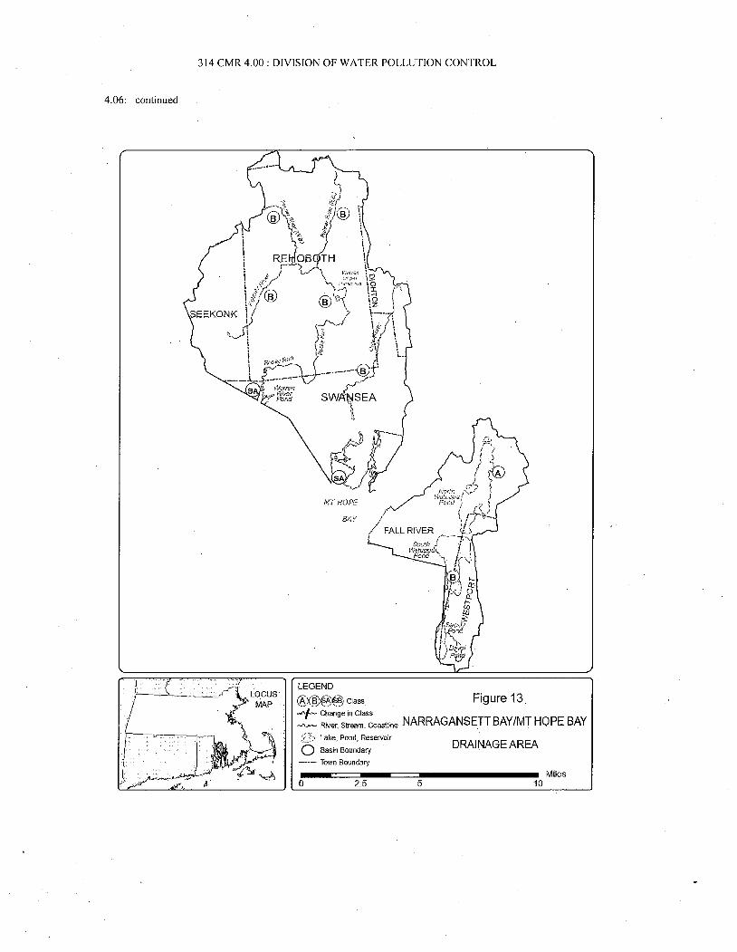
NT NOPE
BAY
LEGEND
0CI~~ Oass Figure 13
Change in Class
~ River, Stream. Coastline NARRAGANSETT BAY/MT HOPE BAY
i5;i Lake , Pond , Reservoir
Basin Boundary
----, Town Boundary
DRAINAGE AREA
Miles

314 CMR4, 00: DIVISION OF WATER POLLUTION CONTROL
06: continued
TABLE 13NARRAGANSETT BAY/MOUNT HOPE BAY DRAINAGE AREA
BOUNDARY MILE POINT CLASS QUALIFIERS
Barrington River
Source to state border Shellfishing
Palmer River
Source to Shad Factory Pond dam Cold Water
Shad Factory Pond dam to state border Shellfishing
Mount Hope Bay
East of line from Brayton Pointto Buoy 4
Shell fishingCSO
West of line from Brayton Pointto Buoy 4
Shellfishing
Lee and Cole Rivers
Source to estuary Wann Water
Estuary Shellfishing
Quequechan River
Entire Length 2.5 - 0. Wann WaterCSO
North Watuppa Pond
Source to outlet in Fall Riverand those trbutaries thereto
Public Water Supply
Treated Water Supply
Treated Water Supply
Treated Water Supply
Shad Factory Pond Reservoir
Anawan Reservoir
Swansea Reservoirin Swansea

314 CMR 4. 00: DIVISION OF WATER POLLUTION CONTROL
06: continued
LEGEND
0CI OassChange in Class
River, Stream. Coastline;;'7.-, Lake, Pond, Reservoir
Basin Boundary
-.--, Town Boundary
Figure
TAUNTON
RIVER BASIN
Miles

314 CMR 4.00: DIVISION OF WATER POLLUTION CONTROL
Q6: continued
TABLE
TAUNTON RIVER BASIN
BOUNDARY MILE POINT CLASS UALIFIERS
Taunton River
Source to R( 24 Bridge 40. 8 - 21. Wann Water
Rt. 24 Bridge to mouth 21. - 0. ShellfishingCSO
Salisbu Plain& Matfield Rivers
Brockton WWTF to confluence Wann Water
Town River
Bridgewater WWTF to confluence 2.4 - 0. Wann Water
Nemasket River
Middleborough WWTF to confluence Wann Water
Saw Mill Brook
Entire Length 1.5 - 0. Wann Water
Mil River
Outlet Lake Sabbatia , Taunton to 3.4 - 0. Wann Waterconfluence with Taunton River
Three Mile River
Source to confluence 15. 8 - 0. Wann Water
Wading River(Attleboro Reservoir)
Source to water supply intakein Mansfield and tributaries thereto
Public Water Supply
From water supply intake, Mansfield toconfluence with Three Mile River
Wann Water
Assawompset Pond
Source to outlet in Lakevilleand those trbutaries thereto
Public Water Supply
Great Quittacas Pond
Source to outlet ih Lakevileand those tributaries thereto
Public Water Supply

314 CMR 4. 00: DIVISION OF WATER POLLUTION CONTROL
06: continued
TABLE
TAUNTON RIVER BASIN (continued)
BOUNDARY MILE POINT CLASS OUALIFIERS
Little Quittacas Pond
Source to outlet in Lakevilleand those tributaries thereto
Public Water Supply
Long Pond
Source to outlet in Lakevileand those trbutaries thereto
Public Water Supply
Pocksha Pond
Source to outlet in Lakevileand those trbutaries thereto
Public Water Supply
Somerset Reservoir
Source to outlet in Somerset andthose tributaries thereto includingSegreganset River tiom pumping stationDighton to source
Public Water Supply
Monponsett Pond
Source to outlet in Halifaxand those tributaries thereto
Public Water Supply
Elders Pond
Source to outlet in Lakevile andthose trbutaries thereto
Public Water Supply
Brockton Reservoir
(Avon Reservoir, SalisburyBrook Reservoir)
Reservoir to outlet in Avon andthose trbutaries thereto
PublIc Water Supply

314 CMR 4.00: DIVISION OF WATER POLLUTION CONTROL
06: continued
' MAP
~~~
LEGEND
0CI OassChange In Class
~ River, Stream, Coastline
i;, Lake , Pond , Reservoir
Basin Boundary
----, Town Boundary
Figure 15
BOSTON HARBOR
DRAINAGE AREA
Miles

314 CMR 4.00: DIVISION OF WATER POLLUTION CONTROL
06: continued
TABLE 15BOSTON HARBOR DRAINAGE AREA
BOUNDARY MILE POINT CLASS QUALIFIERS
Inside a line from the southerlytip of Deer Island to BostonLighthouse to Point Allerton inHull except as denoted below
Shellfishing
Boston Inner Harbor westerlyinside a line from the southern tipof Governors Island to FortIndependence including the CharlesMystic , Island End and Chelsea (Creek)Rivers and Reserved , Fort Point andLitte Mystic Channels
SB(CSO)
Dorchester Bay Shell fishingCSO
Quincy Bay in Quincy fromBromfield Street near the WallastonYacht Club northerly to bouy "C I"southeasterly to the "Willowssometimes known as Lord's Ppint onthe northerly shore of Houghs Neckin Quincy
Shellfishing
Remainder of Quincy Bay Shell fishing
Hingham Harbor in Hingham inside a -line from Crows Point to WorldsEnd Promontery
Shellfishing
Hull Bay Shellfishing
Other coastal and marine watersin the Boston Harbor DrainageArea
Shellfishing
Abe ona River
Source to outlet Mishawum Lake 118.4- 15. Wann Water
Outlet Mishawum Lake to inlet 15. W ann Water
Mystic Lake
Upper Mystic Lake 2 - 8. Wann Water
Lower Mystic Lake 1 - 7.4 Wann Water
stic River
Outlet Lower Mystic Lake to 7.4 - 2. Wann WaterAmelia Earhart Dam CSO
elia Earhar Dam to confluence 0 - 0. SB(CSO) Shellfishing- with the Chelsea River

314 CMR4.00: DIVISION OF WATER POLLUTION CONTROL
06: continued
TABLE 15BOSTON HARBOR DRAINAGE AREA (continued)
BOUNDARY MILE POINT CLASS UALIFIERS
Malden River
Entire Length 1.9 - 0. Wann Water
Alewife Brook
Entire Length 0 - 0. . Wann WaterCSO
Horn Pondin W obum
Wann Water
Belle Isle Inlet Shellfishingand tributaries thereto Outstanding Resource
Water
North Reservoir and MiddleReservoir
Source to outlet in Winchester Public Water SupplYStoneham and Medford and thosetributaries thereto
South Reservoir
Source to outlet in Medford Public Water Supplyand tributaries thereto
Fresh Pond
Source to outlet in Cambridge Public Water Supplyand those trbutaries thereto
onset Reservoir
Upstream of dam at outlet of Above 29. Wann WaterCrackrock Pond High Quality Water
onset River
Source to Mother Brook 29. 5 - 7. Wann Water
Mother Brook to Milton Lower 9 - 4. Wann WaterFalls Dam , Milton/Boston
Tidal Portion 2 - 0. Shellfishing
Weymouth Fore River SB* ShellfishingWanT Water

314 CMR 4. 00: DIVISION OF WATER POLLUTION CONTROL
06: continued
TABLE 15BOSTON HARBOR DRAINAGE AREA (continued)
BOUNDARY MILE POINT CLASS
Weymouth Sack River SA*
Weir River SA*
Fresh River
Cranberr Brook
Cran err Pond
Source to outlet in Braintree
Bouve Pond and
Brewer Pondin Hingham
Straits Pondin Hull and Cohasset
Great Pond
Source to outlet in Braintreeand trbutaries thereto
Upper Reservoir of Great Pond
Source to outlet in Braintreeand trbutaries thereto
Whitmans Pond
Source to outlet in Weymouthand trbutaries thereto
Richardi Reservoir
Source to outlet in Braintreeand trbutaries thereto
Weymouth Great Pond(Great Pond)
Source to outlet in Weymouthand trbutaries thereto
QUALIFIERS
ShellfishingWann WaterOutstanding ResourceWater
Shell fishingOutstanding ResourceWater
Wann Water
Outstanding ResourceWater
Outstanding ResourceWater
Wann WaterOutstanding ResourceWater
Wann WaterOutstanding ResourceWater
Public Water Supply
Public Water Supply
Public Water Supply
Public Water Supply
Public Water Supply

314 CMR4.00: DIVISION OF WATER POLLUTION CONTROL
06: continued
TABLE 15BOSTON HARBOR DRAINAGE AREA (continued)
BOUNDARY MILE POINT CLASS QUALIFIERS
Accord Pond
Source to outlet in Hinghamand tributaries thereto
Public Water Supply
Accord Brook
Outlet of Accord Pond to watersupply intake and tributaries thereto
Public Water Supply
* Marine waters Class SA or SBas designated; fresh waters Class B.

314 CMR 4.00: DIVISION OF WATER POLLUTION CONTROL
06: continued
LEGEND
0CI~~~ OassChange in Class
~ River, Stream. Coastline
:'
Lake, Pond , Reservoir
Basin Boundary
----, Town Boundary
Figure 16
CHARLES
RIVER BASIN
, Miles

314 CMR 4. 00 : DIVISION OF WATER POLLUTION CONTROL
06: continued
TABLE 16CHARLES RIVER BASIN
BOUNDARY MILE POINT CLASS UALIFIERS
Charles River
Source to Dilla Street 78. 9 - 76. Public Water Supply
and tributaries thereto
Dilla Street to Milford WWTF 76.5 - 73. Aquatic Life
Milford WWTF to outlet 73. - 58. Wann Water
Populatic Pond
Outlet Populatic Pond to South 58.9 - 41.0 Wann Water
Natick Dam
South Natick Dam to Watertown 41.0- WanT WaterDam
Watertown Dam to BU Bridge 8 - 3. Wann WaterCSO
Charles Basin
BU Bridge to 7 - 0. Wann Water
New Charles River Dam CSO
Mudd River
Entire Length 7 - 0. B(CSO) Wann Water
Mine Brook
Source to fonner Franklin STP 2 - 4. Wann WaterHigh Quality Water
Fonner Franklin STP to confluence 0 - 0. Wann Water
Unnamed tributa(Su ar Brook
Entire Length WanT WaterHigh Quality Water
Ston Brook Reservoir Turtle Pond
Source to outlet in W eston/W altham Public Water Supply
and those trbutaries thereto
Cambrid e ReservoirHobbs Brook Lower Reservoir)
Source to outlet in Waltham and Public Water Supply
those trbutaries thereto

314 CMR4.00: DIVISION OF WATER POLLUTION CONTROL
06: continued
BOUNDARY
Sandy PondFlint' s Pond)
Source to outlet in Lincolnand those trbutaries thereto
Echo Lake
Source to outlet in Hopkintonand those tributaries thereto
Louisa Lake
Lake to outlet in Milfordand those trbutaries thereto
TABLE 16CHARLES RIVER BASIN (continued)
MILE POINT CLASS QUALIFIERS
Public Water Supply
Public Water Supply
Public Water Supply

314 CMR 4. 00: DIVISION OF WATER POLLUTION CONTROL
06: continued
LOCUSMAP
LEGEND
0CIe-)~ CAass
change in Class
~ River, Stream. Coastline
;G:' Lake , Pond, Reservoir
Basin Boundary
'-"-' Town Boundary
Figure
NASHUA
RIVER BASIN
Miles