Embed Size (px)
Citation preview

Legislation
Tree Conservation Areas/Vacant Land
Prior written approval must be obtained from
the Commissioner of Parks & Recreation for the
removal or cutting of any tree with girth
exceeding 1.0m (measured half a metre from
the ground) growing on a designated Tree
Conservation Area (TCA) or vacant land.
The two Tree Conservation Areas are:
TCA1 - bounded by the Pan Island Expressway,
Clementi Road, Pasir Panjang Road, Telok
Blangah Road, Kampong Bahru Road, Lower
Delta Road, Ayer Rajah Expressway, Alexandra
Road, River Valley Road, Clemenceau Avenue,
Fort Canning Road, Orchard Road, Prinsep
Street, Selegie Road, Dunearn Road, Whitley
Road, Mount Pleasant Road, Thomson Road
and Lornie Road.
TCA2 - bounded by Netheravon Road,
Cranwell Road, Loyang Avenue, Loyang Way,
Upper Changi Road North and Changi Village
Road.
3.1
Note:
Unless otherwise stated,
‘tree’ includes single
stem palms.
Tree Conservation
Areas are geographical
areas in central and
eastern Singapore
designated by the
Government to
safeguard mature trees
against unnecessary
felling. These areas
contain valuable stands
of mature trees worthy
of preservation for our
future generations to
enjoy.
Vacant Land means
any land upon which
no building or other
structures exists; or any
land where the
Commissioner, Parks &
Recreation, has
reasonable grounds to
believe is not occupied
by anyone and
includes any land upon
which exists any
building or other
structure which is
constructed or used
contrary to any written
law.
3.1.1
12/07/2011
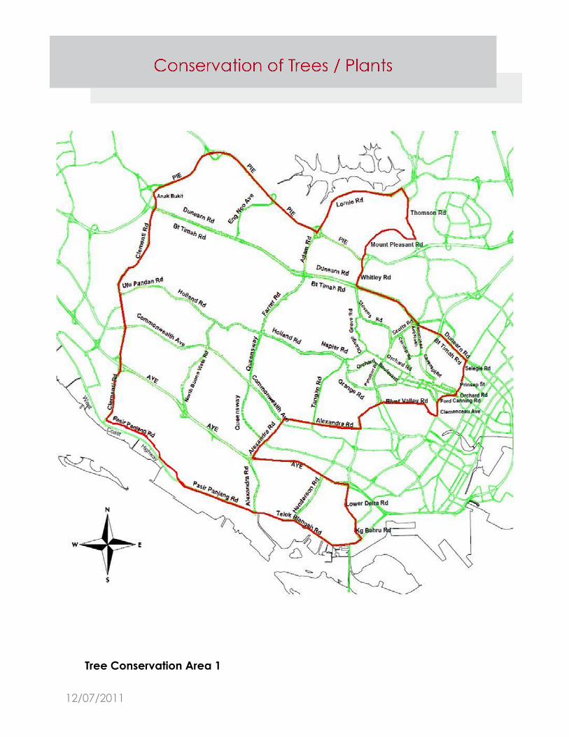
Tree Conservation Area 1
12/07/2011
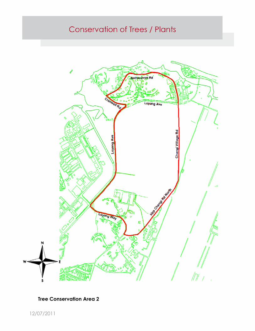
Tree Conservation Area 2
12/07/2011
Roadside Trees
Written approval must be obtained from the Commissioner of
Parks & Recreation for the removal or cutting of any tree or
plant within a road reserve.
Heritage Road Green Buffer
Written approval must be obtained from the Commissioner of
Parks & Recreation for the cutting or removal of any tree or
plant within a designated Heritage Road Green Buffer, and/or
for any -
a. altering, closing up or removal of any Heritage Road Green
Buffer;
b. erecting or placing of any structure or object (whether
temporary or permanent) in, above, across or under any
Heritage Road Green Buffer;
c. erecting, constructing or laying within any Heritage Road
Green Buffer any fence, retaining wall, foundation,
manhole, pipe, cable, mains or any obstruction or structure
(whether temporary or permanent).
3.1.3
3.1.3.1
3.1.2
12/07/2011
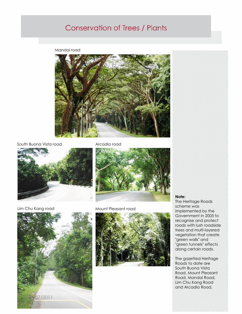
South Buona Vista road Arcadia road
Lim Chu Kang road Mount Pleasant road
Mandai road
Note:
The Heritage Roads
scheme was
implemented by the
Government in 2005 to
recognise and protect
roads with lush roadside
trees and multi-layered
vegetation that create
"green walls" and
"green tunnels" effects
along certain roads.
The gazetted Heritage
Roads to date are
South Buona Vista
Road, Mount Pleasant
Road, Mandai Road,
Lim Chu Kang Road
and Arcadia Road.
12/07/2011
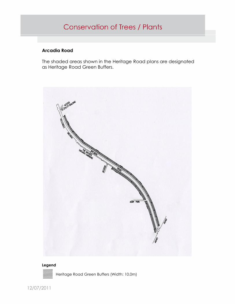
Legend
Heritage Road Green Buffers (Width: 10.0m)
Arcadia Road
The shaded areas shown in the Heritage Road plans are designated
as Heritage Road Green Buffers.
12/07/2011
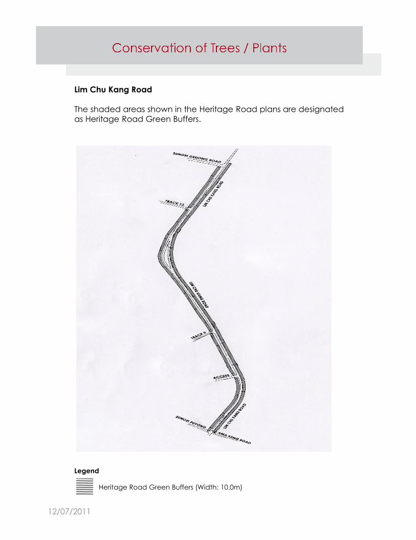
Lim Chu Kang Road
The shaded areas shown in the Heritage Road plans are designated
as Heritage Road Green Buffers.
Legend
Heritage Road Green Buffers (Width: 10.0m)
12/07/2011

Mandai Road
The shaded areas shown in the Heritage Road plans are designated
as Heritage Road Green Buffers.
Legend
Heritage Road Green Buffers (Width: 10.0m)
12/07/2011

Mount Pleasant Road
The shaded areas shown in the Heritage Road plans are designated
as Heritage Road Green Buffers.
Legend
Heritage Road Green Buffers (Width: 0.3m - 10.0m)
12/07/2011
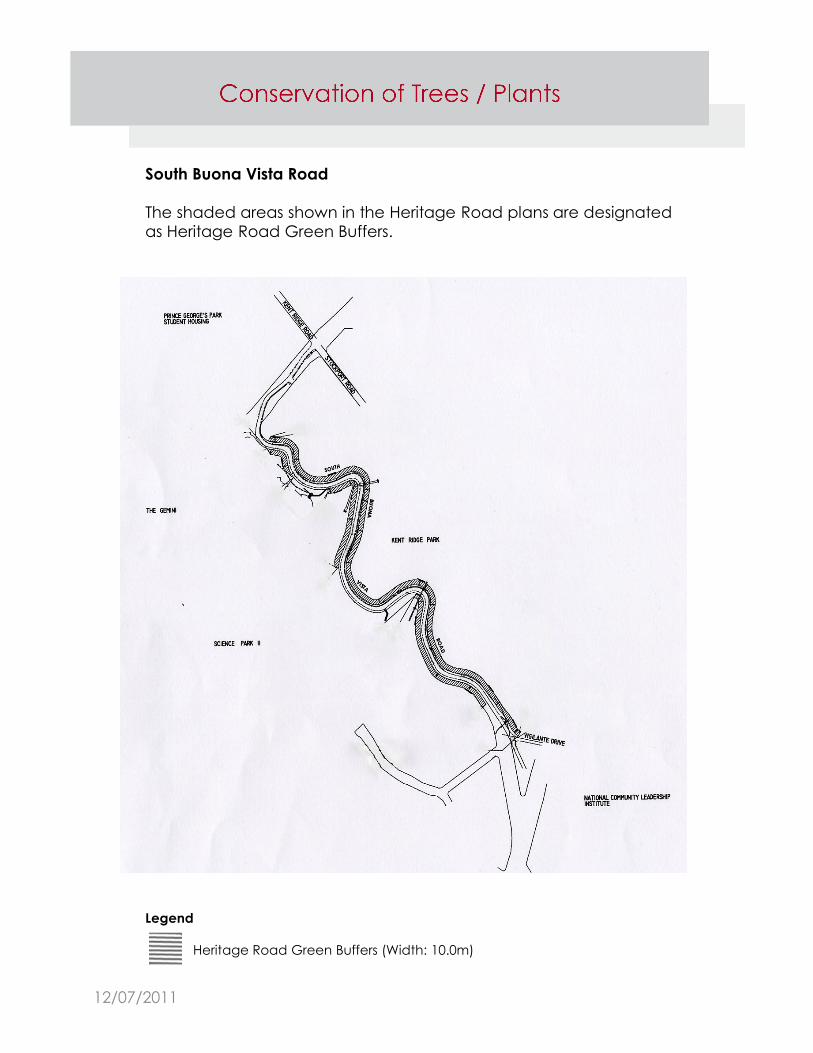
South Buona Vista Road
The shaded areas shown in the Heritage Road plans are designated
as Heritage Road Green Buffers.
Legend
Heritage Road Green Buffers (Width: 10.0m)
12/07/2011
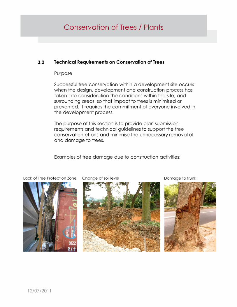
Technical Requirements on Conservation of Trees
Purpose
Successful tree conservation within a development site occurs
when the design, development and construction process has
taken into consideration the conditions within the site, and
surrounding areas, so that impact to trees is minimised or
prevented. It requires the commitment of everyone involved in
the development process.
The purpose of this section is to provide plan submission
requirements and technical guidelines to support the tree
conservation efforts and minimise the unnecessary removal of
and damage to trees.
Examples of tree damage due to construction activities:
3.2
Lack of Tree Protection Zone Damage to trunkChange of soil level
12/07/2011
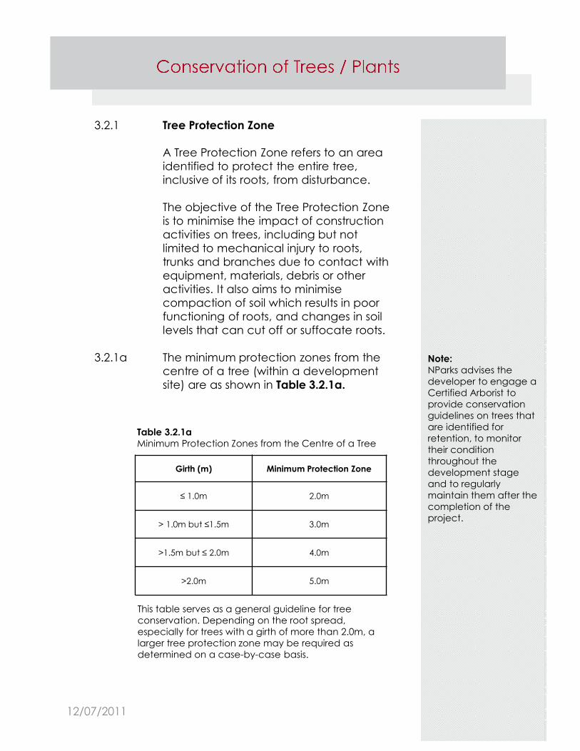
3.2.1 Tree Protection Zone
A Tree Protection Zone refers to an area
identified to protect the entire tree,
inclusive of its roots, from disturbance.
The objective of the Tree Protection Zone
is to minimise the impact of construction
activities on trees, including but not
limited to mechanical injury to roots,
trunks and branches due to contact with
equipment, materials, debris or other
activities. It also aims to minimise
compaction of soil which results in poor
functioning of roots, and changes in soil
levels that can cut off or suffocate roots.
3.2.1a The minimum protection zones from the
centre of a tree (within a development
site) are as shown in Table 3.2.1a.
Girth (m) Minimum Protection Zone
≤ 1.0m 2.0m
> 1.0m but ≤1.5m 3.0m
>1.5m but ≤ 2.0m 4.0m
>2.0m 5.0m
Note:
NParks advises the
developer to engage a
Certified Arborist to
provide conservation
guidelines on trees that
are identified for
retention, to monitor
their condition
throughout the
development stage
and to regularly
maintain them after the
completion of the
project.
Table 3.2.1a
Minimum Protection Zones from the Centre of a Tree
This table serves as a general guideline for tree
conservation. Depending on the root spread,
especially for trees with a girth of more than 2.0m, a
larger tree protection zone may be required as
determined on a case-by-case basis.
12/07/2011
Note:
Table 3.2.1b serves as a
guideline for tree
conservation and on
the basis that no major
root (girth more than
0.2m) will be affected.
Depending on the root
spread, especially for
tree with a girth of more
than 2.0m, a larger tree
protection zone may be
required on a case by
case basis.
Table 3.2.1b
Required Minimum Clearance of Proposed Roadside Elements
from the Centre of an Existing Tree/Single Stem Palm
(Refer to Diagram 3.2.1b for illustration of the clauses below)
Clause Proposed roadside elements
Required minimum
clearance of proposed
roadside elements from the centre of an existing:
Single
stem
palm
Small to
medium
size tree
Large
tree
1 Splay corner of:
Entrance, bin centre access,
substation access, MDF room
access, fire engine access
1.0m 1.5m 2.5m
2 Roadside drain (from its external
wall)
0.8m 0.8m 1.5m
3 Road kerb 0.8m 0.8m 1.5m
4 Scupper pipe/drain 1.0m 1.5m 2.5m
5 Lamp post 4.0m 4.0m 6.0m
6 OG box 2.0m 2.0m 2.5m
TAS manhole
Sewer line and manhole
Electrical post
Fire hydrant
SCV box
Lighting control box
Traffic control box
Traffic light
7 Cement crossing (e.g. pushcart
ramp for bin centre)2.0m
8 Linkway/pedestrian overhead
bridge column footing
at least
1.0m
at
least
1.5m
at least
2.5m
9 Linkway roof eaves to the lowest
branching of a treeat least 0.3m
The minimum clearance required between a
proposed roadside element to the centre of
an existing roadside tree/single stem palm, as
shown in Table 3.2.1b and Diagram 3.2.1b.
3.2.1b
12/07/2011
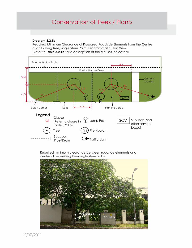
Diagram 3.2.1b
Required Minimum Clearance of Proposed Roadside Elements from the Centre
of an Existing Tree/Single Stem Palm (Diagrammatic Plan View)
(Refer to Table 3.2.1b for a description of the clauses indicated)
cl
FH
Clause
(Refer to clause in
Table 3.2.1b)
Tree
Lamp Post
Fire Hydrant
Traffic Light
SCV Box (and
other service
boxes)
Legend
SCVF
H
External Wall of Drain
Footpath cum Drain
CementCrossing
Splay Corner Kerb Planting Verge
cl 7
cl 2
cl 3 cl 1
cl 6
cl 6
cl 6cl 5
cl 4
Required minimum clearance between roadside elements and
centre of an existing tree/single stem palm
Clause 6Clause 5
Scupper
Pipe/Drain
SCV
12/07/2011

3.2.2 Tree Protective Fencing/Hoarding -
Within development site
Tree protective fencing/hoarding is to be
provided along the limits of the protection
zone around the tree to identify the Tree
Protection Zone within which activities are
restricted.
There must be no excavation, raising/lowering
of soil level, compaction or any form of
construction activities including temporary
works within the hoarded area.
No dumping of debris, excavated materials
and/or storage of construction materials and
equipment are allowed within the Tree
Protection Zone.
Notes:
Protection hoarding is
required, unless
otherwise stated, and
should be installed prior
to site works; installed at
point B around the
edge of the protection
area.
Illustration 3.2.2
Sample of a Tree Protection Hoarding
(within a development site)
12/07/2011
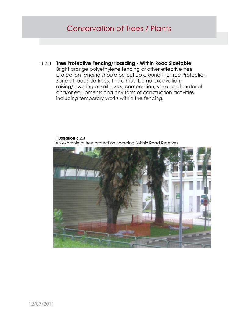
3.2.3 Tree Protective Fencing/Hoarding - Within Road Sidetable
Bright orange polyethylene fencing or other effective tree
protection fencing should be put up around the Tree Protection
Zone of roadside trees. There must be no excavation,
raising/lowering of soil levels, compaction, storage of material
and/or equipments and any form of construction activities
including temporary works within the fencing.
Illustration 3.2.3
An example of tree protection hoarding (within Road Reserve)
12/07/2011
3.2.4 Tree Protection Specification – During Construction Stage
a. Tree protective fencing/hoarding is to be provided along the
limits of the protection zone around the tree to identify the
Tree Protection Zone within which activities are restricted.
b. If major roots (each >0.2m in girth) are encountered during
excavation, the applicant must contact NParks’ officer for a
joint site meeting. Wherever possible, alternative proposals
should be explored to avoid the need to cut the roots.
Nevertheless, if approval is granted by NParks to cut the
roots, this must be done with a clean cut using a chainsaw.
Corresponding pruning of tree branches may be required to
ensure tree stability. Temporary supports to the trees may also
be required.
c. The demolition of drains, structures, etc within the Tree
Protection Zone should be carried out manually and
backfilled with loamy soil immediately.
d. All building debris and chemical wastes are to be hauled
away from the trees/other plants and should not be burned
or buried on the site.
e. Loamy topsoil is to be used immediately to fill around the tree
base after the nearest proposed structure is built, e.g. a
retaining wall.
f. Trees are to be watered regularly if rainfall is inadequate.
g. Trees are to be fertilised if soil tests or deficiency symptoms
indicate they are nutrient stressed.
h. Roots system bridges may be installed to prevent soil
compaction or damage to exposed roots.
12/07/2011
Plan Submission Requirements
A registered architect/professional engineer is required to submit
a completed NParks’ submission form, enclose the letter of
authorisation from the developer, and sign all layers of drawing
digitally.
The plans should comprise:
a. Key and location plans of the development site (scale 1:
10,000 or 1 : 5,000) showing access to the site from the street
or road
b. Site plan (scale 1 : 500, 1 : 200 or 1 : 100)
c. Address, lot and/or plot number of the development site
and neighbouring lots
d. 1st storey plan (scale 1: 500, 1: 200 or 1: 100)
e. Basement plan (scale 1: 500, 1: 200 or 1: 100)
f. Survey plan (survey done less than 2 years at the point of
application and endorsed by a qualified surveyor). This
requirement is not applicable for “Alteration & Additions”
proposals.
3.3
3.3.1
12/07/2011
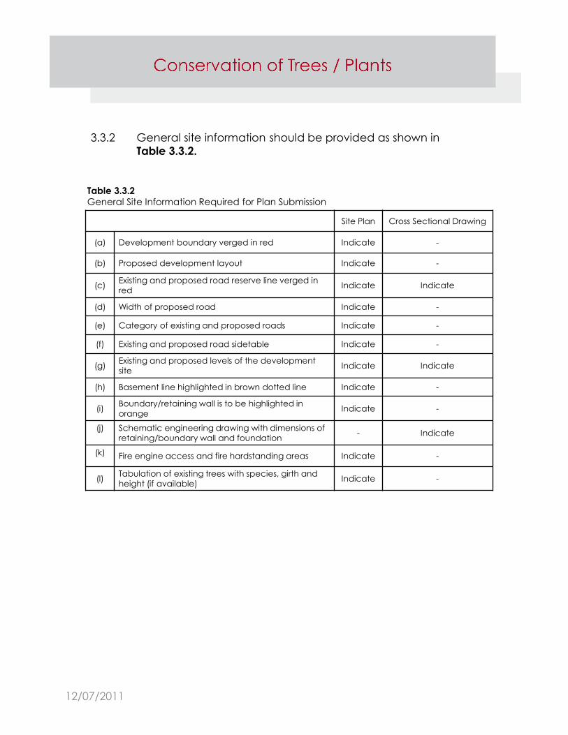
General site information should be provided as shown in
Table 3.3.2.
3.3.2
Site Plan Cross Sectional Drawing
(a) Development boundary verged in red Indicate -
(b) Proposed development layout Indicate -
(c)Existing and proposed road reserve line verged in
redIndicate Indicate
(d) Width of proposed road Indicate -
(e) Category of existing and proposed roads Indicate -
(f) Existing and proposed road sidetable Indicate -
(g)Existing and proposed levels of the development
siteIndicate Indicate
(h) Basement line highlighted in brown dotted line Indicate -
(i)Boundary/retaining wall is to be highlighted in
orangeIndicate -
(j) Schematic engineering drawing with dimensions of
retaining/boundary wall and foundation- Indicate
(k) Fire engine access and fire hardstanding areas Indicate -
(l)Tabulation of existing trees with species, girth and
height (if available)Indicate -
Table 3.3.2
General Site Information Required for Plan Submission
12/07/2011
Information on Trees within Development Site
a. The site and survey plans should show
existing trees within the development
boundary and up to 5.0m from the
boundary with the following
information provided:
i. species
ii. girth – measured 0.5m from the
ground
iii. tree height (if available)
iv. all trees are to be uniquely
numbered. The numbering
should be consistent with
architectural plans (if applicable)
throughout the project.
b. All existing trees indicated on the survey
plan are to be reflected in Tree Survey
Information Form.
c. Clear photographs of trees proposed
for conservation are to be attached.
The photograph should show the entire
height of the trees.
d. The trees in the photographs are to be
numbered according to the numbering
shown on the plan.
Note:
The Qualified Person/
Surveyor is to obtain
permission from the
neighbouring owner(s)
to gather the requisite
tree information within
the neighbouring lot(s).
3.3.3
12/07/2011

Method of measuring girth of a tree:
Generally, the girth of a tree is to be measured at 0.5m from ground
level, except for multi-leader and low branching trees, as shown
below.
0.5m
I. For a simple single trunk tree and buttressed tree –
measure the girth at 0.5m above the ground. [Figure I]
Figure I
12/07/2011

II. For a multi-leader tree where the leaders sprout from the collar -
measure the girth of each individual stem at 0.5m above the
ground, and treat each stem as a separate tree. [Figure II]
0.5m
0.5m
0.5m
Figure II
12/07/2011
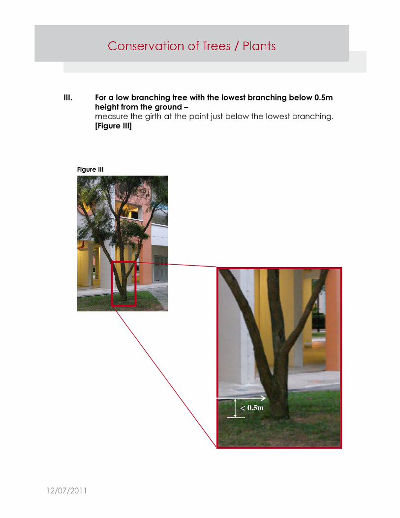
III. For a low branching tree with the lowest branching below 0.5m
height from the ground –
measure the girth at the point just below the lowest branching.
[Figure III]
< 0.5m
Figure III
12/07/2011
3.3.4
3.3.5
Advisory Note:
For a development site
that does not fall within
a Tree Conservation
Area or Vacant Land,
NParks’ written
approval for removal
of trees within the
development site is not
required. However, the
developer is advised to
minimise the number of
trees to be felled and
to take all necessary
precautions to protect
non-affected trees.
The developer is also
advised to engage a
Certified Arborist to
assess and monitor the
condition and safety of
all trees to be
conserved/retained.
Information on Roadside Trees/Cluster
Palms/Shrubs
a. The site and survey plans should show
roadside trees/cluster palms/shrubs
abutting the development boundary and
up to 10.0m on both sides of the boundary
with the following information provided:
i. species
ii. girth – (for tree) measured 1.0m from
the ground
iii. height (if available) and number of
cluster palm/shrub
iv. The numbering should be consistent
with architectural plans (if
applicable) and throughout the
project.
b. All existing trees/cluster palms/shrubs
indicated on the site plan are to be
reflected in the Tree Survey Information
Form.
Information on Trees/Plants Within Heritage Road
Buffer
a. The site and survey plans should show all
existing trees/plants within the Heritage
Road Green Buffer of the development
boundary and up to 5.0m from the
development boundary with the following
information provided:
i. species
ii. girth – (for tree)
iii. height (if available) and number of
plants
iv. The numbering should be consistent
with architectural plans (if
applicable) and throughout the
project.
12/07/2011

Status of existing trees/palms Outline in colour
To be retained Green
To be removed Yellow
Removed without written
approvalRed
Removed with written
approval
*Yellow (indicate the
approved date in the tree
schedule)
Non-existence after
investigation
Indicate a ‘cross’ on tree
symbol
3.3.6 The colour code for existing trees/cluster palms/shrubs is as shown in Table 3.3.5.
Table 3.3.5
Colour Code for Existing Trees/Cluster Palms
12/07/2011


![rajswasthya.nic.inrajswasthya.nic.in/251 dt 19.04.2015 RUHS 2014 MO POSTING...I / 2015/2 s / 04/2015 VACANT POS] VACANT POS] VACANT POST VACANT POST VACANT POST VACANT POST VACANT](https://img.dokumen.tips/doc/110x75/5ab992577f8b9aa6018e0de9/dt-19042015-ruhs-2014-mo-postingi-20152-s-042015-vacant-pos-vacant-pos.jpg)