Embed Size (px)
Citation preview

31 | Context & Site

+ Context: the City of PretoriaTshwane, the capital of South Africa is a city exemplifying the characteristics of a post-colonial African metropolis. It is a city that, since apartheid, has undergone a rapid metamorphosis in terms of its social and cultural milieu. Change of such magnitude has physical implications on a city, and it is the task of the space maker (urban designer, architect, landscape architect and interior architect) to effectuate its transformation.
An influx of a previously disadvantaged populace as well as the exodus of a sizable portion of its former inhabitants has resulted in a somewhat schizophrenic city of segregated developments connected by large automotive roadways. Although relatively well inhabited, the majority of its working population reside on the outskirts of the city. Consequently, each morning the city has to accommodate for a massive inundation of mini-bus taxi’s from outlying townships and private vehicles from suburbia. This leads to a city suffering from the effects of daytime congestion and nighttime abandonment (a migrating culture).
Pretoria, the inner city of Tshwane (area of study), is rich in historical significance with its structures standing firm as monuments within an environment of change. The existing built fabric of Pretoria offers to the space maker a canvas rich in contradiction and possibility, and the task of unpacking and reshuffling these complex archaeologies of place takes on a new urgency in the current social climate of transformation and integration.
Context & Site

32 | 33
+ The Development of the CityThe city has developed according to contextual aspects, universal principles and cultural ideals (Jordaan, 1989: 26). The city is clearly defined and ‘contained’ by its natural elements; the Witwatersberg mountain range to the North with the Apies River running at its foot, curving in a Western direction, to outline the Eastern boundary of the city. Steenhovenspruit defines the Western perimeter, while Pretoria formations of the Magaliesberg, i.e. Langeberge and Skurweberg, delineate the South. The city form is a direct result of the interpretation of these governing natural elements (Jordaan, 1989: 26) which offer a level of sympathy with its context.
The grid of Pretoria was laid out according to the Roman planning principle of the Cardo-Decomanus. The Cardo is a north-south oriented street that formed an integral component of Roman city planning. It was lined with shops and traders, and served as the economic hub of the city. Most Roman cities also had a Decomanus - an east-west oriented street that served as a secondary main arterial. The Forum1 was normally located at the intersection of the two (Bosanquet,1915: 289).
Similarly, Church Square is situated on the crossing of the two main arteries: Paul Kruger -, the former Markstraat (Market
Street, due to its primary function, as the Cardo) and Church Street (Decomanus). It is the symbolic nucleus of the city around which all development was centred (fig. 5.3). The square itself emphasises its importance by articulating the crossing of the two main axis as well as its mandala2 form (illus. 5.1).
Church square is symbolically linked to the landscape by its connections with the ‘poorte’ or natural gateways (Daspoort to the North and Fountains Valley to the South) as well as its link to the rivers on the Eastern and Western periphery of the city.
Pretoria’s city blocks are much larger (80x120m) than the average city block which was a result of the water channel system3. This lead to a rigid gridiron street layout that only changes orientation where it intersects with a dominating natural element (see fig. 5.3 - note the grid orientation directly East of the Apies river).
Opposite |Figure 5. 1: Figure ground of Pretoria (Author, 2011)
01. The public space in the centre of the traditional Roman city. This square was multifunctional: a market place, a gathering place of great social significance, and often the scene of sundry activities, including political debates, meetings and social interaction.
02. A religious geometrical figure representing the universe or the notion of ‘completeness’
03. Water channels were dug from the Fountains Valley to Church Square. From here it was redistributed to the residents of Pretoria’s erven. This grid layout was the most effective and economic to achieve this (reference).

Context & Site
E
W
E
W
E
W
E
W
E
W
This page (left to right) |Figure 5. 2: Diagram of Tshwane illustrating the mountain ranges enclosing the city of Pretoria (Author & other students, 2010)Figure 5. 3: Diagram illustrating the development of the city of Pretoria as informed by its rivers and mountain ranges (Jordaan, 1989. Edited by Author)Opposite |Illustration 5. 1: Photograph of Church square c.1927 (Cleland, 2009)
apies river
steenhovenspruit
Witwate
rsberg
Lang
eberg
e
Skurw
eberg
magaliesberge
witwatersberg
LangebergeSkurweberg

34 | 35
Context & Site
+ Site144 Van Der Walt Street, c/o Vermeulen, Erf 3200, Pretoria, City of Tshwane
The proposed site is currently home to the Munitoria Complex (Municipal Offices of Pretoria). Ahmed Alkayyali (fellow student) and the author are working in a very close proximity on the terrain.
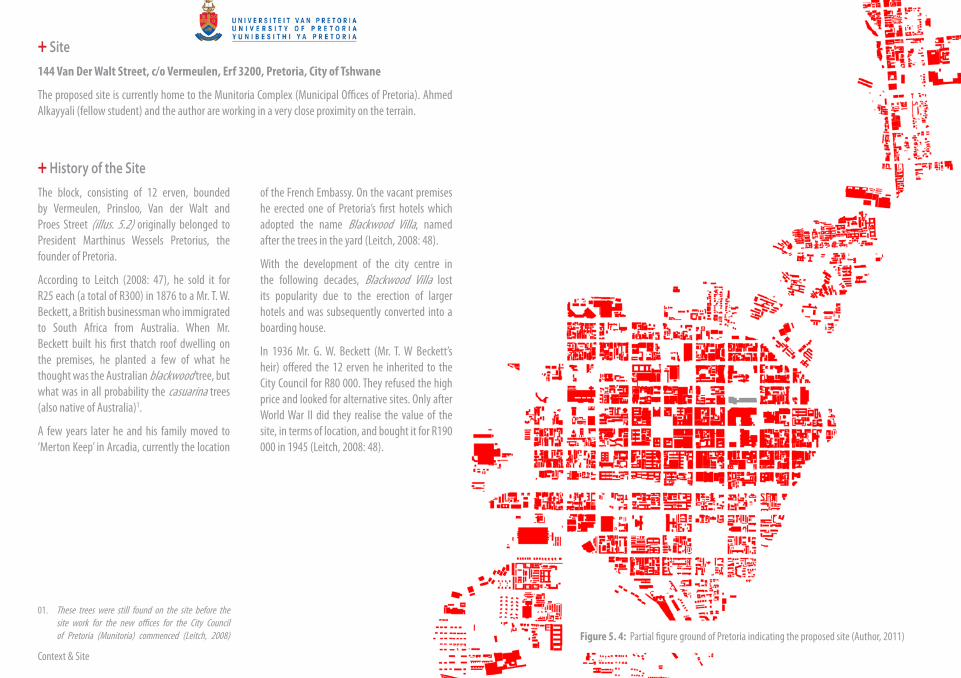
+ History of the SiteThe block, consisting of 12 erven, bounded by Vermeulen, Prinsloo, Van der Walt and Proes Street (illus. 5.2) originally belonged to President Marthinus Wessels Pretorius, the founder of Pretoria.
According to Leitch (2008: 47), he sold it for R25 each (a total of R300) in 1876 to a Mr. T. W. Beckett, a British businessman who immigrated to South Africa from Australia. When Mr. Beckett built his first thatch roof dwelling on the premises, he planted a few of what he thought was the Australian blackwood tree, but what was in all probability the casuarina trees (also native of Australia)1.
A few years later he and his family moved to ‘Merton Keep’ in Arcadia, currently the location
of the French Embassy. On the vacant premises he erected one of Pretoria’s first hotels which adopted the name Blackwood Villa, named after the trees in the yard (Leitch, 2008: 48).
With the development of the city centre in the following decades, Blackwood Villa lost its popularity due to the erection of larger hotels and was subsequently converted into a boarding house.
In 1936 Mr. G. W. Beckett (Mr. T. W Beckett’s heir) offered the 12 erven he inherited to the City Council for R80 000. They refused the high price and looked for alternative sites. Only after World War II did they realise the value of the site, in terms of location, and bought it for R190 000 in 1945 (Leitch, 2008: 48).
01. These trees were still found on the site before the site work for the new offices for the City Council of Pretoria (Munitoria) commenced (Leitch, 2008) Figure 5. 4: Partial figure ground of Pretoria indicating the proposed site (Author, 2011)

36 | 37
Illustration 5. 2: Proposed site (Author, 2011)

Context & Site
Figure 5. 5: Site plan of Blackwood Villa, 1951 (Unknown author, 1951)
38 | 39
+ From City Council to MunitoriaBefore the construction for the new offices of the City Council commenced, a competition (with a R100 cash prize) was organised for the naming of the new building. Of the 9 036 entries, 126 entrants suggested ‘Munitoria’, derived from the combination of ‘muni-cipality’ and ‘Pre-toria’. This name was accepted on March 31, 1965 (Leitch, 2008: 48).
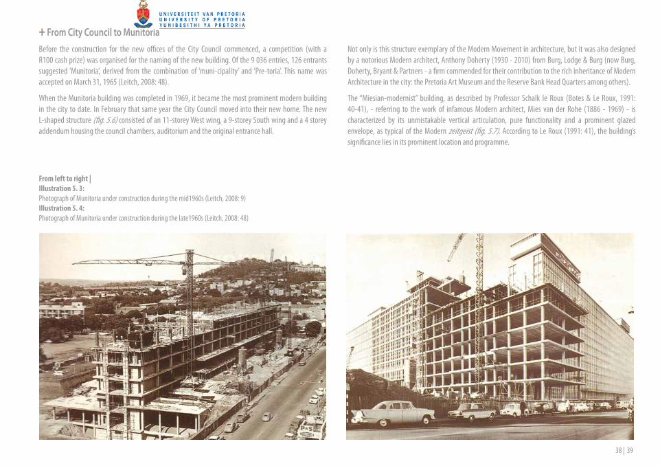
When the Munitoria building was completed in 1969, it became the most prominent modern building in the city to date. In February that same year the City Council moved into their new home. The new L-shaped structure (fig. 5.6) consisted of an 11-storey West wing, a 9-storey South wing and a 4 storey addendum housing the council chambers, auditorium and the original entrance hall.
Not only is this structure exemplary of the Modern Movement in architecture, but it was also designed by a notorious Modern architect, Anthony Doherty (1930 - 2010) from Burg, Lodge & Burg (now Burg, Doherty, Bryant & Partners - a firm commended for their contribution to the rich inheritance of Modern Architecture in the city: the Pretoria Art Museum and the Reserve Bank Head Quarters among others).
The “Miesian-modernist” building, as described by Professor Schalk le Roux (Botes & Le Roux, 1991: 40-41), - referring to the work of infamous Modern architect, Mies van der Rohe (1886 - 1969) - is characterized by its unmistakable vertical articulation, pure functionality and a prominent glazed envelope, as typical of the Modern zeitgeist (fig. 5.7). According to Le Roux (1991: 41), the building’s significance lies in its prominent location and programme.
From left to right |Illustration 5. 3: Photograph of Munitoria under construction during the mid1960s (Leitch, 2008: 9)Illustration 5. 4: Photograph of Munitoria under construction during the late1960s (Leitch, 2008: 48)
Context & Site
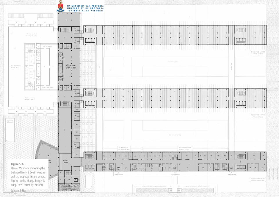
Figure 5. 6: Plan of Munitoria indicating the L-shaped West- & South wing as well as proposed future wings. Not to scale. (Burg, Lodge & Burg, 1965. Edited by Author)

40 | 41
Figure 5. 7: Sections of Munitoria. Not to scale. (Burg, Lodge & Burg, 1965. Edited by Author)

Context & Site
+ The Great Munitoria FireA fire was noticed in the Licensing department in the basement level of the West wing on the 3rd of March 1997. The Fire and Ambulance Control Centre received the first reports of the alleged fire at 18:24 that night. A fire fighting team arrived at the scene 6 minutes later. As the fire spread and turned into a towering inferno, the incident commander requested assistance from the Centurion and Akasia fire departments. Further support came from as far afield as Sandton and the East Rand a few hours later (Leitch, 2008: 8).
The blaze was eventually extinguished at approximately 8:30 on the 4th of March, after a 12 hour battle to contain the flames and prevent it from reaching the bridge linking Munitoria to the Sammy Marx building. The fire unfortunately re-ignited on the evening of the 4th and continued to burn and smoulder for a further three days before being completely extinguished on 7 March (Leitch, 2008: 9).
A multiparty forensic investigation, into the cause of the fire, was conducted in the days following the disaster. It was initially believed that accelerants were present in the area where the fire was initiated, but it was later proven that the fire was caused by a defective electrical light fitting. This ruled out any possibility of arson, but rumours about the Truth and Reconciliation Commission’s amnesty hearings for five former security policemen who were allegedly guilty of murder, were still circulating1.
01. The day preceding the night of the fire, the Truth and Reconciliation Commission’s committee had been provided with evidence (in the Munitoria building’s council chambers) to prove Colonel Marthinus Ras and other policemen guilty of murder. Colonel Ras gave orders to the ‘death squad’ (Jacques Hechter and Paul van Vuuren) to kill a Mamelodi policeman, Sergeant Richard Matosi, in 1988. Sergeant Matosi was accused of being an ANC informant, but this was based on unsubstantial proof. In the process Matosi’s wife, Irene, was also killed, leaving their baby boy orphaned. It was later found that the real motive for the ‘elimination’ was because Sergeant Matosi was involved in a claim against the police force. The evidence and transcripts proving Colonel Ras guilty was housed in Munitoria on the night of the blaze. The fire completely derailed the amnesty hearing’s proceedings for quite some time. In the early hours of the morning on the 4th of March a Munitoria official, Koki Mpshe, was escorted into the building by firemen and returned with two briefcases containing the hearings’ transcripts. Ras’s confession was not destroyed and if the fire was caused by sabotage it would have proven to be unsuccessful. (Green, 1997)
This page | Illustration 5.5: Munitoria on the night of the fire as seen from Proes Str. (Leitch, 2008: 8) Opposite | Illustration 5.6: Munitoria the night after the fire as seen from van der Walt Str. (Leitch, 2008: 8)

42 | 43
Context & Site
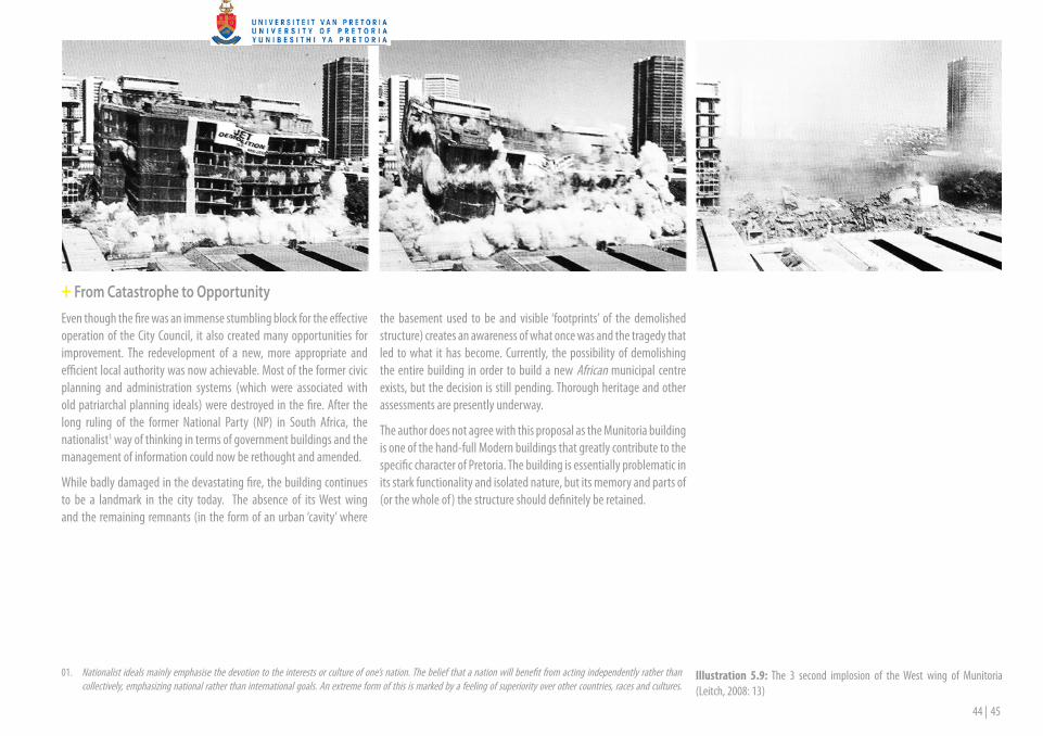
+ Then It All Came DownA specialised team investigated the structural integrity of the burnt down structure and came to the conclusion that the structure would have to be demolished by means of explosives (Leitch, 2008: 10).
On the 1st of February the following year, the West block of the prominent city landmark, was reduced to a 40 000 tonne mountain of debris in a mere 3 seconds (illus. 5.9). Mr Henry Enslin, the Town Clerk at the time, remarked on the occasion that the rubble was representative of a fresh start for the City Council. He continued to say that almost one year ago he had observed “in horror” as the a fire consumed the West block of Munitoria. “The far less painful 3 second implosion was almost welcome, because now the black scar, which served as a constant reminder of that night of horror, has been removed.” (Leitch, 2008: 10)
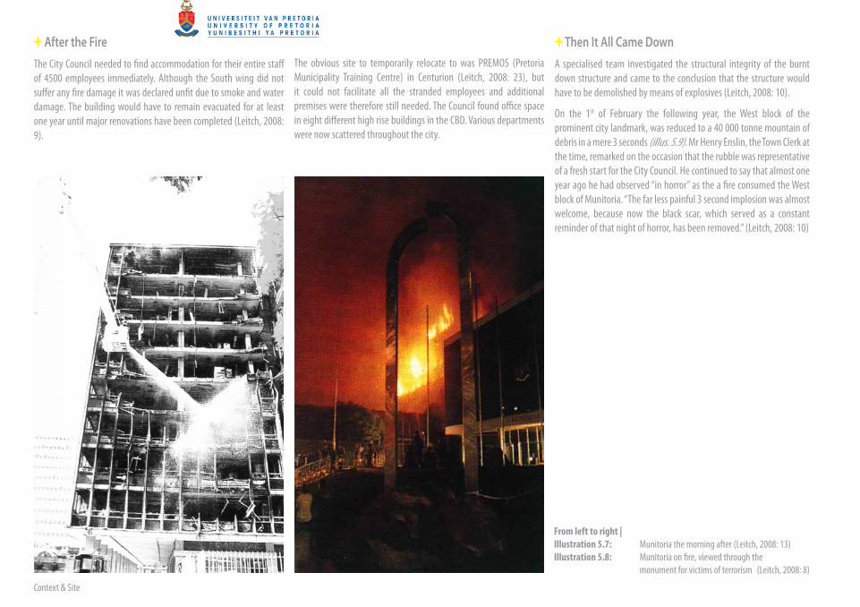
+ After the FireThe City Council needed to find accommodation for their entire staff of 4500 employees immediately. Although the South wing did not suffer any fire damage it was declared unfit due to smoke and water damage. The building would have to remain evacuated for at least one year until major renovations have been completed (Leitch, 2008: 9).
The obvious site to temporarily relocate to was PREMOS (Pretoria Municipality Training Centre) in Centurion (Leitch, 2008: 23), but it could not facilitate all the stranded employees and additional premises were therefore still needed. The Council found office space in eight different high rise buildings in the CBD. Various departments were now scattered throughout the city.
From left to right |Illustration 5.7: Munitoria the morning after (Leitch, 2008: 13) Illustration 5.8: Munitoria on fire, viewed through the monument for victims of terrorism (Leitch, 2008: 8)
44 | 45
01. Nationalist ideals mainly emphasise the devotion to the interests or culture of one’s nation. The belief that a nation will benefit from acting independently rather than collectively, emphasizing national rather than international goals. An extreme form of this is marked by a feeling of superiority over other countries, races and cultures.
+ From Catastrophe to OpportunityEven though the fire was an immense stumbling block for the effective operation of the City Council, it also created many opportunities for improvement. The redevelopment of a new, more appropriate and efficient local authority was now achievable. Most of the former civic planning and administration systems (which were associated with old patriarchal planning ideals) were destroyed in the fire. After the long ruling of the former National Party (NP) in South Africa, the nationalist1 way of thinking in terms of government buildings and the management of information could now be rethought and amended.
While badly damaged in the devastating fire, the building continues to be a landmark in the city today. The absence of its West wing and the remaining remnants (in the form of an urban ‘cavity’ where
the basement used to be and visible ‘footprints’ of the demolished structure) creates an awareness of what once was and the tragedy that led to what it has become. Currently, the possibility of demolishing the entire building in order to build a new African municipal centre exists, but the decision is still pending. Thorough heritage and other assessments are presently underway.
The author does not agree with this proposal as the Munitoria building is one of the hand-full Modern buildings that greatly contribute to the specific character of Pretoria. The building is essentially problematic in its stark functionality and isolated nature, but its memory and parts of (or the whole of) the structure should definitely be retained.
Illustration 5.9: The 3 second implosion of the West wing of Munitoria (Leitch, 2008: 13)