Embed Size (px)
Citation preview

U.S. Department of Energy 2014 UMTRCA Title I Annual Report March 2015 Canonsburg, Pennsylvania
Page 3-1
3.0 Canonsburg, Pennsylvania, Disposal Site 3.1 Compliance Summary The Canonsburg, Pennsylvania, Uranium Mill Tailings Radiation Control Act (UMTRCA) Title I Disposal Site was inspected on October 22, 2014. The site was in excellent condition. No evidence of erosion or slope instability was observed on the disposal cell. The small pedestrian footbridge present at the site was painted during the inspection. Inspectors identified several minor maintenance needs but no cause for a follow-up inspection. Groundwater and surface water sampling to monitor uranium concentrations is conducted every 5 years. Results from the most recent sampling event, conducted in November 2013, demonstrate continued compliance with established site standards. 3.2 Compliance Requirements Requirements for the long-term surveillance and maintenance of the site are specified in the Long-Term Surveillance Plan for the U.S. Department of Energy Canonsburg Uranium Mill Tailings Disposal Site, Canonsburg, Pennsylvania (LTSP) (LMS/CAN/S00404-1.0, U.S. Department of Energy [DOE], March 2013) and in procedures that DOE established to comply with requirements of Title 10 Code of Federal Regulations Part 40.27 (10 CFR 40.27). Table 3-1 lists these requirements.
Table 3-1. License Requirements for the Canonsburg Disposal Site Requirement Long-Term Surveillance Plan This Report Annual Inspection and Report Section 3.3 Section 3.4 Follow-Up Inspections Section 3.4 Section 3.5 Maintenance and Repairs Section 3.5 Section 3.6 Emergency Response Section 3.6 Section 3.7 Environmental Monitoring Section 3.7 Section 3.8
3.3 Institutional Controls The 34.2-acre disposal site (Figure 3-1) is owned by the United States of America and was accepted under the U.S. Nuclear Regulatory Commission (NRC) general license (10 CFR 40.27) in 1996. DOE is the licensee and, in accordance with requirements for UMTRCA Title I sites, is responsible for the custody and long-term care of the site. The site-specific institutional controls include federal ownership of the property and the following features that are inspected annually: perimeter warning signs, a site perimeter fence, and locked gates at the site entrances. Institutional controls also apply to Area C and Tract 117, which are located southeast of Strabane Avenue. Area C (3.1 acres) was sold and transferred in 2005 and Tract 117 (0.431 acre) was sold and transferred in 2009 to the same private owner. DOE and the Commonwealth of Pennsylvania complied with restrictions on parcel transfers stipulated in UMTRCA and the Cooperative Agreement between DOE and the Commonwealth. The deed for Area C and Tract 117 establishes restrictions to limit excavation in the areas, prohibits the disturbance of the stream

2014 UMTRCA Title I Annual Report U.S. Department of Energy Canonsburg, Pennsylvania March 2015 Page 3-2
bank, maintains access for monitoring and stream bank maintenance, and prevents the areas from being used for residential purposes. Use of groundwater is not restricted. Adherence to these institutional controls is evaluated during site inspections. 3.4 Inspection Results The site, approximately 20 miles southwest of Pittsburgh, Pennsylvania, was inspected on October 22, 2014. The inspection was conducted by M. Miller and K. Broberg of Stoller Newport News Nuclear, Inc. (SN3), a wholly owned subsidiary of Huntington Ingalls Industries, Inc. SN3 is the DOE Legacy Management Support contractor. C. Carpenter (DOE Site Manager), L. Stettner representing State Senator Solobay, and C. Rajkovich of the Pennsylvania Department of Environmental Protection attended in the inspection. The purposes of the inspection were to confirm the integrity of visible features at the site, to identify changes in conditions that might affect site integrity, and to determine the need, if any, for maintenance or additional inspections and monitoring. Numbers in the left margin of this chapter refer to items summarized in Table ES-1 of the “Executive Summary.” 3.4.1 Site Surveillance Features Figure 3-1 shows the locations of site surveillance features. Inspection results and recommended maintenance activities associated with site surveillance features are included in the following subsections. Photographs to support specific observations are identified in the text and in Figure 3-1 by photograph location (PL) numbers. 3.4.1.1 Entrance Gate and Entrance Sign Access to the Canonsburg site is directly off Strabane Avenue. The main entrance gate for the site was locked and in good condition. The entrance sign at the gate was in good condition. 3.4.1.2 Perimeter Fence and Perimeter Signs The security fence was replaced in 2007 and remains in excellent condition. The hinge on the northeast vehicle gate requires minor adjustment, but the gate remains operable (PL-1). The personnel gate in the southwest corner of the site has a broken hasp that needs to be repaired and a lock that needs to be replaced. Some small tree limbs have fallen across the top of the west perimeter fence but did not damage the fence (PL-2). The site maintenance contractor will remove the limbs from the fence. The perimeter security fence has 11 attached signs identifying the site. The perimeter signs were in good condition. Perimeter sign P2 covers a small hole in the fence where the original sign was stolen in 2011. 3.4.1.3 Site Markers The site has two granite site markers. Both site markers were in good condition.

U.S. Department of Energy 2014 UMTRCA Title I Annual Report March 2015 Canonsburg, Pennsylvania Page 3-3
Figure 3-1. 2014 Annual Inspection Drawing for the Canonsburg Disposal Site

2014 UMTRCA Title I Annual Report U.S. Department of Energy Canonsburg, Pennsylvania March 2015 Page 3-4
This page intentionally left blank

U.S. Department of Energy 2014 UMTRCA Title I Annual Report March 2015 Canonsburg, Pennsylvania Page 3-5
3.4.1.4 Survey Monuments and Boundary Monuments The site has three survey monuments and four boundary monuments. The survey and boundary monuments were in good condition. 3.4.1.5 Erosion Control Markers The site has four pairs of erosion control markers. All four pairs were in good condition. 3.4.1.6 Monitoring Wells The site has five groundwater monitoring wells. The wells were locked and in good condition (PL-3). 3.4.2 Inspection Areas In accordance with the LTSP, the site is divided into five inspection areas (referred to as “transects” in the LTSP) to ensure a thorough and efficient inspection. The inspection areas are: (1) the disposal cell, (2) the grass-covered area surrounding the disposal cell, (3) the diversion channels and perimeter ditches, (4) the site perimeter, and (5) the outlying area. Within each area, the inspectors examined specific site-surveillance features. Inspectors also looked for evidence of settlement, erosion, or other modifying processes that might affect site integrity, protectiveness, or long-term performance. 3.4.2.1 Disposal Cell The grass-covered disposal cell was in excellent condition. No evidence of erosion or slope instability was observed during the inspection (PL-4). Animal burrows are present on the cell cover. Because the buried tailings are overlain by a 36-inch thick clay layer (radon barrier), an 18-inch thick rock layer, and a 12-inch thick topsoil layer, biointrusion down to or through the radon barrier is unlikely. Therefore, the burrows should not pose a risk to cell integrity or public health. The locations and significance of burrows will continue to be monitored by inspectors each year. No new burrows were observed on the cell during the inspection. 3.4.2.2 Grass-Covered Area Surrounding the Disposal Cell The site consists primarily of mowed grasses within the perimeter fence and on the disposal cell cap, with seeded fescues and crown vetch present across the site. The “spray and mow” approach to vegetation management at the site continues to be effective. Noxious weeds within the fenced area are limited to re-sprouting seedlings, which were observed in portions of mowed areas. A small pedestrian footbridge was installed northeast of the disposal cell in 2010 to allow safe crossing of the riprap-armored diversion ditch. The footbridge was in excellent condition. Inspectors painted the footbridge during this year’s inspection (PL-5 and PL-6).
3A

2014 UMTRCA Title I Annual Report U.S. Department of Energy Canonsburg, Pennsylvania March 2015 Page 3-6
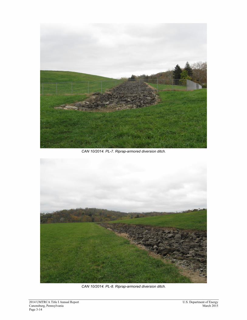
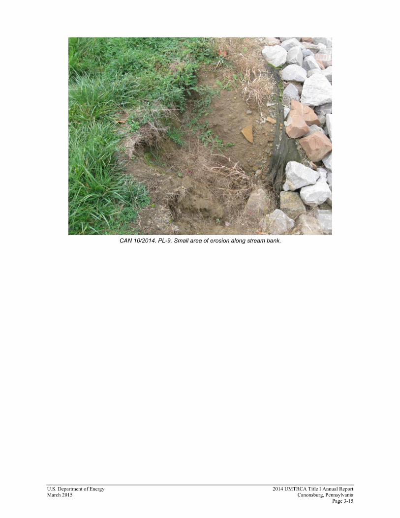
3.4.2.3 Diversion Channels and Perimeter Ditches Rock in the engineered channels and ditches surrounding the disposal cell was in good condition. Rock deterioration does not appear to be a problem, and no indications of poor rock durability were noted during the inspection. Rock durability will continue to be visually monitored during inspections. No woody vegetation in the channels and ditches was observed (PL-7 and PL-8). Physical removal and spot herbicide applications have been effective at reducing woody vegetation. 3.4.2.4 Site Perimeter The area between the perimeter fence and the site boundary was in good condition. A vegetation-free buffer zone is being maintained around the entire site security fence. An area of erosion remains under the fence along the western edge of the site where the old fence line was located (shown on Figure 3-1). The area was stable and does not need to be filled in at this time. Sometime in the past, the railroad south of the site cleared, grubbed, and spread gravel on a small parcel of land inside the unfenced southwest corner of the site. Also, some junk and trash is present in the wooded portion of the land parcel. No new trash or encroachment activity was observed during this inspection. However, a person was camping in this area just outside of the perimeter fence. The person was informed that he was trespassing on DOE property and asked to leave. 3.4.2.5 Outlying Area Chartiers Creek Bank—Chartiers Creek is meandering waterway that flows around the east, north, and west sides of the site. The creek tends to cut into the bank and has required several stream bank stabilization projects along the east and north sides of the site between 2001 and 2009. The stabilized areas were in good condition. A small area of erosion was noted during this year’s inspection and is believed to be caused by surface water runoff to the creek (PL-9). This small area will be modified to decrease the impact of the surface water runoff. The stream bank west of the perimeter fence, which has not required repairs, appears to remain in stable condition. Area C and Tract 117—Area C and Tract 117 form a triangular, grass-covered parcel of vacant property east of the site that is bounded by Strabane Avenue, Chartiers Creek, and the Pittsburgh & Ohio Central Railroad. No evidence was observed during the inspection that any of the institutional controls in place for Area C and Tract 117 have been violated. DOE has two groundwater monitoring wells in Area C and Tract 117 (0424 and 0414B, respectively) that are part of the groundwater-monitoring network. DOE ensured ongoing access to these wells through the sale agreements. The private property owner has done a good job maintaining access to the wells and has graded the land surface so that surface water will not collect and pool around the well pads. The property owner has elevated the ground surface of both areas through the placement and grading of clean fill material. Placement and grading of the fill does not violate land use restrictions. Large fresh piles of fill were present during the inspection.

U.S. Department of Energy 2014 UMTRCA Title I Annual Report March 2015 Canonsburg, Pennsylvania Page 3-7
Strabane Avenue—Strabane Avenue is along the southeast property boundary, and trash tends to be present in the area between the perimeter fence and the road. The site maintenance subcontractor periodically removes trash on and adjacent to DOE property to maintain the property’s appearance. The area along the road was relatively clear of trash.
3.5 Follow-Up Inspections DOE will conduct follow-up inspections if (1) an annual inspection or other site visit reveals a condition that must be reevaluated during a return to the site, or (2) a citizen or outside agency notifies DOE that conditions at the site are substantially changed. No need for a follow-up inspection was identified. 3.6 Maintenance and Repairs The pedestrian bridge was repainted. Several other minor maintenance items will be addressed prior to the next inspection. 3.7 Emergency Response Emergency response is action DOE will take in response to “unusual damage or disruption” that threatens or compromises site safety, security, or integrity (10 CFR 40, Appendix A, Criterion 12). No need for an emergency response was identified. 3.8 Environmental Monitoring DOE monitors groundwater and surface water at the site to comply with the requirements in the current LTSP. The current LTSP combines the objectives of both the original LTSP (issued in 1995) and the Ground Water Compliance Action Plan and Application for Alternative Concentration Limits for the Canonsburg, Pennsylvania, UMTRA Project Site (GCAP) (U0035901, DOE, February 2000). Monitoring prescribed in the original LTSP was a best management practice because NRC determined that cell performance monitoring to ensure compliance with remedial actions discussed under Subpart A of 40 CFR 192 was not required since the disposal cell’s design was adequate to provide long-term protection of human health and the environment. The GCAP required monitoring for a period of no less than 5 years (through 2004) and up to 30 years (through 2029, which is the estimated time for any contamination to naturally attenuate). This monitoring period was established to ensure compliance with Subpart B of 40 CFR 192, which applies to contamination related to legacy uranium-processing sites. The Subpart B protection strategy is no remediation in conjunction with the application of an alternate concentration limit (ACL) for uranium. In accordance with the LTSP, the objectives of groundwater monitoring are to (1) evaluate downgradient contaminant trends in groundwater in the shallow unconsolidated materials and in surface water, (2) demonstrate that concentrations of uranium at point-of-compliance locations are decreasing as predicted and that the system remains in compliance with the GCAP, and (3) ensure that remedial actions at the site and Area C continue to protect human health, safety, and the environment.

2014 UMTRCA Title I Annual Report U.S. Department of Energy Canonsburg, Pennsylvania March 2015 Page 3-8
The monitoring network consists of five wells (0406A, 0412, 0413, 0414B, and 0424) completed in the uppermost aquifer (shallow unconsolidated materials), and one surface water location in Chartiers Creek (0602). Uranium is the constituent of concern for the monitoring network. The approved ACL for uranium in groundwater is 1.0 milligram per liter (mg/L) at the point-of-compliance wells (0412, 0413, and 0414B). The U.S. Environmental Protection Agency maximum concentration limit (MCL) for uranium is 0.044 mg/L (40 CFR 192, Subpart A, Table 1). The uranium limit established for the point of exposure in Chartiers Creek (0602) is 0.01 mg/L. DOE considers the risk associated with uranium in groundwater within the unconsolidated materials and shallow bedrock beneath the site to be negligible because neither is considered a viable aquifer, from a water-resource perspective, even though the zone is capable of discharging to surface water (Appendix A to 10 CFR 40). Because the materials are not ideal for aquifer formation and because the source of recharge to the shallow units is minimal, sustained yield to a well from these units would be limited. The shallow groundwater is not used as a drinking water source in the area although some domestic water is derived from a few private wells that extend deeper than 100 feet. Institutional controls, in the form of government ownership of the site, prevent access to the groundwater directly beneath the site. NRC concurred on deleting groundwater use restrictions for Area C in 2003. Most of the residents in the area are connected to a municipal water system, which is supplied by surface water reservoirs upgradient of the site. Chartiers Creek, the discharge point for the shallow groundwater beneath the site, is not a source of potable water. Additionally, uranium concentrations reported from samples collected from the creek are near the detection limit. Therefore, site-related concentrations do not pose an unacceptable risk to human health and the environment. DOE conducted groundwater and surface water sampling in November 2013, and results were not available in time to be included in the 2013 compliance report. Therefore, the results from 2013 are presented in this report. The results for the 2013 monitoring demonstrate continued compliance with established site standards. The next sampling event is scheduled for 2018. 3.8.1 Groundwater Monitoring Uranium concentrations in 2013 were considerably below the established ACL of 1.0 mg/L (Figure 3-2). With the exception of monitoring wells 0412 and 0413, uranium concentrations in 2013 were also below the MCL. No trends are evident.
3B

U.S. Department of Energy 2014 UMTRCA Title I Annual Report March 2015 Canonsburg, Pennsylvania Page 3-9
Figure 3-2. Time-Concentration Plot of Uranium in Groundwater at the Canonsburg Disposal Site
3.8.2 Surface Water Monitoring The 2013 uranium concentration of surface water at location 0602 remained significantly below the established concentration limit of 0.01 mg/L (Figure 3-3). No trend is evident.
00.050.1
0.150.2
0.250.3
0.350.4
0.450.5
0.550.6
0.650.7
0.750.8
0.850.9
0.951
1995
1996
1997
1998
1999
2000
2001
2002
2003
2004
2005
2006
2007
2008
2009
2010
2011
2012
2013
2014
Ura
nium
(mg/
L)
Date
Loc 0406Loc 0410Loc 0412Loc 0413Loc 0414BLoc 0424MCL = 0.044 mg/LACL = 1.0 mg/L

2014 UMTRCA Title I Annual Report U.S. Department of Energy Canonsburg, Pennsylvania March 2015 Page 3-10
Figure 3-3. Time-Concentration Plot of Uranium in Surface Water at the Canonsburg Disposal Site
3.9 Photographs
Photograph Location Number Azimuth Photograph Description
PL-1 225 Northeast vehicle gate.
PL-2 220 Small tree limbs on perimeter fence.
PL-3 0 Monitoring well 406A.
PL-4 50 Grass-covered disposal cell.
PL-5 225 Side of bridge before being painted.
PL-6 225 Side of bridge after two coats of paint.
PL-7 270 Riprap-armored diversion ditch.
PL-8 20 Riprap-armored diversion ditch.
PL-9 315 Small area of erosion along stream bank.
0.0001
0.0021
0.0041
0.0061
0.0081
1995
1996
1997
1998
1999
2000
2001
2002
2003
2004
2005
2006
2007
2008
2009
2010
2011
2012
2013
2014
Ura
nium
(mg/
L)
Date
Loc 0601
Loc 0602
Loc 0603
POE Limit = 0.01 mg/L

U.S. Department of Energy 2014 UMTRCA Title I Annual Report March 2015 Canonsburg, Pennsylvania Page 3-11
CAN 10/2014. PL-1. Northeast vehicle gate.
CAN 10/2014. PL-2. Small tree limbs on perimeter fence.

2014 UMTRCA Title I Annual Report U.S. Department of Energy Canonsburg, Pennsylvania March 2015 Page 3-12
CAN 10/2014. PL-3. Monitoring well 406A.
CAN 10/2014. PL-4. Grass-covered disposal cell.

U.S. Department of Energy 2014 UMTRCA Title I Annual Report March 2015 Canonsburg, Pennsylvania Page 3-13
CAN 10/2014. PL-5. Side of bridge before being painted.
CAN 10/2014. PL-6. Side of bridge after two coats of paint.
2014 UMTRCA Title I Annual Report U.S. Department of Energy Canonsburg, Pennsylvania March 2015 Page 3-14
CAN 10/2014. PL-7. Riprap-armored diversion ditch.
CAN 10/2014. PL-8. Riprap-armored diversion ditch.
U.S. Department of Energy 2014 UMTRCA Title I Annual Report March 2015 Canonsburg, Pennsylvania Page 3-15
CAN 10/2014. PL-9. Small area of erosion along stream bank.

2014 UMTRCA Title I Annual Report U.S. Department of Energy Canonsburg, Pennsylvania March 2015 Page 3-16
This page intentionally left blank