Embed Size (px)
Citation preview
3. VEGETATION MANAGEMENT PLAN
This plan provides concepts for vegetation management within the structural framework of the General Management Plan Amendment. It tiers from the GMPA, and is an intermediate step between the GMPA and future site-specific action plans. The vegetation mosaic of the Presidio offers a unique management challenge - each type of vegetation affects the others and each has significant resource aspects that must be managed and balanced with other valued natural, historic, and recreational resources. Three of the plan's sections directly relate to the zones shown on Figure 3, Vegetation Management Zoning Map:
• Native Plant Communities Zone • Historic Forest Management Zone • Landscape Vegetation Management Zone
Two other sections - soil erosion and control and fire management - contain discussions that are relevant to all three vegetation zones. Each section consists of a description followed by proposed management actions. The impacts of the adopted management actions are collectively evaluated as the Selected Alternative (Proposed Action) in Section 4, Affected Environment and Environmental Consequences. Other alternatives evaluated include two specific treatment options for forest rehabilitation and a no action alternative.
3.1 VEGETATION MANAGEMENT ZONING OVERVIEW
The basis of the plan is a prescriptive vegetation management zoning map. Management concepts for the resources in each zone are found in the next three sections. The three general management zones - native plant communities, historic forest, and landscape vegetation - are mapped in Figure 3, Vegetation Management Zoning Map. Vegetation resources have been divided into the three zones based upon resource characteristics and values, historic land uses, and practical management concerns. For example, the historic forest management zone is generally the area that was planted as a result of the afforestation plan as estimated from the extent of the original planted forest. However, the extent of the historic forest is not the only factor in determining the boundary of this management zone. Other factors include management effectiveness and practicality. Small islands cannot be effectively managed without extensive maintenance. Small patches of historic forest are sometimes connected with larger areas, or are zoned in the landscape vegetation category (for instance, when an area of historic forest is in or near a developed area with maintained landscaping). In the case of native plant communities, it is desirable to connect remnant natural areas
when possible in order to enhance their viability and to expand the habitat areas for rare plant populations and increase their chance for recovery. The establishment of larger, contiguous areas (and therefore with fewer edges) in each of the three vegetation zones was favored in delineating the zones to allow more sustainable management. Concepts of "edge" management and vegetation transition are important considerations at the interfaces of the three broad vegetation zones. In particular, the edges between the native plant communities zone, which includes populations of rare species, and the historic forest and landscape vegetation management zones require great attention. The greater the zone edge of native plant communities relative to the zone area, the more difficult it is to manage the zone and the less likely it is that a given rare or endangered species will persist over time. An additional concern in the designation of vegetation management zones was to preserve valuable wildlife habitat, as well as to enhance future wildlife diversity. Important wildlife habitat is found in the historic forest management and native plant communities zones. The important attributes of each type of wildlife habitat must be considered and protected. Management concepts that are applicable to each zone, as well as the factors for making site-specific management decisions, are discussed in the following sections. At another level of detail, the management concepts will be tested in practice through adaptive management. The Presidio's living landscape is a dynamic evolving system and adjustments to recommended treatments in the three zones as well as their extent will be continual. Therefore the zoning designations should not be looked on as inflexible mandates. Annual work plans with specific treatments for a geographic area will be developed following additional on-site evaluations and monitoring by resource professionals. These work plans will also be shared and discussed with the public prior to implementation. Resource values, management objectives, and management strategies vary for the three vegetation zones. The ecological principles to be applied and the target vegetation to be achieved are also varied. In general, retaining the historic character of the Presidio and providing visitor access are high priorities in determining management actions. These management actions will define the makeup of the historic forest and landscape vegetation zones. The restoration of ecological processes and preservation of native species and their genetic integrity are priority issues in areas zoned as native plant communities. In addition, the plan seeks to increase the degree to which native species and natural ecological processes can be applied to management of the historic forest management zone to reduce long-term management and maintenance requirements. Special Management Zone. In addition to the three vegetation communities zones, the southwest corner of the Presidio has been designated a Special Management Zone (SMZ) to further focus on the specific conditions in this area (see Figure 3, Vegetation Management Plan Zoning and Figure 3A, Special Management Zone for the Presidio). This area has been subject to major physical change since adoption of the GMPA due to construction of the Richmond Transport Sewer project, subsequent sewer failures with

washouts and slope failure, and revegetation efforts near Lobos Creek. The area also contains lands that are being considered as important habitat for an endangered plant species, the San Francisco lessingia, in a U.S. Fish and Wildlife Service Recovery Plan for Coastal Plants of the Northern San Francisco Peninsula (currently in preparation). Following the finalization of the Recovery Plan, an interdisciplinary group comprised of a variety of resource experts and representatives of adjacent homeowners and park users will chart the appropriate future vegetation zoning and treatment for this area in a collaborative setting based on considerations of vegetation type and land use, viewshed, biological. and neighborhood impacts.
3.2 NATIVE PLANT COMMUNITIES ZONE
3.2.1 Description of Native Plant Communities
Written records indicate that the coastal hills and valleys that we now know as the Presidio were mostly treeless during early period of European settlement of the area. From early written accounts and comparisons with other similar habitat, the natural vegetation in the Presidio was rich and varied. Beaches and dunes in the lowlands were home to wildflowers and grasses interspersed with dense and colorful shrublands and oak woodland groves. In upland areas, shrublands and oak groves were interspersed with wildflower-rich prairies. Along the bay, a large tidal marsh occupied low-lying areas while the bluffs above the marsh supported an oak and bay woodland (see Figure 4, Probable Presidio Native Vegetation Prior to European Settlement). Existing Vegetation Types Once-abundant native plant communities have been almost entirely lost in San Francisco, and the Presidio is an essential refuge for these communities. Historical land management practices on the Presidio, such as grazing, development and planting, as well as the naturalization of planted and invasive non-native plants, have displaced, altered, and reduced much of the native vegetation. This significant loss and modification of natural habitat has resulted in an associated loss of native plant species and plant diversity. Less than 10 percent of the Presidio's 1,480 acres support indigenous native plant communities and most of these natural areas are small, separated from one another by development or horticultural plantings, and impacted by invasive non-native plants. The remaining native plant communities in the Presidio occur primarily on the west- and north-facing coastal bluffs from Crissy Field to Baker Beach and as scattered habitat fragments in the southwestern and southeastern portions of the Presidio (see Figure 2, Presidio Place Names and Figure 5, Existing Native Plant Communities). Native plant communities now found at the Presidio are discussed briefly below:
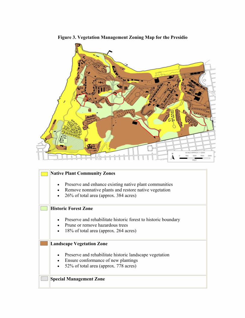
Figure 3. Vegetation Management Zoning Map for the Presidio
Native Plant Community Zones
• Preserve and enhance existing native plant communities • Remove nonnative plants and restore native vegetation • 26% of total area (approx. 384 acres)
Historic Forest Zone
• Preserve and rehabilitate historic forest to historic boundary • Prune or remove hazardous trees • 18% of total area (approx. 264 acres)
Landscape Vegetation Zone
• Preserve and rehabilitate historic landscape vegetation • Ensure conformance of new plantings • 52% of total area (approx. 778 acres)
Special Management Zone

• Area requiring further assessment. Area is under consideration for designation by the USFWS as recovery habitat for the Federally-listed endangered San Francisco Lessingia.
• 4% of total area (approx. 62 acres)
Key Historic Forest Stands *Note: The boundary of the Special Management Zone has changed from that
depicted in the VMP Staff Report (October 2000). The Special Management Zone boundary conforms to the Area A boundary, which has been surveyed and adjusted to meet law enforcement and maintenance needs.
Source: NPS, Presidio Trust, 2001.

Figure 3a. Special Management Zone for the Presidio
Notes:
1. This region is under consideration by the U.S. Fish and Wildlife Service for the enhancement of San Francisco Lessingia habitat.
2. This region has been subject to construction, slope failure, and restoration efforts resulting in changed conditions that require reassessment of the management zones.
3. This region generated the highest number of diverging public comments which

will be resolved through reexamination of San Francisco Lessingia habitat and the changed physical conditions.
4. The boundary of the Special Management Zone has changed from that depicted in the VMP staff report (October, 2000). The Special Management Zone boundary conforms to the Area A boundary, which has been surveyed and adjusted to meet law enforcement and maintenance needs.
Figure 4. Probable Presidio Native Vegetation Prior to European Settlement
Foredune Dune Scrub Bluff Scrub, Coastal Scrub, and Serpentine Scrub Coastal Prairie and Coastal Scrub

Coastal Prairie Coast Salt Marsh Serpentine Grassland and Serpentine Scrub Freshwater Marsh
Arroyo Willow Riparian Forest and Live Oak Riparian Forest
Live Oak Woodland and Coastal Scrub Open Water
Source: Jones & Stokes Associates, Inc., 1997
Figure 5. Existing Presidio Native Plant Communities
Communities

WR Arroyo Willow Riparian Forest BS Bluff Scrub CP Coastal Prairie SM Coastal Salt Marsh CS Coastal Scrub DS Dune Scrub F Foredunes FM Freshwater Marsh OR Live Oak Riparian Forest OW Live Oak Woodland RS Riparian Scrub SC Serpentine Scrub SG Serpentine Prairie
Source: Jones & Stokes Associates, Inc., 1997 and NPS, 2001
Foredune is an open community of low perennial herbs and small shrubs found at Crissy Field and Baker Beach, just beyond the shoreline. It is dominated by beach sagewort, sand verbena, silver beachweed, coast buckwheat, Chamisso's, lupine, beach primrose, American dune grass, and beach strawberry. Plants associated with this community are tolerant of desiccating, salt-bearing winds. Dune scrub is found on the sand terrace slopes above Baker Beach, in the Lobos Creek Dunes, and in several other small patches. This inland sand dune community of shrubs and annual and perennial wildflowers is characterized by densely packed shrubs interspersed with scattered grassy openings. It is dominated by mock heather, lizard tail, bush monkeyflower, coyote brush, bush lupine, chamisso lupine, poison oak, California coffeeberry, and California blackberry. The special-status species San Francisco campion, San Francisco wallflower, San Francisco spineflower, dune gilia, and San Francisco lessingia are found in association with this community. Bluff scrub occurs on steep, ocean- and bay-exposed bluffs and serpentine outcrops at Fort Point and north of Baker Beach. Bluff scrub is dominated by low shrubs and prostrate herbaceous species including California blackberry, prostrate blue-blossom ceanothus, poison oak, lizard tail, and toyon. Special-status species associated with this community are coast rock cress, San Francisco wallflower, and San Francisco gumplant. Coastal scrub is similar in assemblage to bluff scrub but found at a slightly higher elevation on the gentle slopes and inland areas. This community is dominated by California blackberry, poison oak, prostrate and erect coyote brush, golden yarrow,

toyon, and arroyo willow. Coastal prairie was once the most common plant community in the Presidio. This grass and herb community is found on coastal terraces that have well-developed soils. Coastal prairie is dominated by purple needlegrass, foothill needlegrass, California oatgrass, and many non-native grasses. Serpentine grassland is a rare grass- and herb-dominated community found on well-developed serpentine soils on sites north and east of Inspiration Point. It is dominated by purple needlegrass and foothill needlegrass as well as serpentine-endemic special-status species such as the Presidio clarkia and Marin dwarf flax. Serpentine scrub community intergrades with serpentine grassland and serpentine barrens from the World War II Memorial on both sides of Lincoln Boulevard north to the Golden Gate Bridge. It occurs on serpentine outcrops and shallow serpentine soils and is dominated by blue blossom ceanothus, toyon, osoberry, and California blackberry. This community, along with adjacent serpentine communities, provides habitat for several special-status species: Raven's manzanita, Presidio clarkia, Marin dwarf flax, San Francisco owl's clover, San Francisco gumplant, coast rock cress, and San Francisco wallflower. Freshwater marsh, found around the edges of Mountain Lake and within the Crissy Field dune swale, is an herbaceous community occurring in areas with perennial flooding or soil saturation. Dominant species are tules and cattails. Freshwater seep (not delineated on figure) is an herbaceous plant community dominated by rushes and sedges. It is found in the Presidio in scattered sites with seasonal or perennial soil saturation from groundwater seepage. Seeps occur along the bluffs north of Baker Beach and above Crissy Field, near Inspiration Point, and north of the Public Health Service Hospital. The special-status Franciscan thistle occurs in this community. Live oak riparian forest is a stream- or lake-associated community dominated by dense stands of coast live oak occurring in the Presidio above the willow riparian zone adjacent to Lobos Creek. Arroyo willow riparian forest is a stream- or lake-associated community dominated by arroyo willow, often in dense, pure stands. It occurs in the wettest zones of perennial creeks and ponds and seasonal drainages, such as Lobos Creek and the Mountain Lake shoreline. Riparian scrub, found in a small area north of the Public Health Service Hospital tennis court, this stream- or lake-associated community is dominated by shrubs and small trees including California wax myrtle, coyote brush, and arroyo willow. Live oak woodland is found in moist, sheltered sites away from the immediate coast dominated by coast live oak with an understory of grass or shrubs. Only small stands now

exist at the Presidio. Historically, other small trees (such as buckeye, madrone, or California bay) may have occurred with live oak. A coastal tidal salt marsh system was present at Crissy Field before the wetland feature was drained and filled. Freshwater and brackish marshes were also found on the upland edge of the Crissy Field wetland. Some of this coastal marsh has been recently reclaimed through the creation and restoration of the Crissy Field tidal marsh.
Native Plant Habitat of Particular Concern The Presidio plant communities with the highest diversity of native plant species are those found on serpentine substrates. These biologically rich grassland and scrub communities provide habitat for many of the Presidio's native herbaceous annuals and perennials, native grasses, and shrubs. The serpentine grassland community was once extensive and stretched across the San Francisco peninsula. Now the Inspiration Point area contains some of the last remaining serpentine grassland in the Bay Area. Many plant species have become specially adapted to this unique habitat, and as the habitat has diminished, more species have become rare or endangered. The native dune community at Crissy Field and the dune scrub community above Baker Beach (one of the few remaining intact stands of dune scrub in San Francisco, and in all of central California) provide important and unique habitat. These communities have been identified as Special Ecological Areas (SEAs) by resource managers of Golden Gate National Recreation Area. A SEA is identified in each plant community type that is most biologically intact and diverse. The natural resources are the highest priority within a SEA in order to ensure protection and maintenance of ecological diversity and processes. Since 1995, the NPS and community volunteers have been working to restore the native plant habitat at several restoration sites throughout the Presidio, including:
• foredune and dune scrub communities at Baker Beach, Wherry Dunes, North Baker Beach, Lobos Creek Dunes, Battery Caulfield Road, Presidio Hills, Rob Hill, and Crissy Field,
• coastal bluff scrub, serpentine scrub, and serpentine grassland communities at Fort Point and along the northern coastal bluffs and the World War II Memorial,
• serpentine grassland community at Inspiration Point, • riparian forest communities at Lobos Creek and Mountain Lake, and • coastal salt marsh and freshwater marsh at Crissy Field.
Special-Status Species The Presidio of San Francisco supports an unusually large number of rare plant species because of its unique combinations of climate and soil conditions. Thirteen rare plant species are known to occur, and several other rare plant species have occurred here in the past that are locally extinct. With so little habitat remaining, it is surprising that
populations of rare species are still represented at the Presidio. Rare plant populations that remain are small and scattered. Special-status species meet one of the following criteria:
• legally protected as threatened or endangered under the federal or state Endangered Species Acts,
• proposed for listing under these acts, • listed under the California Native Plant Protection Act by California Department
of Fish and Game, or • listed by the California Native Plant Society as rare, threatened, endangered, or of
limited distribution.
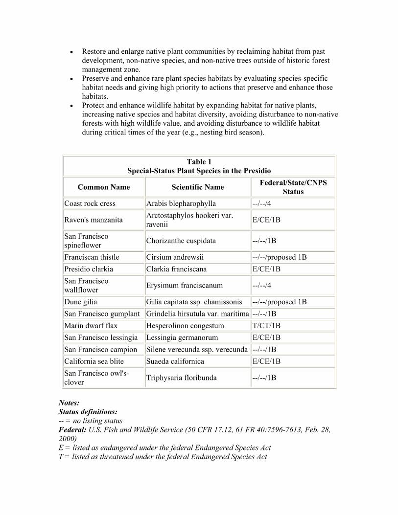
Species listed in Table 1, Special-Status Plant Species in the Presidio, are known to occur at the Presidio. These species have been identified as being within the Presidio by members of the California Native Plant Society, NPS biologists, and biological consultants under contract to the NPS. The principal habitat for most of these rare species is remnant natural areas of dune scrub, serpentine scrub, serpentine grassland, and bluff scrub communities. In some areas, the habitat for special-status plants has been greatly modified and rare plants are intermixed with planted and naturalized forest stands. Important areas include the sand terraces at Baker Beach, the serpentine coastal bluffs and cliffs west of Lincoln Boulevard from the Golden Gate Bridge to the south, and the serpentine areas east of Lincoln Boulevard. Other rare plants are found in serpentine grasslands near Inspiration Point extending down to El Polin Spring and at Crissy Field. The site locations of special-status species have been surveyed and are frequently monitored to detect threats, evaluate management actions, and census population numbers for special-status plants. Many population sites have been fenced for further protection (for example, the population of San Francisco lessingia at Rob Hill). Groups such as the California Native Plant Society and the Presidio Park Stewards have studied, monitored, photographed, planted, seeded, and weeded rare plant sites for over two decades.
3.2.2 Proposed Management Actions
Objectives for Management of Native Plant Communities Management of native plant communities and special-status species will be guided by the following objectives:
• Protect and enhance existing native plant communities and their remaining habitat by removing threats to native species, repairing damage to habitat, and increasing reproductive success.
• Restore and enlarge native plant communities by reclaiming habitat from past development, non-native species, and non-native trees outside of historic forest management zone.
• Preserve and enhance rare plant species habitats by evaluating species-specific habitat needs and giving high priority to actions that preserve and enhance those habitats.
• Protect and enhance wildlife habitat by expanding habitat for native plants, increasing native species and habitat diversity, avoiding disturbance to non-native forests with high wildlife value, and avoiding disturbance to wildlife habitat during critical times of the year (e.g., nesting bird season).
Table 1
Special-Status Plant Species in the Presidio
Common Name Scientific Name Federal/State/CNPS Status
Coast rock cress Arabis blepharophylla --/--/4
Raven's manzanita Arctostaphylos hookeri var. ravenii E/CE/1B
San Francisco spineflower Chorizanthe cuspidata --/--/1B
Franciscan thistle Cirsium andrewsii --/--/proposed 1B Presidio clarkia Clarkia franciscana E/CE/1B San Francisco wallflower Erysimum franciscanum --/--/4
Dune gilia Gilia capitata ssp. chamissonis --/--/proposed 1B San Francisco gumplant Grindelia hirsutula var. maritima --/--/1B Marin dwarf flax Hesperolinon congestum T/CT/1B San Francisco lessingia Lessingia germanorum E/CE/1B San Francisco campion Silene verecunda ssp. verecunda --/--/1B California sea blite Suaeda californica E/CE/1B San Francisco owl's-clover Triphysaria floribunda --/--/1B
Notes: Status definitions: -- = no listing status Federal: U.S. Fish and Wildlife Service (50 CFR 17.12, 61 FR 40:7596-7613, Feb. 28, 2000) E = listed as endangered under the federal Endangered Species Act T = listed as threatened under the federal Endangered Species Act

State: California Department of Fish and Game (2001) CE = listed as endangered under the California Endangered Species Act CT = listed as threatened under the California Endangered Species Act CNPS: California Native Plant Society (Skinner and Pavlik 2000) 1B = List 1B species: rare, threatened, or endangered in California and elsewhere 4 = List 4 species: plants of limited distribution To attain these objectives, the following actions are proposed for the native plant communities zone shown in Figure 3, Vegetation Management Zoning Map for the Presidio. Continue Development of a Long-Term Inventory and Monitoring Program A long-term inventory and monitoring program will allow evaluation of the success of native plant community enhancement and restoration projects. Long-term monitoring requires the development of a documented process for collecting standardized, useful information that can be repeated in the future so that comparisons can be made. Procedures for collecting information are established and institutionalized to allow regular and reliable sampling, data analysis, and reporting over the long term. Monitoring procedures usually call for periodic vegetation mapping, the establishment of permanent transects and photopoints in representative plant communities as well as sensitive areas (such as special-status species habitat), and documentation of sampling frequency and techniques. The current monitoring program includes:
• photo-monitoring and regular qualitative evaluation of most existing native plant communities,
• permanent transects in the serpentine grassland at Inspiration Point and the dune scrub above Baker Beach,
• a detailed monitoring protocol for assessing the development of re-created dune wildflower and scrub communities, and
• annual censusing and/or range mapping of all thirteen special-status plant species.
A monitoring plan is currently in preparation for the Crissy Field marsh and dune restoration project. Additional restoration sites will be monitored using similar procedures. Information gathered by the monitoring program will be used to:
• assist in documenting changes in habitat and species conditions, • monitor population and species composition changes, • increase knowledge of the natural history of rare species (especially the range of
natural variation in population sizes of rare annual plants), • alert staff to potential threats to habitat and individual species so that corrective
actions can be taken, and

• provide a baseline for measuring the effectiveness of enhancement and restoration efforts as they are implemented.
As inventory and monitoring programs are developed, areas will be identified where additional research is needed. Project statements documenting research requirements will be developed. Protect Remaining Native Plant Communities The remaining native plant communities as described in a previous section and mapped in Figure 5, Existing Presidio Native Plant Communities, will be preserved and protected from further deterioration. Threats to existing plant communities are from several sources. The most serious threat to native plant communities in the Presidio is the invasion of naturalized forest trees and aggressive non-native plants. Other threats are visitor foot traffic and drainage alternations that result in soil erosion and habitat loss. Erosion is particularly acute in a few very susceptible soil types where trails have not been built to an adequate standard. Natural resources affected by trampling and changes in run-off from development and visitor activities have been identified, and corrective actions have been proposed (see Section 3.5, Soil Erosion and Control). Restrict and Contain Forest Trees. Native plant populations can be reduced or eliminated through shading or competition from non-native plant species. Trees have naturalized and expanded into native plant communities outside of areas that were originally planted. As trees become established in grassland, shrub, and open dune communities, they alter the habitat by creating a shady, moist, and more nutrient-rich environment that few native plant species can tolerate, reducing both native species diversity and population sizes. These conditions also encourage establishment of invasive non-native species. Continual and long-term management is required to protect existing native plant communities from habitat invasion by forest species. Of the three primary forest species, eucalyptus has the strongest tendency to naturalize, but Monterey pine and Monterey cypress have invaded natural habitat as well, notably in the Inspiration Point serpentine grassland community. Containment efforts are required to constrain expansion beyond the historic forest management zone through eradication of volunteer seedlings and saplings of forest species. Develop Buffer Areas. Management of the edges between native plant communities zones and historic forest management zones requires special attention to contain non-native trees. Containment may be assisted in some areas by the development of a 50- to 100-foot-wide buffer of native plants and shrubs. Such a buffer within an adjacent historic forest management zone could allow better protection of existing native plant communities and reduce maintenance and containment efforts (refer to the subsection, Explore the Development of Native Species Buffer Areas, in Section 3.3.2). Remove Aggressive Non-native Species. Management of non-native species is two-fold:
1) prevent further introduction of non-native species, and 2) control and remove existing non-native species. Future revegetation efforts throughout the Presidio will take into account the potential for non-native plants to invade and threaten native plant communities.
• Non-native plants will be removed from native plant communities, to the extent possible.
• Plant eradication efforts will focus on the most aggressive weedy species that threaten native plant communities because they can rapidly overtake and out-compete native vegetation, especially if the site is disturbed.
• Exceptionally invasive plants such as Andean pampas grass, Australian fireweed, Bermuda buttercup, French broom, Cape ivy, gorse, European dune grass, and sow thistle have the highest priority for eradication and will be removed wherever they are found on the Presidio. Iceplant, albizia, wattle(acacia), velvet and orchard grass, and bentgrass, European annual grasses, prickly ox-tongue, and myoporum particularly threaten serpentine communities.
• A variety of other non-native species will also be removed as labor becomes available to conduct this work. Non-native grasses will be managed for minimization.
• Proposed new plantings throughout the Presidio will be screened against the plant lists developed by park resource managers and landscape architects. The plant lists identify invasive non-native plant species that threaten native species and indicate which plants are prohibited from use as horticultural landscape plants, or that have restricted use and require confinement to historic landscape vegetation zones. Plants that are prohibited and restricted in landscape use are further discussed in Section 3.4.3, Proposed Management Actions, for the landscape vegetation management zone.
• Conduct testing to determine the invasive plant removal methods that are the most cost effective and least damaging to other natural resources. Methods for effective removal and control will vary for each non-native species. For some species, one-time hand or mechanical removal will be effective.
Because native plant communities are found in a patchwork pattern and are often ecological islands, they will continue to be affected by non-native plants. Control will require vigilance, periodic weed removal, and a long-term determined effort. Some non-native plants, such as annual grasses and some annual and perennial forbes, are so established that it will be nearly impossible to eliminate their presence from native habitat areas. However, if monitoring identifies threats to native species, control efforts will be initiated.
Additional information and specific strategies that will be implemented to prevent further non-native species introduction and to control local populations can be found in the program statement "Control of Alien Plant Species" in the Natural Resources Section of the Resource Management Plan (NPS 1994c).
Restore Native Plant Communities
Opportunities for native plant restoration within the Presidio are provided by the removal of non-native forest trees from areas outside of the historic forest management zone, removal of other invasive non-native vegetation, removal of non-historic buildings and development, and vista clearing. Eventually all of the areas zoned as native plant communities on the Vegetation Management Zoning Map (Figure 3) will be restored. (The zone includes both existing native plant communities and areas that will be restored to native plant communities.)
Proposed Restoration Sites. Most of the sites proposed for restoration are contiguous with existing native vegetation communities. Most have special attributes such as riparian and aquatic habitats that can greatly enhance wildlife values, biologically rich communities found on serpentine substrate, and habitat for rare and endangered plants. The proposed restoration areas are:
• the western portion of the Presidio to restore and expand existing dune, bluff, coastal scrub, and grassland areas,
• the northern shore of the bay as previously identified in plans for Crissy Field, • area around Mountain Lake, • Lobos Creek drainage, • Rob Hill viewshed, • portion of Wherry housing site, • areas with rare serpentine soils that support serpentine grassland and serpentine
scrub communities near Inspiration Point and the World War II memorial, • rare dunes at the Public Health Service Hospital, Hicks drainage, and Crissy
Field, • areas north and east of the Public Health Services area, • Infantry Terrace viewshed, • riparian habitat of El Polin Spring and the Tennessee Hollow drainages, and • other scattered locations with habitat for rare plant species and where remnant
native plant communities and riparian areas can be enhanced or enlarged.
The appropriate native plant community to be restored will be the plant community that occurred at each restoration site prior to European settlement. The presumed native plant communities that would have occurred at restoration sites have been determined based upon soils, geology, and existing vegetation and are mapped in Figure 4, Probable Presidio Native Vegetation Communities Prior to European Settlement. Species planted in each restoration site will be representative of all successional stages of that particular native plant community, according to current restoration protocol on sites such as Lobos Creek Dunes.
Restoration Concepts and Process. The general restoration concepts and methods
identified in this section will guide native plant community restoration. Many of the restoration areas now contain forest trees that have expanded beyond the historic forest management zone and will be removed prior to restoration. Other sites will require restoration following the removal of other types of non-native plants or of non-historic development (such as the Wherry housing area). Restoration methods specific to various habitat types are also found in Jones & Stokes Associates, Inc. (1997).
Restoration actions will be planned and evaluated on a site-specific basis by a multidisciplinary vegetation management team so that the impacts of management actions on soils and remaining natural resources can be minimized. A restoration action plan will be prepared for each restoration site to document the process and allow project review. Any of the following procedures that mitigate environmental impacts will also be implemented when rehabilitating historic forest areas (refer to the subsection, Process for Site-Specific Rehabilitation of Historic Forest Stands, in Section 3.3.2).
Conduct On-Site Evaluation. No tree removal activities will be conducted during the breeding season for most bird species (February through August 15). Prior to tree removal, each work site will be evaluated by biologists to determine the status of the following factors:
• The presence of known or suspected nest sites for raptors. A nest that has been used within the past three years will be considered potentially active. All trees will be left within a 100-foot radius of any active or potentially active nest site.
• Any elements of the forest or the proposed restoration site that may provide habitat for any special-status species. Measures will be developed for avoiding any elements identified.
• The relative wildlife habitat value of any forest stand to be removed. Non-native forest stands with high wildlife values will generally be retained, unless they will be replaced incrementally with native plant communities that are very rare, such as serpentine communities, or that also have high wildlife value, such as coast live oak or willow riparian plant communities.
• Any significant roosting or other wildlife use of the habitat that requires management. For example, trees should be assessed for use by Pygmy nuthatches, which are communal roosters and utilize tree cavities throughout the year.
Propagate Plant Material for Restoration
• All plant material (i.e., seeds, cuttings, and whole plants) used for native plant community restoration projects will be derived from populations of native species presently or historically occurring on the Presidio in order to protect locally distinct genetic types.
• Seeds and plant material will generally be propagated in the native plant nursery on the Presidio.
• Work crews will be carefully trained to minimize trampling of native vegetation and maximize native plant salvaging (by collecting seeds, cuttings, or whole plants) prior to forest removal in areas that are to be restored. This salvaged material can be used in habitat restoration efforts by planting into prepared sites or propagated and stored at the native plant nursery for future use.
Prepare the Restoration Site and Enhance Soil Conditions. Careful site preparation and reestablishment of appropriate soil conditions at restoration sites is key to success of native habitat restoration. Measures to prepare the site and enhance soil conditions will include:
• Identify the extent of the area to be disturbed by restoration activities and, if necessary, delineate the boundaries of the work area with habitat fencing where needed to protect adjacent native plants, wildlife habitat and/or cultural resources.
• Limit heavy equipment use to avoid soil compaction to the extent possible. • Fell trees within the restoration area, taking care to protect adjacent native
vegetation. • Remove slash and debris. Stumps may be pulled and removed in dune soils if this
task can be accomplished without compaction from equipment. To minimize soil disturbance and compaction on nondune soils, stumps will be left in place and cut flush to ground level.
• Remove forest litter and duff that can prohibit native plant establishment and growth.
• Counteract water-repelling (hydrophobic) and acidic soil characteristics through soil treatment. Hydrophobic soil conditions occur in some soils (such as sandy soils where dune scrub restoration will occur) under Monterey cypress, increasing the tendency to shed water and increase erosion.
• Control potential soil erosion through revegetation, drainage control, surface stabilization, or redirection of trails. In general, grass seeding is not an appropriate method for erosion control because a grass cover will interfere with native habitat restoration. To avoid unnecessary erosion, tree and log removal should not take place in winter and spring when rains are still likely and soils are moist and most vulnerable to compaction and erosion.
• Reestablish drainage patterns when needed.
Plant Native Plants. Plant the prepared site with native plants propagated from Presidio stock. The appropriate native plant assemblage to be planted will be based upon the historical record, identified reference sites, and site conditions.
Prior to any new introductions to restore a native plant species that once occurred, but is no longer present, a literature review and documentation of the justification for the reintroduction decision will be made. This documentation will inform future ecologists of the manipulation that has taken place.

Maintain and Evaluate Restoration Success
Restoration sites will be maintained and monitored at least until criteria are met to ensure their success. Maintenance may include weeding, remedial erosion control, posting of interpretive signs, preventing damage to native vegetation from human activities, and additional planting and seeding. Periodic non-native species control will be necessary in most sites. When the restoration site previously contained eucalyptus or acacia, sprouts and sprouting stems may be selectively treated with an herbicide in conformance with an integrated pest management plan. Documentation of methods used in each restoration site and nursery documentation will allow evaluation of restoration efforts. Monitoring will be accomplished through the long-term monitoring program previously described.
Manage and Enhance Habitat for Rare Plants
Monitor Special-status Species. Recovery of rare plant species requires that existing species, populations, and habitat be protected; new populations be established; and habitat and species be monitored and managed. One critical element in the management of rare species - a reliable and consistent monitoring program - has been described in a previous section. Baseline data are needed on all special-status species to adequately establish their listing status, determine the effects of management actions, and track population trends over time. Monitoring of all known special-status species populations will be conducted annually until the natural variation in population size is well documented (perhaps 10 years for annual species), and after that at least once every 3 years. Enhance Habitat. Ongoing and future research will expand knowledge about individual special-status species, their distribution, their habitat requirements, their threats, and propagation methods. As managers learn more about these species, actions will be taken to increase suitable habitat and to increase the size of populations through propagation. Actions that are currently underway and that will continue for the enhancement of all thirteen special-status species occurring at the Presidio are summarized here (Jones & Stokes Associates, Inc. 1997, NPS Resource Management Staff). Raven's Manzanita. All management actions for this federally listed species will complement the USFWS recommendations listed in the Raven's manzanita recovery plan and will be undertaken in consultation with the USFWS. A single wild plant and cuttings taken from this individual and planted at the Presidio comprise the existing population of this plant. It grows in shallow, rocky soils, including serpentine, on coastal bluffs and probably also occurred in serpentine scrub areas. The plant can be propagated from cuttings.
Enhancement recommendations include:
• identify sites with suitable serpentine soils for serpentine scrub, • identify sites, from those with suitable soils, that support non-native species as the
dominant or a major component of the vegetative cover, • clear non-native species and thin native species that are directly competing with
the Raven's manzanita, leaving exposed sites for revegetation, • plant rooted cuttings of Raven's manzanita in openings with full sun and sufficient
open surface for expansion with a suite of native species that occur in the same habitat,
• fence or otherwise restrict human access to the restoration sites, and • remove all non-native plants that establish near or encroach on the manzanita
plants for at least 5 years after restoration.
Presidio Clarkia, Marin Dwarf Flax, and San Francisco Owl's Clover. All management actions for the Presidio clarkia (federally listed, endangered) and Marin dwarf flax (federally listed, threatened) will complement the USFWS recommendations listed in both the Serpentine Soils and draft Coastal Plants of Northern San Francisco Peninsula recovery plans for these species. All actions will be undertaken in consultation with the USFWS. Propagation and habitat requirements of these three small annual species are similar. They occur in the Presidio in open serpentine habitat within serpentine scrub and grassland where steep slopes, road cuts, and other disturbances have created openings and removed surface soils. Invasive non-native species, biking, hiking, and erosion threaten these plants. Serpentine soils with suitable habitat are limited but occur on north- and west-facing coastal bluffs near Inspiration Point and between Battery Crosby and Fort Point, and on the bluffs above Crissy Field. Suitable sites for establishing new populations of these species may be found where forest stands are removed from serpentine soils. Seeding locations will be protected from human and dog disturbance and monitored.
Enhancement recommendations include:
• identify suitable serpentine soil areas for potential enhancement efforts; • remove non-historic trees and other non-native vegetation from areas in suitable
soils; • remove buildup of vegetative debris on top of suitable soils to promote the thin,
rocky serpentine soils in which these species occur; • seed existing and created open serpentine barrens within serpentine scrub and
grassland; and • fence or otherwise restrict human access to the restoration sites during plant
establishment. Reevaluate allowable public access on a site specific basis after monitoring;

San Francisco Lessingia, San Francisco Spineflower, Dune Gilia, and San Francisco Campion. All enhancement actions for the San Francisco lessingia (federally listed, endangered) will be undertaken in consultation with the USFWS. The USFWS will soon release a draft Recovery Plan for Coastal Plants of the Northern San Francisco Peninsula that will provide further guidance for recovery actions necessary to restore habitat for San Francisco lessingia and associated dune species. The SMZ in the southwest corner of the Presidio is designated partially in anticipation of the forthcoming release of this recovery plan to allow the NPS and the public to proceed with planning this area once this important guidance on San Francisco lessingia management has been finalized.
Enhancement recommendations and habitat requirements of these herbaceous dune wildflower species are similar. Prior to urban development, San Francisco lessingia, dune gilia, and San Francisco spineflower occurred in clearings within coastal dune scrub throughout the San Francisco peninsula. San Francisco campion ranged from San Francisco to San Luis Obispo County in coastal dune scrub. Threats to the Presidio populations of all rare dune species are from trampling by visitors, pets, and bicycles, and encroachment of ice plant, annual grasses, and naturalized forest trees. On a larger scale, the lack of open corridors to allow for movement of sand has cut off these species from the processes that would naturally open up new suitable habitat. These species prefer full sun and open sandy substrate, and as early successional species, they require new sites opened by disturbance to persist.
Habitat and population enhancement recommendations include:
• control of non-native weedy species, • maintain open sand areas in full sun near existing populations to create new
habitat, • remove non-historic trees that are shading existing populations, • remove non-historic trees that will promote the reestablishment of wind corridors, • collect seeds from extant populations and directly seed any restored areas of
suitable habitat according to successful developed protocols (NPS 1995b, Lobos Creek Dunes Restoration Management Plan),
• restrict human and dog access to plant populations, and • evaluate the potential for dynamic habitat enhancement, including artificial
disturbance of patches of dune scrub in appropriate areas.
California Sea Blite. All enhancement actions for the California sea blite (federally listed, endangered) will be undertaken in consultation with the USFWS. This wind-pollinated, succulent-leafed perennial shrub is in the goosefoot family (Chenopodiaceae). The historic range of this species was limited to the San Francisco estuary and the vicinity of Morro Bay. Historic accounts and herbarium specimens indicate sea blite's distribution was concentrated in the central part of the San Francisco estuary, with a majority of the collections originating from sandy tidal marshes (Heimbinder & Farrell, 2000). No remnant populations occur in the San Francisco Bay. Several sea blite individuals were planted in three distinct areas of the high marsh zone at the restored Crissy Field site as
an experiment in Spring 2001, and will continue to be monitored to determine whether or not the population establishes.
Enhancement recommendations include:
• remove invasive non-native vegetation that may establish in marsh habitat, and • propagate plants and plant into suitable sites, necessary to establish enough
individuals until population becomes self-sustaining,
San Francisco Wallflower, Coast Rock Cress, and San Francisco Gumplant. These three low-growing perennial herbs occur in a wider range of habitats than the other special-status species. The San Francisco wallflower can survive in open dunes and in clearings in dune scrub, serpentine scrub, coastal scrub, and bluff scrub. Currently it is found in many small patches in dunes and along the bluffs on the western edge of the Presidio. San Francisco gumplant occurs in serpentine grassland and openings in serpentine scrub and coastal scrub. Coast rock cress occurs on rocky soils and rock outcrops among bluff scrub, coastal scrub, serpentine scrub, and serpentine grassland. San Francisco gumplant and coast rock cress populations are sited on the bluffs between Battery Crosby and Fort Point and in the bluffs to the east of Fort Point. San Francisco wallflower and San Francisco gumplant have been successfully propagated at GGNRA nurseries and have become established from plantings on a few existing restoration sites. Current threats to these species include competition from non-native vegetation, shading and buildup of litter on the soil surface from naturalized trees, and pedestrian trampling and related erosion, particularly along the social trails of the coastal bluffs.
Enhancement recommendations include:
• remove invasive non-native vegetation, including non-historic trees in existing habitat,
• develop a trail plan for the coastal bluffs that will limit pedestrian trampling, • remove surface layers of organic litter in areas that will be suitable habitat, and • propagate plants and plant into suitable sites.
Franciscan Thistle. This biennial thistle is currently extremely rare, with fewer than twenty individuals remaining in a serpentine seep along the bluffs above and to the east of Fort Point. Several other suitable serpentine seep habitats occur along the coastal bluffs north of Battery Crosby to Fort Point and to the east of Fort Point above Crissy Field. The population is threatened primarily by invasive non-native plants. Suitable sites for potential expansion are threatened by trampling, invasive plants including naturalized trees, and erosion. Due to low population numbers, this species is threatened with local extinction from chance environmental and biological factors as well.
Enhancement recommendations include:
• remove invasive non-native plants from current population range,

• collect seeds and propagate plants at the Presidio Native Plant Nursery and plant back into area of extant population,
• assess the habitat requirements for this species and potential sites for population enhancement, and
• propagate and plant or direct seed into suitable sites for expansion.
Continue to Implement Restoration and Education Programs
Successful native plant restoration projects have been ongoing on the Presidio since 1994 through the Presidio Park Stewards program. This community-based volunteer habitat restoration program has several elements including curriculum-based education programs with school groups, operation of a native plant nursery, hands-on site preparation and planting, and native habitat restoration, monitoring, and maintenance.
Community volunteers have been invaluable in meeting the increasing number of resource management needs of the Presidio. In the process, a stronger sense of stewardship for public lands and a community advocacy for the park and environment has been created.
The Presidio Park Stewards are successfully conducting several restoration projects at sites throughout the Presidio, including Lobos Creek Dunes, North Baker Beach, the Public Health Services area, Rob Hill, and Inspiration Point. This volunteer program will implement many projects for native plant community restoration, special-status species enhancement, and forest rehabilitation discussed in this plan, including plant propagation, site preparation, planting, and maintenance.
The Presidio Native Plant Nursery has been developed with the assistance of Americorps and the San Francisco Conservation Corps to supply plant material needed for native plant community restoration, as well as historic forest restoration. Without volunteer programs, it would be difficult to undertake resource management projects that have intensive staffing requirements.
Interpretive and education programs are invaluable to restoration efforts by increasing public awareness and acceptance of changes to Presidio vegetation, and encouraging community participation in habitat restoration. On-site resource management personnel and exhibits have been successfully used to explain restoration projects, especially when tree removal is a project component. This on-site resource education program will be continued throughout restoration projects.
Vegetation management activities will provide additional educational opportunities to interpret thousands of years of landscape history and resource use prior to Spanish arrival and relatively recent U.S. military history. Programs will be developed to demonstrate and interpret traditional uses of indigenous plants and habitats by Native American Indians. Through these programs, the cultural history and contributions of the original stewards of this land (the Ohlones and Miwoks) can be recognized. Changes in the

vegetation landscape and uses of the landscape over the entire history of the Presidio can be interpreted through resource management and visitor services programs.
3.3 HISTORIC FOREST MANAGEMENT ZONE
3.3.1 Description of Historic Forest
Forest History
In 1883, Army Major W. A. Jones developed a Plan for the Cultivation of Trees upon the Presidio Reservation. This effort stands as the first and relatively rare example of landscape planning on such a large scale for an Army reservation. The impetus may have come in part from the successful example set by Golden Gate Park and other urban parks to develop large urban forests. The plan proposed a major tree-planting program to create a system of windbreaks and to visually enhance the ridges, entrances, and perimeters of the post. The forest would, according to Major Jones, "cover the areas of sand and marsh waste with a forest that will generally seem continuous and thus appear immensely larger than it really is." The forest would serve to increase the visual contrast between the Presidio and the city.
Major Jones' plan specified species to be planted at various locations. They included a large variety of evergreen and deciduous trees and shrubs. Since Major Jones transferred and did not supervise the implementation of his plan, it is unclear how closely mass planting efforts, which began in 1886 by schoolchildren and continued by the Army in 1889 and throughout the 1890s and early 1900s, followed the original plan.
The most commonly planted tree species included blue gum eucalyptus, Monterey pine, Monterey cypress, and blackwood acacia. By the beginning of the 1900s, trees covered approximately 400 acres of the reservation, with much of the forest consisting of densely crowded trees that required thinning.
In 1902, forester W. L. Hall developed a plan for the required thinning as well as additional planting for visual screening and soil retention. During that same year, Major Jones, who had developed the original plan, visited the Presidio and made additional recommendations to beautify it, including thinning of forest stands and planting of a variety of ornamental shrubs and flowers. Large-scale plans launched in 1907 for garrison expansion and construction projects in the post-World War II years reduced the geographic proportions of the forest (Thompson 1994).
Historic Significance of the Presidio Forest. The Presidio was designated a National Historic Landmark in 1962 and listed in the National Register of Historic Places. The Presidio forest is specifically cited in Presidio National Register of Historic Places Registration Forms updated in 1993 as a historically significant contributing resource to the landmark district. (The significant contributing resources are the spectrum of building, sites, structures, objects, and landscapes that contribute to the historic significance of the Presidio.) Afforestation of the reservation is considered the most far-
reaching development during the period of Presidio history while the forest was planned and planted (NPS 1993a). The forest established the wooded character and visual quality of the Presidio, which has continued to the present day.
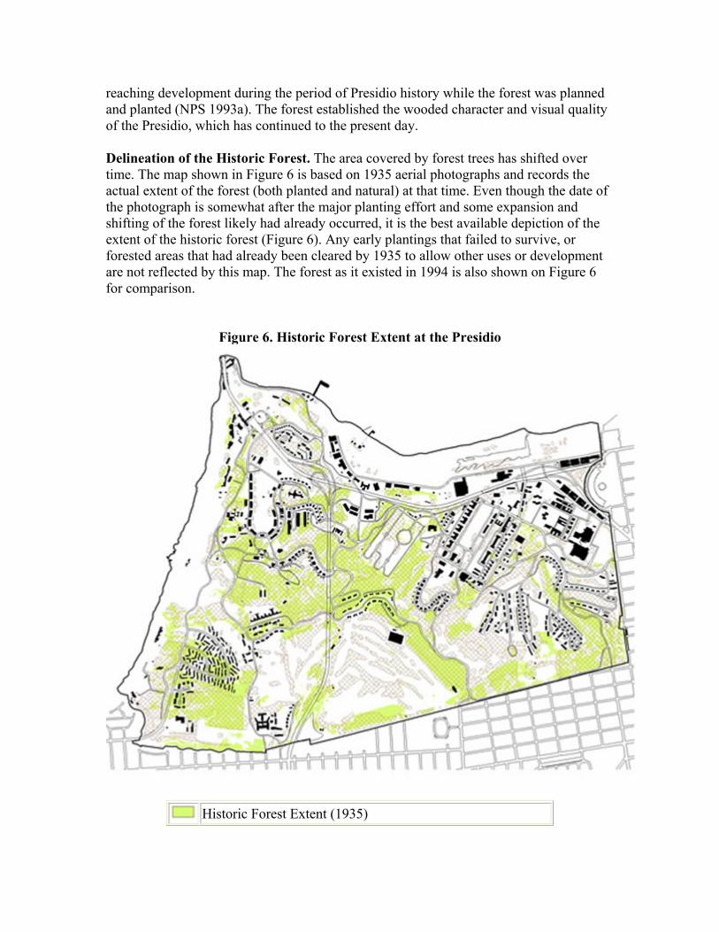
Delineation of the Historic Forest. The area covered by forest trees has shifted over time. The map shown in Figure 6 is based on 1935 aerial photographs and records the actual extent of the forest (both planted and natural) at that time. Even though the date of the photograph is somewhat after the major planting effort and some expansion and shifting of the forest likely had already occurred, it is the best available depiction of the extent of the historic forest (Figure 6). Any early plantings that failed to survive, or forested areas that had already been cleared by 1935 to allow other uses or development are not reflected by this map. The forest as it existed in 1994 is also shown on Figure 6 for comparison.
Figure 6. Historic Forest Extent at the Presidio
Historic Forest Extent (1935)
Forest Boundary 1994 Source: Jones & Stokes Associates, Inc., 1997 and scanned
1935 aerial photographs.
The historic planted forest of 1935 covered approximately 300 acres of the post, primarily on ridges, along boundaries, and at entrances. The following general observations are made concerning the historical development of the forest.
The forest was planted over a period that extended from 1886 to the early 1940s. Development of the forest generally followed the intent of the plan developed by Major Jones in concept, but actual species planted, locations, and spatial arrangement depended upon availability of plant material, funding, and labor. The forest that we have today is the result of many historic actions to create it as well as dynamic natural forces and natural regeneration that are continually changing the forest.
Maintenance thinning was intended as a long-term maintenance strategy as part of Jones' original proposal, "keeping the distance between trees about equal to their height." This maintenance thinning did not occur.
The forest was designed and planted for its visual attributes and windbreak functions. The primary purpose for the development of the forest was to enhance the Presidio's appearance by converting it to a sylvan landscape. In order to remain faithful to historic context it is necessary to maintain the character-defining appearance of the forest - a forest with a canopy of such a scale that it serves to clearly distinguish the Presidio from the adjacent city.
The Current Forest
Species Composition and Stand Structure. Five species now make up 95 percent of the forest: Monterey cypress, Monterey pine, blue gum eucalyptus, blackwood acacia, and coast redwood. While three of these species, Monterey cypress, Monterey pine, and coast redwood, are native to the
California central coast, they have not occurred in San Francisco for thousands of years and therefore none of these trees are considered native to this area. When the Presidio was planted, most stands were planted with even spacing and only one species in each planted area. Single species (or monotypic) stands still prevail; however, several stands now exhibit some tree species diversity.
Eucalyptus stands dominate the Presidio forest, covering 42 percent of the forested acreage. Monterey cypress stands occupy 34 percent, while Monterey pine and mixed-species stands occupy 17 percent (Jones & Stokes Associates, Inc. 1997). The remainder of the historic forest consists of small areas of planted acacia and redwood. Mowing or dense canopy shading has limited the understory of most Monterey pine and Monterey

cypress stands. Groundcover varies under eucalyptus and Monterey pine and includes mostly non-native grasses, forbs, vines, and occasional native shrubs and small trees.
Some reproduction is occurring within the introduced stands. As most of the forest was planted during a relatively short period, much of the forest is of a single age class (or even-aged). Eucalyptus stands were originally even-aged, but because sprouting occurs, many stands are evolving into uneven-aged stands. Where Monterey pine and Monterey cypress have naturalized and expanded into treeless areas, including many native plant communities, the stands exhibit an uneven-aged character.
Reproductive Patterns and Natural Regeneration. Natural regeneration within planted forest stands has been limited, but does occur under certain conditions. The dominant trees of the introduced forest exhibit varying degrees of regeneration based upon species characteristics and site conditions.
Monterey cypress and Monterey pine are fire-responsive species that reproduce most successfully in their native environments after a fire. Heat from the fire opens the cones to allow seed release, bares mineral soil for seed establishment, eliminates competing vegetation, opens the canopy to admit full sunlight, and optimizes reproductive success. In the absence of fire, as is the case at the Presidio, reproduction of these species is slower and more modest, but does occur as evidenced by the spread of young pine and cypress into natural areas adjacent to planted forest stands and along roadsides.
Blue gum eucalyptus and blackwood acacia readily reproduce both under a canopy and in available openings. Both species can regenerate either from seed or by sprouting from stumps and roots and have expanded from their original planting sites and colonized new areas. Redwoods reproduce by stump sprout or seed germination.
Forest Health and Condition. As the forest ages, the trees that were planted in the late 1800s are reaching the ends of their normal life spans. Because much of the planted forest is approximately the same age, the forest has matured uniformly, and a period of much slower growth and possibly high mortality is beginning in the cypress and pine stands.
The three primary tree species all have rapid initial growth, but are relatively short-lived. The life span of Monterey pine is 80 to 100 years, while the life span of Monterey cypress ranges from 100 to 150 years or more. Although subject to large-limb breakage, dieback of the crown, and blowdown after the age of 80 years, blue gum eucalyptus can continue to live much longer and often resprouts when it does fall or break.
Because of the advanced age of most trees, breakage and tree death could substantially reduce the extent of the forest over the next 20 years (Jones & Stokes Associates, Inc. 1997). Damage from storms is also expected to accelerate as the trees weaken. For example, in December 1995 a storm resulted in numerous windthrown trees near the Presidio Drive gate in the southeast portion of the Presidio. The decline in forest health is probably the result of several attributes of the planted forest - the choice of short-lived
trees, overstocking without adequate maintenance thinning to a healthy density level, and the lack of forest openings that would allow more natural regeneration.
The experience of Golden Gate Park may portend a parallel but slightly delayed future for the Presidio forests since the two areas have similar site conditions, weather, and soils. Planting of similar tree species began in the 1870s in Golden Gate Park (approximately two decades before major Presidio planting). Over the last 10 years windfall from destructive storms has increased. Extremely hard-hit have been Monterey pine and Monterey cypress in the western portions of the park. A reforestation program has been in place since 1980 to replace dead and storm-damaged trees.
In much of the Presidio forest, corrective measures such as thinning are no longer effective. At this point it is too late in the life cycle of the Presidio's trees for individual thinning of overstocked areas to be beneficial, since this could increase wind effects in other parts of the stand and would not release the trees from their stagnant formation.
Pest and Disease Threats. Two new pests pose serious threats to the Presidio forest: an insect, the eucalyptus longhorn borer, and a fungal disease, pine pitch canker. As of this writing, neither of these pests have been detected in Presidio forests. However, they have infected trees in nearby areas and have the potential to kill large numbers of trees.
The eucalyptus longhorn borer is a serious pest of eucalyptus trees. Trees stressed by drought or soil nutrient deficiency or recently cut or fallen trees and branches are most commonly attacked. If this insect enters the Presidio's older eucalyptus forest, significant losses could occur. The eucalyptus borer has been found in nearby Contra Costa, Santa Cruz, and Alameda counties. Research is being conducted that may lead to effective controls for this pest (such as a prey-specific predator) in addition to sanitary wood disposal practices.
Following an outbreak of the pine pitch canker in California 1986, this disease has been identified at several locations in the San Francisco Bay area including nearby Golden Gate Park and Marin County. Although recent inspections have not detected this disease in Presidio forests, it can be assumed that the pine pitch canker will eventually be found here. Some Monterey pines are relatively resistant to the effects of the pine pitch canker but the source of the resistance is poorly understood. Insects may eventually kill severely infected trees. Currently this disease cannot be effectively controlled.
3.3.2 Proposed Management Actions
Objectives for Management of Historic Forest Management Zone
Management of the historic forest will be guided by the following objectives.
• Maintain the forest within the historic forest management zone as a significant historic landscape feature, a setting for historic buildings and events, and a historic landscape design by the Army.

• Maintain the windbreak function of the historic forest and the appearance of the forest canopy that differentiates the Presidio from the adjacent city.
• Preserve live, healthy trees within the historic forest management zone. • Preserve historic planting configurations in a few key and highly visible historic
forest stands. • Rehabilitate the aging forest within the historic forest management zone and
manage it to become more self-sustaining by increasing structural and species diversity and encouraging natural regeneration.
• Protect and enhance valuable forest wildlife habitats and avoid adverse habitat impact in rehabilitation activities.
• Select replacement tree species to meet specific needs (for example, to reduce canopy height of forest trees adjacent to specific neighboring communities or to provide buffers between historic areas and native plant communities).
• Manage the forest to maintain the historically identified views from Inspiration Point and Rob Hill and other important visual connections.
It is likely that the mature forest is entering a period of decline where an increase in the rate of tree death from storms, disease, and old age can be expected. These events and the processes of natural succession could greatly change the character of the forest. Management actions will seek to preserve and rehabilitate the historic forest within the historic forest management zone, and increasing the degree to which the historic forest can be managed as a healthy biological community.
The proposed management actions that follow recognize that the forest is a historic resource that will be managed in accordance with standards for treatment of historic properties. As a historic resource it is desirable to preserve the mature healthy trees for as long as possible and to retain the character of the forest over the long term. In addition, natural events and processes (such as windstorms, ecological succession, and natural regeneration) will play an increasing role in management of Presidio forests, and natural events and processes can be used to assist in forest rehabilitation.
Apply Rehabilitation Standards to Treatment of Historic Forest
Any forest treatment must recognize the significance of the forest as a historic resource. The Secretary of the Interior's Standards for the Treatment of Historic Properties with Guidelines for the Treatment of Cultural Landscapes (NPS 1996a) have been applied to assist in the selection of appropriate forest treatment. The standards for rehabilitation and guidelines for rehabilitating cultural landscapes are the most applicable for treatment of the historic Presidio forest. The guidelines offer the following definition of rehabilitation treatment.
• Rehabilitation is the act or process of making possible a compatible use for a property through repair, alterations, and additions while preserving those portions of features which convey its historical or cultural values.
• In rehabilitation, a cultural landscape's character-defining features and materials are protected and maintained as they are in the treatment Preservation; however, a
determination is made prior to work that a greater amount of existing historic fabric has become damaged or deteriorated over time and, as a result, more repair and replacement will be required. The Standards for Rehabilitation and Guidelines for Rehabilitation allow the replacement of extensively deteriorated, damaged, or missing features using either traditional or substitute materials. (NPS 1996a)
The rehabilitation guidelines are appropriate for application to the Presidio historic forest because they emphasize continuity through preservation of features that convey historical values. At the same time, the guidelines recognize that change may have occurred. The guidelines allow for replacement, when necessary, with like kind of plant material in composition, form, and habitat, or, if that is not feasible, with a compatible substitute.
The rehabilitation guidelines are interpreted, with relationship to management of the Presidio forest as a historic resource, as follows:
• The healthy forest trees within the forest management zone will be preserved with the recognition that the forest is a living, and therefore constantly changing, historic component.
• Rehabilitation and replacement of damaged portions of the forest will be necessary to counteract the effects of nature's forces and old age. Historically planted species (Monterey pine, Monterey cypress, and eucalyptus) will continue to exist in the historic forest. In areas where use of historic species conflicts with sustainable management practices, or where important views have been lost over time, other trees species will also be considered for replacement use to retain the general character (form, scale, and appearance) of the forest.
• While many of the original forest stands were planted as even-aged, one-species stands, it is infeasible without cyclic clearing and replanting to maintain such a forest over the long term. Except in designated character-defining areas (key historic forest stands - see Figure 3), the forest will be managed so that it becomes more diverse in age and species.
• Any use of replacement species that was not historically planted to address specific management issues will be thoroughly tested in order to evaluate the compatibility of character and appearance with historically planted species as well suitability for this site.
Historic Forest Character and Treatment Study (Historic Forest Study) A Historic Forest Study will be conducted by the NPS's Olmsted Center for Landscape Preservation, or an affiliated group, to document, analyze and evaluate the characteristic features inherent in the historic forest using the Secretary of the Interior's Standards for Treatment of Historic Properties with Guidelines for the Treatment of Cultural Landscapes. This focused study will be completed to better define the parameters of rehabilitation and diversification allowable within the forest, while ensuring its continuing role as a contributing element of the Presidio's National Historic Landmark. This Study will identify the vital elements or "fabric" inherent to the forest's historicity that must be maintained. The study process will recognize the unique nature of assessing historic

significance and integrity in a dynamic biological system in its findings. The study recommendations will help further refine the following rehabilitation concepts for the historic forest to determine its ultimate composition and character.
Concepts for Rehabilitation of the Historic Forest Management Zone
Most of the historic forest will be managed to incorporate attributes of a diversified biological community in order to reduce maintenance needs and management costs and enhance the value of the forest as habitat for native species. Over time, the majority of forest will be incrementally changed to mimic a more natural forest by including:
• a range of ages from seedlings to dead snags, • a variety of tree densities and spatial configurations, • a multiple-layer canopy structure, • greater species diversity, and • conditions that encourage natural regeneration.
Encourage a Range of Ages. With all age classes and more than one species represented, it will be less likely in the future to have entire stands in decline. The age structure of the forest will be diversified by encouraging natural regeneration in small openings and conducting replacement planting of small areas over the long term (up to 50 years). In less visible areas away from trails and visitor use areas, consideration will be given to allowing senescent and standing dead and fallen trees to remain as wildlife habitat as long as disease potential is not increased or visitor safety is not threatened.
Develop a Variety of Densities. The Army's original plan called for thinning to reduce problems of overstocking as the plants grew. Unfortunately, this maintenance thinning was not accomplished and in many forest stands tree density is 400 to 500 trees per acre.
A commitment must be made to properly thin new plantings in the future so that seedlings can grow into healthy trees. The maintenance of original spacing (and tree-for-tree replacement) is only appropriate in the few key historic forest stands described below. The forest of the future should contain some groves of trees and some irregularly shaped small openings that will allow understory plants and natural tree regeneration.
In the experience of managers of Golden Gate Park, tree vigor is highest where mature tree density is between 30 and 50 trees per acre. When density is above 100 trees per acre, stand vigor decreases (State of California 1980). While site conditions and tree species planted differ somewhat between the forests of Golden Gate Park and the Presidio, it can be assumed that a much lower mature tree density (100 trees per acre or less) would be beneficial to the health and vigor of the Presidio forest of the future.
Develop a Multiple Layer Structure. The development of mid- and under-stories will enhance wildlife habitat potential. Many forest stands are comprised entirely of a high forest canopy with no understory, or a weedy non-native understory. A mixed forest of a variety of ages will increase structural diversity, as will the development of an understory
of native grasses, herbs, shrubs, and small trees where openings to allow sunlight can be created and maintained.
Increase Species Diversity. Historic species will remain dominant in most historic forest stands as natural regeneration occurs in openings created by storms and the death of older trees. A mixture of the primary forest tree species (rather than only one species) will be encouraged. For example, in forests now dominated by Monterey cypress, Monterey pine might also be planted as the opportunity and site conditions allow. In existing eucalyptus stands where other species are present in the understory, natural and storm-created openings will be enlarged to allow regeneration of other tree species and understory vegetation. Irregular small openings should be left to encourage native plants in the understory of the historic forest and natural regeneration of forest trees.
Suitable areas for reintroduction of native trees and other native species within openings in the forest and in transition areas between historic and native plant communities will be identified.
Explore the Development of Native Species Buffer Areas. To reduce the need for containment efforts and to increase forest species diversity, especially where a historic forest management zone is adjacent to a natural area, establishment of transition or buffer areas at the edge of the forest zone will be considered. These transition areas could consist of a mixture of native trees and large shrub species (such as live oak, wax myrtle, madrone, toyon, California buckeye, yellow willow, and arroyo willow). The buffers will provide a flexible management "line" 50 to 100 feet in width. Specific planting plans for buffer areas will be guided by both the Historic Forest Study and site-specific ecological restoration action plans. The purpose of such buffer areas will be to:
• reduce management, maintenance, and containment efforts for non-native trees species and allow better protection of existing native plant communities,
• increase habitat diversity and wildlife habitat potential, and • allow light penetration into native plant communities by decreasing vegetation
height adjacent to native plant communities.
The buffer areas are not appropriate along the edges of "key historic forest stands" because this type of management would alter their historic character and appearance (see the subsection Preserve Key Historic Forest Stands Through Intensive Management, below).
Enhance Conditions to Increase Natural Regeneration. Whenever possible, rehabilitation efforts within the historic forest management zone should seek to create opportunities to allow the occurrence of natural regeneration of Monterey pine, Monterey cypress, and eucalyptus. Natural regeneration appears more likely to occur in the following circumstances:
• when there is a forest litter layer or grass cover, • along the edges rather than within stands,

• in small openings where there is more light, and • where there is more soil moisture from fog drip lines of mature trees.
Monitoring will be undertaken to allow systematic assessment of the actual importance of a variety of soil and other site conditions and seed release and dispersal factors that may affect regeneration, but are of unknown significance. Where natural regeneration occurs, seedlings are likely to be stronger with better root development than nursery stock. Genetic continuity with historic stock will also be assured.
Consider Wind Effects in Forest Rehabilitation. One of the reasons the historic forest was planted by the U.S. Army was to provide a windbreak, presumably to provide wind shelter for the human occupants of the post. Trees were planted on ridgetops and west of developed areas to dissipate wind energy from heavy onshore winds and to reduce blowing of shifting dune sand. The western areas of the Presidio along the ocean coast are most strongly affected by high winds, especially the forests between Baker Beach and Lincoln Boulevard.
In ridgetop forest stands, rehabilitation efforts will consider the possible effects of wind. When planning rehabilitation projects, the potential for additional windthrow might be minimized by designing small rehabilitation area sizes (0.3 to 0.5 acre in size) to minimize the potential for additional windthrow. Forest opening size and configurations will depend largely on the effects of storms, but when storm-damaged trees are cleared to prepare a site for rehabilitation, the effect of wind on regeneration success and windbreak functions will be considered. Clearings will generally be oriented perpendicular to the prevailing wind in a southwest-northeast direction.
It is important to note that upwind natural areas at Lobos Dunes, Baker Beach, Wherry Housing, and Public Health Services North sites might actually require wind to sustain natural processes in dune communities. Forest rehabilitation efforts must consider the need to continue these natural processes.
Preserve Key Historic Forest Stands Through Intensive Management
Stands in four highly visible locations will receive intensive management measures in order to preserve their existing character as long as possible (see Figure 3, Vegetation Management Zoning Map for the Presidio). These stands are:
• eucalyptus stand bordered by Presidio Boulevard and Lovers' Lane, • Monterey cypress stand between Arguello Boulevard and the golf course, • the northernmost Monterey cypress stand of the ridge windbreak system near the
Old Cavalry Barracks and south of the stables, and • Monterey cypress, eucalyptus, and Monterey pine stand at Colby Avenue adjacent
to and east of Lincoln Boulevard and the World War II Memorial.
In these key areas, the historical plantings were kept evenly spaced, mowed, and carefully maintained by the Army. These particular stands have historical values that will be

disrupted by replacement planting and young trees since they are now comprised of mature, evenly spaced trees with a high canopy, little branching, and no understory. This configuration lends a special character to the stand that cannot be retained over time through rehabilitation efforts and will eventually be lost.
In these few key areas, special efforts will be made immediately to care for the trees and maintain them as long as possible. Preservation efforts will be under the direction of an arborist so that any necessary pruning and other maintenance care can be undertaken to extend the lives of trees in these areas as long as possible. As trees within these stands die, become damaged, diseased, or insect-infested, they will be promptly removed, but not individually replaced. These stands will retain their historic character for some time, even with some trees missing.
In the two Monterey cypress stands, a threshold of tree loss will eventually require stand regeneration. When approximately 40 percent of the trees in any small area have been removed, other decadent trees will be removed and a small portion of the stand will be replanted with Monterey cypress. Regeneration area sizes will generally be maintained at the 0.3- to 0.5-acre size to avoid initiation of additional windthrow, maintain windbreak function, and limit visual impact, but also to allow adequate light to reach the ground for vigorous seedling growth. In some locations, where consistency of age class over a larger area is required to maintain the forest's historic character, larger regeneration area sizes may be employed.
In general, the width of forest openings should be twice the height of surrounding trees to allow sufficient light penetration. Opening configurations will depend upon site-specific considerations and visual impacts, but will generally be oriented with the long dimension perpendicular to the prevailing wind in a southwest-northeast direction. Over time, the key historic stands will be regenerated using the historic spacing and configuration, recognizing that once regeneration has been initiated, the appearance of the stand will change significantly. Phasing of tree removal will be coordinated to reduce visual and resource impacts.
Eucalyptus sprouts from its base when cut. Sprouts from cut trees will be selectively controlled through hand pruning to provide replacements for the eucalyptus trees that are removed. Although the visual grid appearance of the stand will be somewhat altered through eventual rehabilitation, the orderly appearance of the historic stands could largely be retained.
Substitute Historically Planted Species
In several situations, species that were historically planted may require substitution with other species or pest-resistant strains of the same species. Consistent with the findings of the Historic Forest Study, any substitute species considered for planting in the historic forest (for example, other species of cypress or eucalyptus) or in historic landscape areas will be tested through pilot projects to assess its ability to survive site conditions and evaluate physical appearance and characteristics.
Replacement for Pest Resistance. It is premature to recommend management actions to deal with pests such as pine pitch canker and eucalyptus longhorn borer because they have not yet affected Presidio forests. Periodic monitoring and seasonal inspection is ongoing to detect disease and pest problems at the earliest possible stage. No serious disease problems currently exist. If a serious disease does occur, a professional forest pathologist will immediately evaluate it and a course of action will be taken based upon the park integrated pest control program. Cultural treatments (including soil amendments, pruning, sanitary cleanup of diseased wood), replanting with genetically resistant species, use of prey-specific natural predators, and other treatments that are effective against the specific pest will be considered at that time. In the meantime, historically planted tree species including Monterey pine and blue gum eucalyptus will be maintained in historic forest areas.
Replacement for Height Modification. Monterey cypresses growing along the southern boundary of the Presidio, adjacent to Julius Kahn Playground have been regularly topped for over 50 years by homeowners. Topping to reduce tree height maintains the views to outstanding visual features of the San Francisco Bay and Golden Gate Bridge from homes adjacent to the Presidio. As a result, the trees in this area are now flat topped, intertwined with irregular side branch growth, and unnatural in appearance. The rehabilitation of the topped forest adjacent to Julius Kahn playground will require special consideration to honor the historic design intent while also improving the health of the trees in this area. Thinning of existing Monterey cypress or individual replacement of the dead trees will not be effective in most of this area because intertwining branches and close spacing prohibits individual tree removal. It will therefore be necessary to replace the trees in blocks. Irregularly shaped blocks will be cut and replaced in a staggered pattern so that not all trees will mature at the same time. In areas where remnant native dune scrub vegetation is present (just east of Julius Kahn Playground), scattered canopy openings will be allowed to remain to protect pockets of native species.
The soils in this area are derived from dune sands, and while Monterey cypress has grown successfully, many other tree species may not survive. Several cypress species that are shorter and are native to central California will be tested for suitability as a replacement species, based upon appearance, growth form, and performance at the Presidio. Consideration would be given to McNab, Sargents, Santa Cruz, and Gowen cypress. Following experimental planting and evaluation of their form and appearance, one or more of these species will be selected as a compatible substitute for the taller Monterey cypress in this area.
Some eucalyptus stands, including those bordering Lyon Street on the southeast, have been topped in the past. However, this practice was not consistently employed over a long period of time as it was at Julius Kahn Playground. Topping of eucalyptus produces unhealthy trees with rapid-growing sprouts at each cut, resulting in distorted tree form and an increase in hazard potential from falling limbs. Because of this, topping will not be used as a forest management practice in these eucalyptus stands. Instead forest management in these areas will focus on remedial pruning to mitigate for past topping. However, in areas where blue gum eucalyptus requires replacement due to safety
concerns or senescence and where height reduction may be desirable, other lower growing, less hazardous, and less invasive species of eucalyptus may be used consistent with the findings of the Historic Forest Study. Potential replacement species such as coral gum, red spotted gum, and flooded gum will be tested to find a suitable alternative. Other small trees (such as coast live oak) that are native to the Presidio could be tested to determine their suitability in this habitat. Following experimental planting in the Presidio and evaluation of their form and appearance, one or more of these species will be selected as a compatible substitute for the taller blue gum .
Process for Site-Specific Rehabilitation of Historic Forest Stands
The concepts discussed above will be applied as opportunities and priorities for rehabilitation are created by natural events and storms, as well as through identified management needs. Storms and natural events have required forest cleanup and rehabilitation in the past (for example the Presidio Gate area in 1995) and the frequency of such events is expected to increase. An interdisciplinary vegetation management team will select specific areas for forest rehabilitation as storms and fallen trees create openings and then develop site-specific forest recommendations for an annual rehabilitation program. Selection of forest rehabilitation sites based upon storm damage will most likely result in a random pattern of forest rehabilitation and will mimic natural processes.
Forest management decisions will be made by the vegetation management team on a case-by-case basis following on-site inspection, a review of resource information and site conditions, and consideration of appropriate vegetation management treatment options found in the Jones & Stokes Associates, Inc. (1997) report. For example, an annual program might consist of a rehabilitation project for forest areas that have windfall damage from a winter storm, existing openings in a forest wind break that require replanting, and several native habitat restoration areas. The group would consist of at least three to four professionals with expertise in the following areas:
• forestry/arboriculture, • landscape architecture/historic landscapes, • grounds maintenance, and • natural resource management.
The team will jointly evaluate the site and make recommendations for treatment of each area based upon field review and consideration of a variety of factors, including the following:
• Size and boundary of the affected area, • Whether the area is part of the historic forest or part of a key visible forest stand, • Previous forest condition (including species of trees, their size, age, and
configuration), • Whether the area is an important windbreak forest stand, • Natural regeneration potential,

• Significant natural elements or cultural features that must be protected (wildlife values, critical plant and animal habitat, presence of native species, archeological resources). The biological evaluation described in the subsection Restore Native Plant Community of Section 3.2.1 also apply,
• Erosion problems that require correction, • Options for forest treatment (referring to Forest Management Decision Matrices
in Jones & Stokes Associates, Inc. (1997)), • Existing and planned use of the area, • Views (historic views, vista points, the need for visual screening), • Maintenance concerns (access, ability to provide irrigation), and • Other concerns or requirements (setback requirements, proximity to neighboring
residential areas, changes in forest windbreak, etc.).
The recommendations of the vegetation management team will include:
• Specific instructions for clearing trees or windfalls (considering access for equipment, other trees that may need to be removed due to damage or hazard potential, any fencing necessary to protect native plants, wildlife habitat, special-status species, or archeological resources ).
• Schedule to conduct work (considering any wildlife and nesting impacts, seasonal rainfall, visitor use patterns, and impacts to neighbors). Forest rehabilitation areas will be treated and replanted as soon after clearing of dead and down trees as possible (when feasible, within one year). Areas targeted for restoration to native plant communities will be revegetated as expeditiously as resources permit.
• Work areas to be closed to the public for safety and avoidance of noise impacts. Tasks that typically generate high noise levels, such as wood chipping, will be conducted at less intrusive areas or moved offsite whenever feasible and will be limited to daylight and weekday hours and will be scheduled to minimize noise impacts for visitors and residents.
• Training for work crews to avoid trampling native vegetation, effectively salvaging native or important horticultural plants, avoiding soil compaction or accelerating site erosion.
• Site preparation and planting plans (species to be planted, and planting configuration).
• Erosion control measures (such as mulching, grass seeding, netting, or drainage repair).
• Care recommendations (including irrigation systems and schedule, thinning, any necessary signing or fencing for visitor control).
• Other considerations (safety, rehabilitation of visitor facilities such as trails parking areas, or viewsites).
• Public review and comment when appropriate.
Maintain Vistas and Historic Views
The striking views of the Presidio from Marin Headlands, the Golden Gate Bridge, and the bay are largely visual impressions of a natural sylvan landscape as a result of the

continuous Presidio forest canopy. This visual impression will be preserved through historic forest rehabilitation. Some of the historic scenic views from the Presidio to nearby landmarks such as the Golden Gate Bridge, Marin headlands, Angel Island, Alcatraz, the Palace of Fine Arts, the city skyline, and panoramic views of the San Francisco coastline have been obscured by naturalized forest stands.
In the original afforestation plan, summit vista points were left unplanted and lower-growing native vegetation allowed uninterrupted views of the ocean and the bay. Over time, trees have been planted or have naturally expanded into these designated vista sites and have blocked some of these views.
Important viewpoints shown on Figure 7, Viewpoints and Vistas to be Restored, include Inspiration Point, Rob Hill, vistas along Lincoln Boulevard and coastal defense batteries, and Golden Gate Bridge viewing area.
Non-native vegetation will be modified, cleared, or maintained as needed to retain these scenic viewpoints and important visual connections (such as the historic visual link between Infantry Terrace and the Main Post). In most cases, native plants of lower stature (forbs, grasses and low shrubs) will be planted at the view sites so that native communities can become established and the view sites can more easily be maintained. In the case of views from historic coastal gun batteries, low-lying native plants may be planted but the viewshed will be managed as landscape vegetation. This will allow height alterations to be made if shrubs begin to obscure these important historic views.
Recycle Plant Material and Market Wood
Vegetation debris and woody material of a variety of sizes will require reuse and disposal. Plant material will usually be removed, rather than allowed to decompose naturally since much of the Presidio is highly visible and intensively used by visitors. In a few areas within the historic forest management zone, standing dead or downed limbs and trees will be allowed to decompose naturally to enhance wildlife habitat if they do not harbor pests or diseases that can affect other Presidio resources nor create a fire hazard.
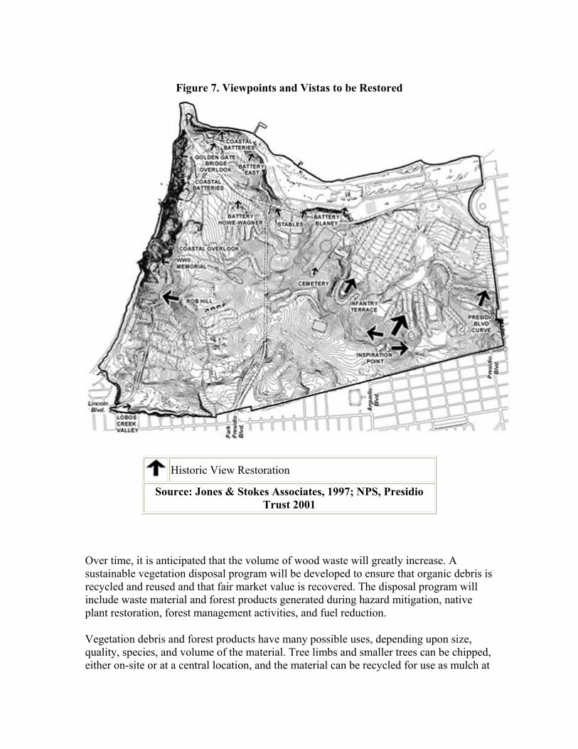
Figure 7. Viewpoints and Vistas to be Restored
Historic View Restoration
Source: Jones & Stokes Associates, 1997; NPS, Presidio Trust 2001
Over time, it is anticipated that the volume of wood waste will greatly increase. A sustainable vegetation disposal program will be developed to ensure that organic debris is recycled and reused and that fair market value is recovered. The disposal program will include waste material and forest products generated during hazard mitigation, native plant restoration, forest management activities, and fuel reduction.
Vegetation debris and forest products have many possible uses, depending upon size, quality, species, and volume of the material. Tree limbs and smaller trees can be chipped, either on-site or at a central location, and the material can be recycled for use as mulch at
forest rehabilitation sites and in developed areas with landscape vegetation. Mulch in excess of needs within the Presidio and Golden Gate National Recreation Area may have commercial value and could offset some of the costs of resource management efforts and landscape maintenance.
When large trees are removed because they are hazardous, standing dead, or windthrown, they may have commercial value. The closely planted trees of the Presidio are often straight and tall with little lower-trunk branching. These characteristics enhance the commercial value of the Presidio's Monterey cypress and may make it desirable as sawlogs and peeler logs for use as lumber and veneer, respectively.
Market values and the species that are desirable for an expanding variety of wood products are constantly changing. At the time of tree removal, the market value should be evaluated to determine whether it is economically feasible to utilize the available wood as logs, pulp chips, firewood, or fuel. In the meantime, markets for wood products should be investigated and developed so that compensation for products can be maximized. Economic needs and harvest value will never be the primary reason for tree removal or harvest.
The opportunity for development of a small business that cuts, splits, sells, and delivers firewood offers the potential to offset some of the annual operating costs of vegetation management, employ local labor, and provide a revenue source. Firewood, in contrast with other methods of wood utilization, has relatively low site impact and requires only small- to modest-sized equipment. It also responds to sustainability principles by allowing recycling of wood products in the local area.
Develop Multi-Agency Cooperative Agreements
Several agencies with land management responsibilities are now dealing with issues related to tree removal, replacement planting, and wood utilization. By pooling resources and working together, these agencies may be able to realize cost savings, decrease site impacts, and identify market interest in wood products. Because larger combined volumes of wood products will be available at one time, market interest from mills and the potential to recover fair market value for wood products will increase.
The development of a multi-agency agreement should be explored between the City and County of San Francisco (Recreation and Park Department) as manager of Golden Gate Park, State of California (Department of Parks and Recreation), the Trust, and National Park Service, and other interested agencies and municipal districts in the San Francisco Bay Area that manage forested areas. The agreement could include provisions to:
• share costs for purchase of expensive specialized equipment for tree clearing, log moving, and chipping,
• develop a skilled crew familiar with low-impact logging techniques suitable for use in park areas,
• develop and maintain market channels for wood products,
• share revenues for sale of wood products, and • develop planting stock sources or a cooperative nursery.
Evaluate Cost Effectiveness
Effective rehabilitation of the historic forest will be incremental, and therefore will take place over a long period of time. The diversification of the forest to a multi-layered and multi-species forest could realistically take place over a number of decades. A continued planning process, assessment and revision over time is necessary.
Management of the historic forest requires an experimental approach - resource managers are likely to learn as they go. The plan has incorporated the flexibility to test new tree species to address specific situations, and to incorporate new knowledge and management techniques as they are developed by experience at the Presidio and in other similar areas. A long-range goal is to develop a self-sustaining forest where trees within the historic forest management zone can be perpetuated indefinitely with minimal maintenance cost. Long-term monitoring of all actions and their effects, and review of situations in similar forest areas will be needed to refine management concepts.
As the forest changes due to natural events and forest rehabilitation, this plan and its cost effectiveness should be evaluated. These proposed management actions within much of the historic forest is based upon a conservative approach to preserve some historic forests as long as possible, rehabilitate following storm damage as opportunities arise, and monitor. More aggressive action may eventually be required. After 5 years, and again after 10 years, a thorough review should be conducted. These evaluations should consider:
• changes in the number and size of windthrow areas, • progress in moving toward more uneven-aged stands, • experience gained from management of the Presidio forest as well as experiences
of other land managers of similar forests, and • past and estimated future costs of forest maintenance.
Adjustments should be made following public review after each 5-year period. If large-scale windthrow patterns of many acres are detected or if the forest is dying in large blocks as a result of senescence or insect infestation, a plan that incorporates small selective cuts may need to be considered to move from reactive to more proactive forest rehabilitation.
3.4 LANDSCAPE VEGETATION MANAGEMENT ZONE
3.4.1 Description of Landscape Vegetation
The designed landscapes of the Presidio provide a rich cultural context and a unique historic sense of place that sharply contrast with the Presidio's forests and native plant

communities. Ornamental plantings played a significant role in the design of these landscapes and the functional evolution of developed sites.
Much of the Presidio's landscape vegetation was planted during periods of historically significant development, and some plantings have been present for one hundred years or more. As a result of this long and rich planting and design history, many species have historic interest as heritage species or may be horticultural species that are no longer commercially available. These plantings unify the various developed sites and buildings and reinforce the role of the Presidio landscape as an essential component of National Historic Landmark designation.
In addition to beautifying the post and contributing to the unique historic setting of the Presidio, the vegetation used for landscaping also serves a wide variety of management functions. Ornamental shrubs, trees, lawns, and groundcover provide vegetative screening, visual accents for developed sites, and physical delineation for specialized uses.
3.4.2 Landscape Vegetation Management Categories
Designed landscapes within the Presidio can be described by grouping them into management categories based upon their design intent, character, function, and location. Management and maintenance will vary somewhat for each of the following landscape vegetation categories so that their distinctive functions can be retained. However, the general principles and management concepts presented in Section 3.4.3, Proposed Management Actions, will apply to all categories.
Buildings with Formal Landscapes
Landscaped areas around buildings at the Presidio are typically characterized by manicured low plantings and lawns that allow a clear view of the building from the street and clear sight lines from the building to distant views. Landscape designs of plantings associated with historic buildings favor regular, rectilinear arrangements. Many of these landscapes associated with buildings have changed significantly over time from their original design intent and have been overgrown, lost, or significantly altered. Maintenance of these plantings varies depending upon their function but typically requires watering, fertilization, mowing, edging, weeding, pruning, and periodic replacement of overgrown, dead, diseased, or hazardous vegetation.
Types of buildings with formal landscape vegetation characteristics include:
• Administration/Community/Commercial Facilities. These public use areas have maintained lawns and groundcovers, flowering foundation planting or low hedges, and occasional specimen trees.
• Industrial/Maintenance Buildings. These utility areas have minimal utilitarian landscaping with shrubs for screening and fences for security and separation.
• Residential Buildings. Front yards are characterized by maintained grass lawns continuous with one another, occasional specimen trees, and continuous foundation plantings of low flowering shrubs and flowers. Back yards consist of maintained grass, some low border chain-link fencing with ivy or hedges pruned 3 to 6 feet high, and foundation plantings continued from front yards.
Open Space and Play Fields
The Presidio contains a variety of recreational play fields including traditional ball fields, informal open grassy areas, and soft-surfaced playgrounds with equipment. Vegetation other than grasses is minimal. Parade grounds at Ft. Scott and the Main Post were traditionally expansive open grassy areas, but the parade grounds at the Main Post are now mostly paved and used for parking.
Landscape Screens
Vegetative screens serve a variety of functions including separation between public use and residential spaces, visual screening of non-historic features and utilities, a buffer from highway noise and lights, and wind screens. Landscape vegetation must be retained at the proper height, density, and maturity in order to function as an effective screen or buffer. Important segments of forest and large shrub screens that will be maintained for visual screening include landscape vegetation along Doyle Drive, at the intersection of Doyle Drive and Highway 1, at the Golden Gate Bridge toll plaza and maintenance areas, and along Lincoln Boulevard near Doyle Drive and near Fort Scott. Where there is a need for vegetation screens and buffers, the park landscape architect and natural resource specialist will identify the appropriate vegetation to be used based upon the location, the existing vegetation species found in the general vicinity, and other pertinent selection criteria.
Road Corridors
Road corridors traverse all three vegetation management zones. Of special concern are scenic and historic vista points along road corridors and gateways entrances into the Presidio. Vista point openings along road corridors were historically left unplanted during afforestation to maintain scenic views of the ocean and the bay. As stated in Section 3.3, Historic Forest Management Zone, these important viewpoints and historic visual links will be maintained, in most cases by establishing and maintaining native plant communities that are generally lower and do not obscure important views.
Gateway entrances were characteristically planted in formal arrangements. Design elements vary at each gate but include the use of sentinel trees, hedged alleyways, flowering shrubs, and open areas of lawn or ground cover. No two gateway plantings are alike, but all were designed to provide a sense of arrival and to contrast with private lands outside the gates.

Coastal Fortifications
Earth sheltered batteries were typically kept open to the front with low grasses and ground cover and camouflaged from view to the rear with informal plantings of shrubs and trees. While considered to be part of the landscape vegetation management zone, these areas have significant habitat for native plants.
Landscaped Areas Managed by Other Agencies
National Cemetery. Managed and maintained by the U.S. Veterans Administration, the cemetery is well tended with formal plantings of mowed lawn, specimen trees, and pruned hedges.
Golf Course. The golf course is managed and maintained by concession agreement. Typical of a golf course, the area includes highly maintained greens, fairways, and rough grasses of various textures and heights, with trees placed strategically and managed as dividers, hazards, and markers. The Concessionaire is currently developing a vegetation management plan in conjunction with the goals and strategies outlined in this document.
Golden Gate Bridge Plaza. This area is managed and maintained by the Golden Gate Bridge District as a view plaza and overlook with seasonal flowerbeds, groundcovers, and low, flowering shrubs.
3.4.3 Proposed Management Actions
Objectives for Management of Landscape Vegetation
The following broad objectives will guide the management of the Presidio's designed landscape vegetation:
• Maximize sustainable practices in plan development, implementation, and maintenance of landscape vegetation projects,
• Identify, document, and map historic and existing landscape plantings and plant species,
• Retain existing historic landscapes and historic plants whenever feasible, • Select appropriate plant material for replacement vegetation considering historic
plant use and design intent, function, potential impacts to native plants, and sustainability,
• Identify and treat hazardous tree conditions, and • Identify and maintain heritage landmark trees.
Based upon The Secretary of the Interior's Standards for the Treatment of Historic Properties with Guidelines for the Treatment of Cultural Landscapes (NPS 1996a) and the objectives identified in the GMPA for historic landscape resources, the most appropriate treatment for most of the Presidio's landscape vegetation is "rehabilitation." Rehabilitation is the act or process of making possible a compatible use for a property

through repair, alterations, and additions while preserving those portions of features which convey its historical or cultural values.
Specific planting practices and the day-to-day maintenance plans for the Presidio's many landscape vegetation categories are not part of this plan, but will be addressed in rehabilitation and reuse projects as they are developed and in maintenance plans for specific areas. As specific plans are developed, additional consultation may be necessary to insure compliance with Section 106 of the National Historic Preservation Act.
Maximize Sustainable Practices
The following sustainable practices will guide landscape vegetation management actions. (See Appendix B for a general discussion of Sustainable Practices at the Presidio.)
• Ensure that landscape management projects are consistent with all applicable cultural and natural resource management guidelines and approved plans to minimize impacts. Utilize an interdisciplinary review process to assess the impacts of proposed modifications to Presidio landscapes.
• Minimize the need to rehabilitate landscape vegetation by maximizing the use and promoting the longevity of existing plant materials where they can meet basic program requirements. Use of existing plant material will include salvaging and replanting existing vegetation, propagating Presidio plant stock from historic plant stock, and integrating core cultural landscape features (such as heritage trees) into site plans and designs.
• Minimize impacts of landscape vegetation on adjacent native plant communities and the historic forest by selecting non-invasive plants with respect to the principles and conditions of sustainable landscapes. Ensure that all projects utilize the approved plant lists.
• Minimize the development of landscapes that require intensive ongoing maintenance and energy expenditures. Plants should be selected that are disease- and pest-resistant, water efficient or drought tolerant, adapted to the site's microclimate, and require minimal ongoing maintenance. The natural growth rate and size characteristics of plants should complement the site. Pruning and guying requirements should be minimal.
• Minimize storm water runoff by maximizing groundwater percolation and storm water drainage at each project site. Implement a thorough site grading and drainage plan utilizing appropriate drainage design measures. Promote groundwater percolation through soil decompaction and specification of permeable ground cover materials.
• Minimize the export of waste materials by maximizing the reuse of existing landscape materials (recycled asphalt, concrete, chipped mulch, compost, etc.).
• Minimize use of chemical fertilizers, pesticides, and herbicides by maximizing the use of natural processes that provide these functions such as integrated pest management, composting, and mulching.
Identify, Evaluate, and Map Historic Landscape Plantings

In most cases, additional information is needed to analyze and evaluate the Presidio's landscape vegetation, determine its historic significance, and develop appropriate plant palettes when replacement is necessary. An inventory of historic plants has been initiated (Ron Lutske Assoc. 1997), but additional data compilation and mapping efforts are still to be completed. Landscape vegetation evaluations will conform to the Secretary's Standards typically including:
• An inventory of the plants within the project area; • Identification and documentation of other valuable information, such as historic
design patterns, spatial arrangement of plants, and character-defining historic form and appearance;
• Identification of the species of historic value which have a direct association with the development of the Presidio, were planted prior to 1946, or have commemorative value;
• Identification of the species of botanic value which have unique physical characteristics, are no longer available in commercial nurseries, are difficult to propagate, have natural resource value, or provide an aesthetic value in the landscape; and
• Cross check identified species with the current reference historic plant inventory and map historically and botanically valuable plants.
Retain and Maintain Existing Historic Landscape Species
All valuable historic plant material will be retained. Commercially available plant material of historic species and/or propagated historic or botanical stock will be used where additional planting is needed. Appropriate maintenance measures will be taken to retain the character of the landscape and promote landscape vegetation health, longevity, and appearance (such as weeding, pruning, mowing, mulching, fertilization, irrigation, and pest management).
Specific maintenance plans will be developed for specific planning areas within the Presidio to provide maintenance guidance and procedures. These plans will provide detailed prescriptive treatment recommendations for the protection and long-term maintenance of the landscape resources. The planning areas established in the GMPA will further be broken down in the landscape preservation maintenance plan into their component landscape parts to include categories such as administrative, residential, viewing, and industrial areas. After general maintenance plans are completed, site-specific maintenance plans will be developed for specific sites and structures. These plans should contain:
• Objectives. Sets out the purpose, scope, and level of detail of the plan and how it will support the existing maintenance program.
• Areas and categories of features. Delineates areas and similar features within a landscape category to help describe the composition of that landscape.
• Inventory of landscape features. Lists all landscape features that are to be managed, including name, origin, age, and size.

• Field inspection and work summary. Provides procedures for conducting field inspections of landscape features and maintenance actions needed.
• Feature data and record keeping. Provides feature-specific information such as historic significance, pest problems and notes relating to individual features concerning changes observed or propagation record.
• Seasonal calendar. Describes cyclic practices and maintenance treatments to insure feature preservation.
Select Appropriate Plants as Replacement Species
When plant replacement is needed within the landscape vegetation zone, historical plant material will be used unless another plant species offers outstanding qualities that better address the goals and objectives of the plan. In such instances, it is important for the new plant material to match the characteristics of historically used plants. To maintain the visual integrity of the landscape which contributes the National Historic Landmark District status, plants with strikingly different characteristics from historic species should not be used on the Presidio. Examples of situations when plant replacement will be required include:
• Revegetation of landscape sites within developed areas when plant materials are missing and documentation of historical conditions exists,
• Removal of plant material to access or provide new utilities, • Replacement of historic vegetation that has become overgrown for its location
and cannot be pruned to scale; is hazardous because of defects, old age, or disease; or that is damaging historic structures,
• Removal and replacement of invasive species that threaten native or historic plant species, and
• Non-historic building landscape renovation.
Selection for Site Conditions. Landscape plants will be selected that will grow and thrive in the Presidio's site conditions (including fog, wind, and the dry summers of a Mediterranean climate). Other important selection criteria are the sustainability and resource conservation considerations discussed previously, including drought tolerance, disease resistance, and maintenance requirements. Plants that require intensive maintenance such as frequent pruning and irrigation to keep them in a healthy condition (such as roses, bedding plants, and climbing vines) should be carefully considered before planting. Additional concerns for plant selection in many developed areas include the ability to withstand heavy recreational use and foot traffic.
Plant Replacement Issues and Lists. In some instances, historically used horticultural plants can conflict with other resource management objectives to protect native plant communities. The threat to native plants results from two tendencies of some horticultural plants: the tendency to cross-pollinate and hybridize with native plants (for example manzanita, ceanothus, California poppy, live oak) and the invasive ability of some plants to spread far from the areas where they were planted and crowd out and
eventually replace native species (for example iceplant, Algerian and German ivy, cotoneaster).
The GGNRA has developed three lists of approved and prohibited plant material for replacement use to be taken into account in plant selection for vegetation in designed landscapes (see Appendix C for additional information). These working lists will be supplemented, refined, and adjusted over time jointly by the NPS and the Trust as more information is collected and approved sources for plant stock are developed.
• List 1. Plants for Consideration in Designed Landscapes • List 2. Conditional Use Plants in Designed Landscapes • List 3. Restricted Use Plants in Designed Landscapes
Lists 1 and 2 contain plants that have been historically used on the Presidio. List 2 contains stipulations to the use of plants to ensure protection of natural resources. Plants on list 3 are prohibited from planting at the Presidio because they are highly invasive or because they have the potential to cross-pollinate with native Presidio plants. Plants that are not found on any of the lists must be evaluated by designated Trust and NPS staff specialists before approval for planting.
Replacing Vegetation of Historic Importance (List 1 or 2). When replacing vegetation that relates to historic buildings and landscapes, historic species will be planted if documentation exists to determine what species were used in the past. When possible, clones of historically significant plants will be propagated to preserve historic genetic material. Exceptions to the selection of a historic species could be made if:
• the species cannot be obtained commercially or through propagation by the park at the time the plant is needed,
• the species cannot be identified, • the species poses a severe threat to native plant communities, or • the plant requires high maintenance that makes management impractical.
In these cases, replacement species will be selected from lists of suitable plants (List 1 or 2) that retain the character (similar type, form, texture, and scale) of the original species. When historic considerations are less important (for example, when landscape material is selected to provide screening of non-historic development or to enhance views), horticultural materials will be selected from List 1 or 2 based upon other considerations, including functional, maintenance, and aesthetic requirements, as well as impacts on natural resources.
Plants with High Invasive Potential (Lists 2 and 3). It is important when selecting species for landscaping to avoid the use of plant species that can escape landscaped areas and invade other areas, such as native plant communities, forest understory, or other landscaped areas. Two important factors that can indicate the invasiveness of plant species are their dispersal mechanisms (such as seed dispersal by wind or animals or vegetative spreading by underground stems) and their competitive ability. In order to
ensure that landscape plantings do not promote the spread of invasive species, certain plants will be prohibited from being planted anywhere (list 3). If any historically significant plants are on these lists, special approval for their use in landscaping will be required and will include review by the park landscape architect and park plant ecologist.
Some historically important species (such as Algerian ivy and other plants in List 2), while aggressive competitors within native plant communities, can be confined to formal landscaped areas and flowerbeds. These species commonly spread through ground runners or root sprouts and must be contained in restricted areas where they cannot escape to surrounding areas. These species can be used in areas that are isolated from natural areas because they are not likely to disperse into the natural areas from long distances. For historically important plants, the desirability of retaining historic integrity would offset the additional maintenance required to contain them in developed areas where they do not threaten native plant species.
Plants with Cross-Pollination and Hybridization Potential (List 3). Native plant species have evolved within a specific environmental context over thousands of years. Their mere persistence to the present time is an indication of their ability to survive the range of ecological conditions that are present in the specific place where they occur. Since their genes provide the information on how to survive to future generations, it is important that the "gene pool" or sum total of all genetic diversity for a given species is able to exist without being altered by plants from other parts of the world that have not evolved to survive their local conditions.
When closely related species or varieties from other parts of the United States or elsewhere are brought into the environment of a native species, cross-fertilization can occur, which alters the gene pool of the native species. The result can range from small changes in the genetic composition of a plant population, to hybridization where new varieties or subspecies change the genetic material of the affected plant species.
For example, the unique two-toned color of the local California poppy found in the Presidio could be lost if poppies from other parts of the state were to cross-pollinate with the local poppy. Some commonly used horticultural plants that could cross-pollinate or hybridize with native Presidio plants are prohibited from use and are found on list 3. Other prohibited plants on list 3 are native to the San Francisco area, but could cross-pollinate with native plant species now growing on the Presidio.
When dealing with native plant material for landscape purposes, it is essential to only use plant material that has been propagated from confirmed Presidio native plant stock. Since the plant material that can be propagated in the near future from Presidio plant stock is limited and does not always meet the horticultural and historic needs for replacement, other non-native plants have been approved that will be suitable for landscape horticultural use (Lists 1 and 2).
Identify and Maintain Heritage Landmark Trees
Heritage landmark trees include trees that have commemorative value, are outstanding botanical specimens, display unique traits, or serve a particular aesthetic function in the landscape. Many Presidio trees might qualify as heritage landmark trees. Important heritage trees will be identified during an inventory of historic landscape trees, and treatment strategies to enhance their longevity will be developed. Should significant decay or defect require that a heritage landmark tree be replaced, a seedling from that tree or a clone (if genetic significance is integral to the importance of the tree) will be established.
Identify and Treat Hazardous Trees
Hazardous vegetation includes weakened or defective trees and shrubs, found growing around buildings or along roads, that have the potential to injure people or damage vehicles or buildings if they fall or break.
Landscape trees are distinguished here from historic forest stands when they are growing alone or in small groups or strips near buildings, and along roads, parking and other developed areas. These trees have high aesthetic value and often complement and enhance nearby development. They also present the greatest threat of injury to individuals or damage to property because they are located in high use areas. There are 7,000 to 8,000 trees growing around residences, offices, and warehouse buildings, or along roads of the Presidio. Many of these landscape trees and shrubs are reaching senescence and will require replacement over time.
Hazard Tree Surveys and Treatment. Prior to the turnover of the Presidio to the National Park Service, the Army contracted to alleviate the most hazardous tree situations. In a subsequent survey conducted in 1994 and 1995 that evaluated the condition of trees according to a hazard rating system used by the NPS, nearly two-thirds of the landscape trees were identified as possible hazards that will require continued monitoring and treatment (Britton Tree Services, Inc., Hazard Tree Inventory, 1994-1995 - an appendix to Jones & Stokes Associates, Inc. 1997). The rating system used by the NPS reflects both the probability of tree failure as estimated from tree-defect ratings and the degree of human and property exposure to the hazard.
To reduce potential hazards to an acceptable level of risk, an aggressive tree hazard management plan must be implemented. Surveys and treatment of hazard trees must be conducted continually, with some work required on an annual basis. Trees that are identified as hazards will be given hazard ratings. Trees that have been given high hazard ratings must be treated and inspected annually, and trees with lower ratings must be inspected every 3 to 5 years.
Recommendations for treatment vary depending upon the defect and risk and include tree pruning, thinning and cabling, or removal. Other alternatives include moving amenities such as picnic tables or bus stops away from hazardous trees.

Trees within developed areas that may have historic significance will be preserved as long as possible and practical through treatment, pruning, and other care to extend tree life. When trees must be removed to manage hazardous tree conditions, they will be documented under procedures outlined in the appropriate Landscape Preservation Maintenance Plan before removal.
Site evaluation (as has been discussed in preceding sections) will be conducted prior to tree removal to mitigate some of the impacts of tree removal. (For example, removal activity will consider soil compaction impacts, will generally not be conducted during bird breeding seasons, and will generally not be scheduled to interfere with recreational uses.) Replacement will generally be made with the same species in the same location. If the same species or location is not feasible, an appropriate substitute species and nearby location will be approved by the park landscape architect. Research will document, to the extent possible, historic landscape components that are already missing as a result of past hazardous tree removal.
Regular, systematic pruning of trees by a qualified arborist reduces problems before branches and trunks begin to break, extending tree life. Proactive pruning can reduce potential hazards and preserve aesthetic and cultural values. There is a significant backlog of work, and funding is required to treat older trees that have been minimally maintained; consequently, hazardous trees must take priority. However, the systematic pruning of all the trees in high-use areas should be a long-term goal in order to preserve these older trees as long as possible and reduce long-term maintenance costs.
Hazardous Tree Replacement. When it is determined that an important landscape tree or a tree of historic significance will be removed within a few years because of hazardous conditions, consideration should be given to establishing a new tree (or trees) in the immediate area so that growth can begin before the old tree is removed. Hazardous tree reports should be reviewed annually by the park landscape architect to determine appropriate areas for new tree establishment. Hazardous trees should be photographed and documented prior to removal and then replaced with a tree of the same species or an approved substitute.
In some cases (for example, along roads through historic forest areas) replanting may not be needed to replace every hazardous tree that is removed. If natural regeneration is likely, replacement may be unnecessary. For example, blue gum eucalyptus will resprout after the parent tree is cut and can be pruned to a single stem for replacement.
3.5 SOIL EROSION AND CONTROL
3.5.1 Description
Much of the Presidio's native soil has been moved or lost as a result of development activities and erosion. Physical disturbance, including excavation and placement of fill during the course of construction activities and vegetation changes such as forest growth, have significantly altered natural soils so they are more erosion prone now than they were

before European settlement. Potentially erosive soils cover large areas of the Presidio (Dames & Moore 1996).
Today the primary causes of erosion are development that has altered runoff and foot traffic that has disturbed ground cover, exposed roots, increased compaction, and altered drainage patterns. Off trail hiking, social trails, and designated trails with inadequate drainage are responsible for many erosion sites. Gullies carrying concentrated runoff have developed where foot trails cross or ascend steep slopes or cross soils that are loose and unstable. Water-repelling soil conditions have been generated under Monterey cypress stands in sandy dune soils, resulting in gully or rill erosion. Many of the erosion sites occur on dune sand-Sirdrak series soils with forest vegetation. In some places, severe erosion has had a significant effect on the environment.
A survey of eroded sites at the Presidio has been conducted (Jones & Stokes Associates, Inc. 1997). The survey documented the location of each eroded site; determined the type of erosion; correlated each erosion site with the associated soil, geology, and vegetation type; rated the severity and cause of erosion; mapped the site; and recommended actions for erosion control. The most severe erosion occurs in the following areas:
• The southeastern quarter of the Presidio beginning near the Presidio Boulevard entrance, continuing around Julius Kahn Playground, past Inspiration Point, and into the center of the Presidio northeast of Washington Boulevard.
• Near the Public Health Service Hospital and extending westward to the slopes inland of Baker Beach then northward to the sea cliffs west of Lincoln Boulevard.
• The southwestern corner of the National Cemetery.
3.5.2 Proposed Management Actions
Because many of the Presidio's soils have been disturbed in the past and have high erosion potential, runoff must be carefully managed and controlled. Any Presidio activity that involves surface disturbance or changes in drainage patterns, whether the activity is vegetation management, development, or changes in recreational use, should consider possible erosion effects. Maps of erosive soils should be consulted (Dames & Moore 1996) and mitigation efforts should be developed to reduce ground cover disturbance, soil loss, and soil compaction, and to increase water infiltration.
Recommended actions to address some of the existing erosion sites have been identified and should be undertaken as documented and mapped by Jones & Stokes Associates, Inc. (1997). Corrective actions include redirecting foot traffic, regrading to improve drainage, removing fill, restoring and revegetating sites, stabilizing soils and replanting, maintaining ground cover, constructing retaining walls and boardwalks, repairing gullying, and combinations of these actions. Some of these actions will take place in conjunction with native plant restoration activities or rehabilitation of historic forest areas. All restoration activities should be designed to improve soil and stormwater runoff retention by reducing compaction and increasing water filtration.

A comprehensive trail plan and environmental analysis is needed that designates trails and provides for reconstruction of the Presidio trail system. The amount of current and projected future trail use requires trails that are designed and maintained with proper drainage, and cannot be supported by a system of informal trails. A firm trail base that appears natural but that provides trail stability and durability is needed. Boardwalks, retaining walls, and drainage structures will be required in some areas so that damage to natural features can be repaired and would not reoccur. When trails are realigned, soils will be stabilized and replanted. In some areas, barriers and informational signing will be required to protect natural areas and native plant restoration sites.
3.6 FIRE MANAGEMENT
3.6.1 Existing Policies
The fire management policy of the U.S. Army and the NPS for the Presidio has been one of prevention and suppression of all fires. In recent decades, the U.S. Army maintained the Presidio forest by removing downed material, mowing groundcover, removing hazardous fuel accumulations (such as fallen branches), and removing or pruning hazardous trees. A fire suppression capability was maintained on the base by the Army and is now maintained at the Presidio by the NPS. Mutual aid agreements with local fire departments are also in place if fire fighting needs exceed on-site capabilities. Fire clearances, as recommended by the State of California, continue to be maintained around structures.
Over time, the amount of fuel on the ground has increased, and in some stands where there has been little fuel modification, the threat of fire is increasing. With more visitation to the Presidio, the potential for fire may increase further. The climate of the Presidio is in general not conducive to wildfires starting and spreading because it is cool and humid. However, for several days annually during late summer or fall, easterly winds blow from a warm, dry continental air mass. These winds dry the usually moist forest fuels, resulting in an above-normal fire danger.
The type of vegetation and the topography greatly influence the severity of the fire hazard. Eucalyptus stands, because of their high natural loading of fuels and oil content, can contribute to explosive, major fires, especially if shed leaves, bark, and branches are allowed to accumulate.
3.6.2 Proposed Management Actions
The current practice of suppressing all human-caused fires will continue. Fire prevention practices will continue to focus on fuel reduction and removal near developed areas (along roads and around buildings) where fires are most likely to start. Fuel loads will be frequently inspected and altered when necessary by removing dead and fallen trees and branches, pruning trees to remove dead branches that can act as a fuel ladder, removing excessive forest litter, and in some cases, clearing or mowing understory vegetation in areas that are frequently visited.
Prescription burning has been effectively used as a management tool in other portions of GGNRA in both native vegetation communities and planted and naturalized eucalyptus forests to reduce hazardous fuel, enhance wildlife habitat, increase plant species diversity, prepare restoration sites, and maintain a healthy environment by encouraging natural regeneration. The option to use prescribed burning as a management tool will be considered in appropriate circumstances in the Presidio. Prescription burns are carefully planned and controlled to meet specific weather, fuel moisture, air quality, and vegetation management requirements. Any plans to use prescription burning will be reviewed by the public, as well as cooperating agencies.
3.6.3 Implementation Strategy
A fundamental concept guiding effective implementation of the VMP is that rehabilitation and replacement occur on a gradual and continuous basis. Successful implementation will require thoughtful testing, preparation and planning; an effective communications strategy; stewardship program development; and a monitoring and maintenance program for many years to come. Yearly work programs will be developed to guide long term implementation that factor in public outreach and review as well as an assessment of the success of prior years efforts.
Historic Forest Management Zone and Native Plant Communities Zone
The proposed framework for implementation for the existing historic forest and native plant communities is broken into three phases, as discussed below.
Phase I: Pre-Implementation (2000-2008)
This phase will include the preparatory work prior to full implementation, the results of which will provide valuable and essential information to support the active implementation phase. Work during this period includes:
• Inventory and identify historic stands with canopy openings, and condition assessments to determine "opportunities" for early stand replacements and understory vegetation diversification,
• Characterize soil in both forest stands and natural areas, • Initiate site-specific pilot projects to test and refine methodologies for forest stand
replacement and non-historic forest stand conversion to natural communities, including one project for historically significant stand replacement towards the end of Phase I. Plans for pilot projects should be presented and made available for public input prior to implementation.
• Develop GIS database and monitoring program, seed collection and plant propagation, stewardship program development and education programming, etc.,
• Continue removal of invasive plants in sensitive areas, and • Develop public education and information-sharing programs.
Phase II: Initiate Implementation (2006-2050)
Based upon an evaluation of work completed under Phase I, a detailed schedule and program for implementation will be developed that will take advantage of "opportunities" presented in the forest's decline as well as a proactive approach to replacement for certain areas. The on-going environmental remediation program to clean up hazardous materials will also result in site-specific opportunities for revegetation. Major activities will include:
• Continue to monitor and document pilot projects following implementation to provide information to make adjustments to future projects.
• Convert 7 to 10 acres of existing non-historic forest stands to native plant communities and/or diversification of historic forest and understory structure every 2 to 3 years.
• Replace historically significant forest groves. • Thin, prune and reforest historic forest stands to promote greater forest vigor and
health. • Revegetate disturbed weedy habitat with designated historic forest or native
vegetation. • Maintain activities in regions where successful conversion and replacement has
occurred.
Phase III: Second Phase Implementation and Maintenance (2010 until completion)
This phase of work will be based upon the results of the active implementation phase, and will complete the forest rehabilitation and conversion, complete the native plant restoration efforts, and shift the majority of resources into an active maintenance program. Once a stabilized state has been achieved, the maintenance and operational costs should stabilize and ultimately decline. Activities to complete the implementation phase will include:
• Complete planned major forest replanting, • Complete planned conversion to native plant habitat, • Final implementation activities, • Active monitoring program of project results and continued invasive plant
removal to ensure the success of work implemented through an active natural areas and forestry stewardship program, and
• Maintenance activities in all zones.
Landscape Vegetation Zone
It is assumed that the designed landscape areas would be rehabilitated and preserved through site-specific planning done in support of other planning and implementation activities (such as leasing) in these developed areas. As an example, the rehabilitation of historic Funston Avenue's landscape, located at the Main Post, would be accounted for in the site planning for the Main Post area, and then implemented in conjunction with the building rehabilitation program for the Funston Avenue houses.
The current hazardous tree management program, which includes cyclic inspections and treatment as necessary of landmark trees previously identified as potential hazards, will continue. This program is currently a part of the Trust's Facilities department and will be covered under the Presidio's operational budget.
A nursery for propagation of horticultural species, particularly historic Presidio plant species not available commercially, will be established to facilitate rehabilitation of historic landscapes. This could be done in conjunction with the existing native plant nursery and build off of the historic plant inventory currently underway.
Costs and Potential Sources of Funding/Implementation
Implementation of the VMP is a long-term undertaking that will take advantage of opportunities as they arise and be proactive, based upon funding availability. Successful implementation will also rely upon careful management and understanding of the dynamic resource, with respect for natural systems and processes.
With this in mind, implementation efforts will be funded and achieved through a variety of resources. It is expected that work would be done largely by NPS and Trust staff and volunteers, with some specific tasks contracted out. The Presidio Park Stewardship program, including the Presidio Native Plant Nursery, will implement many of the projects for native plant community restoration and forest rehabilitation.
The long-range cost projections for implementation will be adjusted on an annual basis, as well as at the completion of each major phase of work. The program for implementation could be adjusted annually depending upon availability of funds - specific tasks could be increased or decreased for a particular year, and a prioritized work program will be regularly updated to be responsive to changes in funding and ensure a proactive approach to implementation. In particular, the results of the pilot projects under Phase I will render valuable information to more accurately predict the costs for implementation; in addition, a post-construction evaluation at the end of Phase I will allow for adjustments to be made in techniques based upon successes and failures in the pilot projects.
The financial support will most immediately come from annual funds from the NPS and Trust operating budgets, the Jim Harvey Restoration Fund, , grants, and for designed landscapes, from tenants conducting building rehabilitation. The Trust's Financial Management Program (July 1998), anticipated capital costs for implementation of the Vegetation Management Plan that are included within the parkwide improvements program for grounds and infrastructure.