Embed Size (px)
Citation preview

Barron, J., Larsen, B., et al., 1991Proceedings of the Ocean Drilling Program, Scientific Results, Vol. 119
3. DEPOSITIONAL ENVIRONMENT AND PETROGRAPHY OF PREGLACIAL CONTINENTALSEDIMENTS FROM HOLE 740A, PRYDZ BAY, EAST ANTARCTICA1
Brian R. Turner2
ABSTRACT
ODP Hole 740A is located on the inner part of the East Antarctic continental shelf in Prydz Bay, at the seaward endof a major onshore rift structure known as the Lambert Graben. Drilling at this site led to the recovery of some 65 m ofcontinental sediments (Prydz Bay red beds) that form part of a much thicker (2-3 km) pre-continental breakup se-quence, the development of which may be related to the initiation and rifting of the Lambert Graben. Palynological andpaleomagnetic studies have not been able to determine the age of the sediments; they may be equivalent to the onshorelate Permian Amery Group or younger. The succession consists predominantly of sandstone, siltstone, and claystone ar-ranged in erosively based, pedogenically influenced fining-upward sequences up to 5 m thick. These were deposited byshallow, braided streams draining an extensively vegetated alluvial plain, with sufficient topographic relief to trap fine-grained sediment and inhibit rapid channel shifting. Pedogenic processes were initiated on the alluvial plain, but cli-matic conditions were generally unsuitable for extensive pedogenic carbonate formation and the development of maturesoil profiles. The sediments were probably derived from a rapidly uplifted fault block terrain composed of upper Pro-terozoic and Archaean gneisses lying to the southeast of the depositional site. Uplift may have taken place along the tec-tonically active seaward extension of the eastern faulted margin of the Lambert Graben, which passes immediatelysoutheast of Hole 740A. Differences in mineralogical composition between the Amery Group and the Prydz Bay redbeds probably reflect differences in rock composition in the source area. The age of the Prydz Bay red beds has still tobe resolved.
INTRODUCTION
Ocean Drilling Program (ODP) Leg 119 drilled five sites onthe East Antarctic continental shelf in Prydz Bay, which lies atthe seaward end of a major onshore rift structure known as theLambert Graben (Fig. 1) (Stagg, 1985; Barron, Larsen, et al.,1989). Encountered in the innermost Hole 740A was a thincover of glacial and glaciomarine sediments (— 56 m) underlainby some 169 m of continental red beds, of which 65 m was re-covered. The red beds lie some 300 m above the basement andwhen traced seaward they can be seen to form part of a 2-3 -km-thick subhorizontal sequence of continental and possibly shal-low-water marine sediments containing a major seismically de-fined unconformity that may separate prebreakup and post-breakup sediments. They represent part of the prebreakupsequence beneath the unconformity, the development of whichwas probably related to the initiation and rifting of the LambertGraben, prior to the Indo-Antarctic breakup in the early Neo-comian (Stagg, 1985). The red beds at this hole represent thefirst record of prebreakup sequence sediments known from pri-mary (core) data.
SEDIMENTARY SUCCESSION
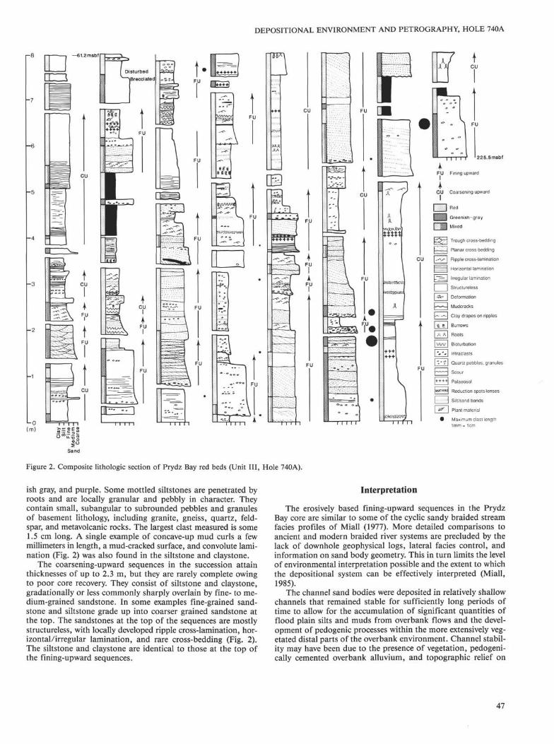
DescriptionThe sediments at Hole 740A consist of sandstone interbed-
ded with siltstone and claystone. The ratio of sandstone to silt-stone and claystone decreases markedly toward the top of thesuccession, from 2/1 in the lower part to 1/1.6 in the upper part(Fig. 2). Internally the succession is characterized by fining-up-
1 Barron, J., Larsen, B., et al., 1991. Proc. ODP, Sci. Results, 119: CollegeStation, TX (Ocean Drilling Program).
2 Department of Geology, The University, Newcastle Upon Tyne, NE1 7RU,U.K. (Present address: University of Durham, Department of Geological Sciences,Science Laboratories, South Road, Durham, DH1 3LE, U.K.).
ward and subordinate coarsening-upward sequences up to 5 mthick. However, because of poor core recovery at this site, rela-tively few sequences are complete. Individual fining-upward se-quences are erosively based and composed of sandstone sharplyoverlain by siltstone and claystone (Fig. 3). The erosion surfaceat the base of the sequence appears to be generally of low reliefand locally overlain by a thin, matrix-supported conglomeratecontaining angular to subangular, elongate claystone and silt-stone intraclasts up to 3.5 cm long and rounded to subroundedpebbles and granules of quartz, quartzite, gneiss, and granite,together with quartzo-feldspathic and rare basic metamorphicclasts (Barron, Larsen, et al., 1989, p. 354, fig. 8). The moreelongate clasts show imbrication. One erosion surface cuts diag-onally across the core at an angle of about 30° and is overlainby claystone intraclasts, including one very large clast up to10 cm long (Fig. 4). The smaller, more elongate clasts have theirlong axes aligned parallel to the scour surface. Most of the ex-ternally derived clasts are concentrated in the lower part of thesuccession, thereby emphasizing the overall fining-upward trend(Fig. 2). This is further emphasized by the individual fining-up-ward sequences in the succession, which are mostly sandstonedominated in the lower part and siltstone and claystone domi-nated in the upper part.
The sandstones are red to greenish gray and medium to coarsegrained, and they attain a maximum thickness of about 3 m.They show a distinct fining-upward trend, with the coarsestparts of the sandstone predominantly green or greenish gray(Fig. 2) owing to the abundance of chlorite and lack of oxidizediron. Both the greenish gray reduced sandstones and the red oxi-dized sandstones contain locally developed zones of contrastingcolor and redox potential. Some of the reduced zones in the redoxidized sandstones concentrate around dark, organic-rich coressuch as rootlets. Small angular to subrounded pebbles and gran-ules of quartz, quartzite, and feldspar are scattered throughoutthe sandstone or less commonly concentrated into discrete lay-ers and stringers. Some of the more elongate pebbles and gran-ules show a distinct horizontal fabric. Grains of pyrite are par-
45

B. R. TURNER
70°E 743.
Prince CharlesMountains
Banded ironstone T jlocality
75
Outcrop
Permian sediments
| Cambrian acid intrusivesI Late ProterozoicI metamorphicsI Late ProterozoicI metasediments
? Middle Proterozoic dikesl Early Proterozoicl metasediments
i l l Archaean metasediments
iSwiil Archaean basement
Figure 1. Generalized geologic map of the Prydz Bay area showing thelocation of the Lambert Graben and drill sites on the East Antarcticcontinental shelf.
ticularly common in the reduced greenish gray sandstones. In-ternal scouring of the sandstones is present in some parts of thecore, but is not common.
The sandstones are simple, single-story sand bodies (Petti-john et al., 1987). They may be massive or more commonlycross-bedded with minor ripple cross-lamination and horizon-tal lamination. The cross-bedding consists mainly of verticallystacked planar sets (Fig. 3); a single occurrence of trough cross-bedding is confined to a 0.50-m-thick sand body near the top ofthe succession (Fig. 3). The troughs are arranged in cosets, inwhich the individual sets are consistently about 4 cm thick (Bar-ron, Larsen, et al., 1989, p. 355, fig. 10). Within the core, indi-vidual planar sets have straight upper and lower bounding sur-faces typical of tabular cross-strata, although the lateral extentof these bounding surfaces is uncertain. Some of the sets showan upward decrease in set thickness from a maximum of about 1to 0.05 m, concomitant with a similar decrease in grain size.The foreset laminae are texturally graded from coarse to fineand attain a maximum thickness of about 6 cm. Small pebblesand granules of quartz tend to concentrate along the base of theforesets. The foresets are typically straight and parallel to oneanother (Barron, Larsen, et al., 1989, p. 355, fig. 9) and in-clined at angles of up to 25° to the lower planar bounding sur-
face, although most have lower foreset dip angles (< 14°). An-gular contact with this bounding surface is sharp and nonerosivewith no evidence from the core of tangentially based foresets. Insome sand bodies individual foreset laminae can be distinguishedby their striped red and green appearance. The coarser laminaeare typically green and greenish gray, whereas the finer laminaeare more clay rich and red or pinkish gray in color.
Small-scale ripple cross-lamination, with amplitudes of formsets up to 1.5 cm and wavelengths up to 6 cm, is locally devel-oped between cross-bedded units and in the finer grained upperparts of major sand bodies. In one example, cross-laminationdips in the opposite direction to that of the planar cross-bedsabove and below. A few ripples show clay-draped ripple pro-files. These are located between a large-scale cross-bedded setand small-scale cosets where there is a sudden decrease in grainsize (Fig. 2). Rare sigmoidal foreset laminae up to 0.7 cm thickand dipping at about 20° occur in Section 119-740A-26R-2,56-60 cm. Most of the wavy lamination and horizontal lamina-tion occur in the lower part of the more massive sandstones,which are locally mottled in shades of brown and yellowishbrown. Spacing between individual laminae is on a millimeter tocentimeter scale. In some parts of the core they can be differen-tiated on the basis of alternating red and green and light anddark red-colored laminae. In addition to the color-differentiatedlaminae, diagenetic red and green color banding is locally devel-oped, in which the contrasting bands are sharply differentiatedand range from 1.4 mm to 4 cm in thickness. Internally the redbands show a striking variation in color; some have a darker,fine red rim at the top, whilst others have more pale interiors.The texture between different color bands is the same through-out, in contrast to the sedimentary lamination. Mottled zonesare less common than in the siltstone and claystone higher in thesequence.
The siltstone and claystone are predominantly red or reddishbrown in color with numerous greenish gray reduction spots andlenses, some of which show dark organic-rich nuclei preservedin the center (Barron, Larsen, et al., 1989, p. 356, fig. 11). Theclaystone, which is subordinate to siltstone in most sequences,has a variable silt content. However, claystone coloration bearsno significant relationship to stratification type or silt content.Both the siltstone and claystone contain coarser, more pale, dif-fuse sandy layers on a millimeter- to centimeter-thick scale andnumerous claystone and siltstone intraclasts, locally concentratedinto conglomerate lenses. Most intraclasts are small and lessthan 1.5 cm long. The largest intraclast recorded is a yellowishbrown, striped siltstone up to 4.3 cm long. Internally, the silt-stone and claystone show slickenside surfaces, some of whichare coated with a thin claystone skin. Fining-upward sequencesup to 25 cm thick occur within the siltstone and claystone. Theyconsist of two main types: (1) fine sandstone and siltstone (spo-radically rippled), passing up into claystone, and (2) erosivelybased intraformational conglomerate with a sandy matrix, pass-ing up into finely laminated and locally rippled siltstone andclaystone (Fig. 5). Small granules and large grains of subangularto subrounded quartz and feldspar up to 3 mm in length aresporadically distributed throughout the siltstone and claystone,which may also contain pyrite. This is particularly common inthe siltstones, where the pyrite may be surrounded by a darkrim of organic-rich material. The siltstone and claystone aremainly structureless, but contain locally developed ripple cross-lamination and regular to discontinuous wavy lamination on amillimeter scale (Fig. 5). The lamination is commonly diffuseand poorly defined as a result of disruption by burrowing andbioturbation caused mainly by rootlets up to 10 cm long, whichare common throughout the siltstone and claystone.
A feature of the siltstone and claystone is the presence of nu-merous mottled zones in various shades of brown, yellow, green-
46
DEPOSITIONAL ENVIRONMENT AND PETROGRAPHY, HOLE 740A
FU|
ICU
1
i| |!
J l
mEZ1l = l
πΘΘE3
1
Θ
Fining upward
Coarsening upward
Red
Greenish-gray
Mixed
Trough cross-bedding
Planar cross-bedding
Ripple cross-lamination
Horizontal lamination
Irregular lamination
Structureless
Deformation
Mudcracks
Clay drapes on ripples
Burrows
Roots
Bioturbation
Intraclasts
Quartz pebbles, granul<
Scour
Palaeosol
Reduction spots-lenses
Silt/sand bands
Plant material
imum clast length= 1cm
Figure 2. Composite lithologic section of Prydz Bay red beds (Unit III, Hole 740A).
ish gray, and purple. Some mottled siltstones are penetrated byroots and are locally granular and pebbly in character. Theycontain small, subangular to sub rounded pebbles and granulesof basement lithology, including granite, gneiss, quartz, feld-spar, and metavolcanic rocks. The largest clast measured is some1.5 cm long. A single example of concave-up mud curls a fewmillimeters in length, a mud-cracked surface, and convolute lami-nation (Fig. 2) was also found in the siltstone and claystone.
The coarsening-upward sequences in the succession attainthicknesses of up to 2.3 m, but they are rarely complete owingto poor core recovery. They consist of siltstone and claystone,gradationally or less commonly sharply overlain by fine- to me-dium-grained sandstone. In some examples fine-grained sand-stone and siltstone grade up into coarser grained sandstone atthe top. The sandstones at the top of the sequences are mostlystructureless, with locally developed ripple cross-lamination, hor-izontal/irregular lamination, and rare cross-bedding (Fig. 2).The siltstone and claystone are identical to those at the top ofthe fining-upward sequences.
Interpretation
The erosively based fining-upward sequences in the PrydzBay core are similar to some of the cyclic sandy braided streamfacies profiles of Miall (1977). More detailed comparisons toancient and modern braided river systems are precluded by thelack of downhole geophysical logs, lateral facies control, andinformation on sand body geometry. This in turn limits the levelof environmental interpretation possible and the extent to whichthe depositional system can be effectively interpreted (Miall,1985).
The channel sand bodies were deposited in relatively shallowchannels that remained stable for sufficiently long periods oftime to allow for the accumulation of significant quantities offlood plain silts and muds from overbank flows and the devel-opment of pedogenic processes within the more extensively veg-etated distal parts of the overbank environment. Channel stabil-ity may have been due to the presence of vegetation, pedogeni-cally cemented overbank alluvium, and topographic relief on
47

B. R. TURNER
cm 1VJ
10
20
30
40
50
60
70
80
90
100
110
120
130
140
—
—
—
_
:
•
cm105
Fc
Sp
Sp
ConglSs 110
Fc
Sp 115
120
Fc
125
Sp
130
Figure 3. Fining-upward sequence in Core 119-740A-28R consisting of ascoured surface (Ss) and channel lag conglomerate (Congl) overlain bymedium- to coarse-grained, low-angle planar cross-bedded sandstone(Sp), which is abruptly overlain by massive and mottled siltstone andsilty claystone (Fc). Note the striped red (dark) and pale greenish gray(light) appearance of the planar cross-bedded foresets.
the flood plain, which would have been sufficient to trap finesthat would then inhibit channel shifting. This seems to havebeen most common during deposition of the upper part of thesuccession. The relatively low incidence of internal scouring andreworking of the channel sand bodies, clay drapes, and other
Figure 4. Steep erosion surface with large claystone intraclast interpretedas part of a collapsed channel bank in Section 119-740A-22R-1, 104-134.5 cm. Note the alignment of the smaller, elongate mud clasts paral-lel to the erosion surface, suggesting downslope movement.
48

DEPOSITIONAL ENVIRONMENT AND PETROGRAPHY, HOLE 740A
cm
20
25
30
35
40
45
Figure 5. Rippled sandstone (Sr) at top of channel-fill sand body over-lain by laminated and rippled overbank siltstone (Fl) and massive clay-stone (Fc) in Section 119-740A-22R-1, 19.5-47 cm. This is succeeded bya fining-upward sequence comprising a scoured surface (Ss), intrafor-mational conglomerate with sandy matrix (Congl), laminated and rip-pled siltstone (Fl), and massive claystone (Fc).
evidence of bedform modification and emergence suggest thatdischarge fluctuations were not very great during their deposi-tion, in contrast to the more ephemeral systems described byTurner (1978) and Tunbridge (1984), which are characterized byrepeated episodes of scour and fill and abundant upper flow re-gime plane beds. This in turn implies that the climate was suffi-ciently wet to maintain discharge throughout the channel sanddeposition. However, the general fining-upward trend in the chan-nel sand bodies and abrupt change to siltstone and claystone areconsistent with the sudden abandonment of most channelsthrough rapid avulsive shifting. The steep erosion surface in Fig-ure 4 is interpreted as a channel bank cut into coherent mud andsilt, which afforded considerable resistance to erosion. The re-sistant nature of the channel banks would also have facilitatedabrupt avulsive events.
The dominance of planar cross-bedding suggests that thechannels may have been occupied mainly by simple transversebars or two-dimensional dune bedforms with only limited devel-opment of in-channel three-dimensional dune (trough) bedforms.However, the lack of lateral control on the nature of the cross-bedding makes identification of the original bedforms uncer-tain. Although local changes in hydrodynamic conditions en-abled ripples to form, there is no evidence to suggest the exten-sive development of bar-top bedforms consistent with rapidlyfluctuating flows. The flume experiments of Jopling (1965) showthat nonerosive basal contacts and low-angle foresets are a re-sult of relatively weak flow velocities characterized by a low ra-tio of suspension load to bedload. Very little of the suspensionload was deposited on the slip face, which was dominated bygrain avalanching. The constant shape and dip of the foresetsand absence of reactivation surfaces imply deposition understeady-state flow conditions, at water depths sufficiently high toallow for the deposition of cosets. The difference in color of thechannel sand bodies probably reflects fluctuations in the level ofthe water table during deposition. Thus, the greenish gray drabsandstones remained mostly below the water table, where reduc-ing conditions prevailed, particularly in the presence of organicmatter (Turner, 1980). Any oxides or hydroxides unstable underthese conditions would be removed. Where the sandstones re-mained above the water table under more oxidizing conditions,the iron oxides and hydroxides, which are mainly containedwithin the clay minerals, imparted a red color to the sediment.Local reduction spots and lenses in these red oxidized sand-stones are mainly linked to decaying organic matter. On oxida-tion, this releases CO2, which is a powerful reducing agent. Theregular alternation of red and green texturally graded foresetlaminae suggests that the critical factor here was differences ingrain size controlled primarily by hydrodynamic sorting pro-cesses during avalanching down the lee face of the original bed-form (Allen, 1983). The coarser bedload-dominated drab-col-ored laminae are more porous and permeable than the finergrained, clay-rich red laminae, with the result that reducinggroundwaters were able to concentrate along this local permea-ble/impermeable boundary.
The siltstones and claystones represent fine-grained floodplain deposits laid down during inundation and flooding of theoverbank environments. Floodwaters carried mainly silt andmud, with coarser sand deposited during major flood events.Most of the coarser silt and sand in the overbank fines occursas thin diffuse layers and lenses rather than discrete beds withsharp bases and tops. The diffuse graded nature of some of thelaminae is consistent with sediment fallout from suspension, asdescribed by De Raaf et al. (1977). Similar laminations havealso been attributed to weak, dilute density flows (Collinsonand Thompson, 1982). The nature of the silt and sand layers im-plies that the floods were small, low-energy, short-lived eventsand that the overbank environment may have been waterlogged
49

B. R. TURNER
at the time of flood incursion; hence, the scarcity of mud cracksin the flood plain deposits and the paucity of sharp beddingcontacts. The scarcity of mud cracks further suggests that theoverbank environment was waterlogged between flood episodes.This interpretation is consistent with the lack of pedogenic car-bonate, which generally requires an arid to semiarid seasonalclimate with a low rainfall for its formation, as discussed in thefollowing section. The inability of the depositional surface todry out completely between flood events may reflect the high siltcontent of the flood plain deposits. Under these conditions, therandomly distributed siltstone and claystone intraclasts in thefloodplain deposits may have been derived from within the chan-nel or the floodplain during flood events, with their small sizereflecting the competence of the flow in the upper part of thewater column in the channel. Each fining-upward sequencewithin the overbank deposits records a single episode of flood-ing and overbank deposition under decelerating flow condi-tions.
Most of the overbank siltstones and claystones lack sedimen-tary structures. This lack of structure in the core and in thin sec-tion, together with the presence of abundant rootlets (indicativeof emergence and colonization by plants), burrows, bioturba-tion, and extensive color mottling is attributed to pedogenicprocesses. Additional micromorphological evidence of pedogene-sis is the presence of voids, ped structures, and plasmic fabrics(B. R. Turner, unpubl. data) typical of modern soils seen in thinsection. In contrast to many pedogenically influenced red beds,the sediments contain no pedogenic carbonate other than a mi-critic root structure in Sample 119-740A-26R-4, 6-10 cm. Pedo-genic carbonate (calcrete) normally requires a prolonged periodof dryness (seasonal climate) for its formation, irrespective ofits climatic setting. However, extensive calcrete formation is fa-vored by arid to semiarid climatic conditions, low rainfall, andnegligible sediment input into the area for prolonged periods oftime (Allen, 1974; Leeder, 1975). Thus, the lack of carbonate inthe sediments could be due to climatic factors (climate too wetor rainfall not seasonally peaked enough), high sedimentationrates, the presence or absence of carbonate in the source rocks,and acid waters that remove carbonate in solution. The relativeimportance of these factors is difficult to assess, but the inferredfluctuations in the water table and perennial nature of the chan-nels suggest that the climate may have been too wet for extensivepedogenic carbonate formation (Bown and Krause, 1981). Al-though the 500-mm isohyet is generally taken as the upper limitfor calcrete formation, incipient calcrete has been known toform in environments with up to 1500 mm of annual precipita-tion (Reeves, 1970).
The gradational coarsening-upward sequences in the succes-sion are interpreted to have resulted from local increases in flowintensity and sediment concentration due to flooding of thelower-lying overbank environment. More rapid flooding by sand-laden currents, and the local development of crevasse channelsor splay lobes, may have been responsible for the sharply basedsandstone at the top of one coarsening-upward sequence (Elli-ott, 1974). Any abandonment facies that might have been pres-ent above this sandstone are not seen because of core loss.
PETROGRAPHY
DescriptionModal analysis of sandstones and siltstones (Table 1) in the
succession, based on a count of 300 grains per slide, shows thatcompositionally they are predominantly poorly sorted, imma-ture sediments containing more than 17% clay matrix. The sand-stones are arkosic wackes (Fig. 6 and PI. 1, Fig. 1) composed ofquartz, mica, and feldspar with subordinate rock fragments,garnet, and opaque minerals set in a clay matrix that makes up
between 17% and 66% of the rock (Table 1). Chlorite and seri-cite are common constituents of the matrix, some of which isdiagenetic. In some sections the matrix consists predominantlyof a coarse mat of biotite, muscovite, sericite, and chlorite, withindividual grains up to 0.024 mm in length, or medium siltgrade. The matrix also includes rare authigenic vermicular crys-tals of chlorite. Other coarse chlorite grains without any obvi-ous mineral precursors may be detrital in origin. X-ray-diffrac-tion analysis shows that in addition to chlorite and sericite thematrix includes illite-smectite and kaolinite. Fine shreds of micaand clay minerals coat the surface of many detrital quartz andfeldspar grains. The quartz grains in the coarser grained chan-nel sandstones (Table 1) attain lengths of up to 1.2 mm. The re-lationship between percentage detrital quartz and grain size fordifferent fluvial environments is shown in Figure 7. The rela-tionship serves to differentiate between channel and overbankdeposits depicted in Table 1, with a further more refined subdi-vision into proximal and distal overbank deposits. Splay de-posits are not common and lie close to the boundary betweenchannel and overbank deposits. The quartz grains are mostlysubangular, but range from angular to subrounded types, withrare, well-rounded second-cycle grains (PI. 1, Fig. 2). In themore clay-rich sandstones the quartz and other detrital grains"float" in the clay matrix, which is red and impregnated withiron oxides (mainly hematite) or less commonly greenish grayand rich in chlorite. Some of the quartz grains show poorly de-veloped secondary overgrowths defined by a thin rim of dustand iron oxide. A feature of many of the grains is the presenceof inclusions, particularly needles of sillimanite (PI. 1, Fig. 3).
The feldspars are predominantly orthoclase with minoramounts of microcline and perthite. Plagioclase is absent orpresent in amounts of 1% or less. Feldspar abundance is ortho-clase > microcline > perthite > plagioclase. The orthoclaseoccurs as relatively fresh to slightly altered angular, prismaticgrains, up to 0.6 mm long, some of which show exsolution fea-tures. Sporadic iron-staining occurs along cleavage planes, andin a few cases grains contain inclusions of other minerals, somewith alignment parallel to the long axis of the feldspar. The feld-spars are commonly larger in size than the quartz grains.
Biotite is the dominant mica in most sandstones, and in somecases it may make up as much as 38% of the rock. It occurs aslarge, elongate detrital grains and shredlike flakes, up to 0.4 mmlong, some of which are bent and folded around other detritalgrains through intergranular pressure. The more elongate grainstend to have their long axes aligned parallel to one another,thereby imparting a distinct fabric to the sandstone, especiallythe finer grained varieties. The biotite grains are relatively freshor show various stages of alteration, principally to hematite.Completely altered grains, however, are rare. Muscovite occursas small shredlike flakes, usually associated with chlorite, or lesscommonly as large detrital grains.
Rock fragments are present in most of the sandstones, butare not very common and never exceed 6% of the rock. Theyconsist mainly of (1) rounded fragments of granite/gneiss com-posed of quartz + muscovite + chlorite + feldspar up to0.7 mm long (PI. 1, Fig. 4); (2) coarse chlorite aggregates, whichrepresent alteration of an earlier mineral phase that has roundedoutlines still discernible; and (3) more angular polycrystallinequartz grains that are generally smaller than the chloritic rockfragments (maximum 0.48 to 0.56 mm long) (PI. 1, Fig. 4).Most of the chloritized grains appear to have undergone altera-tion prior to burial and diagenesis. Some of the quartz grainsare characterized by stretched, elongate crystals with crenulatedmargins typical of a metamorphic source. Others are more typi-cal of an igneous derivation in that they comprise crystals show-ing a large variation in crystal size. Needlelike inclusions (?silli-manite) are distributed throughout a few of the polycrystalline
50

DEPOSITIONAL ENVIRONMENT AND PETROGRAPHY, HOLE 740A
Table 1. Mineral composition of sandstones and siltstones from Hole 740A.
Core, section,interval (cm) Lithology
DominantColor
Meangrain Environment Quartz
Feldspars RockOrthoclase Microcline Plagioclase fragments Biotite Muscovite
Claymatrix
Opaqueminerals
a8R-CC,12R-1,12R-1,12R-1,14R-1,
a14R-1,
14R-2,15R-1,17R-1,
19R-1 ,19R-1,19R-1,19R-1,19R-1,19R-1,20R-3,20R-3,20R-4,22R-1,
22R-2,
23R-1,23R-1,24R-1,25R-1,25R-1,26R-2,26R-3,
b26R-4,
26R-4,26R-4,27R-4,27R-5,27R-5,28R-3,30R-1,
31R-1,
31R-3,31R-5,
15-1729-3241-4555-5834-3699-102
41-4332-34100-103
10-1435-3847-4863-6577-7985-8873-75119-12142-448-10
85-87
102-108106-108103-10616-1899-101136-13920-246-10
7-1048-519-1219-21135-13831-344-5
89-92
4-825-28
SandstoneSandstoneSandstoneSandstoneSiltstoneSandstone
SandstoneSandstoneSandstone
SandstoneSiltstoneSandstoneSandstoneSandstoneSiltstoneSiltstoneSilty sandstoneSandstoneSandstone
Sandstone
SandstoneSandstoneSandstoneSiltstoneSandstoneSandstoneSandstoneSandstone
SandstoneSandstoneSandstoneSandstoneSandstoneSilty sandstoneSandstone
Sandstone
SandstoneSandstone
10YR 6/17.5YR 2/15Y 5/17.5YR 2/110R 3/210R 2.5/110R 4/25G 6/110R 3/210R 5/25G 4/25YR 3/15YR 3/25YR 3/25YR 3/25YR 3/25YR 3/25YR 3/25YR 3/25YR 3/25YR 8/15YR 3/25YR 5/15YR 4/25GY 5/15Y 2.5/15YR 3/210R 4/410G 6/110R 4/210R 3/32.5Y 8/12.5 YR 3/42.5 Y 8/12.5YR 2.5/410R 3/110R 3/210R 3/210R 3/37.5G 3/210G 4/210R 2.5/15GY 5/15YR 3/25YR 3/2
1.552.062.473.683.981.58
1.973.061.95
3.184.512.742.633.7
4.765.013.842.552.24
1.44
3.972.822.512.911.881.2
3.883.53
2.693.322.161.761 .814.062.49
2.88
4.350.76
ChannelSplaySplayOverbankOverbankChannel
ChannelOverbankChannel
OverbankOverbankOverbankOverbankOverbankOverbankOverbankOverbankOverbankChannel
Channel
OverbankOverbankChannelOverbankChannelChannelOverbankOverbank
OverbankOverbankChannelChannelChannelOverbankChannel
Overbank
OverbankChannel
3 13 93 31 71 12 7
2 72 62 9
2 41 13 13 03 51 41 02 12 53 9
3 0
1 32 73 42 42 34 01 41 3
1 72 23 0332 11 52 1
2 7
1 63 3
1 41 18427
416
5
1 01 121T287
1 1
31 1831 21 944
1 01 141 4554
4
42 0
TT
1TT
1
T
1
T
11
213
214
1
T126
2
2
1T32T
2
24T1
T
456
1 0
2 0T
2 437
1 23 812
1 01 62
6
2 31 18
1 21 03
1 3
57445
1 13
9
6
17
1T
41
423
7T
T11
T
11 1
2TT12
T1TT4
1
1
81
3 93 74 06 66 95 4
6 24 35 0
4 18 13 84 4178 38 76 04 43 9
4 5
5 54 44 55 7473 26 68 0
6 05 54 64 46 45 96 9
5 4
6 44 4
966555
245
2392111434
3
3
222231
321 01
92
4
22
a Contains traces of clinopyroxene and olivineb Calcareous root structure
Feldspar
Figure 6. Classification of Prydz Bay sandstones (after Pettijohn et al.,1987). The sandstones contain more than 17% clay matrix.
quartz grains. Other lithologic types, which occur as rock frag-ments, include claystone, siltstone, and quartz-mica schist.
Garnet is present in most sandstones, particularly the coarservarieties where it may make up as much as 4% of the rock. Gar-net occurs as fresh, angular to subrounded grains (PI. 1, Fig. 5),
ranging from 0.03 to 0.42 mm in size. The garnet grains are pre-dominantly colorless to pale pink in thin section but includesome green varieties, especially in Sample 119-740A-22R-1, 8-10 cm. Microprobe analysis of individual garnet grains showsthem all to be iron-rich almandine garnets, containing relativelylittle manganese (0.89%-7.16%), magnesium (2.34%-7.77<%),and calcium (3.38%-5.52<%) (Fig. 8). The opaque mineral suiteincludes magnetite, pyrite, hematite, ilmenite, and titaniferous-rich magnetite. Spinel was also identified during routine ship-board analysis of smear slides. Rare clinopyroxenes and oneolivine crystal were found in two greenish gray, reduced, chlo-rite-rich sandstones containing abundant ilmenite and titano-magnetite. These sandstones (Samples 119-740A-8R-CC, 15-17cm, and 119-740A-14R-1, 99-102 cm) have anomalously highTiO2 and MnO contents (Table 2). The ilmenite and titanomag-netite tend to concentrate into laminae rich in dark, heavy min-erals (PI. 1, Fig. 6), associated with abundant garnets in one ofthe sandstones. In addition to garnet, ilmenite, and magnetite,the heavy mineral suite in the sandstones includes tourmaline,hematite, and pyrite.
InterpretationThe composition of the sandstones (arkosic wackes), their
immaturity, and the angularity of the detrital grains are consis-tent with a provenance of high relief undergoing rapid erosion,with the resulting detritus transported and deposited quickly.This in turn implies a provenance in close proximity to the depo-
51

B. R. TURNER
40
30
N*-•
CO
σ20
10
• Channel
Δ Splay
• Overbank
+ 2.0 +4.0
Grain size 0
+ 6.0
Figure 7. Percentage detrital quartz against grain size for different flu-vial environments. The coarser grained overbank deposits with a higherpercentage of quartz represent more proximal overbank deposits. Datafrom Table 1.
RMg)
G<Ca)
Figure 8. Composition of detrital garnet grains from Prydz Bay redbeds, Hole 740A. P = pyrope; AS = almandine + spessartine; G =grossular.
sitional site that underwent rapid uplift. The rate of uplift anderosion may have exceeded the rate of weathering in the sourcearea, as evidenced by the abundance of relatively fresh biotiteand orthoclase in the sandstone. This view is strengthened bythe locally preserved clinopyroxene and olivine in two of thesandstone samples, as these are normally the first minerals to bedestroyed prior to burial. Thus, whilst the rate of uplift and ero-sion was sufficient to prevent excessive weathering and loss ofbiotite and orthoclase, it was not rapid enough to preserve mostof the less stable minerals, such as pyroxene and olivine. Esti-mates of the rate of erosion and source area relief are precludedby the poor core recovery and lack of paleontological control.However, such rapid uplift implies a tectonic control, possiblyrelated to rifting associated with the development of the Lam-bert Graben prior to continental breakup. Support for a tectoni-cally active source comes from the work of Folk (1968), whosuggested that the presence of angular quartz and feldspar in asediment, in which feldspar is relatively fresh and commonlylarger than the quartz grains, is tectonically derived. He referredto such sandstones as "tectonic arkoses" and considered themto form mainly as alluvial fans or piedmonts, along the marginsof block-faulted, usually granitic, mountainous terrains (Folk,1968, p. 132).
Provenance uplift may in turn have influenced climate at thesource and the rate of basin subsidence thought to have been re-sponsible for the fining-upward trend shown by the succession.Once deposition and burial had occurred, early diagenetic alter-ation and dissolution appear to have been limited, as witnessedby the relatively fresh nature of most detrital grains, particularlythe more unstable biotite and orthoclase grains. This may be thereason for the lack of authigenic silica in the sediments, forwhich the source normally is the alteration and/or replacementof the labile silicates at shallow depths in most red bed succes-sions (Turner, 1980). Similarly, the lack of carbonate inhibitsconditions suitable for the pore-water dissolution of silica gen-erated in this way, and as a result, secondary quartz overgrowthsare poorly developed.
The mineralogy of the sandstones indicates that they werederived from a high-grade metamorphic terrain. Detritus fromthis terrain must have been diluted with second-cycle material ofmetasedimentary origin that probably formed part of the sameprovenance. The detrital mineralogy of the sandstones and thein-situ clasts suggest that the gneisses were predominantly ofgranitic composition but with contributions from a more maficprovenance rock component, as evidenced by the presence ofrarely preserved clinopyroxene and olivine (Table 1), the high Crand Ni content of the sediments (Table 2), and the presence oftitaniferous rich magnetite. The importance of the mafic prove-nance is difficult to assess from the mineralogy because maficand ultramafic components are much less likely to be preservedin a sediment than granite. Nevertheless, the abundance of ortho-clase feldspar with virtually no plagioclase is typical of graniticsource rocks, especially those within a cratonic setting. Althoughseismic data reveal the presence of basement ridges within PrydzBay (Stagg, 1985), the only nearby rocks of this general compo-sition are the upper Proterozoic granulite facies gneisses of thePrydz Bay coast and the Archaean granulite facies of the Vest-fold cratonic block (Fig. 1). The relative importance of thesetwo potential sources is uncertain in the absence of paleocurrentdata and regional facies patterns. Also, the section of core ex-amined represents only a small part (65 m) of a prebreakup se-quence more than 2 km thick (Stagg, 1985).
DISCUSSION
The succession shows an overall fining-upward trend, as re-flected in the ratio of sandstone to siltstone and claystone. This
52

DEPOSITIONAL ENVIRONMENT AND PETROGRAPHY, HOLE 740A
Table 2. Chemical composition of sediments from Hole 740A.
Core, section,sample interval
(cm)
8R-CC,12R-1,12R-1,13R-1,14R-1,14R-1,14R-2,15R-1,15R-1,17R-1,19R-1,19R-1,20R-3,20R-3,20R-4,22R-1,22R-2,23R-1,23R-1,24R-1,25R-1,25R-1,26R-2,26R-3,26R-4,26R-4,
27R-1,27R-1,27R-4,27R-5,28R-1,
28R-1,28R-3,31R-1,31R-3,
31R-4,
15-1729-2155-5837-3934-3699-10241-4332-34
Lithology
SandstoneSandstoneSandstoneSandstoneSiltstoneSandstoneSandstoneSiltstone
137-140 Siltstone100-10363-6585-8873-75119-12142-448-1085-8752-55
SandstoneSiltstoneSiltstoneSiltstoneSandstoneSandstoneSandstoneSandstoneSandstone
102-106 Sandstone103-10616-1899-101136-13920-246-1048-51
107-111134-1369-1219-2143-47
SandstoneSiltstoneSandstoneSandstoneSandstoneSandstoneSiltyclaystoneSandstoneSandstoneSandstoneSandstoneSiltyclaystone
133-137 Si31-3489-928-11
108-111
SiltstoneSandstone
SiO2
(%)
65.567.861.351.760.067.452.061.457.978.966.151.351.051.265.177.568.560.266.366.362.070.773.572.461.060.9
54.755.867.675.053.8
61.453.059.0
Claystone/ 52.2SandstoneSiltyclaystone
53.0
A12O3
(%)
12.413.117.014.616.213.320.315.417.611.115.319.121.817.515.611.415.116.813.814.416.112.912.712.917.416.9
22.118.713.012.521.4
16.520.415.418.7
20.7
Fe2O3
(%)
8.477.479.18
19.312.07.07
11.08.87
10.62.106.25
14.5110.417.86.652.584.899.288.186.908.946.004.104.419.108.58
9.6711.17.392.93
11.0
9.4412.311.614.7
12.8
MgO(%)
1.991.412.031.571.971.782.402.342.440.961.551.952.171.881.751.041.282.441.661.751.991.150.981.512.362.28
2.042.261.551.242.38
2.262.401.722.31
2.03
CaO(%)
0.810.560.560.440.500.920.730.690.560.540.860.520.560.610.740.620.641.040.700.970.720.540.680.850.880.74
0.800.810.970.800.98
0.880.820.601.03
0.68
Na2O(%)
0.850.770.850.660.640.880.930.730.740.680.900.580.580.750.700.700.880.780.720.870.600.540.660.680.720.62
0.640.640.710.680.52
0.640.480.480.68
0.48
K2O(%)
1.612.522.522.312.251.262.382.382.383.073.152.352.392.462.752.683.572.552.712.542.332.823.332.602.642.65
2.662.261.892.672.22
2.522.262.261.91
2.07
Ignition lossat 750°C for
3 hr
3.003.745.005.645.333.425.604.735.122.594.256.847.136.444.512.844.345.754.214.494.973.693.293.465.504.46
6.696.204.323.477.05
5.416.735.097.14
7.25
TiO2
(%)
2.350.880.820.820.843.080.900.850.720.160.540.880.900.830.830.390.500.760.710.820.860.510.611.040.720.81
0.770.881.320.330.77
0.840.750.880.66
0.80
MnO(%)
0.390.060.050.110.090.520.090.190.200.020.040.100.070.120.060.040.050.070.060.080.080.080.060.160.110.09
0.070.120.130.030.09
0.080.090.080.10
0.07
P2O5(%)
0.070.040.030.120.080.110.060.090.110.040.150.100.070.150.050.030.030.060.040.100.080.060.050.080.050.06
0.040.090.090.040.11
0.120.160.060.08
0.08
Cr(ppm)
220140140180156185220140151
5998
200240119124
6299
160120124146
6667
144124146
172132160
80160
218156197780
187
Li(ppm)
612222122
6322330
71643503219
7172215132317
8142322
3430
87
41
22391927
33
Ni(ppm)
3038798687287163801 552859481562158
1123754704627486580
60943529
115
85113
65110
94
Co(ppm)
331720343324302630
62234342917
713541624292012452427
2243161240
30342435
30
Zn(ppm)
575381868748
11482982453
106109104
773168
1127461825841
1408575
109110
6539
111
86115
83120
107
Cu Total(ppm)
2 61 84 5456114602646
95371667 2322 2384 1323 35621
8218
5655
37371 11 247
81533733
71
97.598.399.497.399.9599.7796.597.798.41
100.299.198.397.199.898.899.899.899.899.199.398.7199.0
100.0100.2100.5
98.13
100.298.999.099.7
100.4
100.199.497.2199.6
100.0
trend can be interpreted in two ways: (1) by uplift and gradualerosion and recession of the source area, thereby reducing gradi-ents and sediment supply and increasing the proportion of fine-grained material supplied to the depositional site, or (2) by in-creased rates of subsidence and vertical aggradation, which wouldtend to preserve more fines as the rate of channel reworking de-creased. Unfortunately there is insufficient data from Hole 740Ato assess the relative merits of these two mechanisms, althoughboth may be related if fault controlled. Under these conditionsthe channels would tend to become more sinuous in character asthe amount of silt and mud in the channel bed and bank in-creased (Schumm, 1960). The sediments were deposited by anetwork of shallow, low-sinuosity braided channels draining avegetated alluvial plain (cf. Truswell, 1982) with sufficient topo-graphic relief to trap fine-grained sediments and inhibit rapidchannel shifting. Comparison of the channel deposits to themodels of Miall (1977) and Rust (1978) suggests that the chan-nels drained the intermediate parts of a braided river system,the proximal reaches of which probably existed toward the eastand southeast, in the direction of the basement source area.Coarser grained braided river deposits may be present in this di-rection, with alluvial fans flanking the fault-bounded sourcearea. Palynological studies by Truswell (1982) of seafloor sam-ples dredged from off the East Antarctic coast suggest that well-vegetated alluvial plains were extensively developed over parts ofEast Antarctica prior to continental breakup. However, the onlyrecord of these sequences found to date is the locally preservedonshore Permian Amery Group and the Prydz Bay red beds.Similar sequences are predicted to occur farther south along theEast Antarctic continental margin (Truswell, 1982).
Because of the relative stability of the channels, pedogenicprocesses were initiated on the vegetated flood plain. Most pa-leosols show up as mottled zones in the succession and are at-tributed to alternate wetting and drying of the soil by fluctua-tions in the level of the water table. Although the climate waswarm, it was probably too wet for extensive calcrete formationand the development of mature soil profiles. Petrographic stud-ies indicate that the sediments may have been derived from theupper Proterozoic and Archaean gneisses of the Prydz Bay coast,to the east and southeast of Hole 740A, which, like the sedi-ments, have anomalously high concentrations of Cr and Ni. Noother gneisses in this vicinity show the same geochemical signa-ture. Additional evidence in support of this interpretation isprovided by the seismic data, which show that the preglacialsediments at Prydz Bay form part of a much thicker sequencethat progrades seaward (Stagg, 1985; Cooper and Larsen, 1989).Carbonate is present in the source rocks, but only in minoramounts (Ravich and Federov, 1982), and there is a decrease inthe amount of CaO with decreasing age, which reflects a changein the relative abundance of plagioclase and potassium feldspar(Sheraton et. al., 1984). In view of this, the paucity of carbon-ate in the sediments might also reflect a source area control oncalcium availability to the depositional system as well as a cli-matic one. Tectonic activity and uplift of the source area proba-bly occurred along the seaward extension of the eastern faultedmargin of the Lambert Graben, which according to the seismicdata (Stagg, 1985) passes to the southeast of Hole 740A. If thisinterpretation is correct, then the upper Proterozoic and Ar-chaean gneisses of the Prydz Bay coast must extend seaward, atleast as far as the eastern faulted margin of the Lambert Graben
53
B. R. TURNER
(cf. Stagg, 1985, fig. 12). According to the available seismic datathe boundary fault on the eastern side of the graben is a normalfault.
Palynological analysis of seven samples from this site hasfailed to resolve the age of the sediments (Truswell, this vol-ume). Thus, their age is uncertain, although it has been sug-gested that they may be equivalent to the onshore Permian AmeryGroup or possibly younger (Stagg, 1985). The Amery Group at-tains a maximum thickness of about 270 m and consists of theRadok Conglomerate at the base, overlain by the BainmedartCoal Measures and the Flagstone Bench Formation. The succes-sion was deposited within a fluvial environment, but with thepossibility of a glacial influence on sedimentation during depo-sition of the Radok Conglomerate (R. Tingey in Stagg, 1985).Recent work on the Amery Group has failed to substantiate Tin-gey^ claim (B. McKelvey, pers. comm., 1989), and the RadokConglomerate is considered to have been deposited by braidedstreams draining an alluvial fan system flanking the westernfaulted margin of the Lambert Graben. Sediment was derivedfrom the nearby upper Proterozoic gneisses, granulites, and car-bonate-rich metasediments to the west and southwest of the de-positional site (cf. Mond, 1972). The Flagstone Bench Forma-tion may be lithologically equivalent to the red beds that lieabove the youngest Permian coals in Australia (Truswell, 1982).Furthermore, it is the only formation in the Amery Group toshow any similarity to the Prydz Bay red beds. It consists ofcoarse-grained, cross-bedded, pebbly feldspathic sandstone andsandy siltstone arranged in vertically stacked fining-upward se-quences. The coarser grained sandstones are light gray in color;the finer grained sandstones and siltstones are more reddishbrown and variegated (Ravich et al., 1984). The major petro-graphic differences between the Amery Group sandstones andthe Prydz Bay sandstones are that (1) they contain less biotite,(2) garnet is rare (generally only one grain per slide), and (3) car-bonate (calcite and siderite) is abundant and may replace someof the feldspar, quartz, and clay matrix (Mond, 1972; B. McKel-vey, pers. comm., 1989). These differences probably reflect sourceareas of different composition and have no bearing on the agerelation between the two sequences. The Amery Group is gener-ally considered to be late Permian in age (Mond, 1972; Kemp,1973), although an early Permian age was assigned to the RadokConglomerate by Ravich et al. (1977).
Seismic data indicate that the prebreakup sequence at PrydzBay is 2-3 km thick and of early Permian to Early Cretaceousage (Stagg, 1985). Mond (1972) and Ravich and Federov (1982)correlated the upper Permian Amery Group with the Permo-Tri-assic Beacon Supergroup of the Transantarctic Mountains. Keat-ing and Sakai (this volume) also suggested that the Prydz Bayred beds form part of the Permo-Triassic Beacon Supergroup onthe basis of their similar lithologic relationships and magneticcharacteristics. However, no primary component of Permianmagnetization was isolated in their study, which revealed thepresence of a thermomagnetically induced magnetic overprintattributed to Jurassic igneous intrusions. The possible presenceof igneous intrusions in the Prydz Bay succession was first sug-gested by Stagg (1985). The preservation of Beacon Supergrouprocks within the Wilkes Basin on the East Antarctic coast southof Prydz Bay was postulated by Steed and Drewry (1982). How-ever, palynological studies of dredged seafloor samples indicatethat any Permian sediments that may exist in this part of EastAntarctica have not been deeply buried or subjected to thermalmetamorphism associated with igneous intrusions (Truswell,1982; cf. Keating and Sakai, this volume).
ACKNOWLEDGMENTSMy thanks to the Ocean Drilling Program for the invitation
to participate in Leg 119 and to the U.K. Natural Environmen-
tal Research Council for financial support. The diagrams weredrafted by Christine Jeans, and the final version of the manu-script word-processed by Elizabeth Walton, Pat Bell, and YvonneHall, to whom I am most grateful.
REFERENCES
Allen, J.R.L., 1974. Sedimentology of the Old Red Sandstone (Siluro-Devonian) in the Clee Hills area, Shropshire, England. Sediment.Geol., 12:73-167.
, 1983. Sedimentary Structures: Their Character and PhysicalBasis: Amsterdam (Elsevier).
Barron, J., Larsen, B., et al., 1989. Proc. ODP, Init. Repts., 119: Col-lege Station, TX (Ocean Drilling Program).
Brown, T. M., and Krause, M. J., 1981. Lower Eocene alluvial palaeo-sols (Willwood Formation) and their significance for palaeoecology,palaeoclimatology and basin analysis. Palaeogeogr. Palaeoclimatol.Palaeoecol., 34:1-30.
Collinson, J. D., and Thompson, D. B., 1982. Sedimentary Structures:London (Allen and Unwin).
Cooper, A. K., and Larsen, B., 1989. Stratigraphy of Prydz Bay, Ant-arctica: preliminary results of ODP Leg 119 drilling. Abst. Annu.AAPG Meeting, San Antonio. (Abstract)
de Raaf, J.F.M., Boersma, J. R., and Van Gelder, A., 1977. Wave gener-ated structures and sequences from a shallow marine succession,lower Carboniferous, County Cork, Ireland. Sedimentology, 24:451-483.
Elliott, T., 1974. Abandonment facies of high constructive lobate del-tas, with an example from the Yoredale Series. Proc. Geol. Assoc,85:359-365.
Folk, R. L., 1968. Petrology of Sedimentary Rocks: Austin (Hemphill).Jopling, A. V., 1965. Laboratory study of sorting processes related to
flow separation. J. Geophys. Res., 69:3403-3118.Kemp, E. M., 1973. Permian flora from the Beaver Lake area, Prince
Charles Mountains, Antarctica, I. Palynological examination of sam-ples. Bull. Bur. Miner. Resour. Geol. Geophys. Aust., 126:7-12.
Leeder, M. R., 1975. Pedogenic carbonates and flood sediment accre-tion rates: a quantitative model for alluvial arid-zone lithofacies.Geol. Mag., 112:257-270.
Miall, A. D., 1977. A review of the braided-river depositional environ-ment. Earth Sci. Rev., 13:1-62.
, 1985. Architectural-element analysis: a new method of faciesanalysis applied to fluvial deposits. Earth Sci. Rev., 22:261-308.
Mond, A., 1972. Permian sediments of the Beaver Lake area, PrinceCharles Mountains. In Adie, R. J. (Ed.), Antarctic Geology andGeophysics: Oslo (Universitetfolaget), 585-589.
Pettijohn, F. P., Potter, P. E., and Siever, R., 1987. Sand and Sand-stones (2d ed.): New York (Springer-Verlag).
Ravich, M. G., and Federov, L. V., 1982. Geological structure of Mac-Robertson Land and Princess Elizabeth Land, East Antarctica. InCraddock, C. (Ed.) Antarctic Geoscience: Madison, WI (Univ. ofWisconsin Press), 499-504.
Ravich, M. G., Gor, Y. G., Dibner, A. F., and Lobanova, O. V., 1977.Stratigrafia verknepaleozoiskikh uglenosnykh otlozhenii VostochnoiAntarkidy (raion ozera River). [The stratigraphy of upper Paleozoiccoal measures (Beaver Lake area, East Antarctica).] Antarktika Dok-lady Kommissii, 16:62-75.
Ravich, M. G., Solov'ev, D. S., and Federov, L. V., 1984. GeologicalStructure of Mac. Robertson Land (East Antarctica): New Delhi(Amerind Publ.), 56-69. [Translated from Russian and published forthe Division of Polar Programs, National Science Foundation, Wash-ington, DC]
Reeves, C. C , Jr., 1970. Origin, classification, and geological history ofcaliche on the southern high plains, Texas and eastern New Mexico.J. Geol., 79:352-362.
Rust, B. R., 1978. Depositional models for braided alluvium. In Miall,A. D. (Ed.), Fluvial Sedimentology. Can. Assoc. Petrol. Geol. Mem.,5:605-626.
Schumm, S. A., 1960. The effect of sediment type on the shape andstratification of some modern fluvial deposits. Am. J. Sci., 258:177-184.
Sheraton, J. W, Black, L. P., and McCulloch, M. T., 1984. Regionalgeochemical and isotopic characteristics of high-grade metamorphicsof the Prydz Bay area: the extent of Proterozoic reworking of Ar-
54

DEPOSITIONAL ENVIRONMENT AND PETROGRAPHY, HOLE 740A
chaean continental crust in East Antarctica. Precambrian Res., 26: Turner, B. R., 1978. Sedimentary patterns of uranium mineralization in169-198. the Beaufort Group of the southern Karoo (Gondwana) Basin, South
Stagg, H.M.J., 1985. The structure and origin of Prydz Bay and Mac- Africa. In Miall, A. D. (Ed.), Fluvial Sedimentology. Can. Assoc.Robertson Shelf, East Antarctica. Tectonophysics, 114:315-340. Petrol. Geol. Mem., 5:831-848.
Steed, R.H.N., and Drewry, D. J., 1982. Radio echo-sounding investi- Turner, P., 1980. Continental Red Beds: Amsterdam (Elsevier).gations of Wilkes Land, Antarctica. In Craddock, C. (Ed.), Antarc-tic Geoscience: Madison, WI (Univ. of Wisconsin Press), 969-975.
Truswell, E. M., 1982. Palynology of seafloor samples collected by the1911-14 Australian antarctic expedition: implications for the geol-ogy of coastal East Antarctica. J. Geol. Soc. Aust., 29:343-356.
Tunbridge, I. P., 1984. Facies model for a sandy ephemeral stream and Date of initial receipt: 18 December 1989clay playa complex: the middle Devonian Trentishoe Formation of Date of acceptance: 5 July 1990North Devon, U.K. Sedimentology, 31:697-716. Ms 119B-133
55

B. R. TURNER
500µm 250µm
250µm 1mm
250µm 500µmPlate 1. Thin-section photomicrographs of arkosic wackes from Hole 740A. 1. Poorly sorted, immature, coarse arkosic wacke comprising rounded toangular quartz grains and fresh to slightly altered feldspar set within a chlorite-rich clay matrix. Sample 119-740A-8R-5, 15-17 cm. Crossed nicols.2. Well-rounded, recycled quartz grain associated with angular quartz grains (Q), orthoclase feldspar (F), and black opaque minerals (O). The largequartz grain at bottom right contains abundant needlelike inclusions of ?sillimanite. Sample 119-740A-17R-1, 100-103 cm. Plane polarized light.3. Sillimanite needles in a quartz grain showing corroded margins. The clay matrix is rich in fine shreds of chlorite. Sample 119-740A-23R-1, 102-106 cm.Plane polarized light. 4. Quartz-micaceous-chlorite rock fragment (RF), polycrystalline quartz grains (PQ), and claystone clast (C). Sample119-740A-17R-1, 100-103 cm. Crossed nicols. 5. Angular garnet grains (G), feldspar (F), quartz (Q), and opaque minerals (O). Sample 119-740A-17R-1, 100-103 cm. Plane polarized light. 6. Heavy mineral-rich laminae containing garnet and opaque ilmenite and titanomagnetite. Sample119-740A-14R-1, 99-102 cm. Plane polarized light.
56