Embed Size (px)
Citation preview

Ian Farmer Associates (1998) Limited
1 Fairfield Court, Wheler Road, Seven
Stars Industrial Estate, Coventry, CV4 3LJ
Tel: 024 7630 3422
Fax: 024 7630 7935
ATKINS LIMTED
TAMWORTH GOLF COURSE TAMWORTH GOLF COURSE B77 4EG
FACTUAL REPORT ON SITE INVESTIGATION
Contract: 21232
Date: August 2014
Tamworth Golf Course Tamworth Golf Course B77 4EG
Ian Farmer Associates (1998) Limited
1 Fairfield Court, Wheler Road,
Seven Stars Industrial Estate, Coventry CV3 4LJ
Tel: 024 7630 3422
Fax: 024 7630 7935
FACTUAL REPORT ON SITE INVESTIGATION
carried out at
TAMWORTH GOLF COURSE
TAMWORTH GOLF COURSE B77 4EG
Prepared for
ATKINS LIMTED The Axis
10 Holliday Street Birmingham
B1 1TF
Contract No: 21232
Date: August 2014

Tamworth Golf Course Tamworth Golf Course B77 4EG
Contract No. 21232
EXECUTIVE SUMMARY
On the instructions of Atkins Ltd, on the behalf of Tamworth Borough Council, an investigation was undertaken to determine ground conditions to enable foundation and road/hard standing design to be carried out, together with an assessment of contamination and a review of gas emissions. It is understood that the proposed development comprises of residential properties with a new school and local centre.
The site is situated approximately 3.5km east of Tamworth centre and maybe located by Grid Reference of SK242036. At the time of the investigation the site was currently used by the Tamworth golf members, with the golf club and visitors’ car park on the western boundary.
The site is directly underlain by three bedrock strata; the Pennine Middle Coal Measure to the north, described as interbedded mudstone, siltstone and sandstone with frequent coal beds, the Halesowen Formation, described as sandstone formed in the Carboniferous in a river environment and the Halesowen Formation to the south, described as mudstone, siltstone and sandstone. To the eastern boundary of the site, two faults are present, trending west to east and north to south.
The site work was carried out between the 28th April and 2nd May 2014, during which 32 boreholes were sunk by drive-in window sample technique. Representative disturbed samples were taken, with selected samples dispatched to the laboratory for testing as scheduled by the Engineer.

Tamworth Golf Course Tamworth Golf Course B77 4EG
Contract No. 21232 Page 1 of 6
CONTENTS
EXECUTIVE SUMMARY
1.0 INTRODUCTION 2
2.0 SITE SETTING 2 2.1 Site Location 2 2.2 Site Description 2 2.3 Geological Setting 3
3.0 SITE WORK 4
4.0 LABORATORY TESTS 5 4.1 Geotechnical Testing 5 4.2 Chemical Testing 5
5.0 REFERENCES 6
APPENDIX 1 - DRAWINGS Figure A1.1 - Site Plan Figure 1215/2016/1 - Exploratory Hole Location Plan
APPENDIX 2 - SITE WORK General Notes on Site Work ii/i-ii/ii
Figures 21232.WS1-WS32 - Window Sample Borehole Records
APPENDIX 3 - LABORATORY TESTS General Notes on
Laboratory Tests on Soils iii/i-iii/i Test Report 21232 - Moisture content & Atterberg limits
- Particle size distribution and wet sieving - Dry density and moisture content
- California bearing ratioTest Report 14-07793 - Loss on Ignition
- Calorific Value Test Report 14-08246 - Calorific Value
APPENDIX 4 - CHEMICAL TESTS Test Report 14-06067 - Results of Chemical Tests – Soils and Leachates Test Report 14-06068 - Results of Chemical Tests – Soils Test Report 14-07371 - Results of Chemical Tests – Waters Test Report 14-09279 - Results of Chemical Tests – Waters
APPENDIX 5 - GAS AND GROUNDWATER MONITORING - Results of Gas Monitoring

Tamworth Golf Course Tamworth Golf Course B77 4EG
Contract No. 21232 Page 2 of 6
1.0 INTRODUCTION
1.1 On the instructions of Atkins Ltd, on behalf of Tamworth Borough Council, a site investigation was undertaken to determine ground conditions to enable foundation and road/hard standing design to be carried out, together with a contamination risk assessment and a review of gas emissions.
1.2 It is understood that the proposed development comprises of residential properties with a new school and local centre.
1.3 It is recommended that a copy of this report be submitted to the relevant authorities to enable them to carry out their own site assessments and provide any comments.
1.4 This report has been prepared for the sole use of the Client for the purpose described and no extended duty of care to any third party is implied or offered. Third parties using any information contained within this report do so at their own risk.
1.5 The comments given in this report and the opinions expressed herein are based on the information received, the conditions encountered during site works, and on the results of tests made in the field and laboratory. However, there may be conditions prevailing at the site which have not been disclosed by the investigation and which have not been taken into account in the report.
1.6 The comments on groundwater conditions are based on observations made at the time the site work was carried out. It should be noted that groundwater levels vary owing to seasonal or other effects.
2.0 SITE SETTING
2.1 Site Location
2.1.1 The site is situated at Tamworth Golf Course, approximately 3.5km to the east of Tamworth town centre and may be located by Grid Reference SK242036.
2.1.2 A site plan is included in Appendix 1, Figure A1.1.
2.2 Site Description
2.2.1 The site is irregular in shape covering an area of approximately 62 hectares and comprises of Tamworth Golf Course.
2.2.2 At the time of the investigation the site was currently used by the Tamworth golf members. Access to the site is via the western boundaries, off Eagle Drive, adjacent to the club house and visitors’ car park. The site is bounded by agricultural land to the north, east and south, with residential properties to the west.
2.2.3 The site has varying ground levels and comprises dominantly of soft landscaping with asphalt and concrete.
Tamworth Golf Course Tamworth Golf Course B77 4EG
Contract No. 21232 Page 3 of 6
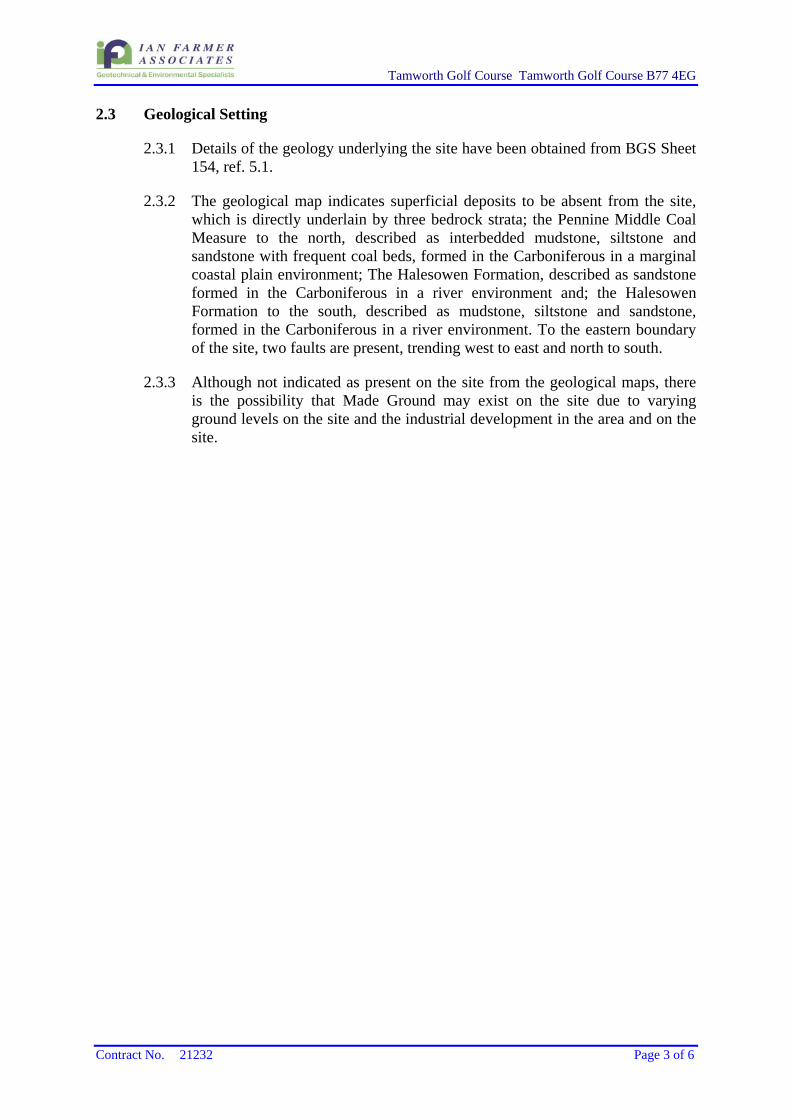
2.3 Geological Setting
2.3.1 Details of the geology underlying the site have been obtained from BGS Sheet 154, ref. 5.1.
2.3.2 The geological map indicates superficial deposits to be absent from the site, which is directly underlain by three bedrock strata; the Pennine Middle Coal Measure to the north, described as interbedded mudstone, siltstone and sandstone with frequent coal beds, formed in the Carboniferous in a marginal coastal plain environment; The Halesowen Formation, described as sandstone formed in the Carboniferous in a river environment and; the Halesowen Formation to the south, described as mudstone, siltstone and sandstone, formed in the Carboniferous in a river environment. To the eastern boundary of the site, two faults are present, trending west to east and north to south.
2.3.3 Although not indicated as present on the site from the geological maps, there is the possibility that Made Ground may exist on the site due to varying ground levels on the site and the industrial development in the area and on the site.

Tamworth Golf Course Tamworth Golf Course B77 4EG
Contract No. 21232 Page 4 of 6
3.0 SITE WORK
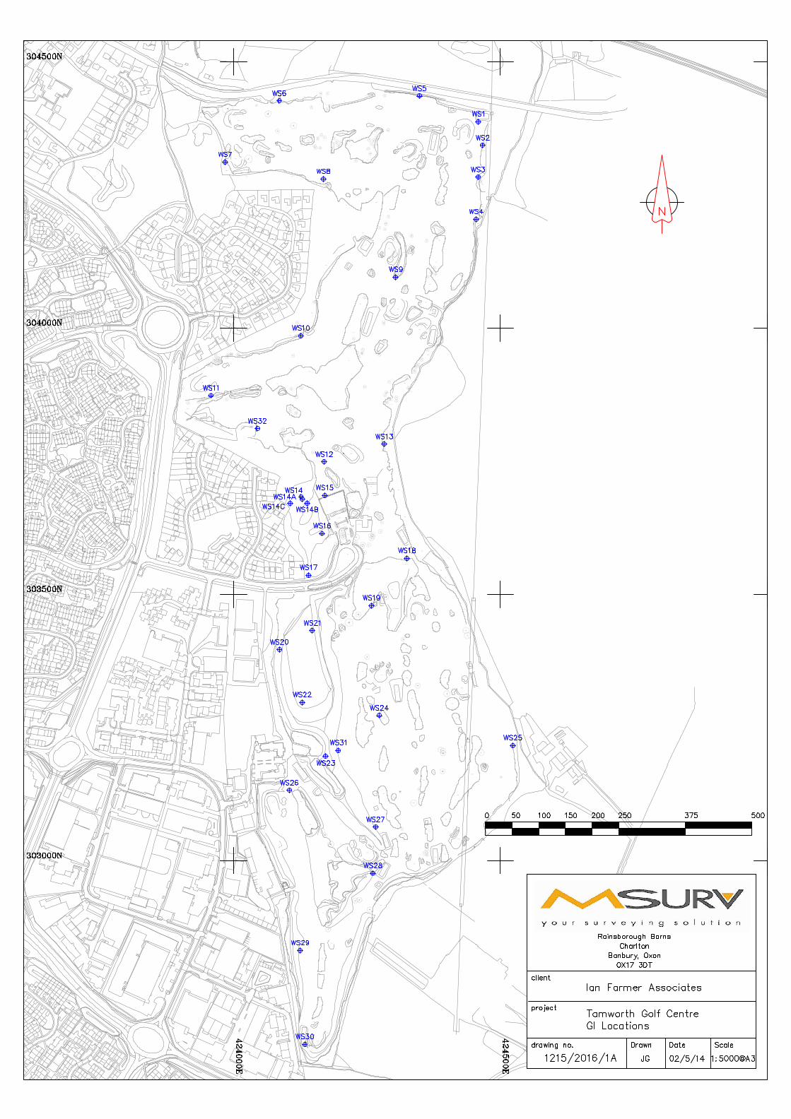
3.1 The site work was carried out between the 28th April and the 2nd May. The locations of exploratory holes were set out under instruction from the Engineer.
3.2 The site work has been carried out on the basis of the practices set out in BS 10175:2011, ref.5.2, BS 5930:2010 ref. 5.3 and ISO 1997:2007, ref 5.4. Additional references are noted within the table.
Exploratory Hole Type Quantity Hole Reference Depths Notes
Window sample boreholes
32 WS01 to WS32 1.20m to 9.0m With an additional three redrills
Slotted Standpipe Installations
13 WS01 to WS32 0.5m to 6.0m
50mm installations to monitor gas and water in the made ground and natural strata in 13 selected locations.
3.3 The positions of the above are shown on the exploratory hole location plan, Appendix 1, Figure 1215/2016/1.
3.4 The depths of the exploratory holes, descriptions of strata encountered and comments on groundwater conditions are given in the site work records in Appendix 2.
3.5 Representative disturbed and undisturbed samples were taken at the depths shown on the borehole records and despatched to the laboratory. Samples for environmental purposes were collected in appropriate containers and retained in a cool box.
3.6 Standard (split-barrel and cone) penetration tests, ref. 5.5 were carried out in the window sample boreholes in the various strata to assess the relative density or consistency. The values of penetration resistance are given in the borehole records.
3.7 Monitoring installations, protected by a stopcock cover were installed in 13 locations as detailed in the borehole records.
3.8 The coordinates and ground levels at the borehole, reported on the records, were surveyed in by MSURV on completion.
3.9 Upon completion of the siteworks, the boreholes instrumented with standpipes were monitored on six occasions at intervals specified by Atkins Limited for groundwater and gas levels. The gas levels monitored were oxygen, carbon dioxide, methane, carbon monoxide and hydrogen sulphide. The flow rate of each borehole was also monitored. The results are given in Appendix 5.
3.10 Groundwater and surface water samples were recovered and dispatched for testing on one occasion, the results of which are presented in Appendix 4, Test Report 14-09279 and 14-07371.

Tamworth Golf Course Tamworth Golf Course B77 4EG
Contract No. 21232 Page 5 of 6
4.0 LABORATORY TESTS
4.1 Geotechnical Testing
4.1.1 All soil samples were prepared in accordance with BS1377: 1990 ref. 5.66 and representative sub-samples were taken for testing. The following tests were carried out:
21 No. Moisture contents 19 No. Atterberg Limits 24 No. Particle size distribution by wet sieving 1 No. California bearing ratio 4 No. 2.5kg Compaction 7 No. Loss on Ignition 15 No. Calorific Value
4.1.2 The results of the testing are given in Appendix 3, Test Reports 21232, 14-07793 and 14-08246.
4.2 Chemical Testing
4.1.1 The suite of chemical analyses has been scheduled by Atkins Limited. The chemical analyses were carried out on 26 samples of soil and 10 samples of leachate. The nature of the analyses is detailed below:
Metals screen - arsenic, boron (water soluble), cadmium, chromium (total and hexavalent), copper, lead, mercury, nickel, selenium and zinc
Organic Screen – TPHCWG hydrocarbons, polycyclic aromatic hydrocarbons (PAH) – USEPA 16 suite, monohydric phenols
Inorganics Screen - sulphate (water soluble) Others - pH, organic matter, asbestos
4.1.2 Cchemical analyses were carried out on 4 groundwater and 3 surface water
samples. The nature of the analyses is detailed below:
Metals screen - arsenic, boron (water soluble), cadmium, chromium (total and hexavalent), copper, lead, mercury, nickel, selenium and zinc
Organic Screen – TPHCWG hydrocarbons, polycyclic aromatic hydrocarbons (PAH) – USEPA 16 suite, monohydric phenols
Inorganics Screen - sulphate (water soluble), total oxygen demand (biochemical and chemical), cyanide, ammoniacal nitrogen, chloride, nitrate, nitrite, nitrogen, ortho-phosphate
Others – pH, hardness,
The soil testing was carried out in accordance with the MCERTS performance standard, ref.5.7, and the results are shown in Appendix 4, Test Reports 14-06067 and 14-06068. The results of the ground and surface water analysis are shown in Appendix 4, Test Report 14-09279 and 14-07371.

Tamworth Golf Course Tamworth Golf Course B77 4EG
Contract No. 21232 Page 6 of 6
5.0 REFERENCES
5.1 BGS Sheet No 154, ‘Lichfield’, solid and drift edition, 1:50,000 scale. British Geological Survey 1926.
5.2 BS 10175: 2011 ‘Investigation of potentially contaminated sites. Code of practice’, British Standards Institute, 2011
5.3 BS 5930:1999+A2:2010 ‘Code of practice for site investigations’, British Standards Institute, 2010
5.4 ISO 1997, Part 2:2007, ‘Eurocode 7 – Geotechnical Design – Part 2, Ground Investigation and Design’.
5.5 ISO 22476 – 3:2005, ‘Geotechnical Investigation and Testing – Field Testing’ Part 3, Standard Penetration Test.
5.6 British Standard 1377:1990, ‘Methods of Test for Soils for Civil Engineering Purposes’.
5.7 MCERTS Performance Standard for Laboratories Undertaking Chemical Testing of Soil’ v2, Feb 2003.
5.8 ISO 14688 Part 1:2002 and Part 2:2004, ‘Geotechnical Investigation and Testing – Identification and Classification of Soil’.
For and on behalf of Ian Farmer Associates (1998) Limited
J H Walker A.C Owen BSc(Hons) MESci(Hons.) MRes FGS Graduate Engineering Geologist Principal Environmental Geologist

APPENDIX 1
DRAWINGS

Figure A1.1
Site Location Plan
Scale: NTS
21232Tamworth Golf Course
SITE

APPENDIX 2
SITE WORK

Appendix 2 pages ii/i-ii/ii ii/i
APPENDIX 2
GENERAL NOTES ON SITE WORKS
A2.1 SITE WORK
A2.1.1 General
Site work is carried out in general accordance with the guidelines given in ISO 1997, ref 5.4 and BS 5930, ref 5.3.
A2.1.2 Drive-in Window Sampler
The drive-in window sampler, consists generally of a track mounted window sampler and a series of cylindrical sample tubes, generally varying in diameter from 98mm to 35mm. A cutting shoe is fitted to the bottom of each tube, while a window, representing about a quarter of the circumference, is cut along the length of the tube. Soil samples are extracted through the window of the tube.
The sample tube is driven by a drop weight, which can also be used for dynamic probing and standard SPT tests and the borehole is extended by using progressively smaller diameter tubes.
Alternatively, undisturbed samples may be collected in plastic liners, known as windowless sampling.
A2.2 IN-SITU TESTS
A2.2.1 Standard Penetration Test
The Standard Penetration Test is carried out in accordance with the proposals recommended by ISO 1997, ref 5.4, BS 1377, Part 9, 1990 ref 5.6.
The standard penetration test, SPT, covers the determination of the resistance of soils to the penetration of a split barrel sampler. A 50mm diameter split barrel sampler is driven 450mm into the soil using a 63.5kg hammer with a 760mm drop. The penetration resistance is expressed as the number of blows required to obtain 300mm penetration below an initial seating drive of 150mm through any disturbed ground at the bottom of the borehole. The number of blows to achieve the standard penetration of 300mm is reported as the ‘N’ value.
The test is generally carried out in fine soils, however, it may also be carried out in coarse granular soils, weak rocks and glacial tills using the same procedure as for the SPT but with a 50mm diameter, 60° apex solid cone replacing the split spoon sampler, CPT.
When attempting the standard penetration test in very dense material or weathered rocks it may be necessary to terminate the test before completion to prevent damage to the equipment. In these circumstances it is important to distinguish how the blow count relates to the penetration of the sampler. This may be achieved in the following manner:
Where the seating drive has been completed, the test drive is terminated if 50 blows are reached before the full penetration of 300mm is achieved. The penetration for 50 blows is recorded and an approximate N value obtained by linear extrapolation of the number of blows for the partial test drive.
If the seating drive of 150mm is not achieved within the first 25 blows, the penetration after 25 blows is recorded and the test drive then commenced.
Appendix 2 pages ii/i-ii/ii ii/ii
For tests in soft rocks, the test drive should be terminated after 100 blows where the penetration of 300mm has not been achieved.
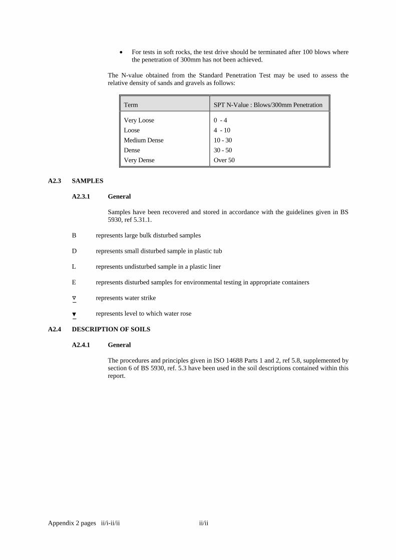
The N-value obtained from the Standard Penetration Test may be used to assess the relative density of sands and gravels as follows:
Term SPT N-Value : Blows/300mm Penetration
Very Loose
Loose
Medium Dense
Dense
Very Dense
0 - 4
4 - 10
10 - 30
30 - 50
Over 50
A2.3 SAMPLES
A2.3.1 General
Samples have been recovered and stored in accordance with the guidelines given in BS 5930, ref 5.31.1.
B represents large bulk disturbed samples
D represents small disturbed sample in plastic tub
L represents undisturbed sample in a plastic liner
E represents disturbed samples for environmental testing in appropriate containers
represents water strike
represents level to which water rose
A2.4 DESCRIPTION OF SOILS
A2.4.1 General
The procedures and principles given in ISO 14688 Parts 1 and 2, ref 5.8, supplemented by section 6 of BS 5930, ref. 5.3 have been used in the soil descriptions contained within this report.

Location
Ground Level (mOD)
Dates
Site
Client
Engineer
JobNumber
Sheet
Wate
r
Legend InstrDescriptionDepth
(m)(Thickness)
Depth(m)
Level(mOD)Sample / Tests
Remarks Scale(approx)
LoggedBy
Figure No.
21232.WS1
1:50 CW
Pit to 1.20m
Tamworth Golf Course
Tamworth Borough Council
Atkins Ltd
21232
WS1
Number
67.37
424458 E 304387 N28/04/2014
Produced by the GEOtechnical DAtabase SYstem (GEODASY) (C) all rights reserved
Excavation Method Dimensions
WaterDepth(m)
Field Records
Drive-in Window Sampler
1
(0.15) TOPSOIL67.22 0.15
(2.80)
MADE GROUND: Light brown, mottled grey, claywith rare oxidized black staining.
At 1.40m: Frequent oxidized black staining.
64.42 2.95
(0.85)
Yellow grey, fine to medium SAND with raresandstone cobble. (Pennine Middle CoalMeasures Formation)
63.57 3.80(0.20) Grey MUDSTONE, recovered as friable fragments
of gravel. (Pennine Middle Coal MeasuresFormation)
63.37 4.00
Complete at 4.00m
Groundwater not encountered.
0.50 E1
1.20-1.65 SPT N=12 1,3/2,3,3,41.20 D11.20-2.00 B11.50 E2
Seepage(1) at 2.00m.2.00-2.45 SPT N=24 1,1/3,4,7,102.00 D2
3.00-3.45 SPT N=19 3,4/4,4,5,63.00 D3
Excavating from 0.00m to 1.20m.
1/1

Location
Ground Level (mOD)
Dates
Site
Client
Engineer
JobNumber
Sheet
Wate
r
Legend InstrDescriptionDepth
(m)(Thickness)
Depth(m)
Level(mOD)Sample / Tests
Remarks Scale(approx)
LoggedBy
Figure No.
21232.WS2
1:50 HP
Pit to 1.20m
Tamworth Golf Course
Tamworth Borough Council
Atkins Ltd
21232
WS2
Number
66.93
424467 E 304343 N28/04/2014
Produced by the GEOtechnical DAtabase SYstem (GEODASY) (C) all rights reserved
Excavation Method Dimensions
WaterDepth(m)
Field Records
Drive-in Window Sampler
(0.15) TOPSOIL and grass.66.78 0.15(0.15)
MADE GROUND: Soft, dark brown to grey, sandy,slightly gravelly clay and frequent rootlets. Gravelis fine to coarse, angular to subangular sandstoneand occasional coal. (Colliery Spoil)
66.63 0.30
(0.60)
MADE GROUND: Soft to firm, brown mottled grey,sandy, slightly gravelly clay and frequent blackspecs and ash. (Colliery Spoil)
66.03 0.90
(1.10) MADE GROUND: Firm, red mottled grey, silty clay.(Reworked). (Colliery Spoil)
Below 1.40m: Brown, mottled grey, withfrequent black specks.
64.93 2.00
(0.90)
Firm, brown mottled grey, silty CLAY with somefine to coarse, angular to subangular mediumsized lithorelicts. (Pennine Middle Coal MeasuresFormation)
64.03 2.90Brown, slightly cemented, silty, fine SAND withsome fine to coarse, angular to subangular gravelsized lithorelicts. (Pennine Middle Coal MeasuresFormation)
63.93 3.00
Complete at 3.00m
Groundwater not encountered.
0.20 E1
0.50 B10.50 E2
1.00 B21.00 E31.20-1.65 SPT N=14 1,1/3,3,3,51.20 D11.40-2.00 B3
2.00-2.45 SPT N=14 2,2/2,3,4,52.00 D22.00-2.90 B4
3.00-3.45 SPT N=42 8,8/10,8,12,123.00 D3
Excavating from 0.00m to 1.20m.
1/1

Location
Ground Level (mOD)
Dates
Site
Client
Engineer
JobNumber
Sheet
Wate
r
Legend InstrDescriptionDepth
(m)(Thickness)
Depth(m)
Level(mOD)Sample / Tests
Remarks Scale(approx)
LoggedBy
Figure No.
21232.WS3
1:50 HP
Pit to 1.20m
Tamworth Golf Course
Tamworth Borough Council
Atkins Ltd
21232
WS3
Number
67.67
424458 E 304283 N28/04/2014
Produced by the GEOtechnical DAtabase SYstem (GEODASY) (C) all rights reserved
Excavation Method Dimensions
WaterDepth(m)
Field Records
Drive-in Window Sampler
1
1
(0.15) TOPSOIL and grass.67.52 0.15(0.15)
MADE GROUND: Soft, dark brown, very sandy,slightly gravelly, clay and frequent rootlets. Gravelis fine to coarse, angular to subangular sandstoneand coal. (Colliery Spoil)
67.37 0.30
(0.40)
MADE GROUND: Brown, damp, very gravelly,slightly clayey, fine to coarse, sand. Gravel is fineto coarse, angular to subangular sandstone.(Colliery Spoil)
66.97 0.70
(2.00)
Firm, brown mottled grey, silty CLAY withcarbonised inclusions. (Colliery Spoil)
At 1.10m: Red mottled grey.At 1.70m: Becoming sandy and slightlygravelly. Gravel is fine to coarse, angular tosubangular sandstone.Below 2.00m: Very sandy, and very gravelly.Gravel is fine to coarse, angular to subangularsandstone.
64.97 2.70(0.30)
Brown, mottled, clayey, fine to coarse SAND withsome black specs. (Halesowen Formation)
64.67 3.00Complete at 3.00m
0.20 E1
0.50 B10.50 E20.80 D1
1.10 D21.20-1.65 SPT N=15 2,2/2,4,4,51.20 D31.20-2.00 B2
Fast(1) at 2.00m, rose to0.85m in 20 mins.
2.00-2.45 SPT N=13 3,3/3,3,3,4
2.00 D42.00-2.70 B3
3.00-3.41 SPT 50/255 10,8/10,8,12,203.00 D5
Excavating from 0.00m to 1.20m.
1/1

Location
Ground Level (mOD)
Dates
Site
Client
Engineer
JobNumber
Sheet
Wate
r
Legend InstrDescriptionDepth
(m)(Thickness)
Depth(m)
Level(mOD)Sample / Tests
Remarks Scale(approx)
LoggedBy
Figure No.
21232.WS4
1:50 HP
Pit to 1.20m
Tamworth Golf Course
Tamworth Borough Council
Atkins Ltd
21232
WS4
Number
67.64
424454 E 304204 N28/04/2014
Produced by the GEOtechnical DAtabase SYstem (GEODASY) (C) all rights reserved
Excavation Method Dimensions
WaterDepth(m)
Field Records
Drive-in Window Sampler
(0.15) TOPSOIL and grass.67.49 0.15(0.20)
MADE GROUND: Soft, dark brown, sandy, slightlygravelly, clay and frequent rootlets. Gravel is fineto coarse, angular to subangular, sandstone, coal,brick and glass. (Colliery Spoil)
67.29 0.35
(0.85)
MADE GROUND: Soft, brown mottled grey, silty,sandy clay and frequent black specks. (Reworked)(Colliery Spoil)66.44 1.20
(0.60)Soft, dark, very sandy, brown mottled grey, siltyCLAY. (Superficial Deposits)
65.84 1.80
(0.65)
Firm, brown mottled grey, silty CLAY. (SuperficialDeposits)
Below 1.90m: Grey.
65.19 2.45Complete at 2.45m
Groundwater not encountered.
0.20 E1
0.80 B10.80 E2
1.20-1.65 SPT N=5 1/1,1,2,11.20 D11.20-1.80 B2
2.00-2.45 SPT N=15 2,2/2,4,4,52.00 D2
Excavating from 0.00m to 1.20m.
1/1
Location
Ground Level (mOD)
Dates
Site
Client
Engineer
JobNumber
Sheet
Wate
r
LegendDescriptionDepth
(m)(Thickness)
Depth(m)
Level(mOD)Sample / Tests
Remarks Scale(approx)
LoggedBy
Figure No.
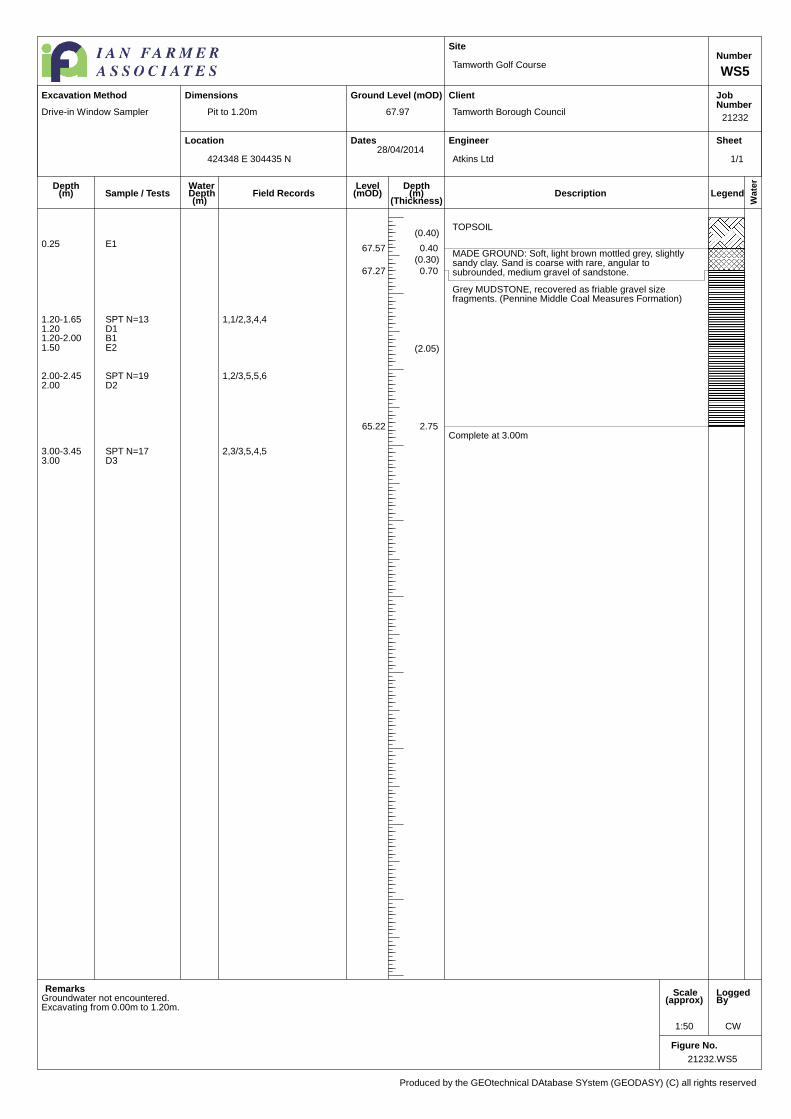
21232.WS5
1:50 CW
Pit to 1.20m
Tamworth Golf Course
Tamworth Borough Council
Atkins Ltd
21232
WS5
Number
67.97
424348 E 304435 N28/04/2014
Produced by the GEOtechnical DAtabase SYstem (GEODASY) (C) all rights reserved
Excavation Method Dimensions
WaterDepth(m)
Field Records
Drive-in Window Sampler
(0.40)TOPSOIL
67.57 0.40(0.30)
MADE GROUND: Soft, light brown mottled grey, slightlysandy clay. Sand is coarse with rare, angular tosubrounded, medium gravel of sandstone.67.27 0.70
(2.05)
Grey MUDSTONE, recovered as friable gravel sizefragments. (Pennine Middle Coal Measures Formation)
65.22 2.75Complete at 3.00m
Groundwater not encountered.
0.25 E1
1.20-1.65 SPT N=13 1,1/2,3,4,41.20 D11.20-2.00 B11.50 E2
2.00-2.45 SPT N=19 1,2/3,5,5,62.00 D2
3.00-3.45 SPT N=17 2,3/3,5,4,53.00 D3
Excavating from 0.00m to 1.20m.
1/1
Location
Ground Level (mOD)
Dates
Site
Client
Engineer
JobNumber
Sheet
Wate
r
LegendDescriptionDepth
(m)(Thickness)
Depth(m)
Level(mOD)Sample / Tests
Remarks Scale(approx)
LoggedBy
Figure No.
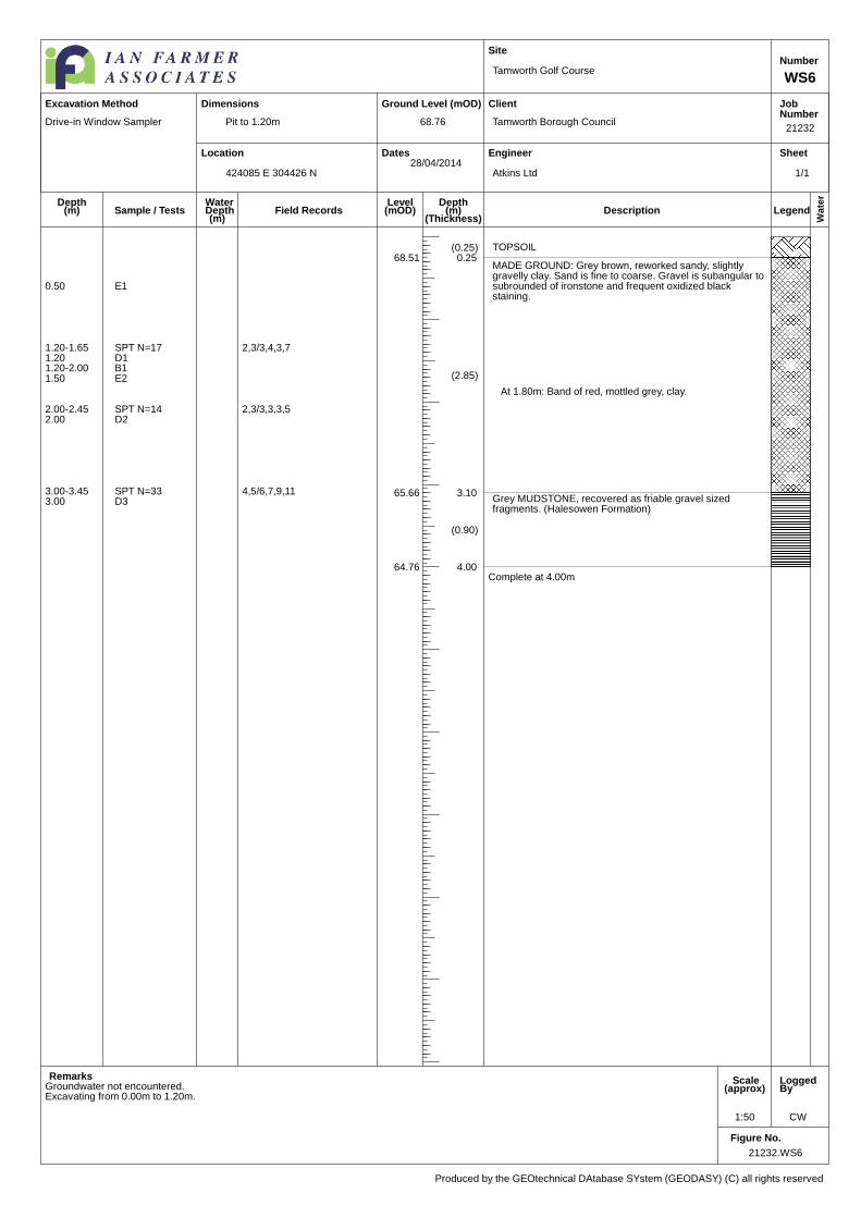
21232.WS6
1:50 CW
Pit to 1.20m
Tamworth Golf Course
Tamworth Borough Council
Atkins Ltd
21232
WS6
Number
68.76
424085 E 304426 N28/04/2014
Produced by the GEOtechnical DAtabase SYstem (GEODASY) (C) all rights reserved
Excavation Method Dimensions
WaterDepth(m)
Field Records
Drive-in Window Sampler
(0.25) TOPSOIL68.51 0.25
(2.85)
MADE GROUND: Grey brown, reworked sandy, slightlygravelly clay. Sand is fine to coarse. Gravel is subangular tosubrounded of ironstone and frequent oxidized blackstaining.
At 1.80m: Band of red, mottled grey, clay.
65.66 3.10
(0.90)
Grey MUDSTONE, recovered as friable gravel sizedfragments. (Halesowen Formation)
64.76 4.00Complete at 4.00m
Groundwater not encountered.
0.50 E1
1.20-1.65 SPT N=17 2,3/3,4,3,71.20 D11.20-2.00 B11.50 E2
2.00-2.45 SPT N=14 2,3/3,3,3,52.00 D2
3.00-3.45 SPT N=33 4,5/6,7,9,113.00 D3
Excavating from 0.00m to 1.20m.
1/1
Location
Ground Level (mOD)
Dates
Site
Client
Engineer
JobNumber
Sheet
Wate
r
Legend InstrDescriptionDepth
(m)(Thickness)
Depth(m)
Level(mOD)Sample / Tests
Remarks Scale(approx)
LoggedBy
Figure No.
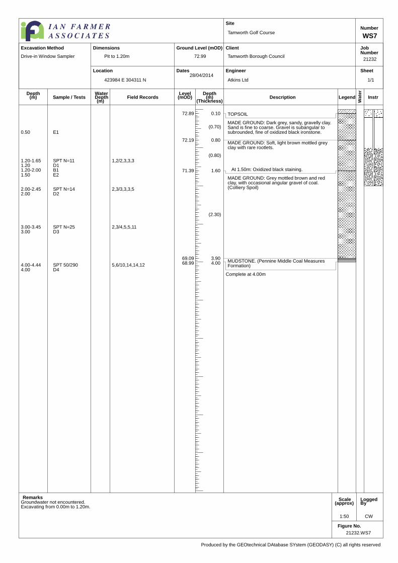
21232.WS7
1:50 CW
Pit to 1.20m
Tamworth Golf Course
Tamworth Borough Council
Atkins Ltd
21232
WS7
Number
72.99
423984 E 304311 N28/04/2014
Produced by the GEOtechnical DAtabase SYstem (GEODASY) (C) all rights reserved
Excavation Method Dimensions
WaterDepth(m)
Field Records
Drive-in Window Sampler
TOPSOIL72.89 0.10
(0.70)MADE GROUND: Dark grey, sandy, gravelly clay.Sand is fine to coarse. Gravel is subangular tosubrounded, fine of oxidized black ironstone.
72.19 0.80
(0.80)
MADE GROUND: Soft, light brown mottled greyclay with rare rootlets.
At 1.50m: Oxidized black staining.71.39 1.60
(2.30)
MADE GROUND: Grey mottled brown and redclay, with occasional angular gravel of coal.(Colliery Spoil)
69.09 3.90MUDSTONE. (Pennine Middle Coal MeasuresFormation)
68.99 4.00
Complete at 4.00m
Groundwater not encountered.
0.50 E1
1.20-1.65 SPT N=11 1,2/2,3,3,31.20 D11.20-2.00 B11.50 E2
2.00-2.45 SPT N=14 2,3/3,3,3,52.00 D2
3.00-3.45 SPT N=25 2,3/4,5,5,113.00 D3
4.00-4.44 SPT 50/290 5,6/10,14,14,124.00 D4
Excavating from 0.00m to 1.20m.
1/1
Location
Ground Level (mOD)
Dates
Site
Client
Engineer
JobNumber
Sheet
Wate
r
LegendDescriptionDepth
(m)(Thickness)
Depth(m)
Level(mOD)Sample / Tests
Remarks Scale(approx)
LoggedBy
Figure No.
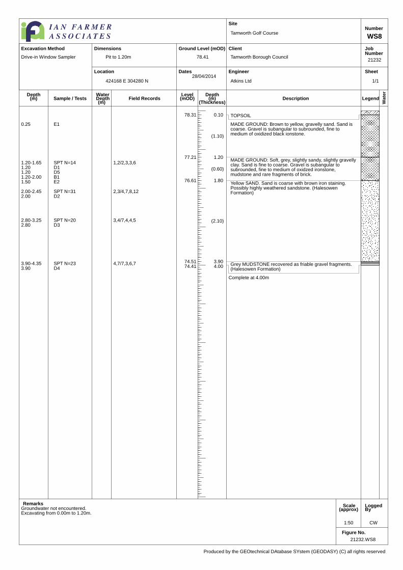
21232.WS8
1:50 CW
Pit to 1.20m
Tamworth Golf Course
Tamworth Borough Council
Atkins Ltd
21232
WS8
Number
78.41
424168 E 304280 N28/04/2014
Produced by the GEOtechnical DAtabase SYstem (GEODASY) (C) all rights reserved
Excavation Method Dimensions
WaterDepth(m)
Field Records
Drive-in Window Sampler
TOPSOIL78.31 0.10
(1.10)
MADE GROUND: Brown to yellow, gravelly sand. Sand iscoarse. Gravel is subangular to subrounded, fine tomedium of oxidized black ionstone.
77.21 1.20
(0.60)
MADE GROUND: Soft, grey, slightly sandy, slightly gravellyclay. Sand is fine to coarse. Gravel is subangular tosubrounded, fine to medium of oxidzed ironstone,mudstone and rare fragments of brick.
76.61 1.80
(2.10)
Yellow SAND. Sand is coarse with brown iron staining.Possibly highly weathered sandstone. (HalesowenFormation)
74.51 3.90Grey MUDSTONE recovered as friable gravel fragments.(Halesowen Formation)
74.41 4.00
Complete at 4.00m
Groundwater not encountered.
0.25 E1
1.20-1.65 SPT N=14 1,2/2,3,3,61.20 D11.20 D51.20-2.00 B11.50 E2
2.00-2.45 SPT N=31 2,3/4,7,8,122.00 D2
2.80-3.25 SPT N=20 3,4/7,4,4,52.80 D3
3.90-4.35 SPT N=23 4,7/7,3,6,73.90 D4
Excavating from 0.00m to 1.20m.
1/1

Location
Ground Level (mOD)
Dates
Site
Client
Engineer
JobNumber
Sheet
Wate
r
LegendDescriptionDepth
(m)(Thickness)
Depth(m)
Level(mOD)Sample / Tests
Remarks Scale(approx)
LoggedBy
Figure No.
21232.WS9
1:50 HP
Pit to 1.20m
Tamworth Golf Course
Tamworth Borough Council
Atkins Ltd
21232
WS9
Number
71.06
424304 E 304095 N28/04/2014
Produced by the GEOtechnical DAtabase SYstem (GEODASY) (C) all rights reserved
Excavation Method Dimensions
WaterDepth(m)
Field Records
Drive-in Window Sampler
(0.15) TOPSOIL and grass.70.91 0.15
MADE GROUND: Soft, dark brown, slightly sandy, slightlygravelly clay. Gravel is fine to coarse, angular to subangularsandstone and ash. (Colliery Spoil)
70.81 0.25(0.35)
MADE GROUND: Soft, brown to dark brown, slightly sandy,slightly gravelly clay. Gravel is fine to coarse sandstone andash. (Colliery Spoil)
70.46 0.60
(1.30) Firm, brown/orange brown mottled grey, silty CLAY.(Superficial Deposits)
69.16 1.90Brown/orange brown, very silty, slightly cemented, fine tocoarse SAND. (Halesowen Formation)
69.06 2.00
Complete at 2.00m
Groundwater not encountered
0.20 E1
0.50 B10.50 E2
1.00 B2
1.20-1.65 SPT N=11 2,2/2,3,3,31.20 D11.20-1.90 B3
2.00-2.33 SPT 50/181 5,9/14,15,212.00 D2
Excavating from 0.00m to 1.20m.
1/1

Location
Ground Level (mOD)
Dates
Site
Client
Engineer
JobNumber
Sheet
Wate
r
Legend InstrDescriptionDepth
(m)(Thickness)
Depth(m)
Level(mOD)Sample / Tests
Remarks Scale(approx)
LoggedBy
Figure No.
21232.WS10
1:50 CW
Pit to 1.20m
Tamworth Golf Course
Tamworth Borough Council
Atkins Ltd
21232
WS10
Number
79.38
424126 E 303986 N29/04/2014
Produced by the GEOtechnical DAtabase SYstem (GEODASY) (C) all rights reserved
Excavation Method Dimensions
WaterDepth(m)
Field Records
Drive-in Window Sampler
1
(0.15) TOPSOIL79.23 0.15
(0.45) MADE GROUND: Black, sandy, silty, slightlyclayey gravel. Sand is fine to coarse. Gravel issubangular to subrounded, fine to medium of ash,clinker, ironstone and rare red burnt shale.(Colliery Spoil)
78.78 0.60
(1.40)
MADE GROUND: Yellow, reworked, silty, clayey,sand and gravel. Sand is coarse. Gravel issubangular to subrounded, fine to medium ofsandstone.
77.38 2.00
(1.10)
MADE GROUND: Grey, reworked, mottled brownclay with occasional oxidized iron staining.
76.28 3.10
(0.90)
Grey, weak MUDSTONE, recovered as friablegravel fragments. (Halesowen Formation)
75.38 4.00Complete at 4.00m
0.50 E1
1.20-1.65 SPT N=9 1,2/2,1,2,41.20 D11.20-2.00 B11.50 E2
Water strike(1) at 2.00m.2.00-2.45 SPT N=18 2,2/4,4,5,52.00 D2
3.00-3.45 SPT N=18 3,3/3,4,5,63.00 D33.10 B2
4.00-4.45 SPT N=37 6,6/7,10,10,104.00 D4
Excavating from 0.00m to 1.20m.
1/1

Location
Ground Level (mOD)
Dates
Site
Client
Engineer
JobNumber
Sheet
Wate
r
LegendDescriptionDepth
(m)(Thickness)
Depth(m)
Level(mOD)Sample / Tests
Remarks Scale(approx)
LoggedBy
Figure No.
21232.WS11
1:50 CW
Pit to 1.20m
Tamworth Golf Course
Tamworth Borough Council
Atkins Ltd
21232
WS11
Number
82.31
423957 E 303873 N29/04/2014
Produced by the GEOtechnical DAtabase SYstem (GEODASY) (C) all rights reserved
Excavation Method Dimensions
WaterDepth(m)
Field Records
Drive-in Window Sampler
(0.30) TOPSOIL
82.01 0.30
(2.70)
MADE GROUND: Brown reworked mottled grey clay.
Between 1.45m and 1.60m: Band of red mottled greyclay with rare, subangular to subrounded, fine tomedium gravel of ironstone and ash.
79.31 3.00Light grey, weak, fissured siltstone with oxidized ironstaining. (Haleswoen Formation)
79.21 3.10
Complete at 3.10m
Groundwater not encountered.
0.50 E1
1.20-1.65 SPT N=16 1,2/3,4,4,51.20 D11.20-2.00 B1
2.00-2.45 SPT N=25 3,4/5,4,6,102.00 B22.00 D2
2.50 E2
3.00-3.40 SPT 50/245 8,8/20,20,103.00 D3
Excavating from 0.00m to 1.20m.
1/1

Location
Ground Level (mOD)
Dates
Site
Client
Engineer
JobNumber
Sheet
Wate
r
LegendDescriptionDepth
(m)(Thickness)
Depth(m)
Level(mOD)Sample / Tests
Remarks Scale(approx)
LoggedBy
Figure No.
21232.WS12
1:50 CW
Pit to 1.20m
Tamworth Golf Course
Tamworth Borough Council
Atkins Ltd
21232
WS12
Number
84.01
424169 E 303749 N29/04/2014
Produced by the GEOtechnical DAtabase SYstem (GEODASY) (C) all rights reserved
Excavation Method Dimensions
WaterDepth(m)
Field Records
Drive-in Window Sampler
(0.20) TOPSOIL83.81 0.20
(3.60)
MADE GROUND: Black, sandy, slightly clayey gravel. Sandis fine to coarse. Gravel is angular to subangular, fine tomedium of concrete, slag, brick, siltstone, coal, clinker, ashand mudstone. (Colliery Spoil)
Between 0.90m and 1.00m: Band of red, slightlygravelly clay.At 1.00m: Increase in coal fragments.
80.21 3.80(0.20) Soft, grey, mottled brown CLAY with occasional subrounded
to rounded, fine to medium gravel of ironstone. (PennineMiddle Coal Measures Formation)
80.01 4.00
Complete at 4.00m
Groundwater not encountered.
0.50 E1
1.20-1.65 SPT N=8 1,2/2,2,2,21.20 D11.20-2.00 B1
2.00-2.45 SPT N=17 4,4/6,5,3,32.00 D2
2.50 E2
3.00-3.45 SPT N=9 2,1/2,2,2,33.00 D3
4.00-4.45 SPT N=20 5,4/5,5,5,54.00 D4
Excavating from 0.00m to 1.20m.
1/1
Location
Ground Level (mOD)
Dates
Site
Client
Engineer
JobNumber
Sheet
Wate
r
LegendDescriptionDepth
(m)(Thickness)
Depth(m)
Level(mOD)Sample / Tests
Remarks Scale(approx)
LoggedBy
Figure No.
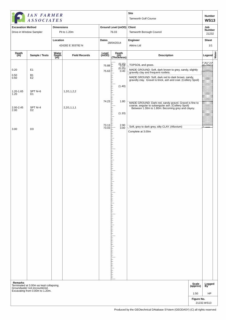
21232.WS13
1:50 HP
Pit to 1.20m
Tamworth Golf Course
Tamworth Borough Council
Atkins Ltd
21232
WS13
Number
76.03
424282 E 303782 N28/04/2014
Produced by the GEOtechnical DAtabase SYstem (GEODASY) (C) all rights reserved
Excavation Method Dimensions
WaterDepth(m)
Field Records
Drive-in Window Sampler
(0.15) TOPSOIL and grass.75.88 0.15(0.25)
MADE GROUND: Soft, dark brown to grey, sandy, slightlygravelly clay and frequent rootlets.
75.63 0.40
(1.40)
MADE GROUND: Soft, dark red to dark brown, sandy,gravelly clay. Gravel is brick, ash and coal. (Colliery Spoil)
74.23 1.80
(1.10)
MADE GROUND: Dark red, sandy gravel. Gravel is fine tocoarse, angular to subangular ash. (Colliery Spoil)
Between 1.30m to 1.80m: Becoming grey and clayey.
73.13 2.90Soft, grey to dark grey, silty CLAY. (Alluvium)73.03 3.00
Complete at 3.00m
Terminated at 3.00m as kept collapsing.Groundwater not encountered.
0.20 E1
0.50 B10.50 E2
1.20-1.65 SPT N=6 1,2/1,1,2,21.20 D1
2.00-2.45 SPT N=4 2,2/1,1,1,12.00 D2
3.00 D3
Excavating from 0.00m to 1.20m.
1/1

Location
Ground Level (mOD)
Dates
Site
Client
Engineer
JobNumber
Sheet
Wate
r
LegendDescriptionDepth
(m)(Thickness)
Depth(m)
Level(mOD)Sample / Tests
Remarks Scale(approx)
LoggedBy
Figure No.
21232.WS14
1:50 CW
Tamworth Golf Course
Tamworth Borough Council
Atkins Ltd
21232
WS14
Number
87.87
424126 E 303683 N29/04/2014
Produced by the GEOtechnical DAtabase SYstem (GEODASY) (C) all rights reserved
Excavation Method Dimensions
WaterDepth(m)
Field Records
Drive-in Window Sampler
TOPSOIL.87.82 0.05
(0.35)MADE GROUND: Red brown, sand and gravel. Sand is fineto coarse. Gravel is angular to subangular of red shale.
87.47 0.40
Complete at 0.40m
Terminated at 0.40m as ground was too compacted to dig.
0.25 E1
1/1
Location
Ground Level (mOD)
Dates
Site
Client
Engineer
JobNumber
Sheet
Wate
r
LegendDescriptionDepth
(m)(Thickness)
Depth(m)
Level(mOD)Sample / Tests
Remarks Scale(approx)
LoggedBy
Figure No.
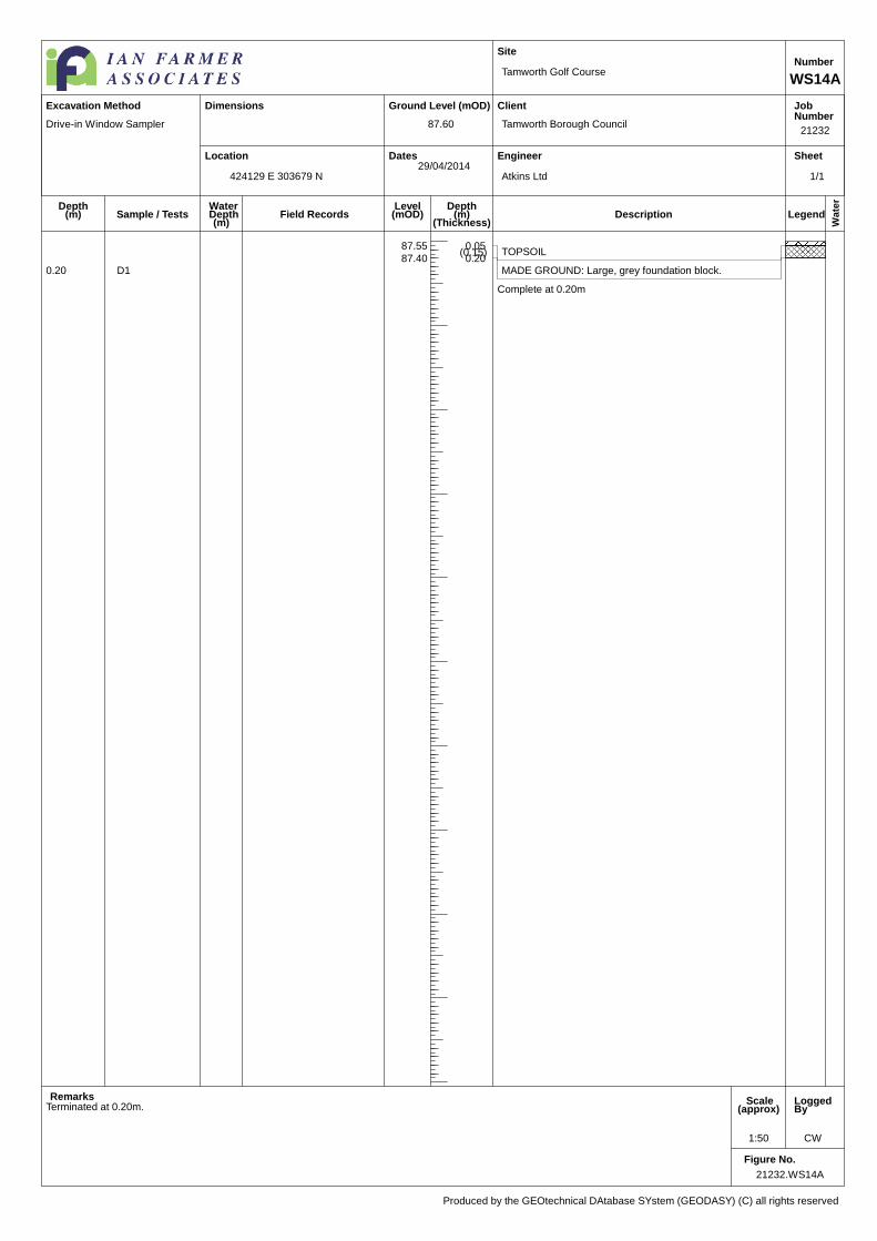
21232.WS14A
1:50 CW
Tamworth Golf Course
Tamworth Borough Council
Atkins Ltd
21232
WS14A
Number
87.60
424129 E 303679 N29/04/2014
Produced by the GEOtechnical DAtabase SYstem (GEODASY) (C) all rights reserved
Excavation Method Dimensions
WaterDepth(m)
Field Records
Drive-in Window Sampler
TOPSOIL87.55 0.05
(0.15)
MADE GROUND: Large, grey foundation block.87.40 0.20
Complete at 0.20m
Terminated at 0.20m.
0.20 D1
1/1

Location
Ground Level (mOD)
Dates
Site
Client
Engineer
JobNumber
Sheet
Wate
r
LegendDescriptionDepth
(m)(Thickness)
Depth(m)
Level(mOD)Sample / Tests
Remarks Scale(approx)
LoggedBy
Figure No.
21232.WS14B
1:50
Pit to 0.70m
Tamworth Golf Course
Tamworth Borough Council
Atkins Ltd
21232
WS14B
Number
87.78
424137 E 303671 N29/04/2014
Produced by the GEOtechnical DAtabase SYstem (GEODASY) (C) all rights reserved
Excavation Method Dimensions
WaterDepth(m)
Field Records
Drive-in Window Sampler
TOPSOIL.87.73 0.05
(0.65) MADE GROUND: Grey black, sandy, gravelly clay. Sand isfine to coarse. Gravel is angular to subangular of coal, redburnt shale, grey brick and mudstone.
87.08 0.70Complete at 0.70m
Terminate at 0.70m.Groundwater not encountered.
0.70 E1
Excavating from 0.00m to 0.70m.
1/1
Location
Ground Level (mOD)
Dates
Site
Client
Engineer
JobNumber
Sheet
Wate
r
LegendDescriptionDepth
(m)(Thickness)
Depth(m)
Level(mOD)Sample / Tests
Remarks Scale(approx)
LoggedBy
Figure No.
21232.WS14
1:50 CW
Pit to 1.20m
Tamworth Golf Course
Tamworth Borough Council
Atkins Ltd
21232
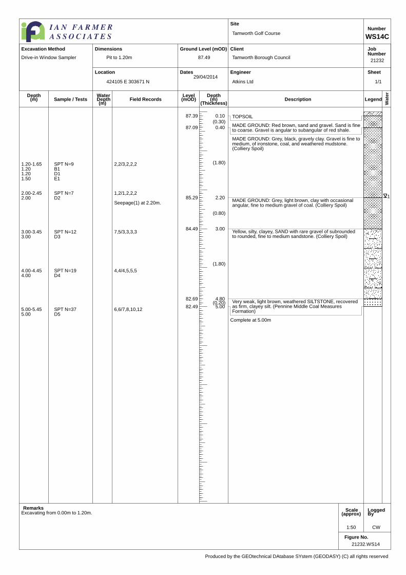
WS14C
Number
87.49
424105 E 303671 N29/04/2014
Produced by the GEOtechnical DAtabase SYstem (GEODASY) (C) all rights reserved
Excavation Method Dimensions
WaterDepth(m)
Field Records
Drive-in Window Sampler
1
TOPSOIL87.39 0.10(0.30)
MADE GROUND: Red brown, sand and gravel. Sand is fineto coarse. Gravel is angular to subangular of red shale.
87.09 0.40
(1.80)
MADE GROUND: Grey, black, gravely clay. Gravel is fine tomedium, of ironstone, coal, and weathered mudstone.(Colliery Spoil)
85.29 2.20
(0.80)
MADE GROUND: Grey, light brown, clay with occasionalangular, fine to medium gravel of coal. (Colliery Spoil)
84.49 3.00
(1.80)
Yellow, silty, clayey, SAND with rare gravel of subroundedto rounded, fine to medium sandstone. (Colliery Spoil)
82.69 4.80(0.20) Very weak, light brown, weathered SILTSTONE, recovered
as firm, clayey silt. (Pennine Middle Coal MeasuresFormation)
82.49 5.00
Complete at 5.00m
1.20-1.65 SPT N=9 2,2/3,2,2,21.20 B11.20 D11.50 E1
2.00-2.45 SPT N=7 1,2/1,2,2,22.00 D2
Seepage(1) at 2.20m.
3.00-3.45 SPT N=12 7,5/3,3,3,33.00 D3
4.00-4.45 SPT N=19 4,4/4,5,5,54.00 D4
5.00-5.45 SPT N=37 6,6/7,8,10,125.00 D5
Excavating from 0.00m to 1.20m.
1/1

Location
Ground Level (mOD)
Dates
Site
Client
Engineer
JobNumber
Sheet
Wate
r
Legend InstrDescriptionDepth
(m)(Thickness)
Depth(m)
Level(mOD)Sample / Tests
Remarks Scale(approx)
LoggedBy
Figure No.
21232.WS15
1:50 CW
Pit to 1.20m
Tamworth Golf Course
Tamworth Borough Council
Atkins Ltd
21232
WS15
Number
88.04
424170 E 303686 N29/04/2014
Produced by the GEOtechnical DAtabase SYstem (GEODASY) (C) all rights reserved
Excavation Method Dimensions
WaterDepth(m)
Field Records
Drive-in Window Sampler
1
2
TOPSOIL87.94 0.10
(0.90)
MADE GROUND: Black, sandy, slightly clayeygravel. Sand is coarse. Gravel is angular tosubrounded, of clinker, ash, brick, siltstone withrare cobbles of brick. (Colliery Spoil)
87.04 1.00
(0.50)
MADE GROUND: Black, sandy, slightly clayey,gravel. Sand is fine to coarse. Gravel is angular tosubrounded, fine to medium concrete, slag, brick,siltstone, coal, clinker, ash and mudstone. (CollierySpoil)
86.54 1.50
(2.40)
MADE GROUND: Light grey, clayey, gravel.Gravel is angular to subangular, fine to medium ofsiltstone. (Colliery Spoil)
84.14 3.90
(1.00)
MADE GROUND: Grey clay with occasionalangular to subangular, fine to medium fragmentsof coal. (Colliery Spoil)
83.14 4.90
(1.90)
MADE GROUND: Dark brown to red, angular tosubangular, fine to medium gravel of ironstone andred burnt shale. (Colliery Spoil)
81.24 6.80(0.20) Soft, dark grey, silty, slightly sandy clay with
oxidized black organic matter. Sand is fine.(Alluvium)
81.04 7.00
Complete at 7.00m
0.50 E1
1.20-1.65 SPT N=7 1,1/1,2,2,21.20 D11.20-2.00 B11.50 E2
2.00-2.45 SPT N=10 1,2/2,2,3,32.00 D2
Seepage(1) at 2.60m.
3.00-3.45 SPT N=9 2,3/2,2,2,33.00 D3
4.00-4.45 SPT N=7 2,1/1,2,2,24.00 D4
5.00-5.45 SPT N=14 1,1/3,3,3,55.00 D5
6.00-6.45 SPT N=9 3,3/2,2,2,36.00 D6
Seepage(2) at 6.70m.
7.00-7.45 SPT N=12 1,1/1,1,5,57.00 D7
Excavating from 0.00m to 1.20m.
1/1
Location
Ground Level (mOD)
Dates
Site
Client
Engineer
JobNumber
Sheet
Wate
r
LegendDescriptionDepth
(m)(Thickness)
Depth(m)
Level(mOD)Sample / Tests
Remarks Scale(approx)
LoggedBy
Figure No.
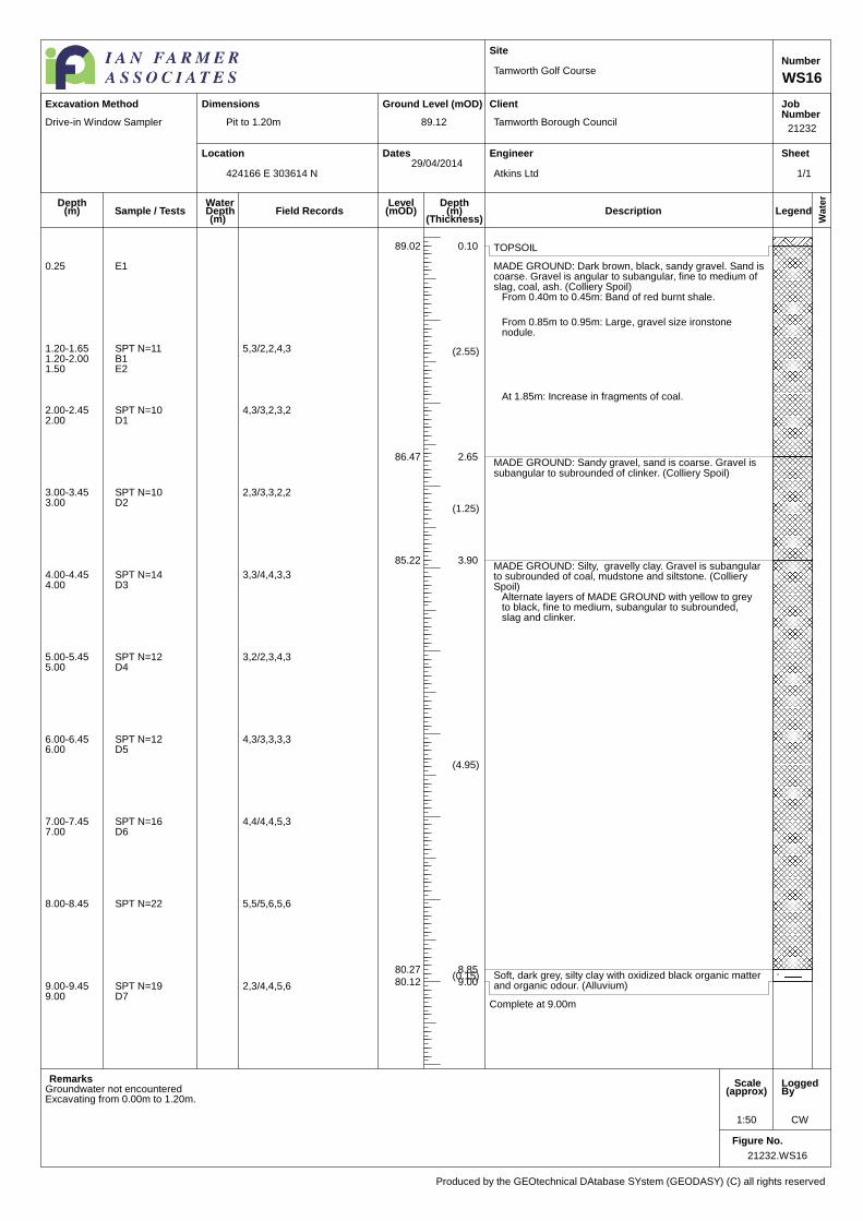
21232.WS16
1:50 CW
Pit to 1.20m
Tamworth Golf Course
Tamworth Borough Council
Atkins Ltd
21232
WS16
Number
89.12
424166 E 303614 N29/04/2014
Produced by the GEOtechnical DAtabase SYstem (GEODASY) (C) all rights reserved
Excavation Method Dimensions
WaterDepth(m)
Field Records
Drive-in Window Sampler
TOPSOIL89.02 0.10
(2.55)
MADE GROUND: Dark brown, black, sandy gravel. Sand iscoarse. Gravel is angular to subangular, fine to medium ofslag, coal, ash. (Colliery Spoil)
From 0.40m to 0.45m: Band of red burnt shale.
From 0.85m to 0.95m: Large, gravel size ironstonenodule.
At 1.85m: Increase in fragments of coal.
86.47 2.65
(1.25)
MADE GROUND: Sandy gravel, sand is coarse. Gravel issubangular to subrounded of clinker. (Colliery Spoil)
85.22 3.90
(4.95)
MADE GROUND: Silty, gravelly clay. Gravel is subangularto subrounded of coal, mudstone and siltstone. (CollierySpoil)
Alternate layers of MADE GROUND with yellow to greyto black, fine to medium, subangular to subrounded,slag and clinker.
80.27 8.85(0.15) Soft, dark grey, silty clay with oxidized black organic matter
and organic odour. (Alluvium)80.12 9.00
Complete at 9.00m
Groundwater not encountered
0.25 E1
1.20-1.65 SPT N=11 5,3/2,2,4,31.20-2.00 B11.50 E2
2.00-2.45 SPT N=10 4,3/3,2,3,22.00 D1
3.00-3.45 SPT N=10 2,3/3,3,2,23.00 D2
4.00-4.45 SPT N=14 3,3/4,4,3,34.00 D3
5.00-5.45 SPT N=12 3,2/2,3,4,35.00 D4
6.00-6.45 SPT N=12 4,3/3,3,3,36.00 D5
7.00-7.45 SPT N=16 4,4/4,4,5,37.00 D6
8.00-8.45 SPT N=22 5,5/5,6,5,6
9.00-9.45 SPT N=19 2,3/4,4,5,69.00 D7
Excavating from 0.00m to 1.20m.
1/1
Location
Ground Level (mOD)
Dates
Site
Client
Engineer
JobNumber
Sheet
Wate
r
Legend InstrDescriptionDepth
(m)(Thickness)
Depth(m)
Level(mOD)Sample / Tests
Remarks Scale(approx)
LoggedBy
Figure No.
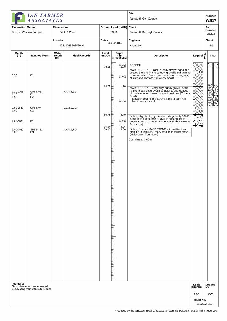
21232.WS17
1:50 CW
Pit to 1.20m
Tamworth Golf Course
Tamworth Borough Council
Atkins Ltd
21232
WS17
Number
89.15
424140 E 303536 N30/04/2014
Produced by the GEOtechnical DAtabase SYstem (GEODASY) (C) all rights reserved
Excavation Method Dimensions
WaterDepth(m)
Field Records
Drive-in Window Sampler
(0.20) TOPSOIL.88.95 0.20
(0.90)
MADE GROUND: Black, slightly clayey, sand andgravel. Sand is fine to coarse, gravel is subangularto subrounded, fine to medium of mudstone, ash,clinker and ironstone. (Colliery Spoil)
88.05 1.10
(1.30)
MADE GROUND: Grey, silty, sandy gravel. Sandis fine to coarse, gravel is angular to subrounded,of mudstone and rare coal and ironstone. (CollierySpoil)
Between 0.95m and 1.10m: Band of dark red,fine to coarse sand.
86.75 2.40
(0.55)
Yellow, slightly clayey, occasionaly gravelly SAND.Sand is fine to coarse. Gravel is subangular tosubrounded of weathered sandstone. (HalesowenFormation)
86.20 2.95Yellow, fissured SANDSTONE with oxidized ironstaining in fissures. Recovered as medium gravel.(Halesowen Formation)
86.15 3.00
Complete at 3.00m
Groundwater not encountered.
0.50 E1
1.20-1.65 SPT N=13 4,4/4,3,3,31.20 D11.50 E2
2.00-2.45 SPT N=7 2,1/2,1,2,22.00 D2
2.65-3.00 B1
3.00-3.45 SPT N=21 4,4/4,5,7,53.00 D3
Excavating from 0.00m to 1.20m.
1/1
Location
Ground Level (mOD)
Dates
Site
Client
Engineer
JobNumber
Sheet
Wate
r
LegendDescriptionDepth
(m)(Thickness)
Depth(m)
Level(mOD)Sample / Tests
Remarks Scale(approx)
LoggedBy
Figure No.
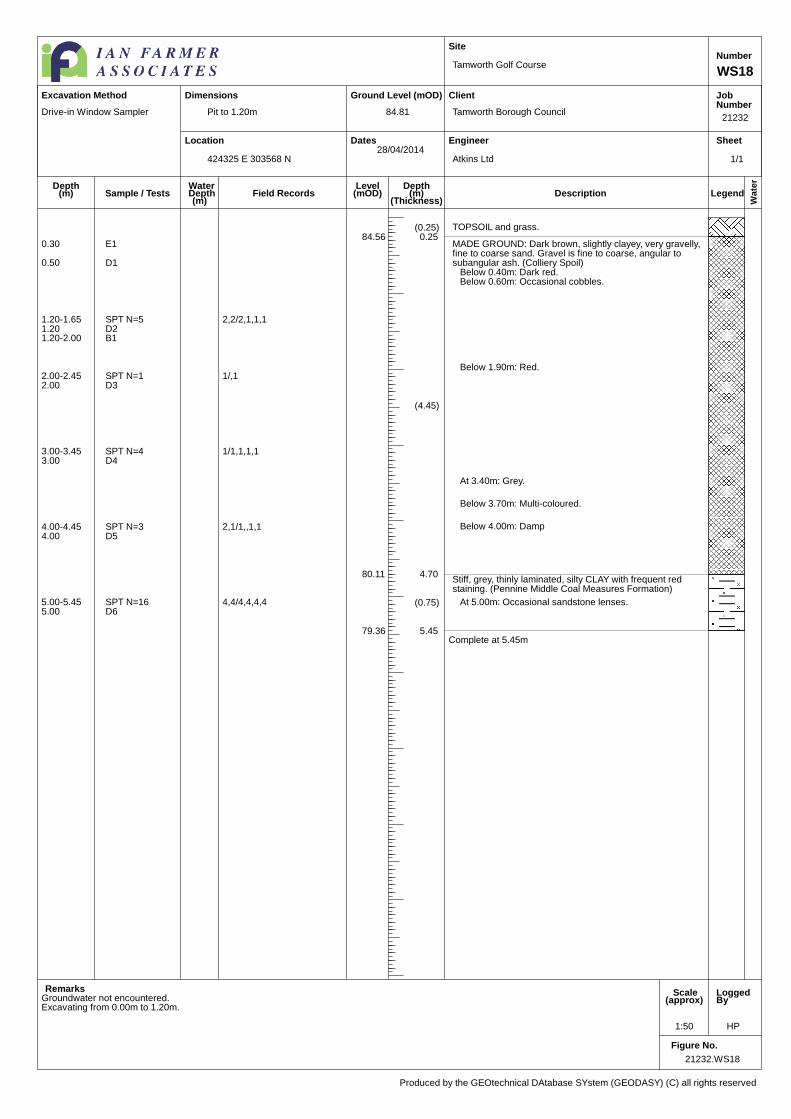
21232.WS18
1:50 HP
Pit to 1.20m
Tamworth Golf Course
Tamworth Borough Council
Atkins Ltd
21232
WS18
Number
84.81
424325 E 303568 N28/04/2014
Produced by the GEOtechnical DAtabase SYstem (GEODASY) (C) all rights reserved
Excavation Method Dimensions
WaterDepth(m)
Field Records
Drive-in Window Sampler
(0.25) TOPSOIL and grass.84.56 0.25
(4.45)
MADE GROUND: Dark brown, slightly clayey, very gravelly,fine to coarse sand. Gravel is fine to coarse, angular tosubangular ash. (Colliery Spoil)
Below 0.40m: Dark red.Below 0.60m: Occasional cobbles.
Below 1.90m: Red.
At 3.40m: Grey.
Below 3.70m: Multi-coloured.
Below 4.00m: Damp
80.11 4.70
(0.75)
Stiff, grey, thinly laminated, silty CLAY with frequent redstaining. (Pennine Middle Coal Measures Formation)
At 5.00m: Occasional sandstone lenses.
79.36 5.45Complete at 5.45m
Groundwater not encountered.
0.30 E1
0.50 D1
1.20-1.65 SPT N=5 2,2/2,1,1,11.20 D21.20-2.00 B1
2.00-2.45 SPT N=1 1/,12.00 D3
3.00-3.45 SPT N=4 1/1,1,1,13.00 D4
4.00-4.45 SPT N=3 2,1/1,,1,14.00 D5
5.00-5.45 SPT N=16 4,4/4,4,4,45.00 D6
Excavating from 0.00m to 1.20m.
1/1
Location
Ground Level (mOD)
Dates
Site
Client
Engineer
JobNumber
Sheet
Wate
r
Legend InstrDescriptionDepth
(m)(Thickness)
Depth(m)
Level(mOD)Sample / Tests
Remarks Scale(approx)
LoggedBy
Figure No.
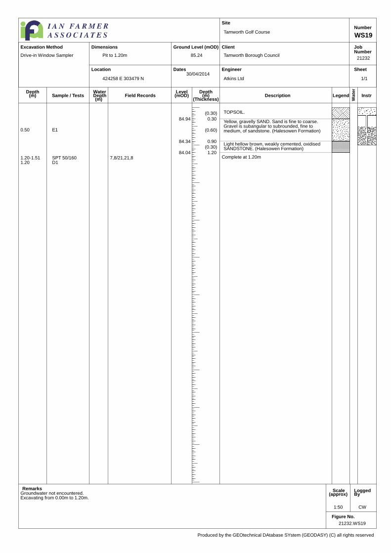
21232.WS19
1:50 CW
Pit to 1.20m
Tamworth Golf Course
Tamworth Borough Council
Atkins Ltd
21232
WS19
Number
85.24
424258 E 303479 N30/04/2014
Produced by the GEOtechnical DAtabase SYstem (GEODASY) (C) all rights reserved
Excavation Method Dimensions
WaterDepth(m)
Field Records
Drive-in Window Sampler
(0.30) TOPSOIL.
84.94 0.30
(0.60)
Yellow, gravelly SAND. Sand is fine to coarse.Gravel is subangular to subrounded, fine tomedium, of sandstone. (Halesowen Formation)
84.34 0.90(0.30)
Light hellow brown, weakly cemented, oxidisedSANDSTONE. (Halesowen Formation)
84.04 1.20Complete at 1.20m
Groundwater not encountered.
0.50 E1
1.20-1.51 SPT 50/160 7,8/21,21,81.20 D1
Excavating from 0.00m to 1.20m.
1/1

Location
Ground Level (mOD)
Dates
Site
Client
Engineer
JobNumber
Sheet
Wate
r
LegendDescriptionDepth
(m)(Thickness)
Depth(m)
Level(mOD)Sample / Tests
Remarks Scale(approx)
LoggedBy
Figure No.
21232.WS20
1:50
Pit to 1.20m
Tamworth Golf Course
Tamworth Borough Council
Atkins Ltd
21232
WS20
Number
98.24
424085 E 303396 N02/05/2014
Produced by the GEOtechnical DAtabase SYstem (GEODASY) (C) all rights reserved
Excavation Method Dimensions
WaterDepth(m)
Field Records
Drive-in Window Sampler
(3.90)
MADE GROUND: Brown, black, sandy, clayey, gravel.Sand is fine to coarse. Gravel is fine to large of brick,concrete, ironstone, sandstone, quartz, with black, organicstaining and organic odour.
Between 1.80m and 3.00m: Band of partially burnt andoxidised, black, fine, gravel size fragments of organicmatter, and wood with occasional fine gravel sizefragmetns of ceramic, glass and copper wire.
94.34 3.90Yellow, fine to coarse SAND with occasional fine to medium,gravel of sandstone and rare subangular to subrounded,fine to medium gravel of ironstone. (Halesowen Formation)
94.24 4.00
Complete at 4.00m
Refused at 4.00m.Groundwater not encountered.
0.50 E1
1.00 D1
1.20-1.65 SPT N=7 2,1/1,2,2,2
4.00-4.45 SPT N=17 3,3/4,4,4,54.00 D2
Excavating from 0.00m to 1.20m.
1/1

Location
Ground Level (mOD)
Dates
Site
Client
Engineer
JobNumber
Sheet
Wate
r
Legend InstrDescriptionDepth
(m)(Thickness)
Depth(m)
Level(mOD)Sample / Tests
Remarks Scale(approx)
LoggedBy
Figure No.
21232.WS21
1:50 CW
Pit to 1.20m
Tamworth Golf Course
Tamworth Borough Council
Atkins Ltd
21232
WS21
Number
91.81
424147 E 303432 N30/04/2014
Produced by the GEOtechnical DAtabase SYstem (GEODASY) (C) all rights reserved
Excavation Method Dimensions
WaterDepth(m)
Field Records
Drive-in Window Sampler
(0.20) TOPSOIL91.61 0.20
(0.90)
MADE GROUND: Brown, silty, sandy, gravellyCLAY. Sand is fine to coarse. Gravel is angular tosubrounded, of porcelain, glass, and stone, withoccasional rootlets.
90.71 1.10
(2.00)
MADE GROUND: Brown, silty, slightly gravellyCLAY. Gravel is sr-r, fine to medium of ironstoneand rare subangular, medium size gravel ofmudstone.
88.71 3.10
(0.85)
MADE GROUND: Yellow, slightly clayey, fine tocoarse reworked sand with occasional browndiscolouration and fine gravel size fragments ofcalcite and oxidized black organic matter.
87.86 3.95Yellow, hightly weathered SANDSTONE,recovered as fine to coarse sand. (HalesowenFormation)
87.81 4.00
Complete at 4.00m
Groundwater not encountered.
0.20 B20.25 E1
1.00 D11.00 E21.00-2.00 B11.20-1.65 SPT N=13 4,6/5,2,3,3
2.00-2.45 SPT N=25 4,4/12,3,6,42.00 D2
3.00-3.45 SPT N=8 1,1/2,1,3,23.00 D3
4.00-4.45 SPT N=32 6,8/8,8,8,84.00 D4
Excavating from 0.00m to 1.20m.
1/1
Location
Ground Level (mOD)
Dates
Site
Client
Engineer
JobNumber
Sheet
Wate
r
LegendDescriptionDepth
(m)(Thickness)
Depth(m)
Level(mOD)Sample / Tests
Remarks Scale(approx)
LoggedBy
Figure No.
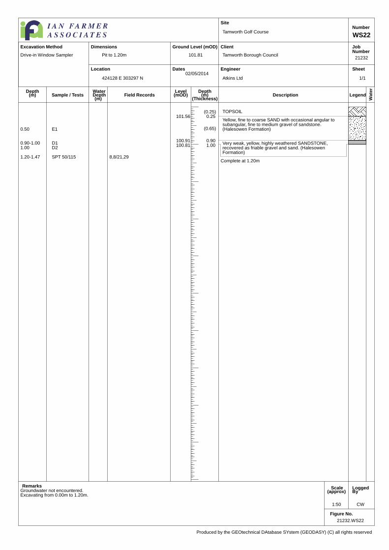
21232.WS22
1:50 CW
Pit to 1.20m
Tamworth Golf Course
Tamworth Borough Council
Atkins Ltd
21232
WS22
Number
101.81
424128 E 303297 N02/05/2014
Produced by the GEOtechnical DAtabase SYstem (GEODASY) (C) all rights reserved
Excavation Method Dimensions
WaterDepth(m)
Field Records
Drive-in Window Sampler
(0.25) TOPSOIL101.56 0.25
(0.65)
Yellow, fine to coarse SAND with occasional angular tosubangular, fine to medium gravel of sandstone.(Halesowen Formation)
100.91 0.90Very weak, yellow, highly weathered SANDSTONE,recovered as friable gravel and sand. (HalesowenFormation)
100.81 1.00
Complete at 1.20m
Groundwater not encountered.
0.50 E1
0.90-1.00 D11.00 D2
1.20-1.47 SPT 50/115 8,8/21,29
Excavating from 0.00m to 1.20m.
1/1
Location
Ground Level (mOD)
Dates
Site
Client
Engineer
JobNumber
Sheet
Wate
r
LegendDescriptionDepth
(m)(Thickness)
Depth(m)
Level(mOD)Sample / Tests
Remarks Scale(approx)
LoggedBy
Figure No.
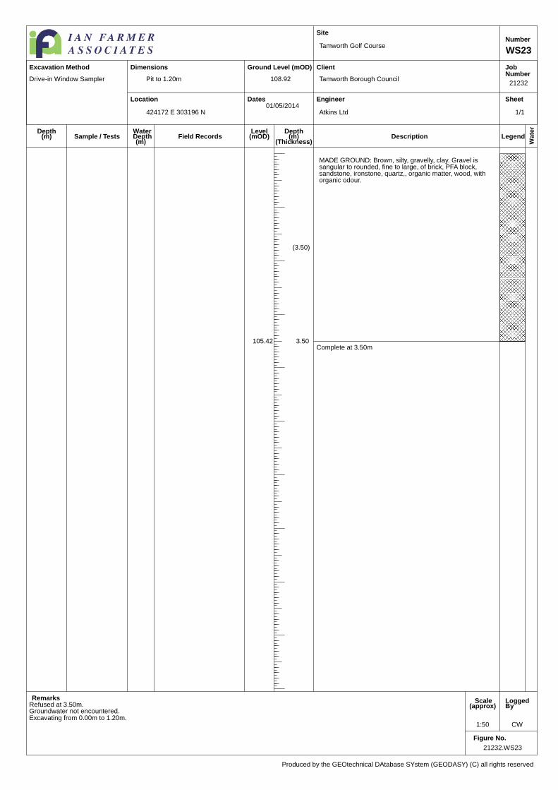
21232.WS23
1:50 CW
Pit to 1.20m
Tamworth Golf Course
Tamworth Borough Council
Atkins Ltd
21232
WS23
Number
108.92
424172 E 303196 N01/05/2014
Produced by the GEOtechnical DAtabase SYstem (GEODASY) (C) all rights reserved
Excavation Method Dimensions
WaterDepth(m)
Field Records
Drive-in Window Sampler
(3.50)
MADE GROUND: Brown, silty, gravelly, clay. Gravel issangular to rounded, fine to large, of brick, PFA block,sandstone, ironstone, quartz,, organic matter, wood, withorganic odour.
105.42 3.50Complete at 3.50m
Refused at 3.50m.Groundwater not encountered.Excavating from 0.00m to 1.20m.
1/1

Location
Ground Level (mOD)
Dates
Site
Client
Engineer
JobNumber
Sheet
Wate
r
LegendDescriptionDepth
(m)(Thickness)
Depth(m)
Level(mOD)Sample / Tests
Remarks Scale(approx)
LoggedBy
Figure No.
21232.WS24
1:50 CW
Pit to 1.20m
Tamworth Golf Course
Tamworth Borough Council
Atkins Ltd
21232
WS24
Number
96.24
424273 E 303272 N01/05/2014
Produced by the GEOtechnical DAtabase SYstem (GEODASY) (C) all rights reserved
Excavation Method Dimensions
WaterDepth(m)
Field Records
Drive-in Window Sampler
TOPSOIL96.19 0.05
(3.35)
Yellow, silty SAND with occasional angular, fine to mediumgravel of sandstone and rare ironstone. (HalesowenFormation)
92.84 3.40(0.20) Yellow, hightly weathered SANDSTONE, recovered as fine
to coarse, sand with occasional large gravel of sandstone.(Halesowen Formation)
92.64 3.60
Complete at 3.60m
Terminated on SPT refusal 3.60m.Groundwater not encountered.
0.50 E1
1.20-1.65 SPT N=20 4,4/4,5,5,61.20 D4
2.00-2.45 SPT N=32 3,4/4,8,8,122.00 D1
3.00-3.45 SPT N=30 4,4/6,6,6,123.00 D2
3.50-3.82 SPT 50/170 6,8/16,24,103.60 D3
Excavating from 0.00m to 1.20m.
1/1

Location
Ground Level (mOD)
Dates
Site
Client
Engineer
JobNumber
Sheet
Wate
r
LegendDescriptionDepth
(m)(Thickness)
Depth(m)
Level(mOD)Sample / Tests
Remarks Scale(approx)
LoggedBy
Figure No.
21232.WS25
1:50 CW
Pit to 1.20m
Tamworth Golf Course
Tamworth Borough Council
Atkins Ltd
21232
WS25
Number
88.02
424523 E 303216 N01/05/2014
Produced by the GEOtechnical DAtabase SYstem (GEODASY) (C) all rights reserved
Excavation Method Dimensions
WaterDepth(m)
Field Records
Drive-in Window Sampler
(0.15) TOPSOIL.87.87 0.15
(1.35)
Yellow, silty, gravelly SAND. Sand is fine to coarse. Gravelis subangular to subrounded, fine to medium of sandstone.(Halesowen Formation)
86.52 1.50
(0.45)
Grey brown, clayey GRAVEL. Gravel is subangular tosubrounded, fine to medium of mudstone and occasionalironstone. (Halesown Formation)
86.07 1.95Yellow, with oxidised ironstaining, fissured SANDSTONE,recovered as friable gravel. (Halesowen Formation)
86.02 2.00
Complete at 2.00m
Groundwater not encountered.
0.50 E1
1.20-1.65 SPT N=16 3,3/4,4,4,41.20 D11.50 E21.50-2.00 B1
2.00-2.34 SPT 50/190 2,3/14,16,202.00 D2
Excavating from 0.00m to 1.20m.
1/1
Location
Ground Level (mOD)
Dates
Site
Client
Engineer
JobNumber
Sheet
Wate
r
Legend InstrDescriptionDepth
(m)(Thickness)
Depth(m)
Level(mOD)Sample / Tests
Remarks Scale(approx)
LoggedBy
Figure No.
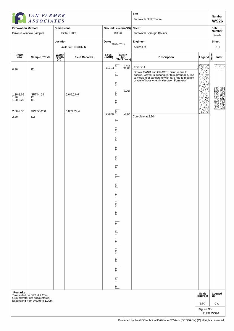
21232.WS26
1:50 CW
Pit to 1.20m
Tamworth Golf Course
Tamworth Borough Council
Atkins Ltd
21232
WS26
Number
110.26
424104 E 303132 N30/04/2014
Produced by the GEOtechnical DAtabase SYstem (GEODASY) (C) all rights reserved
Excavation Method Dimensions
WaterDepth(m)
Field Records
Drive-in Window Sampler
(0.15) TOPSOIL.110.11 0.15
(2.05)
Brown, SAND and GRAVEL. Sand is fine tocoarse. Gravel is subangular to subrounded, fineto medium of sandstone with rare fine to mediumgravel of ironstone. (Halesowen Formation)
108.06 2.20Complete at 2.20m
0.10 E1
Terminated on SPT at 2.20m.Groundwater not encountered.
1.20-1.65 SPT N=24 6,6/6,6,6,61.20 D11.50-2.20 B1
2.00-2.35 SPT 50/200 6,8/22,24,4
2.20 D2
Excavating from 0.00m to 1.20m.
1/1

Location
Ground Level (mOD)
Dates
Site
Client
Engineer
JobNumber
Sheet
Wate
r
Legend InstrDescriptionDepth
(m)(Thickness)
Depth(m)
Level(mOD)Sample / Tests
Remarks Scale(approx)
LoggedBy
Figure No.
21232.WS27
1:50 CW
Pit to 1.20m
Tamworth Golf Course
Tamworth Borough Council
Atkins Ltd
21232
WS27
Number
108.21
424266 E 303063 N01/05/2014
Produced by the GEOtechnical DAtabase SYstem (GEODASY) (C) all rights reserved
Excavation Method Dimensions
WaterDepth(m)
Field Records
Drive-in Window Sampler
1
(0.15) TOPSOIL.108.06 0.15
(1.85)
MADE GROUND: Yellow, reworked, gravellySAND. Sand is fine to coarse. Gravel issubangular to subrounded, fine to large ofsandstone with occasional cobbles of sandstone.
106.21 2.00
(0.80)
Light yellow brown mottled grey, very silty CLAYwith rare calcareous inclusions. (SuperficialDeposits)
105.41 2.80
(1.20)
Weak, grey and red purple SILTSTONE,recovered as friable gravel. (HalesowenFormation)
104.21 4.00Complete at 4.00m
0.15 E1
1.20-1.65 SPT N=32 8,7/15,6,6,51.20 D11.50 E2
Seepage(1) at 1.95m.2.00-2.45 SPT N=30 4,5/5,7,8,102.00 B1
2.00 D2
2.80-3.25 SPT N=32 6,6/6,8,8,10
4.00-4.28 SPT 35/125 8,15/15,204.00 D34.00 D4
Excavating from 0.00m to 1.20m.
1/1
Location
Ground Level (mOD)
Dates
Site
Client
Engineer
JobNumber
Sheet
Wate
r
LegendDescriptionDepth
(m)(Thickness)
Depth(m)
Level(mOD)Sample / Tests
Remarks Scale(approx)
LoggedBy
Figure No.
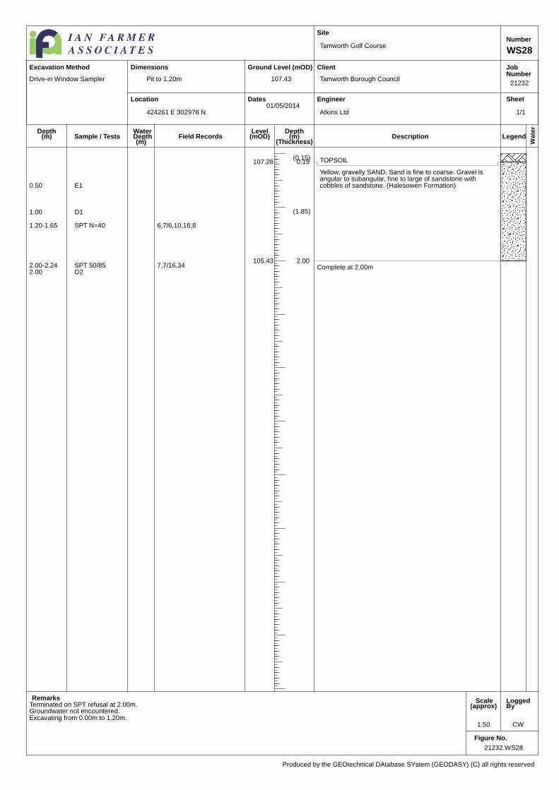
21232.WS28
1:50 CW
Pit to 1.20m
Tamworth Golf Course
Tamworth Borough Council
Atkins Ltd
21232
WS28
Number
107.43
424261 E 302976 N01/05/2014
Produced by the GEOtechnical DAtabase SYstem (GEODASY) (C) all rights reserved
Excavation Method Dimensions
WaterDepth(m)
Field Records
Drive-in Window Sampler
(0.15) TOPSOIL107.28 0.15
(1.85)
Yellow, gravelly SAND. Sand is fine to coarse. Gravel isangular to subangular, fine to large of sandstone withcobbles of sandstone. (Halesowen Formation)
105.43 2.00Complete at 2.00m
Terminated on SPT refusal at 2.00m.Groundwater not encountered.
0.50 E1
1.00 D1
1.20-1.65 SPT N=40 6,7/6,10,16,8
2.00-2.24 SPT 50/85 7,7/16,342.00 D2
Excavating from 0.00m to 1.20m.
1/1

Location
Ground Level (mOD)
Dates
Site
Client
Engineer
JobNumber
Sheet
Wate
r
LegendDescriptionDepth
(m)(Thickness)
Depth(m)
Level(mOD)Sample / Tests
Remarks Scale(approx)
LoggedBy
Figure No.
21232.WS29
1:50 CW
Pit to 1.20m
Tamworth Golf Course
Tamworth Borough Council
Atkins Ltd
21232
WS29
Number
105.87
424124 E 302831 N30/04/2014
Produced by the GEOtechnical DAtabase SYstem (GEODASY) (C) all rights reserved
Excavation Method Dimensions
WaterDepth(m)
Field Records
Drive-in Window Sampler
1
TOPSOIL105.77 0.10
(1.80)
Yellow GRAVEL and SAND. Sand is fine to coarse. Gravelis fine to large, subangular to subrounded of sandstone.(Halesowen Formation)
103.97 1.90
(0.60)
Grey, sandy, gravelly CLAY. Sand is fine to coarse. Gravelis subangular, large of sandstone. (Halesowen Formation)
103.37 2.50Firm, red, weathered, SILTSTONE, recovered as firm,gravelly clay. (Halesowen Formation)
103.27 2.60
Complete at 2.60m
0.50 E1
Water strike(1) at 0.90m.0.90-1.35 SPT N=17 3,7/6,3,4,41.00 D1
1.60-2.60 B1
2.00-2.45 SPT N=22 4,4/4,6,6,62.00 D2
2.60-3.05 SPT N=36 6,6/8,8,8,122.60 D3
Excavating from 0.00m to 1.20m.
1/1

Location
Ground Level (mOD)
Dates
Site
Client
Engineer
JobNumber
Sheet
Wate
r
LegendDescriptionDepth
(m)(Thickness)
Depth(m)
Level(mOD)Sample / Tests
Remarks Scale(approx)
LoggedBy
Figure No.
21232.WS30
1:50 CW
Pit to 0.45m
Tamworth Golf Course
Tamworth Borough Council
Atkins Ltd
21232
WS30
Number
102.73
424133 E 302655 N30/04/2014
Produced by the GEOtechnical DAtabase SYstem (GEODASY) (C) all rights reserved
Excavation Method Dimensions
WaterDepth(m)
Field Records
Drive-in Window Sampler
(0.15) TOPSOIL102.58 0.15(0.30) MADE GROUND: Brown, sandy, slightly clayey gravel.
Sand is fine to coarse. Gravel is sangular to rounded ofquartz and ironstone, with rare cobble of subangularsandstone.
102.28 0.45
Complete at 0.45m
Terminated at 0.45m due to pit flooding in possible french drain.Excavating from 0.00m to 0.45m.
1/1

Location
Ground Level (mOD)
Dates
Site
Client
Engineer
JobNumber
Sheet
Wate
r
Legend InstrDescriptionDepth
(m)(Thickness)
Depth(m)
Level(mOD)Sample / Tests
Remarks Scale(approx)
LoggedBy
Figure No.
21232.WS30A
1:50 CW
Pit to 1.20m
Tamworth Golf Course
Tamworth Borough Council
Atkins Ltd
21232
WS30A
Number
102.73
424133 E 302655 N30/04/2014
Produced by the GEOtechnical DAtabase SYstem (GEODASY) (C) all rights reserved
Excavation Method Dimensions
WaterDepth(m)
Field Records
Drive-in Window Sampler
(0.20) TOPSOIL102.53 0.20
(0.20) COBBLES of angular to subangular sandstone.102.33 0.40
(2.10)
Yellow, gravelly SAND. Sand is fine to coarse.Gravel is subangular to subrounded, fine tomedium of sandstone. (Halesowen Formation)
100.23 2.50Grey, sandy SILT. Sand is fine to coarse with raresr-r, fine to medium gravel of ironstone and(stone?) (Halesowen Formation)
100.13 2.60
(1.10)Grey, brown, gravelly weathered SAND. Sand isfine to coarse. Gravel is subrounded to roundedironstone and quartz. (Halesowen Formation)
99.03 3.70(0.30)
Firm, red brown, SILTSTONE recovered as fine tomedium gravel. (Halesowen Formation)
98.73 4.00Complete at 4.00m
Terminated on SPT.
0.15 E1
Groundwater not encountered.
0.70-1.15 SPT N=8 1,2/2,2,2,20.70 D11.00 D2
1.20-1.65 SPT N=11 2,1/2,2,3,41.20-2.00 B1
2.00-2.45 SPT N=5 2,2/1,1,1,22.00 D3
3.00-3.45 SPT N=17 2,2/3,4,5,53.00 D43.20 B2
4.00-4.45 SPT N=27 5,5/6,6,7,84.00 D5
Excavating from 0.00m to 1.20m.
1/1
Location
Ground Level (mOD)
Dates
Site
Client
Engineer
JobNumber
Sheet
Wate
r
LegendDescriptionDepth
(m)(Thickness)
Depth(m)
Level(mOD)Sample / Tests
Remarks Scale(approx)
LoggedBy
Figure No.
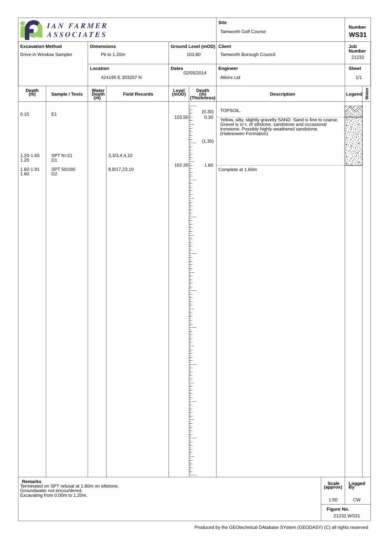
21232.WS31
1:50 CW
Pit to 1.20m
Tamworth Golf Course
Tamworth Borough Council
Atkins Ltd
21232
WS31
Number
103.80
424195 E 303207 N02/05/2014
Produced by the GEOtechnical DAtabase SYstem (GEODASY) (C) all rights reserved
Excavation Method Dimensions
WaterDepth(m)
Field Records
Drive-in Window Sampler
(0.30) TOPSOIL.
103.50 0.30
(1.30)
Yellow, silty, slightly gravelly SAND. Sand is fine to coarse.Gravel is sr-r, of siltstone, sandstone and occasionalironstone. Possibly highly weathered sandstone.(Halesowen Formation)
102.20 1.60Complete at 1.60m
Terminated on SPT refusal at 1.60m on siltstone.
0.15 E1
Groundwater not encountered.
1.20-1.65 SPT N=21 3,3/3,4,4,101.20 D1
1.60-1.91 SPT 50/160 8,8/17,23,101.60 D2
Excavating from 0.00m to 1.20m.
1/1
Location
Ground Level (mOD)
Dates
Site
Client
Engineer
JobNumber
Sheet
Wate
r
LegendDescriptionDepth
(m)(Thickness)
Depth(m)
Level(mOD)Sample / Tests
Remarks Scale(approx)
LoggedBy
Figure No.
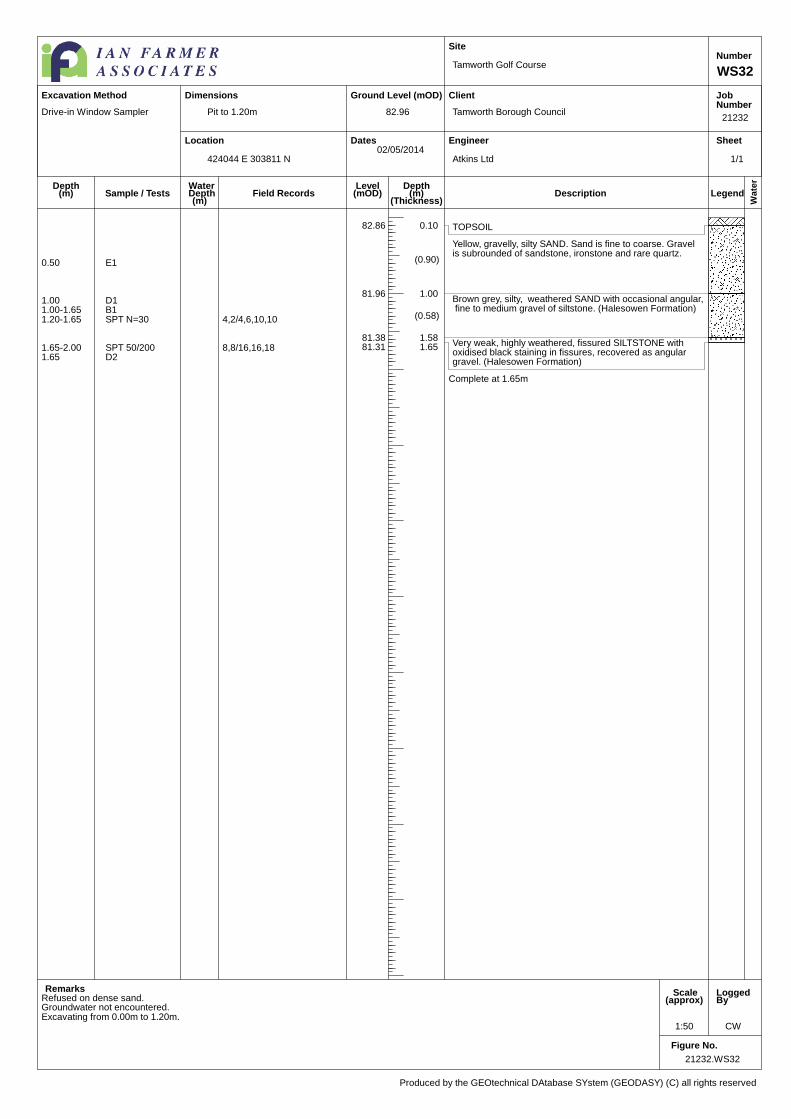
21232.WS32
1:50 CW
Pit to 1.20m
Tamworth Golf Course
Tamworth Borough Council
Atkins Ltd
21232
WS32
Number
82.96
424044 E 303811 N02/05/2014
Produced by the GEOtechnical DAtabase SYstem (GEODASY) (C) all rights reserved
Excavation Method Dimensions
WaterDepth(m)
Field Records
Drive-in Window Sampler
TOPSOIL82.86 0.10
(0.90)
Yellow, gravelly, silty SAND. Sand is fine to coarse. Gravelis subrounded of sandstone, ironstone and rare quartz.
81.96 1.00
(0.58)
Brown grey, silty, weathered SAND with occasional angular,fine to medium gravel of siltstone. (Halesowen Formation)
81.38 1.58Very weak, highly weathered, fissured SILTSTONE withoxidised black staining in fissures, recovered as angulargravel. (Halesowen Formation)
81.31 1.65
Complete at 1.65m
Refused on dense sand.Groundwater not encountered.
0.50 E1
1.00 D11.00-1.65 B11.20-1.65 SPT N=30 4,2/4,6,10,10
1.65-2.00 SPT 50/200 8,8/16,16,181.65 D2
Excavating from 0.00m to 1.20m.
1/1
APPENDIX 3
LABORATORY TESTS

Appendix 3 pages iii/i-iii/i iii/i
APPENDIX 3
GENERAL NOTES ON LABORATORY TESTS ON SOILS
A3.1 GENERAL
A3.1.1 Where applicable all tests are carried out in accordance with the relevant British Standard. The laboratory test procedures are as below:
Test Name Procedures BS1377:1990 Part:Clause Moisture Content 2:3 Liquid Limit 2:4 Plastic Limit and Plastic Index 2:5 Particle Size Distribution 9.2 Sedimentation 9.4 Mass Loss on Ignition 3.4 Sulphate content 3:5 pH Value 3:9 Compaction Test 4:3 California Bearing Ratio 4:7 Consolidation 5:3 Bulk Density 7:2 Laboratory Vane Tests 7:3 Triaxial Compression Total Stress Single-Stage 7:8 Total Stress Multi-Stage 7:9 Desiccation Note 1 Note 1 - BRE Information paper IP4 issued February 1993
A3.1.2 Where an external laboratory carried out testing, their report, including test methods is included in this Appendix.
A3.1.3 A summary sheet of laboratory test results undertaken by Ian Farmer Laboratories is included, however where copies of the individual test results are required these will be provided on request.
A3.1.4 Any discussion in this report is based on the values and results obtained from the appropriate tests. Due allowance should be made, when considering any result in isolation, of the possible inaccuracy of any such individual result. Details of the accuracy of results are included in this section, where applicable.

Unit 4 Faraday Close, Pattinson North Industrial Estate, Washington, Tyne & Wear, NE38 8QJ.Tel. 0191 4828500 Fax. 0191 4828520 Email. [email protected] Internet.www.ianfarmerassociates.co.uk
Ian Farmer Associates (1998) Ltd1 Fairfield Court,Seven Stars Ind Est,Wheler Road,CV3 4LJ
TEST REPORT - 21232
F.A.O. Roy Smith
Site : Tamworth Golf Course
Job Number : 21232
Originating Client : Tamworth Borough Council
Originating Reference : 21232
Date Sampled :
Date Scheduled : 09/05/14
Date Testing Started : 09/06/14
Date Testing Finished : 25/06/14
Remarks : First Report for above Job Number••Samples will be disposed of 28 days after the report is issued unlessotherwise agreed
•This report may contain results from tests which are not includedwithin the scope of the UKAS accreditation. Please see final sheet fordetails.
Daniel SmithAuthorised By:
Position : Laboratory Supervisor Date : 25/06/14
Ian Farmer Associates (1998) Limited. Registered in England and Wales No. 3661447Registered Office: Unit 4 Faraday Close, Pattinson North Industrial Estate, Washington. NE38 8QJOffices in: Coventry (02476) 456565. Harpenden, Herts. (01582) 460018. Truro (01827) 261775Warrington (01925) 855440. Newcastle upon Tyne (0191) 4828500. Motherwell (01698) 230231.
1464
Page 1 of 32
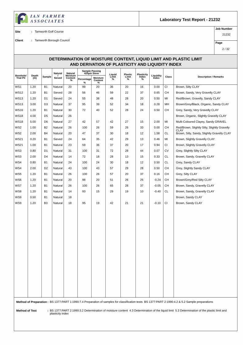
DETERMINATION OF MOISTURE CONTENT, LIQUID LIMIT AND PLASTIC LIMITAND DERIVATION OF PLASTICITY AND LIQUIDITY INDEX
Laboratory Test Report - 21232
Borehole/Trial Pit
Depth(m) Sample
Natural/
Sieved
NaturalMoistureContent
%
Sample Passing425µm Sieve
Percentage%
MoistureContent
%
LiquidLimit
%
PlasticLimit
%
PlasticityIndex
%Liquidity
Index Class Description / Remarks
Job Number
21232
Page
Site : Tamworth Golf Course
Client : Tamworth Borough Council
Method of Preparation : BS 1377:PART 1:1990:7.4 Preparation of samples for classification tests BS 1377:PART 2:1990:4.2 & 5.2 Sample preparations
Method of Test : BS 1377:PART 2:1990:3.2 Determination of moisture content 4.3 Determination of the liquid limit 5.3 Determination of the plastic limit and plasticity index
WS1 1.20 B1 Natural 20 99 20 36 20 16 0.00 CI Brown, Silty CLAY
WS12 1.20 B1 Sieved 28 56 46 59 22 37 0.65 CH Brown, Sandy, Very Gravelly CLAY
WS13 1.20 D1 Sieved 24 55 38 48 28 20 0.50 MI Red/Brown, Gravelly, Sandy CLAY
WS13 3.00 D3 Natural 37 95 39 52 34 18 0.28 MH Brown/Grey/Black, Organic, Sandy CLAY
WS16 1.20 B1 Natural 30 72 40 52 28 24 0.50 CH Grey, Sandy, Very Gravelly CLAY
WS18 4.00 D5 Natural 26 Brown, Organic, Slightly Gravelly CLAY
WS18 5.00 D6 Natural 27 42 57 42 27 15 2.00 MI Multi-Coloured Clayey, Sandy GRAVEL
WS2 1.00 B2 Natural 26 100 26 59 26 33 0.00 CH Red/Brown, Slightly Silty, Slightly Gravelly CLAY
WS2 2.00 B4 Natural 20 47 37 30 18 12 1.58 CL Brown, Silty, Sandy, Slightly Gravelly CLAY
WS21 0.20 B1 Sieved 24 64 35 42 29 13 0.46 MI Brown, Slightly Gravelly CLAY
WS21 1.00 B1 Natural 23 59 36 37 20 17 0.94 CI Brown, Slightly Gravelly CLAY
WS3 0.80 D1 Natural 31 100 31 72 28 44 0.07 CV Grey, Slightly Silty CLAY
WS3 2.00 D4 Natural 14 72 18 28 13 15 0.33 CL Brown, Sandy, Gravelly CLAY
WS4 0.80 B1 Natural 24 100 24 30 18 12 0.50 CL Grey, Sandy CLAY
WS4 2.00 D2 Natural 43 100 43 57 29 28 0.50 CH Grey, Slightly Sandy CLAY
WS5 1.20 B1 Natural 26 100 26 57 20 37 0.16 CH Grey, Silty CLAY
WS6 1.20 B1 Natural 20 98 20 51 26 25 -0.24 CH Brown/Grey/Red Silty CLAY
WS7 1.20 B1 Natural 26 100 26 65 28 37 -0.05 CH Brown, Sandy, Gravelly CLAY
WS8 1.20 B1 Natural 14 93 15 29 19 10 -0.40 CL Brown, Sandy, Gravelly CLAY
WS9 0.50 B1 Natural 18 Brown, Sandy CLAY
WS9 1.20 B3 Natural 18 95 19 42 21 21 -0.10 CI Brown, Sandy CLAY
2 / 32

Grading Analysis
D85
D60
D10
Uniformity Coefficient
Particle Proportions
Cobbles + Boulders
Gravel
Sand
Silt/Clay
Sieve /Particle
Size
%Passing
DETERMINATION OF PARTICLE SIZE DISTRIBUTION
Laboratory Test Report - 21232
Job Number
21232
Page
Site : Tamworth Golf Course
Client : Tamworth Borough Council
Method of Preparation : BS 1377:PART 1:1990:7.3 Initial preparation 7.4.5 Particle size tests
Preparation Details : Sample washed with no dispersant used, Oven Dried at 105 - 110°C
Method of Test : BS 1377:PART 2:1990:9 Determination of particle size distribution
Remarks :
Borehole /
Trial Pit
Depth
(m)Sample
Pipette/
HydrometerDescription
N/AWS10 1.20 B1 Brown, Very Snady, Gravelly CLAY
200 mm 100
150 mm 100
125 mm 100
90 mm 100
75 mm 100
63 mm 100
50 mm 100
37.5 mm 100
28 mm 90
20 mm 89
14 mm 86
10 mm 85
6.3 mm 84
5 mm 84
3.35 mm 83
2 mm 82
1.18 mm 79
600 µm 63
425 µm 46
300 µm 30
212 µm 25
150 µm 22
63 µm 20
11.1 mm
570.9 µm
-
-
0%
18%
62%
20%
0.002 0.0063 0.02 0.063 0.2 0.63 2 6.3 20 63 200 6300
10
20
30
40
50
60
70
80
90
100
Fine Medium Coarse Fine Medium Coarse Fine Medium CoarseCLAY
SILT SAND GRAVELCOBBLES BOULDERS
3 / 32

Grading Analysis
D85
D60
D10
Uniformity Coefficient
Particle Proportions
Cobbles + Boulders
Gravel
Sand
Silt
Clay
Sieve /Particle
Size
%Passing
DETERMINATION OF PARTICLE SIZE DISTRIBUTION
Laboratory Test Report - 21232
Job Number
21232
Page
Site : Tamworth Golf Course
Client : Tamworth Borough Council
Method of Preparation : BS 1377:PART 1:1990:7.3 Initial preparation 7.4.5 Particle size tests
Preparation Details : Sample washed with no dispersant used, Oven Dried at 105 - 110°C
Method of Test : BS 1377:PART 2:1990:9 Determination of particle size distribution
Remarks :
Borehole /
Trial Pit
Depth
(m)Sample
Pipette/
HydrometerDescription
PipetteWS12 1.20 B1 Brown, Sandy, Very Gravelly CLAY
200 mm 100
150 mm 100
125 mm 100
90 mm 100
75 mm 100
63 mm 100
50 mm 100
37.5 mm 100
28 mm 94
20 mm 94
14 mm 92
10 mm 90
6.3 mm 87
5 mm 86
3.35 mm 84
2 mm 80
1.18 mm 76
600 µm 70
425 µm 68
300 µm 64
212 µm 62
150 µm 60
63 µm 54
20 µm 50
6 µm 41
2 µm 26
4.3 mm
160.5 µm
-
-
0%
20%
26%
28%
26%
0.002 0.0063 0.02 0.063 0.2 0.63 2 6.3 20 63 200 6300
10
20
30
40
50
60
70
80
90
100
Fine Medium Coarse Fine Medium Coarse Fine Medium CoarseCLAY
SILT SAND GRAVELCOBBLES BOULDERS
4 / 32

Grading Analysis
D85
D60
D10
Uniformity Coefficient
Particle Proportions
Cobbles + Boulders
Gravel
Sand
Silt
Clay
Sieve /Particle
Size
%Passing
DETERMINATION OF PARTICLE SIZE DISTRIBUTION
Laboratory Test Report - 21232
Job Number
21232
Page
Site : Tamworth Golf Course
Client : Tamworth Borough Council
Method of Preparation : BS 1377:PART 1:1990:7.3 Initial preparation 7.4.5 Particle size tests
Preparation Details : Sample washed with no dispersant used, Oven Dried at 105 - 110°C
Method of Test : BS 1377:PART 2:1990:9 Determination of particle size distribution
Remarks :
Borehole /
Trial Pit
Depth
(m)Sample
Pipette/
HydrometerDescription
PipetteWS13 0.50 B1 Brown, Sandy, Silty, Gravelly CLAY
200 mm 100
150 mm 100
125 mm 100
90 mm 100
75 mm 100
63 mm 100
50 mm 100
37.5 mm 100
28 mm 100
20 mm 98
14 mm 96
10 mm 93
6.3 mm 89
5 mm 85
3.35 mm 81
2 mm 75
1.18 mm 68
600 µm 60
425 µm 57
300 µm 53
212 µm 50
150 µm 46
63 µm 41
20 µm 33
6 µm 23
2 µm 14
5.0 mm
576.1 µm
-
-
0%
25%
35%
26%
14%
0.002 0.0063 0.02 0.063 0.2 0.63 2 6.3 20 63 200 6300
10
20
30
40
50
60
70
80
90
100
Fine Medium Coarse Fine Medium Coarse Fine Medium CoarseCLAY
SILT SAND GRAVELCOBBLES BOULDERS
5 / 32

Grading Analysis
D85
D60
D10
Uniformity Coefficient
Particle Proportions
Cobbles + Boulders
Gravel
Sand
Silt
Clay
Sieve /Particle
Size
%Passing
DETERMINATION OF PARTICLE SIZE DISTRIBUTION
Laboratory Test Report - 21232
Job Number
21232
Page
Site : Tamworth Golf Course
Client : Tamworth Borough Council
Method of Preparation : BS 1377:PART 1:1990:7.3 Initial preparation 7.4.5 Particle size tests
Preparation Details : Sample washed with no dispersant used, Oven Dried at 105 - 110°C
Method of Test : BS 1377:PART 2:1990:9 Determination of particle size distribution
Remarks :
Borehole /
Trial Pit
Depth
(m)Sample
Pipette/
HydrometerDescription
PipetteWS16 1.20 B1 Grey, Sandy, Very Gravelly CLAY
200 mm 100
150 mm 100
125 mm 100
90 mm 100
75 mm 100
63 mm 100
50 mm 100
37.5 mm 100
28 mm 100
20 mm 100
14 mm 96
10 mm 93
6.3 mm 88
5 mm 85
3.35 mm 81
2 mm 75
1.18 mm 69
600 µm 63
425 µm 60
300 µm 58
212 µm 55
150 µm 53
63 µm 50
20 µm 46
6 µm 36
2 µm 24
5.1 mm
415.8 µm
-
-
0%
25%
25%
26%
24%
0.002 0.0063 0.02 0.063 0.2 0.63 2 6.3 20 63 200 6300
10
20
30
40
50
60
70
80
90
100
Fine Medium Coarse Fine Medium Coarse Fine Medium CoarseCLAY
SILT SAND GRAVELCOBBLES BOULDERS
6 / 32

Grading Analysis
D85
D60
D10
Uniformity Coefficient
Particle Proportions
Cobbles + Boulders
Gravel
Sand
Silt/Clay
Sieve /Particle
Size
%Passing
DETERMINATION OF PARTICLE SIZE DISTRIBUTION
Laboratory Test Report - 21232
Job Number
21232
Page
Site : Tamworth Golf Course
Client : Tamworth Borough Council
Method of Preparation : BS 1377:PART 1:1990:7.3 Initial preparation 7.4.5 Particle size tests
Preparation Details : Sample washed with no dispersant used, Oven Dried at 105 - 110°C
Method of Test : BS 1377:PART 2:1990:9 Determination of particle size distribution
Remarks :
Borehole /
Trial Pit
Depth
(m)Sample
Pipette/
HydrometerDescription
N/AWS17 2.65 B1 Brown, Gravelly, Slightly Clayey SAND
200 mm 100
150 mm 100
125 mm 100
90 mm 100
75 mm 100
63 mm 100
50 mm 100
37.5 mm 92
28 mm 85
20 mm 73
14 mm 68
10 mm 66
6.3 mm 64
5 mm 64
3.35 mm 63
2 mm 62
1.18 mm 62
600 µm 60
425 µm 56
300 µm 46
212 µm 36
150 µm 28
63 µm 21
27.9 mm
646.7 µm
-
-
0%
38%
42%
20%
0.002 0.0063 0.02 0.063 0.2 0.63 2 6.3 20 63 200 6300
10
20
30
40
50
60
70
80
90
100
Fine Medium Coarse Fine Medium Coarse Fine Medium CoarseCLAY
SILT SAND GRAVELCOBBLES BOULDERS
7 / 32

Grading Analysis
D85
D60
D10
Uniformity Coefficient
Particle Proportions
Cobbles + Boulders
Gravel
Sand
Silt/Clay
Sieve /Particle
Size
%Passing
DETERMINATION OF PARTICLE SIZE DISTRIBUTION
Laboratory Test Report - 21232
Job Number
21232
Page
Site : Tamworth Golf Course
Client : Tamworth Borough Council
Method of Preparation : BS 1377:PART 1:1990:7.3 Initial preparation 7.4.5 Particle size tests
Preparation Details : Sample washed with no dispersant used, Oven Dried at 105 - 110°C
Method of Test : BS 1377:PART 2:1990:9 Determination of particle size distribution
Remarks :
Borehole /
Trial Pit
Depth
(m)Sample
Pipette/
HydrometerDescription
N/AWS18 1.20 B1 Red/Brown, Very Sandy, Very Gravelly SAND
200 mm 100
150 mm 100
125 mm 100
90 mm 100
75 mm 100
63 mm 100
50 mm 100
37.5 mm 100
28 mm 97
20 mm 93
14 mm 86
10 mm 79
6.3 mm 68
5 mm 64
3.35 mm 58
2 mm 50
1.18 mm 44
600 µm 38
425 µm 36
300 µm 34
212 µm 33
150 µm 32
63 µm 31
13.2 mm
3.9 mm
-
-
0%
50%
19%
31%
0.002 0.0063 0.02 0.063 0.2 0.63 2 6.3 20 63 200 6300
10
20
30
40
50
60
70
80
90
100
Fine Medium Coarse Fine Medium Coarse Fine Medium CoarseCLAY
SILT SAND GRAVELCOBBLES BOULDERS
8 / 32
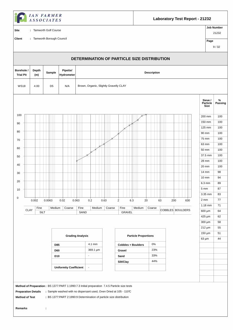
Grading Analysis
D85
D60
D10
Uniformity Coefficient
Particle Proportions
Cobbles + Boulders
Gravel
Sand
Silt/Clay
Sieve /Particle
Size
%Passing
DETERMINATION OF PARTICLE SIZE DISTRIBUTION
Laboratory Test Report - 21232
Job Number
21232
Page
Site : Tamworth Golf Course
Client : Tamworth Borough Council
Method of Preparation : BS 1377:PART 1:1990:7.3 Initial preparation 7.4.5 Particle size tests
Preparation Details : Sample washed with no dispersant used, Oven Dried at 105 - 110°C
Method of Test : BS 1377:PART 2:1990:9 Determination of particle size distribution
Remarks :
Borehole /
Trial Pit
Depth
(m)Sample
Pipette/
HydrometerDescription
N/AWS18 4.00 D5 Brown, Organic, Slightly Gravelly CLAY
200 mm 100
150 mm 100
125 mm 100
90 mm 100
75 mm 100
63 mm 100
50 mm 100
37.5 mm 100
28 mm 100
20 mm 100
14 mm 98
10 mm 94
6.3 mm 89
5 mm 87
3.35 mm 83
2 mm 77
1.18 mm 71
600 µm 64
425 µm 62
300 µm 58
212 µm 55
150 µm 51
63 µm 44
4.1 mm
369.1 µm
-
-
0%
23%
33%
44%
0.002 0.0063 0.02 0.063 0.2 0.63 2 6.3 20 63 200 6300
10
20
30
40
50
60
70
80
90
100
Fine Medium Coarse Fine Medium Coarse Fine Medium CoarseCLAY
SILT SAND GRAVELCOBBLES BOULDERS
9 / 32
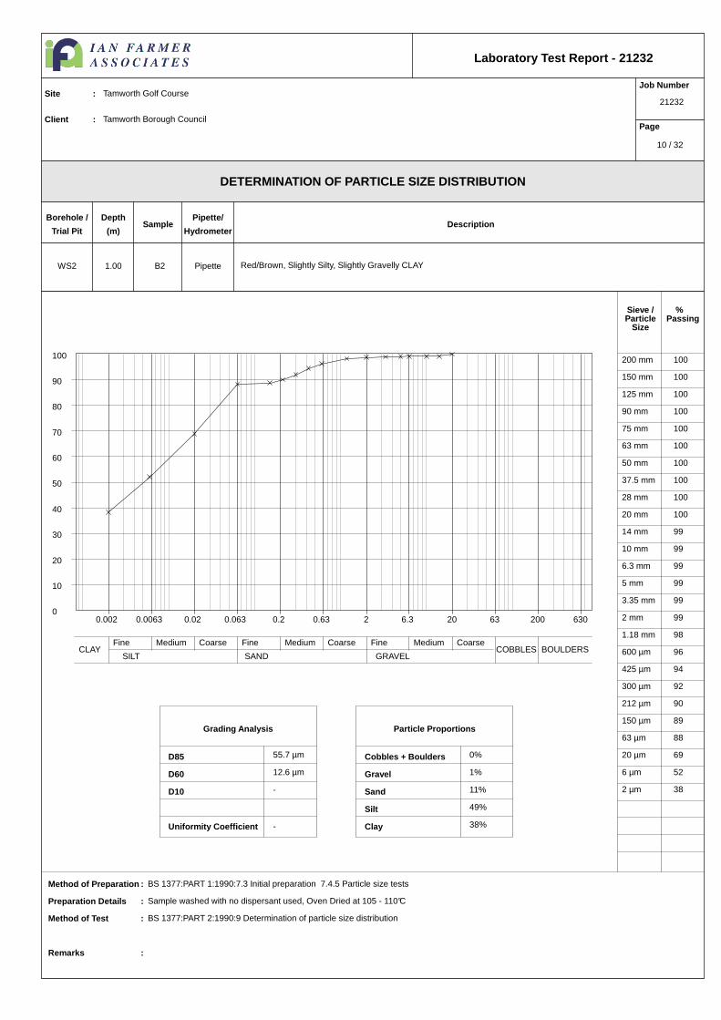
Grading Analysis
D85
D60
D10
Uniformity Coefficient
Particle Proportions
Cobbles + Boulders
Gravel
Sand
Silt
Clay
Sieve /Particle
Size
%Passing
DETERMINATION OF PARTICLE SIZE DISTRIBUTION
Laboratory Test Report - 21232
Job Number
21232
Page
Site : Tamworth Golf Course
Client : Tamworth Borough Council
Method of Preparation : BS 1377:PART 1:1990:7.3 Initial preparation 7.4.5 Particle size tests
Preparation Details : Sample washed with no dispersant used, Oven Dried at 105 - 110°C
Method of Test : BS 1377:PART 2:1990:9 Determination of particle size distribution
Remarks :
Borehole /
Trial Pit
Depth
(m)Sample
Pipette/
HydrometerDescription
PipetteWS2 1.00 B2 Red/Brown, Slightly Silty, Slightly Gravelly CLAY
200 mm 100
150 mm 100
125 mm 100
90 mm 100
75 mm 100
63 mm 100
50 mm 100
37.5 mm 100
28 mm 100
20 mm 100
14 mm 99
10 mm 99
6.3 mm 99
5 mm 99
3.35 mm 99
2 mm 99
1.18 mm 98
600 µm 96
425 µm 94
300 µm 92
212 µm 90
150 µm 89
63 µm 88
20 µm 69
6 µm 52
2 µm 38
55.7 µm
12.6 µm
-
-
0%
1%
11%
49%
38%
0.002 0.0063 0.02 0.063 0.2 0.63 2 6.3 20 63 200 6300
10
20
30
40
50
60
70
80
90
100
Fine Medium Coarse Fine Medium Coarse Fine Medium CoarseCLAY
SILT SAND GRAVELCOBBLES BOULDERS
10 / 32

Grading Analysis
D85
D60
D10
Uniformity Coefficient
Particle Proportions
Cobbles + Boulders
Gravel
Sand
Silt
Clay
Sieve /Particle
Size
%Passing
DETERMINATION OF PARTICLE SIZE DISTRIBUTION
Laboratory Test Report - 21232
Job Number
21232
Page
Site : Tamworth Golf Course
Client : Tamworth Borough Council
Method of Preparation : BS 1377:PART 1:1990:7.3 Initial preparation 7.4.5 Particle size tests
Preparation Details : Sample washed with no dispersant used, Oven Dried at 105 - 110°C
Method of Test : BS 1377:PART 2:1990:9 Determination of particle size distribution
Remarks :
Borehole /
Trial Pit
Depth
(m)Sample
Pipette/
HydrometerDescription
PipetteWS2 2.00 B4 Brown, Silty, Sandy, Slightly Gravelly CLAY
200 mm 100
150 mm 100
125 mm 100
90 mm 100
75 mm 100
63 mm 100
50 mm 100
37.5 mm 100
28 mm 100
20 mm 100
14 mm 98
10 mm 96
6.3 mm 92
5 mm 90
3.35 mm 88
2 mm 86
1.18 mm 85
600 µm 84
425 µm 83
300 µm 82
212 µm 81
150 µm 77
63 µm 54
20 µm 25
6 µm 19
2 µm 12
1.1 mm
85.8 µm
-
-
0%
14%
34%
41%
12%
0.002 0.0063 0.02 0.063 0.2 0.63 2 6.3 20 63 200 6300
10
20
30
40
50
60
70
80
90
100
Fine Medium Coarse Fine Medium Coarse Fine Medium CoarseCLAY
SILT SAND GRAVELCOBBLES BOULDERS
11 / 32

Grading Analysis
D85
D60
D10
Uniformity Coefficient
Particle Proportions
Cobbles + Boulders
Gravel
Sand
Silt/Clay
Sieve /Particle
Size
%Passing
DETERMINATION OF PARTICLE SIZE DISTRIBUTION
Laboratory Test Report - 21232
Job Number
21232
Page
Site : Tamworth Golf Course
Client : Tamworth Borough Council
Method of Preparation : BS 1377:PART 1:1990:7.3 Initial preparation 7.4.5 Particle size tests
Preparation Details : Sample washed with no dispersant used, Oven Dried at 105 - 110°C
Method of Test : BS 1377:PART 2:1990:9 Determination of particle size distribution
Remarks :
Borehole /
Trial Pit
Depth
(m)Sample
Pipette/
HydrometerDescription
N/AWS2 3.00 D3 Brown, Clayey SILT
200 mm 100
150 mm 100
125 mm 100
90 mm 100
75 mm 100
63 mm 100
50 mm 100
37.5 mm 100
28 mm 100
20 mm 100
14 mm 100
10 mm 100
6.3 mm 97
5 mm 96
3.35 mm 95
2 mm 94
1.18 mm 92
600 µm 90
425 µm 88
300 µm 86
212 µm 82
150 µm 68
63 µm 47
276.2 µm
115.1 µm
-
-
0%
6%
46%
48%
0.002 0.0063 0.02 0.063 0.2 0.63 2 6.3 20 63 200 6300
10
20
30
40
50
60
70
80
90
100
Fine Medium Coarse Fine Medium Coarse Fine Medium CoarseCLAY
SILT SAND GRAVELCOBBLES BOULDERS
12 / 32
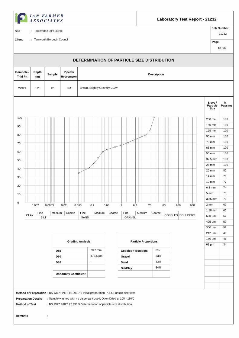
Grading Analysis
D85
D60
D10
Uniformity Coefficient
Particle Proportions
Cobbles + Boulders
Gravel
Sand
Silt/Clay
Sieve /Particle
Size
%Passing
DETERMINATION OF PARTICLE SIZE DISTRIBUTION
Laboratory Test Report - 21232
Job Number
21232
Page
Site : Tamworth Golf Course
Client : Tamworth Borough Council
Method of Preparation : BS 1377:PART 1:1990:7.3 Initial preparation 7.4.5 Particle size tests
Preparation Details : Sample washed with no dispersant used, Oven Dried at 105 - 110°C
Method of Test : BS 1377:PART 2:1990:9 Determination of particle size distribution
Remarks :
Borehole /
Trial Pit
Depth
(m)Sample
Pipette/
HydrometerDescription
N/AWS21 0.20 B1 Brown, Slightly Gravelly CLAY
200 mm 100
150 mm 100
125 mm 100
90 mm 100
75 mm 100
63 mm 100
50 mm 100
37.5 mm 100
28 mm 100
20 mm 85
14 mm 79
10 mm 77
6.3 mm 74
5 mm 73
3.35 mm 70
2 mm 67
1.18 mm 65
600 µm 62
425 µm 59
300 µm 52
212 µm 46
150 µm 41
63 µm 34
20.2 mm
473.5 µm
-
-
0%
33%
33%
34%
0.002 0.0063 0.02 0.063 0.2 0.63 2 6.3 20 63 200 6300
10
20
30
40
50
60
70
80
90
100
Fine Medium Coarse Fine Medium Coarse Fine Medium CoarseCLAY
SILT SAND GRAVELCOBBLES BOULDERS
13 / 32

Grading Analysis
D85
D60
D10
Uniformity Coefficient
Particle Proportions
Cobbles + Boulders
Gravel
Sand
Silt
Clay
Sieve /Particle
Size
%Passing
DETERMINATION OF PARTICLE SIZE DISTRIBUTION
Laboratory Test Report - 21232
Job Number
21232
Page
Site : Tamworth Golf Course
Client : Tamworth Borough Council
Method of Preparation : BS 1377:PART 1:1990:7.3 Initial preparation 7.4.5 Particle size tests
Preparation Details : Sample washed with no dispersant used, Oven Dried at 105 - 110°C
Method of Test : BS 1377:PART 2:1990:9 Determination of particle size distribution
Remarks :
Borehole /
Trial Pit
Depth
(m)Sample
Pipette/
HydrometerDescription
PipetteWS21 1.00 B1 Brown, Slightly Gravelly CLAY
200 mm 100
150 mm 100
125 mm 100
90 mm 100
75 mm 100
63 mm 100
50 mm 100
37.5 mm 100
28 mm 100
20 mm 92
14 mm 87
10 mm 85
6.3 mm 81
5 mm 78
3.35 mm 75
2 mm 71
1.18 mm 68
600 µm 64
425 µm 61
300 µm 53
212 µm 47
150 µm 42
63 µm 35
20 µm 26
6 µm 13
2 µm 6
10.3 mm
416.4 µm
4.0 µm
104.1
0%
29%
36%
29%
6%
0.002 0.0063 0.02 0.063 0.2 0.63 2 6.3 20 63 200 6300
10
20
30
40
50
60
70
80
90
100
Fine Medium Coarse Fine Medium Coarse Fine Medium CoarseCLAY
SILT SAND GRAVELCOBBLES BOULDERS
14 / 32

Grading Analysis
D85
D60
D10
Uniformity Coefficient
Particle Proportions
Cobbles + Boulders
Gravel
Sand
Silt/Clay
Sieve /Particle
Size
%Passing
DETERMINATION OF PARTICLE SIZE DISTRIBUTION
Laboratory Test Report - 21232
Job Number
21232
Page
Site : Tamworth Golf Course
Client : Tamworth Borough Council
Method of Preparation : BS 1377:PART 1:1990:7.3 Initial preparation 7.4.5 Particle size tests
Preparation Details : Sample washed with no dispersant used, Oven Dried at 105 - 110°C
Method of Test : BS 1377:PART 2:1990:9 Determination of particle size distribution
Remarks :
Borehole /
Trial Pit
Depth
(m)Sample
Pipette/
HydrometerDescription
N/AWS22 0.90 D1
200 mm 100
150 mm 100
125 mm 100
90 mm 100
75 mm 100
63 mm 100
50 mm 100
37.5 mm 100
28 mm 100
20 mm 100
14 mm 100
10 mm 100
6.3 mm 98
5 mm 98
3.35 mm 96
2 mm 95
1.18 mm 94
600 µm 91
425 µm 89
300 µm 84
212 µm 78
150 µm 62
63 µm 28
320.3 µm
145.3 µm
-
-
0%
5%
66%
29%
0.002 0.0063 0.02 0.063 0.2 0.63 2 6.3 20 63 200 6300
10
20
30
40
50
60
70
80
90
100
Fine Medium Coarse Fine Medium Coarse Fine Medium CoarseCLAY
SILT SAND GRAVELCOBBLES BOULDERS
15 / 32

Grading Analysis
D85
D60
D10
Uniformity Coefficient
Particle Proportions
Cobbles + Boulders
Gravel
Sand
Silt/Clay
Sieve /Particle
Size
%Passing
DETERMINATION OF PARTICLE SIZE DISTRIBUTION
Laboratory Test Report - 21232
Job Number
21232
Page
Site : Tamworth Golf Course
Client : Tamworth Borough Council
Method of Preparation : BS 1377:PART 1:1990:7.3 Initial preparation 7.4.5 Particle size tests
Preparation Details : Sample washed with no dispersant used, Oven Dried at 105 - 110°C
Method of Test : BS 1377:PART 2:1990:9 Determination of particle size distribution
Remarks :
Borehole /
Trial Pit
Depth
(m)Sample
Pipette/
HydrometerDescription
N/AWS26 1.50 B1 Brown, Gravelly SAND
200 mm 100
150 mm 100
125 mm 100
90 mm 100
75 mm 100
63 mm 100
50 mm 100
37.5 mm 100
28 mm 100
20 mm 95
14 mm 91
10 mm 87
6.3 mm 84
5 mm 83
3.35 mm 82
2 mm 80
1.18 mm 79
600 µm 77
425 µm 74
300 µm 45
212 µm 21
150 µm 13
63 µm 7
7.4 mm
365.3 µm
103.0 µm
3.5
0%
20%
73%
7%
0.002 0.0063 0.02 0.063 0.2 0.63 2 6.3 20 63 200 6300
10
20
30
40
50
60
70
80
90
100
Fine Medium Coarse Fine Medium Coarse Fine Medium CoarseCLAY
SILT SAND GRAVELCOBBLES BOULDERS
16 / 32

Grading Analysis
D85
D60
D10
Uniformity Coefficient
Particle Proportions
Cobbles + Boulders
Gravel
Sand
Silt/Clay
Sieve /Particle
Size
%Passing
DETERMINATION OF PARTICLE SIZE DISTRIBUTION
Laboratory Test Report - 21232
Job Number
21232
Page
Site : Tamworth Golf Course
Client : Tamworth Borough Council
Method of Preparation : BS 1377:PART 1:1990:7.3 Initial preparation 7.4.5 Particle size tests
Preparation Details : Sample washed with no dispersant used, Oven Dried at 105 - 110°C
Method of Test : BS 1377:PART 2:1990:9 Determination of particle size distribution
Remarks :
Borehole /
Trial Pit
Depth
(m)Sample
Pipette/
HydrometerDescription
N/AWS3 0.50 B1 Brown, Very Gravelly, Very Sandy CLAY
200 mm 100
150 mm 100
125 mm 100
90 mm 100
75 mm 100
63 mm 100
50 mm 100
37.5 mm 85
28 mm 80
20 mm 72
14 mm 66
10 mm 63
6.3 mm 59
5 mm 57
3.35 mm 55
2 mm 51
1.18 mm 46
600 µm 35
425 µm 30
300 µm 25
212 µm 21
150 µm 17
63 µm 13
37.3 mm
7.1 mm
-
-
0%
49%
38%
13%
0.002 0.0063 0.02 0.063 0.2 0.63 2 6.3 20 63 200 6300
10
20
30
40
50
60
70
80
90
100
Fine Medium Coarse Fine Medium Coarse Fine Medium CoarseCLAY
SILT SAND GRAVELCOBBLES BOULDERS
17 / 32

Grading Analysis
D85
D60
D10
Uniformity Coefficient
Particle Proportions
Cobbles + Boulders
Gravel
Sand
Silt
Clay
Sieve /Particle
Size
%Passing
DETERMINATION OF PARTICLE SIZE DISTRIBUTION
Laboratory Test Report - 21232
Job Number
21232
Page
Site : Tamworth Golf Course
Client : Tamworth Borough Council
Method of Preparation : BS 1377:PART 1:1990:7.3 Initial preparation 7.4.5 Particle size tests
Preparation Details : Sample washed with no dispersant used, Oven Dried at 105 - 110°C
Method of Test : BS 1377:PART 2:1990:9 Determination of particle size distribution
Remarks :
Borehole /
Trial Pit
Depth
(m)Sample
Pipette/
HydrometerDescription
PipetteWS3 1.20 B2 Brown, Sandy, Silty, Slightly Gravelly CLAY
200 mm 100
150 mm 100
125 mm 100
90 mm 100
75 mm 100
63 mm 100
50 mm 100
37.5 mm 100
28 mm 100
20 mm 100
14 mm 100
10 mm 96
6.3 mm 92
5 mm 90
3.35 mm 87
2 mm 84
1.18 mm 82
600 µm 78
425 µm 77
300 µm 74
212 µm 70
150 µm 65
63 µm 49
20 µm 39
6 µm 27
2 µm 19
2.4 mm
121.9 µm
-
-
0%
16%
35%
30%
19%
0.002 0.0063 0.02 0.063 0.2 0.63 2 6.3 20 63 200 6300
10
20
30
40
50
60
70
80
90
100
Fine Medium Coarse Fine Medium Coarse Fine Medium CoarseCLAY
SILT SAND GRAVELCOBBLES BOULDERS
18 / 32

Grading Analysis
D85
D60
D10
Uniformity Coefficient
Particle Proportions
Cobbles + Boulders
Gravel
Sand
Silt/Clay
Sieve /Particle
Size
%Passing
DETERMINATION OF PARTICLE SIZE DISTRIBUTION
Laboratory Test Report - 21232
Job Number
21232
Page
Site : Tamworth Golf Course
Client : Tamworth Borough Council
Method of Preparation : BS 1377:PART 1:1990:7.3 Initial preparation 7.4.5 Particle size tests
Preparation Details : Sample washed with no dispersant used, Oven Dried at 105 - 110°C
Method of Test : BS 1377:PART 2:1990:9 Determination of particle size distribution
Remarks :
Borehole /
Trial Pit
Depth
(m)Sample
Pipette/
HydrometerDescription
N/AWS32 1.00 B1 Brown SILT
200 mm 100
150 mm 100
125 mm 100
90 mm 100
75 mm 100
63 mm 100
50 mm 100
37.5 mm 100
28 mm 100
20 mm 100
14 mm 100
10 mm 100
6.3 mm 100
5 mm 99
3.35 mm 98
2 mm 96
1.18 mm 93
600 µm 90
425 µm 88
300 µm 86
212 µm 83
150 µm 79
63 µm 62
277.2 µm
-
-
-
0%
4%
34%
62%
0.002 0.0063 0.02 0.063 0.2 0.63 2 6.3 20 63 200 6300
10
20
30
40
50
60
70
80
90
100
Fine Medium Coarse Fine Medium Coarse Fine Medium CoarseCLAY
SILT SAND GRAVELCOBBLES BOULDERS
19 / 32

Grading Analysis
D85
D60
D10
Uniformity Coefficient
Particle Proportions
Cobbles + Boulders
Gravel
Sand
Silt/Clay
Sieve /Particle
Size
%Passing
DETERMINATION OF PARTICLE SIZE DISTRIBUTION
Laboratory Test Report - 21232
Job Number
21232
Page
Site : Tamworth Golf Course
Client : Tamworth Borough Council
Method of Preparation : BS 1377:PART 1:1990:7.3 Initial preparation 7.4.5 Particle size tests
Preparation Details : Sample washed with no dispersant used, Oven Dried at 105 - 110°C
Method of Test : BS 1377:PART 2:1990:9 Determination of particle size distribution
Remarks :
Borehole /
Trial Pit
Depth
(m)Sample
Pipette/
HydrometerDescription
N/AWS4 0.80 B1 Grey, Sandy CLAY
200 mm 100
150 mm 100
125 mm 100
90 mm 100
75 mm 100
63 mm 100
50 mm 100
37.5 mm 100
28 mm 100
20 mm 100
14 mm 100
10 mm 100
6.3 mm 100
5 mm 99
3.35 mm 99
2 mm 99
1.18 mm 98
600 µm 95
425 µm 90
300 µm 77
212 µm 63
150 µm 51
63 µm 38
375.1 µm
194.2 µm
-
-
0%
1%
61%
38%
0.002 0.0063 0.02 0.063 0.2 0.63 2 6.3 20 63 200 6300
10
20
30
40
50
60
70
80
90
100
Fine Medium Coarse Fine Medium Coarse Fine Medium CoarseCLAY
SILT SAND GRAVELCOBBLES BOULDERS
20 / 32

Grading Analysis
D85
D60
D10
Uniformity Coefficient
Particle Proportions
Cobbles + Boulders
Gravel
Sand
Silt
Clay
Sieve /Particle
Size
%Passing
DETERMINATION OF PARTICLE SIZE DISTRIBUTION
Laboratory Test Report - 21232
Job Number
21232
Page
Site : Tamworth Golf Course
Client : Tamworth Borough Council
Method of Preparation : BS 1377:PART 1:1990:7.3 Initial preparation 7.4.5 Particle size tests
Preparation Details : Sample washed with no dispersant used, Oven Dried at 105 - 110°C
Method of Test : BS 1377:PART 2:1990:9 Determination of particle size distribution
Remarks :
Borehole /
Trial Pit
Depth
(m)Sample
Pipette/
HydrometerDescription
PipetteWS5 1.20 B1 Grey, Silty CLAY
200 mm 100
150 mm 100
125 mm 100
90 mm 100
75 mm 100
63 mm 100
50 mm 100
37.5 mm 100
28 mm 100
20 mm 100
14 mm 100
10 mm 100
6.3 mm 100
5 mm 99
3.35 mm 99
2 mm 99
1.18 mm 99
600 µm 98
425 µm 98
300 µm 98
212 µm 98
150 µm 98
63 µm 97
20 µm 96
6 µm 89
2 µm 69
5.1 µm
-
-
-
0%
1%
2%
28%
69%
0.002 0.0063 0.02 0.063 0.2 0.63 2 6.3 20 63 200 6300
10
20
30
40
50
60
70
80
90
100
Fine Medium Coarse Fine Medium Coarse Fine Medium CoarseCLAY
SILT SAND GRAVELCOBBLES BOULDERS
21 / 32

Grading Analysis
D85
D60
D10
Uniformity Coefficient
Particle Proportions
Cobbles + Boulders
Gravel
Sand
Silt
Clay
Sieve /Particle
Size
%Passing
DETERMINATION OF PARTICLE SIZE DISTRIBUTION
Laboratory Test Report - 21232
Job Number
21232
Page
Site : Tamworth Golf Course
Client : Tamworth Borough Council
Method of Preparation : BS 1377:PART 1:1990:7.3 Initial preparation 7.4.5 Particle size tests
Preparation Details : Sample washed with no dispersant used, Oven Dried at 105 - 110°C
Method of Test : BS 1377:PART 2:1990:9 Determination of particle size distribution
Remarks :
Borehole /
Trial Pit
Depth
(m)Sample
Pipette/
HydrometerDescription
PipetteWS6 1.20 B1 Brown/Grey/Red Silty CLAY
200 mm 100
150 mm 100
125 mm 100
90 mm 100
75 mm 100
63 mm 100
50 mm 100
37.5 mm 100
28 mm 100
20 mm 100
14 mm 100
10 mm 100
6.3 mm 100
5 mm 100
3.35 mm 100
2 mm 100
1.18 mm 99
600 µm 99
425 µm 99
300 µm 98
212 µm 98
150 µm 97
63 µm 95
20 µm 90
6 µm 77
2 µm 57
14.8 µm
2.6 µm
-
-
0%
0%
5%
38%
57%
0.002 0.0063 0.02 0.063 0.2 0.63 2 6.3 20 63 200 6300
10
20
30
40
50
60
70
80
90
100
Fine Medium Coarse Fine Medium Coarse Fine Medium CoarseCLAY
SILT SAND GRAVELCOBBLES BOULDERS
22 / 32

Grading Analysis
D85
D60
D10
Uniformity Coefficient
Particle Proportions
Cobbles + Boulders
Gravel
Sand
Silt
Clay
Sieve /Particle
Size
%Passing
DETERMINATION OF PARTICLE SIZE DISTRIBUTION
Laboratory Test Report - 21232
Job Number
21232
Page
Site : Tamworth Golf Course
Client : Tamworth Borough Council
Method of Preparation : BS 1377:PART 1:1990:7.3 Initial preparation 7.4.5 Particle size tests
Preparation Details : Sample washed with no dispersant used, Oven Dried at 105 - 110°C
Method of Test : BS 1377:PART 2:1990:9 Determination of particle size distribution
Remarks :
Borehole /
Trial Pit
Depth
(m)Sample
Pipette/
HydrometerDescription
PipetteWS7 1.20 B1 Brown, Sandy, Gravelly CLAY
200 mm 100
150 mm 100
125 mm 100
90 mm 100
75 mm 100
63 mm 100
50 mm 100
37.5 mm 100
28 mm 100
20 mm 100
14 mm 100
10 mm 100
6.3 mm 100
5 mm 100
3.35 mm 100
2 mm 100
1.18 mm 99
600 µm 96
425 µm 93
300 µm 92
212 µm 91
150 µm 91
63 µm 90
20 µm 90
6 µm 86
2 µm 60
5.9 µm
-
-
-
0%
0%
9%
30%
60%
0.002 0.0063 0.02 0.063 0.2 0.63 2 6.3 20 63 200 6300
10
20
30
40
50
60
70
80
90
100
Fine Medium Coarse Fine Medium Coarse Fine Medium CoarseCLAY
SILT SAND GRAVELCOBBLES BOULDERS
23 / 32
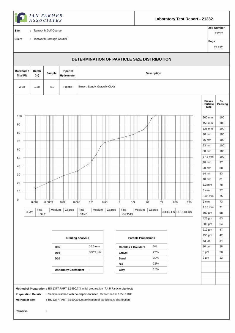
Grading Analysis
D85
D60
D10
Uniformity Coefficient
Particle Proportions
Cobbles + Boulders
Gravel
Sand
Silt
Clay
Sieve /Particle
Size
%Passing
DETERMINATION OF PARTICLE SIZE DISTRIBUTION
Laboratory Test Report - 21232
Job Number
21232
Page
Site : Tamworth Golf Course
Client : Tamworth Borough Council
Method of Preparation : BS 1377:PART 1:1990:7.3 Initial preparation 7.4.5 Particle size tests
Preparation Details : Sample washed with no dispersant used, Oven Dried at 105 - 110°C
Method of Test : BS 1377:PART 2:1990:9 Determination of particle size distribution
Remarks :
Borehole /
Trial Pit
Depth
(m)Sample
Pipette/
HydrometerDescription
PipetteWS8 1.20 B1 Brown, Sandy, Gravelly CLAY
200 mm 100
150 mm 100
125 mm 100
90 mm 100
75 mm 100
63 mm 100
50 mm 100
37.5 mm 100
28 mm 97
20 mm 88
14 mm 83
10 mm 81
6.3 mm 78
5 mm 77
3.35 mm 75
2 mm 73
1.18 mm 71
600 µm 68
425 µm 63
300 µm 54
212 µm 47
150 µm 42
63 µm 34
20 µm 28
6 µm 20
2 µm 13
16.5 mm
382.9 µm
-
-
0%
27%
39%
21%
13%
0.002 0.0063 0.02 0.063 0.2 0.63 2 6.3 20 63 200 6300
10
20
30
40
50
60
70
80
90
100
Fine Medium Coarse Fine Medium Coarse Fine Medium CoarseCLAY
SILT SAND GRAVELCOBBLES BOULDERS
24 / 32

Grading Analysis
D85
D60
D10
Uniformity Coefficient
Particle Proportions
Cobbles + Boulders
Gravel
Sand
Silt
Clay
Sieve /Particle
Size
%Passing
DETERMINATION OF PARTICLE SIZE DISTRIBUTION
Laboratory Test Report - 21232
Job Number
21232
Page
Site : Tamworth Golf Course
Client : Tamworth Borough Council
Method of Preparation : BS 1377:PART 1:1990:7.3 Initial preparation 7.4.5 Particle size tests
Preparation Details : Sample washed with no dispersant used, Oven Dried at 105 - 110°C
Method of Test : BS 1377:PART 2:1990:9 Determination of particle size distribution
Remarks :
Borehole /
Trial Pit
Depth
(m)Sample
Pipette/
HydrometerDescription
PipetteWS9 1.20 B3 Brown, Sandy CLAY
200 mm 100
150 mm 100
125 mm 100
90 mm 100
75 mm 100
63 mm 100
50 mm 100
37.5 mm 100
28 mm 100
20 mm 100
14 mm 97
10 mm 95
6.3 mm 93
5 mm 92
3.35 mm 90
2 mm 89
1.18 mm 88
600 µm 85
425 µm 83
300 µm 80
212 µm 78
150 µm 74
63 µm 60
20 µm 44
6 µm 31
2 µm 24
630.6 µm
61.9 µm
-
-
0%
11%
29%
36%
24%
0.002 0.0063 0.02 0.063 0.2 0.63 2 6.3 20 63 200 6300
10
20
30
40
50
60
70
80
90
100
Fine Medium Coarse Fine Medium Coarse Fine Medium CoarseCLAY
SILT SAND GRAVELCOBBLES BOULDERS
25 / 32
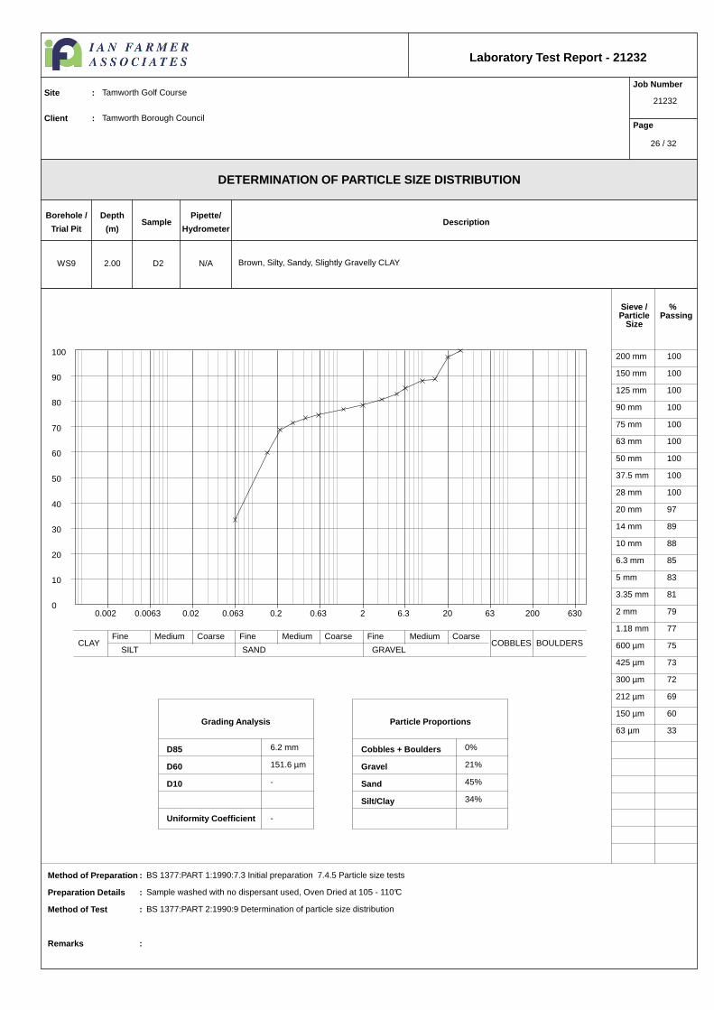
Grading Analysis
D85
D60
D10
Uniformity Coefficient
Particle Proportions
Cobbles + Boulders
Gravel
Sand
Silt/Clay
Sieve /Particle
Size
%Passing
DETERMINATION OF PARTICLE SIZE DISTRIBUTION
Laboratory Test Report - 21232
Job Number
21232
Page
Site : Tamworth Golf Course
Client : Tamworth Borough Council
Method of Preparation : BS 1377:PART 1:1990:7.3 Initial preparation 7.4.5 Particle size tests
Preparation Details : Sample washed with no dispersant used, Oven Dried at 105 - 110°C
Method of Test : BS 1377:PART 2:1990:9 Determination of particle size distribution
Remarks :
Borehole /
Trial Pit
Depth
(m)Sample
Pipette/
HydrometerDescription
N/AWS9 2.00 D2 Brown, Silty, Sandy, Slightly Gravelly CLAY
200 mm 100
150 mm 100
125 mm 100
90 mm 100
75 mm 100
63 mm 100
50 mm 100
37.5 mm 100
28 mm 100
20 mm 97
14 mm 89
10 mm 88
6.3 mm 85
5 mm 83
3.35 mm 81
2 mm 79
1.18 mm 77
600 µm 75
425 µm 73
300 µm 72
212 µm 69
150 µm 60
63 µm 33
6.2 mm
151.6 µm
-
-
0%
21%
45%
34%
0.002 0.0063 0.02 0.063 0.2 0.63 2 6.3 20 63 200 6300
10
20
30
40
50
60
70
80
90
100
Fine Medium Coarse Fine Medium Coarse Fine Medium CoarseCLAY
SILT SAND GRAVELCOBBLES BOULDERS
26 / 32

WS12 1.20 B1Brown, Sandy, Very Gravelly CLAY
0 %
1 %
2
1 Litre/proctor
Max size of cohesive lumps 20 mm
Single
2.65 Assumed
2.5kg Rammer
1.54 18
8.00 10.00 12.00 14.00 16.00 18.00 20.00 22.00 24.00 26.00
221 kPa
163 kPa
121 kPa
50 kPa
21 kPa
DryDensityMg/m³
Moisture Content %
0%5%10%1.64
1.60
1.56
1.52
1.48
1.44
1.40
DETERMINATION OF DRY DENSITY/MOISTURE CONTENT RELAT IONSHIP
Laboratory Test Report - 21232
Job Number
21232
Page
Site : Tamworth Golf Course
Client : Tamworth Borough Council
Method of Preparation : BS 1377:PART 1:7.6, BS 1377:PART 4:1990:3.2 Preparation of samples for compaction tests
Method of Test : BS 1377:PART 4:1990:3.4/3.4 Determination using 2.5 kg rammer or 3.5/3.6 Determination using 4.5kg rammer: PART 2:1990:8.2 Determination of particle density
Remarks :
Description
Percentage retained 37.5 mm
Percentage retained 20.0 mm
Grading Zone
Single or separate samples
Particle density
Method of compaction
OPTIMUM MOISTURE CONTENT
Mould Type
MAX DRY DENSITY Mg/m³ %
Borehole /
Trial Pit
Depth
(m)Sample
Job Number
27 / 32
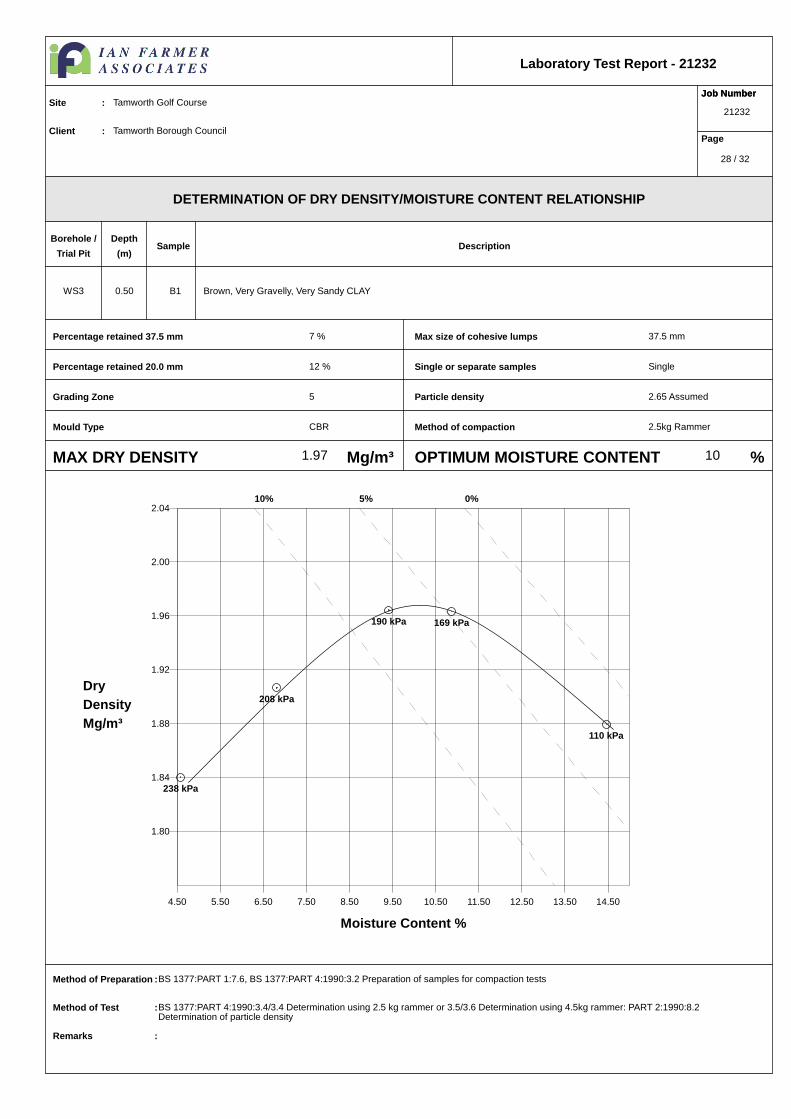
WS3 0.50 B1 Brown, Very Gravelly, Very Sandy CLAY
7 %
12 %
5
CBR
Max size of cohesive lumps 37.5 mm
Single
2.65 Assumed
2.5kg Rammer
1.97 10
4.50 5.50 6.50 7.50 8.50 9.50 10.50 11.50 12.50 13.50 14.50
238 kPa
208 kPa
190 kPa 169 kPa
110 kPa
DryDensityMg/m³
Moisture Content %
0%5%10%2.04
2.00
1.96
1.92
1.88
1.84
1.80
DETERMINATION OF DRY DENSITY/MOISTURE CONTENT RELAT IONSHIP
Laboratory Test Report - 21232
Job Number
21232
Page
Site : Tamworth Golf Course
Client : Tamworth Borough Council
Method of Preparation : BS 1377:PART 1:7.6, BS 1377:PART 4:1990:3.2 Preparation of samples for compaction tests
Method of Test : BS 1377:PART 4:1990:3.4/3.4 Determination using 2.5 kg rammer or 3.5/3.6 Determination using 4.5kg rammer: PART 2:1990:8.2 Determination of particle density
Remarks :
Description
Percentage retained 37.5 mm
Percentage retained 20.0 mm
Grading Zone
Single or separate samples
Particle density
Method of compaction
OPTIMUM MOISTURE CONTENT
Mould Type
MAX DRY DENSITY Mg/m³ %
Borehole /
Trial Pit
Depth
(m)Sample
Job Number
28 / 32

WS7 1.20 B1 Brown, Sandy, Gravelly CLAY
0 %
0 %
1
1 Litre/proctor
Max size of cohesive lumps 20 mm
Single
2.65 Assumed
2.5kg Rammer
1.58 20
12.00 14.00 16.00 18.00 20.00 22.00 24.00 26.00 28.00
221 kPa
145 kPa106 kPa
62 kPa
26 kPa
DryDensityMg/m³
Moisture Content %
0%5%10%1.68
1.64
1.60
1.56
1.52
1.48
1.44
DETERMINATION OF DRY DENSITY/MOISTURE CONTENT RELAT IONSHIP
Laboratory Test Report - 21232
Job Number
21232
Page
Site : Tamworth Golf Course
Client : Tamworth Borough Council
Method of Preparation : BS 1377:PART 1:7.6, BS 1377:PART 4:1990:3.2 Preparation of samples for compaction tests
Method of Test : BS 1377:PART 4:1990:3.4/3.4 Determination using 2.5 kg rammer or 3.5/3.6 Determination using 4.5kg rammer: PART 2:1990:8.2 Determination of particle density
Remarks :
Description
Percentage retained 37.5 mm
Percentage retained 20.0 mm
Grading Zone
Single or separate samples
Particle density
Method of compaction
OPTIMUM MOISTURE CONTENT
Mould Type
MAX DRY DENSITY Mg/m³ %
Borehole /
Trial Pit
Depth
(m)Sample
Job Number
29 / 32

WS9 1.20 B3 Brown, Sandy CLAY
0 %
0 %
1
1 Litre/proctor
Max size of cohesive lumps 20 mm
Single
2.65 Assumed
2.5kg Rammer
1.63 21
13.50 15.50 17.50 19.50 21.50 23.50 25.50
221 kPa
150 kPa
113 kPa
52 kPa
19 kPa
DryDensityMg/m³
Moisture Content %
0%5%10%1.72
1.68
1.64
1.60
1.56
1.52
1.48
DETERMINATION OF DRY DENSITY/MOISTURE CONTENT RELAT IONSHIP
Laboratory Test Report - 21232
Job Number
21232
Page
Site : Tamworth Golf Course
Client : Tamworth Borough Council
Method of Preparation : BS 1377:PART 1:7.6, BS 1377:PART 4:1990:3.2 Preparation of samples for compaction tests
Method of Test : BS 1377:PART 4:1990:3.4/3.4 Determination using 2.5 kg rammer or 3.5/3.6 Determination using 4.5kg rammer: PART 2:1990:8.2 Determination of particle density
Remarks :
Description
Percentage retained 37.5 mm
Percentage retained 20.0 mm
Grading Zone
Single or separate samples
Particle density
Method of compaction
OPTIMUM MOISTURE CONTENT
Mould Type
MAX DRY DENSITY Mg/m³ %
Borehole /
Trial Pit
Depth
(m)Sample
Job Number
30 / 32
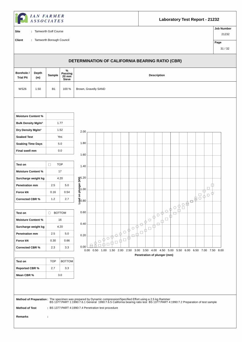
WS26 1.50 B1 Brown, Gravelly SAND
DETERMINATION OF CALIFORNIA BEARING RATIO (CBR)
Laboratory Test Report - 21232
Job Number
21232
Page
Site : Tamworth Golf Course
Client : Tamworth Borough Council
Method of Preparation : The specimen was prepared by Dynamic compression/Specified Effort using a 2.5 kg RammerBS 1377:PART 1:1990:7.6.1 General 1990:7.6.5 California bearing ratio test BS 1377:PART 4:1990:7.2 Preparation of test sample
Method of Test : BS 1377:PART 4:1990:7.4 Penetration test procedure
Remarks :
Borehole /
Trial Pit
Depth
(m)Sample
%Passing20 mmSieve
Description
Penetration of plunger (mm)
Load
on
plun
ger
(kN
)
0.00 0.50 1.00 1.50 2.00 2.50 3.00 3.50 4.00 4.50 5.00 5.50 6.00 6.50 7.00 7.50 8.000.00
0.20
0.40
0.60
0.80
1.00
1.20
1.40
1.60
1.80
2.00
100 %
Moisture Content %
1.77Bulk Density Mg/m³
1.52Dry Density Mg/m³
YesSoaked Test
5.0Soaking Time Days
0.0Final swell mm
TOPTest on
17Moisture Content %
4.20Surcharge weight kg
2.5 5.0Penetration mm
0.16 0.54Force kN
1.2 2.7Corrected CBR %
BOTTOMTest on
16Moisture Content %
4.20Surcharge weight kg
2.5 5.0Penetration mm
0.30 0.66Force kN
2.3 3.3Corrected CBR %
TOP BOTTOMTest on
2.7 3.3Reported CBR %
3.0Mean CBR %
31 / 32

Test Report : 21232
Site : Tamworth Golf CourseJob Number : 21232Originating Client : Tamworth Borough Council
All opinions and interpretations contained within this report are outside of our Scope ofAccreditation.
The following tests contained within this report are not UKAS Accredited.
Date of Issued : 25/06/14
Page 32 of 32
Client
Our Reference
Client Reference
Contract Title
Description
Date Received
Date Started
Date Completed
Test Procedures
Notes
Approved By
Rob Brown
Opinions and interpretations are outside the scope of UKAS accreditation. This
certificate is issued in accordance with the accreditation requirements of the United
Kingdom Accreditation Service. The results reported herein relate only to the material
supplied to the laboratory. Observations and interpretations are outside the scope of
ISO 17025. This certificate shall not be reproduced except in full, without the prior
written approval of the laboratory.
Business Manager
Tamworth
21 Soil samples.
10-Jun-14
10-Jun-14
16-Jun-14
Identified by prefix DETSn (details on request).
Certificate of AnalysisCertificate Number 14-07793
16-Jun-14
Ian Farmer Associates
14 Faraday Close
District 15
Pattinson North Industrial Est
Washington
Tyne & Wear
NE38 8QJ
14-07793
21232
Derwentside Environmental Testing Services LimitedUnit 2, Park Road Industrial Estate South, Consett, Co Durham, DH8 5PY
Tel: 01207 582333 • email: [email protected] • www.dets.co.uk Page 1 of 4 .
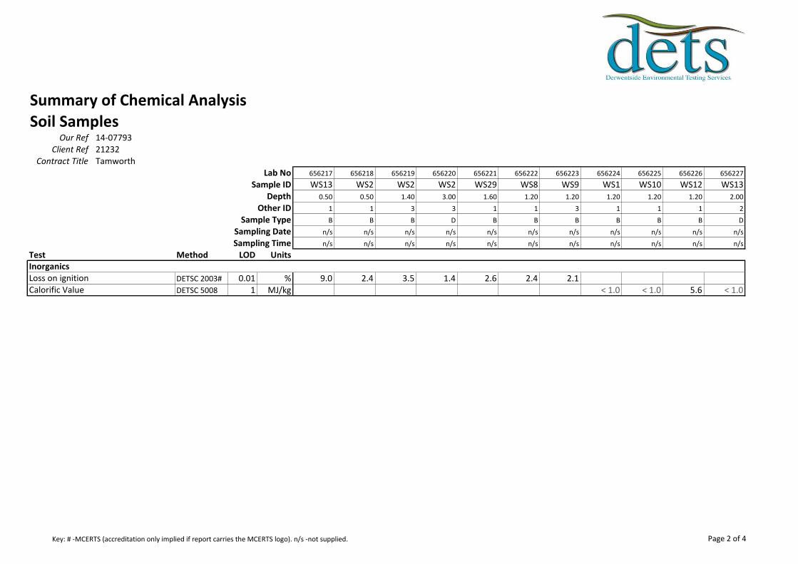
Summary of Chemical AnalysisSoil Samples
Our Ref 14-07793Client Ref 21232
Contract Title TamworthLab No 656217 656218 656219 656220 656221 656222 656223 656224 656225 656226 656227
Sample ID WS13 WS2 WS2 WS2 WS29 WS8 WS9 WS1 WS10 WS12 WS13Depth 0.50 0.50 1.40 3.00 1.60 1.20 1.20 1.20 1.20 1.20 2.00
Other ID 1 1 3 3 1 1 3 1 1 1 2
Sample Type B B B D B B B B B B D
Sampling Date n/s n/s n/s n/s n/s n/s n/s n/s n/s n/s n/s
Sampling Time n/s n/s n/s n/s n/s n/s n/s n/s n/s n/s n/s
Test Method LOD Units
DETSC 2003# 0.01 % 9.0 2.4 3.5 1.4 2.6 2.4 2.1DETSC 5008 1 MJ/kg < 1.0 < 1.0 5.6 < 1.0
Loss on ignitionCalorific Value
Inorganics
Page 2 of 4Key: # -MCERTS (accreditation only implied if report carries the MCERTS logo). n/s -not supplied.

Summary of Chemical AnalysisSoil Samples
Our Ref 14-07793Client Ref 21232
Contract Title TamworthLab No
Sample IDDepth
Other IDSample Type
Sampling DateSampling Time
Test Method LOD Units
DETSC 2003# 0.01 %DETSC 5008 1 MJ/kg
Loss on ignitionCalorific Value
Inorganics
656228 656229 656230 656231 656232 656233 656234 656235 656236 656237
WS16 WS18 WS2 WS21 WS3 WS3 WS4 WS5 WS6 WS71.20 1.20 2.00 1.00 1.20 3.00 0.80 1.20 1.20 1.20
1 1 4 1 2 5 1 1 1 1
B B B B B D B B B B
n/s n/s n/s n/s n/s n/s n/s n/s n/s n/s
n/s n/s n/s n/s n/s n/s n/s n/s n/s n/s
5.7 < 1.0 < 1.0 < 1.0 < 1.0 < 1.0 < 1.0 < 1.0 < 1.0 < 1.0
Page 3 of 4Key: # -MCERTS (accreditation only implied if report carries the MCERTS logo). n/s -not supplied.
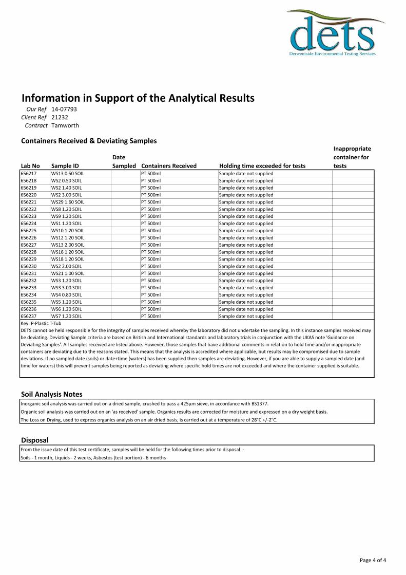
Information in Support of the Analytical ResultsOur Ref 14-07793
Client Ref 21232Contract Tamworth
Containers Received & Deviating Samples
Lab No Sample ID
Date
Sampled Containers Received Holding time exceeded for tests
Inappropriate
container for
tests656217 WS13 0.50 SOIL PT 500ml Sample date not supplied
656218 WS2 0.50 SOIL PT 500ml Sample date not supplied
656219 WS2 1.40 SOIL PT 500ml Sample date not supplied
656220 WS2 3.00 SOIL PT 500ml Sample date not supplied
656221 WS29 1.60 SOIL PT 500ml Sample date not supplied
656222 WS8 1.20 SOIL PT 500ml Sample date not supplied
656223 WS9 1.20 SOIL PT 500ml Sample date not supplied
656224 WS1 1.20 SOIL PT 500ml Sample date not supplied
656225 WS10 1.20 SOIL PT 500ml Sample date not supplied
656226 WS12 1.20 SOIL PT 500ml Sample date not supplied
656227 WS13 2.00 SOIL PT 500ml Sample date not supplied
656228 WS16 1.20 SOIL PT 500ml Sample date not supplied
656229 WS18 1.20 SOIL PT 500ml Sample date not supplied
656230 WS2 2.00 SOIL PT 500ml Sample date not supplied
656231 WS21 1.00 SOIL PT 500ml Sample date not supplied
656232 WS3 1.20 SOIL PT 500ml Sample date not supplied
656233 WS3 3.00 SOIL PT 500ml Sample date not supplied
656234 WS4 0.80 SOIL PT 500ml Sample date not supplied
656235 WS5 1.20 SOIL PT 500ml Sample date not supplied
656236 WS6 1.20 SOIL PT 500ml Sample date not supplied
656237 WS7 1.20 SOIL PT 500ml Sample date not supplied
Soil Analysis NotesInorganic soil analysis was carried out on a dried sample, crushed to pass a 425µm sieve, in accordance with BS1377.
Organic soil analysis was carried out on an 'as received' sample. Organics results are corrected for moisture and expressed on a dry weight basis.
The Loss on Drying, used to express organics analysis on an air dried basis, is carried out at a temperature of 28°C +/-2°C.
DisposalFrom the issue date of this test certificate, samples will be held for the following times prior to disposal :-
Soils - 1 month, Liquids - 2 weeks, Asbestos (test portion) - 6 months
Key: P-Plastic T-Tub
DETS cannot be held responsible for the integrity of samples received whereby the laboratory did not undertake the sampling. In this instance samples received may
be deviating. Deviating Sample criteria are based on British and International standards and laboratory trials in conjunction with the UKAS note 'Guidance on
Deviating Samples'. All samples received are listed above. However, those samples that have additional comments in relation to hold time and/or inappropriate
containers are deviating due to the reasons stated. This means that the analysis is accredited where applicable, but results may be compromised due to sample
deviations. If no sampled date (soils) or date+time (waters) has been supplied then samples are deviating. However, if you are able to supply a sampled date (and
time for waters) this will prevent samples being reported as deviating where specific hold times are not exceeded and where the container supplied is suitable.
Page 4 of 4

Client
Our Reference
Client Reference
Contract Title
Description
Date Received
Date Started
Date Completed
Test Procedures
Notes
Approved By
Rob Brown
Opinions and interpretations are outside the scope of UKAS accreditation. This
certificate is issued in accordance with the accreditation requirements of the United
Kingdom Accreditation Service. The results reported herein relate only to the material
supplied to the laboratory. Observations and interpretations are outside the scope of
ISO 17025. This certificate shall not be reproduced except in full, without the prior
written approval of the laboratory.
Business Manager
TAMWORTH
One Soil sample.
13-Jun-14
16-Jun-14
18-Jun-14
Identified by prefix DETSn (details on request).
Certificate of AnalysisCertificate Number 14-08246
18-Jun-14
Ian Farmer Associates
14 Faraday Close
District 15
Pattinson North Industrial Est
Washington
Tyne & Wear
NE38 8QJ
14-08246
21232
Derwentside Environmental Testing Services LimitedUnit 2, Park Road Industrial Estate South, Consett, Co Durham, DH8 5PY
Tel: 01207 582333 • email: [email protected] • www.dets.co.uk Page 1 of 3 .
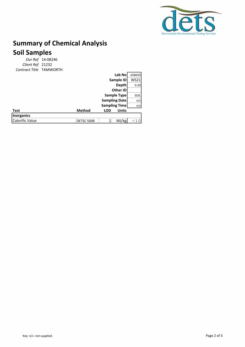
Summary of Chemical AnalysisSoil Samples
Our Ref 14-08246Client Ref 21232
Contract Title TAMWORTHLab No 658659
Sample ID WS21Depth 0.20
Other IDSample Type SOIL
Sampling Date n/s
Sampling Time n/s
Test Method LOD Units
DETSC 5008 1 MJ/kg < 1.0Calorific ValueInorganics
Page 2 of 3Key: n/s -not supplied.
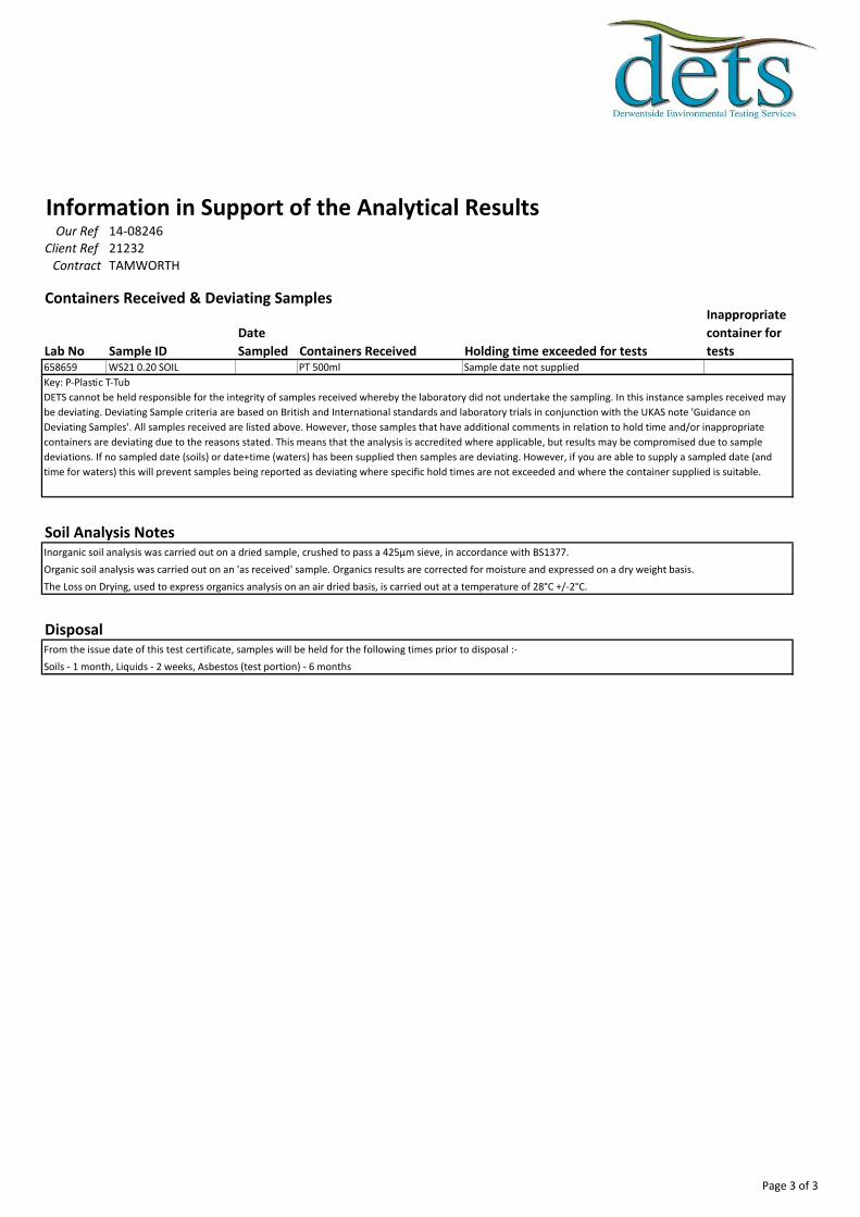
Information in Support of the Analytical ResultsOur Ref 14-08246
Client Ref 21232Contract TAMWORTH
Containers Received & Deviating Samples
Lab No Sample ID
Date
Sampled Containers Received Holding time exceeded for tests
Inappropriate
container for
tests658659 WS21 0.20 SOIL PT 500ml Sample date not supplied
Soil Analysis NotesInorganic soil analysis was carried out on a dried sample, crushed to pass a 425µm sieve, in accordance with BS1377.
Organic soil analysis was carried out on an 'as received' sample. Organics results are corrected for moisture and expressed on a dry weight basis.
The Loss on Drying, used to express organics analysis on an air dried basis, is carried out at a temperature of 28°C +/-2°C.
DisposalFrom the issue date of this test certificate, samples will be held for the following times prior to disposal :-
Soils - 1 month, Liquids - 2 weeks, Asbestos (test portion) - 6 months
Key: P-Plastic T-Tub
DETS cannot be held responsible for the integrity of samples received whereby the laboratory did not undertake the sampling. In this instance samples received may
be deviating. Deviating Sample criteria are based on British and International standards and laboratory trials in conjunction with the UKAS note 'Guidance on
Deviating Samples'. All samples received are listed above. However, those samples that have additional comments in relation to hold time and/or inappropriate
containers are deviating due to the reasons stated. This means that the analysis is accredited where applicable, but results may be compromised due to sample
deviations. If no sampled date (soils) or date+time (waters) has been supplied then samples are deviating. However, if you are able to supply a sampled date (and
time for waters) this will prevent samples being reported as deviating where specific hold times are not exceeded and where the container supplied is suitable.
Page 3 of 3

APPENDIX 4
CHEMICAL TESTS
Client
Our Reference
Client Reference
Contract Title
Description
Date Received
Date Started
Date Completed
Test Procedures
Notes
Approved By
Rob Brown
Opinions and interpretations are outside the scope of UKAS accreditation. This
certificate is issued in accordance with the accreditation requirements of the United
Kingdom Accreditation Service. The results reported herein relate only to the material
supplied to the laboratory. Observations and interpretations are outside the scope of
ISO 17025. This certificate shall not be reproduced except in full, without the prior
written approval of the laboratory.
Business Manager
Tamworth Golf Course
23 Soil samples, 10 Leachate samples.
15-May-14
15-May-14
23-May-14
Identified by prefix DETSn (details on request), Asbestos Analysis DETSC 1101.
Certificate of AnalysisCertificate Number 14-06067
23-May-14
Ian Farmer Associates
Unit 1 Fairfield Court
Seven Stars Industrial Estate
Wheler Road
Coventry
West Midlands
CV3 4LJ
14-06067
21232
Derwentside Environmental Testing Services LimitedUnit 2, Park Road Industrial Estate South, Consett, Co Durham, DH8 5PY
Tel: 01207 582333 • email: [email protected] • www.dets.co.uk Page 1 of 16 .
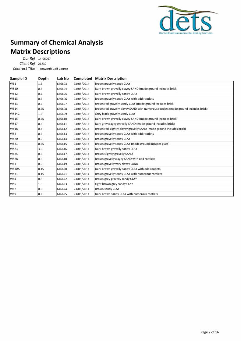
Summary of Chemical AnalysisMatrix Descriptions
Our Ref 14-06067
Client Ref 21232
Contract Title Tamworth Golf Course
Sample ID Depth Lab No Completed Matrix DescriptionWS1 1.5 646603 23/05/2014 Brown gravelly sandy CLAY
WS10 0.5 646604 23/05/2014 Dark brown gravelly clayey SAND (made ground includes brick)
WS12 0.5 646605 23/05/2014 Dark brown gravelly sandy CLAY
WS13 0.2 646606 23/05/2014 Brown gravelly sandy CLAY with odd rootlets
WS13 0.5 646607 23/05/2014 Brown red gravelly sandy CLAY (made ground includes brick)
WS14 0.25 646608 23/05/2014 Brown red gravelly clayey SAND with numerous rootlets (made ground includes brick)
WS14C 1.5 646609 23/05/2014 Grey black gravelly sandy CLAY
WS15 0.25 646610 23/05/2014 Dark brown gravelly clayey SAND (made ground includes brick)
WS17 0.5 646611 23/05/2014 Dark grey clayey gravelly SAND (made ground includes brick)
WS18 0.3 646612 23/05/2014 Brown red slightly clayey gravelly SAND (made ground includes brick)
WS2 0.2 646613 23/05/2014 Brown gravelly sandy CLAY with odd rootlets
WS20 0.5 646614 23/05/2014 Brown gravelly sandy CLAY
WS21 0.25 646615 23/05/2014 Brown gravelly sandy CLAY (made ground includes glass)
WS23 3.5 646616 23/05/2014 Dark brown gravelly sandy CLAY
WS25 0.5 646617 23/05/2014 Brown slightly gravelly SAND
WS28 0.5 646618 23/05/2014 Brown gravelly clayey SAND with odd rootlets
WS3 0.5 646619 23/05/2014 Brown gravelly very clayey SAND
WS30A 0.15 646620 23/05/2014 Dark brown gravelly sandy CLAY with odd rootlets
WS31 0.15 646621 23/05/2014 Brown gravelly sandy CLAY with numerous rootlets
WS4 0.8 646622 23/05/2014 Brown grey gravelly sandy CLAY
WS5 1.5 646623 23/05/2014 Light brown grey sandy CLAY
WS7 0.5 646624 23/05/2014 Brown sandy CLAY
WS9 0.2 646625 23/05/2014 Dark brown sandy CLAY with numerous rootlets
Page 2 of 16
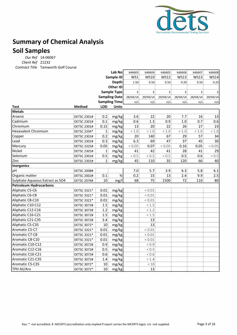
Summary of Chemical AnalysisSoil Samples
Our Ref 14-06067Client Ref 21232
Contract Title Tamworth Golf CourseLab No 646603 646604 646605 646606 646607 646608
Sample ID WS1 WS10 WS12 WS13 WS13 WS14Depth 1.50 0.50 0.50 0.20 0.50 0.25
Other IDSample Type E E E E E E
Sampling Date 28/04/14 29/04/14 29/04/14 28/04/14 28/04/14 29/04/14
Sampling Time n/s n/s n/s n/s n/s n/s
Test Method LOD Units
DETSC 2301# 0.2 mg/kg 3.6 22 20 7.7 16 13DETSC 2301# 0.1 mg/kg 0.6 1.3 0.9 1.0 0.7 0.6DETSC 2301# 0.15 mg/kg 13 20 22 26 27 23DETSC 2204* 1 mg/kg < 1.0 < 1.0 < 1.0 < 1.0 < 1.0 < 1.0DETSC 2301# 0.2 mg/kg 20 140 67 29 57 34DETSC 2301# 0.3 mg/kg 6.3 69 47 37 45 30DETSC 2325# 0.05 mg/kg < 0.05 0.07 < 0.05 0.16 0.05 < 0.05DETSC 2301# 1 mg/kg 41 42 41 28 41 29DETSC 2301# 0.5 mg/kg < 0.5 < 0.5 < 0.5 0.5 0.6 < 0.5DETSC 2301# 1 mg/kg 45 110 35 120 66 40
DETSC 2008# 7.0 5.7 3.9 6.3 5.8 6.1DETSC 2002# 0.1 % 0.2 15 13 2.4 9.9 2.5DETSC 2076# 10 mg/l 68 75 1500 72 110 80
DETSC 3321* 0.01 mg/kg < 0.01DETSC 3321* 0.01 mg/kg < 0.01DETSC 3321* 0.01 mg/kg < 0.01DETSC 3072# 1.5 mg/kg < 1.5DETSC 3072# 1.2 mg/kg < 1.2DETSC 3072# 1.5 mg/kg < 1.5DETSC 3072# 3.4 mg/kg 13DETSC 3072* 10 mg/kg 13DETSC 3321* 0.01 mg/kg < 0.01DETSC 3321* 0.01 mg/kg < 0.01DETSC 3321* 0.01 mg/kg < 0.01DETSC 3072# 0.9 mg/kg < 0.9DETSC 3072# 0.5 mg/kg < 0.5DETSC 3072# 0.6 mg/kg < 0.6DETSC 3072# 1.4 mg/kg < 1.4DETSC 3072* 10 mg/kg < 10DETSC 3072* 10 mg/kg 13
Metals
Inorganics
Petroleum Hydrocarbons
Aromatic C10-C12Aromatic C12-C16Aromatic C16-C21Aromatic C21-C35Aromatic C5-C35TPH Ali/Aro
Aliphatic C16-C21Aliphatic C21-C35Aliphatic C5-C35Aromatic C5-C7Aromatic C7-C8Aromatic C8-C10
Sulphate Aqueous Extract as SO4
Aliphatic C5-C6Aliphatic C6-C8Aliphatic C8-C10Aliphatic C10-C12Aliphatic C12-C16
MercuryNickelSeleniumZinc
pHOrganic matter
ArsenicCadmiumChromiumHexavalent ChromiumCopperLead
Page 3 of 16Key: * -not accredited. # -MCERTS (accreditation only implied if report carries the MCERTS logo). n/s -not supplied.

Summary of Chemical AnalysisSoil Samples
Our Ref 14-06067Client Ref 21232
Contract Title Tamworth Golf CourseLab No 646603 646604 646605 646606 646607 646608
Sample ID WS1 WS10 WS12 WS13 WS13 WS14Depth 1.50 0.50 0.50 0.20 0.50 0.25
Other IDSample Type E E E E E E
Sampling Date 28/04/14 29/04/14 29/04/14 28/04/14 28/04/14 29/04/14
Sampling Time n/s n/s n/s n/s n/s n/s
Test Method LOD Units
DETSC 3301 0.1 mg/kg < 0.1 < 0.1 < 0.1 < 0.1 < 0.1 < 0.1DETSC 3301 0.1 mg/kg < 0.1 < 0.1 < 0.1 < 0.1 < 0.1 < 0.1DETSC 3301 0.1 mg/kg < 0.1 < 0.1 < 0.1 < 0.1 < 0.1 < 0.1DETSC 3301 0.1 mg/kg < 0.1 1.7 < 0.1 < 0.1 < 0.1 < 0.1DETSC 3301 0.1 mg/kg < 0.1 0.9 < 0.1 < 0.1 < 0.1 < 0.1DETSC 3301 0.1 mg/kg < 0.1 0.8 < 0.1 < 0.1 < 0.1 < 0.1DETSC 3301 0.1 mg/kg < 0.1 0.3 < 0.1 < 0.1 < 0.1 < 0.1DETSC 3301 0.1 mg/kg < 0.1 0.4 < 0.1 < 0.1 < 0.1 < 0.1DETSC 3301 0.1 mg/kg < 0.1 1.0 < 0.1 < 0.1 < 0.1 < 0.1DETSC 3301 0.1 mg/kg < 0.1 0.3 < 0.1 < 0.1 < 0.1 < 0.1DETSC 3301 0.1 mg/kg < 0.1 0.5 < 0.1 < 0.1 < 0.1 < 0.1DETSC 3301 0.1 mg/kg < 0.1 < 0.1 < 0.1 < 0.1 < 0.1 < 0.1DETSC 3301 0.1 mg/kg < 0.1 0.6 < 0.1 < 0.1 < 0.1 < 0.1DETSC 3301 0.1 mg/kg < 0.1 < 0.1 < 0.1 < 0.1 < 0.1 < 0.1DETSC 3301 0.1 mg/kg < 0.1 < 0.1 < 0.1 < 0.1 < 0.1 < 0.1DETSC 3301 0.1 mg/kg < 0.1 1.0 < 0.1 < 0.1 < 0.1 < 0.1DETSC 3301 1.6 mg/kg < 1.6 7.6 < 1.6 < 1.6 < 1.6 < 1.6
Indeno(1,2,3-c,d)pyreneNaphthalenePhenanthrenePyrenePAH
PAHs
Benzo(k)fluorantheneBenzo(g,h,i)peryleneChryseneDibenzo(a,h)anthraceneFluorantheneFluorene
AcenaphtheneAcenaphthyleneAnthraceneBenzo(a)anthraceneBenzo(a)pyreneBenzo(b)fluoranthene
Page 4 of 16Key: * -not accredited. # -MCERTS (accreditation only implied if report carries the MCERTS logo). n/s -not supplied.

Summary of Chemical AnalysisSoil Samples
Our Ref 14-06067Client Ref 21232
Contract Title Tamworth Golf CourseLab No
Sample IDDepth
Other IDSample Type
Sampling DateSampling Time
Test Method LOD Units
DETSC 2301# 0.2 mg/kgDETSC 2301# 0.1 mg/kgDETSC 2301# 0.15 mg/kgDETSC 2204* 1 mg/kgDETSC 2301# 0.2 mg/kgDETSC 2301# 0.3 mg/kgDETSC 2325# 0.05 mg/kgDETSC 2301# 1 mg/kgDETSC 2301# 0.5 mg/kgDETSC 2301# 1 mg/kg
DETSC 2008#
DETSC 2002# 0.1 %DETSC 2076# 10 mg/l
DETSC 3321* 0.01 mg/kgDETSC 3321* 0.01 mg/kgDETSC 3321* 0.01 mg/kgDETSC 3072# 1.5 mg/kgDETSC 3072# 1.2 mg/kgDETSC 3072# 1.5 mg/kgDETSC 3072# 3.4 mg/kgDETSC 3072* 10 mg/kgDETSC 3321* 0.01 mg/kgDETSC 3321* 0.01 mg/kgDETSC 3321* 0.01 mg/kgDETSC 3072# 0.9 mg/kgDETSC 3072# 0.5 mg/kgDETSC 3072# 0.6 mg/kgDETSC 3072# 1.4 mg/kgDETSC 3072* 10 mg/kgDETSC 3072* 10 mg/kg
Metals
Inorganics
Petroleum Hydrocarbons
Aromatic C10-C12Aromatic C12-C16Aromatic C16-C21Aromatic C21-C35Aromatic C5-C35TPH Ali/Aro
Aliphatic C16-C21Aliphatic C21-C35Aliphatic C5-C35Aromatic C5-C7Aromatic C7-C8Aromatic C8-C10
Sulphate Aqueous Extract as SO4
Aliphatic C5-C6Aliphatic C6-C8Aliphatic C8-C10Aliphatic C10-C12Aliphatic C12-C16
MercuryNickelSeleniumZinc
pHOrganic matter
ArsenicCadmiumChromiumHexavalent ChromiumCopperLead
646609 646610 646611 646612 646613 646614
WS14C WS15 WS17 WS18 WS2 WS201.50 0.25 0.50 0.30 0.20 0.50
E E E E E E
29/04/14 29/04/14 30/04/14 28/04/14 28/04/14 02/05/14
n/s n/s n/s n/s n/s n/s
18 20 26 19 9.5 9.00.6 0.7 1.0 1.5 0.7 0.651 41 34 47 20 37
< 1.0 < 1.0 < 1.0 < 1.0 < 1.0 < 1.056 64 99 56 25 2533 51 46 40 31 17
0.05 0.11 < 0.05 < 0.05 0.09 < 0.0541 35 66 49 16 29
1.7 1.8 1.2 1.6 0.6 0.665 47 92 78 65 69
4.0 4.2 4.7 6.0 6.5 8.016 13 16 5.2 2.5 0.9
1500 550 1000 110 15 89
< 0.01 < 0.01 < 0.01< 0.01 < 0.01 < 0.01< 0.01 < 0.01 < 0.01
< 1.5 < 1.5 < 1.5< 1.2 < 1.2 < 1.2< 1.5 < 1.5 < 1.5< 3.4 6.1 < 3.4< 10 < 10 < 10
< 0.01 < 0.01 < 0.01< 0.01 < 0.01 < 0.01< 0.01 < 0.01 < 0.01
< 0.9 < 0.9 < 0.9< 0.5 < 0.5 < 0.5< 0.6 < 0.6 < 0.6< 1.4 < 1.4 < 1.4< 10 < 10 < 10< 10 < 10 < 10
Page 5 of 16Key: * -not accredited. # -MCERTS (accreditation only implied if report carries the MCERTS logo). n/s -not supplied.

Summary of Chemical AnalysisSoil Samples
Our Ref 14-06067Client Ref 21232
Contract Title Tamworth Golf CourseLab No
Sample IDDepth
Other IDSample Type
Sampling DateSampling Time
Test Method LOD Units
DETSC 3301 0.1 mg/kgDETSC 3301 0.1 mg/kgDETSC 3301 0.1 mg/kgDETSC 3301 0.1 mg/kgDETSC 3301 0.1 mg/kgDETSC 3301 0.1 mg/kgDETSC 3301 0.1 mg/kgDETSC 3301 0.1 mg/kgDETSC 3301 0.1 mg/kgDETSC 3301 0.1 mg/kgDETSC 3301 0.1 mg/kgDETSC 3301 0.1 mg/kgDETSC 3301 0.1 mg/kgDETSC 3301 0.1 mg/kgDETSC 3301 0.1 mg/kgDETSC 3301 0.1 mg/kgDETSC 3301 1.6 mg/kg
Indeno(1,2,3-c,d)pyreneNaphthalenePhenanthrenePyrenePAH
PAHs
Benzo(k)fluorantheneBenzo(g,h,i)peryleneChryseneDibenzo(a,h)anthraceneFluorantheneFluorene
AcenaphtheneAcenaphthyleneAnthraceneBenzo(a)anthraceneBenzo(a)pyreneBenzo(b)fluoranthene
646609 646610 646611 646612 646613 646614
WS14C WS15 WS17 WS18 WS2 WS201.50 0.25 0.50 0.30 0.20 0.50
E E E E E E
29/04/14 29/04/14 30/04/14 28/04/14 28/04/14 02/05/14
n/s n/s n/s n/s n/s n/s
< 0.1 < 0.1 < 0.1 < 0.1 < 0.1 < 0.1< 0.1 < 0.1 < 0.1 < 0.1 < 0.1 < 0.1< 0.1 < 0.1 < 0.1 < 0.1 < 0.1 < 0.1< 0.1 < 0.1 < 0.1 < 0.1 < 0.1 0.4< 0.1 < 0.1 < 0.1 < 0.1 < 0.1 0.2< 0.1 < 0.1 < 0.1 < 0.1 < 0.1 0.1< 0.1 < 0.1 < 0.1 < 0.1 < 0.1 < 0.1< 0.1 < 0.1 < 0.1 < 0.1 < 0.1 0.3< 0.1 < 0.1 < 0.1 < 0.1 < 0.1 0.2< 0.1 < 0.1 < 0.1 < 0.1 < 0.1 < 0.1< 0.1 < 0.1 < 0.1 < 0.1 < 0.1 0.7< 0.1 < 0.1 < 0.1 < 0.1 < 0.1 < 0.1< 0.1 < 0.1 < 0.1 < 0.1 < 0.1 < 0.1< 0.1 < 0.1 < 0.1 < 0.1 < 0.1 < 0.1< 0.1 < 0.1 < 0.1 < 0.1 < 0.1 < 0.1< 0.1 < 0.1 < 0.1 < 0.1 < 0.1 0.8< 1.6 < 1.6 < 1.6 < 1.6 < 1.6 2.8
Page 6 of 16Key: * -not accredited. # -MCERTS (accreditation only implied if report carries the MCERTS logo). n/s -not supplied.

Summary of Chemical AnalysisSoil Samples
Our Ref 14-06067Client Ref 21232
Contract Title Tamworth Golf CourseLab No
Sample IDDepth
Other IDSample Type
Sampling DateSampling Time
Test Method LOD Units
DETSC 2301# 0.2 mg/kgDETSC 2301# 0.1 mg/kgDETSC 2301# 0.15 mg/kgDETSC 2204* 1 mg/kgDETSC 2301# 0.2 mg/kgDETSC 2301# 0.3 mg/kgDETSC 2325# 0.05 mg/kgDETSC 2301# 1 mg/kgDETSC 2301# 0.5 mg/kgDETSC 2301# 1 mg/kg
DETSC 2008#
DETSC 2002# 0.1 %DETSC 2076# 10 mg/l
DETSC 3321* 0.01 mg/kgDETSC 3321* 0.01 mg/kgDETSC 3321* 0.01 mg/kgDETSC 3072# 1.5 mg/kgDETSC 3072# 1.2 mg/kgDETSC 3072# 1.5 mg/kgDETSC 3072# 3.4 mg/kgDETSC 3072* 10 mg/kgDETSC 3321* 0.01 mg/kgDETSC 3321* 0.01 mg/kgDETSC 3321* 0.01 mg/kgDETSC 3072# 0.9 mg/kgDETSC 3072# 0.5 mg/kgDETSC 3072# 0.6 mg/kgDETSC 3072# 1.4 mg/kgDETSC 3072* 10 mg/kgDETSC 3072* 10 mg/kg
Metals
Inorganics
Petroleum Hydrocarbons
Aromatic C10-C12Aromatic C12-C16Aromatic C16-C21Aromatic C21-C35Aromatic C5-C35TPH Ali/Aro
Aliphatic C16-C21Aliphatic C21-C35Aliphatic C5-C35Aromatic C5-C7Aromatic C7-C8Aromatic C8-C10
Sulphate Aqueous Extract as SO4
Aliphatic C5-C6Aliphatic C6-C8Aliphatic C8-C10Aliphatic C10-C12Aliphatic C12-C16
MercuryNickelSeleniumZinc
pHOrganic matter
ArsenicCadmiumChromiumHexavalent ChromiumCopperLead
646615 646616 646617 646618 646619 646620
WS21 WS23 WS25 WS28 WS3 WS30A0.25 3.50 0.50 0.50 0.50 0.15
E E E E E E
30/04/14 01/05/14 01/05/14 01/05/14 28/04/14 30/04/14
n/s n/s n/s n/s n/s n/s
8.2 11 8.1 6.5 12 100.5 1.7 0.7 0.5 1.3 0.729 38 20 16 20 21
< 1.0 < 1.0 < 1.0 < 1.0 < 1.0 < 1.034 180 6.8 7.8 43 2049 94 16 67 19 33
< 0.05 0.12 < 0.05 < 0.05 < 0.05 0.0620 25 24 18 33 16
< 0.5 < 0.5 < 0.5 0.6 1.7 0.6120 280 110 50 44 75
8.0 9.0 7.3 7.0 7.0 6.32.2 3.6 0.4 0.3 0.6 2.9
1700 950 130 19 21 20
< 0.01 < 0.01 < 0.01 < 0.01 < 0.01< 0.01 < 0.01 < 0.01 < 0.01 < 0.01< 0.01 < 0.01 < 0.01 < 0.01 < 0.01
< 1.5 < 1.5 < 1.5 < 1.5 < 1.5< 1.2 < 1.2 < 1.2 < 1.2 < 1.2< 1.5 5.0 < 1.5 < 1.5 < 1.5< 3.4 49 < 3.4 < 3.4 < 3.4< 10 54 < 10 < 10 < 10
< 0.01 < 0.01 < 0.01 < 0.01 < 0.01< 0.01 < 0.01 < 0.01 < 0.01 < 0.01< 0.01 < 0.01 < 0.01 < 0.01 < 0.01
< 0.9 < 0.9 < 0.9 < 0.9 < 0.9< 0.5 1.7 < 0.5 < 0.5 < 0.5< 0.6 15 < 0.6 < 0.6 < 0.6< 1.4 150 < 1.4 < 1.4 < 1.4< 10 160 < 10 < 10 < 10< 10 220 < 10 < 10 < 10
Page 7 of 16Key: * -not accredited. # -MCERTS (accreditation only implied if report carries the MCERTS logo). n/s -not supplied.
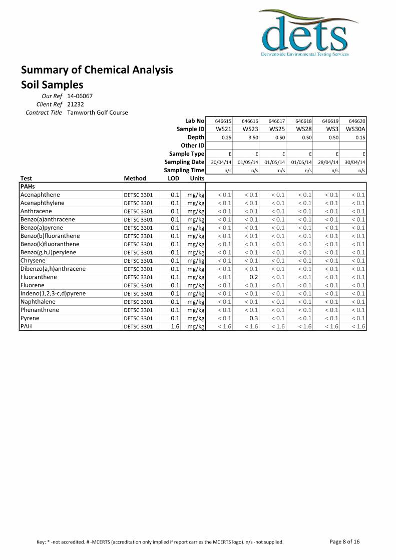
Summary of Chemical AnalysisSoil Samples
Our Ref 14-06067Client Ref 21232
Contract Title Tamworth Golf CourseLab No
Sample IDDepth
Other IDSample Type
Sampling DateSampling Time
Test Method LOD Units
DETSC 3301 0.1 mg/kgDETSC 3301 0.1 mg/kgDETSC 3301 0.1 mg/kgDETSC 3301 0.1 mg/kgDETSC 3301 0.1 mg/kgDETSC 3301 0.1 mg/kgDETSC 3301 0.1 mg/kgDETSC 3301 0.1 mg/kgDETSC 3301 0.1 mg/kgDETSC 3301 0.1 mg/kgDETSC 3301 0.1 mg/kgDETSC 3301 0.1 mg/kgDETSC 3301 0.1 mg/kgDETSC 3301 0.1 mg/kgDETSC 3301 0.1 mg/kgDETSC 3301 0.1 mg/kgDETSC 3301 1.6 mg/kg
Indeno(1,2,3-c,d)pyreneNaphthalenePhenanthrenePyrenePAH
PAHs
Benzo(k)fluorantheneBenzo(g,h,i)peryleneChryseneDibenzo(a,h)anthraceneFluorantheneFluorene
AcenaphtheneAcenaphthyleneAnthraceneBenzo(a)anthraceneBenzo(a)pyreneBenzo(b)fluoranthene
646615 646616 646617 646618 646619 646620
WS21 WS23 WS25 WS28 WS3 WS30A0.25 3.50 0.50 0.50 0.50 0.15
E E E E E E
30/04/14 01/05/14 01/05/14 01/05/14 28/04/14 30/04/14
n/s n/s n/s n/s n/s n/s
< 0.1 < 0.1 < 0.1 < 0.1 < 0.1 < 0.1< 0.1 < 0.1 < 0.1 < 0.1 < 0.1 < 0.1< 0.1 < 0.1 < 0.1 < 0.1 < 0.1 < 0.1< 0.1 < 0.1 < 0.1 < 0.1 < 0.1 < 0.1< 0.1 < 0.1 < 0.1 < 0.1 < 0.1 < 0.1< 0.1 < 0.1 < 0.1 < 0.1 < 0.1 < 0.1< 0.1 < 0.1 < 0.1 < 0.1 < 0.1 < 0.1< 0.1 < 0.1 < 0.1 < 0.1 < 0.1 < 0.1< 0.1 < 0.1 < 0.1 < 0.1 < 0.1 < 0.1< 0.1 < 0.1 < 0.1 < 0.1 < 0.1 < 0.1< 0.1 0.2 < 0.1 < 0.1 < 0.1 < 0.1< 0.1 < 0.1 < 0.1 < 0.1 < 0.1 < 0.1< 0.1 < 0.1 < 0.1 < 0.1 < 0.1 < 0.1< 0.1 < 0.1 < 0.1 < 0.1 < 0.1 < 0.1< 0.1 < 0.1 < 0.1 < 0.1 < 0.1 < 0.1< 0.1 0.3 < 0.1 < 0.1 < 0.1 < 0.1< 1.6 < 1.6 < 1.6 < 1.6 < 1.6 < 1.6
Page 8 of 16Key: * -not accredited. # -MCERTS (accreditation only implied if report carries the MCERTS logo). n/s -not supplied.
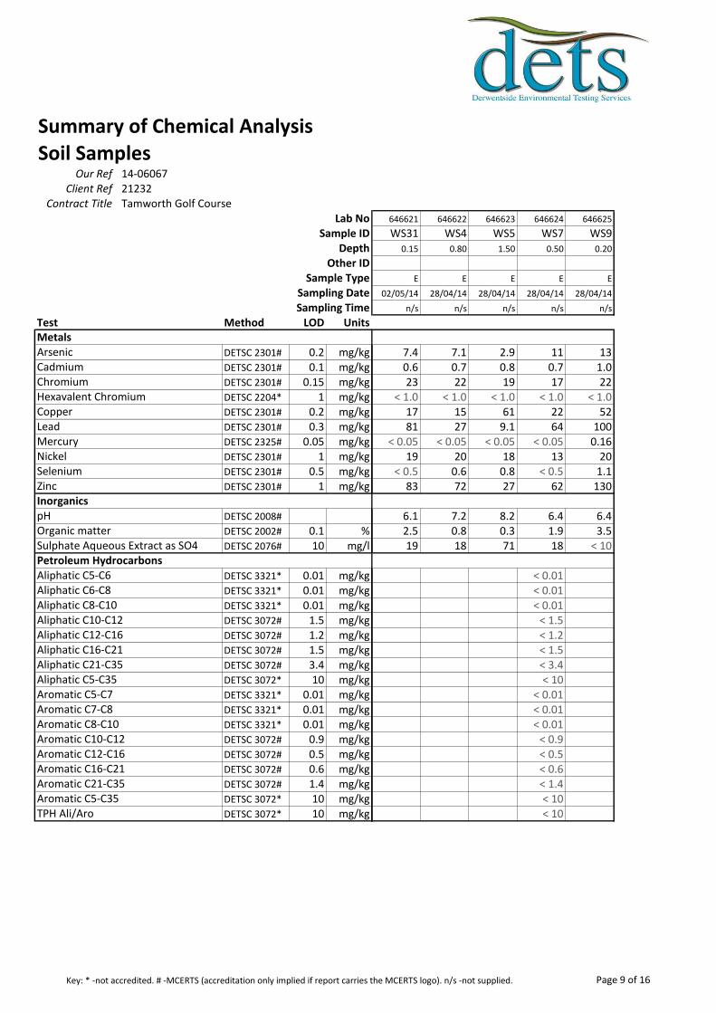
Summary of Chemical AnalysisSoil Samples
Our Ref 14-06067Client Ref 21232
Contract Title Tamworth Golf CourseLab No
Sample IDDepth
Other IDSample Type
Sampling DateSampling Time
Test Method LOD Units
DETSC 2301# 0.2 mg/kgDETSC 2301# 0.1 mg/kgDETSC 2301# 0.15 mg/kgDETSC 2204* 1 mg/kgDETSC 2301# 0.2 mg/kgDETSC 2301# 0.3 mg/kgDETSC 2325# 0.05 mg/kgDETSC 2301# 1 mg/kgDETSC 2301# 0.5 mg/kgDETSC 2301# 1 mg/kg
DETSC 2008#
DETSC 2002# 0.1 %DETSC 2076# 10 mg/l
DETSC 3321* 0.01 mg/kgDETSC 3321* 0.01 mg/kgDETSC 3321* 0.01 mg/kgDETSC 3072# 1.5 mg/kgDETSC 3072# 1.2 mg/kgDETSC 3072# 1.5 mg/kgDETSC 3072# 3.4 mg/kgDETSC 3072* 10 mg/kgDETSC 3321* 0.01 mg/kgDETSC 3321* 0.01 mg/kgDETSC 3321* 0.01 mg/kgDETSC 3072# 0.9 mg/kgDETSC 3072# 0.5 mg/kgDETSC 3072# 0.6 mg/kgDETSC 3072# 1.4 mg/kgDETSC 3072* 10 mg/kgDETSC 3072* 10 mg/kg
Metals
Inorganics
Petroleum Hydrocarbons
Aromatic C10-C12Aromatic C12-C16Aromatic C16-C21Aromatic C21-C35Aromatic C5-C35TPH Ali/Aro
Aliphatic C16-C21Aliphatic C21-C35Aliphatic C5-C35Aromatic C5-C7Aromatic C7-C8Aromatic C8-C10
Sulphate Aqueous Extract as SO4
Aliphatic C5-C6Aliphatic C6-C8Aliphatic C8-C10Aliphatic C10-C12Aliphatic C12-C16
MercuryNickelSeleniumZinc
pHOrganic matter
ArsenicCadmiumChromiumHexavalent ChromiumCopperLead
646621 646622 646623 646624 646625
WS31 WS4 WS5 WS7 WS90.15 0.80 1.50 0.50 0.20
E E E E E
02/05/14 28/04/14 28/04/14 28/04/14 28/04/14
n/s n/s n/s n/s n/s
7.4 7.1 2.9 11 130.6 0.7 0.8 0.7 1.023 22 19 17 22
< 1.0 < 1.0 < 1.0 < 1.0 < 1.017 15 61 22 5281 27 9.1 64 100
< 0.05 < 0.05 < 0.05 < 0.05 0.1619 20 18 13 20
< 0.5 0.6 0.8 < 0.5 1.183 72 27 62 130
6.1 7.2 8.2 6.4 6.42.5 0.8 0.3 1.9 3.519 18 71 18 < 10
< 0.01< 0.01< 0.01
< 1.5< 1.2< 1.5< 3.4< 10
< 0.01< 0.01< 0.01
< 0.9< 0.5< 0.6< 1.4< 10< 10
Page 9 of 16Key: * -not accredited. # -MCERTS (accreditation only implied if report carries the MCERTS logo). n/s -not supplied.
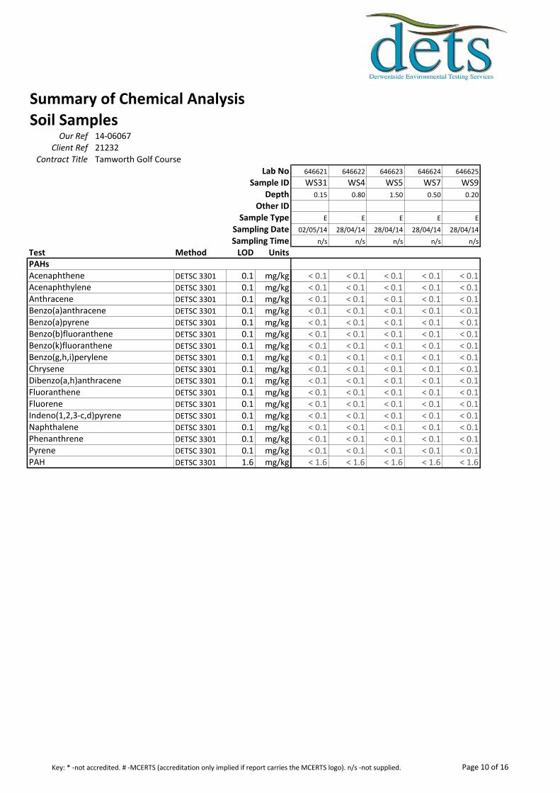
Summary of Chemical AnalysisSoil Samples
Our Ref 14-06067Client Ref 21232
Contract Title Tamworth Golf CourseLab No
Sample IDDepth
Other IDSample Type
Sampling DateSampling Time
Test Method LOD Units
DETSC 3301 0.1 mg/kgDETSC 3301 0.1 mg/kgDETSC 3301 0.1 mg/kgDETSC 3301 0.1 mg/kgDETSC 3301 0.1 mg/kgDETSC 3301 0.1 mg/kgDETSC 3301 0.1 mg/kgDETSC 3301 0.1 mg/kgDETSC 3301 0.1 mg/kgDETSC 3301 0.1 mg/kgDETSC 3301 0.1 mg/kgDETSC 3301 0.1 mg/kgDETSC 3301 0.1 mg/kgDETSC 3301 0.1 mg/kgDETSC 3301 0.1 mg/kgDETSC 3301 0.1 mg/kgDETSC 3301 1.6 mg/kg
Indeno(1,2,3-c,d)pyreneNaphthalenePhenanthrenePyrenePAH
PAHs
Benzo(k)fluorantheneBenzo(g,h,i)peryleneChryseneDibenzo(a,h)anthraceneFluorantheneFluorene
AcenaphtheneAcenaphthyleneAnthraceneBenzo(a)anthraceneBenzo(a)pyreneBenzo(b)fluoranthene
646621 646622 646623 646624 646625
WS31 WS4 WS5 WS7 WS90.15 0.80 1.50 0.50 0.20
E E E E E
02/05/14 28/04/14 28/04/14 28/04/14 28/04/14
n/s n/s n/s n/s n/s
< 0.1 < 0.1 < 0.1 < 0.1 < 0.1< 0.1 < 0.1 < 0.1 < 0.1 < 0.1< 0.1 < 0.1 < 0.1 < 0.1 < 0.1< 0.1 < 0.1 < 0.1 < 0.1 < 0.1< 0.1 < 0.1 < 0.1 < 0.1 < 0.1< 0.1 < 0.1 < 0.1 < 0.1 < 0.1< 0.1 < 0.1 < 0.1 < 0.1 < 0.1< 0.1 < 0.1 < 0.1 < 0.1 < 0.1< 0.1 < 0.1 < 0.1 < 0.1 < 0.1< 0.1 < 0.1 < 0.1 < 0.1 < 0.1< 0.1 < 0.1 < 0.1 < 0.1 < 0.1< 0.1 < 0.1 < 0.1 < 0.1 < 0.1< 0.1 < 0.1 < 0.1 < 0.1 < 0.1< 0.1 < 0.1 < 0.1 < 0.1 < 0.1< 0.1 < 0.1 < 0.1 < 0.1 < 0.1< 0.1 < 0.1 < 0.1 < 0.1 < 0.1< 1.6 < 1.6 < 1.6 < 1.6 < 1.6
Page 10 of 16Key: * -not accredited. # -MCERTS (accreditation only implied if report carries the MCERTS logo). n/s -not supplied.
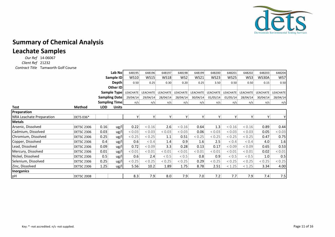
Summary of Chemical AnalysisLeachate Samples
Our Ref 14-06067Client Ref 21232
Contract Title Tamworth Golf CourseLab No 648195 648196 648197 648198 648199 648200 648201 648202 648203 648204
Sample ID WS10 WS15 WS18 WS2 WS21 WS23 WS25 WS3 WS30A WS7Depth 0.50 0.25 0.30 0.20 0.25 3.50 0.50 0.50 0.15 0.50
Other IDSample Type LEACHATE LEACHATE LEACHATE LEACHATE LEACHATE LEACHATE LEACHATE LEACHATE LEACHATE LEACHATE
Sampling Date 29/04/14 29/04/14 28/04/14 28/04/14 30/04/14 01/05/14 01/05/14 28/04/14 30/04/14 28/04/14
Sampling Time n/s n/s n/s n/s n/s n/s n/s n/s n/s n/s
Test Method LOD Units
DETS 036* Y Y Y Y Y Y Y Y Y Y
DETSC 2306 0.16 ug/l 0.22 < 0.16 2.6 < 0.16 0.64 1.3 < 0.16 < 0.16 0.89 0.44DETSC 2306 0.03 ug/l < 0.03 < 0.03 < 0.03 < 0.03 0.06 < 0.03 < 0.03 < 0.03 0.05 < 0.03DETSC 2306 0.25 ug/l < 0.25 < 0.25 1.1 0.51 < 0.25 < 0.25 < 0.25 < 0.25 0.47 0.75DETSC 2306 0.4 ug/l 0.6 < 0.4 1.4 0.9 1.6 2.5 < 0.4 < 0.4 4.0 1.6DETSC 2306 0.09 ug/l 0.72 < 0.09 3.3 0.28 0.13 0.17 < 0.09 < 0.09 0.65 0.53DETSC 2306 0.01 ug/l < 0.01 < 0.01 < 0.01 < 0.01 < 0.01 < 0.01 < 0.01 < 0.01 0.02 < 0.01DETSC 2306 0.5 ug/l 0.6 2.4 < 0.5 < 0.5 0.8 0.9 < 0.5 < 0.5 1.0 0.5DETSC 2306 0.25 ug/l < 0.25 < 0.25 < 0.25 < 0.25 0.29 < 0.25 < 0.25 < 0.25 < 0.25 < 0.25DETSC 2306 1.25 ug/l 5.56 10.2 1.89 1.75 8.78 2.51 < 1.25 < 1.25 3.34 4.00
DETSC 2008 8.3 7.9 8.0 7.9 7.0 7.2 7.7 7.9 7.4 7.5
Mercury, DissolvedNickel, DissolvedSelenium, DissolvedZinc, Dissolved
pH
Preparation
Metals
Inorganics
NRA Leachate Preparation
Arsenic, DissolvedCadmium, DissolvedChromium, DissolvedCopper, DissolvedLead, Dissolved
Page 11 of 16Key: * -not accredited. n/s -not supplied.
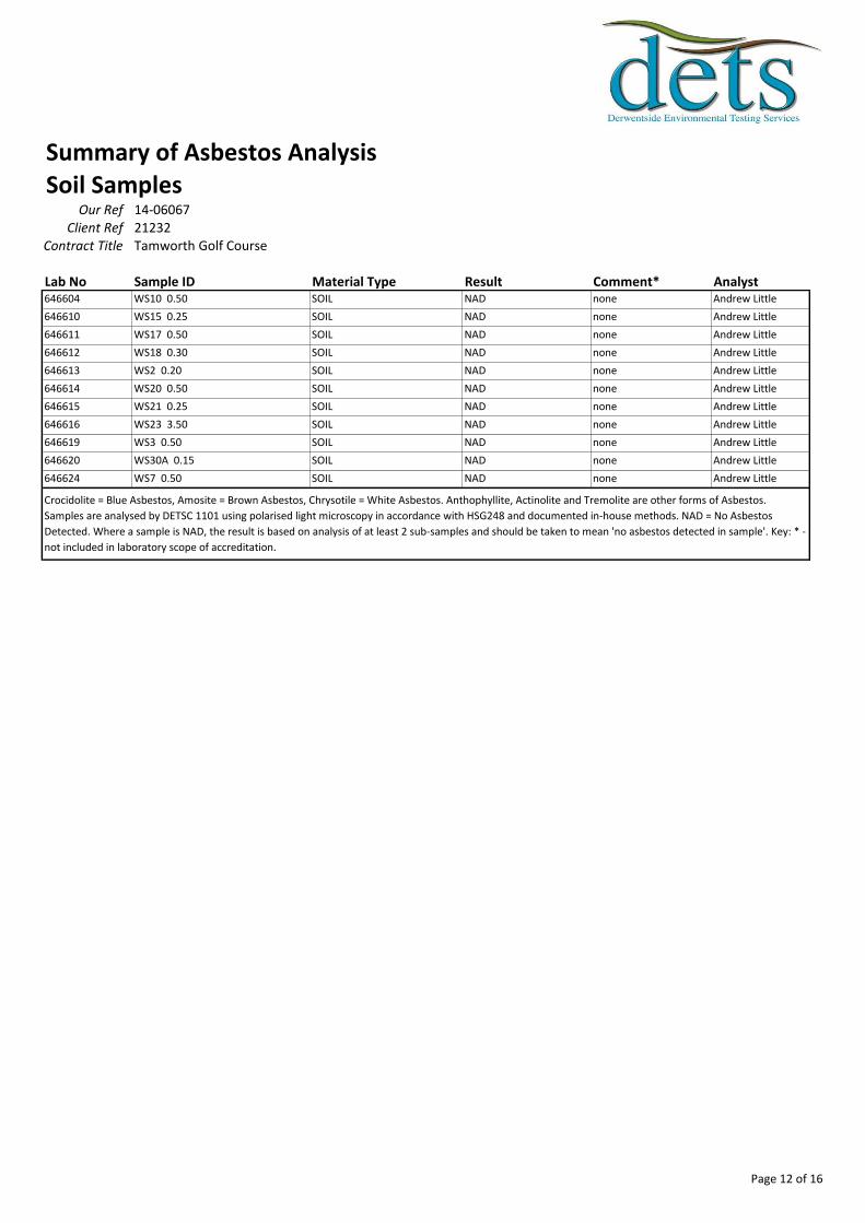
Summary of Asbestos AnalysisSoil Samples
Our Ref 14-06067Client Ref 21232
Contract Title Tamworth Golf Course
Lab No Sample ID Material Type Result Comment* Analyst646604 WS10 0.50 SOIL NAD none Andrew Little
646610 WS15 0.25 SOIL NAD none Andrew Little
646611 WS17 0.50 SOIL NAD none Andrew Little
646612 WS18 0.30 SOIL NAD none Andrew Little
646613 WS2 0.20 SOIL NAD none Andrew Little
646614 WS20 0.50 SOIL NAD none Andrew Little
646615 WS21 0.25 SOIL NAD none Andrew Little
646616 WS23 3.50 SOIL NAD none Andrew Little
646619 WS3 0.50 SOIL NAD none Andrew Little
646620 WS30A 0.15 SOIL NAD none Andrew Little
646624 WS7 0.50 SOIL NAD none Andrew Little
Crocidolite = Blue Asbestos, Amosite = Brown Asbestos, Chrysotile = White Asbestos. Anthophyllite, Actinolite and Tremolite are other forms of Asbestos.
Samples are analysed by DETSC 1101 using polarised light microscopy in accordance with HSG248 and documented in-house methods. NAD = No Asbestos
Detected. Where a sample is NAD, the result is based on analysis of at least 2 sub-samples and should be taken to mean 'no asbestos detected in sample'. Key: * -
not included in laboratory scope of accreditation.
Page 12 of 16
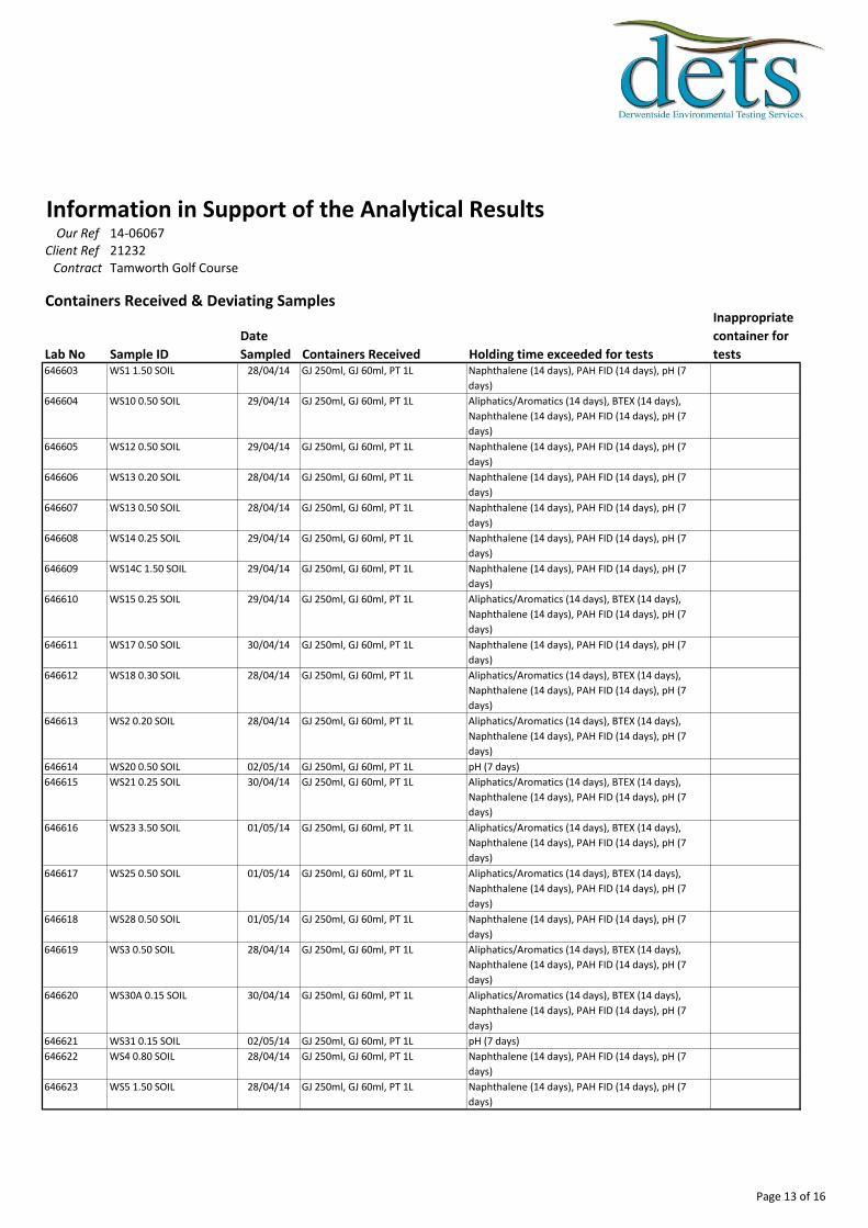
Information in Support of the Analytical ResultsOur Ref 14-06067
Client Ref 21232Contract Tamworth Golf Course
Containers Received & Deviating Samples
Lab No Sample ID
Date
Sampled Containers Received Holding time exceeded for tests
Inappropriate
container for
tests646603 WS1 1.50 SOIL 28/04/14 GJ 250ml, GJ 60ml, PT 1L Naphthalene (14 days), PAH FID (14 days), pH (7
days)
646604 WS10 0.50 SOIL 29/04/14 GJ 250ml, GJ 60ml, PT 1L Aliphatics/Aromatics (14 days), BTEX (14 days),
Naphthalene (14 days), PAH FID (14 days), pH (7
days)
646605 WS12 0.50 SOIL 29/04/14 GJ 250ml, GJ 60ml, PT 1L Naphthalene (14 days), PAH FID (14 days), pH (7
days)
646606 WS13 0.20 SOIL 28/04/14 GJ 250ml, GJ 60ml, PT 1L Naphthalene (14 days), PAH FID (14 days), pH (7
days)
646607 WS13 0.50 SOIL 28/04/14 GJ 250ml, GJ 60ml, PT 1L Naphthalene (14 days), PAH FID (14 days), pH (7
days)
646608 WS14 0.25 SOIL 29/04/14 GJ 250ml, GJ 60ml, PT 1L Naphthalene (14 days), PAH FID (14 days), pH (7
days)
646609 WS14C 1.50 SOIL 29/04/14 GJ 250ml, GJ 60ml, PT 1L Naphthalene (14 days), PAH FID (14 days), pH (7
days)
646610 WS15 0.25 SOIL 29/04/14 GJ 250ml, GJ 60ml, PT 1L Aliphatics/Aromatics (14 days), BTEX (14 days),
Naphthalene (14 days), PAH FID (14 days), pH (7
days)
646611 WS17 0.50 SOIL 30/04/14 GJ 250ml, GJ 60ml, PT 1L Naphthalene (14 days), PAH FID (14 days), pH (7
days)
646612 WS18 0.30 SOIL 28/04/14 GJ 250ml, GJ 60ml, PT 1L Aliphatics/Aromatics (14 days), BTEX (14 days),
Naphthalene (14 days), PAH FID (14 days), pH (7
days)
646613 WS2 0.20 SOIL 28/04/14 GJ 250ml, GJ 60ml, PT 1L Aliphatics/Aromatics (14 days), BTEX (14 days),
Naphthalene (14 days), PAH FID (14 days), pH (7
days)
646614 WS20 0.50 SOIL 02/05/14 GJ 250ml, GJ 60ml, PT 1L pH (7 days)
646615 WS21 0.25 SOIL 30/04/14 GJ 250ml, GJ 60ml, PT 1L Aliphatics/Aromatics (14 days), BTEX (14 days),
Naphthalene (14 days), PAH FID (14 days), pH (7
days)
646616 WS23 3.50 SOIL 01/05/14 GJ 250ml, GJ 60ml, PT 1L Aliphatics/Aromatics (14 days), BTEX (14 days),
Naphthalene (14 days), PAH FID (14 days), pH (7
days)
646617 WS25 0.50 SOIL 01/05/14 GJ 250ml, GJ 60ml, PT 1L Aliphatics/Aromatics (14 days), BTEX (14 days),
Naphthalene (14 days), PAH FID (14 days), pH (7
days)
646618 WS28 0.50 SOIL 01/05/14 GJ 250ml, GJ 60ml, PT 1L Naphthalene (14 days), PAH FID (14 days), pH (7
days)
646619 WS3 0.50 SOIL 28/04/14 GJ 250ml, GJ 60ml, PT 1L Aliphatics/Aromatics (14 days), BTEX (14 days),
Naphthalene (14 days), PAH FID (14 days), pH (7
days)
646620 WS30A 0.15 SOIL 30/04/14 GJ 250ml, GJ 60ml, PT 1L Aliphatics/Aromatics (14 days), BTEX (14 days),
Naphthalene (14 days), PAH FID (14 days), pH (7
days)
646621 WS31 0.15 SOIL 02/05/14 GJ 250ml, GJ 60ml, PT 1L pH (7 days)
646622 WS4 0.80 SOIL 28/04/14 GJ 250ml, GJ 60ml, PT 1L Naphthalene (14 days), PAH FID (14 days), pH (7
days)
646623 WS5 1.50 SOIL 28/04/14 GJ 250ml, GJ 60ml, PT 1L Naphthalene (14 days), PAH FID (14 days), pH (7
days)
Page 13 of 16
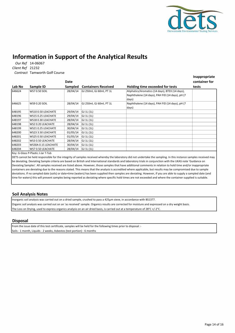
Information in Support of the Analytical ResultsOur Ref 14-06067
Client Ref 21232Contract Tamworth Golf Course
Lab No Sample ID
Date
Sampled Containers Received Holding time exceeded for tests
Inappropriate
container for
tests646624 WS7 0.50 SOIL 28/04/14 GJ 250ml, GJ 60ml, PT 1L Aliphatics/Aromatics (14 days), BTEX (14 days),
Naphthalene (14 days), PAH FID (14 days), pH (7
days)
646625 WS9 0.20 SOIL 28/04/14 GJ 250ml, GJ 60ml, PT 1L Naphthalene (14 days), PAH FID (14 days), pH (7
days)
648195 WS10 0.50 LEACHATE 29/04/14 GJ 1L (1L)
648196 WS15 0.25 LEACHATE 29/04/14 GJ 1L (1L)
648197 WS18 0.30 LEACHATE 28/04/14 GJ 1L (1L)
648198 WS2 0.20 LEACHATE 28/04/14 GJ 1L (1L)
648199 WS21 0.25 LEACHATE 30/04/14 GJ 1L (1L)
648200 WS23 3.50 LEACHATE 01/05/14 GJ 1L (1L)
648201 WS25 0.50 LEACHATE 01/05/14 GJ 1L (1L)
648202 WS3 0.50 LEACHATE 28/04/14 GJ 1L (1L)
648203 WS30A 0.15 LEACHATE 30/04/14 GJ 1L (1L)
648204 WS7 0.50 LEACHATE 28/04/14 GJ 1L (1L)
Soil Analysis NotesInorganic soil analysis was carried out on a dried sample, crushed to pass a 425µm sieve, in accordance with BS1377.
Organic soil analysis was carried out on an 'as received' sample. Organics results are corrected for moisture and expressed on a dry weight basis.
The Loss on Drying, used to express organics analysis on an air dried basis, is carried out at a temperature of 28°C +/-2°C.
DisposalFrom the issue date of this test certificate, samples will be held for the following times prior to disposal :-
Soils - 1 month, Liquids - 2 weeks, Asbestos (test portion) - 6 months
Key: G-Glass P-Plastic J-Jar T-Tub
DETS cannot be held responsible for the integrity of samples received whereby the laboratory did not undertake the sampling. In this instance samples received may
be deviating. Deviating Sample criteria are based on British and International standards and laboratory trials in conjunction with the UKAS note 'Guidance on
Deviating Samples'. All samples received are listed above. However, those samples that have additional comments in relation to hold time and/or inappropriate
containers are deviating due to the reasons stated. This means that the analysis is accredited where applicable, but results may be compromised due to sample
deviations. If no sampled date (soils) or date+time (waters) has been supplied then samples are deviating. However, if you are able to supply a sampled date (and
time for waters) this will prevent samples being reported as deviating where specific hold times are not exceeded and where the container supplied is suitable.
Page 14 of 16
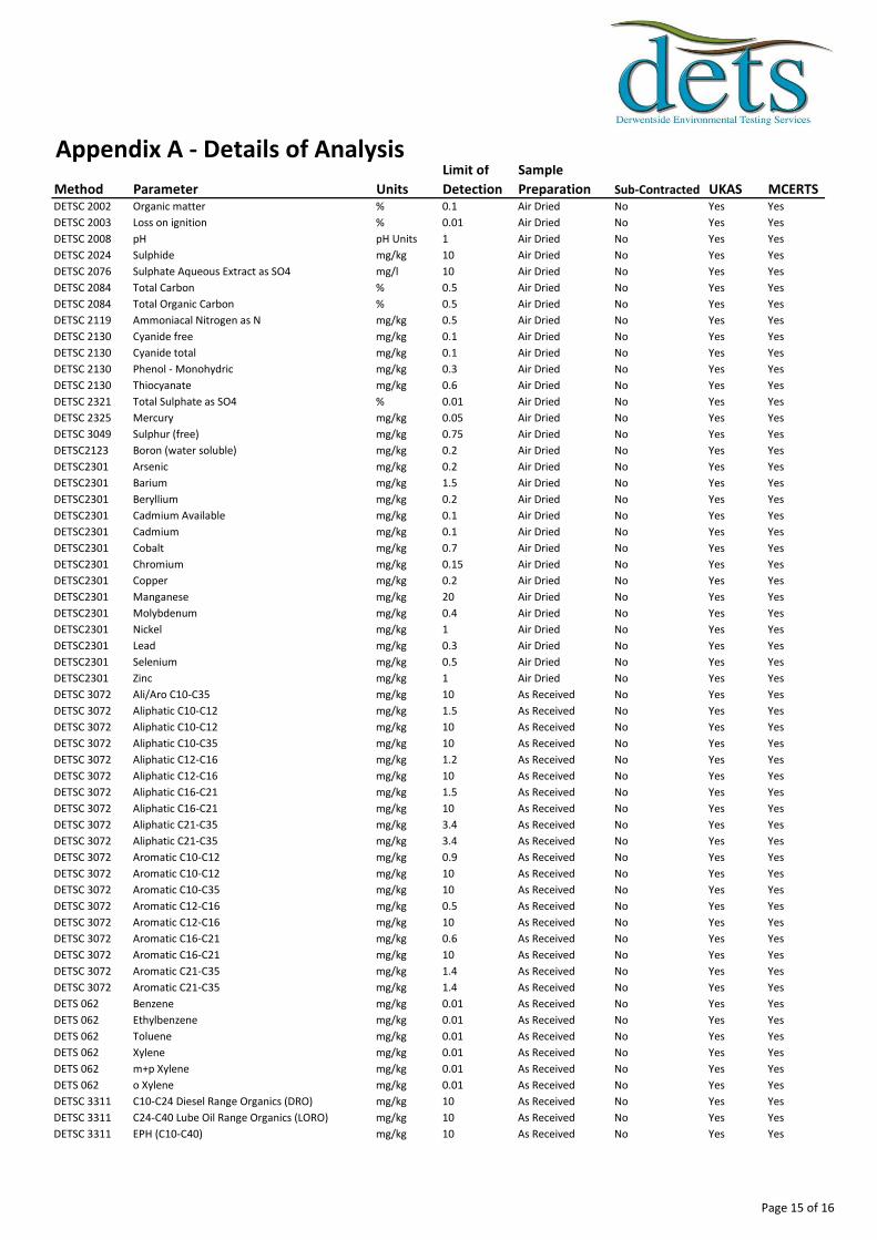
Appendix A - Details of Analysis
Method Parameter Units
Limit of
Detection
Sample
Preparation Sub-Contracted UKAS MCERTSDETSC 2002 Organic matter % 0.1 Air Dried No Yes Yes
DETSC 2003 Loss on ignition % 0.01 Air Dried No Yes Yes
DETSC 2008 pH pH Units 1 Air Dried No Yes Yes
DETSC 2024 Sulphide mg/kg 10 Air Dried No Yes Yes
DETSC 2076 Sulphate Aqueous Extract as SO4 mg/l 10 Air Dried No Yes Yes
DETSC 2084 Total Carbon % 0.5 Air Dried No Yes Yes
DETSC 2084 Total Organic Carbon % 0.5 Air Dried No Yes Yes
DETSC 2119 Ammoniacal Nitrogen as N mg/kg 0.5 Air Dried No Yes Yes
DETSC 2130 Cyanide free mg/kg 0.1 Air Dried No Yes Yes
DETSC 2130 Cyanide total mg/kg 0.1 Air Dried No Yes Yes
DETSC 2130 Phenol - Monohydric mg/kg 0.3 Air Dried No Yes Yes
DETSC 2130 Thiocyanate mg/kg 0.6 Air Dried No Yes Yes
DETSC 2321 Total Sulphate as SO4 % 0.01 Air Dried No Yes Yes
DETSC 2325 Mercury mg/kg 0.05 Air Dried No Yes Yes
DETSC 3049 Sulphur (free) mg/kg 0.75 Air Dried No Yes Yes
DETSC2123 Boron (water soluble) mg/kg 0.2 Air Dried No Yes Yes
DETSC2301 Arsenic mg/kg 0.2 Air Dried No Yes Yes
DETSC2301 Barium mg/kg 1.5 Air Dried No Yes Yes
DETSC2301 Beryllium mg/kg 0.2 Air Dried No Yes Yes
DETSC2301 Cadmium Available mg/kg 0.1 Air Dried No Yes Yes
DETSC2301 Cadmium mg/kg 0.1 Air Dried No Yes Yes
DETSC2301 Cobalt mg/kg 0.7 Air Dried No Yes Yes
DETSC2301 Chromium mg/kg 0.15 Air Dried No Yes Yes
DETSC2301 Copper mg/kg 0.2 Air Dried No Yes Yes
DETSC2301 Manganese mg/kg 20 Air Dried No Yes Yes
DETSC2301 Molybdenum mg/kg 0.4 Air Dried No Yes Yes
DETSC2301 Nickel mg/kg 1 Air Dried No Yes Yes
DETSC2301 Lead mg/kg 0.3 Air Dried No Yes Yes
DETSC2301 Selenium mg/kg 0.5 Air Dried No Yes Yes
DETSC2301 Zinc mg/kg 1 Air Dried No Yes Yes
DETSC 3072 Ali/Aro C10-C35 mg/kg 10 As Received No Yes Yes
DETSC 3072 Aliphatic C10-C12 mg/kg 1.5 As Received No Yes Yes
DETSC 3072 Aliphatic C10-C12 mg/kg 10 As Received No Yes Yes
DETSC 3072 Aliphatic C10-C35 mg/kg 10 As Received No Yes Yes
DETSC 3072 Aliphatic C12-C16 mg/kg 1.2 As Received No Yes Yes
DETSC 3072 Aliphatic C12-C16 mg/kg 10 As Received No Yes Yes
DETSC 3072 Aliphatic C16-C21 mg/kg 1.5 As Received No Yes Yes
DETSC 3072 Aliphatic C16-C21 mg/kg 10 As Received No Yes Yes
DETSC 3072 Aliphatic C21-C35 mg/kg 3.4 As Received No Yes Yes
DETSC 3072 Aliphatic C21-C35 mg/kg 3.4 As Received No Yes Yes
DETSC 3072 Aromatic C10-C12 mg/kg 0.9 As Received No Yes Yes
DETSC 3072 Aromatic C10-C12 mg/kg 10 As Received No Yes Yes
DETSC 3072 Aromatic C10-C35 mg/kg 10 As Received No Yes Yes
DETSC 3072 Aromatic C12-C16 mg/kg 0.5 As Received No Yes Yes
DETSC 3072 Aromatic C12-C16 mg/kg 10 As Received No Yes Yes
DETSC 3072 Aromatic C16-C21 mg/kg 0.6 As Received No Yes Yes
DETSC 3072 Aromatic C16-C21 mg/kg 10 As Received No Yes Yes
DETSC 3072 Aromatic C21-C35 mg/kg 1.4 As Received No Yes Yes
DETSC 3072 Aromatic C21-C35 mg/kg 1.4 As Received No Yes Yes
DETS 062 Benzene mg/kg 0.01 As Received No Yes Yes
DETS 062 Ethylbenzene mg/kg 0.01 As Received No Yes Yes
DETS 062 Toluene mg/kg 0.01 As Received No Yes Yes
DETS 062 Xylene mg/kg 0.01 As Received No Yes Yes
DETS 062 m+p Xylene mg/kg 0.01 As Received No Yes Yes
DETS 062 o Xylene mg/kg 0.01 As Received No Yes Yes
DETSC 3311 C10-C24 Diesel Range Organics (DRO) mg/kg 10 As Received No Yes Yes
DETSC 3311 C24-C40 Lube Oil Range Organics (LORO) mg/kg 10 As Received No Yes Yes
DETSC 3311 EPH (C10-C40) mg/kg 10 As Received No Yes Yes
Page 15 of 16

Appendix A - Details of Analysis
Method Parameter Units
Limit of
Detection
Sample
Preparation Sub-Contracted UKAS MCERTSDETSC 3303 Acenaphthene mg/kg 0.03 As Received No Yes Yes
DETSC 3303 Acenaphthylene mg/kg 0.03 As Received No Yes Yes
DETSC 3303 Benzo(a)pyrene mg/kg 0.03 As Received No Yes Yes
DETSC 3303 Benzo(a)anthracene mg/kg 0.03 As Received No Yes Yes
DETSC 3303 Benzo(b)fluoranthene mg/kg 0.03 As Received No Yes Yes
DETSC 3303 Benzo(k)fluoranthene mg/kg 0.03 As Received No Yes Yes
DETSC 3303 Benzo(g,h,i)perylene mg/kg 0.03 As Received No Yes Yes
DETSC 3303 Dibenzo(a,h)anthracene mg/kg 0.03 As Received No Yes Yes
DETSC 3303 Fluoranthene mg/kg 0.03 As Received No Yes Yes
DETSC 3303 Indeno(1,2,3-c,d)pyrene mg/kg 0.03 As Received No Yes Yes
DETSC 3303 Naphthalene mg/kg 0.03 As Received No Yes Yes
DETSC 3303 Phenanthrene mg/kg 0.03 As Received No Yes Yes
DETSC 3303 Pyrene mg/kg 0.03 As Received No Yes Yes
DETSC 3401 PCB 28 + PCB 31 mg/kg 0.01 As Received No Yes Yes
DETSC 3401 PCB 52 mg/kg 0.01 As Received No Yes Yes
DETSC 3401 PCB 101 mg/kg 0.01 As Received No Yes Yes
DETSC 3401 PCB 118 mg/kg 0.01 As Received No Yes Yes
DETSC 3401 PCB 153 mg/kg 0.01 As Received No Yes Yes
DETSC 3401 PCB 138 mg/kg 0.01 As Received No Yes Yes
DETSC 3401 PCB 180 mg/kg 0.01 As Received No Yes Yes
DETSC 3401 PCB Total mg/kg 0.01 As Received No Yes Yes
Method details are shown only for those determinands listed in Annex A of the MCERTS standard. Anything not included on this list falls outside the scope of
MCERTS. No Recovery Factors are used in the determination of results. Results reported assume 100% recovery. Full method statements are available on
request.
Page 16 of 16

Client
Our Reference
Client Reference
Contract Title
Description
Date Received
Date Started
Date Completed
Test Procedures
Notes
Approved By
Rob Brown
Opinions and interpretations are outside the scope of UKAS accreditation. This
certificate is issued in accordance with the accreditation requirements of the United
Kingdom Accreditation Service. The results reported herein relate only to the material
supplied to the laboratory. Observations and interpretations are outside the scope of
ISO 17025. This certificate shall not be reproduced except in full, without the prior
written approval of the laboratory.
Business Manager
Tamworth Golf Course
3 Soil samples.
15-May-14
16-May-14
21-May-14
Identified by prefix DETSn (details on request), Asbestos Analysis DETSC 1101.
Certificate of AnalysisCertificate Number 14-06068
21-May-14
Ian Farmer Associates
Unit 1 Fairfield Court
Seven Stars Industrial Estate
Wheler Road
Coventry
West Midlands
CV3 4LJ
14-06068
21232
Derwentside Environmental Testing Services LimitedUnit 2, Park Road Industrial Estate South, Consett, Co Durham, DH8 5PY
Tel: 01207 582333 • email: [email protected] • www.dets.co.uk Page 1 of 7 .
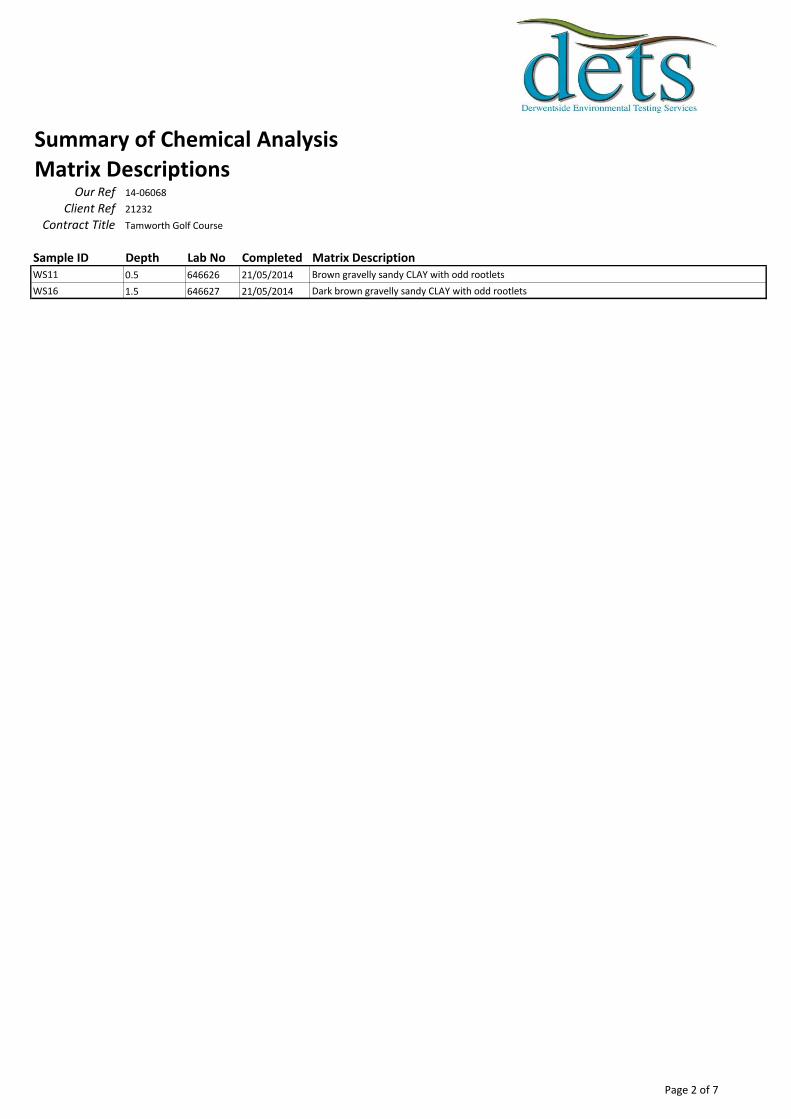
Summary of Chemical AnalysisMatrix Descriptions
Our Ref 14-06068
Client Ref 21232
Contract Title Tamworth Golf Course
Sample ID Depth Lab No Completed Matrix DescriptionWS11 0.5 646626 21/05/2014 Brown gravelly sandy CLAY with odd rootlets
WS16 1.5 646627 21/05/2014 Dark brown gravelly sandy CLAY with odd rootlets
Page 2 of 7
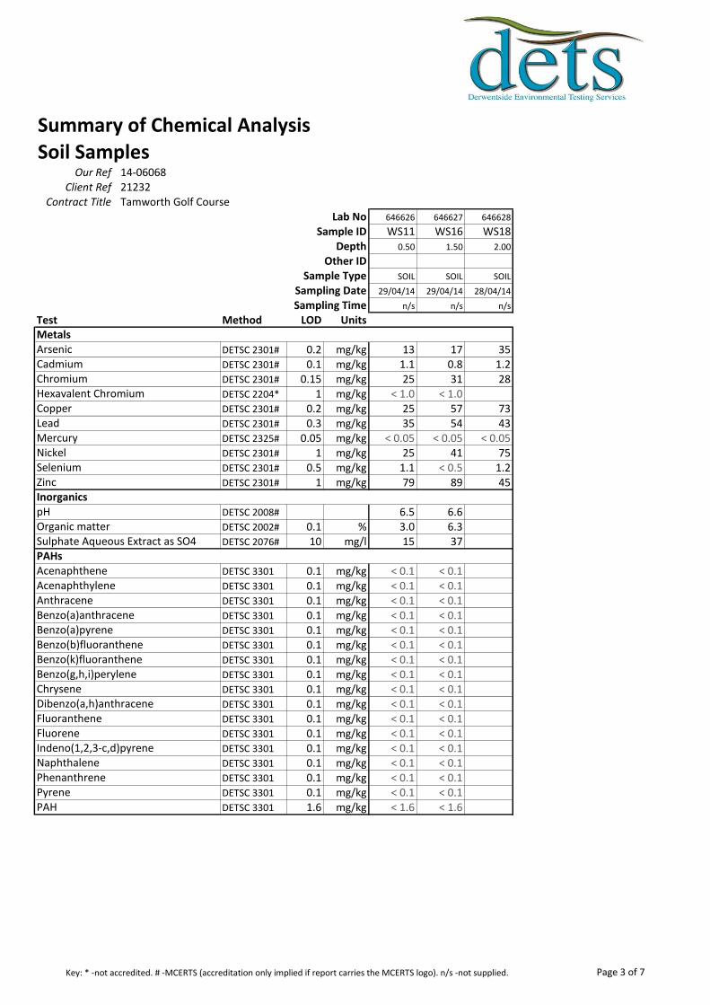
Summary of Chemical AnalysisSoil Samples
Our Ref 14-06068Client Ref 21232
Contract Title Tamworth Golf CourseLab No 646626 646627 646628
Sample ID WS11 WS16 WS18Depth 0.50 1.50 2.00
Other IDSample Type SOIL SOIL SOIL
Sampling Date 29/04/14 29/04/14 28/04/14
Sampling Time n/s n/s n/s
Test Method LOD Units
DETSC 2301# 0.2 mg/kg 13 17 35DETSC 2301# 0.1 mg/kg 1.1 0.8 1.2DETSC 2301# 0.15 mg/kg 25 31 28DETSC 2204* 1 mg/kg < 1.0 < 1.0DETSC 2301# 0.2 mg/kg 25 57 73DETSC 2301# 0.3 mg/kg 35 54 43DETSC 2325# 0.05 mg/kg < 0.05 < 0.05 < 0.05DETSC 2301# 1 mg/kg 25 41 75DETSC 2301# 0.5 mg/kg 1.1 < 0.5 1.2DETSC 2301# 1 mg/kg 79 89 45
DETSC 2008# 6.5 6.6DETSC 2002# 0.1 % 3.0 6.3DETSC 2076# 10 mg/l 15 37
DETSC 3301 0.1 mg/kg < 0.1 < 0.1DETSC 3301 0.1 mg/kg < 0.1 < 0.1DETSC 3301 0.1 mg/kg < 0.1 < 0.1DETSC 3301 0.1 mg/kg < 0.1 < 0.1DETSC 3301 0.1 mg/kg < 0.1 < 0.1DETSC 3301 0.1 mg/kg < 0.1 < 0.1DETSC 3301 0.1 mg/kg < 0.1 < 0.1DETSC 3301 0.1 mg/kg < 0.1 < 0.1DETSC 3301 0.1 mg/kg < 0.1 < 0.1DETSC 3301 0.1 mg/kg < 0.1 < 0.1DETSC 3301 0.1 mg/kg < 0.1 < 0.1DETSC 3301 0.1 mg/kg < 0.1 < 0.1DETSC 3301 0.1 mg/kg < 0.1 < 0.1DETSC 3301 0.1 mg/kg < 0.1 < 0.1DETSC 3301 0.1 mg/kg < 0.1 < 0.1DETSC 3301 0.1 mg/kg < 0.1 < 0.1DETSC 3301 1.6 mg/kg < 1.6 < 1.6
Metals
Inorganics
PAHs
FluoreneIndeno(1,2,3-c,d)pyreneNaphthalenePhenanthrenePyrenePAH
Benzo(b)fluorantheneBenzo(k)fluorantheneBenzo(g,h,i)peryleneChryseneDibenzo(a,h)anthraceneFluoranthene
Sulphate Aqueous Extract as SO4
AcenaphtheneAcenaphthyleneAnthraceneBenzo(a)anthraceneBenzo(a)pyrene
MercuryNickelSeleniumZinc
pHOrganic matter
ArsenicCadmiumChromiumHexavalent ChromiumCopperLead
Page 3 of 7Key: * -not accredited. # -MCERTS (accreditation only implied if report carries the MCERTS logo). n/s -not supplied.

Summary of Asbestos AnalysisSoil Samples
Our Ref 14-06068Client Ref 21232
Contract Title Tamworth Golf Course
Lab No Sample ID Material Type Result Comment* Analyst646626 WS11 0.50 SOIL NAD none Colin Patrick
646627 WS16 1.50 SOIL NAD none Colin Patrick
Crocidolite = Blue Asbestos, Amosite = Brown Asbestos, Chrysotile = White Asbestos. Anthophyllite, Actinolite and Tremolite are other forms of Asbestos.
Samples are analysed by DETSC 1101 using polarised light microscopy in accordance with HSG248 and documented in-house methods. NAD = No Asbestos
Detected. Where a sample is NAD, the result is based on analysis of at least 2 sub-samples and should be taken to mean 'no asbestos detected in sample'. Key: * -
not included in laboratory scope of accreditation.
Page 4 of 7

Information in Support of the Analytical ResultsOur Ref 14-06068
Client Ref 21232Contract Tamworth Golf Course
Containers Received & Deviating Samples
Lab No Sample ID
Date
Sampled Containers Received Holding time exceeded for tests
Inappropriate
container for
tests646626 WS11 0.50 SOIL 29/04/14 GJ 250ml (250ml), GV (40ml), PT 1L
(1kg)
Naphthalene (14 days), PAH FID (14 days), pH (7
days)
646627 WS16 1.50 SOIL 29/04/14 GJ 250ml (250ml), GV (40ml), PT 1L
(1kg)
Naphthalene (14 days), PAH FID (14 days), pH (7
days)
646628 WS18 2.00 SOIL 28/04/14 GJ 250ml (250ml), GV (40ml), PT 1L
(1kg)
Soil Analysis NotesInorganic soil analysis was carried out on a dried sample, crushed to pass a 425µm sieve, in accordance with BS1377.
Organic soil analysis was carried out on an 'as received' sample. Organics results are corrected for moisture and expressed on a dry weight basis.
The Loss on Drying, used to express organics analysis on an air dried basis, is carried out at a temperature of 28°C +/-2°C.
DisposalFrom the issue date of this test certificate, samples will be held for the following times prior to disposal :-
Soils - 1 month, Liquids - 2 weeks, Asbestos (test portion) - 6 months
Key: G-Glass P-Plastic J-Jar V-Vial T-Tub
DETS cannot be held responsible for the integrity of samples received whereby the laboratory did not undertake the sampling. In this instance samples received may
be deviating. Deviating Sample criteria are based on British and International standards and laboratory trials in conjunction with the UKAS note 'Guidance on
Deviating Samples'. All samples received are listed above. However, those samples that have additional comments in relation to hold time and/or inappropriate
containers are deviating due to the reasons stated. This means that the analysis is accredited where applicable, but results may be compromised due to sample
deviations. If no sampled date (soils) or date+time (waters) has been supplied then samples are deviating. However, if you are able to supply a sampled date (and
time for waters) this will prevent samples being reported as deviating where specific hold times are not exceeded and where the container supplied is suitable.
Page 5 of 7
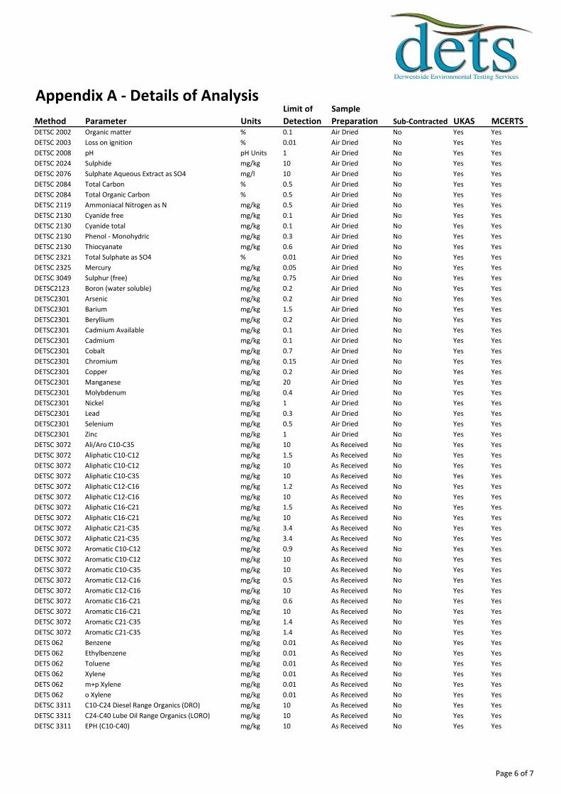
Appendix A - Details of Analysis
Method Parameter Units
Limit of
Detection
Sample
Preparation Sub-Contracted UKAS MCERTSDETSC 2002 Organic matter % 0.1 Air Dried No Yes Yes
DETSC 2003 Loss on ignition % 0.01 Air Dried No Yes Yes
DETSC 2008 pH pH Units 1 Air Dried No Yes Yes
DETSC 2024 Sulphide mg/kg 10 Air Dried No Yes Yes
DETSC 2076 Sulphate Aqueous Extract as SO4 mg/l 10 Air Dried No Yes Yes
DETSC 2084 Total Carbon % 0.5 Air Dried No Yes Yes
DETSC 2084 Total Organic Carbon % 0.5 Air Dried No Yes Yes
DETSC 2119 Ammoniacal Nitrogen as N mg/kg 0.5 Air Dried No Yes Yes
DETSC 2130 Cyanide free mg/kg 0.1 Air Dried No Yes Yes
DETSC 2130 Cyanide total mg/kg 0.1 Air Dried No Yes Yes
DETSC 2130 Phenol - Monohydric mg/kg 0.3 Air Dried No Yes Yes
DETSC 2130 Thiocyanate mg/kg 0.6 Air Dried No Yes Yes
DETSC 2321 Total Sulphate as SO4 % 0.01 Air Dried No Yes Yes
DETSC 2325 Mercury mg/kg 0.05 Air Dried No Yes Yes
DETSC 3049 Sulphur (free) mg/kg 0.75 Air Dried No Yes Yes
DETSC2123 Boron (water soluble) mg/kg 0.2 Air Dried No Yes Yes
DETSC2301 Arsenic mg/kg 0.2 Air Dried No Yes Yes
DETSC2301 Barium mg/kg 1.5 Air Dried No Yes Yes
DETSC2301 Beryllium mg/kg 0.2 Air Dried No Yes Yes
DETSC2301 Cadmium Available mg/kg 0.1 Air Dried No Yes Yes
DETSC2301 Cadmium mg/kg 0.1 Air Dried No Yes Yes
DETSC2301 Cobalt mg/kg 0.7 Air Dried No Yes Yes
DETSC2301 Chromium mg/kg 0.15 Air Dried No Yes Yes
DETSC2301 Copper mg/kg 0.2 Air Dried No Yes Yes
DETSC2301 Manganese mg/kg 20 Air Dried No Yes Yes
DETSC2301 Molybdenum mg/kg 0.4 Air Dried No Yes Yes
DETSC2301 Nickel mg/kg 1 Air Dried No Yes Yes
DETSC2301 Lead mg/kg 0.3 Air Dried No Yes Yes
DETSC2301 Selenium mg/kg 0.5 Air Dried No Yes Yes
DETSC2301 Zinc mg/kg 1 Air Dried No Yes Yes
DETSC 3072 Ali/Aro C10-C35 mg/kg 10 As Received No Yes Yes
DETSC 3072 Aliphatic C10-C12 mg/kg 1.5 As Received No Yes Yes
DETSC 3072 Aliphatic C10-C12 mg/kg 10 As Received No Yes Yes
DETSC 3072 Aliphatic C10-C35 mg/kg 10 As Received No Yes Yes
DETSC 3072 Aliphatic C12-C16 mg/kg 1.2 As Received No Yes Yes
DETSC 3072 Aliphatic C12-C16 mg/kg 10 As Received No Yes Yes
DETSC 3072 Aliphatic C16-C21 mg/kg 1.5 As Received No Yes Yes
DETSC 3072 Aliphatic C16-C21 mg/kg 10 As Received No Yes Yes
DETSC 3072 Aliphatic C21-C35 mg/kg 3.4 As Received No Yes Yes
DETSC 3072 Aliphatic C21-C35 mg/kg 3.4 As Received No Yes Yes
DETSC 3072 Aromatic C10-C12 mg/kg 0.9 As Received No Yes Yes
DETSC 3072 Aromatic C10-C12 mg/kg 10 As Received No Yes Yes
DETSC 3072 Aromatic C10-C35 mg/kg 10 As Received No Yes Yes
DETSC 3072 Aromatic C12-C16 mg/kg 0.5 As Received No Yes Yes
DETSC 3072 Aromatic C12-C16 mg/kg 10 As Received No Yes Yes
DETSC 3072 Aromatic C16-C21 mg/kg 0.6 As Received No Yes Yes
DETSC 3072 Aromatic C16-C21 mg/kg 10 As Received No Yes Yes
DETSC 3072 Aromatic C21-C35 mg/kg 1.4 As Received No Yes Yes
DETSC 3072 Aromatic C21-C35 mg/kg 1.4 As Received No Yes Yes
DETS 062 Benzene mg/kg 0.01 As Received No Yes Yes
DETS 062 Ethylbenzene mg/kg 0.01 As Received No Yes Yes
DETS 062 Toluene mg/kg 0.01 As Received No Yes Yes
DETS 062 Xylene mg/kg 0.01 As Received No Yes Yes
DETS 062 m+p Xylene mg/kg 0.01 As Received No Yes Yes
DETS 062 o Xylene mg/kg 0.01 As Received No Yes Yes
DETSC 3311 C10-C24 Diesel Range Organics (DRO) mg/kg 10 As Received No Yes Yes
DETSC 3311 C24-C40 Lube Oil Range Organics (LORO) mg/kg 10 As Received No Yes Yes
DETSC 3311 EPH (C10-C40) mg/kg 10 As Received No Yes Yes
Page 6 of 7
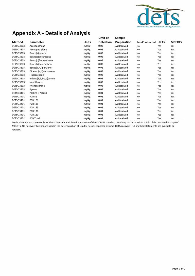
Appendix A - Details of Analysis
Method Parameter Units
Limit of
Detection
Sample
Preparation Sub-Contracted UKAS MCERTSDETSC 3303 Acenaphthene mg/kg 0.03 As Received No Yes Yes
DETSC 3303 Acenaphthylene mg/kg 0.03 As Received No Yes Yes
DETSC 3303 Benzo(a)pyrene mg/kg 0.03 As Received No Yes Yes
DETSC 3303 Benzo(a)anthracene mg/kg 0.03 As Received No Yes Yes
DETSC 3303 Benzo(b)fluoranthene mg/kg 0.03 As Received No Yes Yes
DETSC 3303 Benzo(k)fluoranthene mg/kg 0.03 As Received No Yes Yes
DETSC 3303 Benzo(g,h,i)perylene mg/kg 0.03 As Received No Yes Yes
DETSC 3303 Dibenzo(a,h)anthracene mg/kg 0.03 As Received No Yes Yes
DETSC 3303 Fluoranthene mg/kg 0.03 As Received No Yes Yes
DETSC 3303 Indeno(1,2,3-c,d)pyrene mg/kg 0.03 As Received No Yes Yes
DETSC 3303 Naphthalene mg/kg 0.03 As Received No Yes Yes
DETSC 3303 Phenanthrene mg/kg 0.03 As Received No Yes Yes
DETSC 3303 Pyrene mg/kg 0.03 As Received No Yes Yes
DETSC 3401 PCB 28 + PCB 31 mg/kg 0.01 As Received No Yes Yes
DETSC 3401 PCB 52 mg/kg 0.01 As Received No Yes Yes
DETSC 3401 PCB 101 mg/kg 0.01 As Received No Yes Yes
DETSC 3401 PCB 118 mg/kg 0.01 As Received No Yes Yes
DETSC 3401 PCB 153 mg/kg 0.01 As Received No Yes Yes
DETSC 3401 PCB 138 mg/kg 0.01 As Received No Yes Yes
DETSC 3401 PCB 180 mg/kg 0.01 As Received No Yes Yes
DETSC 3401 PCB Total mg/kg 0.01 As Received No Yes Yes
Method details are shown only for those determinands listed in Annex A of the MCERTS standard. Anything not included on this list falls outside the scope of
MCERTS. No Recovery Factors are used in the determination of results. Results reported assume 100% recovery. Full method statements are available on
request.
Page 7 of 7

Client
Our Reference
Client Reference
Contract Title
Description
Date Received
Date Started
Date Completed
Test Procedures
Notes
Approved By
Rob Brown
Opinions and interpretations are outside the scope of UKAS accreditation. This
certificate is issued in accordance with the accreditation requirements of the United
Kingdom Accreditation Service. The results reported herein relate only to the material
supplied to the laboratory. Observations and interpretations are outside the scope of
ISO 17025. This certificate shall not be reproduced except in full, without the prior
written approval of the laboratory.
Business Manager
Tamworth Golf Course
4 Water samples.
03-Jun-14
03-Jun-14
10-Jun-14
Identified by prefix DETSn (details on request).
Certificate of AnalysisCertificate Number 14-07371
10-Jun-14
Ian Farmer Associates
Unit 1 Fairfield Court
Seven Stars Industrial Estate
Wheler Road
Coventry
West Midlands
CV3 4LJ
14-07371
21232
Derwentside Environmental Testing Services LimitedUnit 2, Park Road Industrial Estate South, Consett, Co Durham, DH8 5PY
Tel: 01207 582333 • email: [email protected] • www.dets.co.uk Page 1 of 4 .

Summary of Chemical AnalysisWater Samples
Our Ref 14-07371Client Ref 21232
Contract Title Tamworth Golf CourseLab No 653622 653623 653624 653625
Sample ID WS3 WS4 WS10 WS27Depth
Other IDSample Type WATER WATER WATER WATER
Sampling Date 29/05/14 29/05/14 29/05/14 29/05/14
Sampling Time 1315 1245 1430 1230
Test Method LOD Units
DETSC 2306 0.16 ug/l 0.38 0.42 0.25 0.89DETSC 2306 0.03 ug/l 0.05 0.08 0.23 0.32DETSC 2306 0.25 ug/l < 0.25 0.33 < 0.25 0.81DETSC 2306 0.4 ug/l 1.4 1.7 0.9 3.3DETSC 2306 0.09 ug/l 0.33 0.63 0.30 0.81DETSC 2306 0.01 ug/l < 0.01 < 0.01 0.02 0.60DETSC 2306 0.5 ug/l 4.2 2.2 9.0 3.8DETSC 2306 0.25 ug/l 7.5 1.2 0.34 0.40DETSC 2306 1.25 ug/l 34.1 38.7 22.5 151
DETSC 2008 8.8 8.2 7.9 7.2DETSC 2031 1 mg/l 2.8 1.6 1.2 I/SDETSC 2032 10 mg/l 330 300 87 I/SDETSC 2055 0.1 mg/l 9.5 5.6 46 I/SDETSC 2055 0.1 mg/l 1.1 0.53 0.75 I/SDETSC 2055 0.1 mg/l < 0.10 < 0.10 < 0.50 I/SDETSC 2205 0.01 mg/l < 0.01 < 0.01 < 0.01 I/SDETSC 2055 0.1 mg/l 47 19 140 I/SDETSC 2085* 1 mg/l 170 25 21 29
DETSC 3322 0.1 ug/l < 0.1 < 0.1 < 0.1 I/SDETSC 3322 0.1 ug/l < 0.1 < 0.1 2.8 I/SDETSC 3322 0.1 ug/l < 0.1 < 0.1 < 0.1 I/SDETSC 3072* 1 ug/l < 1.0 < 1.0 < 1.0 I/SDETSC 3072* 1 ug/l < 1.0 < 1.0 < 1.0 I/SDETSC 3072* 1 ug/l < 1.0 < 1.0 < 1.0 I/SDETSC 3072* 1 ug/l < 1.0 < 1.0 < 1.0 I/SDETSC 3072* 10 ug/l < 10 < 10 < 10 I/SDETSC 3322 0.1 ug/l < 0.1 < 0.1 < 0.1 I/SDETSC 3322 0.1 ug/l < 0.1 < 0.1 < 0.1 I/SDETSC 3322 0.1 ug/l < 0.1 < 0.1 < 0.1 I/SDETSC 3072* 1 ug/l < 1.0 < 1.0 < 1.0 I/SDETSC 3072* 1 ug/l < 1.0 < 1.0 < 1.0 I/SDETSC 3072* 1 ug/l < 1.0 < 1.0 < 1.0 I/SDETSC 3072* 1 ug/l < 1.0 < 1.0 < 1.0 I/SDETSC 3072* 10 ug/l < 10 < 10 < 10 I/SDETSC 3072* 10 ug/l < 10 < 10 < 10 I/S
Metals
Inorganics
Petroleum Hydrocarbons
Aromatic C12-C16Aromatic C16-C21Aromatic C21-C35Aromatic C5-C35TPH Ali/Aro
Aliphatic C21-C35Aliphatic C5-C35Aromatic C5-C7Aromatic C7-C8Aromatic C8-C10Aromatic C10-C12
Aliphatic C5-C6Aliphatic C6-C8Aliphatic C8-C10Aliphatic C10-C12Aliphatic C12-C16Aliphatic C16-C21
ChlorideNitrate as NO3Nitrite as NO2Ortho Phosphate as PSulphate as SO4Total Organic Carbon
Nickel, DissolvedSelenium, DissolvedZinc, Dissolved
pHTotal Biochemical Oxygen DemandTotal Chemical Oxygen Demand
Arsenic, DissolvedCadmium, DissolvedChromium, DissolvedCopper, DissolvedLead, DissolvedMercury, Dissolved
Page 2 of 4Key: * -not accredited. I/S -insufficient sample.

Summary of Chemical AnalysisWater Samples
Our Ref 14-07371Client Ref 21232
Contract Title Tamworth Golf CourseLab No 653622 653623 653624 653625
Sample ID WS3 WS4 WS10 WS27Depth
Other IDSample Type WATER WATER WATER WATER
Sampling Date 29/05/14 29/05/14 29/05/14 29/05/14
Sampling Time 1315 1245 1430 1230
Test Method LOD Units
DETS 074* 0.01 ug/l < 0.01 < 0.01 < 0.01 I/SDETS 074* 0.01 ug/l < 0.01 < 0.01 < 0.01 I/SDETS 074* 0.01 ug/l < 0.01 < 0.01 < 0.01 I/SDETS 074* 0.01 ug/l < 0.01 < 0.01 < 0.01 I/SDETS 074* 0.01 ug/l < 0.01 < 0.01 < 0.01 I/SDETS 074* 0.01 ug/l < 0.01 < 0.01 < 0.01 I/SDETS 074* 0.01 ug/l < 0.01 < 0.01 < 0.01 I/SDETS 074* 0.01 ug/l < 0.01 < 0.01 < 0.01 I/SDETS 074* 0.01 ug/l < 0.01 < 0.01 < 0.01 I/SDETS 074* 0.01 ug/l < 0.01 < 0.01 < 0.01 I/SDETS 074* 0.01 ug/l < 0.01 < 0.01 < 0.01 I/SDETS 074* 0.01 ug/l < 0.01 < 0.01 < 0.01 I/SDETS 074* 0.01 ug/l < 0.01 < 0.01 < 0.01 I/SDETS 074* 0.01 ug/l < 0.01 < 0.01 < 0.01 I/SDETS 074* 0.01 ug/l < 0.01 0.02 < 0.01 I/SDETS 074* 0.01 ug/l < 0.01 < 0.01 < 0.01 I/SDETS 074* 0.2 ug/l < 0.20 < 0.20 < 0.20 I/S
NaphthalenePhenanthrenePyrenePAH
PAHs
Benzo(g,h,i)peryleneChryseneDibenzo(a,h)anthraceneFluorantheneFluoreneIndeno(1,2,3-c,d)pyrene
AcenaphthyleneAnthraceneBenzo(a)anthraceneBenzo(a)pyreneBenzo(b)fluorantheneBenzo(k)fluoranthene
Acenaphthene
Page 3 of 4Key: * -not accredited. I/S -insufficient sample.

Information in Support of the Analytical ResultsOur Ref 14-07371
Client Ref 21232Contract Tamworth Golf Course
Containers Received & Deviating Samples
Lab No Sample ID
Date
Sampled Containers Received Holding time exceeded for tests
Inappropriate
container for
tests653622 WS3 WATER 29/05/14 GJ 1L (1L), GV (40ml), PB 1L (1L) BOD (2 days), Nitrite as NO2 (2 days), Nitrate as NO3
(2 days)
653623 WS4 WATER 29/05/14 GJ 1L (1L), GV (40ml), PB 1L (1L) BOD (2 days), Nitrite as NO2 (2 days), Nitrate as NO3
(2 days)
653624 WS10 WATER 29/05/14 GJ 1L (1L), GV (40ml), PB 1L (1L) BOD (2 days), Nitrite as NO2 (2 days), Nitrate as NO3
(2 days)
653625 WS27 WATER 29/05/14 GV (40ml), PB 1L (250ml) BOD (2 days), Nitrite as NO2 (2 days), Nitrate as NO3
(2 days)
DisposalFrom the issue date of this test certificate, samples will be held for the following times prior to disposal :-
Soils - 1 month, Liquids - 2 weeks, Asbestos (test portion) - 6 months
Key: G-Glass P-Plastic J-Jar B-Bottle V-Vial
DETS cannot be held responsible for the integrity of samples received whereby the laboratory did not undertake the sampling. In this instance samples received may
be deviating. Deviating Sample criteria are based on British and International standards and laboratory trials in conjunction with the UKAS note 'Guidance on
Deviating Samples'. All samples received are listed above. However, those samples that have additional comments in relation to hold time and/or inappropriate
containers are deviating due to the reasons stated. This means that the analysis is accredited where applicable, but results may be compromised due to sample
deviations. If no sampled date (soils) or date+time (waters) has been supplied then samples are deviating. However, if you are able to supply a sampled date (and
time for waters) this will prevent samples being reported as deviating where specific hold times are not exceeded and where the container supplied is suitable.
Page 4 of 4

Client
Our Reference
Client Reference
Contract Title
Description
Date Received
Date Started
Date Completed
Test Procedures
Notes
Approved By
Rob Brown
Opinions and interpretations are outside the scope of UKAS accreditation. This
certificate is issued in accordance with the accreditation requirements of the United
Kingdom Accreditation Service. The results reported herein relate only to the material
supplied to the laboratory. Observations and interpretations are outside the scope of
ISO 17025. This certificate shall not be reproduced except in full, without the prior
written approval of the laboratory.
Business Manager
Tamworth Golf Course
3 Water samples.
27-Jun-14
27-Jun-14
03-Jul-14
Identified by prefix DETSn (details on request).
Certificate of AnalysisCertificate Number 14-09279
03-Jul-14
Ian Farmer Associates
Unit 1 Fairfield Court
Seven Stars Industrial Estate
Wheler Road
Coventry
West Midlands
CV3 4LJ
14-09279
21232
Derwentside Environmental Testing Services LimitedUnit 2, Park Road Industrial Estate South, Consett, Co Durham, DH8 5PY
Tel: 01207 582333 • email: [email protected] • www.dets.co.uk Page 1 of 4 .

Summary of Chemical AnalysisWater Samples
Our Ref 14-09279Client Ref 21232
Contract Title Tamworth Golf CourseLab No 664615 664616 664617
Sample ID SW1 SW2 SW3Depth
Other IDSample Type WATER WATER WATER
Sampling Date 25/06/14 25/06/14 25/06/14
Sampling Time n/s n/s n/s
Test Method LOD Units
DETSC 2306 0.16 ug/l 0.37 0.60 0.44DETSC 2306* 12 ug/l 480 100 97DETSC 2306 0.03 ug/l < 0.03 < 0.03 < 0.03DETSC 2306 0.09 mg/l 120 63 57DETSC 2306 0.25 ug/l < 0.25 0.36 < 0.25DETSC 2203 10 ug/l < 10 < 10 < 10DETSC 2306 0.4 ug/l 3.8 6.2 1.3DETSC 2306 5.5 ug/l 92 8.6 31DETSC 2306 0.09 ug/l 0.17 0.14 0.22DETSC 2306 0.02 mg/l 28 13 11DETSC 2306 0.22 ug/l 250 51 32DETSC 2306 0.01 ug/l < 0.01 < 0.01 < 0.01DETSC 2306 0.5 ug/l 5.8 1.9 0.9DETSC 2306 0.08 mg/l 6.2 3.5 2.2DETSC 2306 0.25 ug/l 0.40 0.28 0.56DETSC 2306 0.07 mg/l 31 22 29DETSC 2306 1.25 ug/l 9.63 12.7 12.2
DETSC 2008 6.0 6.5 6.5DETSC 2031 1 mg/l 2.4 3.3 2.2DETSC 2032 10 mg/l 11 19 260DETSC 2130 20 ug/l < 20 < 20 < 20DETSC 2303* 0.1 mg/l 414 211 188DETSC 2207 0.015 mg/l 0.25 0.21 0.14DETSC 2055 0.1 mg/l 55 48 59DETSC 2055 0.1 mg/l 5.9 21 20DETSC 2055 0.1 mg/l 0.27 0.23 0.35DETSC 2121* 1 mg/l 6.4 12 16DETSC 2205 0.01 mg/l < 0.01 < 0.01 0.12DETSC 2055 0.1 mg/l 250 70 61
DETSC 3311 10 ug/l 420 430 520
DETS 074* 0.01 ug/l < 0.01 < 0.01 0.01DETS 074* 0.01 ug/l < 0.01 < 0.01 < 0.01DETS 074* 0.01 ug/l < 0.01 < 0.01 0.01DETS 074* 0.01 ug/l < 0.01 < 0.01 < 0.01DETS 074* 0.01 ug/l < 0.01 < 0.01 < 0.01DETS 074* 0.01 ug/l < 0.01 < 0.01 < 0.01DETS 074* 0.01 ug/l < 0.01 < 0.01 < 0.01DETS 074* 0.01 ug/l < 0.01 < 0.01 < 0.01
Metals
Inorganics
Petroleum Hydrocarbons
PAHs
Benzo(k)fluorantheneBenzo(g,h,i)perylene
AcenaphtheneAcenaphthyleneAnthraceneBenzo(a)anthraceneBenzo(a)pyreneBenzo(b)fluoranthene
Nitrate as NO3Nitrite as NO2NitrogenOrtho Phosphate as PSulphate as SO4
EPH (C10-C40)
Total Biochemical Oxygen DemandTotal Chemical Oxygen DemandCyanide freeHardnessAmmoniacal Nitrogen as NChloride
Nickel, DissolvedPotassium, DissolvedSelenium, DissolvedSodium, DissolvedZinc, Dissolved
pH
Copper, DissolvedIron, DissolvedLead, DissolvedMagnesium, DissolvedManganese, DissolvedMercury, Dissolved
Arsenic, DissolvedBoron, DissolvedCadmium, DissolvedCalcium, DissolvedChromium, DissolvedHexavalent Chromium
Page 2 of 4Key: * -not accredited. n/s -not supplied.
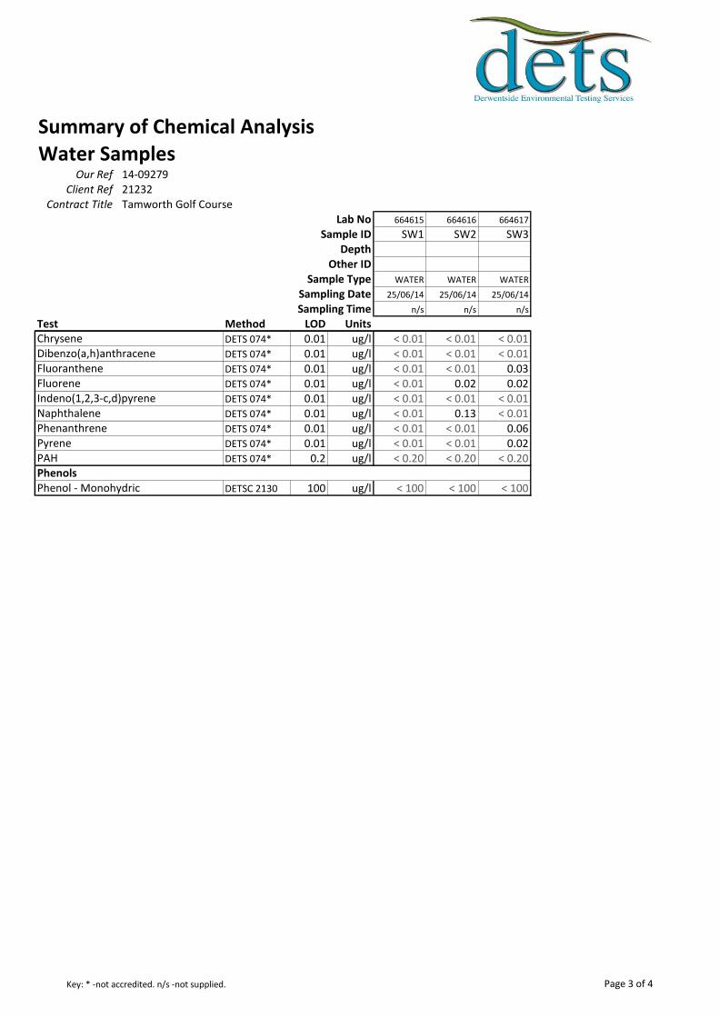
Summary of Chemical AnalysisWater Samples
Our Ref 14-09279Client Ref 21232
Contract Title Tamworth Golf CourseLab No 664615 664616 664617
Sample ID SW1 SW2 SW3Depth
Other IDSample Type WATER WATER WATER
Sampling Date 25/06/14 25/06/14 25/06/14
Sampling Time n/s n/s n/s
Test Method LOD UnitsDETS 074* 0.01 ug/l < 0.01 < 0.01 < 0.01DETS 074* 0.01 ug/l < 0.01 < 0.01 < 0.01DETS 074* 0.01 ug/l < 0.01 < 0.01 0.03DETS 074* 0.01 ug/l < 0.01 0.02 0.02DETS 074* 0.01 ug/l < 0.01 < 0.01 < 0.01DETS 074* 0.01 ug/l < 0.01 0.13 < 0.01DETS 074* 0.01 ug/l < 0.01 < 0.01 0.06DETS 074* 0.01 ug/l < 0.01 < 0.01 0.02DETS 074* 0.2 ug/l < 0.20 < 0.20 < 0.20
DETSC 2130 100 ug/l < 100 < 100 < 100
Phenols
Indeno(1,2,3-c,d)pyreneNaphthalenePhenanthrenePyrenePAH
Phenol - Monohydric
ChryseneDibenzo(a,h)anthraceneFluorantheneFluorene
Page 3 of 4Key: * -not accredited. n/s -not supplied.

Information in Support of the Analytical ResultsOur Ref 14-09279
Client Ref 21232Contract Tamworth Golf Course
Containers Received & Deviating Samples
Lab No Sample ID
Date
Sampled Containers Received Holding time exceeded for tests
Inappropriate
container for
tests664615 SW1 WATER 25/06/14 GJ 500ml (330ml) x2, GV (40ml) x2 Hexavalent Chromium (1 days)
664616 SW2 WATER 25/06/14 GJ 500ml (330ml) x2, GV (40ml) x2 Hexavalent Chromium (1 days)
664617 SW3 WATER 25/06/14 GJ 500ml (330ml) x2, GV (40ml) x2 Hexavalent Chromium (1 days)
DisposalFrom the issue date of this test certificate, samples will be held for the following times prior to disposal :-
Soils - 1 month, Liquids - 2 weeks, Asbestos (test portion) - 6 months
Key: G-Glass J-Jar V-Vial
DETS cannot be held responsible for the integrity of samples received whereby the laboratory did not undertake the sampling. In this instance samples received may
be deviating. Deviating Sample criteria are based on British and International standards and laboratory trials in conjunction with the UKAS note 'Guidance on
Deviating Samples'. All samples received are listed above. However, those samples that have additional comments in relation to hold time and/or inappropriate
containers are deviating due to the reasons stated. This means that the analysis is accredited where applicable, but results may be compromised due to sample
deviations. If no sampled date (soils) or date+time (waters) has been supplied then samples are deviating. However, if you are able to supply a sampled date (and
time for waters) this will prevent samples being reported as deviating where specific hold times are not exceeded and where the container supplied is suitable.
Page 4 of 4

APPENDIX 5
GAS & GROUNDWATER MONITORING

O2% v/v : 21.1 CO2% v/v : 0.0 CH4% v/v : 0.0
H2S ppm : 0 CO ppm : 0Pressure Trend :
Rising
H2S (ppm) CO (ppm) Depth to LNAPL Water Depth Depth to DNAPL Total Depth
Low Steady High Steady High Steady Peak Peak Peak Steady (mbgl) (mbgl) (mbgl) (mbgl)
WS1 -
WS2 -
WS3 - 1009 21.0 21.0 0.4 0.4 0.0 0.0 0 0 0.0 0.0 0.66 3.08
WS4 - 1009 21.0 21.0 0.0 0.0 0.0 0.0 0 0 0.3 0.0 0.22 1.04
WS7 -
WS10 - 1009 16.8 16.8 0.6 0.6 0.0 0.0 0 2 0.0 0.0 1.32 2.10
WS15 -
WS17 - 1009 16.5 16.5 4.3 4.3 0.0 0.0 0 0 0.0 0.0 DRY 2.12
WS19 - 1009 19.4 19.4 2.2 2.2 0.0 0.0 0 0 0.0 0.0 DRY 1.00
WS21 - 1009 17.6 17.6 4.5 4.5 0.0 0.0 0 0 0.0 0.0 2.44 2.81
WS26 - 1009 16.1 16.1 4.4 4.4 0.0 0.0 0 0 0.0 0.0 DRY 2.04
WS27 - 1009 15.2 15.2 3.8 3.8 0.0 0.0 0 0 0.0 0.0 3.71 4.04
WS30 -
Remarks :
Gas Flow Rate (l/hr)
FLOODED - STANDING WATER
FLOODED - STANDING WATER
FLOODED - STANDING WATER
FLOODED - STANDING WATER
FLOODED - STANDING WATER
Location TimeAtmospheric
Pressure (mb)
O2(% v/v) CO2 (% v/v) CH4 (% v/v)
Date : 28/05/2014
Background Readings:Weather Conditions : Cold, wet, windy
Ground Conditions : Saturated
GAS AND GROUNDWATER MONITORING RESULTS
Contract Name : Tamworth Golf Course
Contract No : 21232
Figure A5.1

O2% v/v : 20.5 CO2% v/v : 0.0 CH4% v/v : 0.0
H2S ppm : 0 CO ppm : 0Pressure Trend :
Rising
H2S (ppm) CO (ppm) Depth to LNAPL Water Depth Depth to DNAPL Total Depth
Low Steady High Steady High Steady Peak Peak Peak Steady (mbgl) (mbgl) (mbgl) (mbgl)
WS1 - 1025 17.0 17.0 1.9 1.9 0.0 0.0 0 0 0.0 0.0 - 1.09 - 3.29
WS2 - 1025 20.1 20.1 0.2 0.2 0.0 0.0 0 0 0.1 0.0 - 0.74 - 2.22
WS3 - 1025 20.0 20.0 0.4 0.4 0.0 0.0 0 0 0.0 0.0 - 0.84 - 3.80
WS4 - 1025 20.1 20.1 0.1 0.1 0.0 0.0 0 0 0.0 0.0 - 0.67 - 1.48
WS7 - 1025 19.2 19.2 0.9 0.9 0.0 0.0 0 0 0.0 0.0 - 0.75 - 4.02
WS10 - 1025 17.0 17.0 2.2 2.2 0.0 0.0 0 0 0.1 0.0 - 1.49 - 2.11
WS15 - 1025 7.4 7.4 6.8 6.8 0.0 0.0 0 0 0.0 0.0 - 3.47 - 5.24
WS17 - 1025 17.1 17.1 2.4 2.4 0.0 0.0 0 0 0.0 0.0 - Dry - 2.12
WS19 - 1025 19.6 19.6 1.5 1.5 0.0 0.0 0 0 0.0 0.0 - Dry - 1.01
WS21 - 1025 17.3 17.3 3.1 3.1 0.0 0.0 0 0 0.0 0.0 - 2.09 - 2.84
WS26 - 1025 16.7 16.7 4.9 4.9 0.0 0.0 0 0 0.0 0.0 - Dry - 2.40
WS27 - 1025 18.9 18.9 0.6 0.6 0.0 0.0 0 0 0.0 0.0 - 1.41 - 4.20
WS30 - 1025 13.7 13.7 2.4 2.4 0.0 0.0 0 0 -0.1 0.0 - 1.01 - 3.42
Remarks :
Gas Flow Rate (l/hr)Location Time
Atmospheric Pressure (mb)
O2(% v/v) CO2 (% v/v) CH4 (% v/v)
Date : 03/06/2014
Background Readings:Weather Conditions : Sun and showers
Ground Conditions : Damp
GAS AND GROUNDWATER MONITORING RESULTS
Contract Name : Tamworth Golf Course
Contract No : 21232
Figure A5.2

O2% v/v : 20.7 CO2% v/v : 0.0 CH4% v/v : 0.0
H2S ppm : 0 CO ppm : 0Pressure Trend :
Falling
H2S (ppm) CO (ppm) Depth to LNAPL Water Depth Depth to DNAPL Total Depth
Low Steady High Steady High Steady Peak Peak Peak Steady (mbgl) (mbgl) (mbgl) (mbgl)
WS1 - 1014 16.7 16.7 2.6 2.5 0.0 0.0 0 0 0.3 0.0 - 1.20 - 3.29
WS2 - 1014 19.7 19.7 0.7 0.7 0.0 0.0 0 0 0.0 0.0 - 0.80 - 2.22
WS3 - 1014 20.1 20.1 0.6 0.6 0.0 0.0 0 0 0.2 0.0 - 0.98 - 3.80
WS4 - 1014 20.4 20.4 0.1 0.1 0.1 0.1 0 0 0.0 0.0 - 0.58 - 1.48
WS7 - 1014 20.1 20.1 0.5 0.1 0.0 0.0 0 0 0.0 0.0 - 0.89 - 4.02
WS10 - 1014 17.5 17.5 4.0 4.0 0.0 0.0 0 0 0.0 0.0 - 1.49 - 2.11
WS15 - 1014 3.8 3.8 9.1 9.1 0.0 0.0 0 0 0.0 0.0
WS17 - 1014 16.9 16.9 3.7 3.7 0.0 0.0 0 0 0.0 0.0 - Dry - 2.12
WS19 - 1014 19.3 19.3 1.9 1.9 0.0 0.0 0 0 0.0 0.0 - Dry - 1.01
WS21 - 1014 17.5 17.5 3.8 3.8 0.0 0.0 0 0 0.0 0.0 - 2.18 - 2.84
WS26 - 1014 16.1 16.1 4.7 4.7 0.0 0.0 0 0 0.0 0.0 - Dry - 2.40
WS27 - 1014 19.9 19.9 0.3 0.3 0.0 0.0 0 0 0.0 0.0 - 1.48 - 4.20
WS30 - 1014 15.1 15.1 1.7 1.7 0.1 0.1 0 1 -1.3 -1.3 - 1.10 - 3.42
Remarks :
GAS AND GROUNDWATER MONITORING RESULTS
Contract Name : Tamworth Golf Course
Contract No : 21232
Date : 20/06/2014
Background Readings:Weather Conditions : Warm, sunny spells, 70% cloud, calm, 20°C
Ground Conditions : Dry
Location TimeAtmospheric
Pressure (mb)
O2(% v/v) CO2 (% v/v) CH4 (% v/v) Gas Flow Rate (l/hr)
Unable to remove gas bung to determine water levels
Figure A5.3
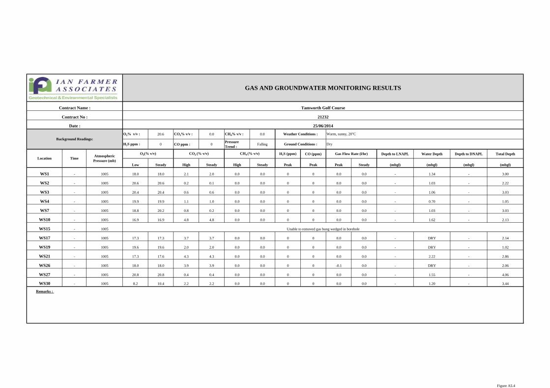
O2% v/v : 20.6 CO2% v/v : 0.0 CH4% v/v : 0.0
H2S ppm : 0 CO ppm : 0Pressure Trend :
Falling
H2S (ppm) CO (ppm) Depth to LNAPL Water Depth Depth to DNAPL Total Depth
Low Steady High Steady High Steady Peak Peak Peak Steady (mbgl) (mbgl) (mbgl) (mbgl)
WS1 - 1005 18.0 18.0 2.1 2.0 0.0 0.0 0 0 0.0 0.0 - 1.34 - 3.00
WS2 - 1005 20.6 20.6 0.2 0.1 0.0 0.0 0 0 0.0 0.0 - 1.03 - 2.22
WS3 - 1005 20.4 20.4 0.6 0.6 0.0 0.0 0 0 0.0 0.0 - 1.06 - 3.03
WS4 - 1005 19.9 19.9 1.1 1.0 0.0 0.0 0 0 0.0 0.0 - 0.70 - 1.05
WS7 - 1005 18.8 20.2 0.8 0.2 0.0 0.0 0 0 0.0 0.0 - 1.03 - 3.03
WS10 - 1005 16.9 16.9 4.8 4.8 0.0 0.0 0 0 0.0 0.0 - 1.62 - 2.13
WS15 - 1005
WS17 - 1005 17.3 17.3 3.7 3.7 0.0 0.0 0 0 0.0 0.0 - DRY - 2.14
WS19 - 1005 19.6 19.6 2.0 2.0 0.0 0.0 0 0 0.0 0.0 - DRY - 1.02
WS21 - 1005 17.3 17.6 4.3 4.3 0.0 0.0 0 0 0.0 0.0 - 2.22 - 2.86
WS26 - 1005 18.0 18.0 3.9 3.9 0.0 0.0 0 0 -0.1 0.0 - DRY - 2.06
WS27 - 1005 20.8 20.8 0.4 0.4 0.0 0.0 0 0 0.0 0.0 - 1.55 - 4.06
WS30 - 1005 8.2 10.4 2.2 2.2 0.0 0.0 0 0 0.0 0.0 - 1.20 - 3.44
Remarks :
Unable to removed gas bung wedged in borehole
Location TimeAtmospheric
Pressure (mb)
O2(% v/v) CO2 (% v/v) CH4 (% v/v) Gas Flow Rate (l/hr)
Date : 25/06/2014
Background Readings:Weather Conditions : Warm, sunny, 20°C
Ground Conditions : Dry
GAS AND GROUNDWATER MONITORING RESULTS
Contract Name : Tamworth Golf Course
Contract No : 21232
Figure A5.4

O2% v/v : 20.7 CO2% v/v : 0.0 CH4% v/v : 0.0
H2S ppm : 0 CO ppm : 0Pressure Trend :
Rising
H2S (ppm) CO (ppm) Depth to LNAPL Water Depth Depth to DNAPL Total Depth
Low Steady High Steady High Steady Peak Peak Peak Steady (mbgl) (mbgl) (mbgl) (mbgl)
WS1 - 1011 18.9 19.2 2.1 1.6 0.0 0.0 0 3 0.3 0.0 1.36 3.21
WS2 - 1011 18.5 18.5 1.9 1.9 0.0 0.0 0 0 0.1 0.0 1.16 2.21
WS3 - 1011 20.5 20.5 0.3 0.3 0.0 0.0 0 0 0.0 0.0 1.11 3.02
WS4 - 1011 18.3 18.3 3.1 3.1 0.0 0.0 0 3 0.0 0.0 0.74 1.03
WS7 - 1011 19.8 20.0 0.5 0.2 0.0 0.0 0 0 -0.1 -0.1 1.09 4.02
WS10 - 1011 18.2 18.2 3.2 3.2 0.0 0.0 0 0 0.3 0.0 1.72 2.10
WS15 - 1011
WS17 - 1011 16.8 16.8 3.6 3.6 0.0 0.0 0 1 0.0 0.0 DRY 2.12
WS19 - 1011 19.6 19.6 1.3 1.3 0.0 0.0 0 0 0.0 0.0 DRY 1.01
WS21 - 1011 17.7 17.7 3.8 3.8 0.0 0.0 0 0 0.0 0.0 2.09 2.85
WS26 - 1011 18.8 18.8 2.6 2.6 0.0 0.0 0 0 0.0 0.0 DRY 2.04
WS27 - 1011 20.3 20.3 0.3 0.3 0.0 0.0 0 0 0.0 0.0 1.78 4.04
WS30 - 1011 4.2 4.2 4.0 4.0 0.0 0.0 0 1 -0.1 -0.1 1.30 3.42
Remarks :
GAS AND GROUNDWATER MONITORING RESULTS
Contract Name : Tamworth Golf Course
Contract No : 21232
Date : 15/07/2014
Background Readings:Weather Conditions : Warm, 100% cloud, slight wind, 20°C
Ground Conditions : Dry
Gas Flow Rate (l/hr)Location Time
Atmospheric Pressure (mb)
O2(% v/v) CO2 (% v/v) CH4 (% v/v)
BUNG STUCK IN PIPE
Figure A5.5

O2% v/v : 21.0 CO2% v/v : 0.0 CH4% v/v : 0.0
H2S ppm : 0 CO ppm : 0Pressure Trend :
Falling
H2S (ppm) CO (ppm) Depth to LNAPL Water Depth Depth to DNAPL Total Depth
Low Steady High Steady High Steady Peak Peak Peak Steady (mbgl) (mbgl) (mbgl) (mbgl)
WS1 - 1008 20.7 20.7 0.0 0.0 0.0 0.0 0 0 0.0 0.0 - 1.76 - 3.16
WS2 - 1008 20.7 20.7 0.2 0.1 0.0 0.0 0 0 0.1 0.0 - 1.58 - 2.21
WS3 - 1008 20.7 20.7 0.1 0.1 0.0 0.0 0 0 0.0 0.0 - 1.35 - 3.02
WS4 - 1008 16.4 16.4 0.3 0.3 0.0 0.0 0 0 0.0 0.0 - 0.90 - 1.04
WS7 - 1008 20.7 20.7 0.1 0.1 0.0 0.0 0 0 0.1 0.0 - 1.23 - 4.00
WS10 - 1008 20.7 20.7 0.0 0.0 0.0 0.0 0 0 0.0 0.0 - 2.03 - 2.09
WS15 - 1008
WS17 - 1005 17.6 17.6 3.7 3.7 0.0 0.0 0 0 0.2 0.1 - DRY - 2.12
WS19 - 1008 19.3 19.3 1.6 1.6 0.0 0.0 0 0 0.0 0.0 - DRY - 1.00
WS21 - 1005 17.1 17.1 4.8 4.8 0.0 0.0 0 0 0.0 0.0 - 2.40 - 2.83
WS26 - 1008 20.3 20.3 0.0 0.0 0.0 0.0 0 0 0.0 0.0 - DRY - 2.03
WS27 - 1005 20.3 20.3 0.0 0.0 0.0 0.0 0 0 0.0 0.0 - 2.67 - 4.04
WS30 - 1008 20.3 20.3 0.0 0.0 0.0 0.0 0 0 0.0 0.0 - 1.40 - 3.42
Remarks :
GAS AND GROUNDWATER MONITORING RESULTS
Contract Name : Tamworth Golf Course
Contract No : 21232
Date : 07/08/2014
Background Readings:Weather Conditions : Warm, 50% cloud, slight wind, 22°C
Ground Conditions : Damp
Gas Flow Rate (l/hr)
BUNG STUCK IN PIPE
Location TimeAtmospheric
Pressure (mb)
O2(% v/v) CO2 (% v/v) CH4 (% v/v)
Figure A5.6