Embed Size (px)
Citation preview


2
ÍNDEX
1. THE AUTHORITY
2. THE TERRITORY
3. THE WATER MANAGAMENT PLAN
4. THE RESOURCE
5. THE RESOURCE MANAGEMENT
6. THE RESOURCE PROTECTION
7. ECONOMIC ANALYSIS
8. PUBLIC PARTICIPATION
Edition: Miño-Sil River Basin Authority. Water Planning Office.
Legal Note: The information in this document is merely informa-tive and not binding legal effect to the Administration. It is authorized to use the information in these pages, providing the source.

3
1. THE AUTHORITY
The Miño-Sil River Basin District Authority
¿What is it? The River Basin District Authorities are public institutions, attached to the Ministry of Agriculture, Food and Environment, which have the River Basin Man-agement competence in interregional basins, i.e. river basins which cover more than one Region. The Miño Sil River Basin District Authority (MSRBD bellow) is the organization re-sponsible for the management of the Miño Sil River Basin District which covers the Miño River Basin- with its main tributary river Sil- , and Limia River Basin in the Spanish side, and also the transitional and coastal waters. The MSRBD Authority manage the continental waters (rivers, lakes and aquifers), the transitional waters (estuary) and coastal water (in the River Miño mouth) belonging to the Spanish side of the River Basin District. There are 278 surface water bodies and 6 groundwater bodies(aquifers).
Which are theirs duties? The conservation of the good status of the rivers and aq-uifers will depend on the water availability to attend all the current and future de-mands with enough quality and quantity. With this aim, the Spanish Water Law con-fer the “elaboration, monitoring, revision of river basin management plan” to the River Basin Authorities. The River Basin Management Plan (RBMP) is the main method in the water management. The RBMP establishes priority of the different water uses and the plan of action to achieve the good status and the protection of the water bodies
How do they manage the water resources? In order to accomplish a better water management in the River Basin District, the RBMP distinguish 6 water resources systems Upper Miño, Lower Miño, Cabe, Limia, Upper Sil and Lower Sil. The water resources Systems consist on water bodies (surface and underground water), hydraulic infrastructures and water use rules. According to the water qual-ity and the environmental objectives established, the RBMP determines the water availability for each system.
Water Systems distribution in Miño Sil River Basin. Own elaboration

4
The Miño Sil River Basin District is an International basin. The last 76 Km of the Miño River, the Trancoso Tributary River and also the Rivers Limia, La-boreiro and Salas (Limia tributary river) are managed by Spain and Portugal in a shared way. Apart from international basin, the MSRBD is an interregional basin. It covers 7 different Provinces from three Regions: Galicia, Castilla y Leon and Asturias. The total area is 17.619 km2. The Miño Sil River Basin District includes more than 200 municipalities. The MSRBD population is 858.310 residents and the population density of the basin is 49 residents per km2, a value under the national average (88 residents/ km2) The territory of the River Basin District has a widely dispersed population dis-tribution, with about 11.703 population centres (cities, towns and villages). The 91% of the MSRBD municipalities have less than 10.000 residents and only in the cities of Lugo, Ourense and Pontevedra the population is more than 50.000 residents. The 25% of the Galician population live in small villages with less than 100 residents.
2. THE TERRITORY
A widely dispersed population
Population centres distribution in Miño Sil River Basin. Own elaboration.
PROVINCE P. CENTRESASTURIAS 1LEON 391LUGO 5997OURENSE 3394PONTEVEDRA 1917ZAMORA 3TOTAL MSRBD 11703
WATER RESOURCE SYSTEM P. CENTRESCABE 756LIMIA 433MIÑO ALTO 4884MIÑO BAJO 4227SIL INFERIOR 997SIL SUPERIOR 406TOTAL MSRBD 11703
REGIONS PROVINCES EXTENSION POPULATION
Galicia
Ourense 6139 304232 Pontevedra 1165 153.710
Lugo 6266 251817 A Coruña 4 ‐
Asturias Asturias 16 87
Castilla y León León 3885 148071 Zamora 144 393
Total River Basin Distidrográfica Miño‐Sil 17619 858310
The Miño-Sil River Basin District
SPAIN

5
3. THE WATER PLAN The planning process: The current planning process starts with the approval of the Water Framework Directive (Directive 2000/60/EC of the European Parliament and of the Council of 23 October 2000 establishing a framework for Community action in the field of water policy) which precepts are integrated in the Spanish code of laws. According to Water Framework Directive, the River Basin Authorities should elaborate the new River Basin Management Plans under the water use sustainability criteria. Promoting:
The integrated management and long term protection of water resources The prevention of the deterioration of water status The protection and the improvement of the aquatic environment and aquatic
ecosystems and reduction of pollution The prevention of the floods and droughts effects The information and public participation
Following the WFD, the Miño-Sil River Basin Authority developed and submitted to public consultation the initial documents. Afterwards the outline of mayor issues (ETI) was published; currently it is approved by the Government Committee of the MSRBD and the competent authorities Committee. Finally, the documents that correspond to “ The Water Management Plan Proposal and Environmental Sustainability Report" of the water planning process for the Spanish part of the Minho-Sil River Basin were drafted and submitted to the official public consultation period (December 15, 2011). After the public consul-tation, in June 2011, the received contributions were analyzed - a total of 70 - and the final documents of the Water Management Plan ,that will regulate the management of river resources in the coming years , were drafted. Planning to ensure the good status of the water bodies The Miño-Sil River Management Plan project is composed by a report which consist of 14 chapters, 12 appendixes that develop each chapter and specific regulations to establish the legal framework of the uses, rights and obligations in respect to the water resources of the MSRBD.
Contents of the Management Plan
Overview of the River Basin District Description of usage, demands and pressures Use priorities and allocation of resources Identification and mapping of protected areas Control programmes and status of the water bodies Environmental objectives for water bodies and assessment of compli-
ance with environmental objectives Economic analysis of water uses and costs recovery Related plans and programmes, stressing in control plans of floods and
droughts Measures programme to achieve the environmental objectives Public participation Monitoring of the river basin district management plan

6
4. THE RESOURCE
Pressures, impacts & measures to achieve the good status of water bodies
The main water network of the River Basin District is composed of the basins of rivers Miño, Sil and Limia. In the Spanish side of the basin there are 278 surface water bodies and 6 underground water bodies (aquifers). The surface water bodies are classified in four catego-ries: river (270), lake (3), transition water (4), coastal water (1). The Miño River Basin covers the area from its source, in the north part of Lugo Province, to the mouth in Atlantic Sea, between the towns A Guarda –Spain- and Caminha -Portugal-. The Sil River is the main tributary to Miño river but also rivers Ladra, Neira, Avia, Deva, Arnoia and Tea are some other tributary rivers. The 95 % of the Miño River Basin area is situated in Spain, but the last 76 Km are international waters which form the natural border between Spain and Portugal. These last 76 Km are managed in a shared way between Spain and Portugal through the Con-vention of Albufeira (Convention about bilateral coop-eration for the protection and the sustainable exploitation of the Spanish-Portuguese river basins). The Limia River Basin is 108 Km long from its source to its mouth in the Atlantic Sea at the Portuguese City of
Viana do Castelo. On its last 67 Km the river goes through Portuguese Territory. The 53 % of the Limia river basin is situated in Spain and the 47% in Portugal; the main tributary river is Salas river.
The Water Network
Portas Reservoir

7
The availability of enough quantity and quality of water to attend our needs depends on the good conservation of the rivers and water bodies. The Water Framework Directive establishes as priority objectives of water planning to achieve good water status, to protect aquatic eco-systems and to reduce pollution. Consequently, the River Basin Management Plan contains an intensive study of the status of all water bodies of the River Basin District; which includes biological, physical, chemical, hydrologi-cal and hydro-morphological studies. This study examines, also, the pressures over the water re-sources made by different water uses and the im-pacts of these pressures.
Impacts
Water Uses
Irrigation
Urban and In-dustrial Supply
Electricity Pro-ducción
Aquiculture
Nautical activi-ties
Pressures
Diffuse Pollu-tion
Puntual dis-charge
Water Extrac-tions
Flow Regula-tions
Morphological alterations
The ecosystem
Concentration of pollutants and organic matter
Stream deterioration and habi-tats degradation
The results of the water bodies study show that most of the MSRBD surface waters (rivers, lakes and reservoirs, transi-tional and coastal waters) are in good condition (70.5%) and so does five out of six underground water bodies. However, there have been identified a total of 78 surface water bodies and one groundwater body in a status worse than good. The inventory of pressures included in the River Basin Management Plan identifies the following major pressures or problems on water: pollution (point and diffuse), water extractions and hydro-morphological alterations in rivers (for elec-tricity production). These pressures reduce water availability, directly affect its quality and undertake the fulfillment of environmental objectives.
Pressures Study
Water uses are different kinds of resource utilization as well as any activity that has signifi-cant impact on water status. Water uses include: population supply, irrigation and other agricul-tural and livestock uses, electricity production and other industrial uses, aquaculture, recrea-tional uses, navigation and water transport. According to the water volume consumed, the most important water uses in MSRBD are agricul-ture, urban and industrial
What threatens our water?

8
Agricultural and livestock activity has a high impact on the water bodies for two reasons: the consumption of wa-ter for irrigation of crops and pastures and diffuse pollution from the use of fertilizers and pesticides in agriculture and livestock. Irrigation is the use in the MSRBD which consumes most water. Rainfed crops, in MSRBD, consume 297,4 hm3/year of water and an area of 26,086 ha. The consumption of livestock (mainly cattle, pigs and sheep and goats) derived from irrigated pastures and meadows. Agriculture accounts for almost 70% of water demand across the River Basin Dis-trict. Livestock farmers use less than 10% of the volume of granted wa-ter.
Diffuse water pollution is the load of nitrogen and phosphorus to soil and water bodies from agricultural activities and livestock, mining discharges and activities of soil pollution. The RBMP identifies 43 river-water bodies at risk of not achieving envi-ronmental objectives due to the effect of diffuse pollution and other pressures.
Which are the gener-ated impacts?
Water extractions produce stream deteriora-tions of rivers, affecting the availability of wa-ter resources in the basin, at the present time or at the future.
Diffuse pollution is responsible for the eutro-phication of lakes and reservoirs by high con-centrations of nutrients (ammonium, phospho-rus...) and surface water pollution for organic matter (nitrogen and phosphorus) from the farms. This impact is detected mainly in the livestock districts of Upper Miño, Lower Miño and Limia.
Which measures are envisaged?
The Measure Programme contains 18 ac-tions aimed to reduce water consumption through the modernization and replace-ment of irrigation systems for more effi-cient methods (sprinkler or drip) and im-proving drainage. Improving irrigation channels will promote a greater efficiency in the transport of irri-gation water. The planned investment is 88.654.450,15 €.
Total demand (%) of water
in MSRBD according to main uses
0%
10%
20%
30%
40%
50%
60%
70%
80%
1Irrigation Industrial Domestic Livestock Others
Main irrigated areas in Miño Sil River Basin

9
Urban water use
It represents the 26% of water consumption in MSRBD, with a total water volume of 52 hm3/year. The households are responsible for the 56.7% of the total water for urban sup-ply. Urban water demand includes domestic use, industrial, commercial and tourist activities, and also the water consumption of municipal facilities and private irrigation and live-stock.
Impacts
Surface water pollution by discharges of prio-rity substances or other pollutants and dis-charges from dumps due to percolation or infiltration of leachate and contaminated runoff.
Contaminated sediments: there have been registered 11 water bodies associated with potentially contaminated soils, located in the Upper Sil System and in Louro river. Con-taminated soils can lead to a contamination of groundwater: an example is the Aluvial of Lower Miño.
Industrial activities
Industrial water demand is not very high in Miño-Sil River Basin except in Upper Sil, due to the importance of mining. The total volume of water extracted for industrial uses from surface water bodies is 11.58 hm3/year. Industrial activities cause an important im-pact on water bodies of the MSRBD, resulting from industrial or mining discharges.
Measures Improvement of sanitation and water treat-ment: Installation and adaptation of WWTP (Wastewater Treatment Plants) in urban areas; drainpipe improvement and sewerage networks extension. The Measure Programme includes 646 actions and an investment of 362,447,428.41 € concerning sanitation.
Control networks of the water bodies: to ac-complish regular controls about the status of surface water and groundwater; and also to prevent contamination and early warning.
Improvement of water supply networks: that guarantees the satisfaction of current and future water demands.
Integrated Water Cycle The responsible people for urban water supply should manage the resource in or-der to be returned to the natural environment in the best possible conditions, the wastewater treatment is required.
Industrial or urban waste water dis-charges generated by a deficiency of water treat-ment facilities. 46 river water bodies do not reach the good status due to the effects of point pollu-tion sources or in combina-tion with other pressures.
Main sources of Urban Waste contamination
Point pollution

10
106 hydroelectric stations are located in MSRBD (36 out of all are big) and two power stations lo-cated in El Bierzo (Compostilla and Anllares). The MSRBD has an installed capacity of 4,402 MW. The whole capacity corresponds to 63% hydroelec-tric and 35% for thermal production of public ser-vice. Water extractions: Water use in hydroelectric stations is a non-consumptive use and the esti-mated return volume is 100%. Power plants need for cooling large quantities of water and they re-turn the water in higher temperature conditions.
Electricity Production
Impacts 48 water bodies (Rivers) do not reach the good status due to the effect of morphological and / or regulation of flow; another 40 water bodies (rivers) are not in good condition as a result of significant water extractions or other pressures. The morphological alterations are the main pres-sure over the water in MSRBD. Dams disrupt the ecosystems and obstruct the flow of water and fish species that migrate upstream to reproduce (eel and salmon). The high level of water extractions produces altera-tions of water flow, jeopardizing the availability of water in the future.
Dams: There are 59 dams higher than 10 me-ters and 2166 dams between 2 and 10 meters. There are only 10 with fish bypass. Water transfers: water extractions in the donor river and water contribution to the re-cipient river. There are 3 water transfers from others river basins; the transferred water is used for supply. Water diversions: There are 85 hydroelec-tric water diversions. The annual volume of derived water is 142.969 hm3/ year. Dredging: Periodic actions to increase the drainage capacity or the riverbeds depth.
Morphological alterations in surface water
Measures
Ecological Flows Regime The Miño-Sil River Basin will consider the nec-essary measures to ensure the ecological flows and to combine use of the resource with the respect for the environment. The River Basin Management Plan 2009-2015 includes some other corrective measures of the morphological alterations: longitudinal perme-abilization of the streams through fish bypasses, obstacles removal in rivers or prevention meas-ures like environmental impact studies for fu-ture actions.
Morphological alterations and Flow Regulations
Main Pressures in Rivers for Morphological alterations
11
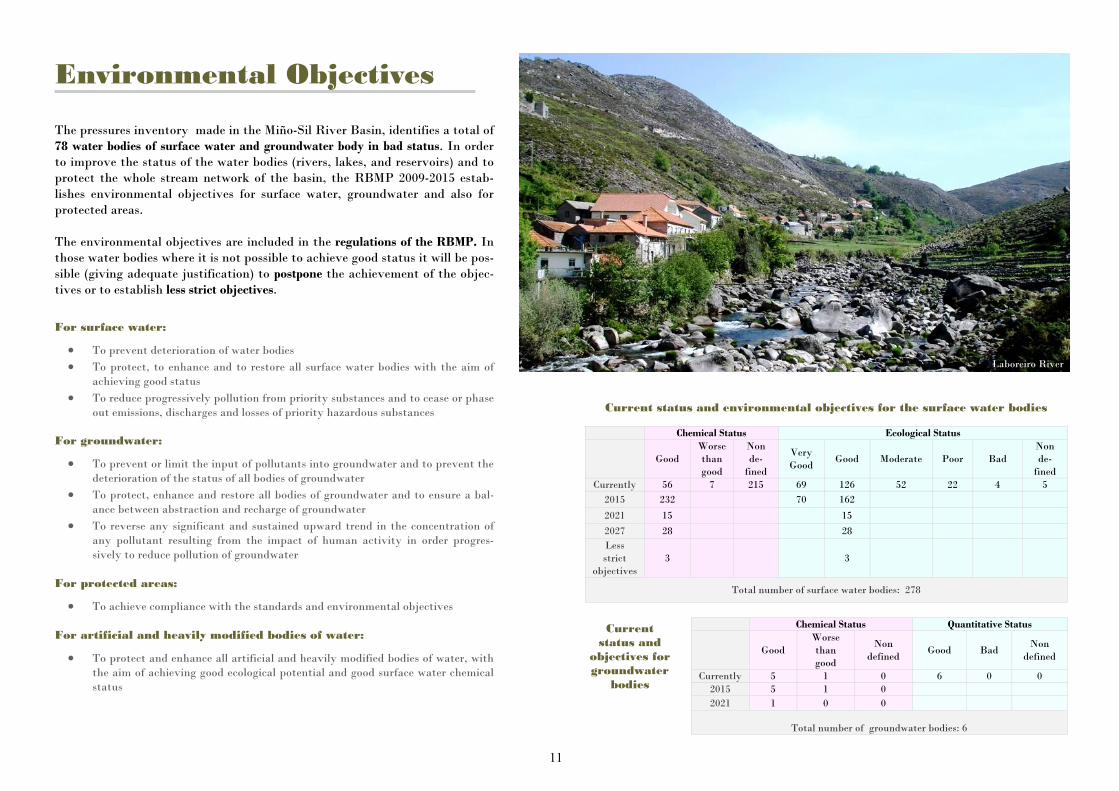
Environmental Objectives The pressures inventory made in the Miño-Sil River Basin, identifies a total of 78 water bodies of surface water and groundwater body in bad status. In order to improve the status of the water bodies (rivers, lakes, and reservoirs) and to protect the whole stream network of the basin, the RBMP 2009-2015 estab-lishes environmental objectives for surface water, groundwater and also for protected areas. The environmental objectives are included in the regulations of the RBMP. In those water bodies where it is not possible to achieve good status it will be pos-sible (giving adequate justification) to postpone the achievement of the objec-tives or to establish less strict objectives.
For surface water:
To prevent deterioration of water bodies To protect, to enhance and to restore all surface water bodies with the aim of
achieving good status To reduce progressively pollution from priority substances and to cease or phase
out emissions, discharges and losses of priority hazardous substances For groundwater:
To prevent or limit the input of pollutants into groundwater and to prevent the deterioration of the status of all bodies of groundwater
To protect, enhance and restore all bodies of groundwater and to ensure a bal-ance between abstraction and recharge of groundwater
To reverse any significant and sustained upward trend in the concentration of any pollutant resulting from the impact of human activity in order progres-sively to reduce pollution of groundwater
For protected areas:
To achieve compliance with the standards and environmental objectives For artificial and heavily modified bodies of water:
To protect and enhance all artificial and heavily modified bodies of water, with the aim of achieving good ecological potential and good surface water chemical status
Current status and environmental objectives for the surface water bodies
Chemical Status Ecological Status
Good Worse than good
Non de-
fined
Very Good
Good Moderate Poor Bad Non de-
fined Currently 56 7 215 69 126 52 22 4 5
2015 232 70 162
2021 15 15 2027 28 28 Less strict
objectives 3 3
Total number of surface water bodies: 278
Chemical Status Quantitative Status
Good Worse than good
Non defined
Good Bad Non
defined
Currently 5 1 0 6 0 0 2015 5 1 0 2021 1 0 0
Total number of groundwater bodies: 6
Current status and
objectives for groundwater
bodies
Laboreiro River

12
Priority of uses In order to combine water uses with the conservation of the resources and the environment, the River Basin Management Plan establishes the order of preference between the different water uses. Apart from guar-anteeing population supply, it will be given priority to actions aimed to: water saving, water resources conservation, community and cooperative projects.
Order of preference between the different water uses:
1. Population supply
a) Urban supply
b) Others population supplies
2. Other environmental uses
3. Irrigation a agriculture uses
4. Industrial uses for electric power
5. Industrial uses
a) Production Industries of consumer articles
b) Exploitation Industries
6. Aquiculture
7. Recreational Uses
a) Non consumptive water-uses
b) Spare time activities related to water in a indirect way
c) Uses which involve diverting water
8. Navigation and aquatic transport
9. Others non environmental uses
5. THE RESOURCE MANAGEMENT
Priority of uses, ecological flows and balance of water resource systems
Ecological Flows In order to achieve the good status or ecologi-cal status in Rivers and transition water, the RBMP 2009-2015 establishes a system of en-vironmental flows for water bodies, it also estimates the flow rate that should be kept in a stretch of river to ensure the life of the fish fauna and the proper run of ecosystems. The environmental flow regime has been cal-culated by hydrobiological methods in 24 priority water bodies (9% of total) and by hy-drological methods in all mass ends (270) Once the studies are finalized, the implementation of the flow regime and the adaptive monitoring continues. An agreement process will be taken in case these flow regime affect water assignment. The defined minimum flows will be compulsory once the agreement process is finished. The implementa-tion of the maximum flows, flood flows and exchange rates will be defined by Miño-Sil River Basin District Authority particularly in each case.
Minimum flows temporarily distributed: It should be exceeded to keep the habitat diversity and the river connectivity
Maximum flows temporarily distributed: It should not be exceeded to keep vulnerable native species
Flood flow: It promote the different species abundance and the physicochemical and geomorphologic con-ditions of the water bodies
Exchange rate: It avoids the negative effects of a sudden flow variation
ASHI Station in Limia River

13
Upper Miño
It covers the Miño River Basin from its source to its confluence with the Sil river, with a total area of 4,690.76 km2. The Upper Miño system has 3,176.82 hm3/year surface water resources and a groundwater body in the upper area of the Miño river . The main water demand in the system is irrigation and the second one is urban demand, essentially in Lugo City. The biggest reservoirs in Miño-Sil River Basin District (Belesar and Os Peares) are located in Upper Miño System and they are used for hydroe-lectric exploitation. .
Resources Balance: The executed studies about available resources and the predicted water demands, show the enough capacity of Upper Miño System to satisfy the current urban demand, however the system could present problems to satisfy new agriculture demands. For that reason, the Measures Program foresees mod-ernizations of irrigations, pollution reduction and the rationalization of the water consumption in order to promote a sustainable use of water for achieving the ecological flows and satisfying the futures water re-quirements.
Lower Miño
It covers the Miño River Basin from its confluence with the Sil river to its mouth at the Miño Estuary. Its total area is 3,592.81 km2 and the main water contributions are the rivers Barbantillo, Avia, Tea, Arnoia and Louro. The Lower Miño System has also a groundwater body called “Aluvial of Lower Miño”. In this System there is a transfer from the Eiras Reservoir (Galicia-Costa River Basin District) that supplies the municipalities of Mos, O Porriño, and Salceda de Caselas. There are 3 regulating reservoirs: Velle, Castrelo and Frieira, their priority use is hydroelectric exploitation. Resource Balance: The Lower Miño System satisfies the current water demands and the predicted ones for 2015 and 2027; it achieves the ecological flow and the minimums flow requirements defined in the Albufeira convention.
Water balance of the water Systems Due to the status and the quality of water resources, each water system has an available amount of water to attend the current and futures demands. The main features and the water resources balance of the six water systems are included in the water balance section.

14
Cabe
It covers the Cabe River Basin from its source in Fontes (O Incio) to its confluence with the Sil river, in the province of Lugo. The total area of the system is 735.18 km2 and the main water contributions are the rivers Mao, Cinsa y Carabelos. The Vilasouto Reservoir is located in this water system and supplies the Val de Lemos irrigation demand and urban demands of the towns Mon-forte and Bóveda.
Resources Balance: The water resources of the system are enough to satisfy the existing demands and the predicted ones for 2015 and 2027. It would be advisable to modernize the irrigations systems and to improve the sanitation and water treatment in order to guarantee the fulfilment of environmental objectives.
Limia The Spanish area of the Limia River Basin covers a total area of 1,328.43 km2, from its resource to the border with Portugal. The hydroelectric exploi-tation is the main use in the Reservoirs: Salas (Salas river), As Conchas and Lin-doso (Limia river). Resources Balance: The total water resources of the System are enough to satisfy the cur-rent urban demands and the predicted ones for the years 2015 and 2027 and also to ensure the ecological flows. The surface water resources are not enough to satisfy the predicted agriculture demands. For that reason the RBMP plans modernizations of irrigation, rationalization of the water consumption and livestock waste management in order to improve de water resources of the system.
Upper Sil It is formed by the Sil River Basin from its source to its confluence with the Cabrera river (León). It covers a total area of 3.976,68 km2 . The most important water con-sumption in Upper Sil System is the agriculture demand of the irrigation communities Canal Alto and Bajo of El Bierzo and also the hydroelectric exploitation.
Lower Sil It covers the Sil River Basin from its confluence with Cabrera river to its mouth at Miño River. The area of this water System covers part of the provinces of Lugo, Ourense and Zamora. The total area of the System is 3,278.56 km2 There are many hydroelectric power plants and plentiful wa-ter resources. Resources Balance: The total wa-ter resources of Lower Sil are enough to satisfy de current demands and the predicted ones for the years 2015 and 2027 and also to ensure the defined ecological flows (in implementation process).
Resources Balance: The total water resources of the Upper Sil Water System are enough to satisfy the existing demands and to ensure the defined ecological flows if modern irrigation systems are installed.

15
6. THE RESOURCE PROTECTION
Biosphere Reserves
The MSRBD covers the territory of 9 Biosphere Reserves: Xurés Gerês, Terras do Miño, Eo River, Oscos and Terras do Burón; Allariz Reserve; Laciana Valley, Valleys Omaña and Luna; Somiedo and Babia.
Protection Areas
The RBMP 2009-2015 establishes the protection of:
Water catchment areas: all water bodies used (currently or in the future) for human consumption with an average of more than 10 hm3/day, or supplying more than 50 people.
Production areas of economically significant species: shellfish production areas and stretches of river waters classified as salmonid waters (salmon and trout).
Sensitive and vulnerable areas: to diffuse pollution or wastewater discharges from urban areas.
Bathing areas: delimited stretch of a river, reservoir or coastal area.
Protection perimeters: of thermal and mineral waters.
Protected Natural Areas and Habitat or Species Pro-tection Areas: protected areas where the maintenance or im-provement of water status is an important factor to ensure their protection. The Special Protection Areas for Birds (SPA) are 13, the Sites of Community Importance (SCI) are 25 and form the Natura 2000 network, the wetlands and other relevant areas of environmental value.
Natural or environmental interest stretches: non-modified or undisturbed stretches in term of morphology, quality or flow regime.
Protected Areas considered in the Management Plan 2009-2015 of the Miño-Sil River Basin District

16
As fragile and threatened natural resource, the Waterfalls will be especially protected for their ecological, cultural, landscape and touristy value. In the future other Water-falls could be considered.
River Nature Reserves
The River Basin Management Plan 2009-2015 protects the Areas of the Water Public Domain of some river stretches in order to conserve the current undisturbed status. The RBMP considers the following River Na-ture Reserves: Laboreiro, Trancoso, Navea, Arroyo Ribeira Grande, Bibei, Lor y Burbia.
Protected Waterfalls
New Figures of Protection considered in the River Basin Management Plan 2009-2015 of MSRBD Laboreiro Waterfalls

17
The Miño-Sil River Basin has an Automatic System of Hydrographic Information (ASHI). This system controls the volume and level of the flow of different water masses, the hydrological and meteorological information. The Automatic System of the Water Quality Information (ASWQI) verifies the chemical and ecological status of the different water bodies (temperature, pH, conductivity, dissolved oxygen turbidity). The Control Network of MSRBD consists of 83 ASHI stations (11 out of the total are also ASWQI) and it will be expanded to 100 stations. The MSRBD will have a checkpoint for every 176 km2 of basin and 90 km2 of main streams. ASHI-ASWQUI network is a major advance in monitoring the water quality. The Data Acquisition Sys-tem processes and transmits the information collected, every five minutes, through Satellite to the Basin Control Center (BCC), in Ourense, as well as occurring alarms .
Water Bodies Control and Monitoring The RBMP 2009-2015 contains a description of the network and control programs for monitoring, operational control and research of surface water bodies and protected areas, in order to obtain an overview of their status. In the MSRBD there are:
Surveillance monitoring network Operating control network Research Monitoring Network
The control and surveillance network aims to obtain a com-prehensive overview of the status of water bodies. It meas-ures biological, physical, chemical and hydromorphological indicators to determine the ecological potential and the chemical indicators to determine the chemical status of wa-ter bodies. There are 51 monitoring stations on the rivers of the MSRBD, 18 checkpoints in lakes and reservoirs and 2 checkpoints in transitional and coastal Waters.
Satellite
GPRS
Remote Station SAT Termi-
nal
HUB SATELITAL
ASHI NET
MADRID
BASIN CONTROL CENTER OF MSRB
Other organisms AEMET
ROEA STATIONS
Miño-Sil corporative Network
ASWI
BCC
HYDRAULICS SENSORS
METEOROLOGICAL SENSORS
HYDRAULICS SENSORS METEOROLOGICAL
SENSORS
FTP
METEOROLOGICAL SENSORS
ASWQI-NET
ANALIZADO-RES DE
Remote Station SAT Termi-
nal
MANUAL NET
CPD-SAIH
PROVINCE NUMBER OF CURRENT STATIONS
NUMBER OF STATIONS AFTER THE EXTENSION
LUGO 27 32
OURENSE 23 29
LEÓN 24 26
PONTEVEDRA 8 12
ZAMORA 1 1
TOTAL 83 100
Operational Scheme of the Basin Control Center

18
7. ECONOMIC ANALYSIS Measures Programme The RBMP considers a measures programme which prioritizes those ac-tions to be performed on water bodies in bad status in order to carry out the proposed environmental objectives and achieve good status or poten-tial and meet deadlines, considering criteria of economy and sustainabil-ity. The proposed measures are grouped mainly in: sanitation and water treat-ment, supply, improvements of irrigation, flood prevention, hydrologic and forest restoration, energy and administrative. The Measures Pro-gramme considers a total of 1,564 actions includes in 1,112 measures with a total investment of 988,880,626. 46 €.
TYPOLOGY INVESTMENT UNTIL
2015 PERCENTAGE
SANITATION AND WATER TREATMENT
362,447,428.41 € 36.7%
SUPPLY 169,450,763.59 € 17.1%
IRRIGATION 88,654,450.15 € 9%
FLOOD PREVENTION 36,720,203.45 € 3.7%
RESTORATION 307,453,983.35 € 31.1%
ENERGY 600,840.80 € 0.1%
ADMINISTRATIVE 23,552,956.70 € 2.4%
988,880,626.46 € 100%
Floods preventions
Early Warning System; Preventions Plans; ac-tions in dams, rivers and protections.
Restoration
River restoration, bank recovery, wetlands resto-ration
Administrative Measures
Monitoring Water Networks (ASHI-ASWQI); cost recovery and rate updates; laws and regula-tion of uses, development of codes of good prac-tices, awareness campaigns and environmental education.
Supply
Measures concerning Water Treatment Stations, tanks and pumping; Improvement of supply net-works, actions in dams, improvement of catch-ments and pipelines.
Sanitation and treatment
Projects on wastewater treatment plants; collec-tors, improvement sanitation networks.
Modernization of irrigations
Financing systems with lower water consumption, improvements of canals and ditches, regulatory measures and concessions.
Main Actions
Total investment of Measure Programme
Measures concerning the improvements of sanitation and treatment considered in the Meassures Programme

19
Costs recovery Mechanisms per service
Costs Recovery The European Union wants to encourage consumers to become aware of their consumption, adjusting rates to the real cost of water. The Water Framework Directive establishes that water prices should be adjusted to real cost of water services, incorporating incentives for effi-cient and rational use of the resource. Cost recovery is a way to achieve an efficient use of resources and an ade-quate contribution to the cost of the services. The supply of an amount of water to each user entail a cost called "cost of water” and it has effect on the final consumer through the price. The price of the water quantifies the cost of service per unit of water consumed (cubic meters). The RBMP considers the following services: Water supply mains Urban water services Water services for irrigation
Urban services It refers to drinking water by pub-lic networks, including the adduct, purification, water supply and sanitation (sewerage and sewage treatment plants).
Cost recovery is for the amortiza-tion of investment costs and the cost of management and operation services. With this objective, municipalities (or other responsible authority) impact these costs through rates of supply and sewage and sanitation canon.
Water supply mains It refers to the collection, storage and water transport through regulation works and conductions from the catchments .
Cost recovery in water supply mains correspond to the amortization of investment costs and the cost of maintenance, operation and manage-ment. The MSRBD applies the fee of regu-lation and the water utilization rate to major users: communities of irriga-tors, hydroelectric and other domestic and industrial uses.
Water for irriga-tion
It refers to the use of irrigation water in agriculture and in-cludes the conduction from the point of delivery of supply mains and the distribution within the irrigation area. The cost recovery mechanisms are similar to those in supply mains.
Services Costs recovery Mechanisms
Water supply mains
Canon of Regulation Water use rate
User fees Urban Water
services Supply Tariff
Sewer Tax Sanitation Tax
Irrigation tariffs Flood Prevention Public service, no economic impact over the benefici-
ary Environmental
Protection Canon of waste control to Water Public Domain
Canon of waste land-sea
Water Administra-tion
Canon for utilization of assets of Water Public Do-main
Canon for occupation and exploitation of the Water Public Domain

20
8. PUBLIC PARTICIPATION The citizen involvement in the water Plan elabora-tion Water is a public resource which concerns to everyone. Therefore, the Miño-Sil Authority sought to ensure the involvement of all the stakeholders during the water planning: pub-lic administrations, employers, enterprises, farmers, consumers, environmentalists, af-fected by the infrastructures, neighbourhood associations and water user communities, citizenship. The Minho - Sil River Basin District conducted, from December 2009 to June 2011, fif-teen conferences of public participation : 6 regional conferences, 9 sectoral tables and an information day, "The responsible management of water for a Sustainable Future ", which involved the presentation of the Draft Water Management Plan and the beginning of the public consultation. The MSRBD has published on its website the "Report of In-formation Actions, Public Consultation and Participation" developed at different phases of water planning.
The Minho - Sil River Basin District has achieved, through the sectoral conferences of public participation, reaching a total of 7 regions and 102 municipalities in the MSRBD. In the sectoral tables participated a hundreds of experts and representatives of the main sectors interested and stakeholders. A total of 814 people representing the local government, business associations and traders, trade unions, farming and agricultural organization, wine sector, irrigation communities, hydroelectric industry and slate industry participated in the process. Also stresses the active participation of environmental and conservationists organizations, water brought communities, resident and socio-cultural association,. Contributions: It was collected about 150 proposals and suggestions that a greater or lesser extent, have been incorporated into the Water Management Plan (Appendix XI.7 )
Three levels of involvement
Public Information: the official documents and the informative publi-cations done to facilitate the compression of the RBMP are available for the public through the website. Public consultation: reference documents of the Water Management Plan such us: • Initial water planning documents, Provisional Outline of Major Issues in water management, Initial document with the Strategic Environmental Assessment, Project for River Basin District Management Plan and the Environmental Sustainability Report. Active involvement: open sessions and sectoral tables in those treated pressures and problems relevant to each region or sector, environmental objectives, proposed measures and regulations document.
Public Workshop held at Tomiño (BaixoMiño)
An open process to the citizens

21
Water Planning Office
MIÑO-SIL RIVER BASIN AUTHORITY
Ministry of Agriculture, Food and Environment
Avenida Habana, 28 Bajo. 32003 – Ourense—Spain
Telephone: 988399410
www.chminosil.es
Email: [email protected] WATER PLANNING