Embed Size (px)
Citation preview

FREE OF CHARGENOT FOR RESALE
2018Yachting Guide toHarwich Harbour and its RiversTHIS MAP IS FOR GENERAL INFORMATION ONLY. NOT TO BE USED FOR NAVIGATIONAL PURPOSES.

CABLES 10 5 0 1 2 Sea Miles
Feet 1000 0 5000 10000 15000 feet
DOVERCOURTBAY
ShipsCork Anchorage
(Ships)
BawdseyAnchorage
(Ships)
PlattersAnchorage
(Ships)
31'30' 33' 34'29'28'27'26'25'24'23'22'21'I°20'19'18'17'15'14'13'12'11'10'09'08' 16'
06'
05'
04'
03'
02'
01'
60'
59'
58'
57'
56'
55'
54'
53'
52'
51'
52˚00'
WAYPOINT51˚ 55.83N01˚ 20-29E
WAYPOINT51˚ 55.23N01˚ 18-39E
WAYPOINT51˚ 55.23N01˚ 20-39E
WAYPOINT51˚ 55.33N01˚ 26-00E
ROUGHS TOWER
TOWER
CHURCHSPIRE
SPIRE
NAZE TOWEROpen to public
RADIO TOWER
RADIO MAST
MartelloTower
MartelloTower
MartelloTower
MartelloTower
MartelloTower
MartelloTower
MartelloTower ‘P’
MartelloTower
MOORINGS
MOORINGS
MOORINGSMOORINGS
MOORINGS
MOORINGS
MOORINGS
MOORINGS
MOORINGS
MOORINGS
MOORINGSMOORINGS
MOORINGS
MOORINGS
MOORINGS
MOORINGS
MOORINGS
MOORINGS
MOORINGS
WRABNESS POINT
OAK FIELD WOOD
HARKSTEAD POINTSTUTTON
NESSHOLBROOK
WRABNESS
ERWARTONNESS
SHOTLEYGATE
TRIMLEYMARSHES
LOOMPIT LAKE
COLLIMERPOINT
LEVINGTONCREEK
LEVINGTONLAGOON
NACTON QUAY
HALLPOINT
PRIORY PARK
ORWELL BRIDGE
TRIMLEYRETREAT
BIRD SANCTUARYHabitat creation by H.H.A.
STONNERPOINT
PRETTYMAN’SPOINT
BLACKMANSHEAD
ISLANDPOINT
HORSEY ISLAND
HEDGE ENDISLAND
FOUNDRYREACH
BUOYED
JOHN WESTONNATURERESERVE
SKIPPER’SISLAND
LANDERMERECREEK
KIRBYCREEK
OAKLEYCREEK
HAMFORD WATER
WALTONCHANNEL
FELIXSTOWEFERRY
BAWDSEYMANOR
KYSON HILL
METHERSGATE QUAY
MARTLESHAMCREEK
RIVERDEBEN
FELIXSTOWEPIER
THEROCKS
COPPERAS WOOD
SUTTONHOO
SHINGLESTREET
CUTLERSAND
BOYTONMARSHES
DOVEYS
ORFORDNESS
SIMPSONSALTINGS
HAVERGATEISLAND
RIVERORE
BUTLEYRIVER
RIVER STOUR
RIVER ORWELL
LANDGUARD
LANDGUARDFORT
LANDGUARDPOINT
PORT OF FELIXSTOWE
Trinity Container Terminal
RoRo
Berth76
5
4
4&3
32
1
8
9
WALTONBACKWATERS
RoRo
Waterski area south
Waterski area north
OBSTNS
OBSTNS
OBSTNS
OBSTNS
OBSTNS
OBSTNS
PUBLICLANDING
PUBLICLANDING
PUBLICLANDING
BUOYED
Stena Line,Cruise Terminals
HARWICHINTERNATIONAL
PORT
RECREATION AREA FOR POWERED CRAFT
Access via launching ramp at Dovercourt Bay. Prior approval required
from Tendring District Council 01255 686868
www.tendringdc.gov.uk
Limit of Ipswich
Limit of Harwich
VHF Ch 68
VHF Ch 71
G
Experimental Buoys
Harwich Approach
Harwich Deep Water Channel
Harwich Deep Water Channel
FI(4)G.15sWadgate Ledge
05
G
G
Cathouse
G
No7GDownham
GMulberry
G
Priory
Bridgewood
No9
GPond Ooze
GE Bridge
GSewer
GEast Fen
GHearth Point
GrogG
No5G
Park BightG
BayG
No3G
StrattonG
TrimleyG
No1G
FagburyG
GangesGBristol
G
Parkeston
GRamseyG
No1G
LeeNo5
FortG
NW BeachG
Beach EndG Rolling Ground
G
No3 Crab KnollG
No5G
No7G
No9G
No11G
No13G
ExchemG
Pennyhole(April-Oct)
Y
Cobbolds Pt(April-Oct)G
Mid KnollsG
No1G
No1AG
No3G
No5G
No7G
Felixstowe LedgeG
Wave RiderG
WashingtonG
CutlerG
Weir Buoy(seasonal April-Oct)
G
No7Y
No5Y
No3Y
No1 Racon (T)Y
G
MedusaG
No9G
No11G
No13G
No16R
No18R
No24R
No22RNo20
R
No14R
No4R
BathsideR
CollegeR
PepysR
BaberghR
OrwellR
No2R
CollimerR
No4R
FoxesBottom
R
ButtR
No6R
MarinaR
Deer ParkR
No8R
FrestonR
HillR
RedgateR
W BridgeR
WhersteadR
W Power
R
No12
R
500 ftR
R
GuardR
GrisleR
N ShelfR
S ShelfR
R
Cliff FootR
Deane
R
Inner RidgeR
Pitching GroundR
No8Y
No6Y
Outer RidgeR
Stone BanksR
Oxley Buoy(seasonal April-Oct)R
No2AR
No2R
No6R No4
R
No8R
No10R
No12R
No12AR
No4Y
No2Y
ArmadaRacing Mark(April-Oct)
Y
S CorkYB
YBY
BYB
S BawdseyYB
CrossY
RW
RoughBY
Orford HavenRW
West KnollR
Woodbridge HavenRW
Knoll SpitR
DebenR
LandguardBY
BY
Shotley SpitYB
Pye EndRW
PlattersYB
Harwich Shelf(March-Nov)
BYB
ShotleyHorse
(April-Oct)
Y
No2No6
No2R
No4 High HillR
No4AR
No6R
No8R
No10R No12
R No14R
No16R
Fox’sRacing Mark(April-Oct)
Y
(April-Oct)Y
(April-Oct)Y
(April-Oct)
Y
(April-Oct)
Y
(April-Oct)
Y(April-Oct)Y
Cork LedgeRacing Mark(April - Oct)
Y
MEDUSA CHANNELCORK SAND
G
Cork Sand BnR
Cork Sand Yacht BnBY
YB
Within the entrance to NEW CUT is a Water Velocity Control Structure which is raised when
required from the river bed. When raised the top of the structure may be just below the water
level. 3 vertical red lights, when lit, warn vessels that they MUST NOT PROCEED.
Personal water craft
area.
Air draught beneath Orwell Bridge is 43.07
metres minus the height of tide at Ipswich
HARBOUR SPEED LIMIT: 8 knots, personal watercraft strictly prohibited.
8KNOTS
BUTLEY RIVER SPEED LIMIT: 8 knots except in personal watercraft area.
8KNOTS
RIVER ORE SPEED LIMIT: 8 knots except in personal watercraft area
8KNOTS
RIVER ORE ENTRANCE: Extreme caution must be exercised in the entrance due to
continually shifting shoals.
POWERED CRAFT RECREATIONAL ZONE: This is the only area in the River Orwell where speeds over 6 knots (6.8mph) may be used by recreational craft. All craft should (with the
exception of emergencies) avoid anchoring in the zone.
Outbound yachts crossing the channel, making for the yacht track should do so early to ensure they are
aware of any inbound commercial vessels.
Extreme caution must be exercised in the entrance due to continually shifting shoals.
Max spring tidal flow 3-4 knots.
OIL JETTY:Keep clear
Shallowwaters
5 knots
Container terminal: Yachts should ensure that they keep well clear of these manoeuvring vessels and at all times
avoid passing between the ship and the berth.
Port of Felixstowe. No facilities for yachts.
Leisure vessels should avoid anchoring within or near the navigational channels and commercial anchorages.
Where necessary to do so, they MUST comply with the requirements of Collision Regulations Rule 30 and
exercise heightened navigational awareness.
Personal watercraft area. Anti-social behaviour is monitored. Use of personal
watercraft outside of this area is extremely hazardous and causes
disturbance to river users and residents.
Reduce speed to limit effects of boat wash and keep to the right hand side of the channel or fairways. Give other craft time and room to
manoeuvre and do not anchor in busy fairways.
Caution must be exercised at the
entrance
Recommended Yacht Crossing Points.
Yachts and leisure craft should cross the main channels in the areas indicated and as nearly as
practicable at right angles to the main traffic flow. Keep well clear of commercial vessels and avoid
crossing close ahead. Note that the recommended track for yachts is not exclusive and small power
driven commercial vessels may use this track.
WALTON BACKWATERS SPEED LIMIT: 8 knots in seaward approaches and Hamford Water, 6 knots in all creeks and channels, 4 knots or less in congested boating areas.
8KNOTS
Harbour tugs may be encountered close to the
buoy line whilst they assist container vessels.
6KNOTS
4KNOTS
4KNOTS
YACHT TRACK:Main channel crossing point
8KNOTS
RIVER STOUR SPEED LIMIT: 8 knots, personal watercraft strictly prohibited. Yachts may anchor off Wrabness. Visiting yachts are advised to navigate close to buoyed channel used by commercial vessels sailing to Mistley.
8KNOTS
RIVER DEBEN SPEED LIMIT: 8 knots above and 10 knots below the personal watercraft
area (May - Sept). For navigation advice contact: John White, the Woodbridge
Haven Pilot, on OddTimes Ch 08 or call 01394 270106, 07803 476621 or
07860 191768. ww.debenestuarypilot.co.uk
10KNOTS
6KNOTS
RIVER ORWELL SPEED LIMIT: 6 knots except in personal watercraft area. A patrol service operates and small crafts will be monitored for excessive speed and general behaviour. Contravention of any by-laws or general direction may result in prosecution. Sailors should be aware that vessels using the main navigation channel may cause turbulence and small craft users should wear a lifejacket at all times.
Tidemill Yacht Harbour50
Larkman’s Boatyard 35
Melton Boatyard Ltd 37
Robertson’s Boatyard 42
The Woodbridge Boatyard 43
Woodbridge Cruising Club 30
Waldringfield Boatyard 44
Waldringfield Sailing Club 18
Deben Rowing Club 03
Deben Yacht Club 04
Deben Watersports Centre 22
Bawdsey Haven Yacht Club02
40 Ramsholt Quay
Felixstowe Ferry Sailing Club 05
Hamilton Sailing25
Ipswich Haven Marina and Neptune Marina
47
East Anglian Sailing Trust24
Haven Ports Yacht Club09
East Anglian Sea School23
Suffolk Yacht Harbour49
Alton Water Sports Centre16
TS Rebel 29
Walton & Frinton Yacht Club 19
Walton Yacht Basin 52
Titchmarsh Marina 51
Debbage Yachting 32
Orwell Yacht Club 11
Fox’s Marina Yacht Club 06
Fox’s Marina & Boatyard 46
Stoke Sailing Club 16
Neptune Sailing 26
Shearwater Sailing School 28
Woolverstone Marina 53
Royal Harwich Yacht Club 13
Pin Mill Sailing Club 12
34Harry King & Sons/Pin Mill Moorings
Pin Mill Cruising 27
Pin Mill Hard 39
Webb Boatyard 45
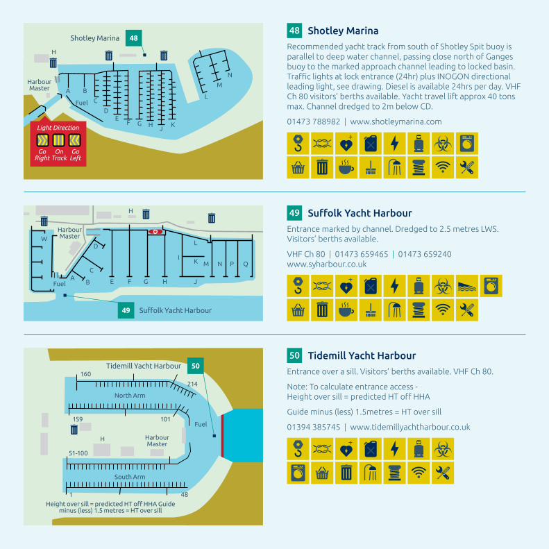
Shotley Marina 48
Shotley Sailing Club 14
Harwich Town Sailing Club 08
Ha’penny Pier 33
Harwich & DovercourtSailing Club
07
Martlesham Creek Boatyard
36
HARWICHVTS
Harwich Haven Authority Yachting Guide Key
46 Fox’s Marina & Boatyard
47 Ipswich Haven Marina and Neptune Marina
48 Shotley Marina
49 SuffolkYachtHarbour
50 TidemillYachtHarbour
51 Titchmarsh Marina
52 WaltonYachtBasin
53 Woolverstone Marina
MARINAS (see overleaf)
THIS MAP IS FOR GENERAL INFORMATION ONLY. NOT TO BE USED FOR NAVIGATIONAL PURPOSES.
BUTLEYRIVER
RIVERORE
Orford CastleRiver Ore
OrfordLighthouse
RIVERALDE
ALDE MUD FLATS
SNAPE
ORFORDVHF CH 08
RIVERS ALDE AND ORE
Water ski area
ALDEBURGH
ORFORDNESS
BOYTONMARSHES
HAZEL WOODMARSHES
Orford Sailing Club 10
Orford Town Trust 38
Aldeburgh Yacht Club 01
Slaughden Sailing Club 15
Aldeburgh Boatyard 31
RF Upson & Sons Ltd 41
MartelloTower
SALTINGS
MELTON BOATYARD
NOTE: High water at MBY is as Harwich +35 minutes
The minimum depth in the Main Channel adjacent
Melton Boatyard at MHWN is 2 metres (based on 3 metre
prediction at Harwich)
Yachts planning to arrive at MBY at HW (MBY) should pass buoy No.24 1 hour
before HW (MBY)
There is no sill at MBY
BEWARE When moving up river at night, ensure you locate Red
number 37 when passing Green 36 to
avoid entering these salt flats.
24
27 2829
3031
3233
3435
3637
38 3940
Tidemill Yacht Harbour50
Woodbridge Cruising Club30
OPS 026/27
Felixstowe Coastwatch
Radio checks, weather reports and local sea state conditions (stationed at Martello Tr ‘P’) 01394 670808
26Marchto28October:
Friday - Monday 0900 - 1700
Tuesday - Thursday 1300 - 1700
Outsideoftheabovedates:
Friday - Monday 0900 - 1630
Tuesday - Thursday 1230 - 1630
Channel 65 Callsign “Felixstowe NCI”
Navigational Warnings
Unlit MooringsExtensive unlit yacht moorings will be encountered throughout the Rivers Deben, Orwell, Stour and Walton Backwaters. When moored in rivers where large commercial vessels navigate, yachtsmen are advised, when staying overnight, to light their craft.
LobsterPotsSome lobster pots are unmarked and there
is a risk of fouling. Great care is required in the identified areas - especially at night time.
STUTTONNESS
Stour Sailing Club17
No.15No.13
No.11
No.12 No.10
No.9 No.7 No.6
No.8
Visitors’ moorings available,can dry out
MISTLEY MARINECommercial Quay
MISTLEY
MANNINGTREE
RIVER STOUR
G G G
GG
R
RRBY
Waterskiing, Jetskiing strictly prohibited
HOGMARSH 8KNOTS
RNLI
A120
HARWICHHARBOUR
HARWICH
NAVYARD
Shallow waters
Ha’pennyPier YachtMoorings
33
Harwich TownSailing Club
08
Harwich & DovercourtSailing Club
07
HarwichShelf
(Mar-Nov)
BYB
HARWICH
FELIXSTOWEERWARTON
NESS
SEDIMENTPLACEMENT TRACKS
SHOTLEY
Dredgers may alter course without warning
21 Alton Water Sports Centre For dinghy and sail boards. Powered boats are not permitted. R.Y.A. recognised training courses. 01473 328408 | www.altonwater.co.uk
nnnnnn22 DebenWatersportsCentre
R.Y.A. recognised training courses. www.dwsc.org.uk
23 East Anglian Sea School R.Y.A. recognised training courses. 01473 659992 | www.eastanglianseaschool.com
24 East Anglian Sailing Trust Sailing for people with disabilities. R.Y.A. recognised training centre. 0333 088 3278 | www.east-anglian-sailing-trust.org.uk
25 Hamilton Sailing R.Y.A. recognised training courses. 07990 777129 | www.hamiltonsailing.com
nnnnn nnnnn
26 Neptune Sailing R.Y.A. recognised training courses. 07707 056158 | www.neptunesailing.org.uk
27 Pin Mill Cruising R.Y.A. recognised training courses. 01473 780510 | www.pinmillcruising.co.uk
28 Shearwater Sailing School R.Y.A. recognised training courses. 07702 259568 | www.shearwatersailingschool.co.uk
nnnnnnn nnnnnnn
29 TSRebel R.Y.A. recognised training centre and cadet training school. 07768 232574 | www.tsrebel.org
30 WoodbridgeCruisingClub R.Y.A. recognised training courses. 01394 386737 | www.woodbridgecruisingclub.org
TRAINING
31 AldeburghBoatyard 01728 452019 | www.aldeburghboatyard.co.uk
n32 DebbageYachting
01473 601169 | 07774 694226 | www.debyacht.co.uk
nnnnnn nnnn
33 Ha’penny Pier See overleaf
34 Harry King & Sons/Pin Mill Moorings 01473 780258 | 07714 260568 www.kingsboatyard.co.uk
nnnnnnn35 Larkman’sBoatyard
01394 382943 | www.larkmansboatyard.co.uk
36 MartleshamCreekBoatyard 01394 384727 | 07850 754726 www.martleshamcreekboatyard.co.uk
nnnnnnnn37 Melton Boatyard Ltd
Buoyage above Woodbridge managed by Melton Boatyard. Caution: the river dies out. 01394 386327 | www.meltonboatyard.co.uk
nnnnn
38 Orford Town Trust Visitor moorings and private launching slip available VHF Ch 08 07528 092635 | http://bit.ly/2EAoMiO
nnn39 Pin Mill Hard
Barge blocks & scrubbing posts. 07714 260568 | www.pinmillhard.info
nnnnnnn40 Ramsholt Quay
George Collins, Mooring Master 07930 304061
41 RF Upson & Sons Ltd 01728 453047
42 Robertson’sBoatyard 01394 382305 | www.robertsons-boatyard.co.uk
nnnnnn43 TheWoodbridgeBoatyard
01394 385786 | www.eversonboats.co.uk
44 WaldringfieldBoatyard 01473 736260 | www.waldringfieldboatyard.co.uk
nnnnnnn45 WebbBoatyard
01473 780291
nnn
FACILITIES
01 AldeburghYachtClub 01728 452562 | www.aldeburghyc.org.uk
02 BawdseyHavenYachtClub 01394 410258
nn03 DebenRowingClub
07899 778995 | www.debenrowingclub.co.uk
nnnn04 DebenYachtClub
www.debenyachtclub.co.uk
05 FelixstoweFerrySailingClub 01394 283785 | www.ffsc.co.uk
nnnnnnn06 Fox’sMarinaYachtClub
01473 684111 | www.fmyc.org.uk
nnnnnnn nnnnnn
07 Harwich&DovercourtSailingClub 07507 344375 | www.hdsc.org.uk
nnnn08 HarwichTownSailingClub
01255 503200 | www.htsc.co.uk
09 HavenPortsYachtClub 01473 659651 | www.hpyc.com
10 OrfordSailingClub 01394 450 997 | www.orfordsail.org.uk
11 OrwellYachtClub www.orwellyachtclub.org
nnnnnn nnnnnn
12 PinMillSailingClub 01473 780271 | www.pmsc.org.uk
nnnnn13 RoyalHarwichYachtClub
Visiting yachts can lay on outer pontoons. 07742 145994 | www.royalharwichyachtclub.co.uk
14 ShotleySailingClub 01473 787500
15 SlaughdenSailingClub 01728 454335 | www.slaughdensailingclub.co.uk
16 StokeSailingClub www.stokesailingclub.uk
n17 StourSailingClub
01206 393924 | www.stoursailingclub.co.uk
18 WaldringfieldSailingClub 01728 638785 | www.waldringfieldsc.com
nnnn19 Walton&FrintonYachtClub
01255 678161 | www.wfyc.co.uk
nnnnnnnn20 WoodbridgeCruisingClub
R.Y.A. recognised training courses. 01394 386737 | www.woodbridgecruisingclub.org
nn
CLUBS
WARNING OR DANGER
All details correct at time of printing. Copies of the yachting guide can be obtained at local marinas, marine-related outlets and the Harwich Haven Authority offices.
If you can’t see the ship’s bridge, then the captain can’t see you! Keep a safe lookout. Be aware of closing speeds. Be aware of any lack of forward visibility.
Be alert. Be visible...
LINE OF SIGHT
1/2 MILE
Large ships often have restricted visibility
ALWAYSWEAR A LIFEJACKET
Danger may arise unexpectedly from the wash caused by passing vessels. We recommend you wear your lifejacket (with crotch straps secured) at all times.
Don’t take the risk…

Safety briefSkippers should educate their crew about the safety equipment onboard the boat, where it is and when and how to use it.
Further guidance is available within MGN 379 - use of Electronic Navigational Aids - www.gov.uk
The prudent mariner should never be overly reliant on the outputs of a single navigational aid.
How to start the engine
Locationoffirstaidkitandbook
How to send a VHF/DSC distress alert and mayday
Useoflifejackets,harnessesandjack-stays
LocationanduseofflaresandEPIRB
MOBequipmentandprocedure
Gassafetyanduseofcooker
LocationanduseofAISkit
Howtogainaccesstotheenginespaceifthere is no automatic system
How to launch the life raft
Thedangerzoneswherethereisriskofinjury from the boom or mainsheet in an accidental gybe
About Harwich Haven AuthorityAsatrustportwithstatutoryresponsibilitiesforconservancyand safety of navigation we ensure that commercial and leisure usersco-existsafelyintheHaven.Wedothisbyprovidingfreeservicesforrecreationalusers,includingnavigationalandtrafficinformationviaourVesselTrafficServices(VTS)andwebsite.
Markerbuoys,yachtchannelsandharbourpatrolsensurethemainchanneliskeptclearforcommercialshipping.Duringtheweekendofthesummermonthswepatrolbetween0800and1800.
WecollaborateonaregularbasiswithlocalyachtclubssuchastheHarwichAreaSailingAssociation(HASA)tomaketheirmembersawareofthehazardsofboatinginourbusyharbour.
Eachyearwewelcomemorethan10,000leisurevesselsofallshapesandsizeswhovisittheHavenfromboththeUKandEurope.
Whetheryouarevisitingtheareaorarealocalsailorweurgeyoutoreviewtheinformationcontainedwithinthisguide,whichwillassistwithsafetyandenhanceyourenjoymentoftheHaven.
Manoeuvring and warning signalsOneprolongedblast --------Leaving a dock, quay, or anchorage
One short blast •Altering to starboard
Two short blasts ••Altering to port
Three short blasts •••Going astern
Five or more blasts •••••Your intentions are unclear
Four short blasts followed by one short blast •••••Turning short round to starboard
Four short blasts followed by two short blasts ••••••Turning short round to port

A mayday should only be sent if there is grave and imminentdangertovesselorpersonwhichrequiresimmediateassistance.
A DSC distress alert will sound an alarm on all DSC sets withinrange,includingshipsandatCoastguardstationsandwillsendthepositionoftheboatifthesetisinterfacedwithaGPS.
Ifitisurgent,butnotlifethreatening,makeaPanPanbroadcastprecededbyaDSCurgencyalert.Foradvicecontact the Coastguard by routine DSC or on Channel 16.
DSC DISTRESS ALERT
Opentheredcover,thenpressandholdthedistressbuttonthroughthecountdown.
UseChannel16onhighpower
MAYDAY, MAYDAY, MAYDAY
THIS IS [vesseltypeandname,vesselname, vessel name] MMSI & call sign
MAYDAY THIS IS [vesseltype&name] MMSI & call sign
IN POSITION [lat/long]
NATURE OF DISTRESS [fire,sinking,mob]
I REQUIRE IMMEDIATE ASSISTANCE
OTHER IMPORTANT INFORMATION [numberofpersonsabandoningtoliferaftorno life raft]
OVER
DuringtheMaydayallthecommunicationislikelytocontinueonChannel16anditwillbepossibletotalktothelifeboatorhelicopteroncetheyareonsceneandallvesselsinthevicinitywillbeawareofyoursituation.
Donotrelyonamobilephoneinanemergencyatsea, itcannotperformthesamefunction.
Mayday
Bestpracticeadvice for sailorsOn1July2002,ChapterVoftheSOLAS(safetyoflifeatsea)Regulationscameintoforceinternationallyaffectingallleisurevessels.
The weather Getaforecastbeforeleavingandconsiderhowitapplies tothearea.Preparetheboatandcrewforthat.Update theinformationregularly.
The tidesWhenarethetidalstreamsfavourable?Willitbewindagainsttidemakingseaconditionsworse?Isthereatidalgate?Istheresufficientheightoftidetocrossanyshallowarea?
Limitations of your vesselIstheboatsuitablefortheconditionsexpected?Doyouhavethesafetyequipmentandsparesthatyouneed?
CrewDoesthecrewhaveenoughexperienceandphysicalability forthetrip?Aretheresufficientcrew?Cold,tiredorseasickcrewwilladdtotheskipper’stasks.Areyou,asskipper,liabletoseasicknesstoo?Istherewarmwaterproofclothing,foodandaccommodationforthecrew?
Navigational hazardsCheckonthechartsandreadpilotbooksforinformation ofthehazardsinthearea.
Contingency planIfitgetstoolate,toodark,ortoocoldtofollowtheoriginalplan,wherewillyougo?Iftheweatherdeterioratesorthereisanaccident,wherewillyougoforasafehaven?Havesufficientchartstocopewithadifferentdestination.
Information ashoreTellsomeoneashoreaboutyourplansandtellthemhowtoinformtheCoastguardifyouareoverdue.Logdetailsofyourvesselanditslife-savingequipmentwiththeCoastguard.UsetheCG66intheUK.Thiscanbefilledinonlinewww.gov.uk/register-boat-coastguard-safety-scheme

Collision awareness checklist• Avesseloflessthan20minlengthorsailingvesselshallnotimpedethepassageofvesselswhichcansafelynavigateonlywithinanarrowchannelorfairway.
• Avesselshallnotcrossanarrowchannelorfairwayifsuchcrossingimpedesthepassageofavesselwhichcansafelynavigateonlywithinsuchchannelorfairway.ThelattervesselmayusethesoundsignalprescribedinRule34(d)ifindoubtastotheintentionofthecrossingvessel.
• Asailingvesselunderwayshallkeepoutofthewayof:
- Avesselnotundercommand;
- Avesselrestrictedinherabilitytomanoeuvre;
- Avesselengagedinfishing;
- Anyvesselotherthanavesselnotundercommandor a vessel restricted in her ability to manoeuvre shall,ifthecircumstancesofthecaseadmit,avoidimpedingthesafepassageofavesselconstrainedbyherdraught,exhibitingthesignalsinRule28.
The Full Collision Regulations (Colregs) can be downloaded at www.collisionregs.com
ChannelsThemaindeep-waternavigationalchannelswithinHarwichHarbourarewellmarkedbybuoysandlights.Yachtsareadvisedtokeepclearofthechannelsandusetherecommendedyachttracks.
Whenmainchannelshavetobecrossed,thisshouldbedoneasnearlyaspracticableatrightangles.Avoidcrossingthebowsofon-comingcommercialtraffic.Largecontainerships,inparticular,haveveryrestrictedvisibilityforquiteadistanceaheadwhencarryingadeckcargoofcontainers.
WerequestthatsailorsconductthemselvesinaresponsiblewaywhileusingtheHavenandadheretoboththeCollisionRegulationsandbestpracticeadvicegivenbytheRoyalYachtAssociation.
Speed limitsThespeedlimitforpowerboats,cruisers,oryachtsis 8knotswithinHarwichHarbour,theRiverStourandtheWaltonBackwaters.Thelimitis6knotswithinthe RiverOrwell.
Forfurtherinformation,downloadHarwichHavenAuthorityByelawsfromourwebsite-www.hha.co.uk/operations/downloads.TheIpswichPortAuthorityByelawscanbedownloadedatwww.abports.co.uk/About_ABP/ABP_ByeLaws/
Navigation channels and speedrestrictions
Waterskiing,jetskiingandsailboardingarenotpermittedin or near any navigational channel used by commercial vessels.Powercraftareonlypermittedindesignatedareas.Sailboardingisnotpermittedinornearmooringareasorbeaches.Pleasebeawarethatpermissiontolaunch and recover may need to be sought from the local authority-www.tendringdc.gov.uk
Watersports
HarwichVTScannotundertakecontrolofsmallcraftinreducedvisibilitybutourVTSteamwillprovideassistanceifpossible.Listeninonchannel71andalwayscarryaradarreflector,flaresandsuitableemergencyequipment.Ifyoudonothaveradarandintendcrossinganyshippinglane,andyouareinseriousdoubtastothecommercialmovements,callHarwichVTSonchannel71,orIpswichPortRadioCh68whilstintheRiverOrwell.CarriageanduseofanoperationalAISisalsoencouraged.Rememberyourobligationsunderthepreventionofcollisionregulations(seeabove),particularlytheabilitytomakeanefficientsoundsignal.
See www.collisionregs.com for full Collision Regulations
Fog
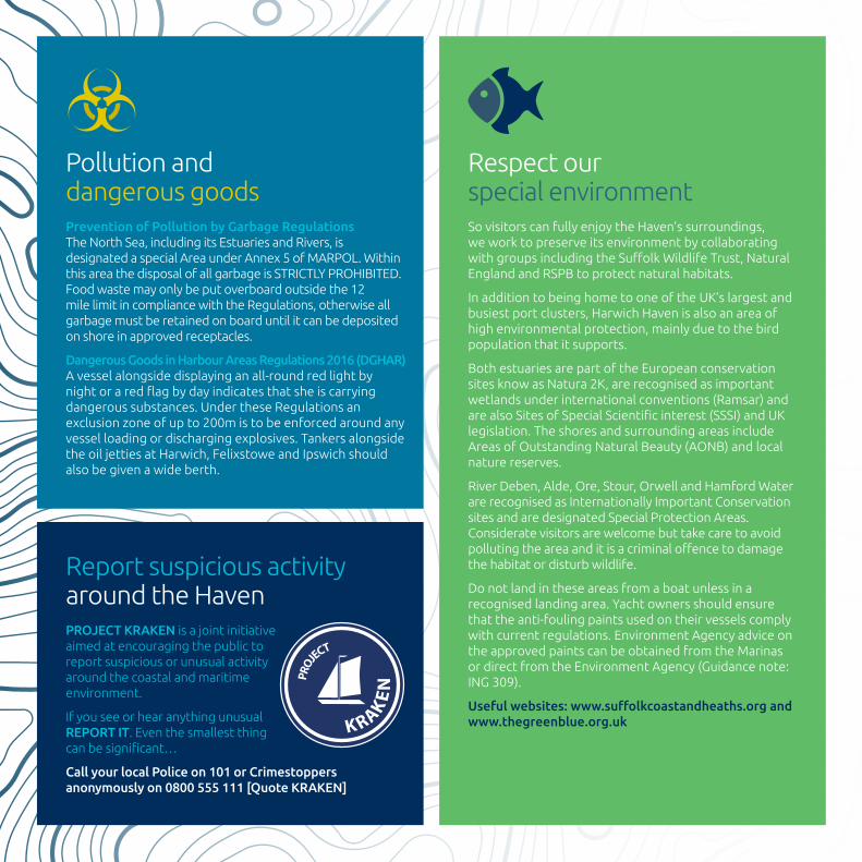
Respectour specialenvironmentSovisitorscanfullyenjoytheHaven’ssurroundings,weworktopreserveitsenvironmentbycollaboratingwithgroupsincludingtheSuffolkWildlifeTrust,NaturalEnglandandRSPBtoprotectnaturalhabitats.
InadditiontobeinghometooneoftheUK’slargestandbusiestportclusters,HarwichHavenisalsoanareaofhighenvironmentalprotection,mainlyduetothebirdpopulationthatitsupports.
BothestuariesarepartoftheEuropeanconservationsitesknowasNatura2K,arerecognisedasimportantwetlandsunderinternationalconventions(Ramsar)andarealsoSitesofSpecialScientificinterest(SSSI)andUKlegislation.TheshoresandsurroundingareasincludeAreasofOutstandingNaturalBeauty(AONB)andlocalnaturereserves.
RiverDeben,Alde,Ore,Stour,OrwellandHamfordWaterarerecognisedasInternationallyImportantConservationsitesandaredesignatedSpecialProtectionAreas.Consideratevisitorsarewelcomebuttakecaretoavoidpollutingtheareaanditisacriminaloffencetodamagethehabitatordisturbwildlife.
Do not land in these areas from a boat unless in a recognisedlandingarea.Yachtownersshouldensurethattheanti-foulingpaintsusedontheirvesselscomplywithcurrentregulations.EnvironmentAgencyadviceontheapprovedpaintscanbeobtainedfromtheMarinasordirectfromtheEnvironmentAgency(Guidancenote:ING309).
Useful websites: www.suffolkcoastandheaths.org and www.thegreenblue.org.uk
Prevention of Pollution by Garbage RegulationsTheNorthSea,includingitsEstuariesandRivers,isdesignatedaspecialAreaunderAnnex5ofMARPOL.WithinthisareathedisposalofallgarbageisSTRICTLYPROHIBITED.Foodwastemayonlybeputoverboardoutsidethe12milelimitincompliancewiththeRegulations,otherwiseallgarbagemustberetainedonboarduntilitcanbedepositedonshoreinapprovedreceptacles.
Dangerous Goods in Harbour Areas Regulations 2016 (DGHAR)Avesselalongsidedisplayinganall-roundredlightbynightoraredflagbydayindicatesthatsheiscarryingdangeroussubstances.UndertheseRegulationsanexclusionzoneofupto200mistobeenforcedaroundanyvesselloadingordischargingexplosives.TankersalongsidetheoiljettiesatHarwich,FelixstoweandIpswichshouldalsobegivenawideberth.
Pollutionand dangerous goods
Reportsuspiciousactivityaround the HavenPROJECT KRAKEN is a joint initiative aimedatencouragingthepublictoreportsuspiciousorunusualactivityaround the coastal and maritime environment.
IfyouseeorhearanythingunusualREPORT IT.Eventhesmallestthingcanbesignificant…
Call your local Police on 101 or Crimestoppers anonymously on 0800 555 111 [Quote KRAKEN]

HarbourMaster Fuel
A
B
C
D
H
Orwell Yacht Club11
Orwell Yacht Club11
Fox’s Marina & Boatyard46
Fox’s Marina & Boatyard
Entrance100mupriverofNo12channelbuoy,whichisdredgedto2mbelowCD.Visitors’berthsavailable.
Yachttravellift70tons.Clubfacilitiesavailabletovisitingcrews.
VHF Ch 80 | 01473689111 | www.foxsmarina.com
46
Keytofacilities
Boathoist&cranage LPG Petrol
Chandlery Provisions
Defibrillator Refuse
Diesel Restaurant/Bar
Electricity Scrubbing berth
Gas(bottles) Showers
Hazardous waste / Oil VHF60
Launchingslip Visitor berths
Laundrette Wifi
LPG Workshop

AllinwardboundleisurecraftshouldcontactLockControlonVHFCh68foruptodateinformationonlocktimes.
ARRIVAL:Itisaccessible24hoursthroughalockentrance,atallstatesofthetideforvesselsupto2mdraft.VesselswishingtousethelockshouldcontactLockControl,VHFChannel68astheycleartheOrwellBridge.Oncethroughthelock,contacteither:IpswichHavenMarinaonVHFChannel80or37orNeptuneMarinaonVHFChannel80or37forallocationofapontoonberth.Craftarrivingearlymayusethelaybypontoons.Visitors’berthsarealwaysavailableforeventhelargestyachtsandnon-commercialcraft.
DEPARTURE:AllvesselstocallLockControlpriortoleavingtheMarinaberth.Thedutyofficerwillinformyouwhenthereisfreefloworwhenyoucanlockout.
LOCK SIGNALS:Lightsfixedattheriversideofthelockentrance(forvesselsarrivingWetDock)andontheOrwellNavigationServicebuilding(forvesselsdepartingWetDock)indicatewhetherthelockisopenorclosedasfollows:
One red light - lock closed to vessels entry
One green light - lock open for vessels entry
Thelockmasterwilladviseifthereisapontoonavailableformooringorifavesselistosecuretothelockside.Duetothestrongturbulencewhichcanbeencountered,itisstronglyadvisedtowearlifejacketsinthelock.
Thelockmasterwilladviseallvesselspriortothecommencementoflockingoperations.
AllyachtstomonitorChannel68whilstontheRiverOrwell.
Within the entrance to NEW CUT is a Water Velocity Control Structure which is raised when required from the river bed. When raised the top of the structure may be just below the water level. Three vertical red lights, when lit, warn vessels that they MUST NOT PROCEED.
New Cut is tidal.Visiting Yachts are
advised not to arrivetwo hours eitherside of low water.
DEBBAGEMARINA
OrwellNavigation
Service
Sig.light
Lock(Sluice)
IPSWICH ENCLOSED DOCK
See warning note opposite.
NewCut
Fuel
Oil
W
IpswichWetDock
A
B
EE
DD
CCBBAA
HarbourMaster H
HarbourMaster
Fuel
Fuel
C
D
E
F
A B C DE
FG
G
HIJKLMNOP
Debbage Yachting 32
Ipswich Haven Marina 47
Neptune Marina 47
Sig.light
Ipswich Haven Marina
01473236644 | www.ipswichhavenmarina.co.uk
47 Neptune Marina
01473215204 | www.neptune-marina.com
47
HarbourMaster
Shotley Marina 48
H
F HGJ
K
L
M
N
C
A
D
B
E
Fuel
Light Direction
GoRight
OnTrack
GoLeft
Shotley Marina
RecommendedyachttrackfromsouthofShotleySpitbuoyisparalleltodeepwaterchannel,passingclosenorthofGangesbuoytothemarkedapproachchannelleadingtolockedbasin.Trafficlightsatlockentrance(24hr)plusINOGONdirectionalleadinglight,seedrawing.Dieselisavailable24hrsperday.VHFCh80visitors’berthsavailable.Yachttravelliftapprox40tonsmax.Channeldredgedto2mbelowCD.
01473788982 | www.shotleymarina.com
48
HarbourMaster
AB
C
D
E F G H J
H
IK
L
M N P Q
W
Fuel
Suffolk Yacht Harbour49
Suffolk Yacht Harbour
Entrancemarkedbychannel.Dredgedto2.5metresLWS.Visitors’berthsavailable.
VHF Ch 80 | 01473659465 | 01473659240www.syharbour.co.uk
49
H HarbourMaster
North Arm
South Arm
Height over sill = predicted HT off HHA Guideminus (less) 1.5 metres = HT over sill
160
1
214
159 101
51-100
48
Fuel
Tidemill Yacht Harbour 50Tidemill Yacht Harbour
Entranceoverasill.Visitors’berthsavailable.VHFCh80.
Note:Tocalculateentranceaccess- Heightoversill=predictedHToffHHA
Guideminus(less)1.5metres=HToversill
01394385745 | www.tidemillyachtharbour.co.uk
50

H
HarbourMaster
Walton Yacht Basin 52
H
A
D
B
E
C
F
G
H
HarbourMaster
Entrance1.0m MLWS
Fuel
Titchmarsh Marina 51
HarbourMaster
FuelABCDEFG
H
Woolverstone Marina 53
Woolverstone Marina
Continuousaccess.Visitors’berths.
VHF Ch 80 | 01473780206 | 01473780354www.woolverstonemarina.co.uk
53
Titchmarsh Marina
Entrance1.0mMLWS.
Visitors’berthsavailable.Yachttravellift35tons.
VHF Ch 80 | 01255672185 | 01255851899www.titchmarshmarina.com
Walton Yacht Basin
VHF 80 | 01255675873 | 07514492815www.wfyc.co.uk
51 52

Ha’penny Pier yacht moorings
Firstcome,firstserved.Chargesmadewhenstayingbetween1600-0900.
PiermasterondutybetweenAprilandOctober.
01255243030 | [email protected] | hha.co.uk/leisure/mooring/
Non exclusive between October - Easter
No public mooring
Moorings
2.0m
2.0m
DANGER of fouling
5 KNOTS maximum speed limit
In adverse weather conditions the bridges joining the pontoons will be raised.
Please be aware of swell one hour before and one hour after high and low water.
MOORING IN HA'PENNY PIER - Be aware that if the wind direction is NW, NNW or West to North there can be a strong swell. Pontoon bridges will be raised to the up position if conditions are not suitable for mooring. Please contact the Harwich
Haven Authority pier master for further information [email protected]
TouristInformation
iInformationPointi Lifeboat
station & shop
No public m
ooring
NOTE: Pontoons dry at MLWS
MISTLEY MARINE
Quay
Quay
Quay
Mistley Marine
Candryout.
VHF 80 | 07850208918
33

08.12
07.10
06.1005.08
06.08
09.14
09.14
09.1408.12
07.11
11.17
12.18
11.1709.14
08.13
10.16
12.18
11.1709.13
08.12
08.13
10.15
14.2206.09
06.09
04.06
06.09
06.0901.02
04.06
03.05
01.02
03.0405.07
02.03
10.16
07.10
10.15
08.13
07.11
12.19
15.22
13.1909.14
10.14
10.16
13.19
12.1810.15
08.12
07.12
09.14
08.12
07.10
06.09
04.06
05.08
04.06
02.03
03.05SLACK
SLACK
6 hours before High Water Harwich
5 hours before High Water Harwich
4 hours before High Water Harwich
3 hours before High Water Harwich
2 hours before High Water Harwich
1 hour before High Water Harwich High Water Harwich
1 hour afterHigh Water Harwich
2 hours afterHigh Water Harwich
3 hours afterHigh Water Harwich
4 hours afterHigh Water Harwich
5 hours afterHigh Water Harwich
6 hours afterHigh Water Harwich
Tidal Stream ChartsTidaldirectionisshownbythearrows.Thefiguresagainstthearrowsgivethemeanneapandspringratesintenthsofaknot.Thus19.34indicatesameanneaprateof1.9Knotsandameanspringrateof3.4Knots.Viewourlivedataatwww.hha.co.uk

Channel 16Thedistresschannel.Monitorthischannelatalltimes. Useforroutinecallingonlyifthereisnoalternative, suchasDSCormobilephone.
Channels 6, 8, 72, 77Non-commercialship-to-shipchannels.
Channel 13Usedbyshipsforbridgetobridgecommunicationsonmattersofnavigationalsafety,usefultomonitorinshippingareas.
Channel 67UsedbyHMCoastguardforsafetycommunications.Vesselsarerequestednottousethischannelforinter-shiptraffic.
Channel 68OrwellNavigationalserviceworkingchannel.
Channel 71HarwichVesselTrafficServicesworkingchannel.MonitorinHarwichHavenAuthoritywaters.OnlycallHarwichVTSforurgentnavigationalsafetyinformation.
Channel 80Themarinachannel.
Vesselsover50G.T.mustreporttoHarwichVTSatdesignatedreportingpoints(asperAdmiraltyCharts).ReportalsotoIpswichPortonchannel68onentrytoRiverOrwell.
Harwich HavenOperationChannels
FelixstoweCoastwatch. . . . . . . . . . . . . . . . . . . 01394 670808 Harwich Harbour Master . . . . . . . . . . . . . . . . . 01255 243030Harwich VTS. . . . . . . . . . . . . . . . . . . . . . . . . . . . . 01255 243000IpswichHarbourMaster . . . . . . . . . . . . . . . . . . 01473 211771IpswichLockControl . . . . . . . . . . . . . . . . . . . . . 01473 213526Orwell Navigation Service . . . . . . . . . . . . . . . . 01473 211066
UK Border AgencyIpswich(YachtLine). . . . . . . . . . . . . . . . . . . . . . 0845 7231110Customs&ExciseFraudHotline. . . . . . . . . . . 0800 595000
HM CoastguardDover Coastguard. . . . . . . . . . . . . . . . . . . . . . . . 01255 675518MMSIVHF/DFC . . . . . . . . . . . . . . . . . . . . . . . . . . 002320009Coastguard in case of emergency . . . . . . . . . 999
Usingourowndataweproduceanddistribute20,000tidetableleafletstomarinas,businessesandretailoutletsacrossEssexandSuffolk,whichyoucanpickupFREEofcharge.Download from our website - www.hha.co.uk/tidetables
Take a look at our live, up to the minute hydrographical, meteorological and vessel movement data - www.hha.co.uk/live-data
Sign up to receive Notice to Mariners and Port Information Notices - www.hha.co.uk/news/subscribe
Useful contactinformation
KeepinguptodatewithHarwich Haven Authority
www.hha.co.uk
Harwich Haven AuthorityHarbourHouse,TheQuayHarwich,Essex,CO123HHT +44 (0)1255 243030E [email protected]
@harwichhavenNot for resale.
Printed free of charge for stakeholders of the Harwich Haven.
This guide is produced by Harwich Haven Authority as a reference and safety guide only. It’s NOT to be used for navigational purposes. All information correct at time of publication. Additional copies can be obtained from [email protected] or by calling 01255 243030.
River navigation maps available at Charity & Taylor, Charts & Publications Ltd: 01502 573943 | www.charityandtaylor.com
Designed by www.trebuchetcreative.co.uk