Embed Size (px)
Citation preview

18420 ATTACHMENT A
Rev. 11-28-16
2016
ROAD DESIGN AND CONSTRUCTION STANDARDS
Department of Transportation
Road Services Division
Richard A. Brater, P.E.
County Road Engineer
Harold S. Taniguchi, Department Director
Brenda Bauer, Division Director

King County Executive Dow Constantine King County Council Rod Dembowski, District 1 Larry Gossett, District 2 Kathy Lambert, District 3 Jeanne Kohl-Welles, District 4 Dave Upthegrove, District 5 Claudia Balducci, District 6 Pete von Reichbauer, District 7 Joe McDermott, District 8 Reagan Dunn, District 9
For more information Please call King County Road Services Division at 206-477-3601
Or visit our Web site at http://kingcounty.gov/depts/transportation/roads.aspx

King County Road Design and Construction Standards-2016
i
TABLE OF CONTENTS
TABLE OF FIGURES ............................................................................................................................................. V
PURPOSE ............................................................................................................................................................ VIII
CHAPTER 1. GENERAL CONSIDERATIONS ........................................................................................... 1-1
1.01 Shortened Designation............................................................................................................................... 1-1
1.02 Applicability ................................................................................................................................................. 1-1
1.03 Severability ................................................................................................................................................. 1-1
1.04 Authority and Duties of Inspectors ............................................................................................................. 1-1
1.05 Responsibility to Provide Roadway Improvements .................................................................................. 1-2
1.06 General References ................................................................................................................................... 1-3
1.07 WSDOT/APWA Documents as Primary Design and Construction References ...................................... 1-3
1.08 Other Specifications and Guidelines ......................................................................................................... 1-4
1.09 Cultural Resources ..................................................................................................................................... 1-4
1.10 Scenic Byways ........................................................................................................................................... 1-5
1.11 Heritage Corridors ...................................................................................................................................... 1-5
1.12 Engineering Plans, Final Corrected Plans, and Final Plat Plans ............................................................. 1-6
1.13 Variances .................................................................................................................................................... 1-8
1.14 Errors and Omissions ............................................................................................................................... 1-10
1.15 Penalties and Financial Guarantees ....................................................................................................... 1-10
1.16 Changes to this Manual ............................................................................................................................ 1-11
1.17 Definitions of Terms ................................................................................................................................... 1-11
CHAPTER 2. ROAD TYPES AND GEOMETRICS ..................................................................................... 2-1
2.01 Road Classifications ................................................................................................................................... 2-1
2.02 Rural Roadways ......................................................................................................................................... 2-2
2.03 Urban Roadways ........................................................................................................................................ 2-8
2.04 Horizontal Curvature and Sight Distance Design Values ....................................................................... 2-13
2.05 Short Plats ................................................................................................................................................ 2-14
2.06 Private Roads ........................................................................................................................................... 2-15
2.07 Half Roads ................................................................................................................................................ 2-17
2.08 Cul-de-sacs, Islands, and Hammerheads ............................................................................................... 2-18
2.09 Alleys and Private Access Tracts ............................................................................................................. 2-19
2.10 Intersections and Low-Speed Curves ..................................................................................................... 2-20
2.11 Maximum Grade and Grade Transitions ................................................................................................. 2-21
King County Road Design and Construction Standards-2016
ii
2.12 Stopping Sight Distance ........................................................................................................................... 2-22
2.13 Entering Sight Distance (ESD) ................................................................................................................ 2-23
2.14 Medians (Optional Design Feature) ........................................................................................................ 2-24
2.15 One-Way Roads and Streets ................................................................................................................... 2-24
2.16 Bus Zones and Turn-Outs ........................................................................................................................ 2-24
2.17 Exception to Paving on Rural Minor Access Roads and Streets (Residential) ..................................... 2-24
2.18 Slope, Wall, and Drainage Easements and Right-of-Way Reduction .................................................... 2-25
2.19 Access and Circulation Requirements .................................................................................................... 2-25
2.20 Exception for Maximum Dwelling Units on Urban Subcollectors ........................................................... 2-25
CHAPTER 3. DRIVEWAYS, SIDEWALKS, CURBS, RAMPS, BIKEWAYS, TRAILS .............................. 3-1
3.01 Driveways ................................................................................................................................................... 3-1
3.02 Concrete Sidewalks ................................................................................................................................... 3-3
3.03 Construction of Curbs, Gutters, and Sidewalks ........................................................................................ 3-4
3.04 Expansion and Dummy Joints. .................................................................................................................. 3-5
3.05 Curb Ramps – New Construction and Alterations .................................................................................... 3-6
3.06 Concrete Steps, Metal Handrail and Barrier-Free Access Ramps .......................................................... 3-8
3.07 Asphalt Shoulders ...................................................................................................................................... 3-8
3.08 Separated Pedestrian Walkways and Trails ............................................................................................. 3-8
3.09 School Access ............................................................................................................................................ 3-9
3.10 Bikeways ..................................................................................................................................................... 3-9
3.11 Equestrian Facilities ................................................................................................................................. 3-10
CHAPTER 4. SURFACING .......................................................................................................................... 4-1
4.01 Residential Roads, Streets, Sidewalks, Shoulders, Walkways, and Bikeways ....................................... 4-1
4.02 Driveway Surfacing .................................................................................................................................... 4-3
4.03 Street Widening .......................................................................................................................................... 4-3
4.04 Requirements for Residential Streets on Poor Subgrade ........................................................................ 4-4
4.05 Arterials and Commercial Access Roads and Streets .............................................................................. 4-4
4.06 Porous Hot Mix Asphalt (PHMA) ............................................................................................................... 4-6
4.07 Materials and Lay-Down Procedures: ..................................................................................................... 4-10
4.08 Asphalt Surfacing Repairs: ....................................................................................................................... 4-11
4.09 Pavement Markings, Markers, and Pavement Tapers ............................................................................ 4-11
CHAPTER 5. ROADSIDE FEATURES........................................................................................................ 5-1
5.01 Rock Facings .............................................................................................................................................. 5-1
5.02 Side Slopes ................................................................................................................................................. 5-3

King County Road Design and Construction Standards-2016
iii
5.03 Street Trees and Landscaping ................................................................................................................... 5-3
5.04 Mail Boxes .................................................................................................................................................. 5-9
5.05 Street Illumination ..................................................................................................................................... 5-10
5.06 Survey Monuments .................................................................................................................................. 5-12
5.07 Roadway Barricades ................................................................................................................................ 5-12
5.08 Bollards ..................................................................................................................................................... 5-13
5.09 Guardrail/Embankment Heights .............................................................................................................. 5-13
5.10 Roadside Obstacles ................................................................................................................................. 5-13
CHAPTER 6. BRIDGES, SPECIAL CULVERTS, AND STRUCTURAL WALLS ...................................... 6-1
6.01 Bridge Principal References ...................................................................................................................... 6-1
6.02 Bridge Geometrics ...................................................................................................................................... 6-1
6.03 Bridge Design Criteria ................................................................................................................................ 6-2
6.04 Special Culverts .......................................................................................................................................... 6-3
6.05 Structural Walls ........................................................................................................................................... 6-3
CHAPTER 7. DRAINAGE ............................................................................................................................ 7-1
7.01 General ....................................................................................................................................................... 7-1
7.02 Road Ditches .............................................................................................................................................. 7-1
7.03 Storm Sewers and Culverts ....................................................................................................................... 7-2
7.04 Catch Basin Locations and Junctions ....................................................................................................... 7-2
7.05 Frames, Grates, and Covers ..................................................................................................................... 7-3
7.06 Erosion Control ........................................................................................................................................... 7-4
7.07 Trenches ..................................................................................................................................................... 7-5
7.08 Low Impact Development (LID) – Best Management Practices .............................................................. 7-5
CHAPTER 8. UTILITIES & INSTALLATION ............................................................................................... 8-1
8.01 Franchising Policy and Permit Procedure ................................................................................................. 8-1
8.02 Standard Utility Locations within the Right-of-Way ................................................................................... 8-1
8.03 Underground Installations .......................................................................................................................... 8-5
8.04 Notification and Inspection ......................................................................................................................... 8-8
8.05 Final Adjustment (To Finish Grade) ........................................................................................................... 8-8
8.06 Final Cleanup, Restoration of Surface Drainage and Erosion/Sediment Control ................................... 8-8
CHAPTER 9. CONSTRUCTION CONTROL AND INSPECTION .............................................................. 9-1
9.01 Basis for Control of the Work ..................................................................................................................... 9-1
9.02 Inspection .................................................................................................................................................... 9-1

King County Road Design and Construction Standards-2016
iv
9.03 Penalties for Failure to Notify and Obtain Approval .................................................................................. 9-3
9.04 Control of Materials .................................................................................................................................... 9-3
9.05 Construction Control in Developments ...................................................................................................... 9-4
9.06 Subgrade .................................................................................................................................................... 9-6
9.07 Construction Staking .................................................................................................................................. 9-6
9.08 Traffic Control in Development Construction ............................................................................................ 9-6
9.09 County Forces and County Contract Road Inspection ............................................................................. 9-7
9.10 Call Before You Dig .................................................................................................................................... 9-7
9.11 Utility Certification ....................................................................................................................................... 9-7
King County Road Design and Construction Standards-2016
v
TABLE OF FIGURES
SECTION 2-000 ROADWAY
Figure No. Figure Title Page
2-001 Rural Type Roadway 2-25 2-002 Vertical Curb Type Roadway 2-26 2-003 Rolled Curb Type Roadway 2-27 2-004 Gravel Surface Roadway 2-28 2-005 Extruded Curb Roadway 2-29 2-006 Private Porous Roadway 2-30 2-007 Cul-De-Sacs 2-31 2-008 Temporary Cul-de-Sac 2-32 2-009 Urban/Rural Eyebrow 2-33 2-010 Half Road 2-34 2-011 Alley Pavement Detail 2-35 2-012 Hammerhead Turnaround 2-36 2-013 Measuring Sight Distance 2-37 2-014 Intersection Landing 2-38 2-015 Widening and Overlay 2-39 2-016 Neighborhood Street Turnaround Alternatives 2-40
SECTION 3-000 CURBS, CURB RAMPS, SIDEWALKS, DRIVEWAYS, AND TRAILS
Figure No. Figure Title Page
3-001 Curb and Sidewalk Joints 3-12 3-002 Curb Details 3-13 3-003 Shoulder and Ditch Section Driveway 3-14 3-004 Residential Driveway Approach - Urban 3-15 3-005 Commercial/Industrial Driveway Approach-
Routed Sidewalk 3-16
3-006 Commercial/Industrial Driveway Approach-Routed Sidewalk, Planting Strip
3-17
3-007 Commercial/Industrial Driveway Approach, Parallel Sidewalk
3-18
3-008 Location and Width of New Driveways 3-19 3-009 Joint Use Driveway Tract 3-20 3-010 Typical Curb Ramp Locations 3-21 3-011 Curb Ramp 1A 3-22 3-012 Curb Ramp Type 1B 3-23 3-013 Curb Ramp Within Radius 3-24 3-014 Cement Concrete Sidewalk Transition to
Asphalt Shoulder 3-25
3-015 Curb Ramp 2A, 2B Alternate 3-26

TABLE of FIGURES
King County Road Design and Construction Standards-2016
vi
3-016 Typical Intersection Plan With Asymmetrical Lanes
3-27
3-017 Preferred Equestrian Trail Easement Adjacent to Public Road
3-28
3-018 Shared Use Trails, Paved Tread, Double Track 3-29 3-019 Shared Use Trails, Natural Tread, Double Track 3-30 3-020 Limited Use Trails, Paved Tread, Single Track 3-31 3-021 Bikeways 3-32
SECTION 4-000 CHANNELIZATION
Figure No. Figure Title Page
4-001 Channelization Details 4-13 4-002 Refuge Islands 4-14
SECTION 5-000 ROADSIDE APPURTENANCES
Figure No. Figure Title Page
5-001 Clearance of Roadside Obstacles on Shoulder Type Road
5-15
5-002 Roadway Barricades 5-16 5-003 Rock Facing, Cut Section 5-17 5-004 Rock Facing, Fill Section 5-18 5-005 Rock Facing Under Sidewalk 5-19 5-006 Rock Facing, Fill Section Reinforcement 5-20 5-007 Concrete Steps and Metal Handrail 5-21 5-008 Metal Handrail 5-22 5-009 Street Tree Location 5-23 5-010 Tree Setbacks/Blockouts/Rock facings 5-24 5-011 Tree Planting in Planting Strips 5-25 5-012 Larger Fills Around Trees 5-26 5-013 Minor Fills Around Trees 5-27 5-014 Mailbox Installation Type 1 & 2 (1 of 3) 5-28 5-015 Mailbox Installation Type 1 & 2 (2 of 3) 5-29 5-016 Mailbox Installation Type 1 & 2 (3 of 3) 5-30 5-017 (N.D.C.B.U.) Mailbox Installation
Neighborhood Delivery and Collection Box Unit
5-31
5-018 Bollards 5-32 5-019 Roadway Survey Monument With Case &
Cover 5-33
5-020 Off-Roadway Survey Monument 5-34 5-021 Transverse Joint Planing and Feathering 5-35 5-022 Chain Link Fence – 18” Wall Height 5-36 5-023 Chain Link Fence – 6’or Higher Wall 5-37
TABLE of FIGURES
King County Road Design and Construction Standards-2016
vii
SECTION 7-000 DRAINAGE
Figure No. Figure Title Page
7-001 Beveled End Pipe Section 7-6 7-002 Field Tapping of Concrete Pipe 7-7 7-003 Catch Basin Type 1 7-8 7-004 Catch Basin Type 1-L 7-9 7-005 Catch Basin Type 2 - 48", 54", 60", 72" and 96" 7-10 7-006 Catch Basin Details 7-11 7-007 Manhole Type 1 - 48", 54" and 60" 7-12 7-008 Manhole Type 2 - 72" & 96" 7-13 7-009 Manhole Type 3 - 48", 54", 60", 72" and 96" 7-14 7-010 Manhole Type 4 7-15 7-011 Manhole Details 7-16 7-012 Curb Inlet 7-17 7-013 Standard Grate 7-18 7-014 Standard Frame with Vertical or Extruded Curb
Installation 7-19
7-015 Solid Cover 7-20 7-016 Through-curb Inlet Frame 7-21 7-017 Through-curb Inlet Frame and Grate with
Vertical Curb Installation 7-22
7-018 Vaned Grate 7-23 7-019 Rolled Curb Frame and Grate 7-24 7-020 Rolled Curb Frame and Grate Installation 7-25 7-021 Rolled Curb Vaned Grate 7-26 7-022 Locking Manhole Cover 7-27 7-023 Locking Manhole Frame 7-28 7-024 Rock-lined Shoulder Ditches-Curbed Shoulders 7-29 7-025 Restrictor Detail 7-30 7-026 Tee Section Shear Gate Detail 7-31 7-027 Flow Restrictor Control Device, Baffle Type 7-32 7-028 Debris Cage 7-33 7-029 Extended Debris Cage 7-34

King County Road Design and Construction Standards-2016
viii
KING COUNTY ROAD DESIGN AND CONSTRUCTION STANDARDS
PURPOSE
King County has adopted these road design and construction standards primarily for a two-fold purpose:
1. To set forth specific, consistent and acceptable road design and construction elements for developers and other private parties constructing or modifying road or right-of-way facilities which require county licenses or permits;
2. To establish uniform criteria to guide the county own design and construction of new county roads or reconstruction of existing roads.
In addition, the Standards are intended to ensure adequate facilities are available to support development. Finally, the Standards are drafted in consideration of King County's policies related to affordable housing, stormwater management, and environmental and cultural resources, and are balanced with the general safety and mobility needs of the traveling public.
The county requires standardization of road design elements to provide, where practical, that motoring, bicycling, transit, equestrian, and pedestrian public safety needs are met. In addition to safety, standards contribute to proper drainage, economical maintenance, and cultural and environmental resource protection. These Standards include specifications for the location and installation of utilities within the right-of-way.
The county's permitting and licensing activities require the adoption of specific identifiable standards to guide private individuals and entities. When right-of-way improvements are proposed within maintained, unmaintained or unopened rights-of-way they must satisfy the requirements of these Standards.
However, the Standards cannot provide for all situations. The Standards are not intended to be the legal standard for the county’s duty to the traveling public. They are intended to assist but not to substitute for competent work by design professionals. It is expected that land surveyors, engineers, architects, and contractors will bring to each project the best skills from their respective areas of expertise. These Standards are not intended to limit unreasonably any innovative or creative efforts or low impact development best management practices that could result in facilities of equivalent or improved safety, quality, and maintainability. Environmental constraints may require more intense or rigorous design parameters than would be otherwise required. However, any proposed departure from the Standards will be judged on the likelihood that such variance will produce a compensating or comparable result, in every way safe and adequate for the public.

King County Road Design and Construction Standards-2016
1-1
CHAPTER 1. GENERAL CONSIDERATIONS
1.01 Shortened Designation
These King County Road Design and Construction Standards will be cited routinely in the text as the "Standards."
1.02 Applicability
These Standards shall apply prospectively to all newly constructed road and right-of-way facilities, both public and private, within King County, except as noted in Chapter 8.02(G)(3). In the event of conflict with the Surface Water Design Manual, improvements within the roadway right-of-way shall meet the requirements of these Standards.
The Standards apply to any county road right-of-way that is improved or used for access or other purposes. Additionally, they shall apply to modifications of roadway features or existing facilities which are within the scope of reconstruction, widening, required off-site road improvements for land developments, or capital improvement projects when so required by King County or to the extent they are expressly referred to in project plans and specifications. These Standards are not intended to apply to "resurfacing, restoration, and rehabilitation" projects, also known as 3R projects, as those terms are defined in the Washington State Department of Transportation (WSDOT) Local Agency Guidelines Manual (LAG), as amended; however, the County Road Engineer may at his/her discretion consider the Standards as optional goals for the design and construction of 3R projects.
The Standards shall apply to every new placement and every planned, non-emergency replacement of existing utility poles and other utility structures within the King County right-of-way. Every effort shall be made to meet the Standards during emergency replacement of existing utility poles and other structures.
1.03 Severability
If any part of these Standards as adopted by ordinance is found invalid, all other parts shall remain in effect.
1.04 Authority and Duties of Inspectors
The County Road Engineer may designate inspectors to inspect all materials used and all work performed. Such inspection may extend to any or all parts of the work and to the preparation and/or manufacture of the materials to be used. The inspector will not be authorized to revise, alter, or relax the provisions of these Standards.
All roadway and drainage infrastructures must be inspected. Subgrade inspection will not commence until density tests confirm that the compaction is in accordance with the specifications. The inspector has the authority to reject defective material and suspend work that is being done improperly. The inspector may advise the applicant or

CHAPTER 1 GENERAL CONSIDERATIONS
King County Road Design and Construction Standards – 2016
1-2
contractor of any faulty work or materials; however, failure of the inspector to advise the applicant or contractor does not constitute acceptance or approval. The inspector has the authority to require revisions to approved engineering plans when necessary due to conflicting field conditions.
1.05 Responsibility to Provide Roadway Improvements
A. Any land development, which will impact the service level, safety, or operational efficiency of roads serving such land development or is required by other county code or ordinance to improve such roads, shall improve those roads in accordance with these Standards. Off-site roadway improvements shall be based on an assessment of the impacts of the proposed land development by the Reviewing Agency.
B. Any land development abutting and impacting existing roads shall improve the frontage of those roads in accordance with these Standards. The extent of improvements shall be based on an assessment of the impacts of the proposed land development by the Reviewing Agency.
C. Any land development that contains internal roads shall construct or improve those roadways in accordance with these Standards, unless otherwise specified in King County Code Title 21A.
D. For commercial developments, these Standards shall apply unless otherwise determined by the Development Engineer and/or as specified by King County Code Title 21A. These Standards shall apply to commercial developments with public/dedicated rights-of-way or easements, unless otherwise determined by the Development Engineer.
E. For a commercial establishment on a shoulder and ditch type road, where development of adjoining lands and highway traffic assume urban characteristics as determined by the Development Engineer, the frontage shall be finished with curb, gutter, and sidewalk, with pipe drainage, all in accordance with these Standards. Alternatively, the Development Engineer may require the entire frontage area to be graded and paved to the right-of-way line with asphalt. In such cases, surface drainage shall be intercepted and carried in a closed system as set forth in Chapter 7. Access shall be limited by means of concrete curbing.
F. Subdivisions, short subdivisions, binding site plans or any other developments that are subject to recording shall not be recorded until there is a recorded continuous public maintained access, or an access that is covered by a maintenance financial guarantee to the development site, except as provided for in Section 2.06. Additionally, the county will not accept a road or the drainage improvements within the road rights-of-way for maintenance until the road is directly connected to a county maintained or an acceptable publicly maintained road. This requirement also applies to public roadways located within a commercial development and those public roadways created through the binding site plan process and any other permit process.
G. All new and reconstructed road and development projects shall provide applicable pedestrian, bicycle, and equestrian improvements that meet the Standards, unless otherwise approved by the County Road Engineer.

CHAPTER 1 GENERAL CONSIDERATIONS
King County Road Design and Construction Standards – 2016
1-3
1.06 General References
The Standards are intended to be consistent with:
A. Home Rule Charter for King County, approved by the electorate on November 5, 1968; specifically subsection 920.20.10.
B. King County Code, as amended, including:
Title 9, Surface Water Management Title 14, Roads and Bridges Title 16, Building and Construction Standards Title 17, Fire Code Title 19A, Subdivisions Title 20, Planning Title 21A, Zoning Title 27A, Financial Guarantees Titles 46 and 47, Traffic
C. Implementing guidelines prepared by King County Department of Natural Resources, and hereafter referred to as the “Surface Water Design Manual.”
D. King County Comprehensive Plan, current edition.
E. Affordable Housing Policy Plan, current edition.
F. King County Regional Trails Plan, current edition.
G. King County Nonmotorized Transportation Plan, current edition.
H. King County Transportation Needs Report, current edition
I. King County Capital Improvement Program, current edition.
J. King County Parks and Open Space Plan, current edition.
K. King County Adopted Basin Plans, current edition.
L. King County Flood Hazard Plan, current edition.
M. Americans with Disabilities Act (ADA).
1.07 WSDOT/APWA Documents as Primary Design and Construction References
Except where these Standards provide otherwise, the design detail, construction workmanship, and materials shall be in accordance with the following publications:
A. WSDOT/APWA Standard Specifications for Road, Bridge, and Municipal Construction, as adopted by King County, current edition as amended. These will be referred to as the "WSDOT/APWA Standard Specifications."
B. The WSDOT/APWA Standard Plans for Road and Bridge Construction, to be referred to as the "WSDOT/APWA Standard Plans," current edition as amended.
C. WSDOT Design Manual, current edition as amended.

CHAPTER 1 GENERAL CONSIDERATIONS
King County Road Design and Construction Standards – 2016
1-4
D. City and County Design Standards for the Construction of Urban and Rural Arterial and Collector Roads, adopted in accordance with RCW 35.78.040 and RCW 43.32.020, current edition as amended.
1.08 Other Specifications and Guidelines
The following specifications and guidelines shall be applicable when pertinent, when specifically cited in the Standards, when required as a development condition, or when required by state or federal funding authority.
A. Local Agency Guidelines, WSDOT, current edition.
B. Guidelines for Urban Arterial Program, WSDOT, current edition.
C. Design criteria of federal agencies including the Federal Housing Administration, Department of Housing and Urban Development and the Federal Highway Administration, Department of Transportation.
D. A Policy on Geometric Design of Highways and Streets, American Association of State Highway and Transportation Officials (AASHTO), current edition, as amended and approved by the WSDOT.
E. Standard Specifications for Highway Bridges, adopted by AASHTO, current edition.
F. FHWA Manual on Uniform Traffic Control Devices, (MUTCD), current editions, as amended and approved by WSDOT.
G. Guide for the Development of Bicycle Facilities, adopted by AASHTO, current edition.
H. American Society for Testing and Materials (ASTM).
I. Metro Transportation Facility Design Guidelines, current edition.
J. Roundabouts: An Informational Guide, FHWA, current edition.
K. AASHTO Standard Specifications for Structural Supports for Highway Signs, Luminaries and Traffic Signals, current edition.
L. Section 106 of the National Historic Preservation Act (49U.S.C. 470) and 36, CFR 800, as amended.
M. Section 4(f) of the Department of Transportation, as amended.
N. Washington State High Occupancy Vehicle (HOV) Policy
O. FHWA Guidance on HOV Lanes
1.09 Cultural Resources
All impacts to any significant cultural resources shall be avoided where and whenever possible, King County Code 20.62. To maximize the opportunities to plan for avoidance, significant cultural resources within or adjacent to a road or development project shall be identified as early in the planning process as possible. At a minimum the following shall apply:

CHAPTER 1 GENERAL CONSIDERATIONS
King County Road Design and Construction Standards – 2016
1-5
A. The applicant shall commence early consultation with the King County Historic Preservation Program office and the affected federally recognized tribe(s) as soon as possible in an effort to identify significant cultural resources in the planning stages.
B. For certain categories of cultural resources, including Historic Landscapes and Districts, and Heritage Corridors and Scenic Byways, the installation or replacement of barrier systems, lighting, and signage shall be done in consultation with the Historic Preservation Program office, who may condition materials or placement.
C. No project shall be permitted in or adjacent to designated King County Landmarks, until and unless the King County Historic Preservation Program office has issued a Certificate of Appropriateness.
D. For projects in and adjacent to archaeological sites, consultation with the Washington State Department of Archaeology and Historic Preservation is also required (RCW 27.53).
1.10 Scenic Byways
RCW 47.39.075 states that local, regional, or other governmental bodies shall develop a corridor management plan for nominated routes that are under their jurisdiction. State of Washington designated Scenic Byways located in King County include but are not limited to:
1. The Cascade Loop (which includes portions of SR-2) 2. The Mountains to Sound Greenway (I-90) 3. The Stevens Pass Greenway (SR-2) 4. The Cascade Valleys Heritage Corridor (SR-202) 5. The Mather Memorial Parkway/Chinook Scenic Byway (SR-410)
In addition to these state designated byways, King County may designate local scenic byways and heritage corridors.
1.11 Heritage Corridors
King County has designated nine roads in the Unincorporated Area as Heritage Corridors. They are listed below:
1. Cedarhurst Road/Westside Highway (Vashon) 2. Dockton Road (Vashon/Maury) 3. Green Valley Road 4. Issaquah-Fall City Road 5. Old Cascade Scenic Highway 6. Osceola Loop 7. Old Sunset Highway (with the US Forest Service) 8. West Snoqualmie River Road 9. West Snoqualmie Valley Road/Carnation Farm Road
Eight of the nine Heritage Corridors are designated as King County Community Landmarks (all except for the Old Sunset Highway)

CHAPTER 1 GENERAL CONSIDERATIONS
King County Road Design and Construction Standards – 2016
1-6
These road standards apply to all of the Heritage Corridors; however consideration will be given to preservation of the defining characteristics of Heritage Corridors. The goal of preserving defining characteristics may not preclude road improvements and shall not result in a significant compromise of safety as determined by the County Road Engineer. Any variance from these road standards will require approval of the County Road Engineer.
1.12 Engineering Plans, Final Corrected Plans, and Final Plat Plans
A. Engineering Plans: Engineering plans for private development proposals shall be prepared and submitted to the Reviewing Agency. At a minimum the plans shall meet the following:
1. A professional engineer licensed in the state of Washington shall prepare the engineering plans. The plans must be reviewed and approved by the Reviewing Agency prior to beginning construction.
2. The plans must be signed and stamped by the responsible professional engineer prior to submittal to the Reviewing Agency.
3. The plans shall be 24”x 36” or 22”x 34” sheet size, dark line on light background. The sheets shall be good quality reproducible ink on mylar or equivalent. Engineer scale shall be required.
4. At a minimum, the plans title block shall include the project name and number, applicant’s/developer’s name, and the name, address, seal, date and signature of the responsible professional engineer.
5. All topographic features within and adjacent to proposed improvements and within sufficient area to assess impacts of slopes, drainage, access, future extensions, etc. shall be incorporated into the plans.
6. All existing and proposed public and private utilities, including water and sewer, telephone, power, gas, cable, and any other utilities within the project area shall be shown on the plans.
7. Delineate existing and proposed drainage facilities such as culverts, catch basins, ditches, etc., indicate direction of flow, size, type of pipe, invert and rim elevations.
8. Identification of adjacent roads, neighborhoods, addresses or any other information to facilitate locations and future reference.
9. Profile drawings shall have a horizontal scale of not more than 50 feet to the inch or a vertical scale of not more than 10 feet to the inch. Plan views shall be of a corresponding horizontal scale.
10. The vertical and horizontal survey controls shall meet the requirements of KCC 19A.08.130.
11. The plans shall clearly identify all existing and proposed improvements, such as the right-of-way and/or easement lines, the roadway, sidewalks, shoulders,

CHAPTER 1 GENERAL CONSIDERATIONS
King County Road Design and Construction Standards – 2016
1-7
utilities, drainage facilities, rock facings, retaining walls and driveways. Existing and proposed driveway cross sections are required.
12. Curb return elevations at a minimum shall be shown at quarter points at all intersections to verify drainage and to facilitate a smooth transition.
13. Roadway profiles shall include existing and proposed centerline elevations at 50-foot stations or less; centerline grades and vertical curves, including stations and elevations at PVC’s, PVI’s, and PVT’s. When existing or proposed roadway includes superelevation, a superelevation diagram shall be included.
14. Detail drawing shall contain adequate dimensions, sections, views, notes, and call outs to construct the structure, or permit preparation of detailed shop drawings by the fabricator when necessary. Use of very light gray shading and very light hatching is acceptable, provided they do not obscure data and other pertinent information at full and reduced scale.
15. Channelization plans for intersections shall be provided at a 1”= 20’ scale.
16. Channelization plans for connecting roadways may be 1”= 40’ scale.
17. The plans must include existing and proposed monuments. The roadway centerline, easements, and other pertinent data will be referenced to existing monuments.
18. When applicable, the plans shall incorporate the engineering plan requirements of the county’s Surface Water Design Manual.
19. The County Road Engineer or Development Engineer may require additional plan elements in addition to those cited above.
B. Waiver of Plan Requirements: Subject to review, the Development Engineer may waive plan requirements, wholly or in part, based on the following criteria:
1. No more than 2,000 square feet will be cleared and graded within the right-of-way or easement; and
2. The existing grade or slope in the road right-of-way or easement does not exceed 8 percent; and
3. The work will not intercept a stream, wetland, or sensitive area buffer, or otherwise impact sensitive areas and natural surface drainage as set forth in King County Code Title 21A and the Surface Water Design Manual; and
4. Plans do not include a retention/detention facility; and
5. The work is required of a short plat development, or a right-of-way use permit and involves less than 100 lineal feet of existing public road improvement; and
6. King County standard drawings, submitted with required permits, are sufficient to describe the improvement to be constructed.
C. Record Plans/Final Corrected Plans: Plan sheets are subject to a physical test that includes wet/dry erasers.

CHAPTER 1 GENERAL CONSIDERATIONS
King County Road Design and Construction Standards – 2016
1-8
1. Final corrected plans for archiving shall be original documents that meet the minimum requirements listed in this section that are produced in a manner that ensures durability, resistance to damage from use or exposure to water or light, and allows for the detection of any alteration. The plans shall be of suitable quality for producing legible prints through reductions, scanning, microfilming or other standard copying procedure.
2. Acceptable processes to create record plans include black ink on 4 mil polyester drafting film (mylar), photographic mylar, mylar created using an ink jet printer process, or other processes approved by the Engineer. The following criteria shall be used to evaluate acceptability:
a. Substrates (such as polyester, polyethylene or polypropylene) shall be durable and capable of producing copies without loss, distortion or transfer of print or images. Ink shall be pigmented and ultraviolet (UV) resistant.
b. Drawing materials used for final corrected plans shall ensure that the documents are stable, reproducible document for a minimum of 50 years.
3. Unacceptable processes to create record drawings include, but are not limited to:
a. Mylars that have material affixed by adhesive.
b. Mylars that have shading, except for detail drawings as allowed in this section and when very light shading is used to delineate edge of existing pavement/surface.
c. Electrostatic mylars such as a xerographic process or mylars created by heat sensitive electrostatic plotting, except as approved by the Engineer.
d. Ammonia process (sepia type) mylars.
D. Final Plat Plans/Maps: An electronic copy of the final plat map(s) shall be submitted to the reviewing agency when the plans/maps are forwarded to the county’s Assessor’s office.
E. Plans shall comply with Section 1.11(C) prior to receiving final construction approval.
F. Engineering plans shall be reviewed to ensure that all road elements proposed for public maintenance will be maintained by the county. Maintenance plans may be required for specialized features. For purposes of public maintenance, a maximum reach of 16 feet by a backhoe type bucket shall be assumed.
1.13 Variances
A. A road variance is required for any design or construction deviation from these Standards. Detailed procedures for applicants requesting variances and appealing variance decisions are contained within an administrative public rule that is available from the County Road Engineer or the Reviewing Agency.

CHAPTER 1 GENERAL CONSIDERATIONS
King County Road Design and Construction Standards – 2016
1-9
B. Variances from these Standards may be granted by the County Road Engineer upon evidence that such variances are in the public interest and that requirements for safety, function, fire protection, transit needs, appearance and maintainability based upon sound engineering and technical judgment are fully met.
C. Variance requests for subdivisions should be proposed at preliminary plat stage and prior to any public hearing. All known variances must be approved prior to approval of the engineering plans for construction. It is the responsibility of the County Road Engineer to interpret the Standards. Any anticipated variances from these Standards, which do not meet the Uniform Fire Code will require concurrence by the King County Fire Protection Engineer.
D. Applications for Road Variances:
1. Applications for proposed variances shall be written and include a specific description of the proposed deviation from the Standards along with any documentation and justification supporting the proposed deviation. Documentation may include, but need not be limited to, a record of successful use by other agencies, or evidence of meeting criteria for quality such as AASHTO and ASTM standards.
2. The applicant shall include those sections of the Standards from which the application proposes to deviate.
3. Applications for location of utilities by an entity allowed under a franchise agreement must be prepared and submitted by that entity.
4. Variance applications not associated with a development proposal shall be directed to the County Road Engineer (CRE) at King County Department of Transportation, Road Services Division, 201 South Jackson Street MS KSC-TR-0313, Seattle, WA 98104-3856.
5. . Variance applications associated with a development proposal shall be directed to the Development Engineer, King County Department of Permitting and Environmental Review (DPER), currently located at 35030 SE Douglas ST., Suite 210, Snoqualmie, WA 98065-9266 on forms prescribed by the CRE and DPER. These applications shall be accompanied by the variance review fee as specified in Title 27 of the King County Code.
6. Variance application forms and submittal requirements are available on the King County website at http://www.kingcounty.gov/property/permits or at 35030 SE Douglas ST., Suite 210, Snoqualmie, WA 98065-9266 .The variance review process is described in Section 6.4.4 of King County Public Rule PUT 10-2-1.
E. Questions regarding interpretation of these Standards may be directed to the County Road Engineer.
F. The County Road Engineer has granted the Development Engineer the decision-making authority for road variances in the following specified areas that relates to development proposals. This authorization is reviewed and approved annually through a memorandum of agreement.
1. Offsite Road Improvement Requirements (Section 1.05A)
CHAPTER 1 GENERAL CONSIDERATIONS
King County Road Design and Construction Standards – 2016
1-10
2. Engineering Plan Requirements (Section 1.11)
3. Determine Urban or Rural Roadway Section (Section 2.01)
4. Private Access Tracts and Private Roads – Not to exceed 20 lots (Section 2.06)
5. Alley Design (Section 2.09A)
6. Road Grade Transitions (Section 2.11)
7. Stopping Sight Distance for Sag Residential Curves (Section 2.12)
8. Off-Street Walkway – Location (Section 3.02)
9. Paved Shoulders (Section 3.07)
10. Mailbox Location (Section 5.04)
11. Bollard Design (Section 5.08)
Note: Under these circumstances, road variance decisions by the County Road Engineer are required only when the applicant disagrees with the Development Engineer’s decision.
1.14 Errors and Omissions
At the discretion of the County Road Engineer or Development Engineer, any significant errors or omissions in the approved plans or information used as a basis for such approvals may constitute grounds for withdrawal of the approvals and/or stoppage of any or all permitted work. It shall be the responsibility of the applicant, developer, or contractor to show cause why such work should continue, and make such changes in plans that may be required by the County Road Engineer or Development Engineer before the plans are re-approved.
1.15 Penalties and Financial Guarantees
Failure to comply with these Standards will be cause for denial of plan or development permit approval, revocation of prior approvals, withholding and reductions of financial guarantees, withholding final inspection approval, withholding occupancy certificates (temporary and permanent), legal action for forfeiture of financial guarantee, code enforcement, and/or other penalties as provided by law.
A. PERFORMANCE/RESTORATION FINANCIAL GUARANTEES: Any construction work on King County right-of-way (both maintained and unmaintained) other than Capital Improvement Projects by the county, county maintenance work, or as waived by K.C.C. 27A shall be guaranteed by a restoration financial guarantee or Public Agency Service Agreement. All work on private road and drainage facilities, required as a condition of a county approval process, shall be guaranteed by a performance financial guarantee at the time of plat recording. The Development Engineer shall determine the maximum amount and form of the financial guarantee. The minimum restoration and/or performance guarantee shall be $10,000.00.
B. MAINTENANCE/DEFECT GUARANTEES: The successful performance of the public right-of-way, or related drainage facilities improvements, shall be guaranteed for a period of at least 2 years (or other period if updated by King County Code)

CHAPTER 1 GENERAL CONSIDERATIONS
King County Road Design and Construction Standards – 2016
1-11
from the date of the Construction Approval. The Development Engineer shall determine the maximum amount and form of the maintenance financial guarantee. The minimum maintenance financial guarantee shall be $10,000.00.
1.16 Changes to this Manual
The County Road Engineer may incorporate minor changes to these Standards as they become necessary. General updates will be publicly available as the County Council considers adoption.
1.17 Definitions of Terms
When referring to these Standards the definitions below shall apply.
2-R Resurfacing and restoration of existing roadways by supplementing the existing road prism.
3-R Resurfacing, restoration, and rehabilitation of existing roadways with minimal changes to alignment or grade.
AASHTO American Association of State Highway and Transportation Officials
ADA Americans with Disabilities Act
ADT The Average Daily Traffic (ADT) is the general unit of measure for traffic defined as the total volume during a given time period (in whole days), greater than one day and less than one year, divided by the number of days in that time period.
Alley A privately maintained thoroughfare, tract, or easement, usually narrower than a road or street, which provides access to the rear boundary of one or more lots and is not intended for general traffic circulation.
Applicant Applicant means a property owner, or a public agency or public or private utility which owns a right-of-way or other easement or has been granted possession and use of a right-of-way or other easement in a written agreement signed by the property owner or has obtained a court order in a condemnation proceeding adjudicating that the use for which the agency or utility seeks to condemn the right-of-way or easement is a public use, or any person or entity designated or named in writing by the property or easement owner to be the applicant, in an application for a development proposal, permit or approval, or their successors or assigns.
Appurtenance Appurtenance is the equipment and/or accessories that are part of an operating system or subsystem.
APWA American Public Works Association

CHAPTER 1 GENERAL CONSIDERATIONS
King County Road Design and Construction Standards – 2016
1-12
As-Built Drawings See Final Corrected Plans
ASTM American Society for Testing and Materials
ATB Asphalt treated base
Auxiliary Lane The portion of the roadway adjoining the traveled way for parking, turning or other purposes supplementary to through-traffic movement.
Backfill Replacement of excavated material with suitable material compacted as specified.
Bikeway A generic term for any road, street, path, or way which in some manner is specifically designated for bicycle travel, regardless of whether such facilities are designated for the exclusive use of bicycles or are to be shared with other transportation modes.
Breakaway Structure A structure that has been crash tested in accordance with National Cooperative Highway Research Program procedures – NCHRP 230.
Boring Grade and alignment controlled mechanical method of
installing a pipe or casing under a road or stream without disturbing the surrounding medium.
Bulb A round area for vehicle turnaround typically located at the end of a cul-de-sac.
Bus Zone A designated space for loading and unloading transit passengers.
Channelization The separation or regulation of conflicting traffic movements into definite paths of travel by the use of pavement markings, raised islands or other suitable means to facilitate the safe and orderly movement of both vehicles and pedestrians.
Clear Run-Out Area The area beyond the toe of a nonrecoverable slope available for safe use by an errant vehicle.
Clear Zone The total roadside border area starting at the edge of the traveled way available for use by errant vehicles. This area may consist of a shoulder, a recoverable slope, a nonrecoverable slope, and/or a clear run-out area.
Compaction The densification of a fill by mechanical means.
County Road Engineer King County Road Engineer (CRE), having authorities specified in RCW 36.75.050 and 36.80, or his/her authorized representative.
Cul-de-sac A short road or street having one end open to traffic and the other temporarily or permanently terminated by a vehicle turnaround at or near the terminus.

CHAPTER 1 GENERAL CONSIDERATIONS
King County Road Design and Construction Standards – 2016
1-13
Cultural Resources Material evidence of human activities, occupations, and systems illustrated by districts, sites, landscapes, structures, objects, artifacts, ruins, buildings, and natural features that have been or are important in human history and prehistory, and in the maintenance of living cultures.
Dead End A road or street without an exit.
Design Speed The speed approved by the County Road Engineer for the design of the physical features of a road as established by Sections 2.02 and 2.03, for residential and commercial access roads and streets or equal to 10 miles per hour above the posted speed limit for arterials.
Developer See Applicant
Development Engineer The Department of Permitting and Environmental Review (DPER) employee responsible for the conditioning, review, inspection, and approval of right-of-way use permits, and road and drainage improvements constructed as part of development permits administered by DPER. The development engineer or his/her authorized representative shall be a professional civil engineer registered and licensed under the laws of the State of Washington.
Driveway A privately maintained access to residential, commercial or
industrial properties.
Dwelling Unit One or more rooms designed for occupancy by a person or
family for living and sleeping purposes, containing kitchen
facilities and rooms with internal accessibility, for use solely
by the dwelling’s occupants; dwelling units include but are
not limited to single detached units, townhouses,
condominiums, apartments, factory built housing, mobile
homes, and accessory units.
Easement An easement grants the right to use the real property of
another for a specific purpose.
Entering Sight Distance The entering sight distance (ESD) is provided at an
intersection and when applicable a driveway to allow
drivers to perceive the presence of potentially conflicting
vehicles. ESD allows the drivers of stopped vehicles a
sufficient view of the intersecting highway to decide when
to enter the intersecting highway or when to cross it.
Eyebrow A partial bulb located adjacent to the serving road that provides access to lots and serves as a vehicle turnaround.
FHWA Federal Highway Administration

CHAPTER 1 GENERAL CONSIDERATIONS
King County Road Design and Construction Standards – 2016
1-14
Final Corrected Plans The plan set which is certified to contain a true and accurate representation of the actual field conditions for the project during construction, or upon completion of construction; also known as “As-Built Drawings”.
Geometrics The physical arrangement of the visible elements of a road such as alignment, grade, curvature, width and side slopes.
Grade Rate or percent of change in slope measured along the centerline of the roadway or access point either ascending or descending from or along the roadway/access point.
Half-Road/Street A road section built adjacent to the property line that serves a maximum of 35 dwelling units or equivalent ADT, which eventually will be completed to a full width road section when the adjacent property is developed.
Hammerhead An alternative turnaround at the terminus of a road running lateral to the road at the end. Serves not more than 4 dwelling units.
Heritage Corridor A transportation corridor that is known for its intrinsic historic resource values irrespective of jurisdictional boundaries and ownership.
HMA Hot mix asphalt
Impervious surface A non-vegetated surface area that either prevents or retards the entry of water into the soil mantle as it would under natural conditions prior to development. Common impervious surfaces include, but are not limited to, roof tops, walkways, patios, driveways, parking lots or stormwater areas, concrete or asphalt roads, gravel roads, packed earthen materials, and oiled, macadam or other surfaces which similarly impede the natural infiltration of stormwater.
In-fill Development The development of a parcel of land in a highly developed urban area.
Intersection The area from the intersection of a roadway to the radius tangent point or stop bar on each approach, whichever is greater.
Joint-Use Driveway A jointly privately owned and maintained driveway serving
two properties.
KCC King County Code
Landing A road or driveway approach area to any public or private road. Also, the level area at the back of the sidewalk ramp, typically four feet wide.

CHAPTER 1 GENERAL CONSIDERATIONS
King County Road Design and Construction Standards – 2016
1-15
Loop Road of limited length that circles back on itself, having no other intersecting road, and functioning mainly as direct access to abutting properties. A loop may be designated for one-way or two-way traffic. The desired maximum length of a loop is 600-feet.
Lot A physically separate and distinct parcel of property that has been created pursuant to the provisions of Title 19A or pursuant to any previous laws governing the subdivision, short subdivision or segregation of land.
Low Impact Development An innovative ecosystem based approach to land development and storm water management that results in fewer environmental impacts.
Low Volume Road A rural collector arterial with an ADT of 400 or less.
MPH Miles per hour
MUTCD The Manual on Uniform Traffic Control Devices, published by the U.S. Department of Transportation, Federal Highway Administration.
New Construction New construction involves the construction of a new roadway facility or structure where nothing of its type currently exists.
Off-Road/Street Parking
Space An area accessible to vehicles, exclusive of roadways, sidewalks, and other pedestrian facilities that is improved, maintained, and used for the purpose of parking a motor vehicle.
Pavement Widening Pavement widening projects are expansion of the roadway surface for vehicular use and may involve earthwork, drainage and paving elements. These projects are considered alterations of the roadway and must address ADA accessibility for pedestrians.
Pavement Width Paved area on shoulder-type roads or paved surface between curb or gutter flow line on all other roads as depicted on Drawings 2-001 through 2-003, and 2-005.
Pedestrian Access Route A pedestrian access route is a continuous and unobstructed path of travel provided for pedestrians with disabilities within or coinciding with a pedestrian circulation path in the public right-of-way.
Permittee See Applicant
Pipe Stem A strip of land having a width narrower than that of the lot or parcel to be served and designed for providing access to that lot parcel.
Plan of Record See Final Corrected Plans

CHAPTER 1 GENERAL CONSIDERATIONS
King County Road Design and Construction Standards – 2016
1-16
Posted Speed The speed limit actually signed along the roadway.
Private Access Tract A privately owned and maintained tract that is 150 feet or less in length that provides vehicular access to six or fewer residential properties.
Private Road A privately owned and maintained access provided for by a tract, easement or other legal means, typically serving three or more potential dwelling units.
Professional Engineer A professional civil engineer registered and licensed to practice in the State of Washington.
Public Road/Street Publicly owned facility-providing access, including the roadway and all other improvements, inside the right-of-way.
PVC Polyvinyl Chloride pipe
PVC Point of Vertical Curve
PVI Point of Vertical Intersection
PVT Point of Vertical Tangency
RCW Revised Code of Washington
Reconstruction Reconstruction projects add additional lanes to an existing roadway or bridge and 50 percent or more of the project length involves vertical or horizontal alignment changes.
Recoverable Slope A slope on which the driver of an errant vehicle can regain control of the vehicle. Slopes of 4H:1V or flatter are considered recoverable.
Rehabilitation Work similar to restoration except the work may include reworking or strengthening the base or subbase, recycling or reworking existing materials to improve their structural integrity, adding underdrains, replacing or restoring malfunctioning joints, substantial pavement under-sealing when essential for stabilization, pavement grinding to restore smoothness (providing adequate structural thickness remains), removing and replacing deteriorated materials; crack and joint sealing but only when the required shape factor is established by routing or sawing, improving or widening shoulders.
Restoration Work performed on pavement or bridge decks to render them suitable for resurfacing. This may include supplementing the existing roadway by increasing surfacing and paving courses to provide structural capability, and widening up to a total of ten feet. Restoration will generally be performed within the exiting right-of-way.

CHAPTER 1 GENERAL CONSIDERATIONS
King County Road Design and Construction Standards – 2016
1-17
Resurfacing The addition of a layer or layers of paving material to provide additional structural integrity, improve serviceability, and rideability.
Reviewing Agency King County Department of Permitting and Environmental Review or its successor agency responsible for reviewing subdivisions and other developments within their jurisdiction.
Right-of-Way Public land, property, or property interest, (e.g., an easement), usually in a strip, as well as bridges, trestles, or other structures, acquired for or devoted to transportation purposes. This does not include recreational or nature trails except where they intersect with or are located within road rights-of-way.
Road A facility serving three lots or more and providing public or private access including the roadway and all other improvements inside the right-of-way.
NOTE: "Road" and "Street" will be considered
interchangeable terms for the purpose of this
document.
Roadway Pavement width plus any paved or non- paved shoulders.
Resource Lands Areas designated in the King County Comprehensive Plan that are characterized by long-term agriculture, forestry, and mining.
Rural Areas Areas designated in the King County Comprehensive Plan that are located outside an urban growth area generally characterized by long-term low density residential and commercial/industrial development.
Scenic Byway A scenic byway is a transportation corridor having special scenic, historic, recreational, cultural, archaeological, and/or natural qualities.
Significant Cultural
Resource A cultural resource that is 40 years or older, and is listed on or eligible for listing on the King County Landmarks Register, Washington State Heritage Register, or National Register of Historic Places.
Single Family Dwelling
Unit A single-family (home, house, or dwelling) means that the building is usually occupied by just one household or family, and consists of just one dwelling unit or suite.
Shared Roadway A roadway that is open to both bicycle and motor vehicle
travel. This may be an existing roadway, a street with wide curb lanes, or a road with paved shoulders.

CHAPTER 1 GENERAL CONSIDERATIONS
King County Road Design and Construction Standards – 2016
1-18
Shoulder The paved or unpaved portion of the roadway outside the traveled way that is available for emergency parking or nonmotorized use.
Street See Road
Street/Road Frontage Any portion of a lot or combination of lots that directly abuts a public right-of-way.
Stopping Sight Distance Stopping sight distance is the sum of two distances: the distance traveled during perception and reaction time and the distance to stop the vehicle.
Surveyor A professional land surveyor registered and licensed by the State of Washington.
Temporary Lasting for a “limited” time.
Traffic Engineer The King County engineer responsible for design, operation and maintenance of traffic control devices.
Traveled Way The portion of a street or road intended for the movement of vehicles, between curbs or shoulders, including turn lanes, but excluding bike lanes, parking lanes and/or shoulders.
Turn Out The paved or concrete area outside the roadway or traveled way for a transit vehicle.
Unmaintained Public Road A public road within the county right-of-way that is accessible to public travel but is not maintained by the county.
Unopened Right-of-Way A county right-of-way that exists by dedication or deed, but for which no vehicular roadway has been constructed.
Urban Areas Areas designated in the King County Comprehensive Plan that are characterized by denser commercial, industrial and residential development.
Utility A privately, publicly, or cooperatively owned line, facility, or system for producing, transmitting, or distributing communications, cable television, power, electricity, light, heat, gas, oil, crude products, water, steam, waste, or any other similar commodity which directly or indirectly serves the public. Additionally, the privately, publicly, or cooperatively owned company that owns the line, facility, or system.
Walkway A facility designated for pedestrian and non-vehicular traffic. Walkways are typically constructed of asphalt. Separation from vehicle traffic may be provided by pavement striping, curbing, a ditch or open space.
WSDOT Washington State Department of Transportation.

King County Road Design and Construction Standards-2016
2-1
CHAPTER 2. ROAD TYPES AND GEOMETRICS 2.01 Road Classifications
County roads are classified functionally as indicated in Sections 2.02 and 2.03. Roads are further characterized as rural or urban. Function is the controlling element for classification and shall govern right-of-way, road width and road geometric. Other given elements such as access, arterial spacing, and average daily traffic count (ADT) are typical. It is necessary to classify roads and streets for purposes of traffic operations, control, and enforcement. Typically, arterials will have higher speed limits and more stringent traffic control measures at intersections, (e.g., traffic signals or stop signs), than non-arterials. In planning, functional classification establishes the hierarchy of roads and highways necessary for a complete transportation system that serves all types of travel needs. Each road has a specified function that produces a comprehensive network for travel and access throughout an area, when combined with the rest of the system.
Land Developments in Urban Areas. Land developments in urban areas as defined by the current King County Comprehensive Plan Map shall provide "curb" type road improvements unless otherwise specified in these Standards, figures 2-002 and 2-003. A curb type road typically requires an underground pipe storm drainage system with curb, gutter, and sidewalks. Exceptions to this may be approved by the Development Engineer on residential access streets that are located in long-term, low-density neighborhoods and where a pattern of "shoulder" type roads is firmly established. Exceptions for 2 lot urban short plats are as allowed in Section 2.05(A).
Land Developments in Rural Areas. Land developments in rural areas as defined by the current King County Comprehensive Plan shall provide "shoulder" type road improvements, unless otherwise specified by these Standards or approved by the County Road Engineer or the Development Engineer, figure 2-001. Certain exceptions to the "shoulder" type standard may apply within clustered housing developments and rural activity centers (unincorporated rural towns such as Vashon or Fall City) where urban densities and uses may make a "curb" type road appropriate, figures 2-002, 2-003 and 2-005. Within these developments, the specifically authorized land uses or business district design guidelines may provide for either a "curb" or "shoulder" type road section. The rural area is comprised of all lands in King County outside the designated Urban Growth Area (UGA), and does not include the designated Forest and Agricultural Production Districts. The rural area is generally located east of the UGA, with the exception of the rural cities and their UGAs, and also includes the entirety of Vashon and Maury Islands. Within the rural area, the following land use categories are applied: Rural, allowing low-density residential development, forestry, farming, and a range of traditional rural uses; Rural town, recognizing historical settlement

CHAPTER 2 ROAD TYPES AND GEOMETRICS
King County Road Design and Construction Standards – 2016
2-2
patterns and allowing commercial uses to serve rural residents; and Rural Neighborhood, allowing small scale convenience services for nearby rural residents.
Rural development can consist of a variety of uses that are consistent with the preservation of rural character and the requirements of the rural element. Rural development does not refer to agriculture or forestry activities that may be conducted in rural areas.
Land Development in Resource Land Areas. Land development in resource land areas as defined by the current King County Comprehensive Plan shall generally provide “shoulder” type road improvements. The actual land use and development proposal will ultimately define the roadway requirements, figures 2-001and 2-004.
2.02 Rural Roadways
A. Rural Principal Arterial
Rural principal arterials provide primary connections between rural areas and also distribute traffic between rural and urban areas. They provide the highest degree of mobility; therefore, direct access to abutting properties is very restricted. They generally serve major centers of activity, highest traffic volume corridors and intra-area travel between business districts, communities and rural town centers.
B. Rural Minor Arterial
Rural minor arterials interconnect with and augment the principal arterial system. They provide intra-community continuity connecting community centers and facilities. A rural minor arterial is typically a continuous road with a direct alignment. Access is partially restricted.
C. Rural Collector Arterial
Rural collector arterials typically are intra-community roadways connecting cities or towns, residential neighborhoods and community centers and facilities. They provide connections between rural local roads and other roadways that are higher in the hierarchy of classification. Access is partially restricted.
D. Low Volume Collector Arterial
Low volume rural collectors are intra-community arterials with an average daily traffic (ADT) of 400 or less that connect residential neighborhoods with small communities. They generally provide connections between rural local roads.
E. Rural Local Roadways
There are several roadway classifications for rural local roadways. Typically "shoulder" type road improvements are provided in the rural area unless otherwise approved by the County Road Engineer or the Development Engineer. The rural local roadway classifications are listed below:
1. Neighborhood Collectors
Neighborhood collectors are the highest in the local roadway classification hierarchy. They connect two or more neighborhoods and typically connect

CHAPTER 2 ROAD TYPES AND GEOMETRICS
King County Road Design and Construction Standards – 2016
2-3
to arterials or other neighborhood collectors. Direct driveway connections to neighborhood collectors are restricted.
2. Subcollectors
Subcollectors are the second highest in the local roadway classification hierarchy. They are typically two-lane asphalt roadways. They provide circulation within neighborhoods and typically connect to neighborhood collectors. Although subcollectors typically allow direct driveway access there are some project related exceptions.
3. Subaccess
Subaccess roads are permanent cul-de-sacs or short loops that connect to subcollectors. Subaccess roads are not supportive of through traffic. They are typically internal subdivision roadways that provide circulation within the subdivision. Direct driveway connections are allowed.
4. Minor Access
A minor access road is a permanent cul-de-sac or short loop with low traffic volumes that provides circulation and access to off-road parking within a residential development boundary. Like subaccess roads, a minor access road allows direct driveway connections.
F. Rural Commercial Access Road
There are several roadway classifications for rural commercial access roads.
1. Attached-Dwelling Access
Attached-dwelling access roads typically serve town houses, condominiums, apartments, and other multiple-dwelling developments.
2. Business Access
Business access roads typically serve very dense multiple-dwelling developments, office buildings, and other professional service buildings.
3. Industrial Access
Industrial access roads typically serve manufacturing, processing, storing and handling activities. These roadways generally route industrial vehicles from the arterial system to and within industrial districts.
4. Commercial Minor Access
Commercial minor access roads provide circulation and access to parking and loading sites within multiple-dwelling, business, and industrial developments.
G. Primitive Road. A primitive road is a road within county right-of-way that meets the criteria of RCW 36.75.300. These roadways are not part of the county primary road system and must be designated primitive by the County Council. A primitive road must be identified with signs, as provided in the Manual of

CHAPTER 2 ROAD TYPES AND GEOMETRICS
King County Road Design and Construction Standards – 2016
2-4
Uniform Traffic Control Devices, at all locations where the primitive road begins or connects to a non-primitive road.

CHAPTER 2 ROAD TYPES AND GEOMETRICS
King County Road Design and Construction Standards – 2016
2-5
2.02(A) Rural Arterials (Shoulder Roadway Section)
Classification Principal Minor Collector Low Volume Collector
Access Controlled with very restricted access to abutting properties.
Partially controlled with infrequent access to abutting properties.
Partially controlled with infrequent access to abutting properties.
As needed with some restrictions to abutting properties.
Arterial Spacing1 2 to 5 miles Under 2 Miles Under 2 miles -
Design Speed2 Varies 40 to 60 mph Varies 35 to 55 mph Varies 35 to 50 mph Varies 35 to 50 mph
Horizontal Curvature See Table 2.1 See Tale 2.1 See Table 2.1 See Table 2.1
Maximum Grade3 9% 10% 12% 12%
Typical Traveled Way4
22 to 56 feet 22 to 56 feet 22 to 44 feet 22 feet
Typical Roadway Width4
38 to 72 feet 38 to 72 feet 34 to 60 feet 30 feet
Typical Lane Width 11 feet 11 feet 11 feet 11 feet
Typical Left Turn Lane Width
12 feet 12 feet 12 feet -
Typical Right Turn Lane Width
12 feet 12 feet 12 feet -
Superelevation5 6% 6% 6% 6%
Minimum Stopping Sight Distance
See Table 2.1 See Table 2.1 See Table 2.1 See Table 2.1
Minimum Entering Sight Distance
See Table 2.1 See Table 2.1 See Table 2.1 See Table 2.1
Minimum Passing Sight Distance
See Table 2.1 See Table 2.1 See Table 2.1 See Table 2.1
Minimum Right-of-Way Width4
100 feet 84 feet 60 to 846 feet 60 feet
Typical Shoulder Width7
8 feet 8 feet 6 to 8 feet 4 feet
1 For arterial spacing, distances are given only as general guidelines. 2 Design speed is a basis for determining geometric elements and does not imply posted or legally permissible speed. 3 Maximum grade may be exceeded for short distances. 4 Criteria for federal and state funding may require greater traveled way, roadway, and right-of-way widths. Greater widths also may be required for the construction of bike lanes, equestrian trails, and other nonmotorized use. 5 See Section 2.04 for allowed use of superelevations greater than 6 percent. 6 Four-lane roadway. 7 For guardrail installation, shoulders shall be 2 feet wider.

CHAPTER 2 ROAD TYPES AND GEOMETRICS
King County Road Design and Construction Standards – 2016
2-6
2.02(B) Rural Local Access Roadways - (Shoulder Roadway Section)
Classification Neighborhood Collectors
Subcollectors Subaccess Minor Access
Access Restricted, Lots front on local access road where feasible.
As needed with some restrictions.
Permanent cul-de-sacs or short loop roads1 that connect to subcollectors. Subaccess roads are not supportive of through traffic.
Permanent cul-de-sacs or short loops1 with low traffic volumes that provide circulation and access to off-road/ parking within residential development boundaries.
Public or Private Public Public Public or Private Public or Private (See Section 2.06)
Serving Potential Number of Lots or Dwelling Units
Over 1002 100 Maximum3 50 Maximum 16 Maximum
Design Speed4 35 mph 30 mph Low Speed Curve (See Section 2.10)
Low Speed Curve (See Section 2.10)
Max Superelevation 6% 6% See Section 2.04 (B) See Section 2.04 (B)
Horizontal Curvature See Table 2.1 See Table 2.1 Low Speed Curve (See Section 2.10)
Low Speed Curve (See Section 2.10)
Maximum Grade5 11% 12% 12% 12%
Minimum Stopping Sight Distance
See Table 2.1 See Table 2.1 150 feet 150 feet
Minimum Entering Sight Distance
See Table 2.1 - - -
Typical Traveled Way6 22 feet 22 feet 20 feet 20 feet
Typical Roadway Width6
38 feet 34 feet 28 feet 24 feet
Minimum Right-of-Way Width6
60 feet 60 feet 48 feet 48 feet
Minimum Shoulder Width7
8 feet 6 feet 4 feet 2 feet
Minimum Half Road Width
20 feet 20 feet 20 feet 20 feet
Minimum One Way Paved Width
20 feet 20 feet 20 feet 20 feet
1 See Section 2.15 for one-way loop rural roads 2 See Section 2.19 for residential access connection requirements. 3 See Section 2.20 for exception criteria. 4 Design speed is a basis for determining geometric elements and does not imply posted or legally permissible speed. 5 Maximum grade may be exceeded for short distances. (See Section 2.11) 6 Greater traveled way, roadway, and road right-of-way widths may be required for the construction of bike lanes, equestrian trails, other nonmotarized use, or water quality facilities 7 For guardrail installation, shoulders shall be 2 feet wider.
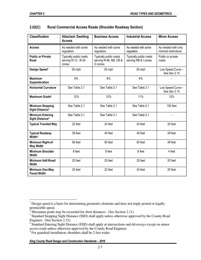
CHAPTER 2 ROAD TYPES AND GEOMETRICS
King County Road Design and Construction Standards – 2016
2-7
2.02(C) Rural Commercial Access Roads (Shoulder Roadway Section)
Classification Attached- Dwelling Access
Business Access Industrial Access Minor Access
Access As needed with some regulation.
As needed with some regulation.
As needed with some regulation.
As needed with only minimal restrictions.
Public or Private Road
Typically public roads serving R-12 - R-24 zones.
Typically public roads serving R-48, NB, CB & O zones.
Typically public roads serving RB & I zones
Public or private roads.
Design Speed1 35 mph 35 mph 35 mph Low Speed Curve – See Sec 2.10
Maximum Superelevation
6% 6% 6% -
Horizontal Curvature See Table 2.1 See Table 2.1 See Table 2.1 Low Speed Curve – See Sec 2.10
Maximum Grade2 12% 12% 11% 12%
Minimum Stopping Sight Distance3
See Table 2.1 See Table 2.1 See Table 2.1 150 feet
Minimum Entering Sight Distance4
See Table 2.1 See Table 2.1 See Table 2.1 -
Typical Traveled Way 22 feet 24 feet 24 feet 20 feet
Typical Roadway Width5
38 feet 40 feet 40 feet 28 feet
Minimum Right-of-Way Width
60 feet 60 feet 60 feet 48 feet
Minimum Shoulder Width
8 feet 8 feet 8 feet 4 feet
Minimum Half-Road/ Width
20 feet 20 feet 20 feet 20 feet
Minimum One-Way Paved Width
20 feet 22 feet 24 feet 20 feet
1 Design speed is a basis for determining geometric elements and does not imply posted or legally permissible speed. 2 Maximum grade may be exceeded for short distances. (See Section 2.11). 3 Standard Stopping Sight Distance (SSD) shall apply unless otherwise approved by the County Road Engineer. (See Section 2.12). 4 Standard Entering Sight Distance (ESD) shall apply at intersections and driveways except on minor access roads unless otherwise approved by the County Road Engineer. 5 For guardrail installation, shoulders shall be 2 feet wider.

CHAPTER 2 ROAD TYPES AND GEOMETRICS
King County Road Design and Construction Standards – 2016
2-8
2.03 Urban Roadways
A. Urban Principal Arterial
Urban principal arterials provide for movement across and between large subareas of an urban region and serves predominantly “through traffic.” They carry the highest traffic volume and serve major centers of activity and are fed by other arterials and local access streets. Principals are expected to provide a high degree of mobility; therefore, access to abutting properties is very restricted.
B. Urban Minor Arterial
Urban minor arterials interconnect with and augment the principal arterial system. They provide intra-community continuity connecting community centers and facilities. A minor arterial may also serve “through traffic”. Access is partially restricted.
C. Urban Collector Arterial
Urban collector arterials typically are intra-community roadways connecting residential neighborhoods with community centers and facilities. They accumulate traffic from local roadways and distribute that traffic to roadways that are higher in the hierarchy of classification. Access is partially restricted.
D. Urban Local Roadways
There are several roadway classifications for urban local roadways. They are listed below:
1. Neighborhood Collectors
Neighborhood collector streets are the highest in the local roadway classification hierarchy. They connect 2 or more neighborhoods and typically connect to arterials or other neighborhood collectors. Direct driveway connections to neighborhood collectors are restricted.
2. Subcollectors
Subcollector streets are the second highest in the local roadway classification hierarchy. Subcollectors provide circulation within neighborhoods and typically connect to neighborhood collectors. Although they typically allow direct driveway access there are some project related exceptions.
3. Subaccess
Subaccess streets are permanent cul-de-sacs or short loop streets that connect to subcollectors. Subaccess streets are not supportive of through traffic. They provide direct driveway connections.
4. Minor Access
A minor access street is a permanent cul-de-sac or short loop street with low traffic volumes that provides circulation and access to off-street parking within a residential development boundary. Like subaccess streets, a minor access street allows direct driveway connections.

CHAPTER 2 ROAD TYPES AND GEOMETRICS
King County Road Design and Construction Standards – 2016
2-9
E. Urban Commercial Access Streets
There are several roadway classifications for urban commercial access streets. Typically "curb" type road improvements are provided along these streets unless otherwise approved by the County Road Engineer or the Development Engineer. The classifications are listed below:
1. Attached-Dwelling Access
Attached-dwelling access streets typically serve town houses, condominiums, apartments, and other multiple-dwelling developments.
2. Business Access
Business access streets typically serve very dense multiple-dwelling developments, office buildings, and other professional service buildings.
3. Industrial Access
Industrial access streets typically serve manufacturing, processing, storing and handling activities. These roadways generally route industrial vehicles from the arterial system to and within industrial districts.
4. Commercial Minor Access
Commercial minor access streets provide circulation and access to parking and loading sites within multiple-dwelling, business, and industrial developments.

CHAPTER 2 ROAD TYPES AND GEOMETRICS
King County Road Design and Construction Standards – 2016
2-10
2.03(A) Urban Arterials (Curb Roadway Section)
Classification Principal Minor Collector
Access Controlled with very restricted access to abutting properties.
Partially controlled with infrequent access to abutting properties.
Partially controlled with infrequent access to abutting properties.
Arterial Spacing1 2 to 5 miles Under 2 Miles Under 2 miles
Design Speed2 Varies 40 to 60 mph Varies 35 to 55 mph Varies 35 to 50 mph
Horizontal Curvature See Table 2.1 See Table 2.1 See Table 2.1
Maximum Grade3 9% 10% 12%
Typical Traveled Way4 44 to 56 feet 44 to 56 feet 36 to 44 feet
Typical Roadway Width4 44 to 66 feet 44 to 66 feet 44 to 54 feet
Typical Lane Width 11 feet 11 feet 11 feet
Typical Left Turn Lane Width 12 feet 12 feet 12 feet
Typical Right Turn Lane Width 12 feet 12 feet 12 feet
Typical Widen Curb Lane Width6 14 feet 14 feet 14 feet
Typical Bike Lane Width 5 feet 5 feet 5 feet
Maximum Superelevation5 6% 6% 6%
Minimum Stopping Sight Distance See Table 2.1 See Table 2.1 See Table 2.1
Minimum Entering Sight Distance See Table 2.1 See Table 2.1 See Table 2.1
Minimum Passing Sight Distance See Table 2.1 See Table 2.1 See Table 2.1
Minimum Right-of-Way Width4 100 feet 84 feet 84 feet
Minimum Sidewalk Width See Section 3.02 See Section 3.02 See Section 3.02
Curb Type Vertical Vertical Vertical
1 For arterial spacing, distances are given only as general guidelines. 2 Design speed is a basis for determining geometric elements and does not imply posted or legally permissible speed. 3 Maximum grade may be exceeded for short distances. 4 Criteria for federal and state funding may require greater traveled way, roadway and right-of-way widths. Greater widths also may be required for the construction of bike lanes, equestrian trails, and other nonmotorized use. 5 See Section 2.04 for allowed uses of superelevations greater than 6 percent. 6 A widen curb lane is provided to accommodate bicycles.

CHAPTER 2 ROAD TYPES AND GEOMETRICS
King County Road Design and Construction Standards – 2016
2-11
2.03(B) Urban Local Access Streets - (Curb Roadway Section)
1 See Section 2.20 for urban exceptions. Also, when Section 2.20 applies the curbing shall be vertical. 2 See Section 2.15 for one-way loops. 3 See Section 2.20 for residential access connection requirements. 4 See Section 2.20 for urban exception criteria. 5 Design speed is a basis for determining geometric elements and does not imply posted or legally permissible speed. 6 Maximum grade may be exceeded for short distances. See Section 2.11. 7 Neighborhood collectors intersecting with arterials shall be 36 feet wide for the first 150 feet. See Section 4.05 for tapers. 8 Greater traveled way, roadway, and road right-of-way widths may be required for the construction of bike lanes, equestrian trails, other nonmotorized use, or water quality facilities.
Classification Neighborhood Collectors
Subcollectors Subaccess Minor Access
Access Restricted, Lots front on local access street where feasible.
As needed with some restrictions.1
Subaccess streets are not supportive of through traffic. Generally permanent cul-de-sacs or short loop2 streets that connect to subcollectors.
Permanent cul-de-sacs or short loops with low traffic volumes that provide circulation and access to off-street parking within residential development limits.
Public or Private Public Public Public or Private Public or Private (See Section 2.06)
Serving Potential Number of Lots or Dwelling Units
Over 1003 100 Maximum4 50 Maximum 16 Maximum
Design Speed5 35 mph 30 mph Low Speed Curve (See Section 2.10)
Low Speed Curve (See Section 2.10)
Max Superelevation See Section 2.04B See Section 2.04B See Section 2.04B See Section 2.04B
Horizontal Curvature See Table 2.2 See Table 2.2 Low Speed Curve (See Section 2.10)
Low Speed Curve (See Section 2.10)
Maximum Grade6 11% 12% 12% 12%
Minimum Stopping Sight Distance
See Table 2.2 See Table 2.2 150 feet 150feet
Minimum Entering Sight Distance
See Table 2.2 - - -
Typical Traveled Way8 22 feet17 22 feet 22 feet 22 feet
Typical Roadway Width8 32 feet7 28 feet 24 feet 22 feet
Minimum Right-of-Way Width8 56 feet 48 feet 40 feet 40 feet
Minimum Half Street Width 20 feet 20 feet 20 feet 20 feet
Minimum One Way Paved Width
20 feet 20 feet 20 feet 20 feet
Minimum Sidewalk Width See Section 3.02 See Section 3.02 See Section 3.02 See Section 3.02
Curb Type Vertical Vertical1/Rolled Vertical/Rolled Vertical/Rolled

CHAPTER 2 ROAD TYPES AND GEOMETRICS
King County Road Design and Construction Standards – 2016
2-12
2.03(C) Urban Commercial Access Streets (Curb Roadway Section)
Classification Attached Dwelling Access Streets
Business Access Streets
Industrial Access Streets
Minor Access Streets
Access As needed with some regulation.
As needed with some regulation.
As needed with some regulation.
As needed with only minimal restrictions.
Public or Private Street
Typically public streets serving R-12 through R-24 zones.
Typically public streets serving R-48, NB, CB, & O zones.
Typically public streets serving RB & I Zones
Public or private streets.
Design Speed1 35 mph 35 mph 35 mph Low Speed Curve-See Section 2.10
Maximum Superelevation
6% 6% 6% -
Horizontal Curvature See Table 2.1 See Table 2.1 See Table 2.1 Low Speed Curve -See Section 2.10
Maximum Grade2 12% 12% 11% 12%
Minimum Stopping Sight Distance3
See Table 2.1 See Table 2.1 See Table 2.1 150 feet
Minimum Entering Sight Distance4
See Table 2.1 See table 2.1 See Table 2.1 -
Typical Traveled Way 36 feet 36 feet 40 feet 24 feet
Typical Roadway Width
36 feet 36 feet 40 feet 24 feet4
Minimum Right-of-Way Width
56 feet 56 feet 60 feet 40 feet
Minimum Sidewalk Width
See Section 3.02 See Section 3.02 See Section 3.02 See Section 3.02
Minimum Half-Street Width
20 feet 20 feet 20 feet 20 feet
Minimum One-Way Paved Width
20 feet 22 feet 24 feet 20 feet
Curb Type Vertical Vertical Vertical Vertical
1 Design speed is a basis for determining geometric elements and does not imply posted or legally permissible speed. 2 Maximum grade may be exceeded for short distances. See Section 2.11. 3 Standard Stopping Sight Distance (SSD) shall apply, unless otherwise approved by the County Road Engineer. See Section 2.12. 4 Standard Entering Sight Distance (ESD) shall apply at intersections and driveways except when a driveway intersects a minor access street, unless otherwise approved by the County Road Engineer.

CHAPTER 2 ROAD TYPES AND GEOMETRICS
King County Road Design and Construction Standards – 2016
2-13
2.04 Horizontal Curvature and Sight Distance Design Values
A. The values shown in Tables 2.1 and 2.2 are minimum design values per tables 3-1, 3-8 through 3-12, and table 9-6 of AASHTO’s “A Policy on Geometric Design of Highways and Streets, 2011 edition”. A maximum of eight percent superelevation may be used, upon approval of the County Road Engineer, for design of improvements to existing arterials, as necessary, to meet terrain and right-of-way conditions. Superelevation run-off lengths on arterials, rural residential and commercial access roads and streets shall be calculated in accordance with the WSDOT Design Manual.
B. Superelevation is not required in the design of horizontal curves on urban residential access streets; however, horizontal curves must be designed based on design speed
and selected cross section as indicated in Table 2.2. This table is based on AASHTO "Low Speed Urban Streets" design methodology. Superelevation may be used on urban residential streets as necessary to meet terrain and right-of-way conditions.
Table 2.1
Arterial Roads, Rural Local and Commercial Access Roads and Streets Design Values1
Design Speed (mph) 30 35 40 45 50 55 60
Horizontal Curvature for 6% (maximum allowable on neighborhood collectors and local access roads and streets) Superelevation, Radius (Ft.)
231 340 485 643 833 1,060 1330
Horizontal Curvature for 8% (maximum allowable on arterials) Superelevation, Radius (Ft.) (requires approval of the County Road Engineer)
214 314 444 587 758 960 1,200
Stopping Sight Distance (Ft.) 200 250 305 360 425 495 570
Entering Sight Distance (Ft.)2,3,4 335 390 445 500 555 610 665
Passing Sight Distance (Ft.) for a 2-Lane Road 500 550 600 700 800 900 1,000
1 See Section 2.12. 2 See Section 2.14. Entering sight distance shown is for a stopped passenger vehicle to turn left onto a two-lane highway with no median and grades 3 percent or less. For other conditions the time gap must be adjusted and required sight distance recalculated. (See 2011 AASHTO – Intersection Control section). 3 For multilane roadways: For left turns onto two-way roadways with more than 2 lanes, add 0.5 seconds for passenger cars or 0.7 seconds for trucks for each additional lane from the left, in excess of one, to be crossed by the turning vehicle. 4 For minor and approach grades: If the approach grade is an upgrade that exceeds 3 percent; add 0.2 seconds for each percent grade for left turns.

CHAPTER 2 ROAD TYPES AND GEOMETRICS
King County Road Design and Construction Standards – 2016
2-14
Table 2.2 Urban Residential Access Streets Design Values
Design Speed (mph) 25 30 35
Horizontal Curvature, for 6% Superelevation, Radius (Ft.)
144 231 340
Horizontal Curvature, for 4% Superelevation, Radius (Ft.)
154 250 371
Horizontal Curvature, for 2% Superelevation, Radius (Ft.)
167 273 408
Horizontal Curvature, Normal Crown Section, Radius (Ft.)
181 300 454
Stopping Sight Distance (Ft.) 155 200 250
Entering Sight Distance (Ft.) 280 335 390
2.05 Short Plats
King County will not accept roads or streets for maintenance within a short plat.
A. Urban Residential Short Plats
1. When an urban residential short plat adds one additional lot to an existing lot that already has a permitted habitable residential dwelling unit, a paved shoulder may be constructed along the short plat frontage as an alternative to curb, gutter, and sidewalk improvements, provided:
a. The surrounding roadways frontage improvements are of rural character; and, b. The potential development of the neighborhood is low and consists primarily
of in-fill.
2. When the short plat access street extends more than 150 feet measured from the centerline of the nearest street intersection and serves or will serve more than two lots, a turnaround shall be provided. The turnaround may be a cul-de-sac or a hammerhead.
3. The total roadway width shall be 20 feet and the surfacing shall be asphalt.
4. The design and construction shall meet the requirements of a residential minor access roadway.

CHAPTER 2 ROAD TYPES AND GEOMETRICS
King County Road Design and Construction Standards – 2016
2-15
B. Rural Residential Short Plats
1. When the short plat access road extends more than 150 feet measured from the centerline of the nearest road intersection and serves or will serve more than two lots, a turnaround must be provided. The turnaround may be a cul-de-sac or hammerhead.
2. The total roadway width (traveled way and shoulders) shall be 20 feet.
3. The design and construction shall meet the requirements of a residential minor access roadway.
4. The roadway surfacing may be gravel, bituminous, porous, or hot mix asphalt, as specified in Section 2.17.
2.06 Private Roads
While public roads, owned and maintained by the county, usually best serve community road requirements, private roads may be appropriate for some local access roads. Usually these are minor access or subaccess roads, either residential or commercial. The design shall meet the requirements of the applicable roadway classification
A. Private roads are required when the development proposal will serve a maximum potential of nine single family dwellings units when the entire length of the private road system to the nearest public maintained road is considered. The designed shall meet the minor access roadway requirements of Sections 2.02 and 2.03 of these Standards. The Development Engineer may allow modifications such as an inverted crown or a thickened asphalt edge rather than curb, provided that stormwater treatment will be adequate and safety will not be compromised.
B. Private roads may be allowed to serve a maximum of 50 single family dwelling units when the entire length of the private road system to the nearest public maintained road is considered and when the County Road Engineer determines:
1. There is no opportunity for connecting to neighboring parcels or developments, or
2. When there are physical barriers, zoning regulations, legal constraints or any other applicable restrictions that prohibits the connection to road stub-outs, easements, neighboring parcel(s), public roads, or rights of way.
C. King County will not accept private roads for maintenance as public roads until King County determines that there is a benefit to the public and such roads are brought into conformance with current King County Code and these Standards.
D. The county will not maintain roadways, signs, drainage conveyance improvements or other appurtenances on private roads, unless otherwise specified. The maintenance responsibility shall be clearly noted on the face of the recorded plat, short plat or binding site plan. The road shall be signed as a private road that is privately maintained.

CHAPTER 2 ROAD TYPES AND GEOMETRICS
King County Road Design and Construction Standards – 2016
2-16
E. Best Management Practices (BMPs) should be used when maintaining private roadways.
F. A private maintenance covenant recorded with the King County Recorder’s Office will be required for any private road. Maintenance shall include, but not be limited to, road surfacing, shoulders, signs, storm drainage facilities and vegetation control. The covenant shall set out the distribution of expenses, remedies for noncompliance with the terms of the agreement, right of use easements and other considerations. It shall be recorded prior to final construction approval and meet the following terms:
1. The covenant shall establish minimum annual assessments in an amount adequate to defray costs of ordinary maintenance and procedures for approval of additional needed assessments.
2. The covenant shall include a periodic maintenance schedule.
3. The covenant for maintenance shall be enforceable by any property owner served by the road.
4. The covenant shall establish a formula for assessing maintenance and repair costs equitably to property owners served by the private road.
5. The covenant shall provide provision for pedestrian access by the public when the private road and/or associated sidewalk or shoulder/walkway adjoins or is connected to a school or park.
6. The covenant shall run with the land.
G. Additionally, all private roads shall adhere to the following criteria:
1. Permanently established by, tract or easement with a minimum width of 40 feet, and
2. They shall provide legal access to each affected lot, dwelling unit, or business, and
3. Sufficient to accommodate required improvements to include provision for future use by adjacent property owners and connection to school pathways, trails or public sidewalks when applicable; and
4. The improved surface width shall be the minimum required per the classification of the roadway. Private roadway width requirements may be increased at the discretion of the Development Engineer if necessary for safe vehicle movement or to accommodate grading, utilities, on-street parking, turning movements or any related road or utility need.-
5. Accessible at all times for emergency and public service vehicle use; and
6. Not obstructing, or part of, the present or future public neighborhood circulation plan developed in processes such as the King County

CHAPTER 2 ROAD TYPES AND GEOMETRICS
King County Road Design and Construction Standards – 2016
2-17
Comprehensive Plan, King County Transportation Plan, or Capital Improvement Program; and
7. Not resulting in land locking of present or future parcels; and
8. Not needed as public roads to meet the minimum road spacing requirements of these Standards.
2.07 Half Roads
A. A half road, figure 2-010, may be permitted as an interim facility when:
1. Such road shall not serve as primary access to more than 35 dwelling units or equivalent ADT; and
2. Such alignment is consistent with or will establish a reasonable circulation pattern; and
3. There is reasonable assurance of obtaining the prescribed additional right-of-way from the adjoining property with topography suitable for completion of a full width road.
B. A half road shall meet the following requirements:
1. Right-of-way width of the half road shall be a minimum width of 30 feet and sufficient to construct the roadway and related grading; and
2. The half road shall be graded consistent with locating the centerline of the ultimate road section as close as possible to the property line; and
3. Traveled way shall be surfaced the same as the designated road type to a width not less than 20 feet, sidewalk shall be constructed as required for the designated road type; and
4. Property line edge of road shall be finished with temporary curbing, shoulders, ditches, and/or side slopes in order to assure proper drainage, bank stability, and traffic safety; and
5. Half roads shall not intersect other half roads or exceed these requirements unless so approved by the County Road Engineer, and
6. The intersection of a half road shall be improved to a full width road of a designated section, and
7. Half-roads shall meet the requirements of Section 4.03 of these Standards.
C. When a half road is eventually completed to a whole road, the completing builder shall reconstruct the original half road as necessary to produce a proper full width crowned road of a designated section.
D. Obtaining any right-of-way or easements to accomplish the above shall be the responsibility of the applicant or developer.

CHAPTER 2 ROAD TYPES AND GEOMETRICS
King County Road Design and Construction Standards – 2016
2-18
2.08 Cul-de-sacs, Islands, and Hammerheads
A. Cul-de-sacs: Whenever a dead-end street serves or will serve more than six lots or extends more than 150 feet from centerline of accessing street to farthest extent of surfaced traveled way, a widened "bulb," figure 2-007 shall be constructed as follows:
1. Minimum right-of-way diameter across bulb section: 100 feet in a permanent cul-de-sac; 84 feet in a temporary cul-de-sac, with bulb area lying outside straight-street right-of-way provided as temporary easement pending forward extension of the street. Right-of-way may be reduced, provided utilities and necessary drainage are accommodated on permanent easements within the development. See Section 2.18.
2. Minimum diameter of surfacing across bulb: 80 feet of paving in curb-type road; 80 feet total in shoulder-type road to include 64 feet of paving and eight-foot shoulders with compacted crushed surfacing material.
3. Where required on cul-de-sacs, sidewalks shall be constructed on both sides, except private porous roadways.
4. A permanent cul-de-sac shall not be longer than 600 feet measured from centerline of intersecting loop or through street to the center of the bulb section. On the basis of pertinent traffic planning factors such as topography, sensitive areas and existing development, the County Road Engineer will consider variances to this requirement.
5. The County Road Engineer or Development Engineer may require an emergency vehicle access and/or an off-street walkway to connect a cul-de-sac at its terminus with other roads, streets, parks, schools, bus stops, or other pedestrian traffic generators.
6. If a road or street temporarily terminates at a property boundary, serves or will serve more than six lots, or is longer than 150 feet, a temporary bulb shall be constructed near the development boundary. The paved bulb shall be 80 feet in diameter with sidewalks. Removal of the temporary constructed cul-de-sac and construction of the extension of the sidewalk shall be the responsibility of the applicant/developer who extends the road. See figure 2-008.
7. The maximum cross slope in a bulb shall not exceed six percent in any direction.
8. Partial bulbs or eyebrows shall have a minimum paved radius and an island configuration as shown on figure 2-009 and located only at mid-block. Partial bulbs shall not be used as temporary or permanent road ending cul-de-sacs. Island shall be offset two feet from edge of roadway.
9. Temporary cul-de-sac easements are extinguished, when applicable, through the right-of-way vacation process in accordance with King County Code 14.40.
10. When a commercial access street change from a public to private designation a public turnaround shall be required, regardless whether

CHAPTER 2 ROAD TYPES AND GEOMETRICS
King County Road Design and Construction Standards – 2016
2-19
another fire access turnaround is provided elsewhere, except as noted in Section 2.08(A).
B. Cul-de-sac Island: A cul-de-sac island is an optional feature for any cul-de-sac when bulb paved diameter is 80 feet or less; mandatory when bulb paved diameter exceeds 80 feet. If provided, island shall have full depth cement concrete vertical curb and gutter. Minimum island diameter shall be 20 feet and there shall be at least 22 foot wide paved traveled way in a shoulder-type section and a 30 foot wide paved traveled way in a curb-type section around the circumference. An island shall be grassed or landscaped. The adjoining property owners or homeowner’s association shall be responsible for the landscaped and or grassed area within the island and the island’s curbing. Additionally, if the island curbing is damaged the adjoining property owners or homeowner’s association shall be responsible for its repair or replacement.
C. Hammerheads: A hammerhead may be used to satisfy the turnaround requirements where a private road or street serves or will serve six or fewer lots. See figure 2-012.
2.09 Alleys and Private Access Tracts
The geometric design criteria for subaccess streets shall be used to design alleys. An alley is considered a private road that provides secondary access.
A. Alleys
1. An alley shall serve a maximum of 30 dwelling units; have a maximum length of 400 feet, no dead ends or cul-de-sacs.
2. The tract width shall be sufficient to construct the alley and related grading. The minimum tract width shall be 20 feet with a pavement surface width of 18 feet (including curb) based on a five foot structure setback. For differing structure setback requirements, the alley surfacing width may be reduced if designed to provide for safe turning access to properties.
3. Paved surface shall have a curb on one side and cross slope in one direction to control surface runoff. It shall be a minimum length of 20 feet. See figure 2-011.
4. Public roads to which an alley connects or which provide access to the front boundary of the properties served by the alley shall be 28 foot minimum paved width with vertical curb. Where connecting streets are curb type sections, driveway cuts shall be required.
5. Modifications to existing alleys serving commercial or industrial properties, in accordance with the above, will be determined on a case-by-case basis subject to approval by the Development Engineer.
6. Alleys shall not intersect other alleys.
7. Alleys shall be privately maintained.

CHAPTER 2 ROAD TYPES AND GEOMETRICS
King County Road Design and Construction Standards – 2016
2-20
B. Private Access Tracts
1. A private access tract shall serve a maximum of six dwelling units.
2. The tract shall have a minimum width of 20 feet with a maximum length of 150 feet. The length shall be measured from the centerline of intersecting street to furthest extent of paved tract. The tract width shall be increased up to 30 feet to accommodate drainage and utilities.
3. The pavement width shall be a minimum of 18 feet with a cross slope in one direction. The pavement width includes curb and gutter; thickened edge curbing is acceptable in both urban and rural areas.
4. The pavement surface may be constructed with a porous surface to reduce surface water runoff.
5. The private access tract shall meet the driveway requirements specified in section 3.01C (4) of these Standards.
6. When crossing an open ditch section, culverts shall be adequately sized to carry anticipated storm water flows and in no case be less than 12 inches in diameter. Pipe shall be long enough to allow for the minimum 3:1 beveled ends, figure 7-001.
7. Storm drainage from private access tracts surfaces must be accounted for in the roadway drainage design. Direct discharge to roadway surfaces and sidewalks is not allowed.
8. The private access tract shall meet the entering sight distance requirements specified in Section 2.13 of these Standards.
2.10 Intersections and Low-Speed Curves
A. Intersections
1. Angle of intersection (measured at 10 feet beyond road classification right-of-way)
Minimum 85 degrees Maximum 95 degrees
2. Minimum centerline radius (2-lane) (radii are for minor or subaccess roads/streets)
55 feet
3. Minimum curb radius
a. Arterials and roads classified neighborhood collector or higher:
35 feet
b. Residential access street intersections where the highest classification involved is subcollector:
25 feet
4. Minimum right-of-way line radius: 25 feet

CHAPTER 2 ROAD TYPES AND GEOMETRICS
King County Road Design and Construction Standards – 2016
2-21
B. Spacing between adjacent intersecting roads/streets, whether crossing or T-connecting, shall be as follows:
When highest classification involved is:
Principal arterial
Minor arterial
Collector arterial
Neighborhood collector
Any lesser street classification
Minimum centerline offset shall be:
1,000 feet
500 feet
300 feet
150 feet
100 feet
C. On sloping approaches at an intersection, landings shall be provided with grade not to exceed one foot difference in elevation for a distance of 30 feet approaching an arterial or 20 feet approaching a residential or commercial street, measured from the future right-of-way line (intersected by an imaginary two percent grade extended from crowned road to right-of-way line) of intersecting street as provided in Section 2.02 or 2.03. See figure 2-014.
D. Roundabout intersections taking the place of standard intersections shall be designed in accordance with current USDOT/FHWA guidelines and the WSDOT Design Manual.
E. Entering Sight Distance. See Sections 2.02, 2.03, 2.04 and 2.13 for design requirements. See Tables 2.1 or 2.2 for specific entering sight distance values based on required design speed.
F. Low Speed Curves: applicable to subaccess and minor access roads/streets only. See Sections 2.03 and 2.04.
Up to 75° 75° & Over
1. Minimum centerline radius (two-lane):
100 feet 55 feet
2. Minimum curb radius: 80 feet 35 feet1
3. Minimum right-of-way line radius:
70 feet 25 feet
2.11 Maximum Grade and Grade Transitions
A. Maximum roadway grade as shown in Sections 2.02 and 2.03 may be exceeded for short distances of 300 feet or less, upon showing that no practical alternative exists. Grades greater than 15 percent that exceed the 300-foot distance must be approved by the County Road Engineer through the road variance process. Additionally, the maximum grade shall not exceed 15 percent unless verification is obtained from the Fire Marshal that additional fire protection requirements will be met and the applicant’s engineer must demonstrate what method will be used to ensure drainage will be controlled. Grades exceeding 12 percent shall be paved with hot mix asphalt (HMA) or portland cement concrete.
1 On residential access road/street intersections where the highest classification involved is a subcollector, the minimum curb radius is 25 feet.

CHAPTER 2 ROAD TYPES AND GEOMETRICS
King County Road Design and Construction Standards – 2016
2-22
B. Grade transitions shall be constructed as smooth vertical curves, without angle points, except in intersections where the difference in grade is one percent or less and upon approval of the County Road Engineer or Development Engineer.
2.12 Stopping Sight Distance
A. Stopping Sight Distance (SSD) is the sum of two distances: the distance traveled during perception and reaction time and the distance required to stop the vehicle. The perception and reaction time used in design is 2.5 seconds. The stopping sight distance is calculated using a constant deceleration rate of 11.2 feet/second2. SSD, see Tables 2.1 and 2.2, applies to street classifications as shown in Sections 2.02 and 2.03.
B. Available stopping sight distance is calculated for a passenger car using an eye height of 3.50 feet and an object height of 2.00 feet
C. When calculating stopping sight distance, use h1=3.50 feet and h2=2.00 feet.
D. The grade of the roadway has an effect on the vehicle’s stopping sight distance. The stopping distance is increased on downgrades and decreased on upgrades. When evaluating sight distance with a changing grade, use the grade for which the longest sight distance is needed. Road grades other than those shown in exhibit 2-1 must be interpolated.
Exhibit 2-1. Stopping Sight Distance on Grades
DOWNGRADE
DESIGN SPEED (MPH) 3 Percent 6 Percent 9 Percent
60 598 638 686
55 520 553 593
50 446 474 507
45 378 400 427
40 315 333 354
35 257 271 287
30 205 215 227
25 158 165 173
20 116 120 126

CHAPTER 2 ROAD TYPES AND GEOMETRICS
King County Road Design and Construction Standards – 2016
2-23
UPGRADE
DESIGN SPEED (MPH) 3 Percent 6 Percent 9 Percent
60 538 515 495
55 469 450 433
50 405 388 375
45 344 331 320
40 289 278 269
35 237 229 222
30 200 184 179
25 147 143 140
20 109 107 104
E. Sag vertical curves on residential or commercial roads and streets that do not meet the minimum SSD may be approved by the Development Engineer if no practical design exists and if acceptable illumination is provided throughout the curve and is maintained by a franchised utility. The design shall meet the requirements of Section 5.05.
F. Intersecting Stopping Sight Distance.
1. Stopping sight distances for the design speeds of proposed commercial access roads and streets, neighborhood collector roads and streets and arterials must be met when intersecting arterials.
2. The minimum stopping sight distance on proposed intersection approaches for all other access to intersecting roadways shall be 125 feet.
2.13 Entering Sight Distance (ESD)
Entering sight distance applies on driveways, roads and streets approaching intersections as set forth in Sections 2.02 and 2.03 with the exception of subcollectors, subaccess, residential minor access, and commercial minor access roads and streets. Specific ESD values for required design speeds are listed in Section 2.04, Tables 2.1 and 2.2.
A. The driver’s eye is 3.50 feet above the roadway surface and the object height is 3.50 feet above the surface of the intersecting roadway, measured 14.5 feet back from edge of traveled way, see figure 2-013.
B. Approaching vehicle height is 4.35 feet.
C. Requirements in Section 2.04, Tables 2.1 and 2.2 apply to an intersection or driveway approach to a typical road under average conditions. In difficult topography the County Road Engineer may authorize a reduction in the ESD based on factors mitigating the hazard. Such factors may include an anticipated posted or average running speed less than the design speed or the provision of acceleration lanes and/or a median space allowing an intermediate stop by an approaching vehicle making a left turn.
D. Where a significant number of trucks will be using the approach road, the County Road Engineer may increase the entering sight distance requirements by

CHAPTER 2 ROAD TYPES AND GEOMETRICS
King County Road Design and Construction Standards – 2016
2-24
up to 30 percent for single-unit trucks and 70 percent for semi-trailer combinations.
2.14 Medians (Optional Design Feature)
Median width shall be additional to, not part of the specified width of traveled way. Edges shall be similar to outer road edges: either extruded or formed vertical curb; or shoulder and ditch; except that median shoulders shall be four feet in width minimum. Twenty feet of drivable surface (which includes traveled way and paved shoulders, if any) shall be provided on either side of the median. The median may be grassed, landscaped, or surfaced with aggregate or pavement. Median shall be designed so as not to limit turning radii or sight distance at intersections. No portion of a side street median may extend into the right-of-way for an arterial street. The County Road Engineer or Development Engineer may require revisions to medians as necessary to provide for new access points and to maintain required sight distance. Non-yielding or non-breakaway structures shall not be installed in medians. Street trees may be planted in the median subject to approval by the County Road Engineer.
2.15 One-Way Roads and Streets
Local access roads and streets, including loops and bulbs, may be designated one-way upon a finding by the County Road Engineer that topography or other site features make two-way traffic impractical.
2.16 Bus Zones and Turn-Outs
During the design of arterials and neighborhood collectors, the designer shall contact the transit agencies and the local school district to determine bus zone (stop) locations and other bus operation needs. The project shall provide wheelchair accessible landing pads at designated bus zones, and where required shall include turn-outs and shelter pads. Pedestrian and disabled access improvements within the right-of-way to and from the bus loading zone or turn-out from nearby businesses or residences shall also be provided as part of the road improvement. Surfacing for bus zones and turnouts shall at a minimum meet the requirements of Section 4.01 of these Standards. Metro's publication, "Metro Transportation Facility Design Guidelines," or other applicable agencies guidelines may require additional surfacing requirements.
2.17 Exception to Paving on Rural Minor Access Roads and Streets (Residential)
A rural minor access street (residential) that is a private street can be designed and constructed to meet the following standard: It shall be graded and, as minimum treatment, be surfaced full width including shoulders, 24 feet with crushed surfacing material as provided in Table 4-1 and Figure 2-004. See Section 2.05 for exception. Half roads shall be surfaced not less than 20 feet wide. Where connecting to a paved public street the connecting area shall be paved between traveled way and right-of-way line (extended) of the public street or provide a landing that is a minimum length of 20 feet, with a radius that meets the requirements of Section 2.10. Paving shall be in accordance with Section 4.01 of these Standards.

CHAPTER 2 ROAD TYPES AND GEOMETRICS
King County Road Design and Construction Standards – 2016
2-25
2.18 Slope, Wall, and Drainage Easements and Right-of-Way Reduction
A. Easements: Either the functional classification or particular design features of a road may necessitate slope, sight distance, and wall or drainage easements beyond the right-of-way line. The County Road Engineer or Development Engineer may require such easements in conjunction with dedication or acquisition of right-of-way. The design engineer must document there is sufficient right-of-way to include cuts and fills and necessary clear zone.
B. Right-of-Way Reduction: The right-of-way width may be reduced to minimum
roadway width, plus storm drainage, sidewalk, one-foot behind sidewalk, provided that potential serving utilities are accommodated within permanent public easements. The reduced right-of-way, plus easement, at a minimum shall allow for construction and maintenance of the sidewalks, one-foot behind sidewalk, planting strips, drainage facilities, and sign placement. Additionally, they shall allow for sidewalk widening around mailbox locations.
2.19 Access and Circulation Requirements
No residential street shall serve more than 100 lots or dwelling units unless the street is connected in at least two locations with another street that functions at a level consistent with Sections 2.02 or 2.03. Additionally, every effort shall be made to provide a second access through the building permit process.
A. The second access requirement may be satisfied through use of connecting a new street to an existing street in an adjacent neighborhood if:
1. No other practical alternative exists, or
2. Existing street was previously stubbed indicating intent for future access, or
3. An easement has been recorded specifically for said purpose.
B. The second access requirement may cause the construction of an off-site road connecting the development to a suitable serving street.
C. These provisions are not intended to preclude the state statute on land locking.
D. This section does not preclude a non-residential project from gaining access through a residential development. Traffic impacts for such projects will be analyzed during the environmental and permitting process.
2.20 Exception for Maximum Dwelling Units on Urban Subcollectors
Proposed subcollectors serving new urban area developments with an average density of seven to eight dwelling units per acre and that meet the access requirements of Section 2.19 may serve up to 250 dwelling units, if approved by the Development Engineer. In this situation, the curbing shall be vertical. Prior to approval, the applicant must submit a traffic circulation study demonstrating a balanced traffic flow of less than 1500 vehicles per day past any access point. Street trees shall be mandatory along subcollectors serving higher densities of seven to eight dwelling units per acre and shall be in conformance with Section 5.03.

King County Road Design and Construction Standards-2016
3-1
CHAPTER 3. DRIVEWAYS, SIDEWALKS, CURBS, RAMPS, BIKEWAYS, TRAILS 3.01 Driveways
This section provides driveway standards for connections to public and private roads. It is not the intent of these Standards to govern design or location of driveways on private property except where they connect to the road right-of-way. However, fire access requirements governed by the Uniform Fire Code and Zoning Code (KCC21A), establish criteria for driveway widths. No new driveway connection shall be constructed which does not conform to this chapter and minimum sight distance criteria established in 2.13.
A. Dimensions slope, and detail shall be as indicated in Figures 3-003, through 3-009, as further specified in the following subsections. See Section 2.13 for entering sight distance and 2.12 for stopping sight distance requirements.
B. New Driveways Requirements:
1. Driveways directly giving access on to arterials may be denied if alternate access is available.
2. All abandoned driveway areas on the same frontage shall be removed, and the curbing and sidewalk or shoulder and ditch section shall be properly restored.
3. Maintenance of driveway approaches shall be the responsibility of the owner whose property they serve.
4. Driveways shall be paved with asphalt between the edge of the paved surface and the right-of-way line, except when on curb and gutter section roadways. See Figure 3-003. The pavement may be porous asphalt to reduce surface water runoff.
5. For driveways crossing an open ditch section, culverts shall be adequately sized to carry anticipated storm water flows and in no case be less than 12 inches in diameter, and at a minimum the culvert shall be equal to or larger than existing pipes within 500 feet upstream. Pipe shall be long enough to allow for the minimum 3:1 beveled ends, figure 7-001. The property owner making the installation shall be responsible for ensuring the proper pipe size. The Development Engineer may require the owner to verify the adequacy of pipe size.
6. Storm drainage from driveway surfaces must be accounted for in the roadway drainage design. Direct discharge to roadway surfaces and sidewalks is not allowed.

CHAPTER 3 DRIVEWAYS, SIDEWALKS, CURBS, RAMPS, BIKEWAYS, TRAILS
King County Road Design and Construction Standards – 2016
3-2
C. Location and Width of New Driveways. Refer to Figure 3-008.
1. A residential driveway shall typically serve only one parcel except as noted below. The minimum width of a residential driveway is 10 feet and the maximum width is 30 feet. A driveway serving more than one parcel shall be classified as a commercial driveway, or a private street, except as provided in 3.a. below.
2. On frontages 75 feet or less, no more than one driveway per lot shall be constructed. On frontages over 75 feet, the Development Engineer may permit two or more driveways per lot, subject to approval.
3. No portion of driveway width shall be allowed within 5 feet of side property lines where it intersects with the street right-of-way line in residential areas or nine feet in commercial areas except as follows:
a. A joint-use driveway tract may be used to serve two parcels:
i. Minimum driveway tract width in urban areas shall be 20 feet with an 18 foot paved surface cross slope in one direction and curb or thickened edge on one side. Minimum driveway length shall be 20 feet from right-of-way line. When required, radius returns on paved apron shall have 10 foot radii.
ii. Minimum driveway tract width in rural areas shall be 20 feet; 30 feet if a ditch is required. Minimum driveway length shall be 20 feet from right-of-way line. Radius returns on paved apron shall have 10-foot radii.
iii. Driving surface (rural areas) shall be 18 feet, paved or gravel, with a paved apron from the edge of pavement of intersecting street to right-of-way line or 20 feet, whichever is greater.
iv. The Development Engineer may allow use of an easement if the only access to a serving roadway is through an adjacent parcel not owned by the applicant, or for urban residential short plats to satisfy minimum lot width requirements.
b. Driveways may utilize full width of narrow "pipe stem" parcels or easements if approved by Development Engineer.
c. On cul-de-sac bulbs, eyebrows, or hammerheads as necessary for proposed residential access.
4. Grade transitions, excluding the tie to the roadway, shall be constructed as smooth vertical curves. Ties to the roadway shall be constructed as shown in driveway figures 3-003 through 3-009. The maximum change in driveway grade, within the right-of-way, shall be eight percent within any 10 feet of distance on a crest and 12 percent within any 10 feet of distance in a sag vertical curve. Whenever there is a potential for future roadway widening, the driveway shall be graded to match the future widened road section without encroachment into graded shoulder or sidewalk. The design engineer for proposed developments shall consider the access

CHAPTER 3 DRIVEWAYS, SIDEWALKS, CURBS, RAMPS, BIKEWAYS, TRAILS
King County Road Design and Construction Standards – 2016
3-3
driveway profile when designing the serving road to ensure that required grade transitions can be complied with considering building set back and lot terrain conditions. Driveways with slope exceeding two percent shall be designed to ensure surface water does not impact the right-of-way adjacent to the driveway.
5. Driveways in rolled curb sections may be constructed abutting and flush with sidewalk or back of curb without gapping or lowering height of curb.
D. Existing driveways may be reconstructed at their existing location provided such reconstruction is compatible with the adjacent road. For new development and/or changes in land use, existing driveway connections, which do not conform to this chapter, shall be reconstructed to the requirements for new driveways.
E. The minimum width for a commercial/business district driveway is 25 feet, and the maximum width is 35feet.
F. For commercial or industrial driveways with heavy traffic volumes or significant numbers of trucks, the Development Engineer may require construction of the access as a road intersection. This requirement will be based on traffic engineering analysis submitted by the applicant that considers, among other factors, intersection spacing, sight distance, and traffic volumes.
G. Notwithstanding any other provisions, driveways will not be allowed where they are prohibited by separate County Council action or where they are determined by the County Road Engineer or Development Engineer to create a hazard or impede the safe operation of traffic on the roadway.
H. When an existing driveway is removed or abandoned, the driveway opening shall be restored to match the frontage improvements.
3.02 Concrete Sidewalks
Sidewalks shall be required and constructed on urban category, curb and gutter type streets, Figures 2-002 and 2-003, unless otherwise allowed by these Standards or the County Road Engineer. They shall be located and constructed as follows:
1. On all arterials, neighborhood collectors, subcollectors, subaccess, attached dwelling, business access streets, and industrial access streets, both sides.
2. On minor access streets (commercial), both sides unless alternative routes are provided for pedestrians.
3. On minor access streets (residential) exceeding 150 feet, both sides.
4. On any cul-de-sacs, both sides.
5. Extended off-street walkways may be required by the Development Engineer to provide direct connections for ease and safety of pedestrians.

CHAPTER 3 DRIVEWAYS, SIDEWALKS, CURBS, RAMPS, BIKEWAYS, TRAILS
King County Road Design and Construction Standards – 2016
3-4
6. Sidewalks shall be constructed next to the curb except in those situations where the County Road Engineer approves the construction of a planting strip adjacent to the curb.
7. Sidewalks shall be a minimum width of five feet on residential access streets and arterials. Minimum sidewalk width shall be six and one-half feet on arterials if curb is next to traveled lane. Sidewalks shall be a minimum width of eight feet on commercial access streets.
8. At least eight feet wide:
a. Where the street frontage has the characteristics of a business/commercial district and where the building frontage is within 80 feet of the street right-of-way.
b. Within the curb radius returns of all arterial intersections where curb ramps are required.
c. Within designated bus zones to provide a landing area for wheelchair access to transit services.
9. With specified width greater than eight feet where the County Road Engineer or Development Engineer determines this is warranted by expected pedestrian traffic volume.
10. With Portland cement concrete surfacing as provided in Sections 3.03 and 4.01. See specifications for joints in Section 3.04 and figure 3-001.
11. A minimum of one foot of gravel or native material shall be provided back of and immediately adjacent to the sidewalk. The material shall be flushed with the top of sidewalk.
3.03 Construction of Curbs, Gutters, and Sidewalks
A. Subgrade compaction for curbs, gutters, and sidewalks shall meet a minimum 90 percent of maximum density. A minimum four inch section of crushed surfacing is required below the curb, gutter and sidewalk.
B. Concrete for curbs, gutters, and sidewalks shall be Class 4000, furnished and placed in accordance with WSDOT/APWA Standard Specifications, Sections 6-02, 8-06, and 8-14, except as otherwise noted in these Standards. Cold and hot weather precautions as set forth in WSDOT/APWA Standard Specifications Sections 5-05.3(14) and 6-02.3(6) A shall apply. As soon as the surface can be worked, it shall be troweled smooth with a steel trowel. After troweling and before jointing or edging, the surface of the sidewalk and curb ramps shall be brushed in a transverse direction with a stiff bristled broom. Concrete sidewalks and curbs shall be cured for at least 72 hours. Curing for sidewalks shall be by means of moist burlap or quilted blankets or other approved methods. During this curing period, all traffic, both pedestrian and vehicular, shall be excluded. Curing for curbs shall be in accordance with one of the methods specified in Section 5-05 of the WSDOT/APWA Standard Specifications. Curing of concrete driveways shall be in accordance with

CHAPTER 3 DRIVEWAYS, SIDEWALKS, CURBS, RAMPS, BIKEWAYS, TRAILS
King County Road Design and Construction Standards – 2016
3-5
Section 5-05.3(13) as set forth in WSDOT/APWA Standard Specification. The driveway entrances may be opened to traffic in accordance with Section 5-05.3(17) of the WSDOT/APWA Standard Specifications.
C. Extruded cement concrete curb shall be anchored to existing pavement by either steel tie bars or adhesive in conformance with WSDOT/APWA Standard Specification Section 8-04. Joints shall be spaced at ten (10) foot intervals and in accordance with figure 3-001.
D. Extruded asphalt curbs shall be constructed in accordance with WSDOT/APWA Standard Specification Section 8-04 and anchored by means of a tack coat of asphalt.
E. Transitions between curb streets or curbs with sidewalks to rural road sections shall meet the following:
1. At intersections, curb wraps shall extend around the radius to better define the lane edge and enhance safe turning movements. The appropriate access ramp described in Section 3.05 shall be provided at terminus.
2. For straight connections, end section shall conform to figure 3-014.
3. The minimum shy distance between the edge of traveled way and the curb shall be 1.5 feet.
F. Replacement of any portion of an existing driveway, sidewalk, or curb shall be from dummy joint to dummy joint.
3.04 Expansion and Dummy Joints.
A. An expansion joint consisting of 3/8 inch or1/4 inch of pre-molded joint material shall be placed full depth around fire hydrants, poles, posts, and utility castings and along walls or structures in paved areas. Joint material shall conform to the requirements of ASTM D994 (AASHTO M33). See figure 3-001.
B. An expansion joint consisting of 3/8 inch or 1/4 inch of pre-molded joint material shall be placed in the upper two inches of curbs and sidewalks at 10 foot intervals and at sides of drainage inlets. When curbs and/or sidewalks are placed by slip forming, a pre-molded strip up to 3/8 inch thick expansion joint, with a two inch to full depth section as described above shall be installed.
C. Expansion joints in sidewalk shall be located so as to match the joints in the curb whether sidewalk is adjacent to curb or separated by planting strip.
D. Tool marks consisting of one inch V-grooves must be made in sidewalk at five-foot intervals, intermediate to the expansion joints.
E. Interface between curb and adjacent sidewalk on integral pour construction shall be formed with 1- inch radius edging tool. On separate pour construction an expansion joint consisting of 3/8 inch or 1/4 inch of pre-

CHAPTER 3 DRIVEWAYS, SIDEWALKS, CURBS, RAMPS, BIKEWAYS, TRAILS
King County Road Design and Construction Standards – 2016
3-6
molded joint material shall be placed full depth between the curb or thickened edge and the adjacent sidewalk.
3.05 Curb Ramps – New Construction and Alterations
On all curbed streets, ramped sections to facilitate passage of disabled persons shall be constructed through curb and sidewalk at street intersections and other crosswalk locations, figure 3-010. Two ramps shall be provided per curb radius. Where a ramp is constructed on one side of the street, a ramp shall also be provided on the opposite side of the street, unless there is no curb or sidewalk on that receiving end. The placement of gratings, solid covers, utility access plates, and similar structures shall be located outside the pedestrian route on all newly constructed roadways.
Curb ramps shall be positioned so that a ramp opening is situated within the marked crosswalk or crossing area if unmarked, figure 3-010. The ramps shall have detectable warning surface consisting of raised tactile surfaces, see WSDOT Standard Plans. The detectable warning surface shall contrast visually with the adjacent gutter, street or roadway, or walkway surfaces. They shall be located outside areas designated or intended for vehicular travel, including driveways. Placement of the detectable warning surface shall be in compliance with WSDOT/APWA Standard Specification Section 8.14.3(5).
Additionally, the following requirements apply to perpendicular and parallel curb ramps.
Perpendicular Curb Ramps:
1. Perpendicular curb ramps shall have a running slope that cuts through or is built up to the curb at right angles or meets the gutter grade break at right angles.
2. The running slope shall not exceed 8.3 percent. 3. The ramp length shall not exceed 15.0 feet. 4. The cross slope at intersections shall be two percent maximum.
The cross slope at midblock crossings shall be permitted to be warped to meet street or highway grade.
5. A landing that is a minimum of four feet by four feet shall be provided at the top of the curb ramp and shall be permitted to overlap other landings and clear space. Running and cross slopes at intersections shall be two percent maximum. Running and cross slope at midblock crossings shall be permitted to be warped to meet street or highway grade.
6. Flared sides shall not exceed a slope of 10 percent maximum, measured parallel to the curb line, but shall not require the flared length exceed 15 feet.
7. Grade breaks at the top and bottom of perpendicular curb ramps shall be perpendicular to the direction of ramp run. At least one end of the bottom grade break shall be at the back of

CHAPTER 3 DRIVEWAYS, SIDEWALKS, CURBS, RAMPS, BIKEWAYS, TRAILS
King County Road Design and Construction Standards – 2016
3-7
curb. Grade breaks shall not be permitted on the surface of curb ramps, landings, and gutter areas within the pedestrian access route. Surface slopes that meet at grade breaks shall be flush.
8. The counter slope of the gutter or street at the foot of a curb ramp or landing shall be five percent maximum.
9. Beyond the curb face, a clear space of four feet minimum by four feet minimum shall be provided within the width of the crosswalk and wholly outside the parallel vehicle travel lane.
Parallel Curb Ramps:
1. Parallel curb ramps shall have a running slope that is in-line with the direction of sidewalk travel.
2. The running slope shall not exceed 8.3 percent. 3. The ramp length shall not exceed 15.0 feet. 4. The cross slope shall be two percent maximum. 5. A landing that is a minimum of four feet by four feet shall be
provided at the bottom of the ramp run and shall be permitted to overlap other landings and clear floor or ground space. Running slope and cross slopes at intersections shall be two percent maximum. Running and cross slope at mid-block crossings shall be permitted to be warped to meet street or highway grade.
6. Where a parallel curb ramp does not occupy the entire width of a sidewalk, drop-offs at diverging segments shall be protected.
7. Grade breaks shall not be permitted on the surface of curb ramps, landings, and gutter areas within the pedestrian access route. Surface slopes that meet at grade breaks shall be flush.
8. The counter slope of the gutter or street at the foot of a curb ramp, landing, or blended transition shall be five percent maximum.
9. Beyond the curb face, a minimum clear space of four feet by four feet shall be provided within the width of the crosswalk and wholly outside the parallel vehicle travel lane.
The area in which an alteration to an existing roadway takes place is known as the project footprint. If a crosswalk (marked or unmarked) will be reconstructed, paved (overlay or inlay), or otherwise altered as part of a project, then the curb ramps that serve the crosswalk are within the construction impact zone and shall comply with the applicable requirements to the maximum extent feasible. Alterations do not include: Spot pavement repair, liquid-asphalt sealing, chip seal (bituminous surface treatment), or crack sealing; or; lane restriping that does not alter the usability of the shoulder.
When reconstructing or altering roadways the placement of gratings, solid covers, utility access plates, and similar structures shall be located outside the pedestrian

CHAPTER 3 DRIVEWAYS, SIDEWALKS, CURBS, RAMPS, BIKEWAYS, TRAILS
King County Road Design and Construction Standards – 2016
3-8
route to the maximum extent feasible. When located within the pedestrian access route the structures shall be stable, firm, and slip resistant and meet the requirements of no abrupt edges of more than 1/4 inch. They shall have spaces no greater than 1/2 inch wide in one direction. Grates with elongated opening shall be placed with long dimension perpendicular to the dominant direction of travel.
3.06 Concrete Steps, Metal Handrail and Barrier-Free Access Ramps
A. Steps shall only be used where acceptable alternative access is available for barrier-free access, and there is a need for a separate stairway. Where used, concrete steps shall be approved by the County Road Engineer and constructed in accordance with figure 5-007 or other design acceptable to the County Road Engineer or Development Engineer and consistent with the WSDOT/APWA Standard Specifications. Handrails, whether for steps or other applications, shall be provided consistent with Figure 5-008 and the WSDOT/APWA Standard Specifications.
B. Ramps used to provide barrier-free access shall have a maximum slope of 12:1 with a maximum rise of 30 inches between landings. Landings shall have a minimum length of four feet and shall be of sufficient width to allow wheelchairs to pass, generally four feet minimum width for two-way traffic.
3.07 Asphalt Shoulders
When allowed, paved shoulders shall be placed in conformance with Sections 2.02.
A. In urban areas, asphalt paved shoulders may be used where approved by the County Road Engineer on existing roads to provide for bicycle and pedestrian use.
B. In rural areas, asphalt paved shoulders, which may serve as walkways and bikeways shall be provided on both sides of any arterials and neighborhood collectors or other roads designated in the King County Nonmotorized Transportation Plan or as directed by the County Road Engineer or Development Engineer.
C. Where shoulders are paved on one side only, they shall be delineated by a four-inch white thermoplastic edge line.
3.08 Separated Pedestrian Walkways and Trails
Separated pedestrian walkways and trails shall be provided where designated in the King County Comprehensive Plan or where required by the County Road Engineer or Development Engineer because of anticipated significant public usage.
Separated facilities are typically located on an easement or within the right-of-way when separated from the roadway by a drainage ditch or barrier. Where

CHAPTER 3 DRIVEWAYS, SIDEWALKS, CURBS, RAMPS, BIKEWAYS, TRAILS
King County Road Design and Construction Standards – 2016
3-9
multi-purpose trails intersect with motorized traffic, sight distance, marking and signalization (if warranted) shall be as provided in MUTCD.
Separated asphalt walkways are designed primarily for pedestrians and are typically located within the right-of-way or easement. Minimum width shall be five feet with asphalt surfacing as indicated in Section 4.01.
3.09 School Access
When school access is required as part of development approval, the surfacing shall be an asphalt walkway, concrete sidewalk or full-width delineated shoulder unless another alternative is available and approved by the County Road Engineer through a road variance request.
3.10 Bikeways
Every effort shall be made to include safe bikeways on all new roadways and reconstruction projects, unless bicyclists are prohibited by law from using the roadway. An exception also may be granted if the designers can demonstrate that there is no need for accommodation or the cost exceeds 20 percent of the project’s construction cost. They shall be located and designed according to the Nonmotorized Transportation Plan, King County Comprehensive Plan, Roads Capital Improvement Program, Transportation Needs Report or as directed by other County code or policy.
The planning and design of bikeways in any category shall be in accordance with the WSDOT Design Manual and the AASHTO Guide for the Development of Bicycle Facilities, current edition.
Bikeways are generally shared with other transportation modes. When substantial bike usage is expected, which would benefit from construction of a bikeway, the facility may be required to be designed exclusively for bicycle use. However, where there is limited right-of-way availability or environmental constraints the bikeway may be a shared roadway facility. Bikeways are categorized below based on degree of separation from motor vehicles and other transportation modes. This classification does not denote preference of one type over another.
The Standards classify bikeways into five groups:
1. Shared Roadway: A roadway that accommodates bicyclists without special markings or designations. Shared roadways accommodate bicycles by either providing a wide paved shoulder or a wide curb lane. A paved shoulder should be at least 4 feet wide to accommodate bicycle travel. A wide curb lane should have a total width of 14 feet without parking. See Figure 3-021.
2. Signed Shared Roadway: Shared roadways that are identified by signing as preferred bicycle routes.
3. Bike Lanes: A portion of the road that is designated by pavement striping for exclusive bicycle use. Bicycle lanes may be signed as part of a

CHAPTER 3 DRIVEWAYS, SIDEWALKS, CURBS, RAMPS, BIKEWAYS, TRAILS
King County Road Design and Construction Standards – 2016
3-10
directional route system. Bicycle lanes are five feet wide on a curbed road and minimum of four feet wide as a shoulder bike lane. See figure 3-021.
4. Bike Path: Bicycle facilities on exclusive rights of way and with minimal cross flow by motor vehicles. However, they may be useful extensions of the road network in some situations, such as providing bicycle connections between roads in places where motor-vehicle travel is prohibited.
5. Shared Use Path: Shared use paved tread trails, double track, are typically designated for bicycle and pedestrian use and in general follow a right-of-way independent from any road. They shall be designed to meet the requirements of figure 3-018 and 3-019.
6. Striping and signing shall be implemented as follows:
1. Pavement markings shall be used on bike lanes and paths according to MUTCD and AASHTO Guide for the Development of Bicycle Facilities, current edition.
2. The design of all signalized intersections will address bicycle usage.
3.11 Equestrian Facilities
Every effort shall be made to include safe equestrian facilities on all new roadways and reconstruction projects located within designated equestrian communities, unless equestrians are prohibited by law from using the roadway. An exception also may be granted if the designers can demonstrate that there is no need for accommodation or the cost exceeds 20 percent of the project’s construction cost.
Equestrian facilities shall meet the following requirements:
1. Shoulders adjacent to the traveled way intended for equestrian use shall be surfaced full-width, with a minimum width of four feet on local access roads and a minimum width of eight feet on neighborhood collectors and arterials. The surfacing shall meet the rural shoulder specifications outlined in Table 4-1 of these Standards.
2. When a separated trail is required it shall be constructed with an 18 percent maximum grade, minimum 10 foot vertical clearance and five foot wide pathway zone and meet the requirements of figure 3-017. The trail shall be constructed of native soil or, where drainage or erosion problems are present, a minimum of 2.5 inches of crushed surfacing top course on graded and compacted native soil shall be used. Native soil, which is not free draining, shall be removed and replaced with free draining soil as necessary to provide a maintainable and well-drained subgrade. Additional crushed surfacing, cinders or other stabilizing materials shall be required if heavy usage is anticipated or if there is any evidence of instability in the subgrade, including free water, swamp conditions, fine-grained or organic soils, slides or uneven trails. When a multi-use trail is required, it shall meet the requirements of figures 3-018 or 3-019.

CHAPTER 3 DRIVEWAYS, SIDEWALKS, CURBS, RAMPS, BIKEWAYS, TRAILS
King County Road Design and Construction Standards – 2016
3-11
3. Where the trail intersects with a paved roadway, the trail approach shall be paved from the edge of the traveled lane to the right-of-way line.
4. Appropriate signs shall be provided to indicate the location of street crossings for trails.
5. On roads with high volumes of equestrian traffic, the County Traffic Engineer may require a crossing signal where the trail and roadway intersects. The signals shall be designed in consultation with and approved by the County Traffic Engineer.

King County Road Design and Construction Standards-2016
4-1
CHAPTER 4. SURFACING 4.01 Residential Roads, Streets, Sidewalks, Shoulders, Walkways, and Bikeways
The minimum paved section, with alternative combinations of materials, for new and reconstructed residential roads, streets, lanes, shoulders, sidewalks and bikeways shall be as indicated in Table 4-1. These sections are acceptable only on stable compacted subgrade constructed with suitable materials. A geotechnical analysis of the proposed road design may be required at the discretion of the Development Engineer.
Any proposed exception to these materials as outlined in Section 4.04 below will be subject to soils strength testing and traffic loading analysis, and subject to review and approval by the County Road Engineer or designee. At any time during construction, should a question on the suitability or placement of native soil or import materials exist, the inspector may require a geotechnical evaluation to address soil conditions. When required, the report shall be prepared, stamped, and signed by a licensed civil engineer registered in the State of Washington and include an assessment of the site conditions and recommendations for corrective actions. A copy of maximum density curves and all associated compaction test reports shall be included with the report. All materials shall meet the requirements of the WSDOT Standard Specifications unless otherwise approved.
Table 4-1 Residential Roads, Streets, Shoulders, Sidewalks, Walkways and Bikeways
TYPE OF FACILITIES
HOT MIX
ASPHALT (HMA)
CLASS ½”
(WEARING
COURSE)
HMA
CLASS ½
”
(LEVELING
COURSE)2
BITUMINOUS
SURFACE
TREATMENT
CRUSHED
SURF. TOP
COURSE
(CSTC)
CRUSHED
SURF. B
ASE
COURSE
(CSBC)
PORTLAND
CEMENT
CONCRETE
RESIDENTIAL ROADS and STREETS – Typical Design Section
2” 2” 8 ½”
AGRICULTURAL PRODUCTION DISTRICTS AND PRIVATE RURAL MINOR ACCESS- Roads, on Grades not Steeper than12 percent
Class A 1½"
2½”
SHOULDERS
Typical Design Section - Non-Equestrian Route
2"
2”
8 ½”

CHAPTER 4 SURFACING
King County Road Design and Construction Standards – 2016
4-2
Notes:
1. The wearing course and leveling course of HMA for residential roads, streets and shoulders shall be placed as two distinct separate lifts.
2. The entire surface of the leveling course of HMA shall be clean and a tack coat shall be applied to the surface prior to placement of the wearing course of HMA as specified in Section 5-04.3(5)A of the WSDOT Standard Specifications.
3. When a walkway or bikeway is incorporated into a road shoulder, the required shoulder section, if higher strength shall govern. Subgrade compaction for bikeways and paved walkways shall meet a minimum of 90 percent maximum density.
TYPE OF FACILITIES
HOT MIX
ASPHALT
(HMA)
CLASS ½”
(WEARING
COURSE)
HMA
CLASS ½
”
(LEVELING
COURSE)2
BITUMINOUS
SURFACE
TREATMENT
CRUSHED
SURF. TOP
COURSE
(CSTC)
CRUSHED
SURF. B
ASE
COURSE
(CSBC)
PORTLAND
CEMENT
CONCRETE
Typical Design Section - Equestrian Routes Neighborhood Collector and Arterial
1½"
8½"
Typical Design Section -Equestrian Routes- Minor, Subcollector, Subaccess
1½"
2½"
SIDEWALKS
Vertical Curb Design Section 4"
Class 4000,
Rolled Curb Design Section 5"
Class 4000,
WALKWAYS & BIKEWAYS
Alternative I 2"
1½" 2½"
Alternative II 3½"
Alternative III 5"
Class 4000,
(20 MPa)

CHAPTER 4 SURFACING
King County Road Design and Construction Standards – 2016
4-3
4.02 Driveway Surfacing
Driveways may be surfaced as desired by the owner, except:
1. On curbed streets with sidewalks, driveway shall be paved with Portland cement concrete Class 4000 (28 MPa) or pervious concrete from curb to back edge of sidewalk. See figures 3-004 through 3-007.
2. On shoulder and ditch sections, the driveway between edge of pavement and right-of-way line shall be HMA or porous asphalt as required by figure 3-003.
3. On thickened edge roadways with underground utilities, Portland cement concrete may be used for driveways between the thickened edge and the right-of-way line provided that a construction joint is installed at the right-of-way line.
4.03 Street Widening
1. When an existing asphalt paved street is to be widened, the edge of the driving lane shall be saw cut to provide a clean, vertical edge for joining to the new asphalt. The existing asphalt may require grinding and/or removal as directed by the Inspector, depending on the condition of the surface and as needed to control surface water flow. After placement of the new asphalt section, the joint shall be sealed and the street overlaid with a minimum of 2.0 inch HMA, Class 1/2 inch, plus a prelevel course, full width throughout the widened area. All failures and cracking on road surfaces must be repaired prior to the overlay see Section 4.07. The limits of the overlay will be based on the condition of existing pavement and the extent of required changes to the surfacing and channelization. When the County Road Engineer or Development Engineer determines that potential impacts from a development warrant subgrade repairs prior to the overlay, the applicant must provide a geotechnical report that includes recommendations for repairing the subgrade. The exception to this requirement must be through the road variance process.
2. If an existing shoulder is proposed to be incorporated into a future traveled way, a pavement evaluation shall be performed. This evaluation shall analyze the structural capacity and determine any need for improvement. Designs based on these evaluations are subject to review and approval by the County Road Engineer or Development Engineer. The responsibility for any shoulder material thickness improvement shall be considered part of the requirement for roadway widening. The shoulder shall be replaced in width as specified in Sections 2.02.
3. Any widening of an existing roadway, either to add traveled way, or paved shoulder, shall have the same surfacing material as the existing roadway.
4. Any widening or channelization will require a full-width overlay, see paragraph one of this section.

CHAPTER 4 SURFACING
King County Road Design and Construction Standards – 2016
4-4
4.04 Requirements for Residential Streets on Poor Subgrade
The minimum material thickness indicated in Section 4.01 is not acceptable if there is any evidence of instability in the subgrade. This includes but is not limited to free water, swamp conditions, fine-grained or organic soil, slides or uneven settlement. If any of these characteristics are present, the soil shall be sampled, tested, and a pavement section designed in accordance with Section 4.05. Both the soils test report and the resulting pavement design will be subject to review and approval by the County Road Engineer.
4.05 Arterials and Commercial Access Roads and Streets
Rigid pavement designs for arterial and commercial access streets shall be prepared by a licensed professional civil engineer registered in the State of Washington and in accordance with the AASHTO Guide for Design of Pavement Structures, current edition. Flexible pavements shall be designed using a layered design analysis in accordance with the AASHTO Guide for Design of Pavement Structures, current edition. The pavement design shall be based on soil parameters reflecting actual field or laboratory tests, and a traffic loading analysis. A subsurface investigation shall be performed in order to provide information on any materials that would cause settlement, stability, or drainage problems. Soil used for the design analysis shall be representative of the native subgrade conditions. The traffic loading analysis shall include traffic volume, percentage growth rate, and axle loadings. Materials shall meet WSDOT specifications. The following design inputs shall be used for calculation of a flexible pavement section:
1. Pavement Design Life = 20 years
2. Reliability (R) = 85%
3. Overall Standard Deviation (So) = 0.50
4. Serviceability
a) Initial Serviceability = 4.5
b) Terminal Serviceability = 3.0
5. Drainage Coefficient (m) < 1.0
6. Layer Coefficients
a) Hot Mix Asphalt, Class ½” = 0.44
b) Crushed Surfacing Materials: a2 = 0.14
7. Resilient Modulus (Mr)
a) HMA: Mr = 450,000 psi
b) Crushed Surfacing Materials: Mr = 28,000 psi
c) Subgrade Soil: The subgrade Mr is based on actual field or laboratory tests. The subgrade Mr value used in the pavement design is not to exceed 15,000 psi.

CHAPTER 4 SURFACING
King County Road Design and Construction Standards – 2016
4-5
Resilient modulus values for the subgrade soil shall be determined by Laboratory Mr tests or Falling Weight Deflectometer tests (FWD) performed in situ or default Mr values based on soil classification per the Unified Soil Classification System (USCS). The soil classification shall be based on laboratory testing of representative samples of subgrade soil. USCS soil types shall be determined per ASTM D 2487. Default Mr values based on the USCS are as follows:
Table 4-2 Default Mr Values Based on Soil Classification
Class Mr (psi) USCS Soil Type
A 15,000 GW, GP, GW-GM, GP-GM
B 12,500 GM, SW, SPC 10,000 SW-SM, SP-SM, SM
1, ML
1
D 7,500 GW-GC, GP-GC, SW-SC, SP-SC, SM2, ML
2
E 2,500 GC, GC-GM, SC, SC-SM, CL, CL-MLF Special Design
3MH, CH, OL, OH, Peat
(1) Nonplastic (2) Plastic (3) Class F soils require a special design to stabilize the subgrade and will be subject to
review and approval by the County Road Engineer.
Table 4.3 provides typical layer thicknesses for both flexible and rigid pavements. Pavement sections in these tables may be utilized in lieu of the full AASHTO design procedure for use on arterial and commercial access roads and streets with a native subgrade resilient modulus of 10,000 psi or greater. Resilient modulus values for the subgrade soil shall be determined by Laboratory Mr tests or Falling Weight Deflectometer tests (FWD) performed in situ or default Mr values based on soil classification per the Unified Soil Classification System (USCS). The soil classification shall be based on laboratory testing of representative samples of subgrade soil. USCS soil types shall be determined per ASTM D 2487. Default Mr values based on the USCS are provided in Table 4.2. Calculation of the equivalent single axle load (ESAL) levels shall be based on a 20 year design period for flexible pavements and a 50 year design period for rigid pavements.

CHAPTER 4 SURFACING
King County Road Design and Construction Standards – 2016
4-6
Table 4-3 Flexible and Rigid Pavement Layer Thickness for Arterial and
Commercial Access Roads and Streets
HMA CSBC PCC Slab
< 2,500,000 6.0 6.0 8.0 CSBC Only 4.0
2,500,000 to 5,000,000 7.0 6.0 8.0 CSBC Only 4.0
5,000,000 to 10,000,000 8.0 6.0 9.0 HMA over CSBC 4.0 + 4.0
10,000,000 to 25,000,000 9.0 6.0 10.0 HMA over CSBC 4.0 + 4.0
>25,000,000 10.0 6.0 11.0 HMA over CSBC 4.0 + 4.0
Design Period ESALs
Layer Thicknesses, Inches
Flexible Pavement Rigid Pavement
Base Type and Thickness
Notes: 1. Pavement design sections shall not be less than those required for residential roads
and streets. 2. The roadway section for a multi-family residential development (commercial) can
be designed and constructed to meet the requirements of a residential roadway section.
4.06 Porous Hot Mix Asphalt (PHMA)
This work shall consist of providing and placing one or more layers of plant-mixed Porous Hot Mix Asphalt (PHMA) on a prepared foundation or base in accordance with Section 5-04 of the WSDOT Standard Specifications and as modified or supplemented in these Standards, and the lines, grades, thicknesses, and typical cross-sections shown in the Plans, or as established by the Engineer. The manufacture of PHMA may include Porous Warm Mix Asphalt (PWMA) processes in accordance with these Specifications. PWMA processes include organic additives, chemical additives, and foaming. PHMA shall be composed of asphalt binder and mineral materials as may be required, mixed in the proportions specified to provide a homogeneous, stable, and workable mixture. Work shall also include preparation and protection of subgrade, subbase and leveling course specific to PHMA. Design Considerations PHMA roadway designs shall meet the applicable requirements of Appendix C, Section C.2.7 of the Surface Water Design Manual. The design shall include an emergency overflow system, unless otherwise approved by the County Road Engineer. PHMA roadways will not be publicly maintained and are limited to private roadways serving nine lots or less. A typical cross-section for a private porous asphalt roadway is provided in Figure 2-006. This section may be modified based on actual site conditions and supporting technical reports and analyses.

CHAPTER 4 SURFACING
King County Road Design and Construction Standards – 2016
4-7
Infeasibility Criteria PHMA roadways are considered infeasible and not required for projects that cannot meet the minimum design requirements prescribed in Appendix C, Section C.2.7 of the King County Surface Water Design Manual. Application of PHMA pavement on steeper slopes may not be suitable because water draining through permeable base may daylight downslope. Ideally, the slope should be less than five percent. Additionally, areas with a high water table or highly impervious soils may be unsuitable for this pavement type. Materials
Section 5-04.2 of the WSDOT Standard Specifications is supplemented with the following:
Aggregates for PHMA shall meet the requirements in Section 9-03.8 of the WSDOT Standard Specifications and conform to the following gradation:
Sieve Size Percent Passing
¾” square 100
½” square 90 - 100
3/8” square 55 - 90
U.S. No. 4 10 - 40
U.S. No. 8 0 - 20
U.S No. 40 0 - 13
U.S. No. 200 0 - 5
Aggregates shall consist of crushed stone with a percent fracture greater than 90 percent on two faces on the No. 4 sieve and above, when tested in accordance with the field operating procedures for AASHTO T 335. Asphalt binder for PHMA shall be PG 70-22ER polymer modified or higher grade. Recycled asphalt pavement (RAP) shall not be used in PHMA. Mix Design Section 5-04.3(7)A of the WSDOT Standard Specifications is supplemented with the following for PHMA: The asphalt binder for PHMA shall be PG 70-22ER polymer modified or higher grade.

CHAPTER 4 SURFACING
King County Road Design and Construction Standards – 2016
4-8
Binder content shall be between six percent and seven percent by total weight of the mix, and shall be the highest percentage that passes both the drain down and void requirements tests at Ndesign = 75 gyrations. The binder content tolerance shall be ±0.3 percent during production/ placement of the PHMA. The contractor shall adjust the aggregate to meet the maximum drain down test requirements within the ranges provided in section 9-03.8. Drain down shall be 0.3 percent, maximum, according to ASTM D6390-05. Void ratio shall be 16 percent to 25 percent per ASTM D3203 at Ndesign = 75 gyrations. The Contractor shall determine anti-strip requirements for PHMA/PWMA and provide data for anti-stripping. The asphaltic mix shall be tested for its resistance to stripping by water in accordance with ASTM D-3625. If the estimated coating area is not above 95 percent, anti-stripping agents shall be added to the asphalt. A report of the anti-stripping evaluation shall be provided to the County Road Engineer. Alternately, anti-strip evaluation of existing dense graded hot mix asphalt of the same maximum nominal aggregate class and from the same aggregate materials source may be used to set the anti-stripping requirements for PHMA/PWMA. The anti-strip requirement for the PHMA/PWMA shall be equivalent to the anti-stripping requirement for the HMA. The mix design shall be performed by a lab accredited by a national authority such as Laboratory Accreditation Bureau, L-A-B for Construction Materials Testing, the Construction Materials Engineering Council, ISO 17025 or AASHTO Accreditation Program and shall supply evidence of participation in the AASHTO Material Reference Laboratory program. The pavement design will be subject to review and approval by the County Road Engineer. Mix designs for PHMA shall be submitted to the County Road Engineer on Washington State DOT Form 350-042 and with the additional PHMA test data required by this Standard. All test results and other relevant information used for preparation of the mix design shall be submitted for review and approval. The Contractor shall include with the submittal temperature viscosity curves from the polymer-modified asphalt binder supplier showing the recommended mixing and compaction temperatures developed for dense graded HMA applications. The proposed HMA mix design submittal shall include the seal and certification, stamp and signature, of a valid licensed Washington State Professional Engineer. Construction Requirements
Section 5-04.3 (1) of the WSDOT Standard Specifications is supplemented with the following: When fiber stabilizing additives are used for PHMA (if needed to achieve the drain down specification), a separate feed system that meets the following will be required:
Accurately proportions by weight the required quantity into the mixture in such a manner that uniform distribution will be obtained. The fibers shall be uniformly

CHAPTER 4 SURFACING
King County Road Design and Construction Standards – 2016
4-9
distributed prior to the injection of the asphalt binder into the mixture. When a continuous or drier-drum type plant is used, the fiber shall be added to the aggregate and uniformly dispersed prior to the injection of asphalt binder.
Section 5-04.3(2) of the WSDOT Standard Specifications is supplemented with the following: The temperature of the mix at the time of discharge from the haul vehicle shall be within the temperature range identified in the approved PHMA.
Section 5-04.3(4) of the WSDOT Standard Specifications is supplemented with the following: Pneumatic tire rollers shall not be used.
Section 5-04.3(8) of the WSDOT Standard Specifications is supplemented with the following: The storage time for PHMA mixtures not hauled immediately to the project shall be no more than four hours for non-insulated silos or eight hours for insulated silos. Placement temperature specifications shall still be met regardless of silo storage time.
Acceptance Sampling and Testing
Section 5-04.3(8)A of the WSDOT Standard Specifications is supplemented with the following: Commercial evaluation will be the basis for acceptance of PHMA.
Section 5-04.3(9) of the WSDOT Standard Specifications is supplemented with the following: Placement temperature of the mixture shall be within the temperature range identified in the approved PHMA submittal.
Section 5-04.3(10) of the WSDOT Standard Specifications is supplemented with the following: The Contractor shall develop a roller pattern that will initially consolidate the pavement structure as well as target 15 percent to 18 percent final air voids (82 percent to 85 percent of maximum theoretical (Rice) density). The Contractor shall monitor compaction during placement of PHMA with a pavement density gage. Compaction Test Results will be submitted to the County Road Engineer as information only.
PHMA Acceptance Infiltration Test
The contractor shall conduct infiltration tests on the finished PHMA per ASTM C1701 at locations chosen by the County Road Engineer. Newly-placed PHMA shall be able to accommodate a minimum infiltration rate of 100 inches/hour.
If the measured infiltration rate is less than 100 inches /hour, conduct additional four additional tests as follows in line with the paver direction of travel. Two tests upstream and two tests downstream of the initial test locations shall be taken at distances of 20 feet and 40 feet. Results of the additional tests should be averaged. Conduct additional testing upstream and downstream to identify area to be removed. If the average infiltration rate is less than required remove and replace at the direction of the County Road Engineer and at no cost to the county.

CHAPTER 4 SURFACING
King County Road Design and Construction Standards – 2016
4-10
PHMA Paving
Paving should be completed late in the project to prevent plugging during construction activities and the potential structural damage that could be caused by heavy equipment and trucks working within the construction site.
ADA and Permeable Pavements
Permeable pavements used for pedestrian facilities and accessible routes of travel must have surfaces that comply with ADA Standards and Guidelines. ADA-compliant pedestrian facilities must include detectable warning surfaces to distinguish pedestrian areas from vehicular areas for the visually impaired. If the surface of a permeable pavement facility is rough enough to obscure raised tactile surface, then a section of conventional asphalt or concrete shall be installed around the warning strip to highlight the transition.
4.07 Materials and Lay-Down Procedures:
Materials and lay-down procedures shall be in accordance with WSDOT/APWA Standard Specifications and the following requirements:
A. Prior to placement of the curb, gutter, and pavement section, a proof roll shall be performed and observed by the inspector to confirm the subgrade is firm and unyielding. A single or dual axle dump truck, loaded to a minimum 90 percent maximum gross weight capacity, shall be used to perform the proof roll. The subgrade must comply with the requirements of Section 8.03, 9.04, and 9.05 of these Standards.
B. During surfacing activities utility covers in roadway shall be adjusted in accordance with Section 8.05.
C. Asphalt pavers shall be self-contained, power-propelled units. Truck mounted pavers are not considered self-propelled. Truck mounted pavers shall only be used for paving of irregularly shaped or minor areas as approved by the County Road Engineer, or as follows:
a) Pavement widths less than eight feet; and
b) Pavement lengths less than 150 feet
D. Hot mix asphalt (HMA) for wearing course shall not be placed on any traveled way between October 1 of any year and April 1 of the following year without written approval from the Inspector. Prior to placement of HMA, a tack coat shall be thoroughly and uniformly applied to all existing paved surfaces in accordance with Section 5-04.3(5)A of the WSDOT/WPWA Standard Specifications. Asphalt for prime coat shall not be applied when the ground temperature is lower than fifty degrees Fahrenheit without written approval from the Inspector.
When discharged from the mixing batch plant, the temperature of the HMA shall not exceed the maximum temperature recommended by the asphalt binder

CHAPTER 4 SURFACING
King County Road Design and Construction Standards – 2016
4-11
manufacturer. Documentation of recommended temperatures shall be submitted prior to placement.
The asphalt shall have a temperature of not less than 260 degrees Fahrenheit. For surface temperature limitations, see Section 5-04.3(16) of the WSDOT/APWA Standard Specifications. Each truckload shall be covered with a suitable tarpaulin while in transit and while waiting to be unloaded to prevent unnecessary heat loss.
E. Unfavorable Weather
Asphalt shall not be applied to wet material. Asphalt shall not be applied during rainfall or before any imminent storms that might damage the construction. The Inspector will have the discretion as to whether the surface and materials are dry enough to proceed with construction.
4.08 Asphalt Surfacing Repairs:
When repairing shallow holes and gouges in asphalt, the surface must be thoroughly cleaned. The bottom and edges of the hole/gouge shall be swabbed with asphalt tack. HMA shall then be placed into the hole or gouge and thoroughly tamped or rolled. The edges shall then be sealed in accordance with Section 5-04.3(19) of the WSDOT/APWA Standard Specifications.
For failures or holes/gouges exceeding one inch in depth, the minimum repair area shall be three feet beyond the perimeter. The existing pavement shall be sawcut or removed by a pavement grinder. Asphalt for tack coat shall be applied to all surfaces of existing pavement in the repair area. HMA shall be placed in lifts of not greater than 0.35 foot compacted depth and shall be thoroughly and uniformly compacted to not less than 92 percent of the maximum density as determined by AASHTO Test Method T-209. Edges shall be sealed in accordance with Section 5-04.3(19) of the WSDOT/APWA Standard Specifications.
4.09 Pavement Markings, Markers, and Pavement Tapers
A. Crosswalks shall be installed at all intersections controlled by traffic signals and other locations approved by the Traffic Engineer. Crosswalk markings shall consist of longitudinal thermoplastic lines 8 inches wide by 10 feet long with an eight inch separation between pairs. The center of the eight inch separation shall be in line with lane lines and the midpoints of lanes as much as practical to separate crosswalk stripes from the wheel paths of vehicles.
B. Centerline medians for left turn channelization shall delineate the opening of the turn lane and close off the median island using reverse curves, Figure 4-001.
C. Right turn lanes that begin adjacent to the through lanes shall have a
deceleration taper length in feet equal to the posted speed in miles per hour multiplied by a factor of three.
D. Yield lines at roundabout entries shall follow the outside edge of the circulatory roadway and shall consist of 12 inch wide thermoplastic stripes three feet in length with a two foot gap. If added emphasis is necessary, the word “YIELD”

CHAPTER 4 SURFACING
King County Road Design and Construction Standards – 2016
4-12
may be installed with thermoplastic letters in the lane in advance of the yield line but the use of shark’s teeth markings is not recommended.
E. Bike lane stripes shall be painted wide lines. Thermoplastic arrows and bike
lane markings are permitted within or adjacent to bike lanes.
All pavement markings shall be laid out with spray paint and approved by the County Traffic Engineer or designee before they are installed. Approval shall require advance notice of three working days to either have field layout reviewed and approved or to make arrangements to meet the County Traffic Engineer or designee on site during the installation.

King County Road Design and Construction Standards-2016
5-1
CHAPTER 5. ROADSIDE FEATURES 5.01 Rock Facings
A. Rock facings may be used for the erosion protection of cut or fill embankments up to a maximum height of 8 feet above the keyway in stable soil conditions, which will result in no significant foundation settlement or outward thrust upon the walls. See figures 5-003 through 5-006. Fill rock facing heights greater than four feet must be reinforced with geo-fabric or geo-grid, see Figure 5-006. A structural wall of acceptable design, stamped by a licensed structural engineer, is required for rock facings heights greater than 8 feet above the keyway or when soil is unstable. As an exception, rock-facing heights may exceed eight feet to a limited extent based on favorable soils analyses and a design by a geotechnical engineer or other professional engineer qualified in rock wall design, subject to approval by the County Road Engineer. Terracing of rock facings is subject to approval by the County Road Engineer. Terracing shall not surcharge lower rock facings.
B. Materials
1. Size categories shall include:
Two-man rock 200 to 700 lb.
18 to 28in.
Three-man rock 701 to 2,000 lb.
28 to 36 in.
Four-man rock 2,001 to 4,000 lb.
36 to 48 in.
Four-man rocks shall be used for bottom course rock in all rock facings over 6 feet in height.
2. The rock material shall be as nearly rectangular as possible. No stone shall be used which does not extend through the wall. The quarried trap rock shall be hard, sound, durable and free from weathered portions, seams, cracks and other defects. Rock quality shall meet all the test requirements of Section 9-13, "Riprap, Quarry Spalls, and Slope Protection" of the current Washington State Department of Transportation (WSDOT) Standard Specifications."
C. Keyway
A keyway consisting of a shallow trench of minimum 12-inch depth shall be constructed the full rockery length, and slightly inclined towards the face being protected. It shall be excavated the full rockery width including the rock filter layer. The keyway subgrade shall be firm and acceptable to the County Road Engineer. See figures 5-003 through 5-006.
D. Underdrains

CHAPTER 5 ROADSIDE FEATURES
King County Road Design and Construction Standards – 2016
5-2
1. A minimum six inch diameter perforated or slotted drainpipe shall be placed in a shallow excavated trench located along the inside edge of the keyway. The pipe shall be bedded on "Gravel Backfill for Drains" (WSDOT/APWA 9-03.12(4)). The pipe shall be completely surrounded and covered with the gravel backfill to a minimum height of 18 inches from the bottom of the trench. Nonwoven geotextile for underground drainage shall surround the gravel backfill and shall have a minimum one-foot overlap along the top surface of the gravel. This requirement for geotextile may be waived by the County Road Engineer or Development Engineer, if shown that soils and water conditions make it unnecessary. See figures 5-003 through 5-006.
2. The perforated pipe shall be connected to the storm drain system or to an acceptable outfall. Cleanouts must be provided at main angle points.
E. Rock Selection and Placement:
Rock selection and placement shall be such that there will be minimum voids and, in the exposed face, no open voids over 6 inches across in any direction. The final course shall have a continuous appearance and be placed to minimize erosion of the backfill material. The larger rocks shall be placed at the base of the facing so that it will be stable and have a stable appearance. The rocks shall be placed in a manner such that the longitudinal axis of the rock shall be at right angles to the face. The rocks shall have all inclined faces sloping to the back of the facing. Each course of rocks shall be seated as tightly and evenly as possible on the course beneath. The rocks shall be placed so that there are no continuous joint planes either horizontally or vertically. After setting each course of rock, all voids between the rocks shall be chinked on the back with quarry rock to eliminate any void sufficient to pass a two inch square probe. See figures 5-003 through 5-006.
F. Rock Filter Layers:
The rock filter layer shall consist of quarry spalls with a maximum size of four inches and a minimum size of two inches. This material shall be placed to a 12 inch minimum thickness between the entire facing and the cut or fill material. The backfill material shall be placed in lifts to an elevation approximately six inches below the top of each course of rocks as they are placed, until the uppermost course is placed. Any backfill material on the bearing surface of one rock course shall be removed before setting the next course.
G. Fill Rockery Facing Supporting Roadway Embankment:
Embankment behind rock facings exceeding four feet in height above the keyway shall be reinforced with a geosynthetic fabric or geogrid specifically manufactured for soil reinforcement, designed on a project-specific basis by a qualified engineer. See figures 5-004 and 5-006.
H. Sidewalks Above Rockery Facings:
When a sidewalk is to be built over a rock facing, the top of the facing shall be sealed and leveled with a cap constructed of cement concrete Class 4000 in accordance with the applicable provisions of Section 6-02 of the WSDOT/APWA Standard

CHAPTER 5 ROADSIDE FEATURES
King County Road Design and Construction Standards – 2016
5-3
Specifications, but with reduced water content resulting in slump of not over two inches. See figure 5-005.
I. Fences and Handrails:
A chain link fence or metal handrail shall be installed when rockery is 18 inches or greater in height or as required by the County Road Engineer or Development Engineer. See figures 5-003 through 5-005, 5-007 and 5-008.
5.02 Side Slopes
A. Side slopes shall generally be constructed no steeper than 2:1 on both fill slopes and cut slopes. Steeper slopes may be approved by the County Road Engineer upon showing that the steeper slopes, based on soil analyses, will be stable. Side slopes on projects funded by federal grants shall be constructed in conformance with WSDOT Local Agency Guidelines.
B. Side slopes shall be stabilized by grass sod or seeding or by other planting or surfacing materials acceptable to the County Road Engineer.
5.03 Street Trees and Landscaping
A. Street trees and landscaping should be incorporated into the design of road improvements for all classifications of roads. Such landscaping in the right-of-way, by applicants/developers, shall be coordinated with off-street landscaping required on applicant’s property under the provisions of King County Code Title 21A.
B. The preservation of existing trees and vegetation is strongly encouraged, where
feasible. Placement of new trees and landscaping shall be compatible with road features and natural elements of the environment. In particular, mature tree heights and spacing shall not conflict unduly with overhead utilities or impact line of sight. Natural root growth shall not impact sidewalks, curbs, inlet structures, bus shelters, and underground utilities. Street tree planting shall conform to the standards in the drawings contained herein. Where street tree(s) are proposed in “existing planting strips” within the county right-of-way and are not part of a new development, the applicant shall obtain the appropriate Special Use Permit from the King County Real Property Division. This permit requires the review and approval by the County Road Engineer or designee with a commitment by the applicant for its permanent care. In these cases, the tree planting procedures (see Figure 5-011) shall still apply, except that the tree(s) may be “pocket planted” in lieu of planter strip excavation (see section 5.03 D6) and the use of a root barrier shall be installed, unless otherwise waived by the County Road Engineer.
C. The preference in approving the planting of trees within the public right-of-way
shall be for planting at back of walk. Planting strips shall be approved by the County Road Engineer only as part of a landscape plan in which the standards have duly been considered, including but not limited to compatibility with above and below ground utilities, size and growth habit, traffic safety, and a lifetime maintenance commitment for the caring of the planting strip and the repairing of

CHAPTER 5 ROADSIDE FEATURES
King County Road Design and Construction Standards – 2016
5-4
any associated damages to sidewalks, curbs and gutters, drainage, and other structures.
D. When the County Road Engineer allows planting strips to be located adjacent to
the curb they shall meet the following requirements:
1. The minimum width from back of curb to sidewalk shall be four feet on residential roads and streets and five feet on arterials.
2. Minimum distance from the center of any tree to the face of curb shall be
three feet. 3. Only deciduous trees from the approved street tree list, and shrubs and grasses
that mature less than 24 inches in height, shall be planted in the planting strips.
4. All trees shall be staked so as to be parallel to the walk and curbs. All tree
planting shall include the installation of an approved root barrier adjacent to walks and curbs for each tree, unless otherwise approved by the County Road Engineer.
5. Location of trees shall take into consideration fixed objects so as not to
obstruct sight distance, bus shelters, street signs, luminaries, mailboxes, utility boxes and other fixtures, (see Figure 5-009).
6. The top 12 inches of soil within the entire planting strip shall be removed
prior to planting and replaced with appropriate topsoil conducive to good plant growth. Provision for drainage and watering shall be considered required relative to the plant species approved. Permanent irrigation systems are not allowed in the right-of-way. The applicant/developer shall ensure that temporary irrigation systems are either removed or properly disconnected to prevent water leakage prior to final roadway acceptance by the county. Permanent irrigation systems are not allowed within the right-of-way, unless approved as part of an approved development and meet the requirements of King County Code 21A.16.330–370 and King County Code 14.28.
7. The County Road Engineer may restrict the use of plant materials in the right-
of-way where sight distance (see Figure 2-013 and King County Code 21A.12.210), traffic safety, pedestrian conflicts and maintenance issues are of concern.
E. Minimum setback of trees in right-of way from fixed objects shall meet the
following criteria, as shown in figure 5-009:
1. 50 feet from intersection vertical curb line 2. 20 feet from luminaries and utility poles 3. 20 feet from signs

CHAPTER 5 ROADSIDE FEATURES
King County Road Design and Construction Standards – 2016
5-5
4. 15 feet from bus shelters, 5. 10 feet from driveways 6. 10 feet from utility vaults/boxes 7. 10 feet back of sidewalk for all evergreen trees 8. 5 feet from hydrants 9. 2 feet from back of sidewalk for all deciduous trees 10. Outside identified sight distance restricted areas
F. All trees adjacent to walkways shall have a seven foot minimum branching height
at time of planting. This may be reduced if trees are more than five feet back of sidewalk. Minimum height clearance of existing trees adjacent to new road shall be 15 feet above the finished roadway grade.
G. Commercial root barriers shall be required for all trees planted back of sidewalks
and curbs. See figure 5-011. H. The use of tree blockouts, figure 5-010, shall meet ADA standards for minimum
sidewalk clearance of 36 inches. Tree grates that meet ADA standards may be considered for meeting the minimum sidewalk width.
I. Trees planted within the King County clear zone shall have a breakaway mature
trunk diameter of four inches or less. Trees with mature trunk diameters of greater than 4 inches shall be located outside the clear zone. King County clear zone setbacks for larger diameter trees shall meet the requirements of Section 5.10. See figure 5-010.
J. Traffic islands and circles may be paved or planted with low shrubs (24 inch
mature height or less) and ground covers, if long-term maintenance is provided by the applicant and they have no traffic or pedestrian safety issues. These planter islands shall be at least nine feet wide from curb face to face. The first 20 feet of these islands may be planted with low shrubs and ground covers. Deciduous trees may be used if set back a minimum of 20 feet from the front of the island and evergreens at a minimum of 30 feet, provided they meet the requirements of 5.03(I).
K. When rock facings or retaining walls are proposed adjacent to sidewalks, they
shall generally be placed as close to the right-of-way line as practicable and a minimum of 10 feet from the edge of the traveled way or edge line and in accordance with figure 5-001.
L. Planting of street trees within the right-of-way shall be in accordance with the list
herein. Alternative tree plantings, not on this list, may be used subject to review and approval by the County Road Engineer.
M. Deciduous trees identified as not acceptable in planting strips less than 15 feet
wide include, but are not limited to london plane, sycamore, sweetgum, soft or sugar maple, alder, boxelder, black locust willow spp., oak, elm, mountain ash,

CHAPTER 5 ROADSIDE FEATURES
King County Road Design and Construction Standards – 2016
5-6
cherry, cottonwood, lombardy poplar, yellow or tulip poplar, walnut, paulownia, honeylocust, horse chestnut, hawthorn, big leaf maple, bamboo, larch and evergreen trees including but not limited to cedar, fir, spruce, pine, monkey puzzle, cypress evergreen, redwood, holly, juniper, madrone or any other tree the department determines has potential to disrupt utilities or impact roadway improvements. See Water & Sewer Systems King County Code, Title 13.04.230. Evergreen trees shall not be allowed in planting strips between walk and curb, due to their size and the potential to impact visibility. Evergreen tress may be proposed for planting at back of walk where they meet the requirements as detailed in Figure 5-009 and are planted outside the established “clear zone” for that roadway.
N. This tree list is a guide for selecting street trees for planting within the right-of-
way and no preference is given by their order of listing. There may be other tree species and varieties not on this list that may be acceptable to the County Road Engineer. Unless otherwise approved, trees that are invasive, bear fruit, have poisonous features or thorns, host disease, cause damage to infrastructure or pose any health or safety risk to the require special maintenance general public will not be approved for use as street trees. Native trees are generally not acceptable for planting in strips between walk and curb, as they become too large and are not typically “nursery grown” (shaped/pruned) as street trees.
The use of the approved “Street Tree List” is as follows: SMALL / MEDIUM TREES (~18’- 30’ ht.):
Small/medium trees are acceptable for use in planting strips four feet or wider. Use of a root barrier required. Maintenance of some species listed is required to maintain clearance under lower power lines.
Acer ginnala / Amur Maple
Acer glabrum / Rocky Mountain Maple
Acer griseum / Paperbark Maple Acer triflorum / Three-Flower Maple Acer truncatum ‘Warrensred’ / Pacific Sunset Maple Amelanchier x grandiflora ‘Autumn Brilliance’ / Serviceberry
Carpinus japonica / Japanese Hornbeam Carpinus caroliniana / American Hornbeam Cercis canadensis / Eastern Redbud
Cornus ‘Eddie’s White Wonder’ / Eddies White Dogwood Cornus kousa / Chinese or Korean Dogwood
Fraxinus pennsylvanica ‘Johnson’ / Leprechaun Ash
Magnolia ‘Elizabeth’ / Elizabeth Magnolia Magnolia ‘Galaxy’ / Galaxy Magnolia Malus ‘Golden Raindrops’ / Flowering Crabapple (little to non-fruiting)
Malus ‘Spring Snow’ / Flowering Crabapple (non-fruiting)
Malus tschonoskii / Tschonoski Flowering Crabapple (sparse to non-fruiting)
Malus ‘Red Jewel’ /Flowering Crabapple

CHAPTER 5 ROADSIDE FEATURES
King County Road Design and Construction Standards – 2016
5-7
Parotia persica / Persian Parrotia Prunus cerasifera 'Thundercloud' / Thundercloud Flowering Plum Prunus cerasifera 'Newport' / Newport Flowering Plum Pyrus calleryana ‘Aristocrat’ / Aristocrat Flowering Pear
Pyrus calleryana ‘Autumn Blaze’ / Flowering Pear
Pyrus calleryana ‘Capital’ / Capital Flowering Pear Pyrus calleryana ‘Chanticleer’/Flowering Pear
Pyrus calleryana ‘Cleveland Select’/ Cleveland Flowering Pear Pyrus calleryana ‘Redspire’ / Redspire Flowering Pear Pyrus calleryana x betulafolia ‘Edgewood’ / Edgewood Callery Pear Oxydendron arboreum / Sourwood Stewartia koreana / Korean Stewartia Stewartia mondelpha / Tall Stewartia Styrax japonica / Japanese Snowbell or Snowdrop Note: The number of Flowering Pear tree cultivars is too extensive to list. Some cultivars are intentionally not listed, as they are too small to meet minimum branch height (seven inches) above sidewalks. For unlisted cultivars obtain written approval from the King County DOT – Road Services Division representative.
MEDIUM / LARGE TREES (~30’- 45’ Ht.) Acceptable for use in planting strips six feet or wider. Use of a root barrier required. (Not for use under power line locations).
Acer campestre ‘Evelyn’ / Queen Elizabeth Maple Acer grandidentatum ‘Schmidt’ / Rocky Mountain Glow Maple Acer rubrum ‘Armstrong’ / Armstrong Maple
Acer rubrum ‘Autumn Flame’ / Autumn Flame Maple
Acer rubrum ‘Bowhall’ / Bowhall Maple
Acer rubrum ’Karpick’ / Karpick Red Maple Acer rubrum ‘October Glory’ / October Glory Maple
Acer rubrum ‘Scarsen’ / Scarlet Maple
Acer rubrum ‘Red Sunset’ / Red Sunset Maple
Betulus jacquemontii, / Jacquemonti Birch
Carpinus betulus ‘Fastigiata’ / European Hornbeam
Cercidiphyllum japonicum / Katsura Fraxinus oxycarpa ‘Raywood’ / Raywood Ash
Fraxinus latifolia / Oregon Ash
Fraxinus pennsylvanica ‘Patmore’ / Patmore Ash
Fraxinus pennsylvanica ‘Summit’ / Summit Ash
Fraxinus pennsylvanica ‘Urbanite’ / Urbanite Ash
Ginkgo biloba ‘Autumn Gold’ / Autumn Gold Ginko (males only)
Ginkgo biloba ‘Princeton Sentry’ / Princton Sentry Ginko (males only)
Halesia monticola ‘Silverbell’ / Mountain Silverbell Robinia psuedocacia ‘Bessoniana’/ Bessoniana Black Locust Robinia x ambigua ‘Idahoensis’ / Pink Idaho Locust Tilia cordata / Little Leaf Linden

CHAPTER 5 ROADSIDE FEATURES
King County Road Design and Construction Standards – 2016
5-8
Tilia cordata ‘Greenspire’ / Greenspire Linden
Ulmus parvifloia ‘Emer I’ / Athena Elm Zelkova serrata ‘Green Vase’ / Green Vase Zelkova
Zelkova serrata ‘Village Green’ / Village Green Zelkova
LARGER TREES: (~45’ and Taller): Acceptable for use in planting strips that are a minimum width of 15 feet or when planted a minimum of 10 feet back of sidewalk. Use of a root barrier is required unless waived by KCDOT. (Not for use under power line locations).
Acer campestre / Hedge Maple Acer fremanii ‘Autumn Blaze’/ Autumn Blaze Maple Acer platanoides ‘Warrenred’ / Pacific Sunset Maple Acer saccharum ‘Bonfire’ / Bonfire Maple
Acer saccharum ‘Green Mountain’ / Green Mountain Maple
Acer saccharum ‘Commemoration’ / Commemoration Maple
Betula ‘Crimson Frost’ / Crimson Frost Birch
Betula nigra / River Birch
Betula Papyrifera / Paper Birch (Canoe Birch)
Cercidiphyllum japonicum / Katsura Fagus sylvatica / Green Beech
Fagus sylvatica ‘Fastigiata’ / Columnar Beech
Fagus sylvatica ‘Dawyck Purple’ / Dawyck Purple Beech Fagus sylvatica ‘purpurea’ / Copper Beech (limit use as accent tree only) Fagus sylvatica ‘Rohanii’ / Purple Oakleaf Beech Fraxinus americana ‘Autumn Applause’ /Autumn Applause Ash Fraxinus americana ‘Empire’ /Empire Ash Fraxinus latifolia / Oregon Ash Fraxinus pennsylvanica ‘Cimmzam’/ Cimmaron Ash Fraxinus pennsylvanica ‘Urbdell’/ Urbdell Ash Fraxinus pennsylvanica ‘Marshall’ / Marshall Ash
Prunus sargentii ‘Columnaris’ / Columnar Sargents Cherry Prunus sargentii / Sargents Cherry Prunus serrulata ‘Kwanzan’ / Kwanzan Cherry
Prunus x yedoensis / Yoshino Cherry
Prunus x yedoensis ‘Akebono’ / Akebono Flowering Cherry Prunus x hilliei ‘Spire’ / Spire Cherry Pyrus calleryana ‘Cambridge’ / Cambridge Flowering Pear Quercus alba / White Oak Quercus coccinea / Scarlet Oak
Quercus garryana / Oregon Post Oak
Quercus kelloggii / California Black Oak
Quercus robur / English Oak
Quercus robur ‘Fastigiata’ / Skyrocket Oak
Quercus robur ‘Pyramid’ / Skymaster Oak
Quercs robur x Quercus alba ‘Crimschmidt’ Quercus rubra / Northern Red Oak Ulmus ‘Homestead’ / Homestead Elm

CHAPTER 5 ROADSIDE FEATURES
King County Road Design and Construction Standards – 2016
5-9
Ulmus ‘Fronteer’ / Frontier Elm Umbellularia californica / California Bay Laurel
O. All street tree plans shall duly consider the natural form, size, habits, (including
trunk diameter growth), impact on current and future sight distance, disease resistance, hardiness, level of maintenance, etc. in selecting the appropriate tree(s).
P. The preparation and planting of street trees is required to follow the general
details, specifications and corresponding text contained within the adopted Standards. Alternative planting practices and emerging technologies that achieve the same intent of these requirements will be considered and may be approved during the review process.
5.04 Mail Boxes
A. The responsibilities for location support structures, and installation of mailboxes in connection with the construction or reconstruction of county roads are as follows:
1. The County Road Engineer or Development Engineer will:
a. Require road improvement plans, whether for construction by the Department of Transportation or by a private builder, to show clearly the designated location or relocation of mailboxes, whether single or in clusters.
b. Require with this information any necessary widening or reconfiguration of sidewalks with suitable knockouts or open strips for mailbox posts or pedestal.
c. Require these plans to include a statement on the first sheet that mailbox locations as shown on these plans have been coordinated with the serving post office at (City/Community), Washington. This will be a prerequisite to plan approval.
d. Require construction of mailbox locations in accordance with these plans, through usual inspection and enforcement procedures.
2. The Postmaster or designated serving post office will:
a. Designate location and manner of grouping of mailboxes when so requested by the design agency. Note on the plans the type of mailbox delivery: NDCBU (Neighborhood Delivery and Collection Box Unit), or Rural type box. Authenticate by stamp or signature when these data have been correctly incorporated into the plans.
b. Do all necessary coordination with owners or residents involved to secure agreement as to mailbox location and to instruct them regarding mailbox installation. Actually install or relocate NDCBUs if these are the types of box to be used in the neighborhood.

CHAPTER 5 ROADSIDE FEATURES
King County Road Design and Construction Standards – 2016
5-10
3. Owners or residents served by mailboxes, at time of original installation, will:
a. If using individual mailboxes, clustered or separate, install and thereafter the owners/residents must maintain their own mailboxes as instructed by the post office.
b. If NDCBU delivery, rely on Post Office to provide and maintain NDCBUs.
4. Applicants or their contractors shall:
a. Where there are existing mailboxes and no plans to replace them with NDCBUs:
When it becomes necessary to remove or otherwise disturb existing mailboxes within the limits of any project, install the boxes temporarily in such a position that their function will not be impaired. After construction work has been completed, the mailboxes must be reinstalled at original locations or at new approved locations as indicated on the plans or as directed by the County Road Engineer or Development Engineer. Use only existing posts or materials except that any damage caused by the builder or his/her contractor is to be repaired at the expense of the applicant.
b. Where there are existing NDCBUs or plans to install NDCBUs:
Call on the Postmaster or designated serving post office to locate or relocate NDCBUs and make the necessary installation.
B. Installation methods are as follows:
1. Mailboxes, in the general case, shall be set in accordance with figures 5-014, 5-015, 5-016, or 5-017. Boxes shall be clustered together when practical and when reasonably convenient to the houses served.
2. NDCBUs will be installed by the Postal Service generally in accordance with figure 5-017.
3. Non-yielding and non-breakaway mailbox structures will not be allowed within the clear zone. See Section 5.10 of these Standards. The use of concrete filled metal pipe for any mailboxes, or the use of horizontally mounted wooded members to support multiple mailboxes is expressly prohibited.
5.05 Street Illumination
Street illumination shall be provided on all urban and rural arterial roadways where there are three or more lanes of travel or where one-half of the roadway is improved to provide a future left-turn, right-turn or two-way left-turn lane. Illumination will also be required where a public road intersects an arterial. Illumination of roadways with turn channelization will include the turn pocket(s) and lane tapers.

CHAPTER 5 ROADSIDE FEATURES
King County Road Design and Construction Standards – 2016
5-11
All new street lights shall be Light Emitting Diode (LED) type. Contact the Traffic Engineer for the most current acceptable make, model and manufacturers of LED light fixtures.
Where existing illumination systems are modified, all fixtures within the project limits and turn channelization being extended shall be LED-type, unless otherwise approved. Light levels and average/minimum uniformity of light shall be based on the location of the system relative to the Urban Growth Boundary as identified on the most recent Comprehensive Plan Land Use map available on the county’s website. The calculation area will include only the driving lanes, no shoulder areas.
Illumination systems within the urban growth boundary shall be designed to provide an average of 1.2 foot candles with an average-to-minimum uniformity ration of 3:1, except at intersections where the system shall be designed to provide a minimum of 1.5 foot candles with an average-to-minimum uniformity ratio of 3:1.
Illumination systems outside the urban growth boundary shall be designed to provide an average of 1.0 foot candles with an average-to-minimum uniformity ratio of 3:1, except at intersections where the system shall be designed to provide an average of 1.5 foot candles with an average-to-minimum uniformity ratio of 3:1. The intersection is the area bounded by the stop bars and/or the radius tangent points, whichever is closer to the center of the intersection. The road approach calculation area will include the turn lanes and tapers.
When illumination is required to satisfy a variance for a sag vertical curve the system shall be designed to provide a minimum of 0.4 foot candles within the limits of the sag curve with a maximum average foot-candle value of 1.0. If an intersection is adjacent to the sag vertical curve, the illumination area must include the intersection. If the adjacent intersection is an arterial, the design criteria (foot candle and uniformity values) above will apply. If the adjacent intersection does not have an arterial classification, then the 0.4 minimum foot candle value shall be met throughout the intersection as well as the sag curve area.
Steel poles shall be used for the street illumination system, unless otherwise approved. See Section 5.10, Roadside Obstacles for direction regarding placement of poles. Where poles are installed along roadways with posted speed limits of 40 mph or more, slip bases will be required, regardless of the presence of curb. Fixed based poles are permitted on roadways with posted speeds of less than 40 MPH as long as they are placed such that the face of pole is at least 10-feet from the edge of traveled way on shoulder-type roadways or behind sidewalk meeting the width requirements of Section 5.10.
Where street illumination is required by the DPER, the applicant shall bear all costs associated with installation. Where the street illumination serves the arterial roadway system, King County will pay for maintenance and energy usage of the system upon acceptance by DPER. Where the street illumination serves non-arterial roadways, the applicant shall bear all costs associated with maintenance and energy usage, or assign such costs to homeowners and/or homeowners associations.

CHAPTER 5 ROADSIDE FEATURES
King County Road Design and Construction Standards – 2016
5-12
Decorative poles and fixtures shall not be installed within county rights-of-way without approval. All maintenance and energy usage associated with decorative poles and fixtures shall be the responsibility of the party seeking approval and will not be assumed by King County, unless authorized in writing.
All equipment shall meet current illumination design standards. Said design standards and current electronic drawing files for equipment will be provided upon request.
5.06 Survey Monuments
A. Monuments that conform to Figure 5-019 shall be placed at all road and street intersections, boundary angle points, points of curves in roads and streets and at such intermediate points as may be required by the County Road Engineer or Development Engineer.
B. All existing monuments, which are disturbed, lost, or destroyed during construction or surveying, shall be replaced by a land surveyor registered in the State of Washington at the expense of the responsible applicant, contractor, builder, developer, or utility per RCW 58.09.130 and 58.04.015.
C. Plat monumentation shall comply with these standards and in conformance with figure 5-019 and 5-020 on developments such as subdivisions, residential, commercial, binding site plans, or any other construction that establish new roadways or reconstruct existing roadways. Monuments shall be set along the center of the right of way at the PVCs and PVTs of curves. When the PVI of the curve falls within the paved area of the road, a PVI monument may be set in lieu of setting monuments at the PVC and PVT.
D. All lot and block corners shall be set with an iron pipe or steel reinforcing bar at least 24 inches in length within 90 days after recording of the plat. All lot corners shall be identified with the land surveyor’s registration number.
E. The monument case will be installed after the final course of surfacing has been placed on the road.
5.07 Roadway Barricades
Temporary and permanent barricades shall conform to the standards described in Section 6C-8 of the Manual on Uniform Traffic Control Devices (MUTCD) and figure 5-002.
A. Type I or Type II barricades may be used when traffic is maintained through the area being constructed/reconstructed.
B. Type III barricades shall be used when roadways and/or proposed future roadways are closed to traffic. Type III barricades shall extend completely across a roadway (as a fence) or from curb to curb. Where provision must be made for access of equipment and authorized vehicles, the Type III barricades may be provided with movable sections that can be closed when work is not in progress, or with indirect openings that will discourage public entry. Where job site access

CHAPTER 5 ROADSIDE FEATURES
King County Road Design and Construction Standards – 2016
5-13
is provided through the Type III barricades, the applicant/contractor shall assure proper closure at the end of each working day.
C. Unless otherwise approved, Type III permanent barricades shall be installed to close arterials or other through roads and streets hazardous to traffic. They shall also be used to close off lanes where tapers are not sufficiently delineated.
D. Type III permanent barricades shall be used at the end of a local access road or street terminating abruptly without a cul-de-sac bulb or on temporarily stubbed off roads and streets. Each such barricade shall be used together with an end-of-road marker.
E. Barricades placed across shoulders shall meet the clear zone requirements outlined in Section 5.10.
5.08 Bollards
When necessary to deny motor vehicle access to an easement, tract, or trail, except for maintenance or emergency vehicles, the point of access shall be closed by a line of bollards. These shall include one or more fixed bollards on each side of the traveled way and removable, locking bollards across the traveled way. Spacing shall provide one bollard on centerline of trail and other bollards spaced at a minimum of 50 inches on center on trails 10 feet wide or less. Spacing shall be 60 inches on center on trails wider than 10 feet. Bollard design shall be in accordance with figure 5-018 or other design acceptable to the County Road Engineer or Development Engineer. No fire apparatus access roads shall be blocked in this manner without the concurrence of the Fire Marshal. Bollards shall be located outside the designated clear zone.
5.09 Guardrail/Embankment Heights
New shoulder section roadways shall be designed with due regard to safety for the traveling public. To ensure a safe roadway configuration, the following features shall be included in the roadway design in order of preference:
1. Provide 4:1 or flatter fill slopes adjacent to the roadway where vertical drops will be greater than six feet.
2. Provide 3:1 or flatter fill slopes where 4:1 slopes cannot be provided and vertical drops will exceed six feet.
3. Design location of storm water runoff ponds where they are not accessible from errant vehicles.
4. Evaluate need for barrier systems and provide design in conformance with WSDOT/APWA Standard Plans, Standard Specifications, and the WSDOT Design Manual
5.10 Roadside Obstacles
Non-yielding or non-breakaway structures exceeding six inches in height, including rock facings, retaining walls and any other objects, which may be potential hazards to
CHAPTER 5 ROADSIDE FEATURES
King County Road Design and Construction Standards – 2016
5-14
the traveling public shall be placed with due regard to safety. On shoulder or mountable curb roads, such as rolled curb, extruded curb, or thickened edge, hazardous objects that are essential to the roadway network shall be placed as close to the right-of-way line as practicable and a minimum distance of 10 feet measured from the edge of the traveled way or edge line and in accordance with figure 5-001. Nonessential items, (e.g., decorative items) shall not be placed within the right-of-way unless otherwise approved by the County Road Engineer through the road variance process. Additionally, no open water facilities, with the exception of ditches and bioswales shall be located within the road right-of-way, unless the County Road Engineer grants a road variance. Landscaping placed within the right-of-way shall meet the minimum requirements specified in Section 5.03 of these Standards. On urban vertical curb roadways with speed limits less than 40 miles per hour, hazardous objects shall be placed as far from the edge of the traveled way or edge line as practical. Such an object shall not be placed in a sidewalk or with the object edge nearest the roadway less than 8.5-feet from the face of curb in commercial/business areas and 5.5-feet from face of curb in residential areas. On urban roads with speed limits of 40 miles per hour or greater, hazardous objects shall be placed as close to the right-of-way line as practicable and a minimum distance of 10 feet from the edge of the traveled way or edge line and in accordance with figure 5-001.When sidewalks are constructed or will be constructed in the future, structures shall be placed a minimum distance of two feet behind the sidewalk. The County Road Engineer must approve the placement of roadside obstacles within a planter strip, provided the minimum roadside obstacle requirements are met. Placement of utility structures shall be in accordance with requirements of Chapter 8 and figure 5-001 to include constraints on placement of poles on the outside of curves. The applicant or his engineer may apply for the setback variance for the obstacle or utility structure when justified by a traffic safety evaluation. The applicable utility company shall be contacted for the opportunity to submit a written recommendation.

King County Road Design and Construction Standards-2016
6-1
CHAPTER 6. BRIDGES, SPECIAL CULVERTS, AND STRUCTURAL WALLS 6.01 Bridge Principal References
Except as specified below, King County bridges, special culverts, and walls whether on public roads or on private roads, shall be designed and constructed to meet the minimum requirements set forth in the latest edition, including all interim addenda of AASHTO Load and Resistance Factor Design (LRFD) Bridge Design Specifications, WSDOT Bridge Design Manual, and in accordance with the most current requirements of WSDOT/APWA Standard Specifications. Bridge traffic barrier and approach railings shall be provided in accordance with those references and the WSDOT Bridge Design Manual and WSDOT/APWA Standard Plans. All new bridges, special culverts, and walls shall be designed to carry HL93 and other loads as defined in AASHTO LRFD, unless otherwise approved by the County Road Engineer. The work shall comply with current King County critical area code requirements. Pedestrian bridges shall be designed in accordance with the most current AASHTO Guide Specifications for Design of Pedestrian Bridges.
6.02 Bridge Geometrics
A. In general, the bridge shall comprise the full width and configuration of the road being served, e.g. traveled way plus curb, sidewalks, walkway, bike lane, equestrian lane and/or shoulder on one or both sides. Requirements of utilities shall be duly considered. Bridge roadway width shall be measured between curbs or between faces of bridge traffic barrier; whichever is less.
B. On designated bike routes, combination bridge traffic barrier and bicycle railings shall be used. Where typical speed is 35 mph or higher and significant pedestrian, bike and/or equestrian traffic can be expected, the County Road Engineer may require that the lanes for these other modes of traffic be separated from motor vehicle traffic by use of a bridge traffic barrier and further protected by a rail at the outer edge.
C. Approach railings and transitions shall be made structurally continuous with bridge railings and shall meet AASHTO specifications as cited in Section 6.01 and details per WSDOT Standard Plans.
D. Overhead vertical clearances for motor traffic on the traveled way or under overpasses shall be 16.5 feet minimum. Vertical clearance for bridges over railroad tracks shall comply with the minimum vertical clearance required by the WSDOT Design Manual and also may require negotiations with the railroad company concerning necessary clearances and bridge span. Vertical clearance of structures above a walkway or sidewalk shall be eight feet minimum and shall be 10 feet minimum on designated equestrian routes unless otherwise specified.

CHAPTER 6 BRIDGES, SPECIAL CULVERTS, AND STRUCTURAL WALLS
King County Road Design and Construction Standards – 2016
6-2
E. Best available flood data, as defined in the Department of Development and Environmental Services Public Rule, Sensitive Areas: Flood Hazard Areas, shall be used to establish the 100-year water surface elevation in consultation with the Department of Natural Resources and Parks, Flood Hazard Reduction Services Section
F. For stream crossing locations where the 100-year peak flow exceeds 100 cubic feet per second (cfs), the height of bridge clearance above rivers and streams shall be a minimum three feet above the 100-year water surface elevation unless otherwise required by the County Road Engineer based on an evaluation of conveyance factors as specified in subsection G of this section. For stream crossing locations where the 100-year peak flow is 100 cfs or less, there is no specific clearance requirement, but bridges must meet the standards in the King County Surface Water Design Manual.
G. Evaluation of conveyance factors shall consider hydraulic capacity, bed aggradations, debris passage, safety margins, and bridges and levees, as specified in Section 4.3.3.1 of the Surface Water Design Manual.
H. For bridge stream crossings, the most current FHWA HEC-18 shall be used for scour analysis.
I. A minimum three feet of clearance between the low chord of the bridge and ground line shall be maintained along the entire bridge to facilitate future bridge inspection and maintenance access.
6.03 Bridge Design Criteria
A. Unless otherwise approved by the County Road Engineer, concrete approach slabs will be required for all new vehicular bridges and shall be constructed in accordance with WSDOT/APWA Standard Plans.
B. Criteria under other recognized road and bridge project classifications, such as those of 3-R projects, set forth in WSDOT Local Agency Guidelines, may be applied under conditions deemed appropriate by the County Road Engineer.
C. The construction, reconstruction, or rehabilitation of bridges will necessitate submittal of the following items to the County Road Engineer:
The construction, reconstruction, or rehabilitation of bridges will necessitate submittal of the following items to the County Road Engineer:
1. Design calculations
2. Load rating analysis and report per WSDOT Bridge Design Manual requirements
3. Hydraulic report
4. Scour analysis
5. Material certification of the major load bearing members

CHAPTER 6 BRIDGES, SPECIAL CULVERTS, AND STRUCTURAL WALLS
King County Road Design and Construction Standards – 2016
6-3
6. Pile driving and drill shaft construction records,
7. Plans of Record (As-built plans)
E. The construction or reconstruction of bridges will necessitate the County Road Engineer’s approval of the following:
1. General bridge type, layout
2. Foundation type
3. Size and shape of the hydraulic opening
4. Vertical clearance between the superstructure and the design water surface, including sensitive areas
5. Location of piers and abutments
6. Roadway cross section
7. Bridge traffic barrier and approach guardrail type
8. Aesthetic treatments
9. Expansion joints (the design of bridge expansion joints shall consider the presence of bicycle traffic).
E. Bridge studies, design reports, design calculations and plans shall be stamped and signed by a Structural Engineer (SE) licensed in the state of Washington. All other structural design reports, design calculations and plans shall be stamped and signed by a Professional Engineer or SE licensed in the state if Washington. Structural design calculations and plans shall be prepared and quality control (QC)/quality assurance (QA) per WSDOT Bridge Design Manual.
6.04 Special Culverts
All corrugated metal structures and reinforced concrete 3-sided and 4-sided box culverts shall be designed in accordance with the most current AASHTO LRFD Bridge Design Specifications.
6.05 Structural Walls
Structural retaining walls shall be designed in accordance with the most current AASHTO “Standard Specifications for Highway Bridges” and the most current WSDOT Bridge Design Manual. Geosynthetics proposed for design of structural earth walls (SEW), geosynthetics retaining walls (GRW), reinforced slopes, and rock facing fill sections shall be listed in the most recent WSDOT Qualified Product List (QPL). The QPL shall be used for determination of ultimate and long-term geosynthetic strengths. Reinforcement lengths of geosynthetics shall meet the minimum embedment

CHAPTER 6 BRIDGES, SPECIAL CULVERTS, AND STRUCTURAL WALLS
King County Road Design and Construction Standards – 2016
6-4
length of 0.7H or 8.0 feet, whichever is greater. Backfill for the reinforced and retained zones of SEW, GRW, and reinforced slopes shall meet the current WSDOT Standard Specification 9-03.14(4) “Gravel Borrow for Structural Earth Wall”.

King County Road Design and Construction Standards-2016
7-1
CHAPTER 7. DRAINAGE 7.01 General
A. Designs: Drainage facilities shall be designed consistent with King County Code 9.04 and the King County Surface Water Design Manual, current edition. No drainage from downspouts, splash blocks, etc. shall discharge across a sidewalk, walkway, or roadway. Structures shall be placed and constructed as shown in the Standard Drawings.
B. Specifications: Materials, construction, and testing are specified in the WSDOT/APWA Standard Specifications. The County Road Engineer may amend, delete, or add specifications or Standard Drawings.
C. Conflicts: Where technical conflicts may occur between this document and the Surface Water Design Manual, the County Road Engineer shall decide which document governs.
7.02 Road Ditches
The following standards shall only apply in design of drainage ditches not requiring drainage review under the provisions of the Surface Water Design Manual.
A. On grades up to 6 percent, grass-lined ditches with grasses as specified in 7.02D shall be used for the drainage requirement. These ditches shall be designed and constructed in accordance with figures 2-001, 2-004 and 2-007. If grass cannot be readily established by the usual seeding method, other methods such as sodding or seeding with slope mat protections shall be used as necessary. For grades between 3 percent and 6 percent, grass lining alone may not be sufficient to stop erosion. Preferred methods to further reduce potential erosion problems include the use of check dams, matting, or wider ditch sections. Rock-lined ditches shall be avoided whenever possible. See figure 7-024.
B. Where the grade is over 6 percent and not over 9 percent, the County Road Engineer may direct use of a standard rock-lined ditch or alternatively a closed (pipe) drainage system under a paved shoulder with asphalt curb or turnpike shoulder. As an exception, cul-de-sacs with over 6 percent grade shall be provided with pipe drainage and not with rock-lined ditches.
1. The standard rock lining shall be in accordance with the Surface Water Design Manual and Section 9-13.6 of the WSDOT/APWA Standard Specifications. Rock gradation shall be as follows:
Passing 8-inch square sieve 100 percent
Passing 3-inch square sieve 40 percent max.
Passing 3/4-inch square sieve 10 percent max.
2. Rocks shall be placed so as to form a firm, dense, protective mat consistent with examples in figure 7-024 and conforming to the design surface of the

CHAPTER 7 DRAINAGE
King County Road Design and Construction Standards – 2016
7-2
ditch. Individual rocks shall not protrude more than 3 inches from that surface.
C. Where the grade exceeds 9 percent, pipe drainage, a special rock-lined ditch or other approved methods shall be provided unless otherwise waived by the County Road Engineer. The special rock-lined ditch shall be designed by a professional engineer, based on soils and hydraulic analyses. Design shall include rock sizing, together with filter rock gradations and/or construction geotextile, and be subject to approval by the County Road Engineer.
D. Grass seed mixture by weight may be 10 percent Colonial bentgrass, 40 percent Tall or Red fescue, 10 percent White clover, hydroseed at 120 lbs./acre, handseed at 3 lbs./1,000 square feet. Where there is high groundwater, the following species may be substituted or added: Meadow or Pacific foxtail, Timothy, or Redtop.
7.03 Storm Sewers and Culverts
A. Minimum pipe size shall be 12-inch diameter. Eight-inch diameter may be permitted on cross street laterals less than 66 feet long to avoid utility conflict or meet shallow gradient. Pipe shall be installed in accordance with section 7-08 of the WSDOT/APWA Standard Specifications.
B. All flexible storm sewer pipe and culvert material, corrugated polyethylene, solid wall PVC and profile wall PVC shall be covered by a minimum two feet of cover unless the applicant submits detailed plans accompanied by the manufacturer’s recommendations specifying allowable cover less than two feet in depth. All nonflexible storm sewer pipe and culvert material, except PVC shall be covered by a minimum of one foot of cover.
C. Driveway culverts shall conform to Figure 3-003.
D. Pipes specified in Section 7-02, 7-03, and 7-04 of the WSDOT/APWA Standard Specifications are allowed. Materials shall meet the requirements specified in Section, 9-01, 9-03, 9-05, 9-07, 9-20 and 9-23 of the WSDOT/APWA Standard Specifications.
E. Thermoplastic pipe, (e.g., SWPE) shall be tested using the deflection test procedure described in Section 7-17.3 of the WSDOT/APWA Standard Specifications.
F. Concrete pipe shall be rubber gasketed and metal pipe shall be gasketed and securely banded. Leak testing shall be conducted if required by the County Road Engineer.
G. The projecting ends of culverts within the right-of-way shall be beveled per Figure 7-001.
7.04 Catch Basin Locations and Junctions
A. Catch basins shall be spaced no greater than 150 feet for grades less than one percent, 200 feet for grades between 1 percent and 3 percent and 300 feet for grades 3 percent and greater.

CHAPTER 7 DRAINAGE
King County Road Design and Construction Standards – 2016
7-3
B. Catch basins, figures 7-003 through 7-006, rather than inlets shall be used to collect storm water from road surfaces, unless approved by the County Road Engineer.
C. Connections to pipe systems may be made without placing a catch basin or manhole on the mainline by meeting all of the following conditions:
1. The mainline pipe is 48 inches or greater and at least two times the size of the connecting pipe.
2. Make connections in accordance with the manufacturer's recommendations. Standard shop fabricated tees, wyes and saddles shall be used, except for concrete pipe connections constructed in accordance with figure 7-002.
3. There shall be a catch basin or manhole on the connecting pipe within 2 to 10 feet of the external wall of the main line. See figure 7-002.
4. Offset angle of connecting pipe to mainline, horizontally and vertically, shall be less than 45 degrees.
5. 2-point survey control shall be used to set catch basin locations.
D. Use Type 2 catch basins, figure 7-005, where the depth to the invert of the pipe exceeds 5 feet.
E. Manholes, figures 7-007 through 7-011, may be used in lieu of catch basins if they do not collect surface water. Manholes must be used if inverts are greater than 18 ft., per figure 7-005.
F. Roof and yard drains, or other concentrated flow from adjacent property shall not discharge over the surface of roadways, sidewalks, walkways, or shoulders.
G. Catch basins or manholes are required when joining differing types of pipes.
H. The location of at least two points of all catch basins shall be surveyed to ensure that the catch basin, frame and grate will properly align with finished curb, horizontally and vertically.
7.05 Frames, Grates, and Covers
A. Metal castings for drainage structures shall not be dipped, painted, welded, plugged or repaired.
B. Porosity in metal castings for drainage structures shall be considered a workmanship defect subject to rejection by the inspector.
C. For all metal castings the producing foundry shall provide certification stating the country of origin, the material shall meet the requirements specified in Section 9-05 of the WSDOT/APWA Standard Specifications. All mating surfaces shall be machine finished to ensure a nonrocking fit.
D. All manhole rings and covers shall be identified as specified in the WSDOT/APWA Standard Specifications, Section 9-05.15.
E. Castings for metal frames for catch basins and inlets shall be cast steel, gray iron, or ductile iron and meet the requirements as specified in Sections 9-06.8, 9-06.9, or 9-06.14 of the WSDOT/APWA Standard Specifications.

CHAPTER 7 DRAINAGE
King County Road Design and Construction Standards – 2016
7-4
F. Castings for metal frames for catch basins, inlets, grates and solid metal covers shall meet the strength requirements of Federal Specification RR-F-621 E.
G. Castings for grates and solid metal covers for catch basins and inlets shall be cast steel or ductile iron as specified in Sections 9-06.8 or 9-06.14 of the WSDOT/APWA Standard Specifications. The foundry name and material designation shall be embossed on the top of the grate. The material shall be identified as “CS” for cast steel and “DUC” or “DI” for ductile iron and shall be located near the manufacturer’s name.
H. Grates and covers shall be seated properly to prevent rocking, including the replacement of existing covers with solid metal covers.
I. Subject to prior approval by the County Road Engineer, other types and materials and drainage hardware may be used provided that recognized specifications are available to control quality and acceptable user experience with the product can be shown.
J. Unless otherwise specified, vaned grates, figure 7-018, shall be used with standard frame in the traveled way, gutter, or shoulder. Grates shall not be located within crosswalks.
K. At sag vertical curves, on the end of downgrade cul-de-sacs, or before intersections with a grade four percent or greater, an analysis shall be done to assure that typical catch basin grates will collect the surface runoff. To collect excessive volumes of runoff or protect against plugged grates and overflow situations, the County Road Engineer or Development Engineer will require the use of through-curb inlet frames on vertical curbs, figure 7-017. On rolled curbs use through curb frames, figure 7-019, that require a hand formed curb taper extending three feet on either side of the frame. Where the through-curb inlets cannot be used, place a catch basin at the low point and two extra inlets located not greater than 0.1 foot above the low point grate within a spacing of 25 feet.
L. Use rolled curb frame and (vaned) grates along rolled curbs. See Figure 7-021.
M. New catch basins that do not collect runoff shall use solid locking covers. See Figure 7-022. Existing catch basins, which no longer collect runoff, shall have their frame and grates replaced with solid covers, figure 7-015).
N. All storm drain covers and grates shall be locking. However, when located outside the improved right-of-way area locking lids are required, unless otherwise approved by the custodial agency; additionally, all control structures storm drain covers shall be locking regardless of their location.
O. Slit drains may be used when approved by the County Road Engineer. At a minimum slit drains shall have catch basins at either end unless used as a driveway culvert. The maximum distance between catch basins along a slit drain shall be 50 feet.
7.06 Erosion Control
Provide erosion control as required in the King County Surface Water Design Manual or as specified by other guidelines and/or regulatory requirements.

CHAPTER 7 DRAINAGE
King County Road Design and Construction Standards – 2016
7-5
When using geotextile for temporary silt fences, the material shall be designed specifically for erosion control. It shall meet the requirements of WSDOT Standard Specifications, Section 9-33.1, Table 6.
Fencing must be inspected regularly for damage. Silt fencing does break down under UV light. Sediment collected behind the fence must be removed so that this material does not push the fence over. Geotextile for permanent erosion control and ditch lining shall meet the requirements of WSDOT Standard Specifications.
7.07 Trenches
All trenches shall comply with Section 8.03 of these Standards.
7.08 Low Impact Development (LID) – Best Management Practices
LID BMPs shall be designed and constructed in accordance with the county’s Surface Water Design Manual, including the design criteria, limitations and infeasibility criteria identified for each BMP, as applicable. Additionally, LID BMPs shall adhere to the following:
a. To ensure that public priority is maintained, the right-of-way shall not be used
for placement of stormwater facilities serving private property.
b. LID BMPs may be installed in the right-of-way for treatment or flow control of stormwater runoff from public roads. The facility shall comply with the county’s clear zone requirements and Section 5.10 of these Standards.
c. BMP and bioretention system plantings in the right-of-way must be low-
growing species and mowable by county maintenance equipment, unless otherwise approved by the Engineer. No plantings that require individual maintenance will be approved in the right-of-way.
d. Rain gardens shall not be located in the public right-of-way due to their special
maintenance requirements, unless approved by the County Road Engineer.
e. In the event a bioretention facility is damaged by construction, maintenance activities or motor vehicles, the party responsible shall restore the facility to an equivalent or better condition, as determined by the County Road Engineer.

King County Road Design and Construction Standards-2016
8-1
CHAPTER 8. UTILITIES & INSTALLATION 8.01 Franchising Policy and Permit Procedure
A. Utilities to be located within existing and proposed county road right-of-way shall be constructed in accordance with current franchise and/or permit procedure, the county’s Regulations for Accommodation of Utilities, and in compliance with these Standards. In their use of the right-of-way, utilities will be given consideration in concert with the traffic-carrying requirements of the road which are, namely, to provide safe, efficient and convenient passage for motor vehicles, pedestrians, and other transportation uses. Aesthetics shall be a consideration. Underground installation of electric and telecommunication utilities will be strongly encouraged, particularly in urban development. Utilities are subject to county codes and policies relating to drainage, erosion/sedimentation control and sensitive areas as set forth in KCC 9.04 and the Surface Water Design Manual.
B. All permits for new placement and replacement of existing utility poles and other utility structures above grade shall be accompanied by written certification from the utility’s professional engineer or from an agent authorized by the utility to certify that the installations conform to these Standards and that the proposed work is in conformity with sound engineering principles relating to highway safety.
C. Requests for exceptions to these Standards will be processed in accordance with variance procedure as referenced in Section 1.12.
8.02 Standard Utility Locations within the Right-of-Way
Utilities within the right-of-way on new roads or on roads where existing topography, utilities or storm drains are not in conflict shall be located as shown in typical sections, figures 2-001 through 2-006, and as indicated below. Where existing utilities or storm drains are in place, new utilities shall conform to these Standards as nearly as practicable and yet be compatible with the existing installations. Above ground utilities located within intersections shall be placed so as to avoid conflict with placement of curb ramps. Mains and service connections to all lots shall be completed prior to placing of surface materials.
A. Gas and Water Lines:
1. Shoulder-and-Ditch Section: In shoulder three feet from edge of traveled lane.
2. Curb and Gutter Section: Preferable: 1.5 feet back of curb but clear of the sidewalk, or at distance which will clear root masses of street trees if these are present or anticipated.

CHAPTER 8 UTILITIES & INSTALLATION
King County Road Design and Construction Standards – 2016
8-2
Otherwise: In the street as close to the curb as practical without encroachment of the storm drainage system.
3. Designated Side of Centerline: GAS: South and West. WATER: North and East.
4. Depth: 36 inches minimum cover from finished grade, ditch bottom or natural ground.
B. Individual water service lines and side sewers shall:
1. Be placed with minimum 36 inch cover from finished grade, ditch bottom or natural ground.
2. Use road right-of-way only as necessary to make side connections.
3. For any one connection, not extend more than 60 feet along or through the right-of-way, or the minimum width of the existing right-of-way.
4. Water meter boxes, when placed or replaced, shall be located on the right-of-way line immediately adjacent to the property being served, unless otherwise approved by the County Road Engineer.
C. Sanitary Sewers: In the general case, five feet south and west of centerline; depth 36-inch minimum cover from finished grade, ditch bottom or natural ground.
1. Side Sewers shall be provided to all adjacent lots or parcels.
2. Side Sewers shall be placed within 10 degrees of perpendicular to road centerline.
D. In the case of individual sanitary sewer service lines which are force mains the pipe shall:
1. Two inch minimum inside diameter, or as required by the utility to maintain internal scouring velocity.
2. If nonmetallic, contain wire or other acceptable proximity detection features; or be placed in a cast iron or other acceptable metal casing.
3. Be placed with minimum three-foot cover from finished grade, ditch bottom or natural ground, within 10 degrees of perpendicular to road centerline, and extend to right-of-way line.
4. Be jacked or bored under road unless otherwise approved by the County Road Engineer.
E. Sanitary and water lines shall be separated in accordance with good engineering practice such as the Criteria for Sewage Work Design, Washington Department of Ecology, current edition.
F. Gravity systems, whether sanitary or storm drainage, shall have precedence over other systems in planning and installation except where a non-gravity system has already been installed under previous approved permit and subject to applicable provisions of such permits or franchises.

CHAPTER 8 UTILITIES & INSTALLATION
King County Road Design and Construction Standards – 2016
8-3
G. Electric utilities, power, telephone, cable TV, fiber optic conduit: Preferable, underground with 36 inch minimum cover, either side of road, at plan location and depth compatible with other utilities and storm drains. All utility poles and other utility structures located above grade shall conform to the following:
1. Utility poles or other approved essential roadside obstacles may be placed within the right-of-way only as follows:
a. Poles and obstacles shall be located as far back from the traveled way or auxiliary lane as practicable.
b. Poles and other obstacles may not unreasonably interfere with the use of the right-of-way by the county, by the general public or other persons authorized to use or be present in or upon the right-of-way.
c. On shoulder type or mountable curb roads, poles or obstacles shall be located behind existing ditches and in accordance with the criteria in Section 5.10 and Drawing No. 5-001. Placement of barrier between the traveled way and the pole or obstacle shall not satisfy this requirement unless the barrier already exists for other purposes and the pole provides a minimum of 3.5 foot separation from the barrier or unless allowed by an approved variance. Variances will be considered only when other reasonable alternatives do not exist.
d. On vertical curb-type roads with a speed limit less than 40 mph, poles or obstacles shall be placed clear of sidewalks and at least 8.5 feet from face of curb in commercial/business areas and 5.5-feet from curb face in residential areas. On urban roads with speed limits of 40 miles per hour or greater, hazardous objects shall be placed as close to the right-of-way line as practicable and a minimum of 10 feet from the edge of the traveled way or edge line and in accordance with figure 5-001. The Development Engineer or County Road Engineer must approve placement of utility poles and other essential roadside obstacles structures within planter strips.
e. Notwithstanding other provisions regarding pole locations described in these standards, no pole shall be located so that it poses a hazard to the general public. Utilities shall place and replace poles with primary consideration given to public safety.
2. Within 30 days, or such longer period as may be specified by the County Road Engineer, following written notice from the County Road Engineer, a utility shall, at its own expense, temporarily or permanently remove, relocate, change or alter the position of any facilities within the right-of-way whenever the County Road Engineer shall have determined that such removal, relocation, change or alteration is reasonably necessary for:

CHAPTER 8 UTILITIES & INSTALLATION
King County Road Design and Construction Standards – 2016
8-4
a. The construction, repair, maintenance, or installation of any county or other public improvement in or upon the right-of-way.
b. The operations of the county or other governmental entity in or upon the right-of-way.
3. Within 30 days following written notice from the County Road Engineer, any utility that owns, controls or maintains any unauthorized facility or related appurtenances within the rights-of-way shall, at its own expense, remove such facilities or appurtenances from the right-of-way. If such utility fails to remove such facilities or appurtenances, the county may cause the removal and charge the utility for the costs incurred. A facility is unauthorized and subject to removal in the following circumstances:
a. Upon expiration or termination of the utility's franchise.
b. Upon abandonment of a facility within the right-of-way.
c. If the system or facility was constructed or installed without the prior grant of a franchise.
d. If the system or facility was constructed or installed without the prior issuance of a required Utility Right-of-Way Permit.
e. If the system or facility was constructed or installed at a location not permitted by the utility's franchise.
f. Any such other reasonable circumstances deemed necessary by the County Road Engineer.
4. Every effort shall be made to meet the standards during emergency replacement of existing utility poles and other structures. After a pole has been replaced, all utilities sharing that pole shall have a maximum of 180 days to relocate their facilities to the new pole and remove the old pole.
5. If a utility is required to relocate, change or alter the facilities constructed, operated and/or maintained hereunder and fails to do so, the county may cause such to occur and charge the utility for the costs incurred.
6. The county retains the right and privilege to cut or move any facilities located within the right-of-way as the county may determine to be necessary, appropriate or useful in response to any public health or safety emergency.
7. The above provisions on pole and obstacle location will not apply to (1) locations not accessible by moving vehicles, (2) "breakaway" structures whose break-off resistance does not exceed that of a single 4 inches x 4 inches wood post or a 1.5 inch standard (hollow) iron pipe or (3) "breakaway" fire hydrants installed to manufacturer's specifications.
8. Deviations from these pole and obstacle clearance criteria will only be allowed through an approved variance when justified by suitable engineering study considering traffic safety. For franchised utility

CHAPTER 8 UTILITIES & INSTALLATION
King County Road Design and Construction Standards – 2016
8-5
permits, the Utility may request a variance from pole and obstacle clearance criteria.
9. Locations of poles shall also be compatible with driveways, intersections, and other road features (i.e., they shall not interfere with sight distances, road signing, traffic signals, culverts, etc.). To the extent possible, utilities shall share facilities so that a minimum number of poles are needed.
10. Where road uses leave insufficient overhang, anchor, and tree-trimming space for overhead utilities, additional easements and/or right-of-way may be required to accommodate the utilities. The costs associated with additional easements and/or right-of-way for this purpose shall be borne by the applicant, builder, or other party initiating the improvement. The associated cost of relocating the utility shall not be borne by King County.
H. Notwithstanding other provisions, underground systems shall be located at least 5-feet away from the road centerline. Additionally, the underground systems shall not disturb existing survey monumentation, unless there is no reasonable alternative.
8.03 Underground Installations
All hard surface roadways shall be jacked or bored. Exceptions will be on a case-by-case basis with the expressed permission of the County Road Engineer. The current WSDOT/APWA Standard Specifications, Sections 7-08 and particularly 7-08.3(3) will generally apply unless otherwise stated.
A. New Roadway Construction, Reconstruction and Widening
1. Cuts on traveled way
When approved, the open cut shall be a neat-line cut made by either saw cutting or jackhammering a continuous line. Trench sides shall be kept as nearly vertical as possible. Compaction and restoration must be done as detailed below and immediately after the trench is backfilled, so as to cause least disruption to traffic. The asphalt or cement pavement shall be cut a minimum of one foot beyond all edges of the trench.
2. Cuts parallel and transverse to road alignment:
a. The entire trench must meet 95 percent of the maximum density as determined by the compaction control tests described in Section 2-03.3(14)D of the WSDOT/APWA Standard Specifications
Regardless of trench depth, a contractor can use native mineral soil or can import a mineral soil as backfill, provided the material meets the requirements of Section 9-03.14(3) of the WSDOT/APWA Standard Specifications for Common Borrow. The material shall not contain more than three-percent organic material by weight. The material shall be mechanically compacted to a minimum of 95 percent of maximum density in lifts as described by Section 8.03.B.3a of these Standards. When the material remaining in the trench bottom is

CHAPTER 8 UTILITIES & INSTALLATION
King County Road Design and Construction Standards – 2016
8-6
unsuitable, the excavation shall be continued to such additional depth and width as required by the Inspector. In any trench where compaction cannot be attained with the native or unclassified backfill, the trench must be backfilled and compacted with “Gravel Borrow ”that meets the requirements of WSDOT/APWA Standard Specifications, Section 9-03.14(1). The gravel shall be mechanically compacted to a minimum of 95 percent of maximum density.
After backfill and compaction an immediate cold mix patch shall be placed and maintained in a manner acceptable to the County Road Engineer. On asphalt pavement, a permanent hot mix patch the same thickness as the existing asphalt or a minimum of 2 inches, whichever is greater, shall be placed and sealed with a paving grade asphalt within 30 calendar days. Cement concrete pavement shall be restored in accordance with Section 5-05.3(22) of the WSDOT/APWA Standard Specifications.
b. Backfill used for trenches exceeding 15 feet in depth will require a soil analysis prior to plan approval.
c. Backfill outside the roadway prism shall be excavated material free of wood waste, debris, clods and/or any rocks exceeding six-inches in any dimension and meet compaction requirements of Section 9.05 of these Standards.
d. Restoration of a trench within an asphalt pavement shall include a minimum of 6.5 inches of crushed surfacing material and HMA the same thickness as the existing asphalt pavement or a minimum of 2 inches, whichever is the greater. Pavement shall then be overlaid full width with a minimum of 2.0 inches compacted HMA. Prior to the overlay, transverse joints and vertical curb lines shall be planed in accordance with figure 5-021. Exceptions to this overlay requirement will be granted only through variance, subject to approval by the County Road Engineer, after considering the pre-existing condition, damage caused by construction, and rating of the pavement. Concrete pavement shall be restored consistent with Section 5-05 of the WSDOT/APWA Standard Specifications. Any concrete pavement traffic lane affected by the trenching shall have all affected panels replaced.
B. Existing Roadways:
1. Cuts on Traveled Way
All hard surface roadways shall be jacked or bored. Exceptions will be on a case-by-case basis with the expressed permission of the County Road Engineer if it can be shown that jacking or boring are not possible due to conflicts or soil conditions, or unless the utility, including drainage structures, can be installed just prior to reconstruction or overlay of the roadway.

CHAPTER 8 UTILITIES & INSTALLATION
King County Road Design and Construction Standards – 2016
8-7
2. Cuts Parallel to Road Alignment:
In cuts parallel to the road alignment, the entire trench shall meet the requirements of Section 8.03A (2) of these Standards. Trench restoration shall satisfy the requirements of Section 8.03A(2)(d) when cuts occur within the traveled way. All cuts outside the traveled way that are located in paved areas shall be restored. The restoration shall include but is not limited to repairing all failures and cracking of the paved surface, repairing failures caused by the construction activity, rebuilding the cross slope to uniformity, and overlaying the area where the pavement was removed.
3. Cuts Transverse to Road Alignment
a. Without exception, the entire trench shall be backfilled with 1¼-inch minus crushed surfacing base course meeting the requirements of Section 9-03.9(3) of the WSDOT/APWA Standard Specifications. Backfill shall be placed and compacted mechanically in 6- inch lifts to 95 percent of the maximum density as determined by the compaction control tests described in Section 2-03.3(14)D of the WSDOT/APWA Standard Specifications. If the capability can be demonstrated, based on compaction equipment or quality of backfill to achieve 95 percent density in thicker lifts, the depth of backfill lifts may be increased up to 1 foot. If the Inspector approves use of CDF, it shall meet the requirements of Section 8.03(C) of these Standards.
b. After backfill and compaction, an immediate cold mix patch shall be placed and maintained in a manner acceptable to the County Road Engineer. On asphalt pavement, a permanent hot mix patch the same thickness as the existing asphalt or a minimum of 2 inches, whichever is the greater, shall be placed and sealed with a paving grade asphalt within 30 calendar days. Cement concrete pavement shall be restored with an eight-sack mix, using either Type II or Type III cement, within 30 calendar days.
C. Controlled Density Backfill:
As an alternative to mechanical compaction, trench backfill above the bedding and below the base course or ATB may be accomplished by use of controlled density backfill (CDF) in a design mixture according to Section 2-09.3(1) E of WSDOT/APWA Standard Specifications. The contractor shall provide a mix design in writing and the CDF shall not be placed until the Engineer has reviewed the mix design. CDF shall meet the requirements of Section 6-02.3(5)C of the WSDOT/APWA Standard Specifications and shall be accepted based on a Certificate of Compliance. The producer shall provide a Certificate of Compliance for each truckload of control density fill. The Certificate of Compliance shall verify that the delivered material is in compliance with the mix design. Testing of CDF shall be in accordance with ASTM D4832.

CHAPTER 8 UTILITIES & INSTALLATION
King County Road Design and Construction Standards – 2016
8-8
Note: On crossings required to be opened to traffic, and prior to final trench restoration, steel plates shall be installed by the contractor as directed by the County Road Engineer or Development Engineer.
8.04 Notification and Inspection
Consistent with Section 9.02 of these Standards, any applicant, utility, or others intending to trench existing or proposed traveled county roads shall notify the county as set forth in Section 9.02 of these Standards for all work associated with a land use permit, and not less than one working day prior to beginning utility construction. This notification shall include:
1. Location of the work and application/permit number
2. Method of compaction to be used
3. Day and hour when compaction is to be done
4. Day and hour when testing is to be done.
As set forth in Section 9.03 of these Standards, failure to notify may necessitate testing or retesting by King County at the expense of the Applicant or Utility. Furthermore, the work may be suspended pending satisfactory test results.
8.05 Final Adjustment (To Finish Grade)
A. All utility covers, including drainage, which are located on proposed asphalt roadways, shall be temporarily placed at subgrade elevation prior to placing crushed surfacing material.
B. Final adjustment of all covers and access entries shall be made following final paving by:
1. Saw-cutting or neat-line jack hammering of the pavement around lids and covers. Opening should not be larger than 12 inches beyond the radius of the cover.
2. Removing base material, surfacing course, and frame; adding raising bricks; replacing frame and cover no higher than finished grade of pavement and no lower than one-half inch below the pavement.
3. Filling and mechanically compacting around the structure and frame with crushed surfacing material or ATB, or placing in five inch minimum thickness of cement concrete Class 4000 to within two inches of the top.
4. Filling the remaining two inches with HMA compacted and sealed to provide a dense, uniform surface.
5. Final adjustment of all covers and access entries shall be completed within 30 days of final paving.
8.06 Final Cleanup, Restoration of Surface Drainage and Erosion/Sediment Control
In addition to restoration of the road as described above, the responsible applicant, utility, contractor, etc., shall care for adjacent areas in compliance with Sections

CHAPTER 8 UTILITIES & INSTALLATION
King County Road Design and Construction Standards – 2016
8-9
1-04.11 "Final Cleanup" and 8-01 "Roadside Seeding" in the WSDOT/APWA Standard Specifications. In particular:
A. Streets and roads shall be cleaned and swept both during and after the installation work.
B. Disturbed soils shall be final graded, seeded and mulched after installation of utility. In limited areas seeding and mulching by hand, using approved methods, will be acceptable.
C. Ditch lines with erodible soil and subject to rapid flows may require seeding, matting, netting, or rock lining to control erosion.
D. Any silting of downstream drainage facilities, whether ditches or pipe and catch basins, which results from the construction activity shall be cleaned out and the work site restored to a stable condition as part of site cleanup.
E. Remove all temporary erosion and sediment control materials and fencing and dispose of properly.

King County Road Design and Construction Standards-2016
9-1
CHAPTER 9. CONSTRUCTION CONTROL AND INSPECTION 9.01 Basis for Control of the Work
A. Work performed in the construction or improvement of public or private roads shall be done in accordance with these Standards and approved plans and any other specifications (Section 1.07) or guidelines. It is emphasized that no work may be started until such plans are approved. Any revision to such plans shall be approved, by the County Road Engineer or Development Engineer before being implemented.
B. The County Road Engineer is authorized to enforce the Standards as well as other referenced or pertinent specifications or guidelines. The County Road Engineer will appoint project engineers, assistants, and inspectors as necessary to inspect the work and they will exercise such authority as the County Road Engineer may delegate.
C. Provisions of Section 1-05 of the WSDOT/APWA Standard Specifications shall apply, with the term "Engineer" therein construed to be the County Road Engineer as defined in Section 1.13.
9.02 Inspection
Generally, on all privately developed infrastructure road and drainage facility construction proposed or in progress by a private developer, control and inspection will be done by the DPER land use inspection staff, on behalf of the County Road Engineer. The custodial agency, (i.e., Road Services Division and Water and Land Resources Division) performs the maintenance/defect inspections. The County Road Engineer must approve any variances from the Standards during construction.
The applicant is ultimately responsible for quality control of construction and the assurance of meeting the standards. DPER and the custodial agency inspectors monitor these activities with enforcement authority when requirements are not met. All work conducted on electrical and communications systems to be maintained by the county shall be inspected by the King County Department of Transportation Electrical Inspector. The LUIS Inspector coordinates the inspections.
All materials provided by the contractor shall be subject to inspection and approval by the inspector at any time during the progress of work until final acceptance. The contractor’s construction schedule shall include sufficient time for materials testing and any required verification by the inspector.
The inspector has the authority to reject defective material and suspend work that is being done improperly. The inspector may advise the applicant or contractor of any faulty work or materials; however, failure of the inspector to advise the

CHAPTER 9 CONSTRUCTION CONTROL AND INSPECTION
King County Road Design and Construction Standards – 2016
9-2
applicant or contractor does not constitute acceptance or approval. At the inspector’s order, the applicant/contractor shall immediately remedy, remove, replace, or dispose of unauthorized or defective work or materials and bear all the costs of doing so.
All roadway and drainage infrastructures must be inspected. Subgrade inspection will not commence until density tests confirm that the compaction is in accordance with the specifications. Prior to any critical task being started the applicant/developer must schedule in advance with DPER. At a minimum the following critical tasks require advance notification:
A. Preconstruction Conference: Three working days prior notice. Conference must precede the beginning of construction and include the applicant, contractor, design engineer, utilities, and other applicable participants. Plan approvals and permits must be in hand prior to the conference.
B. Clearing and Temporary Erosion/Sedimentation Control: One working day notice prior to initial site work involving drainage and installation of temporary erosion/sediment control. Such work to be in accordance with Section 7.06 and the approved plans.
C. Utility and Storm-Drainage Installation: One working day notice prior to trenching and placing of storm sewers and underground utilities such as sanitary, water, gas, power, telephone, and TV lines. See Section 8.03 for additional information.
D. Utility and Storm Drainage Backfill and Compaction: One working day notice before backfill and compaction of storm sewers, drainage structures, and underground utilities.
E. Subgrade Completion: One working day notice at stage that underground utilities and roadway grading are complete; to include placement of gravel base if required. Inspection to include compaction tests and certifications described in Sections 8.03 and 9.04 of these Standards and observation of the proof roll.
F. Curb and Sidewalk Forming: One working day notice to verify proper forming and preparation prior to placing concrete.
G. Curb and Sidewalk Placement: One working day notice to check placement of concrete.
H. Sidewalk Forming: One working day notice to verify forms and crushed surfacing base preparation.
I. Crushed Surfacing Placement: One working day notice to check placement and compaction of crushed surfacing base course and top course.
J. Paving: Three working days’ notice in advance of paving with asphalt or Portland cement concrete.
K. Structural: Three working days notice prior to each critical stage such as placement of foundation piling or footings, placement and assembly of major

CHAPTER 9 CONSTRUCTION CONTROL AND INSPECTION
King County Road Design and Construction Standards – 2016
9-3
components, and completion of structure and approaches. Structural tests and certification requirements will be as directed by the County Road Engineer.
L. Punchlist Inspection: Fifteen working days prior to overall check of road or drainage project site, to include completion of paving and associated appurtenances and improvements, cleaning of drainage system, and all necessary clean-up. Prior to approval of construction work, acceptance and release of construction performance financial guarantees, the applicant/contractor shall pay any required fees, submit any required maintenance and defect financial guarantees, provide a certificate of monumentation and submit required archival quality plans (see Section 1.11), final corrected plans (as-built drawings) reflecting all minor and design plan changes of the road and drainage systems. The Development Engineer shall specify the number of blue-line sets as warranted by the type of improvement. Mylars and blue-line drawings shall not have shading or adhesive addition in any areas except as allowed in Section 1.10 of these Standards.
M. Final Maintenance Inspection: The final maintenance inspection is performed by the Department of Transportation Road Services Division and/or the Department of Natural Resources and Parks Water Land and Resources Division 45 days prior to the end of the maintenance period. Prior to release of the maintenance financial guarantee, there shall be successful completion of the maintenance period as described in Section 1.14, replacement/repair of any failed facilities, and the payment of any outstanding fees.
9.03 Penalties for Failure to Notify and Obtain Approval
Notification by the applicant or the applicant’s contractor, at the necessary time frames noted above, is essential for the county to verify, through inspection, that the work meets the standards. Failure to notify and obtain approval will result in the county requiring sampling and testing with certification either by an approved private laboratory or the King County Materials Laboratory. Costs of such testing and certification shall be borne by the applicant. If the test results conclude that the unauthorized work doesn’t meet the Standards, the applicant will be required to remove the unauthorized material and replace it with materials that meet the Standards at his/her own expense. At the time that such action is directed by the County Road Engineer, further work on the development may be limited or prohibited until all directed tests have been completed, approved, and all corrections identified by the county have been made to the satisfaction of the County Road Engineer. If necessary, the county may take further action as set forth in King County Code Title 23, Enforcement.
9.04 Control of Materials
A. Source of Supply and Quality of Materials: The contractor shall notify the County Road Engineer of Development Engineer of proposed sources of supply for all materials to be furnished. The County Road Engineer or Development Engineer shall approve the source of supply of each of the materials before the delivery is started. Representative preliminary samples or

CHAPTER 9 CONSTRUCTION CONTROL AND INSPECTION
King County Road Design and Construction Standards – 2016
9-4
test data of the character and quality prescribed may be required to be submitted by the contractor or producer for examination by the County Road Engineer or Development Engineer.
Only materials conforming to the requirements of the WSDOT/APWA Standard Specifications shall be used in the work, unless otherwise approved by the County Road Engineer. Any material proposed to be used may be inspected or tested at any time during their preparation and use. If after testing it is found that sources of supply that have been approved do not furnish a uniform product, or if the product from any approved source proved unacceptable at any time, the contractor shall furnish approved materials from other approved sources. Any approved material that becomes unfit shall not be used.
B. Samples and Tests: At the direction of the Development Engineer, the applicant shall direct a certified testing laboratory to conduct necessary field and/or lab tests of materials or methods. All testing shall be in accordance with WSDOT, ASTM and/or AASHTO standards. The applicant/developer shall furnish samples of all materials as requested by the Development Engineer. Materials shall not be used until approved.
The testing laboratory and Inspector should be present during all field tests. Regardless, the Development Engineer shall be furnished certified copies of the complete test reports directly from the testing laboratory.
9.05 Construction Control in Developments
The provisions of Section 2-03 of the WSDOT/APWA Standard Specifications apply in all respects to development construction unless otherwise instructed by the County Road Engineer. The following elements are mentioned for clarification and emphasis:
A. Embankment and Cut Section Compaction: Each layer of the entire embankment shall be compacted to 95 percent of the maximum density as determined by the compaction control tests described in Section 2-03.3(14)D of the WSDOT/APWA Standard Specifications – Method C. In the top two-feet, horizontal layers shall not exceed four-inches in depth before compaction. No layer below the top two-feet shall exceed eight-inches in depth before compaction. The Contractor shall use compacting equipment approved by the Engineer. Any embankment inaccessible to large compacting equipment shall be compacted with small mechanical or vibratory compactors. Controlled Density Fill shall be used in areas that are difficult to reach with any equipment. The moisture content of the material shall not vary more than 3 percent above or below optimum determined by the tests described in Section 2-03.3(14)D.
B. Testing for In-Place Density and Moisture Content
1. Prior to placing any surfacing material on the roadway, it will be the responsibility of the applicant/contractor to provide density test reports

CHAPTER 9 CONSTRUCTION CONTROL AND INSPECTION
King County Road Design and Construction Standards – 2016
9-5
reviewed and approved by a professional engineer and accepted by the Inspector. Optimum moisture content, maximum density, in-place density and moisture content shall be determined by methods cited in Section 2-03.3(14) D of WSDOT/APWA Standard Specifications or by other test procedures approved by the County Road Engineer. For work to be accepted, tests must show consistent uniform density and moisture content as required by tests referenced above.
2. Compaction reports are required for all projects. The reports shall include a sketch showing the locations the tests were taken. Compaction testing shall be accomplished as backfill or embankment construction progresses. At a minimum, compaction tests are required at the following locations. Additional tests and/or shorter intervals may be required by the inspector.
a. Embankment: In fill sections every 1,000 cubic yards or fraction thereof on each lift of fill. In cut sections, once for every 100 linear feet or 500 square yards, whichever results in a greater number of tests.
b. Trench lines: At 150 foot intervals (or between structures if less than 150 feet) and for every two foot depth of material placed or as required by the County Road Engineer.
c. Road and shoulder subgrade: At 50 foot intervals.
d. All curb and gutter locations: At 150 foot intervals, each side.
e. Crushed Surfacing: At 100 foot intervals.
f. All sidewalk, walkway and/or bikeway locations: At 150 foot intervals, each side.
g. Drainage structures: For every two foot of backfill at each structure, unless controlled density fill is used.
h. Hot Mix Asphalt (HMA): A minimum of five density tests per 400 tons or portion thereof.
In cases where tests or frequency of testing do not meet the minimum standard, corrective action shall be taken as directed by the applicant’s engineer and approved by the inspector. Retests shall show passing densities prior to placing the next lift of fill.
C. Unsuitable Foundation Excavation
The contractor shall excavate unstable natural ground before building any embankment over it. This unstable material may include peat, muck, swampland, buried logs and stumps, or other material not fit for a base. If unsuitable material is encountered, the applicant/contractor shall immediately contact the Inspector. No fill, backfill or permanent parts of a structure shall progress until authorized by the Inspector. Corrective actions may include, but are not limited to, over excavation, dewatering and/or development and

CHAPTER 9 CONSTRUCTION CONTROL AND INSPECTION
King County Road Design and Construction Standards – 2016
9-6
approval of a special design section. The contractor shall excavate such material to the boundaries set by the Inspector.
9.06 Subgrade
In preparing the roadbed for surfacing before any paving, the requirements outlined in Sections 2-06.3(1) and 2-06.3(2) of the WSDOT/APWA Specifications shall be met. After the subgrade preparation has been completed, it shall be thoroughly checked by the applicant/contractor using a level, string line, crown board, or other means to determine that the subgrade conforms to the approved roadway section and the Standards prior to placing any surfacing material.
9.07 Construction Staking
To ensure that the construction meets the intent of the engineering design, construction staking performed by or under the direction of a licensed Washington State land surveyor, is required. Construction staking shall consist of, but not limited to, the following:
A. Easement/Right-of-Way lines B. Easements and/or tracts C. Slope stake sub-grade D. Catch basins E. Gutter line F. Top of sub-grade G. Top of gravel base H. Top of crushed surfacing, if required I. Drainage J. Quarter points on cul-de-sacs K. Centerline stations
Staking location shall be determined by the inspector at the pre-construction conference and during construction.
9.08 Traffic Control in Development Construction
A. Interim Traffic Control: The applicant/contractor shall be responsible for interim traffic control during construction on or along traveled county roads. When road or drainage work is to be performed on county roads that are open to traffic, the applicant/contractor will be required to submit a traffic control plan for approval by the Development Engineer prior to beginning the work. Traffic control shall follow the guidelines of Section 1-07.23 of the WSDOT/APWA Standard Specifications. All barricades, signs and flagging shall conform to the requirements of the MUTCD Manual. For more specific requirements for barricades, see Section 5.07 and figure No. 5-002. Signs must be legible and visible and should be removed at the end of each workday if not applicable after construction hours.

CHAPTER 9 CONSTRUCTION CONTROL AND INSPECTION
King County Road Design and Construction Standards – 2016
9-7
B. Temporary Road Closures and Detours: When temporary road closures cannot be avoided the applicant/contractor shall post "This Road Will Be Closed" signs a minimum of 10 days prior to the closing. The types and locations of the signs shall be shown on a detour plan. A proposal for a road closure and a detour plan must be prepared and submitted to the Department of Transportation, Traffic Engineering Section at least 20 working days in advance, (40 calendar days if arterial) and approved prior to closing any county road. In addition, the applicant/contractor must notify, in writing, local fire, school, and law enforcement authorities, Metro transit, and any other affected persons as directed by the County Road Engineer at least 10 days prior to closing.
C. Haul Routes: If the construction of a proposed development is determined by the Development Engineer to require special routing of large trucks or heavy construction equipment to prevent impacts to surrounding roads, residences or businesses, the applicant/contractor shall be required to develop and use an approved haul route.
When required, the haul route plan must be prepared and submitted to the Development Engineer and approved prior to beginning or continuing construction. The haul route plan shall address routing, hours of operation, signage and flagging, and daily maintenance.
If the developer/contractor ‘s traffic fails to use the designated haul route, the Development Engineer may prohibit or limit further work on the development until such time as the requirements of the haul route are complied with.
D. Haul Road Agreement: When identified as a need by the SEPA review process or by the County Road Engineer, a haul road agreement shall be obtained by the franchised utility, developer, or property owner establishing restoration procedures to be performed upon completion of the haul operation.
9.09 County Forces and County Contract Road Inspection
Road construction performed by County forces or by contract for the County will be inspected under the supervision of the County Road Engineer.
9.10 Call Before You Dig
Builders are responsible for timely notification of utilities in advance of any construction in right-of-way or utility easements.
9.11 Utility Certification
All permits for new placement and replacement of existing utilities and utility structures shall be accompanied by written certification from the utility’s professional engineer or from an agent authorized by the utility to certify that the installations conform to these Standards, and that the proposed work is in conformity with sound engineering principles relating to highway safety.