Embed Size (px)
Citation preview

2016 Florida Bay Algal BloomNational Park ServiceU.S. Department of the Interior
South Florida Natural Resources CenterEverglades National Park
Summary
In September 2016, reports from anglers indicated that green-colored water was present in portions of Florida Bay. Aerial surveys with fixed-wing aircraft identified a large area of green water in several connected basins of the north-central bay. The area coincides with a large-scale seagrass die-off that occurred in 2015. The decomposition of seagrass results in the release of nutrients, which most likely spurred phytoplankton (single-celled algae) production. High levels of phytoplankton will turn normally clear bay waters green and murky.
Everglades National Park staff sampled and analyzed Florida Bay waters for chlorophyll-a, a proxy for phytoplankton biomass. An algal bloom was confirmed, which extended over several basins, including Whipray, Sid Key, Corrine Key, and northeastern Twin Keys basins. Chlorophyll-a concentrations were more than forty times higher (>40 μg/L, micrograms/liter) than clear water conditions (<1.0 μg/L) that characterize much of Florida Bay. The Florida Department of Environmental Protection numeric water quality criterion for chlorophyll-a in central Florida Bay is 2.2 μg/L as an annual geometric mean2. Photosynthethic bacteria, termed cyanobacteria (and commonly known as blue-green algae), were identified by the Florida Fish and Wildlife Conservation Commission in water samples from Twin Keys basin (cell counts of one billion cells/liter). At the end of September, the green water was visible from Rankin Lake to the Atlantic Ocean near Long Key.
Aircraft surveillance and satellite images in mid-November revealed that the algal bloom shifted westward after a month of consistent north and northeast winds. Chlorophyll-a measurements in Johnson Key basin in November 2016 were recorded as high as 64 μg/L, a value higher than found in many coastal eutrophic waters (waters with excess nutrients). The location of green water was highly variable within basins and over time. At some sample sites, phytoplankton occurred in both high and low concentrations within the same month. As of February 2017, the algal bloom in the central basins had dissipated, and water clarity returned to normal. Spot checks of the bay bottom in Twin Keys and Sid Key basins
Aerial photo of the beginning of the algal bloom, September 22, 2016; near Dead Terrapin Key. Photo by NPS.
in locations affected by the algal bloom showed no additional
seagrass die-off from the extent identified the previous year.
Background
Florida Bay is a large and productive estuary in south Florida bounded by the Everglades to the north, the Florida Keys to the east and south, and the Gulf of Mexico to the west. It consists of more than fifty shallow basins generally less than two meters deep separated by mangrove island chains and shallow mud banks that may be exposed during times of low water. Many parts of the 2,200 km2 (~544,000 acres) of Florida Bay are less than one meter deep. The expansive seagrass beds of Florida Bay provide shallow water habitat to numerous fish and invertebrates, and a nursery area for a multi-billion dollar fishery. The clean, clear waters of Florida Bay attract recreational anglers year-round in search of tarpon, snook, redfish, sea trout, and snapper. Florida Bay also provides critical habitat to the endangered smalltooth sawfish, American crocodile, and the West Indian manatee, and is home to a number of federally-protected marine mammal and bird species.
Extreme climatic conditions in 2015 altered the ecosystem substantially. The summer of 2015 brought high temperatures and high salinities to all of Florida Bay, but in particular the central basins. A year-long deficit of freshwater to the Everglades, and a prolonged dry season without normal rainfall in June and July, led to exceptional hypersalinity. Extended periods of night-time anoxia (total depletion of oxygen) and elevated sulfide levels in bottom waters resulted in a die-off of an estimated 80 km2 (20,000 acres) of Thalassia testudinum seagrass. The affected area spanned ten basins, which represent 345 km2 (~85,000 acres) in central
Florida Bay (SFNRC 20161). This primary die-off of Thalassia had essentially ended by December 2015, when salinity, dissolved oxygen, and temperature in Florida Bay had returned to normal levels.
The aftermath of the loss of tens of thousands of acres of seagrass is an ecosystem in flux. Decomposition of organic matter and release of nutrients bound in the seagrass biomass increases availability of nitrogen and phosphorous, and promotes plankton productivity. Destabilized sediments become mobile and wind-induced turbidity increases. A seagrass die-off of this scale occurred in Florida Bay in 1987, and, based on that precedent, researchers now anticipate a series of events to follow the current die-off. The Thalassia die-off in 1987 consisted of a primary loss of seagrass in the same central area of Florida Bay as occurred in 2015, followed by several years of algal blooms turning the water green and reducing light penetration. Low light transmission through the water column due to algal blooms led to additional loss of seagrass in other parts of Florida Bay. Recovery of the seagrass beds to a condition similar to that preceding the die-off required approximately 20 years.
Status
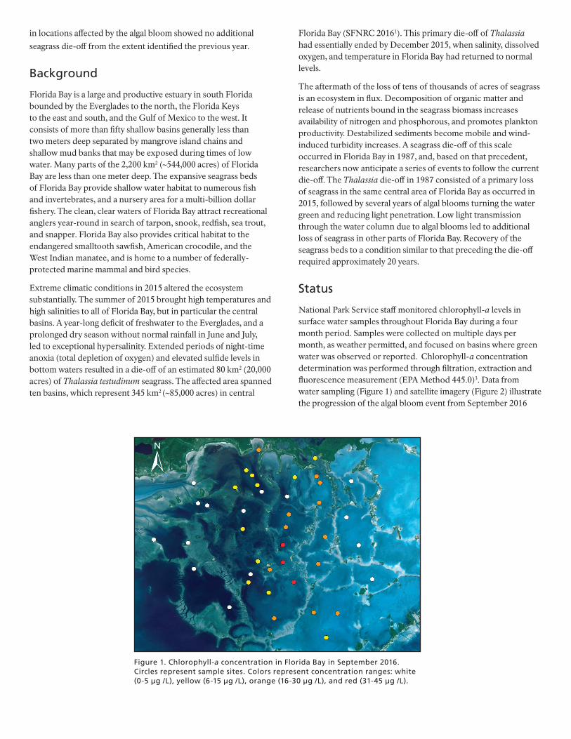
National Park Service staff monitored chlorophyll-a levels in surface water samples throughout Florida Bay during a four month period. Samples were collected on multiple days per month, as weather permitted, and focused on basins where green water was observed or reported. Chlorophyll-a concentration determination was performed through filtration, extraction and fluorescence measurement (EPA Method 445.0)3. Data from water sampling (Figure 1) and satellite imagery (Figure 2) illustrate the progression of the algal bloom event from September 2016
Figure 1. Chlorophyll-a concentration in Florida Bay in September 2016. Circles represent sample sites. Colors represent concentration ranges: white (0-5 µg /L), yellow (6-15 µg /L), orange (16-30 µg /L), and red (31-45 µg /L).

Figure 2. Satellite images of Florida Bay with indicators of algal bloom intensity (circles) and boundaries (dashed lines). Colored circles represent chlorophyll-a concentration ranges: white (0-5 µg /L), yellow (6-15 µg /L), orange (16-30 µg /L), red (31-45 µg /L), and pink (>45 µg /L). Dashed lines estimate the edges of bloom waters. Landsat 84 (A & D) and MODIS5 (B & C) images visualize the extent of the algal bloom from October 2016 through January 2017. Note: Images are not to equivalent scale.
A B
C D

through January 2017. Landsat 8 and MODIS satellite images reveal a spatial shift in the extent of the bloom from central basins in October to the western basins stretching to the southwest in November 2016. The highest concentrations occurred in Johnson Key basin in November 2016, and reached 64 μg/L. A lessening of chlorophyll-a concentrations throughout most central basins was seen in early December 2016, with an associated improvement in water clarity (Figure 3, above). The Rankin Lake area and Johnson Key and Rabbit Key basins, however, appeared to have a resurgence of blue-green algae (cell counts of 2 billion cells/liter) with high chlorophyll-a levels (30-50 μg/L) again briefly in late December 2016. By the end of January 2017, chlorophyll-a concentrations receded in all central basins of Florida Bay to a range of 0.3 to 4.0 μg/L. Associated physical measurements collected during the entire period of sampling reveal temperature, salinity, and dissolved oxygen to be within normal ranges. Green water was still visible in some eastern basins in late January extending from Terrapin Bay through Lignumvitae basin, and reaching the Atlantic Ocean around Lignumvitae Key and Lower Matecumbe Key, at chlorophyll-a concentrations less than 15 μg/L (Figure 2D).
Conclusion
As of February 2017, the algal bloom in the central basins of Florida Bay had receded. The bloom event peaked at chlorophyll levels rarely experienced in coastal ocean waters (chlorophyll-a in the 50s and 60s, μg/L), and then declined to lower, remnant levels (overall average, 1.3 μg/L) after four months. The green waters with increased phytoplankton appear to have circulated among basins and moved south and west over time. Factors that may affect the location of peak algal bloom include tides, wind, turbulence, nutrient availability, and localized rapid cell growth. Visual inspections of the seagrass at some sites where algal concentrations, and thus light attenuation, were high, did not show evidence of
significant seagrass mortality, and this may be because the algal bloom did not remain stationary for an extended period of time. Additional data from partner agencies will help evaluate the effects of the algal bloom over the coming months. The National Park Service will continue to monitor and report on water quality, the condition of seagrass beds, and habitat conditions in the coming months and years to advance our understanding of the complex interaction of ecological responses including carbon, sulfide and nutrient cycling, phytoplankton community dynamics, and recovery of seagrass and the bottom communities in Florida Bay.
References 1 SFNRC. 2016. South Florida Natural Resources Center, Everglades National
Park. 2015 Florida Bay Seagrass Die-Off. May 2016, 4pp .
2 Florida Administrative Code 62-302.532 Estuary-Specific Numeric
Interpretations of the Narrative Nutrient Criterion.
3 U.S. Environmental Protection Agency, Washington, DC. Method 445.0, In
Vitro Determination of Chlorophyll-a and Pheophytin in Marine and
Freshwater Algae by Fluorescence, 1997.
4 NASA Landsat Program 2016, Landsat 8 OLI scene
LC80150432016296LGN00, USGS, Sioux Falls, 10/22/2016
5 NASA Goddard Space Flight Center, Moderate-resolution Imaging
Spectroradiometer (MODIS) Aqua Reflectance Data; NASA OB.DAAC,
Greenbelt, MD, USA. doi: 10.5067/AQUA/MODIS/L3M/RRS/2014.
Figure 3. Relative water clarity as seen by Secchi Disk Depth (SDD) in Johnson Key basin. SDD=25 centimeters in November 2016 (left) and 130 centimeters (clear to the bottom) in early December 2016 (right).
March 2017 • South Florida Natural Resources Center • 950 N Krome Avenue • Homestead, FL 33030 • (305) 224 - 4200