Embed Size (px)
Citation preview

Yukon Forest HEALTH REPORT20
15


YUKON FOREST HEALTH REPORT 2015
Why We Have a Forest Health Program in Yukon ..................................................................... 1
Yukon Forest Health Monitoring Strategy .............................................................................. 1
Rotational Monitoring of Forest Health Zones ..................................................................... 1
Aerial Surveys and Ground Truthing as the Primary Tools for Monitoring ...................... 2
Identification of Major Forest Health Concerns of Yukon ......................................................3
Summary of 2015 Forest Heath Initiatives ............................................................................ 7
Forest Health Aerial Surveys in 2015 ........................................................................................... 7
Monitoring the Northward Expansion of the Mountain Pine Beetle .............................. 9
Monitoring Mountain Pine Beetle in 2015 .......................................................................... 10
Border Zone............................................................................................................................11
British Columbia Observations ........................................................................................14
Using Bait Traps ...................................................................................................................15
Forest Health Zone 3 ..........................................................................................................16
Forest Health Monitoring in 2015 ................................................................................................18
Biotic Disturbances ....................................................................................................................19
Aspen Serpentine Leafminer ............................................................................................21
Large Aspen Tortrix .............................................................................................................21
Willow Blotch Leaf Miner ................................................................................................. 27
Abiotic Disturbances ................................................................................................................ 27
Aspen Decline .................................................................................................................... 27
Flooding .................................................................................................................................30
Forest Health Zone 1 Large Aspen Tortrix Special Surveys ..............................................31
Ground Surveys ...................................................................................................................31
Other Noteworthy Disturbances in 2015 ............................................................................34
References .........................................................................................................................................36
TABLE OF CONTENTS
1
The Government of Yukon’s Forest Management branch (FMB) manages Yukon forests for sustainability and monitors and reports on forest health, which is a major component of forest management in the territory. The Forest Resources Act (FRA) supports forest health monitoring and recognizes that the long-term health of Yukon’s forests must be maintained and protected for the benefit of Yukon people and future generations.
Under section 34-2 of the FRA, the Director of the Forest Management branch may develop research and monitoring plans and programs to: a) investigate the spread, effect and control of insects and pests as it relates to the protection of forest resources; and b) support the advances in forest resource management. This includes monitoring plans such the risk-based Yukon Forest Health Monitoring Strategy adopted by FMB in 2009.
Yukon Forest Health Monitoring StrategyThe Yukon Forest Health Monitoring Strategy focuses on Yukon’s forest stands that are most susceptible to the 10 forest health agents of greatest concern. Since its implementation, the strategy has met the three priorities described below each year.
The objectives of the Yukon Forest Health Monitoring Strategy are:
1. To provide a Yukon-wide overview of forest health issues;
2. To focus monitoring activities on high-risk forest health concerns across forested landscapes that are considered the most value to Yukon residents; and
3. To monitor and assess forest health concerns and to determine and evaluate forest management responses.
As well, in the FRA Regulations (sections 81 and 82), there is a commitment from the Director to provide a written report on the status of forest health in Yukon (the annual Forest Health Report) to the Minister of Energy, Mines and Resources (EMR).
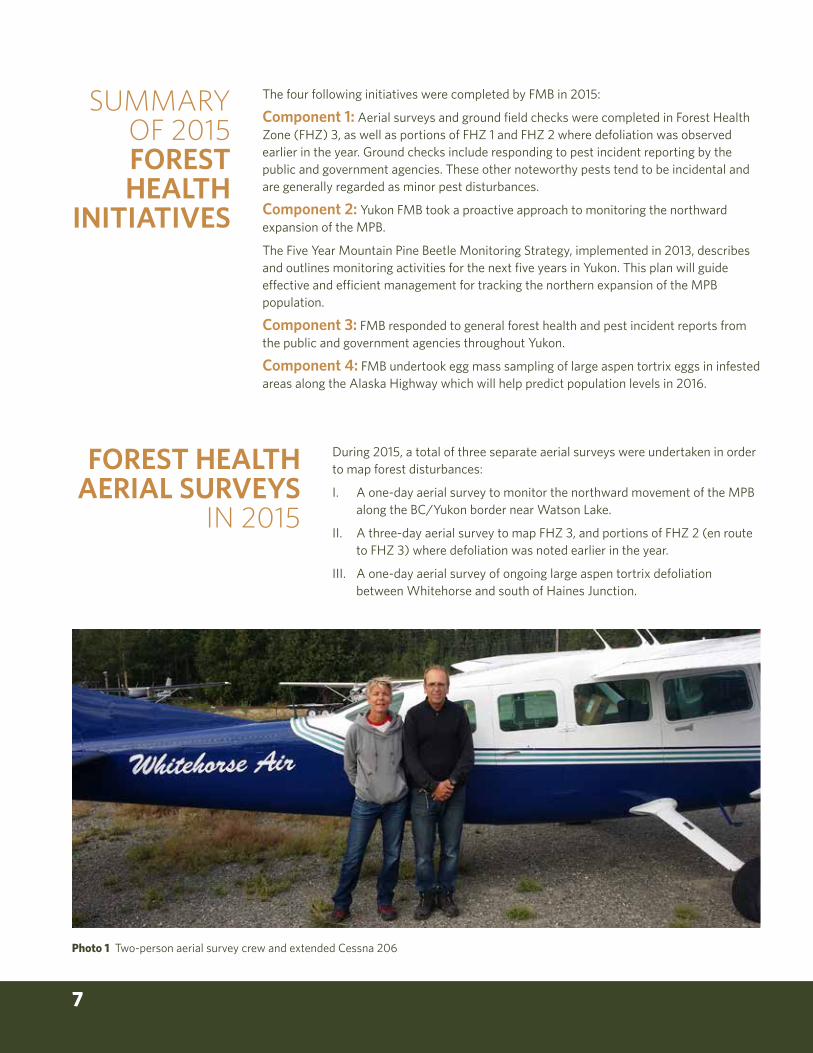
Rotational Monitoring of Forest Health ZonesYukon is divided into five forest health zones (Map 1). In these areas, monitoring focuses on forest stands that are the most susceptible to the 10 forest health agents of greatest concern. Each year since 2009, researchers have completed aerial surveys of one of the five zones.
In 2013, the fifth and last of the five zones was monitored. This year, being the seventh year of aerial surveys, marks the second year that a forest health zone has been resurveyed (two years of data). Given that baseline data has already been captured in each of the forest health zones, the mapping resolution from 2014 forward will be coarser, moving from eight km gridlines to 12 km gridlines. The only exception will be in years when significant pest activity has been noted.
WHY WE HAVE A FOREST HEALTH PROGRAM IN YUKON

YUKON FOREST HEALTH REPORT 2015 2
Aerial overview surveys and ground field checks are a relatively simple and low-cost method for effectively monitoring forest health over large areas (Ciesla, 2000; Mitton J.B. and M.C. Grant, 1980). Aerial overview surveys are also adequate for regional and provincial summaries and to meet national requirements for the Forest Health Network (BC Ministry of Forests, Lands and Mines and CFS, 2000).
As a result, aerial overview surveys are the primary tool for monitoring forest health in Yukon. The forest health aerial overview survey standards used by the BC Ministry of Forests, Lands and Natural Resource Operations are also used in Yukon, which ensures continuity across jurisdictions. Field checks are important for validating the data collected from the aerial surveys. Researchers check a portion of surveyed areas to confirm the identity and severity of the pest or disease disturbance.
Standards for Conducting Aerial Surveys
The following standards are used for conducing aerial surveys in Yukon:
• Use a Cessna 206 or equivalent high wing single engine airplane.
• Flying height of 800m above ground level.
• Aerial surveyors use 1:100,000 scale maps.
• Two qualified aerial surveyors (one positioned on each side of plane).
• Each surveyor oversees a four km wide corridor – in 2014 FMB modified this to a six km wide corridor given that baseline data has been captured for each forest health zone.
• Fly aerial surveys on clear days with sunny skies.
• Aerial surveyors map and record the severity and type of disturbance, such as:
• Dead and dying trees caused by bark beetles.
• Defoliation from insects and diseases such as budworm, leafminers or needle diseases.
• Stressed or dead trees from climatic factors such as flood, drought or wind-throw.
• Trees damaged by animals such as porcupines.
Aerial surveyors also use on-the-ground checks to confirm the type of disturbance recorded from the aerial surveys and digitize recorded mapping data to store in the Government of Yukon Geographic Information System.
AERIAL SURVEYS AND GROUND TRUTHING AS THE PRIMARY TOOLS FOR MONITORING

3
1. Spruce bark beetle (Dendroctonus rufipennis)—This bark beetle is the most damaging forest pest of mature spruce (Picea spp.) forests in Yukon. A spruce bark beetle outbreak in southwest Yukon that began around 1990 has killed more than half of the mature spruce forest (primarily white spruce [P. glauca]) over approximately 400,000 hectares (ha).
1a Grey trees stand level damage Haines Junction, YT.1b Adult spruce bark beetle.
2. Northern spruce engraver (Ips perturbatus)—The northern spruce engraver acts as both a secondary bark beetle that attacks trees infested with spruce bark beetle, as well as a primary pest that attacks and kills stressed spruce trees (primarily white spruce). The population of the northern spruce engraver beetle has increased in Yukon as a result of the increased availability of host trees associated with the spruce bark beetle outbreak in southwest Yukon. In 2008, infestations by the northern spruce engraver were at their greatest level since the beginning of forest health recording in Yukon. Spruce engraver beetle infestation was mapped in southwest Yukon at over 3,000 ha (Garbutt, 2014).
2a Single tree attack.2b Young adults and larva.
3. Western balsam bark beetle (Dryocoetes confusus)—This beetle attacks subalpine fir (Abies lasiocarpa). Western balsam bark beetle has moved north from BC in the late 1980s and has become an active disturbance agent in mature subalpine fir stands in southern Yukon.
3a Single tree attack Watson Lake. 3b Adult western balsam bark beetle.
In 2009, FMB determined the top 10 concerns that pose the greatest risk (i.e. extensive mortality or defoliation) to Yukon forests – ones that can be effectively monitored as part of a risk-based forest health monitoring program. Eight are insects, one is a pathogen, and the last is an environmental effect called drought stress.
All these concerns can effectively be monitored with aerial surveys because their damage to trees is very visible.
The following is a rationale (based on Ott, 2008) for the identification of major forest health concerns that pose the greatest risks to Yukon forests:
1a
1b
2a
2b
3a
3b
IDENTIFICATION OF MAJOR FOREST HEALTH CONCERNS OF YUKON

YUKON FOREST HEALTH REPORT 2015 4
4. Budworms (Choristoneura spp.)—The budworm guild, comprising of eastern spruce budworm, fir-spruce budworm, two-year cycle budworm and western black-headed budworm, cause similar defoliation damage to spruce, subalpine fir and larch (Larix laricina) forests in Yukon. In 2008, eastern spruce budworm damage was mapped across 1,000 ha in Yukon, primarily near Stewart Crossing. Historically, eastern spruce budworm damage has been mapped in the extreme southeast portion of Yukon (Garbutt, 2014).
4a Defoliation to tips of mature spruce trees Stewart Crossing, YT.4b Spruce budworm larva.
5. Larch sawfly (Pristiphora erichsonii)—This defoliator is the most damaging agent of larch in North America. In the mid and late 1990s, mature larch stands in southeast Yukon were heavily defoliated and experienced some mortality.
5 Larch sawfly larva.
6. Large aspen tortrix (Choristoneura conflictana)—This defoliator of trembling aspen (Populus tremuloides) periodically erupts into outbreaks that result in severe defoliation, branch dieback and, at times, extensive tree mortality. Outbreaks of large aspen tortrix have occurred in several places throughout Yukon, including Teslin Lake, Braeburn, Haines Junction, Pelly Crossing and Champagne.
6a Stand Level defoliation Haines Junction, YT.6b Adult moth large aspen tortrix.
7. Aspen serpentine leafminer (Phyllocnistis populiella)—This insect pest occurs throughout the Yukon range of trembling aspen and also defoliates balsam poplar (Populus balsamifera). Starting in the early 1990s, a massive outbreak of aspen serpentine leafminer extended from Alaska through Yukon, and into BC.
7a Stand level damage in Dawson City, YT.7b Leaf damage.
4a
4b
5
6a
6b
7a
7b

5
8a
8b
9a
9b
10
8. Pine needle cast (Lophodermella concolor)—This pathogen is the most common cause of premature needle loss of lodgepole pine (Pinus contorta) in Yukon (Garbutt, 2009). Pine stands in southeast Yukon are chronically infected and the disease is becoming increasingly common in central Yukon. In 2008, pine needle cast occurred from the BC border to the Continental Divide, Yukon. The most northern observation of needle cast was observed in young pine stands in the Minto Flats-McCabe Creek area in the Yukon interior (Ott, 2008). The most severe damage in these pine stands covered 477 ha (Garbutt, 2014).
8a Stand level damage of young pine Minto, YT.8b Damage to needles of young pine.
9. Mountain pine beetle (Dendroctonus ponderosae)—Though endemic to North America, this bark beetle is not present in Yukon. Most western pines in North America are suitable hosts, but lodgepole pine and ponderosa pine (P. ponderosa) are the most important host species (Logan and Powell, 2001). In western Canada, lodgepole pine is the primary host of this beetle (Campbell et al., 2007; Li et al., 2005).
Mountain pine beetle (MPB) is currently the most important forest health concern in western Canada. The current outbreak in BC is responsible for killing over 13 million ha of pine forests (Carroll, 2007). Cold-induced mortality is considered the most important factor controlling MPB dynamics (Régnière and Bentz 2007). A warming climate is expected to allow MPB to expand its range into higher elevations, eastward, and northward (Carroll et al., 2003; Régnière and Bentz 2007), potentially as far north as Yukon. Monitoring for MPB is a high priority because of its severe impact on pine forests during outbreaks and because of its confirmed proximity (80 km) to the Yukon border in 2011.
9a Mature Pine tree attack in Rocky Mountain Trench, BC.9b Surviving larva at base of tree in Rocky Mountain Trench, BC.
10. Tree dieback due to drought stress—Trembling aspen tends to occupy the driest sites in Yukon. Because of this, dry site aspen stands are expected to be the first to exhibit dieback due to drought stress in a warming climate. In 2008, aspen stands exhibiting dieback were scattered along the North Klondike Highway between Whitehorse and Stewart Crossing. Most of these stands were on dry, rocky slopes and bluffs with south and west aspects, although some were located on level ground with well-drained gravel soil. Aspen stands experiencing dieback tended to be in an open canopy and were often stunted. Those on the rocky slopes and bluffs typically were adjacent to treeless steppe plant communities which are found on sites too dry for trees to grow (Ott, 2008).
10 Dieback of Aspen, Mayo, YT.
For further information on these and other Yukon forest health disturbances please refer to the EMR forest health website at http://www.emr.gov.yk.ca/forestry/foresthealth.html. This website contains forest health brochures and annual reports prepared by EMR.

YUKON FOREST HEALTH REPORT 2015 6
MAP 1 Yukon Forest Health Monitoring Zones
!P
!P!P
!P
!P
!P
!P
!P!P
!P
!P
!P
!P
!P
!P
!P
!P
A L A S K A(U.S.A.)
NorthwestTerritories
British Columbia
PellyCrossing
Whitehorse
BurwashLanding Destruction Bay
B E A U F O R T S E A( A R C T I C O C E A N )
M A C K E N Z I EB A Y
P A C I F I CO C E A N
G r e a tB e a r
L k .
Nunavut
Zone 5
Zone 3
Zone 2
Zone 1
Zone 4
Labiche
MintoFaro
Mayo
Teslin
Old Crow
Carmacks
Carcross
Keno City
Ross River
Dawson City
Watson Lake
Eagle Plains
BeaverCreek
Haines Junction
StewartCrossing
0 100 20050
Km
1:5,250,000
North American Datum 1983UTM Zone 8N
Yukon, Canada
Forest HealthMonitoring Zones
February 17, 2016
Forest Monitoring Zones(One zone flown per year)
Zone 1
Zone 2
Zone 3
Zone 4
Zone 5
Map Grid (1:100,000/map)
Primary Highway
Secondary Highway
2015 MPB Survey Area
7
The four following initiatives were completed by FMB in 2015:
Component 1: Aerial surveys and ground field checks were completed in Forest Health Zone (FHZ) 3, as well as portions of FHZ 1 and FHZ 2 where defoliation was observed earlier in the year. Ground checks include responding to pest incident reporting by the public and government agencies. These other noteworthy pests tend to be incidental and are generally regarded as minor pest disturbances.
Component 2: Yukon FMB took a proactive approach to monitoring the northward expansion of the MPB.
The Five Year Mountain Pine Beetle Monitoring Strategy, implemented in 2013, describes and outlines monitoring activities for the next five years in Yukon. This plan will guide effective and efficient management for tracking the northern expansion of the MPB population.
Component 3: FMB responded to general forest health and pest incident reports from the public and government agencies throughout Yukon.
Component 4: FMB undertook egg mass sampling of large aspen tortrix eggs in infested areas along the Alaska Highway which will help predict population levels in 2016.
During 2015, a total of three separate aerial surveys were undertaken in order to map forest disturbances:
I. A one-day aerial survey to monitor the northward movement of the MPB along the BC/Yukon border near Watson Lake.
II. A three-day aerial survey to map FHZ 3, and portions of FHZ 2 (en route to FHZ 3) where defoliation was noted earlier in the year.
III. A one-day aerial survey of ongoing large aspen tortrix defoliation between Whitehorse and south of Haines Junction.
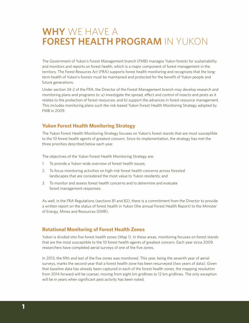
Photo 1 Two-person aerial survey crew and extended Cessna 206
FOREST HEALTH AERIAL SURVEYS
IN 2015
SUMMARY OF 2015 FOREST HEALTH
INITIATIVES
YUKON FOREST HEALTH REPORT 2015 8
!P
!P!P
!P
!P
!P
!P
!P!P
!P
!P
!P
!P
!P
!P
!P
!P
A L A S K A(U.S.A.)
NorthwestTerritories
British Columbia
BurwashLanding Destruction Bay
B E A U F O R T S E A( A R C T I C O C E A N )
M A C K E N Z I EB A Y
P A C I F I CO C E A N
G r e a tB e a r
L k .
Nunavut
Zone 5
Zone 3
Zone 2
Zone 1
Zone 4
PellyCrossing
Whitehorse
2015 MPB Survey Area
Faro
Mayo
Minto
Teslin
Labiche
Old Crow
Carmacks
Carcross
Keno City
Ross River
Dawson City
Watson Lake
Eagle Plains
BeaverCreek
Haines Junction
StewartCrossing
0 100 20050
Km
1:5,250,000
North American Datum 1983UTM Zone 8N
Yukon, Canada
Forest HealthAerial Survey
February 17, 2016
Aerial Survey Year Flown20102011201220132014 (Second rotation)2015 (Second rotation)
Forest Monitoring Zones(One zone flown per year)
Zone 1
Zone 2
Zone 3
Zone 4
Zone 5
Map Grid (1:100,000/map)
Primary Highway
Secondary Highway
MAP 2 Yukon Forest Health Aerial Surveys by year (2010 – 2015)

9
Concerned about the northward expansion of the Mountain Beetle (MPB), the Government of Yukon has developed a risk analysis and subsequent monitoring strategy to track the northern movement of this bark beetle. Below is a history of response to MPB by Government of Yukon:
• A National Risk Assessment of the threat of MPB to Canada’s boreal and eastern pine forests was completed in 2007 by the Canadian Forest Service (CFS).
• In 2009, the Government of Yukon’s FMB implemented the Yukon Forest Health Strategy that is in line with the National Forest Pest Strategy (NFPS).
• From 2009 until present, both FMB and British Columbia’s Ministry of Forests, Lands and Natural Resource Operations have been conducting aerial surveys together. MPB bait trapping has also been conducted each year.
• The Government of Yukon Interdepartmental Mountain Pine Beetle Committee, formed in 2011, provided direction and developed strategies to monitor and manage MPB in the future.
• The MPB committee completed a Yukon specific pest risk analysis in 2012, “Mountain Pine Beetle Pest Risk Analysis for Yukon Lodgepole Pine Forests’’
• From this risk analysis, a five year mountain pine beetle monitoring plan and strategy (Mountain Pine Beetle Monitoring Plan for Yukon Lodgepole Pine Forests 2013-2018) was developed and implemented in 2013
The mountain pine beetle is a native North American bark beetle that is distributed throughout most of the range of lodgepole pine in British Columbia. Historically, climate has impeded its expansion northward and until the current outbreak, was only recorded south of 56°N. The MPB is currently the single biggest forest health concern in western Canada. The current MPB outbreak is responsible for killing over 13 million ha of pine forest in BC alone.
The MPB is one of ten forest health agents that pose the greatest risk to Yukon forests. It can be effectively monitored as part of a risk-based forest health monitoring program. As such, FMB has taken a proactive approach to managing the threat posed by the northward expansion of the MPB from British Columbia. Although the MPB has not expanded into Yukon yet, it moved quickly northwards within the Rocky Mountain Trench (RMT) in northern BC during the peak of the BC outbreak. The RMT represents a potential pathway of MPB into Yukon given the availability of susceptible host and lack of geographic barriers.
Climate plays an important role in the population of MPB. One of the most important factors in controlling the northern movement of MPB is cold weather and an inner bark temperature of -40˚C for at least one week. Mild winter weather allows overwintering MPB populations to thrive and the outbreak to continue. Unseasonably warm, dry springs and summers have likely also played an important role in the expansion of the beetle, possibly allowing for earlier emergence and mating in the spring and summer (Mitton and Ferrenberg, 2012).
MONITORING THE NORTHWARD EXPANSION OF THE MOUNTAIN PINE BEETLE
YUKON FOREST HEALTH REPORT 2015 10
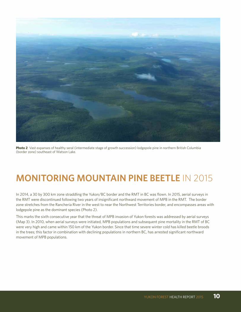
Photo 2 Vast expanses of healthy seral (intermediate stage of growth succession) lodgepole pine in northern British Columbia (border zone) southeast of Watson Lake.
In 2014, a 30 by 300 km zone straddling the Yukon/BC border and the RMT in BC was flown. In 2015, aerial surveys in the RMT were discontinued following two years of insignificant northward movement of MPB in the RMT. The border zone stretches from the Rancheria River in the west to near the Northwest Territories border, and encompasses areas with lodgepole pine as the dominant species (Photo 2).
This marks the sixth consecutive year that the threat of MPB invasion of Yukon forests was addressed by aerial surveys (Map 3). In 2010, when aerial surveys were initiated, MPB populations and subsequent pine mortality in the RMT of BC were very high and came within 150 km of the Yukon border. Since that time severe winter cold has killed beetle broods in the trees; this factor in combination with declining populations in northern BC, has arrested significant northward movement of MPB populations.
MONITORING MOUNTAIN PINE BEETLE IN 2015
11
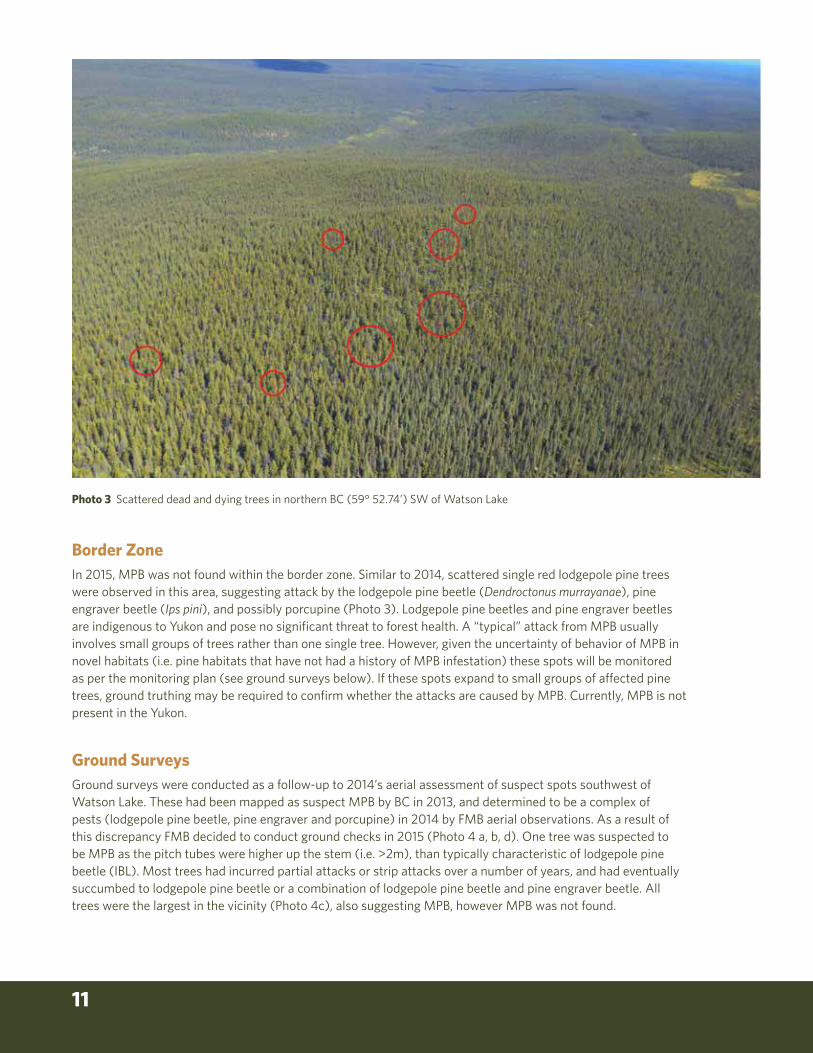
Photo 3 Scattered dead and dying trees in northern BC (59° 52.74’) SW of Watson Lake
Ground SurveysGround surveys were conducted as a follow-up to 2014’s aerial assessment of suspect spots southwest of Watson Lake. These had been mapped as suspect MPB by BC in 2013, and determined to be a complex of pests (lodgepole pine beetle, pine engraver and porcupine) in 2014 by FMB aerial observations. As a result of this discrepancy FMB decided to conduct ground checks in 2015 (Photo 4 a, b, d). One tree was suspected to be MPB as the pitch tubes were higher up the stem (i.e. >2m), than typically characteristic of lodgepole pine beetle (IBL). Most trees had incurred partial attacks or strip attacks over a number of years, and had eventually succumbed to lodgepole pine beetle or a combination of lodgepole pine beetle and pine engraver beetle. All trees were the largest in the vicinity (Photo 4c), also suggesting MPB, however MPB was not found.
Border Zone
In 2015, MPB was not found within the border zone. Similar to 2014, scattered single red lodgepole pine trees were observed in this area, suggesting attack by the lodgepole pine beetle (Dendroctonus murrayanae), pine engraver beetle (Ips pini), and possibly porcupine (Photo 3). Lodgepole pine beetles and pine engraver beetles are indigenous to Yukon and pose no significant threat to forest health. A “typical” attack from MPB usually involves small groups of trees rather than one single tree. However, given the uncertainty of behavior of MPB in novel habitats (i.e. pine habitats that have not had a history of MPB infestation) these spots will be monitored as per the monitoring plan (see ground surveys below). If these spots expand to small groups of affected pine trees, ground truthing may be required to confirm whether the attacks are caused by MPB. Currently, MPB is not present in the Yukon.

YUKON FOREST HEALTH REPORT 2015 12
Photo 4 Top left – failed adult galleries. Top right – attacks on lower bole typical of lodgepole pine beetle. Lower left – largest diameter trees in stand attacked. Lower right – fresh IBL pitch tubes

13
!(
!(
!(
Fort
Nel
son
Yuko
n
Brit
ish
Col
umbi
a
Nor
thw
est
Terr
itorie
s
Alb
erta
Wat
son
Lake
Rai
nbow
Lake
Nea
rest
201
5 sp
ots
to Y
ukon
Alas
ka
Highway
Liar
d
Highway
2015
MPB
Bord
erM
onito
ring
Zone
H y l a n d R i v e r
Liard
River
Fo
rtN
el s
on
R
i ve r
ToadRiver
Fort
Lia
rd
050
Kilo
met
ers
Nor
ther
n B
C M
ount
ain
Pine
Bee
tle20
15 P
olyg
on
2014
Pol
ygon
2013
Pol
ygon
2015
Poi
nt
2014
Poi
nt
2013
Poi
nt
* P
oint
dat
a re
pres
ents
a di
stur
banc
e of
less
than
0.5
hec
tare
s
MA
P 3
M
ount
ain
pine
bee
tle in
nor
ther
n BC
, inc
ludi
ng th
e Ro
cky
Mou
ntai
n Tr
ench
, fro
m 2
013
-20
15, a
nd Y
ukon
FM
B 20
15
bord
er z
one
aeri
al s
urve
y fli
ght l
ine.
Not
e 20
15 d
ata
base
d on
pre
limin
ary
BC re
sults
.

YUKON FOREST HEALTH REPORT 2015 14
British Columbia ObservationsBC’s Ministry of Forests, Lands and Natural Resource Operations also conduct aerial surveys in northern BC. These surveys have found that since 2013, populations in the northern RMT have retreated significantly (with only a few spots noted in 2015), approximately 106 km south of the BC/Yukon border (Map 3). The largest concentration of MPB is now 280 km south of the BC/Yukon border (Map 3).
Based on 2015 aerial survey results, it appears that populations are contracting somewhat in north east BC near the NWT/AB border (Map 3). Westward migration from these infested areas will likely be halted or significantly slowed by the vast young pine stands that resulted from the 1982 “Egg Fire” that burned over 100 000 hectares of mature pine. These young stands will not support an MPB population; they will act as sinks rather than sources given the smaller diameter and thin bark.
During the course of its recent northward advance, MPB has encountered “naïve” pine. These are pine stands that have no prior experience with MPB and thus have none of the genetic defenses of southern pine trees that co-evolved with the MPB. Preliminary research indicates that “naïve” pine trees may have lower resistance and greater MPB production capacity. However the beetle remains susceptible to extended cold periods of -40°C which cause high levels of brood mortality, especially if they occur in early or late winter. This has already been witnessed in the RMT, reinforcing the lethal effect of harsh cold winters on beetle populations. This aspect will likely continue to influence the beetle’s success or failure as it moves farther north.
While there has been a decrease in the northward movement of MPB for three consecutive years, if favorable weather occurs for a few years in a row, populations could increase (Bleiker, 2012 pers com). MPB is an opportunistic species and a large pool of susceptible hosts is present. A possible future scenario could result in small remnant populations surviving and crossing the BC/Yukon border into southeast Yukon and killing scattered individual trees or small groups of trees. According to the MPB risk analysis conducted for Yukon, this could occur within the next five to twenty years. However it seems that for now, the imminent threat from the current outbreak in BC has subsided.
15
!P
!P!P!P
!(
!(
!(
!(!(
!(
!(
!(!( !(!(
!(!(
!(!(
!(!(!(!(
!(!(!(
!(!(!( !(!(!(!(!(!(!(!(!(!(!(!(
!(!(!(
!(!(!(
!(!(!(!(!(!(
!(!(!(
!(
!(!(
!(!(!(
!(!(
!(!(!(!(
!(!(!(
!(!(!( !(!(!(!(!(!(!(!(!(!(!(!(
!(!(!(
!(!(!(
!(!(!(!(!(!(
!(!(!(
!(
!(!(
!(!(!(
!(!(
!(!(!(!(
British Columbia
Whitehorse Yukon
Carcross
Teslin Watson Lake
Cas
siar
Hi g
hway
Highway
Alaska
Robert C
ampbell H
ighway
0 50
Kilometers
2015 MPB Bait Locations
MAP 4 Mountain pine beetle monitoring bait trap locations in southern Yukon and BC.
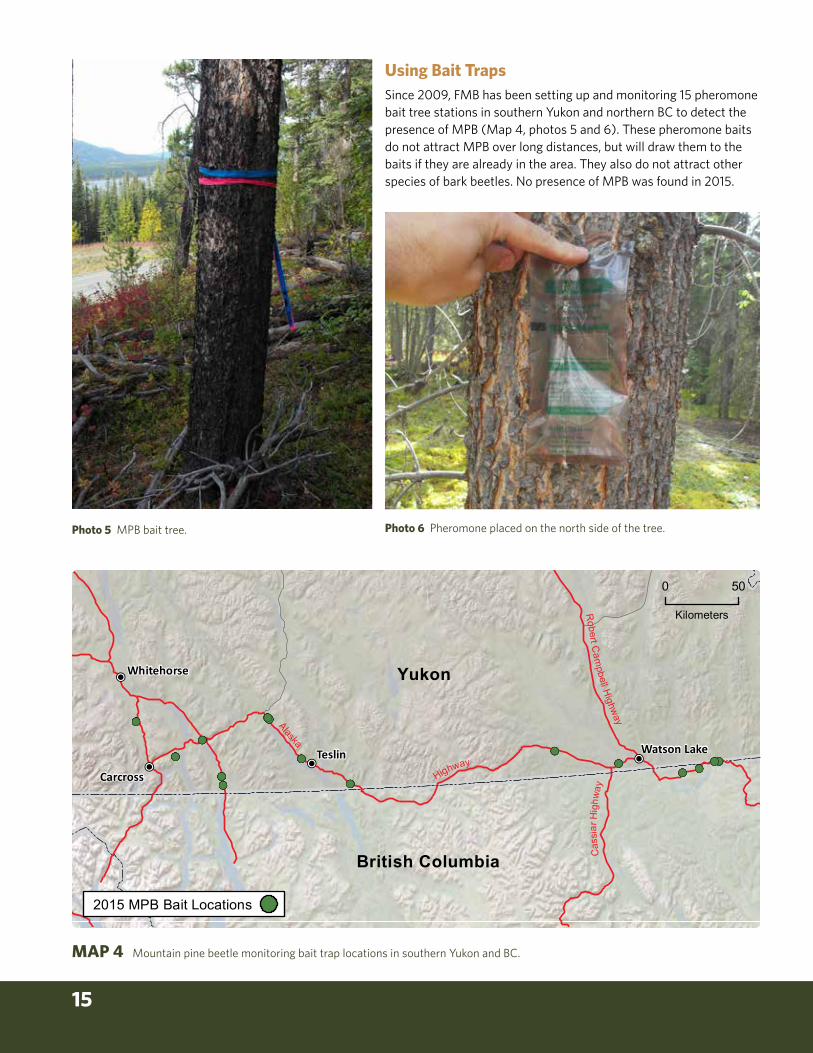
Using Bait TrapsSince 2009, FMB has been setting up and monitoring 15 pheromone bait tree stations in southern Yukon and northern BC to detect the presence of MPB (Map 4, photos 5 and 6). These pheromone baits do not attract MPB over long distances, but will draw them to the baits if they are already in the area. They also do not attract other species of bark beetles. No presence of MPB was found in 2015.
Photo 5 MPB bait tree. Photo 6 Pheromone placed on the north side of the tree.

YUKON FOREST HEALTH REPORT 2015 16
MAP 5 Aerial survey flight lines in 2015 over Forest Health Zone 3, and the highway corridor in Forest Health Zone 2 leading into FHZ 3.
Forest Health Zone 3A three-day aerial survey of the forested area within FHZ 3, and the highway corridor in FHZ 2 leading into FHZ 3, was flown using an extended Cessna 206 fixed-wing aircraft (Map 5). FHZ 1 and FHZ 2 were flown in 2015 due to visible defoliation along their respective highway corridors.
FHZ 3 includes a section of the Porcupine River drainage basin. This is a large area bounded on the south (approximately) by latitude 62° 45’ North, extending northward to latitude 65° 30’ North. To the east it is bound by the Hart River and the Stewart River and the Alaska border to the west. Much of this zone, in particular the northern Ogilvie Mountains, lies within the taiga cordillera ecozone (Photo 7), with only narrow strips of forested land in the river drainages (Photo 8). The remainder lies within the boreal cordillera ecozone, where up to 80% of the forests had been burned within the past 30 years (Photo 9). Given the harsher climate and lack of forest continuity, forest health biotic concerns are not very diverse (Photo 10).
The area was flown in an east-west grid pattern with 12 km between grids, allowing each surveyor to map 6 km on either side of the plane (Map 5). Given that FHZ 3 was surveyed in 2009, it is possible to assess trends over time by comparing pest activity in 2009 and 2015 (Table 1).
Sc rogg ie
Cr eek
C l ea r
R i v e r
Reid Lakes
Riv
er
No rth
W au gh
F o r t y m i l e
North
Ri v e r
Cr ee k
C h a n d i n d u
Gran
d
No
rth
Brew
ery
We s
t
R i v e r
Ri v er
La
du
e
F o r t y m i l e
R iver
K l ondike
Cr ee k
Creek
P ir at e
Ham
i lt on
Cr ee k
R
Ha r t
Wil l o
w
Cr ee k
R
E ag l e
R
Si x
t y
Ri v er
R I V E R
Blac k
Creek
Riv
er
O g i l v i e
Cr ee k
C k
YU
KO
N
Tat o nd uk
Mile
Fi f
t een
mil e
I n d i a n
R
Cre
ek
Ro s e b ud
Kl o
nd
i ke
Cr ee k
Ri v
er
La k e
Cr ee k
La k e
Ha r t
Riv
er
Na
t i o n
Riv er
Riv
er
S wed e
River
Bl a
c k s t o ne
Ck
S TE
WA
RT
S n a g
La due
C r e e k
K a n d i k
Cr eek
Cr ee k
YU
KO
N
Ro
ck
W a l ha l la
M c Q u e s t e n
R a e
Cr ee k
Diamain Lake
RI
VE
R
Ri v
e r
Ma
tso
n
Ck
Hi ll s
Va l le y
Ck
M o os e
Creek
C r o o k e d
R i v e r
C r e e k
McQ
ue st en
N A H O N I
R A N G E
Ice ChestMountain
NorthForkPass
Glacier Mtn
P L A T E A U
O G I L V I E
M O U N T A I N S
Australia Mtn
Mt Sether
Mt Ina
King SolomonDome
WI
LL
OW
HI
LL
S
MountAdami
RedMountain
WeinerwurstMtn
GraniteCanyon
Selwyn Dome
CassiarDomeBaldyMtn
Mount Klotz
MountTyrrell
MountGladman
PtarmiganMountain
KL
ON
DI
KE
TI
NT
IN
A
MountMcCullum
DA
W
SO
N
RA
NG
E
Henderson Dome
GrizzlyDome
Mount Hart
Seela Pass
Flat Top
WestRidge
Reindeer Mountain
ShamrockDome
MountJeckell
Mt Harper
VolcanoMountain
Mount Stewart
PyroxeneMountain
MountBaker
Rough Top
Mount Cockfield
TR
EN
CH
!(
!
!
FHZ 3
Stewart Crossing
Dawson City
ALA
SK
A
Klondike
Highway
Dem
pste
r
Hig
hway
0 50
Kilometers
2015 FlightlinesEcozonesBoreal CordilleraTaiga Cordillera

17
Photo 7 Taiga cordillera ecozone in the
northern portion of FHZ 3.
Photo 8 Scattered forests
transitioning from boreal cordillera
into taiga cordillera in the northern
portion of FHZ 3.
Photo 9 Wildfire damage
north of Dawson City.
YUKON FOREST HEALTH REPORT 2015 18
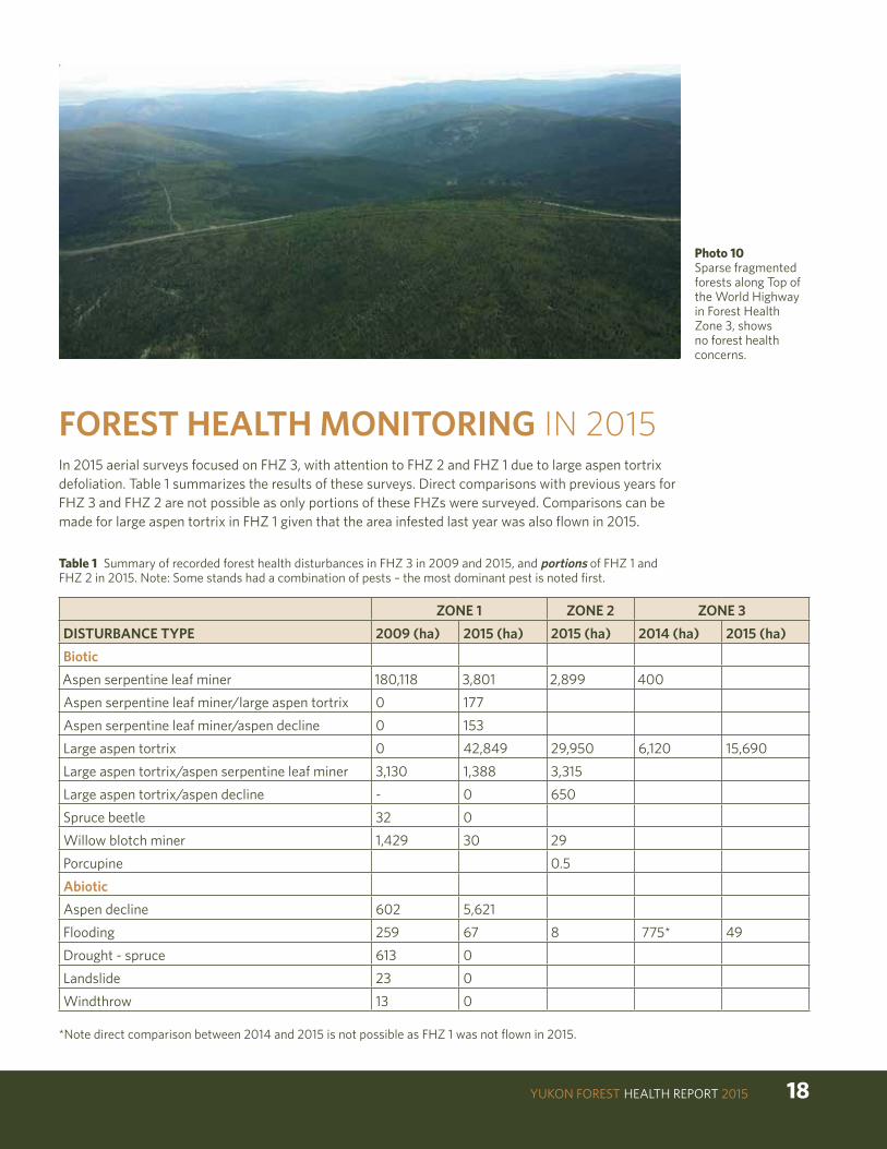
In 2015 aerial surveys focused on FHZ 3, with attention to FHZ 2 and FHZ 1 due to large aspen tortrix defoliation. Table 1 summarizes the results of these surveys. Direct comparisons with previous years for FHZ 3 and FHZ 2 are not possible as only portions of these FHZs were surveyed. Comparisons can be made for large aspen tortrix in FHZ 1 given that the area infested last year was also flown in 2015.
FOREST HEALTH MONITORING IN 2015
Table 1 Summary of recorded forest health disturbances in FHZ 3 in 2009 and 2015, and portions of FHZ 1 and FHZ 2 in 2015. Note: Some stands had a combination of pests – the most dominant pest is noted first.
ZONE 1 ZONE 2 ZONE 3
DISTURBANCE TYPE 2009 (ha) 2015 (ha) 2015 (ha) 2014 (ha) 2015 (ha)
Biotic
Aspen serpentine leaf miner 180,118 3,801 2,899 400
Aspen serpentine leaf miner/large aspen tortrix 0 177
Aspen serpentine leaf miner/aspen decline 0 153
Large aspen tortrix 0 42,849 29,950 6,120 15,690
Large aspen tortrix/aspen serpentine leaf miner 3,130 1,388 3,315
Large aspen tortrix/aspen decline - 0 650
Spruce beetle 32 0
Willow blotch miner 1,429 30 29
Porcupine 0.5
Abiotic
Aspen decline 602 5,621
Flooding 259 67 8 775* 49
Drought - spruce 613 0
Landslide 23 0
Windthrow 13 0
Photo 10 Sparse fragmented forests along Top of the World Highway in Forest Health Zone 3, shows no forest health concerns.
*Note direct comparison between 2014 and 2015 is not possible as FHZ 1 was not flown in 2015.

19
BIOTIC DISTURBANCESAspen Serpentine Leafminer (Phyllocnistis populiella)
The aspen serpentine leafminer is a defoliator of trembling aspen and is common throughout the host range in Yukon. The leafminer’s activities were first recorded in the early 1950s along the Alaska Highway. At endemic levels, single leaf infestation is common but whole tree infestation occurs during outbreaks. Current outbreaks in Alaska and Yukon have impacted hundreds of thousands of hectares of mature and immature aspen. Ten to twenty years of unprecedentedly severe leafminer defoliation has occurred in stands of aspen along the Silver Trail between Mayo and Stewart Crossing.
While the aspen serpentine leafminer rarely causes tree mortality, tell-tale signs of silvery foliage and reduced growth can be seen along most of the highways in Yukon. In general, trees infested by aspen serpentine leafminer will only die if already stressed by factors such as past infestation by large aspen tortrix (Choristoneura conflictana).
Overall in Yukon the area infested by the aspen serpentine leafminer continues to decline, with 2015 marking the fourth consecutive year with minimal activity by this insect pest.
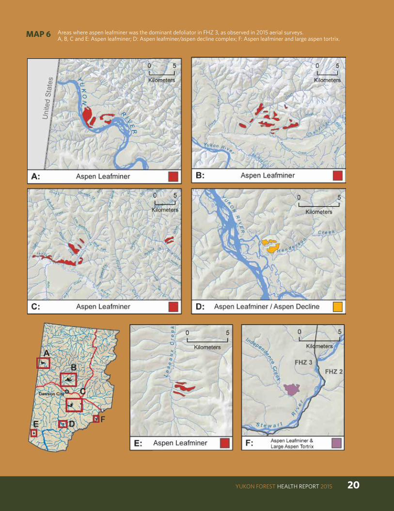
Zone 3Significant decreases in the aspen serpentine leaf miner infestation occurred from 2009 to 2015; the infestation declined from 180,118 ha in 2009 to approximately 4,131 ha in 2015; 92% of the affected area was identified solely as aspen serpentine leaf miner, and 4% each in association with large aspen tortrix, and with aspen decline (Map 6). The majority of solo aspen serpentine leaf miner was recorded in the vicinity of Dawson City, and a small patch in the southwest portion near Leseaux Creek. An additional 1,388 ha of aspen leaf miner was mapped in areas where large aspen tortrix dominated (see large aspen tortrix section).
YUKON FOREST HEALTH REPORT 2015 20
MAP 6 Areas where aspen leafminer was the dominant defoliator in FHZ 3, as observed in 2015 aerial surveys. A, B, C and E: Aspen leafminer; D: Aspen leafminer/aspen decline complex; F: Aspen leafminer and large aspen tortrix.
21
Large Aspen Tortrix
Native to North America, the large aspen tortrix is found throughout trembling aspen range. Before 1990 and the onset of the spruce bark beetle infestation in the southwest Yukon, it was the single most common cause of insect-based disturbance in Yukon forests. In FHZ 1 the last outbreak was prior to 1990, and occurred in stands just north of Haines Junction. In FHZ 2 and FHZ 3 the last recorded outbreak occurred from 1975 to 1981, in aspen stands between McQuesten and Dawson City.
This insect completes its life cycle in a single year. During that time, larvae pass through five developmental stages, known as instars, before reaching maturity. At the end of each instar, larvae shed their skins and re-emerge as the next larger stage. Small second instar larvae emerge from the tents they have spun for winter quarters in late May or early June and feed on the emerging buds and leaves of the aspen trees. In some instances, initial feeding damages the buds to the extent that they fail to flush. At the third instar stage of larval development, they roll the leaves and continue until they complete larval development (Photo 11). Pupation occurs normally at the leaf edge in late June. Adults emerge after about ten days and mate. Then females lay eggs in small masses on the upper surfaces of leaves. Eggs hatch in early August. After hatching, early instar larvae feed on leaf surfaces until late August. Then at the second instar stage, they hide in the bark crevices. Here they spin webs (hibernacula) for overwinter shelter and enter a hibernation stage known as diapause. At this stage, the water in their cells is replaced with glycol (antifreeze) which allows them to withstand winter temperatures as cold as -27°C.
The life history of this insect places it in direct competition with the aspen serpentine leafminer. This inter-specific competition (individuals of different species compete for the same resource) may be contributing to the success of large aspen tortrix in 2015 as aspen serpentine leafminer populations have declined significantly over the last two years.
The outbreak in FHZ 1 has been ongoing for four years, and has just recently begun in both FHZ 2 and FHZ 3.
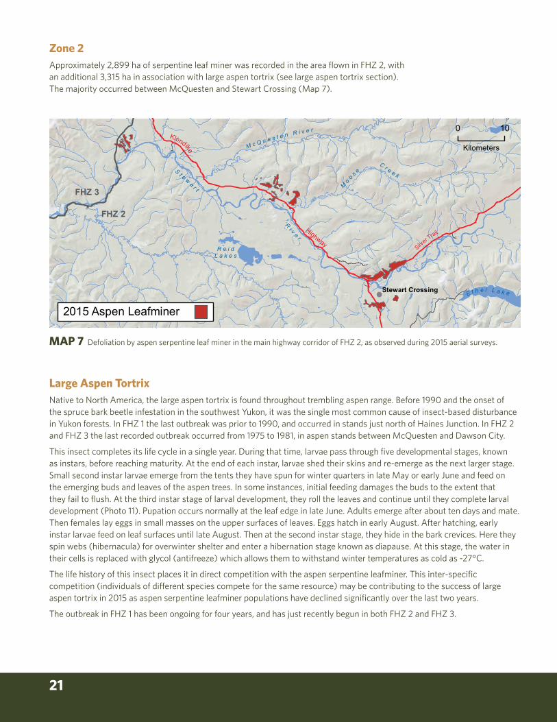
Zone 2Approximately 2,899 ha of serpentine leaf miner was recorded in the area flown in FHZ 2, with an additional 3,315 ha in association with large aspen tortrix (see large aspen tortrix section). The majority occurred between McQuesten and Stewart Crossing (Map 7).
!
FHZ 3
FHZ 2
Klondike
Highway
M c Q u e s t e n R i v e r
S t e wa r t
Ri v e r
Mo o s e
C r e e k
Stewart Crossing
R e i dL a k e s
E t h e l L a k e
2015 Aspen Leafminer
Silver Trail
0 10
Kilometers
MAP 7 Defoliation by aspen serpentine leaf miner in the main highway corridor of FHZ 2, as observed during 2015 aerial surveys.

YUKON FOREST HEALTH REPORT 2015 22
Photo 11 Third instar larvae of large aspen tortrix on fully defoliated leaf.
Zone 3In 2015 a significant increase in the area defoliated by Large Aspen Tortrix was noted, from no recorded defoliation in 2009 to 44,237 ha in 2015. A small portion (<3%) occurred in combination with aspen serpentine leaf miner. The majority of defoliation occurred in trembling aspen stands along the Klondike Highway Corridor, with the most severely defoliated stands near Two Sisters Hill, Australia Creek, and Strickland Lake. (Map 8, Photo 12). These stands, between McQuesten and Dempster Highway, were also defoliated during the last recorded outbreak between 1975 and 1981.

23
!(
FHZ 3
FHZ 2
Dawson City
Dempster Highw
ay
K l o n d i k e R i v e r
I n d i a n
R i v e r
McQ u e s t e n R i v e r
St e
wa
r t
R i v e r
Large Aspen Tortrix
Large Aspen Tortrix & Aspen Leaf Miner
Klondike
Highway
0 10
Kilometers
Photo 12 Moderate to severe large aspen tortrix defoliation in FHZ 3, just west of Strickland Lake along the Klondike Highway.
MAP 8 Extent of large aspen tortrix defoliation (green), and mix with aspen serpentine leaf miner (red) in FHZ 3, as observed in 2015 aerial surveys.

YUKON FOREST HEALTH REPORT 2015 24
Photo 13 Light to moderate defoliation by large aspen tortrix in FHZ 2 north of Pelly Crossing, near Summit Lake.
Zone 2Approximately 29,950 ha of light to severe defoliation by large aspen tortrix occurred in trembling aspen stands between Pelly Crossing and the FHZ 3 border at Barrett Pond (Photo 13). An additional 3,315 ha of defoliation (mixed with aspen serpentine leaf miner), and 650 ha with aspen decline were recorded in FHZ 2.
Zone 1Aerial surveys found a significant increase in area defoliated by large aspen tortrix from 6,120 ha in 2014, to 15,690 ha in 2015. The area infested included areas previously defoliated as well as expansion south of Haines Junction to Dezadeash Lake, north up the Mendenhall River and south of Canyon (Map 9). Over the last 15 years approximately 21,370 ha (non-cumulative) have been defoliated by large aspen tortrix in FHZ 1 (Table 2).
Stem mortality and growth losses are directly related to the intensity and duration of defoliation events and overall tree health. Therefore, despite the fact that this outbreak has been ongoing for four consecutive years, impacts may be minor as only 20 per cent of the stands have been infested for more than one year. Of this 20 per cent, 18 per cent has been for two consecutive years, one per cent for three consecutive years, and one per cent for four consecutive years (Table 2, Map 10). Trembling aspen on poor sites or those predisposed by other disturbances, including abiotic, are likely to be those which will see the largest impact.
MAXIMUM CONSECUTIVE YEARS
AREA (ha)
%
1 17,195 80
2 3,746 18
3 225 1
4 205 1
Total 21,370
Table 2 Maximum consecutive years of large aspen tortrix defoliation in trembling aspen stands in FHZ 1 from 2000 to 2015.

25
!(H
aine
s Ju
nctio
n
Alas
kaHigh
way
Haines
Road
De
za
de
as
h
Ri v
er
De
zad
ea
sh
La
ke
Pi n
e L
ak
e
Ai s
hih
i kL
ake
Ka
thl e
en
La
ke
Ku s a w a L a k e
Tay e
Lak
e
Klo
oL
ake
2015
Lar
ge A
spen
Tor
trix
2014
Lar
ge A
spen
Tor
trix
010
Kilo
met
ers
MA
P 9
Are
a de
folia
ted
by la
rge
aspe
n to
rtri
x in
20
14 a
nd 2
015
in F
HZ
1.

YUKON FOREST HEALTH REPORT 2015 26
MA
P 10
M
axim
um c
onse
cutiv
e ye
ars
of d
efol
iatio
n by
larg
e as
pen
tort
rix
in tr
embl
ing
aspe
n st
ands
in F
HZ
1 fr
om 2
00
0 to
20
15.
!(H
aine
s Ju
nctio
n
Haines
Road
Ala
ska
Highway
De
za
de
as
h
Ri v
er
De
zad
ea
sh
La
ke
Pi n
e L
ak
e
Ai s
hih
i kL
ake
Ka
thl e
en
La
ke
Ku s a w a L a k e
Tay e
Lak
e
Klo
oL
ake
Kl o
oL
ake
Num
ber o
f con
secu
tive
year
s w
here
larg
e as
pen
tortr
ix a
ttack
s oc
curr
ed.
12
34
010
Kilo
met
ers
Max
imum
Co
nsec
utiv
e Ye
ars
Area
(ha)
%
117
,195
802
3,74
618
322
51
420
51
Tota
l21
,370

27
ABIOTIC DISTURBANCESTrembling Aspen Decline
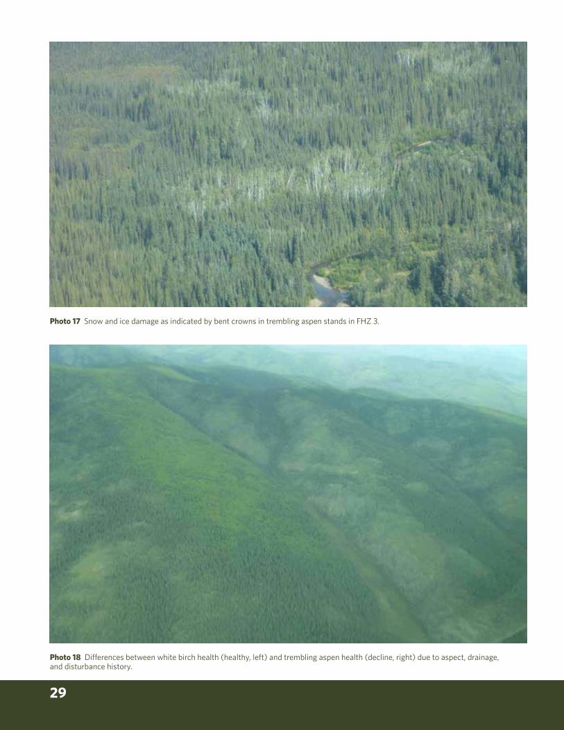
Zone 3Aspen decline was observed over approximately 5,621 ha, mostly between Dawson City and the Dempster Highway (Photos 15 and 16) with small pockets scattered about in southern portions of FHZ 3, some of which occurred in combination with aspen serpentine leaf miner and large aspen tortrix. It has no single causal agent as both biotic and abiotic factors contribute to decline, however research in affected forests in Alberta (Hogg, Brandt and Kochtubajda, 2002; Michaelian et al 2011) and the United States (Worrall et al, 2010) indicates that drought and insects (defoliators and wood borers) are major contributing factors. Some stands mapped in 2015 also appeared to have ice and snow damage (Photo 17).
As climate continues to warm, drought events become more frequent, and insect disturbance frequency and severity change, mortality of trembling aspen is likely to continue. The ability for aspen stands to recover will be dependent upon the extent of root damage. White birch may be better adapted depending upon the disturbance factors and severity involved (Photo 18). Ongoing monitoring of these forests, for examination of climate impacts on health and productivity of aspen, will help explain the factors involved and the extent of and changes to damage levels.
Willow blotch leaf miner
Zone 3Only 2 small patches, totaling approximately 29 ha, of willow blotch leaf miner were mapped near Stewart Crossing (Photo 14). This is down significantly from 1,429 ha mapped in 2009.
Photo 14 Willow blotch leaf miner damage.

YUKON FOREST HEALTH REPORT 2015 28
Photo 15 Aspen decline NE of Dawson City – note whitish hue indicates dead stem or crown rather than the pinkish brown hue typical of current year defoliation.
Photo 16 Aspen decline NE of Dawson City.
29
Photo 18 Differences between white birch health (healthy, left) and trembling aspen health (decline, right) due to aspect, drainage, and disturbance history.
Photo 17 Snow and ice damage as indicated by bent crowns in trembling aspen stands in FHZ 3.

YUKON FOREST HEALTH REPORT 2015 30
FLOODINGZone 3Six patches of flooding along waterways in FHZ 3 occurred mostly in spruce stands, and totalled approximately 67 ha. The largest patch was along the Chandindu River, west of Dawson City, with smaller patches throughout FHZ 3 (Photo 19).
Zone 2Flooding damage to spruce was mapped in an 8 ha patch along the Stewart River, west of McQuesten.
Zone 1Flooding damage to spruce was mapped in a 49 ha patch along the Aishihik River.
Photo 19 Flooding damage to spruce along the Excelsior Creek, NW of Stewart River.

31
FOREST HEALTH ZONE 1 Large Aspen Tortrix Special Surveys
Special surveys were undertaken in FHZ 1 to monitor the ongoing infestation of large aspen tortrix between Whitehorse and south of Haines Junction. This marks the fourth consecutive year of defoliation in this highway corridor. Aerial surveys were completed to determine area infested (see previous section), as well as ground surveys to help predict defoliation levels in 2016 (Map 11).
Ground SurveysEgg mass sampling methods specifically for large aspen tortrix do not exist, therefore sampling protocols for a similar cyclical aspen defoliator, the forest tent caterpillar, were used. Given this fact, expected defoliation levels will be compared to actual defoliation levels in 2016 to assess the applicability of this protocol for large aspen tortrix.
Methods used for surveying large aspen tortrix egg masses were based on Forest Tent Caterpillar (Malacosoma disstria Hübner) Egg Mass Survey to Forecast Defoliation Severity in the Following Year (Government of Alberta, 2014). However, unlike forest tent caterpillar egg band surveys, large aspen tortrix egg mass surveys must be completed before leaf abscission occurs as eggs are laid on the leaf, whereas forest tent caterpillar egg masses are laid on the branches, and are therefore easier to survey post leaf abscission. The protocol uses a sequential sampling system with a minimum of three trees sampled per plot.
Table 3 Predicted defoliation (Light-L, Moderate-M, Severe-S) by large aspen tortrix at 14 sampling sites between Mendenhall and Kathleen Lake.
SITE # TREES SAMPLED
# EGG MASSES AVG. EGG MASS PER TREE
FORECAST (L,M,S)
1 3 2 0.67 -
2 3 0 0.00 -
3 3 22 7.33 S
4 6 7 1.17 M
5 3 0 0.00 -
6 3 0 0.00 -
7 3 0 0.00 -
8 3 11 3.67 -
9 3 14 4.67 -
10 8 22 2.75 M
11 3 0 0.00 -
12 12 22 1.83 M
13 3 3 1.00 -
14 3 0 0.00 -

YUKON FOREST HEALTH REPORT 2015 32
MAP 11 Plot location for large aspen tortrix egg mass surveys.
!( Haines Junction
Alaska Highway
Haines
Road
D e z a d e a s h
R i v e r
De z a d e a s h L a k e
P i n e L a k e
A i s h ih i kL a k e
Ka t h l e e nL a k e
Ais
hihi
kLa
keRd
Ku s a w aL a k e
1
23
45
9
1011
12
13
67
8
14
Tay e L ake
Road
2015 Large Aspen TortrixEgg Survey Sites
0 10
Kilometers
Sampling occurred in or near stands that were defoliated in 2015, as determined by aerial surveys a few days earlier (Photos 20 and 21). Stands with severe defoliation were not sampled due to the lack of foliage. For logistical purposes, sites were easily accessible (e.g. by highway). Sampling occurred 30 meters away from the road to remove the edge effect. Plots were located within a stand using a randomly generated cardinal direction table. Once the prescribed direction and distance had been reached, dominant or co-dominant trees were chosen for sampling. Site characteristics as well as GPS waypoints were collected.
Based on the protocol, a minimum number of three trees at each site were sampled for egg masses, and depending on the number of egg masses detected, sampling was: 1) discontinued as no defoliation is predicted, 2) continued as defoliation levels unknown, or 3) discontinued as noticeable defoliation predicted.
Pole pruners were used to cut two upper crown branches, which were pruned to the top 45 cm, and visually examined for egg masses (Photo 22). Egg masses were tallied and notes were taken on levels of parasitism (Photo 23) and whether or not eggs had hatched. Based on the number of trees sampled, and egg masses discovered, projected severity was assigned as: i) light, ii) moderate, or iii) severe (Shepherd & Brown, 1971).

33
Of the 14 sites examined, only three sites are forecast to have moderate defoliation and one site is forecast to have severe defoliation by the large aspen tortrix in 2016 (Table 3, Map 11).
Photo 23 Large aspen tortrix egg mass with high levels of parasitism (dark spots on the egg mass).
Photo 20 Crown of trembling aspen moderately defoliated by large aspen tortrix as sampling site west of Mendenhall.
Photo 21 Moderate to severe defoliation by large aspen tortrix to trembling aspen stand west of Mendenhall.
Photo 22a Pole pruner sampling of upper crown of trembling aspen (top right).
Photo 22b Visual examination of 45 cm branch sample (bottom right).

YUKON FOREST HEALTH REPORT 2015 34
This section includes incidental pests meaning that they are mostly urban in their occurrence, or are observed on the ground (not visible during aerial survey).
DISTURBANCE HOST SETTING LOCATION COMMENTS
Amber birch leafminer, Profenusa thomsoni
Birch Urban Host range Photo 24
Spruce broom rust, Chrysomyxa arctostaphyli
Spruce Forest Host range Photos 25, 26
Mourning cloak butterfly, Nymphalis antiopa
Deciduous Urban Host range Photo 27a, 27b
Northern spruce engraver beetle, Ips perturbatus
Spruce Forest Haines Junction area in windthrown and stressed spruce adjacent to cutblocks
Photo 28
Birch leaf roller Birch Forest Host range Photo 29
Eriophyid mites, Phyllocoptes didelphus
Trembling aspen
Forest Intermittent along Alaska highway between Whitehorse and Haines Junction
Photo 30
Photo 25 Multiple brooms caused by spruce broom rust on spruce.
OTHER NOTEWORTHY DISTURBANCES IN 2015
Photo 26 Spruce broom rust on spruce.
Photo 24 Birch leafminer on birch.

35
Photo 30 Eriophyid mites on trembling aspen, west of Mendenhall.
Photo 27a Mourning cloak butterfly.
Photo 28 Northern spruce engraver beetle on top side of windthrown spruce.
Photo 29 Birch leaf roller on birch.
27b Larvae stage mourning cloak.
YUKON FOREST HEALTH REPORT 2015 36
BC Ministry of Forests and Canadian Forest Service. 2000. Forest health aerial overview survey standards for British Columbia. Prepared for the Resources Inventory Committee. 36pp.
Bleiker, Kathy. Research scientist, Natural Resources Canada, Canadian Forest Service, Pacific Forestry Centre, Victoria, BC
Canadian Council of Forest Ministers. 2007. National Forest Pest Strategy. 13pp.
Campbell, E.M., R.I. Alfaro, and B. Hawkes. 2007. Spatial distribution of mountain pine beetle outbreaks in relation to climate and stand characteristics: a dendroecological analysis. Journal of Integrative Plant Biology 49: 168-178.
Carroll, A.L. 2007. When forest management and climate change collide: The eruption and spread of mountain pine beetle populations in western North America. Page 11 in Climate change impacts on boreal forest disturbance regimes; Conference program & abstracts. Disturbance dynamics in boreal forests, VI International Conference, Fairbanks, Alaska, 30 May – 2 June.
Carroll, A.L., S.W. Taylor, J. Régnière, and L. Safranyik. 2003. Effects of climate change on range expansion by the mountain pine beetle in British Columbia. Pages 223-232 in Shore, T.L., J.E. Brooks, and J.E. Stone (editors).
Ciesla, W.M. 2000. Remote sensing in forest health protection. USDA Forest Service, Forest Health Technology Enterprise Team, FHTET Report No. 00-03. 266pp.
Garbutt, R. 2014. Yukon Forest Health Report: 2013. Yukon Energy Mines and Resources, Forest Management Branch.
Government of Alberta. Environment and Parks. Lands and Forests Branch. 2014. Forest tent caterpillar egg mass survey to forecast defoliation severity in the following year. http://aep.alberta.ca/lands-forests/forest-health/forest-health-and-adaptation-library/documents/ForestTentCaterpillarManual-Dec2014.pdf
Government of Yukon, Energy, Mines and Resources. Forest Management Branch. Budworm. http://www.emr.gov.yk.ca/forestry/pdf/forest_health6.pdf
Hogg EH, Brandt JP, Kochtubajda B. 2002. Growth and dieback of aspen forests in northwestern Alberta, Canada, in relation to climate and insects. Canadian Journal of Forest Research. 32:823–832.
Li, C., H.J. Barclay, BC Hawkes, and S.W. Taylor. 2005. Lodgepole pine forest age class dynamics and susceptibility to mountain pine beetle attack. Ecological Complexity 2: 232-239.
Logan, J.A., and J.A. Powell. 2001. Ghost forests, global warming, and the mountain pine beetle (Coleoptera: Scolytidae). American Entomologist Fall: 160-172.
Michaelian, M., Hogg, E.H., Ogg, H., Hall, R.J., and Arsenault, E. 2011. Massive mortality of aspen following severe drought along the southern edge of the Canadian boreal forest. Change Biology (2011) 17, 2084–2094, doi: 10.1111/j.1365-2486.2010.02357.x
Mitton J.B. and M.C. Grant. 1980. Observations on the Ecology and Evolution of Quaking Aspen, Populus tremuloides in the Colorado Front Range. Amer. J. Bot. 67 (2): 202-209.
Mitton, J. and S.M. Ferrenberg. 2012. Mountain Pine Beetle Develops an Unprecedented Summer Generation in Response to Climate Warming. The American Naturalist 179 (5): 163 – 171.
Ott, R.A. 2008. RAO Ecological Consulting Services trip report for the 2008 Yukon forest health survey. RAO Ecological Consulting Services, Bennington, Vermont. Government of Yukon Contract Number GN08533048-55495. 19pp.
Régnière, J., and B. Bentz. 2007. Modeling cold tolerance in the mountain pine beetle, Dendroctonus ponderosae. Journal of Insect Physiology 53: 559-572.
Worrall J.J, Marchetti S.B., Egeland L., Mask R.A., Eager T., Howell B. 2010. Effects and etiology of sudden aspen decline in southwestern Colorado, USA. Forest Ecology and Management 260(5): 638-648. http://dx.doi.org/10.1016/j.foreco.2010.05.020.
REFERENCES
Published April 2016Government of Yukon
Energy, Mines and ResourcesISSN 1708 - 9360
www.emr.gov.yk.ca/forestry