Embed Size (px)
Citation preview
LCLC COMMUNITY PLAN Page 1
2015
La Cienega and La Cieneguilla Plan Update
La Cienega and La Cieneguilla Community Planning Committee Santa Fe County Planning Division Santa Fe County Growth Management Department

LCLC COMMUNITY PLAN UPDATE Page 2
La Cienega and La Cieneguilla Community Plan Update 2015 Review Status:
• Internal Re-Review: Oct 8, 2014 • Growth Management Department Review & Revisions: Jan 23, 2015 • Legal Review & Revisions: Feb 6, 2015 • Feb 12, 2015 Team Review:
o Growth Management Director o Planning Manager o Assistant County Attorney
• Reviewed and revised by LCLC Committee: Mar 25, 2015
SATELLITE PHOTO & MAP OF LA CIENEGA and LA CIENEGUILLA PLANNING AREA

LCLC COMMUNITY PLAN UPDATE Page 3
2001 ACKNOWLEDGEMENTS: La Cienega Valley Association Board Of Directors
Robert Romero, President Camille Bustamante, Secretary Grey Howell José Varela Lopez Marilyn Ballard Kathleen McCloud
Karla Blaine Lucielle Romero Charlie C' de Baca Reynaldo Romero Andres Carrillo Billy Schenk
Carl Dickens Vioma Trujillo Tom Dixon Jasper Vassan Linda Hayne
La Cienega and La Cieneguilla Planning Committee
Pete Ayala Marilyn Ballard Jim and Karla Blaine Carnille Bustamante Barbara C' de Baca Charlie C' de Baca Daniel C' de Baca Andres Carrillo Elaine Cimino Tom Dixon Carl Dickens
Alonzo Gallegos JJ Gonzalez Linda Grill Grey Howell Tom Kellie Judy Kowalski Mary and Leonard Montano Joe Orr Isaac Pino Carl Potter Rey Romero
Robert Romero Billy Schenk Tom Simons Michael Romero Taylor Warren Thompson Vioma Trujillo Richard Valerio Charlie Velarde Gilbert Vigil Jose Villegas José Varela Lopez Dan Wallender
Santa Fe County Commissioner Marcos Trujillo, District 1 Commissioner Paul Duran, District 2 (Chairman) Commissioner Javier Gonzales, District 3 Commissioner Paul Campos, District 4 Commissioner Jack Sullivan, District 5 Samuel O. Montoya — County Manager Estevan Lopez - Land Use Administrator Jack Kolkmeyer - Planning Division Director
Judy McGowan - Planner III Alina Bokde - Planner II Paul M. Olafson - Planner I (Co-Lead Planner) Robert Griego - Planner I (Co-Lead Planner) Kenny Pin - Lead Planner (1998-2000) Penny Ellis-Green, Development Review Specialist III Katherine Yuhas, County Hydrologist Erle Wright - GIS Director Jim Gallegos – GIS Technician
NOTE: The original Community Plan document was adopted in August, 2001. A copy of that document is available at the Santa Fe Office of the County Clerk, Book 2064/2065, pages 960-020.
LCLC COMMUNITY PLAN UPDATE Page 4
2015 ACKNOWLEDGEMENTS:
La Cienega Valley Association Board Of Directors Carl Dickens, President Mary Winter, Secretary Paul Murray, Treasurer Linda C de Baca Grill
Keir Careccio Mary Dixon Kathryn Becker Judith Hands
JJ Gonzales Reynaldo Romero Robert Romero
La Cienega and La Cieneguilla Planning Committee Gene Bostwick, chairman Kathryn Becker David Camp Tom Dixon
Rick Dumiak Alonzo Gallegos Tino Gallegos JJ Gonzales
Stan Jones Sylvia LeMaster Robert J. Romero, Pojoaque Pueblo José Varela-Lopez Ivan Trujillo
2015 La Cienega and La Cieneguilla Planning Participants Martin Najera Melissa Garcia John Mevi Cyril Siltala Noah Berke Vicente Marchi Orlando Roybal Juanita Mevi Ida Campos
Santa Fe County Commissioner Henry Roybal, District 1 Kathryn Miller - County Manager Commissioner Miguel Chavez, District 2 Penny Ellis-Green - Growth Management Director Commissioner Robert Anaya, District 3 Vicki Lucero - Building Development Manager Commissioner Kathy Holian, District 4 Robert Griego - Planning Manager Commissioner Liz Stefanics, District 5 Sarah Ijadi - Senior Planner
Tim Cannon – Senior Planner/G.I.S. Amy Rincon – Community Planner
Claudia Borchert - Utilities Division Director

LCLC COMMUNITY PLAN UPDATE Page 5
Contents 1.2 INTENT AND PURPOSE OF THE PLAN .................................................................................................................. 9
1.3 KEY ISSUES .......................................................................................................................................................... 9
1.4 MAJOR RECOMMENDATIONS ............................................................................................................................. 9
1.5 DOCUMENT GUIDE .......................................................................................................................................... 10
1.6 PLANNING AREA BOUNDARY ............................................................................................................................ 11
1.6.1 Boundary Purpose ................................................................................................................................... 11
1.6.2 Boundary Status ...................................................................................................................................... 12
1.6.3 Boundary Description .............................................................................................................................. 12
1.7 COMMUNITY PLANNING HISTORY AND PROCESS ........................................................................................... 14
1.7.1 Planning History ....................................................................................................................................... 14
1.7.2 The Community Planning Process ............................................................................................................ 15
1.7.3 Plan Update Objectives ............................................................................................................................ 15
SECTION II – EXISTING CONDITIONS & TRENDS........................................................................................................... 17
2.1 A BRIEF HISTORY AND DESCRIPTION OF THE PLAN AREA ................................................................................. 17
2.2 COMMUNITY PROFILE AND DEMOGRAPHICS .................................................................................................. 20
2.2.1 Population Growth ................................................................................................................................... 20
2.2.2 Housing Characteristics ............................................................................................................................ 20
2.2.3 Age Structure and Ethnicity ..................................................................................................................... 21
2.2.4 Employment .................................................................................................................................................. 21
2.3 HISTORIC & CULTURAL RESOURCES .................................................................................................................. 22
2.4 EXISTING LAND USE & DEVELOPMENT TRENDS ............................................................................................... 23
2.4.1 Recent Development Trends ..................................................................................................................... 23
2.4.2 Residential Land Use ................................................................................................................................. 24
2.4.3 Agricultural Land Use ................................................................................................................................ 25
2.4.4 Commercial Land Use ................................................................................................................................ 26
2.4.5 Community Facilities ................................................................................................................................. 27
2.4.6 Conservation, Community Stewardship, and Open Space Use ................................................................. 27
2.5 EXISTING COUNTY ZONING AND REGULATIONS ............................................................................................... 32
SECTION III – KEY COMMUNITY ISSUES ....................................................................................................................... 32
3.1 WATER RESOURCES ......................................................................................................................................... 32
3.1.1 Introduction .............................................................................................................................................. 32
3.1.2 Area Hydrology: Rivers, Creeks, Springs, Arroyos, Flood Plains, and Wetlands ........................................ 33
3.1.3 Acequias .................................................................................................................................................... 35
3.1.4 Private Water Wells .................................................................................................................................. 36
3.1.5 Community Water Systems ....................................................................................................................... 36
3.1.7 County Water System ............................................................................................................................... 37
3.1.8 Water-related Policies, Programs, Resolutions, Ordinances, and Activities ............................................. 38
3.1.9 Water Resources Key Issues ..................................................................................................................... 40

LCLC COMMUNITY PLAN UPDATE Page 6
3.1.10 Water Resources Keys to Sustainability ................................................................................................. 41
3.2 WATER QUALITY AND WASTEWATER ............................................................................................................... 43
3.2.1 Introduction .............................................................................................................................................. 43
3.2.2 Community and County Sewer Systems .................................................................................................. 43
3.2.3 Water Quality and Wastewater Key Issues .............................................................................................. 44
3.2.4 Water Quality and Wastewater Keys to Sustainability ............................................................................. 45
3.3 AGRICULTURE................................................................................................................................................... 45
3.3.1 Introduction ............................................................................................................................................. 45
3.3.2 Agriculture Key Issues ............................................................................................................................... 46
3.3.3 Agriculture Keys to Sustainability.............................................................................................................. 47
3.4 TRANSPORTATION AND ROADS ........................................................................................................................ 50
3.4.1 Introduction .............................................................................................................................................. 50
3.4.2 Roads ......................................................................................................................................................... 50
3.4.3 Traffic ........................................................................................................................................................ 51
3.4.4 Traffic Accidents ........................................................................................................................................ 51
3.4.5 Public Transportation and Transit ............................................................................................................. 51
3.4.6 Transportation Key Issues ........................................................................................................................ 52
3.4.7 Transportation Keys to Sustainability....................................................................................................... 53
3.5 COMMUNITY SERVICES .................................................................................................................................... 55
3.5.1 Electric and Gas Utilities ........................................................................................................................... 55
3.5.2 Solid Waste ............................................................................................................................................... 55
3.5.3 Fire Protection .......................................................................................................................................... 55
3.5.4 Community Services Key issues ................................................................................................................ 56
3.5.5 Community Services Keys to Sustainability ............................................................................................... 56
3.6 AIRPORT ............................................................................................................................................................ 57
3.6.1 Introduction .............................................................................................................................................. 57
3.6.2 Airport Key Issues ...................................................................................................................................... 57
3.6.3 Airport Keys to Sustainability .................................................................................................................... 58
3.7 COMMUNITY OPEN SPACE & FACILITIES .......................................................................................................... 58
3.7.1 Open Space ............................................................................................................................................... 58
3.7.2 Community Facilities ................................................................................................................................. 58
3.7.3 Community Open Space and Facilities Key Issues ..................................................................................... 59
3.7.3 Community Open Space and Facilities Key Issues ..................................................................................... 59
SECTION IV: GOALS AND STRATEGIES ......................................................................................................................... 60
WATER RESOURCES ................................................................................................................................................ 60
WATER QUALITY AND WASTEWATER ..................................................................................................................... 62
AGRICULTURE ......................................................................................................................................................... 64
TRANSPORTATION AND ROADS .............................................................................................................................. 65
COMMUNITY SERVICES ........................................................................................................................................... 66

LCLC COMMUNITY PLAN UPDATE Page 7
AIRPORT .................................................................................................................................................................. 68
COMMUNITY OPEN SPACE & FACILITIES ................................................................................................................ 68
SECTION V LAND USE PLAN AND GROWTH MANAGEMENT ....................................................................................... 71
5.1 INTRODUCTION ................................................................................................................................................. 71
5.2 SUSTAINABLE GROWTH MANAGEMENT GUIDELINES ...................................................................................... 71
5.3 LAND USE PLAN AND GROWTH MANAGEMENT GENERAL PROVISIONS & GUIDELINES .................................. 72
5.4 LAND USE PLAN AND GROWTH MANAGEMENT KEY ISSUES ............................................................................ 73
5.5 LAND USE PLAN AND GROWTH MANAGEMENT KEYS TO SUSTAINABILITY ...................................................... 74
5.6 LAND USE PLAN AND GROWTH MANAGEMENT GOAL ..................................................................................... 74
5.7 LAND USE MAP AND LAND USE CATEGORIES ................................................................................................... 76
5.10 TRANSFER OF DEVELOPMENT RIGHTS (TDR) PROGRAM ............................................................................... 80
5.11 TRADITIONAL IRRIGATED AGRICULTURAL LAND PRESERVATION ................................................................... 82
5.12 WATER SERVICE PRIORITY AREA & LA CIENEGA WATERSHED CONDITIONS ................................................ 84
5.13 TRANSPORTATION AND ROADS ...................................................................................................................... 86
5.14 PARKS, TRAILS & OPEN SPACE ...................................................................................................................... 88
SECTION VI- COMMUNITY ACTION PLAN and IMPLEMENTATION MATRIX ................................................................ 90
6.1 ACTION PLAN GUIDELINES .............................................................................................................................. 90
6.1.1 Program Actions ........................................................................................................................................ 90
6.1.2 Implementation and Responsibilities ........................................................................................................ 90
6.2 IMPLEMENTATION MATRIX .............................................................................................................................. 91
SECTION VII- GOVERNANCE/IMPLEMENTATION OF THE COMMUNITY PLANNING ORDINANCE ............................... 93
7.1 Community Notification .................................................................................................................................... 93
7.2 Amendments to the Plan ................................................................................................................................ 93
Appendix ...................................................................................................................................................................... 94
Figures: Figure 1 Planning Area Boundary Map ........................................................................................................................ 13 Figure 2 LC & LC Existing Land Use Map ...................................................................................................................... 31 Figure 3 Community Water Supplies ........................................................................................................................... 42 Figure 4 Upper La Cienega Agriculture Mapblank. ...................................................................................................... 48 Figure 5 Lower La Cienega Agriculture Map ................................................................................................................ 49 Figure 6 Plan Area Roads & Transit Information Map ................................................................................................. 54 Figure 7 La Cienega and La Cieneguilla Land Use Map ................................................................................................ 75

LCLC COMMUNITY PLAN Page 8
SECTION 1 – INTRODUCTION The Planning Area is comprised of Lower La Cienega, Upper La Cienega and La Cieneguilla and surrounding areas. These rural communities in Santa Fe County share a long, enduring history, a scenic rural environment and a tradition of working together through discussion, education, listening and negotiation to solve problems and plan for the future by creating a community plan that encourages sensible and sustainable growth. In the late 1990’s the communities began an in-depth community planning process that resulted in the adoption of the 2001 La Cienega and La Cieneguilla Community Plan and corresponding 2002-9 Ordinance. Much has changed since the 2001 Community Plan and corresponding ordinance were adopted. Population has increased 27% from 3,007 people in 2000 to 3,819 people in 2010. Correspondingly, 261 new homes were added and commercial development in southern portions of the City of Santa Fe and areas adjacent to the valley has greatly intensified. In 2010, the NM Rail Runner Station at the interchange of NM 599 and I-25 just northeast of the plan area opened with over 200 parking spaces and bus connections to Los Alamos and Santa Fe, making it an important regional transit hub for northern New Mexico. These factors combined with the explosive residential growth of the 1990’s have resulted in a population size equal to or greater than many incorporated New Mexico communities and towns. Additionally, Santa Fe County’s legal framework and policies for land use, growth management and development have changed since the 2001 Community Plan was adopted. In late 2010, the Board of County Commissioners, (BCC), adopted the Sustainable Growth Management Plan (SGMP). In December 2013 the BCC adopted the corresponding Sustainable Land Development Code (SLDC) which when in effect will replace the 1996-10 Land Development Code and implement many of the policies from the SGMP. Most significantly, the new code presents a shift from the County’s current hydrologic zoning, which regulates density based on water availability, to a fixed zoning scheme. To implement the new code and zoning scheme, the County will assign zoning districts and adopt a corresponding zoning map following criteria identified in the SGMP including water resources, proximity to public utilities, community character, existing and compatible land uses, densities and lot sizes. For areas such as La Cienega and La Cieneguilla covered by adopted plans and ordinances, the County will work with communities to assign base zoning districts and overlay zones as outlined in Chapter 9 of the SLDC. Both the SGMP and SLDC will guide land use and regulate development throughout the County for years to come. In early 2011, in response to the adoption of the County’s new General plan (the SGMP), Planning Area community members recognized the need to revisit the 2001 La Cienega and La Cieneguilla Community Plan, and corresponding 2002-9 Santa Fe County La Cienega and La Cieneguilla Community District Ordinance. Over the course of several years, members of the community and the County worked together to assess changes in the area, update information, identify issues, and revise and develop strategies to manage growth and development in accordance with the SGMP and SDLC. The process was guided in large part by the Community Vision Statement established in the 2001 Plan:
“The vision for our community is one of a peaceful and rural nature, one that respects diversity and is governed through unity. We resolve to protect our natural environment and unique character by honoring our traditional culture and the area’s historical, agricultural, livestock and rural low-density residential development traditions. We wish to maintain our self-sufficiency and protect our community from urban sprawl. We wish to live in a community where people of all cultures and incomes share in decision making; a community

LCLC COMMUNITY PLAN UPDATE Page 9
in which any changes, improvements and decisions are dictated by realistic understanding of our available resources and by our vision of our relaxed and open quality of life”.
This document is the resulting La Cienega and La Cieneguilla Community Plan Update 2015, (“the Plan Update” or “the Plan”). When adopted it will amend the Santa Fe County Sustainable Growth Management Plan, and it will replace the 2001 La Cienega and La Cieneguilla Community Plan. As an amendment to the SGMP, this plan guides land use policy for the area and provides the framework for future zoning and development regulations, capital projects, programs, and services.
1.2 INTENT AND PURPOSE OF THE PLAN The intent of this plan is to reinforce the unique, historical, rural character of the plan area while serving evolving community needs through a mix of policies, projects, and programs. The purpose of this plan is to:
• Document and map changes from 2001 through 2015 and analyze impacts. • Revisit elements, strategies and recommendations identified in the 2001 La Cienega and La
Cieneguilla Plan. • Establish a future land use map, categories and general provisions to guide future development,
and land use policy • Identify projects, programs and strategies that support the community’s vision and goals. • Provide recommendations to guide zoning and development standards for incorporation into
the SLDC. These standards will define the La Cienega and La Cieneguilla Community District “Overlay” which will replace the La Cienega and La Cieneguilla Santa Fe County Ordinance 2002-9.
• Provide a community action plan to further the Community vision and solve problems on an on-going basis with an emphasis on developing collaborative relationships between residents, local, state federal governments, public agencies and community organizations.
1.3 KEY ISSUES Many issues identified in the 2001 Plan are still relevant today and are brought forward in this update. Among these ongoing and primary concerns are the reduction of the planning area’s surface and ground water resources and a continued desire to preserve and enhance the rural character related to residential development, roads, open space, agriculture and the acequia systems. This plan update also identifies new issues pertaining to growth both within and adjacent to the plan area, particularly the need to coordinate and plan for increased commercial activities both within and adjacent to the plan area, including the areas associated with the Santa Fe Downs, Erica Road, the Airport, I-25/NM 599 interchange, and Sunrise Springs. Additionally, this update addresses issues and opportunities associated with changes that have occurred over a decade in the County’s land use and policy framework. As a result, this document is consistent with the Sustainable Growth Management Plan, including the shift from hydrologic zoning to a fixed zoning scheme established in the Sustainable Land Develop Code and the resulting Official Zoning Map.
1.4 MAJOR RECOMMENDATIONS Many recommendations of the 2001 Plan have been implemented through a variety of public and

LCLC COMMUNITY PLAN UPDATE Page 10
private actions, zoning regulations, capital improvement projects and programs. Recommendations that have not been fully implemented and are still relevant have been brought forward in this update, combined with new ones. Major recommendations include:
• Implement La Cienega Watershed Water conditions fully by seeking the extension of Santa Fe County water lines to serve existing and future residential and commercial uses in Upper La Cienega.
• Preserve and protect traditional agricultural and ranching activities through various means, including incentives such as site development standards, density bonuses and transfers.
• Allow cluster development and density transfers in conjunction with agricultural, archeological and open space conservation easements.
• Establish a bus route through the community that provides connections to the Railrunner Station and to City bus routes on Airport Road.
• Maintain the rural character of roads and increase pedestrian, vehicular and equestrian safety.
• Preserve and protect traditional agricultural and ranching activities through various means, including incentives such as site development standards, density bonuses, and transfers.
• Allow cluster development and density transfers in conjunction with agricultural, archeological and open space conservation easements.
• Ensure that any density increases and/or bonuses take into account all issues into consideration, including water, wastewater, neighborhood surroundings, access, traffic, utilities, history, etc.
• Establish a commercial district on properties on properties associated with the NM 599/I-25 Interchange and Santa Fe Downs.
• Establish community pathways and equestrian trails along existing road network to connect with existing and planned regional trail systems, open space and community facilities.
• Conduct a water/sewer feasibility study for the plan area to analyze utility service options to consider all possible methods of serving the area over the long term including on-site systems, (primarily well and septic), community systems and extensions of the Santa Fe County water and wastewater systems.
• Initiate Public Improvement District or other funding mechanisms to finance infrastructure projects in existing areas with deficiencies.
1.5 DOCUMENT GUIDE The document is composed of seven sections and an appendix: Section I: Introduction Section II: Existing Conditions and Trends
• Brief History • Community Profile & Demographics • Existing Conditions and Trends: o Brief History and Plan Area Description o Community Profile and Demographics

LCLC COMMUNITY PLAN UPDATE Page 11
o Historic and Cultural Resources o Existing Land Use, Zoning and Development Trends
Section III: Key Community Issues
o Water Resources o Water Quality and Wastewater o Agriculture o Transportation and Roads o Community Services o Airport o Community Open Space & Facilities
Section IV: Goals and Strategies Section V: Land Use Plan and Growth Management The Community Land Use Plan is made up of several components that are interrelated and when viewed as a whole provide a framework to guide development decisions, zoning and regulations, utility extensions and capital improvement projects. They consist of: • Future Land Use Map, Categories and general provisions which will be used to guide the
establishment of base zoning districts; • Traditional Agricultural Lands Preservation and Protection Map and recommendations which will
be used to guide the establishment of an Agricultural Overlay Zone to provide incentives to promote the conservation and use of irrigated agricultural land;
• Parks, Open Space and Trails recommendations. • County water system extension and current planned alignment of County water lines. • Roads and Transportation Plan that includes a map, text, and graphics illustrating a proposed
route for a commuter shuttle and recommended rural road profiles and improvement guidelines. Section VI: Community Action Plan and Implementation Matrix Section VII: Governance/Implementation of the Community Planning Ordinance
1.6 PLANNING AREA BOUNDARY
1.6.1 Boundary Purpose The physical boundaries of the Planning Area are designed to recognize the traditional uses of the land and how development would impact the communities. Expansion of the City of Santa Fe and possible annexation of the Planning Area’s communities threatened many of the grazing lands and open lands connecting the villages which are crucial to the fabric of the communities. Through discussion by the 2001 Planning Committee, historic and rural importance was assigned to these areas.

LCLC COMMUNITY PLAN UPDATE Page 12
1.6.2 Boundary Status The planning area boundary follows the La Cienega Traditional Historic Communities boundary that was established by Santa Fe County Ordinance 2000-07 (See Appendix) in accordance with State Law (NMSA 1978, Section 3-21-1) which recognizes the historic importance of the area and prevents annexation by the City of Santa Fe.
1.6.3 Boundary Description The planning area is the same as the area included in the 2001 Community Plan boundary. The boundary follows the upper edge of the La Bajada escarpment on the south, follows topographic features and County Road 56 C to the west and north, the southern airport boundary and NM State Highway 599 to the north and east, and Interstate 25 to the east and south. (See Map 1: La Cienega and La Cieneguilla Planning Area.). Within the core of the planning area the 1980 Santa Fe County General Plan delineated a Traditional Community Zoning District.

LCLC COMMUNITY PLAN Page 13
Figure 1 Planning Area Boundary Map

LCLC COMMUNITY PLAN Page 14
1.7 COMMUNITY PLANNING HISTORY AND PROCESS
1.7.1 Planning History In recent decades unincorporated communities throughout Santa Fe County have experienced rapid growth over the past two decades. The La Cienega Valley Association (LCVA) was formed in 1995. With the draft of the City of Santa Fe’s General Plan calling for expansion of their urban boundary, the citizens feared imminent annexation into the city limits. The LCVA approached the County to request that a community planning process be initiated in La Cienega and La Cieneguilla. In 1996 the Board of County Commissioners requested that the Land Use Department and Planning Division begin working to help Traditional Communities and Contemporary Communities develop local land use plans. To that end they adopted the Santa Fe County Ordinance 1998-5, the subsequent 2003-02 Community Planning Ordinance and the SGMP to guide the process for conducting community planning efforts and provide for County staff to assist communities in developing plans. At the Board of County Commissioners meeting on March 11, 1997, the LCVA requested permission to proceed with a community plan and outlined initial planning boundaries. The group was instructed to survey residents within the proposed boundaries to seek their approval of inclusion in a community plan. With the communities approval the County Planning Division staff began working with the LCVA and other community members to develop a plan for the area. The La Cienega and La Cieneguilla Community Plan was adopted by the Board of County Commissioners as an amendment to the Growth Management Plan on August 14, 2001 via resolution 2001-117. In June of 2002, many aspects of the plan were adopted and codified by Ordinance 2002-9 as amendment to the Santa Fe County Land Development Code. In 2008 several community members recognized the need to review goals, policies and regulations for commercial uses and home occupations in light of continued growth in and adjacent to the plan area. After the review and a survey of existing commercial development in upper La Cienega the decision was made not to amend either the 2001 Community Plan or associated ordinance. In 2009 the LVCA and community members identified the need to revisit the 2001 community plan in light of changes in the area. The process was halted by Resolution 2009-74 to allow the County to focus on the Sustainable Growth Management Plan. In January of 2011 after the SGMP was adopted, the community resumed the planning process. As with the 2001 Plan, the plan update involved a planning process in accordance with the County community planning ordinance. A planning committee was convened with representatives from Upper and Lower La Cienega and La Cieneguilla. All meetings of the Planning Committee were open to the public. Meetings and activities of the Planning
LCLC COMMUNITY PLAN UPDATE Page 15
Committee were periodically announced through mailings, phone calls, bulletin boards and posted signs throughout the planning area. Community open houses were held in April 2012 to solicit input and present work to date. In the fall 2012 a draft of the plan was submitted to the County for internal review. However due to a shift in County priorities the internal review was not completed until early 2015.
1.7.2 The Community Planning Process In order to deal with the inevitable changes and plan for the future, the residents of the La Cienega and La Cieneguilla Planning Area came together to create an updated community plan. Planning in La Cienega and La Cieneguilla must be consistent with the community’s history and the ways that past planning efforts have shaped the area. The planning process must include the opinions and ideas of residents, business owners and property owners in order to be representative of the community. This Plan represents the product of countless hours of volunteer time from community members, friends and neighbors that was spent in meetings, discussions, disagreements and friendly conversations regarding how these communities will best be able to direct future development. The La Cienega and La Cieneguilla Community Plan is the result of the community identifying a common set of concerns, goals that address these concerns, and then create clear policies to achieve the goals for future development in the community. This Plan is a guide for the future growth of the La Cienega and La Cieneguilla Planning Area that is consistent with the directives of The Sustainable Growth Management plan. The Plan helps to inform the Board of County Commissioners and the La Cienega and La Cieneguilla Communities about issues and concerns including land development, the airport, agricultural field burning coordination and many others issues that the community wants to work on in the planning area. By identifying various goals and strategies, the Plan will help in structuring proposed programs and projects that will be considered for funding through County programs such as the Infrastructure Capital Improvements Program (ICIP) and other sources. The community planning process is not static and plans can be amended as new conditions arise, allowing for the community plan to evolve over time as the community changes.
1.7.3 Plan Update Objectives The following objectives were developed to guide the plan update:
• Planning in La Cienega and La Cieneguilla will be consistent with the community’s history and examine the ways that past planning efforts have shaped the area.
• The planning process will include the opinions and ideas of residents, business owners and property owners in order to be representative of the community.
• The Plan Update will be the result of the community identifying a common set of concerns, goals that address these concerns, and identify clear policies to achieve the goals for future development in the community.
• The Plan Update which includes key recommendations from the 2001 La Cienega and La Cieneguilla Community Plan will be consistent with the Sustainable Growth Management Plan.
• The Plan Update will be used to guide the Board of County Commissioners and the La Cienega
LCLC COMMUNITY PLAN UPDATE Page 16
and La Cieneguilla Communities when considering approval of development proposals in the planning area.
• The Plan Update will identify and prioritize project and programs to be considered for funding through County and /or other programs.
“Settlement in Colonial New Mexico was in effect a transplantation, a new version of the order that had prevailed in Colonial Mexico and Spain. It was not the work of footloose individuals in search of adventures or wealth, but of a small homogeneous groups of simple people who brought with them their religion, their family ties, their ways of building and working and farming.”
JB Jackson, Cultural Geographer, La Cienega Resident
LCLC COMMUNITY PLAN UPDATE Page 17
SECTION II – EXISTING CONDITIONS & TRENDS
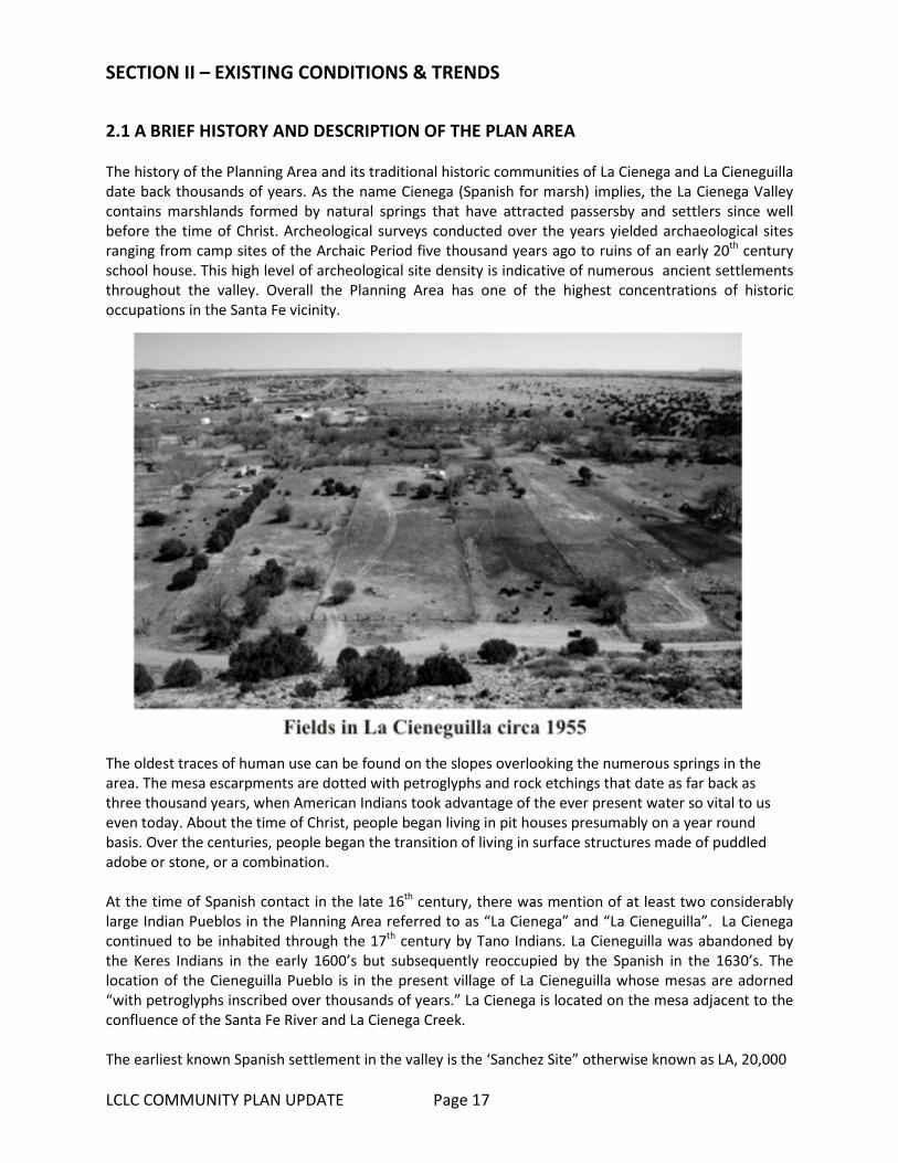
2.1 A BRIEF HISTORY AND DESCRIPTION OF THE PLAN AREA The history of the Planning Area and its traditional historic communities of La Cienega and La Cieneguilla date back thousands of years. As the name Cienega (Spanish for marsh) implies, the La Cienega Valley contains marshlands formed by natural springs that have attracted passersby and settlers since well before the time of Christ. Archeological surveys conducted over the years yielded archaeological sites ranging from camp sites of the Archaic Period five thousand years ago to ruins of an early 20th century school house. This high level of archeological site density is indicative of numerous ancient settlements throughout the valley. Overall the Planning Area has one of the highest concentrations of historic occupations in the Santa Fe vicinity.
The oldest traces of human use can be found on the slopes overlooking the numerous springs in the area. The mesa escarpments are dotted with petroglyphs and rock etchings that date as far back as three thousand years, when American Indians took advantage of the ever present water so vital to us even today. About the time of Christ, people began living in pit houses presumably on a year round basis. Over the centuries, people began the transition of living in surface structures made of puddled adobe or stone, or a combination. At the time of Spanish contact in the late 16th century, there was mention of at least two considerably large Indian Pueblos in the Planning Area referred to as “La Cienega” and “La Cieneguilla”. La Cienega continued to be inhabited through the 17th century by Tano Indians. La Cieneguilla was abandoned by the Keres Indians in the early 1600’s but subsequently reoccupied by the Spanish in the 1630’s. The location of the Cieneguilla Pueblo is in the present village of La Cieneguilla whose mesas are adorned “with petroglyphs inscribed over thousands of years.” La Cienega is located on the mesa adjacent to the confluence of the Santa Fe River and La Cienega Creek. The earliest known Spanish settlement in the valley is the ‘Sanchez Site” otherwise known as LA, 20,000
LCLC COMMUNITY PLAN UPDATE Page 18
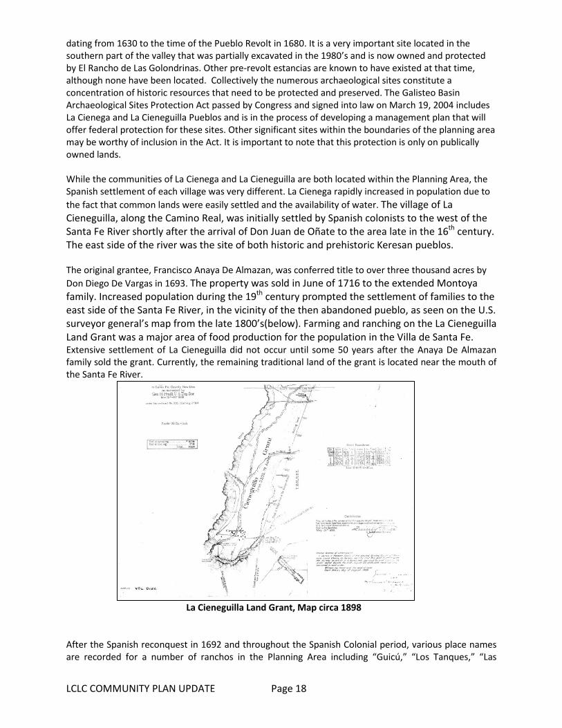
dating from 1630 to the time of the Pueblo Revolt in 1680. It is a very important site located in the southern part of the valley that was partially excavated in the 1980’s and is now owned and protected by El Rancho de Las Golondrinas. Other pre-revolt estancias are known to have existed at that time, although none have been located. Collectively the numerous archaeological sites constitute a concentration of historic resources that need to be protected and preserved. The Galisteo Basin Archaeological Sites Protection Act passed by Congress and signed into law on March 19, 2004 includes La Cienega and La Cieneguilla Pueblos and is in the process of developing a management plan that will offer federal protection for these sites. Other significant sites within the boundaries of the planning area may be worthy of inclusion in the Act. It is important to note that this protection is only on publically owned lands. While the communities of La Cienega and La Cieneguilla are both located within the Planning Area, the Spanish settlement of each village was very different. La Cienega rapidly increased in population due to the fact that common lands were easily settled and the availability of water. The village of La Cieneguilla, along the Camino Real, was initially settled by Spanish colonists to the west of the Santa Fe River shortly after the arrival of Don Juan de Oñate to the area late in the 16th century. The east side of the river was the site of both historic and prehistoric Keresan pueblos. The original grantee, Francisco Anaya De Almazan, was conferred title to over three thousand acres by Don Diego De Vargas in 1693. The property was sold in June of 1716 to the extended Montoya family. Increased population during the 19th century prompted the settlement of families to the east side of the Santa Fe River, in the vicinity of the then abandoned pueblo, as seen on the U.S. surveyor general’s map from the late 1800’s(below). Farming and ranching on the La Cieneguilla Land Grant was a major area of food production for the population in the Villa de Santa Fe. Extensive settlement of La Cieneguilla did not occur until some 50 years after the Anaya De Almazan family sold the grant. Currently, the remaining traditional land of the grant is located near the mouth of the Santa Fe River.
La Cieneguilla Land Grant, Map circa 1898
After the Spanish reconquest in 1692 and throughout the Spanish Colonial period, various place names are recorded for a number of ranchos in the Planning Area including “Guicú,” “Los Tanques,” “Las

LCLC COMMUNITY PLAN UPDATE Page 19
Golondrinas,” “El Alamo,” “La Capilla Vieja” and “El Cañon.” The springs that seep throughout the valley made these areas very desirable for ranching and grazing. In addition, El Rancho de Las Golondrinas was a major paraje (stopping place) on the Camino Real de Tierra Adentro that traversed along the Santa Fe River serving as the first stop leaving Santa Fe when traveling south and the last stop for travelers before entering Santa Fe coming north. Even today, remains of the trail ruts can still be seen in the La Cienega Valley. The names of the early Spanish settlers are ones that are prevalent today in the valley: Baca, Bustamante, C’ de Baca, Delgado, Gonzales, Montoya, Ortiz, Perea, Pino, Rael, Romero, and Sanchez to name a few.
La Cieneguilla Historical Marker Sign 2015
The Planning Area continued to be used for farming and ranching in the 19th century and up to the present. The valley was a busy place in the 19th century as reflected in the census of the time. By World War II, with the development of better roads, motor vehicle travel enabled the economy of the Planning Area to change. More and more people found work in Santa Fe and families sent their children there for schooling. By the early 1980’s, the settlement patterns of La Cienega and La Cieneguilla were changing dramatically; more affordable land was located in this part of the Santa Fe area where families could live. The area was caught in an incredible surge of residential development that included residential population growth and in-migration, Table 1 displays this growth. Although the rate of growth has slowed in recent years, the repercussions to the cultural landscape of the valley are ongoing. What does this all mean? It means that the Planning Area has always been a desirable place for people to live, raise their families, grow their crops, graze their livestock and welcome strangers. It means that we in the valley have become stewards of a cultural landscape that has nurtured our forebears and welcomed recien emigrados (recent émigrés) to the valley for centuries. It means we have a responsibility to preserve as best we can the lay of the land, the water and its traditions, while at the same time allowing controlled growth to take place that respects one’s neighbors.

LCLC COMMUNITY PLAN UPDATE Page 20
2.2 COMMUNITY PROFILE AND DEMOGRAPHICS
2.2.1 Population GrowthTotal Population Growth in population for the plan area from 1990 to 2010 has been relatively high for the County. As Table 1 describes, the La Cienega Planning Area CDP (census dedicated place), which includes most of the populated portions of the plan area, grew substantially between 2000 and 2010. The 27% population increase observed between 2000 and 2010, while substantial is actually a less dramatic increase than occurred in the 1990’s. Between 1990 and 2000 the population increased from 1,775 to 3,007 representing a 69% increase. In general, La Cienega Planning Area has a growing population as result of both residential population growth and in-migration, but the rate is slowing. As Table 2 describes, two decades of growth in the community has resulted in a population size equal or greater than many incorporated New Mexico communities and towns. Table 1: La Cienega CDP POPULATION La Cienega CDP Population changes between 1990 & 2010
1990 2000 2010 Change 1990-2010 Change 2000-2010
no. of people no. of people no. of people % change % change
1775 3007 3819 69% 27%
Source: 1990, 2000, and 2010 Census
Table 2: Population of other small New Mexico towns and communities Community/Town Population Chama Village, Rio Arriba County 1,022 Agua Fria, Santa Fe County* 2,800 City of Santa Rosa, Guadalupe County 2,848 Town of Clayton, Union County 2,980 Village of Chimayo, Santa Fe and Rio Arriba County* 3,177 Town of Edgewood, Santa Fe County 3,735 La Cienega and La Cieneguilla, Santa Fe County* 3,819 Village of Bosque Farms, Valencia County 3,904 Town of Taos, Taos County 5,716 Los Ranchos de Albuquerque Village, Bernalillo County 6,024 Source: 2010 Census *Unincorporated communities within Santa Fe County
2.2.2 Housing Characteristics Growth in housing units also is also relatively high for the County, as seen in Table 3. According to both the census and County data on residential structures, the number of units has increased 24% from approximately 1079 units in 2000 to approximately 1340 units in 2010. The percent of owner occupied units and rental units has remained the same while number units that are vacant has increased slightly to 6% but is relatively low compared to the County vacancy rate of 13%. Table 3: Change in La Cienega Housing Characteristics – 2000 to 2010 2000 2010 Change 2000-2010 no. of units % of total no. of units % of total no. of units % change Occupied Housing 1033 96% 1259 94% 226 22%

LCLC COMMUNITY PLAN UPDATE Page 21
Vacant Housing 46 4% 81 6% 35 76% Owner Occupied 800 77% 966 77% 166 21% Renter Occupied 233 23% 293 23% 60 26% Occasional Use Housing 9 1% 12 1% 3 33% Source: 2010 Census
2.2.3 Age Structure and Ethnicity Compared with the community’s population and housing growth figures, other population characteristics, such as age structure and ethnicity have been more stable (see Table 4). The percent of the population that identifies as Hispanic or Latino has increased from 9% from 2000-2010 while the percent of the population that identifies as not-Hispanic or Latino has decreased by 9%. The percent of individuals under the age 18 has remained the same while the percent of population ages 50-64 has increased 6% and the percent over 65 has increased 3%. Continued increases the elderly population may increase the need for community services in the area.
Table 4: Change in Ethnicity and Age distribution between 2000 and 2010
Ethnicity
2000 2010 change 2000-2010
no. of people % of total pop. No. of people % of total pop. Change in
pop. % change
Hispanic or Latino 2129 71% 3069 80% 940 44%
Non-Hispanic or Latino 878 29% 750 20% -128 -15%
Age
under 19 1017 34% 1292 34% 275 27%
20-24 182 6% 205 5% 23 13% 25-34 458 15% 440 11.5% -18 -4% 35-54 1025 34% 1132 30% 107 10% 55-64 196 7% 477 12.5% 281 143%
65 & over 129 4% 273 7% 144 112%
Source: 2000 and 2010 Census
2.2.4 Employment The limited amount of commercial development and community services in La Cienega Planning Area may limit employment opportunities available within the community. Most working residents travel outside the community for work. Average commute times are about 23% higher in La Cienega Planning Area than in Santa Fe County as a whole and most La Cienega Planning Area residents work in industries that are unevenly represented in the community. However, the significant number of residents who work from home in the community (about 8%) may mean that opportunities for home based businesses may ameliorate the spatial mismatch between jobs and housing in the community. Key employment characteristics are described in Table 5.
Table 5: 2010 Estimates of La Cienega CDP Community Employment Characteristics
Percentage unemployed 3.2% Percentage who work from home 8.1% Mean travel time to work 26.2 minutes
Median income $51,891 Percentage employed in construction 19.9%

LCLC COMMUNITY PLAN UPDATE Page 22
Percentage employed in public administration 18.0%
Percentage employed in educational services, heath care and social assistance 17.5%
Percentage employed in professional, scientific, management, administrative, and waste management services 8.2% Percentage employed in arts, entertainment, and recreation, accommodation, and food services 7.0% Percentage employed in retail trade 6.9%
Percentage employed in transportation and warehousing, and utilities 6.9%
Percentage employed in other services (except public administration) 4.8%
Percentage employed in finance, insurance, real estate, and rental and leasing 3.5%
Percentage employed in agriculture, forestry, fishing and hunting, and mining 3.4% Percentage employed in wholesale trade 1.9% Percentage employed in public administration 1.8%
Percentage employed in educational, health and social services 1.8% Percentage employed in information 1.5% Percentage employed in manufacturing 0.5% Source: 2006-2010 American Community Survey 5-Year Estimates
2.3 HISTORIC & CULTURAL RESOURCES La Cienega’s rich cultural heritage is evident in the continuation of agriculture production in the community, the continued use of the historic acequia systems, local building form and patterns, community traditions, and the many families with histories going back for generations. Historic structures including churches, cemeteries, capillas, homes, barns, corrals, and cisterns, dot the landscape and many are still in use and highly valued by community members. The community values historic resources and actively protects and maintains historic structures and by collaborating in the acquisition and management of historic sites and public lands. Collectively the numerous archaeological sites constitute a concentration of historic resources that need to be protected and preserved. Significant sites within the plan area include:
• La Cienega Pueblo and Petroglyphs- The La Cienega Pueblo dates to A.D. 1100- 1300. It contains over 140 rooms and over 1,000 petroglyphs. The site is not accessible to the public.
• La Cienega Pithouse Village- The La Cienega Pithouse dates to A.D. 700-900. It is not accessible to the public.
• La Cieneguilla Petroglyphs & Camino Real de Tierra Adentro- The Camino Real de Tierra Adentro provided connections among native peoples prior to European contact, and later between colonial Mexico City and Santa Fe. Extensive petroglyphs are associated with the trail.
• La Cieneguilla Pueblo- The La Cieneguilla Pueblo dates to 1325-1600. The Pueblo was
LCLC COMMUNITY PLAN UPDATE Page 23
abandoned and resettled and eventually had a Spanish and Mexican village built on it. It is not open to the public.
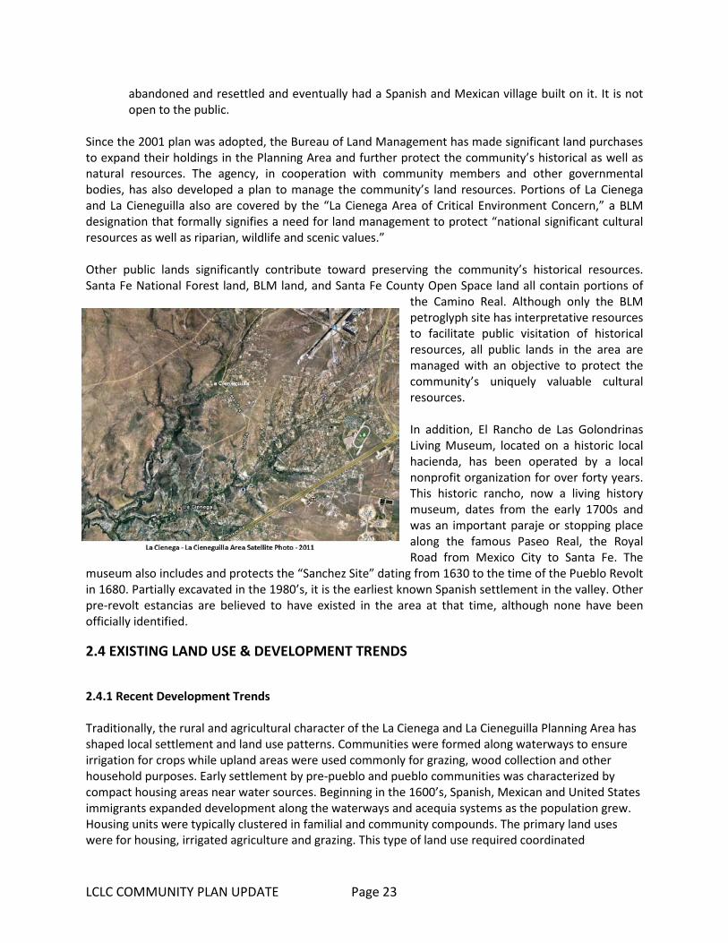
Since the 2001 plan was adopted, the Bureau of Land Management has made significant land purchases to expand their holdings in the Planning Area and further protect the community’s historical as well as natural resources. The agency, in cooperation with community members and other governmental bodies, has also developed a plan to manage the community’s land resources. Portions of La Cienega and La Cieneguilla also are covered by the “La Cienega Area of Critical Environment Concern,” a BLM designation that formally signifies a need for land management to protect “national significant cultural resources as well as riparian, wildlife and scenic values.” Other public lands significantly contribute toward preserving the community’s historical resources. Santa Fe National Forest land, BLM land, and Santa Fe County Open Space land all contain portions of
the Camino Real. Although only the BLM petroglyph site has interpretative resources to facilitate public visitation of historical resources, all public lands in the area are managed with an objective to protect the community’s uniquely valuable cultural resources. In addition, El Rancho de Las Golondrinas Living Museum, located on a historic local hacienda, has been operated by a local nonprofit organization for over forty years. This historic rancho, now a living history museum, dates from the early 1700s and was an important paraje or stopping place along the famous Paseo Real, the Royal Road from Mexico City to Santa Fe. The
museum also includes and protects the “Sanchez Site” dating from 1630 to the time of the Pueblo Revolt in 1680. Partially excavated in the 1980’s, it is the earliest known Spanish settlement in the valley. Other pre-revolt estancias are believed to have existed in the area at that time, although none have been officially identified.
2.4 EXISTING LAND USE & DEVELOPMENT TRENDS
2.4.1 Recent Development Trends Traditionally, the rural and agricultural character of the La Cienega and La Cieneguilla Planning Area has shaped local settlement and land use patterns. Communities were formed along waterways to ensure irrigation for crops while upland areas were used commonly for grazing, wood collection and other household purposes. Early settlement by pre-pueblo and pueblo communities was characterized by compact housing areas near water sources. Beginning in the 1600’s, Spanish, Mexican and United States immigrants expanded development along the waterways and acequia systems as the population grew. Housing units were typically clustered in familial and community compounds. The primary land uses were for housing, irrigated agriculture and grazing. This type of land use required coordinated
LCLC COMMUNITY PLAN UPDATE Page 24
management and stewardship practices to maintain shared water resources and common lands or ejidos for livestock, timber and other uses. These agricultural and community traditions have defined where people built homes and how the community grew well into the 1900’s. In the I980’s and 90’s urban pressures from the City of Santa Fe’s growing population as well as internal growth from settled families spurred rapid residential growth in the plan area. New development intensified in upland areas near the intersection of NM State Highway 599 and Interstate 25 as well as in La Cieneguilla. Growth has also occurred in Upper and Lower La Cienega where traditionally irrigated lands have been converted to housing sites. The Planning Area became an attractive bedroom community for Santa Feans looking for the rural amenities of quiet living, low traffic, and open spaces. From 2000 to present, growth is still influenced by close proximity to the City of Santa Fe, its desirable rural and historic character, a market preference for low-density single family housing, and low initial development costs relative to many other areas proximate to the City of Santa Fe. Increase in employment associated with the Community College District, the Airport, the National Guard and new commercial growth in Southwestern Sector of the City of Santa Fe may also be a contributing factor. Other factors may include proximity to transportation facilities including easy access to I-25, NM 599, NM Route 14 and the opening of the New Mexico Rail Runner Express station in 2010. New development trends continue to pressure the Planning Area’s traditional rural character, farm fields, running acequias, and open spaces. The demand for new housing drives up real estate prices as well as property taxes on undeveloped and agricultural property, thereby making agricultural uses less viable. Community members have expressed that they feel overpowered by development and a lack of local control over land use decisions. One of the primary intents of the Plan is to protect and maintain the rural character and non-urban style development that makes the area special to residents while providing for community input in future land use decisions.
2.4.2 Residential Land Use With the exception of the public lands, a few private ranches, Las Golondrinas Living History Museum and the Santa Fe Downs Property, land uses in the planning area continue to be predominantly low-density, single family residential with a few large and medium sized parcels remaining in agricultural use. From 1990 to 2010, an estimated 404 new housing units were developed in the plan area, representing annual growth rate of 6%. With the exception of the Las Lagunitas subdivision in Lower La Cienega, most of the development occurred on existing lots, small subdivisions of fewer than 5 lots, lots created by family transfers, and infill of a large pre-1980 subdivision in La Cieneguilla, (see page 21, Figure 4: Existing Land Use Map). Several factors will likely influence the rate of residential development in the plan area: Available Land, especially the transfer of private lands to public conservation lands. The transfer
from private to public lands has significantly reduced the amount of land in the planning area available for single residential development. Limited Water Resources. In recent decades, several factors in the larger watershed and water supply of the region have come into play that are having and will continue to have impact on the plan area water supply. Decreases in rain and snowfall and increased temperatures have contributed to longer-term drought conditions. Several new studies and reports have confirmed continued drawdown of the aquifer generally,
LCLC COMMUNITY PLAN UPDATE Page 25
with increases in some isolated areas. Availability of regional water supplies through County and/or community systems may also be limited.
Market Conditions. Between 2000 and 2010, the number of housing units in the planning area
increased 24%, down from a 60% increase between 1990 and 2000. The slower pace of new development in recent years partly reflects the impact of the national recession. According to data from the Santa Fe Association of Realtors, home sales in the broader southwest Santa Fe County region (inclusive of La Cienega and La Cieneguilla, Madrid and Cerrillos) fell over 50% between 2005 and 2012 while median values decreased about 14% during the same period. County-wide, the number of building permits for new single family homes issued between 2005 and 2011 fell about 83%. Also a according to American Community Survey estimates, between 2000 and 2010, the median home value in La Cienega climbed about 56%. Incomes, however, haven’t necessarily increased. More people today are spending more of their incomes on housing in the planning area than ten years ago. According to the American Community Survey estimates, 45% of all 2011 mortgage holders in La Cienega and La Cieneguilla and 43% of all renters have housing costs (a measure which includes mortgage, rent, as well as estimate of utilities and other costs) that are 35% or more of their household incomes.
Zoning and Legal Regulations. Santa Fe County’s recent adoption of the Sustainable Growth
Management Plan and Sustainable land Development Code may represent significant changes in how development will occur. Establishment of zoning districts determines maximum densities which may not be adjusted to reduce lot sizes through signing of water restrictions.
County Purchase of Santa Fe Canyon Ranch. In 2009, Santa Fe County acquired 470-acres of the
Santa Fe Canyon Ranch property (also known as La Bajada Ranch) composed of several additional large parcels which comprise a total of approximately 1300 acres with an approved master plan for 156 single family residential units with a gross density of 2.58 acres per unit. The County has established a steering committee to review development options and potential uses. A 2010 survey of residents conducted by the County revealed a community preference for the property to be preserved as open space or developed with low-intensity land uses such as recreational facilities. The Master Plan was revised in 2014 to remove the large parcels and the remaining Master Plan consists of 470 acres.
Home Occupation Businesses: Home occupation businesses continue to play an important economic role in the community. About 8.1% of residents work from home according to American Community Survey 5-year estimates. Small home-business scaled business operations include agriculture, a lodging facility, a furniture maker, and an upholstery shop among others. While home businesses have the potential to increase opportunities for commercial and employment services, concerns remain about their neighborhood impacts. For example, an asphalt and seal coating home business in La Cienega raised community concerns several years ago when they expanded their business and added heavy equipment storage.
2.4.3 Agricultural Land Use The rich legacy of agricultural production in the planning area includes grazing in dry upland areas as well as harvesting food, herbs, and tree crops along the waterways and acequias. Today, agricultural

LCLC COMMUNITY PLAN UPDATE Page 26
traditions are highly valued by community members and continue to reinforce the planning area’s rural heritage and historic character. Many residents tend gardens and fruit trees which yield substantial harvest for their household consumption. Even so, conversion of irrigable agricultural land to residential uses and home sites combined with declines in water flows in the acequia systems have led to a decrease in agricultural production.
2.4.4 Commercial Land Use Commercial services and employment opportunities in the community are limited. Other than RV and mobile home parks, open-yard commercial operations, a small number of home-based craft studios and shops, and the weekend Flea Market and farmers market at the Downs, there are no grocery stores, gas stations, or retail services in the plan area. As Table 6 makes clear, the number of commercial establishments is low relative to the number of commercial establishments in other small communities in the County.
The amount of commercial services in the plan area will be heavily influenced by utility extensions, water resources, transportation improvements, land use, and zoning regulations. Factors including changes in ownership or land use could have significant impact on the surrounding community and future development proposals. Major factors influencing commercial development include: Medium to Large-Scale Commercial or Quasi-Commercial Properties: A small number of
medium-to-large scale business currently operate within the Plan area. In the Planning Area there are three properties that have current Master Plans with zoning approved from the Board of County Commissioners. These properties include:
o Santa Fe Downs: The Santa Fe Downs property has a Master Plan and has traditionally
hosted recreational or semi-commercial land uses. Currently, the property hosts concerts, equestrian activities, and has had a flea market on weekends and allows organized league play on the irrigated, grassy infield. The property is adjacent to most of the other commercial establishments in the community which is mostly located in Upper La Cienega and Santa Fe Downs is expected to produce a master plan in the near-term that proposes more intensive development on the property.
o Several properties between the Downs and the NM 599 / I-25 Interchange are used for open yard commercial and RV or mobile home parks.
o Sunrise Springs: Sunrise Springs has a Master Plan and has lodging, restaurant, and
retreat facility. The property has extensive gardens and water features and in the past has provided gallery space.
o MCT: MCT has a Master Plan and is a commercial waste management facility that sorts and temporarily stores construction site waste and maintains a fleet of trucks and
Table 6: Commercial Land Use Community % of parcels in commercial use
Pojoaque 3.7% Arroyo Seco 3.9% Agua Fria 4.6% La Cienega 1.3% Source: 2010 Census

LCLC COMMUNITY PLAN UPDATE Page 27
storage/collection containers on site.
Adjacent Commercial Development and other Uses Adjacent to the La Cienega Planning Area: Several properties adjacent to the Planning Area have been developed or are slated for intensive development. These include:
o Santa Fe Municipal Airport.
o The Pavilion business park, 371 acres located along N.M. 599 near the airport. This property is directly adjacent to the boundary of the La Cienega and La Cieneguilla Planning area.
o 23 acre Komis property at northeast intersection of I-25 and N.M. 599.
o Las Soleras, mixed use commercial and residential development, 550 acres located northeast of the outlet mall development.
o National Guard complex on approx. 1,000 acres located across I-25 from the Las Estrellas/racetrack area.
2.4.5 Community Facilities For the size of the population of the plan area there are also relatively few community facilities. There are no medical clinics, public schools or developed parks in the community. However the community does host County facilities including the La Cienega Community Center, Fire Station and the Transfer Station; and there are a couple of churches and cemeteries that provide a variety of services to the community. In general public funding at both the state and County level has dropped during the recession and the lack of appropriate levels of funding for community facilities will continue to influence the ability for the community and the County to adequately meet the needs of this growing community. Despite this, the community has been very active in identifying needs and seeking funding. Currently several projects related to Community Facilities have been listed on the County’s Capital Improvement Plan and/or in resolutions adopted by the Board of County Commissioners: Funding for a new Community Center with associated outdoor recreation facilities has been
listed on the County’s Capital Improvement Plan and the community has identified vacant State Land Office property as a suitable central location with suitable access off of Paseo Real.
2.4.6 Conservation, Community Stewardship, and Open Space Use Settlement in the La Cienega and La Cieneguilla Planning Area has traditionally been focused on rural, agricultural economies and land use practices. Communities formed along waterways to ensure irrigation for crops while upland areas were shared in common by the community for grazing, wood collection and other purposes. This system required coordinated management and stewardship practices to maintain the common areas. The system also allowed for common lands between
LCLC COMMUNITY PLAN UPDATE Page 28
communities and spacing of development to allow for enough resources to support each community. Areas traditionally used as common lands continue to be lost to new development. While these common lands were often privately held, development effectively removes them from the undeveloped landscape and reduces areas for grazing and hiking. The common undeveloped lands also helped define individual villages by forming buffer areas between communities and signified rural, agricultural and historical characteristics of the La Cienega and La Cieneguilla Planning Area. Residents of La Cienega and La Cieneguilla have always considered these lands to be integral and essential parts of the community and continue to collaborate with private landowners, the BLM, the County and the State Land Office in the management and stewardship of these cherished areas. Major conservation land uses include federal, state, and County holdings as well as properties that function to conserve historic and natural resources such as the El Ranchos de Las Golondrinas Living Historic Museum and the Leonora Curtin Wetland Preserve, also known as the Santa Fe Botanical Garden. Since 2001 over 1000 acres has been transferred from private property to public property and is now under the control of the Bureau of Land Management and Santa Fe County Open Space. This transfer from private to public lands has significantly reduced the amount of land in the planning area available for residential development. The public lands contribute greatly to protecting the community’s natural setting, resources, cultural heritage, scenic amenities and recreation value. Public lands in La Cienega and La Cieneguilla encompass approximately 46% of the planning area. They include Santa Fe County Open Space property, Bureau of Land Management properties, US Forest Service land and lands managed by the New Mexico State Land Office. Each agency operates under various management objectives and not all lands have been completely inventoried or have had management plans developed to date. An inventory of public lands within the Plan Area includes: Bureau of Land Management: In 2004, the United States Congress passed the “Galisteo Basin
Archaeological Sites Protection Act” in recognition of the unique historical value of the basin’s archeological resources. The Act designates four sites in La Cienega and La Cieneguilla as “Galisteo Basin Archeological Protection Sites” and directs that sites should be protected and preserved: La Cienega Pueblo and Petroglyphs; La Cienega Pithouse Village; La Cieneguilla Petroglyphs/Camino Real de Tierra Adentro; and La Cieneguilla Pueblo. The BLM is the lead agency in managing La Cienega and La Cieneguilla’s archeological resources and most of the community’s archeological resources recognized in the Galisteo Basin Archeological Sites Protection Act are located on agency land. The agency has increased their land holdings in La Cienega substantially since the adoption of the 2001 community plan and has developed a management plan for its La Cienega and other northern New Mexico land holdings. While much of the agency’s management focuses on historical resources preservation, BLM lands are also managed for habitat values and support community uses such as grazing. The BLM Petroglyphs/Camino Real de Tierra Adentro is one of the few developed interpretive sites on public lands in La Cieneguilla.
Forest Service Lands: Forest Service lands in the Planning Area provide grazing opportunities
under the Caja del Rio grazing allotment (the allotment extends beyond the community planning area and supports in excess of 500 head of cattle). The portions of the Santa Fe National Forest in the La Cienega and La Cieneguilla community planning boundary do not have any developed recreational sites although the Forest Service’s 2012 Travel Management Plan shows that a new road may be built through the portions of the Santa Fe National Forest in the community planning area.
LCLC COMMUNITY PLAN UPDATE Page 29
State Lands: State Trust lands encompass nearly 750 acres of the planning area. They border
public lands managed by the Federal Bureau of Land Management and developed private lands. While State Trust lands have limited trails, they do not have other developed recreation sites or interpretation resources. State Trust lands currently host several agriculture leases and one commercial lease as follows:
o Agricultural Lease 386 acres gm 2828 Reynaldo Romero o Agricultural Lease 258 acres Carlos Kellogg gs2291 o Agricultural Lease 45 acres Santa Fe County Commissioners GO2335 o Agricultural Lease 40 acres Barbara Stein gm 2892 o Commercial Lease .35 acres BL 1037000 Connie Rivera Chavez effective date 6/25/2011
County Lands: County open space properties include holdings in La Cieneguilla and La Cienega:
o In La Cieneguilla A part of the property at La Cieneguilla is included in a site boundary for the
Galisteo Archaeological Sites Protection Act, under the designation for the La Cieneguilla Petroglyphs and management of the property for historic preservation is provided for by a Memorandum of Agreement between the County and BLM.
The County owns and manages approximately 100 acres of the riparian corridor along the Santa Fe River and regularly removes non-native trees and plants native trees. The County also has an agreement with the Santa Fe Girl’s School to use the part of the property along the river for outdoor education and limited water quality monitoring.
o In La Cienega El Peñasco Blanco in La Cienega includes the Springs and restoration work at Los
Carrizales. This property is open to public (access is only possible via horseback or foot), but at the wishes of the La Cienega community, the property lacks any interpretative or directional signage.
Santa Fe Canyon Ranch: Santa Fe County acquired the 470-acre Santa Fe Canyon Ranch property and facilities in 2009. The County has not developed a plan for developing the property, however a 2010 survey of residents conducted by the County revealed a community preference for the property to be preserved as open space or developed with low-intensity land uses such as recreational facilities.
Pueblo Lands: Santo Domingo Pueblo owns approximately 3500 acres located at the southwest
corner of the planning area. The land is not currently designated as tribal land, but it may receive this designation in the future.
El Rancho de Las Golondrinas Living History Museum: El Rancho de Las Golondrinas Living
History Museum: El Rancho de Las Golondrinas is a living museum of Spanish Colonial life in the 17th century in New Mexico. The museum encompasses 193-acres of a former encampment on the Camino Rael and former ranch dating to 1710. The ranch includes a vast number of historic structures restored and added to the site in the 1930s including an 18th century placita house complete with defensive tower, a 19th century home and all of its outbuildings, a molasses mill, a threshing ground, several primitive water mills, a blacksmith shop, a wheelwright shop, a winery and vineyard, a morada, descansos, a Campo Santo and an Oratorio. The museum is

LCLC COMMUNITY PLAN UPDATE Page 30
open to visits from the public and is regularly rented for large events and for filmmaking. They museum and its land are owned and managed by the El Rancho de Las Golondrinas, Inc. a non-profit organization.
The Leonora Curtin Wetland Preserve:
The preserve, also known as the Santa Fe Botanical Garden, is a 35-acre habitat preserve with picnic areas, trails, and interpretive guides. The area includes a spring-fed pond and significant species diversity. It is managed by the Santa Fe Botanical Garden under a long-term lease with the trustees of El Rancho de Las Golondrinas Trust (the entity which formally controlled the Las Golondrinas Living Museum) and is open to the public.

LCLC COMMUNITY PLAN Page 31
Figure 2 LC & LC Existing Land Use Map
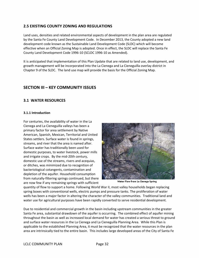
LCLC COMMUNITY PLAN Page 32
2.5 EXISTING COUNTY ZONING AND REGULATIONS Land uses, densities and related environmental aspects of development in the plan area are regulated by the Santa Fe County Land Development Code. In December 2013, the County adopted a new land development code known as the Sustainable Land Development Code (SLDC) which will become effective when an Official Zoning Map is adopted. Once in effect, the SLDC will replace the Santa Fe County Land Development Code 1996-10 (SCLDC 1996-10 as Amended). It is anticipated that implementation of this Plan Update that are related to land use, development, and growth management will be incorporated into the La Cienega and La Cieneguilla overlay district in Chapter 9 of the SLDC. The land use map will provide the basis for the Official Zoning Map.
SECTION III – KEY COMMUNITY ISSUES
3.1 WATER RESOURCES
3.1.1 Introduction For centuries, the availability of water in the La Cienega and La Cieneguilla valleys has been a primary factor for area settlement by Native American, Spanish, Mexican, Territorial and United States settlers. Surface water is found in springs, streams, and river that the area is named after. Surface water has traditionally been used for domestic purposes, to water livestock, power mills and irrigate crops. By the mid-20th century, domestic use of the streams, rivers and acequias, or ditches, was minimized due to recognition of bacteriological cotangents, contamination and depletion of the aquifer. Household consumption from naturally-filtering springs continued, but there are now few if any remaining springs with sufficient quantity of flow to support a home. Following World War II, most valley households began replacing spring boxes with conventional wells, electric pumps and pressure tanks. The proliferation of water wells has been a major factor in altering the character of the valley communities. Traditional land and water use for agricultural purposes have been rapidly converted to serve residential development. Due to residential and commercial growth in the basin including upstream communities in the greater Santa Fe area, substantial drawdown of the aquifer is occurring. The combined effect of aquifer mining throughout the basin as well as increased local demand for water has created a serious threat to ground and surface water resources in the La Cienega and La Cieneguilla Planning Area. While this Plan is applicable to the established Planning Area, it must be recognized that the water resources in the plan area are intrinsically tied to the entire basin. This includes large developed areas of the City of Santa Fe

LCLC COMMUNITY PLAN UPDATE Page 33
and Santa Fe County including the Community College District, areas east of I-25 associated with the Penitentiary, National Guard, Valle Vista neighborhood, and other developments in the Turquoise Trail area. Since the 2001 Plan was adopted several factors in the larger watershed and water supply of the region have come into play that are having and will continue to have impact on the plan area water supply.
• Decreases in rain and snowfall and temperature increases have contributed to short and medium-term drought conditions.
• Several new studies and reports have confirmed continued drawdown of the aquifer with increases in isolated areas.
• The Buckman Direct Diversion project (BDD) has come on-line bringing a source of imported surface water from the Rio Grande to both the City and County water utilities. This has the potential to decrease the rate of ground water depletion by replacing service areas currently dependent on wells with the imported water supply.
• Dramatic increases in beaver populations along the Santa Fe River have impounded water, reducing surface water available to downstream irrigators, and likely increasing ground water infiltration
3.1.2 Area Hydrology: Rivers, Creeks, Springs, Arroyos, Flood Plains, and Wetlands The river, creeks, springs, major arroyos and their tributaries provide a surface water drainage system which forms regional and local hubs of riparian zones, springs, and wetlands. The creeks and their tributaries are mostly intermittent streams due to the complex interaction of geology, ground water and climate of the area. Santa Fe River, La Cienega Creek, Arroyo Hondo, and Arroyo Chamiso The Santa Fe River runs diagonally through the plan area from the northwestern boundary to the southern boundary. It enters the plan area south of City of Santa Fe Wastewater Treatment Plant (WWTP) through a shallow meandering river channel traversing County Open Space crossing Paseo Rael (sometimes under the road, sometimes over the road) flowing through the agricultural lands of La Cieneguilla and into a narrow canyon of basalt eventually joining the Cienega and Alamo creeks in the southern portion of the plan area. The Santa Fe River below the WWTP is a perennial stream, primarily due to effluent release from the plant. In 1996 the 12.7 mile stretch of the Santa Fe River between the WWTP and Cochiti Pueblo, including the portions running through plan area, was classified as impaired due to low dissolved oxygen levels, high pH, high chlorine levels, high ammonia levels, and high sedimentation. Water quality in the reach below the WWTP has improved since the revegetation. Effluent released from the WWTP benefits downstream irrigators, including the community of La Bajada,
Santa Fe River 2015

LCLC COMMUNITY PLAN UPDATE Page 34
and provides semi-consistent flows in the river to replace the flow from area springs which are now virtually depleted. Due to the current release point, this benefit to irrigators does not extend to the Upper and Lower La Cienega area acequias or springs and does not appear to provide wide-spread recharge. During the summers of 2011 and 2012, the effluent flow was retained by beaver dams created at the wetland area near the City of Santa Fe Municipal Airport which resulted in reduced flow and less water for irrigators (see Trends below). Management of effluent from the City ‘s WWTP and beaver activity on City and County property associated with the effluent will continue to impact flow in the Santa Fe River and irrigators that divert off the river. The communities of La Cienega and La Bajada have been diligent in advocating that the City of Santa Fe adjust their water release schedule and volume to accommodate the needs of downstream irrigators and will continue to do so in cooperation with other partners. Arroyo Hondo enters the plan area at its junction with NM 599. Arroyo Chamiso enters the plan area near the eastern boundary of the Airport. Both traverse in a southwestern direction, joining each other in Upper La Cienega. Cienega Creek enters the plan area under Interstate I-25 in Upper La Cienega where it runs west joining Arroyo Hondo just above the north boundary of El Rancho de Las Golondrinas. The intermittent Alamo Creek enters the plan area under Interstate-25 along the southern boundary of Santa Fe Canyon Ranch where it runs west to join the Santa Fe River and Cienega Creek near the western portion of the aptly named Tres Rios Ranch. Trends in the Area Hydrology Since the adoption of the 2001 plan, a number of trends/events have either affected or are likely to affect the community’s water resources:
• Based on the increase in households, the number of ground water wells has increased which has an impact of withdrawing more acre-feet of water per year.
• Work in the late 1990’s and 2000’s to restore the stretches of the Santa Fe River on City of Santa Fe and County-owned land, while increasing water quality, has led to dramatic increases in the beaver population. Beaver activity has impounded enough water to impact downstream irrigators.
• The Santa Fe-Pojoaque Soil and Water Conservation District grant provided for the removal of nonnative vegetation on Santa Fe County Open Space property along the Santa Fe River in La Cieneguilla and at Los Carrizales in La Cienega.
• The New Mexico House of Representatives pass House Memorial 74 requesting that the City of Santa Fe and Santa Fe County work together to ensure sufficient river flows to La Bajada and La Cienega.
• Santa Fe County passes Resolution 2011-191 requesting that the City of Santa Fe release additional effluent to the Santa Fe River to support agricultural production in La Cieneguilla and La Bajada.
• Santa Fe River Traditional Communities Collaborative formed with the goal of promoting the health of the Santa Fe River and the traditional communities that depend on the river. The initiative is the result of partnership among La Cienega community members, La Cieneguilla landowners, the community of La Bajada, the Santa Fe Watershed Association, Forest

LCLC COMMUNITY PLAN UPDATE Page 35
Guardians, the City of Santa Fe, County of Santa Fe, Santa Fe-Pojoque Soil and Water Conservation District and federal agencies with land holdings in the community. The broad mission of the group is to promote the health of the Santa Fe River as well as the communities. In the near-term, the group will be working toward developing a plan for mitigating the impoundment of water associated with beaver activity on public lands.
3.1.3 Acequias Traditional agriculture in the planning area has historically been sustained by spring-fed acequias and, to a lesser extent, diversions of the Santa Fe River. The ojos y ojitos or natural springs filled ponds formed
by construction of earthen dams which store water to be directed into an acequia. These gravity-fed acequia systems have remained basically unaltered for centuries. By the 1990's greatly diminished flows of area springs necessitated the addition of supplemental ground water irrigation wells to maintain flows and acequia system integrity. Additionally, reduced flows in effluent in the Santa Fe River due to the beaver dams (see above) are a major concern to effected acequia associations and communitites. The communities of La Cienega, La Cieneguilla and La Bajada have been diligent in ensuring that the City of Santa Fe adjust their water release schedule and volume to accommodate the needs of downstream irrigators and will continue to do so in cooperation with other partners. There are three acequia associations and four private acequias in the valley that provide water for irrigation. According to a hydrological survey of the area completed by the State Engineer's Office in 1976, approximately 150 acres of land are potentially irrigable by community acequias. Conversion of irrigable agricultural land to use residential in conjunction with declines in water flows in the acequia
systems have led to a decrease in acreage under agricultural production. La Acequia de La Cienega delivers water to 98.6 acres of irrigated land of which approximately 40 acres are currently being farmed. Some of the acreage traditionally used for irrigation has been developed for other purposes; some of it lies fallow. The acequia is entitled to use approximately 294 acre-feet of water per year (one acre-foot equals approximately 325,850 gallons of water). However, due to dramatic declines in water flow from the springs that feed the acequia, an irrigation well has been employed since 1998 to provide a supplemental water source to maintain the ditch integrity. La Acequia de El Guicu traditionally serves approximately 41 acres of irrigated land. The acequia currently irrigates approximately 25 acres. The El Guicu is entitled to approximately 123 ac-ft of water per year. The ditch has an irrigation well to supplement spring or surface flows.
LCLC COMMUNITY PLAN UPDATE Page 36
La Acequia de El Molino (also known as the La Acequia de La Capilla) has approximately 6 users irrigating approximately 15 acres. The valley also supports four private acequias: the El Canon, La Capilla Vieja, Los Pinos, and Romero ditches. The mayor domos of the two largest acequias, La Cienega and El Guicu, report that it is currently not possible to supply water to all of the potentially irrigable acres along their acequias due to low flows from springs. Residents report that one of the reasons for a decline in local agricultural production is the lack of adequate and reliable water flows in the acequias. Residents believe that a primary reason for low flows is the depletion of ground water supplies throughout the Santa Fe watershed. No studies to date adequately illustrate aquifer depletion and resulting potential impairments. Additionally, a reduction in treated effluent releases to the Santa Fe River from the WWTP during the peak summer months and reduced flows from beaver activity are a major concern to effected acequia associations.
3.1.4 Private Water Wells Throughout the La Cienega and La Cieneguilla Community Planning Area, most homes and businesses receive water from private domestic wells. In the Upper La Cienega area and parts of La Cieneguilla, many lots share a well with 1-4 other homes. Several homes still use springs for drinking water. According to OSE data, as of July 2011, the plan area included approximately 146 one-household domestic wells, 28 multi-household wells and 30 irrigation/stock/sanitary wells. All property owners with wells, who have requested a building or development permit with Santa Fe County since 1996 are required to install water meters on their new wells (or in the case of shared wells, meters on each dwelling unit or primary structure), record monthly meter readings, and provide an annual report of monthly readings to the County Hydrologist. Lots Subject to the La Cienega Watershed Conditions The La Cienega and La Cienega Planning District Ordinance implemented many of the strategies identified in the 2001 Community Plan pertaining to water resources including reaffirming and refining the “La Cienega Watershed Conditions.” County parcel data shows that out of approximately 1,645 private parcels in the plan area, approximately one quarter (385 parcels) are subject to watershed conditions with the majority concentrated in Upper La Cienega. The watershed conditions require residential property owners to hook up to County water services, when service is available within 200 feet of the property line of land being divided and all commercial development applications to hook up regardless of distance. Additionally, owners have waived their right to protest the implementation of an improvement or assessment district. An estimated 709 parcels are not subject to the watershed conditions. For 509 parcels it is unclear whether they are subject to the watershed conditions due to missing information on the plats. The County has not extended water lines to serve the majority of those properties. As a result the use and number of private domestic wells using ground water has increased to accommodate the increased number of households.
3.1.5 Community Water Systems La Cienega Mutual Domestic Water Association
LCLC COMMUNITY PLAN UPDATE Page 37
The La Cienega Mutual Domestic Water Association (LCMDWA) was founded in the early 1970's and serves a large portion of Lower La Cienega. The domestic water system uses approximately 21.7 acre feet of water per year. In order to become a member of the system, one must contribute ground water rights to the LCMDWA. The membership cost includes a one-time start-up fee plus the cost of hooking the system to one's home. The monthly user fee includes up to 4,000 gallons per month; use above 4,000 gallons incurs an additional fee. The LCMDWA does not have capacity for commercial use hook-ups and provides limited capacity for fire protection.
In 2000, the LCMDWA served approximately 112 households with a system capacity that could accommodate 25 additional meter hook-ups. In 2012, the LCMDWA served approximately 135 households with an average use per household of 0.16 acre-foot per year.
Other Community Water Systems
Wild & Wooley Trailer Park Community Water System. This water system in Upper La Cienega is based on 72-12-1 sanitary well designated for commercial use with a diversionary use right up to 3 acre-feet. The extension of County water services in this area is anticipated in the future. As of 2012, the trailer park’s is a County wastewater utility customer. La Cienega Water Users Community Water System. This community system in Lower La Cienega is associated with the former Lakeside mobile home park, located at the end of Paseo C de Baca. It is primarily used to supply water to the residence of the park and has a diversion of 5.1 acre feet. Per a 2013 settlement agreement with the County, the County is required to provide the community with water services.
3.1.7 County Water System In 1998, Santa Fe County water service was extended to serve the Las Lagunitas subdivision and down La Entrada to Camino San Jose providing service to the Fire Station and Community Center. In 2004 the water line was extended further to include the Paseo C de Baca area to La Lomita. In 2015, the number of active County utility hook-ups in the plan area is approximately 98, with 73 active accounts in the Las Lagunitas subdivision and 25 hook-ups servicing households along Paseo C. de Baca. At the direction of the BCC (SF County Resolutions Nos. 2006-93 & 2011-162) and with 2013 Water Trust Board funding support, the Utility has nearly completed the design of a looped water service line for the Camino Loma, La Lomita, and Cielo Del Oeste (Lower La Cienega) area. The line extension is expected to be serving customers by 2016. The County system is piped to provide water supply to the LCMDWA system, under an agreement with the County. Wherever County water lines are extended within the planning area, properties with the watershed conditions are required to hook up. Other residents may hook up to the County water utility according to costs and conditions set forth in the then current line extension and customer service policies and

LCLC COMMUNITY PLAN UPDATE Page 38
ordinances. Other notes on the County Water System and County water management with respect to the planning area:
• The County provides approximately 275 acre-feet/year of water to the State Penitentiary, thus reducing the depletions to the shallow Ancha/Tesuque Formation aquifer in the area.
• The County owns surface water rights associated with the Guicu acequia. • The County adopted via Resolution No. 2012-58, a policy that allows small, public or private
water systems to seek water-related technical assistance or water supply service from the County Utilities. The community water systems within the planning area may avail themselves of the services. Qualified systems may or may not be connected to the BDD Rio Grande surface water supply; if not connected to the BDD water supply, water systems run by the County may continue to be supplied using local ground water sources.
• County water systems that rely on ground water include the County Public Works Complex, the Romero Park, and the Caja del Oro system, which serves La Familia Medical Center, the Nancy Rodriguez Community Center, and the Agua Fria fire station. The County has not been pumping its water rights from the Hagerman well since approximately 2011.
• County Water Service Areas established as part of the SGMP (2010) include portions of Upper and lower La Cienega.
• The County continues to analyze the amount of uncommitted water supply available for providing service outside of the SDA-1 area.
3.1.8 Water-related Policies, Programs, Resolutions, Ordinances, and Activities The list below identifies the various actions that, community members, local governments, and other stakeholders have taken in order to support sound water resource management in the planning area. Maintaining and Enhancing Santa Fe River Flows
• Santa Fe County passed Resolution No. 2011-191, requesting that the City of Santa Fe release additional effluent to the Santa Fe River to support agricultural production in La Cieneguilla and La Bajada.
• In 2012, the New Mexico House of Representatives pass House Memorial 74 requesting that the City of Santa Fe and Santa Fe County work together to ensure sufficient river flows to La Bajada and La Cienega.
• The City of Santa Fe, Santa Fe County, NM Game and Fish Department, and Bureau of Land Management analyzed the following alternatives for delivering water from the Santa Fe River to La Bajada:
o trucking potable water from La Cienega to La Bajada reservoir; o pipe potable water from La Cienega distribution line to La Bajada; o control beavers with birth control; o control beavers with beaver deceivers; o buy out farmers' crops; o drill a supplemental well in La Bajada; o sharing of shortage priority of diversion among and within acequias based on crop-
type; o coordinating irrigation diversions.
The city's reports of the alternatives analysis describes that none of the alternatives appear to have high feasibility.

LCLC COMMUNITY PLAN UPDATE Page 39
• Local residents and other stakeholders formed the Santa Fe River Traditional Communities Collaborative, with the goal of promoting the health of the Santa Fe River and the traditional communities that depend on the river. The group is developing a plan for mitigating the impoundment of water associated with beaver activity on public lands. The initiative is a partnership among La Cienega community members, the community of La Bajada, the Santa Fe Watershed Association, Forest Guardians, the City of Santa Fe, County of Santa Fe, and federal agencies with land holdings in the community (Bureau of Land Management and US Forest Service).
• The County 2002-09 Ordinance includes a provision that all projects plans that propose restoration, enhancement or creation of new riparian areas shall:
1. be legally noticed; 2. submit a hydrologic report to the County hydrologist describing proposed projects'
likely effects on evapo-transpiration, infiltration, and recharge; 3. show compliance with existing terrain management and floodway regulations; and 4. demonstrate no net impact on traditional water uses.
Projects on ephemeral streams shall demonstrate how occasional flows will be managed to support wetlands.
The communities of La Cienega and La Bajada, in cooperation with other partners, continue to advocate that the City of Santa Fe adjust their water release schedule and volume to accommodate the needs of downstream irrigators.
Conjunctive Use, Sustainability, and Back-up Supplies
• The County’s Conjunctive Use Management Plan identifies the County’s commitment to importing water to the basin to alleviate the use of domestic wells.
• The County continues to participate in a public process to work with the communities of La Cienega and La Cieneguilla to develop plans to minimize water used from the planning area and in watersheds that impact area acequias.
• In 2014 the County’s Water Policy Advisory Committee considering the high cost and onerous permitting requirements of aquifer-storage and recovery (ASR). Upon the WPAC’s recommendation, the BCC approved Resolution No. 2015-14, which recommends that the County Utility pursue back-up supply to the BDD water supply via in-basin ground water wells, since the BDD has been off-line an average of 17 percent each of the last four years.
Water Right Acquisition
• Per Resolution No. 2006-57, the County acquires or requires developments to acquire water rights necessary to serve future water utility customers.
The Community would like to continue to work in developing a water plan for the County water utility that addresses:
• Recharge of the area aquifer; • Reduced pumping of County held wells in or near the Planning Area; • Planning future expansion of the county water system to manage withdrawals from wells near
the Planning Area to achieve a sustainable ground water supply and recharge of the area aquifer to prevent or mitigate depletion of the aquifer;
• Investigating and actively pursuing other points of diversion that would reduce impact on the Planning Area;

LCLC COMMUNITY PLAN UPDATE Page 40
• Investigating and pursuing the possibility of using effluent to supplement acequia flows and; • Coordinating a cooperative process with the community and all water interests to minimize
impacts of future water use on the Planning Area; and • Incorporate County “growth area” zones to further define areas that may have future access to
County water systems.
3.1.9 Water Resources Key Issues
• Limited water is available to meet both domestic and agricultural needs in the Planning Area. Continued approval of development applications in the Planning Area creates an atmosphere where many local residents feel as if they are forced to compete with new developments for limited water resources. As a result, many residents oppose new development. This serves to hinder all potential development, regardless of scale and leads to community division rather than coordinated planning for development that is determined to be appropriate by local residents.
• The Community Planning Committee has identified issues regarding enforcement of density requirements based on water availability within the Planning Area. Dwellings have been permitted in the Community Planning Area without regard to approved water resource estimates.
• Area residents have identified that property division through family transfer splits and variances are being used to divide properties below the minimum lots sizes. (See Map 2: La Cienega and La Cieneguilla Existing Land Use for information on existing sub-minimum lots and other lot size data.) These newly subdivided lots are often developed for rental or sale. This allows for increased density on small lots which places new demands on local water resources to accommodate the new development. While the community supports the family transfer process, it is felt that more careful examination of the potential impacts of increased densities on local water resources is necessary before variances are granted.
• Large commercial and institutional entities in or near the Community Planning Area are high volume water users (Map1: La Cienega and La Cieneguilla Community Planning Area for more information). The high volume use threatens the limited water resources in the Planning Area as well as the La Cienega and Santa Fe River watersheds. Public records at the Office of the State Engineer (OSE) have documented instances of water use exceeding permitted rights for both institutional and commercial entities in or near the Planning Area.
• Both wells and water rights that affect water resources in the Planning Area and the La Cienega and Santa Fe River watersheds have been actively sought by the City of Santa Fe, the County and private entities. Use of these water resources would further draw down local water supplies. Without adequate protections for local water resources, continued draw down and aquifer mining in the La Cienega and Santa Fe River watersheds threatens to deplete or impair existing water resources for Planning Area residents.
• The Traditional Community District of La Cienega currently has more users drawing water through private wells than the recommended density based on the critical population estimates outlined in the 1980 County General Plan. The critical population estimates were established to define a maximum population carrying capacity for local water resources but were removed from the County's 1999 Growth Management Plan. The Sustainable Growth Management Plan and complimentary code both support planning for centralized sewer and water systems in the Traditional Community in order to accommodate the increased population. Continued development in the area without regard to the limited water supplies threatens the Planning
LCLC COMMUNITY PLAN UPDATE Page 41
Area and watershed surface and ground water resources of all communities in the Planning Area.
• Documentation of aquifer drawdown as demonstrated by decreased stream flows of La Acequia de La Cienega are presented in a 1994 report by W. Fleming that was commissioned by the County. The Fleming report clearly states that the aquifer is being depleted as evidenced by the dropping water flow from springs between 1966 and 1994. Residents confirm these dramatic decreases in spring flows over the past three decades. Aside from USGS monitoring of La Acequia de La Cienega, no data collection systems are in place to measure and document actual impacts to La Cienega and La Cieneguilla area water supplies.
3.1.10 Water Resources Keys to Sustainability The Community supports a number of the water resource keys to sustainability expressed in the County’s Sustainable Growth Management Plan (SGMP), including:
• SGMP Goal 38: Land use and development should be consistent with water management, environmental and hydrological capabilities and constraints.
• SGMP Goal 39: New development will incorporate water conservation and reuse. • SGMP Goal 40: Water conservation will be required to maintain a sustainable water supply and
reduce County-wide per capita water consumption. • SGMP Goal 41: Protect ground water as the County’s secondary source of water to serve as a
back-up supply. • SGMP Goal 42: Provide for a sustainable long-term water supply capable of meeting current and
future needs. In addition, the Community Plan includes several area-specific watershed keys to sustainability:
• Work to provide that an adequate quantity of surface and ground water is available for domestic and agricultural use in the Planning Area.
• Collect and analyze demographic and hydrographic information to help guide development decisions in the Planning Area and the La Cienega and Santa Fe River watersheds.
• Reduce aquifer depletion in the Planning Area and La Cienega and Santa Fe River watersheds. • Implement water conservation throughout the Planning Area and La Cienega and Santa Fe River
watersheds. • Periodically monitor water use to limit ground water depletion and over consumption. • Help protect the water resources and the associated rights of the Planning Area communities. • Optimize aquifer recharge. • Help protect senior water rights in the Planning Area.

LCLC COMMUNITY PLAN Page 42
Figure 3 Community Water Supplies

LCLC COMMUNITY PLAN Page 43
3.2 WATER QUALITY AND WASTEWATER
3.2.1 Introduction Latrines and cesspools were the traditional wastewater systems in the area. Septic tanks and leach fields to treat increasingly higher volumes of wastewater in the valleys have gradually replaced these systems. Currently, almost all development in the plan area uses septic systems to dispose of wastewater. The modernization of wastewater treatment systems has provided limited improvements to wastewater treatment in the Planning Area. Increased commercial and residential development continue to pose a risk of ground water contamination due to the large number of septic systems, areas with high concentrations of active and aging septic tanks, improperly functioning septic systems and pollution from increased runoff. Existing systems leach to the surface, especially during dry weather, and leak into waterways. Additionally, as discussed in the water resources section, effluent from the City of Santa Fe's wastewater treatment plant is released into the Santa Fe River near La Cieneguilla. While the effluent benefits downstream irrigators and provides semi-consistent flows in the river, community members have expressed serious reservations as to the consistency of facility operations as well as the potential for effluent to contaminate local water resources in the planning area. Thus, the potential benefits for effluent to recharge Planning Area aquifers should be explored and must be balanced with clean and safe procedures to protect area water resources. Protection of the Plan Area's water resources from further contamination and maintenance of historic stream flows in the La Cienega Creek and Santa Fe River are critical goals of this Plan.
3.2.2 Community and County Sewer Systems In 2014, The Wild and Wooley Mobile Home Park constructed a wastewater forcemain (pipeline) and a lift (pumping) station. The pipeline was deeded to the County as public infrastructure, while the pumping station remains private. The project was funded privately and there is a pro-rated repayment provision to the owner of the Wild and Wooley for anyone seeking to connect to the pipeline within the next 10 years.
LCLC COMMUNITY PLAN UPDATE Page 44
3.2.3 Water Quality and Wastewater Key Issues • Increased commercial and residential development pose a risk of ground water contamination
due to the large number of septic systems, improperly functioning septic systems and pollution from increased runoff. Existing systems leach to the surface, especially during dry weather, and leak into waterways.
• Commercial and residential development create a risk of surface contamination through increased runoff from impervious surfaces due to the potential for pollution from roadways, parking lots and increased turbidity in surface water from increased flow.
• Ordinance 2002-09 restricts certain land uses based on water quality protection; primarily those that pose a risk of spills and potential to contaminate surface and ground water systems such as gas stations, asphalt batch plants and asphalt production plants, large-scale mining, any warehouse which stores or transfers chemicals, large-scale agricultural operations which stockpile manure or have manure lagoons (e.g.: dairies, horse parks or stables, chicken farms), waste oil recycling, septic tank pumping waste disposal, grease trap waste disposal, large-scale chili processing plants, cheese processing plants, gasoline storage facilities or transfer stations, auto repair facilities, car washes, sludge disposal fields, mortuaries, and slaughter houses.
• Treated Effluent Management Plan: In 1998, the City of Santa Fe adopted the Treated Effluent Management Plan which provided an allocation formula for the 11,000 acre-feet of water that the city projected the WWTP to produce annually. Actual annual effluent production has fallen far below initial projection and the allocation formula has required adjustment. The average volume of effluent discharge from the Santa Fe City waste treatment plant was 3.64 million gallons per day for 2009 and 2010. Volumes were higher from November through March, averaging 4.59 million gallons per day. Volumes were lower from April through October, averaging 2.96 million gallons per day. June volumes were lowest overall, averaging 2.52 million gallons. Records for effluent discharge are kept at the City’s waste treatment facility headquarters, currently at 73 Paseo Rael, Santa Fe, NM 87507. In 2013 the City of Santa Fe created the Reclaimed Wastewater Resource Plan (RWRP), which replaces the 1998 Treated Effluent Management Plan (TEMP).
• The Planning Area is located at the downstream end of the Santa Fe watershed. The area's natural springs and ground water supplies are hydrologically connected to both underground and surface water flows. This interconnectedness of water systems leads the area's environment to be sensitive to alterations in natural water flows, water withdrawals and septic or other water introductions.
• The Environment Department enforces wastewater disposal and septic systems standards but does not always have the resources to monitor or enforce violations if they occur. The County does not have the authority to consistently enforce wastewater discharge requirements following granting of development permits. This allows for the potential of septic systems being installed in the Planning Area on small lots so that the intent of protecting ground water through existing regulations may not always be met.
• The increasing population is served mainly by septic systems. This increases the probability of future ground water contamination through overcrowding of lots and increasing density levels that pose a risk of contamination by placing septic tanks too close to existing water resources.
• State regulation 20.7.3.902 NMAC, Operation and Maintenance Requirements and Inspection Requirements At Time Of Transfer, requires inspection of residential treatment systems at the time of sale of the property. This regulation is largely ignored and rarely enforced.
• Permits for new construction do not require mapping of adjacent properties for septic and waste treatment systems or wells, springs, water courses, etc.
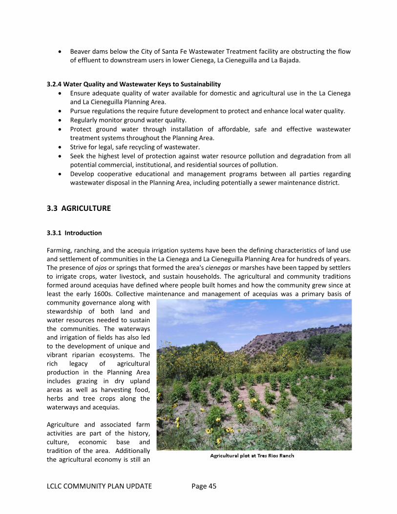
LCLC COMMUNITY PLAN UPDATE Page 45
• Beaver dams below the City of Santa Fe Wastewater Treatment facility are obstructing the flow of effluent to downstream users in lower Cienega, La Cieneguilla and La Bajada.
3.2.4 Water Quality and Wastewater Keys to Sustainability • Ensure adequate quality of water available for domestic and agricultural use in the La Cienega
and La Cieneguilla Planning Area. • Pursue regulations the require future development to protect and enhance local water quality. • Regularly monitor ground water quality. • Protect ground water through installation of affordable, safe and effective wastewater
treatment systems throughout the Planning Area. • Strive for legal, safe recycling of wastewater. • Seek the highest level of protection against water resource pollution and degradation from all
potential commercial, institutional, and residential sources of pollution. • Develop cooperative educational and management programs between all parties regarding
wastewater disposal in the Planning Area, including potentially a sewer maintenance district.
3.3 AGRICULTURE
3.3.1 Introduction Farming, ranching, and the acequia irrigation systems have been the defining characteristics of land use and settlement of communities in the La Cienega and La Cieneguilla Planning Area for hundreds of years. The presence of ojos or springs that formed the area's cienegas or marshes have been tapped by settlers to irrigate crops, water livestock, and sustain households. The agricultural and community traditions formed around acequias have defined where people built homes and how the community grew since at least the early 1600s. Collective maintenance and management of acequias was a primary basis of community governance along with stewardship of both land and water resources needed to sustain the communities. The waterways and irrigation of fields has also led to the development of unique and vibrant riparian ecosystems. The rich legacy of agricultural production in the Planning Area includes grazing in dry upland areas as well as harvesting food, herbs and tree crops along the waterways and acequias. Agriculture and associated farm activities are part of the history, culture, economic base and tradition of the area. Additionally the agricultural economy is still an
LCLC COMMUNITY PLAN UPDATE Page 46
important and component of the plan area and the County as a whole. Many residents have both fulltime employment outside the agricultural sector and engage part time in tending to the orchards, vegetable farms and pastures of the plan area which contributes to the household food budgets and a diverse economy. A number of residents still earn their living entirely from farming. Without taking steps to revitalize local agriculture, residents fear that continued development will eliminate the option of farming in the valley and the communities will permanently lose agriculture along with the rural character of the Planning Area. Maintenance of agricultural production and protection of agricultural land are primary goals of this Plan. (See Maps 5 & 6 – Irrigated Agricultural Lands) According to a hydrographic survey of the area completed by the State Engineer's Office in 1976, approximately 150 acres of land were potentially irrigable by community acequias, surface water sources such as springs, streams and rivers. Out of that 150 acres of acequia irrigated farmland, an estimated 80 acres are actively under cultivation. There lands used for grazing located primarily on the large ranch holdings and public lands in the plan area. Several factors will continue to positively and negatively influence agricultural production in the plan area: The growing demand for organic locally grown food by Santa Fe County residents and visitors
has steadily grown. The Santa Fe Farmers Market and the La Cienega Valley Growers' Market provide local venues for selling produce.
New technologies applied to weed control and water conservation. Continue conversion of agricultural lands into home sites. Continued drought conditions and the drawdown of water supplies. A labor force that is aging. The selling off of water rights associated with the acequia systems.
The demand created for new housing drives real estate prices up as well as property taxes on undeveloped property. Higher property taxes and low returns from agriculture create economic pressure on Planning Area residents. The pressure encourages the sale and development of land traditionally used for agricultural purposes. Once land is converted to housing, it is virtually eliminated from future use in agriculture. Local residents continue to look for viable means to preserve agricultural lands and protect them from development. Potential avenues include: Transfer of Development Rights Programs Conservation Programs Land Trusts Institutional Ownership Traditional Community Preservation Programs
3.3.2 Agriculture Key Issues
• Agricultural land, including irrigated fields, orchards, and grazing areas, are being lost to new development. This significantly alters the local communities, as agricultural activities are integral parts of the rural character and historical heritage of the La Cienega and La Cieneguilla Planning Area.
• The changing agricultural economy and decreased use of agricultural lands helps encourage the conversion of farmlands to other development. A lack of education and promotion of

LCLC COMMUNITY PLAN UPDATE Page 47
economically viable agricultural practices exacerbates this problem for the typical small-scale farmer in the Planning Area.
• Lands managed by the Bureau of Land Management and the New Mexico State Land Office (NMSLO) currently provide opportunities for agricultural uses, such as grazing, within the Planning Area. However, if these lands should change to private ownership through land swaps or state development, they could be removed from use in the communities' traditional grazing practices.
• The drop in spring flows in and near the Planning Area has dramatically impacted local acequias and has made the practice of irrigation difficult because there is less water available for irrigating than the total number of irrigable acres. Residents and longtime irrigators have identified the drop in available water for irrigation as one of the biggest obstacles to maintaining agriculture in the area.
3.3.3 Agriculture Keys to Sustainability The Community supports a number of the keys to sustainability expressed in the County’s Sustainable Growth Management Plan (SGMP), including:
• SGMP Goal 14: Preserve, support, promote and revitalize agriculture and ranching as a critical component of the local economy, culture and character.
• SGMP Strategy 14.1.5: Create an inventory of agricultural lands and conduct a land suitability analysis to identify agricultural potential and determine high priority of protection for agricultural soils and other sensitive arable lands, especially historical agricultural land with water rights.
• SGMP Policy 14.2: Support the practicality of agricultural uses to include financing tools to support viability of agriculture.
• SGMP Strategy 14.2.1: Create a transfer of development rights program for agriculture and ranch lands.
• SGMP Strategy 14.2.2: Assess and develop resource tools such as conservation easements, improvement districts, development of impact fees and grants to support the viability of agricultural uses.
• SGMP Strategy 14.2.3: Coordinate with local communities and organizations to promote the development of agricultural products and markets, including the development of farmers markets, buy-local campaigns, and a local products website to market and distribute fresh goods.
• SGMP Strategy 16.1.1: Develop education programs and outreach to support agriculture and ranching. Include materials on organic farming, year round farming and better range management practices.
In Addition, the Community Plan includes these area-specific agricultural keys to sustainability:
• Protect all agricultural lands in the Planning Area. • Maintain and enhance active agricultural production in the Planning Area.

LCLC COMMUNITY PLAN Page 48
Figure 4 Upper La Cienega Agriculture Map.
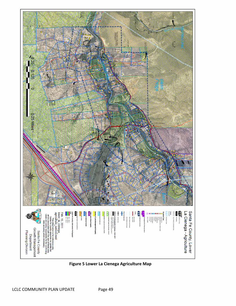
LCLC COMMUNITY PLAN UPDATE Page 49
Figure 5 Lower La Cienega Agriculture Map

LCLC COMMUNITY PLAN Page 50
3.4 TRANSPORTATION AND ROADS
3.4.1 Introduction Significant changes have occurred since the adoption of 2001 Plan that influence traffic conditions and transportation options for the community. New public transit services available just north of the plan area have increased connectivity to the wider region and enhanced the mobility of mobility-restricted residents. Continued residential growth in the plan area has led to increased daily traffic volumes on many roads and the community continues to be concerned about road safety and traffic violations. Residents in some neighborhoods of the plan area have petitioned the County to considered traffic calming measures to increase safety for all users including seniors and children. Similarly, communities across the state are examining their road networks for ways to strengthen overall health of the residents by preventing accidents and increasing opportunities for exercise in the form of walking or bicycling.
3.4.2 Roads The planning area's roads are often narrow and winding. They were created over several centuries, beginning with the Camino Real de Tierra Adentro from Mexico City to Santa Fe and have been continually developing to serve increasing populations while also following natural contours of the landscape.
The majority of roads in the planning area are County owned and maintained. The planning area is accessed from the northeast by the I-25 Frontage Road and Los Pinos Road (CR 5), from the northwest by Paseo Rael, (CR 56) and from the southeast on Entrada La Cienega. Access from Interstate Highway 25 is provided at three intersections: at NM 599, at Exit 271 and at the Waldo exit to the south, near the La Bajada precipice. The County conducts minor repairs of its roads on a regular basis. Overlays and re-paving occur less frequently. Several years ago, the Board of County
Commissioners established the Road Advisory Committee. The Board re-established a Transporation Advisory Committee via Resolution 2013-13 which consists of 13 community volunteers, appointed by the Commission, who represent areas throughout the County. The Committee meets monthly and advises staff on road conditions or problems in their respective areas. Additionally, the Committee prepares an annual Road Improvement Priority Program which lists the County's priority projects. The program is provided to the legislative delegation and becomes the basis for most of the projects funded by the legislature. County Road projects in the plan area are identified on the County’s Road Surface and Proposed Road Maintenance Projects Map (SGMP 2010), page 40.
LCLC COMMUNITY PLAN UPDATE Page 51
Future and on-going transportation study’s, plans and projects adjacent to the plan area present potential impacts and/or opportunities for the plan area. These include:
• The extension of Jaguar to NM 599 (Veterans Memorial Highway) which will provide a major connection to I-25 and the relief route to new and growing developments associated with Tierra Contenta. A major interchange at the intersection of Jaguar and NM 599 just south of the airport which will serve the planned Pavilions Development and possibly access to the Airport.
• A study conducted by NMDOT and completed in 2009 proposed new interchange at the signaled
intersection of NM 599 and I-25 West Frontage RD as well as the extension of the frontage road in the right-of way paralleling the south side of NM 599, the realignment of the I-25 West Frontage Rd and a new local access road providing access to properties associated with Erica Road and Santa Fe Downs. This project is on the NMDOT and Santa Fe MPO list and will be started when funding becomes available.
• The SGMP Future Road Network Map shows a proposed study of a future road extension
between State Highway 14 approximately 1 mile south of the Penitentiary to the interchange at I-25 and Entrada La Cienega.
3.4.3 Traffic The main source of traffic is from local residents with additional traffic generated by several tourist sites located in the planning area. Numerous large and small businesses and home occupation businesses located throughout the planning area generate additional traffic. Due to its proximity to Santa Fe, the area also receives some tourist traffic from "scenic drives" to enjoy the rural character and setting. Presently there are two relatively major generators of traffic in the plan area that generate traffic during specific events; Las Golondrinas and the Santa Fe Downs property when it is hosting the flea market on weekends and soccer practice during the week. Both are accessed via the I-25 frontage road. With the exception of the Transfer Station accessed off of Camino Capilla Vieja, major generators of traffic are not anticipated nor zoned for the interior of the plan area.
3.4.4 Traffic Accidents Between 2006 and 2011 there were 167 traffic accidents. The roads with the highest accident frequency were Los Pinos Road (51 incidents), County Road 56 (26 incidents), and Paseo Rael (11 incidents). The areas around Los Pinos Road and Tierra Hermosa, Los Pinos Road and the Frontage Road, and Los Pinos Road and Camino Colores appear to have the highest frequency of traffic accidents.
3.4.5 Public Transportation and Transit The NM Rail Runner Express commuter train station is located near the intersection of NM 599 and I-25, with current rail access to the City of Santa Fe, and south to Bernalillo, Albuquerque, Belen, and stops in between. The station is within 1 mile of 3% of the plan area (43 parcels including the Downs) but there is not an easy pedestrian trail or bicycle route connecting the area with the station.

LCLC COMMUNITY PLAN UPDATE Page 52
Currently the plan area does not have public transportation or bus routes through the area.. The closest connection to NCRTD buses is the Rail Runner Station where NCRTD buses pick up passengers for routes to the National Guard Facilities. The Santa Fe Trails bus service also has scheduled pick-ups at the station providing connections to a variety of locations in the City of Santa Fe. Another connection closer to the northwestern portion of the plan area and within a mile of La Cieneguilla to the Santa Fe Trails Bus System can be made at a bus station on Airport Road just east of its intersection with NM 599. The Board submitted a Transit Plan to NCRTD in May 2015 which included a La Cienega and La Cieneguilla Pilot Route which is anticipated to begin in February or March 2016.The 2011 Transit Plan considered by the Regional Planning Authority identified the possibility of future transit services in La Cienega. Their recommendation for future transit services suggested the La Cienega and El Rancho de Las Golondrinas areas southwest of Santa Fe represent a potential future transit service market. Based on this recommendation, further discussions should be conducted with the La Cienega Valley Association and the developers of the La Cienega Farmers Market to develop a transit connection from the City of Santa Fe as well as transit connections from the Rail Runner Station at NM599. A resolution approved by the County Commission in May of 2012 also recognized that residents of the plan area could benefit from a NCRTD bus route through the community. A Blue Bus route is proposed to start in 2016 and will go through the Planning Area and connect with existing routes at NM599. The specific routes and stops will be determined through a public input process in the months leading to the buses running. Several plans for adjacent developments present potential impacts and/or opportunities for the plan area. The MPO Bicycle Master Plan identifies on-road and off-road bike lanes and trails in the plan area. On-road bike lanes which will require road widening are shown for both Paseo Rael and Los Pinos Rd. Both the Arroyo Hondo Trail and the Los Chamisos Trail are identified as key elements of the future regional bikeways network although it shows the trails stopping short of the plan area. Additionally, future bikeways planning for the proposed Pavilion development, adjacent to the airport and plan area on the north, will include bicycle paths along the Arroyo de Los Chamisos.
3.4.6 Transportation Key Issues Key issues from the 2001 plan are still relevant today:
• Vehicles often travel at high speeds along the roads in the planning area. The majority of roads are quite narrow with sharp turns. The high vehicle speeds create hazardous conditions for other vehicles, pedestrians, and others sharing the roadways.
• Pot holes and poor road conditions exist on many roads throughout the planning area due to a lack of maintenance.
• Roads in the planning area are subjected to frequent washouts and erosion damage due to runoff from the arroyos, the Santa Fe River, and other drainage sites.
• As the area has grown and tourist destinations have developed, increased traffic including large trucks and busses have created new safety hazards for residents, pedestrians, and livestock on the narrow roads and lanes within the planning area.
• Senior citizens, the disabled, and others who do not drive or have access to transportation lack mobility both within the valley and for trips to Santa Fe.
• Blind and sharp curves often do not have guard rails or other protections. • Many roads leading to area homes have insufficient access for fire safety and emergency

LCLC COMMUNITY PLAN UPDATE Page 53
vehicles.
3.4.7 Transportation Keys to Sustainability The Community supports a number of the keys to sustainability expressed in the County’s Sustainable Growth Management Plan (SGMP), including:
• (SGMP Goal 32) Coordinate with Local, State and Federal governments and transportation organizations to develop a cohesive, safe, and efficient transportation network and transit opportunities to serve County residents, workers, employers and visitors.
• (SGMP Goal 33) Expand safe, convenient and efficient public transportation services to encourage reduction in automobile trips and provide mobility for all people, including underserved populations.
• (SGMP Goal 34) Ensure safe, context-sensitive design standards for transportation improvements that reflect local preferences and the needs of all types of transportation users.
• (SGMP Strategy 34.5.1) Coordinate with the NMDOT to determine what types of traffic calming best management practices can be implemented along state highways which pass through communities in Santa Fe County.
• (SGMP Strategy 35.4.1) Establish a process for evaluating low-water crossings based on traffic volume, road type, runoff volumes, and conjunctive use of the drainage by wildlife and other traffic safety considerations.
In Addition, the Community Plan includes several area-specific keys to sustainability:
• Improved road and bridge infrastructure that maintains the rural character of the Planning Area. • Improved drainage to prevent bridge washouts and flooding. • Roadways that are safe and include traffic calming measures. • Alternative transportation systems that do not rely on auto commuting. • Signage that maintains the rural character of the Planning Area. • Accessible public transportation services for Planning Area residents.
LCLC COMMUNITY PLAN Page 54
Figure 6 Plan Area Roads & Transit Information Map
LCLC COMMUNITY PLAN Page 55
3.5 COMMUNITY SERVICES
3.5.1 Electric and Gas Utilities As the communities of La Cienega and La Cieneguilla have grown in the past few decades, the number of overhead utility cables has dramatically increased. The lines provide power and communications to Planning Area residents. However, the proliferation of overhead lines also creates aesthetically unappealing alterations to the rural landscape and scenic vistas in the area.
3.5.2 Solid Waste Traditionally, residents disposed of household waste by burning it at home. Since the 1980s, the County has managed garbage removal. Solid waste is collected at a County operated transfer station, also known as the La Cienega "Convenience Center" located on County Road 54 B. The transfer station is open five days per week and residents purchase “unit” permits that allow a specified number of visits. Commercial businesses generating less than 850 pounds of refuse per month may also use the transfer station. Use of the facility’s recycling bins is free of charge. The County's Solid Waste Ordinance No. 2014-10 outlines maximum size and weight of loads, requirements for bagging and covering loads, prohibited materials, fines for disposal of waste after hours, permit abuses, and requires recycling of pulp based materials such as paper and cardboard. The existing facility is perceived to lack the necessary capacity for the area it serves and the location is considered inconvenient for many. The large service area, including communities outside of the planning area, brings additional traffic to the area. Illegally dumping garbage along roadways and in arroyos is still an issue. Many residents are unaware of the procedures for disposing of waste or the community impacts of illegal dumping.
3.5.3 Fire Protection The La Cienega and La Cieneguilla Planning Area is served by the La Cienega Fire District which is responsible for providing fire and emergency medical services to the communities of La Cienega, Rancho Viejo, Cochiti Pueblo, Cochiti Village, Valle Vista, the Santa Fe Community College. Its two stations are located outside the plan area and within the plan area at #18 Camino San Jose. The district responds to approximately 450 fire and EMS calls a year with 10 certified Firefighter/EMT's serving approx. 70 sq. miles, a major interstate, large residential development and an ever-increasing commercial development area along state highway 14. The district assists and receives aid from other agencies including NM State Forestry, US Forest Service, the City of Santa Fe, Cochiti Pueblo, Sandoval County Fire Department, as well as other Santa Fe County Districts.

LCLC COMMUNITY PLAN UPDATE Page 56
The La Cienega Volunteer Fire Department was originally started approximately twenty-eight years ago because several of the residents, who were also farmers at the time, would burn off / clear fields in preparation for yearly planting. These fires would sometimes get out of control in the La Cienega Valley bringing them (the residents) together to fight the field fires with whatever resources and personnel they had available. The department started with a garage donated by a resident/member for housing of a 4x4 brush truck on loan by the forest service. Years later, on land donated next to the community center, the members/residents built the current substation (then main station) with donated building materials and labor. Members were trained to basic firefighter levels (no certifications available) however no medical/first aid was available at the time. The organized volunteers responded to approximately 10 calls a year with a used fire engine and borrowed firefighting equipment.
3.5.4 Community Services Key issues
• Overhead cables alter the rural aesthetics of the roads and vistas of the Planning Area. • Utility easement access is often missing for existing homes, and no reasonable method exists to
obtain easements over private property. • The location of the solid waste transfer station on County Road 54 B generates additional traffic
on narrow roads in the Planning Area. This creates safety and traffic problems. • The solid waste transfer station serves too broad of an area and results in a large amount of
solid waste from outside of the Planning Area's communities being brought into the community. • There is illegal trash dumping on public and private property. • The impacts of illegal dumping create problems such as public health, water contamination and
aesthetic detriment to the rural community character. • The communities of the Planning Area have seen a dramatic increase in population over the past
two decades. The increase in residents and home sites has outstripped fire protection infrastructure development. This has led to a lack of accessible and adequately functioning fire hydrants throughout the Planning Area.
• Five of the eight working fire hydrants in the planning boundary do not have adequate water pressure to meet fire suppression needs.
• The working fire hydrants are not positioned to provide timely service to all parts of the Planning Area.
• The La Cienega Fire District does not have enough volunteer members from the Planning Area. More local volunteer firefighters would improve its ability to provide timely responses to emergencies.
• Developments and subdivisions in the Planning Area have been created with commitments to develop adequate fire protection services to new residences and subdivisions. The actual installation of such facilities was not often observed at the community level in the past and residents have expressed concern that facilities may not be fully developed or may not be in proper working order.
• Permits for burning agricultural fields are necessary for local farmers yet are difficult to plan due to potential conflicts.
3.5.5 Community Services Keys to Sustainability The Community supports a number of the keys to sustainability expressed in the County’s Sustainable Growth Management Plan (SGMP), including:
• SGMP Goal 27: Reduce solid waste production and support recycling to limit landfill use and

LCLC COMMUNITY PLAN UPDATE Page 57
move toward zero waste. • SGMP Goal 28: Establish and maintain an all-hazard emergency response plan for Santa Fe
County. • SGMP Goal 29: Preserve and protect public health, safety, welfare and property through
adequate provision of law enforcement, fire and emergency response, and emergency communication services.
• SGMP Goal 30: Establish and maintain an 911 public education/community outreach program. • SGMP Goal 31: Obtain and utilize the latest in emergency communications equipment and
technology. In Addition, the Community Plan includes several area-specific keys to sustainability:
• Improved fire safety throughout the La Cienega and La Cieneguilla Planning Area. • Increased membership of Planning Area residents on the La Cienega Volunteer Fire Department.
3.6 AIRPORT
3.6.1 Introduction The La Cienega and La Cieneguilla Planning Area is located directly south and southwest of the Santa Fe Municipal Airport. The airport was established in the 1950's and has expanded over the years as the region has grown. The airport currently serves as the main air traffic facility serving commercial, private and military aircraft in north central New Mexico. All of the populated areas in the Planning Area are within a 5-mile radius of the municipal airport. Current flight patterns for landing and departing from the facility regularly direct aircraft over the Planning Area. The communities of La Cieneguilla and Upper La Cienega are located directly adjacent to the airport's southern boundary and a large portion of the Planning Area's population lives within two miles of the airport boundaries. These residents and communities have received rapid growth over the past two decades. Simultaneously, as demand for air service from the Santa Fe region has grown, airport operations have intensified. The proximity of these communities to the airport has led to increasing impacts from airport operations. Residents in the Planning Area have strong concerns that possible airport expansion will exacerbate the existing noise and disturbance problems. One intent of this plan is to develop stronger planning and communication between the Planning Area communities and the Santa Fe Municipal Airport in order to minimize and/or eliminate the airport's impacts on these communities.
3.6.2 Airport Key Issues
• The current Santa Fe Municipal Airport flight patterns and flight schedules create nuisances from noise as well as safety concerns for Planning Area residents.
• Training exercises conducted by the Air National Guard at and near the airport facility generate noise and vibrations due to low flying helicopters and jets.
• Expansion of airport facilities including increased or intensified use by commercial, residential and military aircraft will likely exacerbate existing noise and safety problems.

LCLC COMMUNITY PLAN UPDATE Page 58
3.6.3 Airport Keys to Sustainability
• Mitigation of airport operation’s impacts on the surrounding communities in the Planning Area. • Alteration of aircraft flight patterns to minimize flights over populated portions of the Planning
Area.
3.7 COMMUNITY OPEN SPACE & FACILITIES
3.7.1 Open Space Areas traditionally used as community open spaces are being lost to new development. While these common land areas are often privately held, development effectively removes them from the undeveloped landscape which has traditionally been used for grazing areas, hiking and helped define individual villages by forming buffer areas between communities. The development pressures threaten the traditional rural character of the Planning Area as characterized by farm fields, acequias, and open lands buffering village areas. The open lands and buffers between development are significant characteristics of rural, agricultural and historical identity of communities in the La Cienega and La Cieneguilla Planning Area. Open Space and undeveloped areas in the La Cienega and La Cieneguilla Community Planning Area includes County open space property, Bureau of Land Management properties and lands managed by the New Mexico State Land Office. Open space areas throughout the Planning Area contain significant ecological and cultural resources that have not been completely inventoried or had management plans developed to date. It should also be noted that extensive study has been conducted on the adjoining BLM designated Area of Critical Environmental Concern (ACEC) and that the BLM has cooperated with community members in developing management strategies. Residents of La Cienega and La Cieneguilla have always considered these lands to be integral and essential parts of the community. The Plan supports continued and enhanced joint management between community members, private landowners, the BLM, the County, and the State Land Office.
3.7.2 Community Facilities Development in the La Cienega and La Cieneguilla Planning Area has increased in the past two decades. As the community has grown, there has been an increase in demand for more community facility’s. The existing Community Center is located in Lower La Cienega near the intersection of La Entrada de La Cienega and Camino San Jose. This facility was built in the 1930's and served as the community school for many years before becoming the community center. The building also serves as the La Cienega Fire District sub-station and houses the new library. . Additionally, the center is located near the southern end of Lower La Cienega and is not in a central location to serve the growing populations in Upper La Cienega and La Cieneguilla. This center is the only community facility and its limited size and location do not allow for either expansion or development of recreational facilities such as a park and playground for area youth. One aim of this plan is to develop and implement plans for a centrally located community facility to meet growing population and diverse needs of the communities in the planning area.

LCLC COMMUNITY PLAN UPDATE Page 59
3.7.3 Community Open Space and Facilities Key Issues
• Lands managed by the Bureau of Land Management (BLM) and the New Mexico State Land Office (NMSLO) currently provide open space opportunities within the Planning Area. However, if these lands should change to private ownership through land swaps or state development, they might be removed from the communities' traditional open space and buffer areas.
• Open space areas throughout the Planning Area including the county open space, BLM lands and state lands require a coordinated, community-based management plan to maintain and protect these resources while allowing for community uses
• New development on private lands threatens to build over many of the buffer areas and traditional open spaces which help define the rural character of the community.
• Use of off-road vehicles and firearm discharge/target shooting in unauthorized areas as well as garbage dumping on open lands in the Planning Area have also been identified as problems.
• The Planning Area’s existing community center is not centrally located and does not have adequate facilities to support a sufficient range of community activities, particularly outdoor activities. The facility is too small, lacks adequate parking, and is not convenient.
3.7.3 Community Open Space and Facilities Key Issues The Community supports a number of the keys to sustainability expressed in the County’s Sustainable Growth Management Plan (SGMP), including:
• SGMP Goal 44: Ensure that adequate public facilities and services are provided and maintained . • SGMP Goal 45: Equitably finance facilities and services. • SGMP Policy 44.2: The provision of new infrastructure and facilities should be coordinated with
existing infrastructure and facilities and should maximize use of existing facilities capacity to the extent that any exists.
• Protect and maintain all open space areas as an integral part of the community. • Provide ecologically and culturally sensitive management of open spaces and trails in the
Planning Area.

LCLC COMMUNITY PLAN UPDATE Page 60
SECTION IV: GOALS AND STRATEGIES
WATER RESOURCES Goal 1: Ensure a sustainable, fresh water supply for the community. Strategy 1.1: Develop alternative water sources including conservation. Action 1.1.1: Ensure that commercial and institutional entities with on-site wells in or adjacent to the planning area connect to the County water system at the earliest possible date. When possible, existing on-site wells should be retired or dedicated for emergency uses only, such as fire protection or in the event that the County water system should fail. Action 1.1.2 Ensure that all new residential development shall limit water consumption to .25 acre feet or less of water per year for domestic consumption per legal lot of record for all indoor and outdoor water use. Action 1.1.3: Investigate sources of supplemental water to use for irrigation. Sources might include water harvesting and/or other reuse initiatives such as treated effluent from the City of Santa Fe's wastewater treatment plant, the State penitentiary and/or National Guard facility as well as commercial, institutional and residential developments in or near the Community Planning Area. Action 1.1.4: Develop water conservation and protection initiatives at all commercial facilities within and adjacent to the Community Planning Area. Action 1.1.5: Monitor to ensure that water users and all new utility, institutional, residential, and commercial developments in the La Cienega and Santa Fe River watersheds will incorporate a reasoned approach in the development of water sources. These policies will be based upon the best available data and should be considered as necessary aspects of all development approvals in the planning area and in the La Cienega and Santa Fe River watersheds. Strategy 1.2: Retain water rights which currently exist in the community within the community. Action 1.2.1: Develop a monitoring and notification program within the planning area to inform all water rights holders of proposed initiatives and activities that may impact and or potentially impair all water rights in and/or associated with the planning area. Action 1.2.2: Coordinate with the La Cienega Mutual Domestic Water Association (LCMDWA) to leverage community resources to acquire transferable water rights in the planning area and apply such water rights to the expansion of existing or creation of new community water systems. Action 1.2.3: Inventory transferable water rights in the planning area and when possible, develop a voluntary notification process with the water right owners to arrange a preferential right of purchase for these water rights in order that they may continue to serve as a community resource. Action 1.2.4: Coordinate with the acequia associations, the La Cienega Mutual Domestic Water Association, residents, business owners and property owners to expand water conservation initiatives within the community by providing educational materials and practical examples of water conservation

LCLC COMMUNITY PLAN UPDATE Page 61
techniques that can be employed in the planning area. Strategy 1.3 Expedite the implementation of the La Cienega watershed conditions. Action 1.3.1: Implement watershed conditions fully by seeking the prioritization of the extension of Santa Fe County water lines to serve existing and future residential and commercial uses in Upper La Cienega. Seek to have available County water prioritize existing water users over new development (see Water Service Priority Area & La Cienega Watershed Conditions below). Action 1.3.2 Ensure that all new development in the Planning Area connect to the County water system when the system is extended to within 200 feet of the property line or according to SLDC, provided that adequate capacity exists in the system and that taps are available. Strategy 1.4 Require documentation of conservation measures. Action 1.4.1 All land division and zoning density variance applications in the Planning Area shall be granted only if the applicant provides a site-specific hydrogeological report that demonstrates a 100 year water supply and which assess the impact of the new well on neighboring wells, acequias, streams, ponds and springs. Action 1.4.2 Limit the maximum possible existing residential water use to 0.50 acre feet of water per year. Any use above .025 acre feet per year must be applied for with a water budget and proof of 100 year water supply as per the existing County Sustainable Land Development Code or other regulation that may apply. The application must also demonstrate conservation of water through recycling, reduced use, rainwater (and other) collection and other means equal to stringent sustainable land use principles. This water consumption requirement applies only to use of water for domestic purposes from domestic wells as defined by the state and does not apply to any other water rights (irrigation or private.) Action 1.4.3 Verify that all new wells and buildings using ground water drawn from wells located within the Planning Area as a partial or total water supply have installed a water meter on their wells. All new development using shared wells or community water systems shall install a water meter on every dwelling unit or primary structure/intake that uses the well water. Action 1.4.4 Enforce current regulations requiring the monitoring and reporting of water usage. All users shall record water meter readings on a monthly basis and submit an annual report of monthly readings to the County Hydrologist and, if established, to the community’s water management authority. The community will coordinate with the County Hydrologist to develop a water meter auditing program to ensure compliance with water restriction covenants. If a user is over consuming, the County will work with the individual to 1) develop a water budget and conservation plan including efforts to replace any amount over consumed and, 2) develop a fine for repeated instances of over consumption. Strategy 1.5 Promote and enforce water conservation and best management practices. Action 1.5.1 All new development shall incorporate water conservation and best management practices which are compliant with state and county regulations as well as current sustainability practices. This may include reuse of gray water, storm water recharge and rainwater collection systems such as, cisterns, gravel beds or other storage systems for which regulations have been enacted. These practices
LCLC COMMUNITY PLAN UPDATE Page 62
may include:
• Water collection to the extent practical and affordable and not required to exceed 1% of total construction costs, shall be used for landscaping irrigation and/or other domestic uses in order to replace use of potable water supplies.
• Xeriscaping and/or native plants will be encouraged for landscaping on all new landscaping. The area of landscaping to be irrigated will be based on County Hydrologist approved water budget estimates of rainwater collection and storage capacity per the individual development. This will not apply to agricultural uses of water.
• The building of swimming pools is discouraged in the Community Planning Area. Any new pool must meet County SLDC, County water conservation guidelines, satisfy water availability requirements, and include a covering when not in use to minimize evaporation.
Strategy 1.6 Regulate all new development of riparian areas and/or wetlands Action 1.6.1 Prior to development of new riparian areas and wetlands in the Planning Area, applicants shall demonstrate adequate water rights and/or source(s) of water to meet consumptive needs of the riparian area or wetlands, and demonstrate that the project will not negatively impact prior beneficial uses or traditional uses of water resources, in accordance with State Engineer's Office regulations. Action 1.6.2 OSE guidelines for determining the consumptive needs of the riparian area or wetlands shall use the U.S. Soil Conservation Service Modified Blaney-Criddle Method, long-term weather data for the period from 1867 onward and consumptive-use coefficients developed by the U.S Bureau of Reclamation for riparian vegetation in the Middle Rio Grande Valley. The Consumptive Irrigation Requirement (CIR), an annual measure of water uptake by vegetation, exclusive of precipitation, shall be calculated for all proposed types of vegetation to be incorporated into the riparian area or wetlands. Action 1.6.3 All development of new projects in riparian areas and wetlands shall also comply with all County Code requirements including, without limitation, terrain management. Projects may also be subject to monitoring, which will be designed on a case-by-case basis, to ensure that the water rights associated with the project are not exceeded, and to address any possible negative impacts associated with the project.
WATER QUALITY AND WASTEWATER Goal 2: Protect the quality of surface and ground water. Strategy 2.1: Monitor existing on-site treatment wastewater systems to prevent contamination. Action 2.1.1: Undertake and fund a feasibility study for different scales and approaches to wastewater management in the plan area including sanitation districts, satellite systems and regional wastewater treatment facilities. Explore the possibility of establishing local financing mechanisms, such as an assessment district, to create a water and/or sanitation district to serve the planning area Action 2.1.2: Develop a program that will assist homeowners with septic system compliance. Such a program should include education, outreach and funding mechanisms to help homeowners ensure existing and new septic systems meet applicable standards.

LCLC COMMUNITY PLAN UPDATE Page 63
Action 2.13: Develop guidelines and assistance for all new developments to install wastewater treatments systems which are designed to treat effluent or wastewater to EPA and NMED standards. (The state requires systems to meet EPA and NMED standards and in order to get a County development permit an applicant must have a state approved permit). This will include working with the Drinking Water Bureau of the Environment Department to disseminate information regarding how individuals can test their own water, all relevant County and State regulations regarding well drilling and maintenance, as well as scheduling periodic water fairs in the planning area. Action 2.1.4: Work with the NMED to develop voluntary noticing procedures whereby when new wells or septic systems are installed within the planning area, the land owner will provide a map of all wells, septic systems, open water courses, springs, arroyos and acequias on or adjacent to the property. The intent of this is to prevent accidental placement of wells or septic systems which might have potential impacts to water resources and drainage on adjoining properties. Action 2.1.5: Develop a septic tank monitoring program. Such a program will require that individual septic tank sludge levels be measured every 2 years and pumped if called for by NMED standards. A biennial report examining septic tank conditions and problems in the planning area will be compiled and distributed to interested community organizations. This policy is intended to help homeowners ensure that septic systems will not fail, to avoid large costs of repairing failed systems, and protect surrounding water resources from potential contamination. Strategy 2.2: Minimize ground water impacts associated with polluting land uses. Action 2.2.1: Require existing commercial and institutional entities which produce animal or chemical wastes that have the potential to contaminate ground water which are located adjacent to or in the planning area to properly contain and dispose of all wastes either brought onto the property or generated through the entity’s operations. Strategy 2.3: Reduce erosion and pollution from storm water runoff. Action 2.3.1: Develop design requirements for new development that control runoff into arroyos through use of retention ponds and/or other techniques that control runoff while also allowing for aquifer recharge. Action 2.3.2: Review all road projects that may affect run-off in the La Cienega and Santa Fe River watersheds and Planning Area such as the Arroyo de Los Chamisas, Arroyo Calabasas, Arroyo Hondo and the Santa Fe River. Strategy 2.4: Enhance water quality and quantity in the Santa Fe River. Action 2.4.1: Seek to develop a joint information sharing and dissemination program that allows for periodic review of the City's Wastewater treatment facility operations and reports. This will be designed to allow for greater communication and cooperation between the City, the County, NMED and County residents regarding facility operations' impacts on the community at large and the communities of the planning area. Issues of concern to the community include but are not limited to facility design and potential for spills, reliable supplies for power generation and emergency back-ups, sludge treatment and storage capacity, and sludge field injection practices and potentials for water contamination. The goal of this action is to get the above parties to investigate means to formalize such a cooperative program through development of cooperative agreements between the various parties and agencies.
LCLC COMMUNITY PLAN UPDATE Page 64
Action 2.4.2: Monitor to ensure that quantity and quality of effluent flows from the City's wastewater treatment plant are sufficient, based on the best available data, to meet the needs of downstream water users and in recognizing priority water rights of downstream users, once established. Action 2.4.3: Develop a study of best management practices to ensure quality of water, wildlife habitat and beneficial use of water resources along the Santa Fe River in the planning area.
AGRICULTURE Goal 3: Maintain and expand agriculture in the plan area. Strategy 3.1: Limit the conversion of agricultural land to non-agricultural uses. Action 3.1.1: Creating an inventory of agricultural lands in the planning area. Action 3.1.2: Developing a voluntary notification process of all sales of agricultural land. When possible, this will include negotiation of a first right of refusal agreement on sales of said lands. The OSE requires any ditch member to notify the commission of the ditch of intent to sell water rights. El Guicu Ditch’s bylaws give their commission the right to refuse the request. Action 3.1.3: Forming a representative committee of stakeholders to develop a community managed agricultural land protection program using methods such as, but not limited to, land trusts, conservation easements, and transfer of development rights. Action 3.1.4: Investigating various funding mechanisms to support agricultural land protection and management programs through mechanisms including, but not limited to, improvement districts, development impact fees, grants, and legislative appropriations. Action 3.1.5: Supporting public land access, including to federally managed and state managed land, for grazing, as it is a community tradition and directly tied to sustaining economically viable agricultural enterprises in the planning area. Action 3.1.6: Supporting incentive based zoning that encourages property owners to create agricultural conservation easements Strategy 3.2: Support current growers and ranchers. Action 3.2.1: Investigate the feasibility of alleviating property tax burdens for small-scale ranching and farming operations in the planning area. Action 3.2.2: Investigate the feasibility of recharging area springs in order to support traditional agricultural uses of water resources in the planning area. Action 3.2.3 Develop an agricultural support program to help revitalize traditionally irrigated lands and agricultural activities such as small scale farming and ranching in the Planning Area. This will include educational outreach, skills training, and marketing assistance to support economically and environmentally viable farming practices for community members in the Planning Area. The program

LCLC COMMUNITY PLAN UPDATE Page 65
will also include educational outreach for appropriate scale gardening and landscaping in newer subdivision areas.
TRANSPORTATION AND ROADS Goal 4: Develop a transportation system that provides for community mobility and safety. Strategy 4.1: Ensure existing transportation infrastructure is properly maintained. Action 4.1.1: Develop educational materials to inform Planning Area residents of the County's notification procedures for road maintenance needs and requests. Action 4.1.2: Coordinate with the community representative of the County's Road Advisory Committee and the County Planning Division to develop a community priority list of road improvements and funding priorities. Strategy 4.2: Ensure that future transportation improvements do not undermine the plan area’s rural character. Action 4.2.1: Design road safety features, including but not limited to, lighting and signage that are designed to maintain the rural character of the community. Action 4.2.2 Work to ensure that all construction, widening and/or upgrading of public roads into the Planning Area shall be planned and designed through consultation with a representative community body and shall include design standards that meet all legal requirements while also maintaining the rural character of the Planning Area. Strategy 4.3: Enhance the transportation network’s safety. Action 4.3.1: Identify areas with speeding problems and develop a periodic monitoring schedule with the Sheriff’s Department to enforce speed limits within the planning area. Action 4.3.2: Study the feasibility of implementing traffic calming measures, such as speed bumps, on roads with consistent speeding problems. Action 4.3.3: Coordinate with establishments in the planning area that generate high traffic volumes in order to develop either alternative traffic routes and/or event planning to minimize impacts from high traffic. Action 4.3.4: Study the feasibility of implementing guardrails on dangerous and sharp curves in the planning area. Action 4.3.5: Work with the State Highway Department to improve the intersection of Las Estrellas Road and the Interstate 25 frontage road and create screening which will clearly separate headlights on the interstate and on the frontage road. Strategy 4.4: Support the use of alternative transportation modes.

LCLC COMMUNITY PLAN UPDATE Page 66
Action 4.4.1: Study the feasibility of providing transportation services to low mobility residents through existing public, non-profit and private transportation services. Action 4.4.2: Study the feasibility of developing alternative transportation services including options such as ride-sharing and park and ride Action 4.4.3: Develop better walking trails and better pedestrian access along roadways.
COMMUNITY SERVICES Goal 5: Ensure adequate utility services that do not undermine the plan area’s rural character. Strategy 5.1: Ensure that the planning and installation of future utility services reflect community preferences. Action 5.1.1: Develop design and installation standards for all new or replacement utility services in the planning area. All improvements must be designed to maintain the rural character of the community. This will include a public process for input from residents, business owners and property owners. Action 5.1.2 Encourage policies that require all new and replacement utility services within the Planning Area must be installed underground or, if this is not possible, installed in such a manner so as to mitigate the aesthetic impact on the rural character of the community and surrounding natural environment. Goal 6: Ensure solid waste is appropriately disposed. Strategy 6.1: Prevent illegal dumping. Action 6.1.1: Study how well existing solid waste management practices are serving the planning area. This may include investigating the possibilities for additional sites for solid waste transfer, particularly for areas on the eastern side of 1-25 and communities north of the planning area, as well as means to finance a new station. Action 6.1.2: Study the possibility of opening the solid waste facility seven days per week in order to better meet the demand for waste disposal from the entire area served by the transfer station and to eliminate illegal dumping at times when the facility is not open. Action 6.1.3: Develop more effective enforcement of illegal dumping fines and develop regular community wide sweeps to discourage illegal dumping. Action 6.1.4: Develop new signage to educate people regarding illegal dumping and to deter the practice in the planning area. Signage should also educate people about disposal of hazardous household items that can enter water resources. Strategy 6.2: Reduce trash in the plan area. Action 6.2.1: Create a community program for periodic trash pick-up days in the planning area for large items and waste not accepted at the transfer station on private, County, State and BLM lands.

LCLC COMMUNITY PLAN UPDATE Page 67
Action 6.2.2: Initiate an annual community program "Clean-up." This will include developing a representative community committee to coordinate local waste management activities and projects. This may also include expanding an Adopt a Road program and creating affordable incentives for community participation on annual clean-ups. Goal 7: Create a fire protection network for the entire community. Strategy 7.1: Increase capacity to respond to fire events. Action 7.1.1: Investigate means to increase water pressure in existing fire hydrants. This may include but is not limited to connecting existing hydrants to the County water system and/or other available water systems at the earliest possible date. Action 7.1.2: Identify additional public and/or private water sources and to develop use agreements in order to meet emergency service needs in the planning area. Action 7.1.3: Develop an implementation and funding plan in order to expand the number and location of accessible fire hydrants throughout the planning area. This may include, but is not limited to, construction of water storage facilities for emergency use in the planning area. Improvements must be designed to maintain the rural character of the community. Action 7.1.4: Assess the capacity and working order of existing fire hydrants and develop a repair and or replacement program for hydrants which are not in proper working order. Action 7.1.5: Assess fire access conditions in the planning area and develop a community education program to ensure proper access conditions on roads, driveways and gated drives and roads within the planning area. Action 7.1.6 Plan for coordinated permitting and burning of agricultural fields, including working with the local Acequia Associations to coordinate burns and provide support to fire personnel. Action 7.1.7 Ensure that fire protection is available for addressing the spontaneous burning of manure piles and ensure that similar stockpiling of manure does not occur in the future. Strategy 7.2 Require an access management plan for all new roadways, per SGMP Strategy 29.4.2. Action 7.2.1 Ensure that developments and subdivisions in the Planning Area meet all commitments to create adequate fire protection services. These commitments should be fully developed and in proper working order to service new residences and subdivisions. Strategy7.3 Increase volunteer fire fighter recruitment from within the Planning Area. Action 7.3.1 Develop an educational campaign to increase awareness in the Planning Area of the need for volunteers and options for volunteering. (Coordinate with County efforts per SGMP Policy 29.3 and Strategy 29.3.1). Action 7.3.2 Increase fire protection awareness in the Planning Area. This will include an educational campaign to inform residents of current County Code requirements as well as practical measures that residents can implement to improve fire protection.
LCLC COMMUNITY PLAN UPDATE Page 68
AIRPORT Goal 8: Enhance compatibility between the airport and plan area. Strategy 8.1: Minimize the airport’ s external impacts on the plan area. Action 8.1.1: Address the impacts of airport operations on surrounding communities. This representative group will work with the City of Santa Fe, the Federal Aviation Administration (FAA) and any other relevant agency or group on issues including but are not limited to development of flight patterns that do not cross populated areas, timing of flights, placement of navigational beacons and noise abatement. Action 8.1.2: Develop a representative community body which will request that Santa Fe County and the City of Santa Fe jointly create a Noise Mitigation and Abatement Program at the airport. Action 8.1.3: Create and implement a planning process to develop all airport expansion plans. Action 8.1.4: Request a limit on expansion of new carriers, daily flights by commercial aircraft and non-emergency operations until a new airport plan is developed. Action 8.1.5: Explore options and constraints of locating an airport facility away from heavily populated areas in the County. This program action is intended as an investigative measure and does not imply any type of commitments by any party for siting of future facilities. Action 8.1.6: Investigate options and means for developing a scheduling process to limit regular flights to daytime hours and decrease or eliminate regularly scheduled flights after 8:00 p.m. Action 8.1.7: Work with the National Guard to reduce the impact of flights over populated areas and undeveloped private property in the planning area through higher flight patterns, noise abatement efforts, and other means. Action 8.1.8: Encourage the airport management to educate pilots and other airport personnel about the importance of noise abatement procedures, common courtesy toward local residents, and the locations of private property in the airport vicinity.
COMMUNITY OPEN SPACE & FACILITIES Goal 9: Ensure that parks, open spaces and trails in the community reflect and support community values. Strategy 9.1: Ensure that planned uses on public lands do not inappropriately impact the plan area. Action 9.1.1: Develop an accurate inventory of all public land uses and leases in and surrounding the planning area. This will include development of a reporting procedure whereby all parties can be informed as to current and planned uses of these public lands. Action 9.1.2 Coordinate with the County Open Space program and the Planning Division to develop a

LCLC COMMUNITY PLAN UPDATE Page 69
public education program to help clearly identify boundaries between public and private properties in order to respect and protect private property from non-permitted public use. Action 9.1.3 Form a representative committee of stakeholders to develop a community open space protection program. Strategy 9.2: Maintain open space while accommodating new growth. Action 9.2.1: Develop voluntary open space protection programs including but not limited to: clustered housing, land conservation programs, Transfer of Development Rights programs, conservation easements, purchase of development rights programs and community-based land trusts. Strategy 9.3: Plan for appropriate pedestrian and equestrian access aligned with exiting road network that provide connections to community facilities and regional trails. Action 9.3.1 Identify pedestrian connections in conjunction with planning and programming of new community facilities. Action 9.3.2 Identify roads in the plan area with appropriate R.O.W. that can accommodate future trail network to avoid trail linkages across private property or in arroyos. Action 9.3.4 Work with private land owners, the BLM and the State Land Office to develop voluntary use agreements, easements, or other arrangements for public use of these trails. This will include working with all parties to help identify trailhead locations for existing trails. This will also include closure of all unauthorized trails and measures to educate the public to eliminate trespass on private properties. Action 9.3.5 Develop a voluntary notification process of all sales of open space properties identified in the above mentioned inventory. When possible, the community will negotiate a voluntary first right of refusal on sales or transfers in order that the lands may be purchased for protection and inclusion in community open spaces. This program will include exploring funding mechanisms to purchase the lands and maintain the lands. Action 9.3.6 Develop an accurate inventory of wildlife habitat areas in the Planning Area and develop a management and protection program with direct participation from local residents, property owners and business owners Action 9.3.7 Identify and create a management program consistent with existing county and state regulations to preserve historical and archeological areas within the Planning Area including but not limited to petroglyphs, Pueblo ruins, and other historical sites. Action 9.3.8 Develop a community-based stewardship and management program for public lands in and adjacent to the Planning Area. The management program will create environmentally and culturally sensitive programs to maintain traditional activities such as common open space areas, horseback trails, and grazing. Strategy 9.4: Plan for small parks to serve evolving neighborhoods to serve existing and future neighborhood residents.
LCLC COMMUNITY PLAN UPDATE Page 70
Goal 10: Ensure the availability of community facilities to serve the planning area’s diverse and growing population. Strategy 10.1: Establish new community facilities in appropriate locations in the plan area. Action 10.1.1: Investigate means, including funding for development, operations and maintenance costs, to establish a community facility in the planning area. Such a facility may include but not be limited to a park, a local history center, recreational facilities for sports, and a multipurpose community meeting center. Coordinate efforts to apply County resources to local facilities as described in SGMP Chapter 12. Action 10.1.2: Investigate options including but not limited to linking public facilities with acquisition and management of County Open Space properties and /or other lands held by public agencies within the planning area. Coordinate efforts to apply County resources to local facilities as described in SGMP Chapter 6. Action 10.1.3: Investigate mechanisms available to include public recreational facilities in new development and/or local funding mechanisms to support maintenance of community facilities. Coordinate efforts to apply County resources to local facilities as described in SGMP Chapter 6 and 12. Action 10.1.4 Ensure that all proposed community facilities shall be designed through consultation with a representative community body and shall include low water use design, energy efficient construction, passive solar features, and low-maintenance design. Strategy 10.2: Expand the scope of community services available in the plan area. Action 10.2.1: Develop a message board(s) for the Community Organization to use for announcement of development projects to facilitate greater public notification and review of proposed development in the planning area. Such board(s) could be placed in centrally located spot(s) within the planning area and be used by the Community Organization for public notification procedures as outlined in this Plan. A message board or kiosk shall be included at the community center. Coordinate efforts to apply County resources as described in SGMP Chapter 14. Action 10.2.2: Develop a commercial kitchen for community use. Action 10.2.3: Develop a permanent funding source for community outreach, including announcement board signs, community website expansion and maintenance, community newsletters, and other informational program.

LCLC COMMUNITY PLAN UPDATE Page 71
SECTION V LAND USE PLAN AND GROWTH MANAGEMENT
5.1 INTRODUCTION The Community Land Use Plan is made up of several components that are interrelated and when viewed as a whole provide a framework to guide development decisions, zoning and regulations, utility extensions and capital improvement projects. The components include:
• Future Land Use Map and Categories which will be used to guide the establishment of base zoning districts and corresponding overlay zones.
• Traditional Agricultural Lands Preservation and Protection Map and recommendations which will be used to guide the establishment of an Agricultural Overlay Zone to incent and promote the conservation and use of irrigated agricultural land and open space.
• Priority County Water Hook-Up Area Map and recommendations based on existing regulations pertaining to the La Cienega watershed conditions, County water extension policies and current and planned alignment of County water lines.
• Roads and Transportation Plan that includes a map, text and graphics illustrating a proposed route for a commuter shuttle and recommended rural road profiles and improvement guidelines.
• Corresponding Community Facilities, Open Space and Trails Map and recommendations.
5.2 SUSTAINABLE GROWTH MANAGEMENT GUIDELINES Guidelines for growth and development based on the principle of sustainability reflect a number of changes in the ways that zoning densities are determined. Many of the original components of the La Cienega and La Cieneguilla Community Plan incorporate sustainability. Preservation and stewardship of the traditional uses of the land are important aspects of sustainability, as are principles of protecting water resources (in both quantity and quality), and supporting the viability of traditional occupations including agriculture and grazing. In addition to these existing components, sustainability addresses the broader use of all resources, including energy consumption, recycling, and the economic stability of the community. The County’s Sustainable growth Management Plan (SGMP) outlines principles based on long-term sustainability that will guide land use, and provides a framework for zoning for the County’s Sustainable Land Development Code (SLDC). These principles include consideration of water availability and use, terrain, proximity to existing development, energy consumption, and economic viability. Many of the original components of the 2001 La Cienega and La Cieneguilla Community Plan incorporate these principles. Preservation and stewardship of the traditional uses of the land are important aspects of sustainability, as are principles of protecting water resources (in both quantity and quality), and supporting the viability of traditional occupations including agriculture and grazing. This plan update reinforces those principles and supports the goals and policies of the SGMP and in fact implements many of the strategies identified in the SGMP. In conjunction with the SGMP policies and the SLDC, the following future land use map and provisions is intended to ensure compatibility among various land uses, protects existing property rights pertaining to lot size and density, provides flexibility and certainty, conserves local water resources, protects scenic features and environmentally sensitive areas, enhances rural development patterns, delineates areas to incent agricultural preservation while accommodating the anticipated natural growth of the community
LCLC COMMUNITY PLAN UPDATE Page 72
and the potential for appropriate commercial development. The land use categories are consistent with the Future Land Use Categories in the SGMP but are described in greater detail to capture the community’s goals for the plan area and the area’s unique charter. Once adopted The La Cienega and La Cieneguilla Future Land Use Map, (see page 67), corresponding land use categories and provisions refine and amend the SGMP policy framework and Future Land Use Map and as such shall guide future zoning and development decisions. Development types, such as clustered developments and accessory dwelling units are identified as a means to encourage compact development, encourage historic development patterns and accommodate a variety of lifestyles including multi-generational families living together. Many provisions and recommended standards identified in this plan are accommodated in appropriate sections of the SLDC.
5.3 LAND USE PLAN AND GROWTH MANAGEMENT GENERAL PROVISIONS & GUIDELINES The following general provisions and guidelines should guide the drafting and adoption of a La Cienega and La Cienega Community District to amend Chapter 9 Community Districts of the SLDC and Official Zoning Map. Restricted Land Uses based on Water Quality Protection
New development that poses a risk of spills and potential to contaminate surface and ground water systems shall not be permitted within the Planning Area. Non-permitted uses will include gas stations, asphalt batch plants and asphalt production plants, large-scale mining, any warehouse which stores or transfers chemicals, large-scale agricultural operations which stockpile manure or have manure lagoons (e.g.: dairies, horse parks or stables, chicken farms), waste oil recycling, septic tank pumping waste disposal, grease trap waste disposal, large-scale chili processing plants, cheese processing plants, gasoline storage facilities or transfer stations, auto repair facilities, car washes, sludge disposal fields, mortuaries, and slaughter houses.
Restricted Development Areas
Restricted Development Areas simply delineate all of the areas where development will be severely restricted. This can be based on the FEMA maps, the SGMP official maps and the community identified scenic features and environmentally sensitive areas. For example La Cienega Creek, Arroyo Hondo and Alamo Creek and associated bosques could be delineated on a map using FEMA flood plains.
Steep Slope Areas
These are areas with greater than 30% slope. Floodplain Areas
These are the 100-year floodplains that have been mapped by FEMA. Santa Fe County also

LCLC COMMUNITY PLAN UPDATE Page 73
generally prohibits development within a 75-foot buffer adjacent to the mapped FEMA floodplain boundary, which will also be included.
Wetland Areas And Riparian Habitat
The National Wetlands Inventory will be used for wetland areas and the New Mexico ReGAP Vegetative Land Cover data will be used for riparian areas. “Riparian areas” are the willows, cottonwoods, etc. that are typically found near streams, but do not occur in the water-saturated soils that characterize wetlands.
Archaeological Sites
Archaeological sites identified in the under the Galisteo Basin Sites Protection Initiative shall be protected.
Stream And Arroyo Buffers
Streams will have at least a 25-foot buffer based on the current County Land Development Code requirements.
Critical Habitat Areas
These are typically defined as areas that are essential to the maintenance of viable populations of endangered or threatened animal species. Likely areas that may be included as Critical Habitat Areas are usually within the wetland, riparian, and floodplain zones.
5.4 LAND USE PLAN AND GROWTH MANAGEMENT KEY ISSUES
• Community residents have identified that family transfers and variances are sometimes used to divide properties below the minimum lot sizes to avoid subdivision regulations and procedures, contrary to the intent of the family transfer procedure. This allows for increased density on small lots and places higher demands on local water resources to accommodate the new development. More careful examination of the potential impacts of increased densities on local water resources as well as on infrastructure and the area's rural character is necessary before exemptions and variances are granted.
• The rapid development and subsequent changes in land uses, primarily from agricultural to housing, impacts property values and increases tax burdens. This development has benefited some property owners, particularly in the case of large-scale developments. However, the development has also increased economic pressure on families and small-scale landowners to follow the same pattern which has led to piecemeal subdivision of the Planning Area at the expense of the community character. Community residents have identified that continued and uncontrolled development threatens to destroy the rural nature of the community. Additionally, rapid development places strains on limited local natural resources, including water.
• The Planning Area includes various zoning districts including the Traditional Community Zoning District. The maps which depict these different zones, particularly the Traditional Community Zoning District, are interpreted on a case by case basis which has led to confusion on individual zoning decisions. Thus, enforcement is complicated because of unclear boundaries between the various zoning areas.
LCLC COMMUNITY PLAN UPDATE Page 74
• Due to increased growth and concerns regarding water quality in the Planning Area, some community members have called for extension of County water and/or wastewater systems into the Planning Area. However, if these systems were expanded in the Planning Area it might be possible to increase housing densities to areas served by both sewer and water. The increased housing densities would lead to urban style intensive development which would further threaten the rural character of the communities in the Planning Area.
• Zoning and density decisions are largely influenced by water availability and the adequacy of septic systems. This is an appropriate approach in the Planning Area due to the need to balance water resources with development. However, the rural character of the communities in the Planning Area is intrinsically linked to development patterns and zoning decisions. Community members in the Planning Area have expressed the importance of including specific consideration of important elements such as local infrastructure, traffic and other impacts of development on the rural communities along with the critically important water resources.
• In the past two decades, zoning changes and land use policies designed for the entire County have helped to direct new growth in the Planning Area. While growth and change are recognized as inevitable and often positive, the rapid development in the Planning Area has also negatively impacted the quiet, rural character of the community. Community members have expressed frustration and exasperation at decisions and policies impacting the community in which they feel community concerns were not addressed or considered. This has led to the impression of disenfranchisement at the community level and served to discourage participation in community and County level decision-making
5.5 LAND USE PLAN AND GROWTH MANAGEMENT KEYS TO SUSTAINABILITY
• Land uses within the Planning Area will protect the natural resources, historical resources and rural character of the communities in the La Cienega Valley.
• Increased awareness of the importance of maintaining rural and agricultural character of the communities in the Planning Area.
• Protection and maintenance of clean air and water as community priorities in the Planning Area. • Incorporate sustainable land practices which preserve the rural, agricultural, ranching, and
traditional ways of life within the community.
5.6 LAND USE PLAN AND GROWTH MANAGEMENT GOAL Create a land use plan to protect the natural and historical resources and rural character of the communities in the La Cienega Valley while at the same time position the community to leverage its location adjacent to regional and interstate highway systems, regional transit systems and the airport to increase economic viability.

LCLC COMMUNITY PLAN Page 75
Figure 7 La Cienega and La Cieneguilla Land Use Map
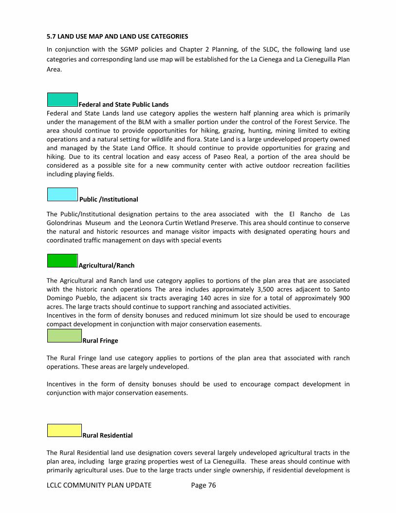
LCLC COMMUNITY PLAN UPDATE Page 76
5.7 LAND USE MAP AND LAND USE CATEGORIES In conjunction with the SGMP policies and Chapter 2 Planning, of the SLDC, the following land use categories and corresponding land use map will be established for the La Cienega and La Cieneguilla Plan Area.
Federal and State Public Lands Federal and State Lands land use category applies the western half planning area which is primarily under the management of the BLM with a smaller portion under the control of the Forest Service. The area should continue to provide opportunities for hiking, grazing, hunting, mining limited to exiting operations and a natural setting for wildlife and flora. State Land is a large undeveloped property owned and managed by the State Land Office. It should continue to provide opportunities for grazing and hiking. Due to its central location and easy access of Paseo Real, a portion of the area should be considered as a possible site for a new community center with active outdoor recreation facilities including playing fields.
Public /Institutional The Public/Institutional designation pertains to the area associated with the El Rancho de Las Golondrinas Museum and the Leonora Curtin Wetland Preserve. This area should continue to conserve the natural and historic resources and manage visitor impacts with designated operating hours and coordinated traffic management on days with special events
Agricultural/Ranch The Agricultural and Ranch land use category applies to portions of the plan area that are associated with the historic ranch operations The area includes approximately 3,500 acres adjacent to Santo Domingo Pueblo, the adjacent six tracts averaging 140 acres in size for a total of approximately 900 acres. The large tracts should continue to support ranching and associated activities. Incentives in the form of density bonuses and reduced minimum lot size should be used to encourage compact development in conjunction with major conservation easements.
Rural Fringe The Rural Fringe land use category applies to portions of the plan area that associated with ranch operations. These areas are largely undeveloped. Incentives in the form of density bonuses should be used to encourage compact development in conjunction with major conservation easements.
Rural Residential The Rural Residential land use designation covers several largely undeveloped agricultural tracts in the plan area, including large grazing properties west of La Cieneguilla. These areas should continue with primarily agricultural uses. Due to the large tracts under single ownership, if residential development is

LCLC COMMUNITY PLAN UPDATE Page 77
proposed, there is an opportunity to support planned compact residential development in conjunction with conservation easements that set aside land for the purpose of preserving contiguous agricultural land, major archeological sites and natural open space as well as trail easements for community pedestrian and equestrian connections to regional trails and open space. All new major residential subdivisions and developments should be required to submit a master site plan that protects adjacent properties, provides an environment within the layout of a site that contributes to a sense of community, preserves and enhances natural amenities and cultural resources; protects the natural features of a site that relate to its topography, shape, and size; and provides for a minimum amount of open space to serve the subdivision or development, pedestrian paths and trails; provide an efficient arrangement of buildings, circulation systems, and infrastructure. Incentives in the form of density bonuses and reduced minimum lot size should be used to encourage compact development in conjunction with hooking up to County water and the establishment of major conservation easements.
Residential Fringe The Residential Fringe land use designation covers sections of the plan area are that south of the Traditional community.
Residential Estate The Residential Estate Land Use Category is designated for areas associated with contemporary residential subdivisions in both La Cienega and La Cieneguilla. This plan anticipates continued infill on the remaining scattered vacant lots; and supports primarily single- family residential development with options for agricultural related uses, home occupations and businesses. All new major residential subdivisions and developments should protect adjacent properties and provide an environment within the layout of a site that contributes to a sense of community, preserves and enhances natural amenities and cultural resources; protects the natural features of a site that relate to its topography, shape, and size; and provides for a minimum amount of open space to serve the subdivision or development, pedestrian paths and trails; provide an efficient arrangement of buildings, circulation systems, and infrastructure.
Residential Community The Residential Community designation applies to only a contiguous residential area in La Cieneguilla that is almost completely built out on existing 1 acre lots created in the late 70’s. No additional areas are proposed to have this zoning designation.
Traditional Community
The Traditional Community Land Use Category is designated for the historic village areas of La Cienega. It is characterized by the historic acequia irrigated farmlands and a concentration of historic homes and traditional development patterns. Agricultural lands and acequias are the defining cultural features of

LCLC COMMUNITY PLAN UPDATE Page 78
the area and should be preserved and expanded through incentives zoning techniques. The La Cienega and La Cieneguilla Traditional Community Boundary was designated in 1980. In 2001 the boundary was surveyed and was incoroporated in the original La Cienega and La Cieneguilla Plan. The current boundary is proposed to expand along the southwest section to include approximately 113 acres of traditional agricultural land. The La Cienega Creek and surrounding bosque are the defining natural features of the area. The creek is the primary surface water source for the area and the bosque provides a ground water recharge zone for several springs as well as an important wildlife corridor and riparian habitat. It should be protected from new development and accessible to the community for maintenance and restoration. The area consists of primarily single-family residential and small scale agricultural development, consistent with historic development patterns and uses. Community facilities, institutional uses, agricultural uses, home businesses and occupations should be allowed anywhere in the area. Incentives to promote preservation of agricultural land, should be encouraged through the use of land use mechanisms such as TDR’s, conservation easements to preserve contiguous agricultural lands.
Planned Development (PDD). Planned Development Districts are included as a land use category in order to recognize existing Master Plan approvals for properties that do not fit a single land use category. Properties in a PDD may be built out in accordance with their approved master plans.
Neighborhood Commercial
The purpose of the Neighborhood Commercial district is to allow for low-intensity convenience retail and personal services, as well as office uses, which are intended to serve and are in close proximity to individual residential neighborhoods. 5.9 GENERAL PROVISIONS AND GUIDELINES Limitations on the Scope of This Plan The adoption of this plan is not intended, nor shall it in any way operate, to obligate any entities identified in this plan, including Federal, State, and Santa Fe County in providing resources, initiating support or implementing any project, program or strategy. Density Transfers
• Density transfer(s) generally are used to protect community assets including but not limited to wetlands, open spaces, springs, watercourses, riparian areas, agricultural lands, acequias, traditional community centers, archeological sites, historical and cultural sites and multi-generational family housing compounds. This could allow developments to transfer minimum lot size densities from an entire piece of property to a specific area of the property in order to protect important community resources such as those listed above. For example if a developer chooses to develop a 10 acre tract in the Traditional Community Zoning District under permitted .75 acre lot size zoning, the county code would allow the developer to divide the

LCLC COMMUNITY PLAN UPDATE Page 79
land into 13 individual parcels with one dwelling unit per .75 acre parcel. Under density transfers, the developer would be able to cluster the gross density of 13 units on a portion of the property, leaving the rest of the property open and undeveloped.
Home Occupations and Businesses
• The Community Plan recognizes the importance of individuals and families to operate small businesses from their homes. Mixed use development consisting of development that house both residential and non-residential uses on the same property and or in the same structures should be permitted as part of a home occupation. Small-scale arts & crafts and galleries already exist in the community as is demonstrated through the annual gallery tour. The Plan determines that home occupations are appropriate throughout the Planning Area and supports the continuation of existing home businesses and small commercial operations in the Planning Area.
Cell Towers and Antennas • Standards and regulations for cell towers provided in the SLDC should be reviewed for
appropriateness. It should be noted that unique standards and regulations for the plan area may be preempted by federal law which limits permitting authority for cell towers.
Family Transfers
• Because local families are one of the great community resources of the La Cienega and La Cieneguilla Community Planning Area, lots created by inheritance or family transfer should be supported as provided by the SLDC.
Land Protection
• Open spaces set aside for density transfer or other easements for the protection of community assets, as described above, should interconnect to similar sites or potential sites on adjacent properties whenever possible.
• Narrow roads and driveways should follow the natural terrain without creating large cut and fill areas and should be designed with more natural edges, using shoulders, ditches and grassy swales rather than curb and gutter.
• Native vegetation should be preserved, when possible, on development sites and local native plants used for landscape buffers and screening.
Acequia Protection
• Development should be set back from the six foot (6') maintenance right of way of the traditional acequias to maintain the integrity.
• Applications for development within twenty-five feet (25') of an acequia should be reviewed by the affected Acequia Association prior to the issuance of permits. The County should work with the Acequia Associations to develop a contact list for review of proposals.
Ridgetop Protection
• In order to more effectively protect the horizons surrounding La Cienega and La Cieneguilla, ridgetops in the Planning Area should not have unnecessary development.
Noise and Lighting Noise and lighting standards should be strictly enforced to protect the quiet nature and dark skies of the community. Community Notification of Water Impacts
LCLC COMMUNITY PLAN UPDATE Page 80
• Development should ensure adequate water resources.
5.10 TRANSFER OF DEVELOPMENT RIGHTS (TDR) PROGRAM The purpose of TDR’s is for the conservation of natural, scenic, and/or agricultural qualities of open land, areas of special character or specific historic, cultural or aesthetic interest or value, or encironmental protection such as watershed, steep slopes, floodplains, etc. The following are suggested guidelines for the creation of a TDR program. Actual program regulations will l be developed in conjunction with the County, based on current conditions. A TDR program will be developed in order to preserve: Traditional agricultural lands for agricultural use. Archeological or cultural sites as identified by Federal or New Mexico State registry. Other sites as determined by future community review and amendment of this Plan. Open Space property.
Participation in the TDR program will be voluntary, and no development restriction or other penalty should be imposed by non-participation. The initial implementation of the TDR program should prioritize the preservation of traditional agricultural lands for agricultural use. The program should identify Sending and Receiving Areas (SAs and RAs) within the La Cienega Planning Area. Sending Areas (SAs) SAs are specific properties eligible to send or transfer their development rights to other properties. Each property shall be evaluated by means of professional appraisal or other acceptable valuation method. The valuation should be used to determine the number of development rights, or Development Units, for the property. The valuation is not necessarily the “selling price” or “market value” of the property or the Development unit. Proposed Sending Areas:
A) Traditional Agricultural Lands Properties identified as having traditional agricultural lands should be identified and mapped. A
land parcel need not be identified as 100% traditional agricultural land to be qualified for the TDR program. The portion of a qualifying land parcel that is identified as having traditional agricultural use shall be used to determine the Development Units available. For example, if a five acre parcel has two acres of traditional agricultural land, the two acres shall be used in calculating the number of Development Units available to the parcel. Development rights transferred from the parcel should only affect the two acres of agricultural land, and the remaining three acres of the parcel should maintain base zoning density.
To qualify as traditional agricultural land, the land must be identified as having long-term
agricultural use. Surface irrigation water rights from current or past acequias, or traditional use of acequias waters with or without identified rights, may be used to identify qualifying lands.
LCLC COMMUNITY PLAN UPDATE Page 81
Traditional surface water irrigation from local streams and rivers, whether by acequia or not, may be used to identify qualifying lands. Other means of qualification of lands may be employed.
B) Archeological or Cultural Sites
Properties identified as having archeological or cultural sites should be identified and mapped.
A land parcel need not be identified as a 100% archeological or cultural site to be qualified for the TDR program. The portion of a qualifying land parcel that is identified as having an archeological or cultural site should be used to determine the Development Units available.
To qualify as an archeological or cultural site, the site must be identified by federal or New
Mexico registry of such sites. Sites note currently identified by federal or state registry may become eligible if they are included in future Federal or State registries.
C) Open Space Properties or portions of properties can qualify for the TDR program to maintain continuous
sections of open space for viewscapes, and trails. o La Bajada Ranch may be used as a sending area to maintain open space.
D) Tres Rios Ranch portions included in the Traditional Community Portions of the Ranch that are within the Traditional Community have been included in the
Traditional Community because of the existing agricultural nature and history of the property. To preserve this site for historical and agricultural uses the site has been identified as a Sending Area.
Receiving Areas (RAs) RAs are properties eligible to receive Development Units and thereby increase the allowable density of the property. Each property shall be evaluated by means of professional appraisal or other acceptable valuation method. The valuation shall be used to determine the number of development rights, or Development Units, that the property can receive. The valuation is not necessarily the “selling price” or “market value” of the property or the Development unit. RA properties shall have an established base zoning density determined by the land use category as established by the Santa Fe County Sustainable Land Development Plan and as specified in the current La Cienega Community Plan and La Cienega Ordinance 2002-9. Each RA property shall also have a specified maximum zoning density that includes the base zoning density plus any increase in density allowed through the application of Development Units from a qualified TDR program. Proposed Receiving Areas Properties that may qualify as RAs include:
A. Properties with PDD and Commercial zoning as identified by this Plan and the Future Land Use map. PDD and Commercial Receiving Areas may qualify for increased density bonus as part of
the TDR program. This density may be adjusted as the TRD program is developed in order to promote and encourage the viability of the program.
Valuation of each property shall be used to determine the number of Development Units required to achieve the maximum density.
B. La Bajada Ranch tracts owned by Santa Fe County comprising approximately 470 acres.
LCLC COMMUNITY PLAN UPDATE Page 82
The development density is limited by on-site water resources, as specified by the La Cienega Ordinance 2002-9. Application of TDRs may be used to increase the limit established by on-site water resources. Increased density allowed by TDRs in this manner shall require imported water. Use of TDRs to increase density by importation of water shall not exceed more than 110% of the maximum density specified by the Land Use category.
If non-residential uses are permitted through master planning or other means, the application of TDRs may be used to increase the maximum lot coverage as established by on-site water resources. Increased density allowed by TDRs in this manner shall require imported water. The density may be adjusted as the TRD program is developed in order to promote and encourage the viability of the program.
Valuation of the tracts should be used to determine the number of Development Units required to increase density through the use of TDRs. A specific ratio shall be determined for the number of Development Units needed to import water for each residential unit or Mixed Use density unit.
C. Other sites as determined by future community review and amendment of this Plan. The TDR program shall be managed through the Santa Fe County Planning Department or other appropriate authority. Unless specified by County or State regulation, the initial list of qualified Sending and Receiving areas should include those specified in the La Cienega TDR program as defined by this Plan and the La Cienega and La Cieneguilla Community Overlay.
5.11 TRADITIONAL IRRIGATED AGRICULTURAL LAND PRESERVATION Maintenance of agricultural production and protection of agricultural land are primary goals of the community. Conversion of irrigated land into home sites often results in land that is no longer irrigated and left fallow shrinking the overall health of the agricultural lands. As an important connection to the history and an important aspect of the community’s rural character, the irrigated agricultural lands of the valley deserve special design guidance and incentives to individual property owners who continue to keep and/or assemble land for agricultural uses. There is a need is to promote the integrity of historic agricultural lands in the valley by incenting individual property owners to assemble and set- aside consolidated tracts of irrigated agricultural land. The strategy is to increase the value of irrigated agricultural lands by establishing zoning incentives, density bonuses, and transfers in conjunction with agricultural conservation. LCLC Traditional Irrigated Agricultural Lands Maps in Figure 4 and 5 identifies parcels that contain irrigated lands as identified by the OSE Santa Fe River Hydrographic Survey of 1972. Of the total acreage, approximately 150 acres are identified in the 1972 OSE Survey as surface or acequia irrigated land and should be considered as qualifying Traditional Irrigated Agricultural Lands, for which residential density bonuses and/or transfers can be established. It should be understood that the parcels depicted on the map include land that is not currently or historically acequia or surface irrigated land. Buildable areas that employ density bonus’s should be encouraged to locate outside of the Traditional Irrigated Agricultural Lands; this reflects traditional patterns in the acequia landscape where prime farmland was preserved for farming. Development, including residential development, was relegated to the drier areas, the ejidos & altitos, above the acequia systems.
LCLC COMMUNITY PLAN UPDATE Page 83
Residential Density Bonuses and Transfers On properties where irrigated agricultural land is preserved (by conservation easement, set-
aside, or other means) from any future development, properties may qualify for a residential density bonus (increase in the number of dwelling units allowed by the base zoning district or overlay) and/or the right to transfer density in the form of dwelling units to qualifying developments (See TDR Program above).
Preserved agricultural lands should be registered as conservation easements or no build-areas
recorded on the plat. Residential density bonuses and transfers will allow for increases to base zoning densities for
residential development and in many cases decreases in minimum lots sizes. In order to accommodate density bonuses the County should first develop minimum regulations
for the divisions of land as well as site development standards and regulations. Regulations and standards for land division and site development should include provisions for
the following:
o Development in the Set-aside of Qualifying Traditional Irrigated Agricultural Land, ("no build area" and/or agricultural conservation easement):
o Land used for roads, parking and private yards should not be counted as part of the set
aside. No buildings or structures should be permitted in the set aside except as incidental to agricultural uses such as green houses, sheds or corrals. Underground and above ground utility easements and land accommodating septic systems, acequias, drains or laterals can be counted as part of the set-aside.
Development in Buildable Areas: Procedures, regulations and standards based on the intent and purpose of the underlying land use designation or base zoning districts should be established to regulate and guide development with increased density due to the use of density bonuses. Particular attention must be paid to water supply and wastewater treatment in conjunction with density and soils suitability. It is anticipated that high performing septic systems and shared wells or hook up to County or community water and waste water systems will be necessary for increased density on most sites. Incentives should be increased for density bonuses that are transferred to qualified developments outside of parcels associated with the Traditional Irrigated Agricultural Lands. Density bonuses in the form of residential units should be established if development right is transferred to a qualifying development outside of a parcel associated with Traditional Irrigated Agricultural Land. Transfer of the development right should be submitted as part of the development application for the qualifying development and include the set-aside of qualifying Traditional Irrigated Agricultural Land in the form of an agricultural conservation easement and/or no-build area depicted on an approved site plan or subdivision plat.
LCLC COMMUNITY PLAN UPDATE Page 84
5.12 WATER SERVICE PRIORITY AREA & LA CIENEGA WATERSHED CONDITIONS This Plan establishes a priority area for implementing the La Cienega Watershed Conditions as outlined in Santa Fe County Ordinance 2002-09 and the extension of Santa Fe County Water Utilities which is identified on the Recommended Priority Area Water Connection Map (page 86). The priority area is in close proximity to existing County water pipes and development, both residential and commercial, is expected to be fully built-out in the next ten years. The intent is to serve Upper La Cienega in order to reduce ground water depletion, negative effects on downstream users and to fully implement the La Cienega Watershed Conditions. Utility service to the plan area should provide an appropriate level of service and maintain rural character that is important to the area residents. On-site systems, (primarily well and septic), community systems and extensions of the Santa Fe County water and wastewater system are all possible methods of serving the area over the long term. Utility extensions will be necessary to support higher density and non-residential uses proposed in the areas designated as commercial mixed-use. The quick facts below provide very basic and preliminary information about the area. A water/sewer feasibility study to analyze utility service extension and options for the area is necessary to begin implementation. Possible funding mechanisms for the project include Public Improvement Districts, County Improvement Districts or Special Assessment Districts. All lots subject to the La Cienega Watershed Conditions have waived the right to protest the implementation of an improvement or assessment district. Water Service Priority Area Quick Facts: Total Lots: 600 Lots subject to La Cienega Water conditions: 307 Total Vacant Lots: 94; Vacant lots subject to La Cienega Water conditions: 36 Number of Wells: 51; Multiple = 16, Domestic = 35
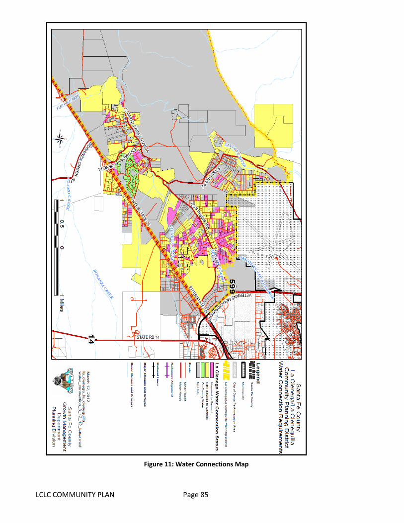
LCLC COMMUNITY PLAN Page 85
Figure 11: Water Connections Map

LCLC COMMUNITY PLAN Page 86
5.13 TRANSPORTATION AND ROADS In addition to the goals, strategies and objectives for roads and transportation in Section IV, the following framework should be considered in all future road projects and maintenance routines for the plan area. SLDC design standards for roads should be reviewed as part of the drafting and adoption of the Community District. Road design standards should be communicated in a clear graphic representation of desired road profiles for each area type. Implementation of design standards for roads should be accomplished through amendments to the SLDC Chapter 9 La Cienega and La Cieneguilla Community District and associated overlay zones. The County Roads and Planning divisions should work with community to determine/refine area type and identify unique contextual elements that will influence the design beyond those generalized below. These might include the church, community center, natural features such as large “heritage” trees, creeks, springs & arroyos, historic features such as archeological sites, acequias, bridges, and miscellaneous structures. Users
Roadways in the plan area serve a variety of users including pedestrians, bicyclists, motor vehicle drivers and passengers. Selecting the appropriate treatment of the roadway to accommodate all users, (including children and the elderly) can influence the overall health of the community by preventing accidents while increasing opportunities for exercise in the form of walking or bicycling. There may be a latent demand above observed pedestrian and bicycle volumes in the plan area because pedestrian and bicycle facilities do not yet exist or are substandard, or do not provide complete connectivity to key community locations such as the community center or church. Future pedestrian and bicycle facilities including paths, crosswalks, and transit stops should be considered in evaluating new or changes in land development, including any potential attractors such as schools, parks and retail uses.
Area Types
Roadways in the plan area traverse three distinct environments; rural open lands, traditional community areas, and rural developed areas, and are characterized by differing land uses, densities and topography with changes in the amount of pedestrian, bicycle and vehicle use. Land use dictates the function of a road; as land use changes along a road the roads functions also change. Roadways should be designed in a manner that serves the existing land use while supporting future land use goals. Traditionally, roadways have been classified either as “rural” or “urban.” It is important to recognize that a roadway’s formal classification as urban or rural (which is determined from census data using periodically-adjusted criteria adopted by the United States Office of Management and Budget) may differ from actual site circumstances or prevailing conditions.
Rural Open Lands • This area type is associated with public conservation or open space shown on the future land use
map, where the roadway travels through range land or other open space. There are few access points along the roadway and little or no development. Design constraints tend to involve topographic, environmental, scenic or historic resources. Pedestrian, bicycle and transit activity is
LCLC COMMUNITY PLAN UPDATE Page 87
usually infrequent and of low volume. However, there may be potential latent demand for bicycle accommodation on low-volume roadways traversing scenic rural areas.
• Most of Paseo Real from the intersection with NM 599 to the intersection with Los Pinos Road passes through rural open lands. It is currently a 2 lane paved road maintained by the County with a 35 mph speed limit through the plan area. A the portion of Paseo Rael goes through La Cieneguilla in area with single family homes, however very few of the properties front or have access directly onto Paseo Rael.
• The SLDC Official Map Functional Classification for Paseo Real is Collector Urban. SLDC Design Standards applied to collector urban classification requires 11’ lane width, two 5’ sidewalks, two 5ft on-road bike lanes and a Right Of Way (ROW) of 45-72 feet.
Traditional Community • This area type is associated with the more compact built-up areas based on traditional acequia
settlement patterns. Varied building setbacks, and frequent driveways and intersections are common. Individual property frontage is generally less than 200 feet. Right-of-way is usually constrained by the built environment. Pedestrian activity is generally moderate. At this time bicycle activity is low but often generated to, from, and within the traditional community. An important safety consideration for design is the often rapid transition between rural open lands or rural developed areas to a traditional community area.
• Major roads in this area include portions of Los Pinos and Entrada La Cienega. SLDC Official Map Functional Classification for the two major roads is “Minor Arterial Urban”. SLDC Design Standards applied to Minor Arterial (SDA-2) classification requires 12’ lane width, two 5’ sidewalks, two 5ft on-road bike lanes and a ROW of 60-100 feet.
• Minor roads include Camino C de Baca, Camino San Jose and Camino Capilla La Vieja. SLDC Official Map Functional Classification for these roads is “Local.” SLDC Design Standards applied to Local (Urban SDA-2) classification requires 10’ lane width, one 5’ sidewalk, and a minimum ROW of 34-48 feet.
Rural Developed • This area type is associated with the low-density residential development based on contemporary
subdivisions and occasional commercial uses. Buildings generally have large setbacks from the roadway. Occasional driveways require a driver to be more alert for entering and exiting vehicles than in rural open land areas. Pedestrian and bicycle activity are more frequent than in rural open lands area, but generally of modest scale.
• Major Roads in this area type include, Calle Debra, Camino Montoya in La Cieneguilla, Cerro Del Alamo, Sunset Road, Nancys Trail, Paseo De Angel, and Las Estrellas in upper La Cienega. The SLDC Official Map Functional Classification for these roads is “Other Major Local or Collector Road Not Officially Classified”. Although there are no SLDC Design Standards for this classification, standards that apply to Local (Urban SDA-2) classification requires 10’ lane width, one 5’ sidewalk, and a minimum ROW of 34-48 feet.
Potential Regional Commercial Node

LCLC COMMUNITY PLAN UPDATE Page 88
Presently there are three relatively major generators of traffic in the plan area; Las Golondrinas Historic Museum during events primarily on weekends, Sunrise Springs property during regular business hours and the Santa Fe Downs property when it is hosting the flea market on weekends and soccer practice during the week. Traffic for both generators is adequately accommodated via access from the I-25 Frontage Road. Additional major generators of traffic are not anticipated nor zoned for the interior of the plan area. However, major traffic generators are expected if the area designated as commercial mixed-use is fully develop with urban densities and infrastructure. This area has large tracts of land, high visibility, close proximity and easy access to regional (NM 599) and interstate highway systems (I-25), the airport and regional transit systems including the Express Rail Runner Commuter Train and North Central Regional Transit Authority buses. Roads and circulation in this area should evolve as part of larger efficient, safe, multi –jurisdictional, multi-purpose circulation plan that encompasses land and facilities associated with the I-25/NM 599 interchange, the Airport and the Rail Runner Station.
Traffic Calming Measures
Residents living along Camino Capilla Vieja would like to see speed humps or other traffic calming measures to slow traffic. Several other areas in La Cienega have existing speed humps or have expressed an interest in traffic calming measures. Review and possible implementation of the County‘s Traffic Calming Policy, Resolution 2013-102, should be initiated at the neighborhood level. Once traffic calming has been implemented, monitoring of the performance of the project should be undertaken to assure that speeds have indeed been reduced, and to provide valuable lessons for future traffic-calming projects.
Transit Options
5.14 PARKS, TRAILS & OPEN SPACE The following locations and functions are identified to assist in planning for a future parks, trails and open space network that serves the La Cienega and La Cieneguilla communities. Central Plan Area
A developed community park should be designed and developed as part of the proposed community center on State Land Office land in the central plan area. Additionally, a pedestrian trail with some educational signage should be developed to connect the community center to adjacent County Open Space land. The community park and trail should be scaled and programmed to serve residents of La Cienega and La Cieneguilla.
La Cieneguilla
A neighborhood scale semi-developed park should be developed In conjunction with any new subdivision on the large undeveloped 40 acre tract located off of Paseo Real. The park should be scaled and programmed to serve residents of La Cieneguillla.
Upper La Cienega

LCLC COMMUNITY PLAN UPDATE Page 89
A neighborhood park should be developed in conjunction with expected new development in the commercial district associated with the Santa Fe Downs property. It should preferably be located in the transition area from higher density/commercial land use and adjacent existing residential areas south and west of the commercial district. It should be scaled and programmed to serve the existing residents of upper La Cienega and the future residents of the commercial district.
Lower La Cienega
Dedicated community open space with trails should be developed in conjunction with expected new development associated Santa Fe Canyon Ranch. There is a potential to provide trail linkages for pedestrians and equestrians to regional trails associated with Arroyo Hondo and Alamo Creek as well as links through Tres Rios Ranch to BLM land in western portion of the plan area. Open space and trails in this area should be scaled and programmed for the La Cienega and La Cieneguilla communities as well as any future residents expected as part of the development of Santa Fe Canyon Ranch.
Southeastern Plan Area
A pedestrian and equestrian trail parallel to but off set from the I-25 West Frontage Road should be developed from Entrada La Cienega to the Flea at Santa Fe Downs.
LCLC COMMUNITY PLAN UPDATE Page 90
SECTION VI- COMMUNITY ACTION PLAN and IMPLEMENTATION MATRIX
6.1 ACTION PLAN GUIDELINES The La Cienega and La Cieneguilla Community Plan is essentially a partnership between the Community and the County to help tailor land use and services to best fit with existing conditions in the Planning Area. The Plan establishes policies that can be enacted through ordinances or implemented through programs and projects. The Plan serves as an amendment to both the Sustainable Growth Management Plan as well as to the Sustainable Land Development Code.
6.1.1 Program Actions Program actions outline in Section III propose future programming or projects that the Community Plan identifies as important work to be addressed in the community. These actions are not proposed ordinances and do not outline any legal changes for land use or future development in the community. Program actions describe various actions that are important for future planning and development in the area. The community is responsible for working with the County and various agencies mentioned to initiate the program actions.
6.1.2 Implementation and Responsibilities The Planning Division of Santa Fe County's Land Use Department is the lead agency responsible for both assisting the residents of the La Cienega and La Cieneguilla Planning Area in the creation of this plan as well as for helping the community coordinate implementation of the various actions outlined in the Plan. The actions contained herein are designed to address specific issues identified as important aspects of future development in the planning Area. All adopted ordinances, including revisions for the La Cienega and La Cieneguilla Community Planning Area, should be enforced by the County. It is important to note that neither the County nor the various agencies listed in the Plan are directly committing resources for the specific program actions outlined. However, the County recognizes the importance of the many projects and programs listed in this plan. The County is committed to assisting the Planning Area's communities in addressing these problems or needs and in finding locally appropriate solutions. The Planning Division will work with representative community organizations to coordinate both planning and implementation of the Plan's many actions. The La Cienega Valley Association (LCVA) has served as the lead community group in helping to organize and develop this plan. However, the County recognizes that the LCVA is not the only community group in the Planning Area and does not imply that the LCVA would be responsible for implementing the actions listed herein. Throughout the Plan, reference is made to the "community" working with the Planning Division and other agencies to implement program actions. The County will collaborate with the "community" through Community Organizations (CO’s) in a collaborative, consensual process to address the program actions called for in the Plan. The Community Plan is intended as an active document that can and should be updated as conditions change throughout the Planning Area. Additionally, it is recognized that the Plan may be tailored to include specific concerns and conditions in smaller geographic areas within the Planning Area boundary,
LCLC COMMUNITY PLAN UPDATE Page 91
such as La Cieneguilla, Upper La Cienega and Lower La Cienega.
6.2 IMPLEMENTATION MATRIX The Implementation Matrix outlines proposed future programming or projects that the Community Plan identifies as important work to be addressed in the community. Entities including federal, state and local governments identified under potential partners are just that- potential. The adoption of this plan does not obligate potential partners to initiate, fund, support or implement any project, program or strategy.
Element, page numbers
Potential Partners Time Frame
1. Water Service Priority Area
Extension of Santa Fe County Water lines in Upper La Cienega
LC/LC Community, Organization County, NMED, Federal Government
Medium
2. Traditional Irrigated Agricultural Land Preservation
Develop Incentive Zoning, Land Use and Development Standards in support of the preservation or expansion of contiguous agricultural lands and acequia systems.
Acequia Associations, Property Owners, LC/LC Community, Organization County
Short-medium
3. Existing Conditions Goals and Strategies Water Resources
Analyze supplemental water to use for irrigation
Acequia Associations, State Penitentiary, National Guard, SF Wastewater, Treatment Plan, Property Owners, LC/LC Community Organization, Santa Fe County
Short
4. Existing Conditions Goals and Strategies Water Resources
Wastewater Feasibility Study County Public Works, NM Environment Dept, EPA, USDA
Short-meduim
5. Community Parks, Open Space & Trails
Community Pedestrian and Equestrian Circulation Study
LC/LC Community Organization SFC Open Space
Short
6. Agriculture Agricultural Lands Directory Acequia Associations LC/LC Community Organization Santa Fe County USDA Farm & Ranch
LCLC COMMUNITY PLAN UPDATE Page 92
7. Community Facilities
Multipurpose, Multigenerational Community Center , Conduct a needs assessment
LC/LC Community Organization Santa Fe County State Land Office
Short-medium
8. Existing Conditions Monitor water rights retirement schedules to ensure that compliance with said schedules are enforced for all water rights derived from the Community Planning Area.
Acequia Associations, LC/LC Community Organization
Short
9. Existing Conditions Develop accurate population estimates for the La Cienega and La Cieneguilla Community Planning Area. These population figures will be used in conjunction with a water budget for the planning area to determine potential population impacts on local water resources and the development of realistic water availability estimates to guide future land use decisions. This study should be completed no more than 3 years from the date that the Plan is adopted
Acequia Associations, LC/LC Community Organization
Short

LCLC COMMUNITY PLAN UPDATE Page 93
SECTION VII- GOVERNANCE/IMPLEMENTATION OF THE COMMUNITY PLANNING ORDINANCE
7.1 Community Notification The community will work with the County Land Use Department to develop a Community Organization (CO) for notification of development proposals.
7.2 Amendments to the Plan Any amendments to the Plan will be made in accordance with the SGMP and the SLDC Chapter 2.

LCLC COMMUNITY PLAN UPDATE Page 94
Appendix Plan Area Zoning: Santa Fe County Ordinance No. 2002-9 Summarized below are general zoning and development regulations that pertain to land use, density, and related environmental aspects of development based on Santa Fe County Ordinance No. 2002-09 for the Planning Area of La Cienega and La Cieneguilla. Acequia Protection
• Acequia Association Review of New Development: Prior to issuance of development permits for activities that may interfere with acequia operations including fences, walls, grading, drainage and septic systems, applications for development within twenty- five feet (25') of an acequia must be reviewed by the affected acequia association.
• Acequia Setback Requirements: No new structures or permanent fences or walls that will impair or obstruct normal operations of an acequia shall be permitted within six (6) feet of community acequias.
Agriculture Development and Tax Valuation Regulations
• Per New Mexico State Statute, Santa Fe County taxes agricultural lands at a lower rate than other land uses in order to help prevent the loss of agricultural lands. One acre of non-improved land is the minimum acreage that can be used as agriculture, and 80 acres minimum for grazing. Property owners interested in the special agricultural assessment must demonstrate that their land is primarily used for the production of plants crops, trees, forest products, orchard crops, livestock, poultry or fish, or proof that the livestock has access to all of the agricultural land for the tax year. [Note: federal definitional standards for farms and farmers for income and estate tax purposes differ from local standards].
• Agricultural sales and roadside stands are allowed in the planning area with a permit. Residential Development
• Residential water use is limited to .25 acre feet a year throughout the plan area. The request for additional water consumption requires a water budget and proof of 100 year water supply.
• The maximum density shall not be increased even when community water and sewer systems are provided except where density transfer or TDR’s are used to protect sensitive lands or preserve community assets.
• Lot Coverage; the total roofed area of principal and accessory structures, shall be no more than twenty percent (20%) of the total lot area.
• Allowable uses within the planning area include residential, agricultural and mixed uses if associated with home occupations.
Hydrologic Zones and TC Zoning District There are three existing hydrologic zones and one zoning district under the existing Land Development Code for residential development that currently regulate density in the plan area:
• Homestead Hydrologic Zone: o Allows 1 dwelling unit per 160 acres. With proof of 100 year water supply through a
geohydrologic reconnaissance report, and application of water use covenants, the maximum density may be increased to one dwelling unit per 40 acres. If an adequate 100 year supply of water, and no impairment to neighboring wells, is proven by an on-
LCLC COMMUNITY PLAN UPDATE Page 95
site geohydrological well test, land may be further divided to a minimum of 2.5 acres per 1 dwelling unit.
• Basin Fringe Hydrologic Zone:
o Allows 1 dwelling unit per 50 acres. With proof of 100 year water supply through a geohydrologic reconnaissance report, and application of water use covenants also known as La Cienega Watershed Conditions, the maximum density may be increased to one dwelling unit per 12.5 acres. If an adequate 100 year supply of water but no impairment to neighboring wells is proven by an on-site geohydrological well test, land may be further divided to a maximum of 2.5 acres per dwelling unit.
• Basin Hydrologic Zone: o Allows 1 dwelling unit per 10 acres. With proof of 100 year water supply through a
geohydrologic reconnaissance report, and adoption of water use covenants also known as La Cienega Watershed Conditions, the maximum density may be increased to one dwelling unit per 2.5 acres.
• La Cienega Traditional Community District:
o The traditional community district is primarily a residential zoning district requiring a minimum lot size and density of one unit per 3/4 acres.
Commercial Zoning Provisions
• County Ordinance 2002-09 limits commercial zoning to those existing at the time of adoption. These properties are restricted to uses, intensities and densities identified on their approved master plans. This includes the Santa Fe Downs property which is zoned for outdoor recreational uses and a few lots fronting Erica Road.
• Expansion or establishment of new commercial development on properties with commercial
zoning are subject to the La Cienega Watershed Conditions and restricted to .35 acre of water per year per acre if on a domestic well. The code also requires a water resources analysis at the time of application. The analysis must demonstrate secured access to a 100 year supply of water as well as secured water rights, as required by state law and/or the code to meet all current and projected demands for the business operation.
• Lot Coverage: The total roofed area of principal structures and accessory structures, roadways,
driveways, walkways and parking facilities shall be no more than sixty percent (60%) the total lot area.
Prohibited Commercial Development
• New developments that pose a risk of contaminating surface and ground water systems shall not be permitted within the planning area. Prohibited uses will include but not be limited to: gas stations, asphalt batch plants and asphalt production plants, large-scale mining, any warehouse which stores or transfers chemicals, large-scale agricultural operations that stockpile manure or have manure lagoons (e.g.: dairies, horse parks or stables, chicken farms), waste oil recycling, septic tank pumping waste disposal, grease trap waste disposal, large-scale chili processing plants, cheese processing plants, gasoline storage facilities or transfer stations, auto repair facilities, car washes, sludge disposal fields, mortuaries, municipal and/or hazardous landfill, and slaughter houses.
Home Occupations
• Mixed use development and small commercial operations consisting of development that house

LCLC COMMUNITY PLAN UPDATE Page 96
both residential and non-residential uses on the same property and/or in the same structures are permitted throughout the plan area. There are standards related to parking, number of employees and percent of total area of a residence that can be occupied by the business. Small-scale retail establishments, such as arts and crafts stores, restaurants or galleries may be permitted as part of a home occupation. The scale is defined by the number of vehicle visits per day with no more than thirty (30) vehicle visits per day and no- more than ten (10) vehicle visits per hour.
General Provisions for All Development Types
• Utilities- Gas, Electric and Telecommunications: All new and replacement utility lines and fixtures must be installed underground.
• Limits on light and noise pollution.
• Landscaping: Recommendations and requirements for preserving native plants, water
conservation, use of xeriscape materials and principles, rainwater collection and storage systems, reuse of gray water, storm water recharge.
• Septic Tanks: All new septic tanks shall meet or exceed existing New Mexico Environment
Department (NMED) and County standards and be equipped with an above ground access port.
• Ridgetop Protection: Building on slopes greater than 15% and ridge tops comply with Code requirements such as setbacks, screening and buildable areas.
La Cienega Watershed Conditions
• The La Cienega and La Cienega Planning District Ordinance implemented many of the strategies identified in the 2001 Community Plan pertaining to water resources including reaffirming and refining the “La Cienega Watershed Conditions.” (For more information see Lots Subject to the La Cienega Watershed Conditions below ).
Other Relevant Ordinances and Regulations
• Santa Fe County Ordinance 2000-7: Confers designation of La Cienega and La Cieneguilla as a Traditional Historic Community (THC) under state law. This ordinance prevents annexation by the City of Santa Fe. The Boundary of the La Cienega THC is congruent with the 2001 La Cienega and La Cieneguilla Plan Area Boundary and will remain in effect with the adoption of this plan.
• Environmental Requirements: It should also be noted that there are additional environmental requirements in both the SCLD 1996-10 and the SLDC 2013 that address flood hazards, liquid waste disposal, terrain management, air quality, noise, water supply and solid waste.
Community Plan Review and Revision • Community Review of the Plan. The La Cienega and La Cieneguilla Community Planning
Committee requests that an annual community review of the La Cienega and La Cieneguilla Community Plan be conducted each year to assess community concerns and assist in monitoring community conditions as well as implementation of Plan elements.
LCLC COMMUNITY PLAN UPDATE Page 97
Formation of a Community Plan Committee to Implement and Monitor Plan • The La Cienega and La Cieneguilla Community Plan authorizes the County Planning Division to
establish a permanent La Cienega and La Cieneguilla Community Plan Committee to conduct this annual review of the Plan. The County Planning Division staff will provide support and help to coordinate the process. This committee shall consist of three (3) representatives each from La Cieneguilla, Upper La Cienega and Lower La Cienega for a total number of nine (9) committee members. Representatives shall serve for two-year terms and the terms shall be staggered to ensure continuity of the planning process. Representatives shall be nominated by residents, property owners and business owners from each respective area. Nominees must be a resident, business owner or property owner in order to be eligible to serve as a representative on the committee. In the case that more than three nominations are received for each area, three names shall be randomly selected to serve on the committee. This committee shall follow the process established for community planning under Santa Fe County Ordinance 1998-5 including consensual decision-making and open public meetings.