Embed Size (px)
Citation preview

1
City of Clyde Hill 2015-2035 Comprehensive Plan

2
In response to the community’s desire to control land use development such as lot size and commercial zoning, Clyde Hill was incorporated as a Town on March 31, 1953, with 971 people and 271 homes. In 1998, Clyde Hill became a non-charter Code City and now finds itself almost fully developed with about 3,000 residents and 1,100 households. Clyde Hill is located in the Seattle Metro area of Washington State and governed by a Mayor-Council form of government with 5 Councilmembers.
Mayor - 2014 The Mayor of Clyde Hill is elected at large to a four-year term and presides over all meetings of the City Council. The Mayor serves as the Chief Executive Officer of the City but has the authority to appoint a City Administrator and a City Clerk to implement the executive duties of the City on a day to day basis. Additionally, the Mayor has the responsibility to appoint members to serve on various City Boards and Commissions, as well as special advisory committees.
George Martin - 2015 City Council - 2014 The Clyde Hill Council is elected at large to staggered four-year terms. Council members have the primary responsibility to establish policy, direction, and goals for the City. The governing laws of the City are developed and adopted by the City Council through specific ordinances and are subject to Washington State Laws as adopted in the Revised Code of Washington (RCW). The City’s laws are embodied in the Clyde Hill Municipal Code. Position 1, Marianne Klaas - 2017 Position 2, Randy Jack - 2015 Position 3, Chris Baker - 2017 Position 4, Barre Seibert - 2015 Position 5, Bruce Dodds - 2017 Planning Commission – 2014 Members of the Clyde Hill Planning Commission are appointed to six-year terms. The Commission consists of five members, serving in an advisory capacity to the City Council on matters involving zoning, land use, and long-range planning. Chair, Jesse Reingold - 2016 Jody Bellar - 2018 Kim Muromoto - 2017 Lynn Janata Tremblay - 2016 Eileen Stempel - 2014 City Staff – 2014 City Administrator, Mitch Wasserman Deputy Clerk, Courtney Benjamin Consultant, Tom Beckwith FAICP

i
History of Clyde Hill Patrick Downey, an Irish immigrant, and the first known settler in Clyde Hill, homesteaded a 160-acre tract of land on the southern slope of Clyde Hill on the 29th of September 1882. Downey's tract was bounded by NE 8th Street on the south, 92nd Avenue NE on the west, NE 16th Street on the north, and 100th Avenue NE on the east and included the Bellevue residential area now known as Vuecrest. Downey filed his final affidavit for a homestead claim, (SE º of Section 30 in Township 25 N of Range 5 E) in September 1888 and described the property as timbered agricultural land. Timber was described as fir and cedar 2nd class. Downey said that in the process of clearing land, he cut, removed, and sold 296,000 board feet from 20 acres to a Terence O'Brien of Seattle. Downey cited Peter Buckley, John McRae, John Davis of Bellevue, Washington Territory and W. W. Easter of Seattle, Washington Territory as references for his claim. McRae, 49 years old, lived on nearby property. Peter Buckley, 42 years old, lived about 1/2 mile away and also gave testimony supporting Downey's homestead claim. Also living near Downey were W. E. Conway and Isaac Bechtel. By 1888, Downey had built an 18' X 27' log house one-story high with shake roof. The house included four rooms and was valued at $300. In addition to the house, the Downey estate included a 16' X 22' shake barn, a 10' X 12' shake stable, a 8' X 10' shake hen house and a 8' X 10' shake storehouse. These additional buildings were valued at a combined $185. During this time Downey raised crops on about 11 acres of land for five seasons, including potatoes, oats, wheat and vegetables. Downey built a log cabin at 100th Avenue NE and NE 12th Street with the help of neighbors. Pat Downey reportedly lived in this cabin for two years before he discovered Meydenbauer Bay. From the cabin Downey hiked to Houghton (now south Kirkland), and rowed to Seattle when he wanted to go to the city. Downey remodeled and rebuilt several times though the entire house was eventually destroyed by fire in 1911.
Downey eventually planted 15 acres of his claim in strawberries that brought a premium from wholesalers on Western Avenue in Seattle. A number of farmers in Clyde Hill raised strawberries and the community was well known for that product. Downey would pack a load of strawberries in a wheelbarrow to the foot of Clyde Road (now 92nd Avenue NE) and board a little wood-burning steamer to Leschi in Seattle. There he could take a cable car over the Seattle hills from Leschi to Elliott Bay. By 1890, about 20 families settled in the Clyde Hill, Medina, and the downtown Bellevue area. In June 1900, the Federal Census of Bellevue Precinct, King County, Washington, encompassing about the same area, enumerated a total of 254 persons.
In June 1894, Patrick and wife, Victoria M. Downey, subdivided the north 80 acres of their original claim (from about NE 12th Street to NE 16th Street), most of which lay in present-day Clyde Hill. His plat, of which most of it is still known today, was entitled "Lake Washington Garden Tracts." Most of the subdivision was platted as 5-acre lots. Streets shown in the plat include Hunter Avenue (present 92nd Avenue NE), Bellevue Avenue (Present 100th Avenue NE) and Downey Street (NE 14th Street). In 1905, early landowners within the present limits of Clyde Hill included Jacob Furth, George B. Shorey, A. Stewart, James Wren, Mr. Mercer, G.

ii
W. R. Pettibone, D. T. Richards, G. M. Talmage, J. H. McDowell, Soren Sorenson, William Tukey, H. M. Leonard, J. M. Frink, M. K. Cradelle, Susan A. Wells, George A. Emory, and Patrick Downey. Special thanks to Dan Bray for this historical information
How Clyde Hill Got Its Name Clyde Hill area residents formed a local community club in 1947 when the postwar home building activity was accelerating. At the time people found that it was difficult to describe the exact location of the Clyde Hill area. It wasn't exactly Bellevue, although the Bellevue Post Office delivered the mail. Columnist Ann Seeger often referred to this area as Nanny-Goat Hill in her column of the Bellevue American (previously the Eastside Journal).
At the first meeting of the new community club, the members grappled with a name. Some of the community club members included Bill Painters, John and Carrie Hill, Al Constans, Sam and Vivienne Boddy, Oscar and Ann Seeger, Father Val-Spinosa of St. Thomas Church, Mickey and Irja Telfer, and Leon Snow. Sam Boddy, whose family had homesteaded here, told the group Clyde Hill Road (now 92nd Avenue NE) first got its name long before 1947. Regular commuters on the Yarrow Point
to Seattle ferry, most of who were of Irish decent, had been giving unofficial names to the various roads along their route. Most of those names were Irish. One of the "regulars" happened to be from an area in Scotland called the "Firth of Clyde" and suggested the name Clyde Road for the road that was later numbered by the County as 92nd Avenue NE. Since "Clyde Road" was the main thoroughfare in 1947 and because the area was obviously a hill, Ken Day proposed the name "Clyde Hill" for the area. Six years later on March 31, 1953, the area incorporated as the Town of Clyde Hill. Special thanks to Ken Day for this historical information
Political History of Clyde Hill The community's desire to control land use development such as lot size and commercial zoning, officially incorporated Clyde Hill as a Town on the 31st of March 1953 by a vote of 145 to 117. Ken Day defeated Don Clark for the first Clyde Hill Mayors position by a vote of 91 to 58. All initial Council members were elected on write-in votes and included F. Lee Campbell, Robert W. Glueck, P.A. Jacobsen, Leslie M. Rudy, and A.C. Thompson Sr. John Woodin became the Town's first Treasurer. Ken Day appointed Priscilla Alden Townsend as Police Judge and Roger Bryan as Marshall. The 1975 Mayoral election in Clyde Hill brought with it suspense and the national media. The two candidates, the incumbent Liberino "Lib" Tufarolo and Miles Nelson finished the election in an even tie. The contest was ultimately decided by a coin toss, with Nelson unseating the incumbent as national and local media looked on. On the 10th of November 1998, the Council voted to organize Clyde Hill as a non-charter Code City.

iii
Contents Introduction 1 Purpose 1 Growth Management Act (GMA 1 Planning goals of GMA 1 Countywide planning 2 Clyde Hill comprehensive planning 2 Environment 4 Issues, goals, and policies 4 Critical areas 4 Water 5 Stormwater 5 Soils 5 Topography 5 Hazard mitigation 5 Trees and views 6 Topography map 7 Urban forest zones map 8 Air quality 9 Sustainability 9 Goals and policies 10 Land use 12 Built form map 13 Land use map 14 Goals and policies 15 Housing 16 Goals and policies 17 Transportation 19 Streets map 20 Transit map 21 Bicycle routes map 22 Sidewalks and trails map 23 Functional classifications 24 Level of service (LOS) 24 Bicycles 25 Pedestrians 26 Goals and policies 26 Capital facilities 28 Administration and public safety 28 Water and sewer 28 Storm drainage 29 Financial issues 29 Goals and policies 30 Utilities 31 Electricity 31 Natural gas 31 Communications service utilities 31 Cable services 31 Goals and policies 32 Parks and open space 33 Points Loop Trail map 34 SR-520 Lids and Clyde Hill Civic Center map 35 Goals and policies 36 Appendices A: Best Available Science (BAS) correspondence A-1 B: ARCH Eastside Housing Analysis B-1

iv

1
Introduction Purpose Clyde Hill’s Comprehensive Plan lists goals and policies based on residents aspirations in the context of current and potential opportunities, concerns, and capabilities. Clyde Hill’s Comprehensive Plan is based on locally established visions, goals, and policies. Clyde Hill’s Comprehensive Plan conforms to the Washington State Growth Management Act (GMA), RCW 36.70A, as originally passed in 1990 and its subsequent amendments, and is consistent with King County’s Countywide Planning Policies (CWPP). Clyde Hill’s Comprehensive Plan shapes the City’s zoning and subdivision regulations, capital improvement programming and budgeting, and other legal and regulatory actions necessary to manage Clyde Hill’s physical, social, and environmental character. All implementation tools are consistent with this plan. This plan contains the following elements: § Natural Environment § Land Use* § Housing* § Transportation* § Capital Facilities* § Utilities* § Open Space and Recreation * Elements that are required by GMA.
Growth Management Act (GMA) The state legislature enacted the Growth Management Act (GMA) in response to its finding that uncoordinated growth and lack of common goals toward land conservation threaten the public’s health, safety, and general welfare. GMA lists 14 planning goals for those counties and municipalities (including Clyde Hill) planning under GMA’s requirements. Planning Goals of the Washington State GMA, RCW 36.70A.020
Urban growth Encourage development in urban areas where adequate public facilities and services exist or can be provided in an efficient manner.
Reduce sprawl Reduce the inappropriate conversion of
undeveloped land into sprawling, low-density development.
Transportation Encourage efficient multi-modal transportation systems that are based on regional priorities and coordinated with county and city comprehensive plans.
Housing Encourage the availability of affordable housing to all economic segments of the population of this state, promote a variety of residential densities and housing types, and encourage the preservation of existing housing stock.
Economic development Encourage economic development throughout the state that is consistent with adopted comprehensive plans, promote economic opportunity for all citizens of this state, especially for unemployed and for disadvantaged persons, Promote the retention and expansion of existing businesses and recruitment of new businesses, recognize regional differences impacting economic development opportunity, and encourage growth in areas experiencing insufficient economic growth, all within the capacities of the state’s natural resources, public services, and public facilities.
Property rights Property rights shall not be taken for public use without just compensation having been made. The property rights of landowners shall be protected from arbitrary and discriminatory actions.
Permits Applications for both state and local government permits should be processed in a timely and fair manner to ensure predictably.
Natural resource industries Maintain and enhance natural resource-based industries, including productive timber, agricultural, and fisheries industries. Encourage the conservation of productive forestlands and productive agricultural lands, and discourage incompatible uses.
Open space and recreation Retain open space, enhance recreational opportunities, conserve fish and wildlife habitat, increase access to natural resource lands and water, and develop parks and

2
recreation facilities.
Environment Protect the environment and enhance the state’s high quality of life, including air and water quality, and the availability of water.
Citizen participation and coordination Encourage the involvement of citizens in the planning process and ensure coordination between communities and jurisdictions to reconcile conflicts.
Public facilities and services Ensure that public facilities and services necessary to support development shall be adequate to serve the development at the time development is available for occupancy and use without decreasing current service levels below locally established minimum standards.
Historic preservation Identify and encourage the preservation of lands, sites, and structures that have historical or archeological significance.
Shorelines For shorelines of the State, the goals and policies of the Shoreline Management Act are added as one of the goals of...[the GMA].
GMA requires consistency between: § Comprehensive plans and the planning
goals identified in RCW 36.70A.020 § Municipal and county comprehensive plans § Comprehensive plans of each municipality
and county with those of neighboring municipalities and counties
§ Elements within the comprehensive plan (internal consistency)
§ Comprehensive plan and development regulations
§ Comprehensive plan and capital budgets § State agency actions and municipal and
county comprehensive plans. GMA also requires concurrency, meaning that public facilities and services must be developed concurrently with the new land uses they serve, ensuring achievement of adopted level of service (LOS) standards. The concurrency requirement is especially forceful concerning transportation: “...local jurisdictions must adopt and enforce ordinances which prohibit development approval if the development causes the level-of-service...to decline below the standards adopted in
the...comprehensive plan, unless transportation improvements or strategies to accommodate the impacts of development are made concurrent with the development.” GMA requirements support a strong relationship between urban growth and the public facilities and services required to serve that growth. This relationship is further enhanced by the concept of Urban Growth Areas (UGA), where land development and public infrastructure improvements are concurrently programmed. To fulfill these new planning requirements, GMA expressly authorizes the use of innovative techniques, such as impact fees. Countywide Planning GMA was amended in 1991 to require counties to adopt countywide planning policies in cooperation with their municipalities. These policies are written policy statements that establish a countywide framework from which county and city comprehensive plans are developed, adopted, and implemented. This framework helps ensure county and city comprehensive plans are consistent with each other and with the intent of GMA. Per RCW 36.70A.210(3), these policies, at a minimum, shall: § Implement RCW 36.70A.110 (the section for
establishing UGAs) and provide for joint county and city planning within urban growth areas
§ Promote contiguous and orderly development and provisions of urban services to such development
§ Provide for public capital facilities of regional or statewide importance
§ Provide for countywide transportation facilities
§ Consider the need for affordable housing § Analyze fiscal impacts. Clyde Hill Comprehensive Planning Clyde Hill's Comprehensive Plan was developed and adopted in 1993 under the adopted GMA requirements and updated in 2002 in accordance with subsequent amendments. Clyde Hill’s Comprehensive Plan contained the required GMA plan elements including land use, housing, transportation, capital facilities and utilities in addition to sections on the local environment and open space. The City’s intent

3
continues to be the furthering of the statutory goals outlined within GMA. King County developed Countywide Planning Policies (CWPP) in accordance with GMA requirements including a number of specific policy statements guiding growth to areas that are already characterized by urban land use, existing services, and infrastructure. Since Clyde Hill is built-out many of King County’s CWPP policies do not apply to Clyde Hill circumstances. Where countywide policies are
relevant or require action by the City, they are referenced within the appropriate Comprehensive Plan section.

4
Environment GMA requires that all towns, cities, and counties adopt development regulations to protect critical areas (aquifer recharge areas, sensitive fish and wildlife habitat, frequently flooded areas, geologically hazardous areas, and wetlands) and resource lands of long-term significance (agricultural, forest, and mineral lands) and that they incorporate “Best Available Science (BAS)” in those regulations. Clyde Hill believes these areas are valuable assets for the ecological balance they provide and also for the aesthetics and quality of life expected by community residents. Issues, goals, and policies Clyde Hill is located within a region that is characterized by remarkable natural beauty providing community residents’ easy access to a wide range of outdoor recreation and scenic activities. Sustaining the region's natural systems is a high City priority necessary to maintaining a productive and supportive environment. Clyde Hill’s viability depends on the health of these regional environmental systems. Clyde Hill will continue to promote cooperation and coordination with neighboring communities to ensure that the quality of life is enhanced through environmental stewardship by providing: § Opportunities for recreational activities § Increased air and water quality § Preserved open spaces § Important wildlife habitat § Unmeasured social and ecological benefits § A sense of community pride and wellbeing This Comprehensive Plan recognizes the general goal of overall environmental protection embodied in GMA and King County’s Countywide Planning Policies (CWPP). Clyde Hill supports the intent to preserve, protect and enhance the aesthetic and functional environmental resources of the county since these resources are essential ingredients to the region's quality of life.
Critical Areas Critical areas often have unique, fragile, and valuable environmental and ecological processes or resources that are vulnerable to development and other human influences. Washington State identifies 5 primary types of critical areas requiring consideration and protection including: § Aquifer recharge areas § Fish and wildlife habitat conservation areas § Frequently flooded areas § Geologically hazardous areas § Wetlands. Preserving and protecting critical areas from negative impacts of development enhances the public health, safety, and welfare and protects private property from natural disasters, such as flooding and landslides. Under GMA provisions cities must review and revise plans and regulations every 7 years, if needed, to ensure compliance with GMA requirements. Recent GMA amendments require that cities include the "Best Available Science (BAS)" when developing policies and development regulations to protect the functions and values of the natural environment, and are directed to give "special consideration" to conservation or protection measures necessary to preserve or enhance fisheries. Clyde Hill is an essentially built-out community and has been such since the beginning of the 1990’s. During the City’s development there was no evidence of critical areas as defined under GMA. King County’s Sensitive Areas Map Folio also did not identify any such features in Clyde Hill. A detailed assessment of Clyde Hill was performed in 2004 in accordance with “Best Available Science (BAS)” practices including wetlands, wildlife habitats, geologically hazardous areas, aquifer recharge areas, and flood hazard areas that is included in the Appendix. The BAS assessment found that Clyde Hill does not have and does not need to designate as critical areas any such physical features within its corporate boundaries as

5
defined by GMA and, therefore, does not require the development of a Critical Area Ordinance (CAO). Clyde Hill will utilize the best available science as defined in WAC 365-195-900 to 925 to help ensure these goals are met. Should future BAS determinations require, Clyde Hill will explore adopting an appropriate CAO protecting critical areas within City boundaries. Water There are two man-made lakes in Clyde Hill - Lake Aqua Vista and Clyde Loch. These lakes were developed in 1965 and 1966 from previously non-wetland sites for aesthetic purposes and are now also used as stormwater retention/detention ponds. There are several small streams that flow seasonally within the City and Cozy Cove Creek has limited sustained flow throughout the year. These have not been classified by King County or the Department of Fisheries as fish-bearing streams and offer limited habitat potential to other wildlife. There are underground springs located along the slopes and hillsides. Most have been capped, but some are occasionally still found. There are areas within the City where the ground is wet on a seasonal basis. This is not necessarily due to the presence of springs, but is generally from seepage of ground water from sandy soils, particularly in areas where the banks of hillsides have been excavated for construction. Residences between 84th and 86th Avenues NE are located on flat ground where the water table is relatively high. During heavy rains the storm drainage system occasionally backs-up, resulting in localized flooding. Stormwater The City encourages best management practices in construction techniques, stormwater control, and individual property maintenance. The 1992 Clyde Hill Stormwater Management Plan includes a water quality program that identifies potential sources of pollution and means for its control. The City is in the process of updating the Stormwater Management Plan. Natural drainage ways are maintained and used to the maximum extent feasible, and the City
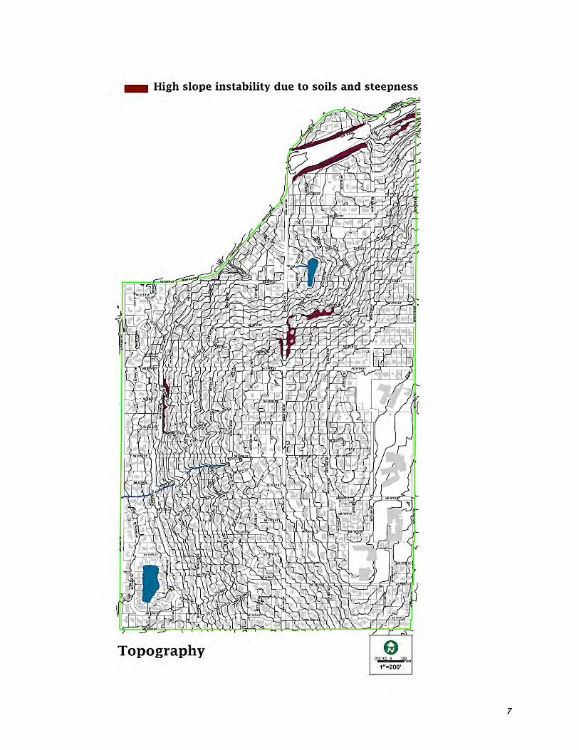
works with adjacent jurisdictions on mutual surface water management issues. Soils Clyde Hill soils are sandy or silt loams and are typically well drained. Soil stability changes somewhat with topography, but does not present any severe erosion potential. Soil along 84th Avenue NE does not drain particularly well and at times has resulted in accumulations of standing water. Three small and fully developed areas come close to fitting a definition of erosion and landslide hazard areas. These areas have undergone full development and have employed construction practices that are sufficient to alleviate potential problems. Clyde Hill’s Building Official has the authority to adequately mitigate development or redevelopment practices within these areas using City building codes. Clyde Hill has no significant geologically hazardous areas and King County has also not identified the City as having any special landslide or seismic hazards. Clyde Hill does lie just north of the Seattle Fault and is within the zone that could produce significant lateral acceleration. However, the soils in the City are not those prone to liquefaction during severe seismic events. Topography Clyde Hill’s elevation reaches 375 feet above sea level at its highest point on a ridgeline along the eastern center than slopes downward to the west to a low point of about 75 feet above sea level at 84th Avenue NE. The topography offers a variety of views of Lake Washington and the Seattle skyline to the west, Maydenbauer Bay to the south, Kirkland to the north, and downtown Bellevue to the east. Clyde Hill’s viewscape is a major element contributing to the character of the City and its associated beneficial impact on property values. Hazard mitigation The United States Geological Survey (USGS) conducts probabilistic seismic hazard assessments about every 6 years to reflect newly published or thoroughly reviewed earthquake science and to keep pace with

6
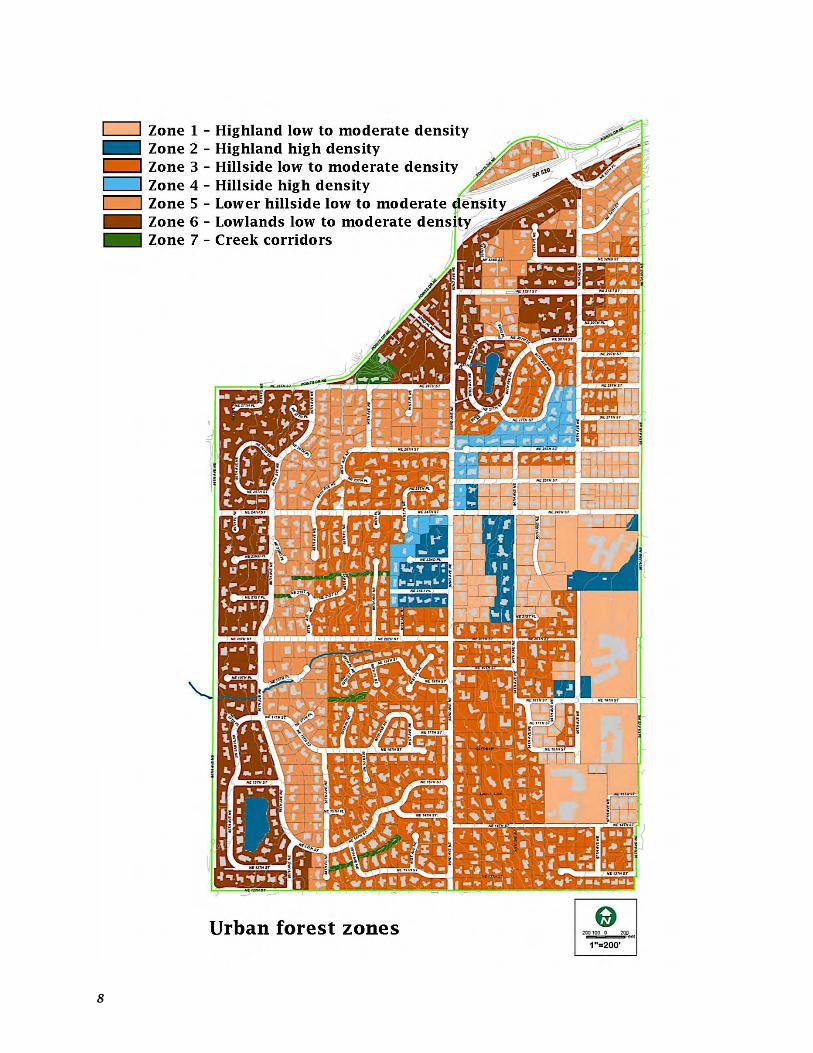
regular updates of building codes. USGS completed the most recent update of the National Seismic Hazard Maps in 2008 that analyzed 8 probabilistic hazards levels – 3 of which directly affect Clyde Hill: § Earthquakes – the 2001 Nisqually Earthquake did not significantly impact Clyde Hill. An earthquake involving the Cascadia Subduction Zone, however, could measure M9.0 on the Richter Scale and would have considerable impact on communities throughout Puget Sound. Similarly, an earthquake along any of the faults in the Seattle area would also extensively impact Clyde Hill. § Severe weather – episodes involving strong winds, ice, and snow have crippled the community for multiple days at a time. With the majority of Clyde Hill’s transportation network on a hill, the impacts from snow and ice are critically necessary to plan for and mitigate. § Stormwater – accumulates in the lower areas of Clyde Hill during severe storms. An updated modeling analysis will be performed to determine where the existing storm infrastructure can be improved to allow the City to prioritize future improvements. In light of these hazards and in cooperation with King County, Clyde Hill developed and adopted a Hazard Mitigation Plan in 2013 that identified initiatives for dealing with each hazard risk. Trees, views, and sunlight Trees and views are features that contribute to the attractiveness and livability within Clyde Hill. For almost 25 years a goal of the City has been to find a balance between urban demands, such as views, and urban forest benefits, such as a beautifully landscaped neighborhood. Landscape related issues have been and will continually evolve into community conflicts as Clyde Hill landscaping matures and homes are developed to capture views of the surrounding area. A great deal of time and effort went into developing Clyde Hill’s view regulations during an open public process. For over two years the Council and the Planning Commission in conjunction with Clyde Hill residents discussed the appropriate manner to address view
obstruction matters that resulted in the development of an Urban Forestry Program. Clyde Hill’s Urban Forestry Program is composed of 3 components:
§ Trees, views, and sunlight regulations – regulate the maintenance and restoration of views within Clyde Hill. The regulations establish a specific process for resolving situations where the growth of one or more trees on a neighboring property unreasonably obstructs the view or sunlight reaching another particular property. Any tree whose age precedes the incorporation of the City (1953), however, is exempted from view regulations. The intent of the view obstruction regulations is to exhaust all reasonable efforts to resolve these matters as neighbors, without governmental intervention. If after exhausting all reasonable approaches as neighbors the view obstruction matter is still unresolved, the complainant is required, with the voluntarily concurrence of the tree owner, to seek the services of the King County Dispute Resolution Center in an attempt to settle the matter.
If this is unsuccessful, the issue can go before the City's Board of Adjustment for a public hearing and a specific decision by the Board. The Board must base its decision on standards and guidelines set forth in Chapter 17.38 of the Municipal Code and on the factual testimony from a public hearing where the matter would be discussed. The tree owner and the complainant are bound by the Board's decision unless the findings are appealed to the City Council, whose decision is final.
7
8

9
Only 4 times since 1991 have residents needed the help of the Board of Adjustment to act on their dispute. § Educational program – developed with the Washington State Department of Natural Resources and the University of Washington College of Forest Resources, Center for Urban Horticulture to encourage appropriate plantings that will not mature into future problems for others. Hundreds of copies of the nationally recognized and award-winning guide, “A Citizen’s Guide to Urban Forest Management in the City of Clyde Hill” have been distributed over the years with great educational and reference results. Published in 1994 and now in its second edition, the Guide includes a list of suggested plantings relating to 7 residential "tree zones" including a guide to appropriate pruning and providing help for all common urban forestry problems. The Guide is an on-going source of public information and is the basis for all City landscape reviews. Landscape review ordinance - was subsequently developed along with the establishment of a City Tree Board (Planning Commission) and a continued goal of meeting the requirements for achieving a Tree City USA award. A landscape review is mandatory for a building permit that changes the "footprint" of a house or proposes building modifications that change the landscaping on the property. Reviews take place prior to final inspection of the work under the building permit.
The free landscape review is conducted by a landscape professional (City Arborist) that provides information and tips. Since adoption of the ordinance, the City Arborist has made about 400 landscape reviews throughout the community meaning that in 2 decades the City Arborist has provided advice for over 1/3 of the entire City. Although the advice is not mandatory, the Arborist’s suggestions have helped residents understand and site hundreds of more appropriate trees and plants in the right places to avoid future view conflicts with their up hill
neighbors…a true win-win and a big reason why there may be less view conflicts now than there were 20+ years ago. § City living fence regulations - were also adopted to address view issues. A ‘fence’ is any barrier that is naturally grown or constructed for purposes of confinement, means of protection or use of a boundary.
Constructed fences cannot exceed 6 feet in height measured from the original grade…Naturally grown fences cannot exceed 8 feet in height as measured from original grade.
Air quality Clyde Hill commits to meeting federal and state air quality requirements and will work with state, regional, and local agencies and jurisdictions to develop transportation control measures and/or similar mobile source emission reduction programs that may be warranted to attain or maintain air quality requirements. Sustainability Sustainability practices use resources and the natural environment in a manner that ensures they will be available for use by future generations through preservation, conservation, social responsibility, and environmental awareness. Clyde Hill supports the concept by addressing issues of sustainability as properties are developed and redeveloped through the use of smart and green building practices in landscape and building designs, construction practices, and building materials that result in a least impact on the environment and a least demand for resources.

10
The City supports the use of recycled building materials, energy efficient appliances, minimized heating and cooling requirements, and the use of native landscape materials, among others. ENV GOAL 1 Preserve and protect water resources.
ENV Policy 1.1 Retain any existing publicly owned open surface water systems in a natural state and undertake programs to rehabilitate any degraded conditions.
ENV Policy 1.2 Maintain and improve surface water quality as defined by state and federal standards.
ENV Policy 1.3 Restrict surface water runoff rates, volumes and quality to predevelopment levels for all new development and redevelopment projects.
ENV Policy 1.4 Review and update as necessary stormwater drainage regulations to ensure they meet State standards for protection of fish species listed in the Endangered Species Act (ESA).
ENV GOAL 2 Preserve and enhance vegetation and earth characteristics.
ENV Policy 2.1 Promote development in a manner that protects existing topographic, geologic, vegetation and hydrologic features.
ENV Policy 2.2 Promote soil stability and use of natural drainage ways by encouraging the retention of existing native vegetation near streams, springs and slopes.
ENV Policy 2.3 Preserve existing vegetation, or provide and enhance vegetation that is compatible with the natural character of Clyde Hill.
ENV Policy 2.4 Minimize and control soil erosion during and after construction through use of best management practices and appropriate development regulations.
ENV Policy 2.5 Protect lands bordering Clyde Hill and adjacent communities that are in a natural state through the use of cooperative agreements.
ENV GOAL 3 Identify and maintain a Hazard Mitigation Action Plan for dealing with earthquake, severe weather, and severe storm events in Clyde Hill.
ENV Policy 3.1 Maintain a Hazard Mitigation Action Plan that identifies risk events and develops appropriate initiatives for reducing and resolving impacts.
ENV Policy 3.2 Develop and improve a Communications Plan to keep residents informed of local conditions and matters of local importance including tools that can be used when the power is out.
ENV Policy 3.3 Conduct a seismic risk assessment of City facilities to determine vulnerability and the need to retrofit City Hall and the Public Works Facilities to withstand earthquakes.
ENV Policy 3.4 Encourage homeowners, particularly of older housing units, to install measures that reduce and mitigate potential hazard impacts such as installing reinforcement straps on water heaters, bracing plates on foundations and support columns, and shut-off valves on gas lines, among others.
ENV Policy 3.5 Update Clyde Hill’s Stormwater Management Comprehensive Plan to deal with severe winter rainstorm events and control stormwater collection and distribution including a citizen’s communications element. Assess what needs and can be done to reduce risk from the 2 private lakes.
ENV Policy 3.6 Encourage homeowners and neighborhoods to develop readiness plans for dealing with hazardous events that promote 72-hour self-sufficiency.
ENV Policy 3.7 Develop a Post Disaster Action Plan to includes a debris removal component and building code related activity that supports the Building and Public Works Departments during reconstruction processes.
ENV GOAL 4 Establish standards for the resolution of conflicts between views and trees that recognizes the inherent values of both.

11
ENV Policy 4.1 Develop recommendations for appropriate tree species for planting within the City.
ENV Policy 4.2 Offer education to residents regarding tree planting and maintenance in accordance with “A Citizen’s Guide to Urban Forest Management in the City of Clyde Hill”
ENV Policy 4.3 Encourage neighbors and neighborhoods to work together to resolve tree and view conflicts.
ENV Policy 4.4 Evaluate the effectiveness of current tree, view, and sunlight regulations.
ENV GOAL 5 Ensure that the development and use of land in Clyde Hill is done in a manner consistent with sustainable use of resources and the natural environment.
ENV Policy 5.1 Make information available to citizens and contractors regarding the benefits of utilizing sustainable building practices and materials.
ENV GOAL 6 Protect air quality from adverse impact and work with other jurisdictions and agencies to promote clean air protection and enhancement including reduction of greenhouse gas (GHG) emissions.
ENV Policy 6.1 Support federal and state action to reduce greenhouse gas (GHG) emissions.
ENV Policy 6.2 Support expansion of public transit, commute trip reduction, vanpooling, ridesharing, biking, and walking as low carbon transportation choices.
ENV Policy 6.3 Support reductions of energy use in existing buildings and limited emissions growth in new buildings.
ENV Policy 6.4 Support implementation of Washington State’s Renewable Portfolio Standard and federal policy on reducing GHG emissions from power production.
ENV Policy 6.5 Support higher rates of recycling and zero waste of resources that have economic value for reuse, resale, and recycling.
ENV Policy 6.6 Support initiatives to protect valuable and important resource lands by focusing development within urban growth areas (UGAs) and maintaining healthy urban forests.
ENV Policy 6.7 Support actions that reduce GHG emissions in government operations through smart and efficient government fleet management practices.

12
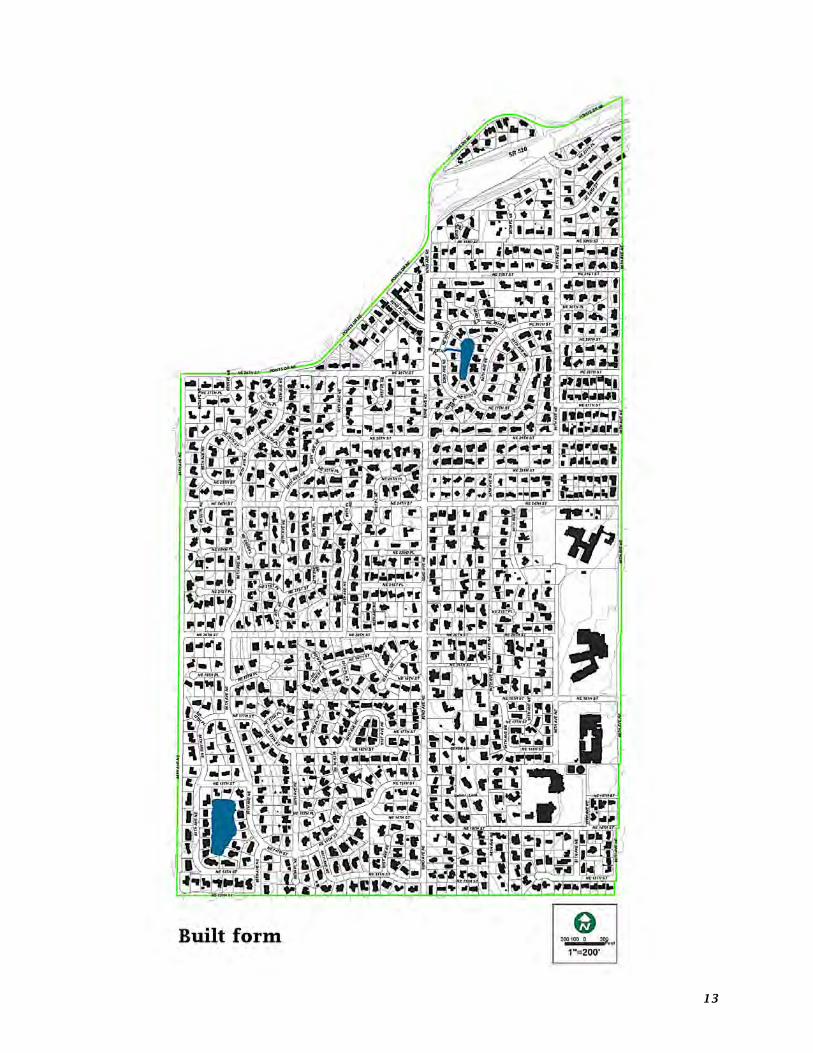
Land use Clyde Hill was incorporated in 1953 as a small residential city covering an area of approximately one square mile bound by Points Drive and NE 28th Street to the north, NE 12th and NE 13th Streets to the south, by 84th Avenue NE to the west, and by 98th Avenue NE to the east. Clyde Hill had an estimated 2012 population of 3,108 persons making it one of the smallest communities in King County. However, the City is located within a rapidly developing metropolitan area sharing its eastern boundary with Bellevue - the state's fourth largest city. Clyde Hill is zoned single family residential with the exception of a: § Gas station on the corner of 84th Avenue NE
and Points Drive § Coffee shop located on Points Drive and NE
28th Street § Bellevue School District’s Clyde Hill
Elementary and Chinook Middle Schools and Bellevue Christian Middle School on 98th Avenue NE
§ Sacred Heart Elementary School on NE 14th Street
§ City Hall and Fire Station on NE 24th Street § City Park located east of 95th Place NE Clyde Hill occupies 632.00 acres of which 69.3% are developed in single family residential, 20.0% in street right-of-way, 7.8% in public and private schools, and 2.2% in city governmental buildings. The minimum lot size allowed in the zoning code is 20,000 square feet with many smaller lots existing from before incorporation. Land use Acres Percent Single family residential 430.18 69.3% Schools 49.60 7.8% City government 13.80 2.2% Parks .92 0.1% Commercial .73 0.1% Utilities .33 0.1% Street right-of-way 126.60 20.0% Vacant 6.04 1.0% Not developable 3.80 0.6% Total 632.00 100.0%
Clyde Hill’s Urban Growth Area (UGA) is surrounded by the incorporated municipalities of Hunts Point, Yarrow Point, and Kirkland to the north, Medina to the west and south, and Bellevue to the east and cannot extend its boundaries through annexation. A few vacant single family lots remain though once these are developed, the City will reach its total growth capacity unless rezones are allowed to increase residential densities or commercial intensity. The current land use pattern and general densities will not change during the 20-year comprehensive planning horizon assuming current zoning and comprehensive plan policies continue to be supported the City's residents. Nor does there appear to be a need to change development patterns within Clyde Hill. Kirkland and Bellevue are rapidly developing a large number and wide variety of medium to high-density residential and mixed-use commercial buildings typical of emerging urban centers in the Puget Sound region. Both cities have hundreds of commercial establishments providing well over a million square feet of retail space and an increasing number of professional, health, and social services within a 2-mile radius of Clyde Hill’s City Hall. Clyde Hill’s major employers provide a total of 700 employees of which public and private schools account for about half with most of the remainder working at home in home offices and businesses. There is no need to provide more employment-related land use since the City is built-out with a stable population. Nor is there capacity to do so since these non-residential land uses are also built-out with the exception of the recent reconstruction of the Chinook Middle School complex. Clyde Hill is located within the Urban Growth Area (UGA) designated in King County’s 1992 Countywide Planning Policies (CWPP) and subsequent amendments but accounts for less than 0.1% of the County land area and 0.002% of
13

14

15
the population. Land use decisions made by the City, therefore, will have little impact on the overall County land pattern or densities. Clyde Hill’s land uses and densities are consistent with those in the directly adjacent communities of Medina, Hunts Point, Yarrow Point and the western neighborhoods of Bellevue. Clyde Hill’s goal is to retain and maintain the original spacious and wooded character of the community and to remain relatively small, simple and intimate. The City’s amenities, quality residential areas, parks, views, and natural landscape are characteristics the community intends to maintain. Clyde Hill will continue to monitor land use decisions in adjacent communities that may have impacts on the residents, businesses, and public uses in Clyde Hill. The City will continue to work with adjacent jurisdictions on land use, traffic, community facility, and service decisions that are compatible with the City and do not put undue burden on the City's infrastructure or adversely affect existing and planned uses. GMA requires comprehensive plans provide a review and permitting process for essential public facilities that are regional in nature as referenced in RCW 36.70A.200. Clyde Hill’s land use pattern will likely preclude the development of regional facilities within the City. SR-520, however, is considered an essential public facility under GMA and the City has a process in place to deal with any permitting issues involved with any future redevelopment of SR-520’s right-of-way. The City will utilize the conditional use permit process for any reviews of essential public facilities.
LU GOAL 1 Support and promote the established land use pattern of predominantly single-family homes in an open and natural setting and protect the neighborhood character and function of the City.
LU Policy 1.1 Limit new commercial land use area within the City.
LU Policy 1.2 Maintain zoning for primarily single-family residential development.
LU Policy 1.3 Maintain the City's 20,000 square foot minimum zoned residential lot size.
LU Policy 1.4 Insure that new development and redevelopment projects are compatible with the existing neighborhood character.
LU Policy 1.5 Consider the design, aesthetics, and natural environment when making decisions affecting the use of land and related improvements.
LU Policy 1.6 Preserve the natural features of the City by encouraging dedication of open space and preservation of significant trees and vegetation.
LU Policy 1.7 Provide policy guidelines that protect views and helps balance the sometimes conflicting benefits of views and trees.
LU Policy 1.8 Establish and maintain relationships with surrounding jurisdictions to insure compatibility of adjacent land use actions and to foster cooperation on issues of mutual interest.

16
Housing A Regional Coalition for Housing (ARCH) compiled a detailed comparison of Clyde Hill’s demographic and housing characteristics for the City as part of an East King County Housing Analysis. The following summary analysis is taken from that report – a copy of which is attached as an Appendix. Clyde Hill is virtually built-out with fewer houses in 2010 than the City had in 1990 as a result of the aggregation of lots for larger houses and because some vacant lots were under development. The city’s population has also remained relatively stable. Clyde Hill’s household mix is very different than King County or even the cities in the balance of East King County. The City has a lower proportion of one-person households and a particularly high proportion of married households with no children.
During the 2000s, however, there was an actual decrease of “empty nesters (households whose children have grown and left the nest)” and a significant, corresponding gain of households with children unlike other areas in East King County where there was little shift in the proportions of married households and families. Along with the increase in family households the City’s school age population increased 24%. Like other Point Cities, Clyde Hill historically has had a relatively high proportion of seniors
living in single-family homes. Neither the proportion nor the age mix of seniors has changed in the City over the past decade. While the region as a whole forecasts an increase in the senior population and a need for senior-oriented housing, it doesn’t appear likely there will be any significant changes in the senior population in Clyde Hill due to the City’s built-out single-family housing development. Clyde Hill’s population has become more racially diverse, though not to the same degree as some East King County cities, with a 6% increase in City minorities (to 17%) and a 10% increase in City foreign-born residents (to 25%). There are some 700 jobs attributed to businesses based in Clyde Hill with about half of these jobs in the education sector, a sector with relatively low wages. Without any significant commercial property in town, the
balance of local employment appears to be primarily attributable to home-based occupations. Approximately 80 households rent homes in Clyde Hill with a relatively low cost burden. Among City homeowners, however, 15% pay more than 50% of their incomes on housing exceeding the recommended HUD allocation standard of 30-35% of income for all housing costs. Some overburdened homeowners could be new owners paying a relatively high portion of their incomes for their mortgage and/or some portion may be senior household on fixed incomes.

17
Clyde Hill’s housing stock is 100% single-family detached homes, much like the other Point Cities. Homeownership is 92% of all Clyde Hill households much higher than typical for East King County but lower than compared to past City homeownership percentages. Clyde Hill housing is expensive with the median price of housing sales in the past 3 years being $1,480,000 according to Redfin.com and median gross rents from 2007-2011 greater than $2,000 according to the American Community Survey (ACS). No special needs housing exists in Clyde Hill, although this type of housing is allowed in the city’s code. GMA and King County’s Countywide Planning Policies (CWPP) require that each jurisdiction take actions that will collectively meet the expected growth in all economic segments of the County population. A primary part of this effort is to provide housing opportunities that are affordable to less advantaged segments of the population. Clyde Hill's ability to participate is limited by a lack of available, suitable building sites, and the realities of the real estate market. The City allows the development of accessory dwelling units on residential lots. The City owns and provides one lower cost home for qualified renters. There are a number of existing legal but smaller lots in the older, original plats of the City that do not meet the minimum zoning requirement of 20,000 square feet. Clyde Hill currently allows development and redevelopment of undersized lots at their existing square footage as a means of preserving the neighborhood’s original scale and reducing housing land costs. Clyde Hill is also a participant in A Regional Coalition for Housing (ARCH), an organization that is dedicated to providing lower cost housing on a regional basis. Clyde Hill addresses a variety of affordable housing needs through ARCH. The ARCH trust fund helps create affordable housing for low and very low-income households and populations who have special needs or are homeless. Through ARCH the City participates in region-wide planning efforts including development of regional
strategies addressing homelessness. HOUS GOAL 1 Preserve, protect, and strengthen the vitality and stability of existing neighborhoods. HOUS Policy 1.1 Support the stability of established residential neighborhoods. HOUS Policy 1.2 Enhance the appearance of and maintain public spaces in residential areas. HOUS Policy 1.3 Promote community involvement to achieve civic and neighborhood enhancement and improvement activities. HOUS Policy 1.4 Protect residential areas through proper enforcement of adopted City codes. HOUS GOAL 2 Preserve the existing variety of lot sizes to help provide housing opportunities for all segments of the Clyde Hill community. HOUS Policy 2.1 Encourage the retention and redevelopment of smaller legal lots in the older, original plats as a means of preserving the neighborhood’s original scale and reducing housing land costs. HOUS Policy 2.2 Promote the development of accessory dwelling units (ADUs) where compatible with surrounding single-family development. HOUS Policy 2.3 Support the use of environmentally sensitive housing development practices. HOUS GOAL 3 Preserve and promote access to housing for all segments of the community including very low and moderate-income, seniors, and special needs populations. HOUS Policy 3.1 Ensure development regulations allow for and have suitable provisions to accommodate housing opportunities for special needs populations. HOUS Policy 3.2 Support housing options, programs, and services that allow seniors to stay in their homes or neighborhoods. HOUS Policy 3.3 Support awareness of Universal Design improvements that increase housing accessibility.

18
HOUS GOAL 4 Continue to provide through A Regional Coalition for Housing (ARCH) a proportionate amount of the countywide needs for affordable and special needs housing where appropriate and feasible. HOUS Policy 4.1 Continue to participate in A Regional Coalition for Housing (ARCH), including funding, to help provide affordable and special needs housing opportunities throughout the region for very low, low, and moderate-income households and to prevent homelessness. HOUS Policy 4.2 Monitor housing supply, type, and affordability,
including how ARCH efforts have helped provide special needs housing and housing affordable for very low, low, and moderate-income households.

19
Transportation
Clyde Hill’s internal streets were constructed as new subdivisions developed and have remained largely unchanged except for surface improvements, widening, and similar alterations. The older, original plats on the north hilltop were aligned in simple grids while the newer subdivisions along the lower ridgelines were laid out in curvilinear patterns with numerous cul-de-sacs. Clyde Hill Elementary and Middle Schools, Bellevue Christian Middle School, Sacred Heart Elementary, and Sacred Heart Church are the largest generators of nonresidential vehicular traffic within Clyde Hill generating school buses, parents transporting students, commercial vehicles, and church worshippers. School traffic has increased slightly in recent years as enrollments have increased and more students are driven to and from school by parents. The development of and recent improvements to SR-520’s access ramps and transit stations, and the continuing growth of Bellevue's downtown business district have generated Clyde Hill traffic mostly due to non-residents using City arterial roads as through routes to the west and eastbound on-ramps to SR 520. SR-520 bound traffic has affected volumes on 84th Avenue NE and NE 12th Street, and to a lesser degree on NE 24th Street, 92nd Avenue, and Points Drive. Recently enacted tolls on SR-520, however, have reduced some of the cut-through traffic volume. NE 12th Street and 84th Avenue NE have been configured for single lanes of traffic (one lane in each direction) reserving the shoulders for bicycle traffic to reduce speeds and improve safety conditions. The double lane configuration (two lanes in each direction) was retained on 84th Avenue NE north of NE 24th Street to separate traffic bound for Hunts Point and Points Drive from the SR-520 on-ramp and prevent queuing at the new roundabout. Clyde Hill along with Hunts Point, Yarrow Point, Medina, and Bellevue work with WSDOT to improve traffic flow to SR-520 and to the recent SR-520 improvements including the roundabouts, traffic lids, Metro and planned
Sound Transit stations, and kiss-and-ride drop-offs. In 2000, WSDOT installed ramp metering for the 84th Avenue NE westbound on-ramp to SR-520. The meters resulted in more backups on local roads during meter-activated times but helped facilitate 2-person High Occupancy Vehicle (HOV) access to SR-520. Since SR-520 is congested during peak hours, local traffic continues to back up onto 84th Avenue NE, NE 28th Street, and Points Drive waiting for access to the highway. Proposed redevelopment of the SR-520 Lake Washington bridge for high-occupancy vehicle (HOV) traffic lanes, transit, and bicycle lanes may improve traffic flow and lessen some of the local traffic backups when fully completed. Available City traffic data shows average workday volumes on arterial streets range from 1,374 to 10,154 vehicles per day (VPD) controlled primarily by stop signs. There are 4 flashing stoplights at major collector and minor arterial intersections and a traffic signal at the intersection of 84th Avenue NE with NE 24th Street.
Metro provides 2 regional bus routes within Clyde Hill located primarily along 84th Avenue NE and NE 12th Street. Both routes provide direct access to downtown Seattle, the University District, and downtown Bellevue by way of 84th Avenue NE to SR-520.

20

21

22

23

24
Metro and Sound Transit provide major bus transfer points over the SR-520 right-of-way and between west and eastbound lanes at the 92nd Avenue NE lid in Clyde Hill and the Evergreen Point Road lid in Medina that are accessible to residents by bike and pedestrian pathways. Bellevue School District’s bus system provides a weekday route access from Clyde Hill to Bellevue High School. Clyde Hill roadways are relatively wide and most provide lane markings with shoulders for parking, biking, and pedestrians. Sidewalks are located along 84th Avenue NE, NE 28th Street Points Drive, and along sections of 91st Avenue NE, NE 12th Street, NE 13th Street, and NE 14th Street. Crosswalks are marked at all major and most other intersections. Bicycle/pedestrian lanes are marked on major arterials including most of the complete length of 84th Avenue NE. Travel demand and trip characteristics will remain relatively stable as a result of the City’s built-out state and fixed school and commercial traffic generators. Clyde Hill annually reviews and updates a 6-year transportation improvement program as part of the City’s budgetary process that includes maintenance and repair needs. Clyde Hill traffic is most affected by land use decisions of adjacent jurisdictions, most notably Bellevue. Downtown Bellevue is designated an urban center to increase densities within the urbanized areas of the County under the provisions outlined in King County’s Countywide Planning Policies (CWPP). Downtown Bellevue will continue to create travel demand on 84th Avenue NE and NE 12th Street as a backdoor access for non-residents to SR-520. Clyde Hill residents perceive the following items as the City’s primary transportation problems: § High traffic volumes, congestion, air
pollution, and noise on and along 84th Avenue NE - generally during peak afternoon commuting periods, as traffic moves to and from SR-520.
§ Traffic volumes and congestion on streets intersecting NE 24th Street - primarily the result of traffic bound for schools or 84th Avenue NE.
§ Traffic volumes and congestion on streets adjacent to the schools and concern for the safety of pedestrians - particularly school students.
§ The problem of spillover parking onto neighborhood streets from the schools and church.
Functional classifications A 4-tiered classification system categorizes functional characteristics of Clyde Hill’s street system. Principal arterial and state routes – SR-520 abuts the northern boundary of Clyde Hill and is the only regional highway with direct City access. SR-520 on and off-ramps split access between 84th Avenue NE and 92nd Avenue NE serving as a regional connector between Seattle and East King County. Minor arterials - distribute traffic from highways to secondary arterials and local access streets and include: § 84th Avenue NE from NE 12th Street to NE
28th Street (Points Drive) § NE 12th Street from 84th Avenue NE to 86th
Avenue NE. Collector arterials - collect and distribute traffic from higher capacity streets to local access streets and include: § NE 28th Street/Points Drive from 84th
Avenue to 92nd Avenue. § NE 24th Street from 84th Avenue NE to 98th
Avenue NE § 92nd Avenue NE from NE 12th Street to SR-
520
Local roads – provide access to individual properties throughout the City and include the remainder of the streets in Clyde Hill. Level of Service (LOS) Level of Service (LOS) is the ability of a roadway or intersection to carry a volume of traffic and is typically measured using a 6-tiered rating system. At an LOS of 'A' motorists experience free flow traffic with seldom more than one vehicle waiting at an intersection. An LOS of 'F' represents gridlock indicating a failure of the roadway or intersection to accommodate traffic volumes. LOS in between A and F represent

25
intermediate degrees of traffic volume and waiting times. LOS of 'D' and better indicate there is reserve capacity on a roadway or intersection. All Clyde Hill roadways are rated LOS C or better indicating there is capacity to accommodate more traffic without excessive waiting times or congestion. 2000 Level of Service (LOS) PM Peak Hour Intersection LOS 84th Avenue NE/NE 20th Street B 92nd Avenue NE/NE 20th Street A 84th Avenue NE/NE 24th Street B 92nd Avenue NE/NE 24th Street C 92nd Avenue NE/NE 14th Street A 96th Avenue NE/NE 18th Street A 98th Avenue NE/NE 24th Street C Local access streets in Clyde Hill typically have LOS 'A' since they do not provide routes through City and are unlikely to experience an increase in traffic due to growth in surrounding jurisdictions. The exception may be local access streets on the west side of the schools during peak school start and stop times. Collector arterials achieve an LOS of 'C' during peak hour traffic volumes while at off-peak hours times the LOS is 'B' or better. Minor arterials also achieve a peak hour LOS of 'C' but function at a higher LOS at other off-peak hours. The intersection of 84th Avenue NE and NE 28th Street at the westbound on-ramp to SR-520 is severely congested by early morning and late afternoon westbound traffic on SR-520 producing LOS’s of 'D' or 'E'. WSDOT’s roundabout construction will improve traffic flow by separating local traffic from SR-520 but will never be improved during peak hours following WSDOT’s recent improvements and likely even after bridge expansion, or additional SR-520 work in Seattle. Future daily traffic demand on the City's arterial streets assumes the continued growth of downtown Bellevue, probable future improvements to SR-520, and a greater choice in alternative transportation modes (i.e. Sound Transit’s rubber-tired and light rail systems) make these estimates tentative.
The following level of service (LOS) standards are proposed for roads and intersections within and around Clyde Hill: Minimum LOS Standards Peak Hour Street type LOS State route (SR-520) D Minor arterial C Collector arterial B Local access A Intersection Minor arterial/minor arterial – includes 84th Avenue NE at SR-520
D
Minor arterial/collector arterial C Arterial/local access C Public transportation While transit ridership in Clyde Hill has historically been low there is and will be sufficient capacity and opportunity for those who choose to use transit. City resident ridership could be increased through some qualitative changes in the way transit service is provided within and between the City and surrounding destinations. Clyde Hill, along with other Point Cities and Bellevue, should work with Metro and Sound Transit to improve transit routes, schedules, stations, stops, and other services. City residents should be encouraged to use transit as an alternative mode of travel to reduce energy consumption, air pollution, traffic congestion, and noise levels. The elderly and persons with impaired mobility are typically regular users of public transit. The City’s topography, however, makes accessing transit facilities difficult particularly when most Metro bus routes are located along 84th Avenue NE at the bottom of a long hill. Metro Transit is considering relocating Route 246 from 84th Avenue NE to 92nd Avenue NE and then along NE 24th Street where bus stops would avoid the steep downhill grades; and configuring shuttle service to SR-520’s new transit stations that would improve access for these groups. Bicycles Clyde Hill completed a Pedestrian Transportation Plan in 2011 that assessed

26
bicycle and sidewalk needs and opportunities within the City. Existing Linear feet Miles Bicycle lanes 3,800 0.7 Paths and trails 500 0.1 Total 4,300 0.8 One bicycle versus vehicle accident occurred between 2005 and 2011 at the intersection of 84th Avenue NE and NE 28th Street. The Pedestrian Transportation Plan will reduce traffic lanes from 11-12 to 10 feet and add 3-4.5 foot wide bicycle lanes on 5 collector roads including: § NE 20th Street from 84th Avenue NE to 92nd
Avenue NE on the south side § NE 24th Street from 84th Avenue NE to 92nd
Avenue NE on the south side § NE 24th Street from 92nd Avenue NE to 98th
Avenue NE on the south side § 92nd Avenue NE from NE 20th Street to NE
24th Street on the east side § 92nd Avenue NE from NE 24th Street to
Points Drive NE on the east side WSDOT’s proposed bridge expansion plan will include bicycle lanes across Lake Washington linking Clyde Hill with the University of Washington, Mountlake, and Seattle to the west and Kirkland to the east. Local bike access to the SR-520 regional bike network will be provided by existing and proposed bicycle lane designations and enhancements to the shoulders of Points Drive NE and 92nd Avenue NE, and NE 12th Street within Clyde Hill. Bike to school routes will be provided by existing and proposed designations and enhancements to 98th Avenue NE, NE 14th Street, NE 24th Street and 92nd Avenue NE. Pedestrians Clyde Hill completed a Pedestrian Transportation Plan in 2011 that assessed bicycle and sidewalk needs and opportunities within the City. Existing Linear feet Miles Sidewalks 18,900 3.6 Paths and trails 500 0.1
Street walkways 32,000 6.1 Total 51,400 9.8 Three pedestrian versus vehicle accidents occurred between 2005 and 2011 at the intersection of 92nd Avenue NE and NE 24th and 34th Streets, and on 98th Avenue. The Pedestrian Transportation Plan will reduce traffic lanes from 11-12 to 10 feet and add 5-foot wide sidewalks on 5 collector roads including: § NE 20th Street from 84th Avenue NE to 92nd
Avenue NE on the south side § NE 24th Street from 84th Avenue NE to 92nd
Avenue NE on the south side § NE 24th Street from 92nd Avenue NE to 98th
Avenue NE on the south side § 92nd Avenue NE from NE 20th Street to NE
24th Street on the east side § 92nd Avenue NE from NE 24th Street to
Points Drive NE on the east side
WSDOT’s improvements to SR-520 already provide and will enhance trail development on the north side of the highway that link Clyde Hill with Medina and Fairweather Park to the west, Hunts Point, Wetherill Nature Preserve, and Yarrow Point to the north, and Yarrow Bay Wetlands and Lake Washington Boulevard to Kirkland to the east as part of the Points Loop Trail. Local pedestrian access to the Points Loop Trail will be provided by existing and proposed shoulder designations and sidewalk enhancements to the shoulders of 84th Avenue NE, Points Drive NE, 92nd Avenue NE, and NE 12th Street within Clyde Hill.

27
Walk to school route portions of the Points Loop Trail will be provided by existing and proposed designations and enhancements to 98th Avenue NE, NE 14th Street, NE 24th Street and 92nd Avenue NE. Wellness is enhanced by resident bicycle and pedestrian activity for exercise, recreation, and travel between points within the City and to the region by way of the Points Loop Trail and SR-520 improvements. TRANS GOAL 1 Maintain the street system to accommodate various modes of transportation at reasonable operating levels while protecting the City character.
TRANS Policy 1.1 Develop strategies and work with adjacent communities and WSDOT to minimize through traffic on the City's streets.
TRANS Policy 1.2 Maintain the efficiency of traffic flow by monitoring traffic, upgrading traffic control devices as appropriate and developing traffic management techniques and keeping regular traffic counts.
TRANS Policy 1.3 Assure that streets are designed and constructed to City standards to efficiently and effectively meet the needs of the community.
TRANS Policy 1.4 Maintain the physical condition of the street system and identify and improve those sections that are in need of repair and upgrading.
TRANS Policy 1.5 Provide sufficient illumination at those intersections that are a potential hazard.
TRANS Policy 1.6 Integrate traffic calming features into the repair and upgrade of City streets where appropriate.
TRANS GOAL 2 Encourage and support the development of a fully accessible public transportation system that will accommodate the present and future travel demands of the community. TRANS Policy 2.1 Work with METRO to provide improved transit services for City residents. TRANS Policy 2.2 Coordinate public transportation plans with adjacent communities and regional transportation systems. TRANS Policy 2.3 Encourage the use of alternative forms of transportation. TRANS Policy 2.4 Encourage carpooling for commuters. TRANS Policy 2.5 Encourage Metro Transit to provide an expanded park and ride system for the City. TRANS GOAL 3 Enhance and expand the pedestrian and bicycle opportunities for City residents. TRANS Policy 3.1 Maintain the street system to allow safe use by pedestrians and bicyclists. TRANS Policy 3.2 Connect paths and trails in adjacent communities to expand and improve the Points Loop Trail and pedestrian connections into Bellevue. TRANS Policy 3.3 Support development of a pedestrian/bicycle facility along SR-520 that connects communities on either side of Lake Washington. TRANS GOAL 4 Encourage residents to use alternative modes of travel in order to reduce energy consumption, air pollution, traffic congestion and noise levels. TRANS Policy 4.1 Educate the public about alternative modes of travel.

28
Capital facilities Administration and Public Safety Clyde Hill City Hall was constructed in 1984 and remodeled and expanded in 1995 to house Council Chambers and administrative offices. City Hall is located on NE 24th Street between 96th and 98th Avenues NE. Clyde Hill provides police protection for the City with an 8-uniformed person force located in City Hall or approximately 1 police personnel per every 487 residents. The City also provides contract police services to the adjacent Town of Yarrow Point. The City of Bellevue provides fire protection and emergency services (EMS) under contract with Clyde Hill and maintains a fire station on NE 24th Street adjacent to City Hall. Bellevue is considering expanding this station facility. Clyde Hill does not plan on expanding or significantly altering City facilities nor do future population or land use forecasts indicate any requirement. Bellevue is currently looking to expand or significantly alter the fire station.
Schools Bellevue School District owns and operates Clyde Hill Elementary School for kindergarten to 5th grade and Chinook Middle School for 6th to 8th grades. Clyde Hill Elementary also contains a small childcare center. Chinook Middle School was completely redeveloped in 2014 including the buildings, grounds, parking, access, and other site improvements. Bellevue Christian School and Sacred Heart School are owned and privately operated for 7th
to 12th and kindergarten to 8th grades respectively. Bellevue Christian School was recently upgraded and remodeled. Water and sewer The City of Bellevue provides water and sewer service throughout Clyde Hill though it has not maintained separate consumption or capacity figures for the City. The Bellevue Public Works Department estimates Clyde Hill’s water consumption and sewage flow based on per capita use information compiled from Bellevue's water and sewage comprehensive plans. Clyde Hill’s residential water consumption is estimated to be 36,676 gallons per person per year and sewage flow amounts to be 25,639 gallons per person per year. Water consumption and sewage flow for all 4 public and private schools is estimated to average 7,257 gallons per person per year for faculty, staff, and students. Clyde Hill’s coffee shop, gas station, fire station and City Hall were not estimated though it is unlikely that they contribute a significant amount to overall City consumption of these services. Water lines Line size Linear feet Percent 2 inch 232 0.2% 4 inch 6,752 5.8% 6 inch 46,362 40.1% 8 inch 49,579 42.8% 10 inch 75 0.1% 12 inch 7,501 6.5% 16 inch 5,227 4.5% Total 115,728 100.0% Sewer lines 6 inch 9,284 9.2% 8 inch 84,361 84.0% 10 inch 777 0.8% 12 inch 594 0.6% 14 inch 117 0.1% 21 inch 5,254 5.2% Total 100,387 100.0% Source: City of Bellevue Public Utilities Department

29
Bellevue Public Works Department’s future water and sewer consumption forecasts do not anticipate much change beyond what Clyde Hill land uses and residents currently require and can be accommodated by the existing systems. Water/Sewer consumption forecast (mgy) Water 1990 2000 2010 2020 households 109.0 111.4 105.0 107.4 schools 14.5 14.5 14.5 14.5 Total 123.5 125.9 119.5 125.6 Sewer 1990 2000 2010 2020 households 76.2 77.9 73.4 75.1 schools 14.5 14.5 14.5 18.2 Total 90.7 92.3 88.0 93.3 mgy = million gallons per year Source: City of Bellevue Public Works Department
Storm drainage Clyde Hill owns and maintains the City’s storm drainage system and completed a major storm drainage and street repair project along 84th Avenue NE in 1990. The City collects and directs storm runoff through 16 miles of storm drainage lines located within street rights-of-way. The 2 privately owned man-made lakes, Clyde Loch and Aqua Vista, were designed to provide intermediate detention/retention ponds for the system. Most of the City’s storm water flows out of Clyde Hill into 2 detention/retention ponds located on Overlake Golf & Country Club in the City of Medina under an agreement with Overlake. Overlake’s ponds store runoff and filter out sediment and suspended solids before the water flows out into Fairweather Creek and eventually into Lake Washington. Clyde Hill’s storm drainage system was originally designed to handle run-off from City streets at a time when much of the City was still undeveloped. As vacant properties developed adding more impervious surface there has been a corresponding increase in surface water run-off beyond the capacity of the in-street collection system. Sewer, natural gas, water, and other utility lines prevent the City from constructing additional detention facilities within the street rights-of-way.
The City’s long-term goal is develop a system that is able to collect and treat storm water generated by a 10-year average storm event. Under Washington law, storm drainage cannot flow onto or adversely impact other properties. Consequently, Clyde Hill requires on-site detention facilities on new and major remodel construction projects as a means of containing additional storm drainage requirements. Storm drainage lines Line size Linear feet Percent 4 inch 200 0.2% 6 inch 1,050 1.0% 8 inch 46,225 44.1% 10 inch 13,525 12.9% 12 inch 33,875 32.3% 14-15 inch 1,200 1.1% 18 inch 1,625 1.6% 21-22 inch 950 0.9% 24 inch 1,075 1.0% 26-27 inch 975 0.9% 30 inch 3,625 3.5% 32 inch 100 0.1% 36 inch 325 0.3% Total 104,750 100.0% Source: City of Clyde Hill Clyde Hill will continue to manage storm and surface water systems to prevent property damage and personal injury, protect water quality, and preserve and enhance existing urban wildlife habitat. Financial issues State initiatives negatively impact the Clyde Hill’s operating budget: § Initiative 695 – eliminated the Motor Vehicle Excise Tax allocation to cities eliminating about 11% of Clyde Hill’s operating revenues. § Initiative 747 - restricts the City’s property tax revenue to an annual increase of 1% above the amount generated in the year before without a vote to reset the property tax levy rate lid. Due to a non-diversified tax base and a very low existing tax rate, a 1% property tax increase only generates about $10,000 in new revenue annually. The combined effects of initiatives, a non-diversified tax base, and unreliable economic trends limit Clyde Hill’s ability to balance the

30
City’s operating budget resulting in a growing gap between operating revenues and expenses that the City is currently balancing with limited reserve funds, tight management controls, and good financial planning. Clyde Hill will not be able to continue this practice for many years without cuts in services or increases in operating revenues. The City will continue to explore alternative funding sources and means to reduce expenses without impacting the quality of City services. CP GOAL 1 Continue to provide quality and responsive municipal services to Clyde Hill residents. CP Policy 1.1 Maintain an appropriate agreement with the City of Bellevue to provide water and sewer services. CP Policy 1.2 Encourage the continued operation of the Bellevue fire station on NE 24th Street and maintain appropriate and cost effective service agreements with the Bellevue Fire Department. CP Policy 1.3 Maintain an appropriate ratio of police officers to population, including contract services with Yarrow Point. CP Policy 1.4 Continue to investigate any cost savings or efficiency modifications to City operations and services with adjoining jurisdictions. CP Policy 1.5 Continue to develop and expand the City's website by making available more services, information, and links to other government agencies. CP Policy 1.6 Resolve a long-term fiscal strategy for managing City revenues at a level sufficient to continue to provide quality City services.
CP GOAL 2 Ensure that surface and storm water runoff is managed in a safe and environmentally sound manner. CP Policy 2.1 Ensure that system expansions and upgrades are sufficient to meet a 10-year storm event. CP Policy 2.2 Complete an assessment of surface and storm water issues and system deficiencies and recommend appropriate system improvements. CP Policy 2.3 Require new development to address individual storm water issues so they do not become problems to adjoining neighbors or others within the community. Emphasize that the management of storm water is an expected responsibility or commitment of a construction project. CP Policy 2.4 Communicate to the community the issues and problems associated with storm water management and describe the goals and methods used to address these problems. CP Policy 2.5 Continue to plan for storm water improvements in conjunction with street overlays and street improvements. CP GOAL 3 Assure the availability of quality local school facilities for City residents. CP Policy 3.1 Encourage the schools to maintain and upgrade their Clyde Hill facilities to meet the needs of the community. CP Policy 3.2 Encourage communication and cooperation between the schools and the public. CP Policy 3.3 Encourage community involvement and support for school activities.

31
Utilities Private utility companies provide services to Clyde Hill in electricity, natural gas, telecommunications, cable access, and garbage and recycle collection though none of the utility companies have major facilities in the City associated with these services. The majority of electrical, gas, telephone, and cable lines are located along or within public rights-of-way. Electricity Puget Sound Energy (PSE) provide electrical power to City residents and business land uses through 110,908 total linear feet of lines including 69,090 linear feet of above ground lines and 41,818 linear feet of below ground lines located primarily within street right-of-way. PSE estimates the average residential customer uses 16,456 about kilowatt (KW) hours per year for which PSE has sufficient local capacity to meet all of Clyde Hill’s present and future needs. The City believes it would be in the best interest of the community to help neighborhoods bury overhead utility wires. City staff helps neighborhoods organize, fund, engineer, supervise, and construct undergrounding projects as the need arises. A few neighborhoods have more recently completed conversion projects including Firwood Heights, NE 14th Street, NE 20th Street, and south 92nd Avenue NE. The City will continue to provide interested neighborhoods with the necessary technical and planning assistance when desired and appropriate. Natural gas Puget Sound Energy (PSE) also provides natural gas service to City residents and business land uses. PSE maintains approximately 88,000 linear feet of gas lines located primarily within street right-of-way. PSE has sufficient local capacity to meet all of Clyde Hill’s present and future needs. Communications service utilities CenturyLink provides telephone service to Clyde Hill customers on an individual basis. State law
(WAC 480-120-086) requires CenturyLink maintain adequate personnel and equipment to handle any reasonable demand. Multiple wireless communications companies lease space on the City of Bellevue’s water tower adjacent to the City Park and along 84th Avenue NE to provide wireless communications to area residents. Several sets of antenna are located on the tower and electronic equipment is located in an enclosure at its base. Installations on 84th Avenue NE are mounted on existing poles with underground equipment cabinets. Cable services Comcast provides cable access to City residents on an individual basis through a franchise agreement. Comcast upgraded cable service to community residents by installing underground fiber optic cable in key trunk lines. Clyde Hill will continue to monitor changes in communications and internet access technologies and encourage utility providers to upgrade service and infrastructure commensurate with available technology. Solid waste & recycle Republic Services provides city resident garbage and recycling services through a franchise agreement with the City. Approximately 93% of all homes in Clyde Hill use a regular garbage service of which about 99% of the garbage customers also recycle and about 77% pay for yard waste service. There currently is not a household hazardous waste repository in Clyde Hill though the City proportionately funds Bellevue's recycling activities to allow Clyde Hill residents the opportunity to utilize hazardous waste programs. The City has a comprehensive recycling plan in place and participates in a uniform regional solid waste program. Republic estimates each Clyde Hill household generates about 1,793 pounds (0.90 tons) of residential garbage and recycles about 1,102 pounds (0.55 tons) or 61% of recyclable materials while also generating about 1,891

32
pounds (0.95 tons) of yard waste. An average household’s annual amount of garbage has increased slightly in recent years though the amount and percent of recyclable materials and yard waste has increased. UTIL GOAL 1 Assure Clyde Hill residents continue to receive ample, quality and reliable utility services at cost effective rates. UTIL Policy 1.1 Continue to provide technical assistance to those neighborhoods that wish to pursue the undergrounding of electrical, telephone, and cable lines. UTIL Policy 1.2 Encourage and educate households to help in waste reduction and recycling of waste materials. UTIL Policy 1.3 Maintain a cost effective and responsive solid
waste and recycle collection system. UTIL Policy 1.4 Encourage and actively participate in a uniform regional approach to solid waste management. UTIL Policy 1.5 Educate households on hazardous waste materials and continue to work with Bellevue to provide special and hazardous waste programs. UTIL Policy 1.6 Work with service providers to improve the coverage of wireless communications opportunities within the City. UTIL Policy 1.7 Work with communication utilities to ensure that their equipment will support high-speed internet access. UTIL Policy 1.8 Work with the electrical utility to address reliability in electrical service.

33
Parks and open space Clyde Hill owns and maintains a 9.2-acre City Park located south of City Hall and through an agreement, maintains an additional portion of City Park from Clyde Hill Elementary School just west of City Hall. City Park improvements include 2 tennis courts, benches, grassy lawn. Clyde Hill also owns and maintains 0.1-acre View Park located at the end of NE 26th Street that provides pedestrian access and a viewpoint.
Bellevue Christian and Chinook Middle Schools improvements include outdoor track facilities that are available for public use. The four public and private schools together provide approximately 12-acres of outdoor recreation space including playgrounds and equipment, basketball courts, soccer, softball, and baseball fields, gymnasiums, classrooms, and conference rooms that are available for public use. Adjacent jurisdictions provide a variety of park and open space amenities most within walking or biking distance that include natural areas and wildlife habitat, trails, picnic tables, playgrounds, basketball and tennis courts, and open grassy play areas in: § Kirkland - Yarrow Bay Wetlands north of SR-
520 § Yarrow Point - Morningside Park and Road
End Beach Park § Hunts Point - Wetherhill Nature Preserve
and DK McDonald Park north of SR-520 § Medina - Fairweather Park, Medina Park,
Medina Beach Park, and Viewpoint Park
§ Bellevue - Clyde Beach Park, Meydenbauer Beach Park, and Downtown Park
§ Points Loop Trail - Clyde Hill, in cooperation with Medina, Hunts Point, and Yarrow Point developed the 5.4-mile Points Loop Trail that includes 1.6 miles of off-street trails, 2.4 miles of sidewalks, and 1.4 miles of trail segments along residential streets and connects several parks including Fairweather Park and Medina Park in Medina, DK McDonald Park and Wetherill Nature Preserve in Hunts Point, and Clyde Hill Park and View Point Park in Clyde Hill. Future improvements will include path extensions within the Points Communities and into Kirkland and Bellevue.
§ SR-520 Lid Parks – WSDOT’s recent roundabout and ramp improvements to SR-520 at 84th and 92nd Avenues NE include a kiss-and-ride drop off transportation facility, bike and pedestrian paths, extensions of the Points Loop Trail, and community view/gathering points with benches and landscaping. Clyde Hill will incorporate future storm drainage into the open space system through acquisitions or cooperative agreements. The City will retain significant trees and vegetation in a natural state within all open space elements. A series of linked greenbelts will be retained or developed along the SR-520 right-of-way in coordination with adjacent communities. Due to budget constraints, Clyde Hill does not currently provide recreation programs for the public relying instead on the numerous programs offered by the City of Bellevue, Bellevue Boys & Girls Club, YMCA, Bellevue Athletic Club, nonprofit athletic leagues, and others in adjacent jurisdictions.

34

35
Clyde Hill Civic Center on 24th Street NE – top from left: 1) City Park, 2) City Hall, 3) Fire Station, 4) City Rental Housing; bottom: 5) Clyde Hill Elementary School next to 6) water tower and communications tower
1
2 3 4
5
6

36
PARK GOAL 1 Develop and maintain a system of open space, park and recreation facilities that is attractive, functional and accessible to all residents. PARK Policy 1.1 Continue to use outdoor school recreation facilities in cooperation with schools. PARK Policy 1.2 Acquire additional park spaces as they become available. PARK Policy 1.3 Expand and develop park sites and establish a method of financing for identified expansions and development. PARK Policy 1.4 Continue to provide improved public access and connections to park and open space areas. PARK Policy 1.5 Continue to cooperate and coordinate with nearby jurisdictions in the planning and development of regional parks, recreation facilities, trail and open space systems. PARK Policy 1.6 Maintain a system of lids above SR-520 for the benefit of the entire community. PARK Policy 1.7 Incorporate storm drainage facilities into the open space system through cooperative use agreements. PARK Policy 1.8 Design, develop and maintain park, open space and recreation facilities with sensitivity and respect for natural systems and retain significant trees and vegetation in their natural state. PARK GOAL 2 Provide Clyde Hill with recreation programs that are creative, productive and responsive to the interests and needs of the community. PARK Policy 2.1 Coordinate and cooperate with other public and private agencies to provide a range of recreation programs.