Embed Size (px)
Citation preview
2014 Fiery Fork Conservation Area Management Plan Page 3 OVERVIEW
• Official Area Name: Fiery Fork Conservation Area, # 8103 • Year of Initial Acquisition: 1981 • Acreage: 1609 acres • County: Camden • Division with Administrative Responsibility: Forestry • Division with Maintenance Responsibility: Forestry • Statement of Purpose:
Fiery Fork Conservation Area was purchased in 1981 as a multiuse area for the public to experience nature and unique natural features, observe forest management, and have access to public fishing and hunting opportunities. Fiery Fork CA will emphasize sustainable management of Missouri’s forest, fish, and wildlife resources and provide opportunity for all citizens to use, enjoy and learn about these resources. Fiery Fork’s forest will be actively managed utilizing appropriate silvicultural techniques. Natural communities such as glades, woodlands, springs and fens will be managed to preserve biodiversity and create wildlife habitat. Furthermore aquatic and visual resources will not be compromised. Finally the enjoyment and use of the area by the public will remain a high priority. Fiery Fork Conservation Area will serve as a benchmark example of how a publicly owned forest can be highly productive for timber production, wildlife and the surrounding community.
A. Strategic Direction 1) Restore natural communities, namely woodlands, glades, savannas and fens. 2) Manage the forest and natural community resource, utilizing sustainable forest
management practices and Best Management Practices (BMP’s) to prevent erosion.
3) Correct fish and sediment passage issues on area streams to promote recovery efforts for the federally threatened Niangua Darter.
4) Maintain adequate public access for fishing, hunting, wildlife viewing and general recreation.
B. Desired Future Condition The desired future condition of Fiery Fork Conservation Area (CA) is a diverse woodland/forest landscape with glades, springs and fens.
C. Federal Aid Statement N/A
2014 Fiery Fork Conservation Area Management Plan Page 4 GENERAL INFORMATION AND CONDITIONS
I. Special Considerations A. Priority Areas:
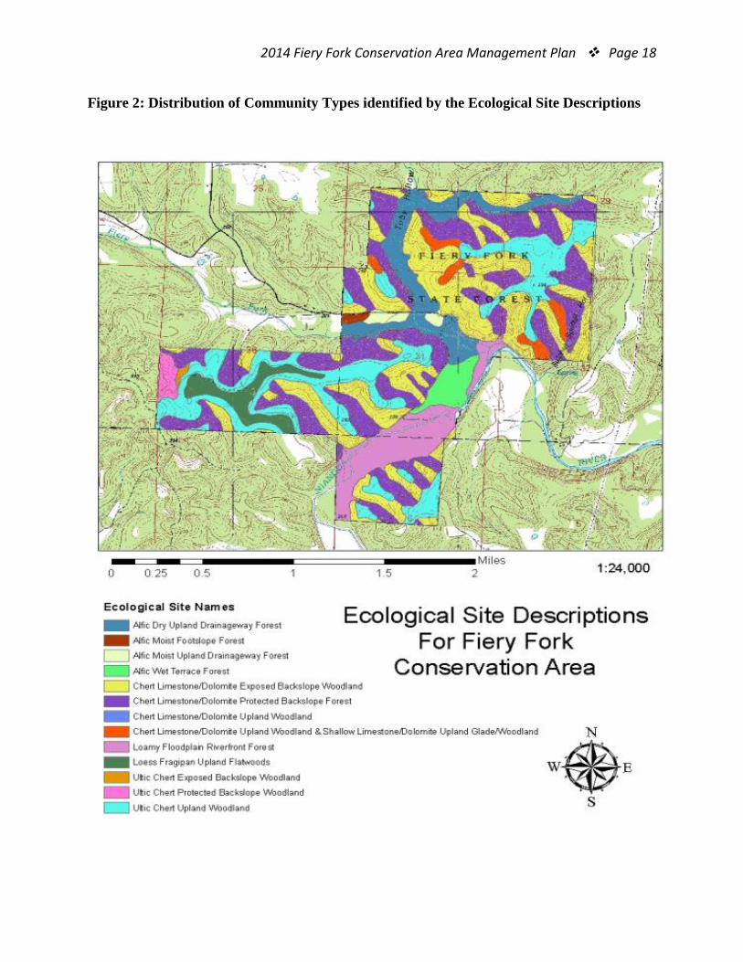
Fiery Fork Conservation Area falls within the boundaries of several priority-focus geographies. The following designations highlight features of the region that are collectively unique.
i. Forest Priority Landscape Fiery Fork CA is found within The Lake of the Ozarks PFL, a geographic designation that identifies portions of Benton, Camden and Morgan Counties for the forest resource of the region. This geography is noted for its large blocks of continuous forest, diversity of habitats and quality of natural communities (MDC, 2011).
ii. Fiery Fork Comprehensive Wildlife Strategy (CWS) The Comprehensive Wildlife Strategy recognizes the Fiery Fork landscape for the diversity of wildlife habitat found in the natural communities and large blocks of contiguous forest of the region. This geography encompasses Fiery Fork CA and is incorporated within the larger Lake of the Ozarks priority forest landscape. (MDC, 2011).
iii. Little Niangua River Priority Watershed Fiery Fork CA is found in the lower portions of the Little Niangua River
Priority Watershed; an 180,648 acre watershed surrounding the Little Niangua River and associated tributaries (MDC, 2011).
iv. Cave Focus Area The geology of this region is rich with Karst topography and designated as a
Cave Focus Area known to provide important gray bat habitat (MDC, 2011). (Refer to Figure 3 for the location of Fiery Fork within the identified priority areas.)
B. Natural Areas: None
II. Important Natural Features and Resources Fiery Fork Conservation Area falls within the Lake of the Ozarks Oak Woodland/Forest Breaks, a land type association (LTA) of the Osage River Hills Subsection located within the Ozark Highlands (Nigh & Schroeder, 2002). This LTA is a highly dissected landscape consisting of rugged hills and narrow ridge tops with local relief ranging from 250 to 350 feet. This diverse landscape was host to a complex of oak woodlands and glades with deep valleys and dolomite outcrops. Oak hickory forests were confined to protected slopes and deep valleys. Isolated Ozark fens and caves are scattered across the landscape (P.114). Today, this LTA consist of degraded woodland/glade complexes and dense second growth forest due to grazing activity, fire suppression and repeated harvesting pressure. Some naturally occurring glades and woodlands have survived due
2014 Fiery Fork Conservation Area Management Plan Page 5
to the presence of human influenced wildfire activity. Nearly all of the savanna and prairie communities have been converted to pasturelands (P.114).
A. Species of Conservation Concern: Species of conservation concern are known from this area. Area Managers should consult the Natural Heritage Database annually and review all management activities with the natural history biologist.
B. Caves: Yes, records kept with the MDC natural history biologist. Managers should follow the Cave Management policy found in the MDC Resource Policy Manual. All caves on this and other Conservation Areas are closed or restricted to public access. The fungus that causes White-nose Syndrome in bats has been documented in Missouri, resulting in the Missouri Department of Conservation’s White-nose Syndrome Action Plan that limits public access to protect bats.
C. Springs: Yes, records kept with MDC natural history biologist. D. Streams:
i. Little Niangua River The Little Niangua River is a fifth order tributary of the Niangua River in
west central Missouri. It originates in central Dallas County, near the town of Pumpkin Center, meandering to the north and east 59 miles before joining the Niangua River. The Little Niangua River watershed is about 320 square miles (211,636 acres). Of the total 59 miles, 13 miles are federally designated critical habitat and 40.8 miles are within known range of the Niangua darter, a federally threatened and state endangered species endemic to Missouri. Approximately 1.5 miles of the Little Niangua River are contained within Fiery Fork Conservation Area.
A primitive canoe access on Fiery Fork CA provides area users with a place to launch boats or wade fish the stream. Unfortunately the open condition of this access also allows unimpeded vehicular traffic which has become difficult to enforce. Recent efforts to restrict this access to foot traffic only have been washed away in rising floodwaters.
In 2008, an inventory and assessment of all low water crossing within the Little Niangua River Watershed and associated Niangua Darter native range was completed and a final report with priority rankings was produced. Within the Little Niangua River watershed, 10 road crossing were identified as creating passage barriers for Niangua darters and other benthic fishes. From 2004 through 2011 eight of the 10 crossings have been replaced or modified. Construction of the ninth crossing is currently underway and requests for funding for the 10th crossing have been completed.
ii. Fiery Fork Creek Fiery Fork Creek originates in Camden County 1 mile east of Climax
Springs (T39N, R19W, S28). Fiery Fork Creek flows 5 miles from its headwaters to its confluence with the Little Niangua River at river mile 12.2.
2014 Fiery Fork Conservation Area Management Plan Page 6
The lower 0.9 miles of Fiery Fork Creek are contained within the area. Fiery Fork Creek enters the area as a third order stream and becomes a fourth order stream at river mile 0.4 below the Toby Hollow Creek confluence. Total watershed area is approximately 7,000 acres.
In May 1989, two concrete slabs were installed by Operations Division across Fiery Fork Creek. Damage caused by flood events has necessitated repairs and modifications to these slabs on about six occasions since initial construction. Camdenton District Forestry staff have made several minor repairs to the gravel approaches after flood events.
Gravel has aggraded on the upstream sides of each slab to an elevation level with the slab surface. With the exception of a few isolated pools, all normal water flow is subsurface for a distance of 0.1 miles above the slabs. In addition to the upstream habitat degradation, these crossings are a passage barrier to fish.
iii. Toby Hollow Creek Toby Hollow, a tributary of Fiery Fork Creek, originates from a spring 0.7
miles southwest of Barnumton (T39N, R18W, S19). Toby Hollow flows 2.3 miles from its headwaters to its confluence with Fiery Fork Creek at river mile 0.4. Toby Hollow is a third order stream on the area. A second order tributary which originates at the junction of Highways 7 and J enters Toby Hollow Creek at river mile 1.2. The area contains the lower 1.0 mile of Toby Hollow. Total watershed area is approximately 2,500 acres.
Toby Hollow carries an extremely high gravel load throughout the area. Much of the watershed above the state forest has been cleared of woody vegetation and is heavily grazed, allowing large amounts of gravel to enter the system. In many areas, Toby Hollow exhibits shallow, braided channels characteristic of an unstable system. This situation is aggravated by a concrete slab which was constructed across Toby Hollow at the same time, and in the same manner, as those on Fiery Fork Creek.
iv. Spring Branch A spring branch (Figure 2) exits from the side of a hill and flows parallel
to and approximately 100 yards from Fiery Fork Creek before entering the Little Niangua River.
A probable recharge area for this spring is the sinkhole located on the ridge to the north. The woody vegetation within and the corridor around this sink should not be disturbed in any way. In addition, the use of herbicides should be closely monitored or restricted within the proximity of the sink.
E. Glades/Woodlands: Glade and woodland habitat is an important feature of the Fiery Fork
Landscape. The 1983 area plan noted these areas as being dry and rocky, suitable
2014 Fiery Fork Conservation Area Management Plan Page 7
for pine conversion. In few locations, site conditions were so poor, conversion was not deemed justifiable. Conversion did occur on a few sites north of the campground but not amounting to more than 5 acres.
The woodland and glade habitat found on Fiery Fork CA are predominantly dry to dry-mesic chert woodlands with pockets of dry to dry-mesic limestone/ dolomite woodlands and glades (Nelson, 2010). These woodland and glade communities are found naturally in association with each other, creating large complexes over the Fiery Fork landscape. Site conditions vary for each community type depending on slope percent, topographic position and parent material. In most cases, these communities are found on narrow to broad ridge tops and on south or west facing upper back slopes. Dry rocky conditions limit the growth of trees and support an abundance of native grasses and forbs in the understory. Fire played an important role in the maintenance of these systems. It is likely that these sites burned at least once every five years (MDC, 2012).
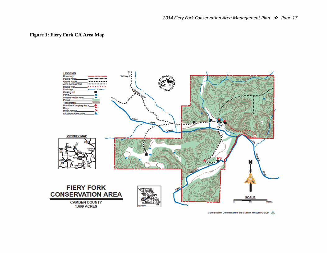
The ecological Classification System further identifies the potential for at least the following six variations of woodland communities on Fiery Fork. (Refer to Figure 2 in Appendix B for distribution of these natural communities.)
• Chert Limestone/Dolomite Exposed Backslope Woodland • Chert Limestone /Dolomite Upland Woodland • Chert Limestone /Dolomite Upland Woodland and Shallow Limestone
Dolomite Upland Glade/Woodland • Ultic Chert Upland Woodland • Ultic Chert Protected Back Slope Woodland • Loess Fragipan Upland Flatwoods
F. Forest: Fiery Fork CA is more than 93 percent forested, most of which is an
upland oak/ hickory cover type of black, white, post and red oak with some scattered blackjack oak and hickory species. This cover type is described as a dry-mesic chert Forest (Nelson, 2010). Variations exist within this community depending on soil characteristics, topographic position and slope. Pockets of dry or dry- mesic Limestone Dolomite Forest are present in small patches along the toe slopes and upper drainage ways (Nelson, 2010).
The forested bottomlands adjacent to Toby Hollow Creek, Fiery Fork Creek and the Little Niangua River consist of typical bottomland hardwood species including oak, ash and hickory on the toe slopes, transitioning to sycamore, silver maple, boxelder, elm, honeylocust and ash near the riparian corridors. This forest shifts from a dry-mesic/mesic bottomland forest to a riverfront forest from the upper waterways of Toby Hollow Creek and Fiery Fork Creek to the bottoms of the Little Niangua River respectively (MDC, 2012).
2014 Fiery Fork Conservation Area Management Plan Page 8
The ecological Classification System identifies the potential for at least the following six variations of forest communities on Fiery Fork. (Refer to Figure 2 in Appendix B for distribution of these natural communities.)
• Alfic Dry Upland Drainage way Forest • Alfic Moist Upland Drainage way Forest • Alfic Moist Footslope Forest • Alfic Wet Terrace Forest • Chert/Limestone/Dolomite Protected Backslope Forest • Loamy Floodplain Riverfront Forest Fire has been a major component of the Fiery Fork landscape. Prior to
public ownership, records show that much of the area consisted of over mature oaks with significant fire damage surrounded by pole timber (MDC, 1983). A nearly 150 acre stand replacing fire from the early 1950s killed all stems, resulting in an even-aged small pole stand (MDC, 1983). Wildfire frequency due to suppression efforts and education has decreased in the area since the initial purchase.
Currently, the forest component of Fiery Fork CA is in small to large saw timber sized oaks with pockets of small pole oak/hickory timber and some small pole pine timber, the result of a previous harvest conversion. Nearly all of the forest has been on an even aged management system with the exception of camping areas and the riparian corridors which have been left for aesthetics and erosion control as prescribed in the 1983 area plan (MDC, 1983). Sustainable timber management for high quality wood products was the main objective for Fiery Fork CA. Using improvement cuts and non-commercial thinning’s, this objective has been meet on several stands.
G. Wetlands: There is a 20 acre wetland site that would have been a forested wetland
adjacent to the Little Niangua River. It had been drained using constructed ditches prior to public ownership and is now row cropped for wildlife. In the early 2000s, five small earthen dams were constructed across these ditches to catch runoff creating small wildlife pools and restore a portion of the wetland habitat. These ditches quickly filled in with autumn olive and bottomland hardwoods creating drainage issues. In 2012, field staff obtained a 404 permit to remove the vegetation from these ditches and control the autumn olive infestation.
H. Fields: Approximately 5 percent of Fiery Forks total acreage is in old pasture and
warm season grass lands. The old pastures are rank with fescue and perennial forbs. Maintenance in recent years has consisted of mowing and occasionally spot spraying to kill woody sprouts. The upland fields located on the western half of Fiery Fork were drilled with warm season grass in an effort to provide diversity
2014 Fiery Fork Conservation Area Management Plan Page 9
and upland game cover. The remaining open ground is in wildlife food plots and accounts for 1 percent of the total acreage. These crops are planted and maintained by Missouri Department of Conservation employees for the purpose of providing wildlife habitat.
Exotic invasive species are established in nearly all open fields and field edges of Fiery Fork. Species present include autumn olive, sericea lespedeza, and small amounts of crown vetch. The current management strategy is to control the spread of these species annually, utilizing both mechanical and chemical methods.
III. Existing Infrastructure • Six gravel parking lots each with the capacity of 10-12 separate vehicles. • Two primitive camp grounds with approximately four gravel pad camp sites and
room to overflow into non-designated areas. • Approximately 11 concrete picnic tables are scattered evenly through both
campgrounds. • Two accessible pit privies are present, one at each designated camp site. • Approximately 1.7 miles of public gravel access road. • Approximately 1 ¼ miles of primitive hiking trail known as the Glade Top Trail. • Three low water crossings. The first crosses Toby Hollow Creek west of the first
campground. The last two cross the braided channel of Fiery Fork Creek. • Three non-stocked ponds totaling approximately 1 acre in size and several small
wildlife watering holes (unknown acreage). • An unimproved primitive boat launch for small boats or canoes.
IV. Area Restrictions or Limitations A. Deed Restrictions or ownership considerations: None B. Federal Interest: Federal funds may be used in the management of this land. Fish
and wildlife agencies may not allow recreational activities and related facilities that would interfere with the purpose for which the State is managing the land. Other uses may be acceptable and must be assessed in each specific situation.
C. Easements: A permanent utility easement with Southwest Electric Cooperative was established in April 1994. The easement is 20 feet wide by 3,871 feet long to enclose an electric line and guide wires. A deeded road easement acquired with the initial purchase of the Whiteford property ensures access to Fiery Fork from Granger Lane. The easement is recorded in deed number 1485 of Book 223 page 407 in the Camden County records maintained at the Camden County Courthouse.
D. Cultural Resources Findings: None observed. E. Hazards and Hazardous Materials: There are no unusual hazards besides a
small cave system. The location of this system is known only by a handful of people and is extremely difficult to locate or even stumble across. (MDC, 1983)
2014 Fiery Fork Conservation Area Management Plan Page 10
F. Endangered Species: Endangered Species are known from this area. Area Managers should consult the Natural Heritage Database annually and review all management activities with the natural history biologist.
G. Boundary Issues: None
MANAGEMENT CONSIDERATIONS
V. Terrestrial Resource Management Considerations Challenges and Opportunities:
1) The forested community should be managed sustainably to improve health, productivity and biodiversity.
2) Natural community resources need active management to promote biodiversity and connectivity.
3) Management should emphasize diverse wildlife habitat. 4) Control of invasive species is high priority.
Management Objective 1: Manage the forest resource to improve health, productivity and sustainability as well as provide protection for aquatic resources.
Strategy 1: Conduct forest inventory by compartment with an estimated re-entry time of 15 years or as needed. Strategy 2: Implement forest management practices as prescribed by the detailed forest inventory process. Strategy 3: Utilize Best Management Practices (BMP’s) to maintain soil, water and visual integrity.
Management Objective 2: Improve natural community diversity.
Strategy 1: Identify landscape scale management units that encompass a complex of natural communities that can be easily managed as a single unit. Strategy 2: Utilize current compartment level inventory, aerial photography and on-site inspection to identify and support management decisions of the identified units. Strategy 3: Use a combination of thinning, harvesting and prescribed fire, if needed, to release the full potential of each natural community management unit. Management activities will occur on a 1-5 year rotation to ensure regular monitoring of these highly sensitive communities. Strategy 4: Conduct post treatment monitoring to ensure management activities are achieving desired results. Strategy 5: Evaluate bottomland fields adjacent to Toby Hollow Creek, Fiery Fork Creek and the Little Niangua River for reforestation. First priority should be expanding the riparian cooridor in these open areas.
2014 Fiery Fork Conservation Area Management Plan Page 11
Management Objective 3: Provide a diversity of wildlife habitat. Strategy 1: Implement Management Objective 2 Strategy 2: Manage most of the existing open land through rotational cropping, hay permitting, prescribed fire and mowing to maintain early successional habitat. See terrestrial management objective 2, strategy 5, for open land reforestation goals in bottomland open areas. Strategy 3: Provide transitional zones between field, woodland and forest. Use a combination of edge feathering, thinning and prescribed fire to meet this strategy. Strategy 4: Increase the riparian corridor around the Little Niangua, Fiery Fork and Toby Hollow tributaries to 200 feet and intermittent streams to 100 feet, specifically for gray bat habitat and stream bank stabilization.
Management Objective 4: Control Invasive Species where applicable.
Strategy A: Identify the extent of both exotic and invasive species and develop an integrated pest/invasive species management attack strategy. Strategy B: Implement the integrated pest/invasive species management attack strategy using available resources both contracted and in-house.
VI. Aquatic Resource Management Considerations
Challenges and Opportunities: 1) Fishing and wildlife viewing opportunities should be maintained for future
generations. 2) Water quality of the streams and ponds must be maintained to support a healthy
ecosystem. 3) Improve upstream habitat for the Niangua Darter and associated aquatic species.
Management Objective 1: Maintain access to area ponds, wetlands and streams for fishing and wildlife viewing opportunities.
Strategy 1: Provide maintenance on an “as needed basis” to the parking lots, trails and signage adjacent to non-stocked ponds and the stream frontage along Toby Hollow Creek, Fiery Fork Creek and the Little Niangua River. Strategy 2: Use BMPs during infrastructure maintenance to prevent erosion from entering aquatic resources.
2014 Fiery Fork Conservation Area Management Plan Page 12
Management Objective 2: Improve the river access to encourage acceptable recreational use.
Strategy 1: Terminate direct access to the river to discourage vehicular traffic and littering within the stream zone. Strategy 2: Provide a turnaround spot at the end of the river access trail for boating and equipment drop off.
Management Objective 3: Increase Niangua Darter habitat. Strategy 1: Replace both low water crossings on Fiery Fork Creek to increase connectivity to habitat above these low water slabs. Strategy 2: Maintain or establish a riparian corridor of woody vegetation to a minimum width of 100 feet along all intermittent streams, and 200 feet along the Little Niangua River, Fiery Fork Creek and Toby Hollow Creek.
VII. Public Use Management Considerations
Challenges and Opportunities: 1) Fiery Fork should be managed to provide the public with multiple opportunities to
enjoy Missouri’s resources. 2) Fiery Fork should be inviting and accessible to all area users.
Management Objective 1: Promote safe and suitable activities on Fiery Fork CA
Strategy 1: Ensure that information regarding the area is accurate, consistent and available to the public through general contact, atlas database, posted signs and brochures. Strategy 2: Provide quick response to issues or questions that arise from area users or activities. Strategy 3: Allow year-round access for area users to hunt, fish, gather edibles, and enjoy Missouri’s outdoors appropriately and in accordance with State and area specific regulations. Strategy 4: Support the local community through group activities such as FFA and Stream Team.
VIII. Administrative Considerations
Challenges and Opportunities: 1) Area infrastructure should be inviting and encourage the public to care for it. 2) Fiery Fork should support the local community through conservation of the local
resources.
2014 Fiery Fork Conservation Area Management Plan Page 13
Management Objective 1: Maintain area infrastructure Strategy 1: Monitor and mark the area boundaries according to the pre-established marking schedule. Strategy 2: Maintain infrastructure on an “as needed” basis to ensure that signage, parking lots, trails and privies are in good shape. Strategy 3: Maintain the primitive camping opportunities.
Management Objective 2: Seek out and develop good relationships with Fiery Fork CA neighbors and the community.
Strategy 1: Inform neighboring landowners of area activities prior to the activity in writing or verbally. Provide periodic updates as needed. Strategy 2: Provide special use permitting for appropriate activities requested by the public and neighboring landowners.
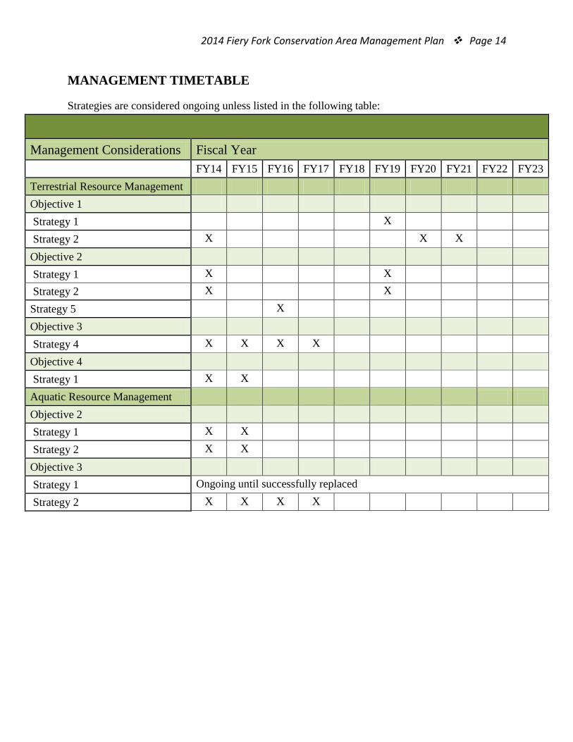
2014 Fiery Fork Conservation Area Management Plan Page 14 MANAGEMENT TIMETABLE
Strategies are considered ongoing unless listed in the following table:
Management Considerations Fiscal Year FY14 FY15 FY16 FY17 FY18 FY19 FY20 FY21 FY22 FY23 Terrestrial Resource Management Objective 1 Strategy 1
X
Strategy 2 X
X X Objective 2
Strategy 1 X
X
Strategy 2 X
X
Strategy 5 X Objective 3 Strategy 4 X X X X Objective 4 Strategy 1 X X Aquatic Resource Management Objective 2 Strategy 1 X X Strategy 2 X X Objective 3 Strategy 1 Ongoing until successfully replaced Strategy 2 X X X X
2014 Fiery Fork Conservation Area Management Plan Page 15 APPENDICES
Area Background: Fiery Fork Conservation Area is in Camden County, 15 miles northwest of Camdenton and 7 miles east of Climax Springs, off Highway 7. The area includes 1,606 acres of oak and hickory forest and was named after Fiery Fork Creek, which flows into the Little Niangua River. Fiery Fork was purchased from Ivan Whiteford in 1980 and had previously been enrolled in the Forest Crop land under former owner Martin Wright. Prior to public ownership, the land associated with the forest had largely been abused. The cave system has been mined for onyx dating as far back as the 1890s. Nearly all cave formations have been damaged or entirely removed due to this practice. Above ground, the entire area has been managed with uncontrolled wildfires resulting in stands of even-aged large pole and small saw timber. During your visit to Fiery Fork Conservation Area, you may view various forest improvement practices designed to improve wildlife habitat, maintain watershed quality, enhance tree growth, quality and species composition. Signs of disturbance are only temporary and the forest will soon return to normal. Hiking trails on the area vary in length from 0.25 mile to 1.25 miles and offer ideal opportunities to view wildlife in its natural setting. All boundaries of the area are marked from tree to tree with blue paint and are posted where they intersect state and county roads or private lands. Visitors are urged to respect the rights of adjacent land owners.
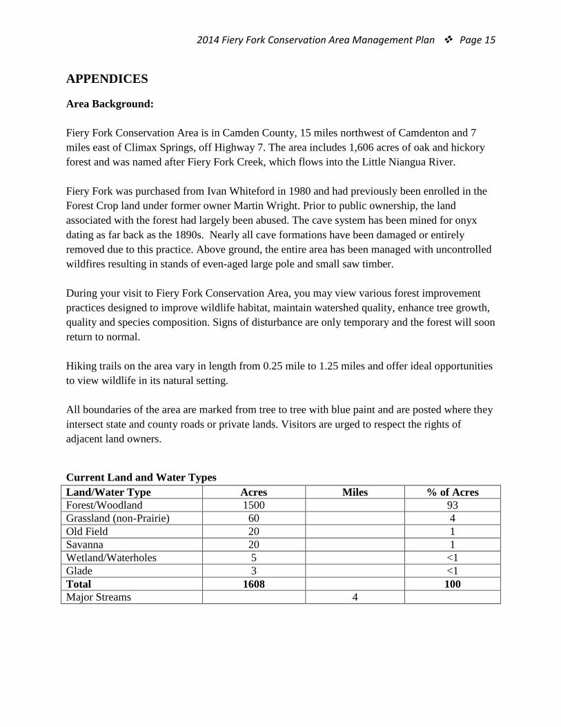
Current Land and Water Types Land/Water Type Acres Miles % of Acres Forest/Woodland 1500 93 Grassland (non-Prairie) 60 4 Old Field 20 1 Savanna 20 1 Wetland/Waterholes 5 <1 Glade 3 <1 Total 1608 100 Major Streams 4
2014 Fiery Fork Conservation Area Management Plan Page 16 Public Input Summary: The draft Fiery Fork Conservation Area Management Plan was available for a public comment period April 1 – 30, 2014. The Missouri Department of Conservation received no comments during this time period. References: MDC. (1983). Fiery Fork State Forest Area Plan. Jefferson City: Missouri Department of Conservation. MDC. (2011). Conservation Priorities; Decision Support Tool . Jefferson City: Missouri Department of Conservation. MDC. (2012). Resource Science Ecological Site Descriptions. Retrieved Feb. 26, 2013, from MDC SharePoint: http://mdcsharepoint/sites/resourcescience/Documents/Terrestrial%20Flora/Ecological%20Classification%20System%20Project/ESD%20Documents/F116AY048MO.pdf Nelson, P. W. (2010). The Terrestrial Natural Communities of Missouri. Jefferson City: Missouri Department of Conservation. Nigh, T. A., & Schroeder, W. A. (2002). Atlas of Missouri ecoregions. Jefferson City: Missouri Department of Conservation.
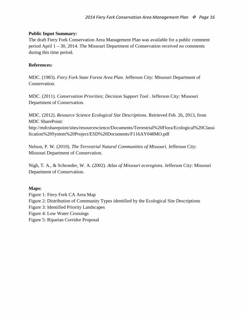
Maps: Figure 1: Fiery Fork CA Area Map Figure 2: Distribution of Community Types identified by the Ecological Site Descriptions Figure 3: Identified Priority Landscapes Figure 4: Low Water Crossings Figure 5: Riparian Corridor Proposal
2014 Fiery Fork Conservation Area Management Plan Page 17 Figure 1: Fiery Fork CA Area Map
2014 Fiery Fork Conservation Area Management Plan Page 18 Figure 2: Distribution of Community Types identified by the Ecological Site Descriptions
2014 Fiery Fork Conservation Area Management Plan Page 19 Figure 3: Identified Priority Landscapes
Figure 3: The above map shows the location of Fiery Fork Conservation Area within the identified priority landscapes.
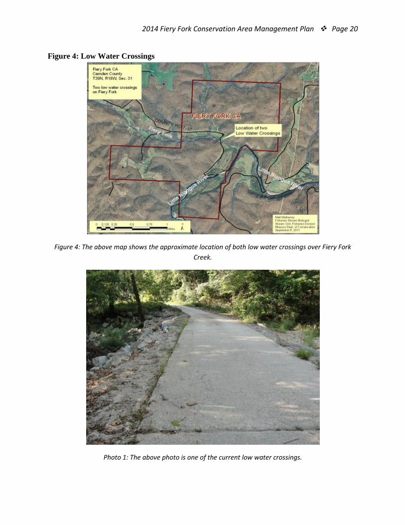
2014 Fiery Fork Conservation Area Management Plan Page 20 Figure 4: Low Water Crossings
Figure 4: The above map shows the approximate location of both low water crossings over Fiery Fork Creek.
Photo 1: The above photo is one of the current low water crossings.
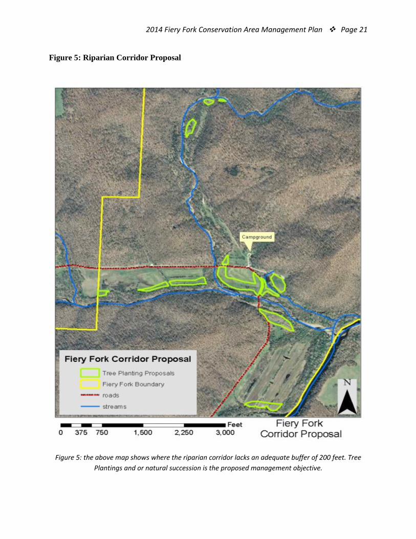
2014 Fiery Fork Conservation Area Management Plan Page 21 Figure 5: Riparian Corridor Proposal
Figure 5: the above map shows where the riparian corridor lacks an adequate buffer of 200 feet. Tree Plantings and or natural succession is the proposed management objective.


![Ricoh ChinaFiery JobFlow Base Fiery , FS200 Pro _Ei*fic Fiery Fiery Productivity Package Fiery JobFlow E] Fiery Windows Fiery Windows 7, 8, 8.1 s 10 32 fi/64 Google Mozilla Firefox](https://img.dokumen.tips/doc/110x75/611424df97efee38ef5fbef2/ricoh-fiery-jobflow-base-fiery-fs200-pro-eific-fiery-fiery-productivity-package.jpg)