Embed Size (px)
Citation preview

Erigeron acomanus (Acoma fleabane)
Status Report
2012
Daniela Roth
New Mexico Forestry Division Energy, Minerals, and Natural Resources Department
Prepared for the
U.S. Fish & Wildlife Service Albuquerque, NM
Section 6, Segment 26

2
INTRODUCTION
Erigeron acomanus Spellenberg and Knight (Acoma fleabane) is an endemic rare plant species found only in west central New Mexico. In 1995, the Fish & Wildlife Service and State of New Mexico funded a University of New Mexico graduate research project to study the genetic basis of perceived population distinctions in Erigeron acomanus (Reed 1996). The study results indicated there are two geographically and genetically distinct populations of this very rare species. In 2007 the USFWS was petitioned by the Forest Guardians (now WildEarth Guardians) to list 475 species in the Southwest Region, including Erigeron acomanus. Not enough substantial information was presented in the petition to indicate whether a listing may be warranted (74 FR 66866). However, Erigeron acomanus remains a very rare species and at least one of the populations is threatened by mining activities. In addition, UNM researchers are preparing a publication to split this species into two varieties, making each variety even more rare and restricted (T. Lowrey 2013, pers. com.). Populations had not been visited since the 1990s and the current status of the species was unknown. Additional survey efforts were necessary to obtain current information on the status, distribution, abundance and of this species and to determine whether any threats were acting on them.
Taxonomic Status and Description
Erigeron acomanus was first collected by Richard Spellenberg in 1977 from Blue Water Canyon in Cibola County, NM. Richard Spellenberg and Paul Knight described it as a new species in 1989 (Spellenberg & Knight 1989).
Erigeron acomanus is a mat-forming perennial herb in the Aster family (Nesom 2006). Mats are 10 to 70 cm in diameter and the caudex branches are covered by persistent leaf bases. Individual mats are vegetative clones, each supported by a persistent woody rhizomatus caudex (Reed 1996). Clones consist of 10-100 flowering stems, each supporting a single flower head. 8 – 30 leaves are clustered in rosettes at the end of caudex branches. Leaves are narrow, obovate or spatulate, 8 – 23 mm long, 2 – 7 mm wide with a rounded tip. The flowering stems are erect, 4.5 – 15 cm tall, with 4 – 10 leaves. Flower heads are solitary, pendulous in bud, erect in flower and fruit. Ray flowers 16 -30, white (pink in bud), 4.5 – 9 mm long, disk corollas yellow. Flowering occurs from late May to July. Erigeron acomanus is distinguished from other Erigerons in New Mexico by being monocephalic, having leafy stems, round obtuse leaf tips, white ray flowers, and a mat-forming habit.
Erigeron acomanus does not follow the pattern of other rare and endemic species by losing genetic diversity or increasing divergence among populations (Reed 1996). Although populations are small and isolated from one another, Erigeron acomanus has a relatively high genetic diversity at the population and species level, resembling that of more widespread species. Mitigating for its isolation are the breeding system (obligate outcrossing combined with clonal,

3
asexual reproduction), migration and dispersal strategy (generalist pollinators, wind dispersal), and heterozygote superiority. Distribution and Abundance Erigeron acomanus is only known from four populations which are divided into 2 distinct sub- populations in McKinley and Cibola counties in New Mexico (Figure 1). Three of these populations are growing in relative close proximity in McKinley County on lands owned and managed by private land owners, the Navajo Nation, and the BLM (McKinley sub-population). The disjunct forth population (type locality) occurs on BLM lands in Cibola County, in Blue Water Canyon (Cibola sub-population). No recent information is available on the abundance of plants within these populations. In 1996 the Bluewater Canyon population was estimated to be around 1,500 individuals (Reed 1996). More than 100 plants were estimated to grow at the San Antone Quarry in 1997 (NMHP 2012). The population at Navajo EO #2 has been estimated between at 160 and 200 individuals (Hevron 1991; Reed 1996). The Casamero Draw population was thought to be the largest of the known populations, estimated at 2000 plants (Reed 1996).

4
Figure 1. Potential habitat (in yellow) and known population sites for Erigeron acomanus in McKinley and Cibola counties, NM.
Cibola Sub-population
McKinley Sub-population
San Antone
Navajo Casamero Draw

5
Habitat
At the McKinley County sub-population the three Erigeron acomanus sites occur on sandy slopes and benches derived from the Entrada Formation, capped by a gypseous limestone segment of the Todilto Formation (Figures1& 2). The McKinley County populations occur on all aspects, above and below Entrada sandstone cliffs with a scattering of Todilto Limestone rocks and cobbles, in shade under pinion and in exposed areas (Figure 2). It is associated with pinion-juniper woodland communities with an understory of Artemisia bigelovii, Bouteloua gracilis, Gutierrezia sarothrae, Purshia stansburiana, Achnatherum hymenoides, and Yucca baccata. Elevation ranges from 7,070 to 7,450 ft.
The Cibola County sub-population at Blue Water Canyon is largely restricted to N-facing slopes where it occurs primarily under the shade of pinions on soils derived from Entrada sandstone. Associated species include Pinus edulis, Juniperus monosperma, Cercocarpus montanus, Bouteloua gracilis, Yucca, and Stipa comata. There is no Todilto Limestone in the vicinity of the Blue Water Canyon population. Elevation ranges from 6,600 to 6,700ft.

6
Figure 2. Erigeron acomanus habitat and growth habit.

7
Conservation Status and Management
The New Mexico Rare Plant Technical Council has adopted the R-E-D code system which is a three-element ranking system giving information on rarity (R), endangerment (E), and distribution (D) of a species (NMRPTC 1999). Erigeron acomanus has a R-E-D code of 3-1-3, indicating that occurrences of the species are limited to one of a few highly restricted populations, or present in such small numbers that it is seldom reported (3), that the species is not endangered (1), and is endemic to New Mexico (3). NatureServe (2012) ranks E. acomanus as a G1/G2 species (rounded rank of G1). The G1 (Global) rank indicates a species that is “Critically imperiled globally because of extreme rarity or because of some factor(s) making it especially vulnerable to extinction. Typically 5 or fewer occurrences or very few remaining individuals (<1,000) or acres (<2,000) or linear miles (<10)”. Affiliated Natural Heritage Programs in New Mexico and the Navajo Nation have each given E. acomanus a State ranking of S1, which indicates a species “Critically imperiled in the state because of extreme rarity or because of some factor(s) making it especially vulnerable to extirpation from the state. Typically with 5 or fewer occurrences or very few remaining individuals (<1,000)”. Erigeron acomanus has been informally acknowledged as a “Species of Concern” by the US Fish & Wildlife Service (NMRPTC, 1999). The Fish & Wildlife Service defines a Species of Concern as “A taxon for which further biological research and field study are needed to resolve their conservation status OR are considered sensitive, rare, or declining on lists maintained by Natural Heritage Programs, State wildlife agencies, other Federal agencies, or professional/academic scientific societies”. The State of New Mexico through its Energy, Minerals and Natural Resources Department-Forestry Division has also informally identified E. acomanus as a “Species of Concern” (NMRPTC 1999). EMNRD-Forestry defines a Species of Concern as “A New Mexico plant species, which should be protected from land use impacts when possible because it is a unique and limited component of the regional flora”. On the Navajo Nation Erigeron acomanus is listed threatened (Group 3) on the Navajo Endangered Species List. Species listed in Group 3 are species or subspecies whose prospects of survival or recruitment are likely to be in jeopardy in the foreseeable future. The Navajo Endangered Species Act (17 NNC § 507) makes it “unlawful for any person to take, possess, transport, export, process, sell or offer for sale or ship” any species listed on the Navajo Endangered Species List.
Erigeron acomanus is a BLM sensitive species, which is defined as a species that has recently undergone, is undergoing, or is predicted to undergo a downward trend such that the viability of the species or a distinct population segment of the species is at risk across all or a significant portion of the species' range, or a species that depends on ecological refugia or specialized or unique habitats on BLM-administered lands, and there is evidence that such areas are threatened with alteration such that the continued viability of the species in that area would be at risk.

8
METHODS
All academic and agency reports and specimen information were compiled for Erigeron acomanus to determine the status and the known distribution of the species’ populations. All Southwest herbaria were consulted through SEINet for information on the distribution of the species. The Navajo Natural Heritage Program (NNHP) and Natural Heritage New Mexico (NHNM) provided information on plant locations, habitat, and abundance.
Known locations were visited in late May, 2012, to assess population status, distribution, and any potential threats. In addition, other potentially suitable Entrada Sandstone habitats were surveyed in west-central New Mexico on accessible lands for additional populations. Populations were mapped using a Garmin eTrex GPS (NAD 83). Documented were population size, phenology, habitat description, and potential threats.
Potential habitat for Erigeron acomanus was determined by overlaying geologic layers over the current distribution of the species in McKinley and Cibola counties, using ArcMap GIS. Initially the Dakota and Entrada sandstone formations were targeted because they had been identified as habitat for the species. None of the known populations were located on the Dakota Sandstone Formation and therefore survey efforts concentrated on the Entrada Formation. In west-central New Mexico the Entrada Formation occurs in very limited areas, primarily on Laguna tribal lands, the Navajo Nation, State, BLM, and private lands, in McKinley and Cibola counties (Figure 1).
RESULTS
Access to relocate known populations and survey for additional populations on non-federal lands was granted for Navajo Nation lands, NM State lands, and private lands. The majority of potential habitat is located on Laguna tribal lands (Figure 1). Access was not granted to Laguna tribal lands and therefore could not be surveyed for additional populations.
Known sites
Between 2000 and 3000 plants were found during the 2012 surveys of the four known populations (Table 1). Estimating the number of individual plants is difficult because of the mat forming habitat of the plants. Overall plants were found in the same locations as originally mapped in the 1990s, at similar numbers, except for the Casamero Draw population, where 2012 population estimates were significantly lower than 1996 estimates. Plants grew in relatively remote and undisturbed areas, except for the San Antone Quarry population.

9
Table 1. Extant populations of Erigeron acomanus in McKinley and Cibola counties, NM.
Population Site/Subpopulation
Population Estimate Land Ownership
Navajo EO #2/ McKinley 200 Navajo Nation Casamero Draw/McKinley 300-500 BLM
San Antone Quarry/ McKinley 100 Private/BLM
Blue Water Canyon/Cibola 1000 - 2000 BLM
Total Plants
San Antone Quarry
Erigeron acomanus grows above and below the Entrada Sandstone cliff at the San Antone limestone quarry on private and BLM lands, at elevations ranging from 7,300 to 7,450 ft (Figure 3). Approximately 100 plants were found, primarily growing above the cliff (Table 1). A few plants were found on sandy slopes below the cliff, in the shade of pinion. Todilto Limestone cobbles and boulders are also present below the cliff. Most plants were in bud or early flowering stage. Plants found above the cliff grow in Todilto Limestone cobble overlaying Entrada Sandstone, where they are found between the rim and the cliff on steep W and SW-facing slopes (Figure 2). The habitat above the cliff is largely open and exposed, with pinion and juniper, Purshia stansburiana, Aristida purpurea, Cryptantha, and Pleuraphis jamesii. Additional associated species below the cliff include Wyethia scabra and Artemisia bigelovii.
No threats were observed to plants growing below the cliff. Plants growing above the cliff were protected by the steepness of the terrain between the rim and the actual cliff. Areas immediately above the rim were significantly disturbed by activities associated with the quarry, including roads, parking, piling of mine debris, and trash dumping.
10
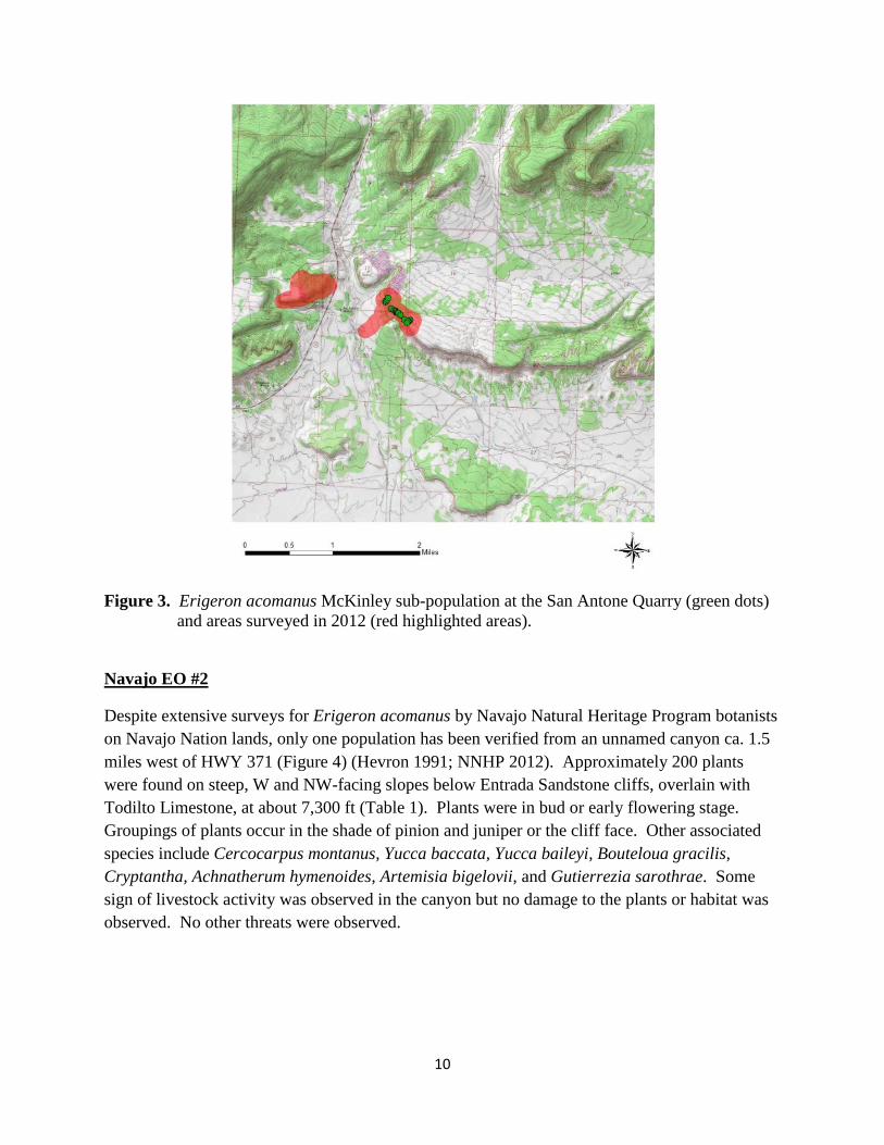
Figure 3. Erigeron acomanus McKinley sub-population at the San Antone Quarry (green dots) and areas surveyed in 2012 (red highlighted areas).
Navajo EO #2
Despite extensive surveys for Erigeron acomanus by Navajo Natural Heritage Program botanists on Navajo Nation lands, only one population has been verified from an unnamed canyon ca. 1.5 miles west of HWY 371 (Figure 4) (Hevron 1991; NNHP 2012). Approximately 200 plants were found on steep, W and NW-facing slopes below Entrada Sandstone cliffs, overlain with Todilto Limestone, at about 7,300 ft (Table 1). Plants were in bud or early flowering stage. Groupings of plants occur in the shade of pinion and juniper or the cliff face. Other associated species include Cercocarpus montanus, Yucca baccata, Yucca baileyi, Bouteloua gracilis, Cryptantha, Achnatherum hymenoides, Artemisia bigelovii, and Gutierrezia sarothrae. Some sign of livestock activity was observed in the canyon but no damage to the plants or habitat was observed. No other threats were observed.

11
Figure 4. Erigeron acomanus McKinley sub-population at Navajo (green dots) and areas surveyed in 2012 (red highlighted areas).
Casamero Draw
Plants occur beneath the cliffs of an unnamed mesa immediately north of the Prewitt Power Plant (Figure 5). Approximately 300 to 500 plants were found in scattered and highly localized small groupings along W and NW-facing slopes (Table 1). Plants grew in shallow, dry washes, at the base of cliffs under the shade of pinion trees, at approximately 7,070ft in elevation. Plants were in bud or early flowering stage. In addition to pinion and juniper, associated species included Heterotheca villosa, Bouteloua gracilis, Stipa comata, Penstemon, and Chaenactis. Some livestock activity was observed in the area but no damage to the plants or habitat was observed. No other threats were observed.

12
Figure 5. Erigeron acomanus McKinley sub-population at Casamero Draw (green dots) and areas surveyed in 2012 (red highlighted areas).
Blue Water Canyon
Blue Water Canyon is located in a remote area, south of the Laguna Indian Reservation, on lands managed by the BLM (Figure 6). It is the type locality for Erigeron acomanus. One thousand to two thousand plants were found exclusively on the south side of a dry rocky wash where they were growing preferentially on steep, N-facing slopes, under the shade of pinion or juniper (Table 1). Few plants were found in open areas or along the dry wash. There was no obvious Todilto Limestone component overlaying the Entrada Sandstone. Plants grew among pinion and juniper with Cercocarpus montanus, Bouteloua gracilis, Yucca, and Stipa comata. Plants occurred between 6,600 and 6,700 ft in elevation. Plants were consistently larger and more robust than plants observed at the McKinley County sub-population. Plants were primarily in bud and were growing in small groupings of 10 – 20 plants, few as large as 100 plants.

13
Livestock was seen in the canyon bottom, but not on the slopes. No livestock damage or impacts were observed in the vicinity of the plants. No other threats were observed.
Figure 6. Erigeron acomanus Cibola sub-population at Blue Water Canyon (green dots) and areas surveyed in 2012 (red highlighted areas).
Herbarium Search
The Southwest Environmental Information Network (SEINet) was accessed to locate specimens deposited in regional herbaria and to determine location information (SEINet 2012). Twenty-three herbarium specimens were located in nine herbaria (University of New Mexico (UNM), NM State University (NMC), Navajo Nation (NAVA), San Juan College (SJNM), Rocky Mountain Herbarium (RM), New York Botanical Garden (NY), University of Arizona (ARIZ), Arizona State University (ASU), and the Desert Botanical Garden Herbarium (DES). These 23 specimens represented voucher collections from the 4 known population sites in McKinley and Cibola County in New Mexico.

14
Three reported collections could not be relocated or confirmed. One specimen from Luna County, NM, was mislabeled in the database as Erigeron acomanus, but labeled on the specimen as E. divergens (DES 39988). Reed reported a site in Crazy Woman Canyon on the Navajo Nation (Reed 1996). This site could not be verified by any specimen or occurrence report provided by the Navajo Natural Heritage Program. Crazy Woman Canyon is approximately 13 air miles west from the closest population (Navajo EO #2). It is believed that the Navajo EO #2 site and the Crazy Woman Canyon site are synonymous because the Crazy Woman Canyon site is described as being about 6 miles west of the Casamero Draw site, which corresponds with the Navajo EO # 2 site (Reed 1996). A collection from an old gravel pit, W of HWY 371(SJC 54321), could not be confirmed and attempts to relocate the collection at the gravel pit and surrounding area were unsuccessful. Geographic coordinates provided with the specimen indicate that the collection location is at the San Antone Quarry.
Additional areas surveyed
Potential habitats have been surveyed in the past on the Navajo Nation and BLM lands. No other populations have been found and none were found in 2012. In addition to searching areas in the vicinity of the known populations, potential habitats surveyed include the base of Entrada sandstone cliffs east of New Mexico HWY 117, on BLM managed lands in the Cebolla Wilderness (El Malpais National Conservation Area); BLM managed lands north of the Prewitt Power Plant, base of Entrada Sandstone cliffs on Navajo Nation lands, west of HWY 371; and BLM lands south of the Laguna Reservation, north and south of Blue Water Canyon.
CONCLUSIONS
Erigeron acomanus remains a very rare plant species of west central New Mexico. No additional populations have been found in the past and none were found during the 2012 surveys. Known populations occur largely in remote areas, where plants grow in highly localized sites. Very few threats to the populations or habitat were observed and plant numbers appear largely stable where it occurs. The Casamero Draw population estimate of 2012 was substantially lower from 1996 estimates. It is unclear whether this represents a population decline or, more likely, differences in the approach of estimating individuals. Determining what constitutes an individual is difficult for this species, because of its clonal nature, and therefore becomes subjective.
The Blue Water Canyon sub-population is currently in the process of getting described as a separate variety, based on genetic and morphological differences (T. Lowrey 2013, pers. com.). In addition, the Blue Water site occurs at lower elevations and does not contain the Todilto Limestone component of the McKinley County sub-population. Although this represents the largest of the four Erigeron acomanus populations, this new variety is therefore known from only one population, making it highly susceptible to stochastic extinction events such as

15
wildfires and regional long term drought impacts. Monitoring of this population is advisable, at least on 3 – 5 year intervals.
Surveys on the Laguna reservation might yield additional populations of the new variety of Erigeron acomanus. To this date, permission for surveys has not been granted.
To offset the potential of a stochastic extinction event, seeds should be collected at all population sites and stored at a certified seed repository for long term storage to ensure seeds are available for future restoration and recovery efforts.

16
REFERENCES CITED
Hevron, B. 1991. Results of survey for: Erigeron acomanus, Asclepias sanjuanensis, Proatriplex pleiantha, and monitoring study of Astragalus humillimus on the Navajo Nation. Unpublished report prepared by the Navajo Natural Heritage Program, Window Rock, AZ, for the NM State Forestry Division, Santa Fe, NM. 15 pp.
Lowrey, T.K. 2013. Phone conversation between T. Lowrey, curator of the UNM Herbarium in
Albuquerque and D. Roth, Botany Program Coordinator, NM Forestry Division, Santa Fe, NM, on January 16, 2013.
Nesom, G. L. 2006. Erigeron. In: Flora of North America Editorial Committee, eds. 1993+.
Flora of North America North of Mexico. 16+ vols. New York and Oxford. Vol. 20, pp. 256-334.
New Mexico Rare Plant Technical Council. 1999. New Mexico Rare Plants. Albuquerque, NM:
New Mexico Rare Plants Home Page. http://nmrareplants.unm.edu (Latest update: 30 March 2012).
Reed, S. 1996. Genetic variation and population structure in four rare species of Erigeron from
the American Southwest. Chapter 1. Unpublished MS Thesis, University of New Mexico, Albuquerque.
SEINet. 2012. Southwest Environmental Information Network. Accessed in June 2012 via
http://swbiodiversity.org/seinet/ Spellenberg, R. and P.J. Knight. 1989. A new species of Erigeron (Asteraceae: Astereae) from
central New Mexico. Madroño 36(2):115-121.