Embed Size (px)
Citation preview
2
1
3
Luke AFB
Cp Navajo
New
Riv
Salt Riv
Color
ado
Riv
APACHE 001
GREENLEE 011
AP A
CHE
001
GR A HAM
0
09
COCONINO 005
COCONINO 005
YAVAPAI 025
YAVAPAI 025MARICOPA 013
MO
HA
VE
015
CO
CO
NIN
O 0
05
PINAL 021
MARICOPA 013 GILA
007
PIN
AL 021
GILA 007
GRAHAM 009
GR
AH
AM
00
9
GR
EENLEE 011
YA
VA
PA
I 02
5
GIL
A 0
07
MARICO
PA 013
GILA 007
COCONINO 005
GILA 007
GILA 007
NAVAJO 017
CO
CO
NIN
O 0
05
NA
VA
JO 0
17
AP
AC
HE
00
1
NA
VA
JO 017
AP
AC
HE
00
1
NAVAJO 017MOHAVE 015
AR
IZO
NA
04
FORT APACHE RES 1140
HOPI RES 1505
NAVAJO NATION RES 2430
ZUNI RES 4785
TONTO APACHE RES 4235
SALT RIVER RES 3340
GILA RIVER IRES 1310
KAIBAB IRES 1720
HAVASUPAIRES 1440
HOPI RES 1505
NAVAJO NATION RES 2430
FORT APACHE RES 1140
SAN CARLOS RES 3355
FORT MCDOWELL YAVAPAINATION RES 1220
YAVAPAI-PRESCOTT RES 4710
YAVAPAI-APACHENATION RES 4708
ZUNI RES
YAVAPAI-PRESCOTT RES
TONTO APACHE RES
FORT MCDOWELLYAVAPAI NATION RES
YAVAPAI-APACHE NATION RES
HAVASUPAIRES
HOPI RES
NAVAJO NATION RES
FORT APACHE RES
SAN CARLOS RES
GILA RIVER IRES
KAIBAB IRES
SALT RIVER RES
T1505
T2430
Chilchinbito 12630
Oljato-Monument Valley 51142
North Fork 50000
Hondah 33440
Greasewood 29430
Fort Apache 24250
Winslow West 83960
McNary 43430Pinetop Country Club 55880
Linden 41085Pinedale 55840
Cibecue 13400
Shonto 66260
Hotevilla-Bacavi 33945
Kayenta 36990
Pinon 56120
Hard Rock 31182
Low Mountain 42590
Lake of the Woods 39790Wagon Wheel 80380
East Fork 21310
Turkey Creek 77415Seven Mile 65780
Indian Wells 35310
Sun Valley 71160
Rainbow City 58620
Whiteriver 82530
Woodruff 84350
White Mountain Lake 82450
Dilkon 19280
Tees Toh 72630
Seba Dalkai 65167
Joseph City 36430
Clay Springs 14030
Heber-Overgaard 32310
Jeddito 36150
Whitecone 82390
KeamsCanyon 37130
First Mesa 23512
Second Mesa 65280
Shongopovi 66190
KykotsmoviVillage 39100
Winslow West
McNary
Canyon Day
Lake Montezuma
Maricopa Colony
St. Johns
Rio Verde
Gold Canyon
Wheatfields
Copper Hill
Claypool
Central Heights-Midland City
Pinal
Tusayan
Grand Canyon Village
KaibabMoccasin
Supai
Rough Rock
Cottonwood
Lukachukai
Many Farms Tsaile
Sehili
Del MuertoChinle
Teec Nos Pos
Red Rock
Red Mesa
Round Rock
Rock Point
Dennehotso
Rock House
Top-of-the-World
Roosevelt
Sun City West
Sun City
Citrus Park
St. Michaels
Sawmill
LeChee
Kaibito
Tonalea
MoenkopiTuba City
Bitter Springs
Cameron
Cedar Creek
CornvilleVerde Village
Spring Valley
Mayer
Paulden
Williamson
Wilhoit
Christopher CreekKohls Ranch
MeadRanch
Concho
Tolani Lake
StrawberryPine
Munds Park
Village of Oak Creek (Big Park)
LeuppDoney Park
Mountainaire
Fort Valley
Kachina Village
Morristown
Hunter Creek
East Verde Estates Bear FlatMesa del Caballo
Haigler Creek
Oxbow Estates
Round Valley
GiselaRye Young
Deer CreekJakes Corner
Tonto Basin
Alpine
Nutrioso
Tonto Village
Whispering Pines
Washington Park
Beaver ValleyFreedom AcresFlowing Springs
Geronimo Estates
Lupton
Oak Springs
Houck
Sanders
Wide Ruins
Klagetoh
Icehouse CanyonSix Shooter Canyon
Cutter
East Globe
San Carlos
Peridot
Cordes Lakes
Black Canyon City
Anthem
New River
Wittmann
Parks
Valle
Ash Fork
Toyei
Nazlini
Ganado
Burnside
Cornfields
SteamboatFort Defiance
Window Rock
Greer
Vernon
Carrizo
Taylor 72420
Winslow 83930
Show Low 66470
Snowflake 67800
Holbrook 33280
Pinetop-Lakeside 55980
Goodyear
Williams
Avondale
Prescott Valley
ChinoValley
Prescott
Guadalupe
ParadiseValley
Tempe
Fredonia
Page
Buckeye
Tolleson
Surprise
El Mirage
Peoria
Glendale Phoenix
Clarkdale
Jerome
Dewey-Humboldt
GilbertChandler
Mesa
Flagstaff
Carefree
Cave Creek
Fountain Hills
Scottsdale
Star ValleyPayson
Sedona
Camp Verde
Cottonwood
Apache JunctionMiami
Globe
Springerville
Eagar
St. Johns
Youngtown
Litchfield Park
17
4040
40
10
40
40
10
17
89
89
69
89
69
89
77
87
377
87
277
99
99
264
260
98
87
260
87
64
87
260
260
260
87
179
179
64
260
260 373
473
188
260
64
170
170
264
264
61
264
61
564
77
77
77
85
73
273
273
85
85
260
389
261
18873
188
188
89
6969
69
89
169
66
60
60
60
163
180
89
70
180
60
180
180
60
66
191
180
180
191
160
180
160
64
89
89
60
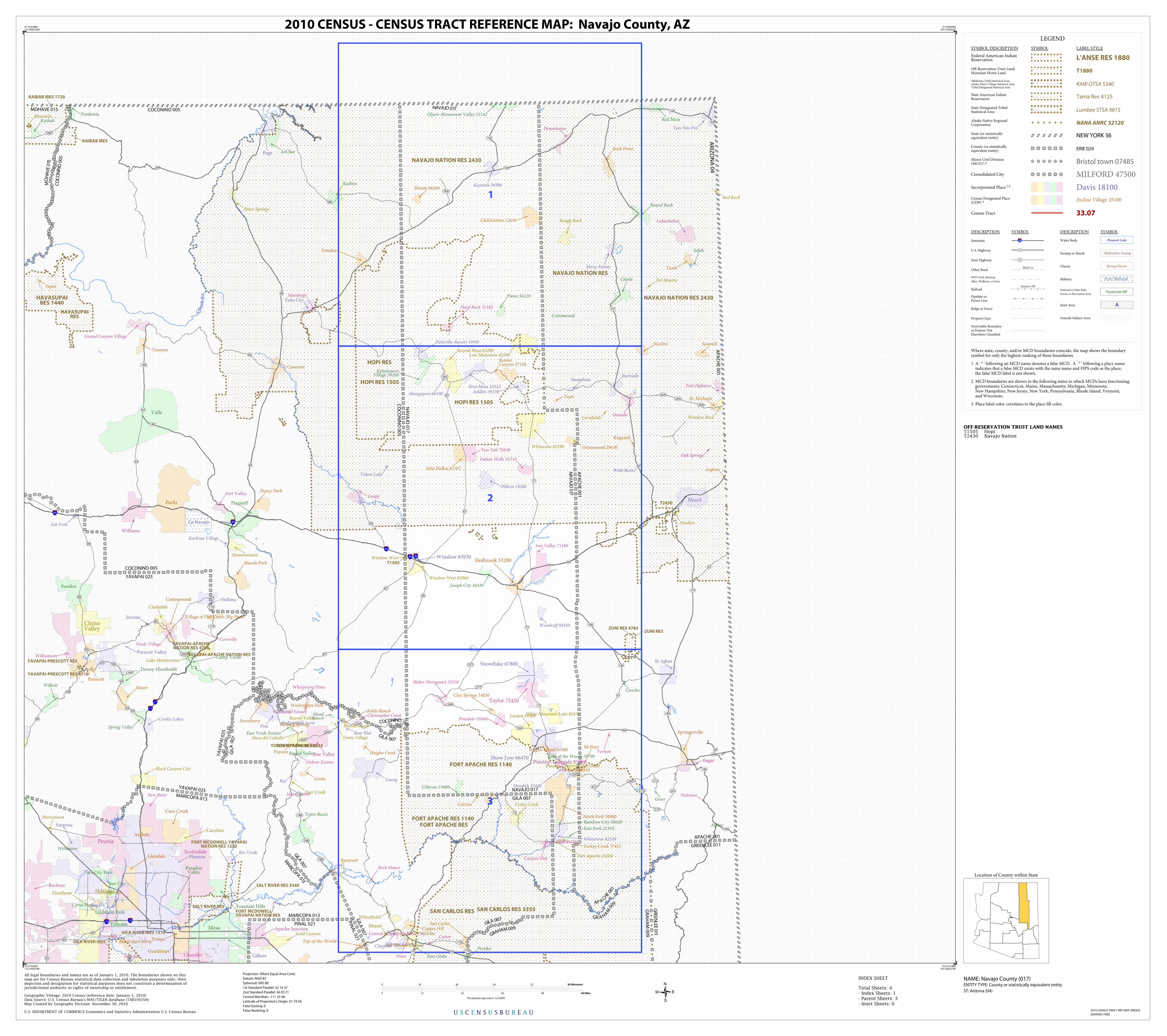
LEGEND
SYMBOL DESCRIPTION SYMBOL LABEL STYLE
Federal American IndianReservation L'ANSE RES 1880
Off-Reservation Trust Land,Hawaiian Home Land T1880
Oklahoma Tribal Statistical Area,Alaska Native Village Statistical Area,Tribal Designated Statistical Area
KAW OTSA 5340
State American IndianReservation Tama Res 4125
State Designated TribalStatistical Area Lumbee STSA 9815
Alaska Native RegionalCorporation NANA ANRC 52120
State (or statisticallyequivalent entity) NEW YORK 36
County (or statisticallyequivalent entity) ERIE 029
Minor Civil Division(MCD)1,2 Bristol town 07485
Consolidated City MILFORD 47500
Incorporated Place 1,3 Davis 18100Census Designated Place(CDP) 3 Incline Village 35100
Census Tract 33.07
DESCRIPTION SYMBOL DESCRIPTION SYMBOL
Interstate 3
U.S. Highway 2
State Highway 4
Other RoadMarsh Ln
4WD Trail, Stairway,
Alley, Walkway, or Ferry
RailoadSouthern RR
Pipeline orPower Line
Ridge or Fence
Property Line
Nonvisible Boundaryor Feature NotElsewhere Classified
Water Body Pleasant Lake
Swamp or Marsh Okefenokee Swamp
Glacier Bering Glacier
Military Fort Belvoir
National or State Park,
Forest, or Recreation AreaYosemite NP
Inset Area A
Outside Subject Area
Where state, county, and/or MCD boundaries coincide, the map shows the boundarysymbol for only the highest-ranking of these boundaries.
1 A ' ° ' following an MCD name denotes a false MCD. A ' ° ' following a place name indicates that a false MCD exists with the same name and FIPS code as the place; the false MCD label is not shown.
2 MCD boundaries are shown in the following states in which MCDs have functioning governments: Connecticut, Maine, Massachusetts, Michigan, Minnesota, New Hampshire, New Jersey, New York, Pennsylvania, Rhode Island, Vermont, and Wisconsin.
3 Place label color correlates to the place fill color.
OFF-RESERVATION TRUST LAND NAMES T1505 HopiT2430 Navajo Nation
U S C E N S U S B U R E A U
Location of County within State
2010 CENSUS TRACT REF MAP (INDEX)
205004017000
INDEX SHEET
37.316548N112.784232W
37.250294N107.732402W
33.212140N107.930227W
33.275226N112.743933W
All legal boundaries and names are as of January 1, 2010. The boundaries shown on thismap are for Census Bureau statistical data collection and tabulation purposes only; theirdepiction and designation for statistical purposes does not constitute a determination ofjurisdictional authority or rights of ownership or entitlement.
U.S. DEPARTMENT OF COMMERCE Economics and Statistics Administration U.S. Census Bureau
Geographic Vintage: 2010 Census (reference date: January 1, 2010)Data Source: U.S. Census Bureau's MAF/TIGER database (TAB10ST04)Map Created by Geography Division: November 30, 2010
ENTITY TYPE: County or statistically equivalent entity
NAME: Navajo County (017) Projection: Albers Equal Area Conic
Datum: NAD 83
Spheroid: GRS 80
1st Standard Parallel: 32 16 37
2nd Standard Parallel: 36 03 21
Central Meridian: -111 55 48
Latitude of Projection's Origin: 31 19 56
False Easting: 0
False Northing: 0
Total Sheets: 4- Index Sheets: 1- Parent Sheets: 3- Inset Sheets: 0
ST: Arizona (04)
0 18 36 54 72 90 Kilometers90 Kilometers
0 12 24 36 48 60 Miles60 Miles
The plotted map scale is 1:614099
2010 CENSUS - CENSUS TRACT REFERENCE MAP: Navajo County, AZ