Embed Size (px)
Citation preview


2008 REPORT ON EXPLORATION ACTIVITIES
PROSPECTING & GEOCHEMICAL SAMPLING
KEPP PROPERTY
CLAIMS: 580172-74
Cariboo Mining Divisions Fort St. James Area, British Columbia
NTS: 093J/5 Latitude 54o16.4’ N Longitude 123o52.2’ W
UTM Zone 10 (NAD 83): 443129E, 6014926N
May, 2009
(BC 2009 ASSESSMENT)
By Felicia Y. Chang, P.Geo (BC)
David F. Gale, P.Geo (BC)
Strongbow Exploration Inc. 860-625 Howe St.
Vancouver, B.C. V6C 1T2

2008 Assessment Report i STRONGBOW EXPLORATION INC. May 2009 Kepp Property
TABLE OF CONTENTS Table of Contents................................................................................................................. i List of Figures ..................................................................................................................... ii List of Appendices .............................................................................................................. ii List of CDs.......................................................................................................................... ii SUMMARY........................................................................................................................ 1 1.0 INTRODUCTION .................................................................................................. 2
1.1 Location, Access, Physiography and Climate..................................................... 2 1.2 Claim Data .......................................................................................................... 2 1.3 History................................................................................................................. 2
2.0 GEOLOGICAL SETTING ..................................................................................... 4 2.1 Regional Geology ............................................................................................... 4 2.2 Kepp Property Geology, Alteration and Mineralization..................................... 6
3.0 GEOPHYSICS........................................................................................................ 6 4.0 GEOCHEMISTRY ................................................................................................. 6
4.1 Introduction......................................................................................................... 6 4.2 Sampling and Assay Procedures....................................................................... 12 4.3 Quality Control Measures ................................................................................. 12 4.4 2008 Exploration Program................................................................................ 12
5.0 INTERPRETATION AND CONCLUSIONS...................................................... 13 6.0 RECOMMENDATIONS...................................................................................... 15 7.0 PERSONNEL AND CONTRACTORS ............................................................... 16 8.0 STATEMENT OF COSTS ................................................................................... 17 9.0 STATEMENT OF QUALIFICATIONS .............................................................. 18 10.0 REFERENCES ..................................................................................................... 20

2008 Assessment Report ii STRONGBOW EXPLORATION INC. May 2009 Kepp Property
LIST OF FIGURES (In Report) Figure 1 Location Map with Mineral Claims Figure 2 Regional and Property Geology Figure 3 Lineation Interpretation of Kepp Property Figure 4 Regional Total Field Magnetics Figure 5 Regional Calculated Vertical Gradient Magnetics Figure 6 Regional and Strongbow Silt, Soil and Rock Samples Locations Figure 7 Copper Results for Silt, Soil, Lake Sediment and Rock Samples Figure 8 Molybdenum Results for Silt, Soil, Lake Sediment and Rock Samples LIST OF TABLES Table 1 Kepp Mineral Claims
LIST OF APPENDICES Appendix I Acme Analytical Laboratories- Laboratory Procedures Appendix II Acme Analytical Laboratories- Laboratory Assay Certificates Appendix IIIa Kepp Property – 2008 Rock Sample Locations, Description and
Geochemical Results Appendix IIIb Kepp Property – 2008 Soil Sample Locations, Description and
Geochemical Results Appendix IIIc Kepp Property – 2008 Silt Sample Locations, Description and
Geochemical Results
LIST OF CDS (With report; 1 copy only) (Final Report and figures and maps; PDF document)

2008 Assessment Report 1 STRONGBOW EXPLORATION INC. May 2009 Kepp Property
SUMMARY The Quesnel Trough denotes one of Canada’s premier copper districts and on a regional scale represents a world-class porphyry metallurgic province. Exploration and development of these monzonitic porphyries has been ongoing since the 1920’s and with the maturity of current projects like Terrane Metals’ Mt. Milligan, outside of Fort St. James, the exploration potential of underexplored areas within the belt is ever the more prospective. In early 2008, Geoscience BC released a suite of geochemical and geophysical surveys to the mining public that were collected from central BC. This area was beginning to experience the onset of a fledgling logging industry due to the widespread infestation of the pine beetle. The purpose of this data release was to encourage mining interest in the area which would in turn generate outside revenue for these rural communities. Strongbow Exploration’s 100% owned Kepp property was staked based on the presence of anomalous lake sediment samples that returned regional copper highs in the 90th percentile range (81.09 ppm, 87.43 ppm, and 94.15 ppm Cu). Geochemistry, combined with a magnetic high signature, displayed trends similar to other porphyry deposits in the region, encouraging Strongbow to stake the property. During a brief field program in the late summer of 2008 Strongbow Exploration established two broadly spaced soil lines, silt sampling and prospecting over the Kepp claims. The soil program was successful in identifying anomalous copper values (highs of 95.3 ppm and 106 ppm). The Kepp property currently represents an encouraging grassroots exploration target with its detailed current and historic geochemistry, geophysics, geology and the high-quality logging road access to claims.

2008 Assessment Report 2 STRONGBOW EXPLORATION INC. May 2009 Kepp Property
1.0 INTRODUCTION
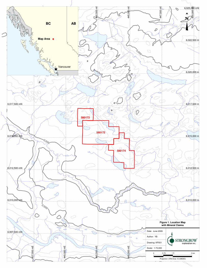
1.1 Location, Access, Physiography and Climate The Kepp property is located in central BC, approximately 30 km southeast of Fort St. James and 30 km to the northeast of Vanderhoof (Figure 1). It is situated in the Omineca Mining Division and consists of three claims blocks, 100% owned by Strongbow, with an area of 944.27 ha (Table 1). The property is situated at latitude 54°16’54”’N and longitude 123°52’55”W or 6083000 N/ 442590 E (UTM NAD 83, Zone 10). The region is covered by 1:50,000 scale NTS map sheet 93J/05. The property is road accessible from Fort St. James by heading south on Provincial Highway 27 and east on Necoslie Rd until logging roads terminate approximately 5 km from the southwestern boundary of the claims. The property is dominantly controlled by rolling hills and low lying swamps of the Nechaka Plateau at the northern edge of the Fraser Basin physiographic region (Schmidt, 2006). The area belongs to the sub-boreal spruce zone and consists of spruce, balsam and pine. The climate in the Fort St. James area presents severe, snowy winters (average temperature approximately -12.50C) with short warm summers (average temperature ~15.60C). Bedrock exposure is weak with extensive till blanket cover over most of the claims. A drumlin with unknown direction runs directly through the Kepp 1 claim.
1.2 Claim Data The Kepp property was staked and is 100% owned by Strongbow Exploration Inc. The claim data is summarized below in Table 1. The claim location may be viewed in Figure 1. Table 1. Kepp Mineral Claims Tenure Number Claim Name NTS Sheet Area (Ha) Expiry Date
580172 Kepp 01 093J 472.10 31-Oct-10 580173 Kepp 02 093J 132.15 31-Oct-10 580174 Kepp 03 093J 340.02 31-Oct-10
TOTAL 944.27
1.3 History The Kepp property is located within the Cache Creek Complex, which is less well known for its copper-molybdenum porphyry deposits. The only major economic mine that occurs in this island arc is Taseko Mines’ open-pit Gibraltar Mine, located approximately 45 km north-west of Williams Lake and 225 km southeast of the Kepp claims. Gibraltar is a copper-molybdenum porphyry deposit that produced 305 Mt grading 0.287% Cu,
442,5
00 m
E
437,5
00 m
E
440,0
00 m
E
6,025,000 mN
6,022,500 mN
6,015,000 mN
6,017,500 mN
6,020,000 mN
437,5
00 m
E
440,0
00 m
E
442,5
00 m
E
445,0
00 m
E
447,5
00 m
E
450,0
00 m
E
6,007,500 mN
6,010,000 mN
6,012,500 mN
6,007,500 mN
6,010,000 mN
6,012,500 mN
6,017,500 mN
450,0
00 m
E
445,0
00 m
E
447,5
00 m
E
6,015,000 mN
6,020,000 mN
6,022,500 mN
6,025,000 mN
2,5002,5002,500
2,5002,500
2,5002,5002,500
2,500
3,000
3,000
3,0003,000
3,0003,000
3,000
3,000
3,000
2,5002,5002,500
2,5002,500
2,5002,5002,5002,500
3,0003,0003,0003,0003,0003,0003,0003,0003,000
3,000
3,000
3,000
3,0003,000
3,000
3,000
3,000
3,000
580172580172580172580172580172580172580172580172580172
580173580173580173580173580173580173580173580173580173
580174580174580174580174580174580174580174580174580174
8888888888888888888888888888888888888888888888888888888888888888888888888888888888888888888888888888888888888888888888888888888888888888888888888888888888888888888888888888888888888888888888888888
ABBC
Map Area
Vancouver
Figure 1. Location Map
with Mineral Claims
3 km
Projection: UTM Zone 10 (NAD83)
1.5
Date: June 2009
Author: YB
Drawing: KP001
0 0.75
Scale: 1:75,000

2008 Assessment Report 4 STRONGBOW EXPLORATION INC. May 2009 Kepp Property
0.003% Mo & 0.345g/t Ag between 1972 and 1998 (Sinclair, 2007). The mine closed between 1998 and 2003 due to low metal prices until it was reopened by Taseko in 2004. Since that time Taseko has expanded drilling and calculated the Proven and Probable Reserves at 472.4 Mt grading 0.315% Cu and 0.008% Mo with current forecasts estimated to extend the mine life to 2035 (Taseko Mines Press Release, 2008).
The Kwanika copper-gold porphyry deposit is located along the boundary between the Cache Creek Complex and Takla Group volcanics, approximately 160 km to the northwest of the Kepp claims. Kwanika is hosted by an alkalic porphyry system where drilling between 2006 and 2008 has defined 182.6 million tonnes of indicated mineral resources grading 0.47% Cu or 0.71 g/t Au (1.62 million ounces of gold and 1.15 billion pounds of copper) and 28.5 million tonnes of inferred mineral resources grading 0.32% Cu or 0.49 g/t Au (additional 0.2 million ounces of gold and 120 million pounds of copper) (Serengeti Resources Press Release, 2009). Similarity between the geological environment of Kwanika and Kepp, where intrusions are emplaced along a major terrane-scale structure (the Pinchi Fault separates the Cache Creek and Quesnel Terrane), suggests potential for copper mineralization at the Kepp property.
2.0 GEOLOGICAL SETTING
2.1 Regional Geology
The Kepp mineral claims are situated within the Cache Creek Complex of the Cache Creek Terrane (CCT), part of the Intermontaine Belt of the Canadian Cordillera (Figure 2). The Cache Creek, Nisling, and Stikine terranes amalgamated to form the Intermontaine Belt during the Triassic-Jurassic (190-178 Ma), accompanied by arc-related magmatic activity that continued into the Tertiary (Macintyre et al., 2001). The CCT is an accretionary assemblage that contains late Paleozoic to Lower Jurassic oceanic strata: remnants of late Paleozoic oceanic plateaus, massive dark-grey to blue-grey recrystallized limestones with Permian fusulinid faunas of exotic Tethyan (Asian) affinity, melange belts, a primitive Lake Permian arc (Kutcho Arc), and Late Triassic and mid-Jurassic blueschists (Nelson and Colpron, 2007). The eastern claim boundary is 5 km west of the contact with the Takla Group, a volcanic package typically associated with gold-copper porphyry-style mineralization such as the Mt. Milligan deposit (Figure 2). No alkalic or calc-alkalic intrusives have been observed within or adjacent to the property.
Regional geology of the area does not indicate any faults that transect the Kepp property. However, the property is situated between two northwest-trending faults: (1) the Pinchi Fault that marks the contact between Cache Creek Complex and Takla Group rocks to the east and (2) a fault within the Cache Creek Complex located 7 km to the west. A review of available topographic and airphoto datasets also indicate a major (~20 km long), northwest-trending feature represented by a river located 2.5 km to the southwest of the


PTrCRgb - Cache Creek Complex - Rubyrock Igneous Complex gabbroic to dioritic intrusive rocks
TrJTvb - Takla Group basaltic volcanic rocks
uTrTls - Tackla Group - limestone bioherm/reef
OMEsf - Earn Group - mudstone, siltstone, shale fine clastic sedimentary rocks
DTrTma - Taltapin Metamorphic Complex - limestone, marble, calcareous sedimentary rocks
PnTrCmd - Cache Creek Complex - mudstone/laminite fine clastic sedimentary rocks
PTrCTum - Cache Creek Complex - Trembleur Ultramafite Unit ultramafic rocks
PnTrClm - Cache Creek Complex limestone, marble, calcareous sedimentary rocks
PTrE - Evans Creek Limestone
TrJsy - Unnamed syenitic to monzonitic intrusive rocks
uPrPzB - Boulder Creek Group
OMEqz - Earn Group - quartzite, quartz arenite sedimentary rocks
CPdr - Undifferentiated dioritic intrusive rocks
CmA - Atan Group
Proterozoic - Paleozoic
Paleozoic - Mesozoic
Paleozoic
KTS - Sifton Formation - Conglomerate, sandstone, shale, coal
KTgr - Undifferentiated granite, alkali feldspar granite intrusive rocks
lJCvc - Chuchi Lake Succession coarse volcaniclastic and pyroclastic volcanic rocks
EJHqd - Hogem Plutonic Suite - quartz dioritic intrusive rocks
MJSLM - Endako Batholith - Stag Lake Plutonic Suite
KT - Undifferentiated marine sedimentary, volcanic and volcaniclastic rocks
LKEnP - Endako Batholith - Pinkut Phase tonalite intrusive rocks
KWpe - Wolverine Range Plutonic Suite pegmatitic intrusive rocks
MiPlCvb - Chilcotin Group basaltic volcanic rocks
EOls - Unnamed undivided sedimentary rocks
PeEgr - Unnamed granite, alkali feldspar granite intrusive rocks
EEva - Nechako Plateau Group - Endako Formation
EJdr - Unnamed dioritic intrusive rocks
LTrJum - Unnamed ultramafic rocks
EJHhy - Undifferentiated intrusive rocks
LTrJgb - Undifferentiated gabbroic to dioritic intrusive rocks
uKEW - Wolverine Metamorphic Complex
PeEvf - Unnamed rhyolite, felsic volcanic rocks
Mesozoic
Mesozoic - Cenozoic
Cenozoic

2008 Assessment Report 6 STRONGBOW EXPLORATION INC. May 2009 Kepp Property
property and several 1 to 2 km long, northeast-trending features cutting through the property (Figure 3). The orientations of these localized faults are similar in geometry to regional faults of the surrounding area (Figure 2).
2.2 Kepp Property Geology, Alteration and Mineralization Due to time constraints placed on Strongbow’s broad 2008 exploration program, little mapping was carried out on the Kepp claims during the short two day investigation of the property. As such, brief field notes collected from outcrops observed during prospecting are described as follows: The property is underlain by calcareous rocks of the Cache Creek Complex. Little to no outcrop or subcrop are present on the property and float boulders are scarce. Where encountered, float to subcrop are limestone. A single sample of weakly pyritized limestone with limonite and manganese alteration was submitted for assay but no significant results were returned.
3.0 GEOPHYSICS No geophysical surveys were conducted on the Kepp property by Strongbow during the 2008 field season. Strongbow staked the Kepp property based partially on total field magnetics and first vertical derivative images that were publicly released by Geoscience BC (Figures 5 and 6). The claims are centred on a magnetic high feature, roughly 4 km by 5 km in dimensions, with a subtle northwest-southeast trend (Figure 4). The magnetic high may represent an intrusive source, which is prospective for porphyry and epithermal-related deposits. First vertical derivative magnetics of the area (Figure 5) show distinctive northwest-southeast regional trends, which may suggest host structures for mineralization. Due to the coarse line-spacing of the surveys, it was not possible to correlate specific magnetic features with individual lineations interpreted from airphoto.
4.0 GEOCHEMISTRY
4.1 Introduction Other than a government geochemical survey, no previous work has been conducted on the Kepp property. Geochemical data is available from a 2008 Geoscience BC (GBC) lake sediment sampling program (Figure 6) but no samples have been collected for regional geochemical silt (RGS) sampling. Results from the GBC lake sediment survey indicate anomalous copper results for samples within the claims (1 sample > 95th percentile: 94.15 and 2 samples > 90th percentile: 87.43 and 81.09 ppm Cu) and to the northeast of the property (1 sample > 90th percentile: 76.25 ppm Cu; Figure 7). No significant molybdenum or gold values were returned in these lake sediment samples.

6,010,000 mN
448,0
00 m
E
6,012,000 mN
6,014,000 mN
6,016,000 mN
444,0
00 m
E
6,018,000 mN6,018,000 mN
6,016,000 mN
446,0
00 m
E
444,0
00 m
E
6,020,000 mN
446,0
00 m
E
448,0
00 m
E
6,010,000 mN
438,0
00 m
E
440,0
00 m
E
442,0
00 m
E
438,0
00 m
E
6,020,000 mN
440,0
00 m
E
442,0
00 m
E
6,014,000 mN
6,012,000 mN
2,600
2,600
2,600
2,600
2,600
2,600
2,600
2,600
2,600
2,6002,6002,600
2,6002,600
2,6002,6002,6002,600
2,7002,7002,7002,7002,7002,7002,7002,7002,700
2,700
2,700
2,700
2,700
2,700
2,700
2,700
2,700
2,700
3,000
3,000
3,000
3,000
3,000
3,000
3,000
3,000
3,000
2,9002,9002,9002,9002,9002,9002,9002,9002,900
2,900
2,900
2,900
2,900
2,900
2,900
2,900
2,900
2,900
2,8002,8002,8002,8002,8002,8002,8002,8002,800
2,6002,6002,6002,6002,6002,6002,6002,6002,600
2,5002,5002,5002,500
2,5002,5002,5002,5002,500
2,6002,6002,6002,6002,6002,6002,6002,6002,600
Figure 3. Lineation Interpretationof the Kepp Property
5 km
Projection: UTM Zone 10 (NAD83)
2.5
Scale: 1: 125,000
Drawing: KP004
0 1.25
Date: June 2009
Author: YB
Interpreted Lineament
Kepp Property

6,010,000 mN
455,0
00 m
E
460,0
00 m
E460,0
00 m
E
445,0
00 m
E
450,0
00 m
E
455,0
00 m
E
6,020,000 mN
6,015,000 mN6,015,000 mN
6,005,000 mN
430,0
00 m
E
435,0
00 m
E
440,0
00 m
E
450,0
00 m
E
445,0
00 m
E
6,025,000 mN
6,010,000 mN
6,005,000 mN
440,0
00 m
E
430,0
00 m
E
435,0
00 m
E
6,020,000 mN
5 km
Drawing: KP003
Scale: 1: 125,000
Figure 4. Regional Total Field Magnetics
Projection: UTM Zone 10 (NAD83)
1.25 2.50
Date: June 2009
Author: YB
-255
-194
-157
-131
-108
-90
-75
-63
-53
-43
-33
-23
-14
-5
3
12
20
29
37
47
58
69
82
95
111
127
144
164
184
206
231
257
287
321
363
416
487
610
nT

6,010,000 mN
455,0
00 m
E
460,0
00 m
E460,0
00 m
E
445,0
00 m
E
450,0
00 m
E
455,0
00 m
E
6,020,000 mN
6,015,000 mN6,015,000 mN
6,005,000 mN
430,0
00 m
E
435,0
00 m
E
440,0
00 m
E
450,0
00 m
E
445,0
00 m
E
6,025,000 mN
6,010,000 mN
6,005,000 mN
440,0
00 m
E
430,0
00 m
E
435,0
00 m
E
6,020,000 mN
Figure 5. Regional CalculatedFirst Vertical Derivative
5 km
Projection: UTM Zone 10 (NAD83)
2.5
Scale: 1: 125,000
Drawing: KP003
0 1.25
Date: June 2009
Author: YB
-0.11474
-0.07591
-0.05787
-0.04539
-0.03746
-0.03145
-0.02653
-0.02252
-0.01917
-0.01647
-0.01422
-0.01235
-0.01061
-0.00919
-0.00784
-0.00665
-0.00555
-0.00454
-0.00359
-0.00258
-0.00161
-0.00059
0.00054
0.00173
0.00303
0.00448
0.00623
0.00811
0.01033
0.01303
0.01621
0.02016
0.02501
0.03160
0.04104
0.05551
0.07877
0.13129
nT/m

44
8,0
00
mE
44
8,0
00
mE
44
8,0
00
mE
44
8,0
00
mE
44
8,0
00
mE
44
8,0
00
mE
44
8,0
00
mE
44
8,0
00
mE
44
8,0
00
mE
6,012,000 mN6,012,000 mN6,012,000 mN6,012,000 mN6,012,000 mN6,012,000 mN6,012,000 mN6,012,000 mN6,012,000 mN
6,014,000 mN6,014,000 mN6,014,000 mN6,014,000 mN6,014,000 mN6,014,000 mN6,014,000 mN6,014,000 mN6,014,000 mN
6,016,000 mN6,016,000 mN6,016,000 mN6,016,000 mN6,016,000 mN6,016,000 mN6,016,000 mN6,016,000 mN6,016,000 mN
6,018,000 mN6,018,000 mN6,018,000 mN6,018,000 mN6,018,000 mN6,018,000 mN6,018,000 mN6,018,000 mN6,018,000 mN
6,020,000 mN6,020,000 mN6,020,000 mN6,020,000 mN6,020,000 mN6,020,000 mN6,020,000 mN6,020,000 mN6,020,000 mN44
6,0
00
mE
44
6,0
00
mE
44
6,0
00
mE
44
6,0
00
mE
44
6,0
00
mE
44
6,0
00
mE
44
6,0
00
mE
44
6,0
00
mE
44
6,0
00
mE
44
6,0
00
mE
44
6,0
00
mE
44
6,0
00
mE
44
6,0
00
mE
44
6,0
00
mE
44
6,0
00
mE
44
6,0
00
mE
44
6,0
00
mE
44
6,0
00
mE
44
8,0
00
mE
44
8,0
00
mE
44
8,0
00
mE
44
8,0
00
mE
44
8,0
00
mE
44
8,0
00
mE
44
8,0
00
mE
44
8,0
00
mE
44
8,0
00
mE
44
4,0
00
mE
44
4,0
00
mE
44
4,0
00
mE
44
4,0
00
mE
44
4,0
00
mE
44
4,0
00
mE
44
4,0
00
mE
44
4,0
00
mE
44
4,0
00
mE
43
8,0
00
mE
43
8,0
00
mE
43
8,0
00
mE
43
8,0
00
mE
43
8,0
00
mE
43
8,0
00
mE
43
8,0
00
mE
43
8,0
00
mE
43
8,0
00
mE
44
4,0
00
mE
44
4,0
00
mE
44
4,0
00
mE
44
4,0
00
mE
44
4,0
00
mE
44
4,0
00
mE
44
4,0
00
mE
44
4,0
00
mE
44
4,0
00
mE
44
0,0
00
mE
44
0,0
00
mE
44
0,0
00
mE
44
0,0
00
mE
44
0,0
00
mE
44
0,0
00
mE
44
0,0
00
mE
44
0,0
00
mE
44
0,0
00
mE
44
2,0
00
mE
44
2,0
00
mE
44
2,0
00
mE
44
2,0
00
mE
44
2,0
00
mE
44
2,0
00
mE
44
2,0
00
mE
44
2,0
00
mE
44
2,0
00
mE
6,014,000 mN6,014,000 mN6,014,000 mN6,014,000 mN6,014,000 mN6,014,000 mN6,014,000 mN6,014,000 mN6,014,000 mN
44
2,0
00
mE
44
2,0
00
mE
44
2,0
00
mE
44
2,0
00
mE
44
2,0
00
mE
44
2,0
00
mE
44
2,0
00
mE
44
2,0
00
mE
44
2,0
00
mE
6,012,000 mN6,012,000 mN6,012,000 mN6,012,000 mN6,012,000 mN6,012,000 mN6,012,000 mN6,012,000 mN6,012,000 mN
6,016,000 mN6,016,000 mN6,016,000 mN6,016,000 mN6,016,000 mN6,016,000 mN6,016,000 mN6,016,000 mN6,016,000 mN
6,018,000 mN6,018,000 mN6,018,000 mN6,018,000 mN6,018,000 mN6,018,000 mN6,018,000 mN6,018,000 mN6,018,000 mN
6,020,000 mN6,020,000 mN6,020,000 mN6,020,000 mN6,020,000 mN6,020,000 mN6,020,000 mN6,020,000 mN6,020,000 mN
44
0,0
00
mE
44
0,0
00
mE
44
0,0
00
mE
44
0,0
00
mE
44
0,0
00
mE
44
0,0
00
mE
44
0,0
00
mE
44
0,0
00
mE
44
0,0
00
mE
43
8,0
00
mE
43
8,0
00
mE
43
8,0
00
mE
43
8,0
00
mE
43
8,0
00
mE
43
8,0
00
mE
43
8,0
00
mE
43
8,0
00
mE
43
8,0
00
mE
ggggggggggggggggggggggggggggggggggggggggggggggggg
2,5002,5002,5002,5002,5002,5002,5002,500
2,500
2,7002,7002,7002,7002,7002,7002,7002,7002,700
2,6002,6002,600
2,6002,600
2,6002,6002,600
2,600
2,6002,6002,6002,6002,6002,6002,6002,6002,600
2,80
0
2,80
0
2,80
0
2,80
0
2,80
0
2,80
0
2,80
0
2,80
0
2,80
0
2,90
0
2,90
0
2,90
02,
900
2,90
02,
900
2,90
0
2,90
0
2,90
0
2,500
2,500
2,500
2,500
2,500
2,500
2,500
2,500
2,500
780247802478024780247802478024780247802478024
784627846278462784627846278462784627846278462
784637846378463784637846378463784637846378463
784647846478464784647846478464784647846478464
780317803178031780317803178031780317803178031780297802978029780297802978029780297802978029
780287802878028780287802878028780287802878028
780277802778027780277802778027780277802778027
780267802678026780267802678026780267802678026784657846578465784657846578465784657846578465 780257802578025780257802578025780257802578025784667846678466784667846678466784667846678466
784687846878468784687846878468784687846878468 780307803078030780307803078030780307803078030
784677846778467784677846778467784677846778467
784697846978469784697846978469784697846978469
784717847178471784717847178471784717847178471784727847278472784727847278472784727847278472784737847378473784737847378473784737847378473
784747847478474784747847478474784747847478474
784707847078470784707847078470784707847078470784757847578475784757847578475784757847578475
780367803678036780367803678036780367803678036
780377803778037780377803778037780377803778037
784787847878478784787847878478784787847878478
784767847678476784767847678476784767847678476
784777847778477784777847778477784777847778477
784807848078480784807848078480784807848078480784797847978479784797847978479784797847978479
784827848278482784827848278482784827848278482
784817848178481784817848178481784817848178481780387803878038780387803878038780387803878038780397803978039780397803978039780397803978039
780347803478034780347803478034780347803478034780357803578035780357803578035780357803578035
780337803378033780337803378033780337803378033
780407804078040780407804078040780407804078040
780417804178041780417804178041780417804178041
780327803278032780327803278032780327803278032
782887828878288782887828878288782887828878288
2 km
Scale: 1: 50,000
Figure 6. Regional and Strongbow Silt, Soil, Lake Sediment and Rock
Samples Locations
Date: June 2009
Author: YB
Drawing: KP005
Projection: UTM Zone 10 (NAD83)
0.5 10
Strongbow Soil Sample
Strongbow Silt Sample
Strongbow Rock Sample
Historic Silt Sample
Historic Lake Sediment Sample

6,010,000 mN6,010,000 mN6,010,000 mN6,010,000 mN6,010,000 mN6,010,000 mN6,010,000 mN6,010,000 mN6,010,000 mN
44
6,0
00
mE
44
6,0
00
mE
44
6,0
00
mE
44
6,0
00
mE
44
6,0
00
mE
44
6,0
00
mE
44
6,0
00
mE
44
6,0
00
mE
44
6,0
00
mE
44
4,0
00
mE
44
4,0
00
mE
44
4,0
00
mE
44
4,0
00
mE
44
4,0
00
mE
44
4,0
00
mE
44
4,0
00
mE
44
4,0
00
mE
44
4,0
00
mE
44
4,0
00
mE
44
4,0
00
mE
44
4,0
00
mE
44
4,0
00
mE
44
4,0
00
mE
44
4,0
00
mE
44
4,0
00
mE
44
4,0
00
mE
44
4,0
00
mE
45
0,0
00
mE
45
0,0
00
mE
45
0,0
00
mE
45
0,0
00
mE
45
0,0
00
mE
45
0,0
00
mE
45
0,0
00
mE
45
0,0
00
mE
45
0,0
00
mE
44
6,0
00
mE
44
6,0
00
mE
44
6,0
00
mE
44
6,0
00
mE
44
6,0
00
mE
44
6,0
00
mE
44
6,0
00
mE
44
6,0
00
mE
44
6,0
00
mE
44
8,0
00
mE
44
8,0
00
mE
44
8,0
00
mE
44
8,0
00
mE
44
8,0
00
mE
44
8,0
00
mE
44
8,0
00
mE
44
8,0
00
mE
44
8,0
00
mE
44
8,0
00
mE
44
8,0
00
mE
44
8,0
00
mE
44
8,0
00
mE
44
8,0
00
mE
44
8,0
00
mE
44
8,0
00
mE
44
8,0
00
mE
44
8,0
00
mE
45
0,0
00
mE
45
0,0
00
mE
45
0,0
00
mE
45
0,0
00
mE
45
0,0
00
mE
45
0,0
00
mE
45
0,0
00
mE
45
0,0
00
mE
45
0,0
00
mE
6,014,000 mN6,014,000 mN6,014,000 mN6,014,000 mN6,014,000 mN6,014,000 mN6,014,000 mN6,014,000 mN6,014,000 mN
6,016,000 mN6,016,000 mN6,016,000 mN6,016,000 mN6,016,000 mN6,016,000 mN6,016,000 mN6,016,000 mN6,016,000 mN
6,020,000 mN6,020,000 mN6,020,000 mN6,020,000 mN6,020,000 mN6,020,000 mN6,020,000 mN6,020,000 mN6,020,000 mN 6,020,000 mN6,020,000 mN6,020,000 mN6,020,000 mN6,020,000 mN6,020,000 mN6,020,000 mN6,020,000 mN6,020,000 mN
6,018,000 mN6,018,000 mN6,018,000 mN6,018,000 mN6,018,000 mN6,018,000 mN6,018,000 mN6,018,000 mN6,018,000 mN
44
0,0
00
mE
44
0,0
00
mE
44
0,0
00
mE
44
0,0
00
mE
44
0,0
00
mE
44
0,0
00
mE
44
0,0
00
mE
44
0,0
00
mE
44
0,0
00
mE
43
8,0
00
mE
43
8,0
00
mE
43
8,0
00
mE
43
8,0
00
mE
43
8,0
00
mE
43
8,0
00
mE
43
8,0
00
mE
43
8,0
00
mE
43
8,0
00
mE
43
8,0
00
mE
43
8,0
00
mE
43
8,0
00
mE
43
8,0
00
mE
43
8,0
00
mE
43
8,0
00
mE
43
8,0
00
mE
43
8,0
00
mE
43
8,0
00
mE
44
0,0
00
mE
44
0,0
00
mE
44
0,0
00
mE
44
0,0
00
mE
44
0,0
00
mE
44
0,0
00
mE
44
0,0
00
mE
44
0,0
00
mE
44
0,0
00
mE
6,016,000 mN6,016,000 mN6,016,000 mN6,016,000 mN6,016,000 mN6,016,000 mN6,016,000 mN6,016,000 mN6,016,000 mN
6,012,000 mN6,012,000 mN6,012,000 mN6,012,000 mN6,012,000 mN6,012,000 mN6,012,000 mN6,012,000 mN6,012,000 mN
44
2,0
00
mE
44
2,0
00
mE
44
2,0
00
mE
44
2,0
00
mE
44
2,0
00
mE
44
2,0
00
mE
44
2,0
00
mE
44
2,0
00
mE
44
2,0
00
mE
44
2,0
00
mE
44
2,0
00
mE
44
2,0
00
mE
44
2,0
00
mE
44
2,0
00
mE
44
2,0
00
mE
44
2,0
00
mE
44
2,0
00
mE
44
2,0
00
mE
6,018,000 mN6,018,000 mN6,018,000 mN6,018,000 mN6,018,000 mN6,018,000 mN6,018,000 mN6,018,000 mN6,018,000 mN
6,014,000 mN6,014,000 mN6,014,000 mN6,014,000 mN6,014,000 mN6,014,000 mN6,014,000 mN6,014,000 mN6,014,000 mN
6,012,000 mN6,012,000 mN6,012,000 mN6,012,000 mN6,012,000 mN6,012,000 mN6,012,000 mN6,012,000 mN6,012,000 mN
6,010,000 mN6,010,000 mN6,010,000 mN6,010,000 mN6,010,000 mN6,010,000 mN6,010,000 mN6,010,000 mN6,010,000 mN
ggggggggggggggggggggggggggggggggggggggggggggggggg
464646464646464646
64.3564.3564.3564.3564.3564.3564.3564.3564.35
94.1594.1594.1594.1594.1594.1594.1594.1594.15
60.4260.4260.4260.4260.4260.4260.4260.4260.42
81.0981.0981.0981.0981.0981.0981.0981.0981.09
87.4387.4387.4387.4387.4387.4387.4387.4387.43
74.4374.4374.4374.4374.4374.4374.4374.4374.43
76.2576.2576.2576.2576.2576.2576.2576.2576.25
70.6470.6470.6470.6470.6470.6470.6470.6470.6457.8257.8257.8257.8257.8257.8257.8257.8257.82
32.3432.3432.3432.3432.3432.3432.3432.3432.34
36.0136.0136.0136.0136.0136.0136.0136.0136.01
53.753.753.753.753.753.753.753.753.762.862.862.862.862.862.862.862.862.8
106106106106106106106106106
77.277.277.277.277.277.277.277.277.2
95.395.395.395.395.395.395.395.395.3
Figure 7. Copper Results for Silt Soil, Lake Sediment and Rock Samples
2 km
Projection: UTM Zone 10 (NAD83)
1
Date: June 2009
Author: YB
Scale: 1: 50,000
Drawing: KP006
0 0.5
Kepp RocksCu ppm
> 5,000
1,000 to 5,000
500 to 1,000
250 to 500
0 to 250
all others
Kepp SiltsCu ICP (ppm)
69.0395 to 10,000 - >97.5th
57.841 to 69.0395 - 97.5th
47.718 to 57.841 - 95th
31.64 to 47.718 - 90th
0 to 31.64 - 70th
all others
Kepp Lake SedsCu ICP (ppm)
69.0395 to 10,000 - >97.5th
57.841 to 69.0395 - 97.5th
47.718 to 57.841 - 95th
31.64 to 47.718 - 90th
0 to 31.64 - 70th
Kepp SoilsCu ICP ppm
169.025 to 10,000 - >97.5th
118.05 to 169.025 - 97.5th
86 to 118.05 - 95th
48 to 86 - 90th
0 to 48 - 70th

2008 Assessment Report 12 STRONGBOW EXPLORATION INC. May 2009 Kepp Property
Following, Section 4.2 will describe the sampling and assay procedures and Section 4.3 discusses the quality assurance/quality control procedures adopted for the 2008 field program. Section 4.4 will discuss the details of the 2008 exploration program.
4.2 Sampling and Assay Procedures Soil sample grids are chained in using a hip chain and compass. Corrections for topography during grid sampling are only applied where changes in the topography are extreme. Sample locations were recorded using a hand held GPS unit where tree cover and vegetation permitted. Where GPS coverage is insufficient, sample locations are approximated based on previous GPS points taken and hip chain and compass measurements. Soil samples are collected with a shovel and sample tags, comprising of orange flagging tape marked with the last 4 digits of the UTM easting and 5 digits of the UTM northing for regional grid samples. In most cases, the B-horizon was sampled, with a small proportion of samples taken from the B/C or C-horizons. Individual sample weight is typically about 0.5 kg and stored in brown kraft bags.
Each rock (prospecting) sample location is marked with a representative sample, wrapped with orange flagging tape that contains the assigned sample number. Individual float and rock samples weigh no more than 5 kg. Rock samples were collected such that the specimens had little to no weathered surface or lichen and represented the overall characteristics of mineralization from that location. In places where rock material is rare or difficult to liberate, chip samples are taken to represent the zone of interest.
Acme Analytical Laboratories of Vancouver, BC, was contracted to conduct sample preparation and analysis of all samples collected during the program. All samples were submitted for a 36-element ICP-MS aqua regia analysis (Acme: 1DX). A detailed explanation of analytical techniques and procedures has been compiled in Appendix I. The certificates for the standards used for the Quality control procedures are also included in Appendix I. Lab certificates showing complete results for geochemical analyses for soil and silt samples are included in Appendix II.
4.3 Quality Control Measures Quality assurance/quality control (QA/QC) for the 2008 field program comprised inserting blanks and standards into the rock sample stream sent to Acme Analytical Laboratories in Vancouver, BC. The blank sample was inserted to monitor for potential contamination during analysis, while standard material (OREAS 61Pb) was inserted to measure the precision and accuracy of Acme’s analysis.
4.4 2008 Exploration Program On April 2nd, 2008 Strongbow Exploration staked the original Kepp claims following the release of regional lake sediment data in this region by Geoscience BC, which indicated

2008 Assessment Report 13 STRONGBOW EXPLORATION INC. May 2009 Kepp Property
anomalous copper values for the area (Figure 7). Anomalous copper values, combined with a magnetic high signature represented in Geoscience BC’s total field magnetic data, encouraged Strongbow to stake the ground. In total, 1 rock, 38 soil, and 2 silt samples were collected on the Kepp property between September 4th and 6th, 2008. The program concentrated on prospecting, silt and soil sampling with a focus on following up on the anomalous lake sediment samples in the area. Broad soil lines were orientated approximately northeast-southwest to perpendicularly transect any mineralization that may have a northwest trend, as observed in regional geophysical trends (Figures 5 and 6). Figure 7 shows the copper results of all geochemical samples collected on the Kepp property. The copper results are thematically mapped based on Strongbow and regional government data. Figure 8 shows thematically mapped molybdenum results for the property. Copper values from both soil lines were generally weakly anomalous, 70th percentile range and less, with the exception of five anomalous samples towards the northeastern end of each line where copper values are greater than 53.7 ppm Cu (>70th percentile; Figure 7). There is no anomalous molybdenum or gold values coincident with copper geochemical anomalies. Two silt samples were collected for the property and both returned weakly anomalous copper values (44.4 and 46 ppm Cu; Figure 7). Gold and molybdenum silt values were generally insignificant. These anomalous samples, when considered with anomalous lake sediment samples in the area, highlight the potential for copper mineralization for the property. Broad prospecting was carried out over the entire Kepp but rock exposure is generally poor to non-existent. Where float or boulders are encountered, limestone is the predominant rock type. A single sample of limestone with local silica replacement, minor, pervasive manganese and limonite alteration, and minor sulphide veinlets was collected, but did not return any anomalous copper (144.1 ppm), molybdenum or gold values.
5.0 INTERPRETATION AND CONCLUSIONS The short 2008 exploration program on the Kepp property did not identify porphyry outcrop or mineralization on the claims but geochemical sampling of the area returned values that are moderately anomalous. At this stage in the Kepp project, it is too early for detailed interpretations but there appears to be broad northwest trends within the anomalous geochemistry, as defined by both the Strongbow and regional soil and lake sediment samples (soils: 53.7 to 106 ppm Cu; lake sediments: 81.09 to 94.15 ppm Cu; Figure 7). The geochemical trend is generally coincident with a local magnetic high, which may be indicative of a relationship between a potential intrusive body and copper

6,010,000 mN6,010,000 mN6,010,000 mN6,010,000 mN6,010,000 mN6,010,000 mN6,010,000 mN6,010,000 mN6,010,000 mN
44
6,0
00
mE
44
6,0
00
mE
44
6,0
00
mE
44
6,0
00
mE
44
6,0
00
mE
44
6,0
00
mE
44
6,0
00
mE
44
6,0
00
mE
44
6,0
00
mE
44
4,0
00
mE
44
4,0
00
mE
44
4,0
00
mE
44
4,0
00
mE
44
4,0
00
mE
44
4,0
00
mE
44
4,0
00
mE
44
4,0
00
mE
44
4,0
00
mE
44
4,0
00
mE
44
4,0
00
mE
44
4,0
00
mE
44
4,0
00
mE
44
4,0
00
mE
44
4,0
00
mE
44
4,0
00
mE
44
4,0
00
mE
44
4,0
00
mE
45
0,0
00
mE
45
0,0
00
mE
45
0,0
00
mE
45
0,0
00
mE
45
0,0
00
mE
45
0,0
00
mE
45
0,0
00
mE
45
0,0
00
mE
45
0,0
00
mE
44
6,0
00
mE
44
6,0
00
mE
44
6,0
00
mE
44
6,0
00
mE
44
6,0
00
mE
44
6,0
00
mE
44
6,0
00
mE
44
6,0
00
mE
44
6,0
00
mE
44
8,0
00
mE
44
8,0
00
mE
44
8,0
00
mE
44
8,0
00
mE
44
8,0
00
mE
44
8,0
00
mE
44
8,0
00
mE
44
8,0
00
mE
44
8,0
00
mE
44
8,0
00
mE
44
8,0
00
mE
44
8,0
00
mE
44
8,0
00
mE
44
8,0
00
mE
44
8,0
00
mE
44
8,0
00
mE
44
8,0
00
mE
44
8,0
00
mE
45
0,0
00
mE
45
0,0
00
mE
45
0,0
00
mE
45
0,0
00
mE
45
0,0
00
mE
45
0,0
00
mE
45
0,0
00
mE
45
0,0
00
mE
45
0,0
00
mE
6,014,000 mN6,014,000 mN6,014,000 mN6,014,000 mN6,014,000 mN6,014,000 mN6,014,000 mN6,014,000 mN6,014,000 mN
6,016,000 mN6,016,000 mN6,016,000 mN6,016,000 mN6,016,000 mN6,016,000 mN6,016,000 mN6,016,000 mN6,016,000 mN
6,020,000 mN6,020,000 mN6,020,000 mN6,020,000 mN6,020,000 mN6,020,000 mN6,020,000 mN6,020,000 mN6,020,000 mN 6,020,000 mN6,020,000 mN6,020,000 mN6,020,000 mN6,020,000 mN6,020,000 mN6,020,000 mN6,020,000 mN6,020,000 mN
6,018,000 mN6,018,000 mN6,018,000 mN6,018,000 mN6,018,000 mN6,018,000 mN6,018,000 mN6,018,000 mN6,018,000 mN
44
0,0
00
mE
44
0,0
00
mE
44
0,0
00
mE
44
0,0
00
mE
44
0,0
00
mE
44
0,0
00
mE
44
0,0
00
mE
44
0,0
00
mE
44
0,0
00
mE
43
8,0
00
mE
43
8,0
00
mE
43
8,0
00
mE
43
8,0
00
mE
43
8,0
00
mE
43
8,0
00
mE
43
8,0
00
mE
43
8,0
00
mE
43
8,0
00
mE
43
8,0
00
mE
43
8,0
00
mE
43
8,0
00
mE
43
8,0
00
mE
43
8,0
00
mE
43
8,0
00
mE
43
8,0
00
mE
43
8,0
00
mE
43
8,0
00
mE
44
0,0
00
mE
44
0,0
00
mE
44
0,0
00
mE
44
0,0
00
mE
44
0,0
00
mE
44
0,0
00
mE
44
0,0
00
mE
44
0,0
00
mE
44
0,0
00
mE
6,016,000 mN6,016,000 mN6,016,000 mN6,016,000 mN6,016,000 mN6,016,000 mN6,016,000 mN6,016,000 mN6,016,000 mN
6,012,000 mN6,012,000 mN6,012,000 mN6,012,000 mN6,012,000 mN6,012,000 mN6,012,000 mN6,012,000 mN6,012,000 mN
44
2,0
00
mE
44
2,0
00
mE
44
2,0
00
mE
44
2,0
00
mE
44
2,0
00
mE
44
2,0
00
mE
44
2,0
00
mE
44
2,0
00
mE
44
2,0
00
mE
44
2,0
00
mE
44
2,0
00
mE
44
2,0
00
mE
44
2,0
00
mE
44
2,0
00
mE
44
2,0
00
mE
44
2,0
00
mE
44
2,0
00
mE
44
2,0
00
mE
6,018,000 mN6,018,000 mN6,018,000 mN6,018,000 mN6,018,000 mN6,018,000 mN6,018,000 mN6,018,000 mN6,018,000 mN
6,014,000 mN6,014,000 mN6,014,000 mN6,014,000 mN6,014,000 mN6,014,000 mN6,014,000 mN6,014,000 mN6,014,000 mN
6,012,000 mN6,012,000 mN6,012,000 mN6,012,000 mN6,012,000 mN6,012,000 mN6,012,000 mN6,012,000 mN6,012,000 mN
6,010,000 mN6,010,000 mN6,010,000 mN6,010,000 mN6,010,000 mN6,010,000 mN6,010,000 mN6,010,000 mN6,010,000 mN
ggggggggggggggggggggggggggggggggggggggggggggggggg
6.336.336.336.336.336.336.336.336.33
1.261.261.261.261.261.261.261.261.26
1.691.691.691.691.691.691.691.691.69
2.342.342.342.342.342.342.342.342.34
3.533.533.533.533.533.533.533.533.53
2 km
Figure 8. Molybdenum Results for Silt Soil, Lake Sediment and Rock Samples
Scale: 1: 50,000
Projection: UTM Zone 10 (NAD83)
1
Date: June 2009
Author: YB
Drawing: KP007
0 0.5
Kepp RocksMo ppm
> 500
250 to 500
100 to 250
50 to 100
0 to 50
all others
BC SiltsMo ICP (ppm)
4.795 to 1,000 - >97.5th
3.422 to 4.795 - 97.5th
2.368 to 3.422 - 95th
1.24 to 2.368 - 90th
0 to 1.24 - 70th
Kepp Lake SedsMo ppm
16.1025 to 10,000 - >97.5th
11.4685 to 16.1025 - 97.5th
7.837 to 11.4685 - 95th
4.11 to 7.837 - 90th
0 to 4.11 - 70th
Kepp SoilsMo ppm
18 to 10,000 - >97.5th
9 to 18 - 97.5th
6 to 9 - 95th
3 to 6 - 90th
0 to 3 - 70th
all others

2008 Assessment Report 15 STRONGBOW EXPLORATION INC. May 2009 Kepp Property
mineralization. The Kepp property is an encouraging grassroots exploration target. With recent work carried out by both Geoscience BC and Strongbow Exploration, anomalous copper geochemistry has been identified on the property in lake sediment, soil and silt samples. This geochemistry, combined with a magnetic high signatures identified from the regional geophysical dataset may indicate a porphyry body close to surface. More geochemical sampling must be conducted to support this hypothesis and with nearby logging road access, combined with accommodation in the area, the claims may be explored at low initial cost.
6.0 RECOMMENDATIONS Any future work on the property should consist, at a minimum, of a 1-week program. Phase 1 should include 5-6 soil lines at 100 m spacing, oriented parallel to the existing lines, and perpendicular to a possible northwest-trending porphyritic intrusion. Prospecting and mapping should take place concurrently with the soil sampling and should focus on the central claim (Kepp 1) of the property to determine if any mineralization or intrusive bodies have been recently exposed by blasting in that area. Mapping of the area will help determine the stratigraphy of the area and in turn ascertain the overall potential of the property. If Phase 1 returns favourable geochemical results or mineralization is observed in outcrop, continued exploration in a second phase should include tightening of soil lines and possibly conducting mechanical trenching to expose continuous sections of mineralized rocks or porphyry. The goal of this program would be to return elevated geochemical results that could jusitify the application of a deep penetrating ground Induced Polarization (IP) geophysical survey in order to identify areas of deep seated mineralization that may underlie the younger volcanic and sedimentary rocks. The IP survey should be centred over the Kepp 1 claim and extended to the northwest and southeast, covering the extent of the magnetic high and interpreted linear trends from calculated vertical gradient data.

2008 Assessment Report 16 STRONGBOW EXPLORATION INC. May 2009 Kepp Property
7.0 PERSONNEL AND CONTRACTORS List of Contractors Contractor Type of Work Address Acme Analytical Labs Geochemical analysis 852 East Hastings Street
Vancouver, BC V6A 1R6 North Track Exploration (Don Coolidge)
Prospecting P.O. Box 7 Iskut, BC V0J 1K0

8.0 STATEMENT OF COSTS
Strongbow Exploration Inc.Summary of Kepp ExpendituresFieldwork commenced on August 25 and ended on August 27, 2008Office work started on October 2008 and was ongoing to March 2009.
Salaries and Benefits CommentsStrongbow Employees - Salary Man Days Time Period (reflects field and office time) Rate per day Total Cost Man Days are totalled for each person and occur mostly within fieldwork period. Small
percentage of time composed of report writing. Full TimeDave Gale 1 August (100% office) 700.00$ 700.00$ VP Exploration; project supervision, planningJustin Jackson 3 July (25% office), August (75% field) 300.00$ 900.00$ Project Geologist, project planning, prospecting
ContractKimberly Schimdt 2 August (100% field) 290.00$ 580.00$ Senior Contract Geologist, prospecting and samplingAlana Haysom 2 August (100% field) 250.00$ 500.00$ Contract Geologist, prospecting and samplingCam Mackay-Stotesbury 2 August (100% field) 215.00$ 430.00$ Junior Contract Geologist, prospecting and sampling
Consulting PersonnelDon Coolidge 2 August (field) 384.45$ 768.89$ Prospecting
Total $ 3,878.89
Geochemical AnalysisACME Labs 788.00$ 1 rock, 38 soil, and 1 silt samples.
Total $ 788.00
Accomodation, Travel, Food, and Field Supplies749.76$
Accomodation (New Caledonia Motel); Food (groceries and restaurants), Field supplies (Canadian Tire and Napa), Fuel for truck
$ 142.92 Transportation Rental for 3 days: Enterprise-Rent-A-Car (one truck at $1600/month), truck maintenance, and insurance.
$ 76.03 Travel - air ticket (Alana Haysom)Total $ 968.71
Communication 95.54$ Communications (radio and sat phones) Total $ 95.54
Documentation and Report Writing Total 1,000.00$
GRAND TOTAL $ 6,731.14
1 of 1


2008 Assessment Report 19 STRONGBOW EXPLORATION INC. May 2009 Kepp Property
I, David F. Gale, of 860-625 Howe Street, Vancouver, BC, V6C 2T6, do certify that: 1. I have been conferred with the academic degrees of Honours Bachelor of Science –
Geology (Memorial University, 1994) and Master of Science – Geology (Queen’s University, 1997).
2. I have been engaged as an exploration geologist throughout Canada since 1995 with
Cominco, Westmin Resources, BHP Ltd., Homestake Canada Inc., and Barrick Gold Corp.
3. I am a member of the Association of Professional Geoscientists of BC (Member No.
27366). 4. I am currently employed with Strongbow Exploration Inc. of 860-625 Howe Street,
Vancouver, BC, V6C 2T6. 5. I certify that to the best of my knowledge the costs listed, and all data presented, were
incurred while carrying out exploration work on the Kepp Property, BC during 2008. Dated at Vancouver, British Columbia, this 30th day of May, 2009. ________________________________ David F. Gale, P. Geo., M.Sc.

2008 Assessment Report 20 STRONGBOW EXPLORATION INC. May 2009 Kepp Property
10.0 REFERENCES
Macintyre, D.G.,Villeneuve, M.E.,and Schiarizza., 2001. Timing and tectonic setting of the Stikine Terrane magmatisim, Babine-Takla lakes area, central British Columbia. Canadian Journal of Earth Sciences. Vol. 38, p. 579-601.
Nelson, J. and Colpron, M., 2007. Tectonics and metallogeny of the British Columbia, Yukon and Alaskan Cordillera, 1.8 Ga to the present, in Goodfellow, W.D., ed., Mineral Deposits of Canada: A Synthesis of Major Deposit-Types, District Metallogeny, the Evolution of Geological Provinces, and Exploration Methods: Geological Association of Canada, Mineral Deposits Division, Special Publicaiton No. 5, p. 755-791.
Ross, C.A. and Ross, J.R.P., 1983. Late Paleozoic accreted terranes of western North America, in Steves, C.H., ed., Pre-Jurassic Rocks in Western North American Suspect Terranes: Pacific Section, Society of Economic Paleontologists and Mineralogists, Los Angeles, California, p. 7-22.
Schmidt, U. 2006. 2005 Prospecting and Sampling Program Carmen Claims. BC
Assessment Report 28458. 18p. Serengeti Resources Press Release, 2009. February 25, 2009.
http://www.serengetiresources.com/s/NewsReleases.asp?ReportID=339265 Sinclair, W.D., 2007, Porphyry deposits, in Goodfellow, W.D., ed., Mineral Deposits of
Canada: A Synthesis of Major Deposit-Types, District Metallogeny, the Evolution of Geological Provinces, and Exploration Methods: Geological Association of Canada, Mineral Deposits Division, Special Publication 5, p. 223-243.
Taseko Mines Press Release, 2008. December 11, 2008.
http://www.tasekomines.com/tko/NewsReleases.asp?ReportID=331641&_Type=News-Releases&_Title=Taseko-Mines-Ltd.-Gibraltar-Reserve-Update
.

2008 Assessment Report Appendix I STRONGBOW EXPLORATION INC. May 2009 Kepp Property
APPENDIX I
Acme Analytical Laboratories Laboratory Procedures
& Gold Standard Reference Material
Sample Preparation Methods and Specifications for Analytical Package Group 1DX - Aqua Regia ICPMS
Standard Material OREAS 61 Pb
852 East Hastings Street, Vancouver, BC Canada V6A 1R6 Phone (604) 253 3158 Fax (604) 253 1716 e-mail: [email protected]
Sample Preparation (e-mail version1.1) Revision Date: Feb 22, 2007
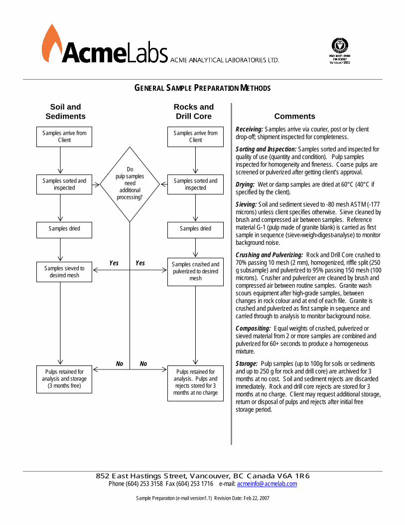
GENERAL SAMPLE PREPARATION METHODS Soil and Rocks and Sediments Drill Core Comments A Yes Yes A No No
Samples arrive from Client
Do pulp samples
need additional
processing?
Samples arrive from Client
Receiving: Samples arrive via courier, post or by client drop-off; shipment inspected for completeness.
Sorting and Inspection: Samples sorted and inspected for quality of use (quantity and condition). Pulp samples inspected for homogeneity and fineness. Coarse pulps are screened or pulverized after getting client’s approval.
Drying: Wet or damp samples are dried at 60°C (40°C if specified by the client).
Sieving: Soil and sediment sieved to -80 mesh ASTM (-177 microns) unless client specifies otherwise. Sieve cleaned by brush and compressed air between samples. Reference material G-1 (pulp made of granite blank) is carried as first sample in sequence (sieve›weigh›digest›analyse) to monitor background noise.
Crushing and Pulverizing: Rock and Drill Core crushed to 70% passing 10 mesh (2 mm), homogenized, riffle split (250 g subsample) and pulverized to 95% passing 150 mesh (100 microns). Crusher and pulverizer are cleaned by brush and compressed air between routine samples. Granite wash scours equipment after high-grade samples, between changes in rock colour and at end of each file. Granite is crushed and pulverized as first sample in sequence and carried through to analysis to monitor background noise.
Compositing: Equal weights of crushed, pulverized or sieved material from 2 or more samples are combined and pulverized for 60+ seconds to produce a homogeneous mixture.
Storage: Pulp samples (up to 100g for soils or sediments and up to 250 g for rock and drill core) are archived for 3 months at no cost. Soil and sediment rejects are discarded immediately. Rock and drill core rejects are stored for 3 months at no charge. Client may request additional storage, return or disposal of pulps and rejects after initial free storage period.
Samples sorted and inspected
Samples dried
Samples sieved to desired mesh
Samples sorted and inspected
Samples dried
Samples crushed and pulverized to desired
mesh
Pulps retained for analysis and storage
(3 months free)
Pulps retained for analysis. Pulps and rejects stored for 3
months at no charge
ACME ANALYTICAL LABORATORIES LTD.
852 East Hastings Street • Vancouver • British Columbia • CANADA • V6A 1R6 Telephone: (604) 253-3158 • Facsimile: (604) 253-1716 • Toll Free: 1-800-990-ACME (2263) • e-mail: [email protected]
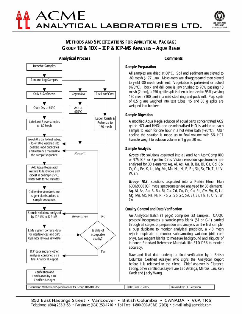
METHODS AND SPECIFICATIONS FOR ANALYTICAL PACKAGE GROUP 1D & 1DX – ICP & ICP-MS ANALYSIS – AQUA REGIA
Analytical Process
Comments Sample Preparation
All samples are dried at 60°C. Soil and sediment are sieved to -80 mesh (-177 µm). Moss-mats are disaggregated then sieved to yield -80 mesh sediment. Vegetation is pulverized or ashed (475°C). Rock and drill core is jaw crushed to 70% passing 10 mesh (2 mm), a 250 g riffle split is then pulverized to 95% passing 150 mesh (100 µm) in a mild-steel ring-and-puck mill. Pulp splits of 0.5 g are weighed into test tubes, 15 and 30 g splits are weighed into beakers.
Sample Digestion
A modified Aqua Regia solution of equal parts concentrated ACS grade HCl and HNO3 and de-mineralised H2O is added to each sample to leach for one hour in a hot water bath (>95°C). After cooling the solution is made up to final volume with 5% HCl. Sample weight to solution volume is 1 g per 20 mL.
Sample Analysis
Group 1D: solutions aspirated into a Jarrel Ash AtomComp 800 or 975 ICP or Spectro Ciros Vision emission spectrometer are analysed for 30 elements: Ag, Al, As, Au, B, Ba, Bi, Ca, Cd, Co, Cr, Cu, Fe, K, La, Mg, Mn, Mo, Na, Ni, P, Pb, Sb, Sr, Th, Ti, U, V, W, Zn.
Group 1DX: solutions aspirated into a Perkin Elmer Elan 6000/9000 ICP mass spectrometer are analysed for 36 elements: Ag, Al, As, Au, B, Ba, Bi, Ca, Cd, Co, Cr, Cu, Fe, Ga, Hg, K, La, Mg, Mn, Mo, Na, Ni, P, Pb, S, Sb, Sc, Se, Tl, Sr, Th, Ti, U, V, W, Zn.
Quality Control and Data Verification
An Analytical Batch (1 page) comprises 33 samples. QA/QC protocol incorporates a sample-prep blank (SI or G-1) carried through all stages of preparation and analysis as the first sample, a pulp duplicate to monitor analytical precision, a -10 mesh rejects duplicate to monitor sub-sampling variation (drill core only), two reagent blanks to measure background and aliquots of in-house Standard Reference Materials like STD DS6 to monitor accuracy.
Raw and final data undergo a final verification by a British Columbia Certified Assayer who signs the Analytical Report before it is released to the client. Chief Assayer is Clarence Leong, other certified assayers are Leo Arciaga, Marcus Lau, Ken Kwok and Jacky Wang.
Document: Method and Specifications for Group 1D&1DX.doc Date: June 7, 2005 Revised By: T. Ferguson
Re-split
Re-analyse
Yes
No
Receive Samples
Sort and Log Samples
Soils & Sediments Vegetation
Label and Sieve samples to -80 Mesh
Rock and Core
Oven Dry at 60°C Ash at 475°C
Label, Crush & Pulverize to -150 mesh
Weigh 0.5 g into test tubes, (15 or 30 g weighed into beakers) add duplicates and reference material to
the sample sequence
Add Aqua Regia acid mixture to test tubes and digest in boiling (>95°C)
water bath for 60 minutes.
Calibration standards and reagent blanks added to
sample sequence.
Sample solutions analysed by ICP-ES or ICP-MS
LIMS system corrects data for interferences and drift. Operator reviews raw data
ICP data and any other analyses combined as a final Analytical Report
Verification and Certification by a BC
Certified Assayer
Is data of acceptable
quality?

2008 Assessment Report Appendix II STRONGBOW EXPLORATION INC. May 2009 Kepp Property
APPENDIX II
Acme Analytical Laboratories Laboratory Assay Certificates
Soil VAN08009073 Silt VAN08009074
Rock VAN08009075

1020 Cordova St. East Vancouver BC V6A 4A3 Canada
Phone (604) 253-3158 Fax (604) 253-1716
Client:
Submitted By:
Receiving Lab:
Received:
Report Date:
Page:
800 - 625 Howe St.
Vancouver BC V6C 2T6 Canada
Felicia Chang
Canada-Vancouver
September 05, 2008
Method
Code
Code Description Report
Status
SAMPLE PREPARATION AND ANALYTICAL PROCEDURES
Test
Wgt (g)
Number of
Samples
SS80 Dry at 60C sieve 100g to -80 mesh38
RJSV Save all or part of soil reject fraction38
1DX 1:1:1 Aqua regia digestion. Analysis by ICP-MS Completed1538
ADDITIONAL COMMENTS
David Gale
Ellen StewartCC:
Invoice To:
This report supersedes all previous preliminary and final reports with this file number dated prior to the date on this certificate. Signature indicates final approval; preliminary reports are unsigned and should be used for reference only.
All results are considered the confidential property of the client. Acme assumes the liabilities for actual cost of analysis only.
Acme does not accept responsibility for samples left at the laboratory after 90
days without prior written instructions for sample storage or return.
Store Soil Reject - RJSV Charges Apply
Store After 90 days Invoice for Storage
STOR-RJT-SOIL
STOR-PLP
38
2535-08-13
2535
Number of Samples:
P.O. Number
Shipment ID:
Project:
SAMPLE DISPOSAL
CERTIFICATE OF ANALYSIS VAN08009073.1
CLIENT JOB INFORMATION
Strongbow Exploration Inc.
800 - 625 Howe St.
Vancouver BC V6C 2T6
Canada
1 of 3
September 26, 2008
ACME ANALYTICAL LABORATORIES LTD.
www.acmelab.com
Strongbow Exploration Inc.

2 of 3
2535
800 - 625 Howe St.
Vancouver BC V6C 2T6 Canada
Project:
Page:
Report Date:
Phone (604) 253-3158 Fax (604) 253-1716
1020 Cordova St. East Vancouver BC V6A 4A3 Canada
1Part
September 26, 2008
www.acmelab.com
Client: Strongbow Exploration Inc.
ACME ANALYTICAL LABORATORIES LTD.
CERTIFICATE OF ANALYSIS VAN08009073.1 CERTIFICATE OF ANALYSIS VAN08009073.1
MDL
Unit
Analyte
Method 1DX15 1DX15 1DX15 1DX15 1DX15 1DX15 1DX15 1DX15 1DX15 1DX15 1DX15 1DX15 1DX15 1DX15 1DX15 1DX15 1DX15 1DX15 1DX15 1DX15
Mo Cu Pb Zn Ag Ni Co Mn Fe As U Au Th Sr Cd Sb Bi V Ca P
ppm ppm ppm ppm ppm ppm ppm ppm % ppm ppm ppb ppm ppm ppm ppm ppm ppm % %
0.1 0.1 0.1 1 0.1 0.1 0.1 1 0.01 0.5 0.1 0.5 0.1 1 0.1 0.1 0.1 2 0.01 0.001
78462 Soil 0.6 29.5 4.7 62 <0.1 25.4 9.8 198 2.70 5.0 0.3 <0.5 1.2 16 0.4 0.4 0.1 76 0.41 0.044
78463 Soil 0.7 77.2 5.5 103 0.2 46.5 19.5 1249 4.02 3.2 0.4 <0.5 1.0 26 0.4 0.3 <0.1 97 0.63 0.089
78464 Soil 1.0 35.1 4.1 91 <0.1 26.1 17.7 378 4.68 3.1 0.2 <0.5 0.9 21 0.3 0.3 <0.1 150 0.83 0.078
78465 Soil 0.6 95.3 2.9 82 <0.1 38.1 28.8 688 5.48 2.1 0.2 1.1 0.8 23 0.3 0.2 <0.1 187 1.57 0.059
78466 Soil 0.5 46.4 2.9 94 <0.1 33.6 17.3 347 3.97 1.8 0.2 <0.5 1.0 20 0.3 0.2 <0.1 126 0.89 0.070
78467 Soil 0.7 34.0 3.1 67 <0.1 27.4 16.5 373 3.81 0.9 0.2 <0.5 0.8 19 0.2 0.2 <0.1 123 0.80 0.031
78468 Soil 1.0 39.2 5.1 226 <0.1 27.6 22.8 1594 4.22 2.3 0.2 <0.5 1.1 20 0.4 0.2 <0.1 107 0.62 0.173
78469 Soil 0.7 41.1 4.5 194 <0.1 28.7 21.6 441 4.39 2.8 0.2 <0.5 1.1 16 0.3 0.2 <0.1 108 0.60 0.205
78470 Soil 0.5 25.2 5.3 111 <0.1 21.9 14.1 649 2.24 2.2 0.3 <0.5 1.1 23 0.3 0.2 <0.1 51 0.47 0.060
78471 Soil 0.5 13.4 5.6 54 <0.1 16.5 5.5 149 1.76 2.1 0.3 <0.5 1.3 18 0.1 0.2 <0.1 50 0.29 0.044
78472 Soil 0.6 10.3 5.3 70 <0.1 13.8 6.2 206 1.58 2.7 0.2 <0.5 1.2 18 0.1 0.2 <0.1 40 0.26 0.060
78473 Soil 0.7 25.7 6.8 89 <0.1 30.2 8.5 265 2.71 7.5 0.3 <0.5 1.7 17 <0.1 0.4 0.1 58 0.22 0.096
78474 Soil 0.5 24.9 5.5 110 <0.1 25.8 11.2 616 2.26 2.1 0.3 <0.5 0.8 25 0.2 0.2 <0.1 61 0.37 0.088
78475 Soil 0.5 19.8 4.3 147 <0.1 24.8 10.8 400 2.21 1.6 0.3 <0.5 1.2 15 0.1 0.2 <0.1 54 0.25 0.077
78476 Soil 0.5 10.8 5.1 95 <0.1 12.3 6.1 240 1.59 2.2 0.2 0.5 1.3 17 0.2 0.2 0.1 46 0.28 0.067
78477 Soil 0.9 31.4 4.5 177 <0.1 31.6 12.2 1288 2.44 2.1 0.3 1.7 1.2 23 0.3 0.2 <0.1 65 0.47 0.055
78478 Soil 1.0 16.9 4.5 103 <0.1 17.4 10.0 249 3.24 2.6 0.2 <0.5 1.3 17 0.4 0.2 0.1 101 0.45 0.130
78479 Soil 0.6 35.7 5.1 92 <0.1 42.7 10.7 1029 2.52 2.6 0.5 <0.5 1.0 28 0.2 0.3 <0.1 63 0.41 0.080
78480 Soil 0.7 23.9 6.6 50 <0.1 37.3 11.4 431 2.80 8.4 0.7 1.2 1.7 24 <0.1 0.5 <0.1 63 0.38 0.026
78481 Soil 0.3 43.1 6.6 46 <0.1 32.5 7.5 384 1.77 7.6 0.3 1.9 1.9 20 0.1 0.5 0.1 34 0.19 0.027
78482 Soil 0.4 7.0 5.5 71 <0.1 19.9 5.9 212 1.62 1.8 0.2 1.3 1.4 16 0.2 0.2 <0.1 41 0.19 0.080
78025 Soil 1.4 53.7 12.8 121 0.2 51.7 14.1 971 3.26 6.5 0.9 1.8 0.9 35 0.4 1.2 0.3 57 0.43 0.092
78026 Soil 0.7 17.2 5.1 77 <0.1 32.3 8.7 354 2.45 4.1 0.4 1.1 1.2 24 0.2 0.3 <0.1 59 0.32 0.050
78027 Soil 1.0 62.8 6.9 89 0.2 45.6 12.1 607 3.14 4.2 0.7 0.9 1.2 27 0.2 0.3 0.1 68 0.37 0.056
78028 Soil 1.0 33.1 5.4 131 0.2 38.2 12.9 856 2.82 3.0 0.5 <0.5 1.0 34 0.4 0.3 <0.1 69 0.56 0.092
78029 Soil 1.1 18.6 5.0 92 <0.1 33.3 10.1 387 2.76 3.9 0.3 1.1 1.2 28 0.1 0.3 <0.1 77 0.42 0.056
78030 Soil 0.7 19.6 4.3 63 <0.1 36.2 10.9 452 2.48 2.5 0.3 1.7 1.1 27 0.2 0.3 <0.1 66 0.52 0.065
78031 Soil 0.4 106.0 6.6 113 <0.1 57.4 30.3 592 6.84 3.7 0.8 2.2 1.1 32 0.6 0.2 <0.1 213 1.84 0.066
78032 Soil 0.5 32.5 4.0 49 <0.1 30.0 10.3 294 2.38 2.5 0.4 1.7 1.0 24 <0.1 0.2 <0.1 67 0.39 0.034
78033 Soil 0.7 21.8 5.1 69 0.1 30.4 7.9 309 2.17 2.0 0.3 3.4 1.3 19 0.1 0.1 <0.1 56 0.22 0.022
This report supersedes all previous preliminary and final reports with this file number dated prior to the date on this certificate. Signature indicates final approval; preliminary reports are unsigned and should be used for reference only. This report supersedes all previous preliminary and final reports with this file number dated prior to the date on this certificate. Signature indicates final approval; preliminary reports are unsigned and should be used for reference only.

2 of 3
2535
800 - 625 Howe St.
Vancouver BC V6C 2T6 Canada
Project:
Page:
Report Date:
Phone (604) 253-3158 Fax (604) 253-1716
1020 Cordova St. East Vancouver BC V6A 4A3 Canada
2Part
September 26, 2008
www.acmelab.com
Client: Strongbow Exploration Inc.
ACME ANALYTICAL LABORATORIES LTD.
CERTIFICATE OF ANALYSIS VAN08009073.1
MDL
Unit
Analyte
Method 1DX15 1DX15 1DX15 1DX15 1DX15 1DX15 1DX15 1DX15 1DX15 1DX15 1DX15 1DX15 1DX15 1DX15 1DX15 1DX15
La Cr Mg Ba Ti B Al Na K W Hg Sc Tl S Ga Se
ppm ppm % ppm % ppm % % % ppm ppm ppm ppm % ppm ppm
1 1 0.01 1 0.001 1 0.01 0.001 0.01 0.1 0.01 0.1 0.1 0.05 1 0.5
78462 Soil 7 35 0.54 197 0.076 2 1.55 0.010 0.05 <0.1 0.01 3.3 <0.1 <0.05 5 <0.5
78463 Soil 11 43 0.98 346 0.097 3 2.29 0.025 0.12 <0.1 0.02 9.9 <0.1 <0.05 7 <0.5
78464 Soil 5 33 0.86 206 0.183 2 2.10 0.014 0.07 <0.1 0.01 4.8 <0.1 <0.05 7 <0.5
78465 Soil 5 38 1.45 243 0.277 4 2.81 0.016 0.09 <0.1 0.02 10.4 <0.1 <0.05 9 <0.5
78466 Soil 5 36 0.89 165 0.166 2 2.05 0.011 0.07 <0.1 0.02 5.0 <0.1 <0.05 7 <0.5
78467 Soil 5 38 0.81 236 0.178 3 1.90 0.013 0.09 <0.1 0.02 5.1 <0.1 <0.05 6 <0.5
78468 Soil 6 32 0.73 276 0.118 3 2.26 0.013 0.11 <0.1 0.02 5.8 <0.1 <0.05 7 <0.5
78469 Soil 6 31 0.88 252 0.116 2 2.40 0.010 0.07 <0.1 0.01 5.5 <0.1 <0.05 8 <0.5
78470 Soil 8 28 0.47 305 0.070 3 1.17 0.010 0.13 <0.1 0.03 3.4 <0.1 <0.05 4 <0.5
78471 Soil 9 26 0.38 165 0.071 1 1.16 0.011 0.05 <0.1 <0.01 2.5 <0.1 <0.05 4 <0.5
78472 Soil 9 20 0.30 178 0.064 1 0.98 0.009 0.07 <0.1 0.02 2.3 <0.1 <0.05 4 <0.5
78473 Soil 9 37 0.53 172 0.054 1 1.76 0.013 0.06 <0.1 0.02 3.3 <0.1 <0.05 6 <0.5
78474 Soil 9 32 0.48 243 0.066 1 1.81 0.012 0.07 <0.1 0.03 3.9 <0.1 <0.05 6 <0.5
78475 Soil 8 31 0.46 143 0.067 1 1.83 0.011 0.05 <0.1 0.02 3.4 <0.1 <0.05 5 <0.5
78476 Soil 8 23 0.23 192 0.072 1 0.88 0.007 0.07 <0.1 0.01 2.4 <0.1 <0.05 4 <0.5
78477 Soil 9 35 0.57 279 0.079 1 1.91 0.014 0.07 <0.1 0.02 4.5 0.1 <0.05 5 <0.5
78478 Soil 7 32 0.41 225 0.129 2 1.58 0.010 0.08 <0.1 0.02 3.8 <0.1 <0.05 7 <0.5
78479 Soil 12 42 0.65 288 0.060 2 2.17 0.011 0.08 <0.1 0.03 4.7 0.1 <0.05 6 <0.5
78480 Soil 9 42 0.59 296 0.054 2 1.88 0.012 0.09 <0.1 0.04 5.4 0.1 <0.05 5 <0.5
78481 Soil 10 27 0.37 162 0.038 2 0.93 0.011 0.12 <0.1 0.11 4.3 0.1 <0.05 3 <0.5
78482 Soil 8 34 0.35 140 0.067 <1 1.19 0.009 0.05 <0.1 <0.01 2.3 <0.1 <0.05 5 <0.5
78025 Soil 15 44 0.49 789 0.035 4 1.93 0.015 0.25 0.1 0.07 5.8 0.2 <0.05 6 <0.5
78026 Soil 9 46 0.69 145 0.088 2 1.46 0.024 0.07 <0.1 0.02 3.0 <0.1 <0.05 5 <0.5
78027 Soil 10 51 0.77 251 0.057 2 2.16 0.025 0.13 <0.1 0.01 5.1 <0.1 <0.05 7 <0.5
78028 Soil 9 45 0.74 276 0.095 3 1.78 0.023 0.14 <0.1 0.03 4.7 <0.1 <0.05 6 <0.5
78029 Soil 8 44 0.72 202 0.089 2 1.75 0.014 0.06 <0.1 0.01 3.2 <0.1 <0.05 6 <0.5
78030 Soil 8 39 0.65 205 0.109 2 1.39 0.012 0.14 <0.1 0.02 3.4 <0.1 <0.05 5 <0.5
78031 Soil 8 46 2.04 460 0.348 4 3.08 0.030 0.09 <0.1 0.04 12.8 <0.1 0.06 10 <0.5
78032 Soil 7 38 0.73 267 0.097 2 1.45 0.015 0.05 <0.1 0.02 3.9 <0.1 0.08 4 <0.5
78033 Soil 8 36 0.49 170 0.079 <1 1.32 0.013 0.06 <0.1 0.01 3.3 <0.1 0.07 4 <0.5
This report supersedes all previous preliminary and final reports with this file number dated prior to the date on this certificate. Signature indicates final approval; preliminary reports are unsigned and should be used for reference only.

3 of 3
2535
800 - 625 Howe St.
Vancouver BC V6C 2T6 Canada
Project:
Page:
Report Date:
Phone (604) 253-3158 Fax (604) 253-1716
1020 Cordova St. East Vancouver BC V6A 4A3 Canada
1Part
September 26, 2008
www.acmelab.com
Client: Strongbow Exploration Inc.
ACME ANALYTICAL LABORATORIES LTD.
CERTIFICATE OF ANALYSIS VAN08009073.1 CERTIFICATE OF ANALYSIS VAN08009073.1
MDL
Unit
Analyte
Method 1DX15 1DX15 1DX15 1DX15 1DX15 1DX15 1DX15 1DX15 1DX15 1DX15 1DX15 1DX15 1DX15 1DX15 1DX15 1DX15 1DX15 1DX15 1DX15 1DX15
Mo Cu Pb Zn Ag Ni Co Mn Fe As U Au Th Sr Cd Sb Bi V Ca P
ppm ppm ppm ppm ppm ppm ppm ppm % ppm ppm ppb ppm ppm ppm ppm ppm ppm % %
0.1 0.1 0.1 1 0.1 0.1 0.1 1 0.01 0.5 0.1 0.5 0.1 1 0.1 0.1 0.1 2 0.01 0.001
78034 Soil 0.5 18.2 5.1 59 <0.1 30.6 7.9 321 2.10 1.9 0.4 1.9 1.4 23 <0.1 0.2 <0.1 54 0.27 0.026
78035 Soil 0.5 15.1 4.1 102 <0.1 29.9 8.5 319 2.12 2.1 0.4 1.8 1.3 21 0.2 0.2 0.1 57 0.26 0.029
78036 Soil 0.8 37.7 5.4 134 0.2 46.5 12.7 1052 2.90 3.1 0.6 1.7 0.9 29 0.3 0.2 0.1 67 0.37 0.069
78037 Soil 0.7 19.7 5.4 58 <0.1 36.9 12.6 607 2.62 4.2 0.4 <0.5 1.2 25 0.2 0.4 <0.1 62 0.31 0.045
78038 Soil 0.5 13.8 4.1 72 <0.1 26.5 7.6 240 2.04 2.4 0.3 0.8 0.9 19 0.1 0.2 <0.1 52 0.25 0.030
78039 Soil 0.6 19.8 4.6 75 <0.1 29.5 9.1 418 2.29 2.5 0.3 <0.5 0.7 22 0.2 0.2 <0.1 56 0.24 0.034
78040 Soil 0.7 26.5 5.7 99 0.1 36.8 12.0 717 2.81 3.4 0.5 0.8 0.6 29 0.1 0.2 0.1 63 0.30 0.073
78041 Soil 0.5 9.9 4.8 59 <0.1 17.7 6.7 205 1.90 1.9 0.3 0.7 1.1 16 0.1 0.2 <0.1 46 0.18 0.038
This report supersedes all previous preliminary and final reports with this file number dated prior to the date on this certificate. Signature indicates final approval; preliminary reports are unsigned and should be used for reference only. This report supersedes all previous preliminary and final reports with this file number dated prior to the date on this certificate. Signature indicates final approval; preliminary reports are unsigned and should be used for reference only.

3 of 3
2535
800 - 625 Howe St.
Vancouver BC V6C 2T6 Canada
Project:
Page:
Report Date:
Phone (604) 253-3158 Fax (604) 253-1716
1020 Cordova St. East Vancouver BC V6A 4A3 Canada
2Part
September 26, 2008
www.acmelab.com
Client: Strongbow Exploration Inc.
ACME ANALYTICAL LABORATORIES LTD.
CERTIFICATE OF ANALYSIS VAN08009073.1
MDL
Unit
Analyte
Method 1DX15 1DX15 1DX15 1DX15 1DX15 1DX15 1DX15 1DX15 1DX15 1DX15 1DX15 1DX15 1DX15 1DX15 1DX15 1DX15
La Cr Mg Ba Ti B Al Na K W Hg Sc Tl S Ga Se
ppm ppm % ppm % ppm % % % ppm ppm ppm ppm % ppm ppm
1 1 0.01 1 0.001 1 0.01 0.001 0.01 0.1 0.01 0.1 0.1 0.05 1 0.5
78034 Soil 9 42 0.62 155 0.108 <1 1.31 0.017 0.08 <0.1 0.02 4.3 <0.1 <0.05 4 <0.5
78035 Soil 8 40 0.54 161 0.103 <1 1.26 0.020 0.07 <0.1 <0.01 3.4 <0.1 0.06 4 <0.5
78036 Soil 12 50 0.61 310 0.061 2 2.04 0.023 0.11 <0.1 0.02 6.2 <0.1 <0.05 6 <0.5
78037 Soil 8 44 0.63 167 0.096 <1 1.27 0.016 0.09 <0.1 0.01 4.6 <0.1 <0.05 4 <0.5
78038 Soil 8 37 0.51 165 0.082 <1 1.22 0.012 0.05 <0.1 0.02 3.1 <0.1 <0.05 4 <0.5
78039 Soil 9 41 0.52 180 0.061 <1 1.43 0.011 0.06 <0.1 0.01 3.5 <0.1 <0.05 5 <0.5
78040 Soil 9 47 0.61 234 0.044 <1 2.00 0.024 0.09 0.1 0.02 4.3 <0.1 <0.05 6 <0.5
78041 Soil 8 27 0.33 133 0.061 <1 1.29 0.010 0.05 <0.1 0.02 3.1 <0.1 <0.05 5 <0.5
This report supersedes all previous preliminary and final reports with this file number dated prior to the date on this certificate. Signature indicates final approval; preliminary reports are unsigned and should be used for reference only.

1 of 1
2535
800 - 625 Howe St.
Vancouver BC V6C 2T6 Canada
Strongbow Exploration Inc.Client:
Project:
Report Date:
www.acmelab.com
Phone (604) 253-3158 Fax (604) 253-1716
1020 Cordova St. East Vancouver BC V6A 4A3 Canada
1PartPage:
September 26, 2008
ACME ANALYTICAL LABORATORIES LTD.
QUALITY CONTROL REPORT VAN08009073.1 QUALITY CONTROL REPORT VAN08009073.11DX15 1DX15 1DX15 1DX15 1DX15 1DX15 1DX15 1DX15 1DX15 1DX15 1DX15 1DX15 1DX15 1DX15 1DX15 1DX15 1DX15 1DX15 1DX15 1DX15
Mo Cu Pb Zn Ag Ni Co Mn Fe As U Au Th Sr Cd Sb Bi V Ca P
ppm ppm ppm ppm ppm ppm ppm ppm % ppm ppm ppb ppm ppm ppm ppm ppm ppm % %
0.1 0.1 0.1 1 0.1 0.1 0.1 1 0.01 0.5 0.1 0.5 0.1 1 0.1 0.1 0.1 2 0.01 0.001
Pulp Duplicates
78467 Soil 0.7 34.0 3.1 67 <0.1 27.4 16.5 373 3.81 0.9 0.2 <0.5 0.8 19 0.2 0.2 <0.1 123 0.80 0.031
REP 78467 QC 0.7 34.8 3.0 68 <0.1 26.9 16.4 377 3.79 1.1 0.2 <0.5 0.8 19 0.2 0.2 <0.1 126 0.79 0.033
78029 Soil 1.1 18.6 5.0 92 <0.1 33.3 10.1 387 2.76 3.9 0.3 1.1 1.2 28 0.1 0.3 <0.1 77 0.42 0.056
REP 78029 QC 1.0 17.9 5.1 86 <0.1 32.4 10.0 391 2.73 3.9 0.3 <0.5 1.3 26 0.2 0.3 <0.1 76 0.42 0.056
78035 Soil 0.5 15.1 4.1 102 <0.1 29.9 8.5 319 2.12 2.1 0.4 1.8 1.3 21 0.2 0.2 0.1 57 0.26 0.029
REP 78035 QC 0.6 14.4 3.8 101 <0.1 30.1 7.6 308 2.07 1.8 0.4 0.8 1.2 21 0.1 0.2 <0.1 55 0.25 0.028
Reference Materials
STD DS7 Standard 20.0 110.3 72.8 413 0.9 55.6 9.0 646 2.44 51.1 4.9 108.2 4.6 83 6.8 6.0 4.5 89 1.00 0.086
STD DS7 Standard 22.3 115.0 70.9 402 0.8 59.4 10.0 661 2.45 48.4 5.0 62.3 4.7 78 6.2 5.6 4.7 89 0.95 0.077
STD DS7 Expected 20.9 109 70.6 411 0.9 56 9.7 627 2.39 48.2 4.9 70 4.4 69 6.4 5.9 4.5 86 0.93 0.08
BLK Blank <0.1 <0.1 <0.1 <1 <0.1 <0.1 <0.1 <1 <0.01 <0.5 <0.1 <0.5 <0.1 <1 <0.1 <0.1 <0.1 <2 <0.01 <0.001
BLK Blank <0.1 <0.1 <0.1 <1 <0.1 <0.1 <0.1 <1 <0.01 <0.5 <0.1 <0.5 <0.1 <1 <0.1 <0.1 <0.1 <2 <0.01 <0.001
MDL
Unit
Analyte
Method
This report supersedes all previous preliminary and final reports with this file number dated prior to the date on this certificate. Signature indicates final approval; preliminary reports are unsigned and should be used for reference only.

1 of 1
2535
800 - 625 Howe St.
Vancouver BC V6C 2T6 Canada
Strongbow Exploration Inc.Client:
Project:
Report Date:
www.acmelab.com
Phone (604) 253-3158 Fax (604) 253-1716
1020 Cordova St. East Vancouver BC V6A 4A3 Canada
2PartPage:
September 26, 2008
ACME ANALYTICAL LABORATORIES LTD.
QUALITY CONTROL REPORT VAN08009073.11DX15 1DX15 1DX15 1DX15 1DX15 1DX15 1DX15 1DX15 1DX15 1DX15 1DX15 1DX15 1DX15 1DX15 1DX15 1DX15
La Cr Mg Ba Ti B Al Na K W Hg Sc Tl S Ga Se
ppm ppm % ppm % ppm % % % ppm ppm ppm ppm % ppm ppm
1 1 0.01 1 0.001 1 0.01 0.001 0.01 0.1 0.01 0.1 0.1 0.05 1 0.5
Pulp Duplicates
78467 Soil 5 38 0.81 236 0.178 3 1.90 0.013 0.09 <0.1 0.02 5.1 <0.1 <0.05 6 <0.5
REP 78467 QC 5 37 0.80 249 0.181 3 1.98 0.015 0.09 <0.1 0.01 4.9 <0.1 <0.05 6 <0.5
78029 Soil 8 44 0.72 202 0.089 2 1.75 0.014 0.06 <0.1 0.01 3.2 <0.1 <0.05 6 <0.5
REP 78029 QC 8 44 0.70 212 0.087 2 1.64 0.014 0.06 <0.1 0.01 3.2 <0.1 <0.05 6 <0.5
78035 Soil 8 40 0.54 161 0.103 <1 1.26 0.020 0.07 <0.1 <0.01 3.4 <0.1 0.06 4 <0.5
REP 78035 QC 8 37 0.54 157 0.096 1 1.23 0.018 0.07 <0.1 0.01 3.3 <0.1 0.06 4 <0.5
Reference Materials
STD DS7 Standard 14 202 1.08 400 0.135 38 1.09 0.101 0.51 3.9 0.20 2.7 4.2 0.23 5 3.0
STD DS7 Standard 13 205 1.07 390 0.134 39 1.10 0.099 0.44 3.8 0.22 3.0 4.3 0.22 5 3.9
STD DS7 Expected 13 163 1.05 370 0.124 39 0.959 0.073 0.44 3.8 0.2 2.5 4.2 0.21 5 3.5
BLK Blank <1 <1 <0.01 <1 <0.001 <1 <0.01 <0.001 <0.01 <0.1 <0.01 <0.1 <0.1 <0.05 <1 <0.5
BLK Blank <1 <1 <0.01 <1 <0.001 <1 <0.01 <0.001 <0.01 <0.1 <0.01 <0.1 <0.1 <0.05 <1 <0.5
MDL
Unit
Analyte
Method
This report supersedes all previous preliminary and final reports with this file number dated prior to the date on this certificate. Signature indicates final approval; preliminary reports are unsigned and should be used for reference only.

1020 Cordova St. East Vancouver BC V6A 4A3 Canada
Phone (604) 253-3158 Fax (604) 253-1716
Client:
Submitted By:
Receiving Lab:
Received:
Report Date:
Page:
800 - 625 Howe St.
Vancouver BC V6C 2T6 Canada
Felicia Chang
Canada-Vancouver
September 05, 2008
Method
Code
Code Description Report
Status
SAMPLE PREPARATION AND ANALYTICAL PROCEDURES
Test
Wgt (g)
Number of
Samples
SS80 Dry at 60C sieve 100g to -80 mesh2
RJSV Save all or part of soil reject fraction2
1DX 1:1:1 Aqua regia digestion. Analysis by ICP-MS Completed152
ADDITIONAL COMMENTS
David Gale
Ellen StewartCC:
Invoice To:
This report supersedes all previous preliminary and final reports with this file number dated prior to the date on this certificate. Signature indicates final approval; preliminary reports are unsigned and should be used for reference only.
All results are considered the confidential property of the client. Acme assumes the liabilities for actual cost of analysis only.
Acme does not accept responsibility for samples left at the laboratory after 90
days without prior written instructions for sample storage or return.
Store Soil Reject - RJSV Charges Apply
Store After 90 days Invoice for Storage
STOR-RJT-SOIL
STOR-PLP
2
2535-08-14
2535
Number of Samples:
P.O. Number
Shipment ID:
Project:
SAMPLE DISPOSAL
CERTIFICATE OF ANALYSIS VAN08009074.1
CLIENT JOB INFORMATION
Strongbow Exploration Inc.
800 - 625 Howe St.
Vancouver BC V6C 2T6
Canada
1 of 2
September 22, 2008
ACME ANALYTICAL LABORATORIES LTD.
www.acmelab.com
Strongbow Exploration Inc.

2 of 2
2535
800 - 625 Howe St.
Vancouver BC V6C 2T6 Canada
Project:
Page:
Report Date:
Phone (604) 253-3158 Fax (604) 253-1716
1020 Cordova St. East Vancouver BC V6A 4A3 Canada
1Part
September 22, 2008
www.acmelab.com
Client: Strongbow Exploration Inc.
ACME ANALYTICAL LABORATORIES LTD.
CERTIFICATE OF ANALYSIS VAN08009074.1 CERTIFICATE OF ANALYSIS VAN08009074.1
MDL
Unit
Analyte
Method 1DX15 1DX15 1DX15 1DX15 1DX15 1DX15 1DX15 1DX15 1DX15 1DX15 1DX15 1DX15 1DX15 1DX15 1DX15 1DX15 1DX15 1DX15 1DX15 1DX15
Mo Cu Pb Zn Ag Ni Co Mn Fe As U Au Th Sr Cd Sb Bi V Ca P
ppm ppm ppm ppm ppm ppm ppm ppm % ppm ppm ppb ppm ppm ppm ppm ppm ppm % %
0.1 0.1 0.1 1 0.1 0.1 0.1 1 0.01 0.5 0.1 0.5 0.1 1 0.1 0.1 0.1 2 0.01 0.001
78024 Silt 0.5 46.0 5.5 91 0.1 39.7 17.0 1982 3.57 5.5 0.9 3.7 0.8 33 0.3 0.3 <0.1 102 1.35 0.086
78042 Silt 1.1 44.4 7.5 97 0.2 60.9 18.2 1457 4.45 8.5 0.5 1.0 0.8 38 0.3 0.3 0.1 81 0.58 0.118
This report supersedes all previous preliminary and final reports with this file number dated prior to the date on this certificate. Signature indicates final approval; preliminary reports are unsigned and should be used for reference only. This report supersedes all previous preliminary and final reports with this file number dated prior to the date on this certificate. Signature indicates final approval; preliminary reports are unsigned and should be used for reference only.

2 of 2
2535
800 - 625 Howe St.
Vancouver BC V6C 2T6 Canada
Project:
Page:
Report Date:
Phone (604) 253-3158 Fax (604) 253-1716
1020 Cordova St. East Vancouver BC V6A 4A3 Canada
2Part
September 22, 2008
www.acmelab.com
Client: Strongbow Exploration Inc.
ACME ANALYTICAL LABORATORIES LTD.
CERTIFICATE OF ANALYSIS VAN08009074.1
MDL
Unit
Analyte
Method 1DX15 1DX15 1DX15 1DX15 1DX15 1DX15 1DX15 1DX15 1DX15 1DX15 1DX15 1DX15 1DX15 1DX15 1DX15 1DX15
La Cr Mg Ba Ti B Al Na K W Hg Sc Tl S Ga Se
ppm ppm % ppm % ppm % % % ppm ppm ppm ppm % ppm ppm
1 1 0.01 1 0.001 1 0.01 0.001 0.01 0.1 0.01 0.1 0.1 0.05 1 0.5
78024 Silt 10 35 0.83 412 0.115 3 1.94 0.048 0.07 <0.1 0.05 8.1 <0.1 <0.05 6 0.7
78042 Silt 13 46 0.78 315 0.039 3 2.28 0.036 0.10 <0.1 0.05 6.2 0.1 <0.05 6 0.6
This report supersedes all previous preliminary and final reports with this file number dated prior to the date on this certificate. Signature indicates final approval; preliminary reports are unsigned and should be used for reference only.

1 of 1
2535
800 - 625 Howe St.
Vancouver BC V6C 2T6 Canada
Strongbow Exploration Inc.Client:
Project:
Report Date:
www.acmelab.com
Phone (604) 253-3158 Fax (604) 253-1716
1020 Cordova St. East Vancouver BC V6A 4A3 Canada
1PartPage:
September 22, 2008
ACME ANALYTICAL LABORATORIES LTD.
QUALITY CONTROL REPORT VAN08009074.1 QUALITY CONTROL REPORT VAN08009074.11DX15 1DX15 1DX15 1DX15 1DX15 1DX15 1DX15 1DX15 1DX15 1DX15 1DX15 1DX15 1DX15 1DX15 1DX15 1DX15 1DX15 1DX15 1DX15 1DX15
Mo Cu Pb Zn Ag Ni Co Mn Fe As U Au Th Sr Cd Sb Bi V Ca P
ppm ppm ppm ppm ppm ppm ppm ppm % ppm ppm ppb ppm ppm ppm ppm ppm ppm % %
0.1 0.1 0.1 1 0.1 0.1 0.1 1 0.01 0.5 0.1 0.5 0.1 1 0.1 0.1 0.1 2 0.01 0.001
Reference Materials
STD DS7 Standard 20.4 107.0 69.4 416 1.0 60.3 9.5 655 2.45 51.9 4.8 78.4 4.2 79 5.9 6.6 4.8 93 0.97 0.084
STD DS7 Expected 20.9 109 70.6 411 0.9 56 9.7 627 2.39 48.2 4.9 70 4.4 69 6.4 5.9 4.5 86 0.93 0.08
BLK Blank <0.1 <0.1 <0.1 <1 <0.1 <0.1 <0.1 <1 0.01 <0.5 <0.1 <0.5 <0.1 <1 <0.1 <0.1 <0.1 <2 <0.01 <0.001
MDL
Unit
Analyte
Method
This report supersedes all previous preliminary and final reports with this file number dated prior to the date on this certificate. Signature indicates final approval; preliminary reports are unsigned and should be used for reference only.

1 of 1
2535
800 - 625 Howe St.
Vancouver BC V6C 2T6 Canada
Strongbow Exploration Inc.Client:
Project:
Report Date:
www.acmelab.com
Phone (604) 253-3158 Fax (604) 253-1716
1020 Cordova St. East Vancouver BC V6A 4A3 Canada
2PartPage:
September 22, 2008
ACME ANALYTICAL LABORATORIES LTD.
QUALITY CONTROL REPORT VAN08009074.11DX15 1DX15 1DX15 1DX15 1DX15 1DX15 1DX15 1DX15 1DX15 1DX15 1DX15 1DX15 1DX15 1DX15 1DX15 1DX15
La Cr Mg Ba Ti B Al Na K W Hg Sc Tl S Ga Se
ppm ppm % ppm % ppm % % % ppm ppm ppm ppm % ppm ppm
1 1 0.01 1 0.001 1 0.01 0.001 0.01 0.1 0.01 0.1 0.1 0.05 1 0.5
Reference Materials
STD DS7 Standard 13 210 1.11 389 0.130 42 1.09 0.103 0.48 4.1 0.19 2.4 4.3 0.18 5 3.7
STD DS7 Expected 13 163 1.05 370 0.124 39 0.959 0.073 0.44 3.8 0.2 2.5 4.2 0.21 5 3.5
BLK Blank <1 <1 <0.01 <1 <0.001 <1 <0.01 <0.001 <0.01 <0.1 <0.01 <0.1 <0.1 <0.05 <1 <0.5
MDL
Unit
Analyte
Method
This report supersedes all previous preliminary and final reports with this file number dated prior to the date on this certificate. Signature indicates final approval; preliminary reports are unsigned and should be used for reference only.

1020 Cordova St. East Vancouver BC V6A 4A3 Canada
Phone (604) 253-3158 Fax (604) 253-1716
Client:
Submitted By:
Receiving Lab:
Received:
Report Date:
Page:
800 - 625 Howe St.
Vancouver BC V6C 2T6 Canada
Felicia Chang
Canada-Vancouver
September 05, 2008
Method
Code
Code Description Report
Status
SAMPLE PREPARATION AND ANALYTICAL PROCEDURES
Test
Wgt (g)
Number of
Samples
R150 Crush, split and pulverize rock to 200 mesh2
1DX15 1:1:1 Aqua Regia digestion ICP-MS analysis Completed153
ADDITIONAL COMMENTS
Ellen Stewart
CC:
Invoice To:
This report supersedes all previous preliminary and final reports with this file number dated prior to the date on this certificate. Signature indicates final approval; preliminary reports are unsigned and should be used for reference only.
All results are considered the confidential property of the client. Acme assumes the liabilities for actual cost of analysis only.
Acme does not accept responsibility for samples left at the laboratory after 90
days without prior written instructions for sample storage or return.
Store After 90 days Invoice for Storage
Store After 90 days Invoice for Storage
STOR-RJT
STOR-PLP
3
2535-08-15
2535
Number of Samples:
P.O. Number
Shipment ID:
Project:
SAMPLE DISPOSAL
CERTIFICATE OF ANALYSIS VAN08009075.1
CLIENT JOB INFORMATION
Strongbow Exploration Inc.
800 - 625 Howe St.
Vancouver BC V6C 2T6
Canada
1 of 2
September 22, 2008
ACME ANALYTICAL LABORATORIES LTD.
www.acmelab.com
Strongbow Exploration Inc.

2 of 2
2535
800 - 625 Howe St.
Vancouver BC V6C 2T6 Canada
Project:
Page:
Report Date:
Phone (604) 253-3158 Fax (604) 253-1716
1020 Cordova St. East Vancouver BC V6A 4A3 Canada
1Part
September 22, 2008
www.acmelab.com
Client: Strongbow Exploration Inc.
ACME ANALYTICAL LABORATORIES LTD.
CERTIFICATE OF ANALYSIS VAN08009075.1 CERTIFICATE OF ANALYSIS VAN08009075.1
MDL
Unit
Analyte
Method WGHT 1DX15 1DX15 1DX15 1DX15 1DX15 1DX15 1DX15 1DX15 1DX15 1DX15 1DX15 1DX15 1DX15 1DX15 1DX15 1DX15 1DX15 1DX15 1DX15
Wgt Mo Cu Pb Zn Ag Ni Co Mn Fe As U Au Th Sr Cd Sb Bi V Ca
kg ppm ppm ppm ppm ppm ppm ppm ppm % ppm ppm ppb ppm ppm ppm ppm ppm ppm %
0.01 0.1 0.1 0.1 1 0.1 0.1 0.1 1 0.01 0.5 0.1 0.5 0.1 1 0.1 0.1 0.1 2 0.01
78288 Rock 1.20 1.1 144.1 4.7 339 <0.1 134.7 8.1 724 13.50 5.6 0.2 4.5 0.6 10 0.1 1.8 0.2 16 0.02
43486 Rock 0.70 0.4 3.0 8.0 4 <0.1 2.3 1.2 283 0.51 1.5 0.2 1.7 2.0 29 <0.1 0.4 <0.1 8 0.61
43487 Rock Pulp 0.07 12.3 106.0 21.0 84 7.5 14.4 17.1 876 3.51 7.8 0.6 4473 1.7 141 1.6 0.5 0.2 94 2.09
This report supersedes all previous preliminary and final reports with this file number dated prior to the date on this certificate. Signature indicates final approval; preliminary reports are unsigned and should be used for reference only. This report supersedes all previous preliminary and final reports with this file number dated prior to the date on this certificate. Signature indicates final approval; preliminary reports are unsigned and should be used for reference only.
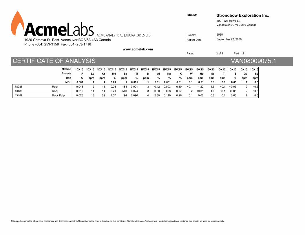
2 of 2
2535
800 - 625 Howe St.
Vancouver BC V6C 2T6 Canada
Project:
Page:
Report Date:
Phone (604) 253-3158 Fax (604) 253-1716
1020 Cordova St. East Vancouver BC V6A 4A3 Canada
2Part
September 22, 2008
www.acmelab.com
Client: Strongbow Exploration Inc.
ACME ANALYTICAL LABORATORIES LTD.
CERTIFICATE OF ANALYSIS VAN08009075.1
MDL
Unit
Analyte
Method 1DX15 1DX15 1DX15 1DX15 1DX15 1DX15 1DX15 1DX15 1DX15 1DX15 1DX15 1DX15 1DX15 1DX15 1DX15 1DX15 1DX15
P La Cr Mg Ba Ti B Al Na K W Hg Sc Tl S Ga Se
% ppm ppm % ppm % ppm % % % ppm ppm ppm ppm % ppm ppm
0.001 1 1 0.01 1 0.001 1 0.01 0.001 0.01 0.1 0.01 0.1 0.1 0.05 1 0.5
78288 Rock 0.043 2 18 0.03 184 0.001 3 0.42 0.003 0.10 <0.1 1.22 4.5 <0.1 <0.05 2 <0.5
43486 Rock 0.010 11 11 0.21 540 0.024 3 0.80 0.098 0.07 0.2 <0.01 1.0 <0.1 <0.05 2 <0.5
43487 Rock Pulp 0.078 13 22 1.07 94 0.096 4 2.39 0.119 0.26 0.1 0.02 6.6 0.1 0.68 7 0.6
This report supersedes all previous preliminary and final reports with this file number dated prior to the date on this certificate. Signature indicates final approval; preliminary reports are unsigned and should be used for reference only.

1 of 1
2535
800 - 625 Howe St.
Vancouver BC V6C 2T6 Canada
Strongbow Exploration Inc.Client:
Project:
Report Date:
www.acmelab.com
Phone (604) 253-3158 Fax (604) 253-1716
1020 Cordova St. East Vancouver BC V6A 4A3 Canada
1PartPage:
September 22, 2008
ACME ANALYTICAL LABORATORIES LTD.
QUALITY CONTROL REPORT VAN08009075.1 QUALITY CONTROL REPORT VAN08009075.1WGHT 1DX15 1DX15 1DX15 1DX15 1DX15 1DX15 1DX15 1DX15 1DX15 1DX15 1DX15 1DX15 1DX15 1DX15 1DX15 1DX15 1DX15 1DX15 1DX15
Wgt Mo Cu Pb Zn Ag Ni Co Mn Fe As U Au Th Sr Cd Sb Bi V Ca
kg ppm ppm ppm ppm ppm ppm ppm ppm % ppm ppm ppb ppm ppm ppm ppm ppm ppm %
0.01 0.1 0.1 0.1 1 0.1 0.1 0.1 1 0.01 0.5 0.1 0.5 0.1 1 0.1 0.1 0.1 2 0.01
Reference Materials
STD DS7 Standard 19.5 105.5 68.2 402 0.6 52.7 9.5 632 2.40 49.0 4.8 61.9 4.5 89 5.8 6.3 4.7 85 0.99
STD DS7 Standard 19.8 101.4 62.5 383 0.5 55.2 9.3 642 2.42 46.2 4.4 74.8 4.1 88 5.4 5.9 4.4 87 1.01
STD DS7 Expected 20.9 109 70.6 411 0.9 56 9.7 627 2.39 48.2 4.9 70 4.4 69 6.4 5.9 4.5 86 0.93
BLK Blank <0.1 <0.1 <0.1 <1 <0.1 <0.1 <0.1 <1 <0.01 <0.5 <0.1 <0.5 <0.1 <1 <0.1 <0.1 <0.1 <2 <0.01
Prep Wash
G1 Prep Blank <0.01 0.4 4.0 2.8 49 <0.1 4.9 4.8 594 2.20 <0.5 2.3 <0.5 4.3 92 <0.1 0.3 <0.1 44 0.64
MDL
Unit
Analyte
Method
This report supersedes all previous preliminary and final reports with this file number dated prior to the date on this certificate. Signature indicates final approval; preliminary reports are unsigned and should be used for reference only.

1 of 1
2535
800 - 625 Howe St.
Vancouver BC V6C 2T6 Canada
Strongbow Exploration Inc.Client:
Project:
Report Date:
www.acmelab.com
Phone (604) 253-3158 Fax (604) 253-1716
1020 Cordova St. East Vancouver BC V6A 4A3 Canada
2PartPage:
September 22, 2008
ACME ANALYTICAL LABORATORIES LTD.
QUALITY CONTROL REPORT VAN08009075.11DX15 1DX15 1DX15 1DX15 1DX15 1DX15 1DX15 1DX15 1DX15 1DX15 1DX15 1DX15 1DX15 1DX15 1DX15 1DX15 1DX15
P La Cr Mg Ba Ti B Al Na K W Hg Sc Tl S Ga Se
% ppm ppm % ppm % ppm % % % ppm ppm ppm ppm % ppm ppm
0.001 1 1 0.01 1 0.001 1 0.01 0.001 0.01 0.1 0.01 0.1 0.1 0.05 1 0.5
Reference Materials
STD DS7 Standard 0.077 14 177 1.08 387 0.136 37 1.10 0.094 0.46 3.7 0.16 2.5 4.2 0.19 5 3.2
STD DS7 Standard 0.069 14 183 1.05 370 0.132 41 1.08 0.092 0.46 3.8 0.17 2.5 4.0 0.19 5 3.6
STD DS7 Expected 0.08 13 163 1.05 370 0.124 39 0.959 0.073 0.44 3.8 0.2 2.5 4.2 0.21 4.6 3.5
BLK Blank <0.001 <1 <1 <0.01 <1 <0.001 <1 <0.01 <0.001 <0.01 <0.1 <0.01 <0.1 <0.1 <0.05 <1 <0.5
Prep Wash
G1 Prep Blank 0.078 11 12 0.64 244 0.146 1 1.17 0.101 0.60 0.1 <0.01 2.3 0.4 <0.05 6 <0.5
MDL
Unit
Analyte
Method
This report supersedes all previous preliminary and final reports with this file number dated prior to the date on this certificate. Signature indicates final approval; preliminary reports are unsigned and should be used for reference only.

2008 Assessment Report Appendix III STRONGBOW EXPLORATION INC. May 2009 Kepp Property
APPENDIX III
A: Kepp Property – 2008 Rock Sample Locations, Description and Geochemical Results B: Kepp Property – 2008 Soil Sample Locations, Description and Geochemical Results C: Kepp Property – 2008 Silt Sample Locations, Description and Geochemical Results

Appendix IIIa - 2008 Kepp Rock Sample Location, Description and Geochemical Results
Sample Type Northing Easting Lithology Alteration Mineralization Comments Cu_ppm Mo_ppm Au_ppb Ag_ppm Ars_ppm Bi_ppm Sb_ppm Pb_ppm Zn_ppm
78288 Float 6014556 444023 Volcanic Silica Sulphide Float 30x15x15cm. Siliceous, manganese, limonite altered volc.cla tic. Southside of road bed. Components: lithic fragments; Genetic Interpretation: autoclastic - autobreccia
144.1 1.1 4.5 0.05 5.6 0.2 1.8 4.7 339
2008 Assessment ReportMay 2009
STRONGBOW EXPLORATION INC.Kepp Property

Appendix IIIb - Kepp Soil Sample Location, Description and Results
Sample Northing Easting Slope_Dip Slope_Dir Colour Ag_ppm Ars_ppm Au_ppb Bi_ppm Cu_ppm Mo_ppm Pb_ppm Sb_ppm Zn_ppm78025 6015658 444167 20 South brown 0.2 6.5 1.8 0.3 53.7 1.4 12.8 1.2 12178026 6015565 444087 3 South tan 0.05 4.1 1.1 0.05 17.2 0.7 5.1 0.3 7778027 6015509 444020 0 brown 0.2 4.2 0.9 0.1 62.8 1 6.9 0.3 8978028 6015431 443958 10 North brown 0.2 3 0.25 0.05 33.1 1 5.4 0.3 13178029 6015355 443883 5 North tan 0.05 3.9 1.1 0.05 18.6 1.1 5 0.3 9278030 6015287 443830 20 South brown 0.05 2.5 1.7 0.05 19.6 0.7 4.3 0.3 6378031 6015219 443751 2 North-East brown 0.05 3.7 2.2 0.05 106 0.4 6.6 0.2 11378032 6015138 443678 0 brown 0.05 2.5 1.7 0.05 32.5 0.5 4 0.2 4978033 6015060 443614 0 brown 0.1 2 3.4 0.05 21.8 0.7 5.1 0.1 6978034 6014993 443540 0 brown 0.05 1.9 1.9 0.05 18.2 0.5 5.1 0.2 5978035 6014909 443457 3 South-West brown 0.05 2.1 1.8 0.1 15.1 0.5 4.1 0.2 10278036 6014842 443403 0 South brown 0.2 3.1 1.7 0.1 37.7 0.8 5.4 0.2 13478037 6014770 443339 15 South brown 0.05 4.2 0.25 0.05 19.7 0.7 5.4 0.4 5878038 6014759 443537 0 brown 0.05 2.4 0.8 0.05 13.8 0.5 4.1 0.2 7278039 6014693 443475 0 brown 0.05 2.5 0.25 0.05 19.8 0.6 4.6 0.2 7578040 6014627 443379 0 brown 0.1 3.4 0.8 0.1 26.5 0.7 5.7 0.2 9978041 6014473 443249 0 tan 0.05 1.9 0.7 0.05 9.9 0.5 4.8 0.2 5978462 6015943 443001 5 North grey 0.05 5 0.25 0.1 29.5 0.6 4.7 0.4 6278463 6015943 442930 7 North-East brown 0.2 3.2 0.25 0.05 77.2 0.7 5.5 0.3 10378464 6015887 442833 3 North-East reddish brown 0.05 3.1 0.25 0.05 35.1 1 4.1 0.3 9178465 6015822 442744 2 North-East brown 0.05 2.1 1.1 0.05 95.3 0.6 2.9 0.2 8278466 6015728 442697 2 South-West brown 0.05 1.8 0.25 0.05 46.4 0.5 2.9 0.2 9478467 6015666 442632 5 South-West brown 0.05 0.9 0.25 0.05 34 0.7 3.1 0.2 6778468 6015536 442463 2 North-East reddish brown 0.05 2.3 0.25 0.05 39.2 1 5.1 0.2 22678469 6015498 442381 4 South-West reddish brown 0.05 2.8 0.25 0.05 41.1 0.7 4.5 0.2 19478470 6015414 442309 2 South-West brown 0.05 2.2 0.25 0.05 25.2 0.5 5.3 0.2 11178471 6015278 442172 0 brown 0.05 2.1 0.25 0.05 13.4 0.5 5.6 0.2 5478472 6015214 442068 0 grey 0.05 2.7 0.25 0.05 10.3 0.6 5.3 0.2 7078473 6015147 442002 0 tan 0.05 7.5 0.25 0.1 25.7 0.7 6.8 0.4 8978474 6015077 441928 0 tan 0.05 2.1 0.25 0.05 24.9 0.5 5.5 0.2 11078475 6015008 441853 0 tan 0.05 1.6 0.25 0.05 19.8 0.5 4.3 0.2 14778476 6014964 441787 2 South-East brown 0.05 2.2 0.5 0.1 10.8 0.5 5.1 0.2 9578477 6014895 441697 2 South-West brown 0.05 2.1 1.7 0.05 31.4 0.9 4.5 0.2 17778478 6014810 441626 2 North-East reddish brown 0.05 2.6 0.25 0.1 16.9 1 4.5 0.2 10378479 6014619 441557 2 South-West brown 0.05 2.6 0.25 0.05 35.7 0.6 5.1 0.3 9278480 6014668 441495 2 North-East tan 0.05 8.4 1.2 0.05 23.9 0.7 6.6 0.5 5078481 6014609 441415 0 tan 0.05 7.6 1.9 0.1 43.1 0.3 6.6 0.5 4678482 6014587 441356 2 South-West tan 0.05 1.8 1.3 0.05 7 0.4 5.5 0.2 71
2008 Assessment ReportMay 2009
STRONGBOW EXPLORATION INC.Kepp Property

Appendix IIIc - Kepp Silt Sample Location, Description and Results
Sample Northing Easting Ag_ppm Ars_ppm Au_ppb Bi_ppm Cu_ppm Mo_ppm Pb_ppm Sb_ppm Zn_ppm78024 6015216 443881 0.1 5.5 3.7 0.05 46 0.5 5.5 0.3 9178042 6014111 443162 0.2 8.5 1 0.1 44.4 1.1 7.5 0.3 97
2008 Assessment ReportMay 2009
STRONGBOW EXPLORATION INC.Kepp Property