Embed Size (px)
Citation preview

______________________________________________________
Upper Tenmile Creek Mining Area Superfund Site
Lewis and Clark County, Montana
2008 COMMUNITY INVOLVEMENT PLAN
U.S. ENVIRONMENTAL PROTECTION AGENCY
Region 8, Montana Office
10 West 15th Street, Suite 3600
Helena, MT 59626
July 2008

2

3
Contents
1.0 Overview of Revised CI Plan page 5 Objectives of the Community Involvement Program Superfund Requirements 2.0 Site Description page 7 Site Location Site History
3.0 Community Profile page16 Rimini Helena 4.0 Community Involvement at the Site page 19 Stakeholders EPA and Other Resources History of Community Involvement Activities Revision of the CIP Overall Interview Findings Summary of Interview Responses by Question 5.0 CI Program Goals page 37 6.0 Techniques for Achieving CI Goals page 38 Contacts Meetings Written materials Direct Contact Site Tours Technical Assistance Grant Information Repository, Administrative Record, and Web page Press Releases/Public Service Announcements Appendices Appendix A List of Contacts and Interested Parties Appendix B Locations for Information and Public Meetings Appendix C Glossary of Terms

4

5
Section 1 Overview of Revised CI Plan
This 2008 Revised Community Involvement Plan identifies the issues of community concern about the Upper Tenmile Mining Area Superfund Site (the Site) located west of Helena in Lewis and Clark County, Montana.
The U.S. Environmental Protection Agency (EPA) has prepared this revised 2008 Community Involvement Plan (CIP) as an update to the 2001 CIP. The CIP describes past outreach activities and identifies efforts EPA will take to inform and involve the communities (Rimini and Helena) in future site activities and decisions. The goal of the CIP is to create a program that meets the information and involvement needs of the affected communities.
The issues documented in this CIP were gathered during interviews with 20 stakeholders in the Upper Tenmile Creek watershed from February though April 2007. Participants included 12 Rimini residents and property owners, seven representatives from the local government (City and County), and the Upper Tenmile Watershed Steering Committee facilitator. Interviews were conducted by EPA and CDM (EPA contractor). Interviewees were asked the same series of questions during the 30-60 minute discussions. The responses are summarized in this CIP. The main comments and concerns raised during the interviews were:
• The number one concern: water and wastewater systems
• The second most common concern: yard cleanups
• Communication tools are good and generally well used
• More involvement is needed in decisions, including more upfront discussions between EPA and the other stakeholders
• Perception is that cleanup is too slow; future plans and schedule are unclear
• Watershed issues must be addressed
• EPA’s trust and credibility need to be strengthened
Revision of the CIP was delayed until 2008 while EPA was conducting a Five Year Review of the Site (July 2008) and preparing for an amendment to the Record of Decision (ROD). (The ROD Amendment is expected later in 2008.) In addition to the information in the community interviews, these and other sources of information (e.g., Site documents, fact sheets, press releases, and other materials contained in Site files) were used in preparation of this revised 2008 Community Involvement Plan.
The Superfund Branch in the EPA Montana Operations office has lead responsibility for the Site and oversees community involvement activities at the Site. EPA coordinates Site activities with the Montana Department of Environmental Quality.

6
Objectives of the Community Involvement Program EPA conducts community involvement activities to ensure that the local public has input to decisions about cleanup actions at hazardous waste sites and is well informed about the progress of those actions.
The Community Involvement Plan forms the basis for planning on-going community involvement activities. EPA regularly prepares outreach and communication plans that are tailored to specific events or issues, using information from the CIP.
Superfund Community Involvement Requirements CERCLA requires that a community involvement effort accompany any Superfund remedial investigation and response. The following are the required community involvement activities at Superfund sites, as stated in the EPA Community Relations in Superfund: A Handbook, prepared by the U.S. EPA, Office of Emergency and Remedial Response, Washington, DC. EPA/540/R-92/009, 1992, updated 2002. These minimal requirements are set forth in the 1990 National Oil and Hazardous Substances Pollution Contingency Plan (NCP), in the Superfund Amendments and Reauthorization Act (SARA), 1986, and in EPA policy documents.
This plan conforms with the requirements of the Comprehensive Environmental Response, Compensation, and Liability Act (CERCLA) of 1980, as amended.
EPA regularly goes beyond the required community involvement activities, tailoring outreach activities and educational materials to address a particular site issue, activity or event. EPA welcomes suggestions!
7
Section 2 Site Description
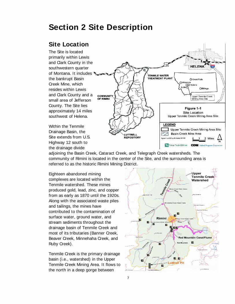
Site Location The Site is located primarily within Lewis and Clark County in the southwestern quarter of Montana. It includes the bankrupt Basin Creek Mine, which resides within Lewis and Clark County and a small area of Jefferson County. The Site lies approximately 14 miles southwest of Helena.
Within the Tenmile Drainage Basin, the Site extends from U.S. Highway 12 south to the drainage divide adjoining the Basin Creek, Cataract Creek, and Telegraph Creek watersheds. The community of Rimini is located in the center of the Site, and the surrounding area is referred to as the historic Rimini Mining District.
Eighteen abandoned mining complexes are located within the Tenmile watershed. These mines produced gold, lead, zinc, and copper from as early as 1870 until the 1920s. Along with the associated waste piles and tailings, the mines have contributed to the contamination of surface water, ground water, and stream sediments throughout the drainage basin of Tenmile Creek and most of its tributaries (Banner Creek, Beaver Creek, Minnehaha Creek, and Ruby Creek).
Tenmile Creek is the primary drainage basin (i.e., watershed) in the Upper Tenmile Creek Mining Area. It flows to the north in a deep gorge between

8
Red Mountain on the east and Lee Mountain on the west. The headwaters of Tenmile Creek are located about 4.5 miles upstream of the Tenmile Mine. The creek flows for 22 miles before entering Lake Helena. Tenmile Creek is a recreational fishery used regularly during the summer. Trout species are prevalent.
Site Contamination The Upper Tenmile Mining Area Superfund Site consists of 18 major abandoned mine complexes, and up to 150 additional individual abandoned mine sites within the Rimini Mining District. These mines and the associated waste piles and tailings have contributed to the contamination of surface water, ground water, and stream sediments throughout the drainage basin of Tenmile Creek and its tributaries. Contaminants from the historic mining include lead, cadmium, arsenic, copper, zinc, and other metals.
Numerous mines affect water quality in the Tenmile Creek watershed. Three mine sources were characterized during preparation of the Site's Hazard Ranking System scoring package: Red Water, Red Mountain, and Tenmile Mines. The location of each mine is described below:
• Red Water Mine. On the east bank of Tenmile Creek, which flows north. Water from the mine enters the creek about 200 yards above the Tenmile Creek drinking water supply intake.
• Red Mountain Mine. About 0.5 miles above Tenmile Creek on the east side of the drainage. Water discharging from the mine flows west in Poison Creek 0.5 miles into Tenmile Creek.
• Tenmile Mine. On the east bank of Tenmile Creek. Water from the upper portion of the site flows into an unnamed tributary that discharges to a wetland area along Tenmile Creek. The distance from the reclaimed dump to Tenmile Creek is 20 feet. Precipitation water flows west from this area into Tenmile Creek.
The City of Helena, located 22 miles from the headwaters of Tenmile Creek, maintains the Tenmile Creek Water Treatment Plant at the junction of U.S. Highway 12 and Rimini Road. The plant has five drinking water supply intakes in the Tenmile Creek Drainage Basin at these locations: Walker Creek, Moose Creek, Minnehaha Creek, Beaver Creek, and Tenmile Creek at the community of Rimini. This water treatment plant provides about 50% (down from 80% at the time of the ROD) of Helena’s water supply. The plant also uses Chessman Reservoir and Scott Reservoir, which are maintained to supply water to intakes. One or both of the reservoirs are used in severely cold weather when smaller tributaries freeze, and sometimes in the summer to supplement the tributaries.
The major threats to human health and the environment are posed by the release of sediment and high concentrations of metals, such as arsenic and lead, from the abandoned mines into Upper Tenmile Creek and from high levels of metals in soils and arsenic in the groundwater. Contaminant concentrations have been observed

9
that exceed EPA maximum contaminant levels for drinking water and water quality criteria for aquatic life.
A Superfund Site EPA's involvement with the Site began when the State of Montana, the Lewis and Clark County Water Quality Protection District, and local community-based watershed groups requested assistance to deal with mines that posed the greatest threat to area resources. In response, EPA's Superfund Removal Program conducted several removal actions at the Site. These time-critical removal actions mitigated immediate threats to the environment, to the residents living within the Site, to the nearby town of Rimini, and to the drinking water source for the city of Helena by removing the sources of contamination.
EPA placed the Site on the final National Priorities List (NPL) in 1999, making it eligible for long-term remedial action financed by the Superfund Trust Fund. A Remedial Investigation/Feasibility Study were completed in 2001 (February and March), followed by a Proposed Plan for clean up (November 2001) and a Record of Decision (ROD) (July 2002). Remedial action activities began in 2003 with the removal of contamination from residential yards in the nearby Landmark Subdivision. Contamination was removed from most Rimini residential yards in 2006. EPA conducted a Fiver Year Review in 2007/2008. EPA is now amending the ROD. The ROD Amendment process included a review by EPA’s National Remedy Review Board and a value engineering analysis by the US Army Corps of Engineers.
Site History The history of investigation and cleanup at the site began before EPA was involved and continues today. The following discussion is divided into four categories:
• Pre-Superfund Activities
• Superfund Emergency Response Activities
• Superfund Remedial Program Activities
• Superfund Post-ROD Activities
Pre-Superfund Activities Prior to Superfund involvement at the Site, various agencies and interested groups conducted investigations to document contaminant concentrations in mine wastes, stream sediments, and surface/ground waters in the Upper Tenmile Creek watershed. These studies indicate releases of hazardous substances containing elevated concentrations of arsenic, cadmium, copper, lead, and zinc that may pose a risk to human health and the environment. In addition, contaminant concentrations have been observed that exceed EPA maximum contaminant levels for drinking water and water quality criteria for aquatic life.

10
To mitigate the potential threat at the Site, the State of Montana has conducted a number of waste removal and containment actions over the last 15 years. During the mid- to late-1980s, the Montana Department of State Lands Abandoned Mine Reclamation Bureau (AMRB) removed waste rock and tailings materials from the following abandoned mines and disposed of the materials at an active mine site in Jefferson County: Avon, Ballou, Bunker Hill, Daniel Stanton, Engstrom Mill Site, Justice, Kelly Mill Site, Lee Mountain, Little Lilly, Little Sampson, Lower Evergreen, and Susie. At each of the mines, AMRB recontoured, stabilized in place, covered and revegetated residual mine wastes. AMRB was not able to collect or treat mine adit discharges.
The timeline of the pre-Superfund Activities is presented below:
• July 1993. The Site was investigated as part of the Montana Department of State Lands/AMRB (MDSL/AMRB) Hazardous Materials Inventory.
• June 1994. The Site was mapped using the Global Positioning System. The information was used to locate the waste materials present at the Site accurately within the different claim boundaries.
• April 1995. MDSL/AMRB prepared the Final Site Inspection Report for the Tenmile Creek Site, Helena, Montana. The following metals were found present in waste rock samples from Red Water, Red Mountain and Bunker Hill Mines at levels significantly above background concentrations: antimony, arsenic, cadmium (Bunker Hill Mine only), copper, lead, mercury, and zinc.
Superfund Emergency Response Activities From 1995 until 1999, EPA conducted a number of time-critical removal actions (TCRAs) to remove known sources of contamination. These TCRAs mitigated immediate threats to: the environment, residents living within the Site, the town of Rimini, and the drinking water source for the City of Helena.
The timeline of the Superfund Emergency Response Activities is presented below:
• October 1995. EPA conducted a removal of waste materials in a residential area near the Lower Bunker Hill mine site and in 1997 consolidated and covered/revegetated near stream waste rock piles at the Red Water mine. Approximately 300 tons of contaminated soils were removed from residential yard areas near the site of the historic Lower Bunker Hill mine complex.
• October and November 1997. The EPA Emergency Response Cleanup Services (ERCS) contractor conducted a removal action at the Red Water Mine. Approximately 5,700 cubic yards of waste rock was excavated and moved to the northern end of the mine, and 1,800 cubic yards of contaminated material from the wooded area north of the waste rock pile and from an area adjacent to the

11
on-site residence was placed on top of the waste rock. A bench was placed on the existing original surface; large rocks (rip rap) were placed on the bench to add support. No clay liner was placed on the bench or the original slope.
• 1997. EPA and its ERCS contractor returned to the Red Water Mine to fix some of the topsoil that had begun sliding because of high rains and snowmelt during the year.
• April 7, 1998. The Lewis and Clark County Water Quality Protection District requested assistance from the Montana Department of Environmental Quality (MDEQ) and EPA in undertaking a cleanup at the Bunker Hill Mine. The erosion of prior reclamation at the Bunker Hill site created a mass loading problem in Tenmile Creek, jeopardizing the safety of drinking water for the City of Helena.
• Fall 1998. Montana Department of Fish, Wildlife and Parks collected brook trout fish tissue samples from Tenmile Creek, which showed elevated levels of arsenic. Tenmile Creek has been identified by the State of Montana as a high priority non-attainment stream with respect to the Clean Water Act 303(d). Identified problems include metals contamination, sedimentation, and dewatering. A Total Maximum Daily Load (TMDL) study is underway to address these concerns.
• April 28, 1999. EPA issued requests for access for sampling, characterization, and response activities at properties in the Upper Tenmile Creek watershed. About 20 letters were sent to owners of properties that lie within the Bunker Hill and Red Mountain mine complexes. Recipients were asked to sign a Consent for Access form and return it within seven days of receipt of the letter.
• May 10, 1999. A Hazard Ranking System (HRS) scoring package was prepared for the Site to evaluate potential relative risks to public health and the environment from releases or threatened releases of hazardous substances. EPA and states use the HRS to calculate a site score (0 to 100) based on the actual or potential release of hazardous substances from a site through air, surface water, or ground water. This score is the primary factor used to decide if a hazardous waste site should be placed on the Superfund NPL. The Tenmile site received an HRS Site Score of 50 (a score above 28.5 makes a site eligible for listing).
• June 7, 1999. EPA prepared an Action Memorandum to initiate a TCRA at the Red Mountain and Bunker Hill mines, and to request exemptions from the $2 million and 12-month statutory limits. High concentrations of arsenic, lead, and other metals found
Red Mountain Mine

12
in waste piles and run-off from the abandoned mine complexes create conditions that present an imminent and substantial endangerment to human health and the environment and meet the criteria for initiating a removal action under 40 CFR Section 300.415(b)(2) of the National Contingency Plan. EPA determined that removal of source material from the mine complexes would reduce the overall mass loading on Tenmile Creek and would lessen infiltration of contaminants into mine adits, thus reducing the metals loading in the discharging adits. The Memorandum identified candidates for possible subsequent phases of the TCRA; these were the National Extension, Upper Valley Forge, Peerless Jenny/King, and Valley Forge/Susie.
• June 24, 1999. MDEQ, pursuant to the Montana Environmental Policy Act, prepared an Environmental Assessment (EA) describing a proposed change in land use at the currently permitted Basin Creek Mine to provide for use of the Luttrell Pit as a mine waste repository. MDEQ presented the EA to the public, and received comments from nine individuals (or couples). MDEQ responded to those comments that specifically addressed the EA in its final revision to that document.
• Summer 1999. EPA's Superfund Removal Program conducted additional limited mine waste removals at the Red Mountain mine. The Red Mountain removal was completed on schedule. About 50,000 cubic yards of waste rock were removed from the Red Mountain mine and deposited in the Luttrell Repository.
• July 22, 1999. The Site was proposed for addition to the Superfund NPL. The NPL is EPA's list of the most serious uncontrolled or abandoned hazardous waste sites identified for possible, long-term cleanup funded with Superfund money.
• October 22, 1999. The Site was listed on the NPL, allowing EPA to: access Superfund for cleanup while it determines whether there are responsible parties that should assist with cleanup costs, take a comprehensive approach to the Tenmile Creek watershed in cooperation with other agencies and community groups, and fund a technical assistance grant (TAG) to enable a community group to hire advisors to help them comment on EPA's actions at the Site.
• Fall 1999. Parties with interests in the Site began discussion for a Memorandum of Understanding (MOU) to promote public awareness and communication between federal, state, and local government agencies and water groups regarding abandoned mine cleanup in Jefferson County and Lewis and Clark County, and the use of the Luttrell Pit repository site. The objective of the MOU was to provide a framework for these parties to fully consider and understand the impact of operating and maintaining a central mine waste repository as part of an overall cleanup plan. The parties to which the MOU applies are: EPA, US Forest Service (USFS), the Bureau of Land Management, MDEQ, Jefferson Valley Conservation District, Lewis and Clark Conservation District, Jefferson County, Lewis and Clark County, and the Upper Tenmile Watershed Steering Committee.

13
• Summer 2000. EPA and the USFS secured the Luttrell Pit as a joint repository. The Luttrell Repository is situated on the Continental Divide between the drainage areas of Boulder River and Tenmile Creek. It will serve as a central waste repository for mine complexes within both the Upper Tenmile Creek Mining Area Site and the Basin Mining Area Site. A highly protective liner system was installed at the pit. Additional removal actions were conducted at the Red Mountain, Susie, and Peerless Jenny/King mines.
Superfund Remedial Program Activities To address long-term cleanup issues, EPA conducted a Remedial Investigation/Feasibility Analysis (RI/FS). The RI/FS is a comprehensive, two-part evaluation of the Site. The RI/FS was conducted in coordination with work being sponsored by the State of Montana and the USFS.
Due to its complexity, the RI/FS process was performed in various phases or steps. The RI involved gathering the necessary data to determine the nature and extent of Site contamination. It also determined whether any additional immediate actions were needed to protect public health, such as providing a potable water supply for Rimini. The FS identified appropriate alternatives for a long-term and permanent remedy to mitigate threats to human health and the environment.
Following completion of the RI/FS, EPA prepared and issued a Proposed Plan for cleanup, held a public meeting, took public comment, assessed the comments and issued a ROD
The timeline of the Superfund Remedial Program Activities is presented below:
• 2000 – 2001. EPA conducted an RI/FS to investigate site contamination and evaluate remediation alternatives for the site. Environmental samples were collected and analyzed in 2000. The draft RI report was issued in February 2001 and draft FS report in March 2001. The final ecological risk assessment (ERA) was issued in April 2001 and the final human health risk assessment (HHRA) in October 2001. An addendum to the RI/FS, responding to comments received on the draft RI and FS documents was issued in December 2001.
• January 2001. EPA conducted additional sampling of tap water from residential wells at the site and provided replacement bottled water for site residents whose well water exceeded maximum contaminant levels (MCLs) for drinking water. EPA recognized the need for interim potable water supply for Rimini prior to the final remedial action and installed individual reverse osmosis treatment systems in homes with contaminated well water.
• Summer 2001. EPA removed waste from the Bunker Hill and Queensbury sites and completed surface reclamation at the Red Mountain, Bunker Hill, Susie, Peerless Jenny/King, and Queensbury sites. USFS removed waste from the Upper Valley Forge site. These wastes were disposed of at the Luttrell repository.

14
• July 2001. EPA released a preliminary draft proposed plan for public review and comment.
• October 22, 2001. The proposed plan for the site was issued for public comment. Significant changes were made to the proposed plan in response to comments provided on the preliminary draft proposed plan. The 30-day public comment period extended from October 22, 2001 to November 21, 2001.
• July, 2002. EPA issues the ROD for the site.
Superfund Remedial Program Activities (Post-ROD) Post-ROD activities at the Site included sampling to delineate the cleanup boundaries and volumes of material to be removed and replaced, preparation of individual site work plans and other remediation documents, incremental funding requests, remediation of contaminated materials from residential yards in Landmark and Rimini, restoration of those removal areas, and installation of water and sewer lines and a community septic system. Changes were also required to the original ROD that necessitate the preparation of a new Proposed Plan and ROD.
Chronological highlights of these activities are:
• Summer 2002. EPA begins sampling of residential yards in Rimini and Landmark to determine which yards, or portions of yards, will require cleanup. Sampling continued throughout the field season.
• Summer 2003. EPA begins removal of wastes from residential yards in the Landmark subdivision. Approximately 10,000 cubic yards of waste were removed in the 2003 construction season and taken to the Luttrell Repository. EPA also trucked 20,000 cubic yards of wastes previously removed from the Lee Mountain Mine to the Repository and constructed an interim adit discharge system at the mine.
• 2003. The Rimini Water and Sewer District is formed.
• Summer 2004. EPA finished removal of the remaining wastes from the Landmark subdivision.
• Summer 2005. EPA conducted road remediation and sewer line installation. The community septic tank, treatment tank, and associated piping were installed. Wastes continued to be placed at the Luttrell Repository. Lee Mountain and Susie Mine Adits were opened. EPA awarded a TAG to Rimini Community, Inc.
• Summer 2006. EPA remediated and partially restored 44 residential properties in Rimini and transported approximately 29,000 cubic yards of waste to the Luttrell Repository. EPA also removed approximately 1,100 cubic yards of waste from a 1,000-foot section of Rimini Road north of Rimini. EPA began work on a ROD amendment.
• Winter 2007. EPA describes the ROD Amendment process to residents.
• Summer 2007. EPA finished restoration of the properties that were remediated in

15
Rimini in 2006.
• August 2007. EPA announces it is beginning a Five Year Review of the Site and, in addition to its own information collection, requests comments from the public.
• October 2007. EPA releases the Proposed Plan for the ROD Amendment, offers a public comment period and receives public comments during a public hearing in Rimini.
• November 2007. EPA extends the public comment period until December 2007.
• Winter/Spring 2008: EPA and Montana DEQ participate in meetings with City, County, and community members regarding site plans.
• Winter/Spring/Summer 2008. EPA considers public comments and prepares the ROD Amendment.
• Summer 2008. EPA applied at least 4 inches of road-base to Rimini Road.
• Summer 2008. EPA plans to cleanup 2 additional yards in the Landmark Subdivision and haul the waste to the Luttrell Repository via Minnehaha Road.
• July 2008. EPA finalizes its Five Year Review for the Upper Tenmile Mining Area.

16
Section 3 Community Profile
The following provides a general profile of the Site communities - Rimini, situated in the approximate center of the Site, and the City of Helena, about 12 miles to the northeast. Helena receives approximately 50 percent of its drinking water from the Upper Tenmile Creek watershed. (This percentage is down from previous contributions of 70 to 80 percent as the City has begun to rely more and more on the Missouri River as a drinking water source.) Both Rimini and Helena are located in Lewis and Clark County, Montana.
Rimini The Rimini Mining District has been renamed and subdivided throughout its history. Some district names reflected its geography, including Red Mountain, Bear Gulch, Monitor Creek, Minnehaha Creek, or Tenmile Creek Districts. Others were associated with its early or successful miners, such as Young Ireland and the Vaughan District.
In just over 60 years, the District produced minerals with an estimated total value of $7,000,000, consisting mainly of gold, silver, and lead, in addition to small amounts of other metals. The greater portion of these minerals was produced prior to 1907.
Miners first came to the Rimini area in 1864, locating placer claims along the creeks. Placer mining continued in the District throughout much of its history. By 1928, the total value of gold obtained through placer mining was $80,000.
By 1874, Rimini mines were producing nearly one-third of the territory's mineral wealth. At least 48 underground mines were developed in the District, primarily in four geographic groups: Rimini proper, Red Mountain, the Peerless Jenny, and the southwestern part of the District. Of the five claims at the Tenmile Mine site, the Daniel Stanton and the Bunker Hill claims (both patented) were among the District's earliest major producers.
Prior to the 1880s, the territory's remoteness made transportation costs prohibitive. Only high grade ore was mined, leaving behind much of the low grade ore. During the 1880s, that practice changed with the construction of the Alta-Montana Smelter at Wickes (located a short distance from Rimini), other Montana milling and smelting facilities, and the Helena and Red Mountain Railroad. Once considered unprofitable, low grade ores were mined and others were sorted from the waste dumps to be shipped for smelting.
Historic Rimini

17
By the end of 1893, falling silver prices shut down most of the region's mines. In 1927, the Montana Lead Co. began the Red Mountain Tunnel, which attempted to consolidate 120 area-claims in order to mine over 40 veins of ore. By 1934, the company was one of the State's major producers of lead. Montana Lead Co. dissolved four years later due to declining prices. It was the last major producer to operate in the Rimini Mining District.
During the World War II period, mining activity was conducted by small operators and lessees, who posted fairly high production figures. Since the post-war era, mining activity in the Rimini District has been very limited, most of the endeavors being small, summer-time operations. The last active mining at the Tenmile site ended in 1953.
In summer 1987, initial steps were taken to nominate the Rimini Mining District to the National Register of Historic Places. The boundary for the proposed Rimini historic district corresponded in general to the boundary for the Rimini Mining District. The northern boundary was moved south about 4 miles, however, to exclude a large number of new housing subdivisions south of U.S. Highway 12 and an area with no patented mining claims north of the highway.
The Rimini Mining District qualified for nomination under three criteria: historic remains associated with events significant to the broad patterns of history; structures which demonstrate architectural significance, such as cribbed log construction; and potential for yielding additional information.
In the watershed, there are two very small and distinct residential areas, the community of Rimini and the Landmark Subdivision. Over the past several years, EPA has conducted residential yard cleanup in both communities. There are two community organizations involved with the Superfund cleanup: the Rimini Community, Inc. (RCI) and the Rimini Independents. RCI applied for and received a Technical Assistance Grant from EPA in 2005. RCI continues to use these funds to obtain independent technical assistance to help community residents better understand and thus, participate more effectively in site-related decisions. The Rimini Independents formed in opposition to the Superfund cleanup and, although few in number, have been vocal in their opposition. In such a small community, support for and opposition to various Superfund activities has created a lot of tension and hard feelings in Rimini. Local residents also voted to form a Water and Sewer District, which is a political sub-division of the County, in 2003. The Water and Sewer District is governed by a Board made up of District residents.
The watershed is also a popular area for recreational activities; these include the use of cabins on a seasonal basis, hunting, fishing, and camping. There is a significant amount of private land in the watershed from old mining claims that could be developed for year-round or seasonal residences.

18
Helena The City of Helena, Montana is located roughly 22 miles east of Rimini. Rimini and Helena are both located within Lewis and Clark County. Helena is the county seat of Lewis and Clark County and is the capital of the State of Montana. One of Helena’s primary water sources is the Upper Tenmile Watershed, and the city has a water treatment plant north of Rimini, near the junction of Rimini Road and U.S. Highway 12. Helena is also home to EPA’s Region 8 Montana Operations office.
The climate in Helena is usually clear, sunny, and dry. The average relative humidity is 57 percent. In January, the average temperature is 18.1 degrees Fahrenheit (F); in July, the average temperature is 67.9 degrees F. Average annual precipitation is 11.37 inches, with average annual snowfall of 47.6 inches. Warming periods between snowfalls prevent heavy accumulations, and snow depths rarely exceed five or six inches. Since 1969, the average number of days per year with an inch or more of snow on the ground is 61.
Four of Montana's six other major cities circle Helena within a radius of about 100 miles. More than 250,000 people live within this radius. Current population for the greater Helena valley is estimated at 68,000, with roughly 26,000 living within the city limits.
Helena's charter provides for the election of four city commissioners, who serve as the legislative and policy-making body. Each commissioner serves a four-year term, with two or three commissioners being elected every odd-numbered year. The Mayor serves as the official head of the city for civil and ceremonial purposes, prepares a statement of the affairs and management of the city each January, and appoints members of boards and committees with the consent of the Commission. The Mayor serves a two-year term. The City Manager is appointed by the City Commission and is the city's chief administrative officer. Lewis and Clark County is governed by three elected commissioners.
The Helena School District has two high schools, two middle schools, and 12 elementary schools. Post-high school educational opportunities include the Helena College of Technology, a division of the University of Montana; Carroll College, a private, liberal arts college; and the Helena Vocational Technical Center. The Lewis and Clark County public library is located in Helena, as is the Montana State Library, and the State of Montana Law Library. Major employers include the government sector, service businesses, mining, publishing, and manufacturing.

19
Section 4 Community Involvement
The discussion of community involvement at the Upper Tenmile Site includes:
• Stakeholders
• EPA and other outreach resources
• History of past activities
• The Community Involvement Plan (CIP) Revision Process
Stakeholders The Upper Tenmile Creek watershed has many stakeholders, including landowners, local communities, State and local government, and special interest groups, as well as EPA and several other federal agencies. Many of these entities have been working together as the Upper Tenmile Watershed Steering Committee, which began meeting in late 1996. The group's goal is to coordinate all efforts to address water quantity issues and riparian conditions. Specifically, the group has worked to characterize water quality and quantity, conduct a tracer study to more precisely locate contaminant loading sources, inventory and assess the health of aquatic organisms, and improve riparian habitat through tree planting.
Group members include:
• Rimini residents and representatives of the City of Helena • Lewis and Clark County Conservation District • Lewis and Clark County Water Quality Protection District • Montana Department of Environmental Quality • Montana Department of Natural Resources and Conservation • U.S. Environmental Protection Agency • U.S. Fish and Wildlife Protection • U.S. Forest Service • U.S. Geological Survey • U.S. Natural Resources Conservation Service The EPA Remedial Project Manager (RPM) for the Site, Mike Bishop, attends monthly meetings of the Upper Tenmile Watershed Steering Committee held in Rimini and Helena. The meetings provide a forum for stakeholders to voice their issues and concerns, and for EPA to respond to these comments in a meaningful way. They also enable EPA to discuss activities with local stakeholders. In addition, EPA periodically meets with the City of Helena, Lewis and Clark County Commissioners, County Board of Health, and Departments of Planning, Health, and Water Quality.

20
EPA and Other CI resources EPA assigned a Community Involvement Coordinator, Diana Hammer, to the Site. Her job is to work with the EPA Project Manager, Attorney and Office Director, as well as the Montana DEQ Project Officer to provide consistent, accurate information to the public and to work with the project team to ensure that stakeholders have input into Site-related decisions. Public meetings, press releases, fact sheets, and public notices provide opportunities for stakeholders and the general public to follow and be involved in Site-related activities.
EPA established an information repository located at the Lewis and Clark Public Library. This file contains fact sheets, technical summaries, site reports (including work plans and the CIP), transcripts, TAG information, and general Superfund literature for public review. Key documents are also available at the Rimini Community Center (old Rimini School House) in Rimini.
The Agency for Toxic Substances and Disease Registry (ATSDR) has also been active in communicating information about site risks to the general public. ATSDR conducted a public health assessment for the site, which was released in April 2001. In preparing and discussing the public health assessment, ATSDR held public meetings in Rimini on May 25, 2000 and June 21, 2001.
History of Community Involvement Activities The following provides highlights of community involvement activities for the Site:
• November 1998. EPA met with the Independent Record, which resulted in a front page article on November 17, 1998. Increased interest led EPA and MDEQ to meet with many entities in the two affected watersheds. These include representatives of the Helena water treatment plants; Helena City Commission; County Commissioners; County Water Quality Protection Board; Pegasus Mining; Jefferson County Commissioners; residents of Rimini, Boulder, and Basin Creek; and local watershed citizens groups.
• December 7, 1998. The County Water Quality Protection District sent a memorandum to EPA compiling public comments about proposed mine waste cleanup activities in the Upper Tenmile watershed.
• February 25, 1999. EPA responded with a letter to County Water Quality Protection District, stating that Mike Bishop of the EPA Montana Office and Paul Peronard of the EPA Denver Office had held numerous meetings with various potentially affected interests to verbally respond to their concerns. A Summary of Issues and Concerns was attached along with examples of sites in Colorado where EPA is participating in a "watershed approach" to addressing environmental contamination. The attachments were distributed to the Upper Tenmile Watershed Steering Committee at its February 25, 1999 meeting.

21
• March 22 and 24, 1999. EPA held joint public availability sessions with the USFS in Helena and Basin regarding the proposal to use the Luttrell Pit for mine waste disposal for the Upper Tenmile Creek Mining Area and Basin Mining Area Sites. During these sessions, EPA heard substantial support from Rimini, Basin and Helena residents, as well as from city and county government officials for both the land use change and planned removal actions.
• Spring 1999. During its preparation of a Hazard Ranking System (HRS) scoring package for the Site, EPA met with the communities of Rimini and Basin, local watershed groups, County Commissioners for Jefferson and Lewis and Clark Counties, and the Lewis and Clark County Health Board to discuss possible Superfund NPL designation. EPA held public meetings in Rimini and Helena to discuss the NPL process. Both meetings were advertised in a public notice in the Helena Independent Record. About 50 individuals attended the Rimini meeting; very few citizens attended the Helena meeting. EPA also briefed Helena's Mayor, Public Works Director, and the City Manager on the issue of potential Superfund designation. EPA also notified the public of the availability of its proposed HRS scoring package (prepared on May 10, 1999). The public was given an opportunity to voice their concerns during a public comment period held in conjunction with the proposed listing.
• Summer 1999. EPA prepared a document to provide responses to public comments on the EA prepared by MDEQ on June 24, 1999. The EA dealt with a proposed land use change at the Basin Creek Mine to provide for use of the Luttrell Pit as a mine waste repository. Comments were received from nine individuals (or couples): four were opposed to the land use change; others were supportive with concerns about operations; and others expressed concerns about long-term issues or requested more analysis. (See Section 3.3, Key Community Issues and Concerns.)
• July 22, 1999. EPA issued a press release announcing its proposal to add the Upper Tenmile Creek Mining Area and the Basin Mining Area to the NPL. The announcement was published in the Federal Register and began a 60-day period in which citizens could send EPA their comments separately on each of the proposed listings.
• October 28, 1999. The Upper Tenmile Watershed Steering Committee met in Rimini to hear the concerns of residents and property-owners of the watershed regarding the summer 1999 field season of EPA's Removal Program project.
• November 1999. EPA Region 8 prepared and distributed a fact sheet that provided information on Site history, upcoming activities, environmental progress, EPA contact persons and information repository locations.
• November 15, 1999. The watershed committee's technical subcommittee met to discuss the comments received at the October 28 meeting, and to provide Mike Bishop, EPA's committee representative, with additional comment from the

22
technical perspective. The group also invited USFS officials to hear project comments as the USFS prepared for its first season of mine-waste removal in the watershed during 2000.
• November 30, 1999. The Upper Tenmile Watershed Steering Committee sent a letter to EPA Superfund Branch Chief Robert L. Fox which outlined the concerns of residents and property-owners of the watershed regarding the summer 1999 field season of EPA's Removal Program project.
• December 1999. EPA conducted interviews with affected residents, local officials, and other interested parties to assess community members' issues and concerns about the Site. In addition, EPA briefed the community about the upcoming RI. Information gathered during the community interviews forms the basis of the original CIP.
• August 2000. EPA facilitated a series of meetings with the City of Helena, DFWP, and representatives of the community of Rimini to discuss options to augment stream flow within Tenmile Creek below Rimini. The city agreed to temporarily allow part of Minnehaha Creek stream flow to bypass the city’s water intake structure on that tributary and augment Tenmile Creek flows. Flow was bypassed for approximately six weeks.
• September 2000. EPA issued a fact sheet summarizing site information and describing potential remedial options being considered at the site.
• December 2000. EPA sent letters to site residents providing the sample analytical results for those residential wells that had been sampled. On January 11, 2001 EPA held a public meeting in Rimini to explain and discuss the results of the sampling of the residential groundwater wells, to recommend that additional tap water samples be collected and analyzed, and to offer replacement bottled water to those residents whose tap water from residential wells exceeded EPA’s maximum contaminant level (MCL) concentrations for drinking water.
• January 2001. EPA releases a Community Involvement Plan for the Site.
• February 21, 2001. EPA released the draft RI report for public comment.
• March 23, 2001. EPA released the draft FS report for public comment.
• May 3, 2001. EPA met with a joint session of the City of Helena and Lewis and Clark County commissioners to discuss project issues and the remedial alternatives that EPA was considering.
• July 2001. EPA provided a preliminary draft of the proposed plan to agencies and site residents to obtain public comment and feedback regarding several of the remedial options being considered by EPA. The public expressed considerable support for providing additional water storage and Tenmile Creek flow augmentation, although concern was expressed over the potential loss of

23
valuable wetlands habitat if the Travis location were selected for a new water storage reservoir. As a result of the public comment on the draft proposed plan, EPA identified and evaluated possible alternative locations for additional water storage capacity in the watershed.
• September 2001. EPA sends a letter to residents discussing the upcoming sampling of residential properties in Rimini.
• October 22, 2001. EPA released the proposed plan for public comment. Public hearings on the proposed plan were held in Rimini on November 8, 2001 and in Helena on November 13, 2001. A formal public comment period was open from October 22, 2001 to November 21, 2001. The RI, FS, and proposed plan were made available to the public in the Administrative Record, located at the EPA Montana Office in Helena and at the Lewis and Clark Public Library. EPA issues a public notice announcing the release of the proposed plan. EPA's responses to public comments received during the public comment period are included in the Responsiveness Summary of the ROD.
• November 2001. EPA holds to public meetings to collect comment on the proposed plan (one in Rimini and one in Helena).
• June 2002. EPA prepares and distributes a fact sheet announcing that sampling of residential properties in Rimini and Landmark would be occurring in summer of 2002.
• June 2002. EPA distributes flyers in Rimini and Landmark providing additional details on the sampling.
• September 2002. EPA sends out a postcard announcing a tour of the Basin and Tenmile Sites.
• May 2003. EPA prepares and distributes a fact sheet discussing the start of environmental remediation work in Rimini and Landmark.
• February 2004. EPA prepares and distributes a remedial action progress fact sheet for 2003.
• March 2004. EPA sends out a post card stating that funding has been received for the 2004 construction season and details will be discussed at the next Watershed meeting.
• April 2004. EPA prepares and distributes a fact sheet announcing the upcoming 2004 construction season activities.
• April 2004. EPA prepares and distributes a survey asking for input on the first year of construction activities, including overall cleanup issues and communication issues.

24
• April 2004. EPA sends out postcards about the proposed alignment of the water and sewer line and invites residents to an April 27, 2004 open house to discuss the specifics.
• May 2004. EPA prepares and distributes a fact sheet that explains the results of the survey.
• June 2004. EPA sends out a postcard announcing the construction work is beginning in the Landmark subdivision.
• August 2004. EPA sends out post cards announcing a tour of the Site and of the Luttrell Repository for local residents.
• January 2005. EPA prepares and distributes a remedial action progress report fact sheet for 2004.
• February 2005. EPA runs a display ad in the local paper announcing the availability of Technical Assistance Grant money.
• November 2005. EPA runs an ad in the local paper announcing the temporary closure of portions of Rimini Road during installation of the water and sewer lines.
• December 2005. EPA prepares and distributes a fact sheet on the community water and wastewater system
• March 2006. EPA prepares and distributes an annual update fact sheet for 2005.
• March 2006. EPA prepares and distributes a construction update for the upcoming 2006 construction season.
• Summer 2006. EPA offers to temporarily relocate anyone in Rimini who has children or medical reasons for not staying in town during the yard removals.
• July 2005 through January 2006 and May through November 2006. EPA prepares weekly updates on construction progress that are posted in Rimini and emailed to local stakeholders.
• August 2006. EPA sends out postcards explaining that the removal and reconstruction of Rimini Road will be postponed until 2007.
• January 2007. EPA prepares and distributes an update fact sheet summarizing work completed in 2006.
• February 2007. EPA issues short fact sheet describing the ROD Amendment process.

25
• February through April 2007. EPA interviews local stakeholders to revise the 2001 Community Involvement Plan. Information obtained in the interviews was used to address any issues from the 2006 residential yard cleanups in Rimini.
• June 2007. EPA prepares and distributes a fact sheet on the upcoming construction season and the National Remedy Review Board review.
• Summer/fall 2007. EPA issues regular cleanup updates to community.
• August 2007. EPA requests public comments/information regarding the first Five Year Review for the Site.
• October 2007. EPA opens public comment period and hosts public hearing on the Proposed Plan for the ROD Amendment.
• November 2007. EPA extends the public comment period on the Proposed Plan.
• December 2007. Public comment period closes.
• Winter/spring 2008. EPA and DEQ meet regularly with stakeholders (City, County, Water and Sewer District, Rimini Community, Inc., and residents).
• Winter/spring/summer 2008. EPA considers public comments and prepares ROD Amendment.
• July 2008. EPA revises the Site Community Involvement Plan.
• July 2008. EPA finalizes the first Five Year Review for the Site.
Throughout this process, EPA attended and continues to attend the (approximately) monthly Upper Tenmile Watershed meetings.
Revision of the CIP In 2007, EPA conducted interviews with a number of residents, city and county officials, and other interested parties, including representatives of the local watershed group. These interviews enabled EPA and community members to exchange information about the Site. EPA was able to obtain local input on the work conducted to date and work planned for the future. Local comment and concerns from these interviews were instrumental in deciding what types of outreach activities would be used in the future at the Site. Details of the interview process are presented below.

26
Interview Process Participants EPA sought to interview people who could provide a diverse range of opinions about the Site. This mix included local Rimini residents, non-resident Rimini property owners, state and local officials, and other interested parties. Not everyone who was contacted agreed to participate.
The 20 individuals who agreed to participate in the interviews were:
• Jess Aber, Upper Tenmile Watershed Group facilitator • Ron and Vivian Banschbach, residents • Jock Bovington, resident and Sewer and Water Board member • Micky Brown, resident and TAG member • Tim Burton, Dave Nielsen, and John Rundquist, City of Helena • Janet Cervelli, property owner • Phil Maynard, resident • Michael McHugh, L&C County Planning Department • Kathy Moore, L&C County Health Department • May Moore, resident • Leonard Pickett, resident • Don Reimer, resident • Roger Siewert, resident • Ed Tinsley, County Commissioner • Chuck Watters, resident • Jim Wilbur, Lewis and Clark County Water Quality Protection District • Richard Wilson, resident Questions EPA asked each participant the following questions:
• What do you know about the project?
• How do you get your information about the project
• Do you have any concerns about the site?
• Do you feel your concerns are addressed?
• What is going well about the clean up?
• What can we do better?
• What additional information would you like?
• How can we best communicate with you about the project?
• If a “working group” were set up to discuss cleanup designs and project activities, would you be interested in participating?
• (asked only if applicable) How did your yard cleanup go?
• Is there anything else you would like to add?

27
Location EPA offered to interview participants at the location of their choice in Helena and Rimini.
Schedule The interviews were conducted between from February through April 2007. Each interview ranged from 30 minutes to an hour in length.
Team Most interviews were conducted by a two-person team comprised of EPA’s Community Involvement Coordinator, Diana Hammer, and Karen Ekstrom, a CDM employee. In general, EPA asked the questions and CDM took notes to capture the interviewee’s responses.
Overall Interview Findings After the interviews were completed, the interview notes were compiled and the key community issues and concerns were identified. In general, the following findings were drawn from the interview responses.
• The most common concern was over the water and wastewater systems
• Concern over yard cleanups was the next most common issue raised
• Communication tools are good and generally well used
• More involvement is needed in decisions, including more upfront discussions between EPA and the other stakeholders
• The perception is that cleanup is too slow; future plans and schedule are unclear
• Watershed issues must be addressed
• EPA’s trust and credibility need to be strengthened
Summary of the Interview Responses The following summarizes the responses to the questions asked during the interview process. Because the interviews were not recorded on tape, they are not exact quotes but are derived from notes taken during the interviews. They represent, as closely as possible, the words of the interviewees.
Q1. What do you know about the Site? The range of knowledge about what was going on at the Site as a whole varied. Most people felt they had a very good understanding of the project, while a few knew only about the residential clean ups. Six people mentioned the residential cleanup and eight mentioned the cleanup of the mine sites and the Luttrell Repository. One person mentioned the search for a water source. Eleven respondents indicated that they had been involved even before the formation of the

28
Upper Tenmile Watershed Group or had a substantial understanding of the watershed approach.
Specific comments and concerns on this topic are:
• The watershed group approach included multiple land use agencies working together. In concept, people know it’s a big project, but they fail to appreciate that plans are subject to change in an alpine environment with a construction season of only 60 days. The project is very expensive, and the cost has been underestimated.
• The project started long ago with the watershed group wanting to get a handle on discharge from the mines and to increase the quantity and quality of water. EPA said they could help with financing. The project got sidetracked and emphasis moved to the yard cleanups. That became EPA’s priority. Discharges should have been the primary focus.
• Has a pretty good sense of Rimini history and what led to the clean up including the pre-listing events, the State clean up, and the emergency removal that brought EPA to the community. Doesn’t know how or when the site will ever be truly cleaned up.
• The County was one of the partners who asked EPA to come. The site is very large and complex and is a nightmare for everyone to keep track of. There are many stakeholders and a very diverse group of residents involved.
• The County first got involved with the basin-wide water quality issues 12 years ago; involved also with siting discussions on the Luttrell Repository.
• Project started with great vigor but has hit a lot of obstacles. EPA has been too generous with residents over septic systems, and EPA and DEQ have not been on the same page.
• Been following the project since 2001; aware of current efforts.
• It is a long and arduous process of investigation and cleanup at the site. The use of experimental technology at the site is admirable and some has been amazing.
• The concept is noble but the handling is less than stellar. It is very frustrating as it should be further down the road to completion by now.
• It has gone on too long. Intentions were good when they started, but it has been slowed down by some people in Rimini who have caused a lot of trouble and don’t want it to succeed.
• The mine sites have been reclaimed; still a lot of “red iron” going to the creek.
• There has been some mine cleanup, and there is some work at the pit (Luttrell Repository). There was a lot of contamination from the Red Mountain Mine (Poison Creek). The mine cleanup looks pretty good now.
• It is a Superfund site concerned with various mining minerals and the health risks they pose for residents. Clean up is so much more than just houses.

29
Q2: How do you get your information about the project? Most people relied on a variety of sources to get their information about the project. The various sources, in order of the frequency they were mentioned, are: weekly updates (12), watershed meetings (11), watershed meeting minutes (8), EPA fact sheets (8), Water and Sewer Board meetings (7), newspaper articles (7), conversations with EPA (6) or others (7), the TAG (2), personal experiences (1).
While some mentioned the value of having a variety of ways to get information, there were several comments indicating that there was conflicting information from the various sources, such as residents vs. EPA. Also it was expressed that although the channels of communication were in place, perhaps there were too many as it can be difficult to find out who has the “final word” on a given issue.
Q3: Do you have any concerns about the site? Most people interviewed indicated that they had concerns, including those about the water and sewer system, yard cleanups, overall length of the cleanup, potential for cleanup to not get finished, changes in plans, lack of cooperation between stakeholders, overall objectives and costs, and Tenmile Creek. The most common concerns were with the water and sewer system, followed by the yard cleanups.
• Community water and sewer system. Seven people cited concerns with the water and sewer system. One believed a community system was needed because of the problem of too many houses in a narrow valley. Another thought individual above-ground systems were needed. One believed the sewer pipes should be put in when the yard is dug up – whether or not they get hooked up – because they are an asset to the community. Another believed that the community system does not have the room for expansion and new additions that would have helped to pay for its operation. It unduly enriches some and is detrimental to others. One person was concerned about possible flow issues in the sewer system – specifically issues with clogging. One respondent said that non-code systems should have been condemned and that people who moved into the area are expecting the world from EPA. One respondent thought that coordination with the Health Department had been poor and that the situation has caused residents of Tenmile to be treated differently than other county residents. Another commented that if septic systems have to be removed, there is a possibility of recontaminating yards.
• Yard cleanups. Six people had concerns regarding the yard cleanups. The biggest concern was drainage issues from the clay content and contour of the fill and whether or not they would resolve themselves over time. One person had concerns about a lack of “craftsmen” on the project (landscapers, concrete installers, etc.). One person said the cleanup was messy, but not much more than would be expected on a construction site. One person wanted test pits to be dug to prove that the soil specifications had been met and post-fill surveys to prove that the grade had been re-established.

30
• Length of Cleanup. Five people thought that the length of time taken to complete the cleanup was too long and two of those worried that the work may not be finished. One was concerned with the contracting process and why it takes so long. Two people thought that the project delays were not anyone’s fault but were typical of construction jobs in general, and one thought people didn’t seem to give EPA any slack on the weather.
• Changes in Plan. Some people were concerned that there had been too many changes to the original plan. Promises made in the ROD were broken. EPA has mistakenly focused on placating the few rather than the majority. Some were concerned about the top-down decision-making and the lack of advance information/discussions with stakeholders.
• Project completion. Some interviewees were concerned that the project would not be completed.
• Cooperation between stakeholders. Interviewees from the City said the City wants basin-wide water issues resolved and feels that two different EPA programs - Superfund and the Total Maximum Daily Load (TMDL) – are making conflicting demands on them. They do not support the drilling of wells in the watershed and believe EPA does not have the authority to do so. The City has three criteria for a basin-wide plan for water decisions: it must protect the City’s water rights, it must not shift costs onto rate holders, and all issues must be resolved before the City buys off on the plan.
• Tenmile Creek. Four people had concerns about Tenmile Creek. One believed there should be a trickle of water left in the creek year round so the fish can survive and to help with the overall aesthetics. Another person hoped that EPA will be able to document real changes in the environment. If there is a better fishery, increased water quality and quantity, there should be a celebration of that accomplishment. One was concerned about the impacts of acid mine drainage on the water quality of Tenmile Creek and had concerns that these impacts won’t be addressed; worries about closure of the Luttrell repository.
• Objectives and Costs. One person was concerned with the overall objectives and cost. Has the money that has been spent accomplished the objectives proportionally? The project started out hoping to address water quality and quantity issues; however the money that has been spent may not have addressed those issues. The Susie and the Red Mountain cleanups addressed those issues, but there is no long-term plan for solving the water quality issues at the three major discharges. Yard cleanup does help address water issues as well as human health. One person thought EPA should have been able to do the cleanup with the funds available but could not due in part to poor worker oversight. Another worried about the contractor “milking” the system.

31
Q4: Do you feel your concerns are addressed? Most respondents felt their concerns were addressed, or an effort was made to address them. Their comments included:
• There is so much going on and EPA does its best to address all concerns.
• They are being addressed as best as they can.
• The field crew and EPA have been very responsive.
• People listen to the comments and do their best to address them.
• Some field-related problems are addressed instantly.
• EPA has been very receptive. The County may not always translate their concerns in a way that EPA can understand.
Other respondents felt that their concerns were not always addressed to their satisfaction. Comments heard from those respondents included:
• Some yes and some no. Soils specification issues were not addressed. However, the whole crew bent over backwards and were easy to work with.
• Not always. The fill issue was not given the respect it deserved. There was also a problem with a fence that caused the property owner to lose faith with EPA. He believes EPA may not have realized how much this meant to him and is unaware of its effect on their relationship.
• Concerns are addressed to a fair degree, but not totally.
Respondents in four of the interviews felt their concerns were not addressed.
• EPA should do a better job of communicating with the City where their operations in the field affect the City. Comments were not taken into account when CDM planned the location of its pipeline, and the reasons for this were not explained. The City has bent over backwards for EPA and wants the project to succeed. EPA assumes the City will agree with whatever EPA decides, which is not the case. EPA must treat the City as a partner. The City was here long before EPA and can say “no” to EPA’s plans (and will go to court) if necessary.
• EPA has told the county that EPA can do whatever it wants under Superfund. While this may or may not be true, it is not the way to build bridges with stakeholders.
• Concerns not addressed; does not trust EPA or CDM.
• With all the recent changes in the project, one person felt that EPA isn’t listening to the local government anymore and that “EPA will do what it wants.”

32
Q5: What is going well about the clean up? Several people mentioned the yard cleanups as an example of what was going well. Some commented that it was admirable that the yards have been cleaned up and the on-the-ground cleanup and tank install went well. What’s been done seems to work well, and when it doesn’t it generally gets fixed. Also, the trees look good in town.
Five people indicated that the clean up of the mine sites was going well, specifically the Susie and the Lee Mountain. One person indicated that the study on the Susie Mine was a great study, as was the Lee Mountain settling ponds study. Another said that the Luttrell Repository was a textbook example of what can be done right in terms of agencies working together for a common goal.
Three people mentioned that the overall cleanup was going well and the project is a good project. Although there have been problems, people seem to be adapting. EPA has worked very hard to accommodate stakeholders and to keep people working together.
Some interviewees hesitated and one did not answer this question. Two respondents thought that nothing was going well, that there was a lack of action, and there were too many outstanding promises that couldn’t be met. The respondent thought EPA should get in and get out and quit coddling people. Another person thought the project had been derailed, but the fact that people were still talking to each other was a good sign. One person thought there were problems but a lot of the work that needs to be done is the work of the community themselves and people need to take responsibility for caring for their property.
Q6: What can we do better? Most people (11) said that communication could be improved on the project, although there was a concern that lines have been drawn and people are not budging from their positions.
Specific communication issues cited were:
• Explain construction issues in advance of the design plan so that people can have ownership in the final decision.
• Stop the very quick ebb and flow of decisions. It has created a loss of confidence.
• Have some other project people give presentations at the watershed meetings. People like to hear from workers on the project.
• Make sure people are well-informed about the road.
• Include the Health Department in the correspondence and information provided to the Planning Department. The departments have differing needs and perspectives.

33
• Brief the County on the schedules for the proposed plan items – they intend to be very involved in the comment process. Brief County Commissioners in advance. It is very frustrating for them to be questioned by the press on issues upon which they have not been briefed.
• Give the County a briefing or training on the basics of the Superfund process.
• Tell people what WILL happen and when and what CAN’T be done.
Three people thought that EPA could improve their performance with planning issues. Specific planning issues included:
• The lack of an overall, logical basin-wide approach from Tenmile to the Missouri.
• Respect for the City’s state-adjudicated water rights.
• Accommodation of local rules and regulations and sensitivity to the needs and wishes of local authorities.
• More money spent on the ground cleanup and less on engineering design.
Six people indicated that EPA needed to do a better job of keeping its promises, both to individual residents and to the community. Promises should be put in writing and, if something needs to get done, EPA should exercise the authority to make it happen. EPA should quit promising people things before they know for certain that it can be done. This has raised expectations that are now in doubt. Setting clear expectations about project activities and timelines – and following through (or explaining why not) will help improve the credibility of EPA and CDM.
Q8: What additional information would you like? The most frequent request was for information on the different aspects of the overall project. Specific topics mentioned were:
• Specifics on how EPA plans to address the basin-wide issues in the Site remediation.
• An update of the water quality in the creek to show if the work has had a beneficial impact on water quality.
• A ROD update.
• Details on which septic systems were damaged and how the proposed piping will be laid out.
• Advance notice to the County on items that might cause the public to call, so the County can be prepared.
• Schedule for completion of the water/sewer installation and the road work.
• Clarification on funding.
• Property-specific information

34
• Extended agreements on remediation structures on personal property.
• Details on staging area clean up.
• Sample results from residential drinking water source.
• Project completion date
Q9: How can we best communicate with you about the project? Overall, people were happy with the communication tools that have been used at the site. When asked to select their preferred methods of communication, the following techniques were given (listed by frequency): EPA fact sheets (5), watershed meetings (4), Water and Sewer Board presentations (3), email updates or messages (3), conversations with EPA (3), weekly updates (2), watershed meeting minutes (1), and briefings between EPA and City/County (2).
Specific comments heard in the interview are:
• EPA should come and brief the commissioners about the project on occasion.
• EPA should give people a phone number they can call if they have questions.
• The current process is good, and the City is in the information loop.
• Come and say what alternatives are being weighed. Remind people of the financial challenges that EPA faces on this project – they may not be aware.
• Keep sending out information so people who don’t go to meetings can stay up to date. RCI needs to get information out. It is difficult, because they are volunteers. Would listen to information provided by the TAG technical advisor.
• Meetings work best for getting information to people who go to them. For yard issues, there should be face-to-face communication. Fact sheets are good for general information and for informing people who do not go to meetings.
• Everyone is trying to be open. The answer given is not always the one hoped for, but people are answering questions. All information sources contribute to keeping people up to speed.
• During residential remediation, there needs to be day-to-day communication with the residents. They need someone to talk to. Assign someone to do this.
• Send email – including group emails and personal notes on upcoming issues.
• Personal phone calls to people affected by the drainage issues to let them know that EPA understands what is going on and will help where they can.
• EPA is doing a good job of getting information out. The problem is that the newsletters say one thing and then EPA does something entirely different.
• Need to broaden the audience to better include the larger community; be sure to keep the County (Commissioners, Boards of Health/Planning, Departments of Water Quality, Planning, Health) better informed.

35
Q10: If a “working group” were set up to discuss cleanup designs and project activities, would you be interested in participating? The overwhelming majority of people were not interested in participating in such an activity. Most said that there were enough meetings to attend already.
Q11 (only if applicable): How did your yard cleanup go? Most of the people who were interviewed and who had a yard cleanup completed felt that the process had been good overall. Many had issues that still needed to be resolved.
These included:
• Possible boggy conditions in remediated yard.
• Sod is not level and was not laid in the proper pattern.
• A decline in the quality of the sod that was replaced over the season.
• Gravel migrating from the driveway to the road.
• More rock was needed in the fill mix.
• Fence needs to be replaced in its original location.
• Pipe from the well head needs to be replaced and the runoff needs to be redirected.
• Backfilling on the south side of driveway needs to be finished.
Is there anything else you would like to add? Several people had additional thoughts they wanted to add to the interview. Those thoughts have been summarized below.
• Would like to talk to someone about point of use systems, specifically whether they can use one if not everyone agrees to participate and it is not enforced by the district. Why were people given the option of opting out of other parts of the cleanup, but not the point of use system?
• City will not allow EPA to drill the wells on the site. They have been adamant about that issue for 7 years.
• It’s not bad to change your mind, as long as you say why.
• It is not fair that EPA in Denver makes decisions unilaterally. This causes everyone to feel blindsided and to not trust the decisions.
• Concern over waste disposal once Luttrell closes – where to take other waste?
• Too bad we can’t go back, but everyone did the best they could. We should focus on the good things and figure out how to get a positive outcome from here. Time is EPA’s worst enemy. People want things finalized and back to normal. Get the yard stuff done and figure out what to do with the mines. The

36
sewer is much more important that the water system. The water will never be affordable. The $110 /month figure was accepted by the community, but this can’t be a real number – it’s going to be higher in the end. Everyone can deal with their own water, so bag the water system. Any alluvial source that EPA comes up with is going to need more treatment than the community can afford.
• Would like to come to some sort of solution that everyone can feel good about. If the project were called complete now, he would not be satisfied.
• The County would like to be part of discussions on roads and wastewater – they have ideas that could be useful. Also, if EPA looks to the County to implement Institutional Controls (ICs), “buy in” is incredibly important. We are very far from achieving that. We need discussions on ICs. Planning has been involved in some of these, but the health department has not. The health department has a lot to say, most of which involves different issues than the ones raised by the Planning Department.
• No outstanding issues - knows how the real world works and is patient.

37
Section 5 Goals of the Revised Community Involvement Plan
The community involvement program at the Site is designed to provide the community with opportunities to learn about and participate in the cleanup process. It focuses on ensuring communication between EPA and interested parties, being responsive to their information needs, and keeping them informed of Site activities.
Based upon information collected from community interviews, EPA’s goals for ongoing community involvement at the Site are:
• Encourage an open dialogue between EPA and the community by responding to concerns and requests in a prompt, meaningful way.
• Improve the relationship between EPA and stakeholders from the City and County so the project team can capitalize on the knowledge of these stakeholders in their particular areas of interest, address their concerns, and work together to achieve a successful outcome to the project.
• Promote public understanding of the complexities of funding, contracting, and scheduling issues faced by EPA and why/how they impact the Site.
• Promote public understanding of decision process used to arrive at specific decision on issues such as the wastewater system so that stakeholders will be able to understand that the decisions were not made arbitrarily.
• Provide interested parties with accurate, timely, and understandable information.
• Provide opportunities for public involvement in EPA's decision-making process.
• Inform the community and state and local officials of planned and ongoing Site activities and coordinate outreach activities with interested parties.
• Maximize community involvement by using local media, the Site mailing list, and other available resources to publicize upcoming Site events.
• Monitor the community's concerns and information needs, especially following the selection of EPA's preferred cleanup alternative for the Site.
• Manage expectations by being careful of what is promised and by letting people know what can and cannot be done, given regulatory and funding constraints and other relevant factors.
This revised CIP will be used to achieve these goals. The specific techniques used for meeting the goals are provided in Section 6.

38
Section 6 Techniques for Achieving Community Involvement Goals
EPA will do its best to keep the affected communities and other interested parties well informed about Site events (for past community involvement efforts, please see the earlier discussion on history of community involvement at the Site). These activities also promote many, varied opportunities for stakeholders to express their viewpoints and participate in the decision-making process.
Techniques used to achieve the Community Involvement (CI) goals include
• Designated Site contacts
• Meetings (public and governmental)
• Written materials
• Direct contacts
• Site tours
• Technical Assistance Grant
• Information repository, administrative record, and Web page
• Updated mailing list
• Press releases/public service announcements
• Revised Proposed Plan and ROD Amendment process
These techniques are explained in further detail below. Additionally, the issues that were raised in the interviews, and the actions EPA proposes to use to address them, are summarized in Table 6-1.
Designated Site Contacts EPA will continue to have two primary contacts for the community - Diana Hammer, Community Involvement Coordinator and Mike Bishop, RPM. EPA will continue to stress to the community that Ms. Hammer and Mr. Bishop are available to discuss any questions or concerns individuals might have.
Larry Scusa will continue to be the primary contact for Montana DEQ.
Contact information is presented in Appendix A.
EPA will rely on designated members of the field team to serve as information sources for field specific activities, especially those related to the day-to-day field schedule and the construction punch list.

39
Table 6.1. Summary of Issues Raised and Proposed Actions to Address Them
Issue/Concern Proposed Action
Most people feel informed and approve of the current informational tools. Some would like more information.
Continue using current tools on a more frequent basis and try some new tools (City/County briefings, etc.). Use other presenters (as well as EPA) at watershed meetings.
Cleanup is too slow and may never get done.
Clarify using meetings, fact sheets etc. Explain national funding and prioritization process.
Cleanup schedules are unclear and changes need to be explained.
Clarify using meetings, fact sheets etc.
Conflicting information feeds rumor mill. Improve timeliness of information. Consider updates on a more frequent basis.
Installation of a community septic system is unwise or unnecessary.
Provide more individual and/or group information on this subject (fact sheet, flyer, presentation?).
Not enough stakeholder input in design/thought process.
Increase opportunities for input before decisions are made so the process is more transparent to stakeholders.
Drainage problems will overwhelm community and soil used in yard remediation was not appropriate.
Continue to monitor conditions and provide updates to interested individuals or groups.
Show improvement in Tenmile Creek water quality.
Report trends in water quality to public in meeting or fact sheet. Use recent monitoring data.
EPA needs to keep its promises and also be clear on what can’t be done.
Be careful in what we “promise.” Sometimes things change that are beyond our control.
Need more water in Tenmile Creek. Scenario planning with City of Helena.
County and City do not feel they are respected as stakeholders (ex. septic system, sewer line, and water rights issues).
Work to improve relationship with more and earlier communication (meetings, quarterly briefings, calls, etc.). Also involve both County Planning Dept and Health Dept.
City and County are not always aware of announcements made by EPA.
Ensure that the City and County are adequately notified in advance, so they can field questions from press/public.
EPA needs “buy-in” from County if they want County to enforce ICs.
Work with County to determine long-range needs and develop the ICs plan.
EPA does not always respect local rules and does not have the right to drill wells without the City’s approval.
EPA does not intend to drill wells in the watershed; if this changes, EPA will first seek City concurrence.
Meetings Public Meetings EPA will continue to host meetings with the public when new information becomes available and at significant milestones.
In addition, EPA will continue to attend meetings held by local watershed groups to provide project updates and to assess current issues and concerns. Where appropriate, EPA will prepare and distribute informational pieces that illustrate the issues being presented and/or will give electronic presentations (such as PowerPoint). Based on the results of the interviews, there does not appear to be an interest in the community for forming a work group.

40
Governmental Meetings EPA will set up periodic informational meetings with governmental stakeholders, such as City of Helena, Lewis and Clark County, and the Montana Department of Environmental Quality in order to develop the relationship between stakeholders and ensure that all needs and interests are heard and considered. EPA will work to ensure that the City, County, and State, as well as the Montana Congressional delegation, are kept up-to-date regarding Site activities.
Written Materials EPA will continue to use a variety of written materials to inform the community and other stakeholders of the work being conducted at the site and to encourage their participation. Those materials include fact sheets, flyers, postcards, and cleanup updates. They will be distributed in a variety of ways including direct mail, electronic mail, and as handouts.
Fact Sheets EPA will continue to prepare fact sheets on an as needed basis to keep stakeholders apprised of major issues and progress at the Site. At a minimum, EPA will produce an annual update fact sheet at the beginning of each calendar year that describes the activities from the previous year. Additional fact sheets may also be produced that cover specific topics relevant to the site.
Fact sheets will be written in non-technical language to promote general understanding. EPA will make sure the information is consistent with other sources and is relevant to the community. Fact sheets will list the EPA contacts and the information repository addresses where documents are available for public access and copying.
Cleanup Updates EPA will continue to prepare the regular cleanup updates during the construction season to keep residents and other stakeholders apprised of the work completed and work planned for the immediate future. These updates will be posted at the Schoolhouse and the group mail box. They will also be emailed to Jesse Aber, the facilitator for the Watershed Steering Committee, who will continue to distribute them to that group as well as other interested parties.
Flyers EPA will continue to prepare and distribute flyers on specific topics (such as yard care, fill specifications, or upcoming site tours), as needed. These flyers will be handed out at meetings or hand delivered within the community.

41
Other EPA will continue to use direct mail, as needed, to provide specific pieces of information to the stakeholders in a timely fashion. This may include mailing of letters, post cards, or other announcements. It may also include the distribution of sampling results and technical reports to interested parties. EPA will continue to make sampling results available to affected landowners as well as other interested parties.
Direct Contacts EPA will continue to make direct contact with various individuals throughout the remediation process. Most commonly, these contacts will be related to upcoming sampling or remediation work at a specific property. EPA maintains a schedule of upcoming sampling activities so that affected parties are informed beforehand. Such direct contact may also be used to provide sample results or other information or to obtain access or final approval of activities to be conducted on a residential property.
Site Tours EPA will continue to hold annual site tours of the Site and the Luttrell Repository. These tours will be advertised in advance in fact sheets, flyers, or postcards and will be free to Site stakeholders.
Technical Assistance Grant EPA will continue to support the community by funding the Technical Assistance Grant to Rimini Community Inc. These funds are used to obtain independent, technical assistance to help the community better understand and thus, better participate in site-related decisions.
Information Repository/Administrative Record and Site Web Page EPA will continue to maintain the Information Repository for the Site and will also update the Administrative Record, as required. This includes fact sheets, technical summaries, Site reports (including Work Plans and the CIP), transcripts, TAG information, and general Superfund literature. EPA will update the information repository as necessary. The location and access information for the repository and the record are provided in Appendix B.
EPA also maintains a web site for the Upper Tenmile Mining Area Superfund Site: http://epa.gov/region8/superfund/mt/upper_ten/index.html

42
Press Releases/Display Ads EPA will continue to prepare press releases and display ads as needed to provide timely, accurate information to the local, known media. This information may include major Site news or the announcement of upcoming public meetings and other opportunities for public involvement. EPA will distribute the press releases and ads to local, known media (Appendix A). On occasion, EPA may contact a local television or radio station to announce public meetings or to report Site news. As in the past, EPA will notify federal, state, and local officials, as well as the watershed committee, in advance of releasing major Site news to the media.

43
APPENDIX A
LIST OF CONTACTS AND INTERESTED PARTIES

44
I. Federal Elected Officials U.S. Senator Max Baucus (202) 224-2651 Capitol Hill Fax: (202) 224-3687 511 Hart Senate Office Building, Washington, DC 20510-3201 Helena Office (406) 449-5480 Empire Block, 30 West 14th Street, Suite 206, 59601 Fax: (406) 449-5484 U.S. Senator Jon Tester (202)-224-2644 Capitol Hill Fax: (202)-224-8594 Senate Dirksen Building, Room B40 E, Washington, DC, 20510 Helena Office (406) 449-5401 Capital One Center, 208 N Montana Ave, Suite 202, 59601 Fax: (406) 449-5462
U.S. Congressman Dennis Rehberg (202) 225-3211 Capitol Hill Fax: (202) 225-8687 516 Cannon House Office Building, Washington, DC 20515-2601 Helena Office (406) 443-7878 950 North Montana Ave, 59601 Fax: (406) 443-8890 II. State Government www.mt.gov Governor’s Office Governor Brian Schweitzer (406) 444-3111 1625 11th Avenue, Helena, MT 59601 Fax: (406) 444-5529 State Legislature Lewis and Clark County — Senate • District 40, Mike Cooney, 713 Pyrite Court Helena 59601-5877 • District 41, Christine Kaufmann, 825 Breckenridge St Helena 59601-4433 • District 42, Dave Lewis, 5871 Collins Road Helena 59602-9584 Lewis and Clark County — House • District 78, Jill Cohenour, 2610 Colt Drive East Helena 59635-3442 • District 79, Dave Gallik, 120 E Lyndale Avenue Helena 59601-4616 • District 80, Mary Caferro, P.O. Box 1036 Helena 59624-1036 • District 81, Galen Hollenbaugh, 907 N Ewing St Helena 59601 • District 82, Hal Jacobson, 4813 US Highway 12 W Helena 59601-9694 • District 84, John Ward, 4525 Glass Drive, Helena, MT 59602-9509 Montana Department of Natural Resources and Conservation • Jesse Aber, Upper Tenmile Watershed Steering Committee facilitator;
Water Management Bureau, 48 Last Chance Gulch, Helena, 59620-1601; (406) 444-6628; [email protected]

45
Montana Department of Environmental Quality www.mt.gov/deq
• Richard Opper, Director; 1520 East 6th Street, Helena, MT 59620; (406) 444-2544; [email protected]
• Sandi Olsen, Remediation Division Administrator; 1100 N. Last Chance Gulch, PO Box 200901, Helena MT 59620; (406)-841-5001; [email protected]
• Larry Scusa, State Project Officer, (406) 841-5035; [email protected]
III. Local Government Lewis and Clark County www.co.lewis-clark.mt.us 316 North Park Avenue (406) 447-8304 Helena, MT 59623 Fax: (406) 447-8370 • Commissioners:
o Ed Tinsley, Chairperson o Michael Murray, o Andy Hunthausen, Vice Chairperson
• Ron Alles, Chief Administrative Officer; T: (406) 447-8311; [email protected]
• Melanie Reynolds, MPH, Health Officer; T: (406) 443-2584; 1930 Ninth Avenue, Helena, 59623; [email protected]
• Kathy Moore, Division Administrator, Environmental Services & Water Quality Protection District; T: (406) 457-8926; [email protected]
• Paul N. Spengler, Coordinator, (406) 447-8285, Lewis & Clark County Disaster and Emergency Services, 221 Breckenridge Ave., Helena, 59623
• Michael McHugh, Planning Department; T: (406) 457-8371; [email protected]
• Spencer Shropshire, Chair, Water Quality Protection District; (406) 457-8927 • Eric Griffin, Public Works Director; T: (406) 447-1636;
[email protected] • David Krainacker, Chiar, Lewis and Clark County Board of Health;
City of Helena www.ci.helena.mt.us/city 316 N. Park Avenue (406) 447-8000 Helena, MT 59623 Fax: (406) 447-8460 • Jim Smith, Mayor [email protected] • Commissioners
o Sandy Oitzinger o Paul Cartwright o Allen Peura o Matt Elsaesser
• Tim Burton, City Manager; T: (406) 447-8401; [email protected] • David Nielsen, City Attorney; T: (406) 457-8595; [email protected] • John Rundquist, Public Works Director; T: (406) 447-8428;
[email protected] • Sharon Haugen, Community Development Director; T: (406) 447-8490;

46
IV. Federal Agency Representatives U.S. Environmental Protection Agency – Region 8 Federal Building 10 West 15th Street, Suite 3200 Helena, 59626 • Mike Bishop, Remedial Project Manger, (406) 457-5041;
[email protected] • Diana Hammer, Community Involvement Coordinator, (406) 457-5040;
[email protected] • John Wardell, EPA Montana Office Director, (406) 457-5001;
[email protected] U.S. Forest Service • Kevin Riordan, Supervisor, Helena National Forest; 2880 Skyway Drive, Helena, 59601; (406) 449-5201; [email protected] • Duane Harp, Helena District Ranger; 2001 Poplar Street, Helena MT 59601; (406) 449-5490; [email protected]
V. Community Organizations and Citizens Groups • Upper Tenmile Watershed Steering Cmte.; Jess Aber, DNRC, (406) 444-6628 • Rimini Community, Inc.; Micky Brown, President, (406) 227-7299 • Rimini Water and Sewer District Board, Don Reimer, Chairman; (406) 443-1102 • Rimini Independents; contact: Michael Russell, P.O. Box 5075 Helena, MT 59604 • Montana Environmental Information Center; (406) 443-2520
VI. CIP Interview Participants • Jess Aber, Upper Tenmile Watershed Group facilitator • Ron and Vivian Banschbach, residents • Jock Bovington, resident and Sewer and Water Board member • Micky Brown, resident and TAG member • Tim Burton, Dave Nielsen, and John Rundquist, City of Helena • Janet Cervelli, property owner • Phil Maynard, resident • Michael McHugh, L&C County Planning Department • Kathy Moore, L&C County Health Department • May Moore, resident • Leonard Pickett, resident • Don Reimer, resident • Roger Siewert, resident • Ed Tinsley, County Commissioner • Chuck Watters, resident • Jim Wilbur, Lewis and Clark County Water Quality Protection District • Richard Wilson, resident

47
VI. Media Newspapers
• Associated Press, T:(406) 442-7440, 1300 Cedar Street, Helena, 59601; T: (406) 442-5162; [email protected]
• Independent Record, T:(406) 447-4000, 317 Cruse Ave. Helena, 59601; F: (406) 447-4052; [email protected]
• Queen City News; T:(406) 443-3678; F: (406) 443-3699; [email protected]
Radio Stations,
• KGR Radio, (406) 443-5237; [email protected] • KMTX-AM,/FM (406) 442-0400, email Katherine: [email protected] • Cherry Creek Radio Stations: (406) 442-6620, for all 6 stations: Contact Joan Holliday, [email protected] KBLL AM/FM, KHLN, KZMT, KHKR-FM, (406) 449-4251 KCAP/KZMT, (406) 442-4490 Television Station
• KTVH TV; (406) 457-1212, 100 West Lyndale Avenue, Suite A, Helena, 59601 Beartooth NBC, (no email) Fax: 442-5106 • KHBB TV; (406) 457-1860, 601 Euclid Ave, Helena 59601

48

49
APPENDIX B
LOCATIONS FOR INFORMATION REPOSITORY, ADMINISTRATIVE RECORD
FILE, AND PUBLIC MEETINGS

50
Information Repository:
Lewis and Clark Public Library 120 S. Last Chance Gulch, Helena, 59626 (406) 447-1690 Hours: Monday through Thursday 10 a.m. - 8 p.m. Friday and Sunday 1 p.m. - 5 p.m. Saturday 10 a.m. - 5 p.m.
Key Site Documents are also available at the Rimini Community Center in Rimini.
Administrative Record File:
U.S. Environmental Protection Agency 10 West 15th Street, Suite 3200 Helena, MT 59626 (406) 457-5046 Hours: Monday through Friday 8 a.m. - 5 p.m.
Public Meetings:
Rimini Community Center, Rimini Road, Helena, MT 59601
Lewis and Clark Public Library, 120 S. Last Chance Gulch, Helena, MT 59626

51
APPENDIX C
GLOSSARY

52
• Administrative Order on Consent - A legal agreement between EPA and potentially responsible parties (PRPs) whereby PRPs agree to perform or pay the cost of a site cleanup. The agreement describes actions to be taken at a site and may be subject to a public comment period. Unlike a consent decree, an administrative order on consent does not have to be approved by a judge.
• Administrative Record - A file that is maintained, and contains all information used, by the lead agency to make its decision on the selection of a response action under CERCLA. This file is to be available for public review and a copy established at or near the site, usually at one of the information repositories. A duplicate file is held in a central location, such as a Regional Office or State.
• Cleanup - Actions taken to deal with a release or threatened release of hazardous substances that could affect public health or the environment. The term is often used broadly to describe various response actions or phases of remedial responses, such as the remedial investigation/feasibility study (RI/FS).
• Comment Period - A time period for the public to review and comment on various documents and EPA actions. For example, a comment period is provided when EPA proposes to add sites to the National Priorities List. A minimum 30-day comment period is held to allow community members to review and comment on a draft RI/FS and proposed plan. A comment period is required to amend the ROD. Similarly, a 30-day comment period is provided when EPA proposes to delete a site from the NPL.
• Community Involvement - EPA's program to inform and involve the public in the Superfund process and respond to community concerns.
• Community Involvement Plan - Formal plan for EPA community involvement activities at a Superfund site. The CIP is designed to ensure citizen opportunities for public involvement at the site, determine activities that will provide for such involvement, and allow citizens the opportunity to learn more about the site.
• Comprehensive Environmental Response, Compensation, and Liability Act (CERCLA) - A Federal law passed in 1980 and modified in 1986 by the Superfund Amendments and Reauthorization Act. The Acts created a special tax that goes into a Trust Fund, commonly known as Superfund, to investigate and clean up abandoned or uncontrolled hazardous waste sites. Under the program, EPA can either:
• Pay for site cleanup when parties responsible for the contamination cannot be located or are unwilling or unable to perform the work, or
• Take legal action to force parties responsible for site contamination to clean up the site or pay back the Federal government for the cost of the cleanup

53
• Hazard Ranking System (HRS) - A scoring system used to evaluate potential relative risks to public health and the environment from releases or threatened releases of hazardous substances. EPA and states use the HRS to calculate a site score based on the actual or potential release of hazardous substances from a site through air, surface water, or ground water. It is the primary factor used to decide if a hazardous waste site should be placed on the National Priorities List.
• Hazardous Substance - Any material that poses a threat to public health and/or the environment. Typical hazardous substances are materials that are toxic, corrosive, ignitable, explosive, or chemically reactive.
• Information Repository - A file containing current information, technical reports, reference documents, and TAG application information on a Superfund site. The information repository is usually located in a public building that is convenient for local residents, such as a public school, city hall, or library.
• Monitoring Wells - Special wells drilled at specific locations on or off a hazardous waste site where ground water can be sampled at selected depths and studied to determine the direction of groundwater flow and the types and amounts of contaminants present.
• National Oil and Hazardous Substances Pollution Contingency Plan (NCP) - The Federal regulation that guides the Superfund program.
• National Priorities List (NPL) - EPA's list of the most serious uncontrolled or abandoned hazardous waste sites identified for possible long-term remedial response using money from the Trust Fund. The list is based on the score a site receives on the Hazard Ranking System. EPA is required to update the NPL at least once a year.
• Potentially Responsible Party (PRP) - An individual or company (such as owners, operators, transporters, or generators of hazardous waste) potentially responsible for, or contributing to, the contamination problems at a Superfund site. Whenever possible, EPA requires PRPs, through administrative and legal actions, to clean up hazardous waste sites they have contaminated.
• Preliminary Assessment - The process of collecting and reviewing available information about a known or suspected hazardous waste site or release. EPA or states use this information to determine if the site requires further study. If further study is needed, a site inspection if undertaken.
• Proposed Plan - A public participation requirement of CERCLA in which EPA summarizes for the public the preferred clean-up strategy, rationale for the preference, alternatives presented in the detailed analysis of the RI/FS, and any proposed waivers to clean-up standards. The proposed plan may be prepared as a fact sheet or a separate document. In either case, it must actively solicit public review and comment on all alternatives under consideration.

54
• Record of Decision (ROD) - A public document that explains which clean-up alternative will be used at National Priorities List sites. The record of decision is based on information and technical analysis generated during the RI/FS and consideration of public comments and community concerns.
• Remedial Action (RA) - The actual construction or implementation phase that follows the remedial design of the selected clean-up alternative at a site on the National Priorities List.
• Remedial Design (RD) - An engineering phase that follows the record of decision when technical drawings and specifications are developed for subsequent remedial action at a site on the National Priorities List.
• Remedial Investigation/Feasibility Study (RI/FS) - Investigative and analytical studies usually performed at the same time in an interactive, iterative process and together referred to as the "RI/FS." They are intended to: • Gather data necessary to determine the type and extent of contamination • Establish criteria for clean up • Identify and screen clean-up alternatives for remedial action • Analyze in detail the technology and costs of the alternatives
• Remedial Project Manager (RPM) - The EPA or State official responsible for
overseeing remedial response activities.
• Remedial Response - A long-term action that stops or substantially reduces a release or threatened release of hazardous substances that is serious but does not pose an immediate threat to public health and/or the environment.
• Removal Action - An immediate action taken over the short-term to address a release or threatened release of hazardous substances.
• Response Action - A CERCLA-authorized action at a Superfund site involving either a short-term removal action or a long-term response action that may include, but is not limited to: • Removing hazardous materials from a site to an EPA-approved, licensed
hazardous waste facility for treatment, containment, or destruction • Containing the waste safely on-site to eliminate further problems • Destroying or treating the waste on-site • Identifying and removing the source of groundwater contamination and
halting further movement of the contaminants • Responsiveness Summary - A summary of oral and written public comments
received by EPA during a comment period on key EPA documents, and EPA's responses to those comments. The responsiveness summary is a key part of the ROD, highlighting community concerns for EPA decision-makers.

55
• Selected Alternative - The clean-up alternative selected for a site on the National Priorities List based on technical feasibility, permanence, reliability, and cost. The selected alternative does not require EPA to choose the least expensive alternative. It requires that if there are several clean-up alternatives available that deal effectively with the problems at a site, EPA must choose the remedy on the basis of permanence, reliability, and cost.
• Site Inspection (SI) - A technical phase that follows a preliminary assessment designed to collect more extensive information on a hazardous waste site. The information is used to score the site using the Hazard Ranking System to determine whether response action is needed.
• Superfund - The common name used for the Comprehensive Environmental Response, Compensation, and Liability Act (CERCLA).
• Superfund Amendments and Reauthorization Act (SARA) - Modifications to CERCLA enacted on October 17, 1986.
• Technical Assistance Grant (TAG) Program - A grant program that provides funds for qualified citizens' groups to hire independent technical advisors to help them understand and comment on technical decisions relating to Superfund clean-up actions.
• Trust Fund - A Fund set up under CERCLA to help pay for cleanup of hazardous waste sites and to take legal action to force those responsible to clean them up.
Source: EPA Community Relations in Superfund: A Handbook, Appendix E, Superfund Glossary and Acronyms, pages E-1 through E-6. Prepared by the U.S. Environmental Protection Agency, Office of Emergency and Remedial Response, Washington, DC. EPA/540/R-92/009. 1992, updated 2002..

56