Embed Size (px)
Citation preview
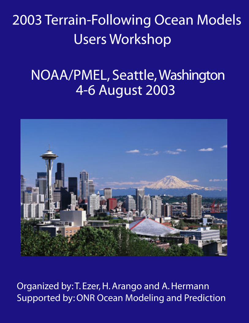
2003 Terrain-Following Ocean ModelsUsers Workshop
NOAA/PMEL, Seattle, Washington4-6 August 2003
Organized by: T. Ezer, H. Arango and A. HermannSupported by: ONR Ocean Modeling and Prediction

1
PARTICIPANTS
Name Email Ådlandsvik, Bjørn [email protected] Aguirre, Enrique [email protected] Albertson, Skip [email protected] Arango, Hernan [email protected] Bang, Inkweon [email protected] Beegle-Krause, CJ [email protected] Budgell, Paul [email protected] Capet, Xavier [email protected] Chao, Yi [email protected] Chu, Peter [email protected] Cousins, Steve [email protected] Curchitser, Enrique [email protected] Darr, David [email protected] Di Lorenzo, Emanuele [email protected] Dobbins, Elizabeth [email protected] Ezer, Tal [email protected] Fennel, Katja [email protected] Fragoso, Mauricio [email protected] Fiechter, Jerome [email protected] Fleming, Naomi [email protected] Foreman, Mike [email protected] Gan, Jianpinggan [email protected] Gross, Tom [email protected] Hadfield, Mark [email protected] Haidvogel, Dale [email protected] Hakkinen, Sirpa [email protected] Han, Guoqi [email protected] Harper, Scott [email protected] He, Ruoying [email protected] Hedstrom, Kate [email protected] Hemer, Mark [email protected] Hermann, Albert [email protected] Howard, Susan [email protected] Hu, Jianyu [email protected] Iskandarani, Mohamed [email protected] Kagimoto, Takashi [email protected] Kilanowski, Elizabeth [email protected] Kim, Chang S. [email protected] Ko, Dong S. [email protected] Koesters, Frank [email protected] Kruger, Dov [email protected] Kurapov, Alexander [email protected] Lewis, Craig [email protected] Li, Zhijin [email protected] Lou, John [email protected]
Name Email Ly, Le [email protected] MacFadyen, Amy [email protected] M. daSilva, Ricardo [email protected] Marshak, Jelena [email protected] Masson, Diane [email protected] McWilliams, James [email protected] Mellor, George [email protected] Miller, Art [email protected] Morrison, John [email protected] Soldate, Mills [email protected] Moore, Andrew [email protected] Moore, Christopher [email protected] Padman, Laurence [email protected] Pali, Madra [email protected] Payton, Debbie [email protected] Pereira, Jose Edson [email protected] Pietrzak, Julie [email protected] Powell, Tom (Zack) [email protected] Rai, Shailendra [email protected] Ro, Young Jae [email protected] Robertson, David [email protected] Robertson, Robin [email protected] Rubash, Lambert [email protected] Shchepetkin, Alexander [email protected] Sherwood, Chris [email protected] Shulman, Igor [email protected] Song, Tony [email protected] Sozer, Adil [email protected] Tang, Charles [email protected] Thompson, LuAnne [email protected] Vincent, Mark [email protected] Wang, Xiaochun [email protected] Warbus, Helen [email protected] Wei, Eugene [email protected] Wilkin, John [email protected] Williams, Bill [email protected] Worthen, Denise [email protected] Wu, Xinglong [email protected] Xie, Lian [email protected] Xue, Huijie [email protected] Zhang, Hong [email protected] Zhang, Xuebin [email protected] Zanzig, Rebecca [email protected] Zheng, Ling [email protected]
2
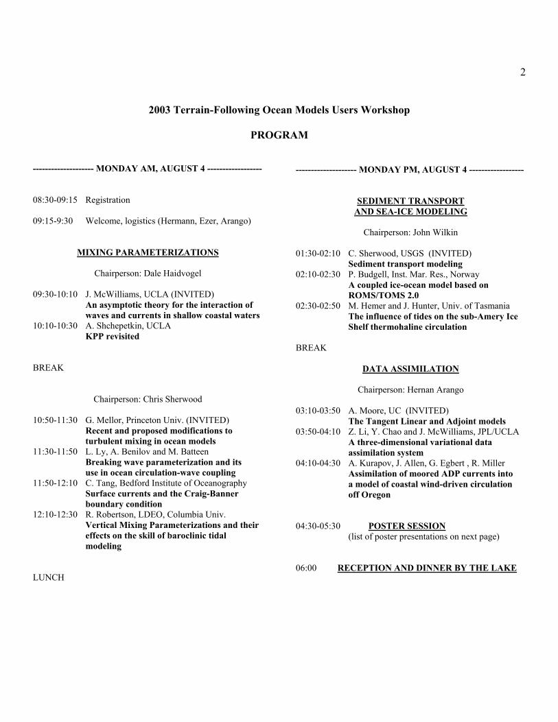
2003 Terrain-Following Ocean Models Users Workshop
PROGRAM
-------------------- MONDAY AM, AUGUST 4 ------------------ 08:30-09:15 Registration 09:15-9:30 Welcome, logistics (Hermann, Ezer, Arango)
MIXING PARAMETERIZATIONS
Chairperson: Dale Haidvogel 09:30-10:10 J. McWilliams, UCLA (INVITED) An asymptotic theory for the interaction of waves and currents in shallow coastal waters 10:10-10:30 A. Shchepetkin, UCLA KPP revisited BREAK
Chairperson: Chris Sherwood
10:50-11:30 G. Mellor, Princeton Univ. (INVITED) Recent and proposed modifications to turbulent mixing in ocean models 11:30-11:50 L. Ly, A. Benilov and M. Batteen Breaking wave parameterization and its use in ocean circulation-wave coupling 11:50-12:10 C. Tang, Bedford Institute of Oceanography Surface currents and the Craig-Banner boundary condition 12:10-12:30 R. Robertson, LDEO, Columbia Univ. Vertical Mixing Parameterizations and their effects on the skill of baroclinic tidal modeling LUNCH
-------------------- MONDAY PM, AUGUST 4 ------------------
SEDIMENT TRANSPORT AND SEA-ICE MODELING
Chairperson: John Wilkin
01:30-02:10 C. Sherwood, USGS (INVITED) Sediment transport modeling 02:10-02:30 P. Budgell, Inst. Mar. Res., Norway A coupled ice-ocean model based on ROMS/TOMS 2.0 02:30-02:50 M. Hemer and J. Hunter, Univ. of Tasmania The influence of tides on the sub-Amery Ice Shelf thermohaline circulation BREAK
DATA ASSIMILATION
Chairperson: Hernan Arango 03:10-03:50 A. Moore, UC (INVITED) The Tangent Linear and Adjoint models 03:50-04:10 Z. Li, Y. Chao and J. McWilliams, JPL/UCLA A three-dimensional variational data assimilation system 04:10-04:30 A. Kurapov, J. Allen, G. Egbert , R. Miller Assimilation of moored ADP currents into a model of coastal wind-driven circulation off Oregon 04:30-05:30 POSTER SESSION
(list of poster presentations on next page) 06:00 RECEPTION AND DINNER BY THE LAKE

3
POSTERS 1 B. Ådlandsvik, Institute of Marine Research, Norway Using ROMS in the North Sea- a validation study 2 E. Aguirre and E. Campos, Oceanog. Inst. São Paulo Univ. Sea circulation off Peruvian coast 3. S. Albertson, WA State, Dept. of Ecology A comparison of along-channel flow and residuals in a model of South Puget Sound with ADCP data along select transects 4. P. Chu and L. Ivanov, Naval Postgraduate School Prediction-skill variability in regional ocean models 5. P. Chu and A. Ong, Naval Postgraduate School Uncertainty in Diagnostic Initialization 6. J. Gan and J. S. Allan, Oregon State Univ. Open boundary condition for a limited-area coastal model off Oregon 7. G. Han, Fisheries and Oceans, Canada Tidal currents and wind-driven circulation off New Foundland 8. M. Hadfield, NIWA, New Zealand New Zealand region ocean modeling with terrain- following and z-level models 9. J. Hu and H. Kawamura, Xiamen & Tohoku Univ., Japan Numerical simulation of tides in the northern South China Sea and its adjacent seas 10. T. Kagimoto, Frontier Res. Global Change Sensitivity of the Equatorial Undercurrent to the vertical mixing parameterization 11. C. Kim and H. Lim, Korea Ocean R&D Institute Simulation of circulation and density structure of the Yellow Sea using ROMS 12. D.-S. Ko, NRL NRL DBDB2- a global topography for ocean modeling 13. F. Koesters and R. Kaese, University of Kiel, Germany Modeling of Denmark Strait Overflow 14. L. Ly, R. Stumpf, T. Gross, F. Aikman, C. Lewis and T. Powel, NPS, NOS, UC Berkeley A physical-biological model coupling study of the West Florida Shelf
15. J. Marshak and S. Hakkinen, NASA GSFC NASA POM performance optimization: costs and benefits of using MPI, SMS and OpenMP 16. D. Masson, Institute of Ocean Sciences, Canada Simulation of seasonal variability within the Straits of Georgia and Juan de Fuca using POM 17. J. Pereira, Applied Science Associates, Brazil Modeling of tidal dynamics in a resonant system. application and integration with GIS tools 18. S. Rai, Allahabad University, India Simulation of southern Indian Ocean using sigma coordinate ocean model 19. Y. Ro, Chungnam National University, Korea Data assimilation experiment in the East (Japan) Sea based on POM-ES 20. R. Robertson, LDEO, Columbia Univ. Modeling internal tides in the Ross Sea 21. L. Rubash and E. Kilanowski, Raincoast GeoResearch Experimenting with Lagrangian drifters in a Washington Lake using POM 22. A. Shchepetkin, UCLA Poor's man computation: How much power one can get from a Linux PC 23. T. Song, NASA/JPL Developing generalized vertical coordinate ocean model for multi-Scale compressible or incompressible flow applications 24. Sozer, Metu Institute of Marine Sciences, Turkey Three-dimensional numerical modeling of Bosphorus Strait 25. L. Xie, North Carolina State University Modeling inundation and draining in estuaries and coastal oceans 26. H. Xue, University of Maine Towards a forecast system for the Gulf of Maine
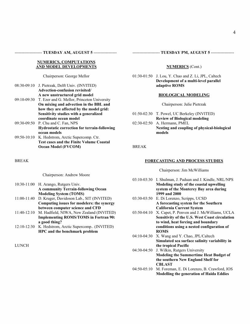
4 -------------------- TUESDAY AM, AUGUST 5 -----------------
NUMERICS, COMPUTATIONS AND MODEL DEVELOPMENTS
Chairperson: George Mellor
08:30-09:10 J. Pietrzak, Delft Univ. (INVITED) Advection-confusion revisited/ A new unstructured grid model 09:10-09:30 T. Ezer and G. Mellor, Princeton University On mixing and advection in the BBL and how they are affected by the model grid: Sensitivity studies with a generalized coordinate ocean model 09:30-09:50 P. Chu and C. Fan, NPS Hydrostatic correction for terrain-following ocean models 09:50-10:10 K. Hedstrom, Arctic Supercomp. Ctr. Test cases and the Finite Volume Coastal Ocean Model (FVCOM) BREAK
Chairperson: Andrew Moore
10:30-11:00 H. Arango, Rutgers Univ. A community Terrain-following Ocean Modeling System (TOMS) 11:00-11:40 D. Kruger, Davidoson Lab., SIT (INVITED) Computing issues for modelers: the synergy between computer science and CFD 11:40-12:10 M. Hadfield, NIWA, New Zealand (INVITED) Implementing ROMS/TOMS in Fortran 90: a good thing? 12:10-12:30 K. Hedstrom, Arctic Supercomp.. (INVITED) HPC and the benchmark problem LUNCH
-------------------- TUESDAY PM, AUGUST 5 -----------------
NUMERICS (Cont.) 01:30-01:50 J. Lou, Y. Chao and Z. Li, JPL, Caltech Development of a multi-level parallel adaptive ROMS
BIOLOGICAL MODELING
Chairperson: Julie Pietrzak 01:50-02:30 T. Powel, UC Berkeley (INVITED) Review of Biological modeling 02:30-02:50 A. Hermann, PMEL Nesting and coupling of physical-biological models BREAK
FORECASTING AND PROCESS STUDIES
Chairperson: Jim McWilliams 03:10-03:30 I. Shulman, J. Paduan and J. Kindle, NRL/NPS Modeling study of the coastal upwelling system of the Monterey Bay area during 1999 and 2000 03:30-03:50 E. Di Lorenzo, Scripps, UCSD A forecasting system for the Southern California Current System 03:50-04:10 X. Capet, P. Penven and J. McWilliams, UCLA Sensitivity of the U.S. West Coast circulation to wind, heat forcing and boundary conditions using a nested configuration of ROMS 04:10-04:30 X. Wang and Y. Chao, JPL/Caltech Simulated sea surface salinity variability in the tropical Pacific 04:30-04:50 J. Wilkin, Rutgers University Modeling the Summertime Heat Budget of the southern New England Shelf for CBLAST 04:50-05:10 M. Foreman, E. Di Lorenzo, B. Crawford, IOS Modelling the generation of Haida Eddies
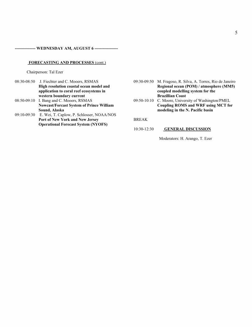
5 --------------- WEDNESDAY AM, AUGUST 6 -----------------
FORECASTING AND PROCESSES (cont.) Chairperson: Tal Ezer 08:30-08:50 J. Fiechter and C. Mooers, RSMAS High resolution coastal ocean model and application to coral reef ecosystems in western boundary current 08:50-09:10 I. Bang and C. Mooers, RSMAS Nowcast/Forcast System of Prince William Sound, Alaska 09:10-09:30 E. Wei, T. Caplow, P. Schlosser, NOAA/NOS Port of New York and New Jersey Operational Forecast System (NYOFS)
09:30-09:50 M. Fragoso, R. Silva, A. Torres, Rio de Janeiro Regional ocean (POM) / atmosphere (MM5) coupled modelling system for the Brazillian Coast 09:50-10:10 C. Moore, University of Washington/PMEL Coupling ROMS and WRF using MCT for modeling in the N. Pacific basin BREAK 10:30-12:30 GENERAL DISCUSSION
Moderators: H. Arango, T. Ezer

6
ABSTRACTS
Using ROMS in the North Sea - a validation study
Bjørn Ådlandsvik Institute of Marine Research, Bergen, Norway
The ROMS model is set up for a North Sea domain with 8 km grid size. The meteorological forcing is taken from the NCEP reanalysis. Laterally it is forced by climatology, tides, and fresh water runoff. As this is a preliminary step in seting up a nested system, the issue of open boundary conditions are ex-amined. The Flow Relaxation Scheme is implemented as an open boundary condition for the 3D baroclinc mode in ROMS. The performance of this scheme is compared with the alterna-tive boundary conditions. The model results are compared to the extensive Skagex dataset obtained in an international coordinated field experi-ment in 1990. Emphasis is put on recreating the observed tem-perature and salinity structure in the Skagerrak and the Nor-wegian coastal areas. -------------------------------------------------------------------------- Tuning of a Numerical Model (POM) for Study of Oceanic
Circulation along the Peruvian Coast.
Aguirre, E, E, L.; Campos, E. J. D. Oceanographic Institute of São Paulo University
The model is tuning with the goal of studying the oceanic cir-culation in the region of the Pacific Ocean along the Peruvian coast. The turning process consist of three stages: Generation of curvilinear grid with variable resolution, Interpolation of bathymetry, climatological data of temperature and salinity and wind stress of scatterometers ERS-1 and ERS-2 for points of the curvilinear grid, and Realization of a preliminary ex-periment of turning. First, we get the grid of finite difference through the use of GRIDPAK software. The resolution varies from near 100 Km in the oceanic region to 10 Km in regions more near to the coast. Then we get a bathymetric data used through ETOPO-2 (Earth Topography at 2 minutes resolution). The model ran for more 50 days, the circulation pattern to the end of simulation is still very indefinite, showing clearly that the model is still in the process of baroclinic tuning. In spite of that realistic simulation, we notice some inter-esting characteristics such as the raising of isotherms in re-gions nearest to the surface in the east of the grid (coastal up-welling) and also a change in the inclination of isotherms with depth. This fact suggests the change in a contrary direction of a current near the slope (Cronwell Current) --------------------------------------------------------------------------
A Terrain-Following Ocean Modeling System (TOMS)
Hernan G. Arango
Institute of Marine and Coastal Sciences, Rutgers University An overview and status report of an ongoing effort to develop the next generation terrain-following ocean model for scien-tific and operational applications will be presented. The new model was distributed to several beta testers last January and to the full ROMS community at the end of June 2003. The system includes accurate and efficient numerical algorithms, a suite of vertical mixing schemes, interfaces for coupling to atmospheric forecasting models, multiple levels of nesting and composed grids, and tangent linear and adjoint models for variational data assimilation (4DVAR, representers), ensemble forecasting, and stability analysis. The parallel framework includes both shared-memory (OpenMP) and distributed-memory (MPI) paradigms. --------------------------------------------------------------------------
Nowcast/Forcast System of Prince William Sound, Alaska
Inkweon Bang and Christopher N.K. Mooers
Ocean Prediction Experimental Laboratory (OPEL), RSMAS, University of Miami
Nowcast/Forcast System of Prince William Sound, Alaska (PWS-NFS) based on POM has been up and running since November, 2000. Beginning March 2003, a high-resolution (4 km), regional atmospheric model (PWS-RAMS) has been providing 36-hour forecast winds for PWS-NFS. A hydrologi-cal model is also implemented which forecast freshwater flux to PWS due to snowmelt in the surrounding mountains. These two major additions along with tidal sub-component which is already running makes PWS-NFS a failry comprehensive NF system. A process study has been conducted for the interaction of PWS with Northern Gulf of Alaska (Bang and Mooers, 2003. JPO, 33, 19-36) and a series of validation experiment has also been performed (Bang and Mooers, 2003. CSR, under revision). ---------------------------------------------------------------------------

7 A Coupled Ice-Ocean Model Based on ROMS/TOMS 2.0
W. Paul Budgell
Institute of Marine Research Bergen, Norway
A dynamic-thermodynamic ice module has been developed for coupling with ROMS 2.0. The ice dynamics are based upon the Elastic-Viscous-Plastic rheology of Hunke and Dukowicz (1997, 2002) and Hunke (2001). The thermodynamics are based on those of Mellor and Kantha (1989) and Häkkinen and Mellor (1992). The design and structure of the ice module will be outlined. Preliminary results from the coupled model will be presented from an application to a region consisting of the Atlantic Ocean north of 30S, the GIN Seas and the Arctic Ocean. -------------------------------------------------------------------------- Sensitivity of the U.S. West Coast circulation to wind, heat forcing and boundary conditions using a nested configura-tion of ROMS.
X. Capet, P. Penven, J. McWilliams
IGPP/UCLA, IRD, IGPP/UCLA Ocean dynamics along the U.S. West Coast (USWC) is largely driven by a seasonally upwelling favorable wind stress which generates a longshore coastal current, along with intense sub-meso- and meso-scale features. Using ROMS, a realistic Cali-fornia Current System (CCS) solution has been obtained and has revealed nearshore sensitivity to the structure of the forc-ing fields. This sensitivity is under investigation through the use of increasingly high resolution and realistic products for the wind, heat flux, and boundary conditions at the limits of the regional domain. The cross-shore baroclinic structure of the CCS long-term solutions is compared against correspond-ing long term-data (essentially along CalCOFI line 67). More generally, the effect and range of influence of localized forc-ing changes on the CCS are assessed, using Eulerian and La-grangian diagnostics. --------------------------------------------------------------------------
Uncertainty in Diagnostic Initialization
Chu, P.C., and A. Ong Naval Postgraduate School
Ocean modeling is usually constrained by the lack of observed velocity data for the initial condition. The diagnostic initiali-zation is widely used to generate velocity data as initial condi-tion for ocean modeling. It integrates the model from known temperature (Tc), salinity (Sc) and zero velocity fields and holds (Tc, Sc) unchanged. After a period of the diagnostic run, the velocity field (Vc) is established, and (Tc, Sc, Vc) fields are treated as the initial conditions for the numerical
modeling. During the diagnostic initialization period, the heat and salt 'source/sink' terms are generated at each time step. In this Thesis, the Princeton Ocean Model implemented to the South China Sea demonstrated extremely strong thermohaline sources and sinks generated by the diagnostic initialization. Such extremely strong and spatially non-uniform initial heat-ing/cooling (salting/freshening) rates in the ocean model may cause drastic change in thermohaline and velocity fields ini-tially (after the diagnostic run). There is a need to overcome such problems or find alternative methods as diagnostic ini-tialization is extensively used. --------------------------------------------------------------------------- Prediction-Skill Variability in Regional Ocean Models
Chu, P.C., and L.M. Ivanov Naval Postgraduate School
Short and intermediate range (few days to two months) fore-cast error evolution for a semi-enclosed ocean model is identi-fied using the model irreversible prediction time (IT). Model prediction skill is examined with various input uncertainties such as initial condition (IC) errors (first kind predictability), wind errors, and boundary condition (BC) errors (second kind predictability). Using the empirical orthogonal functions de-composition, the Lyapunov dimension of the system attractor is about 5.5 that in general indicates the exponential growth of initial errors. However, our results demonstrate the existence of a set of predictability regimes which are differ from the traditional exponential error growth even for the first kind of predictability. Initial error evolutes at least along fourth suc-cessive dynamical regimes: (i) first error decay, (ii) exponen-tial and super-exponential growth (iii) power growth for and (iv) saturation due to nonlinear effects. For stochastic wind forcing and uncertainty of open boundary condition we also observed altering regimes of exponential and power growth of model error and its saturation. For two sources of uncertainty, such as weakness initial errors and stochastic wind or open boundary condition error, the decay of model error was found as the first prediction regime. Statistics of IT were asymmetric non-Gaussian even for infinitesimal and small errors, prob-ability density functions of IT have long tail stretching into long and short prediction times. Excluding when initial error is white noise there are always individual predictions called "ex-treme successful predictions" which were considerably longer that the mean or the most probable ones. Multi-attractor dy-namical system conception explains specificities of prediction error behavior observed in the present study. ---------------------------------------------------------------------------
8 Hydrostatic correction for terrain-following ocean models
Chu, P.C. and C.W. Fan
Naval Postgraduate School How to reduce the horizontal pressure gradient error is a key issue in terrain-following coastal models. The horizontal pres-sure gradient splits into two parts and incomplete cancellation of the truncation errors of those parts cause the error. Use of the finite volume discretization leads to a conserved scheme for pressure gradient computation that has better truncation properties with high accuracy. The analytical coastal topogra-phy and seamount test cases are used to evaluate the new scheme. The accuracy of the new scheme is comparable to the sixth-order combined compact scheme (with an error reduc-tion by a factor of 70 comparing to the second-order scheme) with mild topography and much better than the sixth-order combined compact scheme with steep topography. The com-putational efficiency of the new scheme is comparable to the second-order difference scheme. The two characteristics, high- accuracy and computational efficiency, make this scheme use-ful for the sigma coordinate ocean models. ---------------------------------------------------------------------------
Modelling the Generation of Haida Eddies
Emanuele Di Lorenzo Scripps Institution of Oceanography, La Jolla, California
Mike Foreman, Bill Crawford
Institute of Ocean Sciences, Sidney BC, Canada
A numerical model forced with average annual cycles of cli-matological winds, surface heat flux, and temperature and salinity along the open boundaries is used to demonstrate that Haida Eddies are typically generated each winter off Cape St. James, at the southern tip of the Queen Charlotte Islands of western Canada. Annual cycles of sea surface elevation meas-ured at coastal tide gauges and TOPEX/POSEIDON crossover locations are reproduced with reasonable accuracy. Model sensitivity studies show that Haida Eddies are baroclinic in nature and are generated by the merging of several smaller eddies that have been formed to the west of Cape St. James. The generation mechanism does not require the existence of instability processes and is associated with the mean advection of warmer and fresher water from Hecate Strait around the cape. Sustained winds to the north or northwest (typical in winter) are a necessary condition for this advection and strong winds, such as those seen during the 1997-98 El Niño, have produced eddies with diameters larger than 200km and life-times longer than two years after they detach from the coast and drift into the Gulf of Alaska. ---------------------------------------------------------------------------
On mixing and advection in the BBL and how they are affected by the model grid: Sensitivity studies with
a generalized coordinate ocean model
Tal Ezer and George L. Mellor Princeton University
An extension of a sigma coordinate ocean model that includes a generalized coordinate system allows a comparison between the behavior of bottom boundary layers (BBLs) in terrain-following and in z-level vertical grids, while other numerical aspects remain unchanged. Sensitivity studies with a course resolution (100 km) basin-scale configuration and with a higher resolution (10 km and 2.5 km) regional domain are used to investigate the influence of model parameters such as horizontal diffusivity, vertical mixing, horizontal resolution, and vertical resolution on the simulation of bottom layers for the different coordinate systems. A major difference in the behavior of the BBL in the two grids is caused by a too large vertical mixing generated by the second order turbulence scheme over the step-like topography in the z-level grid, com-pared to a weaker mixing and a more stably stratified BBL in the sigma grid. Therefore, a better resolved BBL and more realistic deep-water masses are achieved with terrain-following grids, while z-level grids require additional special BBL formulations to achieve acceptable results. Increasing horizontal and vertical resolution in the z-level grid converges the results toward those obtained by a much coarser resolution sigma coordinate grid, but some differences remain due to the basic differences in the mixing process in the BBL. ---------------------------------------------------------------------------
9
Regional Ocean (POM)/Atmosphere (MMS) Coupled Modeling System for Brazilian Coast
M. R. Fragoso, R. M. Silva, Audalio R. Torres Jr.
Marine and Atmospheric Processes Modeling Laboratory Federal University of Rio de Janeiro, Brazil
The marine circulation of southeast Brazilian coast presents some interesting characteristics such as meanders and eddies that occur in Brazil Current largely influenced by a complex seabed topography, as well as ocean/atmosphere interaction processes like upwelling and sea breeze, which makes its cir-culation very complex. In order to try to capture most part of the complexity of the marine dynamics of this region, a re-gional ocean/atmosphere coupled model system (MOREA) was designed by the Marine and Atmospheric Processes Mod-eling Laboratory (LAMMA) of the Federal University of Rio de Janeiro - Brazil. The MOREA system consists in coupling the Princeton Ocean Model (POM) (using boundary and initial conditions provided by the Modular Ocean Model - MOM) with the PSU/NCAR Mesoscale Modeling System (MMS) (using boundary and initial conditions provided by reanalyses NCEP project). The MOREA system intends to be a diagnos-tic and prognostic system of ocean and atmosphere, in re-gional scale, of the southeast Brazilian coast. Strategy of cou-pling and preliminary results will be shown and discussed. --------------------------------------------------------------------------- High-Resolution Coastal Ocean Model and Application to
Coral Reef Ecosystems in Western Boundary Current
Jerome Fiechter and Christopher N.K. Mooers RSMAS, University of Miami
The East Florida Shelf - Princeton Ocean Model (EFS-POM) is implemented as part of the Southeast Atlantic - Coastal Ocean Observing System (SEA-COOS) program. With a high-resolution of ca. 2-6km horizontally and 25 terrain-following levels, the model is used to study the variability of the Florida Current under synoptic atmospheric forcing for periods of several years. Sea surface temperatures and coastal sea levels are compared with observations from moored buoys and tide gauges. EFS-POM also serves as a source for open boundary conditions to drive a nested model of the Dry Tortugas do-main. With horizontal resolutions of less than 1km, this local model is aimed at predicting the influence of physical vari-ables such as temperature, salinity and turbulence on coral reef communities. In addition to the Eulerian fields, a Lagrangian approach is used to investigate transient circulation patterns and provide some insight about possible pathways and rates for larval dispersion and recruitment at both local and regional scales. ---------------------------------------------------------------------------
Open boundary condition for a limited-area coastal model off Oregon
Jianping Gan and J. S. Allen
Oregon State University Open boundary conditions (OBCs) developed for a limited-area high-resolution coastal ocean model off Oregon are dis-cussed in this study. The OBCs separate not only the inward and outward fluxes, but also the local and the coastally-trapped wave-related global solutions at the open boundaries. The external information, which is provided by a reduced-physics two-dimensional (x-z) model in this study, is smoothly imposed into the model domain during inward flux. The dis-turbances from the interior of the model are radiated out of the domain by applying radiation boundary condition on the global solutions during outflow conditions. To ensure consis-tancy, the same OBCs are applied to both barotropic and baro-clinic variables. A weak spatial smoother is used in the global part of the solution at the open boundary where long coastal trapped waves exit to effectively eliminate noisy fluctuations. The transition between inward and outward fluxes is coped with using a weak relaxation process. A number of experi-ments are conducted to examine the effects of OBCs on shelf flow fields from different wind and outer forcing regimes. The model response during 1999 to spatially variable forcing by heat flux and wind stress obtained from a mesoscale atmos-pheric model is presented. ---------------------------------------------------------------------------
Implementing ROMS in Fortran 90: a good thing?
Mark Hadfield National Institute of Water and Atmospheric Research
ROMS 2 is written in Fortran 90, whereas ROMS 1 was writ-ten in Fortran 77. The new version makes use of some of the new features in Fortran 90 (eg. composite data types, dynamic memory allocation) but not of others (eg. operations on array subsets). As a result, performance appears not to have suffered and in some situations has improved. At NIWA, ROMS has been run on single-processor workstations and on a distrib-uted-memory supercomputer (Cray T3E). I will discuss its performance on these platforms, point out some pitfalls and draw some general lessons for implementing ocean hydrody-namics codes in Fortran 90. ---------------------------------------------------------------------------

10
NZ region ocean modelling with terrain-following and z-level models
Mark Hadfield and Graham Rickard
National Institute of Water and Atmospheric Research
We have attempted to capture the mean circulation in the vi-cinity of New Zealand on a domain covering some 50 degrees latitude by 40 degrees longitude. Flow in this domain is con-trolled by the interaction of global and basin-scale currents (notably the Antarctic Circumpolar Current and the South Pa-cific western boundary current) with the topography of the New Zealand land mass. Simulations with a z-level model, MOMA, have been reasonably successful in matching obser-vations. Simulations with a terrain-following model, ROMS, have been less successful. We find that ROMS is affected by a tendency observed in other terrain-following models: it sup-ports vertically coherent, bathymetrically locked currents. This has unfortunate consequences for the flow around the eastern edge of the land mass. The presentation will describe the prob-lem and discuss attempts to resolve it. --------------------------------------------------------------------------- NASA POM performance optimization: costs and benefits
of using MPI, SMS and OpenMP
Sirpa Hakkinen, Jelena Marshak Goddard Space Flight Center, NASA
NASA version of POM represents Coupled Ice-Ocean Model. POM was developed in late 1970 by G. Mellor and A. Blum-berg; in 1990, Ice Model functionality was added to the POM by S. Hakkinen, who continues to enhance and use the Cou-pled Model for Arctic-North Atlantic climate modeling. As the computing technology advances it offers ways to optimize the performance of NASA POM, which was recently ported from Cray SV1 and Cray T3E machines to Compaq CS45. In an attempt to find the best way to decrease the execution time, several optimization techniques were applied to the model code, including MPI, SMS and OpenMP. Each of them has their own benefits and disadvantages. The presented poster will compare and analyze the techniques based on their appli-cation to the Ice-Ocean Model. ---------------------------------------------------------------------------
Test Problems and FVCOM
Kate Hedstrom University of Alaska Fairbanks, ARSC
The Finite Volume Coastal Ocean Model (FVCOM, Chen et al.) is a new sigma coordinate model, using unstructured, tri-angular grids. We are considering its use in the Gulf of Alaska due to the nature of the coastline there. Before trying any model in a realistic environment, the logical thing to do is to try it on some test problems. This allows us to learn about its numerical characteristics in a controlled environment and al-lows us to learn the model in a relatively small domain. I will present the results of FVCOM with several of the Haidvogel and Beckmann test problems. ---------------------------------------------------------------------------
HPC and the ROMS benchmark Problem
Kate Hedstrom University of Alaska Fairbanks, ARSC
The Arctic Region Supercomputing Center is in the process of acquiring two new supercomputers. Other groups are also con-sidering new equipment so we felt that creating a BENCH-MARK application for comparing these systems would be a good idea. Our experiences with this problem on the ARSC computers will be described, as will the computers them-selves. ---------------------------------------------------------------------------
The influence of tides on the sub-Amery Ice Shelf thermohaline circulation.
Mark Hemer, John Hunter
Antarctic Co-operative Research Centre, University of Tasmania
A modified version of the free-surface Princeton Ocean Model is applied to the ocean cavity beneath the Amery Ice Shelf, East Antarctica, with tides included in the dynamics. The mean density driven circulation beneath the ice shelf is characterised by a buoyancy driven overturning circulation caused by melting and freezing at the base of the ice shelf pa-rameterised in the model with surface heat, salt and mass fluxes. The effects of increased mixing as a result of tidal forcing at the open boundaries will be presented - both on the pre-dicted mass balance of the ice shelf, and on the mean sub-ice-shelf circulation. The influence of global warming on the melting and freez-ing rates in the sub-ice-shelf cavity, and its dependence on tides, will also be discussed.

11
Numerical Simulation of Tides in the Northern South China Sea and its Adjacent Seas
Jianyu Hu, Hiroshi Kawamura
Institute of Subtropical Oceanography, Xiamen University,
China; Center for Atmospheric and Oceanic Studies, Tohoku University, Japan
Princeton Ocean Model (POM) has been used to simulate the tides in the northern South China Sea and its adjacent seas. The model has a horizontal grid spacing of 1/12deg in longi-tude × 1/12deg in latitude (about 9.26 km) and is applied to the studied area between 105.5E-128.5E and 15.0N-30.0N. It is simultaneously forced by seven principal tidal constituents (M2, S2, K1, O1, P1, N2 and K2) at the east, south and north open boundaries. The harmonic constant of each considered tidal constituent at the open boundary is obtained using the tidal harmonic constants derived from 6 years of TOPEX/POSEIDON altimeter data from 1993 to 1999. The simulated results in a barotropical state indicate that the co-tidal charts of all these principal tidal constituents are in good agreement with those derived from satellite altimeter data and in situ observations. Finally, several problems encountered with the baroclinic tidal simulation are discussed. --------------------------------------------------------------------------- Sensitivity of the Equatorial Undercurrent to the vertical
mixing parameterization
Takashi Kagimoto Frontier Research System for Global Change, Japan.
How the Equatorial Undercurrent (EUC) is spun up in the nu-merical model is examined with various kinds of vertical mix-ing parameterizations. The Princeton Ocean Model with the modified turbulent closure model (Mellor, 2001) could not represent the EUC well. Maximum zonal velocity of the simu-lated EUC is at most 20cm/sec and its spatial structure is very far from the real one. This is due to the upper bound for the non-dimensional shear function (GM). When the vertical shear increases, the turbulent kinetic energy also increases because of the upper bound. This leads to the large vertical eddy vis-cosity and tends to destroy the vertical shear between the South Equatorial Current and the EUC. This is not the case with the original Mellor-Yamada 2.5 turbulent closure model. In fact, it does not have such the upper bound for the GM function. ---------------------------------------------------------------------------
Inter-annual variability of circulation and water mass properties in the Yellow Sea using ROMS
Chang S. Kim and H.S. Lim Korea Ocean R&D Institute
Digital Ocean and Virtual Environment Center The Yellow Sea is characterized by relatively shallow water depth, varying range of tidal action and very complex coastal geometry such as islands, bays, peninsulas, tidal flats, shoals etc. The dynamic system is controlled by tides, regional winds, river discharge, and interaction with the Kuroshio. The circulation, water mass properties and their variability in the Yellow Sea are very complicated and still far from clear un-derstanding. Numerical simulation of using the ROMS model was con-ducted for seasonal circulation and thermohaline structure in the Yellow Sea. This study demonstrates the applicability of the terrain-following ROMS model to major processes in the Yellow Sea such as distinct features of different circulation patterns, dilution of seawater due to fresh water discharge from major rivers, exchange between coastal waters and shelf waters across the tidal fronts etc. The model adopts curvilinear grid with horizontal resolu-tion of 3 -5 km and 20 vertical grid spacing confirming to rela-tively realistic bottom topography. The model was initialized with the LEVITUS annual climatological data and forced by the monthly mean air-sea fluxes of momentum, heat and fresh water derived from COADS. On the open boundaries, clima-tological temperature and salinity are nudged every 5 days for data assimilation. During the simulation run after the initial run, the model was integrated again for another several more years with climatological monthly mean surface wind stress, net heat flux, and fresh-water flux from the COADS data and available regional environmental data. This study demonstrates a Yellow Sea version of Atlantic Basin experiment conducted by Haidvogel et al. (2000) ex-periment that the ROMS simulates the dynamic variability of temperature, salinity, and velocity fields in the ocean. ---------------------------------------------------------------------------
12
Modeling the Denmark Strait Overflow
Frank Koesters, Rolf Kaese
Institute for Geosciences, Institute for Marine Research University of Kiel
The Denmark Strait plays an important role as a dense water gateway from the Arctic to the North Atlantic. Previous stud-ies have shown that the volume transported over the sill is limited by hydraulic constraints. A regional ocean circulation model (ROMS) with a horizontal resolution of 1/20 degree and 30 sigma levels in the vertical is applied to study present-day throughflow characteristics. First, a process model is used changing the upstream reservoir conditions systematically to test hydraulic limitations. Generally, the throughflow is less than the predicted maximal value from hydraulic theory by almost 50%. Second, the process model is extended to realistic climatology and surface forcing. Model results indicate only a weak influence of the vertical stratification on the overflow but changes in entrainment and overflow path. Moreover, di-rect influence of wind seems to be minor. The results will be compared to observations and an initial open-boundary ver-sion of the model. ---------------------------------------------------------------------------
Computing Issues for Modelers: The Synergy between Computer Science and CFD
Dov Kruger, Anne Pence and Alan Blumberg
Davidson Laboratory, Stevens Institute of Technology CFD Modelers are dependent on computers, so it is little sur-prise that computer science knowledge can have a beneficial effect on modeling. We present an overview on: (1)hardware characteristics (using the PC architecture as an exam-ple),(2)price/performance ratio of various computing solu-tions, (3)single-CPU optimization techniques and heuristics, (4) shared memory parallelization (automatic and OpenMP), and (5) MPI. The second part focuses on optimization and accuracy and how computer science and CFD modeling each hold promise at improving the state of the art of the other discipline. We first try to debunk scientists' generally optimistic view of what compilers will and will not optimize. We show that a com-puter-science focus enables us to manually speed the core al-gorithms in ECOMSED /POM by a factor of 3 to 7, and even-tually, we hope roughly a factor of 5 overall. Getting an im-mediate performance jump by a factor of two or three is rela-tively easy; further optimizations are quite difficult and make the code increasingly difficult to understand. We then propose automated tools to solve this need. In the course of these ex-periments, we have incorporated the the knowledge of CFD modelers to define a new set of optimizations that will dra-matically enhance performance of next-generation models
without requiring the laborious hand optimizations that are currently needed. Examples include a sample 20-fold im-provement in computational speed of bottom shear, a high speed implementation for calculation of density. Last, we discuss computational accuracy, and point out inconsistencies in the current models; some routines are com-puted very accurately even though the accuracy is discarded immediately afterward. We point out solutions, and point out that a more coherent strategy is needed to validate models and prevent potential problems. ---------------------------------------------------------------------------
Assimilation of moored ADP currents into a model of coastal wind-driven circulation off Oregon
Alexander L. Kurapov , J. S. Allen, G. D. Egbert, R. N. Miller
COAS/ Oregon State University A system based on the Princeton Ocean Model and an optimal interpolation (OI) sequential data assimilation (DA) algorithm is utilized to assimilate low-pass filtered velocity measure-ments from an array of moored Acoustic Doppler Profilers (ADP) installed off Oregon during the COAST (Coastal Ad-vances in Shelf Transport) field experiment, May-August 2001. An inhomogeneous stationary estimate of the forecast error covariance, required for OI, was obtained from averag-ing over an ensemble of model solutions. Our objectives in-clude determination of the alongshore spatial scales of influ-ence of assimilated currents and examination of multivariate capabilities of the data assimilation system. Different data sets from the COAST field experiment are used for model valida-tion. We find that DA improves prediction of the currents at an alongshore distance of 90 km from the site where data were assimilated, both to the north and to the south. Improvement to the south in part results from advection of corrections with the southward upwelling jet. Improvement to the north may be an effect of northward propagation of information with coastally trapped waves. Assimilation of moored ADP velocities im-proves modeled sea surface height near the coast and isopy-cnal structure in the interior. Discussion of solutions con-strained by the data includes analysis of a cross-shelf transport and of dynamical processes responsible for biological produc-tivity on the mid-Oregon shelf, for instance, spatial and tem-poral variability in bottom boundary layer processes. ---------------------------------------------------------------------------

13 A three-dimensional variational data assimilation system
for ROMS
Zhijin Li and Yi Chao Jet Propulsion Laboratory
James McWilliams
University of California, Los Angeles A real-time three-dimensional variational data assimilation system (3DVAR) has been developed for ROMS, and imple-mented in a real-time forecasting system for the U. S. West coastal region. This 3DVAR system assimilates sea surface temperatures (SSTs)and along track sea surface heights (SSHs) from multiple satellites, as well as a variety of in-situ measurements. The real-time implementation of this 3DVAR has shown satisfactory performance in terms of results, reli-ability and efficency. Some particular strategies are implemented in this 3DVAR. A new strategy for constructing three-dimensional error self-covariances and cross-covariance is developed, which allows us to construct inhomogeneous and anisotropic error correlations. To guarantee assimilated currents to be well in dynamic balances, the 3DVAR is further implemented with constraints in geostrophic and hydrostatic balances that are applied to the analysis increment. This 3DVAR system has been programmed with both OpenMP and MPI parallelism. The limited-memory quasi Newton minimization algorithm that has been recognized to be the most efficient algorithm for atmospheric and oceanic data assimilation is employed. ---------------------------------------------------------------------------
Development of a multi-level parallel adaptive ROMS
John Z. Lou, Yi Chao, Zhijin Li JPL/Caltech
We describe a framework of performing multi-level parallel computations in the ROMS model, and an implementation of the framework with the help of a parallel adaptive mesh li-brary called PARAMESH in a Fortran 90 environment. Topics to be discussed include assumptions on concurrent multi-level ROMS, adaptive mesh generation in a block-tree (PA-RAMESH) framework, tools needed and issues for multi-level computing and coupling, and load-balancing. A test case of ROMS US West model under this framework will also be dis-cussed. ---------------------------------------------------------------------------
On a New Version of Breaking Wave Parameterization and Its Use in Ocean Circulation-Wave Coupling
Le Ly
Dept. of Oceanography, NPS, Monterey, CA 93943
Alexander Benilov Davidson Lab, Stevens Institute of Technology, NJ 07030
Mary Batteen
Dept. of Oceanography, NPS, Monterey, CA 93943 Breaking waves are considered an important source of turbu-lent energy, in addition to traditional shear production in the air-sea system at all scales. Breaking waves also play an im-portant role in the development of thermo-dynamical and tur-bulent structures in the ocean. Based on a new concept of oce-anic turbulence and a wave-breaking model, a surface wave parameterization is developed. This wave parameterization with wave-dependent roughness is compared with available data on wave-dependent turbulence dissipation, roughness length, drag coefficient, and momentum fluxes using a cou-pled air-wave-sea model. Taking the wind-wave-turbulence-current relationship into account, a turbulence closure with the wave parameterization is used in the POM model to create the NAval postgraduate school ocean Model (NAM). The wave parameterization in the model is able to relate model variables to wave parameters such as wave height, age, phase speed, period, and length. The NAM box model is used in an ocean circulation-wave cou-pling study with idealized wave height and wave age fields for the idealized California Coast region. This study is focused on the sensitivity of the current field to the surface waves. The study also demonstrates the capability of the NAM model to reproduce an observed upwelling feature for the California Coast region. ---------------------------------------------------------------------------

14
A Physical-Biological Model Coupling Study of the West Florida Shelf
Le Ly (1,2)
National Ocean Service, NOAA Dept. of Oceanography, Naval Postgrad School
Richard Stumpf, Thomas Gross and Frank Aiman III
National Ocean Service, NOAA
C. Lewis and T. Powel UC Berkeley
Studies have shown that harmful algae blooms (HAB) of Karenia Brevis routinely occur along the West Florida Shelf in late summer and can persist for months. These blooms can impact commercial and recreational fisheries and the tourist industry through inducing neurotoxin shellfish poisoning. An effort to monitor and forecast these blooms has been ongoing by NOAA for the past several years. A physical-biological coupled model is used for the West Florida Shelf (WFS) in which the Regional Ocean Modeling System (U.C. Berkeley version) is coupled with a biological model of four compo-nents, NPZD (Nutrient, Phytoplankton, Zooplankton and De-tritus). The WFS model is set up with realistic bathymetry, temperature, salinity and wind forcing and numerical experi-ments are carried out to study the model physical-biological interaction under wind and stratification conditions that ex-isted during the late summers and autumns of 2000 and 2001. The model results are compared with available data and dis-cussed. ---------------------------------------------------------------------------
An Asymptotic Theory for the Interaction of Waves and Currents in Shallow Coastal Waters
James C. McWilliams, UCLA
The scientific study of oceanic surface gravity waves is a ma-ture topic, operational implementation of WAM-type assimila-tion and forecast models (Komen, 1994). The topic of wave effects on oceanic currents is much less mature. From the per-spective of the wave community, the waves provide an aver-aged radiation stress tensor, T, whose divergence accelerates currents, at the shoreline (Longuet-Higgins & Stewart, 1964; Longuet-Higgins, 1970; Hasselmann,1971) in addition to the extra local mixing due to wave breaking. This approach has had conspicuous success in predicting nearshore currents that result from wave dissipation in the surfzone. However, this viewpoint, while formally correct, usually does not capture the principal wave effects when the output of a WAM-type model is used to evaluate T. The more generally useful perspective comes from the type of asymptotic-expansion and wave-averaging theory first made by Craik & Leibovich (1976). This implicates a wave-averaged vortex force, U^s x (del x v) - where U^s is the waves' Stokes drift and v is the current ve-locity - that has had great success as the basis for understand-ing and simulating Langmuir Circulations and their material transport in the surface boundary layer (McWilliams, 1997). This type of theory was extended to include corrections to the mean Ekman currents, Stokes-drift Lagrangian transport of material concentrations, and wave modification of the infer-ence of surface geostrophic pressure from sea level measure-ments (e.g., altimetry), all of which have been empirically estimated as significant (McWilliams & Restrepo, 1999) but which still lack direct observational testing. Recently a further generalization to average over the ap-proximately 100 m horizontal scale of the wave spectrum peak, adds even greater structure to the predicted wave-averaged dynamical effects on strong (e.g., coastal) currents and associated material distributions(McWilliams, 2003). In it a multi-scale asymptotic theory is derived for the evolution and interaction of surface gravity waves and currents in water of finite depth, under conditions typical of coastal shelf wa-ters. The practical utility of the theory is that it provides a model with which shelf dynamics may be explored without the necessity of resolving features of the flow on space and time scales of the primary gravity-wave oscillations. The essential nature of the dynamical interaction is currents modulating the slowly evolving phase of the wave field and waves providing both phase-averaged forcing of long surface waves and vortex forces for the current evolution equations. Analogous relations are derived for material tracers and density stratification which include phase-averaged Stokes-drift advection. Illustrative solutions are analyzed for the special case of depth-independent currents. Prospects are discussed for its imple-mentation in ROMS and application to realistic coastal phe-nomena.

15
Recent and proposed modifications to turbulent mixing in ocean models
George L. Mellor
Atmospheric and Oceanic Sciences, Princeton University The talk will review three areas of recent research aimed at improving turbulent mixing in ocean models: 1. The paper by Mellor (2002) parameterized the effects of wave induced oscillations on bottom friction by the addition of production to the TKE equation and by modifying the law-of-the-wall appropriately. It was then found (Newberger, per-sonal communication) that the parameterization became inef-fectual for poor bottom vertical resolution relative to the scale of the bottom boundary layer. Very recently, this problem has been significantly alleviated. 2. The wave breaking scheme of Craig and Banner (1994) has been inserted into the Mellor-Yamada turbulence closure model along with consideration of wave induced enhancement of the surface drag coefficient (Mellor and Blumberg, 2003). Mixing is enhanced during the summer months when the sur-face boundary layer is shallow. 3. A new formulation to provide coupling between ocean circulation models and wave models has been derived, expos-ing fundamental unknowns and suggesting the need for new research (Mellor, 2003). Craig, P. D. and M. L. Banner, 1994: Modeling wave-enhanced turbulence in the ocean surface layer. J. Phys. Oceanogr., 24, 2546-2559. Mellor, G. L., 2002: The oscillatory bottom boundary layer. J. Phys. Oceanogr., 32, 3075-3088. Mellor, G. L. and A. Blumberg, 2003: Wave breaking and surface layer thermal response. Submitted to J. Phys. Oceanogr. Mellor, G. L., 2003: The three dimensional, current and surface wave equations. J. Phys. Oceanogr., In Press. ---------------------------------------------------------------------------
A new unstructured grid finite volume coastal ocean model
Julie Pietrzak, David Ham and Guus Stelling Delft University of Technology, The Netherlands
A novel unstructured grid semi-implicit finite volume ocean model is presented. The model solves the three-dimensional hydrostatic primitive equations. Typically coastal and oceanic models employ horizontal orthogonal curvilinear co-ordinates in order to resolve lateral boundaries and bathymetric features. Unfortunately this approach lacks flexibility in modelling ir-regular coastlines and bathymetry. However, complex bathymetry needs to be resolved in order to compute details of transport pathways in oceanic and coastal basins. In addition coastal and boundary flows are dominated by alongshore flows in approximate geostrophic balance. For such flows it is important to ensure that the cross-shore region within a Rossby radius of the coast is well resolved. At the same time it is important to resolve the details of the coastline variability and bathymetry, since these too have an important influence on the alongshore propagation of waves and on coastal trans-port processes in general. Therefore an unstructured model approach was adopted here. Mass conservation was consid-ered an important property consequently a finite volume tech-nique was employed. The North Sea has a complex topogra-phy including a deep trench in the north and shallow and vari-able topography in the south. In addition it has complex lateral boundaries that need to be resolved. Here examples of Kelvin wave propagation in the North Sea are considered in order to demonstrate the advantages of horizontal grid flexibility of-fered by the unstructured approach. ---------------------------------------------------------------------------
Simulation of Southern Indian Ocean Using Sigma Coordinate Ocean Model
Shailendra Rai, A. C. Pandey and A.P. Mishra
Banerjee Centre of Atmospheric & Ocean Studies, Allahabd University
A sigma coordinate, free surface numerical model with turbu-lance has been implemented for Southern Indian Ocean from 60S to 10N and 50E to 120E. It is driven at surface by monthly SST and wind stress climatologies and run for one year. Horizontal Circulation, Model climate drift for tempera-ture and salinity initial condition are described. ---------------------------------------------------------------------------

16
Data Assimilation Experiment in the East (Japan) Sea Based on POM-ES
Young Jae Ro
Dept. of Oceanography, Chungnam National University Yusung-ku, Kung-dong 220, Taejon, Korea, 305-764
The pattern of the East (Japan) Sea water circulation is still poorly understood, owing to its highly complicated boundary current system and their significant seasonal and interannual variability. One of the most prominent features in the East (Japan) Sea is the Polar Front separating the water masses from the warm and saline water in the south supplied by the Kuroshio and the cold and fresher water in the north. The for-mation of the polar front in the East (Japan) Sea and its vari-ability is one of crucial processes in understanding the general circulation in this region. This study will focus on this key question with numerical modeling based on POM-ES. POM-ES (Ro, 1999; 2000; 2001) was developed based on Princeton Ocean Model with realistic bottom topography. Model con-figuration is designed with grid resolution (1/10 deg), bottom topography, boundary conditions (three open boundaries at Korea, Tsushima, and Soya Strait with 3 (Sv) seasonally vary-ing transport), monthly surface forcings with wind stress and radiation. POM-ES was initially spinned up with monthly GDEM dataset in diagnostic mode for three years and ran for next 30 years in prognostic mode with 3-D T-S nudging scheme. Model is restarted with the final output with data as-similation of satellite SST and T/P SSA Two schemes of data assimilation (nudging and adjoint) are used. --------------------------------------------------------------------------- Vertical Mixing Parameterizations and their effects on the
skill of Baroclinic Tidal Modeling
Robin Robertson Lamont-Doherty Earth Observatory
The skill of different vertical mixing parameterizations was evaluated with respect to baroclinic tidal modeling over Fie-berling Guyot using observational velocity and dissipation data. The different parameterizations evaluated were generic length scale, Pacanowski-Philandar (PP), a modification of PP developed at Lamont-Doherty Earth Observatory (LDEO), Large-McWilliams-Doney (LMD) Kp profile, a modification of LMD developed by a group at Oregon State Univ., Mellor-Yamada 2.5 level turbulence closure, and a Brunt-Väisälä fre-quency based scheme. The generic length scale parameteriza-tion was found to perform the best, followed by a modification of the Pacanowski-Philandar parameterization made by a group at LDEO Good agreement was found between the ver-tical viscosity estimated by the model and observations in the region. ---------------------------------------------------------------------------
Experimenting with Lagrangian Drifters in a Washington Lake Using POM
Rubash, Lambert L.
Raincoast GeoResearch
Kilanowski, Elizabeth M. Raincoast GeoResearch
To simulate drifter tracking experiments, POM was config-ured for Lake Whatcom in northern Washington State and a routine was written to advance an array of drifter positions once for every cycle of the internal mode loop. A 300 x 100 x 21 cell grid was used and a masking technique was incorpo-rated to remove dry cells from computational loops. Much of the lake's watershed is periodically logged, and a significant and growing portion is residential; the lake itself serves both recreational users, and as an industrial, and drink-ing water source for the nearby city of Bellingham. Concern about degrading water quality has created a need for publicly available circulation data in an easily understood form. Public discussion is generally based on an implied assump-tion that the lake is a long, deep, narrow body of nearly still water that slowly moves from southeast to northwest. Much of the water that enters in the southeast is glacial meltwater that is popularly thought to refresh and cleanse the lake, although a settling pond is used to remove suspended solids before the water enters the lake. Flushing time has been estimated to be about 14 years, and this flushing time is often confused with average water movement. This study demonstrated that simulated drifter tracking can provide circulation study data that contradicts public percep-tions, and yet is sufficiently accessible and intuitive to be able to overcome public mistrust of scientific authority. The drift-ers in this study also traced unsuspected local circulation pat-terns that surprised researchers, but were as would be ex-pected, once revealed. ---------------------------------------------------------------------------

17
Modeling study of the coastal upwelling system of the Monterey Bay area during 1999 and 2000.
Igor Shulman
Naval Research Laboratory, Stennis Space Center
Jeff Paduan, Leslie Rosenfeld, Steve Ramp Naval Postgraduate School
John Kindle
Naval Research Laboratory, Stennis Space Center The focus of this paper is to demonstrate the capability of a Monterey Bay area high-resolution model (1-4 km and 30 vertical levels) to track the major features in an upwelling sys-tem when constrained by the proposed measurement suite and nested within a regional model. The model was originally con-figured as part of the Innovative Coastal-Ocean Observing Network (ICON) program. In order to include dominant flow regimes from the California Current system and the important effects of processes crossing from the deep water to the conti-nental shelf, the ICON model is nested within the regional-scale NRL Pacific West Coast (PWC) model. The ICON model has been forced with atmospheric products from both coarser-resolution NOGAPS and finer-resolution COAMPS Navy atmospheric models; the ICON model assimilates HF radar-derived surface currents and MCSST data. The ICON model simulations reproduce upwelling fila-ments originating at Pt. Ano Nuevo and Pt. Sur north and south of Monterey Bay, respectively. These upwelling fila-ments form and decay with realistic space and time scales and produce a realistic meandering front between the cooler, up-welled water and the warmer water of the California Current. A narrow, poleward-flowing California Undercurrent along the continental slope is another realistic feature of the simula-tions. Analyses of ICON model runs show that high-resolution atmospheric forcing (e.g., COAMPS wind and heat fluxes) as well as accurate open boundary conditions (e.g., PWC model runs also forced with COAMPS) are equally critical for the model accuracy within this relatively small (~100 km) do-main. Data assimilation of HF radar-derived surface current maps is shown to improve model tracking of mesoscale fea-tures between the surface and depths around 100 m. ---------------------------------------------------------------------------
Developing the Generalized Coordinate Ocean Model for Multi-Scale Compressible or Incompressible Flow
Applications
Tony Song NASA/JPL
Two physical parameters are introduced into the basic ocean equations to generalize an ocean model for using the optimal or hybrid features of the commonly used z-level, terrain-following, isopycnal, and pressure coordinates in a single nu-merical configuration. The two parameters are formulated by combining three techniques: the arbitrary vertical coordinate system of Kasahara (1974), the Jacobian pressure gradient formulation of Song (1998), and a newly developed paramet-ric function that permits both compressible (conserving mass) and incompressible (conserving volume) flow conditions. Based on the new formulation, a generalized modeling ap-proach is proposed and a staggered finite volume method is designed to ensure conservation of important physical proper-ties and numerical accuracy. Several representing oceanographic problems with differ-ent scales and characteristics- coastal canyon, seamount to-pography, and non-Boussinesq Pacific Ocean with nested high-resolution cold-tongue region are used to test the pro-posed new model. The results show that the model is capable of resolving multi-scale processes with both compressible and incompressible conditions in the same numerical configura-tion. The inclusion of the compressible physics in the topogra-phy-following ocean model does not incur computational ex-pense, but more faithfully represents satellite sensing data, such as TOPEX sea-surface elevation and GRACE bottom-pressure anomaly, which directly measure the changes of the water mass, instead of the changes of the water volume. Such a generalized coordinate model is expected to benefit diverse ocean modelers for solving a variety of ocean-related prob-lems and for sharing modeling resources with less restrictions. ---------------------------------------------------------------------------
18
Application of a Three-Dimensional Numerical Model to the Idealized Conditions of the Bosphorus strait
Adil Sozer and Emin Ozsoy
Metu Institute of Marine Sciences, Turkey
The Bosphorus strait is a narrow and shallow channel between the Sea of Marmara and the Black Sea which plays an impor-tant role in the Turkish Straits System connecting the Black Sea and the Mediterranean Sea. Having the narrowest and shallowest channel geometry within the System, it is the most important element constraining the exchange between the Black Sea the Mediterranean Seas. In this study, the response of the strait is investigated with respect to open boundary conditions corresponding to ideal-ized geometrical hydrographical conditions. The free-surface, primitive equation ocean model, SCRUM, was used for nu-merical simulations. Many simulations were performed in-cluding the testing of boundary conditions, experiments with different type of horizontal and vertical mixing and diffusion parametrizations, advection schemes and tests of geometrical effects as well as grid resolution and type. These simulations showed the three-dimensional model to be applicable to the special case of strait exchange flows. The selection of the open boundary conditions is a non-trivial first step for successful application of the model. The results ob-tained from the tests with the idealized conditions correspond-ing to Bosphorus Strait indicate the need for judicious choices of boundary conditions, which depend on the flow direction. However the results obtained with these choices and even the case with purely radiation boundary conditions started from the 'lock-exchange' initial condition support the existence of maximal exchange controlled flows exemplified by observa-tions in the Bosphorus. ---------------------------------------------------------------------------
Surface currents and the Craig-Banner boundary conditions
Charles Tang
Bedford Institute of Oceanography The Princeton Ocean Model has been applied to the eastern Canadian seas for studies of high-latitude processes and fore-casting of ocean conditions. Model results of circulation and deep convection in Labrador Sea, seasonal variation of sea-ice coverage, wind-driven surface currents will be shown. The model gives satisfactory results except surface currents as can be seen in a comparison of model simulated surface drifts and trajectories of surface drifters deployed on the Grand Banks in the fall of 2002. We propose that the lack of wave effects in POM is mainly responsible for the discrepancy between model and observation. The Craig-Banner boundary condition, the Stokes drift and coupling of surface waves and Ekman layer will be discussed. ---------------------------------------------------------------------------
Simulated Sea Surface Salinity Variability in the Tropical Pacific
Xiaochun Wang, Yi Chao
JPL/Caltech The Sea Surface Salinity (SSS) variability simulated by an oceanic general circulation model forced by daily NCEP-NCAR reanalysis from 1990 to 2001 is analyzed in the letter. With daily forcing, the model can reproduce SSS change of the tropical Pacific on different timescales. The model-simulated SSS compares well with the Tropical Atmosphere Ocean (TAO) mooring observation. The correlation coeffi-cients between the model output and observation are around 0.6 and significant at a level of 99% for selected sites that have relatively long observations. The western tropical Pacific is a large variability center on different timescales. On the interannual timescale, the standard deviation of SSS in the region could reach 0.4 practical salinity unit (psu). The 1997-1998 ENSO event is associated with a freshening of the whole equatorial Pacific with an amplitude as large as 0.6 psu. However, the eastern equatorial Pacific shows relatively weak SSS variability (0.1 psu), implying that the western tropical Pacific and the eastern tropical Pacific have quite dif-ferent mechanisms of SSS changes. On the seasonal timescale, the western tropical Pacific has variability around 0.3 psu. On the intraseasonal timescale (timescale shorter than 50 days), SSS variability in the equatorial Pacific has an amplitude of 0.1 psu. Relevance to the upcoming Aquarius satellite mission to measure SSS from space is discussed. ---------------------------------------------------------------------------

19 Modeling the Summertime Heat Budget of Southeast New
England Shelf Waters
John Wilkin, Lyon Lanerolle Institute of Marine and Coastal Sciences, Rutgers University
The Regional Ocean Modeling System (ROMSv2.0) has been configured for a region of the southeastern New England shelf encompassing the Coastal Boundary Layers and Air-Sea Transfer (CBLAST) observation area. CBLAST observations include precise measurements of air-sea fluxes of heat, mo-mentum and mass, and vertical profiles of turbulent mixing throughout both the atmospheric and oceanic boundary layers. Accordingly, these observations are ideally suited to critically evaluating key components of a coupled ocean-atmosphere modeling system. An objective of the modeling study is to evaluate vertical turbulence closure parameterizations in ROMS (KPP, Mellor-Yamada, and the Generalized Length Scale scheme of Umlauf and Burchard 2003) in a region of strong tidal forcing, strong diurnal heating, yet low to moderate wind-speed conditions (the CBLAST-LOW regime). Evaluating the respective merits of the turbulence parameterizations is achieved by comparing a geographically realistic model to observations in a setting relevant to the development of a practical forecast system. A further objective is to complement observational data analysis. Horizontal stirring and advection are largely unob-served by the CBLAST field instrumentation, yet these proc-esses affect the local heat budget at the Martha's Vineyard Coastal Observatory (MVCO) meteorological tower site and adjacent moorings. In particular, results to date show the local heat balance at MVCO is significantly affected by the advec-tion of vertically mixed waters originating on the Nantucket Shoals, tidally generated eddies transporting Vineyard Sound water through Muskegat Channel, and cooling due to wind-driven upwelling to the southwest of Martha's Vineyard. ---------------------------------------------------------------------------
Port of New York and New Jersey Operational Forecast System (NYOFS)
Eugene Wei
Coast Survey Development Laboratory, NOAA/NOS
Ted Caplow, Peter Schlosser Department of Earth & Environmental Engineering
Columbia University The real-time Port of New York and New Jersey Operational Forecast System (NYOFS) became operational on February 10, 2003 at NOAA\'s National Ocean Service (NOS). NYOFS includes a hydrodynamic model component and a suite of software for processing input and output data, including graphic applications. The hydrodynamic model is based on the three-dimensional Princeton Ocean Model with a nested-grid con-figuration. A high-resolution grid is embedded within and dynamically connected to a coarse grid to provide detailed current shears and eddies in the navigation channels of the Kill Van Kull leading into the Port of Elizabeth and Newark Bay. There is one-way coupling from the coarse to the fine grid and the model is run in a three-dimensional barotropic mode. NYOFS generates hourly nowcasts and hourly forecast guid-ance out to 30 hours of currents and water levels. The system has been incorporated into NOS\'s Physical Oceanographic Real-Time System (PORTS(r)), which provides an operational monitoring system (24 hours a day, 7 days a week) for quality assurance and control of the NYOFS inputs, operational pro-cedures, and product dissemination. In July, 2002, researchers from Columbia University's De-partment of Earth & Environmental Engineering conducted a deliberate SF6 experiment in Newark Bay to study the circula-tion and dispersion in this estuary. By adding a routine for a passive substance to NYOFS, the model appears capable of reproducing the dominant mixing processes with appropriate calibration. With calibrated configurations, the model is fur-ther used to simulate tracer dispersion in assisting the planning of a June, 2003 field experiment in the East River. ---------------------------------------------------------------------------