Embed Size (px)
Citation preview

S T A T U T O R Y I N S T R U M E N T S
2001 No. 3747
TAXES
The Stamp Duty (Disadvantaged Areas) Regulations 2001
Made - - - - - - - 29th November 2001
Laid before the House of Commons 29th November 2001
Coming into force - - - - - 30th November 2001
The Treasury, in exercise of the powers conferred upon them by section 92(4) and (9) of theFinance Act 2001(a), hereby make the following Regulations:
Citation and commencement
1. These Regulations may be cited as the Stamp Duty (Disadvantaged Areas) Regulations2001 and shall come into force on 30th November 2001.
Designation of disadvantaged areas
2. The following are designated as disadvantaged areas for the purposes of section 92 of,and Schedule 30 to, the Finance Act 2001—
(a) the areas in England specified in Schedule 1 to these Regulations;
(b) the areas in Wales specified in Schedule 2 to these Regulations;
(c) the areas in Scotland specified in Schedule 3 to these Regulations;
(d) the areas in Northern Ireland specified in Schedule 4 to these Regulations.
Anne McGuireJohn Heppell
Two of the Lords Commissioners of Her Majesty’s Treasury29th November 2001
a)( 2001 c. 9. The eVect of section 92 of, and Schedule 30 to, the Finance Act 2001 is varied by the Variation of StampDuties Regulations 2001 (S.I. 2001/3746).
1

SCHEDULE 1 Regulation 2
AREAS IN ENGLAND DESIGNATED AS DISADVANTAGED AREAS
The areas in England specified in this Schedule are—
(a) the wards and electoral divisions, as at 7th May 1998, which are—
(i) listed as wards in the Index of Multiple Deprivation 2000 published by the Department ofthe Environment, Transport and the Regions(a), and
(ii) listed in Tables A to I below; and
(b) any land which—
(i) as at 7th May 1998, did not fall within any of the wards and electoral divisions mentionedin paragraph (a), but
(ii) as at 27th November 2001, had a postcode which was identical to the full postcode of landwhich, as at 7th May 1998, did fall within one of those wards and electoral divisions.
TABLE A—ENGLAND: EAST MIDLANDS
Local Authority Ward
Amber Valley Aldercar
Alfreton West
Ashfield Kirkby in Ashfield East
Sutton in Ashfield East
Sutton in Ashfield Central
Kirkby in Ashfield West
Kirkby in Ashfield Central
Sutton in Ashfield West
Bassetlaw Worksop South East
Rampton
Hodsock
Harworth East
Harworth West
East Retford North
Bolsover Shirebrook North-West
ScarcliVe North
Shirebrook South
Shirebrook North
Shirebrook East
Elmton-with-Creswell
Bolsover Central
ScarcliVe East
Shirebrook South-West
Pleasley
Bolsover North
Bolsover West
Ault Hucknall
Whitwell
Boston Fenside
Holland Fen
Broxtowe Eastwood South
Chesterfield Markham
Rother
Middlecroft
St. Helen’s
Barrow Hill and Hollingwood
a)( The Index of Multiple Deprivation 2000 is available from the Department for Transport, Local Government and theRegions, Eland House, Bressenden Place, London SW1E 5DU and is also available on line at www.dtlr.gov.uk.
2

Local Authority Ward
Lowgates and Woodthorpe
Dunston
Old Whittington
Corby Kingswood
Hazelwood
Derby Litchurch
Osmaston
Babington
Derwent
Normanton
Sinfin
East Lindsey Ingoldmells
Mablethorpe
Sutton and Trusthorpe
Winthorpe
Scarbrough
Trinity
St. Clements
New Leake
Chapel St. Leonards
Theddlethorpe St. Helen
Erewash Ilkeston North
Gedling Oxclose
High Peak Gamesley
Leicester North Braunstone
WycliVe
Spinney Hill
SaVron
New Parks
West Humberstone
Mowmacre
Belgrave
Eyres Monsell
Coleman
Beaumont Leys
Latimer
Charnwood
Thurncourt
Lincoln Tritton
Minster
Abbey
Castle
Longdales
Mansfield Northfield
Pleasleyhill
Meden
Cumberlands
Titchfield
Ladybrook
Birklands
Sherwood
3

Local Authority Ward
Ravensdale
Broomhill
Oak Tree
Newark and Sherwood Devon
Clipstone
Ollerton North
Bilsthorpe
Boughton
Blidworth
North East Derbyshire Holmewood and Heath
Hasland
Clay Cross South
North West Leicestershire Greenhill
Northampton Dallington and Kings Heath
St. Crispin
Castle
Nottingham Strelley
Manvers
Radford
Trent
Aspley
St. Ann’s
Bulwell West
Bridge
Bestwood Park
Lenton
Forest
Beechdale
Bulwell East
Byron
Bilborough
Robin Hood
Clifton East
Basford
Portland
Greenwood
South Kesteven Earlesfield
Wellingborough Queensway
Croyland
West Lindsey Gainsborough East
Gainsborough South-West
4

TABLE B—EASTERN ENGLAND
Local Authority Ward
Basildon Vange
Fryerns East
Pitsea West
Fryerns Central
Bedford Kingsbrook
Cauldwell
Queens Park
Breckland Thetford-Abbey
Colchester St. Andrew’s
Fenland Wisbech North
Great Yarmouth Regent
Nelson
Northgate
Lichfield and Cobholm
Magdalen West
Magdalen East
Claydon
Yarmouth North
Harlow Hare Street and Town Centre
Ipswich Gainsborough
Town
Chantry
King’s Lynn and West Norfolk Lynn North
St. Margarets
Gaywood South
Lynn South West
Lynn Central
Luton Dallow
Biscot
Norwich Mile Cross
Mancroft
Catton Grove
Bowthorpe
Lakenham
Peterborough Central
Dogsthorpe
Ravensthorpe
East
North
St. Edmundsbury Clements
Tendring Golf Green
St. James
Rush Green
St. Marys
Harwich East
Thurrock Tilbury Riverside
Tilbury St. Chads
Belhus
Chadwell St. Mary
West Thurrock
5

Local Authority Ward
Waveney Harbour
Kirkley
Normanston
St. Margarets
Whitton
TABLE C—ENGLAND: LONDON
Local Authority Ward
Barking and Dagenham Gascoigne
Fanshawe
Abbey
Manor
Alibon
Marks Gate
Village
Thames
Heath
Becontree
Parsloes
Triptons
Goresbrook
Cambell
Bexley Thamesmead East
Brent Carlton
Stonebridge
St. Raphael’s
Roundwood
Harlesden
Church End
St. Andrew’s
Willesden Green
Bromley Anerley
Penge
Camden St. Pancras
Somers Town
Castlehaven
Grafton
Caversham
Gospel Oak
Priory
King’s Cross
Holborn
Regent’s Park
Camden
Kilburn
Croydon Fieldway
New Addington
Ealing Dormers Wells
Northcote
Glebe
6

Local Authority Ward
Heathfield
Enfield Angel Road
Craig Park
Latymer
St. Peters
Weir Hall
Ponders End
St. Alphege
Greenwich St. Mary’s
Arsenal
Glyndon
Nightingale
Middle Park
Sherard
Eynsham
Ferrier
Hornfair
West
Woolwich Common
Herbert
Burrage
Rectory Field
Lakedale
Kidbrooke
Charlton
Thamesmead Moorings
Plumstead Common
Hackney Queensbridge
Wenlock
Chatham
Haggerston
Westdown
Eastdown
Northfield
New River
Leabridge
Dalston
Springfield
Kings Park
Rectory
Moorfields
Homerton
Northwold
De Beauvoir
Brownswood
Victoria
Clissold
Wick
South Defoe
North Defoe
Hammersmith and Fulham White City and Shepherds Bush
7
Local Authority Ward
College Park and Old Oak
Broadway
Wormholt
Coningham
Haringey Coleraine
White Hart Lane
Park
Tottenham Central
Bruce Grove
High Cross
South Tottenham
Seven Sisters
Noel Park
West Green
Green Lanes
Woodside
Harringay
South Hornsey
Havering Hilldene
Hounslow Hanworth
Islington Hillmarton
Sussex
Tollington
Junction
Highview
Thornhill
Bunhill
Holloway
Canonbury West
Canonbury East
Highbury
Mildmay
Quadrant
Barnsbury
Clerkenwell
St. Peter
Hillrise
St. George’s
Kensington and Chelsea Golborne
St. Charles
Avondale
Lambeth Angell
Vassall
Gipsy Hill
Larkhall
Bishop’s
Stockwell
Ferndale
St. Martin’s
Tulse Hill
Prince’s
8

Local Authority Ward
Oval
Knight’s Hill
Town Hall
Lewisham Evelyn
Grinling Gibbons
Bellingham
Downham
Churchdown
Whitefoot
Marlowe
Grove Park
Rushey Green
Sydenham West
Drake
Hither Green
Newham Ordnance
Beckton
Canning Town and Grange
St. Stephens
Stratford
Park
Little Ilford
Plaistow
Manor Park
Plashet
West Ham
Hudsons
Upton
Custom House and Silvertown
Kensington
Castle
Monega
New Town
Wall End
Forest Gate
South
Central
Bemersyde
Greatfield
Redbridge Loxford
Southwark Friary
Consort
Liddle
Brunswick
Rotherhithe
Chaucer
Barset
The Lane
Burgess
St. Giles
Cathedral
9

Local Authority Ward
Browning
Faraday
Abbey
Newington
Waverley
Bellenden
Bricklayers
Tower Hamlets Spitalfields
Lansbury
Weavers
Blackwall
Limehouse
Redcoat
East India
St. Dunstan’s
St. James’
Park
Holy Trinity
Bromley
Shadwell
St. Peter’s
Bow
St. Mary’s
St. Katherine’s
Millwall
Waltham Forest Leyton
Higham Hill
Cathall
Cann Hall
Lea Bridge
Hoe Street
St. James Street
Wandsworth Latchmere
Roehampton
Westminster Queen’s Park
Church Street
Westbourne
Harrow Road
TABLE D—NORTH EASTERN ENGLAND
Local Authority Ward
Alnwick Alnwick Clayport
Berwick-upon-Tweed Tower
Blyth Valley Cowpen
Croft
Hartford and West Cramlington
Kitty Brewster
Plessey
Cramlington East
Isabella
10

Local Authority Ward
Castle Morpeth Lynemouth
Chevington
Chester-le-Street Chester West
Grange Villa
Edmondsley
Pelton Fell
Darlington Central
Eastbourne South
Cockerton West
Eastbourne North
Park East
Lascelles
Northgate South
Bank Top
Northgate North
Derwentside South Stanley
Craghead
Consett South
South Moor
Catchgate
Delves Lane
Burnhope
Stanley Hall
Leadgate
Dipton
Annfield Plain
Durham Pelaw
New Brancepeth
Shadforth
Bearpark
Easington Eden Hill
Deneside
Dawdon
Shotton
Easington Colliery
Acre Rigg
Haswell
Wheatley Hill
Horden North
Horden South
Wingate
Dene House
High Colliery
Thornley
Blackhalls
Howletch
South
Hutton Henry
Murton West
South Hetton
Deaf Hill
11

Local Authority Ward
Passfield
Gateshead Bede
Felling
Bensham
High Fell
Teams
Deckham
Saltwell
Leam
Lamesley
Blaydon
Hartlepool Owton
Dyke House
Stranton
St. Hilda
Brus
Jackson
Rossmere
Brinkburn
Park
Fens
Middlesbrough Thorntree
Pallister
St. Hilda’s
Park End
Beckfield
Beechwood
Berwick Hills
North Ormesby
Westbourne
Grove Hill
Easterside
Southfield
Ayresome
Gresham
Stainton and Thornton
Hemlington
Newcastle upon Tyne Walker
Monkchester
Elswick
West City
Byker
Scotswood
Benwell
Woolsington
Moorside
Fawdon
Blakelaw
Kenton
Wingrove
Fenham
12

Local Authority Ward
Newburn
Walkergate
Denton
North Tyneside Chirton
Riverside
Collingwood
Longbenton
Howdon
Wallsend
Valley
Redcar and Cleveland Grangetown
South Bank
Kirkleatham
Coatham
Newcomen
Dormanstown
Eston
Lockwood and Skinningrove
Loftus
Sedgefield West
Thickley
Cornforth
Old Trimdon
Sunnydale
New Trimdon and Trimdon Grange
Chilton
Broom
Fishburn
Tudhoe
Ferryhill
South Tyneside Rekendyke
Bede
Cleadon Park
Tyne Dock and Simonside
Biddick Hall
Primrose
Beacon and Bents
All Saints
Hebburn South
Harton
Whiteleas
Monkton
Fellgate and Hedworth
Horsley Hill
Hebburn Quay
Whitburn and Marsden
Stockton-on-Tees Portrack and Tilery
Hardwick
Parkfield
Newtown
Roseworth
13
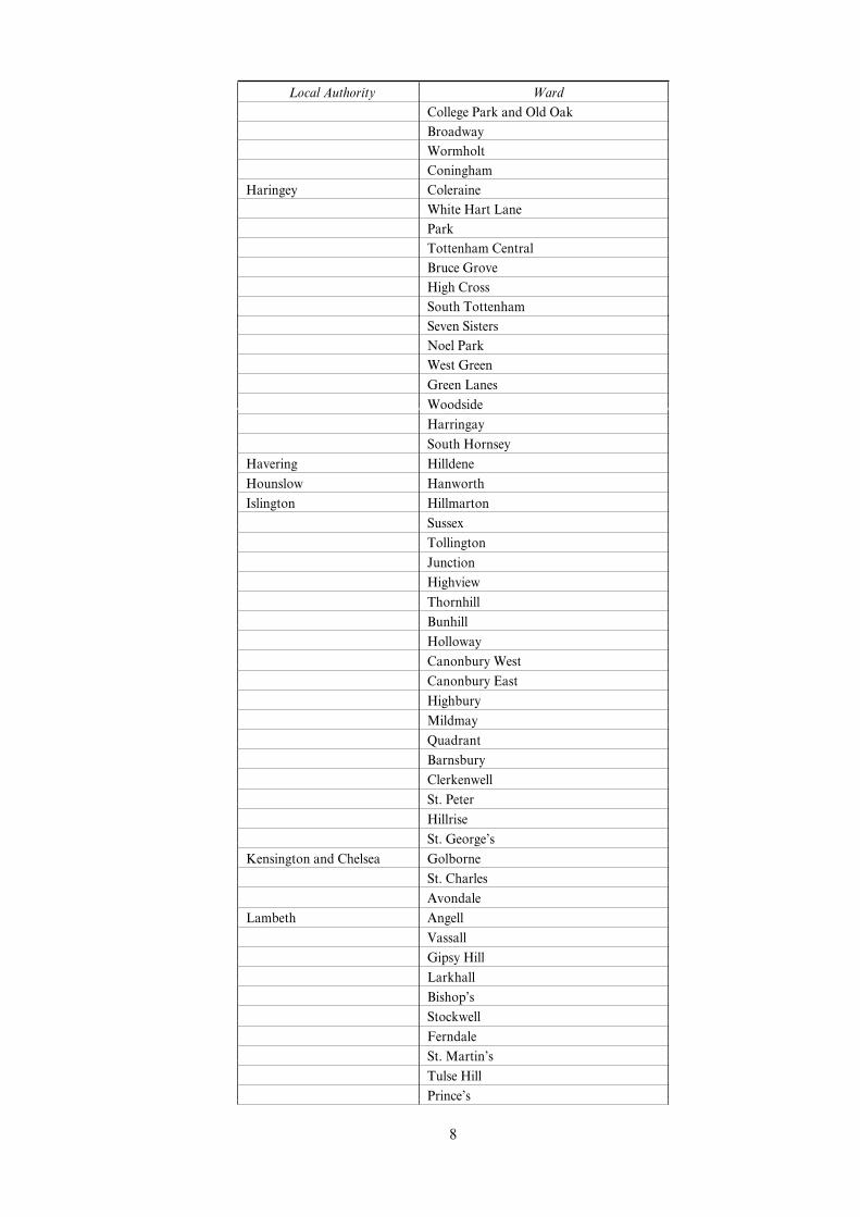
Local Authority Ward
Mile House
Blue Hall
Victoria
Charltons
Mandale
Grange
Stainsby
St. Aidan’s
Sunderland Southwick
Town End Farm
Thorney Close
South Hylton
Grindon
Castletown
Colliery
Hendon
Washington North
Central
Hetton
Houghton
Eppleton
Thornholme
Ryhope
Pallion
Teesdale Evenwood with Ramshaw
Cockfield
Tynedale Prudhoe North
Wansbeck Hirst
Newbiggin East
Choppington
Central
Park
College
Sleekburn
Newbiggin West
Wear Valley Woodhouse Close
St. Helen’s
Coundon
Henknowle
Stanley
Willington East
Wheatbottom and Helmington Row
Coundon Grange
Tow Law
Willington West
West Auckland
14
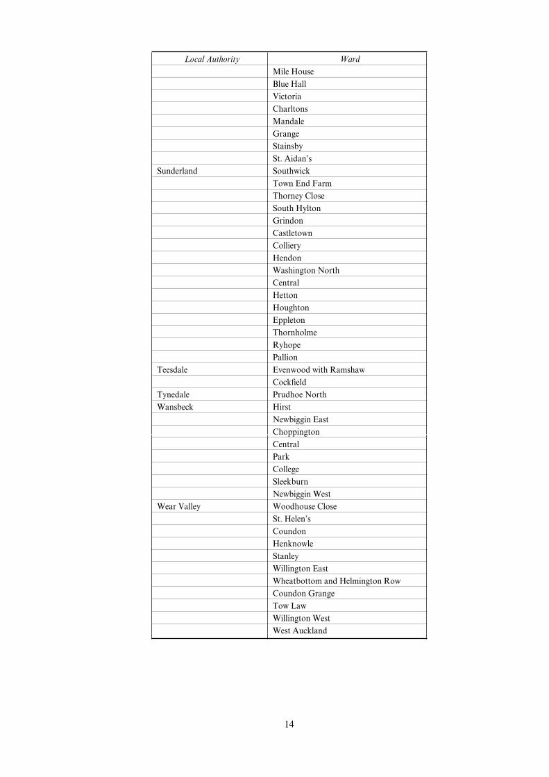
TABLE E—NORTH WESTERN ENGLAND
Local Authority Ward
Allerdale Salterbeck
Ewanrigg
Westfield
Northside
Moorclose
Ellenborough
Clifton
Netherhall
Barrow-in-Furness Central
Risedale
Hindpool
Barrow Island
Ormsgill
Walney North
Blackburn with Darwen Audley
Shadsworth
Higher Croft
Wensley Fold
Shear Brow
Queen’s Park
Bastwell
Little Harwood with Whitebirk
Mill Hill
Sudell
Meadowhead
Corporation Park
Blackpool Park
Alexandra
Claremont
Talbot
Foxhall
Clifton
Brunswick
Victoria
Tyldesley
Warbreck
Waterloo
Bolton Central
Derby
Farnworth
Tonge
Halliwell
Burnden
Harper Green
Breightmet
Burnley Daneshouse
Bank Hall
Barclay
Trinity
Fulledge
15

Local Authority Ward
Brunshaw
Coal Clough with Deerplay
Bury Redvales
East
Besses
Carlisle Upperby
Botcherby
Morton
Chester Blacon Hall
Dee Point
Chorley Chorley East
Copeland Mirehouse West
Sandwith
Cleator Moor South
Mirehouse East
Distington
Frizington
Harbour
Cleator Moor North
Hensingham
Crewe and Nantwich Maw Green
Ellesmere Port and Neston Westminster
Stanlow
Grange
Central
Wolverham
Rivacre
Halton Castlefields
Riverside
Kingsway
Murdishaw
Palace Field
Grange
Brookvale
Halton Brook
Norton
Mersey
Broadheath
Hough Green
Ditton
Hyndburn Central
Church
Spring Hill
Barnfield
Knowsley Princess
Longview
Cherryfield
Kirkby Central
Northwood
Cantril Farm
Tower Hill
16

Local Authority Ward
Knowsley Park
St. Michaels
St. Gabriels
Halewood South
Whitefield
Page Moss
Park
Halewood West
Prescot East
Whiston South
Whiston North
Lancaster Alexandra
Poulton
Skerton Central
Skerton East
Liverpool Speke
Everton
Vauxhall
Granby
Pirrie
Breckfield
Melrose
Clubmoor
Smithdown
Dovecot
Netherley
Kensington
St. Mary’s
Valley
Abercromby
County
Dingle
Tuebrook
Fazakerley
Anfield
Broadgreen
Picton
Old Swan
Gillmoss
Warbreck
Arundel
Croxteth
Allerton
Manchester Benchill
Harpurhey
Beswick and Clayton
Bradford
Ardwick
Central
Newton Heath
Gorton South
17
Local Authority Ward
Woodhouse Park
Moss Side
Longsight
Hulme
Cheetham
Lightbowne
Baguley
Blackley
Sharston
Gorton North
Charlestown
Brooklands
Burnage
Moston
Crumpsall
Northenden
Rusholme
Fallowfield
Whalley Range
Levenshulme
Barlow Moor
Old Moat
Oldham Coldhurst
Werneth
Alexandra
St. Marys
Hollinwood
St. James
Lees
St. Pauls
Chadderton South
Pendle Whitefield
Bradley
Waterside
Walverden
Southfield
Brierfield
Marsden
Vivary Bridge
Preston Fishwick
Ribbleton
Deepdale
St. Matthew’s
Brookfield
Avenham
Central
Rochdale Central and Falinge
Middleton West
Smallbridge and Wardleworth
Newbold
Middleton Central
18

Local Authority Ward
Brimrod and Deeplish
Balderstone
Heywood West
Rossendale Worsley
Greensclough
Stacksteads
Longholme
Salford Broughton
Little Hulton
Blackfriars
Ordsall
Pendleton
Langworthy
Winton
Weaste and Seedley
Barton
Walkden North
Pendlebury
Sefton Linacre
Orrell
Derby
Netherton
Ford
Litherland
St. Oswald
Church
South Ribble Seven Stars
St. Helens Parr and Hardshaw
Broad Oak
West Sutton
Marshalls Cross
Queen’s Park
Thatto Heath
Grange Park
Newton West
Sutton and Bold
Haydock
Stockport Brinnington
Tameside Ashton St. Peters’
Hyde Godley
Longdendale
Denton South
Ashton St. Michael’s
Hyde Newton
TraVord CliVord
Bucklow
Talbot
Vale Royal Over Two
Wharton
Vale Royal
Warrington Westy
19

Local Authority Ward
Bewsey and Whitecross
Orford
Hulme
Poplars
West Lancashire Tanhouse
Digmoor
Moorside
Birch Green
Skelmersdale North
Wigan Norley
Ince
Newtown
Abram
Leigh Central
Atherton
Whelley
Hindley
Wirral Bidston
Birkenhead
Tranmere
Seacombe
Leasowe
Egerton
Liscard
New Brighton
Claughton
Bromborough
Wyre Pharos
Park
Mount
TABLE F—SOUTH EASTERN ENGLAND
Local Authority Ward/Electoral Division
Arun Littlehampton River
Littlehampton Ham
Ashford Stanhope
Ashford Brookfield
Ashford Hampden
Brighton and Hove Marine
Moulsecoomb
Queen’s Park
Dartford Joyce Green
Dover Buckland
St. Radigunds
Town and Pier
Castle
Tower Hamlets
Gravesham Riverside
Hastings Central St. Leonards
Castle
20

Local Authority Ward/Electoral Division
Gensing
Hollington
Broomgrove
Mount Pleasant
Maze Hill
Ore
Braybrooke
Wishing Tree
Havant Warren Park
Barncroft
Bondfields
Battins
Isle of Wight St. Johns-1
Pan
Ryde North East
Ventnor-1
Maidstone Shepway West
Park Wood
Medway Twydall
Milton Keynes Woughton
Eaton Manor
Oxford Blackbird Leys
Portsmouth Charles Dickens
Paulsgrove
Reading Whitley
Shepway Folkestone Central
St. Mary in the Marsh
Folkestone East
Folkestone Harbour
Southampton Redbridge
Bargate
Swale Sheerness West
Eastern
Sheerness East
Thanet Pier
Ethelbert
Newington
Northdown Park
Cecil
Marine
Central EastcliV
Northwood
Central WestcliV
21

TABLE G—SOUTH WESTERN ENGLAND
Local Authority Ward
Bath and North East Somerset Twerton
Bournemouth Boscombe West
Wallisdown
Bristol, City of Lawrence Hill
Filwood
Southmead
Knowle
Ashley
Whitchurch Park
Bishopsworth
HartcliVe
Easton
Lockleaze
Kingsweston
Carrick Penwerris
Exeter Wonford
Gloucester Barton
Westgate
Matson
Kerrier Illogan South
Camborne North
Camborne West
Redruth North
Camborne South
North Devon Trinity
Ilfracombe Central
St. Mary’s
Ilfracombe East
North Somerset Weston-Super-Mare South
Weston-Super-Mare Ellenborough
Penwith Penzance East
Penzance West
Hayle-Gwithian
Marazion
St. Ives North
St. Just
Hayle-Gwinear
Plymouth St. Peter
Ham
Budshead
Honicknowle
Sutton
St. Budeaux
Keyham
Swindon Whitworth
Park
Taunton Deane Taunton Halcon
Taunton Lyngford
Torbay Tormohun
Torwood
22

Local Authority Ward
Blatchcombe
Coverdale
Torridge Westward Ho!
West Somerset Williton
Weymouth and Portland Melcombe Regis
TABLE H—ENGLAND: WEST MIDLANDS
Local Authority Ward
Birmingham Aston
Sparkbrook
Small Heath
Nechells
Soho
Washwood Heath
Handsworth
Sparkhill
Ladywood
Shard End
Kingstanding
Bartley Green
Fox Hollies
Longbridge
Kingsbury
King’s Norton
Stockland Green
Weoley
Yardley
Sandwell
Hodge Hill
Acock’s Green
Billesley
Cannock Chase Broomhill
County of Herefordshire Belmont
Coventry Foleshill
St. Michael’s
Longford
Henley
Binley and Willenhall
Radford
Holbrook
Upper Stoke
Dudley Castle and Priory
St. Thomas’s
Netherton and Woodside
Brockmoor & Pensett
Brierley Hill
Lye and Wollescote
East StaVordshire Victoria
Waterside
Uxbridge
23

Local Authority Ward
Burton
Broadway
Eton
Newcastle-under-Lyme Holditch
Cross Heath
Silverdale
Nuneaton & Bedworth Camp Hill
Redditch Batchley
Sandwell Soho and Victoria
St. Pauls
Greets Green and Lyng
Friar Park
Smethwick
West Bromwich Central
Hateley Heath
Princes End
Great Bridge
Oldbury
Tipton Green
Wednesbury North
Wednesbury South
Bristnall
Rowley
Solihull Chelmsley Wood
Fordbridge
Smith’s Wood
Kingshurst
South StaVordshire Huntington
StaVordshire Moorlands Biddulph East
Stoke-on-Trent Brookhouse
Blurton
Burslem Grange
Longton South
Tunstall North
Great Fenton
Chell
Shelton
Burslem Central
Berryhill
Abbey
Norton and Bradeley
Meir Park
Fenton Green
Tamworth Glascote
Telford & Wrekin Woodside
Malinslee and Langley
Cuckoo Oak
Brookside
Donnington
Arleston
Walsall Blakenall
24

Local Authority Ward
St. Matthew’s
Birchills Leamore
Pleck
Darlaston South
Bentley and Darlaston North
Palfrey
Bloxwich East
Willenhall South
Bloxwich West
Brownhills
Wolverhampton Low Hill
East Park
St. Peter’s
Heath Town
Ettingshall
Bilston East
Blakenhall
Bilston North
Graiseley
Bushbury
Fallings Park
Worcester St. Barnabas
Wyre Forest Oldington and Foley Park
TABLE I—ENGLAND: YORKSHIRE AND HUMBERSIDE
Local Authority Ward
Barnsley Dearne Thurnscoe
Athersley
Monk Bretton
Brierley
Dearne South
Ardsley
Worsbrough
Cudworth
Park
Hoyland West
North West
Darfield
Royston
Hoyland East
Bradford Little Horton
Bradford Moor
University
Bowling
Toller
Tong
UndercliVe
Keighley South
Heaton
Eccleshill
25

Local Authority Ward
Shipley East
Odsal
Keighley West
Great Horton
Calderdale St. John’s
Ovenden
Mixenden
Doncaster Conisbrough
Central
Bentley Central
Thorne
Mexborough
Adwick
Balby
Askern
Town Field
Intake
Wheatley
Rossington
Stainforth
East Riding of Yorkshire Bridlington South
Kingston upon Hull, City of Noddle Hill
Orchard Park
Myton
Marfleet
St. Andrews
University
Newington
Longhill
Pickering
Southcoates
Ings
Stoneferry
Kirklees Deighton
Thornhill
Dewsbury West
Crosland Moor
Newsome
Batley West
Batley East
Dewsbury East
Leeds City and Holbeck
Seacroft
Harehills
Burmantofts
Richmond Hill
Hunslet
University
Chapel Allerton
Beeston
North East Lincolnshire North East
26

Local Authority Ward
South
Marsh
Park (Cleethorpes)
Croft Baker
North Lincolnshire Brumby
Frodingham and Town
Rotherham Central
Herringthorpe
Park
Dalton, Hooton Roberts and Thrybergh
Brampton, Melton and Wentworth
Greasbrough
Rawmarsh West
Maltby
Rawmarsh East
Boston
Swinton
Wath
Thurcroft and Whiston
Scarborough Castle
Eastfield
Falsgrave
Selby Selby South
Selby North
SheYeld Southey Green
Burngreave
Manor
Park
Firth Park
Castle
Nether Shire
Darnall
Owlerton
Brightside
Sharrow
Norton
Wakefield Hemsworth
Castleford Ferry Fryston
South Kirkby
Wakefield East
South Elmsall
Wakefield Central
Normanton and Sharlston
Castleford Whitwood
Knottingley
Featherstone
Wakefield North
Castleford Glasshoughton
27
SCHEDULE 2 Regulation 2
AREAS IN WALES DESIGNATED AS DISADVANTAGED AREAS
The areas in Wales specified in this Schedule are—
(a) the electoral divisions, as at 1st April 1998, which are—
(i) contained in the Welsh Index of Multiple Deprivation 2000 published by the NationalAssembly for Wales(a), and
(ii) listed in Table J below; and
(b) any land which—
(i) as at 1st April 1998, did not fall within any of the electoral divisions mentioned in paragraph(a), but
(ii) as at 27th November 2001, had a postcode which was identical to the full postcode of landwhich, as at 1st April 1998, did fall within one of those electoral divisions.
TABLE J—WALES
Unitary Authority Electoral Division
Blaenau Gwent Nantyglo
Tredegar Central and West
Llanhilleth
Sirhowy
Rassau
Cwmtillery
Blaina
Cwm
Ebbw Vale South
Ebbw Vale North
Brynmawr
Six Bells
Abertillery
Beaufort
Georgetown
Badminton
Bridgend Caerau
Bettws
Blackmill
Llangeinor
Blaengarw
Cornelly
Maesteg West
Morfa
NantyVyllon
St. Bride’s Minor
Pontycymmer
Nant-y-moel
Pyle
Maesteg East
Ogmore Vale
Cefn Cribwr
Caerphilly New Tredegar
Aberbargoed
Darran Valley
Twyn Carno
a)( The Welsh Index of Multiple Deprivation 2000 is available from the Statistical Directorate, Briefing Unit, NationalAssembly for Wales, Cathays Park, CardiV CF10 3NQ and is also available on line at www.wales.gov.uk.
28

Unitary Authority Electoral Division
Tir-Phil
Pontlottyn
Bargoed
Moriah
Argoed
Hengoed
Aber Valley
Gilfach
Abertysswg
St. Cattwg
Cefn Fforest
St. James
Machen
Bedwas and Trethomas
Crumlin
Pengam
Ynysddu
Newbridge
Penyrheol
Pontllanfraith
Abercarn
Nelson
Crosskeys
CardiV Butetown
Ely
Caerau
Splott
Adamsdown
Llanrumney
Trowbridge
Grangetown
LlandaV North
Fairwater
Riverside
Carmarthenshire Glanymor
Llwynhendy
Felinfoel
Tyisha
PantyVynnon
Glanamman
Bigyn
Bynea
Garnant
Kidwelly
Burry Port
Trimsaran
Dafen
Pembrey
Quarter Bach Llynfell Brynamman
Elli
Ammanford
29

Unitary Authority Electoral Division
Llangyndeyrn
Tumble
Saron
Cross Hands
Myddynfych
Lliedi
Hengoed
Pontyberem
Betws
Penygroes
Glyn
Llangeler
Llandybie and Heolddu
Llangennech
Ceredigion Aberystwyth South
Llangeitho
Cardigan
Llandyfriog
Llandysul Town
Llanarth
Lledrod
Troedyraur
Llangybi
Penbryn
Capel Dewi
Llanfihangel Ystrad
Tregaron
New Quay
Conwy Pant-yr-afon/Penmaenan
Tudno
Bryn
Glyn
Towyn
Kinmel Bay
Pentre Mawr
Llysfaen
Gogarth
Mostyn
Denbighshire Rhyl West
Rhyl South West
Meliden
Denbigh Upper/Henllan
Rhyl East
Bodelwyddan
Denbigh Central
Prestatyn North
Flintshire Flint Castle
Ffynnongroyw
Mold West
Bagillt West
Higher and East Shotton
30

Unitary Authority Electoral Division
Mostyn
Holywell West
Sealand
Greenfield
Gronant
Holywell East
Connah’s Quay Central
Flint Oakenholt
Queensferry
Saltney
Gwynedd Peblig
Marchog
Talysarn
Bowydd and Rhiw
Barmouth
Pwllheli South
Rachub
Cadnant
Ogwen
Deiniolen
Penygroes
Conglywal and MaenoVeren
Llanaelhaearn/Pistyll
Pwllheli North
Corris/Mawddwy
Aberdaron
Arthog
Seiont
Llanllyfni
Hirael
Gerlan
Hendre
Cynfal and Teigl
Clynnog
Tudweiliog
Botwnnog
Deiniol
Trawsfynydd
Penisarwaun
Llanberis
Llanbedrog
Llanrug
Abersoch
Isle of Anglesey Morawelon
Holyhead Town
Tudur
Maeshyfryd
Amlwch Port
Porthyfelin
Llannerch-y-medd
AberVraw
31

Unitary Authority Electoral Division
Rhosneigr
Kingsland
London Road
Bryngwran
Llanbadrig
Moelfre
Mechell
Amlwch Rural
Llanfaethlu
Bodorgan
Llaneilian
Rhosyr
Parc a’r Mynydd
Llanidan
Merthyr Tydfil Gurnos
Penydarren
Dowlais
Merthyr Vale
Bedlinog
Cyfarthfa
Vaynor
Plymouth
Town
Park
Treharris
Monmouthshire Lansdown
Neath Port Talbot Cymmer
Gwynfi
Sandfields West
Glyncorrwg
Onllwyn
Sandfields East
Ystalyfera
Briton Ferry West
Neath East
Lower Brynamman
Pelenna
Seven Sisters
Godre’r graig
Gwaun-Cae-Gurwen
Aberdulais
Aberavon
Neath South
Cwmllynfell
Blaengwrach
Bryn and Cwmavon
Glynneath
DyVryn
Crynant
Trebanos
Taibach
32

Unitary Authority Electoral Division
Neath North
Resolven
Margam
Pontardawe
CoedVranc Central
Port Talbot
Briton Ferry East
Newport Pillgwenlly
Tredegar Park
Bettws
Ringland
Alway
Victoria
Stow Hill
Gaer
Shaftesbury
Pembrokeshire Pembroke: Monkton
Pembroke Dock: Llanion
Pembroke Dock: Central
Pembroke: St. Mary
Neyland West
Garth
Milford North and West
Pembroke Dock: Market
Hakin
Pembroke Dock: Pennar
Goodwick
Neyland East
Castle
Milford Central and East
Merlin’s Bridge
Maenclochog
St. Dogmaels
Powys Ystradgynlais
Tawe-Uchaf/Ystradfellte
Aber-craf
Newtown South
Cwm-twrch
Newtown Central
Ynyscedwyn
Welshpool Castle
Rhondda, Cynon, TaV Pen-y-waun
Maerdy
Tylorstown
Glyncoch
Llwyn-y-pia
Penrhiwceiber
Treherbert
Cwm Clydach
Rhydfelen Central/Ilan
Gilfach Goch
33

Unitary Authority Electoral Division
Mountain Ash West
Cymmer
Ynyshir
Trealaw
Aberaman South
Tonyrefail West
Pen-y-graig
Ystrad
Cwmbach
Ferndale
Tonypandy
Abercynon
Tonyrefail East
Aberaman North
Hirwaun
Pentre
Rhigos
Rhydfelen Lower
Porth
Llanharry
Treorchy
Mountain Ash East
Cilfynydd
Aberdare East
Graig
Ynysybwl
Tyn-y-nant
Rhondda
Aberdare West/Llwydcoed
Swansea Townhill
Penderry
Graigfelen
Castle
Bonymaen
Landore
Gorseinon East
St. Thomas
Dulais East
Cockett
Penllergaer
Mynyddbach
Lower Loughor
The Vale of Glamorgan Castleland
Gibbonsdown
Court
Cadoc
Buttrills
Torfaen Trevethin
St. Cadocs and Penygarn
Cwmyniscoy
Abersychan
34

Unitary Authority Electoral Division
Upper Cwmbran
Brynwern
St. Dials
Snatchwood
Greenmeadow
Blaenavon
Pontnewynydd
Wrexham Plas Madoc
Queensway
Caia Park
Gwenfro
Pant
Penycae
Brymbo
Cefn
Gwersyllt North
Whitegate
Ruabon
Maesydre
Ponciau
Acton
35
SCHEDULE 3 Regulation 2
AREAS IN SCOTLAND DESIGNATED AS DISADVANTAGED AREAS
The areas in Scotland specified in this Schedule are—
(a) the areas which, as at 21st April 1991, had any of the postcodes which are—
(i) contained in Revising the Scottish Area Deprivation Index published by the ScottishExecutive(a), and
(ii) listed in Table K below; and
(b) any land which—
(i) as at 21st April 1991, did not fall within any of the areas mentioned in paragraph (a), but
(ii) as at 27th November 2001, had a postcode which was identical to the full postcode of landwhich, as at 21st April 1991, did fall within one of those areas.
TABLE K—SCOTLAND
Postcode Local Authority
AB1 3 Aberdeen
AB2 1 Aberdeen
AB2 2 Aberdeen
DD1 5 Dundee
DD11 1 Dundee
DD2 3 Dundee
DD2 4 Dundee
DD3 0 Dundee
DD3 7 Dundee
DD4 0 Dundee/Angus
DD4 6 Dundee
DD4 8 Dundee
DD4 9 Dundee
DG1 2 Dumfries and Galloway
DG9 7 Dumfries and Galloway
EH11 3 Edinburgh
EH14 2 Edinburgh
EH16 4 Edinburgh
EH3 8 Edinburgh
EH4 4 Edinburgh
EH5 1 Edinburgh
EH54 5 West Lothian
EH6 6 Edinburgh
EH8 8 Edinburgh
FK2 7 Falkirk
FK8 1 Stirling
FK10 1 Clackmannanshire
G1 5 Glasgow
G11 6 Glasgow
G13 2 Glasgow
G13 3 Glasgow
G13 4 Glasgow
G14 0 Glasgow
G15 7 Glasgow
G15 8 Glasgow
G20 0 Glasgow
G20 7 Glasgow
a)( Revising the Scottish Area Deprivation Index is available from the Scottish Executive, Central Research Unit, VictoriaQuay, Edinburgh EH6 QQ and is also available on line at www.scotland.gov.uk.
36

Postcode Local Authority
G20 8 Glasgow
G20 9 Glasgow
G21 1 Glasgow
G21 2 Glasgow
G21 3 Glasgow
G21 4 Glasgow
G22 5 Glasgow
G22 6 Glasgow
G22 7 Glasgow
G23 5 Glasgow
G3 8 Glasgow
G31 1 Glasgow
G31 2 Glasgow
G31 3 Glasgow
G31 4 Glasgow
G31 5 Glasgow
G32 6 Glasgow
G32 7 Glasgow
G32 8 Glasgow
G33 1 Glasgow
G33 3 Glasgow
G33 4 Glasgow
G33 5 Glasgow
G34 0 Glasgow
G34 9 Glasgow
G4 0 Glasgow
G40 1 Glasgow
G40 2 Glasgow
G40 3 Glasgow
G40 4 Glasgow
G41 1 Glasgow
G42 0 Glasgow
G42 7 Glasgow
G42 8 Glasgow
G42 9 Glasgow
G43 1 Glasgow
G45 0 Glasgow
G45 9 Glasgow
G46 8 Glasgow/East Renfrewshire
G5 0 Glasgow
G5 9 Glasgow
G51 1 Glasgow
G51 2 Glasgow
G51 3 Glasgow
G51 4 Glasgow
G52 1 Glasgow
G52 4 Glasgow
G53 5 Glasgow
G53 6 Glasgow
G53 7 Glasgow/East Renfrewshire
G66 2 East Dunbartonshire
37
Postcode Local Authority
G71 5 North Lanarkshire
G72 0 South Lanarkshire
G72 7 South Lanarkshire
G73 1 South Lanarkshire
G81 1 West Dunbartonshire
G81 2 West Dunbartonshire
G81 4 West Dunbartonshire
G81 5 West Dunbartonshire
KA1 4 East Ayrshire
KA18 3 East Ayrshire
KA18 4 East Ayrshire
KA3 1 East Ayrshire
KA3 2 East Ayrshire/North Ayrshire
KA6 7 East Ayrshire
KA7 1 South Ayrshire
KA8 0 South Ayrshire
KA8 9 South Ayrshire
KY1 2 Fife
KY1 3 Fife
KY5 8 Fife
KY8 2 Fife
KY8 3 Fife
ML1 4 North Lanarkshire
ML2 0 North Lanarkshire
ML2 7 North Lanarkshire
ML2 9 North Lanarkshire
ML3 0 South Lanarkshire
ML4 2 North Lanarkshire
ML5 2 North Lanarkshire
ML5 4 North Lanarkshire
ML5 5 North Lanarkshire
ML6 0 North Lanarkshire
ML6 6 North Lanarkshire
ML6 7 North Lanarkshire
PA1 1 Renfrewshire
PA1 2 Renfrewshire
PA14 6 Inverclyde/Renfrewshire
PA15 2 Inverclyde
PA15 3 Inverclyde
PA15 4 Inverclyde
PA16 0 Inverclyde
PA2 0 Renfrewshire
PA3 1 Renfrewshire
PA3 2 Renfrewshire
PA3 4 Renfrewshire
PA4 8 Renfrewshire
PH1 5 Perth & Kinross
38

SCHEDULE 4 Regulation 2
AREAS IN NORTHERN IRELAND DESIGNATED AS DISADVANTAGEDAREAS
The areas in Northern Ireland specified in this Schedule are—
(a) the wards, as at 21st April 1991, which are—
(i) contained in Measures of Deprivation in Northern Ireland 2001 published by the NorthernIreland Statistics and Research Agency(a), and
(ii) listed in Table L below; and
(b) any land which—
(i) as at 21st April 1991, did not fall within any of those wards, but
(ii) as at 27th November 2001, had a postcode which was identical to the full postcode of landwhich, as at 21st April 1991, did fall within one of those wards.
TABLE L—NORTHERN IRELAND
Local Government District Ward
Antrim Rathenraw
Fountain Hill
New Park
Ards West Winds
Central
Armagh Callan Bridge
Abbey Park
Downs
Keady
Carrigatuke
Ballymena Ballykeel
Ballee
Fair Green
Moat
Dunclug
Castle Demesne
Ballymoney Newhill
Ballyhoe and Corkey
Benvardin
Stranocum
Route
Killoquin Lower
Carnany
Banbridge Edenderry
Gilford
Belfast Crumlin
Falls
Whiterock
St. Annes
Ballymacarrett
Woodvale
New Lodge
The Mount
Shankill
Upper Springfield
Ardoyne
a)( Measures of Deprivation in Northern Ireland 2001 is available from the Northern Ireland Statistics and ResearchAgency, McAuley House, 2-14 Castle Street, Belfast BT1 1SA and is also available on line at www.nisra.gov.uk.
39

Local Government District Ward
Shaftesbury
Water Works
Duncairn
Clonard
Woodstock
Beechmount
BlackstaV
Glencairn
Island
Glencolin
Glen Road
Highfield
Botanic
Ballysillan
Legoniel
Falls Park
Andersonstown
Cliftonville
Bloomfield
Ladybrook
Bellevue
Sydenham
Chichester Park
Carrickfergus Northland
Gortalee
Sunnylands
Killycrot
Love Lane
Clipperstown
Castlereagh Tullycarnet
Enler
Cregagh
Minnowburn
Coleraine Ballysally
Churchland
Cross Glebe
Royal Portrush
Central
Kilrea
Cookstown Ardboe
Pomeroy
Dunnamore
Killycolpy
Killymoon
Newbuildings
Gortalowry
Stewartstown
The Loop
Moneymore
Craigavon Court
Drumgask
40

Local Government District Ward
Drumgor
Corcrain
Church
Tullygally
Drumnamoe
Ballybay
Taghnevan
Tavanagh
Ballyoran
Derry Brandywell
Creggan South
The Diamond
St. Peter’s
Victoria
Creggan Central
Shantallow East
Shantallow West
Westland
Glen
Rosemount
Carn Hill
Beechwood
Corrody
Strand
Caw
Clondermot
Enagh
Culmore
Crevagh and Springtown
Ebrington
Banagher
Claudy
Faughan
Down Flying Horse
Cathedral
Murlough
Killyleagh
Castlewellan
Ardglass
Dungannon Ballysaggart
Coalisland South
Altmore
Fivemiletown
Clogher
Ballygawley
Mullaghmore
Washing Bay
Drumglass
Augher
Coalisland West and Newmil
Coalisland North
41
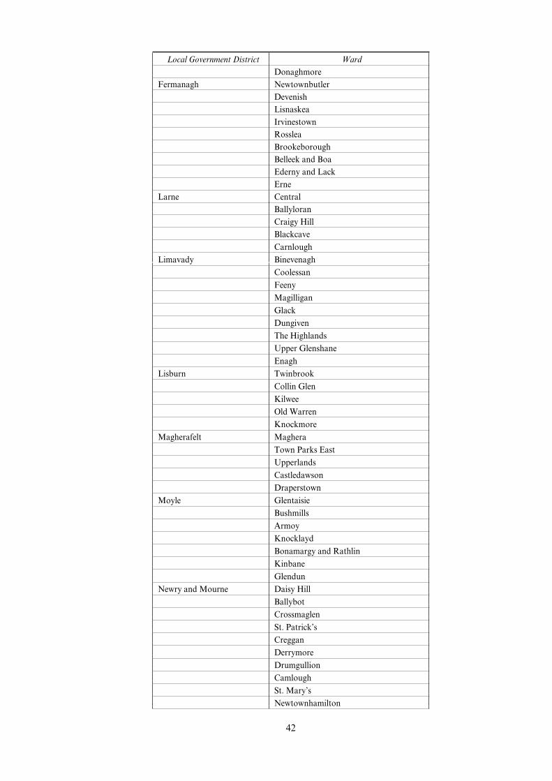
Local Government District Ward
Donaghmore
Fermanagh Newtownbutler
Devenish
Lisnaskea
Irvinestown
Rosslea
Brookeborough
Belleek and Boa
Ederny and Lack
Erne
Larne Central
Ballyloran
Craigy Hill
Blackcave
Carnlough
Limavady Binevenagh
Coolessan
Feeny
Magilligan
Glack
Dungiven
The Highlands
Upper Glenshane
Enagh
Lisburn Twinbrook
Collin Glen
Kilwee
Old Warren
Knockmore
Magherafelt Maghera
Town Parks East
Upperlands
Castledawson
Draperstown
Moyle Glentaisie
Bushmills
Armoy
Knocklayd
Bonamargy and Rathlin
Kinbane
Glendun
Newry and Mourne Daisy Hill
Ballybot
Crossmaglen
St. Patrick’s
Creggan
Derrymore
Drumgullion
Camlough
St. Mary’s
Newtownhamilton
42

Local Government District Ward
Silver Bridge
Beesbrook
Spelga
Rathfriland
Forkhill
Kilkeel South
Clonallan
Kilkeel Central
Lisnascree
Fathom
Newtownabbey Braden
Dunanney
Coole
Whitehouse
Valley
Monkstown
North Down DuVerin
Whitehill
Conlig
Harbour
Omagh Termon
Fintona
Owenkillew
Sixmilecross
Dromore
Drumquin
Gortrush
Lisanelly
Drumnakilly
Camowen
Newtownsaville
Trillick
Dergmoney
Strabane East
Castlederg
Glenderg
Clare
Newtownstewart
Sion Mills
Dunnamanagh
West
Plumbridge
Victoria Bridge
South
Artigarvan
Slievekirk
Finn
North
43

EXPLANATORY NOTE
(This note is not part of the Regulations)
Section 92 of the Finance Act 2001 (“the 2001 Act”) provides for an exemption from the stampduty chargeable on a conveyance or transfer on sale of an estate or interest in land or a leaseof land if the land in question is situated in a disadvantaged area. Schedule 30 to the 2001 Actmakes similar provision in relation to cases where land is partly in a disadvantaged area.Section 92(4) of the 2001 Act provides that a disadvantaged area is an area designated as suchby regulations made by the Treasury.
These Regulations designate the areas specified in Schedules 1 to 4 as disadvantaged areasfor the purposes of section 92 of, and Schedule 30 to, the 2001 Act.
Schedule 1 specifies areas in England.
Schedule 2 specifies areas in Wales.
Schedule 3 specifies areas in Scotland.
Schedule 4 specifies areas in Northern Ireland.
The eVect of section 92 of, and Schedule 30 to, the 2001 Act has been varied by the Variationof Stamp Duties Regulations 2001 (S.I. 2001/3746). As varied, the exemptions apply broadlyonly to conveyances or transfers on sale where the consideration is £150,000 or less or, inrelation to grants of leases, only in respect of the stamp duty payable on a premium of £150,000or less.
44

45

46

47

? Crown copyright 2001
Printed and published in the UK by The Stationery OYce Limited
under the authority and superintendence of Carol Tullo, Controller of
Her Majesty’s Stationery OYce and Queen’s Printer of Acts of Parliament.
E2083 12/2001 012083 19585