Embed Size (px)
Citation preview

Local Coastal Program Coastal Land Use Plan
2-1
2.0 Land Use and Development 2.1 Land Use The Coastal Land Use Plan was derived from the Land Use Element of the General Plan and is intended to identify the distribution of land uses in the coastal zone. The Land Use Element may contain more precise development limits for specific properties. Should a conflict exist, the land use intensity or residential density limit that is most protective of coastal resources shall take precedence. However, in no case, shall the policies of the Coastal Land Use Plan be interpreted to allow a development to exceed a development limit established by the General Plan or its implementing ordinances. 2.1.1 Land Use Categories Policy 2.1.1-1 The land use categories in Table 2.1.1-1 establish the type, density
and intensity of land uses within the coastal zone. If there is a conflict between the development limits of the Land Use Element and the Coastal Land Use Plan, the provision that is most protective of coastal resources shall take precedence. However, in no case, shall the policies of the Coastal Land Use Plan be interpreted to allow a development to exceed a development limit established by the General Plan or its implementing ordinances.
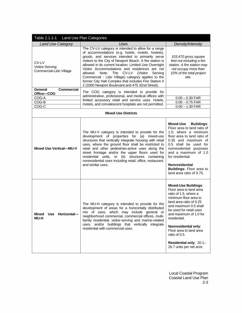
Table 2.1.1-1 Land Use Plan Categories
Land Use Category Uses Density/Intensity
Residential Neighborhoods
Single Unit Residential Detached—RSD The RSD category applies to a range of detached
single-family residential dwelling units on a single legal lot and does not include condominiums or cooperative housing.
RSD-A 0.0 – 5.9 DU/AC RSD-B 6.0 – 9.9 DU/AC RSD-C 10.0 – 19.9 DU/AC RSD-D 20.0 – 29.9 DU/AC Single Unit Residential Attached—RSA The RSA category applies to a range of attached
single-family residential dwelling units on a single legal lot and does not include condominiums or cooperative housing.
RSA-A 0.0 – 5.9 DU/AC RSA-B 6.0 – 9.9 DU/AC RSA-C 10.0 – 19.9 DU/AC RSA-D 20.0 – 29.9 DU/AC Two Unit Residential—RT The RT category applies to a range of two
family residential dwelling units such as duplexes and townhomes.
RT-A 0.0 – 5.9 DU/AC RT-B 6.0 – 9.9 DU/AC RT-C 10.0 – 19.9 DU/AC

Local Coastal Program Coastal Land Use Plan
2-2
Table 2.1.1-1 Land Use Plan Categories Land Use Category Uses Density/Intensity
RT-D 20.0 – 29.9 DU/AC RT-E 30.0 – 39.9 DU/AC Multiple Unit Residential—RM
The RM category is intended to provide primarily for multi-family residential development containing attached or detached dwelling units.
RM-A 0.0 – 5.9 DU/AC RM-B 6.0 – 9.9 DU/AC RM-C 10.0 – 19.9 DU/AC RM-D 20.0 – 29.9 DU/AC RM-E 30.0 – 39.9 DU/AC RM-F 40.0 – 52.0 DU/AC
Commercial Districts and Corridors
Neighborhood Commercial—CN
The CN category is intended to provide for a limited range of retail and service uses developed in one or more distinct centers oriented to primarily serve the needs of and maintain compatibility with residential uses in the immediate area.
0.00 - 0.30 FAR
Corridor Commercial—CC The CC category is intended to provide a range of neighborhood-serving retail and service uses along street frontages that are located and designed to foster pedestrian activity.
CC-A 0.00 – 0.50 FAR
CC-B 0.00 – 0.75 FAR
General Commercial—CG The CG category is intended to provide for a wide variety of commercial activities oriented primarily to serve citywide or regional needs.
CG-A 0.00 - 0.30 FAR CG-B 0.00 – 0.75 FAR Recreational and Marine Commercial—CM
The CM category is intended to provide for commercial development on or near the bay in a manner that will encourage the continuation of coastal-dependent and coastal-related uses, maintain the marine theme and character, encourage mutually supportive businesses, encourage visitor-serving and recreational uses, and encourage physical and visual access to the bay on waterfront commercial and industrial building sites on or near the bay.
CM-A 0.00 - 0.30 FAR
CM-B 0.00 – 0.50 FAR
Visitor Serving Commercial—CV
The CV category is intended to provide for accommodations (e.g. hotels, motels, hostels), goods, and services intended to primarily serve visitors to the City of Newport Beach. Limited Use Overnight Visitor Accommodations (e.g. time shares, fractionals, condominium-hotels) (LUOVA) are an allowed use when provided together with traditional overnight, hotel visitor accommodations. Furthermore, any permitted LUOVA shall be subject to specific restrictions on the quantity, duration of owner use of such facilities, management of the accommodations as part of the hotel facility and an allowance for transient overnight use by the general public when not owner occupied. All of these requirements shall be further defined in the implementing regulations for this land use plan (when such regulations are certified) and through the coastal development permit process.
CV-A 0.00 – 0.75 FAR
CV-B 0.00 – 1.50 FAR
Local Coastal Program Coastal Land Use Plan
2-3
Table 2.1.1-1 Land Use Plan Categories Land Use Category Uses Density/Intensity
CV-LV Visitor-Serving Commercial-Lido Village
The CV-LV category is intended to allow for a range of accommodations (e.g. hotels, motels, hostels), goods, and services intended to primarily serve visitors to the City of Newport Beach. A fire station is allowed in its current location. Limited Use Overnight Visitor Accommodations and residences are not allowed. Note: The CV-LV (Visitor Serving Commercial - Lido Village) category applies to the former City Hall Complex that includes Fire Station # 2 (3300 Newport Boulevard and 475 32nd Street).
103,470 gross square feet not including a fire
station. A fire station may not occupy more than 10% of the total project
site.
General Commercial Office—COG The COG category is intended to provide for
administrative, professional, and medical offices with limited accessory retail and service uses. Hotels, motels, and convalescent hospitals are not permitted.
COG-A 0.00 – 0.30 FAR COG-B 0.00 – 0.75 FAR COG-C 0.00 – 1.30 FAR
Mixed Use Districts
Mixed Use Vertical—MU-V
The MU-V category is intended to provide for the development of properties for (a) mixed-use structures that vertically integrate housing with retail uses, where the ground floor shall be restricted to retail and other pedestrian-active uses along the street frontage and/or the upper floors used for residential units, or (b) structures containing nonresidential uses including retail, office, restaurant, and similar uses.
Mixed-Use Buildings: Floor area to land ratio of 1.5; where a minimum floor area to land ratio of 0.35 and maximum of 0.5 shall be used for nonresidential purposes and a maximum of 1.0 for residential. Nonresidential Buildings: Floor area to land area ratio of 0.75.
Mixed Use Horizontal—MU-H
The MU-H category is intended to provide for the development of areas for a horizontally distributed mix of uses, which may include general or neighborhood commercial, commercial offices, multi-family residential, visitor-serving and marine-related uses, and/or buildings that vertically integrate residential with commercial uses.
Mixed-Use Buildings: Floor area to land area ratio of 1.5, where a minimum floor area to land area ratio of 0.25 and maximum 0.5 shall be used for retail uses and maximum of 1.0 for residential. Nonresidential only: Floor area to land area ratio of 0.5. Residential only: 20.1–26.7 units per net acre.

Local Coastal Program Coastal Land Use Plan
2-4
Table 2.1.1-1 Land Use Plan Categories Land Use Category Uses Density/Intensity
Mixed Use Water Related—MU-W
The MU-W category is intended to provide for commercial development on or near the bay in a manner that will encourage the continuation of coastal-dependent and coastal-related uses and visitor-serving uses, as well as allow for the development of mixed-use structures with residential uses above the ground floor. Freestanding residential uses shall be prohibited. Overnight accommodations (e.g. hotels, motels, hostels) are allowed. Limited Use Overnight Visitor Accommodations (e.g. time shares, fractionals, condominium-hotels) may be permitted in lieu of allowable residential development provided the use is above the ground floor.
Mixed-Use Buildings: Floor area to land ratio of 1.5; where a minimum floor area to land ratio of 0.35 and maximum of 0.7 shall be used for nonresidential purposes and a maximum of 0.8 for residential. Nonresidential only: Floor area to land area ratio of 0.5. Residential only: 15 units per acre per net acre.
Public, Semi-Public, and Institutional
Public Facilities—PF The PF category is intended to provide public facilities, including public schools, cultural institutions, government facilities, libraries, community centers, public hospitals, and public utilities.
Not applicable. School districts are exempted from local land use controls and development limits are not specified. Development intensities for other public institutions are more appropriately determined by their function rather than floor areas, such as number of hospital beds and number of students.
Private Institutions—PI The PI category is intended to provide for privately owned facilities that serve the public, including places for religious assembly, private schools, health care, cultural institutions, museums, yacht clubs, congregate homes, and comparable facilities.
PI-A 0.00 – 0.30 FAR PI-B 0.00 – 0.75 FAR
PI-C 0.00 – 1.00 FAR
Opens Space—OS The OS category is intended to provide areas for a range of public and private uses to protect, maintain, and enhance the community’s natural resources.
Open spaces may include incidental buildings, such as maintenance equipment and supply storage, which are not traditionally included in determining intensity limits.

Local Coastal Program Coastal Land Use Plan
2-5
Table 2.1.1-1 Land Use Plan Categories Land Use Category Uses Density/Intensity
Parks and Recreation—PR
The PR category applies to land used or proposed for active public or private recreational use. Permitted uses include parks (both active and passive), golf courses, marina support facilities, aquatic facilities, tennis clubs and courts, private recreation, and similar facilities.
Not applicable for public uses. Private uses in this category may include incidental buildings, such as maintenance equipment sheds, supply storage, and restrooms, not included in determining intensity limits. For golf courses, these uses may also include support facilities for grounds maintenance employees.
Tidelands and Submerged Lands—TS
The TS category is intended to address the use, management, and protection of tidelands and submerged lands of Newport Bay and the Pacific Ocean immediately adjacent to the City of Newport Beach. The category is generally not applied to historic tidelands and submerged lands that are presently filled or reclaimed.
Not applicable.
Notes: Residential densities are calculated on net acreage, exclusive of existing and new rights-of-way, public pedestrian ways, and neighborhood parks. Floor area ratios (FAR) are calculated by the gross floor area of all buildings on a lot divided by the lot area, but do not include floor areas of parking structures.

Local Coastal Program Coastal Land Use Plan
2-6
2.1.2 District/Corridor Policies Districts are uniquely identifiable by their common functional role, mix of uses, density/intensity, physical form and character, and/or environmental setting. Newport Beach’s coastal zone districts are in transition as existing viable districts are enhanced, underperforming properties are revitalized, and opportunities are provided to accommodate the City’s fair share of regional housing needs. Corridors share common characteristics of districts by their identifiable functional role, land use mix, density/intensity, physical form and character, and/or environmental setting. They differ in their linear configuration, generally with shallow depth parcels located along arterial streets. They are significantly impacted by traffic, often inhibiting access during peak travel periods. Their shallow depths make them unsuitable for many contemporary forms of commercial development that require large building footprints and extensive parking. Policy 2.1.2-1. Development in each district and corridor shall adhere to
policies for land use type and density/intensity contained in Table 2.1.1-1, except as modified in Sections 2.1.3 to 2.1.8.
Lifeguard rescue boats

Local Coastal Program Coastal Land Use Plan
2-7
2.1.3 West Newport The West Newport Coast Highway Corridor extends from Summit Street to just past 60th Street. It is a mixed commercial and residential area, with the former serving the adjoining Newport Shores residential neighborhood, the West Newport residential neighborhood south of Coast Highway, and beach visitors. Commercial uses are concentrated on the north side of Coast Highway at the Orange Street intersection and east of Cedar Street to the Semeniuk Slough. Intervening areas are developed with a mix of multi-family apartments and, west of Grant Avenue, mobile and manufactured homes.
Residential in West Newport Commercial in West Newport
Primary commercial uses include community-related retail such as a dry cleaners, liquor store, deli, and convenience stores, as well as a few visitor-serving motels, dine-in, family-style restaurants, and fast-food establishments. Generally, they are developed on shallow parcels of substandard size and configuration due to past widening of West Coast Highway and contain insufficient parking. Many of the commercial buildings appear to have been constructed in the 1960’s to 1980’s, although some motels have been recently upgraded. A portion of the mobile homes are situated along Semeniuk Slough and the Army Corps restored wetlands, while a number of the single-family homes outside the area are also located along the Slough. A mobile home park containing older units, many of which appear to be poorly maintained, is located on the westernmost parcels and a portion of the tidelands. This site serves as the “entry” to the City and as a portal to the proposed Orange Coast River Park. Coast Highway fronting properties in West Newport will be improved by concentrating local and visitor-serving retail in two centers at Prospect Street and Orange Street with expanded parking, enhancing existing and allowing additional housing on intervening parcels, and developing a clearly defined entry at the western

Local Coastal Program Coastal Land Use Plan
2-8
edge with Huntington Beach. The latter may include improvements that would support the proposed Orange Coast River Park. Policies: 2.1.3-1. Work with community groups and the County to facilitate the
acquisition of a portion or all of the Western Entry Parcel (designated RM/OS) as open space, which may be used as a staging area for Orange Coast River Park with public parking, public park-related uses, and access to the ocean. As an alternative, accommodate multi-family residential on portions of the property not used for open space, public parking, and public park-related uses. Require the siting and design of new development, including landscaping and public access, to maintain buffers of sufficient size to protect sensitive or rare resources including but not limited to those within the Semeniuk Slough wetland against significant disruption of habitat values.
2.1.3-2. Allow local and visitor-serving retail consistent with the CV category in
two centers at Prospect Street and Orange Street.

Local Coastal Program Coastal Land Use Plan
2-9
2.1.4 Mariners’ Mile Mariners’ Mile is a heavily traveled segment of Coast Highway extending from the Arches Bridge on the west to Dover Drive on the east. It is developed with a mix of highway-oriented retail and marine related commercial uses. The latter are primarily concentrated on bay-fronting properties and include boat sales and storage, sailing schools, marinas, visitor-serving restaurants, and comparable uses. A large site is developed with the Balboa Bay Club and Resort, a hotel, private club, and apartments located on City tidelands. A number of properties contain non-marine commercial uses, offices, and a multi-story residential building. The vitality of the Mariners’ Mile Corridor will be enhanced by establishing a series of distinct retail, mixed-use, and visitor-serving centers. Harbor-fronting properties would accommodate a mix of visitor-serving retail, marine-related businesses and vertically integrated mixed-use structures. View and public access corridors from Coast Highway to the Harbor would be required, with a public pedestrian promenade developed along the length of the Harbor frontage. Parcels on the inland side of Coast Highway, generally between Riverside Avenue and the southerly projection of Irvine Avenue, would evolve as a pedestrian-oriented mixed-use “village” containing retail businesses, offices, services, and housing. Sidewalks would be improved with landscape and other amenities to foster pedestrian activity. Inland properties directly fronting onto Coast Highway and those to the east and west of the village would provide for retail, marine-related, and office uses. Streetscape amenities are proposed for the length of Mariners’ Mile to improve its appearance and identity.
Mariners’ Mile

Local Coastal Program Coastal Land Use Plan
2-10
Policies: 2.1.4-1. For properties located on the inland side of Coast Highway in the
Mariners’ Mile Corridor that are designated as MU-H, (a) the Coast Highway frontages shall be developed for marine-related and highway-oriented general commercial uses in accordance with CM and CG categories; and (b) portions of properties to the rear of the commercial frontage may be developed for free-standing neighborhood-serving retail, multi-family residential units, or mixed-use buildings that integrate residential with retail uses on the ground floor in accordance with the CN, RM , CV, or MU-V categories respectively.
2.1.4-2. For bay-fronting properties that are designated as MU-W, encourage
marine-related and visitor-serving retail, restaurant, hotel, institutional, and recreational uses. Vertically integrated mixed use structures are allowed as described below. Permitted uses include those permitted by the CM, CV, and MU-V categories. On sites developed with mixed-use structures, a minimum of 50 percent of the permitted square footage shall be devoted to non-residential uses. Mixed-use structures may only be developed on sites with 200 feet or more of street frontage along Coast Highway and, in aggregate, no more than 50 percent of the waterfront land area along Coast Highway between the Arches Bridge and the Boy Scout Sea Base may be developed with mixed use structures.
2.1.4-3. Permit development intensities in areas designated as CG to be
increased to a floor area ratio of 0.5 where parcels are consolidated to accommodate larger commercial development projects that provide sufficient parking.
2.1.4-4. For bay-fronting properties that are designated as CV or CM,
encourage marine-related and visitor-serving retail, restaurant, hotel/motel, institutional, and recreational uses.
2.1.4-5. Development shall be designed and planned to achieve high levels
of architectural quality and compatibility among on-site and off-site uses. Adequate pedestrian, non-automobile and vehicular circulation and parking shall be provided.
2.1.4-6. Require sufficient area be provided for individual uses to prevent
fragmentation and assure each use’s viability, quality, and compatibility with adjoining uses.

Local Coastal Program Coastal Land Use Plan
2-11
2.1.4-7. For bay-fronting properties, provide plazas and other open spaces that protect existing and provide new view corridors and access from Coast Highway to the Harbor.
2.1.4-8. For bay-fronting properties, require that development on the Bay
frontage implement amenities that assure access for coastal visitors including the development of a public pedestrian promenade along the bayfront.
2.1.4-9. For bay-fronting properties require that buildings be located and sites
designed to provide clear views of and access to the Harbor and Bay from the Coast Highway in accordance with the following principles, as appropriate: ■ Clustering of buildings to provide open view and access corridors to the Harbor ■ Modulation of building volume and mass ■ Variation of building heights ■ Inclusion of porticoes, arcades, windows, and other “see-through” elements in addition to the defined open corridor ■ Minimization of landscape, fencing, parked cars, and other nonstructural elements that block views and access to the Harbor ■ Prevention of the appearance of the harbor being walled off from the public right-of-way ■ Inclusion of setbacks that in combination with setbacks on adjoining parcels cumulatively form functional view corridors ■ Encourage adjoining property owners to combine their view corridors to achieve a larger cumulative corridor than would be achieved independently ■ A site-specific analysis shall be conducted for new development to determine the appropriate size, configuration, and design of the view and access corridor that meets these objectives, which shall be subject to approval in the Coastal Development Permit process.
2.1.5 Balboa Peninsula Lido Village, Cannery Village, McFadden Square, and Balboa Village are to be enhanced as distinct pedestrian-oriented centers of Balboa Peninsula that would be interconnected through improved streetscapes along Newport/Balboa Boulevard, a waterfront promenade on Newport Harbor, and cross-access between the Harbor and beachfront. Lido Village, McFadden Square, and Balboa Village would contain a mix of visitor-serving, retail, small overnight accommodation facilities, and housing.

Local Coastal Program Coastal Land Use Plan
2-12
Throughout the Peninsula, priority is established for the retention of marine-related uses. Lido Village Lido Village is primarily developed with commercial uses including grocery stores, restaurants, salons, home furnishings, apparel, and other specialty shops. It also includes Lido Marina Village, a pedestrian-oriented waterfront development that includes visitor-serving commercial uses, specialty stores, and marine uses.
Pedestrian-oriented retail use in Lido Village
Lido Marina Village has experienced a high number of building vacancies and many retail stores are underperforming. Parking is limited. Multiple property ownerships have traditionally inhibited cohesive and integrated development. Lido Village has a unique location at the turning basin in Newport Harbor. The channel is wider than in other locations, providing an opportunity for waterfront commercial uses that will not negatively impact residential uses across the channel.
Cannery Village Cannery Village is the historic center of the City’s commercial fishing and boating industry and contains a mix of small shops, art galleries, professional offices, and service establishments. Marine-related commercial (boat sales) and marine-related industrial uses (boat repair) are also found in the area. Redevelopment of properties for residential, loft, and mixed residential and commercial uses, including live/work facilities, appears to be an emerging trend. Older developments include some single-family residential units combined with commercial uses on single lots. Although the residential component of mixed-use projects has performed well, there
Movie theater in Lido Village

Local Coastal Program Coastal Land Use Plan
2-13
has been less success in attracting the commercial uses envisioned for the area particularly on the waterfront. The goal in Cannery Village is a pedestrian-oriented residential neighborhood that provides opportunities for live/work facilities and supporting retail uses. Commercial or mixed-use buildings would be developed at street intersections with intervening parcels developed for mixed-use or free-standing housing and a mix of marine-related, residential uses on the Bay frontage, and retail and visitor-serving uses along Newport Boulevard Corridor. McFadden Square McFadden Square surrounds the Newport Pier and extends between the ocean front and harbor. Commercial land uses are largely concentrated in the strips along Balboa and Newport Boulevards, with residential along the ocean front and marine-related uses fronting the harbor. Numerous visitor-serving uses include restaurants, beach hotels, tourist-oriented shops (t-shirt shops, bike rentals, and surf shops), as well as service operations and facilities that serve the Peninsula. There are several bars in the area with some featuring live music, especially along the ocean front. Historically, the area has been known for its marine-related industries such as shipbuilding and repair facilities and boat storage on the harbor, some of which have been in continuous operation for over fifty years. Public parking is available in three lots, which primarily serve the beach users, tourists, and the restaurant patrons.
Cannery Village boardwalk
McFadden Square Plaza

Local Coastal Program Coastal Land Use Plan
2-14
The goal in McFadden Square is to revitalized the area as a pedestrian-oriented village that reflects its location on the ocean, pier, and bay front, serving visitors and local residents Lido Peninsula The MU-W is applied to the Lido Peninsula to provide for the horizontal intermixing of recreational and marine-related and residential uses, in accordance with CM and RM categories respectively.
Lido Peninsula commercial
Newport Pier

Local Coastal Program Coastal Land Use Plan
2-15
Balboa Village Balboa Village is the historic center for recreational and social activities on the Peninsula. It has had a strong marine heritage, and has attracted fishermen, recreational boaters, summer residents, and beachgoers. Many of the retail uses are visitor-oriented and seasonal in nature, including a “fun zone” along Edgewater Place that contains entertainment uses. Marine-related commercial uses, including ferries to Balboa and Catalina Islands and harbor tours, are present in the area. In general, Balboa Village is pedestrian-oriented with articulated building facades, and signage that is pedestrian scale. The Balboa Village core is surrounded by residences, with isolated pockets of commercial uses scattered along Balboa Boulevard. Peninsula Park also serves the area. Balboa Village and the greater Peninsula have experienced a transition to year-round residential occupancy while the visitor uses have continued. Cumulatively, there is more commercial space than can be supported by local residents, and marginal commercial space is used by businesses that are seasonal and do not thrive throughout the year. Balboa Village will continue to serve as the primary center of the lower Peninsula, surrounded by residential neighborhoods along and flanking Balboa Boulevard. The goal is an economically viable pedestrian oriented village that serves local residents, visitors, and provides residential in proximity to retail uses, entertainment, and recreation.
Balboa Village
Main Street – Balboa Village
Local Coastal Program Coastal Land Use Plan
2-16
Policies: 2.1.5-1. For bay-fronting properties that are designated as MU-W, marine-
related uses may be intermixed with buildings that provide residential on the upper floors. Permitted uses include those permitted by the CM, CV, and MU-V categories. In the MU-W designation, free-standing and ground floor residential shall not be permitted in Lido Marina Village, Cannery Village, McFadden Square, and Balboa Island.
2.1.5-2. Encourage uses that take advantage of Lido Village’s location at the
Harbor’s turning basin and its vitality and pedestrian character, including visitor-serving and retail commercial, small lodging facilities (bed and breakfasts, inns), and mixed-use buildings that integrate residential above the ground floor with retail uses.
2.1.5-3. Discourage the development of new office uses on the ground floor of
buildings in Lido Village that do not attract customer activity to improve the area’s pedestrian character.
2.1.5-4. In Lido Marina Village (designated as MU-W), marine-related uses
may be intermixed with buildings that provide residential on the upper floors. Permitted uses include those permitted by the CM, CV, and MU-V categories. Free-standing residential shall not be permitted.
2.1.5-5. For interior parcels in Cannery Village and at 15th Street (designated
as MU-H), permit mixed-use structures, where the ground floor shall be restricted to nonresidential uses along the street frontage such as retail sales and restaurants and the rear and upper floors used for residential including seniors units and overnight accommodations (comparable to MU-V). Mixed-use or commercial buildings shall be required on parcels at street intersections with intervening parcels developed for mixed-use or free-standing housing.
2.1.5-6. Allow retail and visitor-serving commercial along the Newport
Boulevard Corridor consistent with the CV category. 2.1.5-7. Accommodate visitor- and local-serving uses that take advantage of
McFadden Square’s waterfront setting including specialty retail, restaurants, and small scale overnight accommodations, as well as mixed-use buildings that integrate upper floor residential with ground level retail.

Local Coastal Program Coastal Land Use Plan
2-17
2.1.5-8. On the Lido Peninsula, CM development shall occupy 30 percent of the total land area and residential development shall occupy 70 percent of the land area. One residential dwelling unit is allowed for each 2,900 square feet of lot area.
2.1.5-9. On the Balboa Village bay frontage (designated as CV), prioritize
water-dependent, marine-related retail and services and visitor-serving retail.
2.1.5-10. For the Balboa Village core properties that are designated as MU-V,
encourage local- and visitor-serving retail commercial and mixed-use buildings that integrate residential with ground level retail or office uses that attract customer activity and improve pedestrian character.
2.1.5-11. Development and use of lands designated CV (Visitor Serving
Commercial) within Balboa Village may include a component that is a visitor serving private institutional facility such as a nautical museum, or similar visitor serving private institutional use.
2.1.6 Balboa Island Marine Avenue is a two-block retail district on Balboa Island. Marine Avenue reflects the unique characteristics of the Balboa Island community. Balboa Island is known for its casual and laid-back lifestyle and Marine Avenue serves as its town square. Marine Avenue has a number of small-scale, locally-owned businesses, including restaurants, retail shops, art galleries, and services. This small-town downtown atmosphere
has made Marine Avenue a popular visitor destination. Although Marine Avenue does not have the typical "tourist-driven" mix of shops and businesses, visitors are drawn there to experience a Southern California coastal island community. The number and variety of businesses cannot be supported by the local economy alone and without local support, most of these businesses could not survive year-round. Therefore, the continued success of the retail economy on Marine Avenue is contingent on businesses that serve both local residents and visitors.
Marine Avenue

Local Coastal Program Coastal Land Use Plan
2-18
Policy 2.1.6-1. On Marine Avenue and Agate Avenue (designated as MU-W), marine-related uses may be intermixed with buildings that provide residential on the upper floors. Permitted uses include those permitted by the CM, CV, and MU-V category. Free-standing residential shall not be permitted.
2.1.7 Newport Dunes The Newport Dunes consists of 100 acres of State tidelands property on the Upper Newport Bay held in trust by the County of Orange. This area is designated PR and is intended for recreational and visitor-serving uses. Land uses and development limits are established pursuant to the Newport Dunes Settlement Agreement. The site is currently developed with a 406-space recreational vehicle park, a 450-slip marina, a
restaurant, dry boat storage, boat launching facilities, surface parking, and beach day use facilities. This area also includes an undeveloped site for a 275-room hotel with up to 500,000 square feet of floor area, 27,500 square feet of floor area for restaurants, and 5,000 square feet of floor area for retail commercial. Policies: 2.1.7-1. Protect, and if feasible, expand and enhance, the variety of
recreational and visitor-serving uses. Particular attention should be given to provision of lower cost uses.
2.1.7-2. New development shall provide for the protection of the water quality of
the bay and adjacent natural habitats. New development shall be designed and sited to minimize impacts to public views of the water and coastal bluffs.
2.1.8 Balboa Bay Tennis Club Located in Newport Center, the Balboa Bay Tennis Club is designated MU-H/PR. This is in recognition of the private recreational tennis courts and the potential development of short-term rental bungalows and a limited number of single-family homes.
Newport Dunes Aquatic Park

Local Coastal Program Coastal Land Use Plan
2-19
Policy 2.1.8-1. Allow the horizontal intermixing of short-term rental units and single-family homes with the expanded tennis club faculties. Permitted uses include those permitted by the MU-H and PR categories.
2.1.9 Back Bay Landing
Located at 300 East Coast Highway at the northwesterly corner of the intersection of East Coast Highway and Bayside Drive, the Back Bay Landing site is an approximately 7-acre privately-owned site adjacent to the Upper Newport Bay. The site is the landside portion of Parcel 3 of Parcel Map 93-111 and is currently improved with existing structures and paved areas utilized for outdoor storage space of RVs and small boats, parking and restrooms facilities for the Bayside Marina, a kayak rental and launch facility, parking and access to Pearson’s Port seafood market, and marine service equipment storage under the Coast Highway Bridge. The site would accommodate the development of an integrated, mixed-use waterfront project consisting of coastal dependent and coastal related visitor-serving commercial and recreational uses allowed in the current CLUP CM-A and CM-B designation, while allowing for mixed-use structures with residential uses above the ground floor. Residential development would be contingent upon the development of the above-referenced marine-related and visitor-serving commercial and recreational facilities on the ground floor, including a boat storage facility. The public bayfront promenade shall be continuous along the waterfront and connect the sidewalks along East Coast Highway at one end (west, to and along the shoreline of Back Bay Landing, then continuing along a waterfront accessway that is adjacent to the mobile home development located on Parcel 2 of Parcel Map 93-111) and then to the bike and waterfront pedestrian access at the Newport Dunes recreation area at the other end (east). Bike lanes and pedestrian access will be provided along Bayside Drive from the intersection of Bayside Drive/East Coast Highway intersection running northerly to the terminus of Bayside Drive at the Newport Dunes recreation area as shown on Coastal Access Map 3-1 and Bikeways and Trails: Map 2. These public bike and pedestrian improvements shall occur prior to or concurrent with any new development at Back Bay Landing. Policy 2.1.9-1 The Back Bay Landing site shall be developed as a unified site
with coastal-dependent, coastal-related, and visitor-serving development as priority uses, with residential uses allowed above the ground floor only.
The Mixed-Use Water Related – MU-W category is applicable to the project(s) site; it is intended to provide for commercial development on or near the bay in a manner that will encourage

Local Coastal Program Coastal Land Use Plan
2-20
the continuation of coastal-dependent and coastal-related uses and visitor-serving uses, as well as allow for the development of mixed-use structures with residential uses above the ground floor. Freestanding residential uses shall be prohibited. Overnight accommodations (e.g. hotels, motels, hostels) are allowed. Limited Use Overnight Visitor Accommodations (e.g. time shares, fractionals, condominium-hotels) may be permitted in lieu of allowable residential development provided the use is above the ground floor. A minimum floor area to land area ratio of 0.25 and a maximum of 0.5 shall be used for non-residential uses. The amount of residential floor area shall not exceed the amount of non-residential floor area (commercial plus boat storage).
The site shall be limited to a maximum floor area to land area ratio as established in General Plan Land Use Element Anomaly Cap No. 80. The boat storage, public promenade and public plazas, shall, as priority uses, be sited adjacent to the bayfront, with the public launch area and boat storage on the western/northwestern bayfront edge of the site, adjacent to the existing Pearson’s Port seafood market. A seafood market is planned to be preserved as a priority visitor-serving/coastal-related commercial use. A public coastal access proposal shall be submitted with any coastal development permit application for Parcel 3 (Back Bay Landing) which shall incorporate amenities that assure access for the public, including the development of a public pedestrian promenade along the bayfront (as described in Policy 2.1.9-2); bikeways with connections to existing regional trails and paths; boat storage; a public launch area for non-trailered, non-motorized watercraft; public access parking; marina parking; public restrooms; and public plazas and open spaces that provide public views, view corridors, and new coastal view opportunities. Bayside Drive shall be improved on both sides with a new Class 2 (on‐street) bike lane up to Bayside Way and a new Class 3 (shared‐use) bikeway east of Bayside Way. A Class 1 (off‐street) bikeway and pedestrian trail will also be provided on the east side of Bayside Drive originating at the Bayside Drive/East Coast Highway intersection and running northerly to

Local Coastal Program Coastal Land Use Plan
2-21
the terminus of Bayside Drive at the Newport Dunes recreation area to accommodate both cyclists and pedestrians. This improvement shall serve as an enhanced link between the new public bayfront promenade and the existing City and County trail systems and the Newport Dunes recreation area. The site shall be developed as a unified site to prevent fragmentation and to assure each use’s viability, quality, and compatibility with adjoining uses. Development shall be designed and planned to achieve a high level of architectural quality with pedestrian, non-automobile and vehicular circulation and adequate parking provided.
Policy 2.1.9-2 A public bayfront pedestrian promenade shall be continuous
along the waterfront and connect the sidewalks along East Coast Highway at one end (west), to and along the shoreline of Back Bay Landing, then continuing along a waterfront accessway that is adjacent to the mobile home development located on Parcel 2 of Parcel Map 93-111 and then connecting to the waterfront pedestrian access at the Newport Dunes recreation area at the other end (east). These public access improvements shall be provided and made available for public use concurrent with the development of the Back Bay Landing site. Restrictions on the hours of public access, if any, and landscape improvements shall only be established if they are approved as part of a coastal development permit for development of Back Bay Landing.
Policy 2.1.9-3 As a condition of approval on any coastal development permit
issued for development of the Back Bay Landing site, the applicant/landowner shall record a public easement, or an Offer to Dedicate (OTD) a public access easement, across the entire width and length of the public accessways described in Policy 2.9.1-2, including over the marina accessway adjacent to the mobile home development and also across the private beach/submerged fee owned land located on Parcel 3 of Parcel Map 93-111, and across any portion of Parcel 2 underlying the private beach or marina access way necessary to provide sufficient width to complete a continuous, connected, bayfront walkway.

Local Coastal Program Coastal Land Use Plan
2-22
Policy 2.1.9-4 A site-specific hazards assessment of the potential for erosion, flooding and/or damage from natural forces including, but not limited to, tidal action, waves, storm surge, or seiches, prepared by a licensed civil engineer with expertise in coastal processes, shall be submitted as part of any coastal development permit application for Parcel 3 (Back Bay Landing). The conditions that shall be considered in a hazards analysis are: a seasonally eroded beach/shoreline combined with long-term (75 years) erosion; high tide conditions, combined with long-term (75 year) projections for sea level rise using the best available science; storm waves from a 100-year event or a storm that compares to the 1982/83 El Niño event.
Policy 2.1.9-5 Require any coastal development permit application for Parcel
3 (Back Bay Landing) to develop and implement a shoreline management plan for the development and shoreline areas subject to tidal action, flooding, wave hazards and erosion. The shoreline management plan shall incorporate measures to adapt to sea level rise over time and provide for the long term protection and provision of public improvements, coastal access, public opportunities for coastal recreation, and coastal resources including beach and shoreline habitat.
2.1.10 Coastal Land Use Plan Map The Coastal Land Use Plan Map depicts the land use category for each property and is intended to provide a graphic representation of policies relating to the location, type, density, and intensity of all land uses in the coastal zone. Policy 2.1.10-1. Land uses and new development in the coastal zone shall be
consistent with the Coastal Land Use Plan Map and all applicable LCP policies and regulations.

Local Coastal Program Coastal Land Use Plan
2-23
2.2 General Development Policies 2.2.1 Location of New Development
The Coastal Act provides for the protection of coastal resources by requiring that new development be located in areas in close proximity to existing development with available public services to minimize the impacts associated with the extension of infrastructure and services. Most of the areas of Newport Beach’s coastal zone were developed during the first half of the 20th Century. Therefore, new development within the coastal zone will occur in the form of redevelopment or infill development within or adjacent to existing developed areas. These areas have adequate public services or are capable of having public services extended or expanded without significant adverse effects on coastal resources.
The only exception is the 505-acre Banning Ranch property. Save for oil field facilities, Banning Ranch is undeveloped, but is contiguous to the developed areas of Newport Beach, Costa Mesa, and Huntington Beach. Banning Ranch is designated as a deferred certification area due to unresolved land use and resource protection issues (see Section 2.2.4).
Coastal Act policies related to the location of new development that are relevant to Newport Beach include the following: 30250 (a). New residential, commercial, or industrial development, except as otherwise provided in this division, shall be located within, contiguous with, or in close proximity to, existing developed areas able to accommodate it or, where such areas are not able to accommodate it, in other areas with adequate public services and where it will not have significant adverse effects, either individually or cumulatively, on coastal resources. In addition, land divisions, other than leases for agricultural uses, outside existing developed areas shall be permitted only where 50 percent of the usable parcels in the area have been developed and the created parcels would be no smaller than the average size of surrounding parcels. 30252. The location and amount of new development should maintain and enhance public access to the coast by (1) facilitating the provision or extension of transit service, (2) providing commercial facilities within or adjoining residential development or in other areas that will minimize the use of coastal access roads, (3) providing nonautomobile circulation within the development, (4) providing adequate parking facilities or providing substitute means of serving the development with public transportation, (5) assuring the potential for public transit for high intensity uses such as high-rise office buildings, and by (6) assuring that the recreational needs of new residents will not overload nearby coastal recreation areas by correlating the amount of development with local park acquisition and development plans with the provision of onsite recreational facilities to serve the new development.
Banning Ranch

Local Coastal Program Coastal Land Use Plan
2-24
Policies: 2.2.1-1. Continue to allow redevelopment and infill development within
and adjacent to the existing developed areas in the coastal zone subject to the density and intensity limits and resource protection policies of the Coastal Land Use Plan.
2.2.1-2. Require new development be located in areas with adequate
public services or in areas that are capable of having public services extended or expanded without significant adverse effects on coastal resources.
2.2.1-3 Provide commercial facilities within or adjoining residential
development or in other areas that will minimize the use of coastal access roads.
2.2.2 Coastal Development Review
In order to ensure that development within the coastal zone is consistent with the LCP and any applicable policies from Chapter 3 of the Coastal Act, the City will require a coastal development permit prior to commencement of any development in the coastal zone, with the exceptions of developments in areas where the Coastal Commission retains permit jurisdiction, developments where an amendment to a Coastal Commission-
issued permit is required, developments determined to be categorically excluded according to the categories and
Coastal Act policies related to development review that are relevant to Newport Beach include the following: 30600 (a). Except as provided in subdivision (e), and in addition to obtaining any other permit required by law from any local government or from any state, regional, or local agency, any person, as defined in Section 21066, wishing to perform or undertake any development in the coastal zone, other than a facility subject to Section 25500, shall obtain a coastal development permit. 30600 (d). After certification of its local coastal program or pursuant to the provisions of Section 30600.5, a coastal development permit shall be obtained from the local government as provided for in Section 30519 or Section 30600.5.
Beachfront residential development on the Balboa Peninsula

Local Coastal Program Coastal Land Use Plan
2-25
standards established by the Coastal Commission, and developments determined to be excluded from the coastal development permit requirements pursuant to Public Resources Code Section 30610 and its implementing regulations. Development may also be excluded from permit requirements pursuant to Public Resources Code Sections 30005 (b), 30608 and 30600 (e), which address nuisance abatement, vested rights and emergency circumstances, respectively. Policies: 2.2.2-1. After certification of the LCP, require a coastal development permit for all
development within the coastal zone, subject to exceptions provided for under the Coastal Act as specified in the LCP.
2.2.2-2. Incorporate coastal development permit procedures into the
implementation plan to ensure that all public and private development in the coastal zone is consistent with the LCP.
2.2.2-3. Prior to approval of any coastal development permit, the City shall make
the finding that the development conforms to the policies and requirements contained in the Coastal Land Use Plan.
2.2.2-4. Implement building design and siting regulations to protect coastal
resources and public access through height, setback, floor area, lot coverage, building bulk, and other property development standards of the Zoning Code intended to control building placement, height, and bulk.
Beachfront homes in West Newport

Local Coastal Program Coastal Land Use Plan
2-26
2.2.3 Exclusion Areas
Section 30610 (e) of the Coastal Act provides for a category of development, or a category of development within a specifically defined geographic area, to be excluded from the coastal development permit provisions of the Coastal Act provided there is no potential for any significant adverse effect, either individually or cumulatively, on coastal resources or on public access to, or along, the coast. Residential Areas On June 14, 1977, the Coastal Commission adopted Categorical Exclusion Order E-77-5, at the request of the City of Newport Beach pursuant to Section 30610 (e) of the Coastal Act. The categorical exclusion is for the demolition and/or construction of all single-family and two-family residences and their appurtenant facilities in most residentially-zoned districts within the City of Newport Beach within the coastal zone. The categorical exclusion, however, does not include the first row of lots adjacent to the beach, bay or wetlands nor is the categorical exclusion applicable to major undeveloped residential sites within the coastal zone, Planned Community zoned districts or gated communities within the City. In Resolution No. 9190, the City Council found and determined that the exclusion applies only to Balboa Island, the Balboa Peninsula, Cameo Highlands, Cameo Shores, Corona del Mar, Corona Highlands, Irvine Terrace, Lido Isle, Shorecliffs, the Upper Bay and West Newport. Pursuant to Section 13249 (b) of the California Code of Regulations, a categorical exclusion order automatically terminates upon the effective date of the delegation of development review authority to a local government. Therefore,
Excerpts from specific Coastal Act sections related to exclusion areas that are relevant to Newport Beach include the following: 30610. Notwithstanding any other provision of this division, no coastal development permit shall be required pursuant to this chapter for the following types of development and in the following areas: (e) Any category of development, or any category of development within a specifically defined geographic area, that the commission, after public hearing, and by two-thirds vote of its appointed members, has described or identified and with respect to which the commission has found that there is no potential for any significant adverse effect, either individually or cumulatively, on coastal resources or on public access to, or along, the coast and, where the exclusion precedes certification of the applicable local coastal program, that the exclusion will not impair the ability of local government to prepare a local coastal program.
Infill residential development in Corona del Mar

Local Coastal Program Coastal Land Use Plan
2-27
Categorical Exclusion Order E-77-5 will terminate when the LCP is certified and adopted. The categorical exclusion was adopted in recognition that the residential areas in question contained little vacant land and that new development consisted primarily of the conversion of single-family dwellings to two-family dwellings and the replacement and improvement of existing single-family and two-family residences. These residential areas consist of well-established neighborhoods. Development in the 27 years since the adoption of the categorical exclusion has continued to be in the form of redevelopment or infill projects. The permitted residential unit type and maximum density of the Coastal Land Use Plan reflect the predominant form of development in these areas. Residential floor areas and building heights have been strictly controlled since the early 1970’s to insure that the scale, size, and character of new development is compatible with existing development in the surrounding area. Therefore, the City will seek a new categorical exclusion for these residential areas concurrently with certification of the LCP. Commercial Areas The Corona del Mar commercial area is generally located along Coast Highway between Avocado Street (including the southwest corner) and Hazel Drive. Only the south side of Coast Highway is located within the coastal zone. It has been zoned for commercial uses since 1936 and developed as a business district for over 75 years. The commercial area is completely urbanized and new development is limited to a maximum floor area to land area ratio of 0.75. Unlike other coastal commercial areas that largely serve the visitor market, Corona del Mar has the broadest base of local-serving retailers. The portion of the Corona del Mar commercial area located in the coastal zone is located 1,000 to 2,500 feet from the shoreline. Given this commercial area’s considerable distance from the shoreline and minimal use by coastal zone users, there is no potential for significant adverse effects, either individually or cumulatively, on public access to the coast or on coastal resources. Therefore, the City should seek a categorical exclusion for this commercial area concurrently with certification of the LCP.
Coast Highway in Corona del Mar

Local Coastal Program Coastal Land Use Plan
2-28
Policies: 2.2.3-1. Pursuant to Section 30610 (e) of the Coastal Act, request a categorical
exclusion for the residential areas: Balboa Island, the Balboa Peninsula, Cameo Highlands, Cameo Shores, Corona del Mar, Corona Highlands, Irvine Terrace, Lido Island, Newport Center, Newport Heights, Newport Shores, Shorecliffs, Upper Newport Bay, and West Newport.
2.2.3-2. Pursuant to Section 30610 (e) of the Coastal Act, request a categorical
exclusion for the portion of the Corona del Mar commercial area located in the coastal zone, which consists of all commercial properties on the south side of Coast Highway between Avocado Street (including the southwest corner) and Hazel Drive.
2.2.3-3. Incorporate the terms and conditions of categorical exclusions into the
implementation plan. 2.2.3-4. Provide a graphical representation of the terms of the categorical
exclusion order by depicting the subject properties on a Permit and Appeal Jurisdiction Map and incorporate into the implementation plan. In case a conflict exists between the Permit and Appeal Jurisdiction Map and the text of the categorical exclusion order, the text of the categorical exclusion order shall govern the terms of the exclusion.
2.2.4 Deferred Certification Areas Deferred Certification Area (DCA) refers to an area which has not been officially segmented for purposes of LCP preparation and where both the land use plan and implementation plan have been deferred to some future date in order to avoid delay in certifying the balance of the LCP. The Coastal Commission retains permit jurisdiction in all deferred certification areas. Banning Ranch. Banning Ranch consists of 505 acres located north of the Semeniuk Slough and Coast Highway West and east of the Santa Ana River. Nearly all of Banning Ranch (454 acres) is located within the City’s sphere of influence in unincorporated Orange County. Oil and gas operations are conducted throughout the County portion of the property (West Newport Oil Field) pursuant to California Coastal Commission Exemption E-144. These operations consist of 483 producing, idle, injection, and abandoned well sites and related service roads, pipelines, storage, and other facilities. The property contains a number of sensitive habitat types, including southern coastal bluff scrub, alkali meadow, southern coastal salt marsh, southern black willow forest, coastal brackish marsh, and vernal pools. The property also contains steep coastal bluffs along the southern and western edges of
Local Coastal Program Coastal Land Use Plan
2-29
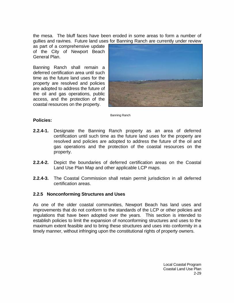
the mesa. The bluff faces have been eroded in some areas to form a number of gullies and ravines. Future land uses for Banning Ranch are currently under review as part of a comprehensive update of the City of Newport Beach General Plan. Banning Ranch shall remain a deferred certification area until such time as the future land uses for the property are resolved and policies are adopted to address the future of the oil and gas operations, public access, and the protection of the coastal resources on the property. Policies: 2.2.4-1. Designate the Banning Ranch property as an area of deferred
certification until such time as the future land uses for the property are resolved and policies are adopted to address the future of the oil and gas operations and the protection of the coastal resources on the property.
2.2.4-2. Depict the boundaries of deferred certification areas on the Coastal
Land Use Plan Map and other applicable LCP maps. 2.2.4-3. The Coastal Commission shall retain permit jurisdiction in all deferred
certification areas. 2.2.5 Nonconforming Structures and Uses As one of the older coastal communities, Newport Beach has land uses and improvements that do not conform to the standards of the LCP or other policies and regulations that have been adopted over the years. This section is intended to establish policies to limit the expansion of nonconforming structures and uses to the maximum extent feasible and to bring these structures and uses into conformity in a timely manner, without infringing upon the constitutional rights of property owners.
Banning Ranch

Local Coastal Program Coastal Land Use Plan
2-30
Policies: 2.2.5-1. Legal nonconforming structures shall be brought into conformity in an
equitable, reasonable, and timely manner as rebuilding occurs. Limited renovations that improve the physical quality and character of the buildings may be allowed. Rebuilding after catastrophic damage or destruction due to a natural event, an act of public enemy, or accident may be allowed in limited circumstances that do not conflict with other policies and of the Coastal Land Use Plan.
2.2.5-2. In the older commercial districts of Balboa Village and Corona del Mar,
allow existing commercial buildings that exceed current intensity limits to be renovated, upgraded, or reconstructed to no more than their existing intensity only where a finding can be made that the development will not perpetuate or establish a physical impediment to public access to coastal resources, nor adversely impact coastal views or biological resources. Where such development cannot meet current parking standards, such approval may only be granted if the proposed development includes at least as much parking as the existing development, and provides for or facilitates the use of alternative modes of transportation such as ride-sharing, carpools, vanpools, public transit, bicycling or walking to the extent feasible.
2.2.5-3. When proposed development would involve demolition or replacement of
50 percent or more of the exterior walls of an existing structure that is legally non-conforming due to a coastal resource protection standard, the entire structure must be made to conform with all current development standards and applicable policies of the Coastal Land Use Plan..
2.2.5-4. The enlargement or intensification of legally established nonconforming
uses shall be limited to only those uses normally permitted by right or by the approval of a use permit, but which were made nonconforming by additional regulations of the district in which they are located. Such enlargement or intensification shall be subject to discretionary review and approval by the City and shall not increase the degree of the use’s nonconformity.

Local Coastal Program Coastal Land Use Plan
2-31
2.3 Visitor-serving and Recreational Development
2.3.1 Commercial
Newport Beach has thirty-seven distinct commercial areas within the coastal zone. These areas range from small strip commercial areas to large hotel complexes. Most of the coastal zone’s commercial development is in the City’s older business districts. These business districts were originally developed to serve harbor-related businesses and industries and to serve the City’s original residential areas. Over the years, portions of these business districts have been redeveloping to visitor-oriented retail, water-related businesses, recreational uses, and mixed commercial/residential projects. The Coastal Land Use Plan allows for the continuation of this trend, while continuing to provide businesses that serve the needs of residents and are essential to the harbor operations.
Visitor-serving and recreational activities are an important part of the character and economy of Newport Beach. In 2003, Newport Beach had 14 hotels, motels, timeshares, and bed & breakfast inns in the coastal zone and 18 citywide. These facilities provide a total of 2,287 rooms in the coastal zone and 3,520 rooms citywide. In FY 2001, Newport Beach received 7.2 million visitors (people other than those
Coastal Act policies related to visitor-serving and recreational development that are relevant to Newport Beach include the following: 30213. Lower cost visitor and recreational facilities shall be protected, encouraged, and, where feasible, provided. Developments providing public recreational opportunities are preferred. 30221. Oceanfront land suitable for recreational use shall be protected for recreational use and development unless present and foreseeable future demand for public or commercial recreational activities that could be accommodated on the property is already adequately provided for in the area. 30222. The use of private lands suitable for visitor-serving commercial recreational facilities designed to enhance public opportunities for coastal recreation shall have priority over private residential, general industrial, or general commercial development, but not over agriculture or coastal-dependent industry. 30223. Upland areas necessary to support coastal recreational uses shall be reserved for such uses, where feasible. 30250 (c). Visitor-serving facilities that cannot feasibly be located in existing developed areas shall be located in existing isolated developments or at selected points of attraction for visitors.
Oceanfront Boardwalk near Newport Pier

Local Coastal Program Coastal Land Use Plan
2-32
who reside or work here). Over 80 percent of the City’s visitors are here for purposes of leisure and the vast majority are day visitors. Other visitor-serving and recreational facilities located within commercial areas include restaurants, snack bars, boat rentals, sports equipment rentals, boat tours of the harbor, boat launching facili-ties, amusement and recreation facilities, and numerous shops selling specialized merchandise. Many of these facilities have become tourist attractions in their own right, such as the Balboa Pavilion, the Fun Zone, Balboa Ferry, the entire Marine Avenue area on Balboa Island, and certain restaurants. Most of the lands suitable for visitor-serving and recreational uses are in the commercial areas surrounding and adjacent to the west end of Newport Harbor. Most of the waterfront land in this area has been designated for recreational and marine uses. Also, individual hotel and motel sites on the Balboa Peninsula, in West Newport, and adjacent to the Upper Newport Bay and other open space areas are designated for visitor-serving uses. A 2002 retail commercial market analysis verifies that the City’s main coastal zone commercial areas largely serve the visitor market. In Balboa Village, Balboa Island, McFadden Square, and Mariner’s Mile, visitors (people from outside each study area) account for the vast majority of retail sales. On Balboa Island, retail sales are dominated by apparel stores, specialty retail stores, and restaurants, which generally sell to tourists and other non-residents. In McFadden Square and Balboa Village, which are adjacent to beaches, restaurants are the single most prominent retail sales category, followed by apparel and sporting goods stores that primarily cater to visitors.
Visitor Spending in Coastal Zone Commercial Area Percentage of Retail
Spending By Visitors Balboa Island 85.1% Balboa Village 80.9% Corona del Mar 75.8% Lido-Cannery 48.0% McFadden Square 86.0% Mariner’s Mile 96.6% Source: Newport Beach General Plan Update Retail Commercial Market Analysis, December 2002.
Edgewater boardwalk in Balboa Village

Local Coastal Program Coastal Land Use Plan
2-33
The lower percentage of retail spending by visitors in Lido-Cannery is due primarily to the presence of two large grocery stores that serve West Newport, Lido Isle, and the Balboa Peninsula and constitute over half of the retail sales. The extremely high percentage of retail spending by visitors in Mariner’s Mile is due primarily to the high concentration of restaurants, entertainment boat operations, automobile and boat dealers, and marine-related retail stores.
While the coastal zone commercial areas are heavily oriented to the visitor market, some commercial areas are also underperforming economically. McFadden Square and Balboa Village have sales per square foot that are below national averages in nearly every retail category. Many businesses have to drastically reduce their hours of operation or close down completely during the winter months. This often gives an impression of economic stagnation and can detract from the ability of the commercial district to attract customers. Therefore, these areas should continue to be permitted a wider range of commercial uses in order to maintain year-around economic viability. While a high proportion of spending in Corona del
Mar is by visitors, many of the categories represented are not necessarily visitor-oriented.
About half of the retail sales are generated by grocery stores and furniture, home furnishings, and home improvement stores. This indicates that much of the retail spending in Corona del Mar is from customers from neighboring communities, but who are not necessarily coastal zone visitors. This is to be expected since the portion of the Corona del Mar commercial area located in the coastal zone is 1,000 to 2,500 feet from the shoreline. Policies: 2.3.1-1. Permit visitor-serving retail and eating and drinking establishments in
all commercially designated areas. 2.3.1-2. Continue to provide waterfront-oriented commercial uses, including
eating and drinking establishments and recreation and entertainment establishments, as a means of providing public access to the waterfront.
McFadden Square shops on the Oceanfront Boardwalk

Local Coastal Program Coastal Land Use Plan
2-34
2.3.1-3. On land designated for visitor-serving and/or recreational uses, give priority to visitor-serving commercial recreational facilities designed to enhance public opportunities for coastal recreation over other commercial uses, except for agriculture and coastal-dependent industry.
2.3.1-4. Protect oceanfront land designated for visitor-serving and/or
recreational uses for recreational use and development unless present and foreseeable future demand for public or commercial recreational activities that could be accommodated on the property is already adequately provided for in the area.
2.3.1-5. Protect special communities and neighborhoods which, because of
their unique characteristics, are popular visitor destination points for recreational uses.
2.3.1-6. Where feasible, reserve upland areas necessary to support coastal
recreational uses for such uses. 2.3.1-7. Give priority to visitor-serving and recreational uses in the mixed-use
areas of the Balboa Peninsula, and Balboa Island.
2.3.1-8. LCP Amendment No. 2005-001 (NPB-MAJ-1-06 Part A) to the Coastal Land Use Plan changing a portion of land, not to exceed 4.25 acres in size, designated Visitor-Serving Commercial (CV) in Newport Center to a residential designation shall require a payment of a fee to mitigate for the loss of visitor-serving land. The mitigation fee shall be used for the protection, enhancement and provision of lower-cost visitor-serving uses at Crystal Cove State Park. The mitigation fee shall be in the amount of five million (5,000,000.00) dollars to off-set the loss of the priority land use in Newport Center. The mitigation fee shall be paid prior to issuance of any coastal development permit granted for any residential project within the newly designated area and to an entity, identified by the permitting agency, capable of implementing the mitigation at Crystal Cove State Park. Until paid in accordance with the terms and conditions of the coastal development permit, the amount shall be increased every July 1st by an amount calculated on the basis of the percentage change from the year 2007 in the California Consumer Price Index for Urban Consumers as determined by the entity that grants the coastal development permit.

Local Coastal Program Coastal Land Use Plan
2-35
2.3.1-9. In Mariner’s Mile, require that development on the Bay frontage implement amenities that assure access for coastal visitors. Pursue development of a pedestrian promenade along the Bayfront.
2.3.1-10. Support continued operation of passenger/sightseeing boats, passenger/fishing boats (“day boats”), and long-term boat rentals and sales.
2.3.1-11. Support continued short-term rental of small boats while encouraging vendors to teach customers how to safely operate the watercraft.
2.3.1-12. Support continued operation of entertainment and tour boats subject to reasonable regulations designed to ensure the operations don’t have an adverse impact, such as unsafe navigation, impaired water quality, reduced visual quality, excessive noise, unsafe street traffic conditions, or parking shortages on the environment and land uses surrounding the harbor.
2.3.1-13. Any proposal to demolish existing overnight accommodations shall be required to demonstrate that rehabilitation of the units is not feasible. Any hotel/motel rooms for which a certificate of occupancy has been issued on or before the effective date of adoption of Coastal Land Use Plan Amendment No. 2007-001 (NPB-MAJ-1-07) shall not be permitted to convert to a Limited Use Overnight Visitor Accommodation, except as provided in Policy 2.3.3-7.
2.3.2 Open Space and Tidelands/Submerged Lands Newport Beach’s open space designated areas in the coastal zone include beaches, parks, golf courses, yacht clubs, and environmentally sensitive habitat areas and other natural resources. These areas provide a wide range of recreational and visitor-serving uses and facilities. Nearly all of the oceanfront land, including the entire Balboa Peninsula, is public beach. In total, there are over 276 acres of public beaches on the shoreline. There are also approximately 415 acres of recreational and view parks on or adjacent to the shoreline.
Rowing in the Upper Newport Bay

Local Coastal Program Coastal Land Use Plan
2-36
Tidelands and submerged lands are State lands held in trust by the City of Newport Beach, the County of Orange or State resource agencies. These lands are subject to the public trust doctrine and are limited to public trust uses, such as navigation, fisheries, commerce, public access, water-oriented recreation, open space and environmental protection. The waters of Newport Bay and of the Pacific Ocean adjacent to Newport Beach are used for a wide variety of recreational activities, including boating, diving, excursions, fishing, kayaking, paddle boarding, parasailing, rowing, sailing, surfing, swimming, and wind surfing. Development in the form of marinas, moorings, piers, and equipment rentals provide recreational opportunities and access to the water. The Newport Dunes Aquatic Park is on 100 acres of State tidelands property held in trust by the County of Orange. The park is leased to a private operator and provides a recreational vehicle park, campgrounds, a marina, boat launching and storage facilities, beach day use facilities, and a swimming lagoon. Policies: 2.3.2-1. Continue to use public beaches for public recreational uses and
prohibit uses on beaches that interfere with public access and enjoyment of coastal resources.
2.3.2-2. Continue to designate lands to provide visitor-serving and recreational
facilities and view parks on or adjacent to the shoreline. Pirate’s Cove
2.3.2-3. Cooperate with the County of Orange to continue to provide a variety
of visitor-serving and recreational uses at the Newport Dunes,
Local Coastal Program Coastal Land Use Plan
2-37
including recreational vehicle park and campground areas as a means of providing alternative and lower cost overnight accommodations.
2.3.2-4. Continue to administer the use of tidelands and submerged lands in a
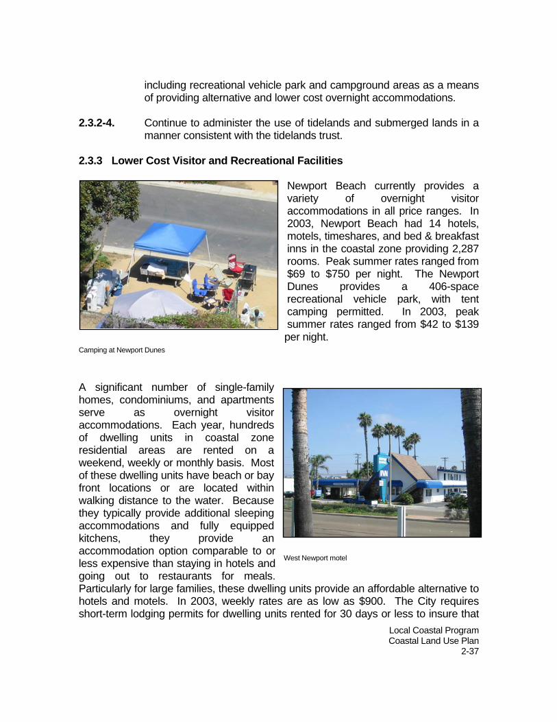
manner consistent with the tidelands trust. 2.3.3 Lower Cost Visitor and Recreational Facilities
Newport Beach currently provides a variety of overnight visitor accommodations in all price ranges. In 2003, Newport Beach had 14 hotels, motels, timeshares, and bed & breakfast inns in the coastal zone providing 2,287 rooms. Peak summer rates ranged from $69 to $750 per night. The Newport Dunes provides a 406-space recreational vehicle park, with tent camping permitted. In 2003, peak summer rates ranged from $42 to $139 per night.
A significant number of single-family homes, condominiums, and apartments serve as overnight visitor accommodations. Each year, hundreds of dwelling units in coastal zone residential areas are rented on a weekend, weekly or monthly basis. Most of these dwelling units have beach or bay front locations or are located within walking distance to the water. Because they typically provide additional sleeping accommodations and fully equipped kitchens, they provide an accommodation option comparable to or less expensive than staying in hotels and going out to restaurants for meals. Particularly for large families, these dwelling units provide an affordable alternative to hotels and motels. In 2003, weekly rates are as low as $900. The City requires short-term lodging permits for dwelling units rented for 30 days or less to insure that
Camping at Newport Dunes
West Newport motel

Local Coastal Program Coastal Land Use Plan
2-38
overcrowding and public nuisances do not result in adverse impacts to residential areas, coastal access, and coastal resources (see Section 2.7). In 2003, the City issued over 800 short-term lodging permits. The City provides approximately 360 acres of public beaches and parks in the coastal zone, which are available free of charge. Also, the County’s Upper Newport Bay Nature Preserve and the day use facilities at the County’s Newport Dunes Aquatic Park are available free of charge. These areas offer a variety of free or lower cost recreational opportunities and are discussed further in Section 3.2. The City, County, and private organizations also provide several coastal-related educational and interpretative facilities and programs that are either free or have a nominal charge. These include the Muth Interpretative Center in the Upper Newport Bay Nature Preserve, the Back Bay Science Center on Shellmaker Island, the Newport Aquatic Center at North Star Beach, and the Newport Harbor Nautical Museum. Policies: 2.3.3-1. Lower-cost visitor and recreational facilities, including campgrounds,
recreational vehicle parks, hostels, and lower-cost hotels and motels, shall be protected, encouraged and, where feasible, provided. Developments providing public recreational opportunities are preferred. New development that eliminates existing lower-cost accommodations or provides high-cost overnight visitor accommodations or limited use overnight visitor accommodations such as timeshares, fractional ownership and condominium-hotels shall provide lower-cost overnight visitor accommodations commensurate with the impact of the development on lower-cost overnight visitor accommodations in Newport Beach or pay an "in-lieu" fee to the City in an amount to be determined in accordance with law that shall be used by the City to provide lower-cost overnight visitor accommodations.
2.3.3-2. Encourage new overnight visitor accommodation developments to
provide a range of rooms and room prices in order to serve all income ranges. Consistent with Section 30213 of the Coastal Act, the City shall in no event (1) require that overnight room rental be fixed at an amount certain for any privately owned and operated hotel, motel, or other similar visitor-serving facility located on either public or private land; nor (2) establish or approve any method for the identification of low or moderate income persons for the purpose of determining eligibility for overnight room rentals in any such facilities.

Local Coastal Program Coastal Land Use Plan
2-39
2.3.3-3. Identify, protect, encourage and provide lower-cost visitor-serving and recreation facilities, including museums and interpretative centers.
2.3.3-4. Encourage visitor-serving and recreational developments that provide
public recreational opportunities. 2.3.3-5. Continue to provide and
protect public beaches and parks as a means of providing free and lower-cost recreational opportunities.
2.3.3-6. Continue to issue short-
term lodging permits for the rental of dwelling units as a means of providing lower-cost overnight visitor accommodations while continuing to prevent conditions leading to increase demand for City services and adverse impacts in residential areas and coastal resources.
2.3.3-7. Permit limited-use overnight visitor accommodations on the hotel
resort property located at 1107 Jamboree Road where such accommodations are provided together with traditional overnight, hotel visitor accommodations and which shall be subject to specific restrictions, including on: quantity (no less than 391 units shall be traditional hotel units available for transient overnight use by the general public year round and no more than 88 of the total 479 units planned may be limited-use overnight visitor accommodations), duration of owner use of such facilities (maximum use of 90 days per calendar year with a maximum of 29 days of use during any 60 day period), management of the units as part of the hotel facility and allowance for transient overnight use by the general public when not owner occupied; all of which shall be further defined in the implementing regulations for this land use plan (when such regulations are certified) and through the coastal development permit process.
2.3.3-8. A method to define whether a facility providing overnight
accommodations is low, moderate, or high cost for the City of
Montero Avenue Beach

Local Coastal Program Coastal Land Use Plan
2-40
Newport Beach coastal zone shall be developed in the implementing regulations for this land use plan (when such regulations are certified) and through the coastal development permit process.

Local Coastal Program Coastal Land Use Plan
2-41
2.4 Coastal-dependent/related Development
2.4.1 Commercial Newport Harbor supports a wide range of coastal-dependent and coastal-related commercial uses. These include passenger/sightseeing boats, passenger-fishing boats, boat rentals and sales, recreational equipment rentals, entertainment boats, boat/ship repair and maintenance, and harbor maintenance facilities. These uses play an important role in the character of the harbor and provide the services necessary to sustain one of the world’s great small boat harbors.
Over the past 20 years, a number of marine-related businesses and industries in Newport Beach have moved to inland areas. This is reflective of a regional trend, largely due to increased environmental regulation in California affecting fiberglass manufacturing processes, as well as real estate price inflation in coastal communities. The Recreational and Marine Commercial (CM) land use category is the primary method of providing for the continuation of coastal-dependent and coastal-related
commercial uses on or near the bay. The CM designation is applied to areas that have historically provided marine-related businesses and industries and visitor-serving and recreational areas. CM uses are also permitted in the Mixed Use (MU-V, MU-H, and MU-W) land use categories located on or near the bay to encourage the
Coastal Act policies related to coastal-dependent and coastal-related development that are relevant to Newport Beach include the following: 30255. Coastal-dependent developments shall have priority over other developments on or near the shoreline. Except as provided elsewhere in this division, coastal-dependent developments shall not be sited in a wetland. When appropriate, coastal-related developments should be accommodated within reasonable proximity to the coastal-dependent uses they support.
Basin Marine Shipyard
Coastal-dependent/-related
Coastal-dependent refers to a development or use that requires a site on, or adjacent to, the sea to be able to function at all. Coastal-related refers to a development or use that is dependent on a coastal-dependent development or use.

Local Coastal Program Coastal Land Use Plan
2-42
continuation of coastal-dependent and coastal-related uses, as well as allow for the integrated development of residential. Policies: 2.4.1-1. Give priority to coastal-dependent uses over other uses on or near the
shoreline. 2.4.1-2. When appropriate, accommodate coastal-related developments within
reasonable proximity to the coastal-dependent uses they support. 2.4.1-3. Discourage re-use of properties that result in the reduction of coastal-
dependent commercial uses. Allow the re-use of properties that assure coastal-dependent uses remain, especially in those areas with adequate infrastructure and parcels suitable for redevelopment as an integrated project.
2.4.1-4. Design and site new development to avoid impacts to existing coastal-
dependent and coastal-related developments. When reviewing proposals for land use changes, give full consideration to the impact on coastal-dependent and coastal-related land uses including not only the proposed change on the subject property, but also the potential to limit existing coastal-dependent and coastal-related land uses on adjacent properties.
2.4.1-5. Maintain the Recreational and Marine Commercial (CM) land use
category and allow CM uses in the Mixed Use land use categories (MU-V, MU-H, and MU-W) in areas on or near the bay to encourage a continuation of coastal-dependent and coastal-related uses.
2.4.1-6. Protect and encourage facilities that serve marine-related businesses
and industries unless present and foreseeable future demand for such facilities is already adequately provided for in the area. Encourage coastal-dependent industrial facilities to locate or expand within existing sites and allowed reasonable long-term growth.

Local Coastal Program Coastal Land Use Plan
2-43
Kerckhoff Marine Laboratory in Corona del Mar
2.4.2 Public Facilities Lands designated for public facilities that are on or adjacent to the shoreline are primarily used for public parking, public safety facilities, and educational facilities. These include coastal-dependent/related institutional uses, such as the Orange Coast College David A. Grant Collegiate Rowing Center, the Sea Scout Base, and the Kerckhoff Marine Laboratory. Policy 2.4.2-1. Continue to designate lands for coastal-dependent/related
educational and recreational uses.

Local Coastal Program Coastal Land Use Plan
2-44
Balboa Yacht Basin
2.5 Tidelands and Submerged Lands
2.5.1 The Tidelands Trust
Tidelands and submerged lands are subject to a public trust that, among other things, limits their use to navigation, fishing, commerce, public access, water-oriented recreation, open space and environmental protection. Tidelands and submerged lands within the corporate limits of Newport Beach are, with very limited exceptions, owned by the State. The vast majority of tidelands and submerged lands in Newport Beach have been granted to the City or the County of Orange to administer in a manner consistent with the public
trust limitations relative to use of the property and revenue derived from that use. The tideland boundary in Newport Harbor has been, for virtually all of the properties, established by court judgments stemming from a series of lawsuits filed in the 1920’s and 1930’s. Newport Beach tidelands also include large portions of the City’s ocean beaches and land covered by the Pacific Ocean from the shoreline three miles out to sea and between the Santa Ana River and the east end of the Cameo Shores tract. 2.5.2 Tidelands Leases Chapter 494 of the Statutes of 1919 granted to the City of Newport Beach all tidelands and submerged lands that were within its corporate limits at that time. Additional tidelands were granted by Chapter 70 of the Statutes of 1927. These tidelands and submerged lands consist primarily of the land bayward of the bulkhead and portions of bay beaches in the Lower Bay. The Beacon Bay Bill (Chapter 74,
Coastal Act policies related to tidelands and submerged lands that are relevant to Newport Beach include the following: 30213. Lower cost visitor and recreational facilities shall be protected, encouraged, and, where feasible, provided. Developments providing public recreational opportunities are preferred. 30221. Oceanfront land suitable for recreational use shall be protected for recreational use and development unless present and foreseeable future demand for public or commercial recreational activities that could be accommodated on the property is already adequately provided for in the area. 30223. Upland areas necessary to support coastal recreational uses shall be reserved for such uses, where feasible.

Local Coastal Program Coastal Land Use Plan
2-45
Public beach at Beacon Bay
Statutes of 1978) regranted to the City of Newport Beach all tidelands and submerged lands that were within its corporate limits on July 25, 1919. The Beacon Bay Bill established limitations on the use of tidelands and submerged lands to those in which there is a general statewide purpose, including the establishment, improvement and conduct of a public harbor, recreational facilities open to the public, and the preservation and enhancement of the lands in their natural state. The Beacon Bay Bill also modified some of the public trust restrictions on certain properties, such as portions of Beacon Bay and the Balboa Bay Club, subject to a requirement that revenue generated by these properties be used for public trust purposes. Beacon Bay Beacon Bay refers to an area located between Promontory Bay and the Balboa Island Channel. This area was tidelands that were filled and reclaimed in the 1920s as the result of an improvement plan, which included the development of a harbor facility that would become the Balboa Yacht Basin. Chapter 200 of the Statutes of 1931 allowed the area west of the Balboa Yacht Basin (designated as Beacon Bay) to be leased for residential purposes. A 72-unit residential subdivision was developed in the 1930s, which included 35 homes located on approximately 4 acres of State tidelands. As indicated above, the Beacon Bay Bill released the residential lots of Beacon Bay located within State tidelands from the public trust land use limitations and allows existing leases to continue. These leases are limited to terms not to exceed 50 years and lease revenues have to be deposited into tidelands trust funds. Senate Bill 573 (Chapter 317, Statutes of 1997) revised the Beacon Bay Bill to require the residential lease revenue be deposited into specific tidelands trust funds. The current lease runs to June 27, 2043. In Fiscal Year 2002-03, the City of Newport Beach received over $729,000 in lease revenues from Beacon Bay, which were deposited in tidelands trust funds and State Lands Commission Land Bank Fund.

Local Coastal Program Coastal Land Use Plan
2-46
Bayfront walkway at the Balboa Bay Club and Resort
Balboa Bay Club
The Balboa Bay Club and Resort is on approximately 12.6 acres of State tidelands held in trust by the City of Newport Beach and leased to the Balboa Bay Club, Inc. The property is located on the south side of the 1200 block of West Coast Highway and was filled and reclaimed in the 1920s as part of a public project to develop the Lower Bay as a harbor. The property is currently developed with a 132-room resort hotel, restaurant, spa,
private club facilities, and 144-unit
apartment complex. The State Lands Commission has determined that the use of tidelands for private residential purposes is in conflict with the public trust limitations on use. This conflict was first addressed in the Beacon Bay Bill (Chapter 74 of the Statutes of 1978) and later in Assembly Bill 3139 (Chapter 728, Statutes of 1994). AB 3139 recognized that the lease of the apartment complex (identified as Parcel D) for residential purposes provides fiscal and economic benefits to the public trust and a means of improving public access. Under the provisions of AB 3139, lease revenues are placed in tidelands trust funds to provide facilities and services that directly support public use of tidelands and submerged lands. Income from the apartments provides an income stream that allowed the lessee to finance the redevelopment of the club to transition it from a private membership facility to visitor-serving commercial land uses. AB 3139 therefore allows Parcel D to be leased for residential purposes until no later than December 31, 2044. In Fiscal Year 2002-03, the City of Newport Beach received over $1,870,000 in lease revenues from Parcel D, which were deposited in tidelands trust funds and State Lands Commission Land Bank Fund. The redevelopment of the Balboa Bay Club was completed in 2003 and provides public access to the hotel, restaurant, spa, the main parking lot, and a public walkway to and along the bulkhead.

Local Coastal Program Coastal Land Use Plan
2-47
Harbor Island Developed in 1926, Harbor Island is a 35-lot single-family community on a private island located between Linda Isle and Collins Island. Portions of tidelands surrounding Harbor Island have been filled or reclaimed and are no longer submerged or below the mean high tide line. Harbor Island residents have improved these lands with landscaping and other improvements. The State, through the adoption of Chapter 715, Statutes of 1984, found that these lands are generally inaccessible to the public and, in their present condition, are not suitable for public trust uses. Both the County of Orange (most of the subject lands are County tidelands) and City of Newport Beach are authorized to allow the Harbor Island tidelands to be used for non-permanent recreational and landscaping uses. These leases are limited to terms of 49 years or less and lease revenues have to be deposited into tidelands trust funds. Policies: 2.5.2-1. Administer the use of tidelands and submerged lands in a manner
consistent with the tidelands trust and all applicable laws, including Chapter 70 of the Statutes of 1927, the Beacon Bay Bill (Chapter 74, Statutes of 1978), SB 573 (Chapter 317, Statutes of 1997), AB 3139 (Chapter 728, Statutes of 1994), and Chapter 715, Statutes of 1984 and the Coastal Act.
2.5.2-2. Promote the public's right of access to the ocean, beach, and bay and
to the provision of coastal-dependent uses adjacent to the water in the leasing or re-leasing of publicly owned land.
2.5.2-3. Evaluate and ensure the consistency of the proposed use with the
public trust restrictions and the public interest at the time any tideland lease is re-negotiated or renewed.
2.5.2-4. Negotiate or renegotiate tidelands leases at the fair market value
based on the uses authorized in the lease and use the funds as required by law or the public trust.
2.5.2-5. Require public access in a manner consistent with the policies of the
Coastal Act and this LCP when the City issues new leases of public land, or renew existing leases. This requirement shall be understood to apply to all other public leaseholds in the coastal zone, including beaches leased to the Lido Isle Association.

Local Coastal Program Coastal Land Use Plan
2-48
2.6 Industrial Development
None of the City’s industrial areas are located within the coastal zone. However, portions of Cannery Village (SP-3) are designated for a mixture of general commercial and light industrial uses to encourage marine-related business. When Newport Beach adopted its charter in 1954, oil and gas exploration, drilling, production, and refining was banned in the City. However, one oil field operation existed prior to the ban. The Newport Oil Field is located in the western portion of Newport Beach. The field was divided into two areas known as the Cagney and Beach areas. The Beach Area discovery well was drilled in 1922 and discovery well in the Cagney Area was drilled in 1947. The Beach Area has been abandoned, but there were still 3 gas-producing wells in the Cagney Area. Oil and gas operations are also conducted throughout the County portion of the Banning Ranch property (West Newport Oil Field) pursuant to California Coastal Commission Exemption E-144. Banning Ranch is a deferred certification area due to unresolved issues relating to land use, the future of the oil and gas operations, and the protection of the coastal resources on the property (see Section 2.2.4). The City of Newport Beach and other coastal communities in Southern California have long opposed the federal government's offshore oil leasing programs. Newport Beach residents and visitors rely heavily on the bay and oceanfront beaches for recreation, and much of the City's economy is based upon its natural resources. Development of offshore tracts creates visual impacts and poses the threat of significant oil spills and resulting environmental damage.
Coastal Act policies related to industrial development that are relevant to Newport Beach include the following: 30250 (b) Where feasible, new hazardous industrial development shall be located away from existing developed areas.
30260. Coastal-dependent industrial facilities shall be encouraged to locate or expand within existing sites and shall be permitted reasonable long-term growth where consistent with this division. However, where new or expanded coastal-dependent industrial facilities cannot feasibly be accommodated consistent with other policies of this division, they may nonetheless be permitted in accordance with this section and Sections 30261 and 30262 if (1) alternative locations are infeasible or more environmentally damaging; (2) to do otherwise would adversely affect the public welfare; and (3) adverse environmental effects are mitigated to the maximum extent feasible. 30262. Oil and gas development shall be permitted in accordance with Section 30260,…
Commercial and light industrial uses in Cannery Village

Local Coastal Program Coastal Land Use Plan
2-49
Policies: 2.6-1. In the areas designated for
industrial land uses, give priority to coastal-dependent and coastal-related industrial uses over other industrial uses on or near the shoreline.
2.6-2. Continue to monitor the
federal government's offshore oil leasing programs to insure the City and its citizens are fully aware of all proposed offshore activities, which could adversely affect the coastal environment, including participation in the Local Government Coordination Program or other similar programs.
2.6-3. Oppose and lobby against proposed lease sales off the coast of Orange
County and elsewhere in the Southern California region, which could adversely affect the environment or the economy of the City of Newport Beach.
2.6-4. Assist jurisdictions in other areas of the state that are opposed to offshore
lease sale programs in their vicinity. 2.6-5. Where feasible, locate new hazardous industrial development away from
existing developed areas. 2.6-6. Encourage coastal-dependent industrial facilities to locate or expand within
existing sites and permit reasonable long-term growth where consistent with the Coastal Land Use Plan.
West Newport Oil Field operations

Local Coastal Program Coastal Land Use Plan
2-50
2.7 Residential Development
Newport Beach has a wide variety of residential development types in the coastal zone, ranging from low-density single-family detached subdivisions to high-density high-rise condominiums. Most of the residential areas in the coastal zone were originally subdivided in the early 20th Century, with many developments marketed as vacation home sites. This established the grid system of small lots and narrow streets and alleys that still exists today. These subdivision characteristics and the development of two-family and multi-family development have resulted in relatively high residential densities in Newport Beach’s coastal neighborhoods. Coastal zone residential areas are almost completely built out, with the exception of the Banning Ranch area (see Section 2.2.4). Most residential building activity consists of remodeling and/or the total reconstruction of existing dwelling units. Newport Beach’s proximity to major employment markets and its desirable coastal setting have led to steadily increasing land costs. In 2001, Newport Beach was one of the ten California communities with the highest median home prices. This high market demand is manifest in a number of development issues facing the City, including development on odd-shaped or physically constrained properties, trends towards larger dwelling units, and proposals to allow residential development in commercial areas. Hundreds of dwelling units in coastal zone residential areas are rented for 30 days or less. The vast majority of these rentals occur during the summer when the demand for parking and City services is greatest. Overcrowding and public nuisances associated with these short-term rentals have resulted in adverse impacts to residential areas, coastal access, and coastal resources. Since 1992, the City has required short-term lodging permits to assist in controlling overcrowding and unruly behavior. Short-term lodging permits require the owner of the short-term rental to agree to limit overnight occupancy of the unit to a specific number of occupants not exceeding that permitted by the Building Code. Short-term rental owners are also required to use best efforts to insure that the occupants and guests are law abiding, do not create unreasonable noise or disturbances, or engage in disorderly conduct. Short-term rental owners are also required to use best efforts to insure compliance
Coastal Act policies related to residential development that are relevant to Newport Beach include the following: 30007. Nothing in this division shall exempt local governments from meeting the requirements of state and federal law with respect to providing low-and moderate-income housing, replacement housing, relocation benefits, or any other obligation related to housing imposed by existing law or any law hereafter enacted. 30222. The use of private lands suitable for visitor-serving commercial recreational facilities designed to enhance public opportunities for coastal recreation shall have priority over private residential, general industrial, or general commercial development, but not over agriculture or coastal-dependent industry.

Local Coastal Program Coastal Land Use Plan
2-51
with all health and sanitation regulations. Illegal or “bootleg” dwelling units exist in Newport Beach, experienced most often in the older, beach-oriented areas of West Newport, Balboa Peninsula, Balboa Island and Corona del Mar. These units are found in two typical forms: the “splitting” of a single dwelling unit into two separate occupancies, and the conversion of garages to living space. These units usually have a number of health and safety code violations, due to conversion without proper building permits and inspections. Associated overcrowding, traffic congestion, and illegal vehicle parking have also resulted in adverse impacts to residential areas and coastal resources. Illegal dwelling units are less prevalent than in the past, due to increased year-round owner occupancy in these areas and Report of Residential Building Records inspections that occur when properties are sold. A Report of Residential Building Records is a report issued by the City describing the zoning of the residential building, the number of dwelling units permitted pursuant to the zoning classification, and other information relevant to the use, occupancy and construction of the residential building. Policies: 2.7-1. Continue to maintain appropriate setbacks and density, floor area, and height
limits for residential development to protect the character of established neighborhoods and to protect coastal access and coastal resources.
2.7-2. Continue the administration of provisions of State law relative to the
demolition, conversion and construction of low and moderate-income dwelling units within the coastal zone.
2.7-3. Continue to authorize short-term rental of dwelling units pursuant to permits
and standard conditions that ensure the rentals will not interfere with public access and enjoyment of coastal resources.
2.7-4. Continue to require Report of Residential Building Records inspections prior
to the sale of residential properties to reduce and prevent violations of building and zoning codes by providing prospective owners of residential property with information as to permitted and illegal uses and construction.
West Newport homes

Local Coastal Program Coastal Land Use Plan
2-52
2.8 Hazards and Protective Devices
2.8.1 General Newport Beach is susceptible to hazards, including, storm surges, beach and bluff erosion, landslides and slope failure, and wildland fires. Newport Beach is also susceptible to low-probability but high-risk events like earthquakes and tsunamis. It is the mandate of the Coastal Act to reduce potential risks to life and property and to avoid substantial alteration of natural landforms. In reviewing coastal development permits, the emphasis needs to be placed on siting and designing new development to avoid hazardous areas rather than relying on protective devices. Policies: 2.8.1-1. Review all applications for new development to determine potential
threats from coastal and other hazards. 2.8.1-2. Design and site new development to avoid hazardous areas and
minimize risks to life and property from coastal and other hazards.
Coastal Act policies related to hazards and protective devices that are relevant to Newport Beach include the following: 30235. Revetments, breakwaters, groins, harbor channels, seawalls, cliff retaining walls, and other such construction that alters natural shoreline processes shall be permitted when required to serve coastal-dependent uses or to protect existing structures or public beaches in danger from erosion and when designed to eliminate or mitigate adverse impacts on local shoreline sand supply. Existing marine structures causing water stagnation contributing to pollution problems and fishkills should be phased out or upgraded where feasible. 30253. New development shall:
(1) Minimize risks to life and property in areas of high geologic, flood, and fire hazard.
(2) Assure stability and structural integrity, and neither create nor contribute significantly to erosion, geologic instability, or destruction of the site or surrounding area or in any way require the construction of protective devices that would substantially alter natural landforms along bluffs and cliffs.
(3) Be consistent with requirements imposed by an air pollution control district or the State Air Resources Control Board as to each particular development.
(4) Minimize energy consumption and vehicle miles traveled.
(5) Where appropriate, protect special communities and neighborhoods which, because of their unique characteristics, are popular visitor destination points for recreational uses. 30236. Channelizations, dams, or other substantial alterations of rivers and streams shall incorporate the best mitigation measures feasible, and be limited to (1) necessary water supply projects, (2) flood control projects where no other method for protecting existing structures in the flood plain is feasible and where such protection is necessary for public safety or to protect existing development, or (3) developments where the primary function is the improvement of fish and wildlife habitat.

Local Coastal Program Coastal Land Use Plan
2-53
2.8.1-3. Design land divisions, including lot line adjustments, to avoid hazardous areas and minimize risks to life and property from coastal and other hazards.
2.8.1-4. Require new development to assure stability and structural integrity,
and neither create nor contribute significantly to erosion, geologic instability, or destruction of the site or surrounding area or in any way require the construction of protective devices that would substantially alter natural landforms along bluffs and cliffs.
2.8.2 Tsunamis and Rogue Waves Tsunamis A tsunami is a sea wave caused by any large-scale disturbance of the ocean floor that occurs in a short period of time and causes a sudden displacement of water. Tsunamis can travel across the entire Pacific Ocean basin, or they can be local. Large-scale tsunamis are not single waves, but rather a long train of waves. The most frequent causes of tsunamis are shallow underwater earthquakes and submarine landslides; however, underwater volcanic explosions, oceanic meteor impacts, and even underwater nuclear explosions can also cause tsunamis. The highest elevation that the water reaches as it runs up on the land is referred to as wave runup, uprush, or inundation height. Inundation refers to the horizontal distance that a tsunami wave penetrates inland. The historical tsunami record for California suggests that the tsunami hazard in the Southern California region, from the Palos Verdes Peninsula south to San Diego, is moderate. However, the Southern California historical record is very short and it is possible that Southern California has been impacted by tsunamis for which there is no record. More significantly, there are several active faults immediately offshore of the Southern California area, and any of these could generate a future earthquake that could have a tsunami associated with it. Finally, several submarine landslides and landslide-susceptible areas have been mapped offshore, within 3.5 to 14 km (2.2 8.7 mi) to of the coastline. For the Orange County coastline particularly, near-shore tsunamis should be considered worst-case scenarios, as these have the potential to cause high runups that would impact the coastline with almost no warning. The Channel Islands and Point Arguello protect Newport Beach from most distantly generated tsunamis (teletsunamis) spawned in the Pacific Ocean, except for those generated in the Aleutian Islands, off the coast of Chile, and possibly off the coast of Central America. Nevertheless, since the early 1800’s, more than 30 tsunamis have been recorded in Southern California, and at least six of these caused damage in the area, although not necessarily in Newport Beach. Tsunamis generated in the

Local Coastal Program Coastal Land Use Plan
2-54
Alaskan region take approximately 6 hours to make it to the Southern California area, while tsunamis generated off the Chilean coast take 12 to 15 hours to reach Southern California. Given those time frames, coastal communities in Southern California can receive adequate warning, allowing them to implement evacuation procedures. Alternatively, very little warning time, if any, can be expected from locally generated tsunamis. Locally generated tsunamis caused by offshore faulting or landsliding (including earthquake-induced landsliding) immediately offshore from Newport Beach are possible, and these tsunamis have the potential to be worst-case scenarios for the coastal communities in Orange County. Modeling off the Santa Barbara coast suggests that locally generated tsunamis can cause waves between 2 and 20 m (6 to 60 feet) high, and that these could impact the coastline with almost no warning, within minutes of the causative earthquake or slump. The tsunami inundation maps were prepared based on several sea water levels scenarios for 100- and 500-year tsunamis. The findings are summarized below: Tsunami Inundation at Mean Sea Level. In this scenario, Newport Bay and most of the harbor would be inundated with the potential to damage small vessels and docks. Some of the properties adjacent to the Bay would also be impacted, especially the northwestern section of Balboa Island, which is predicted to be inundated. The water level in Upper Newport Bay is anticipated to rise some but the data available are insufficient to quantify the hazard in this area. Tsunami Inundation at Mean High Water. In this scenario, Most of the harbor area, including the inland, developed portion of the Balboa Peninsula, Balboa Island, and Upper Newport Bay could be inundated during such an event. Near-shore sections of Lido Isle and Linda Isle would also be impacted, and Lido Isle would be cut off from the mainland due to flooding along Newport Boulevard and 32nd Street. This scenario is expected to cause considerable damage to homes in the low-lying areas and to all moored boats. Tsunami Inundation at Extreme High Tide. In this scenario, a significant portion of Newport Harbor and the low-lying areas south of Coast Highway would be inundated by both the 100- and 500-year wave runups. The 100-year event shows that except for a small sliver of Lido Isle, the entire Newport Bay area would flood. Flooding is also anticipated in the area where Newport Dunes Resort is located. In the 500-year event, all of Lido Isle is expected to flood. The probability of a tsunami occurring during extreme high tide is highly improbable and represents the worst-case scenario. However, these tsunami runups are possible if a tsunami occurs immediately offshore of Newport Beach, whether as a result of faulting or landsliding.

Local Coastal Program Coastal Land Use Plan
2-55
Rogue Waves Rogue waves are very high waves, as much as tens of meters high, but compared to tsunamis, they are very short from one crest to the next, typically less than 2 km (1.25 mi) long. Rogue waves arise unexpectedly in the open ocean and their generating mechanism is a source of controversy and active research. Some theories on rogue wave formation include: Strong currents that interact with existing swells making the swells much
higher; A statistical aberration that occurs when a number of waves just happen to be
in the same place at the same time, combining to make one big wave; The result of a storm in the ocean where the wind causes the water surface to
be rough and choppy, creating very large waves. Rogue waves are unpredictable and therefore making planning nearly impossible. Nevertheless, some high waves that have historically impacted the Orange County coastline may be best explained as rogue waves. If this is the case, rogue waves have the potential to impact the Newport Beach area in the future. Policies: 2.8.2-1. Review local and distant tsunami inundation maps for Newport Beach
and adjacent coastal communities as they are developed to identify susceptible areas and plan evacuation routes.
2.8.2-2. Periodically review and update tsunami preparation and response
policies/practices to reflect current inundation maps and design standards.
2.8.2-3. Participate in any regional effort to develop and implement workable
response plans that the City’s emergency services can adopt immediately for evacuation in the case of a tsunami warning.
2.8.2-4. Prepare and deploy a system of tsunami detection and early warning
systems. 2.8.2-5. Include tsunami evacuation route information as part of any overall
evacuation route sign program implemented in the City. Evacuation routes off of the peninsula and islands in the Bay should be clearly posted. An evacuation route traffic monitoring system that provides

Local Coastal Program Coastal Land Use Plan
2-56
Storm berm at The Wedge
real-time information on the traffic flow at critical roadways should be considered.
2.8.2-6. Continue projects like the Surfside-Sunset/West Newport Beach
Replenishment program to maintain beach width. Wide beaches provide critical protection against tsunami runup for structures along the oceanfront.
2.8.2-7. Develop and implement a tsunami educational program for residents,
visitors, and people who work in the susceptible areas. 2.8.2-8. Require overnight visitor-serving facilities in susceptible areas to
provide tsunami information and evacuation plans. 2.8.2-9. Encourage the Newport-Mesa School District to include in their
earthquake-preparedness curriculum information specifically related to the natural hazards that Newport Beach's citizens could face, and what to do about them.
2.8.2-10. Support tsunami research in the Newport Beach offshore and Newport
Bay areas. 2.8.3 Storm Surges and Seiches Two common coastal flooding processes include storm surges and seiches. Storm Surges A storm surge is an abnormal rise in sea water level associated with hurricanes and other storms at sea. Surges result from strong on-shore winds and/or intense low-pressure cells associated with ocean storms. Water level is controlled by wind, atmospheric pressure, existing astronomical tide, waves and swell, local coastal topography and bathymetry, and the storm's proximity to the coast. Most often, destruction by storm surge is attributable to:

Local Coastal Program Coastal Land Use Plan
2-57
Balboa Peninsula houses destroyed by storm surge from the 1939 tropical storm
Wave impact and the physical shock on objects associated with the passing
of the wave front. The water may lift and carry objects to different locations. Direct impact of waves on fixed structures. This tends to cause most of the
damage. Indirect impacts, such as flooding and the undermining of major infrastructure
(such as highways and railroads). Storm surges affect primarily ocean front property, and the low-lying areas of Newport Bay just inland from the jetties. Newport Bay is less affected by storm surge. Unlike tsunamis, which can occur anytime, storm surges are associated with bad weather. Given that during bad weather fewer people are expected to be at the beach, storm surges are more likely to impact residents than tourists, and the potential number of casualties can be expected to be significantly less.
The most common problem associated with storm surges is flooding of low-lying areas, including structures. Coastal flooding in Newport Beach occurred in the past when major storms, many of these ENSO (El Niño Southern Oscillation) events, impacted the area. This is often compounded by intense rainfall and strong winds. If a storm surge occurs during high tide, the flooded area can be significant. In the Southern California area, including Newport Beach, localized
flooding and accelerated rates of coastal erosion have occurred when storms are
combined with high tides. This occurred during the 1977-1978 storms, when the combination of high waves, local storm surges and high tides damaged several coastal structures in southern California. During the storms in 1988, the high water extended to the first row of houses behind the groin field at Newport Beach causing minor flood damage to these structures. Storm surging associated with a tropical storm has been reported only once in the history of Newport Beach, in 1939. This suggests that the hazard of cyclone-induced storm surges has a low probability of occurrence. Nevertheless, the one incident in 1939 caused millions of dollars in damage to Newport Beach.

Local Coastal Program Coastal Land Use Plan
2-58
Seiches A seiche is defined as a standing wave oscillation in an enclosed or semi-enclosed, shallow to moderately shallow water body or basin, such as lake, reservoir, bay or harbor. Seiches continue (in a pendulum fashion) after the cessation of the originating force, which can be tidal action, wind action, or a seismic event. Seiches are often described by the period of the waves (how quickly the waves repeat themselves), since the period will often determine whether or not adjoining structures will be damaged. The period of a seiche varies depending on the dimensions of the basin. Whether an earthquake will create seiches depends upon a number of earthquake-specific parameters, including the earthquake location (a distant earthquake is more likely to generate a seiche than a local earthquake), the style of fault rupture (e.g., dip-slip or strike-slip), and on the configuration (length, width and depth) of the basin. Amplitudes of seiche waves associated with earthquake ground motion are typically less than 0.5 m (1.6 feet high), although some have exceeded 2 m (6.6 ft). A seiche in Hebgen Reservoir, caused by an earthquake in 1959 near Yellowstone National Park, repeatedly overtopped the dam, causing considerable damage to the dam and its spillway. The 1964 Alaska earthquake produced seiche waves 0.3 m (1 ft) high in the Grand Coulee Dam reservoir, and seiches of similar magnitude in fourteen bodies of water in the state of Washington. Upper Newport Bay, the harbor and some of the reservoirs in Newport Beach could be susceptible to seiches. However, there is no record of seiches impacting the area after both local and distant earthquakes. Wind-generated seiches in Newport Bay also have not been reported. Due to the small surface area of Newport Bay and Upper Newport Bay, the probability that damaging seiches would develop in these bodies of water is considered low and are not considered a significant hazard in Newport Beach. If a seiche developed in Newport Bay, the waves are expected to be low, impacting primarily moored boats. Policies: 2.8.3-1. Require all coastal development permit applications for new
development on a beach or on a coastal bluff property subject to wave action to assess the potential for flooding or damage from waves, storm surge, or seiches, through a wave uprush and impact reports prepared by a licensed civil engineer with expertise in coastal processes. The conditions that shall be considered in a wave uprush study are: a seasonally eroded beach combined with long-term (75 years) erosion; high tide conditions, combined with long-term (75
Local Coastal Program Coastal Land Use Plan
2-59
year) projections for sea level rise; storm waves from a 100-year event or a storm that compares to the 1982/83 El Niño event.
2.8.3-2. Prepare and periodically update (every 5 years) comprehensive
wave uprush and impact reports for shoreline and coastal bluff areas subject to wave action that will be made available to applicants for new development on a beach or coastal bluff property for use in fulfilling the requirement of Policy 2.8.3-1 above.
2.8.3-3. Develop and implement shoreline management plans for shoreline
areas subject to wave hazards and erosion. Shoreline management plans should provide for the protection of existing development, public improvements, coastal access, public opportunities for coastal recreation, and coastal resources. Plans must evaluate the feasibility of hazard avoidance, restoration of the sand supply, beach nourishment and planned retreat.
2.8.3-4. Continue to utilize temporary sand dunes in shoreline areas to
protect buildings and infrastructure from wave uprush, while minimizing significant impacts to coastal access and resources.
2.8.3-5. Encourage the use of sand dunes with native vegetation as a
protective device in beach areas. 2.8.3-6. Encourage the use of non-structural methods, such as dune
restoration and sand nourishment, as alternatives to shoreline protective structures.
2.8.4 Hurricanes and Tropical Storms Most hurricanes that affect the southern California region are generated in the southern portion of the Gulf of California. Though no hurricane-strength storms have reportedly hit the Los Angeles basin area in modern times, damage from wave swell and weather related to hurricanes that develop in the Baja California area has been reported throughout southern California. Swells caused by offshore storms and hurricanes in Baja California can cause localized flooding and erosion of the southern California coastline. Only one tropical-strength storm has ever been recorded as actually hitting California. Near the end of September 1939, a tropical storm with sustained winds of 80.5 km/hr (50 mi/hr) came ashore at Long Beach. The storm generated five inches of rain in the Los Angeles basin on September 25th, and between 15 and 30.5 cm (6 and 12 inches) of rain in the surrounding mountains. In Newport Beach, this storm produced 30-foot high waves (as high as a three-story building) that tore away half of Newport Pier and destroyed most of Balboa Pier,

Local Coastal Program Coastal Land Use Plan
2-60
damaged portions of the jetties, several homes and small vessels, and caused numerous drownings. Other less severe but still significant storms that impacted the southern California coastline occurred during 1927, 1938-1939, 1941, 1969, 1977-1978, 1983, 1988 and even more recently in 1995, and 1997-1998. Many of these wet winters have been associated with ENSO (El Niño Southern Oscillation) events. The main hazards associated with tropical cyclones, and especially hurricanes, are storm surge, high winds, heavy rain, flooding, and tornadoes. The greatest potential for loss of life related to a hurricane for coastal communities is from the storm surge, which if combined with normal tides can increase the mean water level by 4.6 m (15 ft) or more. Waves that high would breach or extend over the Balboa Peninsula and impact all development adjacent to the coastline, including areas along Corona del Mar. 2.8.5 Sea Level Rise The level of the oceans has always fluctuated with changes in global temperatures. The last ice age ended approximately eighteen thousand years ago, and since then the world has been experiencing global warming - most of the ice caps have melted, most of the glaciers have retreated, and the sea level has risen. Until about 5,000 years ago, sea level rose rapidly at an average rate of nearly 0.4 in (1 cm) a year. Since then, sea levels have continued to rise but at a slower pace. We are currently in an interglacial period, meaning “between glacial” periods, and as a result, sea levels are relatively high. However, during the last major interglacial period (approximately 100,000 years ago), temperatures were about 1oC (2oF) warmer than today and sea level was approximately 6 meters (20 feet) higher than today. Global sea level trends, therefore, have generally been estimated by combining the trends at tidal stations around the world. These records suggest that during the last century, worldwide sea level has risen 10 to 25 cm (4 to 10 inches), much of which has been attributed to global warming. Although sea level rise by itself does not cause substantial changes in the landform, several processes associated with sea level rise can have dramatic effects on our environment. For example, a significant rise in sea level would inundate coastal wetlands and lowlands, and the increased surges and swells associated with this rise in sea level would accelerate coastal
Half the Newport Pier was destroyed by heavy surf from the 1939 tropical storm

Local Coastal Program Coastal Land Use Plan
2-61
erosion and exacerbate coastal flooding, thereby threatening local structures and habitat. Other related processes include higher water tables, increased sea-water intrusion into fresh water aquifers, and increased salinity of rivers, bays, and aquifers. The warmer climate may also result in a much higher probability of extremely warm years with increased precipitation in some areas, and drought in other areas. It is clear that global changes in climate will occur, but the local impacts are still being debated. In fact, recent studies have moved away from the global doomsday predictions to predictions at the local scale. Much work yet needs to be done in this area. Previous studies suggest that a 1 m (39 in) rise in sea level would generally cause beaches to erode 200 to 400 m (650 to 1,300 ft) along the California coast. Given that the width of the beaches in Newport Beach varies between 15 and 190 m (50 and 600 ft), a sea level rise of as little as 15 cm (6 in) could have a negative impact on the low lying areas around Newport Bay that are not protected by bulkheads and seawalls. Sea level rise would also cause increased sea-cliff retreat in the southern portion of the City where the beaches are narrow, and the surf pounds at the base of the bluffs, eroding away the soft bedrock that forms the cliffs. The record of sea level rise in the last century is poorly constrained in this region, however. Gauge records up and down the Pacific Coast show substantial variations in relative sea level rise. Based on the historical records from the two gauges closest to Newport Beach, in Los Angeles and San Diego, a 15-cm rise in sea level in the Newport Beach area may take anywhere between 70 and 180 years, assuming that global warming does not accelerate in the next few decades. These estimates are too poorly constrained to engender policy changes and development of appropriate mitigation strategies. However, sea level rise would lead to the permanent inundation of low-lying areas, with potentially significant changes in land use, so it is not too soon to develop longer-term strategies that can be implemented to cope with these changes. 2.8.6 Coastal Erosion Beach Erosion Both natural processes and humans have modified the Newport Beach coastline extensively for over the past 180 years. The Balboa Peninsula did not begin to form until 1825. The wide sandy beaches that we associate with West Newport Beach are actually the result of shoreline stabilization programs that began as early as the 1920’s, and beach sand nourishment programs that began in earnest in the 1960’s. The “natural” beaches that characterized the southern California coastline prior to significant anthropogenic intervention were narrow strips of dry beaches on a sand-

Local Coastal Program Coastal Land Use Plan
2-62
starved coast. These beaches would be unable to support the present-day demands for coastal access and recreation.
In an undeveloped area, the availability of sand to replenish the beaches is dependent on floodwaters that bring sediment down from the mountains and into the littoral drift zone offshore. However, with the increase in dams and other flood control structures upstream, significantly less quantities of sediment reach the coast. Therefore, the sediments lost by natural near-shore processes are not being replaced. This is certainly the case in southern California, where most of the major streams have been dammed, or are lined in concrete, significantly reducing their sediment load. In the Newport Beach area, sand was historically delivered to the local beaches by the San Gabriel and Santa Ana Rivers, and to a limited extent, as a result of coastal bluff erosion. With the construction of dams and channelization of portions of the Santa Ana and San Gabriel Rivers, there was a substantial reduction in the volume of sediment reaching the coastline. Construction of harbors, jetties, and other coastal barriers further reduced the amount of sand moved by along-shore currents. Beach sands occur from south of the Santa Ana River to the north entrance to Newport channel. Some of these deposits support dune vegetation, especially the sands forming the Balboa and Newport beaches. When the dune vegetation is well established, erosion of these sediments is minimal. However, foot or vehicular traffic and the burrowing action of rodents can easily compromise the health of this vegetation cover, exposing the near-
surface sediments to erosion. Sand is easily transported during storms and can erode quickly if up-drift sand sources are cut off.
The narrow beaches south of the channel entrance are especially vulnerable to high waves caused by tsunamis or storm surge. Beach erosion may be a problem south of the channel entrance due to the impedance of sediment redistribution via longshore flow by seawalls and rocky bluffs to the north. The area north of the jetties is also vulnerable to inundation due to low beach relief and erosion of coastal dunes (see Section 4.1.4 for dune habitat protection).
Beach erosion in West Newport in the late 1960s

Local Coastal Program Coastal Land Use Plan
2-63
Bluff Erosion South of the channel entrance to Newport Bay, to the south of the beach nourishment project area, the coastline is defined by steep coastal bluffs with a narrow basal wavecut platform that is covered by a thin veneer of beach sand. The bluffs form steep cliffs, especially at points. The Newport Beach coastal bluffs consist of siliceous marine shales, marine sandstone, and siltstone of the Monterey Formation. The sandstone beds are resistant and cliff forming, while the siltstone beds are less resistant and form steep talus-covered slopes.
The bedrock of the Monterey Formation is folded, and dips primarily to the east, away from the bluff face. Overlying the Monterey Formation are Pleistocene marine terrace deposits. These deposits are massive to crudely bedded, consist of medium to coarse sand with a trace of pebble-sized gravel, and are friable and locally loose. A resistant shell bed marks the base of the terrace deposits.
At the base of the bluffs is a mantle of colluvium. It consists of angular, pebble- to boulder-size clasts of sandstone and siltstone. In some areas, this colluvial cover buries the bluffs almost to the top, and in some areas, the material is reworked and forms a low terrace with weak soil development. The colluvium is heavily vegetated and appears to protect the base of the cliffs against normal wave action. The elevated 100,000-year old marine terrace deposits are prone to landslides along steep cuts (such as those along Coast Highway) and are susceptible to significant erosion by stream incision, including rilling and gullying along bluff tops. Several streams are cutting through the coastal bluffs, forming steep narrow gorges and undermining the bluffs where they emerge along the coastline. The cap of marine terrace deposits overlying bedrock of the Monterey Formation is heavily rilled along stream cuts and along the face of the bluffs; so it is retreating faster than the underlying bedrock. The shaley and silty parts of the Monterey Formation is very fissile and fractured. Sliding and slumping of this unit appears to be the primary mechanism for current bluff retreat, with these processes occurring primarily along slopes that have been oversteepened by wave action (along rocky bluffs) or stream incisions.
Erosion of coastal bluffs due to increased water application

Local Coastal Program Coastal Land Use Plan
2-64
Rock groin along Newport Beach
The more sandy parts of the Monterey Formation is the most resistant bluff-forming unit in the area. This geologic unit is prone to landsliding or mass wasting where undercut by wave action, especially at rocky bluffs or points, failing primarily as large blocks. A concern with urbanization of the bluff areas is that the bluff-forming materials become saturated when shallow ground water rises in response to the increased watering of lawns, generally in an attempt to grow non-native vegetation. Agricultural irrigation, septic tanks and leach lines also contribute to the increased water content of these deposits. This over-watering increases the weight of the sediments, lubricates any joints or fractures that can act as planes of weakness, and increases the chemical dissolution of the underling rocks. All of these processes can contribute to slope instability along the bluffs. Artificial Coastal Protection
The use of artificial coastal protection structures was favored 30 to 50 years ago, when the groin field in West Newport was constructed. Other structures intended to protect the coast, such as concrete and wooden seawalls and bulkheads, riprap and rock aprons are located in and around Newport Harbor and the adjacent shoreline. However, it has been long observed that where such protective structures extend seaward beyond
adjacent unprotected lots, immediate
erosion and notching may occur down drift, especially during large storms and periods of high tide. As beach sand levels fall, storm waves tend to converge on projecting structures (i.e. groins) and the waves refract toward unprotected areas of the beach. Therefore given that improperly located artificial protective devices can have negative impacts that far outweigh their benefits, beach nourishment has emerged as the preferred method of shoreline stabilization in recent decades.
Structures built perpendicular to the shoreline tend to slow the long-shore drift of sediments and thus starve the down-drift area of beach-nourishing sediments. This is seen on a larger scale with the system of groins in the West Newport. The area east of the jetties has an erosional notch due to the blockage of littoral drift from the north. On a smaller scale, groins can have the same effect. In the case of West

Local Coastal Program Coastal Land Use Plan
2-65
Newport Beach, eight rock groins were installed in the late 1960’s and early 1970’s to help maintain the beach. The effect of this groin field on the width of the beach is readily apparent (the beach on the northwest side of the groin field is wider than the beach where the groins are located). Southeast of the groin field, sand is being trapped by the west jetty at the harbor entrance, which stabilizes the Balboa Peninsula. The effect of these structures is complemented and augmented by regular beach sand replenishment. The protection of the beaches provides more than just a wider beach for recreational purposes and real-estate development; it serves as a buffer zone that provides protection from tsunami runup or storm surges, especially in areas where there are no dune deposits in front of residential or commercial development. Erosion stabilization measures that have been implemented in the Corona del Mar area include concrete covering on one unstable slope, vegetation along the tops and bases of bluffs, boulders at the base of bluffs, where no colluvial cover exists, and channelization of the streams to prevent further downcutting of the terrace and bedrock units. Policies: 2.8.6-1. Prepare and periodically update comprehensive studies of seasonal
and long-term shoreline change, episodic and chronic bluff retreat, flooding, and local changes in sea levels, and other coastal hazard conditions.
2.8.6-2. Continue to monitor beach width and elevations and analyze
monitoring data to establish approximate thresholds for when beach erosion or deflation will reach a point that it could expose the backshore development to flooding or damage from storm waves.
2.8.6-3. Develop and implement a comprehensive beach replenishment
program to assist in maintaining beach width and elevations. Analyze monitoring data to determine nourishment priorities, and try to use nourishment as shore protection, in lieu of more permanent hard shoreline armoring options.
2.8.6-4. Maintain existing groin fields and jetties and modify as necessary to
eliminate or mitigate adverse effects on shoreline processes. 2.8.6-5. Permit revetments, breakwaters, groins, harbor channels, seawalls,
cliff retaining walls and other structures altering natural shoreline processes or retaining walls when required to serve coastal-dependent uses or to protect existing principal structures or public beaches in

Local Coastal Program Coastal Land Use Plan
2-66
danger from erosion and when designed to eliminate or mitigate adverse impacts on local shoreline sand supply, unless a waiver of future shoreline protection was required by a previous coastal development permit.
2.8.6-6. Design and site protective devices to minimize impacts to coastal
resources, minimize alteration of natural shoreline processes, provide for coastal access, minimize visual impacts, and eliminate or mitigate adverse impacts on local shoreline sand supply.
2.8.6-7. Discourage shoreline protective devices on public land to protect
private property/development. Site and design any such protective devices as far landward as possible. Such protective devices may be considered only after hazard avoidance, restoration of the sand supply, beach nourishment and planned retreat are exhausted as possible alternatives.
2.8.6-8. Limit the use of protective devices to the minimum required to protect
existing development and prohibit their use to enlarge or expand areas for new development or for new development. “Existing development” for purposes of this policy shall consist only of a principle structure, e.g. residential dwelling, required garage, or second residential unit, and shall not include accessory or ancillary structures such as decks, patios, pools, tennis courts, cabanas, stairs, landscaping etc.
2.8.6-9. Require property owners to record a waiver of future shoreline
protection for new development during the economic life of the structure (75 years) as a condition of approval of a coastal development permit for new development on a beach, shoreline, or bluff that is subject to wave action, erosion, flooding, landslides, or other hazards associated with development on a beach or bluff. Shoreline protection may be permitted to protect existing structures that were legally constructed prior to the certification of the LCP, unless a waiver of future shoreline protection was required by a previous coastal development permit.
2.8.6-10. Site and design new structures to avoid the need for shoreline and
bluff protective devices during the economic life of the structure (75 years).
Note: See Section 4.4.3 for Coastal bluff policies.

Local Coastal Program Coastal Land Use Plan
2-67
2.8.7 Geologic and Seismic Geologic The Newport Mesa and San Joaquin Hills areas of the City include slopes that are surficially unstable and can become a problem during intense or sustained rainfall. Many of the geologic units underlying these areas are also easily erodible. Cuts made into these high relief areas may be unstable if planes of weakness are exposed. In addition to posing a hazard to life and property, landslides and slope failure can impact traffic flow along major routes, such as Coast Highway. Mudslides and debris flows also have the potential to impact development at the mouths of canyons and at the base of the hills. Compressible soils are characteristic of areas underlain by poorly consolidated stream and colluvial deposits. These soils have a moderate to high potential for differential settlement when a large load, such as a building, is applied to them. Compressible soils underlie a significant part of the City. Areas of the City where compressible soils are most likely to occur are active and recently active stream channels, estuary deposits, beach and dune deposits, and young alluvial fan deposits. In the San Joaquin Hills, compressible soils are commonly found in canyon bottoms, swales, and at the base of natural slopes. Fine-grained soils, such as silts and clays, may contain variable amounts of expansive clay materials. These materials can undergo significant volumetric changes as a result of changes in moisture content. The upward pressure induced by the swelling of expansive soils can have significant harmful effects upon structures and other surface improvements. Thick soil profiles developed on the older marine deposits west of Newport Bay are typically clay-rich and will probably fall in the moderately expansive range. Potentially expansive bedrock may be exposed on natural slopes and ridges in the San Joaquin Hills, or may be uncovered by grading cuts made for developments. Man-made fills can also be expansive, depending on the soils used to construct them.

Local Coastal Program Coastal Land Use Plan
2-68
Seismic The Newport-lnglewood fault extends across Newport Beach in a northwesterly direction. The southern portion of the City is underlain by the San Joaquin Hills fault, a recently discovered fault that does not extend to the surface but that could have associated, secondary faults at or near the surface. A major earthquake along any of these faults could result in substantial casualties and damage resulting in collapsed buildings, damaged roads and bridges, fires, flooding, and other threats to life and property. The San Joaquin Hills blind thrust was only discovered in the late 1990s and its geometry and behavior are not well constrained. However, an earthquake on this fault, due to its blind thrust geometry and location has the potential to be more damaging to Newport Beach than rupture of the Newport-Inglewood fault. Typically, earthquakes on thrust faults produce greater vertical accelerations than comparably sized strike-slip earthquakes (such as one on the Newport-Inglewood fault) and vertical motions are more damaging to structures. Scientists suggest the San Joaquin Hills blind thrust fault could produce a magnitude 6.8 to 7.3 earthquake. The Newport-Inglewood fault is considered the second most active fault in California. Prior to the discovery of the San Joaquin Hills fault, the Newport-Inglewood fault was thought to pose the greatest threat to Newport Beach because of its close proximity to the City, historic activity, and its recurrence interval. It runs from the City of Inglewood through Newport Beach where it extends out into the Pacific Ocean. This fault is capable of producing earthquakes in the range of 6.3 to 7.5 magnitudes. The 1933, 6.5 magnitude Long Beach earthquake occurred on the Newport-Inglewood fault, causing 120 deaths and severe damage. Unreinforced masonry buildings collapsed leaving people trapped beneath the rubble. Schools collapsed. The Long Beach earthquake epicenter was in the Newport Harbor area of Newport Beach. Buildings were damaged in the City as a result of this earthquake. The low population and development of the time attributed to decreased damage in the Newport Beach area. The San Andreas fault is located approximately 70 miles northeast of the City. This fault is capable of producing earthquakes in the magnitude 8+ range. Current estimates are that major earthquakes on this fault occur approximately every 145 years. The last major earthquake on the Southern San Andreas fault occurred in 1857.
Damage to a home and Park Avenue on Balboa Island caused by the 1933 Long Beach earthquake
Local Coastal Program Coastal Land Use Plan
2-69
The Whittier fault is the northern extension of the Elsinore fault and is located approximately 20 miles north of the City. No major historical earthquakes have been attributed to the Whittier fault. However, trenching studies have documented recurrent movement of this fault in the last 17,000 years. The Southern California Earthquake Center determined there is a five percent chance of an earthquake occurring on the Whittier fault by 2024. The Whittier fault is thought capable of producing a magnitude 6.8 maximum magnitude earthquake, although some investigators propose an even larger magnitude 7.1 quake. In addition to the four fault systems mentioned above, there are several other known potential sources of strong ground shaking within 60 miles of Newport Beach. These include the Peralta Hills, Santa Monica-Hollywood, Puente Hills and Cucamonga faults. These faults could also affect Newport Beach, though not as severely. There are still many uncharted earthquake faults throughout California and several active offshore faults posing possible impacts for Newport Beach. Poorly consolidated sediments and shallow groundwater underlie portions of Newport Beach, particularly from West Newport to the tip of the Balboa Peninsula and in the areas in and around Newport Bay. These areas have a high susceptibility to liquefaction during earthquakes. Liquefaction is a geologic process that causes various types of ground failure. When liquefaction occurs, the sediments involved have a total or substantial loss of shear strength, and behave like a liquid or semi-viscous substance. Liquefaction can cause structural distress or failure due to ground settlement, a loss of bearing capacity in the foundation soils, and the buoyant rise of buried structures. The excess of hydrostatic pressure generated by ground shaking can result in the formation of sand boils or mud spouts, and/or seepage of water through cracks. The areas with the liquefaction potential are densely populated and possess considerable commercial property. It is likely that a nearby moderate to strong earthquake will cause extensive damage to buildings and infrastructure. Newport Beach requires the properties in these areas to be built on compacted soils, which should lessen the liquefaction potential. Other secondary affects of earthquakes include: Fires. A high probability of fire following an earthquake results from the
number of broken gas lines typically occurring during shaking. Water mains and lines often break as well, due to ground movement. The combination of fires and a water shortage seriously complicates the response to earthquakes and their secondary affects.

Local Coastal Program Coastal Land Use Plan
2-70
Dam Failure. Flooding caused by earthquake induced dam failure of the Prado Dam could impact Newport Beach. However, the probability of flooding due to dam failure is low since the Prado Dam is rarely full. Flooding could also result from the failure of the Big Canyon Reservoir.
Hazardous Chemical Spills. The north end and west side of the Newport
Beach house a large percentage of the City's industries with large quantities of hazardous chemicals. This area would be most affected by hazardous chemical spills and hazardous chemical fires resulting from earthquakes.
Oil Spills and Pipeline Breakage. Oil fields and oil storage tanks can be seen
on the west side of Newport Beach. Although the tanks are diked, a major earthquake could damage the tanks and dikes causing vast amounts of oil spillage. There are numerous underground pipelines traversing the City. An earthquake could easily cause a pipeline breakage, releasing either natural crude oil or refined petroleum products.
Policies: 2.8.7-1. Conduct hydrological studies of Big Canyon, Buck Gully and Morning
Canyon to develop methods to control water quality, sedimentation, erosion, and slope failure and to protect downstream areas from debris flows.
2.8.7-2. Require new development to provide adequate drainage and erosion
control facilities that convey site drainage in a non-erosive manner in order to minimize hazards resulting from increased runoff, erosion and other hydrologic impacts to streams.
2.8.7-3. Require applications for new development, where applicable [i.e., in
areas of known or potential geologic or seismic hazards], to include a geologic/soils/geotechnical study that identifies any geologic hazards affecting the proposed project site, any necessary mitigation measures, and contains a statement that the project site is suitable for the proposed development and that the development will be safe from geologic hazard. Require such reports to be signed by a licensed Certified Engineering Geologist or Geotechnical Engineer and subject to review and approval by the City.
2.8.7-4. Continue to regularly update building and fire codes to reflect the best
available standards for seismic safety design.

Local Coastal Program Coastal Land Use Plan
2-71
2.8.8 Fire Due to its weather, topography and native vegetation, the entire southern California area is at risk from wildland fires. The extended droughts characteristic of California’s Mediterranean climate result in large areas of dry vegetation that provide fuel for wildland fires. Furthermore, the native vegetation typically has a high oil content that makes it highly flammable. The area is also intermittently impacted by Santa Ana winds; the hot, dry winds that blow across southern California in the spring and late fall, often igniting and/or spreading fires. Combine these conditions with the fact that more people than ever are living and playing in wildland areas, and the potential for major wildland fires to occur increases even further.
Fires usually last only a few hours or days, but their effects can last much longer. An intense wildland fire may destroy all the vegetation. The fire also destroys most of the roots that hold the soil in place, allowing running water to wash the soil away. In addition, the organic material in the soil may be burned away or decompose into water-repellent substances that prevent water from percolating into the soil. As a result, even normal rainfall can cause exceptional erosion, flooding and debris flows from a burned area. The 1993 Laguna Canyon wildland fire burned 17,000 acres, destroyed
366 homes, and forced the evacuation of Laguna Beach’s 24,000 residents. In 1997, wildland fires charred many areas of southern California, leaving them barren before the next winter's heavy El Niño rainfall. Of the 25 large southern California wildland fires that occurred that year, ten produced debris flows after the first major winter storm, and flooding plagued eight other areas. Only four burn areas showed little erosion or runoff. Flood control facilities may be severely taxed by the increased flow from the denuded hillsides and the resulting debris that washes down. Recreation areas that have been affected may also be forced to close or operate at a reduced scale. In addition, the buildings that are destroyed by fire are usually eligible for reassessment, which reduces income to local governments from property taxes. In the aftermath of the 1993 Laguna Canyon fire, Newport Beach fire officials, in cooperation with federal, state, county, and other local officials, began analyzing the conditions that allowed this fire and others to occur. The areas at greatest risk of wildland fires are homes and structures in and around the urban wildland interface
1993 Laguna Canyon fire advancing towards Newport Beach

Local Coastal Program Coastal Land Use Plan
2-72
areas. These areas include lower Buck Gully, Morning Canyon, the mouth of Big Canyon, and Spyglass Canyon. Newport Beach employs two different methods for reducing the risk of fire in these urban wildland interface areas: hazard reduction and fuel modification. Both methodologies use the principle of reducing the amount of combustible fuel available, which reduces the amount of heat, associated flame lengths, and the intensity of the fire that would threaten the adjoining structures. Hazard reduction reduces the amount of fuel within 100 feet of any structure, thus creating a defensible space used to slow the rate and intensity of an advancing wildfire and to create an area for firefighters to suppress the fire and save the structure. Fuel modification zone establishes a ribbon of land surrounding the homes designed to diminish the intensity of a wildfire as it approaches the homes. A fuel modification zone differs from a hazard reduction zone through a combination of methodologies, including the removal of native vegetation replaced with fire resistive plant species, as well as the reduction of amount of native combustible vegetation. In addition to reduction of the vegetation hazards, areas regulated by fuel modification requirements are also required to "harden" the structures immediately adjacent to the wildland area. This "hardening" is done by providing automatic fire sprinkler protection, installation of class "A" roof assemblies, installation of dual glazed windows, one-hour fire resistive construction on sides of the structure facing the wildland area, and the elimination of any combustible exterior structural elements, such as patio covers. Policies: 2.8.8-1. Apply hazard reduction, fuel modification, and other methods to reduce
wildfire hazards to existing and new development in urban wildland interface areas.
2.8.8-2. Site and design new development to avoid fire hazards and the need
to extend fuel modification zones into sensitive habitats. 2.8.8-3. Use fire-resistive, native plant species from the City-approved plant list
in fuel modification zones abutting sensitive habitats. 2.8.8-4. Prohibit invasive ornamental plant species in fuel modification zones
abutting sensitive habitats. 2.8.8-5. Continue to maintain a database of parcels in urban wildland interface
areas.
Local Coastal Program Coastal Land Use Plan
2-73
2.8.8-6. Continue annual inspections of parcels in the urban wildland interface areas and, if necessary, direct the property owner to bring the property into compliance with fire inspection standards.
2.8.8-7. Continue to regularly update building and fire codes to reflect the best
available standards for fire safety design.

Local Coastal Program Coastal Land Use Plan
2-74
2.9 Transportation
2.9.1 Public Transit The City’s Transportation Demand Management Ordinance requires new nonresidential developments that are estimated to employ 100 or more employees to reduce the number of peak-period vehicle trips, promote and encourage the use of alternative modes of transportation, and provide support facilities for alternative modes of transportation. Bus Transportation Public transportation services in Newport Beach are provided by the Orange County Transportation Authority District (OCTA) and consist of regular fixed-route service. OCTA operates the Newport Beach Transportation Center at Avocado and San Joaquin Hills Road. Demand for bus service from the inland areas to Newport Beach is intensified during the summer peak months. OCTA adds buses to beach routes most in demand to offset the increased load. The City’s Subdivision Code provides for the dedication of transit facilities, such as bus turnouts, benches, shelters and similar facilities, by new development. The City’s Public Works Department coordinates with OCTA on the location of transit facilities.
Coastal Act policies related to transportation that are relevant to Newport Beach include the following: 30212.5. Wherever appropriate and feasible, public facilities, including parking areas or facilities, shall be distributed throughout an area so as to mitigate against the impacts, social and otherwise, of overcrowding or overuse by the public of any single area. 30252. The location and amount of new development should maintain and enhance public access to the coast by (1) facilitating the provision or extension of transit service, (2) providing commercial facilities within or adjoining residential development or in other areas that will minimize the use of coastal access roads, (3) providing nonautomobile circulation within the development, (4) providing adequate parking facilities or providing substitute means of serving the development with public transportation, (5) assuring the potential for public transit for high intensity uses such as high-rise office buildings, and by (6) assuring that the recreational needs of new residents will not overload nearby coastal recreation areas by correlating the amount of development with local park acquisition and development plans with the provision of onsite recreational facilities to serve the new development.
Bus parking area in Balboa Village

Local Coastal Program Coastal Land Use Plan
2-75
Water Transportation The Balboa Island Ferry has been providing ferry service from Balboa Island to the Balboa Peninsula since 1906. Three ferries shuttle automobiles, pedestrians, and bicyclists across the Newport Channel, an average of one thousand people a day. The 500-passenger Catalina Flyer provides daily passenger service from Newport Beach to Avalon on Catalina Island, transporting an average of 81,700 people each year.
The City supports expanded use of water transportation uses linking the Harbor with other visitor-serving and recreation destinations and providing cross-Harbor service. Polices: 2.9.1-1. Continue to implement the Transportation Demand Management
Ordinance. 2.9.1-2. Continue to require new development to dedicate transit facilities, such as
bus turnouts, benches, shelters and similar facilities, where appropriate. 2.9.1-3. Locate and design larger commercial and residential developments to be
served by transit and provide non-automobile circulation to serve new development to the greatest extent possible.
2.9.1-4. Encourage the use of commercial and institutional parking areas for use
as public parking during weekends and holidays in conjunction with public transit or shuttles to serve coastal recreational areas.
2.9.1-5. Encourage OCTA to continue and expand summer bus service to coastal
recreational areas. 2.9.1-6. Maintain and enhance existing public water transportation services and
encourage and provide incentives for expansion of these uses and land support facilities.
Balboa Island Ferry

Local Coastal Program Coastal Land Use Plan
2-76
2.9.1-7. The City shall study alternative funding mechanisms to provide a low-cost public transportation system to serve beach areas impacted by traffic during summertime, peak-use periods. The City shall address feasible implementation measures for a summertime shuttle or other transit opportunities in the Implementation Plan of the LCP.
2.9.1-8. Employment, retail, and entertainment districts and coastal recreational
areas should be well served by public transit and easily accessible to pedestrians and bicyclists. Streets, sidewalks, bicycle paths, and recreational trails (including the Coastal Trail) should be designed and regulated to encourage walking, bicycling, and transit ridership.
2.9.1-9. The City shall encourage employers to provide incentives for transit
ridership (e.g. subsidies for transit use, shuttles to transit stations), ridesharing, vanpools, and other transportation demand measures designed to reduce vehicle miles traveled.
2.9.1-10. Encourage new developments to design projects to facilitate transit
ridership and ridesharing through such means as locating and designing building entries that are convenient to pedestrians and transit riders.
2.9.2 Bikeways and Trails Newport Beach provides an extensive system of bikeways and trails to serve bicyclists, equestrians, and pedestrians (see Bikeways and Trails Map). In addition to providing coastal access and recreational opportunities, these bikeways and trails also facilitate alternative modes of transportation. Policies: 2.9.2-1. Maintain, expand, and encourage
the use of bikeways and trails as alternative circulation routes.
2.9.2-2. Continue to cooperate with state,
federal, county and local agencies to coordinate bikeways and trails throughout the region.
Bicycle racks at 32nd Street end

Local Coastal Program Coastal Land Use Plan
2-77
2.9.2-3. Develop and implement a uniform signing program to assist the public
in locating, recognizing, and utilizing public bikeways and trails. 2.9.2-4. Design and site new development to provide connections to existing
and proposed bikeways and trail systems. 2.9.2-5. Where appropriate, provide bicycle racks and hitching posts at public
beaches and parks. 2.9.2-6. Require new non-residential developments with floor areas of 10,000
square feet or more to provide bicycle racks for use by customers. Encourage smaller non-residential developments to provide such facilities, when feasible.
2.9.2-7. Require new non-residential developments with a total for 100 or more
employees to provide bicycle racks, lockers, and showers for use by employees and tenants who commute by bicycle. Encourage smaller non-residential developments to provide such facilities, when feasible.
Note: See Section 3.1 for public access policies.
2.9.3 Parking Parking in the coastal zone is a major issue in Newport Beach. Surveys indicate that the current supply is generally adequate in the winter for both residents and visitors. During the summer the demand for parking increases. During peak summer weekends, parking demand associated with beach and bay uses is virtually unlimited. Commercial All of the commercial areas in the coastal zone were originally developed at a time when little or no off-street parking was required. Therefore, a number of properties do not conform to current off-street parking requirements. In many coastal zone commercial areas, commercial parking demand is accommodated by on-street parking spaces and in public lots. This has created conflicts between commercial uses, residential uses, and coastal zone visitors. The City’s off-street parking regulations are consistent with other coastal communities and are adequate to meet land use demands. Therefore, new development will be required to provide adequate off-street parking.

Local Coastal Program Coastal Land Use Plan
2-78
The coastal zone’s main commercial areas were studied during the summer of 2002 to determine if there is adequate parking. Field observations and analysis were conducted to inventory and review current parking conditions. A forecast of future parking adequacy was also conducted using a parking analysis model.
West Newport. West Newport is a commercial strip on the north side of West Coast Highway between the Semeniuk Slough and the city limits. Of the 258 parking spaces, there are slightly more private off-street spaces (57%) than public on-street spaces. There are also 174 public spaces on the south side of West Coast Highway in the West Newport Park lots and on Seashore Drive. The 2002 field observations indicate there is adequate parking on the north side of
West Coast Highway to meet land use demands. Public spaces along the
south side were occupied with residential vehicles in the early morning and were replaced with beach traffic in the afternoon until the evening when residential vehicles returned. The parking analysis model indicates that parking in this area should be adequate to accommodate demand. Beach users mainly use the parking on the south side and it is anticipated that none of these spaces are needed to serve demand from the north side of the highway. Mariner’s Mile. The Mariner’s Mile commercial area is located on Coast Highway between Newport Boulevard and Dover Drive. Marine-related, visitor serving, and entertainment businesses dominate the Mariner’s Mile waterfront. Therefore, most coastal zone visitors in this area are patrons of these businesses. The vast majority (87%) of 3,245 parking spaces in Mariner’s Mile are private spaces designated for use by business patrons. The 2002 field observations indicate there is adequate parking during daytime hours, but that parking facilities reach effective capacity during evening hours, due to the concentration of restaurants and entertainment establishments. The parking analysis model indicates that a parking shortage should be experienced in the Mariner’s Mile area during the weekday midday hours. This discrepancy with the 2002 field observations indicate that the area is experiencing a higher than normal amount of multi-purpose trips, and/or trips by alternative mode than
West Newport commercial

Local Coastal Program Coastal Land Use Plan
2-79
estimated in the parking requirements or that some land uses may not be open during the weekday midday hours as anticipated in the parking estimates. Balboa Peninsula. Lido/McFadden includes the Lido, Civic Center, Cannery Village, and Newport Pier commercial areas. The majority (56%) of 5,393 parking spaces in Lido/McFadden are in public lots and on-street. In Balboa Village, the vast majority (73%) of 1,267 parking spaces are in public lots and on-street. The 2002 field observations indicate that on both weekdays and weekends, public lots are used more heavily than any other type of parking and private lots have the lowest occupancy. Parking analysis indicates parking shortfalls in both Lido/McFadden and Balboa Village. Marine Avenue. Marine Avenue is a retail district on Balboa Island that is popular with residents and coastal zone visitors. Of the 134 parking spaces, there are slightly more public on-street spaces (57%) than private off-street spaces. The 2002 field observations indicate that parking is routinely at or above capacity and that parking demand extends well beyond the blocks immediately surrounding the business area.
The model indicates a significant latent demand for parking in this area. The density of development along Marine Avenue and the pedestrian-oriented character of the development create a unique condition in this area. Land uses in the area generate trips with a much higher than normal amount of multi-purpose stops. In addition, many of the existing land uses cater to the needs of the local residents who walk to and from the sites, as well as to visitors. Therefore, the actual parking demand is less than the model is predicting. However, the demand is still much higher than the current supply.
Marine Avenue on Balboa Island
Balboa Pier parking lot
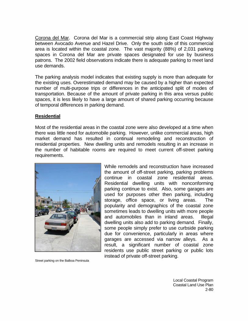
Local Coastal Program Coastal Land Use Plan
2-80
Corona del Mar. Corona del Mar is a commercial strip along East Coast Highway between Avocado Avenue and Hazel Drive. Only the south side of this commercial area is located within the coastal zone. The vast majority (88%) of 2,031 parking spaces in Corona del Mar are private spaces designated for use by business patrons. The 2002 field observations indicate there is adequate parking to meet land use demands. The parking analysis model indicates that existing supply is more than adequate for the existing uses. Overestimated demand may be caused by a higher than expected number of multi-purpose trips or differences in the anticipated split of modes of transportation. Because of the amount of private parking in this area versus public spaces, it is less likely to have a large amount of shared parking occurring because of temporal differences in parking demand. Residential Most of the residential areas in the coastal zone were also developed at a time when there was little need for automobile parking. However, unlike commercial areas, high market demand has resulted in continual remodeling and reconstruction of residential properties. New dwelling units and remodels resulting in an increase in the number of habitable rooms are required to meet current off-street parking requirements.
While remodels and reconstruction have increased the amount of off-street parking, parking problems continue in coastal zone residential areas. Residential dwelling units with nonconforming parking continue to exist. Also, some garages are used for purposes other then parking, including storage, office space, or living areas. The popularity and demographics of the coastal zone sometimes leads to dwelling units with more people and automobiles than in inland areas. Illegal dwelling units also add to parking demand. Finally, some people simply prefer to use curbside parking due for convenience, particularly in areas where garages are accessed via narrow alleys. As a result, a significant number of coastal zone residents use public street parking or public lots instead of private off-street parking.
Street parking on the Balboa Peninsula

Local Coastal Program Coastal Land Use Plan
2-81
Policies: 2.9.3-1. Site and design new development to avoid use of parking
configurations or parking management programs that are difficult to maintain and enforce.
2.9.3-2. Continue to require new development to provide off-street parking
sufficient to serve the approved use in order to minimize impacts to public on-street and off-street parking available for coastal access.
2.9.3-3. Require that all proposed development maintain and enhance public
access to the coast by providing adequate parking pursuant to the off-street parking regulations of the Zoning Code in effect as of October 13, 2005.
2.9.3-4. Periodically review and update off-street parking requirements to
ensure that new development provides off-street parking sufficient to serve approved uses.
2.9.3-5. Continue to require off-street parking in new development to have
adequate dimensions, clearances, and access to insure their use. 2.9.3-6. Prohibit new development that would result in restrictions on public
parking that would impede or restrict public access to beaches, trails or parklands, (including, but not limited to, the posting of “no parking” signs, red curbing, and physical barriers), except where such restrictions are needed to protect public safety and where no other feasible alternative exists to provide public safety.
2.9.3-7. If public parking restrictions are allowed to protect public safety, require
new development to provide an equivalent quantity of public parking nearby as mitigation for impacts to coastal access and recreation, where feasible.
2.9.3-8. Continue to require properties with nonconforming parking to provide
code-required off-street parking when new uses, alterations or additions result in increased parking demand.
2.9.3-9. Approve no application for a modification or waiver of off-street parking
requirements that are found to impact public parking available for coastal access.

Local Coastal Program Coastal Land Use Plan
2-82
2.9.3-10. Require new development to minimize curb cuts to protect on-street parking spaces. Close curb cuts to create new public parking wherever feasible.
2.9.3-11. Continue to require alley access to parking areas for all new
development in areas where alley access exists. 2.9.3-12. Provide incentives to encourage lot consolidation where lots are of
insufficient size to accommodate on-site parking and sufficient commercial intensity of development.
2.9.3-13. Encourage commercial and institutional development located near
beaches and other coastal resources to provide parking for public access during weekends and holidays.
2.9.3-14. Develop parking management programs for coastal zone areas that
achieve the following:
Provides adequate, convenient parking for residents, guests, business patrons, and visitors of the coastal zone;
Optimizes use of existing parking spaces;
Provides for existing and future land uses;
Reduces traffic congestion;
Limits adverse parking impacts on user groups;
Provides improved parking information and signage;
Generates reasonable revenues to cover City costs;
Accommodates public transit and alternative modes of
transportation. 2.9.3-15. Set in-lieu parking fees commensurate with actual market value for the
provision of off-street parking. 2.9.3-16. Continue to rigorously enforce parking ordinances.