Embed Size (px)
Citation preview

TECHNICAL NOTE
M:\Vicky Benham\_Environment\_Stefan Boss\Fellowship Square EIA Technical Note FINAL ISSUE.docx Page 1 of 24
Job Name: Phase 2 Regeneration Works to the Town Hall Campus
Date: 6th July 2021
Prepared By: Stefan Boss, Abbie Becker
Subject: Environmental Impact Assessment Technical Note
1. Introduction
This technical note has been produced by Stantec UK on behalf of Countryside Properties Plc in response to the Environmental Statement Review Report (May 2021) produced by Quod in relation to the Proposed Development of ‘Phase 2 Regeneration Works to the Town Hall Campus’.
This technical note provides clarification to the support Environmental Impact Assessment (EIA) undertaken for the project, and supports the Environmental Statement (ES) (dated March 2021) submitted alongside the planning application (planning reference: 210776).
A RAG Assessment of the ES has been commissioned by Quod on behalf of London Borough of Waltham Forest (LBWF). This technical note sets out a response to items listed as red (potential Regulation 25 items) and amber (clarifications) within this assessment. No response is required for those items listed as green. For clarity, headings in this technical note have been listed as per the ES Review Report titles as produced by Quod to provide a direct and clear response.
2. Review of Non-Technical ES Chapters
Ref 1: Introduction
The ES (March 2021) has been provided as part of the planning application for the Proposed Development, under planning application reference 210776. Alongside this application, Listed Building Consent is also being sought for works to the Town Hall.
Ref 3.1: Description of Development and Ref 3.2: Description of Development
The new civic building will replace the existing Magistrate’s Court building, and will mirror the height of the Town Hall and Assembly Hall. The residential areas of the Proposed Development will be set over five blocks set over differing storey heights, which are as follows:
Block B: Majority 5 storeys with a 6th storey section to the east;
Block C: 7 Storeys with a 9th storey section to the north east of the block;
Block D: 5 storeys;
Block H: Majority 5 storeys with a 6th storey section to the west; and
Block J: 5 storeys.
Blocks H and B will also mirror the height of the Town Hall and Assembly Hall. The 6th storey element to these blocks is placed on opposite sides away from the Town Hall to respect the heritage assets of the site. Blocks J and D are approximately the same mass and are aligned with the Civic Building and Assembly Hall, and act as bookends for the development. Block C is the tallest element of the scheme, and has therefore been placed furthest away from the Town Hall and has been designed with the surrounding context of Waltham Forest College in mind.

TECHNICAL NOTE
M:\Vicky Benham\_Environment\_Stefan Boss\Fellowship Square EIA Technical Note FINAL ISSUE.docx Page 2 of 24
The choice of materials for the Proposed Development will create one unified surface, connecting the Civic Square with adjacent streets. Materials for the Civic Building will be complimentary to existing surrounding buildings, with key materials in the design including pre-cast stone, limestone and granite. Other complementary materials provide moments of colour and contrast. Examples include the copper-clad clock tower to the Town Hall and triple-height gilded glazing to the Assembly Hall foyer. A combination of rough and smooth textured stone will provide emphasis to key elements of the Civic Building, for example the plinth and columns.
The residential blocks will be made of light warm tone brick together with light natural grey mortar, relating to the warm greys of the Portland Stone in the existing buildings. Finer detailing of the building appearances will be in warm light precast concrete to compliment the proposed façade of the new Civic Building and Portland Stone of the existing ones.
Ref 4.1: Description of demolition and construction
Consented Phase 1 works are majority constructed, with full completion due in July 2021. .
Demolition for the Proposed Development is due to take place August till December 2021. The individual elements of the Proposed Development are set for the following timescales:
New Civic Building: August 2022 – September 2023;
Block B: December 2021 – December 2023;
Block C: September 2021 – May 2024;
Block D: August 2021 – September 2022
Block H: April 2023 – January 2025; and
Block J: March 2024 – July 2025.
Ref 5.2: Cumulative Schemes
The cumulative scheme of Thorpe Coombe Hospital (cumulative scheme ref: No. 6, planning ref: 141145) has now been built out and construction has been completed. Therefore, the cumulative assessment undertaken within the ES (March 2021) continues to present a conservative cumulative scenario.
The addition of this scheme to the baseline is unlikely to result in any new or different likely significant effects to those assessed in the ES (March 2021) as when considered within the wider baseline this represents a limited change.
3. Review of Built Heritage and Archaeology
Ref 7.6 Baseline Conditions
Heritage Assets within the study area but excluded from the Heritage Statement due to no impact
The Study Area in Figure 2 includes several heritage assets, as noted in the Heritage Statement as follows ‘There are several other heritage assets in the wider vicinity, but none are in such proximity nor have any other connections so as to be impacted by the development’ and ‘There are several non-designated heritage assets in the wider area, but none are in such proximity so as to be impacted by the proposals’.

TECHNICAL NOTE
M:\Vicky Benham\_Environment\_Stefan Boss\Fellowship Square EIA Technical Note FINAL ISSUE.docx Page 3 of 24
All of the below heritage assets were considered and the assessments here are those made at the time of the site visit, the result of which justifies their exclusion. Those which were considered not to be impacted at all by the development were omitted to optimise the Heritage Statement. The omitted heritage assets were assessed thus;
1357627 Thorpe Combe Hospital - (original house only) – II
Architectural value lies in the building being an example of late 18th century residential design and its historic value in it being part of the 18th century development of north Walthamstow, visible on early maps, including the Tithe maps. Their setting was originally an agricultural and rural context which no longer exists, having been replaced by commercial, residential and civic buildings in the late 19th and 20th centuries. There is no intervisibility between the heritage asset and subject site, due to distance and road curvature, nor are there any other connections which indicate setting therefore it has been concluded that the proposals do not cause harm to the heritage asset by development in its setting.
Historic England description:
Substantial house, now part of hospital. Late C18. Stock brick. Roof not visible. 3 storeys plus basement. 5 bays wide, the centre 3 set forward slightly and crowned by pediment above second floor. Former central entrance and its doorcase now removed. Square gauged, headed windows; sashes, glazing bars. Stucco band above ground floor. Console cornice above second floor parapet. Extensive C20 additions to right not of listable quality. Interior not inspected.
1065061 Walthamstow House (Corpus Christi School) including entrance gates and bollards - II*
Architectural significance lies in the building being a good example of a mid-18th century residence with fine detail, albeit with later alteration. Its historic significance is as a contributor to the early building stock of Walthamstow, which was a popular location for homes for prosperous residents. These values are not directly impacted by the development, nor are they harmed by development in their setting due to lack of intervisibility with no other connections related to setting.
Historic England description:
Substantial detached house, now school. Mid C18, under restoration (1985). Stock brick, red gauged heads. 3 storeys and basement. 15 bays including 3 canter full height bay windows to centre and either side. Entrance to fifth bay from right, in projecting Doric porch. Segmental headed windows, flush frames, sashes, glazing bars. Interior: Rococo plaster ceilings to drawing room to left of entrance hall and to entrance hall itself. Contemporary staircase with fluted and turned balusters. GLC plaque to Sir Robert Wigram MP 1744-1830, High Sheriff of Essex and Merchant who lived here.
1065568 Old Butchers Shop (shop extension only) – II
Architectural significance is within it being an example of a functional building with much of its original fabric remaining. Its historic significance is in it being, as the Historic England citation notes, ‘a rare example’ of a largely 18th century commercial building which has been part of the history of Walthamstow for over 200 years. Neither value is harmed by the proposals, nor are they harmed by development in their setting due to neither intervisibility nor other connections which suggest setting.

TECHNICAL NOTE
M:\Vicky Benham\_Environment\_Stefan Boss\Fellowship Square EIA Technical Note FINAL ISSUE.docx Page 4 of 24
Historic England description:
Butchers shop. Probably late C18. Weatherboarded with pitched pantiled roof to eaves. Single storey. Shop front to right hand side; roof continued to form overhanging canopy above, with timber post supports bearing iron hooks for hanging meat. Tiled stall-riser, plate glass window; entrance to right. To left hand side a meat store with entrance to centre of building and slatted screen for ventilation. Painted fascia board on roof "C Jones Family Butchers Estd 1750". A rare survival.
Tramway Offices and Depot – II
The early 20th century architecture, typical of public service buildings of the time, is the reason for the building’s architectural significance and its historic significance is in it being an example of public services, the development of which was an indication of local civic pride. Neither value is directly harmed by the proposals, nor by development in their setting due to lack of intervisibility and other connections which indicate setting.
Historic England description (Edited):
Tramway offices and depot. 1905. Brick in flemish bond with terracotta dressing. High unusual roof of slate to front block, with pitched roof of slate to rear. rear wing detailed below. Two storeys, three window range with 3-window range to left return and late C20 firestair, specifically excluded from this listing, to right. Round-arched ground-floor windows with brick and terracotta voussoirs; flat arched windows to first floor that to centre an oriel topped by semi circular pediment. Centre range flanked by full-height brick pilasters, terminating at roof line in a broad segmental pediment, the tympanum of which has a shield and clock; balustrade forms parapet over end ranges and returns.
The Water House, Lloyd Park (William Morris Gallery) 19.10.51 - II*
The Water House is a fine example of a mid-18th century residence, originally set in a rural and agricultural landscape in the north Walthamstow area which was increasingly popular at that time for similar houses, and its architectural significance resides in this definition.
Its historic importance in initially in it being an example of an 18th century residential building within the building stock of Walthamstow, is greatly enhanced by its connection with William Morris which also results in particular artistic value to the building. None of these values are directly impacted by the development.
The Water House is set some way to the west of the study site with no intervisibility from either the environs of the house or its garden due to the intervening multiple rows of terraced housing. There are no other connections which indicate setting. These values are thus not harmed by development in their setting.
Historic England description:
Substantial detached house, now museum. 1762, altered and restored. Stock brick. Hipped slate roof to parapet. 3 storeys, 9 windows wide, the outer triplets forming large full height semicircular bays. Central Corinthian columned timber porch enclosing recessed entrance with semicircular fanlight. 6-panelled door. Square-headed windows gauged heads architraved to central bays. Double band above ground floor. Heavy stucco cornice and parapet. Interior with contemporary panelling, staircase and stucco-enriched stairwell. The childhood home of William Morris.
TECHNICAL NOTE
M:\Vicky Benham\_Environment\_Stefan Boss\Fellowship Square EIA Technical Note FINAL ISSUE.docx Page 5 of 24
Telephone Kiosk outside William Morris Gallery
The architectural and historic values are set within the structure being a remaining example of Sir Giles Gilbert Scott’s design. They are neither directly nor indirectly, as a result of development within their setting, harmed by the proposals.
Historic England description:
GV II Telephone kiosk. Type K6. Designed by Sir Giles Gilbert Scott. Made by various contractors. Cast iron. Square kiosk with domed roof. Unperforated crowns to top panels and margin glazing to windows and doors.
1065612 Walthamstow High School – II
The building is a fine example of a pre-First World War school building, the quality of both its detail and layout being evidenced by the fact that it is still used for its original purpose with relatively little internal alterations. These architectural and historic values are impacted neither directly nor by development within t heir setting, due to lack of intervisibility or other connections which indicate setting.
Historic England description:
School. 1913. Red brick. Some stone and some rubbed brick dressings. Plain tile hipped roof to eaves. 2 storeys, 7-bay centre block with advanced 3-bay wings and 1-bay linking blocks. Symmetrical Neo-Georgian composition. Central segmental pedimented Ionic entrance. Square-headed windows, sashes with small panes and glazing bars. The upper windows taller with timber transoms and brick aprons. Prominent keystones. Central upper window and central bay to flanking blocks. Round- headed stone architraved upper windows to centre and central bays of flanking blocks. Modillion cornice; segmental open pediments to central bays of central and outer wings, that to centre with carved brickwork. Central domed lantern.
1357603 Gates, gatepiers and railings to Walthamstow High School – II
Historic England description:
Railings, gates and gatepiers. Brick gatepiers, iron gates and railings. Included for group value.
1190780 Monoux Almshouses - GV II
The architectural significance of The Almhouses is in their being an example of well-detailed structure with early origins and later alteration. Their historic significance results from being a recognisable example of early philanthropy and element within Walthamstow’s history.
Historic England description:
Almshouses. Early to mid C18, incorporating early C16 work. Much restored and altered C20, west end rebuilt 1955 to design of Braddell and Laurence. Red brick to ground floor; stucco above; steeply pitched tiled roof to eaves. 2 storeys. 9 main bays. Jettied gabled crossing. 2 windows wide, roughcast. Square-headed windows, casements, plate glass. C20. Doorways and doors with C20 triplets of windows inserted above. Crosswing with small paned sash to ground floor and timber cross mullioned casements above.

TECHNICAL NOTE
M:\Vicky Benham\_Environment\_Stefan Boss\Fellowship Square EIA Technical Note FINAL ISSUE.docx Page 6 of 24
1065613 Pillar box on corner of Church Lane and path to St Mary's Church – II
The architectural value is in the structure being an early example of a pillar box, most of which are listed. Its historical value is in being part of the Victorian urban landscape as a representation of the expanding range of public services. Neither are directly impacted by the developemnt, nor by development in its setting due to lack of intervisibility, intervening built form and no other connections which signify setting.
Historic England description:
Pillar box. Probably c.1865. Octagonal penfold type.
1357600 Parish Church of St Mary's - II*
The church dates from the 16th century with later additions and its Grade II* status reflects the importance of its early age. Its architectural significance resides in it being a fine example of an ecclesiastical building. Its historic significance is as a result of it being an early and enduring element within Walthamstow. The proposals do not directly impact these values The development is not within the setting of the church, the urban context of which now being its setting a sit has evolved over time. There is no intervisibility as a result of intervening developments nor any other connection which indicates setting therefore it is concluded that the significance of the church is not harmed by development in its setting. This assessment includes the listed monuments and wall within the churchyard.
Historic England description:
Church. Mainly early C16, erected on site of earlier church; altered and enlarged 1818 and 1843; galleries and roof of 1876. Stuccoed. Low pitched roof to parapet. Western tower C1535 with diagonal buttresses and battlemented parapet. Interior: 6 bay nave, buttressed with octagonal piers and galleries to west and north. Y tracery to 2-light aisle windows. Lower chancel.
Contains notable series of monuments including that to Sir Thomas and Lady Merry 1633, by Nicholas Stone, with demi-figures in oval niches; that to Sigismond Trafford died 1723, his wife and daughter; retaining railings;. also many other monuments, tablets and floor slabs.
1357601 St Mary's Churchyard (Tomb about 20 yards to northwest of tower) – II
Assessment included within assessment of church.
Historic England description:
Table tomb, early 19th century. Probably Portland stone. Gothic style, with clustered shafts to four corners.
1065609 St Mary's Churchyard, tomb of Edward Solly, about 20 yards to south west of tower – II
Assessment included within assessment of church.
Historic England description:
Chest tomb to Edward Solly (died 1776). Portland stone, Coadestone and bronze. Rectangular Portland stone plinth surmounted by Coadestone sarcophagus, supported on lionclaw feet, and decorated with lions heads and guilloche. Engraved bronze plaques.

TECHNICAL NOTE
M:\Vicky Benham\_Environment\_Stefan Boss\Fellowship Square EIA Technical Note FINAL ISSUE.docx Page 7 of 24
1065610 St Mary's Churchyard, Tomb of Thomas Wise, close to south wall of tower – II
Assessment included within assessment of church.
Historic England description:
Table tomb to Mr Thomas Wise, d.1710. Portland stone with greystone lid. Balusters to corners, gadrooning to base. Cartouches and carved foliage to long sides.
1065611 St Mary's Churchyard, table tomb close to 1st bay from east of south wall of chancel – II
Assessment included within assessment of church.
Historic England description:
Table tomb, 1754. Portland Stone with grey stone lid. Winged cherubs heads to corners with floral swags between. Gadrooning to base. Inscribed plaque to flank.
1357602 Wall to southeast side of graveyard to St Mary's Church – II
Assessment included within assessment of church.
Historic England description:
Wall. Probably C18, partly rebuilt. Red brick. About two metres high. Included for group value.
Walthamstow Village Conservation Area (WVCA)
WVCA is set some way to the south of the study site, its northern section just within the study area.. It was designated in December 1967 and includes much of the historic core of Walthamstow, dating back to the Medieval period. It includes the majority of the designated heritage assets in Walthamstow, including the Monoux Almshouses, St Marys Church and graveyard, Squire’s Almshouses, The Ancient House and Vestry House. There is no intervisibility between the study site and WVCA, nor any other connections, the study site representing a much later phase in the development of Walthamstow. As a result of this, there is no impact by the proposals on the Walthamstow Village Conservation Area.
Heritage assets which were included within the Heritage Statement:
Brookscroft
The following is set out within the Heritage Statement:
Introduction
There are several other heritage assets in the wider vicinity, but none are in such proximity nor have any other connections so as to be impacted by the development, with the possible exception of Brookscroft (Plate 6), originally a late 18th century residence of some quality, facing the north boundary of the study site but on the opposite side of Forest Road.
Brookscroft is a residence on the opposite (south) side of Forest Road (Plate 6) to the study site. Grade II Listed, it is described as a two storey ‘substantial detached house’, built around 1760. It is constructed of ‘stock brick with a slate mansard roof to parapet with dormers’.

TECHNICAL NOTE
M:\Vicky Benham\_Environment\_Stefan Boss\Fellowship Square EIA Technical Note FINAL ISSUE.docx Page 8 of 24
Its artistic and architectural value is in its detailing and its historic value in being part of the older building stock of Walthamstow. Neither are impacted by the proposals. The study site is not part of Brookscroft’s setting by connection, having pre-dated the development on the site by over hundred years, and they are now separated by a busy, wide road.
There is some very limited inter-visibilty, possibly comprising distant views of the eastern sections of the development. It is positioned some way to the south of the rear pavement boundary and a deep forecourt which, together with mature trees, restricts intervisibilty to a negligible level. Therefore, the significance of the heritage asset is not harmed by development in its setting’. (HS Page xiv)
In accordance with the legislation and guidelines set out in Section 2 of the Heritage Statement, the values are identified and it is established that they are not directly harmed by the proposals. It is noted that there is potential for impact on them due to potential development in their setting as a result of their proximity. It is established that the proposals do not harm the values by development in its setting for the reasons noted.
Historic England Listing Brookscroft
FOREST ROAD Walthamstow El7 (south side) No 590 (Brookscroft). GV II
Substantial detached house. Circa 1760. Stock brick, slate mansard roof to parapet. 2 storeys, plus dormers. 5 bays wide, with 2-bay early to mid C19 extension. set-back to right. Centre 3 bays set forward slightly with pediment. Steps up to central entrance with pedimented Doric doorcase; triglyph frieze; 6-panelled door. Square gauged leaded sashed windows, glazing bars. Thermal window to pediment. Band between storeys. Modillion cornice. Interior contains contemporary open tread staircase with turned balusters and carved tread-ends; fireplaces, that to drawing room more elaborate than others.
Walthamstow College (The Local Listing description is used although it is now referred to as Waltham Forest College. Note that only the south range is included within the local listing)
The following is set out in the Heritage Statement:
Introduction
There are several non-designated heritage assets in the wider area, but none are in such proximity so as to be impacted by the proposals. Although not on the study site, Walthamstow College to its east (Plate 11) contributes to the study site, in a lesser manner, to the overall group by virtue of its scale and rhythm.
List No. 53 - Walthamstow College was designed by J Stuart in a neo-Georgian style for Essex County Council and opened in 1939 as the South West Essex Technical College. It is located to the east of the study site and was being constructed around the same time as those on the study site.
Its uncomplicated but well-detailed and proportioned elevations result in its artistic and architectural values as being at the lower end of the medium scale. Its date and development as a local community hub is shared with the study site and results in its historic values being also at the lower level of the medium scale. None of these values are impacted by the development.
By virtue of its scale and proportion, it both contributes and benefits from the study site in a limited way. Both are substantial buildings, and the college extends the civic and community purpose of the study site, thus each contributes to the others’ values.

TECHNICAL NOTE
M:\Vicky Benham\_Environment\_Stefan Boss\Fellowship Square EIA Technical Note FINAL ISSUE.docx Page 9 of 24
There will be intervisibily between the study site and Walthamstow College, but the proposal’s scale and detail will be more cohesive with that of the heritage assets and will not impact the significance of the college by development in its setting’. (HS Page xiv)
In accordance with the legislation and guidelines set out in Section 2 of the Heritage Statement, the values are identified, and it is established that they are not directly harmed by the proposals. It is noted that there is potential for impact on them due to development in their setting as a result of their proximity. It is established that the proposals do not harm the values which contribute to significance by development in its setting.
Visual inspection suggests that the proposals will have limited impact . There is currently an assortment of buildings to the north of the college, including Sycamore House, which are visible from locations to the south and west of the college and which obscure the view of the college from Chestnuts Fields to the north. Glimpses of the proposals will be visible in the distance beyond the south elevation, which will be partially obscured by trees, but these are at such distance that they will not significantly impact the views of the southern or western elevations of the Locally Listed front (south) range.
Views towards the study site from the west elevation of the south range, are obscured by mature trees both in front of the college and on the study site and various later inappropriate structures on the study site. The replacement of these by buildings which relate in scale and proportion to the college will not be to the detriment of these views.
Local Listing:
53.Walthamstow College (front range) Forest Road E17 – Designed by J Stuart in a neo-Georgian style for Essex County Council and opened in 1939 as South West Essex technical College. (NEW ADDITION)
Phase 1 Heritage Statement
Phase 1 is under construction at present and does not form part of the development for which the application is being made. It is for largely internal works to the Town Hall building itself, with some lesser external works including to the central basin and ramp access to its south. It is reasonably assumed will be completed in the near future the Heritage Statement takes the view that the completed Town Hall is part of the baseline information.
Ref 7.7: Baseline Heritage Photography
Site conditions in the report are, in common with standard practice, relevant to the day on which the report is carried out. The limitations caused by the scaffold were identified in the Heritage Statement as there were no detail pre-scaffold photographs. A selection of photographs has now been provided which illustrate the wider site prior to the scaffold being erected. None of these are set in the precise locations of those photographs in the Heritage Statement, but we have selected some which are indicative of the site. These are contained within Appendix A.
Ref 7.8: Baseline - Heritage significance
The Baseline conditions refer to ‘medium value or ‘upper level of medium’ referring to assessment of heritage values in Historic England’s Conservation Principles, Policies and Guidance (HE 2008). The overall significance of these assets is defined according to Table 7.2. The Conservation Area is not considered sensitive to change therefore it is not included in the Baseline Conditions. The following provides a brief summary of the Conservation Area for clarification:
TECHNICAL NOTE
M:\Vicky Benham\_Environment\_Stefan Boss\Fellowship Square EIA Technical Note FINAL ISSUE.docx Page 10 of 24
Walthamstow Village Conservation Area (WVCA)
WVCA is set some way to the south of the study site, its northern section just within the study area. It was designated in December 1967 and includes much of the historic core of Walthamstow, dating back to the Medieval period. It includes the majority of the designated heritage assets in Walthamstow, including the Monoux Almshouses, St Marys Church and graveyard, Squire’s Almshouses, The Ancient House and Vestry House. There is no intervisibility between the study site and WVCA, nor any other connections, the study site representing a much later phase in the development of Walthamstow. As a result of this, there is no impact by the proposals on the Walthamstow Village Conservation Area.
Ref 7.9 Baseline Setting and Significance
Detailed Statements of Significance are provided in the Heritage Statement for each heritage asset on site, together with an assessment of the impact of the development. Only that for the Town Hall is provided below for brevity, similar assessments of all other heritage assets on site are included within the Heritage Statement:
The Town Hall
Described in its Grade II Listing as the ‘Town Hall at Walthamstow Civic Centre’ (Appendix B), the south frieze notes that it is ‘Walthamstow Town Hall’. The building was designed by P D Hepworth, as a response to a competition. Although it won, the design was altered to accom-modate budget requirements. Constructed of Portland stone, it is three storeys high, with a copper lantern (Plate 8). With a four-pier central portico, its unmoulded capitals are indicative of limited decorative detail which defined its style.
With shallow architraves to windows and iron balconies to first floor centre, the design combined both a Scandinavian concept with a formal civic function. It is currently being refurbished and retained for civic purpose. These works do not form part of the development described in this report therefore their impact upon the building is not considered here.
The artistic and architectural values of the Town Hall are related to the ‘Nordic Classicism’ which de-fines the architectural style. Classical proportion and detail are largely stripped of decoration, although the lantern and individual features provide restrained decorative detail.
Whilst a feature of several Scandinavian civic buildings, this style is not widely used in the United Kingdom and, as it is well-executed, results in artistic and architectural value being at the up-per level of medium.
The building’s historical value lies in its position as being part of the development of Civic Centres as a result of the post - First World War regeneration of towns. This was in response to the con-tinued devolution of administration from Central to Local Government as the population grew.
It was part of a tendency to group civic buildings for administration and entertainment in a civic com-plex, which had accelerated since Victorian times and resulted in similar civic centres around the country. As part of this movement, and its importance as the centre of local government throughout the 20th century, its historic value is also at the upper level of medium’. (HS Page xvi – xvii)
As noted, there are similar assessments which address individually each asset on site. This provides a Statement of Significance for the asset and its setting, as per ‘Statements of Heritage Significance: Historic England Advice Note 12’ published 21 October 2019. Assessment is also provided of group value in Section 4.43 – 4.49 of the Heritage Statement, the group being those structures to which group value is assigned in their listing as set out below;

TECHNICAL NOTE
M:\Vicky Benham\_Environment\_Stefan Boss\Fellowship Square EIA Technical Note FINAL ISSUE.docx Page 11 of 24
Group Value
The Listing for the Town Hall, Assembly Hall, Flagpoles and Gates Piers and Railings all conclude by stressing the point that all are designed as a whole within the civic centre and that they con-tribute both individually and cumulatively to its significance.
In the Town Hall’s citing, the Assembly Hall is noted as an ‘integral part of the design’. This coherent identity sets out markers which retain the cohesiveness of the site thereby enhancing its values and significance.
This group value can be seen to be defined by the coherence between the Town Hall and Assembly Hall, and by, with the exception of the current Magistrates Court, extending throughout the site, bound by the formality of the landscape.
The demolition of the existing Magistrates Court and its replacement with the new Civic Centre rein-states the originally intended ‘square’, although only three sides are built form, facilitating a view of the three buildings from Forest Road, the primary viewpoint.
This reinstatement of the original intention for the focus of the site extends out through the land-scaping and encompasses the other heritage assets within it’. (HS Page xxi)
The setting of the wider site is described as follows:
The Existing Site
The existing buildings are set some way back from the southern boundary (Plate 15) at Forest Road which allows a panoramic view of the buildings from the main road beyond a land-scaped scheme with planting, a small pond and features such as decorative gates and rail-ings (Plate 6). This is the primary view of the building group, which remains unobscured by the development.
Garden Allotments and Chestnut Fields (Plate 13) to the rear (north) benefit from views of the Town Hall and Assembly Hall, although the latter is set some way back. The sense of sym-metry, which prevails to the south elevations, is less obvious. This view is currently domi-nated by an asphalt topped car parking (Figure 17).
The grouping of the buildings on site was intended to be largely symmetrical about the cen-tral axes of the three primary buildings but the proposed building to the west, opposite the Assembly Hall, was never built. The Magistrates Court of the early 1970s was constructed but it was not located in the intended position from the original scheme and was designed in a contrasting style to the Town and Assembly Halls’. (HS Page 4)
Additional clarification is provided only in this note only for the Town Hall and Assembly Hall.
The setting of the Town Hall is as the centrepiece of the complex. The symmetrical layout implies a formality and hierarchy in which the Town Hall is the most important element. This is indicated by its pinnacle tower and central position between the Assembly Hall and the originally intended location of the Magistrates Court, beyond the central basin.
The setting of the Assembly Hall is part of the primary group around the central basin, to the east of the Town Hall. The west facing main entrance indicates it is secondary to the Town Hall, but it shares its principle design attributes which connect the two structures. Positioned opposite what was intended to be the Magistrates Court (not completed until the 1970s in a different style, due to budget issues), the buildings flanked the Town Hall as slightly subservient but not inconsequential roles. Smaller service buildings were intended to be located to the east of the Assembly Hall (and to the west of the Magistrates Court) which extend the symmetry.

TECHNICAL NOTE
M:\Vicky Benham\_Environment\_Stefan Boss\Fellowship Square EIA Technical Note FINAL ISSUE.docx Page 12 of 24
The following aspects of the setting are common to all buildings. The primary viewpoint is from the south on Forest Road, from which can be seen the three buildings around the central basin, the view framed and punctuated by railings, gates and flagpoles. The originally intended setting was eroded by;
The landscape not being completed but the lawns and planted boundaries all contribute to the formal ceremonial effect of the individual design and their grouping.
Intended ‘playing fields’ to the rear are now restricted to Chestnuts Fields, the land immediately adjacent to the Town Hall being tarmacked parking areas.
The incompletion of the original grouping by the omission of the Magistrates Courts and their later addition in a non-symmetrical and non-complimentary style (which was most likely a deliberate design statement).
Despite these omissions, the strong symmetry, scale and cohesive but not identical detail, override any anomalies to create a coherent and legible arrangement which the proposals complement and enhance.
Ref 7.10: Future Baseline
As noted in 7.6, the baseline reasonably assumes that Phase I has been completed.
Ref 7.11: Assessment of Effects (Archaeology) Section 7.6.8 & 7.6.9)
According to the agreed methodology Negligible effects to archaeological receptors include Negligible magnitude of change to assets of any significance (International, National, Regional, Local and Negligible) or low Magnitude of impact or change to an archaeological asset of Local or Negligible Importance. There are no known archaeological remains within the areas of impact and the potential for well-preserved archaeological remains of Regional importance is considered low, based on existing evidence.
This is based on an assessment of past impacts within the site and results of archaeological investigations in the vicinity. The potential for previously unrecorded archaeological evidence of more significance cannot be ruled out entirely, however, the assessment is based on available evidence and the assessment is considered proportionate and accurate based on that. The request for trenching by the LPA Archaeologist does not increase the potential or significance of effect. It provides a framework for ensuring that the overall significance of effect is negligible.
Ref 7.12: Assessment of Effects (Built Heritage – Demolition)
Demolition effects of the Magistrates Court is assessed as minor adverse and other non-listed buildings as no effect/negligible. Demolition of the Magistrates Court is due to take place in November 2021 with completion in January 2022. A Demolition Plan is provided in Appendix C.
Scaffolding will not be required on College land for demolition. Scaffolding will be pinned to the building so College operations are not interrupted.
Ref 7.13: Assessment of Effects (Built Heritage – Construction)
Indirect construction effects are considered in para. 7.6.7: As the significance of these assets will remain unchanged the magnitude of impact is considered negligible in line with table 7.3: Negligible perceptible change to the significance of a building, archaeological site or Conservation Area due to a change in setting. The significance of effect is considered Negligible in line with Table 7.4.

TECHNICAL NOTE
M:\Vicky Benham\_Environment\_Stefan Boss\Fellowship Square EIA Technical Note FINAL ISSUE.docx Page 13 of 24
Ref 7.14: (Built Heritage – Construction)
Temporary effects on the setting of the locally listed Walthamstow College should be assessed.
Indirect construct effects are considered in para. 7.6.7 and can be applied to the locally listed Walthamstow College: As the significance of these assets will remain unchanged the magnitude of impact is considered negligible in line with table 7.3: Negligible perceptible change to the significance of a building, archaeological site or Conservation Area due to a change in setting. The significance of effect is considered Negligible in line with Table 7.4.
Ref.16 Assessment of Effects (Built Heritage Completed Development)
The comments made in relation to Brookscroft and Walthamstow College in 7.6 of this note apply here, where copies of the assessments in the Heritage Statement are included together with additional comment. Assessments of significance and impact have been made for each and further clarification provided which does not alter the assessment.
AVR 11 Impact of the proposals on Walthamstow College south elevation
The Local Listing citation notes that the front (south) range is the Listed element. The existing image of the main elevation to the front range shows that the eastern section of the Assembly Hall is visible but the primary focus is the symmetrical College elevation, partly obscured by planting. In the proposed image, the Assembly Hall is partly obscured by new construction closer to the College, but whilst it is a change, it does not detract significantly from the main college elevation.
Ref 7.17: Completed Development Effects – Built Heritage
AVR 12 Impact of the demolition of the Magistrates’ Courts and replacement by the new Civic Centre
The existing image emphasises the slightly asymmetrical positioning of the Magistrates’ Courts which undermines the originally intended symmetry of the Town Hall, Assembly Hall and Magistrates’ Courts. The proposed replacement of The Magistrates’ Courts with The Civic Centre illustrates the reinstatement of the intended symmetry. This is not reduced by the differing style of The Civic Centre as it carefully responds to the scale, proportion and materials of the existing heritage assets without pastiche. This enhances the group value of the assets.
AVR 13 Impact of Block to the north of The Assembly Hall
The existing view shows The Assembly Hall with The Town Hall to the north, creating three sides of a rectangular composition. The proposed Block to the north of the Assembly Hall visually extends the Town Hall elevation towards The Assembly Hall. Although it reduces the open space between the two heritage assets, the fact it is not mirrored on the opposite (south) side, results in the effect having some, but not necessarily a negative, impact.
Ref 7.18: Wording Clarification
The Heritage Statement makes the distinction between the values being directly harmed by the proposals (by alteration or destruction) and indirectly by development in their setting.
Ref 7.19: Completed Development Effects – Built Heritage
Descriptions of the development are provided within the report thus:

TECHNICAL NOTE
M:\Vicky Benham\_Environment\_Stefan Boss\Fellowship Square EIA Technical Note FINAL ISSUE.docx Page 14 of 24
‘Residential blocks are located to the east and west of the Town Hall. Their proximity to the heritage asset impacts the setting. The following are the features which have been considered in the design to identify the new blocks as having a separate function and also being an element of the site grouping.
spaces between buildings are wide and allow appreciation of both facades avoiding a tunnel-like experience. Hard and soft landscaping is deployed to encourage people to connect with the space, and the changes of level are defined so as to fragment what might other-wise be tunnel-like routes.
the scale and envelope of the residential blocks follows that of the existing civic buildings, with no level on the elevations above the eaves line of the Town Hall.
proportion and detail also follow the rhythm of the Town Hall. At upper levels, the elevations are broken by the vertical small brickwork step on which the rainwater pipes are set. These present a contemporary reflection of those on the Town Hall, provide divisions along the length of the elevation.
detail design which includes flat relief to the underside of the balconies, and sloping reveals in brickwork respond to the detail of the Town Hall but remain subservient to its focal position on the study site.
however, the residential blocks signal their different purpose by their difference in materials which is brick, although the colour is selected to complement the Town Hall, it does not overwhelm it’. (HS Page xiv)
Analysis of the materials for the proposed Civic Centre has been carefully considered in the DAS and as summary is provided in the Heritage Statement. Page 144 in Section 9.1 of the DAS presents materials which respond to the Town Hall and Assembly Hall, but within a modern context. Residential building appearance is noted as being different but complementary to the heritage assets. Section 7 of the Design and Access Statement (DAS) sets out the background and context of the materials used, which is a slightly variegated brick. Brick is used to signify the residential purpose of the proposals but in a tone which reflects but does not conflict with the Town Hall. It provides a coherence whilst identifying the non-civic buildings as a separate function.
Similarly, materials used in the landscape balance both a civic formality and a sense of community. These are illustrated on Pages 66 and 67 of the DAS, at the interface of the Town Hall and residential buildings. The route between them is of a width which allows appreciation of each façade, with stretch header-laid paving to present a directional aspect, with less formal planting and seating areas adjacent the residential buildings.
The formal ‘parterre’ nature of the landscape to the south of the heritage assets is enhanced with additional boundary planting with symmetry and formality being retained to this primary view of the heritage assets. To the north elevation, a new garden is created to the rear (north) of the Town Hall as a transition space with Chestnuts Fields. This adds emphasis to the Town Hall as the central entity within the composition.
Changes to the skyline are created by the proposed buildings, but none in immediate proximity to the Town Hall are higher than it, with limited increases in height being set to the west and east, away from the heritage asset. The dominant feature remains the central pinnacle to the Town Hall.
It is assumed that lighting refers to artificial lighting. There are no proposals for the detail of this at present and it is assumed that it would be made a detail of any approval.

TECHNICAL NOTE
M:\Vicky Benham\_Environment\_Stefan Boss\Fellowship Square EIA Technical Note FINAL ISSUE.docx Page 15 of 24
The impact of the proposed blocks adjoining the Town Hall is assessed as negligible (with the exception of the extension of Block B) due to the distance allowed between the blocks which allows clear view of the elevation, as illustrated on Page 67 of the DAS. The dominance of the Town Hall within the north view of the study site is maintained by it being framed by steps to its west and east from Chestnuts Fields and the garden set to the north of its elevation. Long views down its east and west elevations run uninterrupted through to Forest Road which preserve an element of separation between the Town Hall and the residential buildings and allow the Town Hall to maintain its significance within the study site.
The impact of Block B extending beyond the is described in the Heritage Statement thus:
‘The residential blocks flanking the Town Hall will evidently have an impact upon its setting, but this is not assessed as a negative impact with the exception of the extension of Block B, beyond the northern boundary of the Town Hall. This does have an impact upon its setting which would impact its artistic and architectural value. This harm is assessed at less than substantial.
Although this is the secondary main view of the study site, the first being that from Forest Road to the south, it is nonetheless of importance. The Town Hall Is not directly obscured but views of it will be limited from eastern parts of Chestnut Fields although it will remain fully visible from the Garden Allotments.
The extension of Block B to the east of the Town Hall is necessary in order to provide the required level of accommodation within the scheme. Therefore, although it is noted that the reduction of views does cause less than substantial to the architectural significance of the Town Hall by development within its setting, this is outweighed by the public benefits of the scheme’ (HS Page xviii)
This limitation of the view from certain locations of the Town Hall due to the extension of Block B is, as noted, a result of providing the required residential and parking space on site. The primary view from the south is not obstructed and the group value of the heritage assets is not impacted.
Whilst Block B will restrict views of the north elevation of the Town Hall from areas of Chestnuts Fields and the allotments, the elevation is fully or substantially visible across the majority of these areas north of the Town Hall. Views have been produced separately to support this within Appendix B. As the primary views from the south, symmetry of the grouping and central position of the Town Hall within the grouping are not impacted it is assessed that less than substantial harm is caused.
The Assembly Hall’s relationship to the Town Hall and The Magistrates Courts, set around the central basin, is of paramount importance and this relationship is not impacted by the proposals. The building’s west elevation is its’ primary elevation, which is not eroded by the proposals. The proposed block to the north allows considerable distance between the north façade of The Assembly Room and the new building, which in turn allows its elevation to be appreciated. Hepworth’s original scheme included service buildings to the west of the Magistrates Court and to the east of the Assembly Hall. The blocks to the east of The Assembly Hall retain a respectful distance to allow appreciation of its east elevation. Viewed from the south, these blocks extend the symmetry originally intended.
Ref 7.20: Completed Development Effects – Built Heritage Group Value
The group value is noted in the Heritage Statement as referring to only those assets which are assigned with group value in Historic England’s descriptions. However, there are numerous references to the nature of the study site group value, some are included below:

TECHNICAL NOTE
M:\Vicky Benham\_Environment\_Stefan Boss\Fellowship Square EIA Technical Note FINAL ISSUE.docx Page 16 of 24
Group Value
The Listing for the Town Hall, Assembly Hall, Flagpoles and Gates Piers and Railings all conclude by stressing the point that all are designed as a whole within the civic centre and that they contribute both individually and cumulatively to its significance.
In the Town Hall’s citing, the Assembly Hall is noted as an ‘integral part of the design’. This coherent identity sets out markers which retain the cohesiveness of the site thereby enhancing its values and significance.
This group value can be seen to be defined by the coherence between the Town Hall and Assembly Hall, and by, with the exception of the current Magistrates Court, extending throughout the site, bound by the formality of the landscape.
The demolition of the existing Magistrates Court and its replacement with the new Civic Centre re-instates the originally intended ‘square’, although only three sides are built form, facilitating a view of the three buildings from Forest Road, the primary viewpoint.
This reinstatement of the original intention for the focus of the site extends out through the land-scaping and encompasses the other heritage assets within it.
Although the proposed residential units are significant interventions on the study site, they follow both plan form and scale, and positively respond to existing detail and proportion.
Appropriate distance is retained between heritage assets and residential blocks throughout the site. Therefore, any impact upon group significance through development in its setting is out-weighed by the public benefits of the scheme, bringing the Civic Centre into full use and providing residential and recreational facilities’. (HS Page xxi)
The overall impact of the proposals on the group value when considered as the entire study site is therefore:
The reinstatement of the trio of buildings – The Town Hall, Assembly Hall and the Civic Centre around the central basin in the symmetrical arrangement originally intended, to which the previous Magistrates Courts did not adhere, is facilitated by the design. The primary view of this group from the south is not impeded.
The symmetry established in the original design extends throughout the development. Refurbishment of Flagpoles and Railings, and hard and soft landscaping which acknowledges and complements them, contributes to the overall coherence of the group of heritage assets.
Distance between existing and proposed buildings allows appreciation of facades and avoid a constricting effect between existing and proposed structures. Restriction of height of proposed buildings in immediate proximity to the Town Hall, raising only as the blocks move further to the east and west, retains the central dominance of the Town Hall on the study site.
Ref 7.21: Mitigation and Monitoring – Built Heritage
The Magistrate’s Court is not a heritage asset having been granted immunity from Listing due to the features which would have provided its historic value – the interiors indicative of mid-20th century design developments in Law Courts - having been removed in an earlier refurbishment. A detailed history is included within the Certificate of Immunity. However, interpretation of both the Magistrates Courts within the study site as a whole and it is assumed that these proposals would be required as a detail of approval.

TECHNICAL NOTE
M:\Vicky Benham\_Environment\_Stefan Boss\Fellowship Square EIA Technical Note FINAL ISSUE.docx Page 17 of 24
Ref 7.22: Cumulative Effects
As previously noted, the completed Phase 1 works, which are a separate contract, are taken as the baseline therefore no assessment of cumulative effects is provided.
4. Landscape and Visual
Ref 8.4: Request for Additional Visualisation and Assessment of Views in TVIA
Consultation with the London Borough of Waltham Forest (LBWF) regarding view locations for the TVIA was undertaken during November/December 2020, which set out eight representative views, based on preliminary viewshed analysis and cross referenced to relevant baseline information. In response to that consultation, LBWF requested two additional view locations (identified in the ES as Views 9a/b and 10), which were included and assessed as part of the submitted TVIA ES chapter. No further requests for additional view locations were made by the LBWF prior to the submission of the ES on the 26th February 2021.
Regarding the request from the Reviewer, for three additional views in relation to impacts on Heritage Setting, it has been assumed that those additional views also need to be considered as additional visual receptors in the TVIA. A location plan was prepared and submitted to LBWF for agreement on 3rd June 2021. Scott Hacker of LBWF agreed the locations of the additional views in his email of 7th June 2021 and made a further request for the visualisations from Chestnuts Field that had previously been provided as wirelines to be further developed as AVRs. The view location plan is provided with the three additional requested visualisations in Appendix B of this EIA Technical Note.
Both VL9 and VL10 have been updated to show the full render image, these are provided in Appendix B.
The visual effects assessment for those three additional visual receptors has been undertaken in accordance with the methodology of TVIA ES Chapter: Appendix D and is set out in detail in Appendix C: Visual Effects of this EIA Technical Note. In summary, the additional visual effects are judged as:
VL11: Forest Road, looking directly at Walthamstow College - a Medium overall sensitivity with a Moderate magnitude of change to the view that is adverse During Construction, which results in an additional Moderate level of significance of effect that is Significant. On Completion, there would be a Moderate magnitude of change to the view, which is considered on balance to be beneficial; resulting in an additional Moderate level of significance of effect, that is Significant.

TECHNICAL NOTE
M:\Vicky Benham\_Environment\_Stefan Boss\Fellowship Square EIA Technical Note FINAL ISSUE.docx Page 18 of 24
Thumbnail of AVR for VL11: Forest Road, looking directly at Walthamstow College.
VL12: Forest Road, looking directly at the Waltham Forest Town Hall - a Medium overall sensitivity with a Moderate magnitude of change to the view that is adverse During Construction, which results in an additional Moderate level of significance of effect that is Significant. On Completion, there would be a Moderate magnitude of change to the view, which is considered on balance to be beneficial; resulting in an additional Moderate level of significance of effect, that is Significant.
Thumbnail of AVR for VL12: Forest Road, looking directly at Waltham Forest Town Hall.

TECHNICAL NOTE
M:\Vicky Benham\_Environment\_Stefan Boss\Fellowship Square EIA Technical Note FINAL ISSUE.docx Page 19 of 24
VL13: View of the western elevation of the Assembly Hall, from within the western part of the Site, adjacent to the Town Hall - a High overall sensitivity with a Moderate magnitude of change to the view that is adverse During Construction, which results in an additional Major level of significance of effect that is Significant. At Completion, on balance, the visual change is considered to be a change to the composition of the view, but a change which is entirely in keeping with, and appropriately respects the existing elements of the view, such that the quality of the existing baseline view is maintained. The visual change is not considered to either degrade or enhance the view. The change for this additional visual receptor is therefore considered to be Neutral; resulting in an additional Negligible level of significance of effect, that is Not Significant.
Thumbnail of AVR for VL13: View of the western elevation of the Assembly Hall, from within the western part of the Site, adjacent to the Town Hall.
VL11 and VL12 are similar outcomes to the previously assessed VL3 and VL4, which are also representative of people’s views from Forest Road.
VL13 represents people’s views from within the Site; and the identified adverse, Major level of significance of effect that is Significant during construction is short term and arises because of the location of the visual receptor within the Site and the higher sensitivity of the visual receptor at this location within the curtilage of a Listed Building looking towards another Listed Building. At completion, identified positive effects include that the Proposed Development respects the existing built form, townscape and civic public realm and historic nature of the view, and contributes to the visual identity of the civic square. The view to the Town Hall and Assembly Hall is maintained and the completed development does not cause degradation of the view. The negative visual effects identified relate to reduction of the visual gap between the end of the Town Hall and the Assembly Hall, but this does not alter the quality of the baseline view. The perceived change is to a small part of the view composition.
No further townscape or visual mitigation or enhancement is required because of these additional assessed visual effects. The effects reported above would therefore remain after implementation of the embedded mitigation measures, and the residual visual effects are as reported above. Monitoring would be in accordance with Section 9 of the TVIA ES Chapter.
TECHNICAL NOTE
M:\Vicky Benham\_Environment\_Stefan Boss\Fellowship Square EIA Technical Note FINAL ISSUE.docx Page 20 of 24
It is considered that there would be no intervisibility between the Proposed Development and other committed developments from VL11, VL12 or VL13; and as such no cumulative visual effects are expected as a result of the addition of the Proposed Development.
Phase 1 of the Waltham Forest Town Hall (Planning Ref: 192584) involves minor changes to the hard landscape within the civic square and construction works within this area are already underway. For VL13, should the Phase 1 construction activity overlap with the Proposed Development’s construction period, in the worst case there would be a short time where greater level of construction activity is seen in the view. However, this would not be a dominant or complete change to the view, but would be clearly noticeable, and the magnitude of combined cumulative visual effect would be a short term, Moderate adverse cumulative visual effect, which results in an additional Major level of significance of effect that is Significant during construction. This arises because of the location of the visual receptor within the Site, and the higher sensitivity of the visual receptor at this location within the curtilage of a Listed Building looking towards another Listed Building.
At completion, the hard landscape changes to the civic square would be complete; the completed development would be seen as in keeping with the improved civic square, and materials and appearance would be architecturally complementary. The combined cumulative visual change is considered to cause a perceptible change to the baseline view as the improved square is in the foreground of the view. That change would be beneficial, but would not materially affect the view composition and therefore would be a Slight magnitude of change. This results in an additional cumulative visual effect which is a beneficial Moderate level of significance of effect, that is Significant. This arises because of the location of the visual receptor within the Site, and the higher sensitivity of the visual receptor at this location within the curtilage of a Listed Building looking towards another Listed Building.
The Site is subject to current planning and design policies for regeneration in LBWF. Therefore, changes in people’s local views of the Site are to be expected. The additional visual effects that have been assessed find that, as previously concluded in the TVIA ES Chapter, the Proposed Development will positively contribute to achieving those regeneration, planning and design objectives, and that the Proposed Development, when completed, is considered to have the potential to result in beneficial (positive) changes.
Ref 8.6: Townscape Effects – Local Townscape Character
As identified in paragraph 4.1.26 of the ES TVIA chapter, there are no published local townscape character assessments relating to the Site or the 2.5km Study Area.
There would be no direct effects on adjacent local townscape character. There is potential for indirect effects arising on adjacent local townscape character as a result of intervisibility of the Proposed Development from adjacent local townscape character areas.
A Zone of Theoretical Visibility (ZTV) plan was previously provided as Figure 03, Appendix B of the TVIA ES Chapter. This establishes the theoretical ‘worst case’ extent to which the Proposed Development would be visible. The ZTV indicates very limited intervisibility between the Proposed Development and the townscape surrounding the Site.
During construction, intervisibility between adjacent townscape areas and the works at the Site is anticipated to be very limited with only occasional glimpses of the tops of cranes and tops of emerging buildings seen from some parts of the local townscape that surrounds the Site. This very limited intervisibility would not alter the local townscape character of the areas outside of the Site and it is the professional judgement of the Assessor that there would be no significant effects on adjacent local townscape character.
At Completion, intervisibility between the completed development and adjacent townscape areas would be very limited, as indicated by the ZTV. This limited intervisibility would not alter the local

TECHNICAL NOTE
M:\Vicky Benham\_Environment\_Stefan Boss\Fellowship Square EIA Technical Note FINAL ISSUE.docx Page 21 of 24
townscape character of the areas outside of the Site and it is the professional judgement of the Assessor that there would be no significant effects on adjacent local townscape character.
Ref 8.7 Visual Effects
The Reviewer states the TVIA approach is in line with the stated methodology and GLVIA3 and not action is identified. We therefore suggest item 8.7 is shown as Green instead of Amber and consider that there is no further action required.
Ref 8.8 Future Baseline – Phase 1 Development Works
Paragraph 5.9.14 of the ES explains that ‘approved developments’ are considered to be planning permissions that are partially built out and extant planning permissions. A review of partially built out permissions and extant permissions was undertaken to inform the EIA Screening Report. Furthermore, Quod’s EIA Screening Advice Note identified that in addition to the committed schemes identified in the Screening Report, cumulative effects with the Phase 1 Waltham Forest Town Hall works should also be considered. Phase 1 has therefore been included in the assessment of cumulative effects.
Paragraph 10.1.6 of the TVIA ES Chapter provides commentary on Phase 1 Development Works as follows:
‘Phase 1 of the Waltham Forest Town Hall (Planning Ref: 192584) involves minor changes to the hard landscape within the civic square and construction works within this area are already underway. No cumulative visual effects are expected as a result of the addition of the Proposed Development alongside the Phase 1 activity at construction or operation on the visual receptors from the assessed VL3 or VL4 locations.’
Ref 8.11: Assessment of Effects Para 6.3.1
We confirm that the text in Paragraph 6.3.1 of the TVIA ES Chapter should read ‘9 storeys’ in line with the development description.
Ref 8.13: Assessment of Visual Effects of the Completed Development
The Reviewer agrees that judgments on visual effects are transparent and reasoned, and that they account for both positive and negative changes in visual composition.
Regarding comments about VL1 and VL2: The visual effects are described in TVIA: Appendix F Visual Effects, and to assist the reader in understanding the nature of the visual change, the positive and negative visual effects are described in detail. As described in TVIA: Appendix F Visual Effects, the visual change for VL1 is considered to be “...adverse, because the Listed Building Waltham Forest Town Hall is obscured by the new buildings.” As cited in the identified negative visual effects, from this angle, only the very uppermost section of the clock tower would be visible, and this is considered to be an adverse effect. This is shown in the AVR for VL1 (snip below).

TECHNICAL NOTE
M:\Vicky Benham\_Environment\_Stefan Boss\Fellowship Square EIA Technical Note FINAL ISSUE.docx Page 22 of 24
Thumbnail of AVR for VL01: Entrance to Chestnuts Fields, Spruce Hills Road.
Whereas, whilst people’s views at VL2 from within Chestnuts Fields would change to see the new built form of the Proposed Development, the clock tower of the Listed Building Waltham Forest Town Hall would remain in the view, as cited in the identified positive visual effects. This is demonstrated by the AVR for VL2, snip below. The identified positive visual effects outweigh the identified negative visual effects for this visual receptor, and therefore the judgement of an overall balance of beneficial visual change is upheld.
Thumbnail of AVR for VL02: Chestnuts Fields.

TECHNICAL NOTE
M:\Vicky Benham\_Environment\_Stefan Boss\Fellowship Square EIA Technical Note FINAL ISSUE.docx Page 23 of 24
Regarding the Reviewer’s comments about VL3 and request for the Magistrates Court to be removed from the visualisation, the AVR for VL3 has been updated and is provided at Appendix B of this EIA Technical Note.
VL10 was a view location requested by LBWF in response to the original consultation on visual receptors / view locations. The Proposed Development would fill the frame due to the proximity of the observer to the new building. Both VL9 and VL10 have been updated to show the full render image, these are provided in Appendix B of the EIA Further Information.
The three additional visualisations that were requested are contained in Appendix B of the EIA this EIA Technical Note, as VL11, VL12 and VL13.
Ref 8.14: TVIA Appendix C: AVRs
It is assumed that the Reviewer is referring to the baseline photography for View 9 (identified as 9B in the Visual Effects Table), as opposed to View 9A which was previously provided within TVIA: Appendix C Representative Baseline Photography. The baseline photograph for View 9 was included within TVIA: Appendix C Accurate Visual Representations (AVR) and AVR Methodology of the submitted ES. However, the baseline photograph for View 9b has been included again at Appendix B of this EIA Technical Note.
Both VL9 and VL10 have been updated to show the full render image, these are provided in Appendix B of this EIA Technical Note. VL10 was a view location requested by LBWF in response to the original consultation on visual receptors / view locations. The Proposed Development would fill the frame due to the proximity of the observer to the new building.
AVRs for VL3 and VL7 have been updated to reflect demolition of the Magistrates Court; these are provided in Appendix B of this EIA Technical Note.
The materials / colouration of the buildings in the AVR for VL4 have been reviewed and a revised version is provided in Appendix B of this EIA Technical Note.
The three additional visualisations that were requested are contained in Appendix B of this EIA Technical Note.
Where trees are to be retained these have been shown on the AVR images in situ as part of the baseline photography. Proposed planting has also been shown, based upon the landscape plan, representing winter worst case scenario where foliage cover is at its minimum.
Ref 8.15: Trees for Removal Subject to TPOs
The requested information was previously provided in the Design and Access Statement, at page 17, Section 10.6, Soft Landscape Proposal. The Design and Access Statement accompanied the Planning Application and shows which of the trees identified for removal are TPO trees.
5. Conclusion
In conclusion, the clarifications provided within this EIA Technical Note in response Quod’s Environmental Statement Review Report do not alter the conclusions of the March 2021 ES.
Noting the requirements of Regulation 25 of the EIA Regulation, as a result, the information provided in the EIA Technical Note should not be “directly relevant to reaching a reasoned conclusion on the likely significant effects of the development”. We therefore believe that this EIA Technical Note should not be considered as “further information” as defined by Regulation 25.

APPENDIX A: Pre-scaffold site photographs


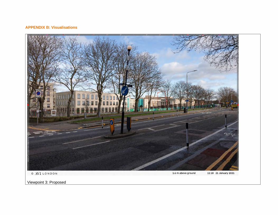
APPENDIX B: Visualisations
Viewpoint 3: Proposed
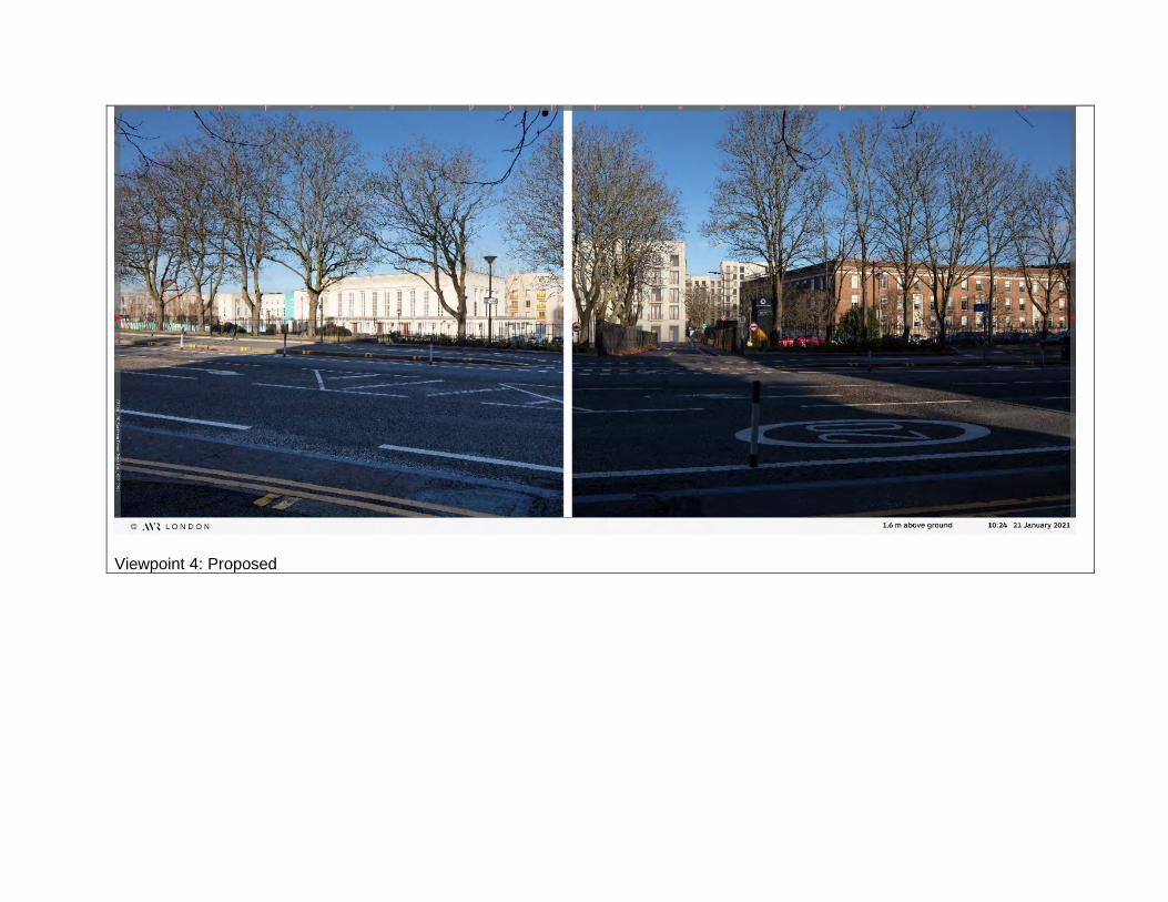
Viewpoint 4: Proposed

Viewpoint 7: Proposed

Viewpoint 9: Existing

Viewpoint 9: Proposed

Viewpoint 10: Existing

Viewpoint 10: Proposed

Viewpoint 11: Existing

Viewpoint 11: Proposed

Viewpoint 12: Existing

Viewpoint 12: Proposed

Viewpoint 13: Existing

Viewpoint 13: Proposed

EIA Further Information Technical Note - Appendix B: Visual Effects: 46831 Phase 2 Regeneration Works to the Town Hall Campus February 2021
Terminology for Visual Effects: Type of View: Glimpsed, Open, Oblique, Framed, Filtered Geographical Extent of Effect: (Descriptive) Abbreviations: Number of Viewers: Few, Moderate, Many Duration: Long-term, Medium-term, Short-term, Direct, Indirect TCA: Townscape Character Area Value of Views: High, Medium, Low Reversibility: Yes, within (timescale)/No
\\pba.int\bgl\Projects\46831 Waltham Forest Town Hall\10. Townscape\04 - Reports\46831 WFTH EIA Further Information Technical Note - Appendix B Visual Effects Table_NJ.docx
Susceptibility to Change: High, Medium, Low Overall Magnitude of Effect: Major, Moderate, Slight, Negligible, Neutral, No Change Overall Sensitivity of Receptor: High, Medium, Low Nature of Effect: Adverse, Benefit, Neutral, Not Applicable, Direct, Indirect, Secondary Size/Scale of Effect: Major, Moderate, Slight, Negligible, Neutral, No Change Significance: Substantial, Major, Moderate, Minor, Negligible, Significant, Not Significant P a g e | 1
Mitigation Measures
Embedded Mitigation:
Height and massing response to context – building heights are arranged to minimise impact of development on the surrounding area, ranging from 3 to 9 storeys in height. Building heights and massing seek to reference the height of the existing Town Hall and assembly hall, with adjacent buildings of 5 storeys. Taller buildings of 6-9 storeys are located away from the civic centre with the tallest being positioned in the eastern part of the Site, adjacent to the existing buildings of Waltham College.
Architectural appearance – the building layout mirrors the original, regular layout of the Town hall and Assembly Hall. Buildings are geometric in appearance with flat roofs which is consistent with the existing buildings on Site and provides visual coherency and legibility. Building materials used are in keeping with the surrounding context of the civic buildings and Waltham College.
New secondary routes which respond to existing urban grain – enhanced permeability of the Site through the provision of new cycle and pedestrian links from Forest Road and Farnan Avenue. Several pedestrian links from Forest Road through the front lawns of the Town Hall will be created.
New green space – the lawns in front of Town Hall and the Civic Building will be enhanced, creating improved public spaces that will enhance the proposed and existing buildings within the development and will provide structure to the landscape.
Town Hall Gardens – to the rear of Town Hall will be a formalised garden;
Chestnut Field – the recreational field to the north of the development will be enhanced through creation of a wetland landscape with aquatic planting and a circular walking route.
Animation of the new public space – active uses at the edges of the buildings and new public spaces
Considerate construction – construction works to be carried out in a considerate manner and in line with the Construction Environment Management Plan submitted with the application
Further Mitigation and Enhancements:
No further (secondary) townscape mitigation measures are proposed in this TVIA, because the maximum achievable mitigation within the Site boundaries has already been included in the embedded (primary) mitigation measures. As the Site is located within a dense urban environment, it is considered that off-site further townscape mitigation would not be feasible and would not provide certainty of further reduction of adverse effects.
Baseline Photos and Verified Views: To aid the reader’s understanding, baseline photos and verified views are included as thumbnails at the foot of each visual receptor assessment sheet, with the full-size images within Appendix A of the EIA Further Information Technical Note. The view location plan that was agreed with LBWF is also included. Baseline photos and accurate visual representations (AVRs as verified views) as full image renders and wirelines have been prepared by AVR London, as set out in the AVR London Methodology which is contained in the previously submitted TVIA ES Chapter - Appendix C.

EIA Further Information Technical Note - Appendix B: Visual Effects: 46831 Phase 2 Regeneration Works to the Town Hall Campus February 2021
Terminology for Visual Effects: Type of View: Glimpsed, Open, Oblique, Framed, Filtered Geographical Extent of Effect: (Descriptive) Abbreviations: Number of Viewers: Few, Moderate, Many Duration: Long-term, Medium-term, Short-term, Direct, Indirect TCA: Townscape Character Area Value of Views: High, Medium, Low Reversibility: Yes, within (timescale)/No
\\pba.int\bgl\Projects\46831 Waltham Forest Town Hall\10. Townscape\04 - Reports\46831 WFTH EIA Further Information Technical Note - Appendix B Visual Effects Table_NJ.docx
Susceptibility to Change: High, Medium, Low Overall Magnitude of Effect: Major, Moderate, Slight, Negligible, Neutral, No Change Overall Sensitivity of Receptor: High, Medium, Low Nature of Effect: Adverse, Benefit, Neutral, Not Applicable, Direct, Indirect, Secondary Size/Scale of Effect: Major, Moderate, Slight, Negligible, Neutral, No Change Significance: Substantial, Major, Moderate, Minor, Negligible, Significant, Not Significant P a g e | 2
Visual Effects Assessment Table
BASELINE AND SENSITIVITY CHANGE, MAGNITUDE AND SIGNIFICANCE
Visual Receptor Reference and View Location
Designation, Townscape / Landscape Character Area and Approx. Distance to Site Boundary
Description of Baseline View, Type of View and Number of Visual Receptors
Value of Views, Susceptibility to Change; OVERALL SENSITIVITY
DESCRIPTION OF CHANGE TO THE VIEW Size / scale, Geographical Extent and Duration / reversibility; OVERALL MAGNITUDE
Overall Nature of Effect
LEVEL OF SIGNIFICANCE
11: Forest Road, looking directly at Walthamstow College
Designation: Key View in the draft London Borough of Waltham Forest Skyline Study TCA: None
Baseline Description, Type of View, Viewer and Number of Users: Mature boundary trees along the college and road boundary filter views of Waltham Forest College, part of the existing Listed Building Waltham Forest Town Hall and other civic buildings. Waltham Forest College lies adjacent to the eastern boundary of the Site and comprises a series of large-scale buildings of varying architectural style. Currently, there is a gap in the townscape in filtered views from this location, to the left of the view, where an access road separates the existing civic and college buildings extending north-south along the eastern boundary of the Site. Part of the Site is located behind the red brick college building. During winter, without leaves on the trees, the existing college buildings and car park will be more visible between the winter tree canopies and trunks. Typical street scene view from within the local townscape experienced by pedestrians and road users of the busy Forest Road (A503). Views from this location are within the zone identified as a Key View in the draft London Borough of Waltham Forest Skyline Study.
Value of Views: Medium Susceptibility to Change: Low to Medium OVERALL SENSITIVITY: MEDIUM
During Demolition & Construction: There are filtered, partial views of construction activity to the left of the view, seen through gaps in between the mature trees / through winter tree canopies. Activities include demolition of existing buildings, hoardings, cranes. Construction activity, due to proximity of the view location to the Site, would be a noticeable change in visual composition of view.
During Construction: Size/Scale: Moderate Geographical Extent: Left of the view, looking north-west Duration/Reversibility: Short term OVERALL MAGNITUDE: MODERATE
Adverse Moderate, Significant
On Completion: There would be a change to the filtered, partial view of the current gap in the townscape between the civic and college buildings, which is replaced by new built form and mass of high-quality architectural design but seen through gaps between the mature trees / through winter canopies. Introduction of new built form offers regeneration of the Site in line with Policy 8: Character-led Intensification Waltham Forest Local Plan Part 1 Strategic Policies – LP1 (Proposed Submission Local Plan, 2020) and Site SA38 in Waltham Forest Local Plan Part 2, Draft Site Allocations Document – LP2 (Draft Plan (Preferred Options), 2020). Positive visual effects include:
• New built form fills the current gap in the townscape helping to create legibility and continuity to the development pattern along Forest Road (A503)
• Creates new interest in views along Forest Road (A503) and a focal point to highlight the regeneration of the Site from within the local townscape;
• Includes variation of architectural form and finishes; • Does not obscure views of the Town Hall or the Town Hall clock tower; • Introduction of new structural and ornamental landscaping within the southern aspect of the Town Hall
estate Negative visual effects include:
• The development proposals extend slightly further south towards Forest Road (A503) than the current pattern of built form.
On balance the visual change is considered to be beneficial.
On Completion: Size/Scale: Moderate Geographical Extent: Left of the view, looking north-west Duration/Reversibility: Long term/no OVERALL MAGNITUDE: MODERATE
Beneficial Moderate, Significant

EIA Further Information Technical Note - Appendix B: Visual Effects: 46831 Phase 2 Regeneration Works to the Town Hall Campus February 2021
Terminology for Visual Effects: Type of View: Glimpsed, Open, Oblique, Framed, Filtered Geographical Extent of Effect: (Descriptive) Abbreviations: Number of Viewers: Few, Moderate, Many Duration: Long-term, Medium-term, Short-term, Direct, Indirect TCA: Townscape Character Area Value of Views: High, Medium, Low Reversibility: Yes, within (timescale)/No
\\pba.int\bgl\Projects\46831 Waltham Forest Town Hall\10. Townscape\04 - Reports\46831 WFTH EIA Further Information Technical Note - Appendix B Visual Effects Table_NJ.docx
Susceptibility to Change: High, Medium, Low Overall Magnitude of Effect: Major, Moderate, Slight, Negligible, Neutral, No Change Overall Sensitivity of Receptor: High, Medium, Low Nature of Effect: Adverse, Benefit, Neutral, Not Applicable, Direct, Indirect, Secondary Size/Scale of Effect: Major, Moderate, Slight, Negligible, Neutral, No Change Significance: Substantial, Major, Moderate, Minor, Negligible, Significant, Not Significant P a g e | 3
12: Forest Road, looking directly at the Waltham Forest Town Hall
Designation: Key View in the draft London Borough of Waltham Forest Skyline Study TCA: None
Baseline Description, Type of View, Viewer and Number of Users: Partly framed view looking northwards and directly into the Site, through formal gates / gateway, to the existing Listed Building Waltham Forest Town Hall and other civic buildings. A mature street tree frames the left side of the view and in summer filters the view of the western part of the site. The clock tower is the focal point on the skyline in the centre of the view, and the formal gateway piers at the threshold of the town hall lead the eye towards the tower. Currently, there is a partial gap in the townscape of the Site, seen under the tree canopy, at the western area of the Site. Typical street scene view from within the local townscape experienced by pedestrians and road users of the busy Forest Road (A503). Views from this location are within the zone identified as a Key View in the draft London Borough of Waltham Forest Skyline Study.
Value of Views: Medium Susceptibility to Change: Low to Medium OVERALL SENSITIVITY: MEDIUM
During Demolition & Construction: Activity is seen in the view, looking north across Forest Road (A503);including demolition of existing buildings, hoardings, cranes. The Listed Building Waltham Forest Town Hall and clock tower remain in the view. Construction activity, due to proximity of the view location to the Site, would be a noticeable change in visual composition of view.
During Construction: Size/Scale: Moderate Geographical Extent: Across the view, looking north Duration/Reversibility: Short term OVERALL MAGNITUDE: MODERATE
Adverse Moderate, Significant
On Completion: The current gap in the townscape in the west of the view is replaced by new built form and mass. The upper element of new buildings in the east of the Site, behind the Town Hall and retained civic buildings is just perceptible at around the line of the top of the metal entrance gates in the right side of the view. Introduction of new built form offers regeneration of the Site in line with Policy 8: Character-led Intensification Waltham Forest Local Plan Part 1 Strategic Policies – LP1 (Proposed Submission Local Plan, 2020) and Site SA38 in Waltham Forest Local Plan Part 2, Draft Site Allocations Document – LP2 (Draft Plan (Preferred Options), 2020). Positive visual effects include:
• New built form fills the current gap in the townscape helping to create legibility and continuity to the development pattern along Forest Road (A503)
• Creates new interest in views along Forest Road (A503) and a focal point to highlight the regeneration of the Site from within the local townscape;
• Includes variation of architectural form and finishes; • Contributes to the visual identity of the civic square within the local townscape and does not obscure
views of the Town Hall or the Town Hall clock tower, which remains the central skyline focal feature. Negative visual effects include:
• The development proposals extend slightly further south towards Forest Road (A503) than the current pattern of built form
On balance the visual change is considered to be beneficial. During winter months when the street trees along Forest Road (A503) are without leaves, the partial views of the Proposed Development would be slightly greater.
On Completion: Size/Scale: Moderate Geographical Extent: Across the view, looking north Duration/Reversibility: Long term/no OVERALL MAGNITUDE: MODERATE
Beneficial Moderate, Significant

EIA Further Information Technical Note - Appendix B: Visual Effects: 46831 Phase 2 Regeneration Works to the Town Hall Campus February 2021
Terminology for Visual Effects: Type of View: Glimpsed, Open, Oblique, Framed, Filtered Geographical Extent of Effect: (Descriptive) Abbreviations: Number of Viewers: Few, Moderate, Many Duration: Long-term, Medium-term, Short-term, Direct, Indirect TCA: Townscape Character Area Value of Views: High, Medium, Low Reversibility: Yes, within (timescale)/No
\\pba.int\bgl\Projects\46831 Waltham Forest Town Hall\10. Townscape\04 - Reports\46831 WFTH EIA Further Information Technical Note - Appendix B Visual Effects Table_NJ.docx
Susceptibility to Change: High, Medium, Low Overall Magnitude of Effect: Major, Moderate, Slight, Negligible, Neutral, No Change Overall Sensitivity of Receptor: High, Medium, Low Nature of Effect: Adverse, Benefit, Neutral, Not Applicable, Direct, Indirect, Secondary Size/Scale of Effect: Major, Moderate, Slight, Negligible, Neutral, No Change Significance: Substantial, Major, Moderate, Minor, Negligible, Significant, Not Significant P a g e | 4
13: View of the western elevation of the Assembly Hall, from within the western part of the Site.
Designation: Key View in the draft London Borough of Waltham Forest Skyline Study. View from curtilage of a Listed Building, looking towards a Listed Building TCA: None
Baseline Description, Type of View, Viewer and Number of Users: View across the Campus Lawns, large formal civic space lawns, accessible to the public and which are part of the public realm and civic setting to the Town Hall and Assembly Hall. Flag poles, lighting, seating, lavender hedging, and trees are features within the civic space. Hard landscape paths, the same white colour as the Town Hall building, dissect the green lawns, providing geometry and formal character. The Town Hall frames the left of the view, and the line of mature trees between the Site and Forest Road provides a soft green skyline to the rear of the view at the right. The Assembly Hall forms the central focus of the view, set between trees. Trees are located in the gap between the Town Hall and the Assembly Hall. Typical public realm view from within the Site, for people visiting the Town Hall and other civic buildings. Views from this location are identified as a Key View in the draft London Borough of Waltham Forest Skyline Study.
Value of Views: High (within curtilage of Listed Building) Susceptibility to Change: Medium OVERALL SENSITIVITY: HIGH
During Demolition & Construction: Activity is seen in a small area of the view, at the far end of the Town Hall and to the left of the Assembly, including hoardings, cranes, the new building emerging from the ground and the refurbishment of the lawns. Construction activity, due to the view location begin within the Site boundary, would be a noticeable change in visual composition of view.
During Construction: Size/Scale: Moderate Geographical Extent: Within the Site, across Campus Lawns Duration/Reversibility: Short term OVERALL MAGNITUDE: MODERATE
Adverse Moderate, Significant
On Completion: The gap between the far end of the Town Hall and the Assembly Hall is reduced by new built form and mass; however, part of the existing tree and gap remains in place in the view. The new building height in the view is below the height of the Assembly Building. The new building is seen in scale with the existing masses and heights of the Town Hall and Assembly Building. Introduction of new built form offers regeneration of the Site in line with Policy 8: Character-led Intensification Waltham Forest Local Plan Part 1 Strategic Policies – LP1 (Proposed Submission Local Plan, 2020) and Site SA38 in Waltham Forest Local Plan Part 2, Draft Site Allocations Document – LP2 (Draft Plan (Preferred Options), 2020). Positive visual effects include:
• Respects the existing townscape and civic public realm, and historic nature of the view across the Campus Lawns.
• Respects adjacent built form through stepped roof form, heights, scale, mass and façade treatment; • Includes variation of, but complementary, architectural form and finishes; • Contributes to the visual identity of the civic square within the local townscape and does not obscure
views of the Town Hall or the Town Hall clock tower. Negative visual effects include:
• In this view, the development proposals appear as extended built form of the Town Hall, which is closer to the Assembly Building than the current pattern of built form;
• Less of the tree canopies between the end of the Town Hall and the Assembly Hall is visible. On balance, the visual change is considered to be beneficial.
On Completion: Size/Scale: Moderate Geographical Extent: Within the Site, across Campus Lawns Duration/Reversibility: Long term/no OVERALL MAGNITUDE: MODERATE
Beneficial Major, Significant

TECHNICAL NOTE
M:\Vicky Benham\_Environment\_Stefan Boss\Fellowship Square EIA Technical Note FINAL ISSUE.docx Page 24 of 24
APPENDIX C: Demolition Plan

Project:
Client:
Location
Title:
Date Description By
Job No.
Date:
Revision Check KeyNotes
installation.
and specialists consultants information. Any discrepancies must be reported prior to
This drawing should be read in conjunction with all relevant specifications, engineers
to the architect.
site prior to fabrication of any building element. Any discrepancies are to be reported
Contractors, sub-contractors and suppliers must verify any critical dimensions on
and engineers drawings.
reported to architect. To be read in conjunction with all relevant architects services
Do not scale drawings. All dimensions should be checked on site. Errors to be
Client logo
Scale:
Package RevisionStatus Reference
Drawing Number:
Fumbally Court, Fumbally Lane
+353 (0)1 531 4889
Dublin, D08 N2N8
813
2
58
Lodge
6
Garage
817 to 823
3
13
25.9m
4
688
ST
RE
ET
23
LB
9
24
1
PH
35
13
4
The
16
25.6m
House
680
19
26.8m
1
16
5
31.1m
26.5m
29.0m
25.9m
SH
ER
NH
ALL
795
2
FOREST R
OAD
805
1
30
26
16
Sub Sta
642
658
6
28
21.4m
Chy
1a
168
FA
LM
ER R
OA
D
to
9 to 1
4
Hancocke
621
51
36a
526
25.7m
534
1 to 22
12
1
619
60
Pond
2
El
War Memorial
674
6
642a
640
20
27
644
29
21
528
18
25 to 3
0
31 to 3
8
24
Howard
30
58
14
13b
603
(PH)
56
59
2
65
516
22.1m
61
53
48
18
83
13a
TCBs
FS
32
Chy
656a
Sub
YMCA Hostel
8
El Sub Sta
13
560
49a
Howard Mansions
31.0m
19 to 24
574
46
21.2m
25.6m
Sta
Mace House
21.4m
637
31
2
27
8
El
49b
HU
RS
T R
OA
D
13
19a
52
LB
23.8m
11
10
to
49
KE
NIL
WO
RT
H A
VE
NU
E
Gaitskell H
ouse
154
63
588
14
FA
RN
AN A
VE
NU
E
Hallin
gbury C
ourt
20
5
67
36
Health Centre
41
20
Courthouse
El Sub Sta
24
FOREST ROAD
72
12
7
1
PO
1 to 21
16
4
19
24.2m
25.1m
656
524
FS
Fns
532
30
55
House
22
536
1 to 8
40
El Sub Sta
47
1
25.1m
39
13c
18
1
The Bell
75
183
Mansions
26
4
193
70
171
TCB
13e
12
64
1
66
3
16a
22
76
20
13
31.1m
591
2
60
16.7m
54
11a
22
77
1 to 5
615
159
2
KE
NIL
WO
RT
H A
VE
NU
E
42
1
19.5m
1a
63
74
66
8
43
16
520
55
9a
33
23
36
24
24.7m
617
AU
BR
EY R
OA
D
617a
176
CHIN
GF
OR
D R
OA
D
26a
1 to 6
Trinity
Fanshaw House
538
16
3 to 8
Gilbert
1 to 2
8
Southgate House
Thorpe Coombe
1 to 6
House
1 to 6
FA
RN
AN A
VE
NU
E
53
67 65
92
69
74
100
79
SP
RU
CE HIL
LS R
OA
D
SP
RU
CE HIL
LS R
OA
D
35
14
113
6
13
97
94
130
14.6m
89
98
95
88
103
104
CHANDOS AVENUE
118
KE
NIL
WO
RT
H A
VE
NU
E125
13.7m
96
104
2
BR
AN
TW
OO
D C
L
617b
CR
4
1 to 12
Manning Hous
e
Gara
ge
2
124
102
108
84
80
41
33
51
LB
138
5
Club
The Holy Family Technology College
Shelter
Hall
Woodpecker
Club
Our Lady and
Kingdom
ShelterWard Bd
y
Ward BdyCR
Office
Catholic Primary School
St George's
Shelter
2c
2d
House
TCB
Shelter
(Upper School)
Waltham Forest College
Hall
Town Hall
Shelter
Shelter
Shelter
Athletics Ground
L Twr
Allotment Gardens
L Twr
Chestnuts Sports Ground
Waltham Forest Feel Good Centre
Government
Shelter
CR
54
62
1 to 17
548 550556
1 to 14
558
30
28
5a 7a
1a
153a
78
7 to 12
1 to 10
10
9
2
1
7 to 12
7 to 12
86
590
Brookscroft House
21
Marsham Court
1 to 15
7 12
9
1 to 6
8
BLACKBERRY CLOSE
85
87
13d
654
740
Branches
L Twr
ROAD
L Twr
89
77
99
L Twr
Shelters
Hatton
Terrace
3
1
484 to
512
Aston Grange
CR
Ward Bd
y
Ward B
dy
CR
Ward B
dy
21 to 27111
L Twr
L Twr
L Twr
81
78
87
67
153
156
79
146
SPRUCE HILL
S
ST J
OH
N'S R
OA
D
63
31
77
79
13
48
79a
60
113
56
77a
104
23
24
45
46
114
28
46
58
86
56a
81
114
101
96
59 7
0
36
50
10
18
70
47
60
76
102
81
67
20.3m
18.9m
56
65
97
13
58
68
98
100
12
57
12
37
23
86
61
64
72
62
CLIF
FO
RD R
OA
D
80
35
1906 P 101 102 P1
Waltham Forest Town Hall
Countryside Properties
Forest Road, Waltham Forest
1:1000 at A1
N
Jan 2021
KP05.02.21P1
Demolition Plan
To be demolished
AMPlanning Issue
0 20m10m5m 50m
1:1000 @ A1