Embed Size (px)
Citation preview
IHO MACHC seminar - Acapulco 2 -4 october 2006
Integrated costal zones management
Serge ALLAIN
SHOM - France

IHO – MACHC seminar – Acapulco 2 – 4 october 20062
Integrated costal zones management - ICZM
Definition
ICZM deals with
The management and the substainable use of the coastal zones into consideration the economic and social development linked to the existence of the sea while safegarding, for the future and present generations, the biologic and ecologic fragile equilbrium of the coastal zone and the landscapes

IHO – MACHC seminar – Acapulco 2 – 4 october 20063
ICZM
This definition adds :
The setting up of an ICZM requires the creation of institutional
instruments and standards making possible the participation
of the actors as well as the coordination of the objectives, of
the policies ans of the activities and leads to deal with the
problems in a global way which takes into account the
interaction between all the components of the environment.

IHO – MACHC seminar – Acapulco 2 – 4 october 20064
ICZM
This supposes several levels of integration
- Geospatial : Land and Sea core data in a seamless representation
- Administrative: coordination between the actors
- Sectorial : coordination of activities
- Temporal : Short Time and Long Time, sustainable development
IHO – MACHC seminar – Acapulco 2 – 4 october 20065
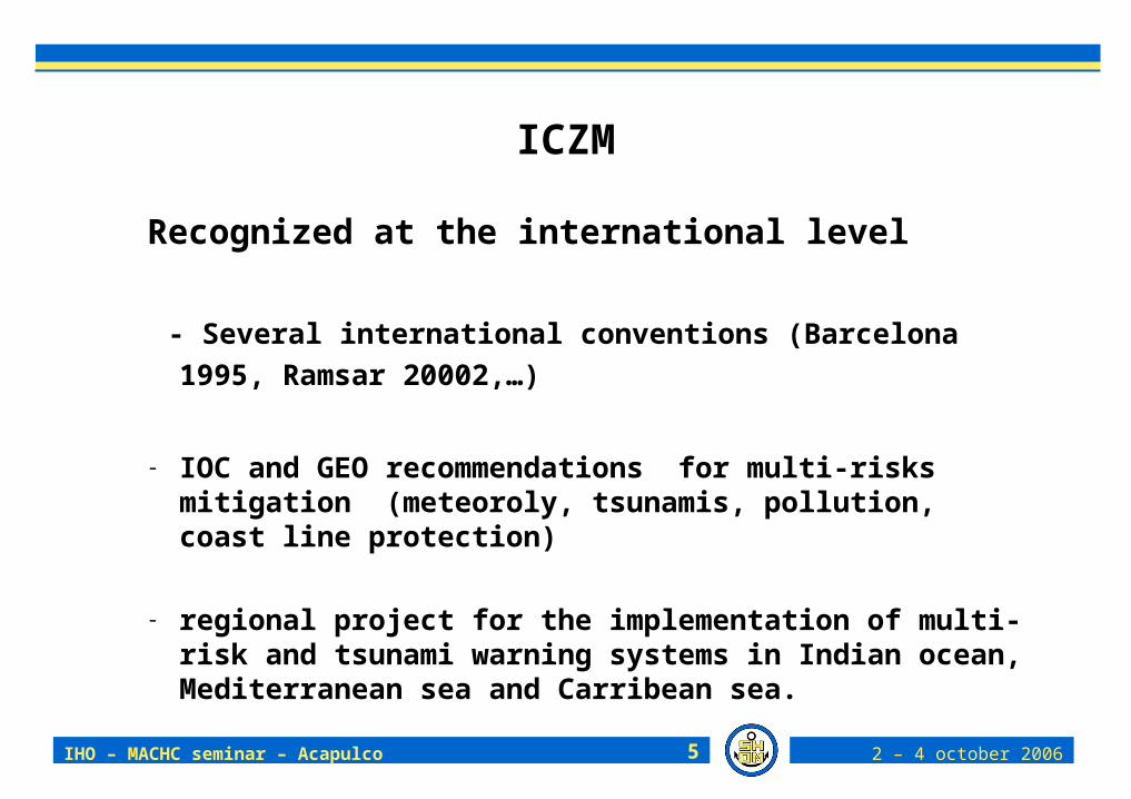
ICZM
Recognized at the international level
- Several international conventions (Barcelona 1995, Ramsar
20002,…)
- IOC and GEO recommendations for multi-risks mitigation (meteoroly, tsunamis, pollution, coast line protection)
- regional project for the implementation of multi-risk and tsunami warning systems in Indian ocean, Mediterranean sea and Carribean sea.

IHO – MACHC seminar – Acapulco 2 – 4 october 20066
IZCM
We can now consider ICZM through
- the needs
- the actors
- the data

IHO – MACHC seminar – Acapulco 2 – 4 october 20067
The needs
1 Littoral protection
2 Management of the littoral land use
3 Prevention and assessment of the risks
4 Exploitation of living resources
5 Exploitation of mineral resources
6 Port facilities development
7 Scientific works
8 Military needs
9 Miscelleanous

IHO – MACHC seminar – Acapulco 2 – 4 october 20068
The needs
1 Littoral protection Modification of the coastline (erosion,
implementation of protection structures...)
Swell impact
Coastal domain protection (physical action of the sea, flooding, chemical, biological, radioactivity spills, aso.)
Protection or management of living species of the littoral domain

IHO – MACHC seminar – Acapulco 2 – 4 october 20069
The needs
- 1 Littoral protection - 2 Management of the littoral land use
Consequences of a development (used waters rejections, modification of the coastal currents or of the sediment dynamics...)
Development of touristic areas
Beach facilities, marinas development projects, etc.
Coastal regulations (environment, safety, historic patrimony protection, navigation, buoyage...)
Determination of the coast line
Determination of maritime public domain

IHO – MACHC seminar – Acapulco 2 – 4 october 200610
The needs
1 Littoral protection 2 Management of the littoral land use
3 Prevention and assessment of the risks Identification of flooding areas
Coastal infrastructures for the prevention of natural hazards
Risk assessment (eg tsunami consequences)
Nuclear plants protection

IHO – MACHC seminar – Acapulco 2 – 4 october 200611
The needs
1 Littoral protection2 Management of the littoral land use3 Prevention and assessment of the risks4 Exploitation of living resources
Aquaculture
Conchyliculture
Coastal fishing
Alga exploitation and culture
Assessment of possible resources: potentially favourable areas, simulations, implementation possibilities

IHO – MACHC seminar – Acapulco 2 – 4 october 200612
The needs
1 Littoral protection
2 Management of the littoral land use
3 Prevention and assessment of the risks
4 Exploitation of living resources
5 Exploitation of mineral resources Sampling of marine granulates or of sediments

IHO – MACHC seminar – Acapulco 2 – 4 october 200613
The needs
1 Littoral protection2 Management of the littoral land use3 Prevention and assessment of the risks4 Exploitation of living resources5 Exploitation of mineral resources6 Port facilities development
Development projects
Impact simulations
Bottom changes simulation (assessment of the volumes to be dredged)
Knowledge of the nature and the structure of the subbottom

IHO – MACHC seminar – Acapulco 2 – 4 october 200614
The needs
1 Littoral protection2 Management of the littoral land use3 Prevention and assessment of the risks4 Exploitation of living resources5 Exploitation of mineral resources6 Port facilities development7 Scientific research and studies (generally part of other needs)
Studies on sediments dynamics
Studies on living resources changes
Studies for understanding coastal processus
Studies on littoral geography
Submarine archeology

IHO – MACHC seminar – Acapulco 2 – 4 october 200615
The needs
1 Littoral protection2 Management of the littoral land use3 Prevention and assessment of the risks4 Exploitation of living resources5 Exploitation of mineral resources6 Port facilities development7 Scientific research and studies8 Military needs
Beaching : knowledge of the intertidal area and land use of the coastal area, aceesability, beaches gradient…
Knowledge of very shallow waters: sedimentology, acoustics, bathymetry... (notably mine warfare)
IHO – MACHC seminar – Acapulco 2 – 4 october 200616
The needs
The actors

IHO – MACHC seminar – Acapulco 2 – 4 october 200617
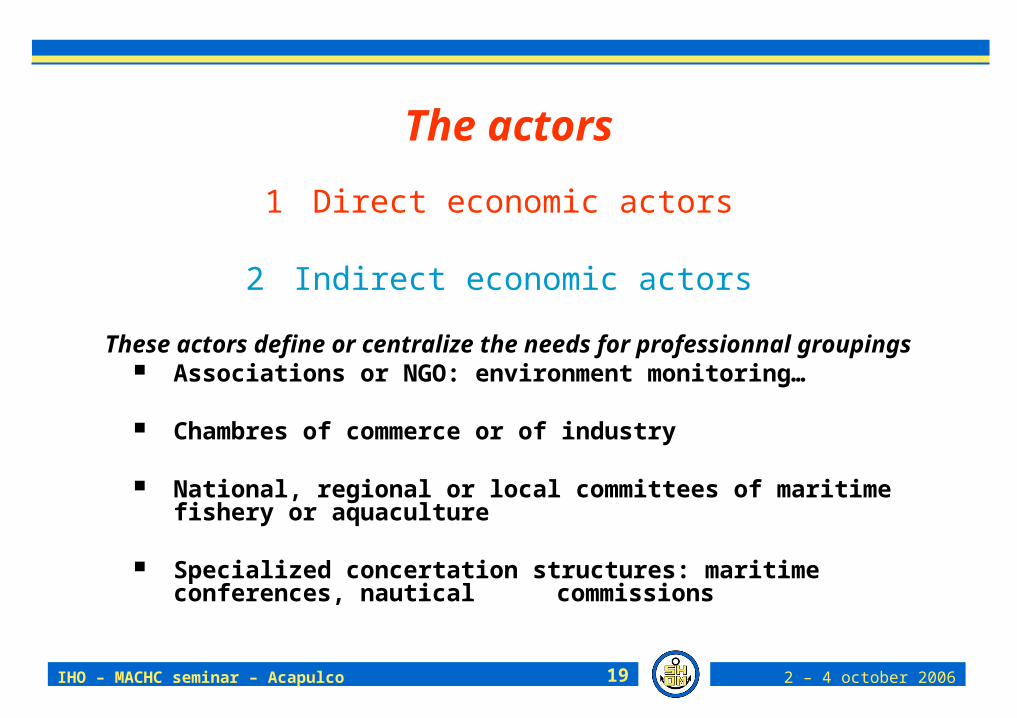
The actors
We define now who will be the users of the littoral geographic and hydrographic data. This is not exhaustive, just a sample gained from SHOM ’s experience.
1 Direct economic actors
2 Indirect economic actors
3 State Actors
4 Intermediary actors

IHO – MACHC seminar – Acapulco 2 – 4 october 200618
The actors
1 Direct economic actors
For conducting their economic activities, be they private or public, these actors need littoral geographic information; they are fishermen, conchylicultors, industry or craftmen, public works companies, surveyors, autonomous harbours, transport companies, services societies, ...
IHO – MACHC seminar – Acapulco 2 – 4 october 200619
The actors
1 Direct economic actors
2 Indirect economic actors
These actors define or centralize the needs for professionnal groupings Associations or NGO: environment monitoring…
Chambres of commerce or of industry
National, regional or local committees of maritime fishery or aquaculture
Specialized concertation structures: maritime conferences, nautical commissions

IHO – MACHC seminar – Acapulco 2 – 4 october 200620
The actors
1 Direct economic actors 2 Indirect economic actors
3 State Actors Prime minister and Ministers : Interior, Defense, Insdustry,
Fishing, Research, Maritime authorities, Foreign Office, Budget, Transport and infrastructures, Ecology
State : prefects, maritime prefects
Territorial or local collectivities : regions, departments, …
Public establishments and agencies
Coastal natural parcs

IHO – MACHC seminar – Acapulco 2 – 4 october 200621
The actors
1 Direct economic actors
2 Indirect economic actors
3 State Actors
4 Intermediary actors Coastal developers (landscapes, port protection
infrastructure).
Private study service agencies
Hydrographic, dredging, water retreatement private companies,
IHO – MACHC seminar – Acapulco 2 – 4 october 200622
The needs
The actors
The data

IHO – MACHC seminar – Acapulco 2 – 4 october 200623
Résultats locaux Résultats régionaux
56 62
56 46
64 62
56 46
24 62
52 38
72 69
60 54
64 31
52 54
48 54
56 46
56 46
64 46
repsonse off level1 data per actors
Limites physiographiques
0 hydrographique
limites basses de l'estran
le trait de côte
trait de côte pour mesurer l'érosion
La bathymétrie-topographie
un Modèle Numérique de Terrain (MNT)
hauteur d'une surcote avec une haute mer de vives eaux et tempête importante
aire d'influence des cours d'eau qui se jettent en mer
principaux rejets à la mer (émissaires)
Géologie et sédimentologie
nature des sédiments et roches sur les fonds marins et sur l'estran
hydrodynamique et hydrologie
courants de marée et leur intensité
direction et intensité des houles
sens de la dérive littorale
marnage
hauteur des surcotes les plus importantes que l'on a pu observer
IHO – MACHC seminar – Acapulco 2 – 4 october 200624
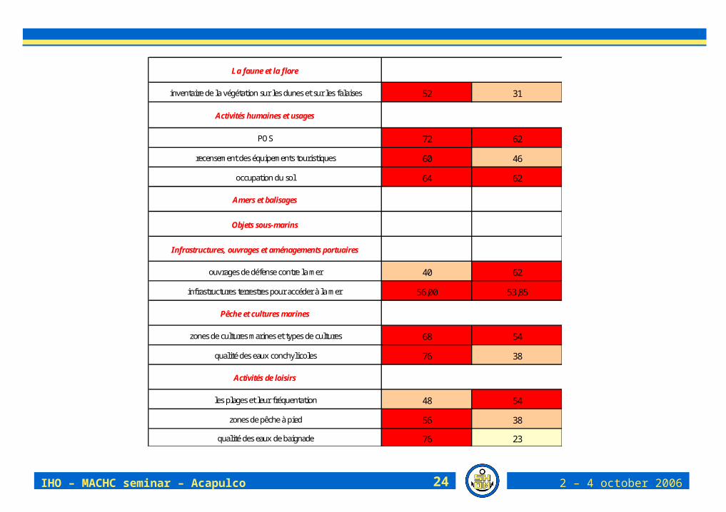
52 31
72 62
60 46
64 62
40 62
56,00 53,85
68 54
76 38
48 54
56 38
76 23
ouvrages de défense contre la mer
infrastructures terrestres pour accéder à la mer
Pêche et cultures marines
zones de cultures marines et types de cultures
Objets sous-marins
Infrastructures, ouvrages et aménagements portuaires
inventaire de la végétation sur les dunes et sur les falaises
Activités humaines et usages
POS
recensement des équipements touristiques
occupation du sol
Amers et balisages
La faune et la flore
qualité des eaux conchylicoles
Activités de loisirs
les plages et leur fréquentation
zones de pêche à pied
qualité des eaux de baignade

IHO – MACHC seminar – Acapulco 2 – 4 october 200625
52 15
72 77
88 69
80 62
56 54
88 69
76 46
64 62
84 69
64 77
64 69
68 54
44 69
bassin et sous bassin-versant
Protection des milieux
les sites protégés(ZPS, ZNIEFF…)
Domaine Public Maritime (DPM)
zone d'application de la loi littorale
carte IGN, Scan 25
points d'entrée d'eau des marais salants
évolution population, urbanisation, résidences secondaires
carto des espaces littoraux remarquables au titre de la loi Littoral
Autres
orthophotographie
zones acquise et de préemption du Conseratoire du littoral
inventaire des zones humides
les zones de rejets de dragages
Limites administratives
Tous types de limites administratives
zones d'extraction de ressources minérales

IHO – MACHC seminar – Acapulco 2 – 4 october 200626
DOMAINESTHÈMES OU
THÉMATIQUES OU « SUPER THÈMES »
DONNÉES DE RÉFÉRENCE PROPOSÉES
Cote du zéro hydrographique
Tracé du Zéro hydrographiqueZéro terrestre (IGN 69 NGF)ortho-photographiesTrait de côte (limite des plus hautes marées astronomiques)niveaux marins extrêmes (limites des plus hautes marées astronomiques + surcôte)Bathymétrie TopomètrieFormations géologiques (Nature du substrat)Réseau hydrographique (rivières, fleuves) + Zones hydrographiques systèmes aquifères
HabitatRéseau benthique (REBENT)Espèces et Habitats des directives "Oiseaux" et "Habitats" Eaux de Rivières, Eaux piscicolesEaux de baignadeEaux piscicoles
Eaux et sédiments de Ports maritimes
Eaux ConchylicolesEaux côtières (ou marines)
Marées
CourantsHoulesDebits
Apports à la mer côtière (le BRGM souhaiterait que cela figure dans Qualité)
PiézomètrieVents, pression, température, pluviométrie, ensoleillement
CARACTÉRISATION DE LA ZONE CÔTIÈRE : PHYSIQUE,
BIOLOGIQUE, ÉCOLOGIQUE
Géographie de la zone côtière
Faune et Flore
Qualité (physique, chimique,
biologique) des eaux et sédiments
terrestres et maritimes
Hydrodynamique côtière, des fleuves
et des rivières

IHO – MACHC seminar – Acapulco 2 – 4 october 200627
DOMAINESTHÈMES OU
THÉMATIQUES OU « SUPER THÈMES »
DONNÉES DE RÉFÉRENCE PROPOSÉES
Objets remarquablesBalisage fixe,
Balisage mobile
Points GéodèsiquesOccupation des fonds marins et de l’estran :Apports à la mer convention OSPARCultures marines Objets sous-marins :câbles, Digues marines pour la protection des populationsdépôts de dragage, zones draguées
épaves, obstructions
rejets urbains
rejets industriels
Emissaires
Exploitations de ressources minérales
Exploitations de ressources vivantes
Algues
Pêche
Tourisme (balisage des plages, zones de mouillage…)Occupation du littoral (nomenclature à définir)Sites et sols pollués nécessitant une action de l'Etat
Données socio-économiques
Population
Activité portuaire
Statistiques sur la pêche , l’agriculture ( nbre et type de bâteaux, de marins…), l'Industrie et le Commerce
Fréquentation des ports marchands
Occupation anthropique de la
zone côtière
ACTIVITÉS HUMAINES ET
USAGES

IHO – MACHC seminar – Acapulco 2 – 4 october 200628
DOMAINESTHÈMES OU
THÉMATIQUES OU « SUPER THÈMES »
DONNÉES DE RÉFÉRENCE PROPOSÉES
Cadastre Conchylicole
« terrestre »
Limites administratives
Communes (dont communes littorales y compris territoire en mer), départements, régions, Limites de salure des eaux,
ligne de base
ligne de base droitelimite des eaux territorialesZones d’autorité des préfectures de région en merZone d’autorité des préfectures maritimesZone portuaire administrative
DPM, Domaine Public Fluvial..
Plateau continental (juridique)
Conservation des patrimoines
Réserves naturelles, monuments historiques, parcs nationaux, terrains du Conservatoire du littoral…etcRéserves dites marines
Sauvetage, sécurité Stations de sauvetageCROSS, moyens de coordination
Zones maritimes de restrictions
Zones réglementées à la navigation et à la pêche
Périmètre des SMVM (approuvés et en cours..) DTA,
SAGE / SDAGE
Limites de Communautés urbaines, d’agglomération ou de commune ayant une partie maritime, Pays « maritimes » (sens loi Chevènement, loi Voynet)
ADMINISTRATION, CONSERVATION ,
RÉGLEMENTATION ET AMENAGEMENT
DE LA ZONE CÔTIÈRE
Zonages d’aménagement et
de gestion de la zone côtière