Embed Size (px)
Citation preview
1st edition October 2016
PORTFOLIO
CartONGMapping and information management for humanitarians
33
Editorial
This portfolio is addressed to our current NGO and International Organisation partners (or any new partner wanting to work with us) to give an overview of all the types of projects that we manage on a day-to-day basis and the diversity of skills that we have on the team. We hope you find it an interesting read. We are also full of ideas of projects that we could develop in the years to come on new Information Management technologies and methodologies that are emerging and that are changing the humanitarian field to an extent that would not have seemed possible just a couple of years ago- don’t hesitate to get in contact with anybody from the team if you would like to know more !
Charlotte Pierrat, President of CartONG
SUMMARY
Editorial CartONG 5 Who we are 6 Volunteersandstaff,ourmodusoperandi 7 Our Values 8 Location 9
INFORMATION MANAGEMENT 11 Information Management Strategy 12 Database & Analysis 13 Dashboard & Data Visualization 14
GIS & MAPPING 17 Mapping 18 Map Portals 20 Webmapping 21 UAV/Remote sensing 22
MOBILE DATA COLLECTION 25 MDC Tool Implementation 26 Mobile Mapping 28 SMS 29
CAPACITY BUILDING 31 Training in class & on the job 32 Remote Support 34 Community building 35 Best Practices 36
Current Partners
4 54 5
“ What [we] like with CartONG, it’s that there is a
double skillset: a very strong technical skillset, but also a knowledge of the humanitarian sector
”René Saameli
GIS Coordinator
CartONG
6 76 7
Who we are
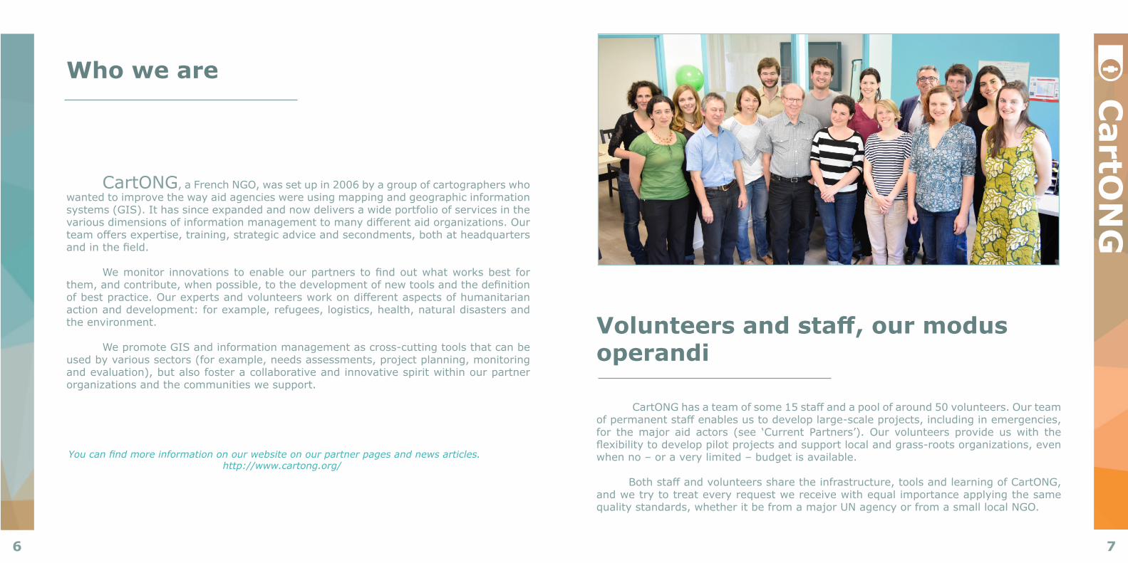
CartONG,aFrenchNGO,wassetupin2006byagroupofcartographerswhowanted to improve the way aid agencies were using mapping and geographic information systems (GIS). It has since expanded and now delivers a wide portfolio of services in the variousdimensionsofinformationmanagementtomanydifferentaidorganizations.Ourteamoffersexpertise,training,strategicadviceandsecondments,bothatheadquartersandinthefield.
Wemonitor innovationstoenableourpartnerstofindoutwhatworksbest forthem,andcontribute,whenpossible,tothedevelopmentofnewtoolsandthedefinitionofbestpractice.Ourexpertsandvolunteersworkondifferentaspectsofhumanitarianactionanddevelopment:forexample,refugees,logistics,health,naturaldisastersandthe environment.
We promote GIS and information management as cross-cutting tools that can be usedbyvarioussectors(forexample,needsassessments,projectplanning,monitoringandevaluation),butalsofosteracollaborativeandinnovativespiritwithinourpartnerorganizations and the communities we support.
Youcanfindmoreinformationonourwebsiteonourpartnerpagesandnewsarticles.http://www.cartong.org/
Volunteers and staff, our modus operandi
CartONGhasateamofsome15staffandapoolofaround50volunteers.Ourteamofpermanentstaffenablesustodeveloplarge-scaleprojects,includinginemergencies,for the major aid actors (see ‘Current Partners’). Our volunteers provide us with the flexibilitytodeveloppilotprojectsandsupportlocalandgrass-rootsorganizations,evenwhen no – or a very limited – budget is available.
Bothstaffandvolunteerssharetheinfrastructure,toolsandlearningofCartONG,andwetrytotreateveryrequestwereceivewithequalimportanceapplyingthesamequalitystandards,whetheritbefromamajorUNagencyorfromasmalllocalNGO.
CartO
NG
8 98 9
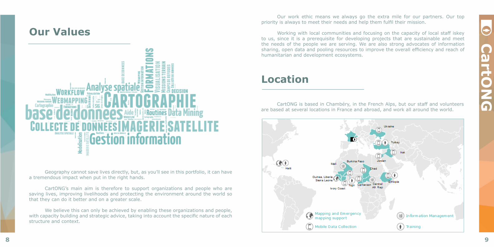
Location
CartONGisbasedinChambéry,intheFrenchAlps,butourstaffandvolunteersarebasedatseverallocationsinFranceandabroad,andworkallaroundtheworld.
Our Values
Geographycannotsavelivesdirectly,but,asyou’llseeinthisportfolio,itcanhavea tremendous impact when put in the right hands.
CartONG’s main aim is therefore to support organizations and people who are savinglives,improvinglivelihoodsandprotectingtheenvironmentaroundtheworldsothat they can do it better and on a greater scale.
Webelievethiscanonlybeachievedbyenablingtheseorganizationsandpeople,withcapacitybuildingandstrategicadvice,takingintoaccountthespecificnatureofeachstructure and context.
CartO
NG
Ourwork ethicmeanswe always go the extramile for our partners. Our toppriorityisalwaystomeettheirneedsandhelpthemfulfiltheirmission.
Workingwithlocalcommunitiesandfocusingonthecapacityoflocalstaffiskeytous,since it isaprerequisite fordevelopingprojects thataresustainableandmeetthe needs of the people we are serving. We are also strong advocates of information sharing,opendataandpoolingresourcestoimprovetheoverallefficiencyandreachofhumanitarian and development ecosystems.
10 11
“ Now thanks to CartONG I can manage my 200 000 beneficiaries without double counting & I’m actually looking forward to writing my post
distribution monitoring report for once !
”Carolyn Meyer
Responsable de l’Information ProgrammeSolidarités International in Central African Republic
February 2016
INFORMATION MANAGEMENT
Yourorganizationcollectsdataeverytimeateamgoestothefield?Wouldyouliketovisualizeyour NGO’s core information on a map in order to get a better sense of where the needs are and,therefore,toplanyouractivitiesaccordingly?Doyouwanttoimplementanewactivity
butonlyhavethenameofthevillageandareunsurewherethatvillageis?
12 13
INFO
RM
AT
ION
MA
NA
GE
ME
NT
Information Management Strategy
• Shaping the future of IM in your NGO• Prioritising your needs and actions
Information management includes many aspects linked to data and information, from collection to compilation, modification and maintenance, as well as analysis, visualization and the dissemination of data transformed into valuable information.
Ex: CartONG can help you establish this strategy by looking at yourrequirements and the full datachain. A GIS strategy is an IM strategy focusing on data with a spatial connotation.CartONG has drawn up and helped implement a three year strategy for the development of GIS within MSF.Thisworkwasdonefollowingan assessment of existing internal capacity
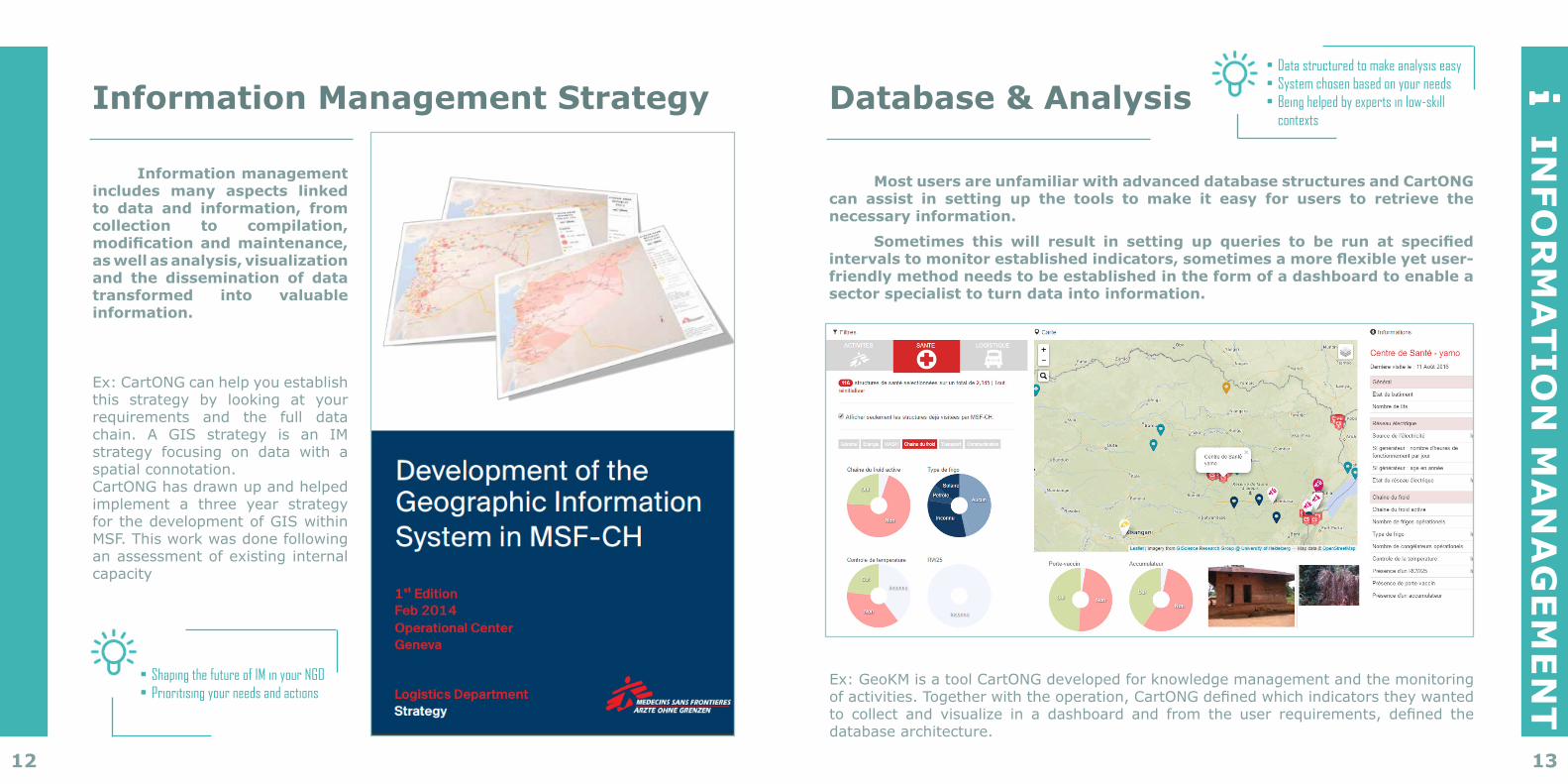
Database & Analysis
Most users are unfamiliar with advanced database structures and CartONG can assist in setting up the tools to make it easy for users to retrieve the necessary information.
Sometimes this will result in setting up queries to be run at specified intervals to monitor established indicators, sometimes a more flexible yet user-friendly method needs to be established in the form of a dashboard to enable a sector specialist to turn data into information.
• Data structured to make analysis easy• System chosen based on your needs• Being helped by experts in low-skill
contexts
Ex:GeoKMisatoolCartONGdevelopedforknowledgemanagementandthemonitoringofactivities.Togetherwiththeoperation,CartONGdefinedwhichindicatorstheywantedto collect and visualize in a dashboard and from the user requirements, defined thedatabase architecture.

14 15
INFO
RM
AT
ION
MA
NA
GE
ME
NT
Dashboard & Data Visualization
CartONG can develop dashboards for partners to analyse and share data and information seamlessly. The associated dataViz can include tables, maps, graphs, timelines and charts.
(We are developping using the most recent web-technology available: Leaflet, Power BI, OpenLayers3, Javascript, D3/DC.js and using different API to get data. Available online and offline.)
• User friendly tools for analysis• Sharing your data seamlessly• Analysis only one click away
Ex:CurrentlyourpartnerisrunningprojectsinSwazilandandoffersMobileandHome-basedHIVCounsellingandTesting(HTC).CommunitybasedHIVtestingstrategiescanincreaseuptakeoftestingandpromoteearlyaccesstocare.TheaimistomapoutwherecommunityHTCserviceshavebeenperformedperdistrictto knowexactlywhere testingactivitieshave takenplace in order to targetdifferentcommunitiesanddifferenthomesteadsinthefuture,thusensuringthatHTCservicesareofferedtoall.
The datavis we developed here displays the number of tests performed at each location disaggregated by age group and type of intervention. The population density data is overlayed with the information collected and all health facilities are indicated in the map.
16 17
“ That map translated the scientific
into the operational.
”MSF field staff
2015
GIS & MAPPING
Yourorganizationcollectsdataeverytimeateamgoestothefield,butisthisdatafullyutilized,orisitlostwithinaPDFdocument?WouldyouliketovisualizeyourNGO’score
informationonamapinordertogetabettersenseofwheretheneedsareand,therefore,toplanyouractivitiesaccordingly?Doyouwanttoimplementanewactivitybutonlyhavethe
nameofthevillageandareunsurewherethatvillageis?
18 19
GIS
& M
AP
PIN
GMapping
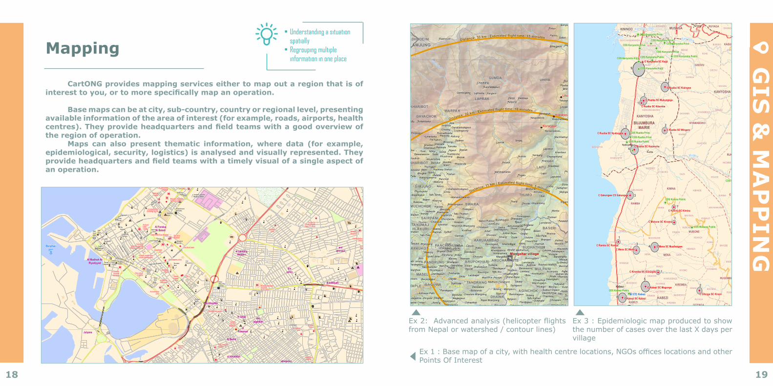
CartONG provides mapping services either to map out a region that is of interest to you, or to more specifically map an operation.
Base maps can be at city, sub-country, country or regional level, presenting
available information of the area of interest (for example, roads, airports, health centres). They provide headquarters and field teams with a good overview of the region of operation.
Maps can also present thematic information, where data (for example, epidemiological, security, logistics) is analysed and visually represented. They provide headquarters and field teams with a timely visual of a single aspect of an operation.
• Understanding a situation spatially
• Regrouping multiple information in one place
!(
!(
!(
!(
!(
!(
!(
!(
!(
!(
!(
!(
!(
!(
!( !(
!(
!(
!(
!(
!(
!(
!(
!G(
!G( !G(!G(!G(
!G( !G(!G(
!G(
!G(
!G(
!G(!G(
!G(!G(
!G(!G(!G(
!G(!G(
!G(!G(
!G(!G(
!G(
!G(
!G(
!G(!G(
!G(
!G(!G(
!G(
!G(
!G(
!G(
!G(!G(
!G( !G(
!G(
!G(
!G(
Nyabiti
Kanyosha
Kanyosha
Mugere
M
ugere
Kan
yosha
Kanyosha river
Mugere
Buhonga
Ruziba
Kamesa
Mutumba
Kiyenzi
Nyabugete
Kabezi
Muhuta
Mutambu
KANYOSHA1
KABEZI
MUHUTA
MUKIKE
MUTAMBU
NYABIRABA
KININDO
KANYOSHA
MUSAGA
9
4
3
1
25
4
1
31
1
1
3 4
1
5
4
2
110
22
3
BUJUMBURAMAIRIE
RUMONGE
BUJUMBURARURAL
RUTONGO
MASAMA
MWAZA
RUBURA GASEBEYI
CANDA
GOMVYI
KIREMBA
MENA
KIMINA
GITENGA
BURIMA
RUGEMBE
MUBONE
GIHONDO
HIGIRO
BURAZI
RUTOVU
RURAMBIRA
GAKARA
RUBANDA
MURAMBI
MASENGA
RUVYAGIRA
NYANKERE
BUGONGO
BUHANDA
NYARWEDEKA
NTOBO
MUGENDO
MUGENDO
KARAMA
NYAMABOKO
GISOVU
RUYAGA
KABUMBA
MUSUGI
RUKUBA
BUHINA
BUHONGA
MBOZA
KINAMA
MWICO
RUVUMU
MIRAMA
KINYAMI
KINYAMI
KABEZI
RAMBA
MIGERA
KINANI
MAYEBE
KIBERU
MASAMA
GATWENZI
CUMBA
RUTONDE
GIHANGANGE
NYARENDE
KIRASA
MUYIRA
GASEBEYIMASANGO
MUGURWERUHINGA
KAMORI
BUTURO
KIVUNGWE
MWAZA
RARO
GITARA
BUSENGAKINANGA
GACACA
GITSITARA
NYARUSENGEGISAGWA
KIREMBA
RUHANANGABWE
KINAMA
GATONGO
RUYANGE
MENA
MUSONGWE
RYAZO
GARA
KIMINA
GITOBORO
KIVOMO
KINANI
MUGONGO
MASHENYO
RUYAGA
GITENGA
KIVUNGWE
KIDOBWE
NTEMBWE
NGANGA
MUBONE
KINAMA
KIBANDA
GAZA
KINYINYA
BURIMA
NYAMUZI
RONKE
KIBANDE
KINYAMAKARA
KIGAGE
GOMVYI
NKORO
GIHONDO
MASANGO RUGOTI
HIGIRO
MWIZITE
MPINGO
RWANGA
NGWENA
NKOROMBWA
GAKE
RUGOBE
RUGOBE
BURAZIRUTEMBA
MASARA
GIKONGORO
BIRAYI
RUTOVU
KERO-RURAMBIRA
GAKARA
MPINGWERARO
KAYENWE
GASHIRWE
RUGEMBE
KADERI
MANDA
RUBANDA
RUSHORA
BUGONGWE
RUBEMBERI
NYANKERE
GIHETA
RUVYAGIRA
BUGONGO
GIKOMBE
MASENGA
BAMBA
NYAMUZI
NYANGARA
MBUGA
NTOBO
MUHANDA
MURAMBI
BUHANDA
MUGENDO
NYARUHEKE
BUSOVU
CARWE KAZIBA
KARAMA
RUHABIRO
BUREBO
SAGAMBA
KADENDE
KINAMA
MUKENDE
KIBAZONYAMABOKO
BENGE
GIHINGA
ROHE
GISOVU
NYAMUTENDERI
KAVUMU
NKOMBE
NYAGATOKE
MUSUGI
RUKUBA
MUSAGARA
KABUYE
GIKANGAKA
KABUMBA
NKONDO
NAMA
BUYUKI
MASARARA
GIHEMBE
RUTWENZI
GTONGATI
KABUNGERE
BUHINA
NYABUKENZI
RURINZI
KIYENZI
KINAMA
GISARENDA
BURUNGU
BUYENGERO
RUVUMU
MUGWA
MUDEGA KIRAMAMPINGA
GATARE
KABINGOMUSUMBAMUGUYE
KINYAMI
KINYAMI
RUSAGWE
NYAKARARA
NYAKAYENGO
NYAKAYENGO
MUJEJURU
DANGARI
MIGERA
GAKOMBERA
NYABAGE
GAKUNGWE
KIRASA
RUTONDE
KABEZI
RAMBA
MUTUMBA
MUGONGO
GISYO-NYABARANDA
GITARAMUKA
KAJIJI
KAMESA
KANYOSHA
KIBENGAKINANIRA I
KININDO
KIZINGWE-BIHARA
MARAMYVA
MUSAMA
NYABUGETE
CTC Kabezi
C Kanyosha SC Kajiji
C Ruziba SC Kizingwe
C Ruziba SC Mukungogu
C Ruziba SC Kibembe
C Ruziba SC WingareC Ruziba SC Nyabugete
C Ruziba SC Kazimuha
C Kimina SC Kimina
C Gakungwe CS Gakungwe C Burima SC Giheta
C Mubone SC Kinama
C Ramba SC RambaC Mena SC Mena
C Mena SC Mushongwe
C Kiremba SC Guisagwa
C Kabezi SC Mugongo
C Kabezi SC KabeziC Gitenga SC Kinani
C Mwaza SC NgambweC Kabezi SC Gakombera
C Migera SC Rutonde C Masama SC Cumba
C Migera SC Kiringi
CDS Kanyosha Privé
CDS Kanyosha PrivéCDS Kanyosha Privé
CDS Kanyosha Privé
CDS Kanyosha Privé
CDS Kanyosha Kijiji CDS Kanyosha Public CDS Kanyosha Public
CDS Kanyosha Kajiji
CDS Ruziba PrivéCDS Ruziba Privé
CDS Ruziba Public
CDS Kabezi Public
CDS Kimina Public
CDS Burima Public
CDS Mubone Public
CDS Masama
CDS Mutumba
Roads : OpenStreetMapPopulated Places: OCHAAdministrative borders : OCHAHealth Facilities : MSF
BURUNDI - Bujumbura Rural - Number of cases of cholera (w32 - 2016)
SOURCES
Document name : BDI_EPI_cholera_Bujumbura_A3PCreation date : 16-Aug-16Created by : MSF GIS Unit - [email protected] format : A3 Portrait
0 500 1,000 1,500250 m1:55,000 1 cm = 0.55 km
PROPERTIES
SCALE
±
This map is for information purposes only and has no political significance. The boundaries and names shown and the designations used on this map do not imply official endorsement or acceptance by MSF.
!G( CDS!G( CSC!G( CTC
Capital cityTownVillage
o Airport
RiverPrimary roadSecondary roadTertiary roadOther road
Province bound.Commune bound.Colline bound.Sous-colline bound.
Number of cases
!(10
!(5
!(1
LEGEND
Ex1:Basemapofacity,withhealthcentrelocations,NGOsofficeslocationsandotherPoints Of Interest
Ex2:Advancedanalysis(helicopterflightsfrom Nepal or watershed / contour lines)
ALGERIA
EGYPT
GREECEITALY
LIBYA
MALTA
NIGERSUDANCHAD
TUNISIA
Valletta
Al KhumsAz Zawiyah Gharyan
Hun
Ajdabiya
Darnah
Misratah
Sabha
Banghazi
Tripoli
ö
ö
a
l
ö
ö
ö
ö
ö
º
n
l
l
l
ö
n
ö
ö
ö
º
ö
a
"""" ""
ö
ö
"""" ""
ö
ö
ö
"""" ""
ö
ö
ö
ö
ö
ö
ö
n
ö
n
º
n
ö
ö
ö ö
"""" ""
"""" ""
ö
ö
ö
ö
ö
ö
ö
ö
ö ö
ö
ö
ö
l
l
ö
æ
ö
k
k©
"""" ""n
k
k
ö
ö
n
ñ
º
ñ
ö
n
n©
n
n
n
n
n
ö
n
ö
ö
ö
ö
n
"""" ""
n
n
"""" ""
ö
ö
"""" ""
ö
n
a
a
"""" ""
ö
ll
n
ö
ö
ö
©©ö
ö
n
n
n
ö
ö
öl
ö
ö
ö
ö
ö
ö
ö
nö
n
ö
ºö
ö
a
n
ö
n
ö
ö
ö
n
n
n
n
n
n
ön
ö
n
nn
nö
n
n
nn
ö
ö
ön
"""" ""
n
nnn
ön
n
n
n
n
a
nön ö
n
ö n
nö"""
" ""
a
n
n
n
"""" "" a
ö
n
n
n
ö
n
º
"""" ""
l
l
©
nn
nn
l
nn
n
ö
n
h
l
n
ö
ö
ö
l
l
ö
ö
²
²
²
²¶²
²
²¶²
k
n
k
kk
²
²
!G(
"G)5
"G)
"G)
"G)
"G)5
"H)
"H)
"G)
"G)
G
"H)
"H)
"H)
"H)"H)
"H)
"G)"G)
"G)
"H)
"H)
"G)
"H)
"G)
"H)
G
"G)
"G)
"G)
"H)
!G(
"H)"H)
"H)
"H)
"H)
"G)
G
"H)
"H)
!G(
!G(
"H)
"G)
!G(
"H)
"H)
"G)5
G
"H)
"H)
"G)
"G)
"G)
G
"H)
"G)
G
"H)
G
GG
G
G
G
G
G
"H)
Î
Al Berka
Julyana
GardenCity
Mintaqat alLathamah
Qaryat al`Unayzi
Ras Abaydah
al salmanyWestern
binyunis
cd uonis
hi alsalam
Tabalino-Tipolino
alkish
almajoory
al Laithi
bu ahdayma
hi alsalam
al himmidah
abuazghibah
hi langy
Shebnah
al barzakh
al Dollar
Al sertyah
ard alshireef
al hadaik
alRuwaisat
ardalhirasa
al badriyah
Al FonduqAl Baladi
SidiHussein
Al Madinah ArRiyadiyyad
WesternFwayhat
WesternDawud
Al Bazar str.
Via Torino
Via SidiBerberastr.ViaZuara
Ben Issa Street
Shwaykhat str.
Gasr Hamed Street
Al Mahdawi
Abdullah
Bala Street
Venic
eystr
.
Venic
ey st
r.
Venic
ey str.
Venic
ey str.
Shari' ash Shuhada'
Al Andalusstr.
Shari' ash Shuhada'
Via El Mohessci
Al na
har s
tr.
Omer El Mokhtar Street
23rd July Street
14 str.
Al Khlij str.
Venicey str.
Venicey str.
Umar Ibrj Al Aas
Al Hubza str.
Hijas str.
Shari'as
h Shuhada
'
Hijas str.
Al Khlij str.
20 str.
Venicey str.
Al nahar str.
First Ring Road
Jamal Abdel Nasser Street
Al Fonduq str.
Veni cey str.
Algeriastr.
23rd July Street
First ring road
July
ana
Brid
ge
Shari Muhammad al Maqrif
Sharia
JamalAbdel N
asser
Alhawary road
Shari'al Aquiyyah
Algeria
stree t
Shari a
l Aqri
yyah
First Ring
Searoa
d Qamini
s-Be
ngha
zi
TAH1
First ring road
50st
r.
Be
ngh
azi-
agd
ab
ia
PoliceStation
FerjanyGreermosque
University of GarYounes (Universityof Benghazi)
MedinaMosque
Omar MukhtarSecondarySchool
ArabMedicauniversity
KhadijaMosque
Zaytounneighborhoodmarket
Abdullahbin Jaafarmosque
BenghaziUniversity
Blonmosque
Ajyadmosque
Al-Nourmosque
FatimaZahramosque
FormerCathedral
AtiqMosque
CivilProtection
CentralBankof Libya
HomelandSecurity
People'sTheatre
Al ArabMedicalUniversity
Children'sTheater
ProvidentBank
SabriGeneralMarket
Directoratefor Security
University LibyanInternationalMedical Sciences
ComprehensivecareersInstitute
PoliceStatio (RasAabeda)
MunicipalHotel
Passports andNationality
Khadija SecondarySchool For Girls
OmarAl-MukhtarMosque
Academy graduateBenghazi branch
Al AmanBank
Al WahieshiMosque
TibestiHotel
ReegensyHotel
Al Wahathotel
Al-NooranHotel
HotelDojal
HighCourt
JanuaryMartyrSchool
NationalLibrary
Libyan AirlinesUtilitySecretariat
QasrAnnilHotel
OmanAlkharamHotel
Benghaziport
Medicalcenter
Arab Medical University
10 Maresclinic
23 JulyClinic
Sidi YunusClinic
Faculty ofMedicine Al Arab
Medical University
7 OctoberHospitalBenigazi
AlnagahHospital
Al shertaclinic
Al keshclinic
Ministryof Health
Al aom alhanoon
Al atfal hospitalAl FawyhatHospital
Al Galaa BenigaziHospital(Evacuation)
Al HaramClinic
Al Jamhureahospitl
Al KhaClinicAl majuree
clinic
Al markazuaclinic
Al marwa Eyehospital
Al MarwaHospital
Al mntageen clinic
AL naherHospital
AL Sabrey Polyclinic
Al sadreeaclinic
Al saha almadrasee
Al shateeal tbeeclinic
Al WafaClinic
AljamaiaClinic
AlsherefHelthCenter
Ambulances center
AssafwaHospital
BenamerHospital
BenghaziChildrenHospital
BenghaziHospital
Specialist
BenghaziMedicalCenter
Centre forPrimary HealthCare (11) June
Centrefor the
disabled
ClinicAhlas
Clinic forhelp for
day surgery
Communicablediseases center
FoodControlCenter
Great River Eye Hospital
Health CareCentre, Ibn Zahr
HIVcenter
Hospitaldisabled
InfectiousDiseasesHospital
InternationalUniversity
Medicinecompany
MunicipalHospital
New policehospital
No. 1AlsatyCombined
clinic
Primary health carecenter Sidi Hussein
Red Crescental barka
RehabilitationCentre
Republic Hospitalfor Poor Citizen
Sedeehuseen
clinic
Stores withdisabilities
TariqHospital
TBD
TBDThe blood bank
Al Fateh
Places : OSMAirports, harbor, roads, Logistic ClusterHealth facilities : Compilation of several sources made by Hot-OSM / StandBy Task Force / GIS CorpsRivers, water : Digital Chart of the World
LIBYA - Benghazi city center - Reference map and Health facilities
SOURCES
Document name : LBY_BM_Benghazi_centre_A0Creation date : 29-Feb-16Created by : MSF GIS Unit - [email protected] format : A0 Landscape
Banghazi
0 250 500 750 1,000125 m
1:15,000 1 cm = 0.15 km
SCALE
±
This map is for information purposes only and has no political significance. The boundaries and names shown and the designations used on this map do not imply official endorsement or acceptance by MSF.
Î Port
"H) Hospital"G) Clinic!G( Medical Center"G)5 Health EducationÆL LaboratoryG Other / Unknown© Bankh Bus stationl Fuel
²¶ hotel
"""" "" Marketplaceö Mosqueæ Cathedral
a Police
k Public buildingn schoolñ theatre
º university
Bridge on primary roadBridge on secondary roadPrimary roadSecondary roadMain urban roadUrbain roadFootway, pathMain buildingsBassinCemeteryCommercialFarmlandForestParkIndustrialMilitaryParkSport facilitiesWater
PROPERTIES
LEGEND
CHINA
INDIAKathmandu
NUWAKOT
DHADING
GORKHA
LAMJUNG
SALMESALME
GHAIRUNG
PANCHKHUWADEURALI
6000
5000
3000
2000
5000
4000
6000
5000
4000
3000
4000
3000
3000
2000
3000
2000
5000
4000
5000
4000
4000
3000
4000
4000
2000
1000
3000
6000
6000
4000
3000
2000
2000
1000
2000
5000
4000
4000
2000
1000
1000
1000
1000
1000
1000
UngulChyamthaliLakcho
KokhimRichetTingchetKalmrangPatichoChamtang
Jersyat
SangyungChogegaun
Singang AgthaliKuri
Birchet
ArchaletolKhorsyattolKharen
Gorkang PachetPatiKapre Maur Aranchet
PachetKhaniyabasJenjen GoromPati BradiKhululu Thambu
GumbungNangsariBhogteni Dangchet
Darsingang
GombogangMuilambra
KapurgaunTirgaunRichetgaunKupchet
Lapchet
IsimgaunLapagaun
Lebengchet Borang
RangnenChhurmrang
RijyambuKachetSyupchet
ChhapchetKarangTenchet YamchetGarsyong
Khahare BajarBelghariSukaura Simpani
PauwaphantGairigaun Maut
Charangephedi Kyamare DharadhuriDamgade
Lakure KebaraParamuni
RipBhotepadhera
LamathangaunPangreThapagaun
Kajigaun LapangHulakigaunTodke Bajar
Salle GhalegaunGairigaun Chheugaun
Bhogteni BajarGairigaun
BanchaurSele
ArukharkaGhormun
Naiyachha
HajareLahuregaunKhalchet KeraujaChhapKabhre Kattike
BhankharkaBhorle ChintekharkaSimleSatbise
MadhubanMadankharka
AsubangBatuwa Dhunge
ArgalePanchghare PurbegauDsdagaun Guthi
Tharpu Bhanjyang
GairagaunBhanthanabesiBirdigaunKhabdigaun Barrabote
KumaltarChapabot Thapatar
SundarpurKuwapaniDharapani
SatbisetarLakuri BhanjyanJalbireMailun
ApswanraKumalgaun
KyamuntarRampurtarGagatetarSimletar
Ratmate KumaltariKholaparigaun
SukauraChaksigaunRanipauwaDandagaunPolichhap
PolichhapDhunganiyagaun
DhandaDhodeni
Taribesi TimalsinagaunBharmaleArghautaGhatbesiPaudarkoDil Dhadagaun
RatomatekarkhetigaunButtargaun
BhadaureDumeregairaMahadevtar
Pipaltar Lumo BandagaunEkaltarAnakanyamai
Dhodeni KhatigaunMugidanda Gaun
GahateriSalbas
TallorampurDandagaun
BhotedandaNigalpaniKhumtar
ChulidandaDhandagaungShamidandaTripurasundari Bhaduwar
Dhulimaidan Pauwa Khaite
Kichet
Patalekharka
Tajimarang
TinsureDandaGomma
LadapRigaunBhatkeli MajuwaKattike Majuwa PurungTawalSokthali
DhuseniMansire DhandkharkaDhaje KutawalBarreMajuwabesi
Dandagaun SingangPainyakharka
Chimchok Koda BhoteniTangbade
Banskharka ArukhetDeurali
DarkhaDumla
DangsingSananLapsibot
TinkhanneMarauti Bardhang
PokharaSu BhanjyangPhulkharka Mammai
DandathokMurchuk Kakchet
ChhelanRaute
Archalepani
DhangarchokKalthutaMathillo MulabariKalleri Tallo
Kattike GumdiSatdobatoKhanyubasRamichaur
RatmateEkle InduMahabhirOdaregaun
ShivakharkaSalmetarSarkigaun OjagiBhandarigaun
KintangbesiSaldumHatiyakot
BhogteniDandapari KoklingKotthokBelung BorangPhalangi
DhokarpurBhirswanra
SaptariNibuwabotKaste AlthokArchaleTilarDeuralichhap
Chautara BarsanchetChhapthok
PantetarKhanigaunAnpchaur
MarpakBokrang PokharaThalaNimachokAchanetarLapang Lamidanda
LagdandaChundanda
Chanaute SisapaniThumkiKharchok BhanjyangSiranthar
SwanraKalimati SulikotKumaltari
Tallo Ekle Ratmati
Takukot GyajiBhanjyang LakureKhanigaun Amle
Mailung Dhawari Dhari
Upallo Jaran Pandrung ArukotBaluwaBesi
DharapaniTallo JarangPandegaun Ramche Gairichhap
PataleTallo RamcheMajhthok Ghoptegaun
Dandagaun Tinkhande
OkhaleDarbare Banjaragaun
Dukhuwa
PandegaunAdhmare Pallo Banduke
Dudegaihra Jhingate Ripgaun Waglegaun
Kaphal Chhap NayangaunAsrang
OkhalepaniThumka
SoranggaunGamoj ThotneriChitre DharapaniBuddhigairaNebot Pokhari BasuriJundhumu Lamdanda
Jamunedanda KokhetarThumiChisapani
KumthaliSekha
Dhodeni BaseriSwanragaunArbikBhainseOdareArkhet Bajar
Tallo-PipleGhorpaniOyak
BhangeriArbang Galane
ChaunchuliKalimati
LakurePittheShanti-BajarDandagaun
AlaincheLokuwa
KalleriAlkatar BudhathumKhatriswanra
AmboteDandapari Simaraphant
ChurungRatmate
Mangaltar SimleGurunggaun
Pokhara MathilloSiureniTuniboteLamidanda
Sisneri DhakalgaunKubindeArutar
Dandagaun BaraswanraArukharkaLambesi
Deurali ThulibesiKastegaun
Tallo AruKauchhiniArughatLambagar BirtaBesi
AhaleOkhle Bishal BajarMajinthok (Nange)
Sikatar ChhapthokMarchugaunMaithum (Tariphant)
Dandabesi Sanagaun PhulbariDigaunMajhgaun KatheriBaddanda Bolang
Chautara Bhanjyang GolangBamshagaunDigaun
Tallo KatheriRajali Bhanjyang GolangtarBelgaun Chisapani
PandegaunChhapthokDandagaun Baluwatar Chhapgaun
Rumchet
KeraunjaKeraunjabesi
Machhakholagaun
Khanibesi
Chamakharka
Tham Bhanjyang
Phalbang YarsaKhalding
MajhgaunDorbaSallaghari
Managi BhanjyangMajhgaun
Shyamchet
Manbu
TorkekharkaDilluAtali
JongongDambukholagaun
LisyangpungChisangPumsalkharkaPanjegaun
KebungLimkharka Keurung
Pachgaun SyamerBirujung
TumsikaDhansiraKharbari
Chamraun Harsimle
GonjeAlgaunTordiKhor
SodaNilmu
DewalswanraPhusenang
Thailidanda
GhyachchokBarpakChauthal
Bansbot PitadandaMandreSnan
Ropeway StationThumgaun
MilimGalmu
Mahabhir
PokhariBhugtoliBalphe
KaldungswanraPatleRanchok
Matijung
KeuraChhaharekholagaun
Phurbujetar SimbuBagalegaun Tallo Simbu
MahabhirswanraBojeni KharungKalibote
BhandarigaunKapseri
BanchokJedanda
Bhailam Tallo ThotneriArchale Ahaldanda
SinglaLaprak
LapsibotBarpak
YamkangGumda
KhanigaunKirunjeKhanibesi
LapuNambaikharkaPogatu Lapubesi
LidingBhirkuna
Armala
Soti
ShyamrangThantiDeurali
Thalagaun
Thangurmu
EkleboteBangsing
Sarsim
Philim
Nagjet GumbaPurano Philim
Sirdibas PadiLokpaGumjed
Pukyu
PaimoSalleri
JagatBhalugaun
Lhakpa
IndurMaiku
Dungla SulachetPhaibang
Bhinchet Dobhan
HulchukThingjet
LabuchetTatopani
Lisyapu
MeksichetRumchetRumchetbeshi
Mindapuk
Yangodanda
DambajeKaigungDanje
Pangkim
Rupchetalgaun
Chwakang
LekharkaGambugang
Rupina La
Chhampachet
SenenGairagaunSemjong
Chautara PhalantePolchetPangchu
NayangaunKuwa
Thulodanda
Kalleri PokhariPrepgaun
TaksarTharpu
PuranpaniganBharyang
ChilaunebasKallabariPokhariRingaun
BhangeKuwagaunParamchet
Ankhu Khloa
Mahabhir Khola
Budhi G anda
ki
wa
terway
Diyong Khola
Aphal Khola
Daraudi Khola
Ankhu khloa
Ankhu Khloa
Thopal Khola
Ankhu Khola
Distance: 22 km / Estimated flight time: 10 minutes
Distance: 33 km / Estimated flight time: 15 minutes
Distance: 11 km / Estimated flight time: 5 minutes
Uhia
Korlabesi
Korlagaun
Kashigaon
Dunchet
Mangaltar village
BARSUNCHETBUNGTANG
DEURALI
KINTANGSALME
SAMARI
AGINCHOK
BASERI
BUDHATHUM
CHAINPUR
DARKHA
DHOL DHOLDHUWAKOT
GUMDI
JHARLANG
JYAMRUCK
KATUNJE
KHARI
LAPA
MARPAK
MULPANI
MURALIBHANJYANG
PHULKHARKA
RIGAUN
SALYANKOT
SALYANTAR
SANGKOS
SATYADEVI
SEMDHUNG
SERTUNG
TRIPURA
AARUAARBAD
ARUCHANAUTEARUPOKHARI
ASRANG
BAGUWA
BORLANG
BUNGKOT
CHUNCHET
DHAWA
GHAIRUNG
GHYACHOK
GUMDA
KASHIGAUN
KEROJA
KHARIBOT
KHARIBOT
LAPRAK
LAPU
MANBU
MASEL
MUCHCHOK
NAMJUNG
PANDRUNG
PROK
SAIRPANI
SIMJUNG
SIRDIBAS
SWARA
TARKUKOT
TAKUMAJHLAKURI
TANDRANGTAPLE
THUMO
UHIYA
WARPAK
DHODEINI
85°0'0"E84°55'0"E84°50'0"E84°45'0"E
28°2
5'0"
N28
°20'
0"N
28°1
5'0"
N28
°10'
0"N
28°5
'0"N
28°0
'0"N
Roads : OpenStreetMapRiver: OpenStreetMapAdministrative borders : OCHACityes and villages : OCHAElevation: SRTM
Nepal - MSF OCP estimated flight time to villages from Mangaltar village
SOURCES
Document name : NPL_LOG_Nepal_timeflightOCP_A3P_20150518Creation date : 20/05/2015Created by : MSF GIS Unit - [email protected] format : A3 Portrait
CHINA
INDIA
KAZAKHSTAN
RUSSIA0 1 2 30,5 km
1:150 000 1 cm = 1,5 km
PROPERTIES
SCALE
±
This map is for information purposes only and has no political significance. The boundaries and names shown and the designations used on this map do not imply official endorsement or acceptance by MSF.
CapitalRegion capitalAnchal capitalDistrict capitalVillage
OCP Drop pointDrop point
Depart point
Estimated flight time and distance from Mangaltar villageTrunk/motorway
Primary roadSecondary roadTertiary roadTrack/pathUrban roadOther roadRailroadRiverDistrict brder (Admin 3)VDC (Admin 4)Elevation contour line (1000 m)
LEGEND
Ex 3 : Epidemiologic map produced to show the number of cases over the last X days per village
20 21
GIS
& M
AP
PIN
GWebmapping
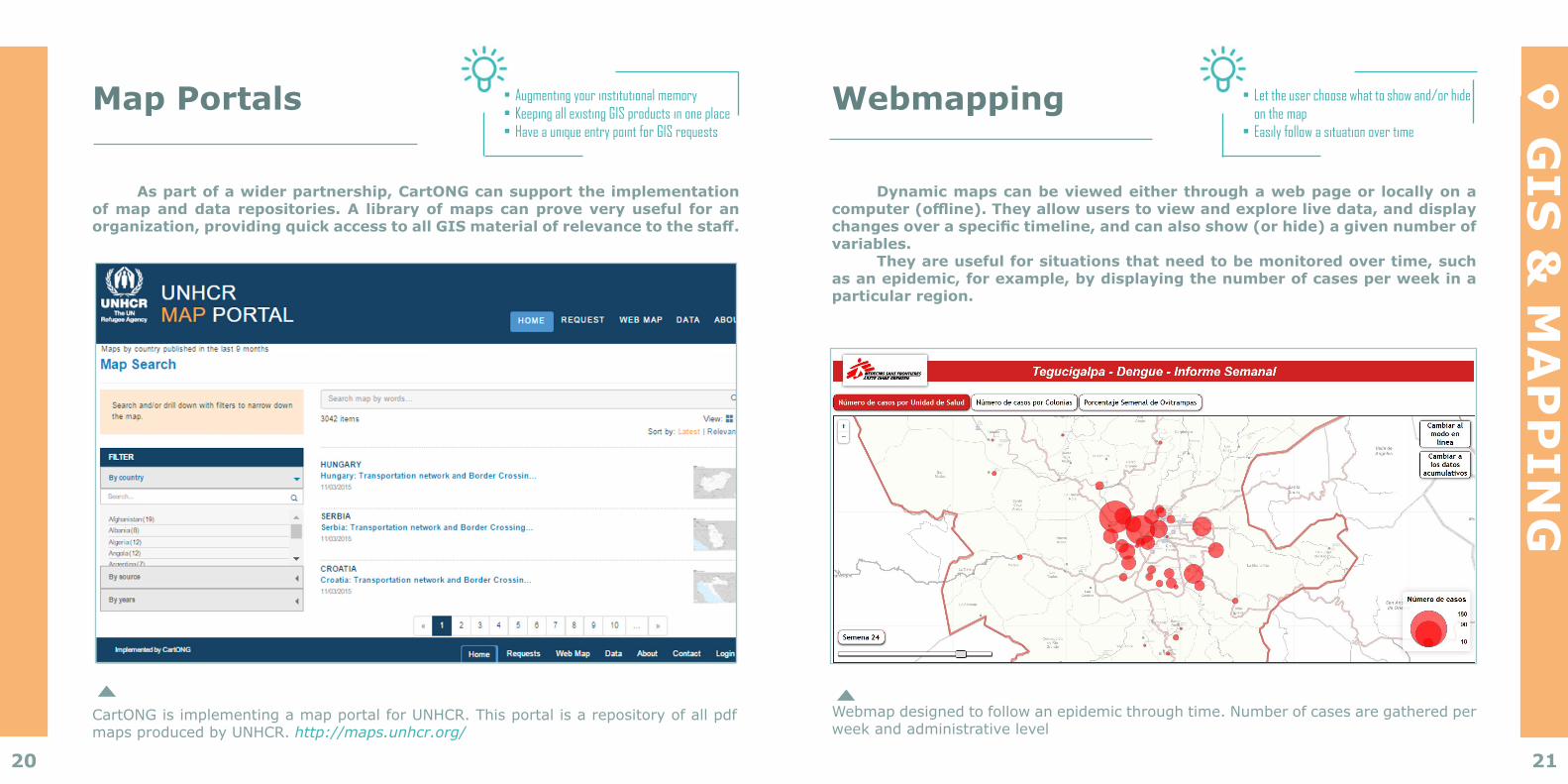
Dynamic maps can be viewed either through a web page or locally on a computer (offline). They allow users to view and explore live data, and display changes over a specific timeline, and can also show (or hide) a given number of variables.
They are useful for situations that need to be monitored over time, such as an epidemic, for example, by displaying the number of cases per week in a particular region.
Webmap designed to follow an epidemic through time. Number of cases are gathered per weekandadministrativelevel
• Let the user choose what to show and/or hide on the map
• Easily follow a situation over time
Map Portals
As part of a wider partnership, CartONG can support the implementation of map and data repositories. A library of maps can prove very useful for an organization, providing quick access to all GIS material of relevance to the staff.
• Augmenting your institutional memory • Keeping all existing GIS products in one place • Have a unique entry point for GIS requests
CartONGisimplementingamapportalforUNHCR.ThisportalisarepositoryofallpdfmapsproducedbyUNHCR.http://maps.unhcr.org/
22 23
GIS
& M
AP
PIN
GUAV/Remote sensing
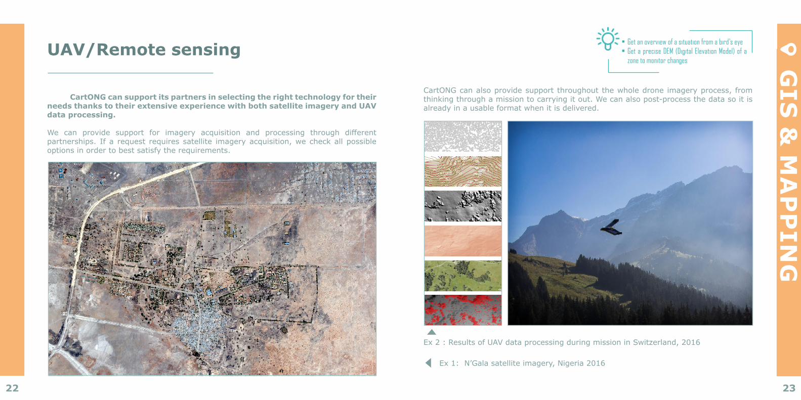
CartONG can support its partners in selecting the right technology for their needs thanks to their extensive experience with both satellite imagery and UAV data processing.
We can provide support for imagery acquisition and processing through differentpartnerships. Ifa request requiressatellite imageryacquisition,wecheckallpossibleoptionsinordertobestsatisfytherequirements.
• Get an overview of a situation from a bird’s eye• Get a precise DEM (Digital Elevation Model) of a
zone to monitor changes
CartONGcanalsoprovidesupportthroughoutthewholedroneimageryprocess,fromthinkingthroughamissiontocarryingitout.Wecanalsopost-processthedatasoitisalready in a usable format when it is delivered.
Ex2:ResultsofUAVdataprocessingduringmissioninSwitzerland,2016
Ex1:N’Galasatelliteimagery,Nigeria2016
NIGER
CAMEROON
CHAD
NIGERIA
Satellite : Google EarthDate : 02/22/2016
NIGERIA - Borno state - Ngala local government area - Ngala City
SOURCES
Document Name : NGA_Ngala_A2L_230916Creation date : 28/09/2016Created by : MSF GIS Unit - [email protected] format : A2 LandscapeConfidentiality : MSF Internal Access ONLY
BORNO
1:9 000 1 cm = 0,09 km
PROPERTIES
SCALE
±
This map is for information purposes only and has no political significance. The boundaries and names shown and the designations used on this map do not imply official endorsement or acceptance by MSF.
24 25
“ The collaboration with CartONG on rolling out the MDC strategy in standardised expanded nutrition
surveys (SENS) has been crucial in bringing this project to fruition.
Advances in the experience of using MDC and in the possibilities that the software offers mean that
countries are becoming more and more autonomous.
”Caroline Wilkinson
Senior Nutrition OfficerUNHCR HQ Geneva. May 2016.
MOBILE DATA COLLECTION
Do you sometimes wish you had a better understanding of context in order to respond in a relevantandproportionatemannertoyourNGO’sneeds?Doyoufindithardtodecidewhichareasandwhichbeneficiariesneedyourhelpthemost,ortoensurethatyourhelpiseffectiveinthelongrun?Youareawarethatthereareloadsofnewtoolsoutthereyoucoulduseto
collectdata,butdoyouknowwhichonestouseandhow?
26 27
MO
BILE
DA
TA
CO
LLEC
TIO
N
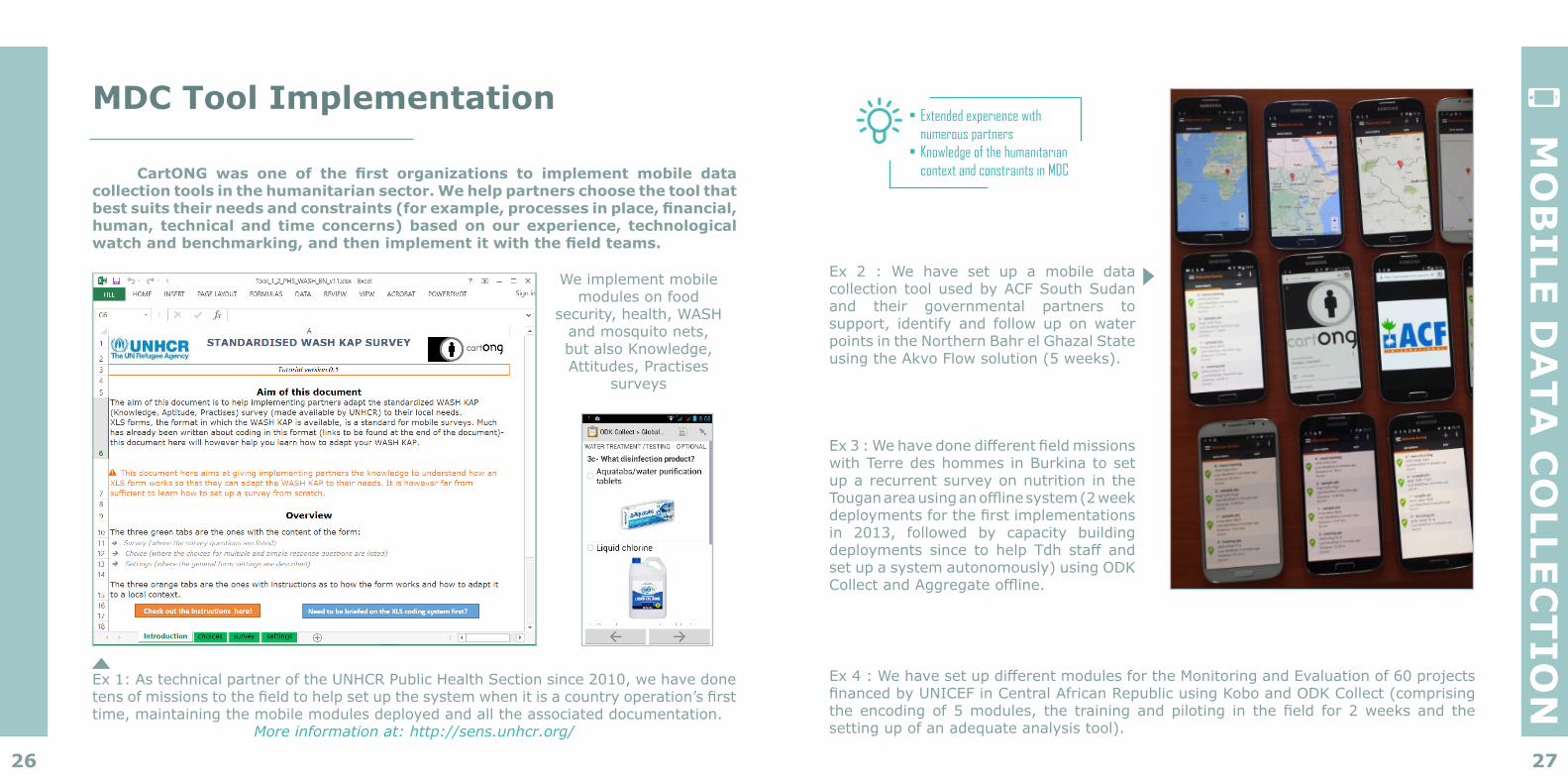
MDC Tool Implementation
CartONG was one of the first organizations to implement mobile data collection tools in the humanitarian sector. We help partners choose the tool that best suits their needs and constraints (for example, processes in place, financial, human, technical and time concerns) based on our experience, technological watch and benchmarking, and then implement it with the field teams.
• Extended experience with numerous partners
• Knowledge of the humanitarian context and constraints in MDC
Ex4:WehavesetupdifferentmodulesfortheMonitoringandEvaluationof60projectsfinancedbyUNICEFinCentralAfricanRepublicusingKoboandODKCollect(comprisingtheencodingof5modules, the trainingandpiloting in thefield for2weeksand thesettingupofanadequateanalysistool).
Ex3:WehavedonedifferentfieldmissionswithTerredeshommesinBurkinatosetup a recurrent survey on nutrition in the Touganareausinganofflinesystem(2weekdeploymentsforthefirstimplementationsin 2013, followed by capacity buildingdeployments since to help Tdh staffandset up a system autonomously) using ODK CollectandAggregateoffline.
Ex 2 : We have set up a mobile data collection tool used by ACF South Sudan and their governmental partners to support, identify and followup onwaterpoints in the Northern Bahr el Ghazal State usingtheAkvoFlowsolution(5weeks).
Ex1:AstechnicalpartneroftheUNHCRPublicHealthSectionsince2010,wehavedonetensofmissionstothefieldtohelpsetupthesystemwhenitisacountryoperation’sfirsttime,maintainingthemobilemodulesdeployedandalltheassociateddocumentation.
Moreinformationat:http://sens.unhcr.org/
We implement mobile modules on food
security,health,WASHandmosquitonets,butalsoKnowledge,Attitudes,Practises
surveys

28 29
MO
BILE
DA
TA
CO
LLEC
TIO
N
Mobile Mapping
Mobile mapping is useful for the collecting and/or monitoring of spatial information, such as camp infrastructure. CartONG can help set up the necessary tools and methodologies.
• Offline data collection for infrastructure
• Local actors maintaining the map • Storing camp infrastructure data in
one place only
CartONG implements camp mapping together withUNHCRFICCSunit.Deploying user-friendly smartphone applications for data collection and maintenance and storage of all collected information online.
Results are available in versatile web maps accessible to all actors in need of it. Already covered camps are accessible in the webmap section of the map portal. http://maps.unhcr.org/apps/campmapping/index.html SMS
For many remote areas with low bandwidth connectivity, communicating and sending information takes place through SMS. The choice of system, provider and tools often depends on the availability of those services on the ground.
Wehave implementedseveralprojectsusingFrontlineSMSandUshahidi,but,throughourbenchmarking,wearealsofamiliarwithandhavetestedothersystemsthatallowSMScommunication.Someworkasastandalonesolution,whileothersareprimarilyMDCsystems,whichallowthecollecteddatatobesentviaSMS.
• Connecting different solutions and customizing them as needed
30 31
“ Actually these tools are revolutionary for project
monitoring, it opens a world of opportunities !
”
Bioforce studentsDiscovering mobile data collection with ODK
CAPACITY BUILDING
DoyouwanttostartusingMDCorGIS,butyourteamhasneverheardofeitherandyouwouldthereforeneedtraining,guidingandsupport?Doyouneedhelplearninghowtohandleyourgeographicdata?Doyouwanttoimprovetheday-to-dayefficiencyofyourteamswithbetterdata?WouldyouliketodevelopanewIMstrategy,andarewonderingwhatskillsand
processesyou’llneed?
32 33
CA
PA
CIT
Y B
UILD
ING
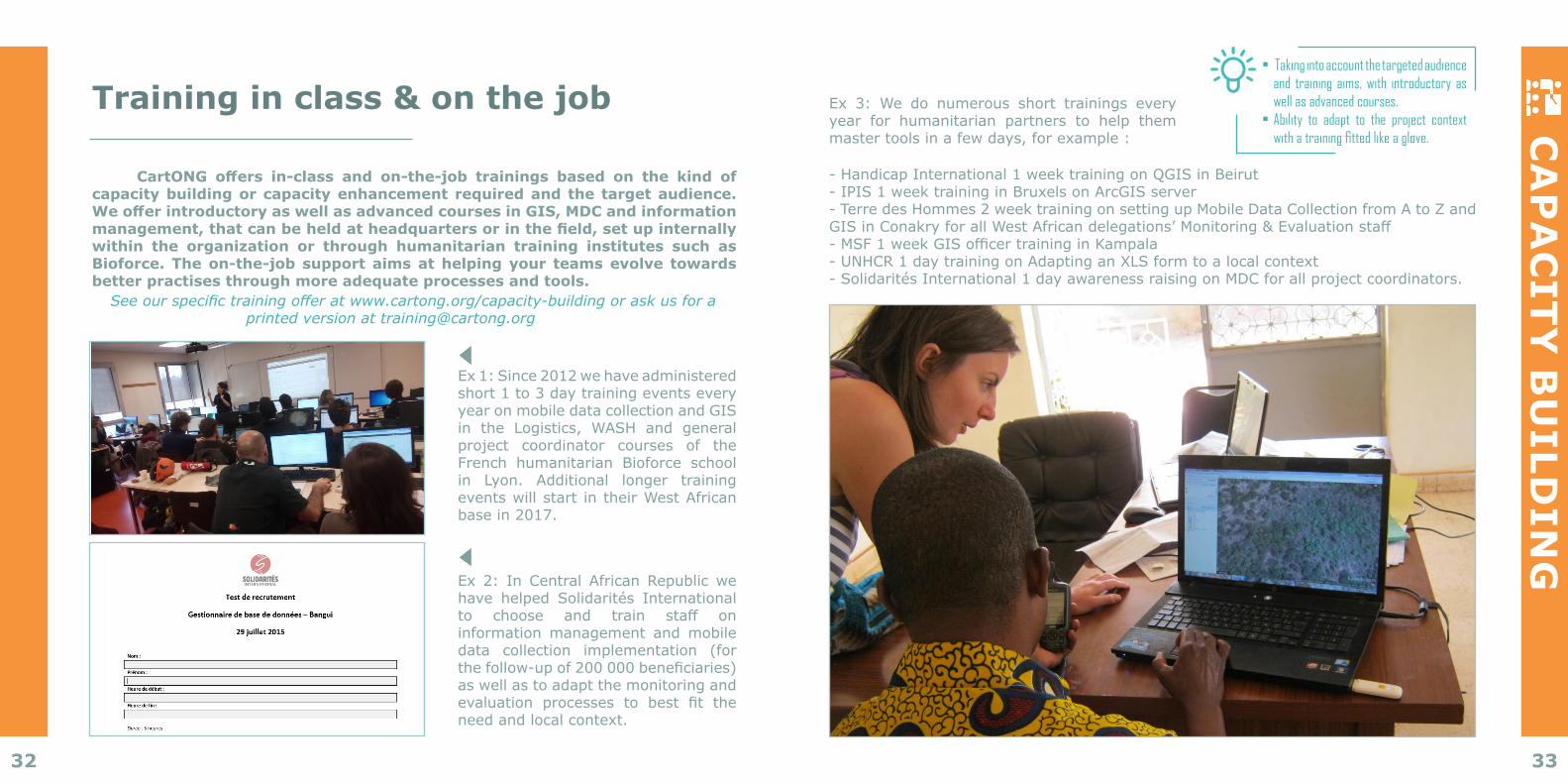
Training in class & on the job
CartONG offers in-class and on-the-job trainings based on the kind of capacity building or capacity enhancement required and the target audience. We offer introductory as well as advanced courses in GIS, MDC and information management, that can be held at headquarters or in the field, set up internally within the organization or through humanitarian training institutes such as Bioforce. The on-the-job support aims at helping your teams evolve towards better practises through more adequate processes and tools.Seeourspecifictrainingofferatwww.cartong.org/capacity-buildingoraskusfora
Ex 1: Since 2012 we have administered short 1 to 3 day training events every year on mobile data collection and GIS in the Logistics, WASH and generalproject coordinator courses of the French humanitarian Bioforce school in Lyon. Additional longer training events will start in their West African basein2017.
Ex 2: In Central African Republic we have helped Solidarités International to choose and train staff oninformation management and mobile data collection implementation (for thefollow-upof200000beneficiaries)as well as to adapt the monitoring and evaluation processes to best fit theneed and local context.
• Taking into account the targeted audience and training aims, with introductory as well as advanced courses.
• Ability to adapt to the project context with a training fitted like a glove.
Ex 3: We do numerous short trainings every year for humanitarian partners to help them mastertoolsinafewdays,forexample:
-HandicapInternational1weektrainingonQGISinBeirut-IPIS1weektraininginBruxelsonArcGISserver-TerredesHommes2weektrainingonsettingupMobileDataCollectionfromAtoZandGISinConakryforallWestAfricandelegations’Monitoring&Evaluationstaff-MSF1weekGISofficertraininginKampala-UNHCR1daytrainingonAdaptinganXLSformtoalocalcontext- Solidarités International 1 day awareness raising on MDC for all project coordinators.
34 35
CA
PA
CIT
Y B
UILD
ING
Remote Support
As it is often not necessary to go to the field to help implement projects, CartONG provides a lot of remote support that can take various forms.
For example, it can involve answering technical questions, encoding mobile surveys (when field staff are well drilled in the use of mobile tools and do not need field support), setting up analysis dashboards, writing tutorials or setting up a hotline.
• Responsiveness of the team• Support based on knowledge of
the field
Ex 1: CartONG has been supporting Solidarités International field staff since2015with(amongstotherthings,suchastrainings and in-country implementation) a hotline helping operations with their survey conception technical difficulties,their choice of tools or their MDC strategy (We reply under 2 working days in thiscase).
Ex 2: For the UNHCR SENS project (see Mobile Data Collection) CartONG has beenensuringremotesupportforcountryoperationssince2010,withtheadaptationofformcontent to local settings or help on analysis when it is necessary for operations with well established mobile implementation.
Community building
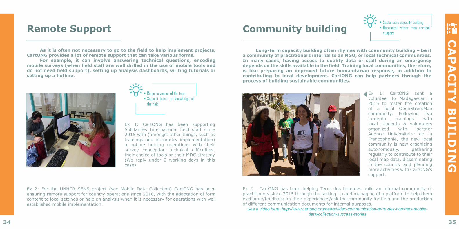
Long-term capacity building often rhymes with community building – be it a community of practitioners internal to an NGO, or local technical communities. In many cases, having access to quality data or staff during an emergency depends on the skills available in the field. Training local communities, therefore, is like preparing an improved future humanitarian response, in addition to contributing to local development. CartONG can help partners through the process of building sustainable communities.
• Sustainable capacity building • Horizontal rather than vertical
support
Ex 2 : CartONG has been helping Terre des hommes build an internal community of practitioners since 2015 through the setting up and managing of a platform to help them exchange/feedbackontheirexperiences/askthecommunityforhelpandtheproductionofdifferentcommunicationdocumentsforinternalpurposes.
See a video here: http://www.cartong.org/news/video-communication-terre-des-hommes-mobile-data-collection-success-stories
Ex 1: CartONG sent a volunteer to Madagascar in 2015 to foster the creation of a local OpenStreetMap community. Following two in-depth trainings with local students & volunteers organized with partner Agence Universitaire de la Francophonie, the new localcommunity is now organizing autonomously, gatheringregularly to contribute to their localmapdata,disseminatingin the country and planning more activities with CartONG’s support.
36 37
CA
PA
CIT
Y B
UILD
ING
Best Practices
CartONG’s added value also comes from its ability to advise partners on the best tools for their situation, budget and local context. This is possible thanks to the technological and methodological watch that CartONG maintains at all times as well as the different events it organises in an effort to share knowledge, foster good practice and encourage collaboration between humanitarian organisations in this field. CartONG regularly benchmarks tools in various areas of IM and GIS, compiles case studies, literature reviews and has conducted user-based interviews for partners. Much of this work has also been published.
• Benefitting from the whole community’s feedback
• Discussing strategy, process and tools
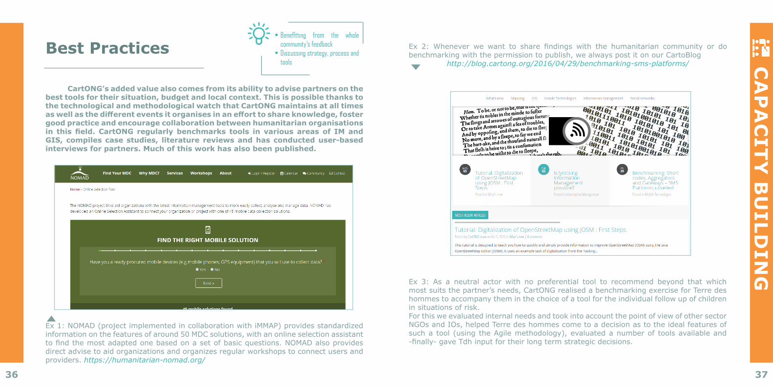
Ex 1: NOMAD (project implemented in collaboration with iMMAP) provides standardized informationonthefeaturesofaround50MDCsolutions,withanonlineselectionassistanttofindthemostadaptedonebasedonasetofbasicquestions.NOMADalsoprovidesdirectadvisetoaidorganizationsandorganizesregularworkshopstoconnectusersandproviders. https://humanitarian-nomad.org/
Ex 2: Whenever we want to share findings with the humanitarian community or dobenchmarkingwiththepermissiontopublish,wealwayspostitonourCartoBlog
http://blog.cartong.org/2016/04/29/benchmarking-sms-platforms/
Ex 3: As a neutral actor with no preferential tool to recommend beyond that which mostsuitsthepartner’sneeds,CartONGrealisedabenchmarkingexerciseforTerredeshommes to accompany them in the choice of a tool for the individual follow up of children insituationsofrisk.ForthisweevaluatedinternalneedsandtookintoaccountthepointofviewofothersectorNGOsandIOs,helpedTerredeshommescometoadecisionastotheidealfeaturesofsuchatool(usingtheAgilemethodology),evaluatedanumberof toolsavailableand-finally-gaveTdhinputfortheirlongtermstrategicdecisions.
393938
Current Partners
This list reflects our main partners over the past few years, it neither is exhaustive nor implies a permanent partnership with us.
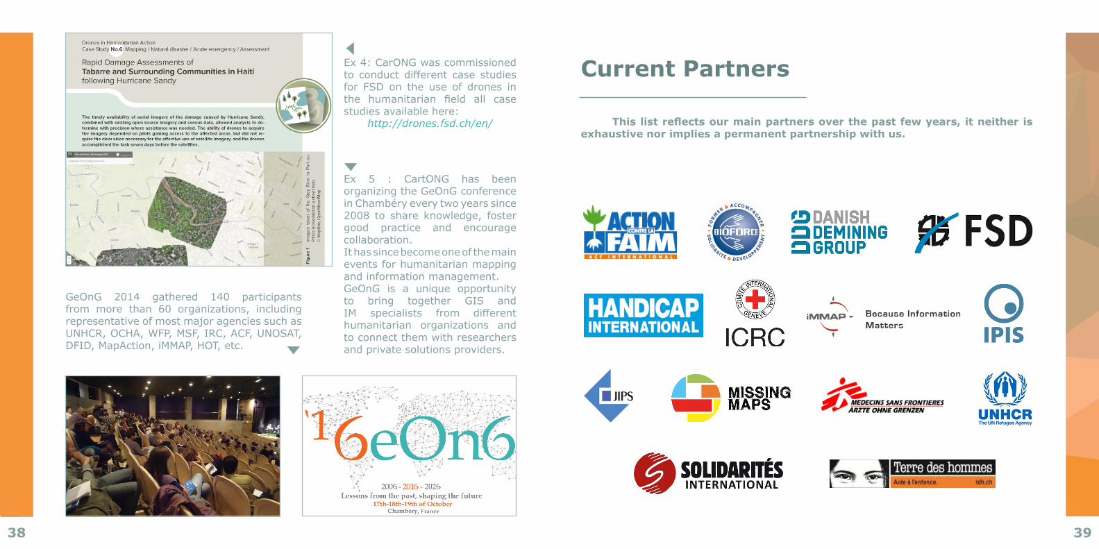
Ex 5 : CartONG has been organizing the GeOnG conference in Chambéry every two years since 2008 to share knowledge, fostergood practice and encourage collaboration. It has since become one of the main events for humanitarian mapping and information management. GeOnG is a unique opportunityto bring together GIS and IM specialists from differenthumanitarian organizations and to connect them with researchers and private solutions providers.
Ex 4: CarONG was commissioned to conductdifferent case studiesfor FSD on the use of drones in the humanitarian field all casestudies available here:
http://drones.fsd.ch/en/
GeOnG 2014 gathered 140 participants from more than 60 organizations, includingrepresentative of most major agencies such as UNHCR,OCHA,WFP,MSF,IRC,ACF,UNOSAT,DFID,MapAction,iMMAP,HOT,etc.
BâtimentB,1erétageParc d'activités de Côte Rousse
180,rueduGenevois73000Chambéry
France
Phone:+33479262882
Twitter: @assocCartONGFacebook:CartONG
Photo credits: CartONGDesign by: Fanny BAS