Embed Size (px)
Citation preview

approved & adopted
1992
NORTH BETHESDA GARRETT PARK
'< .. '

1992 APPROVED AND ADOPTED NORTH BETHESDA/GARRETI PARK
MASTER PLAN
INCORPORATING
THE 1994 APPROVED AND ADOPTED STAGING AMENDMENT
AND
THE 1997 APPROVED AND ADOPTED CONFERENCE CENTER AMENDMENT
December 1992 (Amended November 1994 andjune 1997)
An amendment to the 1970 Master Plan for the North Bethesda/Garrett Park Planning Area, as amended; the 1978 Sector Plans for Twinbrook, Nicholson Lane (White Flint), and Grosvenor, as amended; the 1970 Master Plan for the Aspen Hill and Vicinity Planning Area, as amended; the 1978 Master Plan of Bikeways, as amended; the 1979 Master Plan for Historic Preservation, as amended; being also an amendment to the General Plan for the Physical Development of the Maryland-Washington Regional District within Montgomery County, as amended; and the Master Plan of Highways within Montgomery County, as amended.
THE MARYLAND-NATIONAL CAPITAL PARK AND PLANNING COMMISSION
8787 Georgia Avenue Silver Spring, MD 20910
NORTII BETIIESDA/GARRETr PARK APPROVED & AnoPTED
TITLE: 1992 Approved and Adopted North Bethesda-Garrett Park Master Plan, incorporating the 1994 Approved and Adopted Staging Amendment and the 1997 Approved and Adopted
Conference Center Amendment
AUTHOR: The Maryland-National Capital Park
and Planning Commission
SUBJECT: Master Plan for the North Bethesda-
Garrett Park Planning Area, incorporating Staging Amendment and Conference Center Amendment
DATE: December 1992 (Master Plan)
November 1994 (Staging Amendment) June 1997 (Conference Center Amendment)
PLANNING AGENCY: The Maryland-National Capital Park
and Planning Commission 8787 Georgia Avenue
Silver Spring, MD 20910-3760
SOURCE OF COPIES: The Maryland-National Capital Park and Planning Commission
8787 Georgia Avenue, Silver Spring, MD 20910-3760
ABSTRACT: This document contains the text with supporting maps and tables for the 1992 Approved and Adopted Master Plan for the North Bethesda-Garrett Park Planning Area. It incorporates the
three Sector Plan areas within its boundaries: Twinbrook, White Flint and Grosvenor. This Plan amends the 1970 Approved and Adopted Master Plan for the North Bethesda-Garrett Park
Planning Area, as well as the 1978 Approved and Adopted Sector Plans for Twinbrook, Nicholson Lane (White Flint), and Grosvenor. It also amends the Master Plan of Highways
and the 1978 Master Plan of Bikeways.
This document also contains the text with supporting maps and tables for the 1994 Staging Amendment and the 1997 Conference Center Amendment to the
1992 North Bethesda-Garrett Park Master Plan.
NoRTII BETHESDA/GARRETT PARK APPROVED & ADOPTED
II
CERTIFICATE OF APPROVAL AND ADOPTION
This Comprehensive Amendment to the North BethesdaGarrett Park Master Plan; the Twinbrook, Nicholson Lane (White Flint) and Grosvenor Sector Plans; the General Plan for the Physical Development of the MarylandWashington Regional District; and the Master Plan of Highways within Montgomery county, Maryland; has been approved by the Montgomery county Council, sitting as the District Council, by Resolution No. 12-878 on November 9, 1992; and the Montgomery County Executive on November 19, 1992; and has been adopted by the Maryland-National Capital Park and Planning Commission by Resolution No. 92-25 on December 16, 1992, after duly advertised public hearings pursuant to Article #28 of the Annotated Code of Maryland, 1986 (1988 Supplement).
THE MARYLAND-NATIONAL CAPITAL PARK AND PLANNING COMMISSION
/~~ 1 Gus Bauman Chairman
a~~ A.EawardNaarre secretary-Treasurer
NORTH BETI-IBSDA/ GARRETT PARK APPROVED & ADOPTED
111

THE MARYLAND-NATIONAL CAPITAL PARK AND PLANNING COMMISSION
The Maryland-National Capital Park and Planning Commission is a bi-county agency created by the General Assembly of Maryland in 1927. The Commission's geographic authority extends to the great majority of Montgomery and Prince George's Counties; the Maryland-Washington Regional District (M-NCPPC planning jurisdiction) comprises 1,001 square miles, while the Metropolitan District (parks) comprises 919 square miles, in the two Counties.
The Commission has three major functions:
1. The preparation, adoption, and, from time to time, amendment or extension of the General Plan for the Physical Development of the Maryland-Washington Regional District in Montgomery and Prince George's Counties (1964);
2. The acquisition, development, operation, and maintenance of a public park system; and
3. In Prince George's County only, the operation of the entire County public recreation program.
The Commission operates in each county through a Planning Board appointed by and responsible to the county government. All local plans, recommendations on zoning amendments, administration of subdivision regulations, and general administration of parks are responsibilities of the Planning Boards.
The Maryland-National Capital Park and Planning Commission encourages the involvement and participation of individuals with disabilities, and its facilities are accessible. For assistance with special needs (i.e., large print materials, listening devices, sign language interpretation, etc.), please contact the Community Relations Office, (301) 495-4600 or TDD (301) 495-1331.
NORTH BETHESDA/GARRETT PARK APPROVED & ADOPTED
IV

ELECTED AND APPOINTED OFFICIALS
COUNTY COUNCIL
Marilyn J. Praisner, President William E. Hanna, Jr., Vice President
Bruce Adams Derick P Berlage
Nancy Dacek Gail Ewing
Betty Ann Krahnke Isiah Leggett
Michael L. Subin
COUNTY EXECUTIVE
Neal Potter
THE MARYLAND-NATIONAL CAPITAL PARK AND PLANNING COMMISSION
Gus Bauman, Chairman John W Rhoads, Vice Chairman
Montgomery County Planning Board
Gus Bauman, Chairman Nancy M. Floreen, Vice-Chairman
Ruthann Aron Patricia S. Baptiste
Davis M. Richardson
Prince George's County Planning Board
John W Rhoads, Chairman Roy I. Dabney, Jr., Vice-Chairman
ZolaE. Boone James M. Brown Regina J. McNeill
NORTH BETI-lESDA/GARRETI PARK APPROVED & AnoPTED
V

NORTH BETHESDA/GARREn PARK MASTER PLAN
ADVISORY COMMITTEE
Scott Stinson, Luxmanor Citizens Association, Chairman
William C. Prinz,* Town of Garrett Park, Former Chairman
Arlene S. Allen, West Femwood Citizens Association
Harriet Arshawsky, Grosvenor Park Condo Citizens Association
Allen E. Bender, Randolph Civic Association
Charles E. Camalier III, Davis-Camalier Families Venture
Paul E. Edlund, Town of Garrett Park
Richard Koch, II REDS, Inc.
Wolfgang J. Lehmann, North Bethesda Congress
Harry W Lerch, Lerch, Early and Brewer
David S. Neufeld, Tilden Woods Citizens Association
Raymond P. Schmidt, North Ashburton Citizens Association
Eugene M. Smith, E.M. Smith Associates, Inc.
Jeanne E. Snodgrass, North Bethesda United Methodist Church
Michael L Springer, U.S. Nuclear Regulatory Commission
John G. Tyner II, Twinbrook Citizens Association
The listing of the names of members of the Advisory Committee does not indicate approval or disapproval of this document by any committee member. The Advisory Committee does not
take a position or vote as a body. The members advise the Montgomery County Planning Board regarding the problems, needs and views of the groups or areas they represent. These views are
then considered by the Planning Board in its deliberations regarding the Master Plan.
*Resigned
NoRrn BETHESDA/GARRETT PARK APPROVED & ADoPTED
VI
NOTICE TO READERS
An area master plan, after approval by the County Council and adoption by the MarylandNational Capital Park and Planning Commission, constitutes an amendment to the General Plan for Montgomery County. As such, it provides a set of comprehensive recommendations and guidelines for the use of publicly and privately owned land within its planing area. Each area plan reflects a vision of future development that responds to the unique character of the local community within the context of a County-wide perspective.
Area master plans are intended to provide a benchmark point of reference with regard to public policy. Together with relevant County-\vide functional master plans, they should be referred to by public officials and private individuals when decisions are made that affect the use of land within the plan's boundaries.
Master plans generally look ahead to a time horizon of about 20 years from the date of adoption, although it is intended that they be updated and revised about every ten years. It is recognized that the original circumstances at the time of plan adoption will change over time, and that the specifics of a master plan may become less relevant as time goes on. Any sketches or site plans in an adopted plan are for illustrative purposes only, and are intended to convey a general sense of desirable future character rather than any specific commitment to a particular detailed design.
NORTIT BETHESDA/GARRETr PARK APPROVED & ADOPTED
VII

THE MASTER PLAN PROCESS
Staff Draft Plan - This document is prepared by the Montgomery County Planning Department for presentation to the Montgomery County Planning Board. A Public Hearing (Preliminary) Draft Plan is then prepared for approval to go to public hearing by the Planning Board. The Public Hearing (Preliminary) Draft Plan incorporates those preliminary changes to the Staff Draft Plan that the Planning Board considers appropriate.
Public Hearing (Preliminary) Draft Plan - This document is a formal proposal to amend an adopted master or sector plan prepared by the Montgomery County Planning Board of The Maryland-National Capital Park and Planning Commission. It is prepared for the purpose of receiving public hearing testimony. Its recommendations are not necessarily those of the Planning Board. Before proceeding to publish a Planning Board (Final) Draft Plan, the Planning Board holds a public hearing. After the close of the record of this public hearing, the Planning Board holds open worksessions to review the testimony and to revise the Public Hearing (Preliminary) Draft Plan.
Planning Board (Final) Draft Plan - This document is the Planning Board's recommended Plan. Since October 1, 1992, changes in the Regional District Act require the Planning Board to transmit the Plan directly to the County Council with copies to the County Executive. The Regional District Act then requires the County Executive, within sixty days, to prepare and transmit a fiscal impact analysis of the Planning Board (Final) Draft Plan to the County Council. The Executive may also forward any other comments and recommendations regarding the Planning Board (Final) Draft Plan within the sixty-day period.
After receiving the Executive's fiscal impact analysis and comments, the County Council may hold a public hearing to receive public testimony on the Plan. After the close of record of this public hearing, the Council's Planning, Housing, and Economic Development Committee (PHED) holds open worksessions to review the testimony and revise the Planning Board (Final) Draft Plan. The County Council, after its worksessions, then adopts a resolution approving the Planning Board (Final) Draft Plan, as revised.
Adopted Plan - The Plan approved by the County Council is forwarded to The MarylandNational Capital Park and Planning Commission for adoption. Once adopted by the Commission, the Plan officially amends the various master or sector plans cited in the Commission's adoption resolution.
NORTII BETiffiSDA/GARRETI PARK APPROVED & ADOPTED
VIII
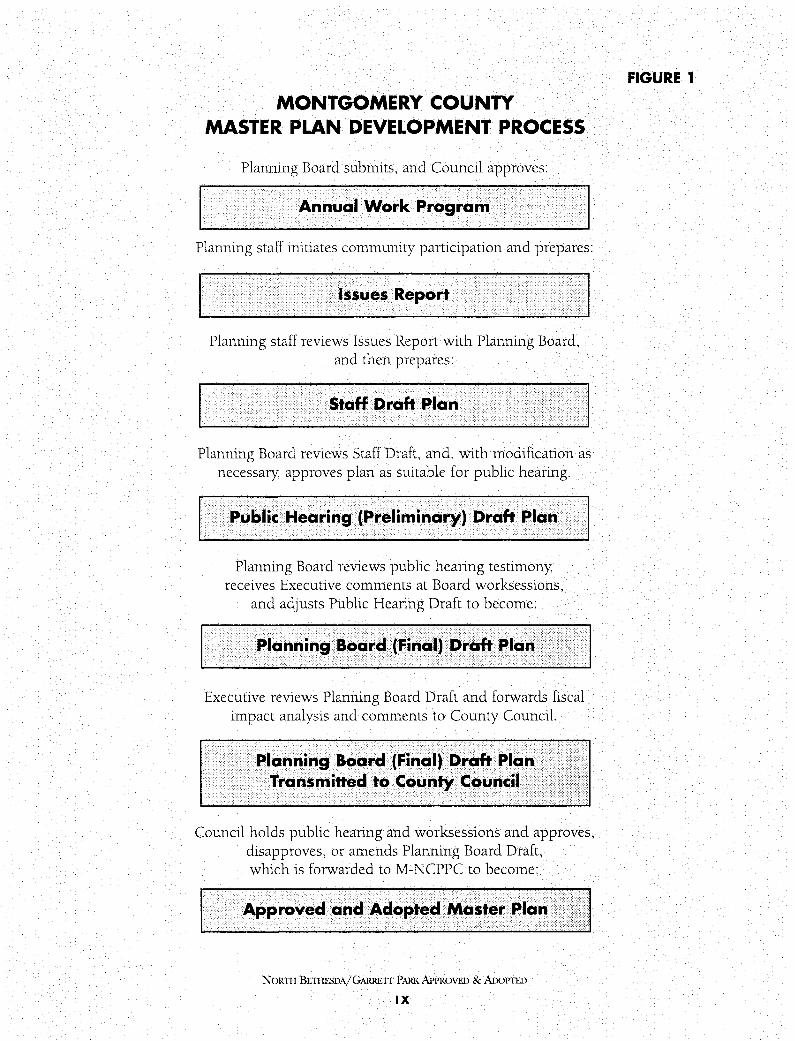
MONTGOMERY COUNTY MASTER PLAN DEVELOPMENT PROCESS
Planning Board submits, and Council approves:
Annual Work Program
Planning staff initiates community participation and prepares:
Issues Report
Planning staff reviews Issues Report with Planning Board, and then prepares:
Staff Draft Plan
Planning Board reviews Staff Draft, and, with modification as necessary, approves plan as suitable for public hearing.
Public Hearing (Preliminary) Draft Plan
Planning Board reviews public hearing testimony, receives Executive comments at Board worksessions,
and adjusts Public Hearing Draft to become:
Planning Board (Final) Draft Plan
Executive reviews Planning Board Draft and forwards fiscal impact analysis and comments to County Council.
Planning Board (Final) Draft Plan Transmitted to County Council
Council holds public hearing and worksessions and approves, disapproves, or amends Planning Board Draft, which is forwarded to M-NCPPC to become:
Approved and Adopted Master Plan
NORTII BE11-IFSDA/GARRETI PARK APPROVED & ADOPTED
IX
FIGURE 1

TABLE OF CONTENTS Page No.
Master Plan
1 Plan Highlights ............................................... 1
2 Background ................................................. .5 2 .1 Area History . . . . . . . . . . . . . . . . . . . . . . . . . . . . . . . . . . . . . . . . . . . . . .5 2 .2 Planning Framework ........................................ 6 2.3 Concurrent Planning Activities ................................ 9 2.4 Development Profile ...................................... .15 2.5 Pending Development Contiguous to North Bethesda ............... 27 2.6 Plan Objectives ........................................... 33
3 Land Use and Zoning Plan ................................... 35 3.1 Overview ................................................ 35 3.2 Twinbrook Sector Plan Area .................................. 41 3.3 White Flint Sector Plan Area ................................ .51 3.4 Grosvenor Sector Plan Area .................................. 62 3.5 Key Vacant or Redevelopable Parcels ........................... 72 3.6 Garrett Park Overlay District ................................. 87 3.7 Rock Spring Park .......................................... 94
4 Urban Design Plan ......................................... 107 4.1 Overview .............................................. .107 4.2 Rockville Pike Corridor .................................... 111 4.3 Twinbrook/Montrose Crossing ............................... 122 4.4 White Flint ............................................ .126 4.5 Grosvenor .............................................. 132 4.6 Rock Spring Park ......................................... 135 4. 7 Streetscape ............................................. 138
5 Transportation Plan ........................................ 147 5 .1 Overview and Recommendations ........................... 14 7 5 .2 The Traffic Forecasting Process ............................. 16 7 5.3 Results of Road Systems Analysis ........................... 172 5 .4 Results of Transit Services Analysis .......................... 1 79 5.5 Results of Transportation Demand Management Analysis .......... 182 5.6 Results of Development Review Regulatory Standards Analysis ...... 184 5. 7 Results of Reservation of Future Transitways Analysis ............. 185 5.8 Results of Bicycle and Pedestrian Analysis ..................... 185
NORTH BETHESDA/GARRETT PARKAPPROVED &ADOPTED
XI

Table of Contents (Cont'd.)
Page No.
6 Historic Resources . . . . . . . . . . . . . . . . . . . . . . . . . . . . . . . . . . . . . . . .191 6.1 Overview and Recommendations ........................... 191 6.2 Development of the North Bethesda/Garrett Park Community ...... 193 6.3 Resources Designated on the Master Plan for Historic Preservation ... 197 6.4 Resources Evaluated for Master Plan Designation ................ 205 6.5 Historic District Data .................................... 217 6.6 Historic Preservation Designation Criteria ..................... 224 6.7 Effects of Historic Designation ............................. 225
7 Community Facilities Plan ................................. 22 7 7 .1 Overview and Recommendations ........................... 22 7 7.2 Park and Recreation Facilities .............................. 229 7 .3 Community Recreation Centers ............................. 238 7.4 Public Schools ......................................... 239 7 .5 Libraries ............................................. 239 7.6 Cultural Facilities ....................................... 241 7.7 Public Safety .......................................... 243 7.8 Post Offices ........................................... 243 7.9 Elderly Housing Facilities ................................. 244 7 .10 Child Day Care Facilities ................................. 2 44 7.11 Housing for Special Populations ............................ 245
8 Environmental Resources Plan ............................. 247 8.1 Overview and Recommendations ........................... 247 8.2 Tree Preservation ....................................... 249 8.3 Greenways ............................................ 250 8.4 Green Corridors ........................................ 250 8.5 Billboards ............................................ 251 8.6 Air Quality ............................................ 252 8. 7 Noise ................................................ 252 8.8 Stormwater Management ................................. 253 8.9 Water and Sewer ....................................... 256
9 1994 Staging Amendment to the 1992 Approved and Adopted North Bethesda/Garrett Park Master Plan ......... 257
NORTH BETIIESDA/GARREIT PARK APPROVED & AnoPTED
XII
Table of Contents ( Cont'd.)
Page No.
10 Resolutions ................................................. 2 99 Resolution of Approval of the Final Draft North Bethesda-
Garrett Park Master Plan .................................. 299 Resolution of Adoption of the Final Draft North Bethesda-
Garrett Park Master Plan .................................. 335 Resolution of Approval of the Planning Board (Final) Draft Staging
Amendment to the 1992 North Bethesda-Garrett Park Master Plan ... 337 Resolution of Adoption of the Planning Board (Final) Draft Staging
Amendment to the 1992 North Bethesda-Garrett Park Master Plan ... 349 Resolution of Approval of the Planning Board (Final) Draft Staging
Amendment for a Conference Center/Hotel Complex ............. 351 Resolution of Adoption of the Planning Board (Final) Draft Staging
Amendment for a Conference Center/Hotel Complex ............. 357
NORTII BE11-IESDA/GARRETI PARKAPPRO\lf:D & AnoPTI.D
XIII

LIST OF FIGURES Page No.
1 Plan Highlights 1. Master Plan Development Process ........................... .ix
2 Background 2. Planning Area Map ....................................... 16 3. Regional Locational Map ................................... 17 4. General Plan ........................................... 18 5. Distribution of Commuters from North Bethesda ................. 20 6. Residence Distribution - NRC Employees ...................... 21 7. Residence Distribution - DHHS Employees ..................... 22 8. Distribution of Commuters to Jobs in North Bethesda ............. 23 9. Pipeline or Pending Development ............................ 28
10. Registered Loophole Properties .............................. 30
3 Land Use and Zoning Plan 11. Existing Land Use ....................................... 39 12. Existing Zoning . . . . . . . . . . . . . . . . . . . . . . . . . . . . . . . . . . . . . . . . .40 13. Twinbrook Sector Plan Area - Existing Zoning .................. .44 14. Twinbrook Sector Plan Area - Proposed Base Zones ............... 46 15. Twinbrook Sector Plan Area - Proposed Floating Zones ............ 4 7 16. Twinbrook Sector Plan Sub-Areas ............................ 49 17. White Flint Sector Plan Area - Existing Zoning .................. 53 18. White Flint Sector Plan Area - Proposed Base Zones .............. 54 19. White Flint Sector Plan Area - Proposed Floating Zones ........... .55 20. White Flint Sector Plan Sub-Areas ........................... 59 21. Grosvenor Sector Plan Area - Existing Zoning ................... 64 22. Grosvenor Sector Plan Area - Proposed Base/Floating Zones ......... 65 23. Grosvenor Sector Plan Sub-Areas ............................ 67 24. Key Vacant or Redevelopable Parcels .......................... 73 25. Wilgus Tract - Existing Zoning, Proposed Base/Floating Zones ....... 77 26. Proposed Zoning Changes
(Outside Sector Plan Areas and Rock Spring Park) ................ 85 2 7. Garrett Park Overlay District - Vacant Lots ..................... 89 28. Garrett Park Overlay District - Lot Distribution .................. 93 29. Rock Spring Park Parcels .................................. 95 30. Rock Spring Park - Existing Zoning .......................... 98 31. Rock Spring Park - Proposed Base/Floating Zones ................ 99
NORTH BETHESDA/GARRETT PARK APPROVED & AnoPTED
XIV
4 Urban Design Plan
List of Figures (Cont'd.)
Page No.
32. Planning Area Concept Diagram ............................ 110 33. Opportunities and Constraints ............................. 112 34. Urban Design Comparison (Existing Condition) ................ 115 35. Street Network Comparison (Existing Condition) ............... 116 36. Parking Comparison (Existing Condition) ..................... 117 3 7. Building Height Comparison (Existing Condition) ............... 118 38. Main Street Comparison .................................. 119 39. Rockville Pike Street Sections (Existing) ...................... 120 40. Twinbrook/Montrose Crossing Concept Diagram ................ 124 41. Twinbrook Illustrative Plan ................................ 125 42. White Flint Concept Diagram .............................. 129 43. White Flint West Illustrative Plan ........................... 130 44. White Flint East Illustrative Plan ............................ 131 45. Grosvenor Concept Diagram ............................... 133 46. Grosvenor Illustrative Plan ................................ 134 4 7. Rock Spring Park Concept Diagram ......................... 13 7 48. Streetscape Concept - Urban Tertiary ........................ 141 49. Streetscape Concept - Business Street ........................ 14 2 50. Streetscape Concept - East-West 'Main Street' (White Flint) ........ 143 51. Streetscape Prototype Concept - Rockville Pike ................. 145
5 Transportation Plan 52. Existing Highways ...................................... 148 53. Proposed Public Transportation System Improvements ............ 152 54. Montrose Parkway Proposals ............................... 157 55. Proposed Local Circulation Improvements ..................... 158 56. Proposed Highway Capacity Improvements .................... 159 57. 1970 Master Plan Roads to be Deleted ....................... 165 58. Future Transitway Alignment .............................. 166 59. Proposed Bikeway Plan ................................... 168 60. Location of Portals for High Capacity Network ................. 170 61. Total Morning Peak Hour Inbound Traffic at Portals ............. 171 62. Intersection Levels of Service (A.M. Peak) 1989 Conditions ........ 173 63. Intersection Levels of Service (PM. Peak) 1989 Conditions ......... 17 4 64. Public Transit Coverage .................................. 181
NORTII BETHESDA/ GARRETT P;\RR APPROVED & ADoPTE.D
xv

6 Historic Resources
List of Figures (Cont'd.)
Page No.
65. Historic Resources ...................................... 195 66. Wilkins Estate Environmental Setting ........................ 207 67. Garrett Park Historic District .............................. 215
7 Community Facilities Plan 68. Existing Parkland ....................................... 230 69. Existing Public Facilities .................................. 235 70. Montrose Parkway-Ownership Status ........................ 237 71. Walter Johnson Cluster ................................... 240 72. Proposed Community Facilities ............................. 242
8 Environmental Resources Plan 73. Stormwater Management ................................. 254
NORTH BEn-IESDA/GARRETI PARK APPROVED & ADoP'IED
XVI

LIST OF TABLES
Page No.
1. Daily Passenger Boardings by Metro Station ..................... 19
2. North Bethesda Profile .................................... 25
3. New Non-Residential Building Completions by Type 1980-1989 ..... 26
4. Loophole Registrant Development Potential Seventy-Fifth Percentile Density Yield ........................................... 31
5. Loophole Registrant Development Potential Maximum Theoretical Yield ........................................ 32
6. Garrett Park Overlay District - Vacant Lots ..................... 91
7. Garrett Park - Summary of Existing Development Standards ........ 92
8. Existing and Potential Development at Rock Spring Park ........... 97
9. Streets Requiring Special Design Treatment .................... 140
10. Identification of Master Plan Strategies for Improved Transportation in North Bethesda ...................................... 151
11. Highway and Street Classifications .......................... 162
12. Bikeways Plan ......................................... 188
13. Developed Parks in North Bethesda-Garrett Park ................ 231
14. Ballfield Inventory, Public Schools ........................... 232
N ORT! l BETIIESDA/ GARRETT PARK APPROVED & ADOPTED
XVII

ACKNOWLEDGEMENTS
Montgomery County Planning Department Management
Robert W Marriott, Jr., Planning Director
Perry Berman, Chief, Community Planning
Jeffrey Zyontz, Coordinator, Community Planning
Project Staff
Callum Murray, Community Planning, Project Planner Carolyn Hufbauer, Community Planning Marsha Kadesch, Community Planning
Rick Hawthorne, Transportation Planning Larry Ponsford, Development Review
Sally Roman, Research and Information Systems Gwen Marcus, Historic Resources
Marjorie Slater-Kaplan, Environmental Planning
Technical Staff
James Sumler, Mapping and Graphics Sheila Sampson, Word Processing
Charles Coleman, Administrative Services
Divisions of the Planning Department that contributed to this Plan include:
Administrative Services Design, Zoning, and Preservation
Environmental Planning Mapping and Graphics
Research and Information Systems Transportation Planning
Others that contributed to this Plan include:
LMD, Design & Production

• NORTH BETHESDA/GARRETT PARK
• published by
THE MONTGOMERY COUN1Y DEPARTMENT of PARK & PLANNING 8787 Georgia Avenue, Silver Spring, Maryland 20910
lllil!l~ll!ml!lll!lllll!IIIII 0000000604

PLAN HIGHLIGHTS
i~(·lillil=l,i=hi-1•1·1 .... >
Chapter 1
PLAN HIGHLIGHTS
Montgomery County has experienced a rapid rate of urban growth in the past ten years. Although this growth has been contained within the framework of the Countys growth management system, suburban traffic conditions have markedly deteriorated. There has been a dawning recognition that the land use and physical design characteristics of suburban workplaces have directly contributed to the decline in suburban mobility by inducing most employees to drive alone to work. Specifically, it is increasingly argued that the low density, single use and non-integrated character of suburban office-commercial centers and corridors, combined with their tendency to provide abundant free parking, have compelled many workers to become dependent on their automobiles for travel to work. These factors, combined with a lack of affordable housing in the vicinity of jobs, a reduction in new road construction and meager levels of suburban transit services, have led to unprecedented levels of congestion.
This Plan attempts to address each of these factors. Housing affordability is increasingly becoming an oxymoron in North Bethesda and is of major concern throughout the metropolitan area. High housing costs contribute to other problems such as labor shortages and transportation congestion. Workers in entry-level and service jobs, households headed by single individuals, and senior citizens often cannot afford to live near their places of employment. Longer commutes contribute to traffic congestion and increased individual stress. Workers without automobiles often have difficulty traveling to their jobs because public transportation is not practicable, convenient, or affordable.
In 1990, the North Bethesda median price for a resale detached house was $220,000. The few new single-family detached houses had a median price of $555,545, beyond the reach of most households. In 1992, there were only 763 affordable units in North Bethesda, including moderately priced dwelling units, Housing Opportunity Commission projects, and older Section 8 units.
Although high-rise apartments are expensive to build, relative to garden apartments, demand for this type of unit has been strong in North Bethesda. Multi-family housing is the most likely type of housing to yield affordable units and this Plan recommends a significant increase in this component of the housing market.
Residential units are recommended at all three Metro stations. Mixed uses with a significant residential component are proposed at Twinbrook and White Flint, introducing a housing element into exclusively commercial areas. The Plan also recommends rezoning property from commercial to residential and recommends residential planned developments in several areas. Theoretically, at full buildout of all properties, North Bethesdas capacity for dwelling units and jobs would be approximately 25,000 and 103,000 respectively
NORTH BrnIESDA/GARRETT PARK APPROVED &ADOPTED

• PLAN HIGHLIGHTS
NORTH BETHESDA
page
2
The Plan also makes significant recommendations to encourage transit use, including major expansions to the public transportation system. Recommendations are made regarding increased Metro rail frequency, a new MARC railroad station, demand management programs, high occupancy vehicle lanes and reservation for a future transitway
A recommendation is made to resolve the long-standing issue of the Rockville Facility reservation in North Bethesda. The recommendation has a three-fold purpose: to provide additional east-west traffic capacity, to provide an alternative to a dangerous at-grade crossing at Randolph Road and the MARC railroad, and to provide a greenway to connect the regional parks flanking the Planning Area.
This Plan proposes the following primary recommendations.
A. LAND USE AND URBAN DESIGN This Plan recommends:
• that future development be focused at Metrorail (Metro) stops, new transit stations, and areas best served by transportation infrastructure, with more emphasis on housing;
• new residential and mixed-use development at Twinbrook;
•
•
the introduction of a residential component into exclusively commercial parcels at Twinbrook and White Flint;
the preservation of an area for light industrial purposes extending from Twinbrook to White Flint;
• an expansion of transit related residential and mixed use zoning at White Flint;
• a publicly-owned conference center with integral, privately-owned hotel be located on the WMATA parking lot;
• confirmation of residential zoning at Grosvenor;
• a residential planned neighborhood on the portion of the Georgetown Preparatory School property within the Grosvenor Sector Plan boundary;
• mixed-use development at Montrose Crossing;
• an expansion of retail opportunities at Loehmanns Plaza and Rock Spring Park;
• a mixed-use planned development on the 54-acre vacant parcel in Rock Spring Park;
• transfer of development rights on to various residential parcels;
• preservation of the unique park-like setting of Garrett Park by the application of an 'overlay' zone;
NORTH BETHESDA/GARRETT PARK APPROVED &ADOPTED

• a reduction in block sizes in the vicinity of Metro areas;
• improvements to the pedestrian friendliness of streets, particularly near transit nodes;
• the provision of a landmark quality and sense of place for nodal areas and districts; and
• reinforcement of the concept of Rockville Pike as the "Main Street" of North Bethesda-Garrett Park.
B. TRANSPORTATION PLAN This Plan recommends:
• increasing the frequency of Metrorail and MARC service, and increasing bus services throughout the area;
• the creation of transportation management districts to increase transit ridership and car pooling, with emphasis on parking price and availability;
• the construction of Montrose Parkway from Montrose Road to Veirs Mill Road, with grade separated intersections at Rockville Pike and the MARC railroad, and no through access at Veirs Mill Road;
• retaining the former Rockville Facility right-of-way from 1-270 to Veirs Mill Road for a possible future transitway;
• that Executive Boulevard be extended across Rockville Pike to meet Huff Court and that Nebel Street be extended to Chapman Avenue, providing a local circulation alternative parallel to Rockville Pike;
• a new MARC station to serve Twinbrook and Montrose Crossing;
• the addition of two lanes in the medians of the 1-2 70 spurs;
• a direct access ramp from I-270 (east spur) to Rock Spring Park;
• a direct access HOV ramp from the 1-270 west spur to Rock Spring Park;
• a high capacity transit connection between Grosvenor Metrorail station and Montgomery Mall, via Rock Spring Park;
• intersection capacity improvements at selected locations; and
• changes to the regulatory standards for the area.
C. COMMUNITY FACILITIES PLAN This Plan recommends:
• that the existing Wall Park be extended to include the parcel to the north;
NORTH BETHESDA/GARRETT PARK APPROVED & ADOPTED
page
3

PLAN HIGHLIGHTS
NORTH BETHESDA
page
4
• five urban amenity open spaces to be located at Twinbrook Metro, Montrose Crossing, White Flint Metro, Grosvenor Metro, and Rock Spring Park;
• that a continuous portion of the Montrose Parkway right-of-way be reserved as a greenway, with hiker/ biker facilities;
• that new ball parks be located on the state-owned land west of Tildenwood Drive;
• that a community recreation center be located on the Davis Parcel at Rock Spring Park;
• the proposed expansion of the Strathmore Hall Arts Center as envisioned by the Strathmore Hall Foundation;
• that day care centers be provided at Metro stations and at Rock Spring Park; and
• that affordable elderly housing be provided through the special exception process.
D. ENVIRONMENTAL RESOURCES PLAN This Plan recommends:
• the protection of woodlands through land use recommendations and development guidelines;
• a system of greenways including the Montrose Parkway hiker/biker trail;
• a "green corridors" policy for North Bethesda roadways;
• that development be focused at transit stations in order to improve air quality;
• noise mitigation measures related to the proposed 1-270 spur widening and the proposed Grosvenor transitway;
• that existing stormwater management problems be addressed, particularly at the time of new development; and
• that existing billboards in North Bethesda be removed expeditiously
NORTII BETI-IESDA/GARRETI PARK APPROVED & ADOPTED

BACKGROUND
i~[•];ii=l:Jai=l#•t·i · ·, · > ,
Chapter 2
BACKGROUND
2. 1 AREA HISTORY
For much of its history, North Bethesda has been a passageway between Georgetown (and later the District of Columbia) and Rockville, and points north and west. The Rockville-Georgetown Pike was at one time an Indian trail and in the 1750s was used by General Braddocks army to move against the French and Indians in western Pennsylvania. By 1800, the Pike carried a stage line twice a week between Frederick and Georgetown. During the War of 1812, the Pike was used by government officials fleeing the British invasion of Washington.
In 1806, the Washington Turnpike Company received Montgomery Countys first toll road charter for the Rockville Turnpike, improvements being completed in 1828. In 1829, toll booths were erected, with one booth located at the present Strathmore Avenue. In 1887 the toll booths were abandoned, the toll at the time being five cents.
The land encompassed by the present North Bethesda-Garrett Park Planning Area was settled in the early eighteenth century Tobacco was a staple crop and traces of the areas early farming and plantation history can still be seen. The memoirs of Josiah Henson, a former slave on the Riley Plantation, inspired Harriet Beecher Stowes novel, Uncle Toms Cabin. The Riley Plantation was located on Old Georgetown Road, near the present Tilden Lane. Josiah Hensons former sleeping quarters, a one-room log cabin, is still in existence, attached to an eighteenth century house at 11420 Old Georgetown Road.
In 1873, the Metropolitan Branch of the Baltimore and Ohio (B&O) Railroad was completed through North Bethesda, with stations at Halpine (Twinbrook), Randolph and Garrett Park The railroad increased farming prosperity by improving accessibility to fertilizers and farm machinery
Garrett Park, named after Robert Garrett, founder of the B&O Railroad and built on 154 acres, is one of the County's earliest and most significant railroad communities. Trains still stop at Garrett Park, and the town's layout is distinctly different from surrounding suburban patterns, retaining much of the ambience of a nineteenth century community.
In the early 1890s, a trolley line was extended from Bethesda on Old Georgetown Road and then via a private right-of-way; passing along the west boundary of what is now Georgetown Preparatory School and emerging on Rockville Pike in the vicinity of its present intersection with Old Georgetown Road. From that point, it continued to the City of Rockville on Rockville Pike. In the l 930's, streetcar service was discontinued, the tracks removed, and bus service instituted.
NORTII BETI-lESDA/GARRETr PARK APPROVED & AnoPrED

BACKGROUND
NORTH BETHESDA
page
6
By the early 1900's, North Bethesda was still sparsely settled, and Rockville Pike was still a twolane road bordered by large estates. The only vestige that remains of the Montrose community, located at the intersection of Old Georgetown Road and Rockville Pike, is the two-room Montrose School, located at 5721 Randolph Road.
In 1919, Georgetown Prep School was moved to its present location from its original site in Old Georgetown Heights where it had been established in 1789. In 1920, the present Strathmore Hall Arts Center was constructed as the estate house for Charles Corby, who was prominent in the baking industry at the time. Much of the Corby estate became the site of the Holy Cross Academy in 1960.
During the 1960s the area developed slowly and then with increasing rapidity in the 1970's. The number of dwelling units and total population in 1960 was 8,859 and 32,875 respectively. It is startling to note that the January 1990 household population of North Bethesda was virtually unchanged at 33,450 persons, but the number of households was 15,000, indicating a steep decline in persons per household. In Garrett Park, U.S. Census Population counts indicate that the population peaked in 1970 at 1,276, falling to 884 in 1990.
2.2 PLANNING FRAMEWORK
A. THE GENERAL PLAN The General Plan provides broad policy guidance for development patterns and for transportation and environmental issues in Montgomery County. This comprehensive and strategic plan was approved by the County Council in 1969 as a modification of the Montgomery County portion of .. .On Wedges and Corridors: A General Plan for the Development of the Maryland-Washington Regional District, adopted by the MarylandNational Capital Park and Planning Commission in 1964.
The basic concept of the General Plan is a system of wedges and corridors, with employment and residential nodes concentrated in corridors served by rail transit and major highways. Figure 4 depicts the North Bethesda-Garrett Park Planning Area located in the context of the General Plan concept.
The General Plan made the following broad recommendations:
• Growth should be channeled into corridor cities located along the 1-270 corridor and into existing established down-County activity centers.
• Transportation needs should be met through the development of a rapid rail transit system supported by an extensive network of local bus routes.
• Rapid transit stations should be located in areas conducive to multi-use development in close proximity to stations.
NORTH BETHESDA/GARRETT PARK APPROVED & AnoP'IED

• A mixture of housing and employment opportunities should be developed in the County:
• New development should be planned to minimize impacts on existing development.
B. THE 1970 NORTH BETHESDA-GARRETT PARK MASTER PLAN In terms of the "wedges and corridors" concept, the 1970 Master Plan envisaged the Planning Area as the base of a corridor extending through Bethesda, Rockville, Gaithersburg, and Germantown. The spine of the corridor was Interstate 70-S (now I-270), combined with a proposed rapid transit line (Metro).
For areas it defined as 'committed,' the 1970 Master Plan was essentially silent. These areas included single-family residential areas and the Davis Tract (Rock Spring Park). However, for 'uncommitted' areas, the Master Plan proposed two new zones: a Planned Residential Development Zone in the Timberlawn area that would be predominantly residential with a variety of housing types and some ancillary retail uses, and a Transit Impact Zone for the three Metro station areas. The objective of the latter zone was to encourage a mixture of offices, retail uses and multi-family dwellings within convenient walking distance of rapid transit stations.
C. THE 1978 NORTH BETHESDA SECTOR PLANS These Sector Plans refined and amended the 1970 Master Plan. In the case of each Sector Plan, the scale of development proposed by the 1970 Master Plan was reduced considerably: For example, the 1970 Master Plan recommended significant amounts of C-2 zoning in the Rockville Pike corridor, particularly at White Flint. At that time, the C-2 Zone permitted a net FAR of 12.2 (excluding parking). The C-2 standards were reduced in 1976 to permit a maximum FAR of 1.5.
D. ENVISIONING OUR FUTURE In 1988 the Commission on the Future of Montgomery County submitted their final report entitled 'Envisioning Our Future.' This informative and thought provoking document provided a basis for addressing many complex issues and policy decisions. The report addressed several major themes in the framing of specific recommendations, including a sense of community, a moderate course on growth, demographic change, and education.
E. COMPREHENSIVE GROWTH POLICY STUDY (CGPS) Recognizing the importance of long-range planning, the Montgomery County Council assigned to the Planning Board a technical study; termed the Comprehensive Growth Policy Study (CGPS). The CGPS technical analysis of current trends and forces that affect urban growth was intended to provide a contextual frame of reference for individual master plans, including that for North Bethesda-Garrett Park. The CGPS suggests directions for a policy response, but it is important to recognize that the CGPS is a study, and not a Plan.
NORTH BETHESDA/GARRETT PARK APPROVED & ADOPTED
page
7
BACKGROUND
NORTH BETHESDA
page
8
The CGPS states that in order for Montgomery County to grow without excessive congestion, the average auto driver share of work trips should be reduced from 75 percent to 50 percent.
"To accomplish such a goal, we would need to:
a. Introduce new travel networks (e.g., trolley, van, and hiker/biker trails);
b. Cluster land uses at points along these networks (e.g., urban village centers); and
c. Take actions to help people break the automobile habit (e.g., auto/transit pricing and pedestrian friendly design)."
The study also concluded that, in terms of the adequacy of management tools, the following could be candidates for exploration and action:
"a. A new travel network plan (to preserve rights-of-way for trolley, van, and hiker/biker trails); ...
b. Revision of master plans and zoning over time to further reduce sprawl and increase strategic concentration (urban village centers)."
Land use patterns are identified by the CGPS as significant in influencing congestion:
"It seems clear that, from a long-term perspective, the pattern of urban growth is much more important than either the pace of growth ... or the jobs to housing proportion of growth .... Although control over the timing of growth is important (especially from a fiscal perspective), control over the spatial and infrastructure pattern is far more important in the long run. Ultimately, zoning and facility location are more important than staging, insofar as traffic congestion is concerned."
It has been argued elsewhere that the emergence of suburban workplaces with densities equivalent to small downtowns, alternative transportation strategies, rich mixtures of clustered land uses, pedestrian friendly environments, and nearby affordable housing could do much to mitigate suburban congestion.
The CGPS argues cogently that:
"Inserting new transportation infrastructure to serve the urban envelope designated by the General Plan will not be enough by itself. Unless new growth is clustered at nodal points convenient to the new travel network, people will not use the new network enough to justify its cost. To accomplish this land use concentration, zoning patterns will need to be adjusted. This will not be an easy task."
NOR1H BETHESDA/GARRETT PARK APPROVED & ADOPTED

The Comprehensive Growth Policy Study analysis demonstrates a somewhat different context for land use and transportation planning in North Bethesda than that which pertained during preparation of the existing Master Plan in 1970. That context is evolving on several fronts, described in the following section under 'Concurrent Activities.'
2.3 CONCURRENT PLANNING ACTIVITIES The following is a summary of concurrent studies and activities, all of which affect North Bethesda to varying degrees. They include studies of growth, transportation and zoning, together with alternative approaches to congestion, and examples of area-wide transportation strategies.
A. THE METROPOLITAN WASHINGTON COUNCIL OF GOVERNMENTS -JOINT TASK FORCE ON GROWTH AND TRANSPORTATION The January 1991 Summary Report of the Joint Task Force defined a new vision for the 21st century, including the following elements:
• Concentrated, balanced growth of both jobs and housing in transportation corridors,with greenbelts and open spaces confining urban growth concentrations.
• Well designed regional and sub-regional centers with downtown densities and improved transit services.
• A coordinated regional system of greenways, high occupancy vehicle (HOV) and transit services to provide an alternative to the private automobile and to link regional and subregional centers.
• Selected road widenings and new alignments designed to support the growth and goals of the vision and provide for the efficient movement of people and goods within and through the region.
B. TRANSPORTATION NETWORK STUDY The Comprehensive Growth Policy Study advocated the need for new travel networks in order to achieve growth without excessive congestion. The purpose of the Transportation Network Study is to recommend additional rights-of-way to be preserved in master plans for future exclusive transit or HOV facilities.
The study focuses on the more densely populated down-county section of Montgomery County where land available for transit facility rights-of-way is already scarce. North Bethesda is at the heart of the study area. The study included progressively more detailed levels of analysis in step with the Master Plan schedule.
The Phase One Analysis recommended the former Rockville Facility reservation within North Bethesda, and a link between Montgomery Mall to Grosvenor Metro, via Rock Spring Park, for further evaluation.
NOR:n-1 BETHESDA/ GARRETT PARK APPROVED & ADOPTED
page
9
BACKGROUND
NORTH BETHESDA
page 10
C. MARYLAND STATEWIDE COMMUTER ASSISTANCE STUDY -MARYLAND DEPARTMENT OF TRANSPORTATION
D.
This recently completed study is currently under review. It identified the range and general staging of highway and transit capital improvements anticipated to be needed in major transportation corridors over the next 20 years. Two of the corridors, Corridor 9 -Capital Beltway, and Corridor 10 - Frederick to Washington, D.C., (I-270) are of significance to North Bethesda.
Findings and recommendations include the following:
Corridor 9 High occupancy vehicle lanes during peak periods on the Washington Beltway, 1-95 to the American Legion Bridge.
Corridor 10 High occupancy vehicle lanes on 1-270, MD 118 to 1-270 Spurs:
• Widen 1-270 Spurs for high occupancy vehicle lanes.
• Expand rail service on MARC commuter line.
• Expand existing commuter transit services.
CIRCUMFERENTIAL TRANSIT ACCESSIBILITY STUDY -METROPOLITAN WASHINGTON COUNCIL OF GOVERNMENTS A draft of this study, dated January 1991, describes the potential impact that a light rail service operating across the Potomac River between Montgomery and Fairfax Counties might have on improving the accessibility to regional employment. The analysis was performed for the year 2010 and assumed a light rail service connecting Grosvenor Metrorail station in Montgomery County with Dunn Loring Metrorail station in Fairfax County
The analysis concluded that no change in accessibility to regional employment using transit occurred when applying a 45 minute travel time limit. However, by using a 70 to 80 minute travel time limit, the study noted dramatic increases in accessibility to regional employment. Residences within walking or cycling distance of most Metrorail stations in both Red Line corridors and the Virginia portion of the Orange Line achieved access to over 2.5 million jobs, almost three quarters of projected 2010 employment in the region, and a figure which exceeds today's total employment.
E. NORTH BETHESDA TRANSITWAY FEASIBILITY STUDY -MONTGOMERY COUNTY DEPARTMENT OF TRANSPORTATION The purpose of this study is to determine the feasibility of a transitway connecting Grosvenor Metrorail station and Montgomery Mall, via Rock Spring Park.
The Final Report of the Feasibility Study, dated April 1991, outlined the following key conclusions and findings.
NoRrn BErnESDA/GARRETT PARK APPROVED & AnoPTED
• A transitway between Grosvenor Metrorail station and Montgomery Mall with stops in Rock Spring Park would attract between 10,777 and 13,982 riders a day
• A two-track elevated monorail shuttle could be constructed for $64 million (excluding right-of-way acquisition and any utility relocation). Annual operating and maintenance costs would be $1. 7 million. Trains would run every 7 minutes with a terminal-toterminal travel time of 7 minutes.
• The proposed alignment uses existing public rights-of-way for most of its length with moderate environmental impact. Passage of the alignment through the stream valley between Tuckerman Lane and 1-270 represents the most sensitive environmental area with possible floodplain, wetland, stream valley, aesthetic and noise impacts.
• The proposed transitway would alleviate traffic congestion and improve air quality by diverting 4,600 persons a day from automobiles. This would remove 45,000 vehicle miles a day from area streets and roads or 11. 4 million vehicle miles a year. It would reduce the need for parking in Rock Spring Park by 2,086 parking spaces.
F. METRORAIL/METROBUS STRATEGIC PLAN· WMATA The Washington Metropolitan Transit Authority (WMATA) has prepared a draft strategic plan as a framework for addressing policy issues and program challenges through the period of build-out of the Metrorail system. The plan does not set out specific program proposals. However, it does identify many concerns that face the Authority, including completion of the rail construction program, operating cost increases, replacement and rehabilitation programs as facilities and equipment deteriorate, productivity and revenue generation, and coordination with other transit systems.
G. MARC RAIL STRATEGIC PLAN STUDY The Maryland State Railroad Administration (SRA) is planning to improve commuter rail service (MARC) through North Bethesda. The first part of this study identified improvements which include:
• Increasing the frequency of train service by increasing the number of trains operating during the peak hours.
• Providing trains traveling in the off-peak direction.
• Providing a number of improvements at selected stations.
A second phase of the study will examine the potential for adding new stations to the system. A North Bethesda station, north of Randolph Road on the Montrose Crossing property, is being considered. Resources permitting, the SRA anticipates that the study will be followed with the programming of design and right-of-way funding. This Plan supports improvements to the MARC service.
N01m1 BETHESDA/ GARRETT PARK APPROVED & ADOPTED
page
1 1
BAC KG ROUND
NORTH BETHESDA
page
1 2
H. TRANSIT- AND PEDESTRIAN-ORIENTED NEIGHBORHOODS STUDY This study, currently underway, attempts to identify planning principles by the analysis of prototypical neighborhoods. Precedents set by historic neighborhoods, local neighborhoods - including Garrett Park - and contemporary neighborhoods have been analyzed.
Elements which encourage the use of transit and reduce dependence on the automobile have been identified. These elements are intended to establish a set of planning principles that would foster the creation of neighborhoods that provide an identifiable center for community life, improve pedestrian circulation and increase access to transit. These transit and pedestrian-oriented planning principles include the following:
1. Create an Identifiable Sense of Place for Each Neighborhood
An identifiable center and a legible system of streets are components that create a sense of place.
2. Provide a Mix of Uses
3.
Retail shops, offices, residences, and community facilities such as parks and schools are elements that foster a sense of community and encourage interaction among workers and residents. Locating this mix of uses within walking distance of all portions of a neighborhood will reduce dependence on the automobile.
Establish an Interconnected System of Streets
An interconnected system of streets will provide more direct access for pedestrians, bicyclists, and vehicles to all areas of the neighborhood including transit stops, civic spaces, employment areas and residences. Major arterials should not pass through the center of a neighborhood to reduce conflicts between pedestrians and high speed vehicular traffic.
4. Provide a Diversity of Housing Types
A wide range of housing types within each neighborhood should be encouraged to avoid large concentrations of any single type and increase the potential for pedestrian connection between diverse housing types.
5. Provide a Mix of Active and Passive Open Spaces
To foster the creation of transit and pedestrian-oriented neighborhoods with a strong sense of place, a mix of active and passive open space areas should be provided within walking distance of all users to reduce dependence on the automobile. Active open spaces include large open play fields, local parks, civic spaces, and small recreation areas. Civic spaces should be located near transit stops. Passive open spaces should be located near the boundaries of neighborhoods to preserve natural features.
NORTH BETHESDA/GARRETT PARK APPROVED & ADOPTED

I.
6. Street Oriented Buildings and Pedestrian Ways
Buildings should be clustered along streets. This approach will facilitate pedestrian movement between buildings, and reduce the walking distance between buildings and transit stops located along streets. A safe and attractive neighborhood environment along streets that encourages pedestrian travel along the sidewalk will also be established.
The pedestrian system should not rely upon internal pathways through parking areas or rear yards to improve safety and reinforce street oriented development.
7. Locate Transit Stops Within Walking Distance
Transit stops should be located within a 1/4 mile walking distance of all portions of mixed use neighborhoods.
8. Design the Public Right-of-Way for Streets to Accommodate a Variety of Transportation Modes
The public right-of-way for streets in transit- and pedestrian-oriented neighborhoods should accommodate pedestrians, bicyclists, and transit vehicles in addition to automobiles. Streets should also provide a sense of place and increase opportunities for social interaction.
ACTIONS RECOMMENDED TO INCREASE THE USE OF HIGH OCCUPANCY VEHICLES IN NORTH BETHESDA AND ROCKVILLE • THE TRANSPORTATION ACTION PARTNERSHIP, INC. This consortium of public and private officials provides a forum within which potential transportation-related policies can be developed, and a mechanism through which potential solutions can be implemented within the private sector.
ln a report dated September 1990, the Transportation Action Partnership's High Occupancy Vehicle (HOV) panel identified possible HOV facilities for further review by county and state planning authorities. Recommendations for HOV facilities at specific locations in North Bethesda and Rockville were divided into primary and supplementary facilities as follows:
HOV Lanes on Roads Primary
• 1-270 and 1-495
• Ritchie Parkway
Supplementary
• Rockville Facility Right-of-Way
• East Jefferson Street Extension
• Veirs Mill Road
NORTH BETIIF.SDA/ GARRETT PARK APPROVED & AnOJ>TED
page
13

BACKGROUND
NORTH BETHESDA
page
14
HOV Priority Ramps Primary
• Ritchie Parkway at 1-270 (HOV only)
• Democracy Boulevard at 1-270, 1-495
• Old Georgetown Road at 1-270, 1-495
HOV Destination Parking Garages Primary
• Rock Spring Park
Transit-Ridesharing Transfer Centers Primary
• Ritchie Parkway at 1-2 70
• Rock Spring Park
• Montgomery Mall
Supplementary
• Montrose Road (Rockville Facility ROW to 1-270)
• Femwood Road Bridge
Supplementary
• Washington Science Center
Supplementary
• Montrose Crossing ( Gourmet Giant site between Twinbrook and White Flint Metros)
• Randolph and Veirs Mill Road (shuttle to Metrorail and employment)
J. NUCLEAR REGULATORY COMMISSION (NRC} TRAFFIC MITIGATION The Nuclear Regulatory Commission's headquarters facility, located immediately south of White Flint Metro station, opened in 1986. An innovative program of transit fare subsidies, ridesharing promotion, and parking charges was implemented to encourage employees to use alternative transportation modes. Monitoring shows that almost 30 percent of the employees at the facility use public transportation to commute to work, and over 25 percent use cars or vanpools. These percentages are higher than at most suburban office locations, including all previous NRC locations, and have attracted widespread interest. For the location distribution of NRC employee residences see Figure 6. The NRC program has resulted in removal of sufficient peak hour trips to facilitate approval of a second headquarters building to consolidate all remaining offices of the agency
K. ROCK SPRING PARK AND MONTROSE AND EXECUTIVE COMMUTER SERVICE CENTERS Since 1987, these two Commuter Service Centers have achieved substantial trip reduction in the North Bethesda Planning Area. Working in cooperation with employers, the programs have offered a wide range of alternative transportation services, including car/vanpool matching, information and incentives for transit use, and emergency ride home taxi service.
NORTH BETHESDA/GARRETT PARK APPROVED & ADOPTED

L SILVER SPRING TRANSPORTATION SYSTEM MANAGEMENT DISTRICT (TMD) The Silver Spring TMD was established by County law in 1987 as a coordinated transportation program to maximize the capacity of the existing road network and to encourage the use of alternative transportation options. The TMD has achieved significant results, including substantial increases in transit use and numbers of carpools, and a more than 10 percent reduction in the number of drive-alone commuters. The success of the Silver Spring TMD indicates that, with appropriate incentives and disincentives, area-wide transportation management strategies can reduce single occupant commuting. This type of institutional arrangement may be particularly applicable in the North BethesdaRockville area.
M. ROCKVILLE PIKE CORRIDOR SHUTTLE STUDY As part of a "Private Transit Optional Study" funded by the Federal Transit Administration, the Metropolitan Washington Council of Governments retained the Urban Mobility Corporation to conduct a study of the feasibility of operating shuttles linking Metro stations and other destinations along Rockville Pike. The study concluded that shuttle service could increase use of the Metrorail system in the corridor, thus enhancing mobility and reducing congestion. A technical, financial, and institutional plan was devised for a shuttle bus program in which the private sector would play a significant role.
One of the routes recommended by the study has been implemented by the Nuclear Regulatory Commission and others are under consideration by various private interests.
2.4 DEVELOPMENT PROFILE The North Bethesda-Garrett Park Master Plan encompasses the area defined as Planning Area 30 by the Maryland-National Capital Park and Planning Commission (Figure 2). It is bordered on the west by Interstate Highway 1-2 70, on the north by the existing limits of the City of Rockville, on the east by Rock Creek, and on the south by Interstate Highway 1-495 (Capital Beltway).
Figure 3 illustrates the strategic location of North Bethesda at the confluence of the two interstates and at the threshold of the 1-270 corridor. Figure 4 shows the relationship of the North BethesdaGarrett Park area vis-a-vis the General Plan and the "wedges and corridors" concept.
In terms of highway facilities, the Planning Area is served by Montrose Road, a six-lane undivided road connecting 1-2 70 on the west with Rockville Pike in the center of the Planning Area, then continuing east as Randolph Road. Major north-south highways that provide internal service are Rockville Pike (MD 355) and Old Georgetown Road (MD 187), both of which are six-lane undivided roads that provide connections \Vith 1-270 and I-495 to the south. While access to the north and south is adequate, as is access to the west, via Montrose Road, Tuckerman Lane and Democracy Boulevard, access to the east is restricted, due to the natural barrier imposed by Rock Creek Park The only connectors through this barrier are Randolph Road, a four-lane undivided facility, and Strathmore Avenue, a two-lane winding road.
NORTII BETill'BDA/GARREIT PARK APPROVED & ADOPTED
page
1 5
page
16
PLANNING AREA MAP
/'/ .,, LITTLE ~OCA.CY BA.SIN
/clCKERSON-BAFINESVILLE
,~' .,.12 ~
,1' ( 1 MA.FITINS8URG
& VlCfNITY
POOLESVILLE' .& VJC!NlTY
PA.17
NORTH BETHESDA/GARRETT PARK APPROVED & AnoPTED
FIGURE 2

REGIONAL LOCATION MAP
LOUDOUN COUNTY
PRINCE WILLIAM COUNTY
FREDERICK COUNTY
NORTII BETHFSDA/GARRETI PARK APPROVED & ADOPTED
FIGURE 3
North
page
17

page
1 8
GENERAL PLAN
•••• Planning Area Boundary
Concentrated Growth Centers, Corridor Cities, and Satellite Communities
D Low Density "Wedge" Areas
NORTI-! BETI-IESDA/GARREIT PARK APPROVED & ADOPTED
FIGURE 4
North
A. TRANSIT SYSTEM The regional Metrorail system operates through three stations in North Bethesda (Twinbrook, White Flint and Grosvenor). The stations constitute gateways for regional traffic and are factors in how much North Bethesda can develop. Passenger boardings increased steadily to 1990 and have subsequently declined, possibly due to a number of factors, including the current recession and the major widening of 1-270. (See Table 1.)
TABLE 1
DAILY PASSENGER BOARDINGS BY METRO STATION
May May May May May May Apr. Nov. Station 1985 1986 1987 1988 1989 1990 1991 1991
Grosvenor 2618 2946 3161 3310 3638 3794 3434 3442
White Flint 2199 3077 3775 4109 4074 4333 3988 3710
Twinbrook 2354 3264 3662 4330 4516 4515 4446 3955
Source: Metrorail Passenger Surveys
The area is also served by the MARC commuter train service between Martinsburg or Brunswick and Washington, D. C. Three morning trains stop at Garrett Park while four do so in the evening. The annual ridership on the line has increased steadily from a total of 761,127 in 1987 to 1,262,783 in 1991.
Other transit services, including conventional fixed-route bus service, are supplied by WMATA and the County's Ride-On service. Most of these are scheduled services, with thirty-minute frequencies, designed to serve as feeder routes to and from Metrorail. The current bus service constitutes an integrated system designed primarily to serve Metrorail.
Twenty-two percent of North Bethesda's employed residents commute to Washington, D.C., while 16.2 percent use Metrorail for all work destinations (Figure 5).
Figure 6 illustrates the residence distribution of 1300 employees at the Nuclear Regulatory Commission at White Flint. Figure 7 illustrates the distribution for 5365 employees of the Department of Health and Human Services at Twinbrook who choose to drive to work. The distribution for the latter includes homes in Prince William, Charles, and Calvert Counties, Annapolis, Chesapeake Beach, Poolesville and Frederick. Five hundred and thirty-one residence locations are beyond the area shown on the map, including Hagerstown, Brunswick, )Aartinsburg, and some in Pennsylvania. The fact that the complex of federal buildings at Twinbrook is located within 2500 feet of a Metro
NORTI-1 BETHESDA/ GARRETT PARK APPROVED & ADOPTED
page
19

page
20
DISTRIBUTION OF COMMUTERS FROM NORTH BETHESDA FIGURE 5
OTHER MARYLAND
1.8%
/( / .
/ \ / \
/ ~. / 0.5% '\,
_/ RURAL ( /. MONTGOMERY 1
/ COUNTY ---·:-:--,·-----..
/ ·· .... ····~· ... · '----\ ......... .-· ·--....,
24.5%
·······.
VIRGINIA
9.9%
\ ~ .... ',
f..)
:·····~ 9.8%
.. ···· .. ··. .. .... . -/
... '-..,-.,:, ··.. )
(.,-/""' EASTERN .....__,/
'.• 1.4% MONTGOMERY ,/) • •• :,., •• ••• • : KENSINGTON COUNTY
• WHEATON ;· • • •. : •. ·•· ~ •. :. ASPEN HILL 0.5o/4 :--:•ROCKVILLE ••• OLNEY ;·
· 9.6%-; ~ .
= :.;, ••• r.st[?:; \ /
__j~~~-- ..... ''. .1 .: 0iE~· v _. . .J.:E:t:i· ~:~~;~y 3.3%
\.___·-----~ . ....,..,__ 13.5% : ----.,_ '\,
\ .
\ • .// WASHINGTON D.C.
22% NORTH BETHESDA TO NORTH BETHESDA
Source: Washington COG Household Survey, 1987-88.
NORTH BETHESDA/GARRETT PARK APPROVED & ADOPTED
RESIDENCE DISTRIBUTION • NUCLEAR REGULATORY
COMMISSION EMPLOYEES
NORTH BETI-lESDA/GARRETT PARK APPROVED & ADOPTED
FIGURE 6
I I
// /;_/
ii"
\ l ! i
. \ \ \ '·\,
~~ ..........
page
21

page
22
RESIDENCE DISTRIBUTION • DEPARTMENT OF HEALTH
AND HUMAN SERVICES EMPLOYEES
" t· ... . •·.
NORTII BETHESDA/GARRETT PARK APPROVED & ADOPTED
FIGURE 7
ti Ij~ ·11 i.,:;
. ") r--·--1 \ '\
J
i/o /!/
l/ ) . ~ i I /
{ )
' \ ......

DISTRIBUTION OF COMMUTERS TO JOBS
IN NORTH BETHESDA
(
/( / \
./ \. / .
,,,/ 1.9% ""·'\ / RURAL
/ MONTGOMERY (
// COUNTY
1_3~HER // ••••••• _..·· ...... ··~·
/ /
14.1%
" N. BETHESDA TO N. BETHESDA
14.6% GERMANTOWN • ••••
•••• ~LARKS)(BURG /.: ............ .
:·· : _.: _:
.. · : ..... ..
~. .· .: • ••• _.. :: GAITHER BUAG/ ANO VIC,
.........
Source: Washington COG Household Survey, 1987-88.
NoRTII BETHESDA/GARRETT PARK APPROVED & AnoPTED
FIGURE 8
page
23

BACKGROUND
NORTH BETHESDA
page
24
station and within three miles of a MARC station, yet such an extraordinary percentage of employees (approximately 84%) choose to drive, says a great deal regarding the influence of cheap gasoline and unlimited free parking on commuter choice.
B. SUMMARY PROFILE The North Bethesda Planning Area extends to nine square miles and has a 1990 household population of approximately 35,000 people living in 15,700 households.The number of jobs, as of January 31, 1992, is estimated at 66,000 with an additional 13,316 in the current pipeline. The current profile of North Bethesda is illustrated in Table 2.
In its existing configuration, the North Bethesda Policy Area has a negative transportation capacity for employment and is in subdivision moratorium. The current deficit, as of January 31, 1992, is 8,125 jobs. The net remaining housing capacity; as of the same date, is 1,324 dwelling units.
C. NON-RESIDENTIAL BUILDING COMPLETIONS In 1990, non-residential building completions in North Bethesda totaled 597,016 square feet, almost 24 percent of the County total (see Table 3). North Bethesda ranked first in total non-residential completions in the County for 1990, with office developments representing over 4 7 percent of the area's completions.
The 1990 total was comprised of a 249,000-square-foot office in Rock Spring Park and a 31,652-square-foot extension to the American Speech, Language and Hearing Association building on Rockville Pike. Since 1980, 5,406,038 square feet of new office space has been constructed in North Bethesda, more than in any other area of the County
In 1990, retail development contributed 84,900 square feet of new development to the area with the completion of two retail centers on Rockville Pike at White Flint. In 1990, the only non-residential completion in the 'other' category was the 249,000-square-foot Marriott Hotel in Rock Spring Park.
Non-Residental Pipeline The major office sites in the non-residential pipeline (Figure 9) are IBM (Rock Spring Park) at 1,384,430 square feet, Rock Spring Plaza (Rock Spring Park) at 183,990 square feet, NRC Phase II (Rockville Pike) at 357,900 square feet, Tri-Rock (Hubbard) at 275,000 square feet, and Washington Science Center Parcel E (Executive Boulevard) at 225,386 square feet.
Pipeline Employment Pipeline employment, as ofJanuary 31, 1992, numbered 13,316. It should be noted that the effect on the development pipeline of site plan approval for IBM, a partially exempt 'loophole' property; has been to substantially increase North Bethesda's employment deficit.
Residential Completions and Pipeline There were approximately 230 acres of vacant land zoned residential use in North Bethesda in 1989. The 5-year, 1984-1988 average for housing completions in North
NORTH BETHESDA/GARRETT PARK APPROVED & ADOPTED

NORTH BETHESDA PROFILE TABLE 2
SINGLE-DATA FROM 1987 HIGH- GARDEN TOWN- FAMILY ALL
CENSUS UPDATE SURVEY RISE APT. HOUSE DET. TYPES
% Housing Units by Type 16.2% 28.8% 8.5% 46.5% 100%
Household Population 3,122 7,507 3,372 18,119 32,120
Average Household Size 1.38 1.87 2.84 2.79 2.3
Number of 0-4 Year Olds * 477 288 694 1,473
Number of 5-17 Year Olds * 582 589 3,044 4,253
%<20 Year Olds 2.4% 14.8% 28.3% 23.2% 19.7%
%>64 Year Olds 43.3% 7.3% 1.3% 14.2% 14.1%
Average Age of Household Head 60 40 41 53 49
Tenure - % Rental 47.9% 71.0% 17.8% 8.4% 33.6%
% in Same Home 5 Years Ago 57.5% 18.7% 12.2% 69.8% 50.8%
Average Years in Same Home 7.1 3.7 2.7 14.7 9.3
% Non-White-Household Head 3.2% 14.6% 11.4% 7.2% 9.1%
% Spanish Origin-Household Head 3.3% 6.1% 6.1% 4.6% 5.0%
Average Years Education Age >24 15.0 15.6 16.4 15.5 15.6
% With Graduate Degrees 26.0% 28.4% 48.8% 29.4% 30.7%
1986 Median Household Income $36,157 $37,108 $75,987 $64,166 $48,977
Number of Workers 1,563 5,529 2,070 9,915 19.077
Female Work Force Partic. % 45.2% 84.0% 72.0% 60.7% 65.6%
% Women with Children < 6 Years Olds, Working FT% * 62.2% * 59.3% 56.8% Full-Time or Part-Time PT% * 15.0% * 33.2% 29.7%
Work Location: % MC in Beltway 20.8% 27.3% 20.1% 26.3% 25.4% % MC Out Beltway 44.9% 36.6% 23.0% 38.1% 36.6% % to D.C. 26.5% 25.8% 43.8% 26.4% 28.1%
Work Trip: % Driving 69.0% 74.7% 75.21% 79.6% 76.8% % Public Transit or Rail 25.1 % 18.3% 23.1% 11.7% 16.0%
Source: Montgomery County Planning Department, Research and Information Systems Divisions: January, 1991.
* Insufficient data for reliable estimates.
NoRm BETIIESDA/G,\RRETT PARK APPROVED & ADoPTED
page
25

z 0
~ t;o M
~ ~ < i ::J
i ~ B ~ fl:'>
~
~
.-u ~: D
°' co : CD
NEW NON-RESIDENTIAL BUILDING COMPLETIONS BY TYPE, 1980-1990 IN SQUARE FEET
1980 1981 1982 1983 1984 1985 1986 1987 1988 1989
NORTH BETHESDA
Office 427,852 707,783 2,257 20,753 282,656 1,349,333 1,153,035 567,073 112,994 501,650
Retail 42,098 2,062 0 201,919 97,224 21,239 6,372 0 31,402 3,510
Industrial 10,497 85,886 37,560 129,935 119,383 89,949 720 0 130,243 0
Other 29,160 0 0 0 0 0 0 0 0 40,425
Total 509,607 795,731 39,817 352,607 499,263 1,460,521 1,160,127 567,073 274,639 545,585
Office 83.96% 88.95% 5.67% 5.89% 56.61% 92.39% 99.39% 100.00% 41.14% 91.95%
Retail 8.26% 0.26% 0.00% 57.26% 19.47% 1.45% 0.55% 0.00% 11.43% 0.64%
Industrial 2.06% 10.79% 94.33% 36.85% 23.91% 6.16% 0.06% 0.00% 47.42% 0.00%
Other 5.72% 0.00% 0.00% 0.00% 0.00% 0.00% 0.00% 0.00% 0.00% 7.41%
Total 100.00% 100.00% 100.00% 100.00% 100.00% 100.00% 100.00% 100.00% 100.00% 100.00%
1990
280,652
84,900
7,954
223,510
597,016
47.01%
14.22'%
1.33%
37.44%
100.00%
Source: Research Division, Montgomery County Planning Department, Building Completion File. Compiled from data provided by the State Department of Assessment and Taxation.
;: ta ,.. ffl (,,)
Bethesda was 346 units per year. The 3-year pipeline forecast, 1989-1991, indicated an annual completion rate of 491 housing units per year. However, it appears that the downturn in the economy will reduce that number substantially
As of January 31, 1992, the North Bethesda area had 1,343 housing units in the pipeline (265 single-family, 20 percent, and 1,078 multi-family, 80 percent). The Wisconsin, a 755-unit, two-building high-rise condominium, is the largest development, with 203 units scheduled for completion by mid-1992. South of the Washington Suburban Sanitary Commission (WSSC) water tower, and west of Woodglen Avenue, construction work on the 132-unit Fallstone townhouse project is currently constrained by the current financial climate.
An elderly housing project of 123 units to be constructed on the south side of Tuckerman appears to have been delayed by Marriotts internal difficulties. Other projects that have been delayed by the state of the economy include a 40-unit single-family detached subdivision on Fleming Avenue and the 200-unit apartment building associated with the White Flint North subdivision.
2.5 PENDING DEVELOPMENT CONTIGUOUS TO NORTH BETHESDA Immediately adjacent to North Bethesda, significant pending development includes the 2-million square feet of office and 300 room hotel proposed within the Tower Oaks development in Rockville, in the northwest quadrant of 1-270 and Montrose Road (Figure 9).
The City of Rockville has granted two significant approvals within the Twinbrook Metro Performance District (Figure 9). The first is a mixed-use project (Chapman Place) on a 5.6-acre block on the northeast comer of Chapman Avenue and Twinbrook Parkway
The project is comprised of the following major elements: six floors (75 feet) of office space containing 320,800 square feet; two, 11-story residential towers (110 feet) containing 335 rental apartments; ground level retail space containing 44,200 square feet; and 1,261 parking spaces located on two levels below the building.
This is the first project to be approved under the optional method of development provisions of the Rockville Pike Corridor Plan and zoning requirements. It represents the maximum density (office/retail and residential) and building heights permitted in the Pike corridor. The project is to be constructed in a single phase, and with almost 700,000 square feet of usable floor area (excluding structured parking) will be the largest building in Rockville.
The second significant project is Twinbrook Mall and Towers, a mixed-use development including 212,000 square feet of retail space and 231 apartments to be located on a 3.86-acre site bounded by Rockville Pike, and Thompson, Chapman and Bouie Avenues. This site is also within the Twinbrook Metro Performance District.
NORTII BETIIESDA/GARRETI PARK APPROVED & ADOPTED
page
27

page 28
PIPELINE OR PENDING DEVELOPMENT FIGURE 9
1000 0 1000
FEET
1. Tower Oaks a. The Wisconsin
2. Twinbrook Mall and Towers 9. Nuclear Regulatory Commission
3. Chapman Place 10. Milton
4. Tri-Rock 11. IBM
5. Wilgus Tract 12. Rock Spring Plaza
6. Washington Science Center, Parcel E 13. Marriott
7. State Highway Administration 14. Ward
NORTII BETHESDA/GARRETT PARK APPROVED & AnoPTED
A. PREVIOUSLY RECORDED LOTS ("LOOPHOLE" PROPERTIES) The Annual Growth Policy (AGP) provides guidelines to implement the Adequate Public Facilities Ordinance (APF0), which is part of the County's subdivision regulations. Since previously recorded lots have already received subdivision approval, they had previously been exempt from new AGP requirements. In 1989, due to increasing concern that these "loophole" properties, lots recorded prior to 1982 or recorded in conformance with a preliminary plan approved prior to 1982, had been approved under a less stringent APF0 transportation test (or none at all), the Council passed Bill 25-89. This Bill requires nonresidential lots approved prior to 1982 to pass Local Area Transportation Review prior to building permit, but exempts them from Policy Area Transportation Review untiljuly 2001, if they registered with the Planning Board before July 1, 1990. There are 226 registered "loophole" properties covered by Bill 25-89 in North Bethesda. (See Figure 10.)
Tables 5 and 6 illustrate the development potential of these properties under seventy-fifth percentile density yield and maximum theoretical yield scenarios. The former is considered more realistic and indicates an unbuilt potential of 6.6-million square feet, of which the net additional square footage approved for IBM constitutes approximately 21 percent.
NOR11! BETI-IESDA/GARREIT PARK APPROVED &ADOPTED
page
29

page
30
NoRm BETHESDA/GARRETT PARK APPROVED & AnoPTED
FIGURE 10
1000 0 1000
FEET
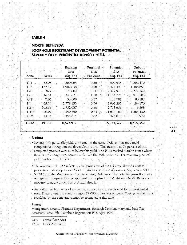
TABLE 4
NORTH BETHESDA LOOPHOLE REGISTRANT DEVELOPMENT POTENTIAL SEVENTY-FIFTH PERCENTILE DENSITY YIELD
Existing Potential Potential GFA FAR GFA
Unbuilt Potential
Zone Acres (Sq. Ft.) Per Zone (Sq. Ft.) (Sq. Ft.)
C-1 32.05 300,065 0.36 502,535 202,470 C-2 137.52 1,987,848 0.58 3,474,499 1,486,651 C-0 36.7 175,809 1.50* 2,397,978 2,222,169 C-P 26.51 241,071 1.00 1,154,776 913,705 C-T 7.06 33,600 0.37 113,787 80,197 I-1 98.56 2,778,133 0.69 2,962,303 184,170 I-3 105.55 2,752,057 0.60 2,758,655 6,598 I-3** 40.02 250,750 0.85* 1,634,180 1,383,430 0-M 13.34 356,644 0.82 476,614 119,970
TOTAL 497.32 8,875,977 15,475,327 6,599,350
Notes: • Seventy-fifth percentile yields are based on the actual FARs of non-residential
completions throughout the down-County area. This means that 75 percent of the completed projects were at or below this yield. The FARs marked* are in zones where there is not enough experience to calculate the 75th percentile. The maxium practical yield has been used instead.
• The row marked I-3* * reflects special provisions of the 1-3 Zone allowing certain properties to develop to an FAR of .85 under certain circumstances. See Section 59-C-5.438 (c) of the Montgomery County Zoning Ordinance. The potential gross floor area represents the square footage approved at site plan for IBM, the only North Bethesda property to apply under this provision thus far.
• An additional 26. l acres of residentially zoned land are registered for nonresidential uses. These properties contain almost 74,000 square feet of space. Their potential is not regulated by the zone and cannot be estimated at this time.
Source: Montgomery County Planning Department, Research Division, Maryland State Tax Assessors Parcel File, Loophole Registration File, April 1990.
GFA - Gross Floor Area FAR - Floor Area Ratio
NoRm BEnIFSDA/GARRETI PARK APPROVED & ADOPTED
page
31
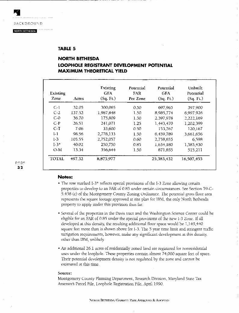
BACKGROUND
NORTH BETHESDA
page
32
TABLE 5
NORTH BETHESDA
LOOPHOLE REGISTRANT DEVELOPMENT POTENTIAL MAXIMUM THEORETICAL YIELD
Existing Potential Potential Existing GFA FAR GFA Zone Acres (Sq. Ft.) Per Zone (Sq. Ft.)
C-1 32.05 300,065 0.50 697,965 C-2 137.52 1,987,848 1.50 8,985,774 C-0 36.70 175,809 1.50 2,397,978 C-P 26.51 241,071 1.25 1,443,470 C-T 7.06 33,600 0.50 153,767 1-1 98.56 2,778,133 1.50 6,439,789 1-3 105.55 2,752,057 0.60 2,758,655 1-3* 40.02 250,750 0.85 1,634,180 O-M 13.34 356,644 1.50 871,855
TOTAL 497.32 8,875,977 25,383,432
Notes:
Unbuilt Potential (Sq. Ft.)
397,900 6,997,926 2,222,169 1,202,399
120,167 3,661,656
6,598 1,383,430
515,211
16,507,455
• The row marked 1-3* reflects special provisions of the 1-3 Zone allowing certain properties to develop to an FAR of 0.85 under certain circumstances. See Section 59-C-5.438 (c) of the Montgomery County Zoning Ordinance. The potential gross floor area represents the square footage approved at site plan for IBM, the only North Bethesda property to apply under this provision thus far.
• Several of the properties in the Davis tract and the Washington Science Center could be eligible for an FAR of 0.85 under the special provisions of the new 1-3 Zone. If all developed at this density, the resulting additional floor space would be 1,149,440 square feet more than is shown above for 1-3. The 5 year time limit and stringent traffic mitigation requirements, however, make any significant development at this density, other than IBM, unlikely
• An additional 26.1 acres of residentially zoned land are registered for nonresidential uses under the loophole. These properties contain almost 74,000 square feet of space. Their potential development density is not regulated by the zone and cannot be estimated at this time.
Source: Montgomery County Planning Department, Research Division, Maryland State Tax Assessors Parcel File, Loophole Registration File, April 1990.
NORTII BETHESDA/GARRETT PARK APPROVED & ADOPTED

2.6 PLAN OBJECTIVES
A. LAND USE
B.
1. Protect and reinforce the integrity of existing residential neighborhoods.
2. Direct future development to land nearest to Metro stops and new transit stations, and to areas best served by transportation infrastructure.
3. Preserve and increase the variety of housing stock, including affordable housing.
4. Encourage a mixture of land uses in redeveloping areas to promote variety and vitality
5. Encourage a land use pattern that provides opportunities for housing and employment.
6. Maintain and enhance the area's regional employment centers.
7. Preserve and enhance a spectrum of retail facilities ranging from regional to neighborhood shopping.
8. Preserve and expand green areas and greenways, including institutional open space, for environmental protection, wildlife sanctuary, recreation and visual relief.
TRANSPORTATION 1. Provide a safe, attractive and efficient transportation system to serve the
recommended land use pattern for the Planning Area.
2. Reduce dependence on the automobile by expanding the availability of transit services throughout the Planning Area. Increase transit service to major employment and retail centers and for non-work trips, including recreation, and to meet the mobility needs of the elderly and handicapped.
3. Provide a comprehensive, safe, and more pleasant bicycle and pedestrian network as part of the transportation system.
C. URBAN DESIGN 1. Improve the appearance and the pedestrian environment of Rockville Pike.
2. Enhance the vitality and variety of the visual environment and provide an improved pedestrian experience at Rock Spring Park
D. HISTORIC RESOURCES 1. Protect and enhance North Bethesdas historic and architectural heritage for the
benefit of present and future County residents.
NORTH BETIIESDA/ GARRE'IT PARK APPROVED & ADOPTED
page
33
BACKGROUND
NORTH BETHESDA
page
34
E. COMMUNITY FACILITIES 1. Provide public facilities to meet the recreational, social and human service needs
of the community, particularly the elderly and handicapped.
F. ENVIRONMENT 1. Preserve existing woodland and encourage reforestation throughout the
Planning Area.
2. Adopt land use and transportation policies that will help improve air quality and minimize exposure to air pollution.
3. Adopt land use and transportation policies and implement noise attenuation measures to reduce the impact of noise on residential neighborhoods.
4. Adopt stormwater management and erosion control policies to minimize flooding, reduce erosion and improve water quality in the streams flowing through the Planning Area.
NORTH BETHESDA/GARRETT PARK APPROVED & ADOPTED
LAND USE AND ZONING PLAN
iit•J;idi=l,i=iitl·i ·' '. Chapter 3
LAND USE AND ZONING PLAN
3. 1 OVERVIEW
The Land Use and Zoning Plan gives general information on the distinction between Euclidean and floating zones, the significance of Moderately Priced Dwelling Units (MPDUs) relative to density, a brief explanation of Transferable Development Rights (TDRs), and a policy on special exceptions for the North Bethesda-Garrett Park Planning Area. Then, following the Land Use and Zoning Objectives for Twinbrook, White Flint, Grosvenor, Key Vacant and Redevelopable Parcels, Garrett Park Overlay District, and Rock Spring Park, each of these areas is described and analyzed. The text for each area contains the specific land use and zoning recommendations for this Plan. Additional functional and urban design recommendations and guidelines can be found in the Plan's remaining chapters.
This Plan recommends that the zoning for all parcels in North Bethesda, outside of the above areas, remain unchanged with the single exception of White Flint Neighborhood Park. This Plan recommends that the southern portion of White Flint Neighborhood Park be rezoned from its present C-P (Commercial Office Park) classification to the R-90 Zone (single family residential) in order to bring it into conformance with the current zoning on the northern portion of the site. (Figure 26.)
A. LAND USE AND ZONING OBJECTIVES • Focus future development on land nearest to Metro stops, new transit stations,
and areas served by existing transportation infrastructure.
• Preserve and increase the variety of housing stock, including affordable housing.
• Encourage a mixture of land uses in redeveloping areas to promote variety and vitality
• Encourage a land use pattern that provides opportunities for housing and employment.
B. EUCLIDEAN AND FLOATING ZONES It is standard practice in all master plans adopted in Montgomery County since I 971 to designate a base "Euclidean" Zone for every parcel and to indicate for some parcels an appropriate floating zone, which allows somewhat different development and sets a higher limit on the intensity of development than the base zone. Euclidean zones contain rigid requirements such as lot size, setbacks, and height limits. Except when developed under the cluster option, the entire land area will be divided into approximately equal size lots.
NOR111 BitfHESDA/GARRETI PARK APPROVED &ADOPTED
LAND USE AND ZONING PLAN
NORTH BETHESDA
page
36
C.
Euclidean zones may be applied to an entire area by the County Council in a comprehensive rezoning following a master plan study Piecemeal requests for Euclidean rezonings may be granted only upon a showing that there has been a change in the character of the neighborhood since the last comprehensive rezoning or there was a mistake in that comprehensive rezoning.
Floating zones have more flexible development standards, but they may be approved by County Council only upon a finding that the development will be compatible with surrounding land uses and is in accord with the purpose clause of the zone. In all floating zones, development can only occur in accordance with a detailed site plan approved by the Planning Board.
The practice of following a master plan with a comprehensive rezoning through a sectional map amendment is a safeguard against piecemeal Euclidean rezonings. The comprehensive rezoning establishes the base against which "change or mistake" will be measured. Since the comprehensive rezoning conforms to the master plan, and floating zones cannot be considered changes in the character of the neighborhood, there is a strong safeguard against future Euclidean rezoning. This is an important element in assuring the stability of the area.
TRANSFERABLE DEVELOPMENT RIGHTS This Plan designates several parcels of land as suitable for transferable development rights (TDR) receiving areas. Receiving areas are permitted to develop to a specified density greater than that designated by the base zoning density
The zoning density of a development in any residential zone within a designated TDR receiving area may be increased (subject to Planning Board approval and in conformance with an approved and adopted master plan) by one dwelling unit for each development right received from a rural property designated a "sending area." Transferable development rights is a method of preserving agricultural land. Owners of agricultural land sell "development rights" from their land.
The zoning density in a receiving area may not be increased by transfer of development rights beyond the density recommended by the land use plan. A request to utilize development rights on a property within a receiving area is submitted in the form of a preliminary plan of subdivision. The preliminary plan of subdivision must normally include at least two-thirds of the maximum number of development rights permitted to be transferred to the property
A property development with TDR's must provide moderately priced dwelling units (MPDU's) in accord with the Montgomery County Code. The MPDU requirement is calculated on the total dwelling unit count, including TDR units. (Additional TDRs do not have to be purchased to exercise the MPDU bonus.) Development with TDRs must conform to the standards of the Planned Development (PD) Zone nearest (but not higher) in density to the TDR density shown on the Master Plan.
NORTH BETHESDA/GARRETT PARK APPROVED & ADOPTED

D. MODERATELY PRICED DWELLING UNITS When consulting this Plan, it is important to note that on any given property, the residential densities and allowable types of dwelling units shown may be modified by the requirements of the Montgomery County Moderately Priced Dwelling Unit (MPDU) Ordinance. This ordinance is designed to ensure that new development includes some housing that is affordable by households of modest means. It applies to any residential development of fifty or more dwelling units that is constructed in any residential zone with a minimum lot size of a half-acre or less or in any planned development, mixed-use zone.
A portion of the units in any such development must be MPDUs. The prices of such units are controlled, and buyers or renters are subject to limitations on maximum income. The required number of MPDUs is based on the total number of dwelling units approved for the development. Effective in early 1989, the percentage ranges from 12.5 percent to 15 percent of the total number of dwelling units and is dependent on the level of density increase achieved on the site in question.
This density increase, or "MPDU bonus," is allowed as compensation for requiring some below-market-rate housing. The bonus may be no more than 22 percent above the normal density of the zone, according to the optional MPDU development standards in the zoning ordinance. In some zones, these standards also provide for smaller lot sizes and dwelling types than would be allowed otherwise. For example, the density of a subdivision in the R-200 Zone is normally 2 units per acre, the minimum lot size is 20,000 square feet, and only one-family, detached houses are permitted. In a subdivision developed according to MPDU standards, the maximum density may be as much as 2.44 units per acre, the lot size for a detached house may be as small as 6,000 square feet, and some units may be townhouses or other types of attached dwelling units.
E. SPECIAL EXCEPTIONS This Plan endorses guidelines for the location of special exception land uses in residential areas. Special exception uses, as identified in the Montgomery County Zoning Ordinance, may be approved by the Board of Appeals for single-family zones if they are found to meet the compatibility standards and general conditions set forth in the Ordinance. The Ordinance provides that special exceptions may be denied by the Board of Appeals where an excessive concentration exists in a particular residential area or where they are inconsistent with Master Plan recommendations.
Recent actions by the Montgomery County Council would now prohibit large medical complexes such as those previously allowed in North Bethesda-Garrett Park Current regulations now limit medical clinics in residential zones to four doctors, while the cumulative effect provision allows consideration of whether there would be a negative impact from allowing an additional provider in a particular use category that already has several existing providers. Home occupations with no more than one employee are a permitted use in residential neighborhoods; more than one employee requires a special exception.
This Plan provides the following guidelines to protect residential areas, while also
NORTH BETIIESDA/GARREIT PARK APPROVED & ADOPTED
page
37

LAND USE AND ZONING PLAN NORTH BETHESDA
page
38
attempting to meet important social needs.
1. Avoid excessive concentration of special exception and other nonresidential land uses along major highway corridors.
Because sites along these corridors have better visibility for business uses, they are more vulnerable to over-concentration of such uses. Of particular concern are office uses, which should be discouraged because they are better located in areas with commercial zoning. It is also important to minimize uses that degrade roadway safety and capacity by creating too many access points and conflicting turning movements.
2. Avoid over-concentration of commercial service or office-type special exception uses in residential communities.
3.
These include funeral parlors, horticultural nurseries, veterinary clinics, medical or dental clinics, medical or professional offices, and philanthropic organizations. The Plan does not discourage home occupations that meet Zoning Ordinance criteria. The most vulnerable areas for over-concentration are near employment centers and along major highways.
Protect major highway corridors and residential communities from incompatible design of special exception uses.
In the design and review of special exceptions, the following guidelines should be followed, in addition to those stated for special exception uses in the Zoning Ordinance.
a. Any modification or addition to an existing building to accommodate a special exception use should be compatible with the architecture of the adjoining neighborhood and should not be significantly larger than nearby structures.
b. Front yard parking should be avoided because of its commercial appearance; however, in situations where side or rear yard parking is not available, front yard parking should be allowed only if it can be comprehensively landscaped and screened.
4. Support special exception uses that contribute to the housing objectives of this Plan.
In general, the Plan endorses meeting special population needs through provision of elderly housing and group homes that are compatible with nearby land uses.
5. Support special exception uses that contribute to the service objectives of the Plan.
The needs and objectives related to child day care and the elderly are discussed in the Community Facilities Chapter. In general, the Plan endorses provision of child day care, group homes, elder day care, and nursing homes.
NORTH BETHESDA/GARRETT PARK APPROVED & ADOPTED

EXISTING LAND USE FIGURE 11
1000 0 1000
FEET
A Residential, One-Family G Multiple-Family, High M Commercial, Office Park
20,000 sq. ft. Density Residential N Light Industrial/Mixed Use
B Residential, One-Family H Planned Residential 0 Technology and Business
9,000 sq. ft. Development Park
C Residential, One-Family Transit Station, Residential p Vacant Land 6,000 sq. ft.
J Transit Station, Mixed Q Institutional (Church,
D Residential, Townhouse K Local Commercial/Retail School, etc.)
E Multiple-Family, Low L General Commercial R Parkland Density Residential
Office/Retail s Parking Lot F Multiple-Family, Medium
Density Residential
NOR11-l BETHESDA/GARRETf PARK APPROVED & AnoPTED
page
39

page
40
EXISTING ZONING
R-200 Residential, One-Family R-H Multiple-Family, High
R-90 Residential, One-Family Rise Planned Residential
R-60 Residential, One-Family PD-9 Planned Development
RT-10 Residential, Townhouse PD-11 Planned Development
RT-12.5 Residential, Townhouse TS-R Transit Station, Residential
R-30 Multiple-Family, Low TS-M Transit Station, Mixed
Density Residential O-M Office Building, Moderate
R-20 Multiple-Family, Medium Intensity
Density Residential c-o Commercial Office Building
R-10 Multiple-Family, High C-T Commercial Transition Zone Density Residential C-P Commercial Office Park
NORTII BETHESDA/GARRETT PARK APPROVED & ADOPTED
FIGURE 12
C-1 Local Commercial
C-2 General Commercial
1-1 Light Industrial
1-3 Technology and
Business Park

3.2 TWINBROOK SECTOR PLAN AREA
A. PLAN OBJECTIVES • Introduce a transit serviceable residential component into the Sector Plan area, and
ensure its compatibility with the adjacent Twinbrook single-family residential community.
• Retain a significant portion of the Sector Plan area for light industrial incubator business development.
• Improve the urban environment of the Twinbrook area.
B. PLAN RECOMMENDATIONS • Support development under the 1-4 Zone (Low Intensity, Light Industrial) for part of
the Twinbrook Sector Plan area to preserve the area as an "industrial sanctuary" for small businesses.
• Support development of a portion of the area east of Twinbrook Parkway as a Transit Station-Mixed Use development (TS-M Zone) with a significant residential component.
• Support development under the Transit Station-Residential (TS-R) Zone for the WMATA property at Twinbrook Metro station.
• Support future redevelopment under the 0-M Zone (Office Building, Moderate Intensity) south of Wicomico Avenue abutting the railroad tracks and west of Twinbrook Parkway on the south side of Ardennes Avenue.
C. SUMMARY The Twinbrook Sector Plan area is defined as that area of Montgomery County within walking distance of the Twinbrook Metro station entrance. The land surrounding the Twinbrook Metro station is an underutilized yet potentially important asset in the Rockville Pike Corridor. It lies on the Red Line, which runs from Shady Grove via downtown Washington to Wheaton. The station is located at the southern boundary of the City of Rockville. The corporate boundary between the City of Rockville and Montgomery County bisects the area and the Metro facilities. The Metro station platform is on the west side of the CSX/MARC Railroad tracks within the City of Rockville, but the station has access from both sides. Of a total of 970 park and ride spaces, 2 70 are located in the City west of the CSX/MARC Railroad tracks.
The Twinbrook area developed originally with railroad-oriented industrial uses such as warehouses, storage, and light manufacturing. As the region became less dependent on railroads, the buildings attracted small contracting businesses, automotive and equipment repair shops, and small community service businesses displaced from redeveloping areas further south in the County Most tenants tend to have limited space requirements, typically occupying warehouse bays of 3,000 square feet. Recently, small high-tech firms have discovered Twinbrook and compete for the less expensive space at this location.
NORTH BETI !FBDA/GARRETT PARK APPROVED & AnOPTFD
page
41
LAND USE AND ZONING PLAN
NORTH BETHESDA
page
42
D.
This area is one of the few remaining down-County locations for relatively affordable industrial sites.
In the past few years, office developments and retail uses have begun to encroach on the industrial uses in this area. The Plan, however, recognizes this area as vital for maintaining general business services for the down-County population. The Plan recommends retaining the area east of Twinbrook Parkway and generally south of Parklawn Lane as an "industrial sanctuary" for small businesses, providing protection for existing small light industrial incubator businesses.
In all, the Sector Plan area incorporates approximately 85 acres, excluding public roadways. There are approximately 9300 existing employees in the Twinbrook Sector Plan area, of which approximately 7000 are located in buildings leased by the federal government. Employees of the federal government thus constitute a very significant presence in the Sector Plan area.
THE CITY OF ROCKVILLE The City of Rockville has designated the area lying to the west of the MARC Railroad tracks as a "Metro Performance District" and has developed urban design goals, strategies and an extensive set of guidelines for development, which are incorporated in the Rochviile Pihe Neighborhood Plan. The land use and transportation recommendations of the Plan for the Metro Performance District are intended to focus significant commercial and residential densities in the vicinity of the transit station. Within the Metro area, commercial developments are allowed a maximum Floor Area Ratio (FAR) of 1.25 with the use of optional method zoning. With the addition of a residential component, mixed-use developments can achieve much greater total densities.
The intention of the City!; Plan is to encourage residential development where possible. Public pedestrian ways and grade separated pedestrian crossings are recommended to
form an integrated pathway system that will link the Metro station with residential and mixed-use developments. Street network changes are also recommended to aid the movement of local traffic, offering more options to motorists and thus increasing the efficiency of the Rockville Pike corridor.
The City has approved two major projects in the Metro Performance District since adoption of the Pike Neighborhood Plan. The Chapman Place development is located on Twinbrook Parkway and bounded by the CSX/MARC Railroad tracks, Chapman Avenue and Thompson Avenue. This 5.6 acre site will contain 320,800 square feet of office space, 44,200 square feet of retail space, and 335 multi-family residential units at a density of 60 units per acre with a residential FAR of 1.32 and a total FAR of approximately 2.8, excluding parking. The below grade parking structure will have 1261 spaces. At over 700,000 square feet, Chapman Place will be the largest building in Rockville. The second project is the Twinbrook Mall and Towers. This project, on 3.9 acres of land located at Rockville Pike and Thompson Avenue, will include 212,000 square feet of retail space and 231 apartments in a seven story building with a residential FAR of 1.26 and a total FAR of approximately 2.5, excluding parking. Three levels of parking will provide 1144 spaces.
NORTH BETHESDA/GARRETT PARK APPROVED & ADOPTED

E. EXISTING CONDITIONS The most striking feature about the immediate vicinity of Twinbrook Metro west of Twinbrook Parkway is the contrast between development on the City of Rockville side and development on the County side. Development on the Rockville side tends to consist of moderate intensity office and retail buildings of six or seven stories, in marked contrast to the low intensity uses on the County side. The proposed Rockville mixed-use projects detailed above will exaggerate this contrast. In essence, the City of Rockville seeks to maximize the potential of the Metro station node, and to respond to the massive public investment in transit facilities.
The existing zoning in Twinbrook is primarily light industriaL (See Figure 13.) Most existing development in the area, however, is in office use, which is permitted in the 1-1 (Light Industrial) Zone. Within the Sector Plan area, approximately 90 percent of the employees are office workers.
West of Twinbrook Parkway, the area can be characterized as generally industrial. The major existing land use is the Metro station and parking lot. The proposed Twinbrook Office Center, to be located at the southeast comer of Parklawn Drive at Wicomico Avenue, has site plan approval. The 83,500-square-foot building and separate 271 car garage will be located on a 1.28 acre parcel adjacent to the Metro station.
East of Twinbrook Parkway, and north of Fishers Lane, existing land use is predominantly office. The United States Pharmacopoeia has two office buildings on Twinbrook Parkway, and the U.S. Food and Drug Administration has approximately two hundred employees housed in several scattered buildings in this area. A 7 -Eleven store, a pizza shop and a gas station are also located in this part of Twinbrook.
East of Twinbrook Parkway and south of Fishers Lane, the predominant land use is light industrial, at least in terms of land area. However, in terms of intensity of use, the Parklawn Building dominates this area as well as the entire Sector Plan area. Headquarters of the U.S. Public Health Service, Department of Health and Human Services (DHHS), this 18-story office building is situated between Fishers Lane and Parklawn Drive. The building is approximately 1.35 million square feet in area, which includes approximately 300,000 square feet of structured parking and 1.05 million square feet of office space. It houses approximately 6,555 employees.
South of Parklawn Drive is an area of small residential lots and houses which have gradually been converted to industrial uses. They are part of the Spring Lake Park subdivision, originally recorded in 1892. Some of these small lots have been assembled and redeveloped, but the majority of the lots and original buildings still remain along Wicomico, Arundel, Frederick, and other avenues in that vicinity
The entire Sector Plan area encompasses approximately 2,170,489 square feet of office space, 685,177 square feet of industrial area, and 142,865 square feet of general retail floor area.
NORTI I BETHE.SDA/ GARRETT PARK APPROVED & ADOPTED
page
43

page
44
TWINBROOK SECTOR PLAN AREA - EXISTING ZONING
0-M Office Building, Moderate Intensity
I -1 Light Industrial
NoRnI BETI-IESDA/GARREIT PARK APPROVED & ADOPTED
FIGURE 13

Outside the Sector Plan area along Wilkins Avenue and Parklawn Drive, the majority of parcels have been developed with office and industrial uses, along with some retail uses. Best Products and Read Plastics are located in this area together with an animal hospital and two restaurants. To the east of the Sector Plan area, along Twinbrook Parkway and off Braxfield Court, are two multi-family residential areas, Bethesda Park and Walnut Grove. North of the residential area is the Parklawn Cemetery. The cemetery property includes land leased to the Parklawn Building for parking, granted as a special exception.
Northwest of the Sector Plan area, within the City of Rockville, is the Twinbrook residential community This community has developed a set of goals and guidelines intended to retain the character of single-family homes and maintain extensive buffering with the abutting County Sector Plan area. These guidelines are incorporated in the City of Rockvilles Twinbrooh Neighborhood Plan.
Some land assemblage has already occurred in anticipation of future redevelopment in Twinbrook The ]BG Companies have acquired acreage for a significant portion of the Sector Plan area to the east of Twinbrook Parkway, and land outside of but directly abutting the Sector Plan area bounded by Twinbrook Parkway, Halpine Road and Ardennes Avenue.
Existing stormwater drainage problems in the area adjacent to the Metro parking lot will have to be addressed with any new development proposals as well as any redevelopment. The underground parking below the U.S. Pharmacopoeia Building requires constant pumping. Drainage from the Metro parking lot on the Rockville side is pumped underneath the Metro line to the lot on the County side and into a stormwater management pond west of Ardennes Avenue, and then slowly released through the Thompson site, east of Ardennes. From there it proceeds north. Thus, all of the Metro parking lot outflow passes into the City of Rockville. The impacts of any proposed high density development at Metro will have to be evaluated very carefully in order not to cause drainage problems for the adjacent jurisdiction.
F. LAND USE AND ZONING RECOMMENDATIONS This Plan's recommendations for the 1winbrook Sector Plan area are shown on Figures 14 and 15. Figure 16 depicts the following sub-areas.
Area 1 This sub-area is the location of the Parklawn building and an area on the opposite side of Parklawn Drive used as a surface parking lot by Parklawn employees.
The Plan recommends retaining the 1-1 Zone in this area. The Plan recognizes the applicability of the non-conforming use provision of Section 59-C-5.421, and recognizes the existing special exception parking associated with the Parklawn building. However, because of the proximity of the Twinbrook Metro station, and the fact that 84 percent of Parklawn building employees currently drive to work, the Plan recommends that no additional special exceptions for parking be granted.
NORTH BETHESDA/GARRETT PARK APPROVED & ADOPTED
page
45

page
46
TWINBROOK SECTOR PLAN AREA • PROPOSED BASE ZONES FIGURE 14
~ R-90 Residential, One-Family 1-1 light Industrial
- 0-M Office Building, Moderate Intensity 1-4 Low Intensity, Light Industrial
8 C-0 Commercial Office Building
NORTII BETHESDA/GARRETT PARK APPROVED & AnoPTED
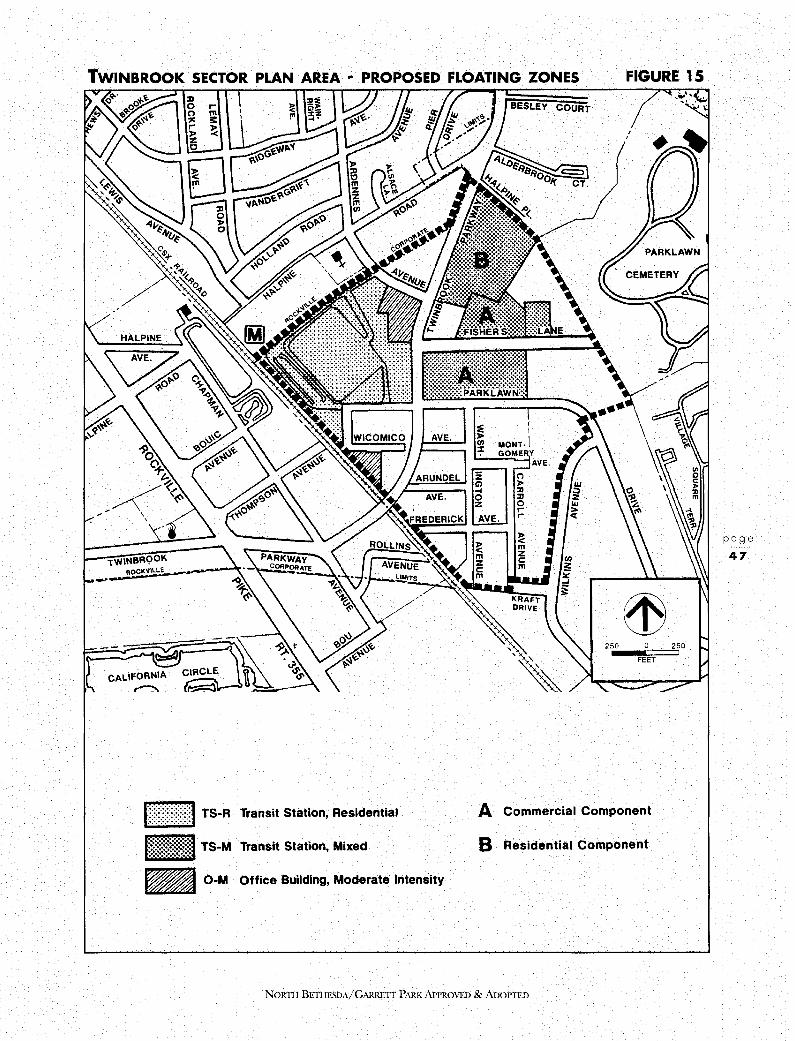
TWINBROOK SECTOR PLAN AREA • PROPOSED FLOATING ZONES FIGURE 15
h~f r \:UI TS-R
-TS-M -0-M Transit Station, Residential
Transit Station, Mixed
Office Building, Moderate Intensity
BESLEY COURT
I I
MONT-I GOME V
AVE.
250
I I
FEET
A Commercial Component
B Residential Component
NORTII BETIIESDA/GARREIT PARK APPROVED & ADoPTED
250
page
47

LAND USE AND ZONING PLAN
NORTH BETHESDA
page 48
Area 2 This area is east of Twinbrook Parkway and generally south of Parklawn Drive. The area retains many of the original residential structures that are now used for small industrial businesses. Light manufacturing, automobile and engine repair, warehouses, and a wide variety of small businesses predominate.
This Plan recommends the 1-4 Zone for this area (see Figure 16), and recommends that the area be identified as an Incubator Business District.
Area 3 Area 3 is comprised of the area bounded by Twinbrook Parkway to the west, the Sector Plan boundary to the east, and Parklawn Drive to the south, with the exception of the Parklawn Building area.
This Plan recommends the floating TS-M Zone for most of the area. At a commercial FAR of 1.0, a theoretical maximum additional 483,429 square feet would be generated on redevelopment. The Plan also recommends that the commercial component of any TS-M development be confined to Area A (Figure 15), generating a maximum average FAR on these parcels of 1.84 (as compared with an FAR of 5.16 for the adjacent Parklawn building). Area B (Figure 15) is recommended for the residential component, generating 416 units at 4 7 units per acre, at a residential FAR of 0.5. Area Bis contiguous to existing multi-family R-30 development, and future residential development would provide a transitional step between the R-30 and the TS-R Zone proposed for Area 4. It is recommended that any additional housing units permitted in the TS-M Zone not be located on Area B.
The Plan recommends retaining the 1-1 Zone as a base zone in this area, subject to the base development standard of a 42-foot height limit, with the exception of the new U.S. Pharmacopoeia building at the northeast comer of Fishers Lane and Twinbrook Parkway. At an FAR of 1.34, with four levels of underground parking, this property is considered to be built out, and the C-O Zone ( Commercial Office) is recommended as the most appropriate zone.
Area 4 Area 4 generally conforms to the Twinbrook Metro station and the portion of its parking lot within the Sector Plan area. The northern portion is currently zoned 1-1 (Light Industrial) and the southern portion is zoned O-M (Office Building, Moderate Intensity).
This Plan recommends rezoning the area generally conforming with the WMATA property, with its existing transit station and parking lot, from 1-1 (Light Industrial) and O-M (Office Building-Moderate Intensity) to R-90 as a base zone with TS-R (Transit StationResidential) as a floating zone. The floating zone recommendation can only be applied with the property owners request and the County Council's approval. Although the TS-R Zone allows a density of 150 dwelling units per acre, this Plan recommends no more than 60 units per acre on this property, with a step-down in height and significant buffering and setbacks in order to ensure compatibility with the existing Twinbrook residential
NORTI-I BETHESDA/GARRETT PARK APPROVED & ADOPTED

TwtNBROOK SECTOR PLAN SUB-AREAS
BESLEY COURT
250
IN}) [{;:) Sub-Areas
NORTI-1 BETHESDA/GARRETT PARK APPROVED & ADoPTED
FIGURE 16
I I
FEET
250
page
49

LAND USE AND ZONING PLAN NORTH BETHESDA
page
50
neighborhood. At 60 units per acre, a maximum of 1101 residential units could be developed, with a maximum FAR of 1.6. Consolidation of Metro parking into a structure would raise the total FAR to approximately 1.9. Structured parking is not counted as FAR for the purposes of calculating zoning density. The development plan for this parcel should also incorporate an urban amenity open space.
The Metro property straddles the City of Rockville corporate boundary During the development of this site consideration should be given as to whether it might be more appropriate to locate the urban amenity open space and possibly also a child day care center on Metro property within the City.
Area 5 Area 5 is a 3.16-acre, triangular piece ofland bounded by Twinbrook Parkway, Ardennes Avenue, and the City of Rockville corporate boundary. A 2.1-acre vacant portion of this area constitutes the only remaining wooded area in the Sector Plan area. Offices, retail businesses and a restaurant are located at the northern end of the site.
This Plan confirms the existing O-M Zone (Office Building, Moderate Intensity) for this area. The vacant property should be developed to protect as many of the existing trees on the site as possible. In order not to adversely affect the adjoining residential neighborhood, it is recommended that future development at this location meet the following criteria: 1) maintain a tree buffer along Ardennes Avenue, 2) maximize the proportion of subsurface parking, 3) set back or terrace any stories above three levels, and 4) screen development from the adjacent residential subdivision.
Area 6 This 2.4-acre area is west of Twinbrook Parkway, south of Parklawn Drive, and north and south of Wicomico Avenue. It is currently zoned O-M (Office Building, Moderate Intensity). Existing land uses in this area include an automobile parking lot, an automobile repair business, a lumberyard, small office buildings, and a restaurant.
This Plan confirms the existing O-M Zone for this area. The Twinbrook Center office development has site plan approval for a 83,500 square-foot building and a separate 271 car garage on a 1.28 acre parcel of land located at the southeast comer of Parklawn Drive at Wicomico Avenue adjacent to the Metro station. A Transit Participation Program Agreement was executed as part of the site plan approval process for this project.
Area 7 This 1.1-acre area abuts the MARC Railroad tracks south of Wicomico Avenue. It is currently zoned 1-1 (Light Industrial), and is the location for an automobile repair business.
This Plan recommends the Light Industrial (I-1) Zone as a base for this area, with a floating O-M Zone (Office Building, Moderate Intensity). The application of the O-M Zone would consolidate and round off the O-M Zone in the triangle formed by the Metro tracks, Twinbrook Parkway and Parklawn Drive.
NORTI-1 BETIIESDA/GARREIT PARK APPROVED & ADOPTED
Area 8 This 2.1-acre area is west of Twinbrook Parkway and south of Ardennes Avenue. Existing development includes an Exxon service station and an office building previously occupied by U.S. Pharmacopoeia. The Pharmacopoeia site is a registered "loophole" property (See section on Loophole Properties.) The existing zoning for this area is 1-1 (Light Industrial). A building permit was issued to construct a new three-story building on the Pharmacopoeia site under standard 1-1 development criteria, but the project did not proceed to construction and the pem1it has expired.
The 1978 Approved and Adopted Twinbrook Sector Plan recommended the O-M Zone for future development at this location, but retained existing developed properties in the I-1 classification to avoid placing them in a non-conforming category
This Plan recommends a base zone of 1-4 for this sub-area, and recommends a floating O-M Zone. Application of the floating zone is subject to the property owners request and the approval of the County Council.
3.3 WHITE FLINT SECTOR PLAN AREA
A. PLAN OBJECTIVES • Develop White Flint as the main urban center of North Bethesda.
• Capitalize on the public investment in the Metro system and encourage its use rather than continued reliance on the automobile.
• Promote mixed-use development near the Metro station to ensure the 24-hour vitality of the area.
• Include a significant transit serviceable residential component within the Sector Plan area.
• Develop policies to ensure a lively pedestrian environment.
B. PLAN RECOMMENDATIONS • Provide a local circulation alternative to Rockville Pike by extending Chapman Avenue
to meet Huff Court (see Figure 55).
• Extend Executive Boulevard east to meet Huff Court.
• Extend the Transit Station Mixed-use Zone (TS-M) to the south and to the west (see Figure 19).
• Consolidate the Transit Station Residential Zone (TS-R) on the west side of Rockville Pike (see Figure 19).
NORTII BETHFSDA/GARRETT PARK APPROVED & ADOPTED
page
51

LAND USE AND ZONING PLAN NORTH BETHESDA
• Extend Wall Local Park to include the parcel to the north.
• Provide an urban amenity open space within the Metro property east of White Flint station.
• Rezone the industrial property east of Nebel to the IA (Low-Intensity, Light Industrial) Zone.
C. SUMMARY
page
52
White Flint Metro Station, called Nicholson Lane in the 1978 Sector Plan, is located at the northeast corner of Rockville Pike and Marinelli Road. The station is served by a parking lot with a capacity of 1000 cars, located directly opposite the station on the west side of Rockville Pike. A pedestrian tunnel connects the parking facility to the station.
The station constitutes the raison d'etre for the Sector Plan area, which extends to approximately 200 acres, exclusive of public rights-of-way One of the major principles underlying the land use provisions of the 1978 Sector Plan was the County:s desire to create a mixed-use environment in this particular Sector Plan area. White Flint was envisioned as a unique opportunity, present nowhere else in Montgomery County, to provide new mixed-uses including office, retail, and residential development on vacant land in close proximity to a rapid-rail station.
Ironically, during an intervening period of explosive growth, only a fraction of this vision has been realized. Today, a large proportion of the White Flint Sector Plan land area lies vacant, including the 35 acre parcel on which the Metro station is located.
This Plan recommends that White Flint become the main urban center for North Bethesda and proposes land use, transportation and urban design recommendations accordingly A loop circulation street system is proposed, to provide additional capacity and an alternative to Rockville Pike for short trips. The loop system is proposed to connect five activity centers (White Flint, Twinbrook, Washington Science Center, Montrose Crossing and Rockvilles Metro Performance District). The system would connect two Metro stations and a proposed MARC station and would provide a street grid of small blocks and pedestrian-friendly streets within walking distance of Metro.
The Plan also recommends a more intensive mixed-use development pattern for White Flint, with the emphasis on employment east of the Pike and housing west of the Pike. The tallest buildings are proposed adjacent to the Pike, stepping down in height to the east and west. It is proposed that the existing Metro parking be consolidated in a structure.
The Plan recommends that Wall Local Park be extended north of the Aquatic Center, and that an urban amenity open space be established east of the Metro station, using the existing 'white flint' rock outcrops as a theme.
NORTH BETHESDA/GARRETT PARK APPROVED & ADOPTED
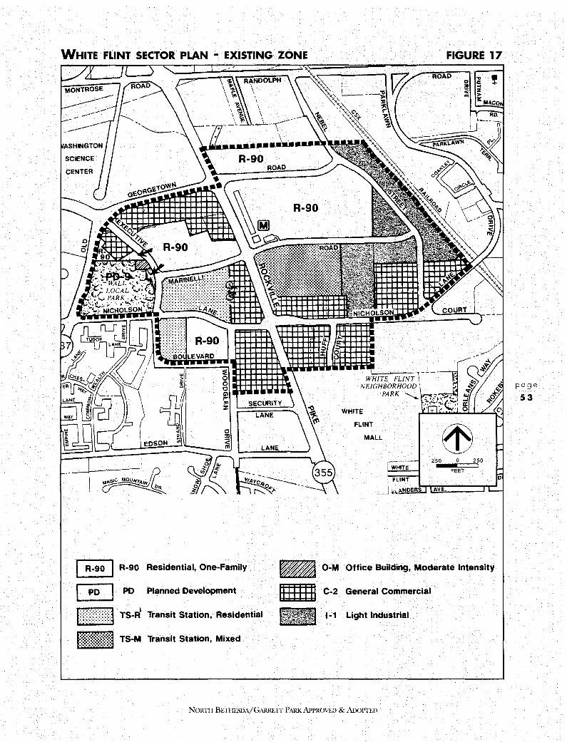
WHITE FLINT SECTOR PLAN • EXISTING ZONE FIGURE 17
8 R-90 Residential, One-Family
I PD I PO Plamed Development
f ~Yt:)}~:j TS-Fl Transit Station, Residential
- TS-M Transit Station, Mixed
WHIYE
FLINT
MALL
WHITE
i FLINT
ROAD ~ < m
COURY
250 0 250
FEET
!
_J "' 1>,NOERs~tA~v!:::===== ......
- O-M Office Building, Moderate Intensity
m C-2 General Commercial
1-1 Light Industrial
NoRm BE'TIIESDA/GARREIT PARK APPROVED & ADoPTED
page
53

page
54
WHITE FLINT SECTOR PLAN AREA • PROPOSED BASE ZONES FIGURE 18
~ R-90
a PD-9
Eiillill TS-R
- TS-M
Residential, One Family O-M
Planned Development C-2
Transit Station, Residential 1-1
Transit Station, Mixed 1-4
WHITE
FLINT
MALL
WHITE
ROAD 0
·:r,
< m
250 0 250
FEET
AVE.
Office Building, Moderate Intensity
General Commercial
Light Industrial
Low Intensity, Light Industrial
NORTII BETIIESDA/GARRETI PARK APPROVED & AnoPTI.D
!

WHITE FLINT SECTOR PLAN AREA • PROPOSED FLOATING ZONES
WHITE
FLINT
MALL
r-, WHITE
FLINT
FIGURE 19
!
250 0 250
FEET 0
. _j .,_\.p,,N R~S ....,.1.1;A";_v't-,.:.:.::::::: ......
1t:n:r )JI TS-R Transit Station, Residential
- TS-M Transit Station, Mixed
NoRTI-1 BETHESDA/GARRETf PARK APPROVED & AfX)PTED
page
55

LAND USE AND ZONING PLAN
NORTH BETHESDA
D. EXISTING CONDITIONS
page
56
E.
The White Flint Sector Plan area extends to Old Georgetown Road on the west, the MARC railroad tracks on the east, the Forum apartment building on the north, and the White Flint Mall on the sou th.
The Sector Plan area is bisected by two major highways, Rockville Pike in a north/south direction, and Nicholson Lane in an east/west direction. The continued growth of east/west traffic will create a demand for peak hour trips that will exceed the capacity of the current intersection of these two highways.
Within the Sector Plan area, the 35-acre WMATA parcel and the 10-acre Montouri parcel comprise one of the largest areas of undeveloped land around a Metro station anywhere in Montgomery County:
Existing land uses within the Sector Plan area include an eclectic mix of office, retail, industrial, and high rise residential. There are 4,800 jobs and 179 dwelling units currently within the Sector Plan area. The development pipeline will raise the numbers to 5,136 jobs and 1,134 dwelling units. Public facilities include the Aquatic Center and Wall Local Park, the Metrorail facilities, a 15-acre Metrobus facility and the Montgomery County Pre-Release Center on Nebel Street.
LAND USE AND ZONING RECOMMENDATIONS This Plans recommendations for the White Flint Sector Plan area are shown on Figures 18 and 19. In all instances where TS-Mis recommended, it is to be limited to a 2.0 FAR, with a maximum cap to be allowed only if any increase between 2.0 and 2.4 is all residential and includes at least 50 percent affordable housing. The proportions of commercial to residential uses up to 2.0 FAR shall be as follows: FAR up to 1.5, twothirds commercial and one-third residential (maximum 1.0 FAR commercial and 0.5 residential); between FAR 1.5 and 2.0, additional density above base 1.0 FAR commercial must be residential (maximum 1.0 FAR commercial and 1.0 FAR residential).
In order to provide flexibility to meet other County-wide goals, the County Council may permit, in its decision approving a local map amendment application, up to a 2.0 commercial FAR for TS-M properties in the White Flint Sector Plan area. In order for the Council to approve over a 1.0 FAR, an applicant must establish that the following criteria are met.
1. That the parcel is a greater than 6 acres;
2. That between a 1.0 and a 2.0 commercial FAR is necessary for an identified employment user;
3. That 1.0 FAR of residential development must be provided on-site;
4. That the employer shall provide and fund a traffic mitigation plan to mitigate all generated trips above a 1.0 commercial FAR.
NORTI-l BETIIESDA/GARRETI PARK APPROVED & ADOPTED

The following sub-areas are depicted in Figure 20.
Area 1 This area is bounded by Old Georgetown Road, Nicholson Lane and Executive Boulevard. It includes Wall Local Park, and the Aquatic Center, in an 11. 70 acre parcel zoned PD-9. A small property extending to 0.43 acres and zoned O-M (Office Building, Moderate Intensity) fronts Executive Boulevard north of the Aquatic Center access. This property was the subject of a Sector Plan amendment in 1987 adjusting the boundary of Wall Park to provide for a property exchange in lieu of public purchase.
North of both parcels is an area of 3.32 acres in the R-90 (Residential, One-family) and C-2 (General Commercial) zones, currently used as a parking lot for the car dealership in the same ownership to the east of Executive Boulevard.
This Plan recommends the floating TS-M (Transit Station-Mixed Use) Zone for the 3.32 acres. The Plan further recommends that the parcel be dedicated to public use as an extension of Wall Local Park. This dedicated area should be indicated as part of the TS-M zoning application and development plan for this area and the area east of Executive Boulevard (See 2 below). The Plan recommends that the density should be transferred from the parcel north of Wall Park to the property adjacent to the Pike and White Flint Metro station. This concept may require a zoning text amendment.
Area 2 This area is bounded by Old Georgetown Road, Executive Boulevard, Marinelli and Rockville Pike. The southern portion of the area consists of a 12-acre Metro parking lot zoned R-90. The northern portion includes low density development, including two car dealerships, three restaurants, a realtors office, a bank, and stores for furniture rental and stereo equipment. All of the above property is in the C-2 (General Commercial) Zone. A zoning case has been pending since 1985 requesting the TS-M Zone for approximately 2 acres of this property.
This Plan recommends the floating TS-R (Transit Station Residential) Zone at a maximum of 70 units per acre for the Metro parking lot. This compares with the approximately 75 units per acre pertaining to the adjacent Wisconsin condominium, also zoned TS-R
The existing WMATA parking lot is an appropriate location for a conference center/hotel complex. Factors such as coverage, building height and amenity open space should be reviewed in the zoning, mandatory referral, and site plan review processes for compatibility with adjacent existing and future residential development. It is anticipated that the proposed conference center will be publicly-owned and will be approximately 100,000 gross square feet in size, expandable to around 190,000 gsf; and that the associated hotel will be privately-owned and will consist of approximately 225 rooms with possibility of expansion to around 450.
The Plan further recommends the floating TS-M Zone for the C-2 zoned property in this sub-area. As noted in 1, above, it is recommended that the density from the 3.32-acre parcel west of Executive Boulevard be transferred to the above C-2 zoned property.
NORTI! BETIIESDA/GARRETI PARK APPROVED & ADOPTED
page
57
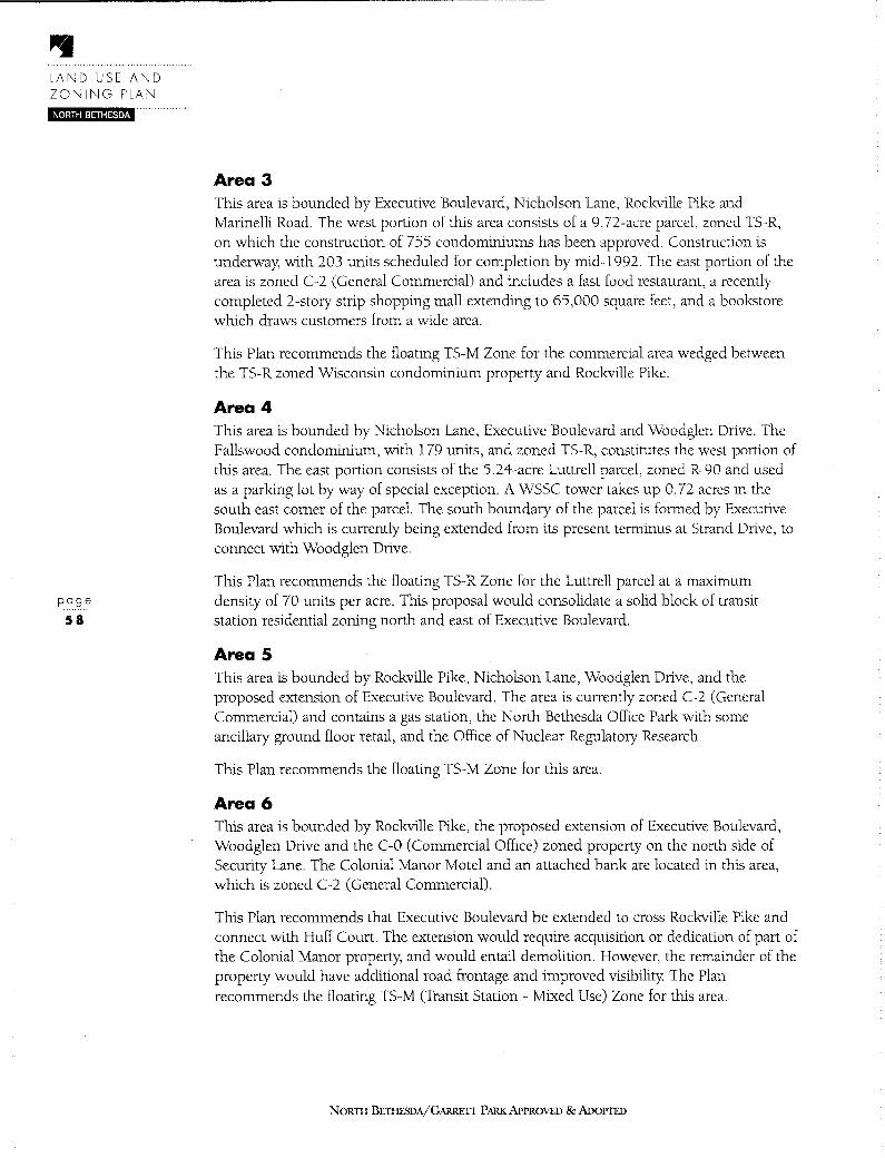
LAND USE AND ZONING PLAN
iij[•hiiil=l,Hl¥i•t·i · ....
page
58
Area 3 This area is bounded by Executive Boulevard, Nicholson Lane, Rockville Pike and Marinelli Road. The west portion of this area consists of a 9. 72-acre parcel, zoned TS-R, on which the construction of 755 condominiums has been approved. Construction is underway, with 203 units scheduled for completion by mid-1992. The east portion of the area is zoned C-2 (General Commercial) and includes a fast food restaurant, a recently completed 2-story strip shopping mall extending to 65,000 square feet, and a bookstore which draws customers from a wide area.
This Plan recommends the floating TS-M Zone for the commercial area wedged between the TS-R zoned Wisconsin condominium property and Rockville Pike.
Area 4 This area is bounded by Nicholson Lane, Executive Boulevard and Woodglen Drive. The Fallswood condominium, with 179 units, and zoned TS-R, constitutes the west portion of this area. The east portion consists of the 5.24-acre Luttrell parcel, zoned R-90 and used as a parking lot by way of special exception. A WSSC tower takes up 0. 72 acres in the south east corner of the parcel. The south boundary of the parcel is formed by Executive Boulevard which is currently being extended from its present terminus at Strand Drive, to connect with Woodglen Drive.
This Plan recommends the floating TS-R Zone for the Luttrell parcel at a maximum density of 70 units per acre. This proposal would consolidate a solid block of transit station residential zoning north and east of Executive Boulevard.
Area 5 This area is bounded by Rockville Pike, Nicholson Lane, Woodglen Drive, and the proposed extension of Executive Boulevard. The area is currently zoned C-2 (General Commercial) and contains a gas station, the North Bethesda Office Park with some ancillary ground floor retail, and the Office of Nuclear Regulatory Research.
This Plan recommends the floating TS-M Zone for this area.
Area 6 This area is bounded by Rockville Pike, the proposed extension of Executive Boulevard, Woodglen Drive and the C-0 (Commercial Office) zoned property on the north side of Security Lane. The Colonial Manor Motel and an attached bank are located in this area, which is zoned C-2 (General Commercial).
This Plan recommends that Executive Boulevard be extended to cross Rockville Pike and connect with Huff Court. The extension would require acquisition or dedication of part of the Colonial Manor property, and would entail demolition. However, the remainder of the property would have additional road frontage and improved visibility The Plan recommends the floating TS-M (Transit Station - Mixed Use) Zone for this area.
NORTI-I BETIIESDA/GARRETT PARK APPROVED & ADOPTED
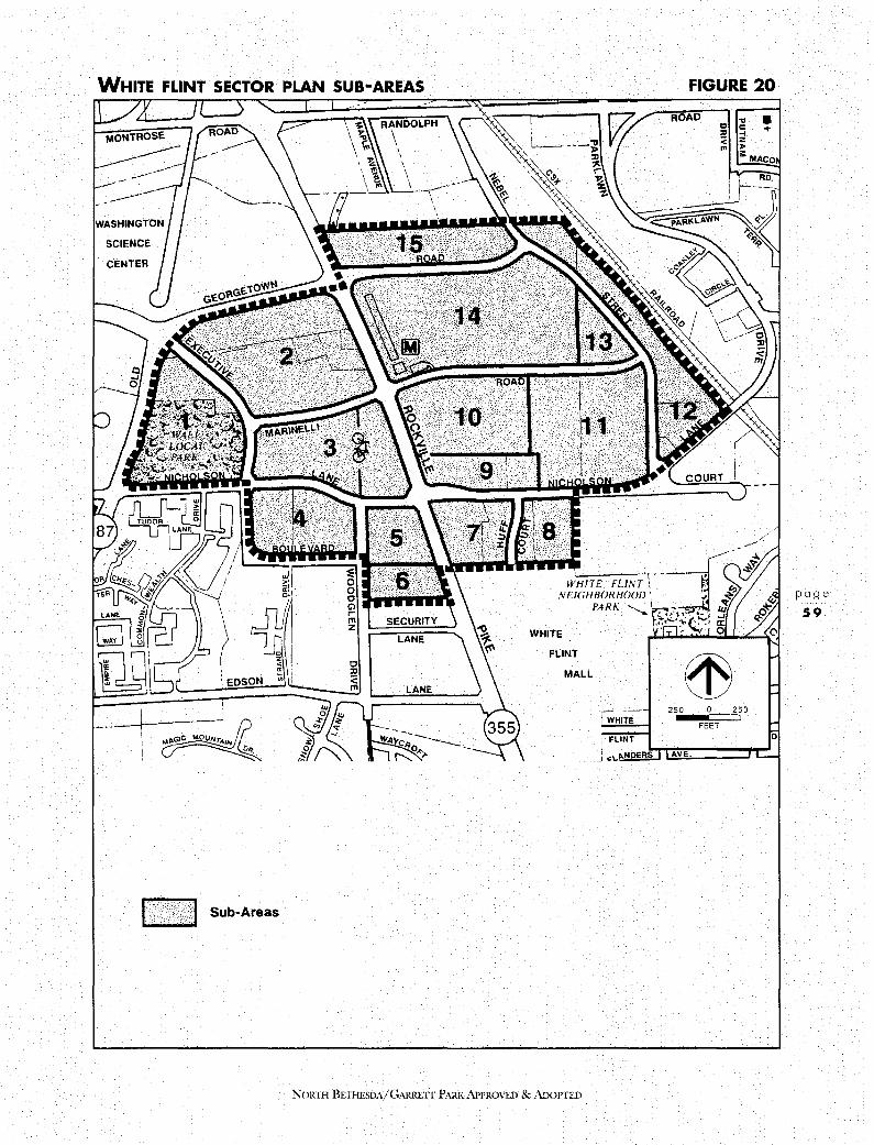
WHITE FLINT SECTOR PLAN SUB-AREAS
f U: }i,:jJ Sub-Areas
WHITE
FLINT
MALL
NORTH BE11!ESDA/GARRETI PARK APPROVED & AnoPTED
FIGURE 20
ROAD C ;g ! "' ... < z m >
3::: MACO
250 0 250
FEET D
AVE.
page
59

LAND USE AND ZONING PLAN
NORTH BETHESDA
page
60
Area 7 This area is bounded by Rockville Pike, Nicholson Lane, Huff Court and the proposed extension of Executive Boulevard. The area is currently zoned C-2 (General Commercial) and contains a gas station, car dealership, fast food outlet, carpet store, two electronics stores and a vacant office building.
This Plan recommends the floating TS-M Zone for this key area. The Plan also recommends a text amendment to the TS-M Zone that would permit cars to be displayed for sale in the same fashion as other retail goods. The Plan envisions that car storage and service would occur a short distance away, at the northwest quadrant of Nicholson Lane and Nebel Street. Members of the public wishing to purchase or service a vehicle would be within a short shuttle trip, or walk, to Metro.
Area 8 This area is bounded by Huff Court, Nicholson Lane, White Flint Plaza and White Flint Mall. The area is zoned C-2 (General Commercial) and contains Bioscience Laboratories, the four-story Nicholson Research Center and a two-story office building on Huff Court.
This Plan recommends the floating TS-M (Transit Station - Mixed Use) Zone for this area.
Area 9 This area is bounded by Rockville Pike, Nicholson Lane, the White Flint North property and the Metro bus garage. The area is zoned C-2 (General Commercial) and contains a mix of land uses including auto related uses, a plumbing and industrial air conditioning business, a tailor, printer, hair salon, dance studio, restaurant, and a retail strip of approximately 20,000 square feet.
This Plan recommends that improvements to the local circulation system bisect this area (Figure 55). No buildings are presently constructed within the proposed right-of-way
The Plan further recommends that the area east of the proposed extension of Huff Court remain zoned C-2. For the property to the west, the Plan recommends the floating TS-M Zone.
Area 10 This area constitutes the 12.25 acre White Flint north site, zoned TS-M. It is bounded by Rockville Pike, Marinelli Road, the WMATA bus maintenance facility and the general commercial development described in 9 above.
The site consists of three lots, one of which is occupied by the existing 310,000 square foot office building occupied by the Nuclear Regulatory Commission. Phase 2 of the White Flint North development has received site plan approval and includes 375,400 square feet of office and 200 apartments.
This Plan recommends that the extension of Huff Court follow the east boundary of the White Flint North property This will not be achieved easily At present, along the boundary with the WMATA bus garage, in a slope easement in favor of WMATA, there
NORTI-I BETIIESDA/GARREIT PARK APPROVED & ADOPTED

exists a rip-rapped embankment, sloping towards the WMATA property and flanked by fences along the top and toe of the slope.
This Plan recommends no change in zoning for this property
Area 11 This area is bounded by Nicholson Lane, Nebel Street, Marinelli Road, the proposed extension to Chapman Avenue and the general commercial area described in 9 above.
The area includes the Metrobus facility, a door supplier, racquetball courts, and the Nebel Office Center in the 1-1 (Light Industrial) Zone and a car dealership in the C-2 (General Commercial) Zone.
1n order to preserve land for light industrial purposes, this Plan recommends retaining the existing 1-1 zoning in this area.
The Plan also recommends retaining the existing C-2 zoning as a base zone on the 3.58-acre property in the northwest quadrant of the intersection of Nicholson Lane and Nebel Street, with a floating zone of C-3 (Highway Commercial). Currently the location of a car dealership, this property may be appropriate for the consolidation of automobile-related services-such as auto repair, new and used car sales, part sales and similar services combined with other automobile-related office and retail uses-for a full service urban automobile mall. The Plan recommends a Zoning Text Amendment to permit a height limit waiver for a specific use (auto mall) within the C-3 Zone.
Area 12 This area is bounded by Nebel Street, Nicholson Lane, the MARC railroad and the north boundary of the Sector Plan. The south portion of this area is zoned C-2 (General Commercial) and consists of a strip center including a 7-11 store, a bakery, hair salon, restaurant and fabric store.
To the north is property zoned 1-1 (Light Industrial) in three parcels-the Montgomery County Pre-Release Center, a utility company, and a vacant parcel.
The Plan recommends that the existing C-2 zoning in this area be confirmed and that the 1-1 (Light Industrial) Zone be rezoned to 1-4 (Low Intensity, Light Industrial).
Area 13 This area is bounded by Nebel Street to the north and east, Marinelli Road to the south, and the WMATA property to the west. The area includes an insurance office at an FAR of 0.21, and printing, heating and air conditioning businesses.
This Plan recommends confirming the existing 1-1 Zone.
Area 14 This area is bounded by Marinelli Road, Rockville Pike, Old Georgetown Road and the industrial area described in sub-area 13 above. The land is zoned R-90 and extends to 35 acres. The property includes the White Flint Metro Station and is otherwise vacant. It is
NORTII BETHF.SDA/GARRETT PARK APPROVED & ADOPTED
page
61
LAND USE AND ZONING PLAN
NORTH BETHESDA
page
62
the largest and most significant parcel within the Sector Plan area. With the exception of a small parcel of 7,400 square feet in the extreme northeast, the entire property is owned byWMATA.
The 1978 Sector Plan recommended the floating TS-M (Transit Station-Mixed Use) Zone for this parcel. In 1981, a preliminary plan was filed for two office structures near Rockville Pike and Marinelli Road, a 350 room hotel at the northwest corner of the property, and a total of 732 condominium units on the eastern portion of the property, including 82 MPDUs. The proposed FAR was approximately 1.6. The project has been held in limbo for a decade because of traffic capacity constraints, highlighting an inconsistency with the purpose for which Metro was created, and an inconsistency with the purpose for which the TS-M Zone was designated.
This Plan recommends that the floating TS-M Zone be confirmed for this property The Plan also recommends that Huff Court be extended to bisect the parcel and proposes a system of pedestrian-friendly local streets to subdivide the area. (See Urban Design Chapter.) The Plan recommends that an urban amenity open space be established within this parcel, using the existing "white flint" rock outcrops as a theme.
Area 15 This area is bounded by Rockville Pike, Old Georgetown Road, Nebel Street, and the north boundary of the Sector Plan area. The property is zoned R-90, and extends to 10.3 acres. It has not been subdivided.
With the exception of an outdoor nursery and sales located at the west end of the property under a temporary lease, and an abandoned barn, the property is undeveloped. The 1978 Sector Plan recommended the floating TS-M (Transit Station-Mixed Use) Zone for this significant parcel.
This Plan recommends that the floating TS-M Zone be confirmed for this property
3.4 GROSVENOR SECTOR PLAN AREA
A. PLAN OBJECTIVES • Develop Grosvenor as a transit serviceable residential district, ensuring compatibility
with the adjacent Stoneybrook and Parkside communities.
• Support convenience retail at the shared Metro/transitway station to serve both local residents and commuters.
• Develop policies to protect green space on both sides of Rockville Pike.
• Provide for development of cultural facilities.
NORTH BETI1ESDA/GARRE1T PARK APPROVED & ADOPTED
B. PLAN RECOMMENDATIONS • Support development in the Planned Development Zone on the Grosvenor
Metro property
• Support expansion and development of a cultural arts campus at the Strathmore Hall Arts Center.
• Support retaining open space on the Georgetown Preparatory School property by recommending that any future residential development be constrained to the portion of the site within the Sector Plan area.
• Support evaluation of the Georgetown Prep school building to determine its value as a historic resource.
C. SUMMARY This Plan confirms the recommendations of the 1978 Grosvenor Sector Plan calling for predominantly residential development around the Grosvenor Metro station. It attempts to preserve and extend the existing multi-family residential and institutional character of the area. The Plan supplements and augments the existing residential character of the Grosvenor district. Any new development in the Sector Plan area should be compatible with existing residential development. Ancillary retail development is recommended within the residential development to be located on the WMATA property
Grosvenor is almost exclusively a residential area, forming a readily identifiable gateway to Rockville Pike. This residential enclave is almost surrounded by open spaces created by Rock Creek Regional Park and major institutional land uses. Located at the southern terminus of Rockville Pike, Grosvenor has the potential to evolve into a major landmark.
D. EXISTING CONDITIONS The area encompassed by the Grosvenor Sector Plan is generally within a 2,000-foot radius of the entrance to the Grosvenor Metro station. The area extends approximately to the Beltway on the south, 1-270 on the west, Georgetown Preparatory School and the American Speech, Language and Hearing Association on the north, and Rock Creek Park and the Stoneybrook and Parkside communities on the east. It encompasses approximately 215 acres, exclusive of public rights-of-way, with 105 acres on the east side of Rockville Pike and 110 acres on the west.
The Grosvenor Sector Plan area is bisected in a north-south direction by Rockville Pike, a six lane divided highway with median strip, curbs, gutters, and sidewalks. It is an extension of Wisconsin Avenue and a major artery to downtown Washington, D.C.
Existing land uses are predominantly residential and institutional. The existing zoning pattern is residential, ranging in density from four units per acre to 43.5 units per acre (see Figure 21).
NoRTII BETIIESDA/GARRETf PARK APPROVED & ADOPTED
page
63
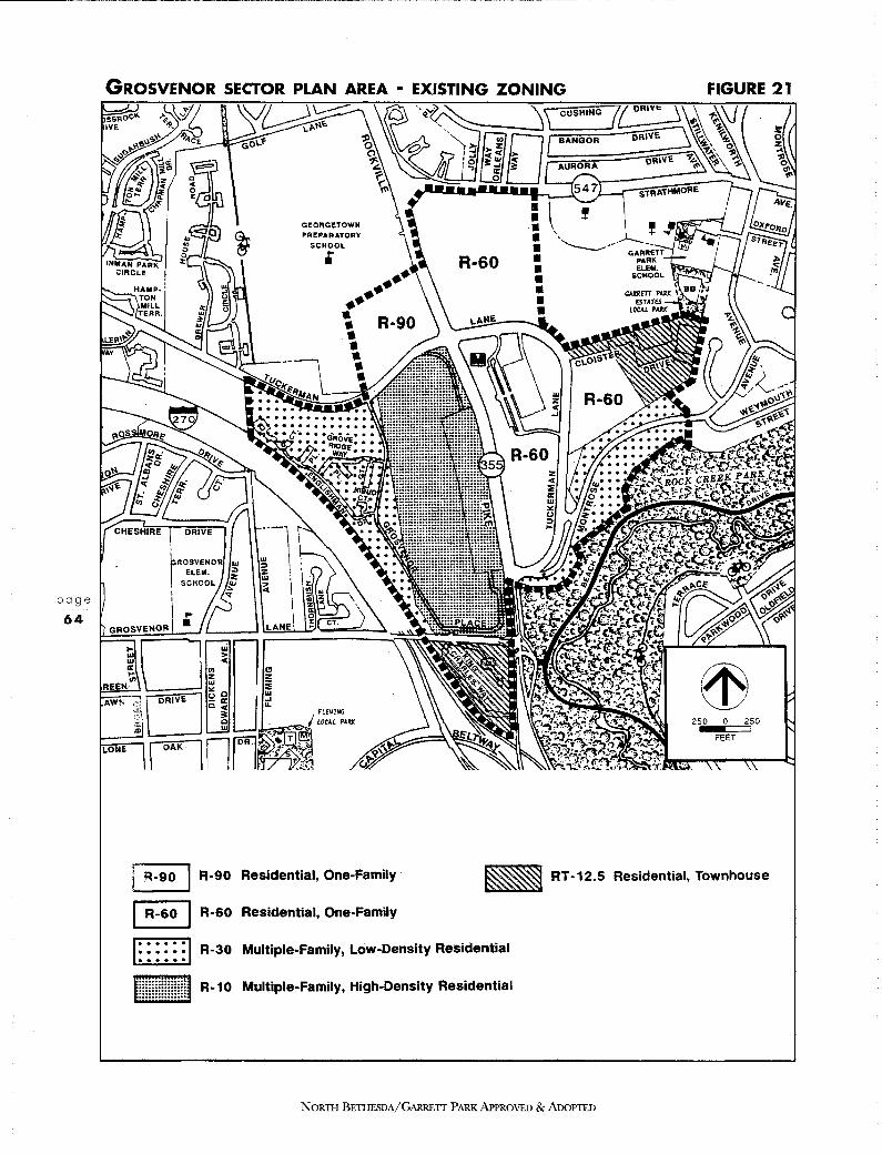
page
64
GEORGETOWN PREPARATORY
SCHOOL •
FIGURE 21
250 O 250
FEET
r !=1-90 I R-90 Residential, One-Family
8 R-60 Residential, One-Family
- RT-12.5 Residential, Townhouse
...... ...... . . . . . . R-30 Multiple-Family, Low-Density Residential
EE R-10 Multiple-Family, High-Density Residential
NORTI-1 BETHESDA/GARRETT PARK APPROVED & AnoPTED

GROSVENOR SECTOR PLAN AREA • PROPOSED
BASE/FLOATING ZONES
• • • GEORGETOWN PREP.ORATORY
SCHOOL • -------- .
FUMJ..:;
L-.JJ,r.;:,~~ LOCAl PA2K
• • • • • •
FIGURE 22
250 0 250
FEET
1~_901p 0 _281 R-90/ Residential, One-Family/
... __ _,_ PD-28 Planned Development
I R-&oiPcc I R-60/ Residential, One Family/ PCC Planned Cultural Center
...... ...... ...... [iilliiliiid -
R-30 Multiple-Family, Low Density Residential
R-10 Multiple-Family, High Density Residential
IR-&oJPo-251 R-60 / Residential, One Family/ '-· __ _._ PD-25 Transit Station, Residential RT -12.5 Residential, Townhouse
r;.;;;7 R-S0 One Family Detached L.:..::_J Residential
NORTII BETIIESDA/G,\RRETI PARK APPROVED & ADOPTED
page
65

LAND USE AND ZONING PLAN NORTH BETHESDA
E. LAND USE AND ZONING RECOMMENDATIONS
page
66
The Sector Plan area has been divided into eight areas for the purposes of this Master Plan analysis. (See Figure 23.) Land use and zoning recommendations for these eight areas are as follows:
Area 1 WMATA/Grosvenor
This 45 acre parcel, located on the east side of Rockville Pike, is the site of the Grosvenor Metrorail station, a station on the Red Line with service from Shady Grove via downtown Washington, D.C., to Wheaton.
Tuckerman Lane, which provides direct access, traverses the property, and the existing Stoneybrook and Parkside communities abut it to the east and south respectively Strathmore Hall (see Community Facilities chapter) lies to the north on the opposite side of Tuckerman Lane. The existing Grosvenor garden and high-rise apartments are on the opposite side of Rockville Pike. The existing zoning on the WMATA property is R-60 (single-family residential, medium density). The Zoning Plan in the 1978 Grosvenor Sector Plan shows an R-60 base zone, with a floating zone designation for either TS-R (Transit Station-Residential) or equivalent P-D (Planned Development) zoning.
WMATA does not directly develop land on its own. It offers the building rights to private developers and proceeds with "joint" (WMATA and the private developer) development. WMATA is currently considering inviting joint development proposals involving the integration of the existing transit facilities with a residential development project.
The land use and zoning recommendations are based on the premise that relatively high density residential development, compatible with existing development in the Grosvenor Sector Plan area, will encourage use of the Metro system, as well as provide a suitable living environment for people in the down-County area. Therefore, the most intensive development is recommended at the center of the Sector Plan area, in close proximity to the Metro station itself. The least intensive development is recommended for the part of the property lying to the east of Tuckerman Lane because it is at a greater distance from the Metro station entrance and has environmental and compatibility constraints.
The purpose of the Plans recommendations is two-fold: to provide additional housing in the Planning Area and to expand potential Metro ridership.
The Plan recommends retaining the existing R-60 zoning as a base zone with PD-25 as a floating zone. The total number of residential units to be developed under the PD-25 Zone should be limited to a maximum of 1,403 units including MPDUs. The maximum number of units on the east side of Tuckerman Lane should be limited to 100, and these units should be situated in the southwest comer of this portion of the site, south of the stream. No units should be built north of the stream. At the time of zoning and site plan review, some or all the units may be shifted from the east to the west side of Tuckerman in order to satisfy environmental or compatibility constraints. The Plan recommends waiving the percentage requirements for single and multi-family units for development in the PD
NORTH BETI-IESDA/GARREIT PARK APPROVED & ADOPTED

GROSVENOR SECTOR PLAN SUB-AREAS
ki< 1 Sub-Areas
GEORGETOWN PREPARATORY
SCHOOL •
NOR11 I BETHESDA/GARRETT PARK APPROVED & AnoPTED
FIGURE 23
250 0 250
FEET
page
67
LAND USE AND ZONING PLAN
NORTH BETHESDA
page
68
Zone for this property in order to respond to the constraints on the environmentally sensitive portion of the property located on the east side of Tuckerman Lane.
Potential noise and vibration impacts on future development on these parcels must be addressed at the time of zoning (development plan) and site plan review because of their proximity to Rockville Pike, the Metro station, and the elevated section of the subway tracks. Proposed development on these parcels should incorporate noise reduction and vibration control measures in both site and building design so that acceptable noise and vibration levels are achieved in interior living spaces and any outdoor use areas.
Future development of the east side of Tuckerman Lane should include buffering and screening between this parcel and the existing Parkside and Stoneybrook communities, with a minimum building setback of 100 feet, and with building heights stepping down from the north to the south and east towards the existing Parkside and Stoneybrook communities. Building height should be limited to four stories and factors such as shadow effect, area coverage, amenity open space, buffering and screening should be reviewed in the site plan approval process for compatibility with adjacent neighborhoods. Garden apartments and similar configurations are the appropriate housing type. Standard townhouses will not achieve the density with the environmental constraints and are unlikely to be approved for the parcel.
Measures should be taken to protect all residential communities in this area, both existing and new, from commuter parking overflow. The maximum number of trees and understory should be preserved, particularly in the buffer areas, the stream valley and the panhandle area east of Tuckerman Lane and north of Montrose Avenue. The stream valley buffer should have a minimum width of 200 feet. Responsibility for maintenance of the major open spaces should be shared with the residential units west of Tuckerman unless dedicated for public use.
The development plan for this area should include an urban amenity open space, possibly incorporating an existing tree stand. The location and design of this amenity open space should be determined as part of the development process.
The Grosvenor Metro station is approximately two miles from Rock Spring Park and 2.5 miles from Montgomery Mall. A transitway connection from the Metro station to
Montgomery Mall via Rock Spring Park is recommended. (See Transportation chapter.)
The Metro board of directors recently voted to consider day-care centers to be built on WMATA'.s property at Metro stations. This Plan supports the Grosvenor station as a location for a future child day care facility.
Area 2 Strathmore Hall and American Speech, Language and Hearing Association
Area 2 is approximately 30 acres in size. Its boundaries are Strathmore Avenue to the north, Tuckerman Lane to the south, Rockville Pike to the west, and the Academy of the Holy Cross to the east. Two major institutional uses are located here: Strathmore Hall, the
NoRrn BETHESDA/GARRETT PARK APPROVED & ADOPTED

former Corby Mansion, now owned by the County (see Historic Resources section), and the American Speech, Language and Hearing Association (ASHA). The existing zoning is R-60 (single-family residential, medium density).
The ASHA building is located on 19 acres of land at the northern end of the site. This building was developed under two special exceptions, one granted in 1978 and a modification granted in 1989. The ASHA building and parking lot take up approximately 9 acres.
The Strathmore Hall Arts Center, which lies to the south, has a long range plan for development of a County cultural arts campus at this location. Existing facilities include the 1914 mansion, an outdoor pavilion and a stage. Long-range plans include the addition of a 700-seat music hall, a 1500-seat concert hall, a formal greensward for large outdoor festivals, and a museum. Realizing these goals would require acquisition of the ten adjacent acres of the ASHA property The Approved and Adopted Grosvenor Sector Plan of 1978 recommended a County Performing Arts/Civic Center using the southern half of the ASHA property
The Plan recommends that the existing base zone of R-60 be confirmed for the entire area. The Strathmore Hall property is suitable for an application for the PCC (Planned Cultural Center) Zone, and any portion of the ASHA property eventually acquired by Strathmore Hall would also be appropriate for the PCC Zone.
A development plan for the PCC Zone should not include an inn as a supplemental use because it would not be appropriate at this location due to traffic and other factors.
Area 3 Georgetown Preparatory School
The Georgetown Preparatory School is a private school for boys with an enrollment of 400 students, situated on 92.59 acres of land at Rockville Pike and Tuckerman Lane. A nine-hole private golf course provides an open space vista from Rockville Pike. The school was founded in 1 789 and is the oldest Catholic high school for boys in the United States. The school moved to its present location in 1919.
The Georgetown Prep site is one of the last large open spaces in the Planning Area. It is linked to the opposite side of Rockville Pike by existing open space at Strathmore Hall. This open space provides recreational opportunities for the school as well as visual relief from the other more intense uses along Rockville Pike.
The school's administrators have expressed a desire to continue to operate the school at its present location for the foreseeable future, and would like to expand their facilities to include a new 500-seat theater/auditorium, six classrooms, and offices for faculty and extra-curricular activities.
The Plans land use recommendation for this site is institutional. Objectives for this site are (1) to maintain the use of the school and to support reasonable future renovation and expansion, (2) to maintain as much of the sites existing open space as possible, and (3) to
NORTII BErHESDA/GARRETI PARK APPROVED & ADOITED
page
69

LAND USE AND ZONING PLAN
NORTH BETHESDA
page
70
confine any future residential development on the site to the area within the Sector Plan boundary and thus in close proximity to the Grosvenor Metro station. These objectives would be implemented at the time of development plan review.
The Plan recommends retaining R-90 (single family residential) as the base zone for this property In order to encourage retention of the school and its environmental setting, it is recommended that PD-28 zoning be applied to 15 acres generally conforming to the area within the Sector Plan boundary It is recommended that the following development plan guidelines be applied to this site:
1. Provide convenient pedestrian access to Metro.
2. If feasible, provide vehicular access from Tuckerman Lane.
3. Restrict residential development under the PD-28 Zone, which is a floating zone, to 15 acres more or less conforming to the 15 acres of the site within the Grosvenor Sector Plan boundary The exact configuration of the 15 acres to which the PD-28 floating zone may be applied will depend on environmental, topographic, or other similar reasons. Any deviations from the Sector Plan boundary would be expected to be minor in nature.
4. Submit a landscaping plan that provides a buffer between the residential development and the remainder of the site.
The Georgetown Prep school building may have historic value. It is not currently on the Locational Atlas and Index of Historic Sites in Montgomery County, and therefore was not examined as part of the process for potential designation on the Master Plan for Historic Preservation. This Plan recommends that the building be studied for future designation as an historic resource.
The Georgetown Prep area also contains two very small residual parcels located at the intersection of Rockville Pike and Tuckerman Lane. These two parcels total 0.34 acre in size and are owned by the Corby family Because of their size and configuration, they are undevelopable. This land may be needed by the State Highway Administration for future intersection improvements.
Area 4 Grosvenor Park Townhouses
The Grosvenor Park Townhouses are located between Tuckerman Lane and I-270, to the west of the high-rise apartment buildings. One hundred and eighty-six residential units are located on approximately 14 acres of land currently classified in the R-30 (multifamily) zoning category
This area also contains 2.75 acres of vacant land in the R-30 Zone extending the length of its frontage along Tuckerman Lane. This land is owned by the Corby family and is part of a parcel that was bisected when Tuckerman Lane was constructed. The parcel is heavily wooded and includes a stream valley and woodlands.
NORTI-I BETHESDA/GARRETT PARK APPROVED & ADOPTED
No zoning changes are recommended for either of the parcels in this area.
Area 5 Grosvenor Apartments
This 55-acre area is located along the west side of Rockville Pike, between Tuckerman Lane and Grosvenor Lane. Five high-rise structures, with a total of 2139 residential units, are situated along Grosvenor Place. A garden apartment development of 214 units, Grosvenor Park Condominiums, is also located in this area, along Rockville Pike. A small amount of ancillary retail, 7000 square feet, is located in the lower level of one of the high-rise apartment buildings.
This area is developed in the R-10 Zone (multi-family, high density residential, 43.5 units per acre). No land use or zoning changes are recommended for this area.
Area 6 Grosvenor Mews
Grosvenor Mews is an existing residential development consisting of 99 single-family attached units on 14 acres of land bordered by 1-270, Rockville Pike and Grosvenor Lane. The existing zoning is RT-12.5 (residential townhouse, 12.5 units per acre). No land use or zoning changes are proposed for this area.
Area 7 Parkside Condominium Apartments
The Parkside Condominium community consists in total of 954 garden apartments in 104 buildings on 69 acres of land. Two hundred and eighty-two of these units are on 12 acres of land within the Sector Plan area, lying between Rock Creek Park and the Grosvenor Metro station. Montrose Avenue traverses the community, and Rock Creek Park abuts its southern border. The existing zoning is R-30 (multi-family residential, 14.5 units per acre). No zoning or land use changes are proposed for this area.
Area 8 Stoney brook
This existing residential development, located off Tuckerman Lane, consists of 120 townhouse units on 16 acres of land. Existing zoning is RT-12.5 (residential townhouse, 12.5 units per acre). No zoning or land use changes are proposed for this area.
NORTII BE111ESDA/GARRETI PARK APPROVED & ADOPTED
page
71

LAND USE AND ZONING PLAN
NORTH BETHESDA
page
72
3.5 KEY VACANT OR REDEVELOPABLE PARCELS
The following parcels or groups of parcels have been identified as those with the greatest potential for change outside the boundaries of the Sector Plan areas and Rock Spring Park. The individual parcels or groups of parcels are depicted in Figure 24. The proposed zoning for the parcels is indicated in Figure 26.
These critical parcels and areas are undeveloped or underdeveloped for a variety of reasons, including environmental or market constraints, poor access or visibility, complex or unresolved ownership problems, decisions to hold land as an investment, zoning incompatible with an owner's aspirations, or inadequate public facilities.
As all these parcels or areas are outside the four nodal areas of Twinbrook, White Flint, Grosvenor and Rock Spring Park, it is generally recommended that the existing zone be retained or a less intensive zone applied. In several instances, due to unique circumstances pertaining to individual sites, a more intensive zoning pattern is recommended.
1. 1-1 (LIGHT INDUSTRIAL) ZONE OUTSIDE SECTOR PLAN AREAS The area zoned 1-1 (Light Industrial) in North Bethesda outside the Twinbrook and White Flint Sector Plan areas, and excluding the B.F Saul property, extends to 175.68 acres. It includes 126 separate parcels and 3,285,228 square feet of existing development.
Most of the light industrial zone is generally located east of the MARC railroad and west of Parklawn Drive, with significant concentrations extending west to Maple Avenue, south along Boiling Brook Parkway, and west to White Flint Plaza.
The 1-1 Zone was intended to accommodate small to medium scale light industrial activities including research and development, warehousing and storage, light manufacturing and assembly of products and other similar uses. The area also includes small contracting businesses, automotive repair, community service businesses, and many small 'incubator' hi-tech firms.
The gradual intrusion of general office development and traditional retail uses now provides the area with an eclectic mix of uses, but is steadily diminishing the amount of industrial space. This Plan recognizes the light industrial area as vital for maintaining hitech incubator firms and general business services for the down-County population.
The Plan recommends that the area zoned 1-1 (Light Industrial) with the exception of the area north of Bou Avenue, be rezoned to 1-4 (Low Intensity, Light Industrial). This would have the effect of excluding general offices, except by special exception. The Plan recommends a zoning text amendment that will permit pre-existing uses to continue, through a grandfather clause provision, on property rezoned from 1-1 to 1-4.
This Plan recommends that the area zoned 1-1 and C-2 to the north of Bou Avenue be rezoned C-4 (Limited Commercial). The area includes a 2.29-acre parking lot zoned 1-1 east of Chapman Avenue and the Pike Center retail development to the west of Chapman Avenue (73,187 square feet on 6.84 acres straddling the 1-1 and C-2 Zones with an existing FAR of 0.24).
NORTII BETIIESDA/GARRETT PARK APPROVED & ADOPTED

KEY VACANT OR REDEVELOPABLE PARCELS FIGURE 24
~
1000 0 1000
FEET
(Outside Sector Plan Areas and Rock Spring Park)
1. 1-1 Zone Outside Sector Plans 12. WMATA
2. Montrose Crossing 13. Georgetown Preparatory School
3. Armstrong and Mervis 14. Holy Cross
4. Maryland National Bank 15. Corby
s. Wilgus 16. Davis-Lux Lane
6. Mid Pike Plaza 17. Aubinoe
7. White Flint Parking Lot 18. Davis-Democracy
8. Poindexter 19. American Foresters/NRF
9. Edson Lane North 20. WMAL, Inc.
10. Edson Lane South 21. Tri-Rock
11. Hillery Way 22. Loehmann's Plaza
23. Chang
NORTil BETHESDA/GARRETT PARK.APPROVED & AooPTED
page
73
LAND USE AND ZONING PLAN
NORTH BETHESDA
2. MONTROSE CROSSING
page
74
The Montrose Crossing property, variously termed the 'Flagship Center' or 'Gourmet Giant' site is one of the most critical parcels in North Bethesda. It is located at the northeast quadrant of Rockville Pike and Randolph Road, contiguous to the State-owned right-of-way for the former Rockville Facility It is bordered on the east by the MARC railroad, to the west by Rockville Pike, and to the north by Bou Avenue. The extreme northeast comer of the site is contiguous to the Rockville City limits.
This latter fact could be of extreme significance. Although outside the present maximum expansion limits for the City of Rockville, this critical property could technically be annexed.
The property is virtually equidistant from both Twinbrook and White Flint Metro stations, and straddles the Metro line. The Metro tracks emerge from tunnel to surface at the northeast comer of the site, paralleling the MARC railroad to the north.
The property extends to 39.34 acres and is comprised of two parcels of 31.68 and 7.66 acres. The smaller parcel is zoned C-2 (General Commercial), is approximately rectangular in shape and is located in the northeast quadrant of the site. The larger parcel is zoned predominantly 1-1 (Light Industrial), with a small C-2 (General Commercial) area in the northwest quadrant.
All buildings on the site, with the exception of a small structure on a pad, are within the 1-1 (Light Industrial) Zone. The gross square footage of the largest building is 174,920 square feet, of which 157,320 square feet is leased space. Tenants include Marshalls, two clothing stores, a restaurant, liquor store, hair salon, computer store and tire store.
The Levitz furniture store, in the southeast quadrant of the site, comprises 158,000 square feet of gross floor area. This structure was originally serviced by a railroad siding, and the original tracks are still apparent contiguous to the east side of the building.
Four other small structures have been constructed on parking lot pads. They consist of a restaurant, florist and two banks at 10,860, 9,650, 4,640 and 3,200 square feet respectively The total gross floor area on the property extends to 361,320 square feet, with an FAR of 0.21.
Several transportation recommendations pertain to the Montrose Crossing property A new MARC station is proposed for the east boundary, two local circulation routes (Nebel Street Extended and Chapman Avenue Extended) are proposed to traverse the site, and the Montrose Parkway is proposed to form the south boundary. The proposed extension of Nebel Street would connect this property with the Twinbrook and White Flint employment areas, the Washington Science Center, the City of Rockvilles Twinbrook Performance District, and would connect the proposed MARC station with two Metro stations. (See Figure 55.) The precise location of the station will be determined by subsequent engineering studies. Redevelopment of the Montrose Crossing property should not preclude the optimal siting of the station.
NoRTI-I BETHESDA/GARREIT PARK APPROVED & ADOPTED

It is one of this Plan's objectives to facilitate mixed use development, including residential and office components, on this site, while recognizing the existing substantial retail development in place.
The existing 1-1 zoning over the greater portion of the site is an anachronism. However, a review of existing alternatives revealed difficulties with each zoning option. The RMX (Residential Mixed Use) Zones come closest to fulfilling the objectives for the site, but would require amendment.
This Plan recommends a text amendment to add two new RMX Zones to the Zoning Ordinance. In terms of Montrose Crossing, the Plan recommends the RMX-3C Zone (Residential-Mixed Use Development, Regional Center - Commercial Base). The zone would contain a retail/commercial based standard method and a retail oriented optional method, with substantial residential and office components. The Plan recommends that the most intensive uses, including residential and office uses, be located in the vicinity of the proposed MARC station, and recommends phasing to facilitate the earliest development on the existing vacant C-2 parcel.
The Plan further recommends a maximum commercial FAR of 0.5 with a limit of 25 percent of gross floor area devoted to office use. The minimum number of dwelling units is proposed as 150, with a maximum of 40 units per acre.
The Plan recommends that the standard method of development have an FAR limit in the range of 0.25 to 0.35, with the limit to be decided at the time of approval of a zoning text amendment. It is recommended that the standard method of development include both a concept plan and a site plan requirement, to assure that the standard method of development not pre-empt the ultimate long term optional method of development on this important property.
3. ARMSTRONG AND MERVIS Both of these properties are located directly south of Montrose Road. They are bordered to the west by the Tildenwood subdivision, north and south of Tildenwood Lane. To the east, the properties are bordered by the Montrose Woods townhouse development. The former Rockville Facility reservation traverses both properties, abutting the Tildenwood and Luxmanor subdivisions to the south.
The Armstrong property is the larger of the two properties, extending to 16.7 acres, and lies to the west of the Mervis property, which extends to 5.8 acres. Old Farm Creek bisects the Armstrong property, and constitutes the boundary between two single family residential zones, R-90 to the west, and R-200 to the east. The Mervis property is zoned R-200.
In 1986, a zoning application was filed for four acres of the Mervis property, requesting RT-10 or RT-12.5 (residential townhouse). Although the hearing examiner~ report found that townhouse zoning would be compatible in terms of land use and density, the rezoning was remanded because of adverse traffic impacts. This Plan recommends R-200/IDR- l l zoning on the Mervis property and on that part of the Armstrong property
NOR11! BETIIF.SDA/GARREIT PARK APPROVED & ADOP1Till
page
75
LAND USE AND ZONING PLAN
NORTH BETHESDA
east of Old Farm Creek. Much of the land east of Old Farm Creek is in a floodplain and undevelopable. Extensive buffering will be necessary on both properties at the time of development in order to visually separate residential uses from the proposed Montrose Parkway
The proposed Montrose Parkway alignment would diagonally bisect the Armstrong property (see Figure 54). This Plan recommends that the Armstrong property be acquired in connection with the Montrose Parkway proposal and maintained as far as possible in its natural wooded state to buffer the adjacent single-family land uses.
4. MARYLAND NATIONAL BANK
page
76 5.
This property is located directly south of Montrose Road and east of Shagbark Drive. It is bordered by the Montrose Forest townhome community, zoned RT-12.5, to the west and to the east by land zoned C-T ( Commercial Transition) and developed with commercial townhouses. To the south is undeveloped land zoned C-T. To the north of the property is land zoned R-200 and occupied by the B'Nai Israel Congregation and the Greater Washington Jewish Community Foundation.
The Maryland National Bank property extends to 1.29 acres, is zoned R-200 and is improved with a single-family detached dwelling unit. Its continued existence at this location is an interesting anomaly
This Plan recommends R-60/TDR-15 zoning for this parcel.
WILGUS This property is located south of Montrose Road, east of East Jefferson and west of Old Georgetown Road. A 300-foot wide piece of land along the southern portion of the property is zoned primarily R-200 with a parcel zoned C-O (Commercial Office) abutting Old Georgetown Road. The 300-foot wide section is in voluntary reservation for the former Rockville Facility and separates the site under consideration from the Washington Science Center to the south. Together with the right-of-way, the area extends to 29.6 acres. All of the property east of East Jefferson, including the land in reservation, is registered as a loophole property, having received preliminary plan approval in 1981 for 165,000 square feet of office space and a service station. Site plan approval was granted in March 1982. The office building, proposed at the southeast comer of Montrose Road and East Jefferson, was never constructed. An Exxon Gas station, on Montrose Road approximately at the midpoint of the site, is the only development on the Wilgus tract. The center portion of the property fronting Montrose Road is zoned C-2 and is bounded by property zoned C-O.
This site is located outside the Metro nodes, and the potential maximum FAR of 3.0 for the C-O Zone is regarded as out of balance with the 0.5 maximum for the I-3 (Industrial Park) Zone at the Washington Science Center, the potential commercial maximum of 0.50 at the Montrose Crossing site and the proposed maximum of 2.0-2.4 FAR for the recommended TS-M zoned properties within the White Flint Sector Plan area.
It is one of the purposes of this Plan to provide a broad range of housing types and to
NORTH BETHESDA/GARRETT PARK APPROVED & ADOPTED
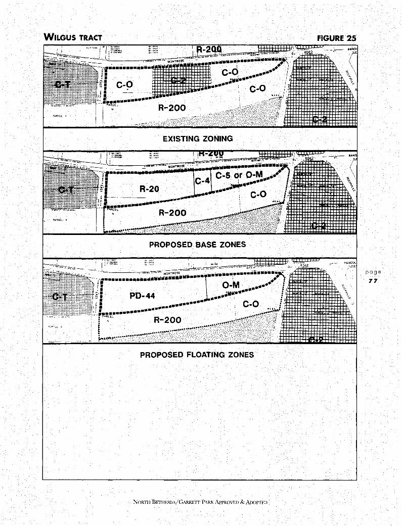
WILGUS TRACT
j I • \ (........ ....u,. - \I.: I A~AO ' 1
•·• "" / zL; :;::::; ::::::: \ JI 21\~i~ . , ...... ·
EXISTING ZONING
J ,t...... ... ... l I~":"'\, I .... ... R/ltD .._ i ~ l::-,;~~- . :::::: I 1n•.-E:VU ~/ ......
PROPOSED BASE ZONES
PROPOSED FLOATING ZONES
N01m1 BETI!ESDA/GARREIT PARK APPROVED & ADOPTED
FIGURE 25
: -;,-- ,·\·~~ .•..
"i, <., 1 <_.
a
. .. , < \ ,. 1' <_.
RANDOL
/"'
,"}
page
77

" LAND USE AND ZONING PLAN
NORTH BETHESDA
page
78
6.
encourage the creation of a distinctive visual character and identity for each development. This property appears suited to a coordinated mixture of residential, convenience commercial and office uses. These uses will provide compatibility with adjacent development, provide an orderly transition from residential to retail to office from East Jefferson Street towards Rockville Pike, and introduce a residential component into an area zoned for exclusively commercial purposes. (See Figure 25.)
Accordingly, this Plan recommends a base zone of R-20 on eight acres and C-4 (Limited Commercial) on the two acres where the existing gas station is located. An optional floating PD-44 Zone is recommended on ten acres, subject to a maximum of 429 dwelling units, including the maximum percent of MPDU:s and 40,000 square feet of retail space. It is more likely that full density may be achieved with a higher proportion of smaller units. The Plan recommends that a unit type percentage waiver be granted at time of rezoning to maintain the maximum number of trees on the property Further, the base C-5 (Low-Density Office) Zone is recommended for 3.5 acres, with an optional O-M Zone designation. The Plan supports development of the property in the O-M Zone with an FAR limitation of 1.0.
MID-PIKE PLAZA This property is located west of Rockville Pike, north of Old Georgetown Road and east of the old section of Old Georgetown Road, now a cul-de-sac. The property is zoned C-2 (General Commercial), and extends to 20.04 acres. The Plaza, a traditional strip shopping mall, has a gross floor area of 201,919 square feet with an FAR of 0.23. It is bordered to the north by property owned by the State Highway Administration (SHA) and extending to 7.8 acres. The SHA property is within the former Rockville Facility right-of-way, is developed as a parking lot and is indistinguishable on the ground from the retail center parking lot. Out of a total of 27.8 acres, almost 23 acres is surface parking.
The property links the White Flint Sector Plan area to the Washington Science Center. It is recommended that the existing zoning be confirmed. It is further recommended that a zoning text amendment be adopted to render future development in the Euclidean C-2 Zone subject to urban design review.
7. WHITE FLINT PLAZA - SPECIAL EXCEPTION AREA White Flint Plaza is zoned C-2 and extends to I94,644 square feet of floor space on 15.02 acres, for an FAR of 0.30. Additional surface parking currently exists (by special exception) in the southeast comer of the site on a 2.57-acre parcel zoned R-90. The R-90 parcel is bordered by White Flint Mall and White Flint Plaza to the west and north, respectively, both zoned C-2. The parcel is bordered on the south by White Flint Neighborhood Park and to the east by the Garrett Park Estates subdivision, both zoned R-90.
A modification to the special exception has been granted for construction of a 2-1/2 level parking garage with 340 spaces. This Plan recommends that the existing zoning be confirmed.
NORTH BETIIBSDA/GARRETI PARK APPROVED & ADOPTED

8. POINDEXTER The property known as lots 4 and 5, Block D, Luxmanor subdivision, extends to 58,932 square feet, and is located at the southwest quadrant of Poindexter Lane and Old Georgetown Road. The property is zoned R-200 and was the subject of a zoning application in 1988, requesting reclassification to the O-M Zone. With a record of substantial community opposition, the Planning Board recommended denial in October 1989. Prior to consideration by the County Council, the request was withdrawn without prejudice.
This Plan recommends that the existing zoning of R-200 be confirmed.
9. & 1 O. EDSON LANE NORTH AND SOUTH The R-90 zoned parcels on the north and south side of Edson Lane, east of Woodglen Drive, present a complex zoning problem. To the south is located the Wickford subdivision, zoned R-90. To the east, on the south side of Edson Lane, are buildings in the C-T (Commercial Transition) Zone. To the east, on the north side of Edson Lane, a six-story building zoned O-M (Office Building, Moderate Intensity) is located. To the north is located a twelve story building, including two levels of open deck parking,in the C-O (Commercial Office) Zone. To the west, north of Edson Lane, a 132-unit townhouse development in the PD-11 (Planned Development) Zone has been approved. Finally, to the west, south of Edson Lane, is the R-90 zoned Timberlawn subdivision.
The R-90 properties form three distinct elements:
1. One of the R-90 lots is within the same ownership as the 6-story office building on the north side of Edson Lane. lt constitutes approximately 1.8 acres out of a total of 4.8 acres, and is presently vacant. The site plan documents for the office building expressly encompassed both parcels and provided for landscaping and minor amenity development on the R-90 parcel. Therefore, any additional development on the R-90 lot must occur pursuant to approval of an amendment to the office site plan.
2. Immediately to the west is an area of approximately 1.9 acres on the northeast quadrant of Edson Lane and Woodglen Avenue. The area is comprised of five R-90 zoned lots.
3. On the south side of Edson Lane are located five single-family homes comprising approximately 2.7 acres.
The challenge for Edson Lane has been to find an appropriate transition from west to east, and particularly from south to north, between single-family detached housing and a 12-story office structure.
This Plan encourages the assembly and unified development of the properties presently zoned R-90 north of Edson Lane. The Plan also recommends that redevelopment at this location have a transition in height descending from the north and east towards the south and west in order to be compatible with existing development in the area.
NORTI-1 BET! IF.SDA/ GARRETT PARK APPROVED & ADOPTED
page
79
LAND USE AND ZONING PLAN
NORTH BETHESDA
page
80
For the 3.7 acre property on the north side of Edson Lane (Parcel 9), the Plan recommends retaining the existing R-90 zone as a base zone. If the County Council approves a pending text amendment allowing higher densities in the TDR zone, this Plan recommends R-90/TDR-28 zoning for this property; otherwise this plan recommends PD-28 as a floating zone for the 1.9 acres comprising the west portion of area 9, and PD-35 for the 1.8 acres comprising the east portion of area 9.
For Parcel 10 on the south side of Edson Lane, this Plan recommends retaining the existing R-90 Zone. The Plan further recommends that these parcels be designated suitable for the C-T Zone ( Commercial Transition) on a parcel by parcel basis in order to provide a transition between residential and commercial areas. The Plan recommends against assemblage or resubdivision of these parcels.
11. HILLERY WAY This property is under single ownership, consists of 1.53 acres, and is located at the northwest quadrant of Rockville Pike and Hillery Way. Dietles Bar occupies a 0.58-acre lot, zoned C-2 (General Commercial) and fronting Rockville Pike. This small bar constitutes the southern extremity of commercial development on Rockville Pike. The remainder of the property is zoned R-90.
Hillery Way is a cul-de-sac and forms the north boundary to the Crest of Wickford townhouse community; zoned RT-12.5. Hillery Way also bounds the rear and side lot lines of several single-family detached lots in the Wickford subdivision, zoned R-90.
Despite its proximity to Rockville Pike, Hillery Way; west of the commercial property, has an undeniable residential ambiance. This Plan recommends no change in the existing R-90 zoning. It is further recommended that a zoning text amendment be adopted to render future development in the Euclidean C-2 Zone subject to urban design review.
12. WMATA, ROCKVILLE PIKE This Area consists of four vacant R-60 lots within the Garrett Park Estates subdivision and owned by the Washington Metropolitan Area Transit Authority (WMATA). All four lots have frontage on Rockville Pike, opposite the Crest of Wickford townhouse community, and immediately south of medical offices in the C-0 (Commercial Office) Zone. The properties are encumbered with a permanent underground easement for a Metrorail tunnel.
This Plan recommends that the existing zoning for these parcels be confirmed.
13. GEORGETOWN PREPARATORY SCHOOL This parcel is bisected by the Grosvenor Sector Plan boundary. Recommendations for the parcel are contained in the Grosvenor Sector Plan section of the Land Use and Zoning Plan Chapter.
14. ACADEMY OF THE HOLY CROSS This parcel is comprised of approximately 35.22 acres and is owned by the Sisters of the Holy Cross. The property is zoned R-60 and the existing land uses are school buildings, athletic fields, and a group home for retired nuns.
NORTH BETHESDA/GARRETI PARK APPROVED & ADOPTED

The Academy of the Holy Cross is a 4-year Catholic high school for girls, with 425 students, many of whom rely on the Metro system, coming from a widely distributed area. The entire acreage is used either by the school or the retirement home.
It is one of the objectives of this Plan to preserve green areas and institutional open space for environmental protection, wildlife sanctuary, recreation and visual relief. Accordingly, this Plan supports the continued existence of the Academy and the retirement home at this location and recommends that the existing R-60 zoning be confirmed.
15. CORBY
16.
The Corby parcel comprises approximately 4.5 acres north of Tuckerman Lane, and south of the Georgetown Preparatory School property 1t is contiguous to the Tuckerman Station townhouse community to the west, zoned PD-9. The original site has been bisected by Tuckerman Lane, and a 2.75-acre remnant is located on the south side, within the Grosvenor Sector Plan area. The property on the north and south side of Tuckerman Lane is zoned R-90 and R-30 respectively Both parcels are heavily wooded.
This Plan recommends that the existing R-90 zoning be changed to R-90/fDR at 9 units per acre. It is further recommended that this parcel be designated as suitable for certain special exception uses such as group day-care facilities for children or senior citizens. A recommendation for the south parcel is included in the Grosvenor Sector Plan section of the Land Use and Zoning Plan chapter.
DAVIS-LUX LANE This parcel extends to approximately 19 acres and is located in the northwest quadrant of Old Georgetown Road and 1-270, contiguous to the Luxmanor community The existing zoning is R-200 and the property is presently vacant, with relatively level topography
The proposed ramp from 1-270 to provide direct access into Rock Spring Park will take a substantial portion of the site, possibly 50 percent. Details of the configuration of the interchange are unknown at present.
This Plan recommends that the existing R-200 zoning be retained.
17. AUBINOE The Aubinoe property extends to approximately 25 acres and is located in the southeast quadrant of Old Georgetown Road and 1-270, adjacent to the Wildwood Manor subdivision. The existing zoning is R-90 and the property is presently vacant.
The owners have received preliminary plan approval for 44 single-family detached units under the existing R-90 zoning, with the objective of locking up capacity The preliminary subdivision plan is limited to 44 units because of the difficulty of passing local area review.
The Aubinoe tract is completely covered with a second-growth tree stand of very good quality To develop the site under the existing zone would necessitate the destruction of all woodlands with the exception of a central stream valley and peripheral buffer strips on
NoRnI BETI!ESDA/GARRETT PARK APPROVED & ADOPTED
page
81
LAND USE AND ZONING PLAN
NORTH BETHESDA
page
82
the north and west. On the other hand, the new development would be compatible with the existing Wildwood Manor subdivision.
An alternative method of development that would save a far greater proportion of the woodlands and provide a wooded buffer for the existing homes would be to cluster more intensive development in the western portion of the site. The objectives of this Plan include increasing the variety of housing stock, including affordable housing, and preserving existing woodland. Accordingly, this Plan recommends the R-90/TDR-7 Zone for the property with a maximum of 160 dwelling units, including 52 TDRs. This pattern of development would preserve 50 percent of the existing woodland and provide a permanent wooded buffer with a minimum width of 250 feet for the Wildwood Manor community
Development at densities greater than R-90 must conform to the following guidelines:
1.
2.
3.
4.
5.
6.
7.
8.
A maximum of 160 dwelling units, the number to be reduced rather than prejudice any other guideline;
No single family detached units;
Development to be restricted to the west of the property;
Fifty percent of existing woodland to be preserved;
A permanent restriction on future development in the remaining wooded area;
A minimum setback of 250 feet to the property line facing the Wildwood Manor subdivision;
Any required stormwater management pond to be located at the west end of the wetland currently classified "intermittent;" and
No vehicular access from the Wildwood Manor subdivision.
R-90 (Cluster) development would also be appropriate on this site. Development in the R-90 Zone would require access from the existing Wildwood Manor subdivision.
18. DAVIS-DEMOCRACY This property extends to 3.42 acres and is located in the southwest comer of Democracy Boulevard and Old Georgetown Road, immediately north of the Ashburton and Marymount subdivisions. The existing zoning is R-60 and the property is presently vacant.
To the east and north of the site are the Wildwood and Georgetown Square shopping centers, both zoned C-1 (Convenience Commercial). To the west is located a 2-1/2 story special exception medical office with 12 suites. Bells Mill Road forms the southern boundary of the site.
NORTI-I BETIIBSDA/GARRETI PARK APPROVED & ADOPTED

The property has approximately 700 feet of frontage along Democracy Boulevard and 204 feet of frontage along Old Georgetown Road. The site is partially wooded with some very large specimen oak trees.
Uses considered for this site included a park, residential townhouse, commercial townhouse, and retail. The location of the property adjacent to a major intersection, the proximity to a single-family subdivision, special exception and retail uses, the shallow depth of the site, and the possibility of additional right-of-way on Democracy Boulevard were all considered. The property was considered unsuitable for single-family detached homes, while the provision of park facilities and additional retail facilities was considered more appropriate within Rock Spring Park. Accordingly, this Plan confirms the existing R-60 zoning on this property The property is suitable for development under the R-60 (Cluster) option, with access from Bells Mill Road.
19. RENEWABLE NATURAL RESOURCES FOUNDATION This property extends to 35 .4 acres and is located south of Grosvenor Lane and in between 1-495 and 1-270. The existing zoning is R-90.
The property owned by the Renewable Natural Resources Foundation and the Society of American Foresters is part of the original 100-acre family estate of the late Dr. Gilbert H. Grosvenor, former president of the National Geographic Society The estate remained intact until purchase of 40 acres by the State Highway Administration for the 1-495/1-270 interchange; the balance went to the Fooks Hill Marriott, Grosvenor Mews townhouses, and the Renewable Natural Resources Foundation, which conveyed a portion to MNCPPC for Fleming Park.
In 1973, the Board of Appeals granted the petition of the Foundation to operate a scientific society headquarters as a special exception use in the R-90 Zone. The ultimate size of the project was anticipated to be 300,000 square feet, to be developed in three phases. The first two phases, totaling 283,000 square feet of offices, were approved in the 1973 opinion, which included a requirement for review of Phase 1 by the Board before work was begun on Phase 2. A second review of Phases l and 2 took place in 1980.
To date, the original Grosvenor mansion has been renovated for use as the Gifford Pinchot Forestry Building, and two office buildings have been constructed (1981 and 1987). The r~AR of the existing 44,000 square feet is .02, and the FAR of the final plan will be 0.19, in 2- to 3-story buildings. Ultimate development under the Foundations approved comprehensive site plan for the entire property will provide 300,000 square feet of office space, including a 16,500 square foot conference and common-services facility, housed in seven buildings. The office structures plus surface parking will occupy 10 acres of the 35.
This Plan supports the planned expansion of the Renewable Natural Resources Foundation and the Society of American Foresters as a special exception approved by the Board of Appeals in the existing R-90 Zone.
NORTII BETHE$DA/GARRETT PARK APPROVED & ADOPTED
page
83
LAND USE AND ZONING PLAN NORTH BETHESDA
20. WMAL
page
84
21.
This property extends to 75.04 acres and is located in the extreme southwest of the Planning Area at the confluence of 1-495 and the 1-270 west spur. The existing zoning is R-90.
The site is occupied by four transmission towers, and the owners have indicated that they plan to continue the present use of the property for the foreseeable future. The possibility of joint use of the property, including a community recreation center and ballfields, was investigated. However, the owners indicated that the existence of a multiplicity of underground cables and equipment, at a shallow depth, rendered construction, or even ballfields, impracticable.
This property, the largest in North Bethesda, is surrounded on three sides by single-family housing in the R-90 Zone. Should the use of the property for transmission towers ever be discontinued, this Plan recommends that the site be used for single-family residential development in the R-90 Zone. The Plan also recommends that Greentree Road be connected to Greyswood Road as part of any residential development.
TRI-ROCK The Tri-Rock site is a rectangular shaped parcel of 4.98 acres located to the north of Montrose Road and west of Rockville Pike. The parcel is an interior tract of vacant land without direct access to a public street. It is bordered on the east by the Georgetown Park Office Condominiums and on the southeast comer by the Pavilion, a 17-story high-rise apartment complex, both developed under C-2 zoning. To the south are located a fourstory parking garage and a ten-story office building on Montrose Road developed under C-O zoning. To the southwest stands a C&P Office building developed on R-200 zoned land, followed by a narrow C-O zoned property developed with a four-story office also fronting Montrose Road. The narrow strip of C-O zoned property forms the western border of the site and is developed as a surface parking lot. Beyond the C-O property to the west stand several elderly care residence buildings within the Jewish Community Center complex. Finally, directly to the north of the Tri-Rock site stands another elderly care residential building, four stories high, within the Jewish Community Center complex. The entire Jewish Community Center complex is developed on R-200 zoned land. Adjacent to the northern property runs a SO-foot private right-of-way known as Hubbard Drive. The private right-of-way extends to Rockville Pike.
Prior to 1978, the Tri-Rock site was zoned R-200 and recommended in the 1970 Master Plan for a residential planned unit development. However, the County Council approved O-M zoning in 1978 on the basis that there had been sufficient change in the character of the surrounding neighborhood to justify commercial zoning.
This Plan reiterates the recommendation of the 1970 Master Plan. It recommends the R-20 (multi-family, medium density) Zone as a base zone for the property, and PD-35 as a floating zone. This recommendation is consistent with the Plan's goal to provide additional housing in the planning area. At present, this site does not meet the criteria of areas best served by transportation infrastructure, and its current O-M zoning is inconsistent with the Plans philosophy to limit development outside of the Metro sectors.
NORTH BETHESDA/GARRETT PARK APPROVED & ADOPTED

PROPOSED ZONING CHANGES
(Outside Sector Plan Areas and Rock Spring Park)
NOR11l BETIIESDA/GARREIT PARK APPROVED & ADOPTED
FIGURE 26
1000 0 1000
FEET
page
85

LAND USE AND ZONING PLAN
NORTH BETHESDA
22. LOEHMANN'S PLAZA
page
86
This 9. 7 4-acre property is located at the southeast quadrant of Parklawn Drive and Randolph Road. Of the 9.74 acres, 8.09 acres are in the C-1 (Convenience Commercial) Zone and 1.65 acres are in the RT-12.5 (Residential Townhouse) Zone.
The site contains a 95,507 square foot shopping center, including a 21,750 square-foot Safeway, an 18,315 square-foot Rite Aid Store, the Loehmann:S Store and 17 smaller stores. The property zoned RT constitutes the east portion of the property It is rectangular in shape, with approximately 140 feet of frontage on the south side of Randolph Road and approximately 490 feet of frontage along Putnam Road. The property to the north is zoned R-20 and R-60, the property to the east is zoned R-90 and R-60 and the property to the south is zoned R-20. To the west, the land is zoned 1-1 (Light Industrial). The land zoned RT is presently used as a parking lot, contiguous to the C-1 zoned property, having received a special exception for 189 spaces in 1969.
In 1990, the owner filed a zoning application to rezone the RT portion to C-1 or, alternatively, C-4. The rezoning would permit Safeway to expand from 21,750 to 35,000 square feet, and would accommodate additional retail space expansion of approximately 11,000 square feet. It was argued that the expansion of Safeway as a full-service grocery store would be of benefit to the community:
In September 1990, the Hearing Examiner recommended that the reclassification from RT-12.5 to C-1 be withdrawn or denied. The examiner also concluded that the amendment of the C-4 Zone into a floating zone and its consideration for the subject property in the context of the Master Plan revision could potentially provide for development that might satisfy public interest considerations. Based on this recommendation, the County Council remanded the zoning application to the Hearing Examiner pending changes in the text of the C-4 Zone and completion of the North Bethesda-Garrett Park Master Plan. The proposal to change the C-4 Zone to a floating zone was considered but not endorsed by the Task Force on the non-CBD Commercial zones.
The RT Zone was originally proposed as a buff er between the C-1 Zone and the residential community to the east. Site plan review could achieve the same objective, without threatening the loss of Safeway as an anchor for Loehmanns Plaza.
The existing development of 95,507 square feet has an FAR of 0.22. If both the C-1 and the RT property were rezoned C-4, an additional 10,933 square feet would increase the FAR to 0.25, beyond which, site plan approval is required. The expansion of Safeway alone would account for an FAR above 0.25.
This Plan recommends that both the C-1 and RT-12.5 zoned portions of Loehmann:S Plaza be rezoned to C-4 (Limited Commercial).
This Plan also recommends that any future development on this site be subject to rigorous landscaping and screening conditions during the site plan approval process, particularly along Putnam Road. The existing planted buffer strip on the parcel should be retained along the west side of Putnam Road, and supplemented with additional screening, particularly at the west end of Macon Road.
NORTII BETIIBSDA/GARREIT PARK APPROVED & ADOPTED

23. CHANG PROPERTY These two vacant properties, both under the same ownership, present development difficulties because of their configuration, location, and current classification in two different zones.
One of the parcels is a narrow rectangle with approximately 100 feet of frontage on Rockville Pike. It is improved with a gravel surface and leased as a parking lot for adjacent properties. Approximately 19,040 square feet (0.44 acres) in size, it is zoned C-2, and is located between two C-1 parcels. These two adjacent parcels are improved with an animal hospital, a computer store, and two restaurants.
The second parcel is zoned R-200 and is approximately 33,857 square feet (O. 78 acres) in size. It abuts the rear of the C-2 parcel and has access to Hubbard Drive. Surrounding land uses include the Jewish Community Center to the west and commercial townhouses on the opposite side of Hubbard.
This Plan recommends that both of these parcels be reclassified in the C-1 Zone in order to facilitate development of the property in a coherent fashion. A minimum 30' setback will be required from the adjacent R-200 zoned land. In the event that the C-1 Zone is amended to require site plan approval, the setback would be an appropriate location for a landscaped area to screen commercial development and to buffer the adjacent Jewish Community Center property
3.6 GARRETI PARK OVERLAY DISTRICT
A. PLAN OBJECTIVES • Preserve the unique park-like setting of the 19th century garden suburb and maintain
the prevailing pattern of houses and open spaces by retaining the maximum amount of green area around new or expanded houses.
• Encourage a compatible relationship between new or expanded houses and neighboring structures in scale, siting and orientation on the lot.
• Maintain housing diversity and choice by retaining existing housing stock yet allowing a reasonable amount of expansion in living space.
• Create a uniform set of development standards in order to resolve the multiplicity of standards that currently apply in Garrett Park
B. PLAN RECOMMENDATIONS • Apply an overlay zone to the Tov.n of Garrett Park to meet the foregoing objectives.
NORTII BETHESDA/GARRETT PARK APPROVED & ADOPTED
page
87

LAND USE AND ZONING PLAN
NORTH BETHESDA
C. BACKGROUND
page
88
The Town of Garrett Park was laid out in the late 1880s on 154 acres adjacent to the B & 0 Railroad. The meandering streets north of Strathmore Avenue and also the grid streets to the south are lined with mature deciduous and flowering trees, reflecting the original landscape plan. The Town has adhered to the arboretum concept over the years, and the heavy tree canopy is a distinguishing feature of Garrett Park.
Another distinctive characteristic is the amount of open space. The typical lot in the original layout was long and narrow, with a street frontage of 50 feet and a depth of 200 feet. The setting for the Victorian houses was usually two or more such lots. Many of the small "Chevy houses" built in the mid 1920s were also located on every other lot, in response to the Towns desire to preserve open space. In addition, the Town adopted a 10-foot side yard setback at that time. The initiative to rezone Garrett Park from R-60 to R-90 in 1964, discussed below, was a further attempt by the Town to create greater spacing between houses and to achieve larger lots.
In 1990, the Town of Garrett Park appointed an Historic Preservation Committee. Their major concern was the construction of new houses that were considered out of scale with surrounding homes and that, by consuming more of the lot than was typical in Garrett Park, diminished the amount of open space. This concern focused, in part, on the possible construction of overly large houses on the 30 existing vacant lots. (See Figure 2 7 and Table 6). A greater concern was the possibility of modest houses being demolished and replaced by very large houses, or small houses being expanded substantially In addition to the "Chevy" bungalows, the Town contains other small-scale houses from different decades which contribute to the appealing diversity in housing size and style. (See Historic Resources).
There are also several different zoning standards that apply to lots within the Town, depending on the year the lot was created. Most lots reflect the original late 19th century layout. When Montgomery County adopted its first zoning ordinance in 1928, the Residential "A" zone was applied to the Town. The 1941 Zoning Ordinance superseded the 1928 Ordinance, confirming the Residential "A" zone and did not contain a "grandfather" provision for buildable lots. The County government therefore applies the standards of the 1941 ordinance to the "A" lots. (See Table 7). Note that there is no lot coverage restriction in the "A" zone.
Onjanuary 1, 1954, Garrett Park was rezoned to R-60, requiring a minimum lot area of 6,000 square feet for newly platted lots. The Town was rezoned to R-90 in 1964, requiring a minimum lot area of 9,000 square feet and introducing a new set of standards for newly platted lots. (See Table 7).
According to Section 59-B-5.1 of the zoning ordinance, lots recorded prior to June 1, 1958 are legally buildable lots and the standards of the zone under which they were created ("A" or R-60) apply-except for building height, where R-90 standards are applicable. There is no explicit language in the zoning ordinance that grandfathers lots recorded between 1958 and 1964; thus any R-60 lots created in Garrett Park during that period can only develop or redevelop under R-90 standards.
NORTII BETHESDA/GARRETT PARK APPROVED & ADOPTED

GARRETI PARK OVERLAY DISTRICT • VACANT LOTS
Vacant Lot
NORTII BETIIESDA/GARRETT PARKAPPROVFJ) & ADOPTED
FIGURE 27
page
89

LAND USE AND ZONING PLAN
NORTH BETHESDA
Section 59-B-5.3 provides that a structure built on a lot recorded before June 1, 1958 is not nonconforming. Therefore, if it were destroyed, it could be rebuilt under the standards of the zone under which it was created-whether "A", R-60, or R-90.
The majority of the lots in Garrett Park-about 325 lots out of a total of 390-were recorded before 1954, and thus fall under the standards of the "A" zone. There are approximately 37 R-60 lots and 28 R-90 lots. (See Figure 27). In reviewing building permits, staff at the County Department of Environmental Protection must refer to the date when the lot was platted in order to know which standards to apply
Compounding the complication of three sets of standards, the Town government has had the custom ( unsanctioned by the Regional District Act, which gives zoning power to the County) of reviewing Building Permits and enforcing a 10-foot side yard set back This setback is more restrictive than that in any of the three zones discussed above.
D. ZONING RECOMMENDATION
page
90
This Plan recommends that an overlay zone be applied to the Town of Garrett Park to address the issues discussed above.
Because of the complicated pattern of zoning standards that confront Garrett Park homeowners, an important purpose of the overlay zone is to develop one, uniform set of standards that would apply to all construction within the Town. If an individual homeowner had a hardship meeting these standards, the existing procedure for applying for a variance through the Board of Appeals process would allow redress. The Town could designate an individual or committee to review building permits and advise homeowners whether a variance was required.
An overlay zone will continue to allow construction of houses on previously buildable lots, but under the stricter, unified standards. It will allow a house that was destroyed or seriously damaged to be reconstructed on the previous footprint, but any alteration, renovation or enlargement beyond the previous square footage would have to conform to the new standards.
The standards of the overlay zone are the same as for the R-90 Zone except in specified respects, and will provide one set of standards for all lots in Garrett Park. It will modify setbacks, reduce the maximum lot coverage and introduce an F.A.R. standard, thereby limiting the maximum size of a house that can be built and reducing the percentage of the lot that can be covered by a building. Thus the overlay zone has the potential for helping the Town preserve some of the unique relationships of building scale and open space that make Garrett Park visually distinct.
NORTH BETHESDA/GARRETT PARK APPROVED & ADOPTED

TABLE 6
GARRETT PARK OVERLAY DISTRICT - VACANT LOTS
Address Street Square Feet (Unimproved)
4701 Argyle Avenue 10,516 4400 Cambria Avenue 523 10701 Clermont Avenue 12,114 10710 Clermont Avenue 6,500 4511 Clermont Place 14,115 10700 Kenilworth Avenue 10,941 10707 Kenilworth Avenue 10,000 10802 Kenilworth Avenue 9,850 10803 Kenilworth Avenue 10,000 10807 Kenilworth Avenue 10,000 10909 Kenilworth Avenue 9,183 10925 Kenilworth Avenue 10,694 10925 Kenilworth Avenue 10,072 11024 Kenilworth Avenue 9,950 page 11218 Kenilworth Avenue 17,003 91 11314 Kenilworth Avenue 11,761 10709 Montrose Avenue 6,500 10710 Montrose Avenue 10,000 10910 Montrose Avenue 5,093 10915 Montrose Avenue 10,326 10923 Montrose Avenue 11,381 10939 Montrose Avenue 11,264 10943 Montrose Avenue 11,824 4504 Oxford Street 11,250 11117 Rokeby Avenue 11,748 4609 Waverly Avenue 8,806 4 705 Waverly Avenue 3,248 4710 Waverly Avenue 18,588 4 711 Waverly Avenue 7,765 4716 Waverly Avenue 10,707
301,722
Total Number of Lots 30
NORTH BETIIESDA/ GARRETT PARK APPROVED & ADOPTED

LAND USE AND ZONING PLAN
NORTH BETHESDA
page
92
TABLE 7
GARRETT PARK • SUMMARY OF EXISTING DEVELOPMENT STANDARDS
"A" R-60 · R-90
MAIN BUILDING:
Minimum Lot Area, Sq.Ft. 5,000 6,000 9,000
Maximum Percentage of Lot Area Covered by Buildings no max. 35% 30%
Floor Area Ratio none none none
Setback from Street 25 ft. 25 ft. 30 ft.
Setback from Adjoining 71 Side Lot 8 ft. 8ft.
Sum of Both Sides 141
18 ft. 25 ft.
Setback along Side Street of Comer Lot no min. 15 ft. 15 ft.
Setback from Adjoining Rear Lot 20 ft. 20 ft. 25 ft.
Minimum Lot Width at Front Building Line 50 ft. 60 ft. 75 ft.
Minimum Lot Width at Street Line no min. 25 ft. 25 ft.
Maximum Building Height2 35 ft. 35 ft. 35 ft.
A lot having a width of not less than 40 feet and not more than 50 feet at the building line and which corresponds in location and lot lines with a record lot on a plat or deed recorded prior to March 6, 1928, may have minimum side yards 5 feet in width along each side lot line.
2 The height may be increased beyond 2-112 stories or 35 feet to 3 stories or 40 feet mth site plan appro'lal.
NORTII BETHESDA/GARRETT PARK APPROVED & ADOPTED

GARRETT PARK OVERLAY DISTRICT • LOT DISTRIBUTION
D ""Zone
R-60
R-90
NORTll BETIIF.SDA/GARRETI PARK APPROVED & ADoPTED
FIGURE 28
page
93
LAND USE AND ZONING PLAN
NORTH BETHESDA
3.7 ROCK SPRING PARK
page
94
A. INTRODUCTION
Plan Objectives • Provide for reasonable expansion of existing office uses at Rock Spring Park.
• Add residential and retail uses.
• Preserve publicly accessible open space.
• Provide pedestrian and bicycle paths linking the open space with other areas in the office park, with public facilities, and with adjacent residential neighborhoods.
• Integrate transitway stations and right-of-way into future development.
Plan Recommendations • Support office development on the IBM parcel that includes a retail component; a public
park; an easement for transitway station/right-of-way; and bicycle path; pedestrian paths, and streetscape improvements.
• Endorse a mixed use planned development under the MXPD Zone on the Davis parcel. Future development should adhere to development guidelines designed to meet Master Plan objectives.
• Confirm the C-P ( Commercial Office Park) Zone on the Martin Marietta parcel.
• Confirm the O-M Zone on the five Bells Mill Road properties, with a development cap of 0.5 FAR over the entire site.
• Confirm the existing 1-3 and C-P zones on all other parcels so zoned.
Summary Rock Spring Park is a corporate office center located between the 1-270 spurs, near their junction with I-495. It provides a gateway to the I-270 technology corridor and proximity to Baltimore, Washington and suburban Virginia. It also has easy access to three high volume airports. The Parks visibility; unique access to major transportation networks, and proximity to other commercial/industrial centers, to the nations capital and to stable residential neighborhoods make it the most convenient corporate office location in the County
The Park covers 247 acres and provides 5.3 million square feet of office space in 21 buildings. Corporate headquarters for high technology companies including Martin Marietta, Marriott, and IBM occupy about 40 percent of the Parks total square footage. "High tech" professional and service firms occupy the remaining space. The most recent additions to the Park consist of two IBM buildings and Rock Spring Plaza II (Comsat).
Business demand for the type of space offered at Rock Spring Park is typically very high.
NORTH BETHESDA/GARRETT PARK APPROVED & ADOPTED
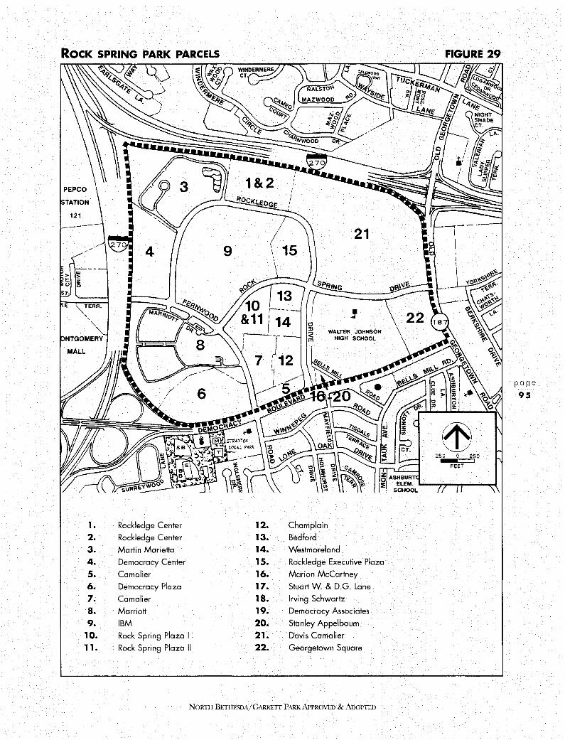
RocK SPRING PARK PARCELS
MALL
1. Rockledge Center
2. Rockledge Center
3, Martin Marietta
4, Democracy Center
s. Comelier
6. Democracy Plaza
1. Camalier
a. Marriott
9. IBM
10. Rock Spring Plaza I
11, Rock Spring Plaza II
12. 13, 14. 1 s. 16, 17. 18. 19. 20. 21. 22.
Champlain
Bedford
WALTER JOHNSON HIGH SCHOOL
Westmoreland
Rockledge Executive Plaza
Marion McCartney
Stuart W. & D.G. Lane
Irving Schwartz
Democracy Associates
Stanley Appelbaum
Davis Camalier
Georgetown Square
NOR11I BETIIESDA/GARRETT PARK APPROVED & ADoPTED
FIGURE 29
250 0 250
FEET
page
95
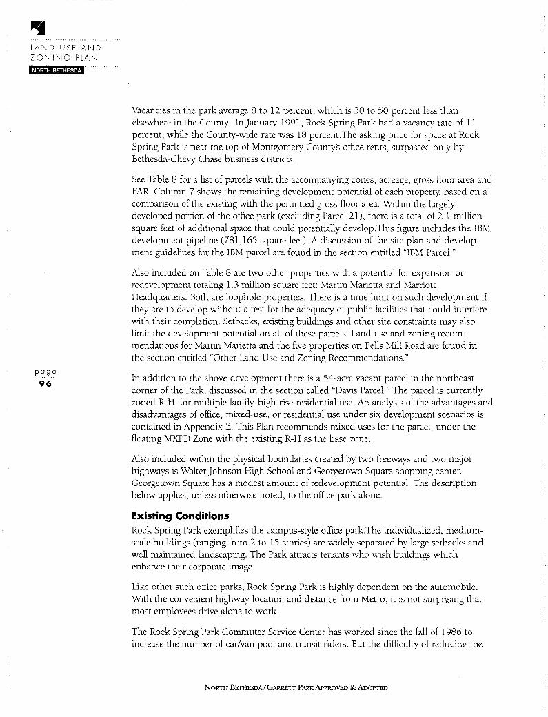
LAND USE AND ZONING PLAN
NORTH BETHESDA
page
96
Vacancies in the park average 8 to 12 percent, which is 30 to 50 percent less than elsewhere in the County In January 1991, Rock Spring Park had a vacancy rate of 11 percent, while the County-wide rate was 18 percent.The asking price for space at Rock Spring Park is near the top of Montgomery Countys office rents, surpassed only by Bethesda-Chevy Chase business districts.
See Table 8 for a list of parcels with the accompanying zones, acreage, gross floor area and FAR. Column 7 shows the remaining development potential of each property; based on a comparison of the existing with the permitted gross floor area. Within the largely developed portion of the office park ( excluding Parcel 21), there is a total of 2 .1 million square feet of additional space that could potentially develop.This figure includes the IBM development pipeline (781,165 square feet). A discussion of the site plan and development guidelines for the IBM parcel are found in the section entitled "IBM Parcel."
Also included on Table 8 are two other properties with a potential for expansion or redevelopment totaling 1.3 million square feet: Martin Marietta and Marriott Headquarters. Both are loophole properties. There is a time limit on such development if they are to develop without a test for the adequacy of public facilities that could interfere with their completion. Setbacks, existing buildings and other site constraints may also limit the development potential on all of these parcels. Land use and zoning recommendations for Martin Marietta and the five properties on Bells Mill Road are found in the section entitled "Other Land Use and Zoning Recommendations."
In addition to the above development there is a 54-acre vacant parcel in the northeast comer of the Park, discussed in the section called "Davis Parcel." The parcel is currently zoned R-H, for multiple family; high-rise residential use. An analysis of the advantages and disadvantages of office, mixed-use, or residential use under six development scenarios is contained in Appendix E. This Plan recommends mixed uses for the parcel, under the floating MXPD Zone with the existing R-H as the base zone.
Also included within the physical boundaries created by two freeways and two major highways is Walter Johnson High School and Georgetown Square shopping center. Georgetown Square has a modest amount of redevelopment potential. The description below applies, unless otherwise noted, to the office park alone.
Existing Conditions Rock Spring Park exemplifies the campus-style office park.The individualized, mediumscale buildings (ranging from 2 to 15 stories) are widely separated by large setbacks and well maintained landscaping. The Park attracts tenants who wish buildings which enhance their corporate image.
Like other such office parks, Rock Spring Park is highly dependent on the automobile. With the convenient highway location and distance from Metro, it is not surprising that most employees drive alone to work.
The Rock Spring Park Commuter Service Center has worked since the fall of 1986 to increase the number of car/van pool and transit riders. But the difficulty of reducing the
NORTH BETHESDA/GARRETT PARK APPROVED & ADOPTED
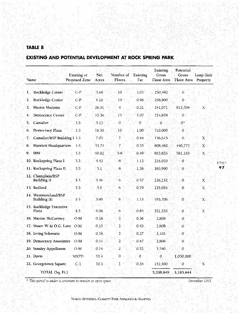
TABLE 8
EXISTING AND POTENTIAL DEVELOPMENT AT ROCK SPRING PARK
Existing Potential Existing or Net Number of Existing Gross Gross Loop Hole
Name Proposed Zone Acres Floors Far Floor Area Floor Area Property
I. Rockledge Center C-P 5.69 10 1.01 250,492 0
2. Rockledge Center C-P 6.16 10 0.96 258,900 0
3. Martin Marietta C-P 26.51 4 0.21 241,071 913,704 X
4. Democracy Center C-P 15.36 15 1.07 714,878 0
5. Camalier 1-3 3.13 0 0 0 0*
6. Democracy Plaza 1-3 16.35 10 1.00 710,000 0
7. Camalier/RSP Building I 1-3 7.05 7 0.44 136,615 0 X
8. Marriott Headquarters 1-3 33.74 7 0.55 808,482 440,775 X
9. IBM 1-3 40.02 3-8 0.49 853,835 781,165 X
10. Rockspring Plaza I 1-3 4.42 8 1.12 216,010 0 page
1 I. Rockspring Plaza II 1-3 3.1 8 1.36 183,990 0 97
12. Champlain/RSP Building II 1-3 5.46 6 0.57 136,152 0 X
13. Bedford 1-3 3.9 6 0.79 135,054 0 X
14. Westmoreland/RSP Building III 1-3 3.90 6 1.15 195,706 0 X
15. Rockledge Executive Plaza 1-3 9.06 6 0.84 331,355 0 X
16. Marion McCartney O-M 0.18 2 0.36 2,808 0
17. Stuart W & O.G. Lane O-M 0.15 2 0.43 2,808 0
18. Irving Schwartz O-M 0.18 2 0.27 2,105 0
19. Democracy Associates O-M 0.14 2 0.47 2,808 0
20. Stanley Appelbaum O-M 0.14 2 0.52 3,180 0
21. Davis MXPD 53.4 0 0 0 1,050,000
22. Georgetown Square C-1 10.3 1 0.34 152,400 0 X
TOTAL (Sq. Ft.) 5,338,649 3,185,644
* This parcel is under a covenant to remain as open space. December 1992
NORTH BE11IESDA/GARREIT PARK APPROVED & ADOPITcD

page
98
ROCK SPRING PARK EXISTING ZONING
PEPCO
STATION
121
a: 0 w b~ > ::!o ~ sr.
KE: TERR.
' '
ONTGOMERY
MALL
8 R-90 Residential, One Family
- R-H
I C-P I C-P
- 0-M
Multiple-Family, High-Rise Planned Residential
Commercial, Office Park
Office Building, Moderate Intensity
WALTER JOHNSON HIGH SCHOOL
R-90
FIGURE 30
250 0
FEET
250
C-1 Convenience Commercial
1-3 Technology and Business Park
NORTH BETIIESDA/GARRETT PARK APPROVED & AnoPTED

ROCK SPRING PARK • PROPOSED BASE / FLOATING ZONES FIGURE 31
PEPCO
STATION
121
' '
ONTGOMERY
MALL
R-90
~ D
G] .
-R-90
R-H/ MXPD
C-P
0-M
Residential, One-Family
Multiple-Family, High Rise/ Mixed Use Planned Development
Commercial, Office Park
Office Building, Moderate Intensity
R-H/MXPD
250 0
FEET 250
- C-1 Convenience Commercial
1-3 Technology and Business Park
NORTII BETIIESDA/GARRETT PARK APPROVED & AnoPTED
page
99
LAND USE AND ZONING PLAN
NORTH BETHESDA
page
100
dependence on the single-occupant automobile is illustrated by the fall in bus ridership that resulted in the termination of the J-5 bus service from Montgomery Village to Rock Spring Park. Though some of the ridership loss appears to have occurred because of layoffs at the Marriott Corporation, the opening of six new lanes on 1-270 eliminated a major source of commuting stress and made it convenient once again to drive alone.
Several factors in the Park encourage single occupant auto use:
• Densities in the Park are low, ranging from 0.14 FAR to 1.36. Densities are one of the most important land use determinants of the modes chosen by commuters.
• There is abundant free or subsidized parking, making it convenient to drive. The land devoted to parking lots or structures separates the buildings and makes walking distances greater. Several buildings provide many more spaces than mandated by County zoning regulations.
• It is inconvenient to use transit or to walk. The Park is two miles from the Grosvenor Metro stop, so transit users must rely on buses, which run every 30 minutes. Pedestrian connections from buildings to bus stops and sidewalks, and also between buildings, are generally poor. The major sidewalks are located next to the road; there are no street trees and few bus shelters.
• The Park currently has an insignificant amount of retail. The combination of limited retail destinations within the Park, an unappealing walking environment, and easily accessible parking means most employees choose to have cars available for noon-time lunches, shopping and other errands.
Rock Spring Park shares other features with campus-style office parks:
• The Parks image is characterized by unrelated sets of buildings, each located in the center of its site with parking more or less successfully hidden in decks behind or below. The buildings are somewhat homogeneous, yet they lack a unifying urban design other than the generous landscaping. When IBM and Martin Marietta located in the Park almost twenty years ago, a more pastoral approach was desired and was in many ways more appropriate to the area than it is today.
• Despite the landscaping there is little usable public open space and no outdoor gathering places where the public feels welcome. The streets, a major public space, offer little more than vehicular access; with no street trees, sidewalks adjacent to the curb, and unlandscaped medians, they allow but hardly encourage pedestrian circulation. Some building sites have provided a somewhat friendlier pedestrian realm, notably the pond next to Martin Marietta, the water garden behind Marriott, the sculpture garden behind Rockledge Center, and the plaza of Democracy Center. These sites, however, are not readily accessible to the public or are primarily visual amenities.
NORTH BETHESDA/GARRETT PARK APPROVED & ADOPTED
• The Park is physically isolated from surrounding communities by the boundary highways. It would be hard for neighborhood residents to get to the area other than by car, even if public attractions existed.
Walter Johnson High School and Georgetown Square Shopping Center sit in one corner of the Park, but are not related visually or functionally to the rest of the Park. Students not only drive to and from school, they also use their cars at noon for lunch at Montgomery Mall or the neighborhood shopping centers.
Development guidelines in the sections on the IBM and Davis parcels are intended to address some of the concerns discussed above. Several of the guidelines and recommendations in the Urban Design, Transportation and Community Facilities chapters are also relevant to the development of this area.
B. IBM PARCEL Site Plan IBM currently has an approved site plan for a total of 1.6 million (1,635,100) square feet. The design calls for five office buildings encircling a formal central park with radial drives providing vehicular and pedestrian access to the park. The geometric pattern of the five buildings is designed to impose a strong visual order on what could otherwise be a set of unrelated architectural events. Building heights will range from 4 to 7 stories, but average 5 stories. There will also be a retail structure with rooftop parking on the southern part of the site. It will provide convenience retail and services for Park employees (as intended by the zone) and will be designed to complement the North Bethesda transitway stop. The approved plans include landscape designs for the site which will add substantial plantings to the existing mature trees.
Development on the site will be staged over the next ten years, allowing construction of one building at a time. The building complex should reinforce the goals of the Master Plan and address some of the urban design deficiencies in Rock Spring Park discussed above: weak urban design relationships between the buildings; the dearth of public open space, the poor pedestrian environment, and the absence of retail uses. The following guidelines reflect the approved site plan and should be used if the existing site plan approval expires or the owners seek a site plan amendment.
Development Guidelines I. Ensure that individual buildings are part of a design scheme that organizes the
elements into a coherent whole. Provide a strong relationship between the form and materials so that the buildings are compatible with each other and are viewed as parts of one building composition.
2. Orient the buildings to create a significant open space that is not only a visual focal point but also highly accessible to and usable by the public.
NORI1! BETIIESDA/GARRETl' PARK.APPROVED &ADOPTED
page
101
LAND USE AND ZONING PLAN
NORTH BETHESDA
page
102
c.
3. Provide pedestrian links between all sides of the central public park and other pedestrian destinations along the exterior roadways.
4. Provide an easement for future dedication of all necessary right-of-way for the North Bethesda Transitway and a station along the southern portion of the site. The right-of-way should allow for a bikeway and bus pull-off at the transitway station.
5. Coordinate the design of the retail structure with that of the transit station to create a focal point of activity and vitality in Rock Spring Park and a link to the central public park.
6. Accommodate to a reasonable extent the reconfiguration of the Femwood Road/Rock Spring Drive intersection to allow uninterrupted east-west flow along the southern boundary of the IBM site. Provide right-of-way for a sidewalk.
7. Provide streetscape elements along the realigned road, including sidewalks, street trees, benches, bus shelters, and other streetscape elements.
8. Explore with adjacent property owners and public agencies the opportunity for creating a small public park or landscaped island on land "left over" from the road realignment.
DAVIS PARCEL The major undeveloped site in Rock Spring Park is the 54-acre Davis parcel. The existing zoning is R-H (multiple family, high-rise residential). This Plan recommends retaining R-H as the base zone, and MXPD (Mixed Use Planned Development) as a floating zone.
Development Guidelines Under the MXPD option, careful design will ensure that the 54-acre parcel becomes the urban village center for this area of North Bethesda, creating a more pedestrian friendly, transit serviceable environment with the housing and retail on the Davis parcel linked to the offices in the remainder of the Park.
In order to ensure the realization of the land use, transportation, environmental and urban design objectives of the Plan in a comprehensive vision for the site, development should adhere to the following guidelines:
Phasing
1. Defer subdivision approval until County adequate public facilities requirements have been met.
2. Provide significant residential development in the first phase of construction.
3. Prior to the issuance of the building permit for the second office building, a community center must be operational or its construction must have started.
NORTH BETHESDA/GARRETT PARK APPROVED & ADOPTED
4. Upon rezoning of the property to the MXPD Zone for the development provided for in this Plan, the landowners will agree to lease the existing estate house to the County for use as an interim community center. Subsequently, as part of the development of the site, the Davis estate house would be used for some purpose such as a day-care center, conference center, meeting place, or other uses to serve residents and/or employees consistent with the covenant upon this land.
5. Dedicate land that is adequate for the following facilities:
a. Direct access ramp(s) from 1-270 near Old Georgetown Road and the roadway connection from the ramp to Rockledge Drive.
b. The North Bethesda Transitway (See #18.)
c. A community center, generally on the southern edge of the central woods or other appropriate location. The site should be adequate to accommodate a 23,000 square foot structure.
d. Streets leading to the community recreation center and to major open spaces in order to ensure public access to these facilities and amenities.
Affordable Housing
6. Develop a proposal for a creative, employer-sponsored or supported employee housing program, to serve employees of the Park and nearby locations. Implementation of a program devised in conjunction with agencies such as the Housing Opportunities Commission, the Housing and Community Development Department of Montgomery County or the State of Maryland is strongly encouraged.
7. Require the construction of 226 MPDUs (22 percent of the base housing component of 1,024 units) as part of the development plan approval for the MXPD Zone.
Office and Retail Use
8. Provide approximately 150,000 square feet of retail space designed to serve not only the residents in the development but also the employees and residents of the surrounding communities. This amount may be increased up to a maximum of 220,000 square feet provided any increase above 150,000 square feet would require an equal reduction in the office floor area. The public community recreation center is not counted as retail or office space.
9. Provide a maximum 900,000 square feet of office space. Incorporate site amenities and design features which will ensure compatibility with the remainder of Rock Spring Park and with on-site residential and retail uses.
NORTII BETIIESDA/GARRETI PARK APPROVED & ADOPTED
page
103

LAND USE AND ZONING PLAN
NORTH BETHESDA
page
104
10. Preserve a significant portion of the woods in the center of the site for public use and enjoyment. The woods may be modified and enhanced but may not be removed. The Plan encourages location of the public community recreation center on the southern side of the woods or in another appropriate location.
11. Retain the open space around the estate house (subject to an existing covenant) and utilize the house for an accessory use such as a day care center, conference center or meeting space. Recreation uses on the site are also encouraged. Provide for use of the existing estate house as an interim community center.
12. Incorporate the stream corridor into the urban design. Use the land in the northwest comer of the site for stormwater management.
13. Develop and maintain a visual buffer of woodlands along 1-270 to screen the new development.
14. Create a linked open space system, subject to a public use easement, including the stormwater management area, central woods and estate house grounds, along the northwest to southeast diagonal axis of the site.
15. Provide pedestrian/bicycle paths through the site, linking the central woods and community center with Walter Johnson High School.
16. Organize the site plan around the two diagonal axes through the site which intersect in the central park. Take advantage of the potential to locate landmark buildings where the view axes of north and southbound Old Georgetown Road intersect. ( See Figure 4 7.)
1 7. Provide an open space and park system on a minimum of 40 percent of the site area.
Circulation and Parking
18. Accommodate the North Bethesda transitway and station in development of the site. The preferred alignment of the transitway is on the southern edge of the site (along the north right-of-way line of Femwood/Rock Spring Drive). Flexibility should be retained for the precise alignment along the eastern edge of the property, but the final design should be compatible with the estate house and grounds. The station should be sited north of the Georgetown Square Shopping Center to serve the new development, existing shopping centers, and high school. The alignment must be shown on the development plan. The final alignment will be determined at site plan review, and must be coordinated with the easement provided by IBM on the parcel to the west.
19. Coordinate major access points with existing development, and ensure safe ingress and egress to Walter Johnson High School.
20. Create a fine-grained grid of streets open to the public at a size that will result in urban-scale blocks. Locate parking garage entrances and loading docks in a
NORTII BETHESDA/GARRETT PARK APPROVED & ADOPTED

manner to minimize interruptions to the retail frontage along the streets.
21. Provide most of the parking in structures. (Some surface parking will be required for residential and retail uses.) Also provide some parking on-street in order to ensure streets with an urban character.
Building Location, Height, and Use
22. To ensure a lively pedestrian environment, provide public spaces adjacent to the streets. For the most part, locate buildings adjacent to both sides of the street (except those on the central park).
23. Provide a mix of building heights. Locate the high buildings on the central park or at the southwest comer of the site, with the highest buildings on the northeastsouthwest axis. Reduce heights and visibility of structures to Luxmanor by stepping down building heights towards Luxmanor and by including appropriate screening and architectural treatment to break up massing.
24. Locate a significant portion of the retail along the southern portion of the site to relate to Georgetown Square Shopping Center.
25. The bulk of the retail should be sited in the southeast segment of the site with visibility to Rock Spring Drive. This retail siting is designed to enhance the pedestrian connection along Rock Spring Drive between the offices to the west and the shops and apartments to the east and to reinforce the role of Rock Spring Drive as the main spine of Rock Spring Park. The location of retail is intended to attract the pedestrian to the central park and recreational facilities.
C. OTHER LAND USE AND ZONING RECOMMENDATIONS 1. Martin Marietta The Martin Marietta parcel is currently zoned C-P. The zone does not have a specified FAR, but the height/setback/coverage requirements could result in an FAR of as much as 1.25; an FAR of 1 is more realistic, given the site constraints. The existing building has an FAR of .21; thus the owners of the property could expand their existing floor area very substantially by adding up to 913,704 square feet. Martin Marietta has registered as a loophole property
If public policy makes it advisable to reduce the development potential on the site because of the increase in traffic that would be generated, there are several options but none that is very satisfactory Much of the Park is zoned 1-3, but the 1-3 is a floating zone, with a maximum FAR of 0.5, and there would be no incentive for the owner to apply for rezoning. The R&D (Research & Development) Zone has an FAR of 0.3 or up to 0.5 with the Optional Method and is a Euclidean Zone-allowing the Council to impose a zone by Sectional Map Amendment. But the R&D Zone is designed to allow low scale flexible space for a variety of types of research and development, not for general office use; no more than 50% of the gross floor area may be used for office.
N01m1 BETIIFBDA/GARRETT PARK APPROVED &ADOPTED
page
105
LAND USE AND ZONING PLAN
NORTH BETHESDA
page
106
It would be inappropriate to initiate a zoning text amendment to change the FAR of the C-P Zone itself (as done with the 1-3 Zone), since Rock Spring Park is one of only two locations in the County where the zone is in use. Moreover, the adjacent properties zoned C-P would become nonconforming: Rockledge Center has FARs of 1.01 and 0.96, and Democracy Center an FAR of 1.07. The arguments for confirming the existing C-P Zone are that three of the four properties are unable or unlikely to redevelop, leaving only the Martin Marietta property with the possibility of expansion. The site has unexcelled highway access and the possibility of a high quality transit connection to Grosvenor Metro. The property clearly conforms to the office use for which the existing zone was designed, and it sits in an office park that has been designated as an employment center for over 30 years.
The Plan recommends confirming the existing C-P Zone.
2. Five Properties on Bells Mill Road Stub There are five converted houses on a stub of Bells Mill Road southwest of Walter Johnson High School. They are currently zoned O-M. The purpose of O-M is "to provide locations for moderate-intensity office buildings in areas outside of central business districts. It is intended that the O-M Zone be located in areas where high-intensity uses are not appropriate, but where moderate intensity office buildings will not have an adverse impact on the adjoining neighborhood. This zone is not intended for use in areas which are predominantly one-family residential in character." The zone allows a maximum FAR of 1.5.
The Plan recommends confirming the existing O-M zoning with a development cap of 0.5 FAR over the entire site.
3. Other Parcels The Plan recommends confirming the existing zoning on all other parcels zoned 1-3 or C-P
NORTH BETHESDA/GARRETT PARK APPROVED & ADOPTED
URBAN DESIGN PLAN
Chapter 4
URBAN DESIGN PLAN
4. 1 OVERVIEW
A. CHAPTER ORGANIZATION Urban Design issues are intertwined with all the other components of the Master Plan. Both discussion of these issues and recommended guidelines to address them appear in this chapter. To provide a frame of reference, the chapter begins with an introduction to an urban design vocabulary. Using this language, the text presents a description of North Bethesda and a set of urban design objectives for realizing the vision for the planning area. The text then contains an analysis and guidelines for each of the following geographic areas: Rockville Pike Corridor as a whole; Twinbrook/Montrose Crossing, White Flint, Grosvenor, and Rock Spring Park. The last section discusses streetscape concepts for a range of proposed street types.
B. AN URBAN DESIGN LANGUAGE The central urban design problem of suburbia, especially true of the Rockville Pike area in North Bethesda, is legibility: it is hard to perceive or "read" any distinctive pattern. Decades of unbridled sprawl have slowly produced visual chaos and eroded societys image of the ideal urban or suburban pattern.
Kevin Lynchs landmark book "The Image of the City" redefined the patterns and provided a language for reading, analyzing and designing cities. His pattern types are used to structure this Plan's urban design analysis and recommended guidelines. They are as follows:
Path: Any line of movement in any mode.
Node: Any concentration of movement or focal point of activity:
District: Any area with a common identifying characteristic.
Edge:
Landmark:
Any barrier to transverse movement or boundary of any district.
Any visual aid to navigation or any feature that provides symbolic meaning to its surroundings.
NORTH BETIIESDA/G,\RRETT PARK APPROVED & ADOPTED
URBAN DESIGN PLAN
NORTH BETHESDA
These five pattern types create a structure for most of the issues facing urban designers. They apply to all scales of planning; for example, a path can be as large as Rockville Pike or as small as a sidewalk.
C. DESCRIPTION OF NORTH BETHESDA-GARRETT PARK
page
108
North Bethesda-Garrett Park contains attractive residential districts and a broad spectrum of commercial uses, but the development pattern promotes a heavy reliance on the automobile at the expense of transit users, pedestrians and bicyclists. The various uses are spread thinly across the planning area. The edges of most neighborhoods are bounded by heavily traveled paths, and most commercial areas are poorly connected to one another or to the neighborhoods except by car.
There are three major transit stations in North Bethesda, but these transportation nodes do not coincide with activity nodes. Centers of activity, such as shopping centers and community facilities, are not, for the most part, convenient to transit stops; one of the few exceptions is the Aquatic Center, which is near the White Flint Metro station. Moreover, the nodes are hard to find because there are no clear landmarks differentiating the node from the surrounding commercial area and helping to give it a unique character. The dispersal of the nodes amid the visually cluttered commercial area along Rockville Pike, and the lack of landmarks make navigation difficult; people must develop their own techniques for finding the nodes.
Many of the districts in North Bethesda, especially in the sprawling commercial areas along Rockville Pike, also lack a strong identity They do not provide residents and visitors a sense of place. The edges between one district and another overlap or are not clearly defined; they fail to reinforce the sense of a cohesive district.
There are both commercial and residential districts, and districts of varying sizes. The districts that are the easiest to recognize are those that can be read at an automobile scale; for the pedestrian, there are few legible districts within these larger auto-dominated areas. The commercial areas tend not to include residential uses, and the residential areas are characterized by a single housing type: one-family detached, townhouse (one-family attached), garden apartment, or high-rise apartment. Many residential neighborhoods have no central focal point such as a civic or retail space, and the path network, auto and pedestrian, is unfocused.
There are several problems with the path system (the Metro and MARC transit lines, the streets, the bicycle paths, and the sidewalks). The street system is confusing, even to residents. The most easily recognized path in the area is Rockville Pike, but finding a particular business or cross street is a challenge; shopping center signs become more important aids to navigation than street signs. Moreover, the network of streets in nonresidential areas is too coarse; there are surprisingly few streets for such a large area. This means that some streets have to carry too much traffic because there are few, if any, alternate routes.
The over-sized blocks result in massive developments that are out of scale with pedestrians, and the heavily traveled paths deter walking. Pedestrians, as well as cyclists,
NORTH BETI-IESDA/GARRETI' PARK APPROVED & ADOPTED

have too few ways to get conveniently and pleasantly to the Metro stops, so transit is under-used. The two largest paths, Rockville Pike and the MARC/CSX railroad line, act as barriers to pedestrian movement.
In addition to paths for commuters, there is also a need for recreational paths. Elements of a bikeway system exist, but there is potential to expand it and to link many of the amenity features of the planning area together so that more people can enjoy them, without using their cars.
D. URBAN DESIGN FRAMEWORK FOR NORTH BETHESDA-GARRETT PARK The proposed urban design framework for North Bethesda is illustrated by Figure 32 (Planning Area Concept Diagram). The recommended structure for the planning area will use the existing north-south transit line (Metro) and the proposed east-west transit line (the Grosvenor transitway) to organize the areas structure. The Plan provides for new development within districts focused around transit nodes. The objective of the nodal pattern is to establish a balance between auto and transit access by designing for non-auto movement within walking distance of transit stops. In order to encourage transit use, it is advisable to have people living and working nearby and to make it convenient and pleasant for them to use the transit stop without driving.
The main yardstick for establishing the size of transit-accessible districts is maximum walking distance. Design objectives focus on streetscape and public space improvements. Objectives addressed in more detail in other chapters of the Plan are also critical; for example, land use and zoning recommendations for mixed-use or high density residential use at the transit stops, and transportation recommendations for shuttle buses, bike routes and sidewalks to feed the transit system.
E. URBAN DESIGN OBJECTIVES I. Combine activity nodes and transit nodes by locating new development
and a variety of activities at or near transit stops.
2. Provide legibility and a unique identity to districts by defining their edges, providing them with landmarks, and developing nodes as a focus for civic, recreational, residential and commercial activity
Use historic and natural features as landmarks to give a sense of place and unique identity to each district.
4. Add local streets to create a more interconnected local street network and reduce the size of blocks in high intensity areas.
5. Greatly improve the pedestrian friendliness of new and existing streets, particularly within walking distance of transit nodes, and increase the number of pedestrian and bicycle routes to transit.
6. Overcome the barrier characteristics of existing edges to facilitate pedestrian movement.
NoRnI BE1HESDA/GARRETr PARK APPROVED & ADOPTED
page
109

page
110
PLANNING AREA CONCEPT DIAGRAM
. • . .
.:t.,,-.,, \ .i ;· 1-/L, •••• .-...
f
:• ., .. .. z• . .. .. •• •• . , .· .. • .. " ... · . ................... l
PATH (Any Major Thoroughfare in any mode)
LANDMARK (Any Commonly Used Aid to Navigation)
EDGE (Any Barrier to Transverse Movement)
NODE (Any Focus of Movement or Activity)
DISTRICT (Any Area With a Common Characteristic)
FIGURE 32
' .. ' ······ ..... .. .. ~ . ~ .
•.. r, /JI •,i ; -7 ,, .. ,,.,,..,,· ,,·. !'JJ~ \ .... \ .... '
i. -~ •
Yrt1i \ i If;, '• • '"Vol~/~ ; 'I;¼ /\ ~ ... \ ~ ' '
'~·-···. 'l!J.1/ •• ~ .. .-, t,;• • •• l \ .... ,!,:"•. •• • • ,~ -..v.0, •• • .... :. ,/h1,··· •
•• •• •• ..... "".l/11 .. ' .... -...;. -./~,. . ·?·.. 'lff}}.. \ : .\ ··0.·· -•
.............. \ 'lfl;:-...:. •••••••••• '-:,l/1 6flQJ1111o/.•. '°'=· \ 11
1;,'l.1. '/ ..... • 'l.1 ........ ~.... l!J --~.--~ • ) 1/ 01,
1 ,••' CSX ~-4; :· •• .. • • • f"PtC,t£, ~.Q
/ I///
North
-k /#/$$/.#///#'//////,,
~~~
NORTI-I BETIIESDA/GARRETI PARK APPROVED & AnoITED

7. Create a greenway system linking residential, commercial and employment centers with natural areas, parks, and community and cultural facilities.
4.2 ROCKVILLE PIKE CORRIDOR
A. IMAGE Main Street for Cars
B. DESCRIPTION The section of Rockville Pike within the North Bethesda-Garrett Park Planning Area has two distinct parts: the segment south of White Flint Mall and the segment from the Mall north. The latter is an auto-oriented marketplace offering a variety of goods and services and a few enclaves of housing; it is characterized by low buildings and an occasional high-rise scattered across large expanses of parking, generally located adjacent to the Pike. The green character of the southern corridor contrasts markedly with the suburban shopping strip to the north. It contains residential uses and two large campuses with extensive open space, Strathmore Hall and Georgetown Preparatory School.
The Pike is dominated by through traffic and traffic resulting from local circulation. The three Metro stops are the focus of transit activity, both bus and rail, but the Pike is a hostile environment for pedestrians trying to reach the Metro stops. In spite of the activity along the Pike and the presence of nearby neighborhoods, there are no focal points for the communities where many activities might converge and discrete neighborhood identities might find expression.
C. OPPORTUNITIES AND CONSTRAINTS The Rockville Pike corridor as a whole contains several opportunities to achieve one of the main goals of the Master Plan: the creation of attractive transit serviceable neighborhoods, linked to one another, at the three Metro stops and at a proposed new MARC stop. There are also constraints that will affect the realization of this goal. Figure 33 illustrates the main opportunities and constraints in the Rockville Pike corridor.
There are several opportunities of special note. Existing tree stands at White Flint and Grosvenor can be incorporated into urban parks. A greenway system including hikerbiker trails can be developed between Rock Creek Park and the White Flint Metro station, linking the park with many of the existing and proposed cultural and community resources including Strathmore Hall Arts Center, the Georgetown Prep campus, and the Aquatic Center. It can link up, via Executive Boulevard, with the proposed greenway in the Montrose Parkway right-of-way (See Transportation, Community Facilities, and Environmental chapters.)
There are a number of opportunities for creating gateways to the North Bethesda area and to each of the centers along the Rockville Pike corridor. These include the existing and
NORTII BETIIESDA/GARRETr PARK APPROVED & ADOPTED
page
1 1 1
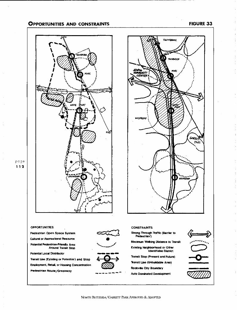
page
1 1 2
OPPORTUNITIES AND CONSTRAINTS
< ~~, \ ~ \ \ I I
I I I
OPPORTUNITIES
Pedestrian Open Space System
Cultural or Recreational Resource
Potential Pedestrian-Frlencly Area Around Transit Stop
Potential Local Distributor
Transit Line (Eicisting or Potential) and Stop
Employment, RetaH, or Housing Concentration
Pedestrian Route/Greenway
~ • .. .,. .............
-----' 0 ) ------------
. . . 1. •• ..
CONSTRAINTS
• . ... ......
Strong Through 'li'affic (Barrier to Pedestrian)
Maximum walking Distance to 1i'anslt
Existing Neighborhood or Other Identifiable District
Transit Stop (Present and Future)
Transit Line (Unbuildable Area)
Rockville City Boundary
Auto Dominated Development
NORTH BETHESDA/GARRETT PARK APPROVED & ADOPTED
FIGURE 33
~ D ·······. .. . .. c:::> -0-_ .. _ ~

proposed residential towers at Grosvenor, the Twinbrook Parkway approach from Kensington, the proposed Nicholson Lane overpass at Rockville Pike, streetscapingjust south of White Flint Mall on the Pike and the grade-separated intersection proposed at Montrose Parkway and Rockville Pike.
Existing elements that can serve as landmarks include the white rock outcrops in the White Flint area, the parkland south of the Grosvenor area, the historic Montrose School on Randolph Road, the campus landscape associated with Georgetown Preparatory School and Strathmore Hall, existing tall buildings along the Pike, and the few remaining tree stands within developed areas.
In addition to these opportunities, there are also many constraints to achieving urban design objectives. The auto-dominated pattern of commercial development in the northern corridor runs counter to the main objective of creating pedestrian-friendly precincts around transit stops. The walking distances are often fairly long between transit stations and existing development. Existing sidewalks are narrow and are located next to lanes of moving traffic. Pedestrians must cross large parking lots to reach building entrances, and must negotiate long crosswalks in conflict with turning vehicles.
A density transition must be provided between the higher density developments proposed near transit stops and existing low-density neighborhoods. Streams and woodlands, while offering opportunities, are also constraints to development. The heavy traffic on Rockville Pike, Montrose/Randolph Road, and the MARC railroad line impede pedestrian movement. Restrictions on building over the Metro line represent a significant constraint to planning the Montrose Crossing area, while the barrier constituted by Rockville Pike between Marinelli Road and Old Georgetown Road severely constrains the unification of the east and west halves of the White Flint node.
Finally, the Rockville municipal boundary is a planning constraint. Although the Twinbrook node functions as one entity, part of it is within the City of Rockvilles planning jurisdiction.
An area of special concern on the Pike is the Montrose Road/ Randolph Road and Rockville Pike intersection. This intersection is characterized by parking lots, a disorganized collection of signs, congested traffic patterns and few buildings or trees. It is uninviting to the pedestrian, although people cross regularly to use the shopping centers to the east and south of the intersection. With transportation improvements to the intersection to facilitate east-west traffic flow, this area could become a true no-mans land for those on foot.
As this area redevelops, emphasis should be on creating pedestrian-friendly neighborhoods to the north and south. Those neighborhoods could have excellent pedestrian access to Twinbrook/Montrose Crossing and White Flint. Therefore, the Montrose/ Randolph Road intersection could function as a divider between two pedestrian-friendly neighborhoods. The area or edge immediately adjacent to the intersection could be used for future parking garages and auto-oriented uses to keep them out of the pedestrian
intensive transit nodes.
NORTII BETHESDA/G,\RRETI PARK APPROVED & ADOPTED
page
1 1 3

URBAN DESIGN PLAN
NORTH BETHESDA
D. A COMPARISON OF SELECTED URBAN PATTERNS ON ROCKVILLE PIKE WITH BETHESDA CBD AND WASHINGTON, D.C.
page
11 4
Comparing Rockville Pike with the Bethesda Central Business District and Washington, D.C. highlights the disorganization of the Pike area. Figure 34 compares the urban design elements of paths, nodes, districts, edges, and landmarks in the three areas. Distinctively urban in character and higher in density, Bethesda CBD and Washington, D. C., have a composition of patterns that produce legible and cohesive urban designs and a strong sense of place. In contrast, the uncoordinated urban design patterns in the Rockville Pike area do not combine to create a coherent, legible image.
• Street Network: The Street Network Comparison (Figure 35) contrasts the coarse network of the Rockville Pike area with the finer grids of the Bethesda CBD and Washington, D.C. A finer network allows for easy pedestrian use of the sidewalk system for movement throughout the area. It allows for many route options for vehicles and, therefore, more dispersed traffic and fewer turning movements at each intersection to interfere with pedestrian crossing. It provides more street frontage, precluding the need for interior-block pedestrian paths.
• Parking: The function and appearance of the Rockville Pike area is a dramatic reflection of the dominance of the car. Surface parking lots abound. The expanse and location of pavement discourages people from walking from place to place, while the prevalence of free surface parking further discourages use of transit. The Parking Comparison in Figure 36 highlights the contrast between the Pike and the more urban, pedestrian-friendly areas where much less area is devoted to free surface parking.
• Building Height: Building heights along the Pike reflect an intensity of use that is much too low to take full advantage of transit and too random to help create visual order. On Figure 37, the disorder of the Rockville Pike area is apparent when compared to the Bethesda CBD and Washington, D.C., where taller buildings are placed to form clusters or focal points. A more intense development pattern of taller buildings, closer to the street would express an urban fabric and establish visual order, while ensuring an efficient use of transit infrastructure and a humane pedestrian environment.
• Main Street: Rockville Pike is not a traditional main street in spite of the presence of housing, supermarkets, restaurants and a host of other uses that are main street ingredients. Although it carries a flood of traffic and provides access to an economically healthy mix of regional uses, Rockville Pike falls far short of the intensity of use that brings life to a traditional main street. The excessive distance between buildings fronting the Pike is clearly illustrated in the Main Street Comparison in Figure 38, where Rockville Pike is compared to several successful "main streets" of comparable length and width which are known for their vitality: the Champs Elysees in Paris, Pennsylvania Avenue in Washington, D.C. and Michigan Avenue in Chicago. Because of the Pikes
NORTH BETHESDA/GARRETT PARK APPROVED & ADOPTED

URBAN DESIGN COMPARISON (EXISTING CONDITION}
... , ..
PATH (Any Major Thoroughfare)
LANDMARK (Any Commonly Used Aid to Navigation)
EDGE (Any Barrier to Transverse Movement)
NODE (Any Focus of Movement or Activity)
DISTRICT (Any Area With a Common Characteristic)
. .. . ... _.... .. :
.. . l
... .. .. f
FIGURE 34
,,
~==$) -k
/#///0/#///$///////
i$~~
.·•··· :.;
:
NORTII BETHESDA/GARRETT PARK APPROVED & ADoPTED
page
1 1 5

page
1 1 6
STREET NETWORK COMPARISON (EXISTING CONDITION) FIGURE 35
,n-, I
IAI I l ....... I I I I \r-1 ~w
I. A I I \ \ , r ...........
0 __, .... ...... u.. ,,_. -lf : ......
~ .... ~ ~,/ ....... ~ - • I V ---,-
LJ ~ _.,I
\ - ~ ~ j.() --
~
I\ ii\ t---- >- \ "'""-r ' ~ \ ,-
''( ..-:::. ---- .J ~ \ ..,- - i/" J-..:_
ill~~~-/ '
""'Ill! ... --..........
r1- '" ""I!!! I I I \ T -x- ' '\( ~b' I 111 I I I
The finer networks of Bethesda and Washington allow for comfortable
pedestrian use and many route options for vehicles. This pattern means more
dispersed traffic and fewer turning movements at each intersection to conflict
with pedestrians in the crosswalks.
NoRm BETI-IESDA/GARRETT PARK APPROVED & ADOPTED

PARKING COMPARISON (EXISTING CONDITION) FIGURE 36
• • q l. - ••
I'
...
!:I; ... I
• • - .. • I .
"\-II
'-..;J
II ., -= ... ~---
.. .. 'l""' ..
- fn ,- :::iT'll", " • .. j ..... , ,-,- ,__ ..
'\ .- o I , _. • 1111
Free surface parking lots abound, encouraging overuse of automobiles and
discouraging pedestrians. This means less use of transit and considerable
environmental degradation, along with a lack of sense of place.
N01m1 BETHESDA/GARRETT PARK APPROVED & ADOPTED
.. l ,.
..
page
11 7

page
1 1 8
BUILDING HEIGHT COMPARISON (EXISTING CONDITION) FIGURE 37
ROCKVILLE PIKE
BETHESDA CBD
]
·.1r.t> • :c:.::; .• -.i:: 1\ml !:I::::::::::
·:.~:i _;_.4,1!, !
WASHINGTON, DC
0 1-4 Stories
• Over 4 Stories
The pattern of tall buildings in Bethesda and Washington creates a strong, legible
environment in scale with the pedestrian. It is no accident that Security Lane and
Executive Boulevard are the most pleasant commercial streets in North Bethesda;
the buildings are organized along these streets.
NORTH BETHESDA/GARRETT PARK APPROVED & ADOPTED
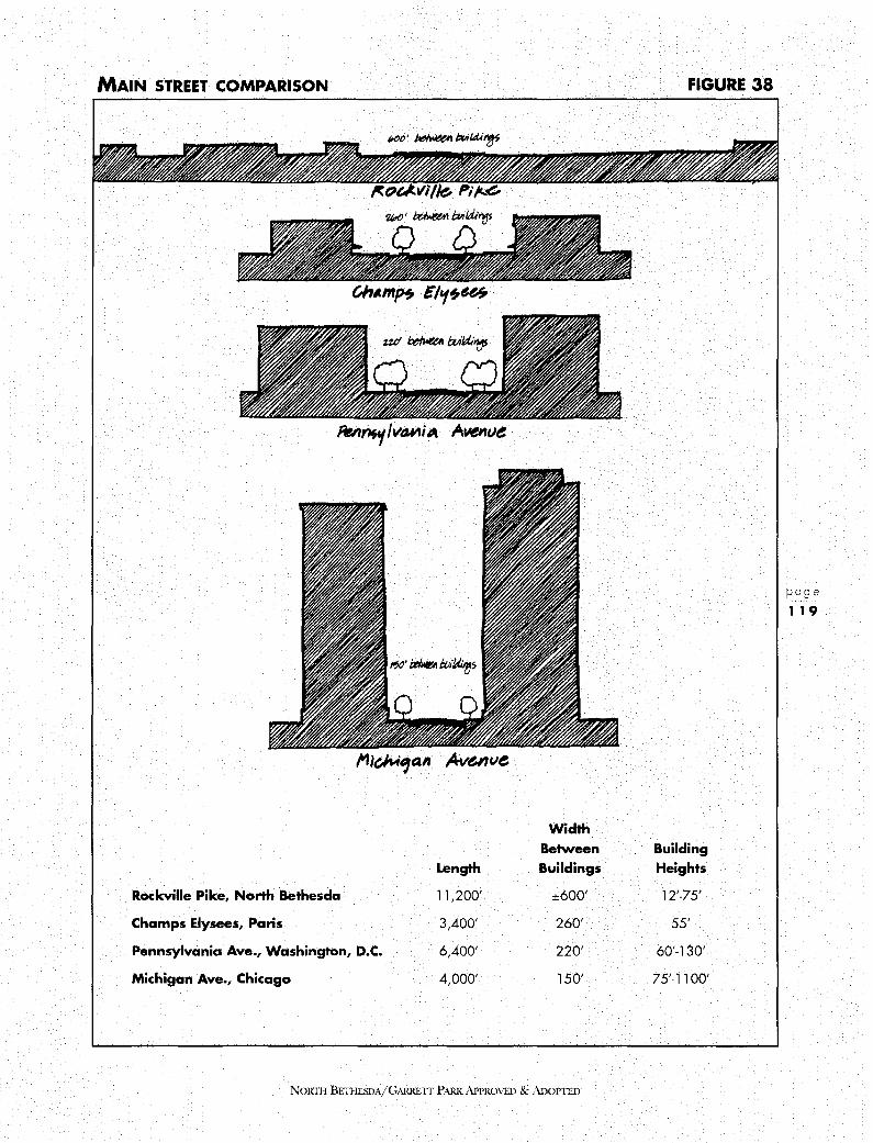
MAIN STREET COMPARISON
Width Between
Length Buildings
Rockville Pike, North Bethesda 11,200' ±600'
Champs Elysees, Paris 3,400' 260'
Pennsylvania Ave., Washington, D.C. 6,400' 220'
Michigan Ave., Chicago 4,000' 150'
NORTII BETHESDA/GARRETT PARK N'PROVED & ADOPITD
FIGURE 38
Building Heights
12'-75'
55'
60'-130'
75'-1100'
page
119

page
120
ROCKVILLE PIKE STREET SECTIONS {EXISTING) FIGURE 39
These sections illustrate the difficulty of trying to establish any single image for the entire length of the Pike. Instead, the transit-oriented nodes would allow different images to be developed for each district, thus breaking the vast area into visually coherent parts.
NORTH BETHESDA/GARRETT PARK APPROVED & ADOPTED
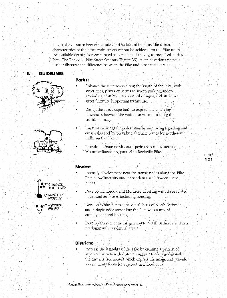
length, the distance between facades and its lack of intensity, the urban characteristics of the other main streets cannot be achieved on the Pike unless the available density is concentrated into centers of activity, as proposed in this Plan. The Rockville Pike Street Sections (Figure 39), taken at various points, further illustrate the difference between the Pike and other main streets.
E. GUIDELINES
I I
I
• ~{WINfWll'.l< • 111Ul.n · tJOot;;5
1<" Wl-lllb r::-LJW( ~!ltl/£5
Paths:
•
Enhance the streetscape along the length of the Pike, with street trees, plants or berms to screen parking,undergrounding of utility lines, control of signs, and attractive street furniture supporting transit use.
Design the streetscape both to express the emerging differences between the various areas and to unify the corridor's image.
• Improve crossings for pedestrians by improving signaling and crosswalks and by providing alternate routes for north-south traffic on the Pike.
• Provide alternate north-south pedestrian routes across Montrose/Randolph, parallel to Rockville Pike.
Nodes: •
•
Intensify development near the transit nodes along the Pike . Retain low-intensity auto dependent uses between these nodes.
Develop Twinbrook and Montrose Crossing with three related nodes and auto uses including housing.
• Develop White Flint as the visual focus of North Bethesda, and a single node straddling the Pike with a mix of employment and housing.
• Develop Grosvenor as the gateway to North Bethesda and as a predominantly residential area.
Districts: • Increase the legibility of the Pike by creating a pattern of
separate districts with distinct images. Develop nodes within the districts (see above) which express the image and provide a community focus for adjacent neighborhoods.
NORTil BETHESDA/GARRETT PARK APPROVED & ADOPTED
page
1 21
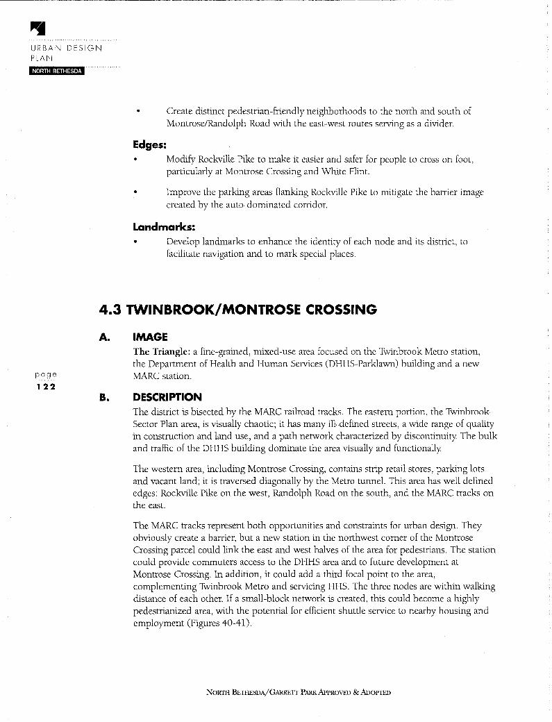
URBAN DESIGN PLAN NORTH BETHESDA
• Create distinct pedestrian-friendly neighborhoods to the north and south of Montrose/Randolph Road with the east-west routes serving as a divider.
Edges: • Modify Rockville Pike to make it easier and safer for people to cross on foot,
particularly at Montrose Crossing and White Flint.
• Improve the parking areas flanking Rockville Pike to mitigate the barrier image created by the auto-dominated corridor.
Landmarks: • Develop landmarks to enhance the identity of each node and its district, to
facilitate navigation and to mark special places.
4.3 TWINBROOK/MONTROSE CROSSING
page
122
A.
B.
IMAGE The Triangle: a fine-grained, mixed-use area focused on the Twinbrook Metro station, the Department of Health and Human Services (DHHS-Parklawn) building and a new MARC station.
DESCRIPTION The district is bisected by the MARC railroad tracks. The eastern portion, the Twinbrook Sector Plan area, is visually chaotic; it has many ill-defined streets, a wide range of quality in construction and land use, and a path network characterized by discontinuity The bulk and traffic of the DHHS building dominate the area visually and functionally
The western area, including Montrose Crossing, contains strip retail stores, parking lots and vacant land; it is traversed diagonally by the Metro tunnel. This area has well defined edges: Rockville Pike on the west, Randolph Road on the south, and the MARC tracks on the east.
The MARC tracks represent both opportunities and constraints for urban design. They obviously create a barrier, but a new station in the northwest comer of the Montrose Crossing parcel could link the east and west halves of the area for pedestrians. The station could provide commuters access to the DHHS area and to future development at Montrose Crossing. In addition, it could add a third focal point to the area, complementing Twinbrook Metro and servicing HHS. The three nodes are within walking distance of each other. If a small-block network is created, this could become a highly pedestrianized area, with the potential for efficient shuttle service to nearby housing and employment (Figures 40-41).
NORTII BETHESDA/GARRETT PARK APPROVED & ADOPTED

C. GUIDELINES Paths: • Develop pedestrian and vehicular patterns to connect existing
and proposed neighborhoods and to feed the existing Metro stop and proposed MARC stop.
• Complete and refine the small-block network east of the MARC/Metro tracks.
Develop shuttle routes connecting HHS, and the Twinbrook Metro and MARC stations.
Develop an interconnected path network to allow for the possibility of a shuttle bus route between White Flint Mall, the Twinbrook Metro and MARC stations, and White Flint Metro.
• Provide an east-west connection with greatly enhanced streetscape from Rockville Pike to the new MARC station.
• Develop Fishers Lane and Parklawn Drive between the HHS building and the Twinbrook Metro station to serve as major pedestrian routes.
• Enhance the streetscape of Washington Avenue between the HHS building and the MARC station to serve as a major pedestrian route.
• Provide a network of new streets at Montrose Crossing. Interconnect the grid south to the White Flint districts grid, and west across Rockville Pike. Locate the streets to accommodate a gradual transition of existing businesses to new, mixed-use patterns in the vicinity of the proposed MARC station.
Nodes: • Focus urban-density development in the northeast corner of
Montrose Crossing, near the proposed MARC station and within walking distance of Twinbrook Metro.
Provide an urban open space and a convenience retail focus near the Twinbrook Metro station for the existing neighborhood to the north and the future transit-oriented residential units to the east.
• Provide an urban open space and a community/retail focus at Montrose Crossing for the existing neighborhood to the west and future residential development.
NORTH BETIIF.SDA/GARRETf PARK.APPROVED & AnoPTFn
page
123
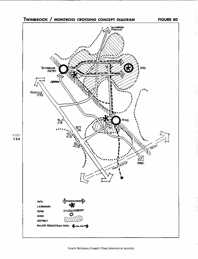
TWINBROOK / MONTROSE CROSSING CO NCEPT DIAGRAM
•••••• • • • • •
• • • • • HAJ?c:. •.
• IU ••
FIGURE 40
"11,·. iJ : • • \• JI • ~-~11 \ : ': ,,,,,,/·. fli1.
. . . : / / ,, r;;,:;-. .,.,
LANDMARK
EDGE NOOE lll/lll/l/llllfl#INlfl'II
DISTRICT ·'\'\_,0 ·\\'' MAJOR p \\;;;.\§:;,\i
EDESTRIAN PATH L. ~---+
....... ~·1/ ,,,; ~o~t N!eEt.
I \ ~
ARRETI PARK AP NORTHB ETHESDA/G PROVED&An OPTED

TwlNBROOK ILLUSTRATIVE PLAN
NORTII BETHESDA/GARRETT PARK APPROVED & ADonED
FIGURE 41
page
125
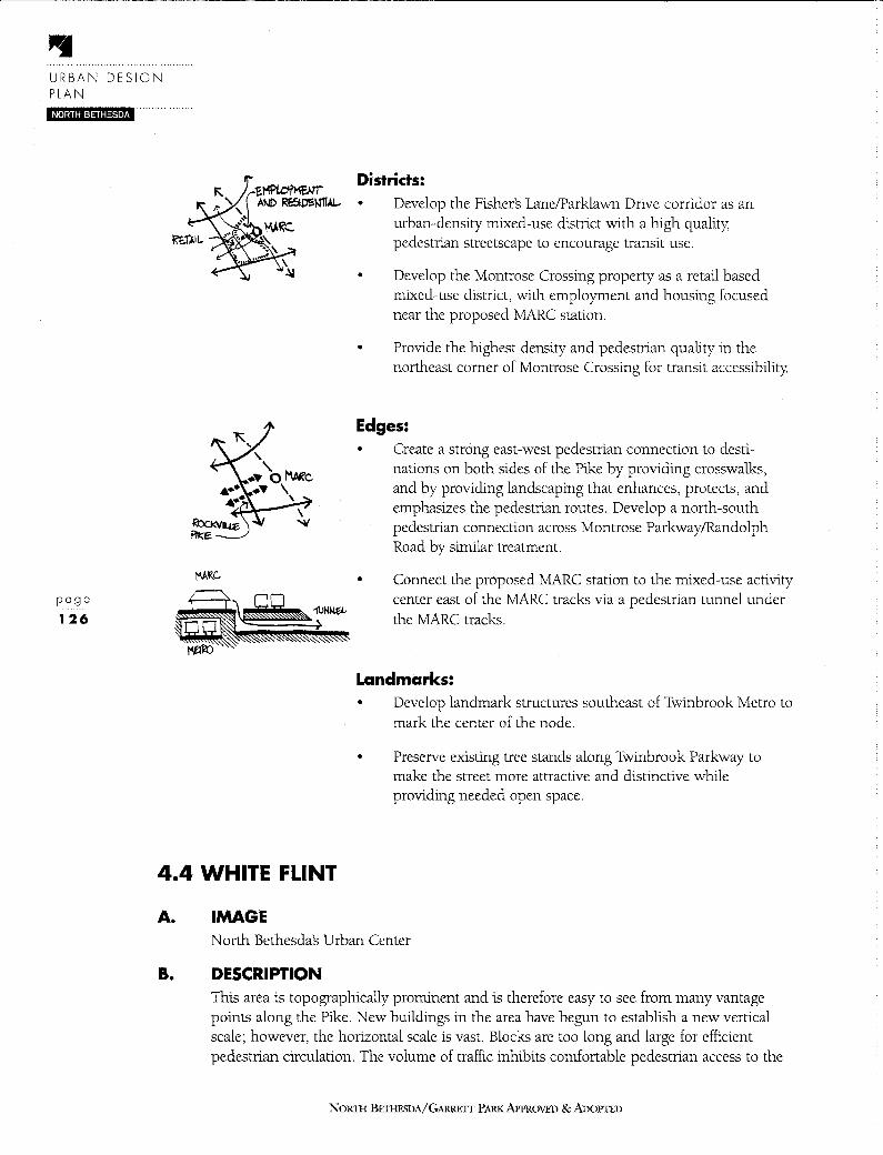
URBAN DESIGN PLAN
NORTH BETHESDA
page
126
4.4 WHITE FLINT
A. IMAGE
Districts: • Develop the Fishers Lane/Parklawn Drive corridor as an
urban-density mixed-use district with a high quality, pedestrian streetscape to encourage transit use.
• Develop the Montrose Crossing property as a retail based mixed-use district, with employment and housing focused near the proposed MARC station.
• Provide the highest density and pedestrian quality in the northeast comer of Montrose Crossing for transit accessibility.
Edges: • Create a strong east-west pedestrian connection to desti
nations on both sides of the Pike by providing crosswalks, and by providing landscaping that enhances, protects, and emphasizes the pedestrian routes. Develop a north-south pedestrian connection across Montrose Parkway/Randolph Road by similar treatment.
• Connect the proposed MARC station to the mixed-use activity center east of the MARC tracks via a pedestrian tunnel under the MARC tracks.
Landmarks: • Develop landmark structures southeast of Twinbrook Metro to
mark the center of the node.
• Preserve existing tree stands along Twinbrook Parkway to make the street more attractive and distinctive while providing needed open space.
North Bethesdas Urban Center
B. DESCRIPTION This area is topographically prominent and is therefore easy to see from many vantage points along the Pike. New buildings in the area have begun to establish a new vertical scale; however, the horizontal scale is vast. Blocks are too long and large for efficient pedestrian circulation. The volume of traffic inhibits comfortable pedestrian access to the
NORTH BETHESDA/GARRETT PARK APPROVED & ADOPTED

Metro. A new, more urban scale, with tamed vehicular movement, enhanced streetscape, a fine-grained street grid, urban parks and high intensity mixed-uses would improve the area for pedestrians, and thereby strongly support Metro. (Figures 42-44.)
C. GUIDELINES
.a.l1Uo
Paths: • Provide a grid with small blocks and pedestrian-friendly
streets within walking distance of Metro.
• Continue the NRC promenade on the east side of the Pike from the Metro station southward to White Flint Mall, at ground level over the Metro tunnel.
•
•
•
Establish a shuttle and a bicycle route connecting White Flint Mall to White Flint and Twinbrook Metro stations, utilizing the Metro tunnel easement wherever possible.
Develop a shuttle bus hub at Metro .
Establish a special east-west street between Marinelli and Old Georgetown Road as a main, pedestrian-friendly avenue for the district. It should link a series of civic and open spaces, beginning with the Aquatic Center, intersecting with Rockville Pike, and extending to Nebel Street. A signal to provide for pedestrian crossing of Rockville Pike would be desirable. This would require a detailed operational analysis.
• Provide on-street parking to buffer pedestrians, to slow traffic and to provide more human-scaled local streets.
Nodes: • Intensify development around the Metro station, in a mixed
use pattern, with employment dominant east of the Pike and housing dominant west of the Pike.
• Develop the image of a single node straddling the Pike by locating the tallest buildings along the Pike and stepping down in height to the east and west.
• Redevelop the existing Metro parking lot as an air-rights joint development, converting the surface lot to garage parking.
NORTI! BETIIK~DA/GARRETT PARK APPROVED & ADOPTED
page
127

URBAN DESIGN PLAN
NORTH BETHESDA
page
128
• Develop a community facility and park north of the Aquatic Center, as the western end of the east-west avenue and open space system. This is one of two possible sites for a community recreation center. It could provide a community focus for the existing neighborhoods to the west and southwest as well as for the new TS-R Zone neighborhood.
• Develop an urban open space east of the Metro station to include part of the existing tree stand and the white rock outcropping representing 'White Flint.' Expand the public space east and west of the tree stand to form a series of linked green spaces along the east-west special street.
Districts: • Use equivalent streetscape treatments, block sizes, and building scale to visually
link the east and west halves of the district. Apply these patterns throughout the area within walking distance of the METRO stop.
• Use the local white boulders in landscape plans to symbolize the 'white flint' image, as was done at White Flint Mall.
• Establish white stone as a theme element for all new architecture in the White Flint district, to provide a district identity.
Edges: •
•
.,. ;
f tuU, \,
Make every effort to overcome barriers to pedestrian movement across Rockville Pike, between Old Georgetown Road and Nicholson Lane, in order that the two halves of the node function efficiently as one.
Develop the small WMATA-owned lots south of White Flint Mall on the Pike as a landscaped amenity open space which would, in conjunction with existing trees on the Pikes west side, clearly define the edge between the White Flint and Grosvenor districts.
Landmarks: • Create a landmark of art and landscaping at the WMATA-owned
lots south of White Flint Mall to help create a gateway between adjacent districts.
• Place the tallest buildings next to the Pike, on "top of the hill" to serve as landmarks.
• Use grade separations at Nicholson Lane and Montrose Parkway to create gateways into the White Flint district.
NORTH BETHESDA/GARRETT PARK APPROVED & ADOPTED

WHITE FLINT CONCEPT DIAGRAM
. • •
e.)(.Ec,Ufrl/G ! . . . : • • • • • • . ~ .
• • . . • • • •• • • • • •• • . . . . . • ..
" ........ . •••
PATH (Any Major Thoroughfare)
LANDMARK (Any Commonly Used Aid to Navigation)
EDGE (Any Barrier to Transverse Movement)
NODE (Any Focus of Movement or Activity)
DISTRICT (Any Area With a Common Characteristic)
MAJOR PEDESTRIAN PATH
~ ~
FIGURE 42
~
' ~ ~ ¾ csx ~~ ~ ~ /,:t
.. ···. % . ·. ~ : .. ~ : · .. ~ , . ~ • •• ½ • • /-1/, . .. ~
.· ·. ~
. • • • • • • • • • • • .
<s ,ft
•• •• •
•• • ••
!lllllll//lflll////l/Mtf$/
.. o .. \\ t\\\\\\.\.';
•
~-----~
• • • • • • • • • • • • • •
N ORTII BETI IESDA/ GARRETT PARK APPROVED & ADoPTED
page
129

NT WEST ILLUSTRATI WHITE FLI VE PLAN
BETHESDA/GARRETT NORTH &ADOPTED PARK APPROVED

WHITE FLINT EAST ILLUSTRATIVE PLAN
NORTII BETIIESDA/GARRETI PARK APPROVED & AnoJYrED
page
1 31

URBAN DESIGN PLAN
NORTH BETHESDA
page
132
4.5 GROSVENOR
A. IMAGE The Gateway to North Bethesda
B. DESCRIPTION Grosvenor marks the entrance to North Bethesda for those traveling north on Wisconsin Avenue. It is a residential island, nearly surrounded by open space, including the preserved woodland of Rock Creek Park and the campuses of Georgetown Preparatory School and Strathmore Hall. The existing residential towers will continue to function as landmarks and, together with the proposed high-rise residences east of the Pike, will form a gateway to North Bethesda. (Figures 45-46.)
C. GUIDELINES Paths: • Introduce the Grosvenor Transitway, connecting Metro to Rock Spring Park and
Montgomery Mall. If possible, develop a single station for both Metro and the transitway
• Improve pedestrian and bicycle connections between Metro and the nearby communities.
• Provide a greenway connection to the northwest along the periphery of the Georgetown Prep site (or as otherwise designed in a P-D application) to the old trolley right-of-way bike path. Provide a connection to the northeast through the Strathmore Hall site and the Garrett Park Estate neighborhood.
Nodes: • Develop Grosvenor as an air-rights, joint development housing site south and east
of Metro.
• Include convenience retail and services in the shared Metro-Transitway station, to serve existing and new residents and commuters.
• Provide open space within the new development, preserving existing tree stands to the maximum possible extent.
~~ .n~~-&~m Districts: l'fW'· u\~ lWi-- • Continue the residential character of the Grosvenor district.
~6-11 • Preserve the open space at Strathmore Hall and Georgetown Prep School. (See Land Use and Zoning: Grosvenor).
NORTI-I BETHESDA/GARRETT PARK APPROVED & ADOPTED

GROSVENOR CONCEPT DIAGRAM
PATH (Any Major Thoroughfare)
LANDMARK (Any Commonly Used Aid to Navigation)
EDGE (Any Barrier to Transverse Movement)
NODE (Any Focus of Movement or Activity)
DISTRICT (Any Area With a Common Characteristic)
MAJOR PEDESTRIAN PATH
FIGURE 45
• • • •
• ••• • • • • • • • •
•
• •• •••
• .
•
;
•
II • .. .. ...... .,. . , .,, . .,,,, .. ,,, .· / .·, ~ : I C$Etl-
: I PAF!/:. .. , : I • .. ' I I
<s==,Jt====~ ////(/(////( //( ///1//// (/// I
-~ o\\~ :~ :~\\ ~ \ .. ~ ~-----t
NORTII BE111ESDA/GARRETf PARK APPROVED & ADOPT£D
page
133

GROSVENOR ILLUSTRATIVE PLAN
page c~
134
NORTH BETHESDA/GARRETT PARK APPROVED & AnoPTED
FIGURE 46

Edges: • Step development intensity down at the east and south edges
of the future housing site for compatibility with existing neighborhoods.
• Design pedestrian routes from the existing tunnel under the Pike, through the new development to the Metro stop, to overcome the barrier to pedestrians caused by Pike traffic.
Landmarks: • Protect and enhance the distinctive greenspace character of
Georgetown Prep and Strathmore Hall by allowing residential development only on the southeast comer of the Georgetown Prep site and by providing for a cultural center at Strathmore Hall that would retain the green space along the Pike. (See Land Use and Zoning: Grosvenor.)
• Reinforce the gateway and landmark functions of the towers flanking the Pike.
4.6 ROCK SPRING PARK
A. IMAGE Large, high quality; mixed-use Urban Village or planned residential development
B. DESCRIPTION The district has well defined edges: 1-270, Democracy Boulevard, and Old Georgetown Road. It contains one of the East Coasts premier office parks, characterized by typically undistinguished office towers set into green lawns with well hidden parking. The shopping center along the west side of Old Georgetown Road functions as part of the district, even though it is partially separated. To the west, Montgomery Mall is effectively separated from the district by the 1-270 south spur. The district is characterized functionally by an auto-dominated movement system and horizontally separated land uses, even though most of these uses are within walking distance of each other.
Visually, the area lacks any order other than that represented by the pure separation of land uses and homogeneity of form within those separate areas. There are no major concentrations of any one activity and very few landmarks to provide legibility or singular identity.
NORTII BE11-IESDA/GARRETT PARK APPROVED & ADOPTED
page
135

URBAN DESIGN PLAN
NORTH BETHESDA
page
136
C. GUIDELINES Paths: • Introduce the Grosvenor Transitway system along the Rock
Spring Drive/Femwood axis, connecting Grosvenor Metro with Montgomery Mall. The alignment of the system should be along the north right-of-way line of Femwood and Rock Spring Drives, and along the west side of Old Georgetown to 1-270.
• Redesign the Rock Spring Drive axis as the main visual organizing element, with improved sidewalks, street trees, the transitway, station stops, and a bikeway
• Reconfigure the Fernwood/Rock Spring Drive intersection to allow through movement east-west across the south comer of the IBM site. Tee the south part of Femwood into this realigned east-west spine.
• Develop a fine-grained, small-block grid of public streets on the Davis parcel.
• Provide a pedestrian/bicycle link from the Luxmanor neighborhood south through the open space system on the Davis parcel to the existing shopping center, high school and library
Nodes: • Provide community retail uses on the Davis parcel, to serve
residents of new and existing neighborhoods and Rock Spring Park employees. Locate these uses along the south side of the Davis parcel.
• The Davis parcel is the preferred location for a community recreation center. Locate the community center either in the vicinity of the estate house or on the south side of the central park.
• Locate transitway stops 1) near the Rock Spring Drive/ Femwood intersection and 2) north of the Georgetown Square Shopping Center.
NORTI-I BETHESDA/GARRETT PARK APPROVED & ADOPTED

ROCK SPRING PARK CONCEPT DIAGRAM FIGURE 47
!, ,A F~ll.l'lklooc, l/~· ~i 1-\\At'tltlO'f"T
~~ I// ....
0 w;:r 11-s
~~~ ~ ~ ¼ .,, - . .. . , '/ ..... ..,,/. .,.,............... . .. ' •••• /,.,; • ... y...tO ~ • ••• •• • ..... ....... ..... /,., ... .. e..... •. .... ½ . . . •• .. ...... .. ,:.w"' ... • •• • •
~ ~~~~~ . ...... .. / ......... .. ~ ..... ~ % ...... ~
_ ••••• f\?:610&!'-l;v.i.... .. l l
/ ....
PATH (Any Major Thoroughfare)
LANDMARK (Any Commonly Used Aid to Navigation)
EDGE (Any Barrier to Transverse Movement)
NODE (Any Focus of Movement or Activity)
DISTRICT (Any Area With a Common Characteristic)
TRANSIT PATH
N01m1 BE'TTIESDA/GARRETI PARK APPROVED & AIX)PTED
--·•---
page
137
URBAN DESIGN PLAN
NORTH BETHESDA
page
138
4.7 STREETSCAPE
Districts: • Encourage the gradual evolution of the entire area from
Wildwood Shopping Center to the Westlake housing area into a single district. The enhanced accessibility provided by the transitway and the unifying visual influence of the redesigned Femwood/Rock Spring Drive axis can reduce the horizontal separation of the various parts and overcome the barriers imposed by the 1-270 south spur and Old Georgetown Road.
Edges: • Partially mitigate the barrier between Montgomery Mall
and Rock Spring Park presented by the 1-270 south spur by the linking effect of the transitway and the enhanced Femwood/Rock Spring Drive streetscape.
• Retain the wooded buffers along the 1-270 spurs to the maximum extent possible.
Landmarks: • Locate a tall, landmark building where the view axes of
north and southbound Old Georgetown Road intersect. A landmark here would mark the symbolic center of the Rock Spring Park district.
• Preserve the wooded area in the center of the Davis parcel and the estate house as landmarks.
Most of the existing and proposed streets in the planning area will require careful attention to detailed design to encourage pedestrian usage, particularly within walking distance of transit nodes. This Master Plan addresses the character of these streets with general streetscape concepts and guidelines.
A. EXISTING STREETS
Description Many of the existing streets in the commercial area do not foster pedestrian comfort. All sidewalks have been built next to the curb and almost all streets lack street trees, creating an exposed, unpleasant environment. In most cases the pedestrians on the sidewalk are adjacent to moving traffic lanes rather than buffered by curbside parking. Multiple tum
NoRm BETHESDA/GARRETT PARK APPROVED & ADOPTED

lanes and the absence of crosswalks reduce pedestrian safety The overall effect of these conditions, combined with land use patterns that require longer walking distance, discourages people from walking.
General Guidelines To improve conditions on existing streets, street trees should be added to all existing streets that are within 1/4 mile of a rapid transit stop. Because street trees should be located three feet from the curb to buffer pedestrians from moving traffic, the sidewalks should be widened as necessary to allow cut-outs for tree pits. Retrofits should be designed on a block-by-block basis and some existing streets should receive additional special design treatment.
B. NEW STREETS General Guidelines Proposed streets would be designed to either existing Road Code approved cross sections (pedestrianized where necessary), or according to proposed additions to the Road Code. Some of the alignments of streets depicted in the Transportation Chapter are specifically located wherever possible, while the alignments of those additional streets shown on these concept diagrams will be determined during development review. All streets shown are to
be public. All new streets are to contain street trees between curb and sidewalk and, wherever possible, on-street parking.
Urban Tertiary Street This Plan proposes introduction of a new Urban Tertiary street, to be used in fine-grained, residential local applications and as a one-way pair in low-intensity employment areas. It could be one-way with parking on one or both sides or two-way with parking on one side (Figure 48). The proposed Urban Tertiary streets are indicated in the streetscape diagrams.
Business Street The business street accommodates two-way traffic in two lanes with two parking lanes, three moving lanes with one parking lane, or four moving lanes. Tree planting beds should be located between the curb and sidewalk in grass strips or, in more pedestrian intense areas, in pits cut out of the sidewalk (Figure 49). The proposed business streets are indicated in the streetscape diagrams.
Other Significant Streets The Plan also proposes special treatment of several existing or proposed significant streets. The streets are listed in Table 9 and, because of their particular function or context, will require detailed planning, possibly as part of the subsequent Townscape Plan. For proposed streets, the pavement widths are subject to more detailed review. The significant or special streets are indicated in the streetscape diagrams.
NORTII BETI-IESDA/GARREIT PARK APPROVED & ADOPTED
page
139
URBAN DESIGN PLAN
NORTH BETHESDA
page
140
TABLE 9
STREETS REQUIRING SPECIAL DESIGN TREATMENT
Road Alignment Public Code Existing/ Pavement/ Street Type Proposed R-0-W
Rockville Pike Major Existing 66/120 (several variations of one Road prototype are needed for different areas)
White Flint Sector Business Proposed 50/80 East/West "Main Street" Street (Figure 55)
Montrose Crossing New Urban Proposed 27/50 Entry Boulevard Tertiary*
Fishers Lane/ Business Existing & 50/80 Parklawn Drive, Street Proposed between HHS & Metro
Washington Street, New Urban Existing Varies/ between HHS & Tertiary* Varies Proposed MARC
Rock Spring Drive/ Arterial Existing & 50/80 Fernwood Axis, including Proposed Plus Grosvenor transitway Transitway
Davis Parcel Business Proposed 40/70 Street Surrounding Street Central Park
Montrose Parkway Special Proposed 50/300
* Proposed addition to the road code.
NORTH BETHESDA/GARRETT PARK APPROVED & ADOPTED
Fixed/ Flexible
Fixed to 100/150
Fixed & Flexible
Flexible
Fixed
Fixed
Fixed
Flexible
Flexible w/in R-O-W

5TREETSCAPE CONCEPT - URBAN TERTIARY FIGURE 48
One-way, low speed, low capacity, with permanent parking on one or both sides. Used in commercial, mixed use or residential areas.
NORTil BETHE.SDA/GARRETI PARK APPROVED & ADOPTED
page
141

STREETSCAPE CONCEPT • BUSINESS STREET FIGURE 49
Proposed Road Code street type, with 40' paving, 70' R.O.W., two moving lanes, two off-peak parking lanes, with enhanced streetscape.
NORUI BETHESDA/GARRETI PARK APPROVED & ADoPTED

5TREETSCAPE CONCEPT • EAST-WEST "MAIN STREET"
{WHITE FLINT)
l I
I
:~ I
NOIU!-1 BETHESDA/GARRETT PARK APPROVED & Alx)PTI'.D
FIGURE 50
I
page
143
URBAN DESIGN PLAN
NORTH BETHESDA
C. ROCKVILLE PIKE Description
page
144
For most of its length through North Bethesda, Rockville Pike is a roadway devoid of trees and safe pedestrian routes. It consists of between six and nine 11-foot lanes in a right-ofway of 120-150 feet. In the few locations where there are only six lanes (no tum lanes or acceleration/deceleration lanes) the right-of-way accommodates a 12-foot median and 20 feet between the curb and the edge of the right-of-way: However, much of the Pike has a five-foot concrete median and only eight feet from the curb to the edge of the right-ofway, because of the tum lanes and acceleration/deceleration lanes. These conditions allow only a three-foot grass strip between the curb and a five-foot sidewalk. In several locations, a five-foot sidewalk abuts the curb, leaving no space for street trees. These conditions are inimical to pedestrian comfort.
The Rockville Pike streetscape should, in most areas, accommodate pedestrians and cyclists, and provide enhancement of desirable views and screening of undesirable views. An overall greening of the roadway environment is needed. The streetscape should unify the fragmented sections of the Pike while reinforcing a unique character for each sector or significant area.
Guidelines for Rockville Pike Prototype The standard prototype recommended for the Pike includes a double row of street trees and sidewalks on both sides of the road (Figure 51). Variations of the prototype will be recommended where necessary to fit within physical constraints or where desired to provide a unique character. For example, each district might have a different species of street tree within an overall continuous pattern of tree placement, in order to provide both individual identity for the district and continuity along the Pike.
• Widen the right-of-way as necessary to allow two rows of street trees with a six-foot sidewalk between rows of trees.
• Plant median trees wherever the median is eight feet or more in width.
• In areas within walking distance of transit stops, establish a build-to line ten feet beyond the right-of-way line.
NORTII BETHESDA/GARRETT PARK APPROVED & ADOPTED

5TREETSCAPE PROTOYPE CONCEPT • ROCKVILLE PIKE
NORTH BE1HESDA/GARRETT PARK APPROVED & Ano!'r£D
FIGURE 51
page
145

TRANSPORTATION PLAN NORTH BETHESDA
Chapter 5
TRANSPORTATION PLAN
5. 1 OVERVIEW AND RECOMMENDATIONS
A. CHAPTER ORGANIZATION This chapter has eight main sections. This first section, the overview, presents the general conclusions on which the recommendations in this chapter are based, the objectives, recommendations, and overall strategies for improving transportation in North Bethesda. The second section explains how future traffic was estimated and the resulting numbers analyzed. The final sections explain the recommendations listed in the overview, by topic.
B. GENERAL CONCLUSIONS For this Master Plan, future traffic was forecast. Those forecasts were analyzed to
determine what transportation improvements will be necessary in the future. There are several basic findings from the transportation analysis that underlie the recommendations. They are summarized here and presented in greater detail and with quantification in subsequent sections.
Current roadway network conditions in North Bethesda are generally congested. Indicators of this are that key intersections are at low levels of service and the area-wide average for all roadway links is outside the acceptable limits for the current Annual Growth Policy (AGP). These conditions are due to a generally restricted roadway system, moderate levels of transit and ridesharing use, and high levels of commercial and residential development in both the Planning Area and other portions of the region. (The existing highway system is shown on Figure 52.)
Restricting development in North Bethesda will not eliminate the need for transportation system improvements. In addition to approved but unbuilt development in North Bethesda, growth will occur in other portions of Montgomery County and throughout the region. Due to North Bethesda's strategic location, many vehicle trips will travel through the area to homes and jobs regardless of growth levels in North Bethesda. Adding jobs and dwelling units in North Bethesda provides opportunities for some of the otherwise through trips to be destined to North Bethesda and for some workers to live near their jobs. So new trips, whether due to local growth or through traffic, will add to current congestion and necessitate additional capacity.
Transit and demand management are desirable to provide additional capacity, but will need to be accompanied by additional roadway capacity. Increasing use of non-
NORTI I BETHESDA/GARRETT PARK APPROVED & ADOPTED

page
148
Freeway
Major Highway
Arterial
NORTII BETHESDA/GARRETT PARK APPROVED & AnoPTED
FIGURE 52

auto-driver modes such as transit, ridesharing, walking or biking is important to obtain many of the Plan objectives. Retaining right-of-way for future transitways identified in the Transportation Network Studies provides for long-term needs. However, the remaining vehicle trips will create unacceptable levels of congestion and delay unless there are significant additions to the roadway network. This Plan recommends additional roadway capacity, together with transit and demand management with emphasis on pedestrian and bicycle use.
C. PLAN OBJECTIVES • Provide a balanced transportation system for the recommended land use plan.
•
This Plan defines balance between transportation and land use as a system where no roads or intersections are beyond their total capacity and the average areawide level of service (a measure of traffic congestion) is within the bounds for the recommended transportation category (in this case, Group Vas defined by the Annual Growth Policy).
It is important to note that the recommended transportation system is designed to be in balance with land use, including projected growth external to North Bethesda and the full build-out of every parcel according to the recommended land use. It is deemed prudent that the transportation system plan accommodate full build-out, although it is highly unlikely that this build-out will occur within the 20-year life of the Plan.
Increase the non-auto-driver modes for commuting. The transportation analysis and recommendations strongly address actions to increase the peak hour commuter use of transit, ridesharing, bicycling, and walking. These modes are under-used now in North Bethesda, and they offer significant potential for improving a variety of situations created by the current overuse of the singleoccupant automobile.
• Provide for better local circulation in the commercial areas. Even with increased use of non-auto modes, growth around the Metrorail stations and in Rock Spring Park will bring increased auto volumes. The roadway network needs to be expanded to provide motorists with circulation and access to existing, approved, and new development without having to use highways such as Rockville Pike or Old Georgetown Road.
• Provide guidance for standards in the regulatory process. This Master Plan envisions a changing, evolving North Bethesda. Revisions to the standards used in Local Area Transportation Review and perhaps the Annual Growth Policy should be developed to accompany the other recommendations.
D. SUMMARY OF TRANSPORTATION STRATEGIES Table 10 presents a summary which identifies Master Plan strategies for improved transportation in North Bethesda. These strategies are among those discussed in more
NoRTII BE11IE.5DA/G,\RRETT PARK APPROVED & ADOPTED
page
149

TRANSPORTATION PLAN
NORTH BETHESDA
detail in the chapter. This summary shows that there are four basic trip orientations that differentiate the strategies: people traveling through, to, from, and within North Bethesda. Particular strategies should be oriented to meeting the transportation needs and travel behavior of those different types of travelers.
The summary is also organized by the trip path of the travelers based upon the start of their trips, the predominant means of travel, and the end of their trips. Different strategies are identified that affect peoples travel behavior in distinctly different ways. For example, strategies for controlling parking availability and rates are primarily related to the end of trips for persons who are coming to the area from outside or perhaps from within. Such parking-related strategies will have no effect on people traveling through the area or residents who travel from North Bethesda to other areas unless such programs are in place at their destination.
This overview summary is not meant to be a complete identification of all strategies. Rather, it should be viewed as a tool which can be used to compare and interrelate the very diverse transportation strategies discussed below.
E. PLAN RECOMMENDATIONS
page
150
The following presents a brief description of the key transportation system and policy recommendations in the Master Plan. Each of these is described in more detail in subsequent sections, with supporting findings and other information. Many of the recommendations are also shown schematically on the accompanying Figures.
Public Transportation System • Major expansions to the public transportation system in North Bethesda are
needed to provide an alternative to driving and to encourage transit use. Additional service will be needed to meet expected demands on some sections of the Metrorail system because of already high peak-hour ridership levels. Preservation of future transitways is a long-term addition to services, discussed in a separate recommendation. The improvements are summarized on Figure 53.
• Future plans should include running every northbound train on the Red Line all the way to Shady Grove. Since approximately every other train now turns back at Grosvenor, this would have the effect of increasing the frequency of transit service and providing many more seats for North Bethesda passengers.
• Provide increased local bus services both as feeders to the Metrorail stations and to connect the stations with employment locations. Many routes in North Bethesda now operate at 30 minute headways, which are not frequent enough to attract ridership. This recommendation includes expansions and enhancements to the current bus services operating as shuttles from the White Flint station. The additional services can be successful if supported by Transportation Demand Management actions as discussed below.
• Provide a MARC station between Bou Avenue and the Montrose Parkway right-ofway. The precise location of the station will be determined by subsequent
NORTH BETHESDA/GARRETT PARK APPROVED & ADOPTED

%
§ to
~ t2 t r ~ ....J
'° ~ i ~ ?:='
I
IDENTIFICATION OF MASTER PLAN STRATEGIES FOR IMPROVED TRANSPORTATION IN NORTH BETHESDA
Trip Orientation Start of the Trip
-& o Locate more housing closer to accessible transit that come through the area
To o Locate more housing closer to transit routes that come into
e) the area
From o Share-a-ride Program
G for area residents
o Improve pedestrian and bike access to bus routes and Metrorail stations
Within o Improve sidewalks,
8 bike routes, access to bus routes, and shuttle buses
Components of Travel Through, To, From, and Within North Bethesda Predominant Means of Travel for the Trip
Auto/Highway
o Emphasize 1-270, and Md 355 for through trips
o I-270 spur expansion
o Montrose Parkway o Intersection
improvements o TMD emphasis o Rock Spring Park-
I-270 Interchanges
o Intersection improvements
o Montrose Parkway o Rock Spring Park-
1-270 Interchanges
o Intersection improvements
o Provide new local circulation roads
Transit
o Increase Metrorail frequency pest Grosvenor
o Fare policy changes o County-wide demand
management programs
o HOV lane on I-270 and HOV connection to Rock Spring Park
o Increased Metrorail frequency pest Grosvenor
o Fare policy o Establish TMD o Transit connection from
Grosvenor station to Montgomery Mall
o New MARC Station
o Increase Metrorail fre.. quency pest Grosvenor
o Improved bus services in area
o New MARC station o Transit connection from
Grosvenor station to Montgomery Mall
o Transitconnection between Grosvenor and Rock Spring Park/ Montgomery Mall
o Shuttle buses between Metrorail areas and commercial/residential areas
... -0
UI o ... co
(D
Blldng
o Implement bikeway plan
o Bike paths to employ-ment centers and Transit
o Improved bike storage at Metro station
o Greenway system
o Improve bike paths to employment centers and community facilities
o Improve bike storage at employment centers
o Greenway system
Walldng End of the Trip
o Parking availability and rates
o TMD and programs for each employ-men! center
o Bike storage for workers at employ-men! centers
o Transit and pedes-trian circulation systems in Mont-gomery County and regional activity centers
o Improve o Reduce conflicts with pathway and vehicles; pedestrian sidewalk system emphasis at between intersections; residential areas improved street-and employ- scapes ment centers and community facilities
o Greenway system
;: DJ rm -0

page
152
NoRm BETHESDA/GARRETT PARK APPROVED & AnoPTED

engineering studies. Care should be taken so that redevelopment in the vicinity does not preclude the optimal siting of the station. The selected site should accommodate auto, bus, bicycle, and pedestrian access, and an appropriate amount of parking should also be provided.
• Provide a high capacity transit connection between the Grosvenor Metrorail station and Rock Spring Park, extending to Montgomery Mall and even further west to the neighboring multi-family residential areas. The transit use in Rock Spring Park is very low now, under 10% of peak-hour trips. The thousands of workers and future residents there could be attracted to Metrorail with a high quality connection, provided through a separate transitway The recently completed North Bethesda Transitway Feasibility Study provides one good vision of how this could be provided and the right-of-way for a transitway is included in this Master Plan. The final alignment of this transit connection should be designed so that pedestrian access from Wildwood to the Davis Tract is
•
not precluded.
The Maryland Department of Transportation has announced its intent to add a High-Occupancy Vehicle (HOV) lane in each direction on both the 1-270 East Spur and the 1-270 West Spur, and to designate an existing lane in each direction on the 1-270 mainline for HOV use as well. The subsequent staging amendment to this Plan will evaluate the impact of this decision on the planning areas level of service for transportation, and it will determine the amount of development that can be associated with implementation of this HOV system.
Transportation Demand Management A variety of actions can be taken to support the use of non-auto driver modes. These will need to be implemented through the actions of both the public and private sector. This Plan describes the actions needed in general terms, to provide flexibility in future structuring of specific programs.
• Create one or more Transportation System Management Districts (TMD) around, at the least, the Metrorail stations and Rock Spring Park. These TMDs would have mandatory participation by all existing and future employers, similar to the current Silver Spring TMD. The TMDs should build upon, and not supplant, existing traffic mitigation programs in the area. TMDs could mandate the following four types of general activities:
• Traffic mitigation programs: require employers to develop, submit and implement a traffic mitigation plan. This technique often can draw upon public and private programs such as share-a-ride matching services or fare subsidy programs, but normally requires considerable involvement by the employer. The achievement of trip mitigation goals is often part of the requirements for new developers.
No1m-1 BETIIESDA/G,\RRETT PARK APPROVED & ADOPTED
page
153

TRANSPORTATION PLAN
page
154
• Data collection: require employers to collect and submit data on employee commute characteristics for use in planning and monitoring programs, or to cooperate with TMD surveys.
• Information dissemination: require employers to provide employees with information on alternative commute modes, alternative work hours, and other ridesharing measures. This information could be prepared by the TMD staff.
• Transportation coordinators: require employers to designate an employee as a transportation coordinator to implement the traffic reduction programs.
• Encourage transit accessible land-use patterns. The layout and orientation of development can have a major bearing on the decision by workers and residents to use transit. This policy entails a variety of different actions, some of which are being developed as part of the Transit- and Pedestrian-Oriented Neighborhood Study currently underway in the Planning Department. This Master Plan encourages appropriate modification to regulatory procedures and guidelines and the development of transit accessible patterns in North Bethesda.
• Hold fare increases to the minimum. Transit ridership in an auto-oriented environment such as North Bethesda is very sensitive to transit fares. Most riders have a choice between transit and the auto and make this choice based on a variety of factors, with fares usually weighted very strongly. Even with improved service levels, higher fares will make increasing ridership difficult.
• Increase or institute parking charges and decrease parking supply. There is a good deal of evidence that the cost and availability of parking is a critical variable in estimating the level of auto versus transit use in an area. Free parking, or relatively inexpensive parking, makes the choice to drive very easy. This Master Plan recommends that a mechanism be instituted in North Bethesda to ensure that free parking for commuters is virtually eliminated for both new and existing development. If possible, any money collected through surcharges or other means by the public should be used to keep fares low.
Roadway System Improvements • Construct the Montrose Parkway from Montrose Road to Veirs Mill Road and
maintain the remainder of the right-of-way to the west side of the connection to Montrose Road for a possible future transitway. This Master Plan envisions a divided four-lane parkway with a wide landscaped median in a portion of the former Rockville Facility right-of-way, from east of Tildenwood Lane to Veirs Mill Road. The precise alignment near the western terminus of the parkway will be determined in a future engineering study which will take into account the potential access to affected properties, environmental constraints, and appropriate road design, among other factors. It would have points of access to Rockville Pike and/or Old Georgetown Road, be grade-separated at Rockville Pike, Randolph Road, and the CSX Railroad, and would connect with Veirs Mill Road using the
NORTI·I BETIIESDA/GARRETI PARK APPROVED & ADOPTED

old alignment of Gaynor Road. This recommendation also includes a configuration at Veirs Mill Road that would not allow any through movement to Parkland Drive from this new road. This Plan does not recommend any elevated structure at the intersection of the proposed Montrose Parkway and Veirs Mill Road. This intersection will be further addressed during the preparation of the Aspen Hill Master Plan.
In the segment of the Montrose Parkway east of Parklawn Drive, this Master Plan also endorses as an equivalent option a three-lane undivided roadway crosssection. Under this option the center lane would be reversible, operating westbound in the morning peak hours and eastbound during the evening peak hours. The lane may be for general use, or it could be reserved for highoccupancy vehicles or for buses only Both the four-lane divided and three-lane undivided options should be evaluated, and the final selection should be made by resolution of the County Council.
This road is essential to future capacity for east and west vehicular movement across the planning area. The two existing roads, Montrose/Randolph Roads and Twinbrook Parkway, are currently congested and have high accident rates. Future growth in the region, even with little growth in North Bethesda, makes the provision of additional capacity essential. The parkway would add capacity, replacing capacity removed by the deletion of the Aspen Hill Road Extension. A parkway-type road, with wide medians, could be easily accommodated in the current 300-foot right-of-way with inclusion of a hiker/biker trail in a linear greenway Additional recommendations for this new roadway include a 45 mph planned speed and prohibitions against trucks. Figure 54 shows the proposed alignment, noting recommendations concerning related actions. An illustrative section is shown below.
MONTROSE PARKWAY AND GREENWAY • ILLUSTRATIVE SECTION
GREENWAY
$00' f/!..O.W'.
ft z·· I ~o· I ... n WtNIJSGAPEO
M~DIAH
PARKWAY
HIICE/l.· <c'R rfC.A/1.-
GREENWAY
In the long-tem1 future, beyond the time frame of this Master Plan, a transitway link to the Shady Grove transitway and Prince Georges County may be desirable.
NoRTII BETHESDA/GARRETI PARK APPROVED & ADOPTED
page
155

TRANSPORTATION PLAN
NORTH BETHESDA
page
156
For this reason, the entire right-of-way from 1-270 to Veirs Mill Road should be maintained for future transportation purposes. This Plan does not envision a roadway connection east of that shown on the accompanying maps.
• Provide Local Circulation Roads serving the Metro station areas. Figure 55 shows two new routes developed by linking together existing roads, serving existing and future activity centers. These roads would allow vehicles access and circulation through current and planned development in this area without the need to use MD 355 (Rockville Pike). This would ease congestion and increase safety and convenience. Many of the new sections can be constructed through agreements when the major parcels are developed. However, the southern link, using Executive Boulevard Extended through the site of the Colonial Manor Motel, may possibly require public acquisition, as may other segments. It is envisioned that Chapman Avenue Extended would be a non-divided Business District Street, with two travel lanes and two parking lanes. Nebel Street Extended would require four travel lanes at all times because of its higher emphasis on longer trips.
• Increase highway capacity at selected locations. (Figure 56 summarizes the recommended highway improvements). The increase in traffic from regional and North Bethesda growth, even with conservative demand management assumptions, will necessitate major modifications to the highway network. Traditionally, Master Plans do not specify intersection layouts, as this should be done when the demand numbers warrant actual construction. However, when grade separation or new interchanges are envisioned, these are to be included in the Plan.This Plan includes several such locations.
• A direct connection should be made between the 1-270 east spur and Rock Spring Park, connecting with Rock Spring Drive. This would provide a way for trips destined for the employment and residential uses here to bypass the more local roadway system and the current Old Georgetown Road interchange.This proposal would substantially reduce congestion on both Democracy Boulevard and Old Georgetown Road south of the 1-270 east spur.
• Widen the 1-270 spurs, both east and west, by an additional lane in the median, providing for three lanes in each direction. Current patterns of congestion as well as future volumes projected for these roadways make this additional capacity essential and the increased lanes were included in the transportation network for all alternatives. If collector-distributor lanes or other means of providing for better access to the current and future interchanges are needed, these would be in accordance with this Master Plan.
• The Fernwood Road bridge over the 1-270 spur should be connected to the 1-2 70 spur to and from the north via ramps. More extensive ramping appears difficult to construct from an engineering perspective, although it would not be incompatible with this Master Plan if designs can be devised. The ramps to and from the north would be suitable for HOV-only use, as part of a system including the 1-270 bus/HOV lanes. Facilities providing for convenient transfers to
NORTH BETHESDA/GARRETT PARK APPROVED & ADOPTED

MONTROSE PARKWAY PROPOSALS
MONTROSE PARKWAY WEST
MONTROSE PARKWAY EAST
(Using Primarily the R-0-W for the Previous Rockville Facility)
----- Four- Lane Divided Parkway With Landscaped Median
-·-·-·- Hiker-Biker Trail
Woodland Buffer
NOR111 BETIIESDA/GARRETr PARK APPROVED & ADOPTED
FIGURE 54
MATTHEW HENSON
STATE PARK
page
157

page
158
PROPOSED LOCAL CIRCULATION IMPROVEMENTS
WHITE FLINT
- Sector Plan Areas •••••• ~ Metro Performance District (City of Rockville) -·-l I I I I I I
~~~~~i~j~~~ Washington Science Center
- Montrose Crossing [M)
NORTII BETHESDA/GARRETT PARK APPROVED & ADOPTED
500
FIGURE 55
0
FEET
500
· Existing Street System
Proposed Street System
Marc Rail
Metro
Metro Station

PROPOSED HIGHWAY CAPACITY IMPROVEMENTS
(See Urban Design Graphics for Additional Minor Streets)
NO!ml BETIIESDA/GARRETI PARK APPROVED & ADOPTED
FIGURE 56
1000 0 1000
FEIT
page
159
TRANSPORTATION PLAN
NORTH BETHESDA
page
160
better local bus service and/or a high capacity transit connection between Montgomery Mall and the Grosvenor Metrorail station should also be part of these highway improvements.
• A grade separation of Nicholson Lane with Rockville Pike appears needed in the future if growth occurs as predicted. This location will experience large volumes of both north-south and east-west traffic. Continued at-grade expansion sufficient to accommodate predicted future growth will not be possible. Rockville Pike should be kept as a high capacity major roadway and not allowed to experience severe congestion, since this will result in traffic diverting to less desirable routes such as Old Georgetown Road.
• The intersection of Marinelli Road with Rockville Pike will need additional intersection capacity, with the design dependent upon the actual configuration of the new development in the currently under-developed adjacent areas. Both vehicular movements and pedestrian crossings will be essential considerations.
• The intersections of Old Georgetown Road with Democracy Boulevard and with Tuckerman Lane are projected to experience demand above the capacity of the current configuration. A configuration that will address the future demands would include additional tum lanes. The ability to accommodate expected traffic here depends in part on other improvements to the system keeping future volumes on Old Georgetown Road from increasing beyond those forecast. The ultimate designs should provide for safe pedestrian crossings.
Unbuilt or Disconnected Streets There are several streets on the current Master Plan that have not been fully connected or built. This Plan recommends the following actions at specific locations:
• Edson Lane between Old Georgetown Road and Rockville Pike should be connected and serve as a Primary Street. This street has been on the North Bethesda Plan since 1962, before virtually any of the adjacent development was constructed. It would serve as a connector between these two major highways and also provide access for adjacent residential areas. There is insufficient eastwest movement capacity in this area and this street would provide an additional link in the street grid. Recommended restrictions on traffic include no trucks on Edson Lane, no through movement to or from White Flint Mall and tum restrictions at Woodglen Drive at some times of the day.
• One other unbuilt roadway section that should remain on the Master Plan of Highways and be constructed at an appropriate time is the Greyswood Road to Greentree Road connection. This section is potentially needed should the WMAL transmitter site redevelop.
• This Plan recommends deleting currently unbuilt sections of roadways at five locations, as shown on Figure 57. These are locations that do not have any future
NORTH BETHESDA/GARRETI PARK APPROVED &ADOPTED

significant value as portions of the network, or where the future cost and/or environmental effects of the connection are too high to justify its construction for the potential benefit. Portions to be deleted include: Aspen Hill Road from Veirs Mill Road to Twinbrook Parkway, Old Club Road to Tuckerman Lane, Stonewood Lane to Ibsen Drive, Old Stage Road to Goya Drive, Weymouth Street to Knowles Avenue.
Roadway Rights-of-Way Table 11 identifies the recommended Master Plan of Highway and Street Classification with rights-of-way This is used in the regulatory process as a guide to dedication and other actions. It incorporates the individual recommendations noted in other sections of this chapter.
Future Transitway Alignments The Transportation Network Studies have identified a need to establish and preserve rights-of-way in several locations throughout the mid-County area for possible future transitways or HOV priority roads. These are links in a regional network and are not envisioned to be built within the time frame of this Master Plan. However, the preservation of the right-of-way through the designation of the alignment for future transportation allows for future decision making and implementation should demands warrant. One such link parallels the alignment of the Montrose Parkway, from 1-270 to Veirs Mill Road, and is included as future transit use in this Master Plan (shown on Figure 58). The capacity of this transitway was not included in the transportation analysis for this Plan.
Development Review Regulatory Standards • Revise the standards used for this planning area in the regulatory process at an
appropriate time. The transit improvements and demand management actions noted above would justify the inclusion of North Bethesda in the AGP Group V, rather than the current Group IV More bus services and better rail frequencies are key clements, as are the supporting policies such as parking management and Transportation Management Districts. However, these changes should be funded, implemented, and even monitored for success before the category is revised. Also, the treatment of intersections in the Transportation Management Districts should be redefined, probably emphasizing an area-wide analytic approach and definition of needed actions that would be coordinated by Montgomery County, with developer participation.
Bicycle and Pedestrian System Improvements This Plan recommends a series of improvements to the bicycle and sidewalk network in North Bethesda, as part of an overall effort to encourage use of these modes for commuting. The overall Plan is shown on Figure 59, with key recommendations summarized below.
• Implement the current Master Plan of Bikeways, with appropriate additions recommended in this Master Plan, including the following:
NORTH BETHF.SDA/ GARRETT PARK APPROVED & ADOPTED
page
1 61

~ ~ ... t:d
~
! i ::j
~ ~ ~ ~ g fl:>
i
MASTER NAME PLAN OF
IDGHWAYS
FREEWAYS
F-8 Capital Beltway (1-495)
F-1 1-270
F-la 1-270 Spur
MAJOR HIGHWAYS
M-6 Rockville Pike (MD 355)
- .-u :o 0, 'CO ~: (I)
HIGHWAY AND STREET CLASSIFICATIONS
North Bethesda - Garrett Park Planning Area
--LIMITS
1-270 Spur Rockville Pike
Rockville Pike to Rockville City Limits
Capital Beltway to 1-270
Capital Beltway to Grosvenor Lane Grosvenor Lane to Nicholson Lane Nicholson Lane to Rockville City Limits
M-4 Old Georgetown Road (MD 187) Capital Beltway to Rockville Pike
M-5 Democracy Boulevard 1-270 ~ur to Bells Mill Road Bells ill Road to Old Georgetown Road
ARTERIALS
A-37 Twinbrook Parkway Rockville City Limits to Ardennes A venue Ardennes Avenue to Veirs Mill Road
A-64 Parklawn Drive Randolph Road to cul-de-sac 600' west of Twinbrook Parkway
A-69 Nicholson Lane Old Georgetown Road to Nebel Street Parklawn Drive Nebel Street to Randol~h Road Randolph Road Parklawn Drive to Roe Creek
A-71 Tuckerman Lane 1-270 to Old Georgetown Road Old Georgetown to Rockville Pike
A-81 Rock Spring Drive Femwood Road to Old Georgetown Road
LANES** ----
6, divided
12, divided
6, divided
6, divided 6, divided 6,divided
6, divided
6, divided 6, divided
6 4
4
4 4 4
2 4, divided
4
MINIMUM RIGHT-OF-
WAY
300 feet
300 feet
300 feet
200 feet 150 feet 134 feet
120 feet
150 feet 120 feet
104 feet 80 feet
80 feet
80 feet 80 feet 100 feet
80 feet 80 feet
80 feet
;: DJ .... m ... ...

MASTER - NAME PLAN OF
IDGHWAYS
A-85 Femwood Road
A-90 Montrose Road
Randolph Road
z A-270 Montrose Parkway 0
~ tp A-271 East Jefferson Street
I A-272 Strathmore Avenue (MD 547) '-.__ INDUSTRIAL & BUSINESS STREETS
i B-1 Fisher's Lane ~
Old Georgetown Road i B-2
~ B-3 Woodglen Drive Extended
:,, B-4 Chapman Avenue
~ ??
Huff Court
8 B-5 Nebel Street
~ B-6 Marinelli Road
B-7 Executive Boulevard
B-8 Boiling Brook Parkway
B-9 Wicomico A venue Connector
B-10* White Flint Avenue
B-ll* New Street
.. LIMITS
Democracy Boulevard to 1-270 Spur
1-270 to Old Bridge Road Old Bridge Road to Rockville Pike Rockville Pike to Parklawn Drive
Montrose Road to Parklawn Drive Parklawn Drive to Rock Creek Park Rock Creek Park to Veirs Mill Road *** * Executive Boulevard to Rockville City Limits
Rockville Pike to Beach Drive
Twinbrook Mctrorail Station to Parklawn Cemetery
Rockville Pike to Nebel Street
Nicholson Lane to Edson Lane
Rockville City Limit to Marinelli Road Marinelli Road to Nicholson Lane Nicholson Lane to Executive Boulevard
Nicholson Lane to Chapman Avenue
Executive Boulevard to Nebel Street
East Jefferson Street to Old Georgetown Road Old Georgetown Road to Huff Court
Schuylkill Road to Nicholson Lane
Parklawn Drive to Wicomico Avenue
Nebel Street to B-11
Marinelli Road to Old Georgetown Road
... -o :a
o, =co w; Cl)
~ a, ,.. m
L ES** MINIMUM ... ... RIGHT-OF- -WAY n
0 4 80 feet :::s .. .. 4 300 feet a. -4 80 feet 4 100 feet
4, divided 300 feet 3 or 4, d!v *** 300 feet 3 or 4, div **"' 80 feet
4 80 feet
2 80 feet
4 80 feet
4 80 feet
2 80 feet
4 70 feet 4 60 feet 4 80 feet
4 80 feet
4 80 feet
4, divided 120 feet 4 80 feet
4 80 feet
4 80 feet
2 80 feet
2 70 feet
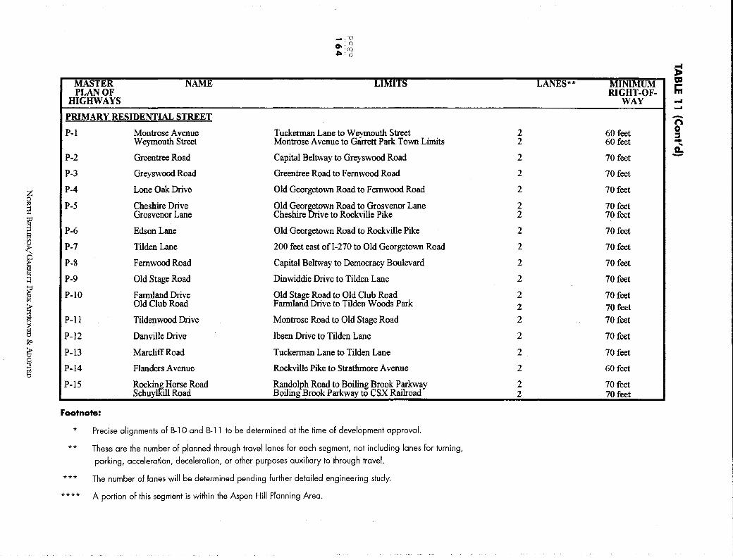
z 0
~ t;o
g ~ < I ;:j
i i i ?,<>
6'
~
-.-o 0, 0 ,Iii co
. (D
MATER NAME LIMITS PLAN OF
HIGHWAYS
PRIMARY RESIDENTIAL STREET
P-1 Montrose Avenue Tuckerman Lane to Weymouth Street Weymouth Street Montrose Avenue to Garrett Park Town Limits
P-2 Greentree Road Capital Beltway to Greyswood Road
P-3 Greyswood Road Greentree Road to Femwood Road
P-4 Lone Oak Drive Old Georgetown Road to Femwood Road
P-5 Cheshire Drive Old GeorE;fwn Road to Grosvenor Lane Grosvenor Lane Cheshire · ve to Rockville Pike
P-6 Edson Lane Old Georgetown Road to Rockville Pike
P-7 Tilden Lane 200 feet east ofl-270 to Old Georgetown Road
P-8 Femwood Road Capital Beltway to Democracy Boulevard
P-9 Old Stage Road Dinwiddie Drive to Tilden Lane
P-10 Farmland Drive Old Stage Road to Old Club Road Old Club Road Farmland Drive to Tilden Woods Park
P-11 Tildenwood Drive Montrose Road to Old Stage Road
P-12 Danville Drive Ibsen Drive to Tilden Lane
P-13 Marcliff Road Tuckerman Lane to Tilden Lane
P-14 Flanders Avenue Rockville Pike to Strathrnore A venue
P-15 Rockin~ Horse Road Randolph Road to Boiling Brook Parkway Schuy ·11 Road Boiling Brook Parkway to CSX Railroad
Footnote:
* Precise alignments of 8-10 and 8-11 to be determined at the time of development approval.
**
***
****
These are the number of planned through travel lanes for each segment, not including lanes for turning,
parking, acceleration, deceleration, or other purposes auxiliary to through travel.
The number of lanes will be determined pending further detailed engineering study.
A portion of this segment is within the Aspen Hill Planning Area.
;: LANES** MINIMUM "' r-
RIGHT-OF- m WAY ---n
2 60 feet 0 ::s 2 60 feet .. ...
a.. 2 70 feet -2 70 feet
2 70 feet
2 70 feet 2 70 feet
2 70 feet
2 70 feet
2 70 feet
2 70 feet
2 70 feet 2 70 feet 2 70 feet
2 70 feet
2 70 feet
2 60 feet
2 70 feet 2 70 feet
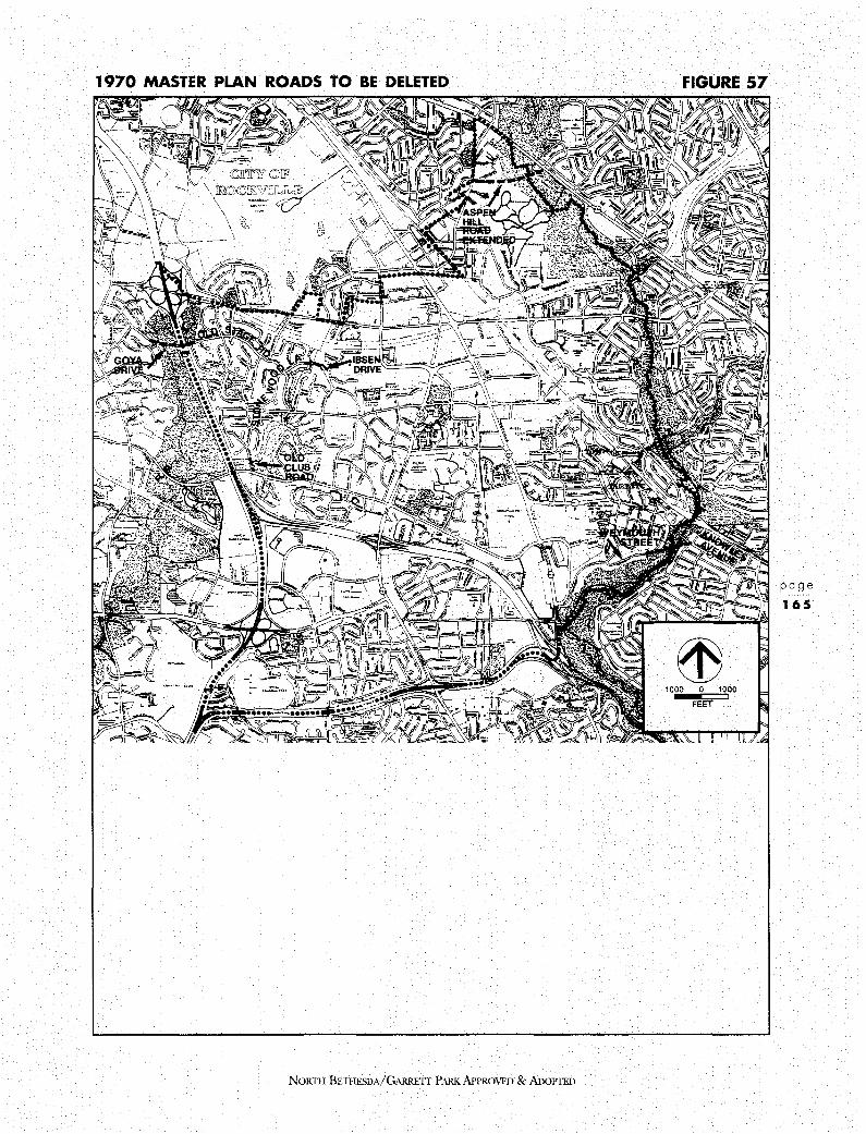
1970 MASTER PLAN ROADS TO BE DELETED
~
NORTII BETIIFSDA/GARRETI' PARK APPROVED & ADOPTED
FIGURE 57
1000 0 1000
FEET
page
165
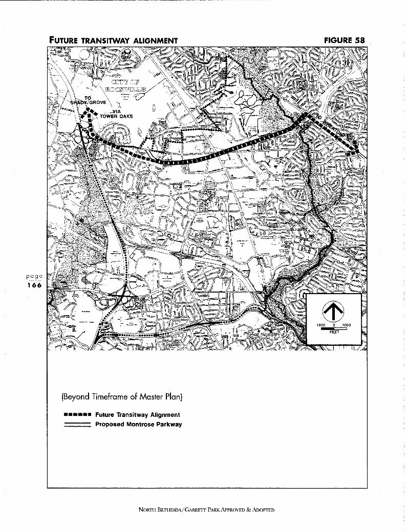
FUTURE TRANSITWAY ALIGNMENT
(Beyond Timeframe of Master Plan)
•••••• Future Transitway Alignment
=== Proposed Montrose Parkway
NORTH BETHESDA/GARRETT PARK APPROVED & AnoPIED
FIGURE 58
1000 0 1000
FEET
• Connect the Grosvenor and Twinbrook Metrorail stations via the proposed new MARC Rail station.
• Connect Rock Spring Park with Luxmanor and the residential areas to the north of 1-2 70.
• Construct priority sidewalk sections as identified in this Plan.
• Include crosswalks and pedestrian crossing signals at all signalized locations in the Sector Plan areas, adjacent to all schools, and eventually, in all locations in North Bethesda.
Staging Amendment A staging amendment will be prepared which will determine the priority and sequence of the development and the transportation elements in this Plan. For each stage, a level of development will be linked to the implementation of a set of transportation projects, programs, and policies. Prior to action on the staging amendment, the projects, programs, and policies-and the assumptions behind them-will be evaluated as to: (1) effectiveness in providing capacity and increasing the non-auto-driver mode share; (2) cost; and (3) likelihood of implementation.
5.2 THE TRAFFIC FORECASTING PROCESS This Master Plan used a computerized model to forecast the traffic that would result from several different land use alternatives and transportation system alternatives. Several techniques were employed to provide a quantified answer to such questions as: What is the overall level of congestion in the area? Which intersections are the most sensitive to future development? By how much and in what ways can non-automobile modes of commuting be increased? The analysis, described below, focused upon periods of peak demand in the morning and evening.
A. MORNING PEAK HOUR TRAFFIC FORECASTS The EMME2/TRAVEL 1.0 travel demand forecasting model was employed to provide an understanding of the complex interaction of development and transportation infrastructure between the region and North Bethesda. The model, using assumptions made about the number and location of future households and jobs and the future transportation system, estimated future morning peak hour traffic and daily home-towork transit trips. The data provided by the model were summarized into both tabular and graphical products such as computer-generated maps of roadway congestion and reports of area-wide congestion level and transit use. Analysis of these and other model outputs led to the creation of alternative transportation scenarios designed to achieve acceptable traffic conditions for the North Bethesda-Garrett Park Master Plan study area.
NORTI I BETHESDA/ GARRETT PARK APPROVED & ADoPTED
page
167

page
168
PROPOSED BIKEWAY PLAN
OOOOCJOC Existing Bikeway
ooooooc Planned Blkeway
1 Class I An Independent Bikeway on a Separate Right-of-Way or Easement
FIGURE 59
ffi 1000 0 1000
FEET
2 Class II A Bike Lane on a Roadway Designated by Striped Pavement or a Physical Barrier
3 Class Ill A Bike Route on a Roadway Designated by Signing Only
NORTH BETHESDA/GARRETT PARKAPPROVED &ADOPTED

B. EVENING PEAK HOUR TRAFFIC FORECASTS Building upon the morning analysis, a series of manual techniques was used to forecast conditions during the evening peak, typically the most congested time of day M-NCPPC local trip generation rates were applied to employment, shopping and residential sites, or clusters of sites, in the North Bethesda study area to determine the number of trips leaving and arriving at these sites in the evening. Trips were routed through the study area based upon expected roadway preferences. As a practical matter, determining the point at which trips exited or entered the study area could not be determined using manual techniques; instead, it was assumed that those trips leaving, entering, and passing through would do so in approximately the same proportion as in the morning.
The evening analysis focused upon conditions at selected intersections expected to experience the heaviest demand. Critical Lane Volumes ( CLV), a standard measure used in local area review to measure the performance of an intersection, were calculated for this analysis. Intersections forecast to exceed their capacity were examined further to determine how much benefit might be derived from selected intersection improvements.
The effect of increased transit service and transportation demand management on auto use was estimated using results obtained from policies like those contemplated in this Master Plan in similar locations, an established technique known as elasticity analysis. Using travel information developed by the EMME2/TRAVEL 1.0 model as a starting point, percentage decreases in auto trips estimated with the elasticity analysis were applied to the generation of evening trips, resulting in reduced volumes at the intersections under study page
In summary, the beneficial effects of the transit recommendations were accounted for in 1 6 9
determining the need for roadway changes.
C. TRAFFIC FORECASTS AT PORTALS Portals are sections of roads where vehicles "enter" and "exit" the planning area. Figure 60 locates the portals used in the analysis. Figure 61 shows the 1987 and forecast total morning peak hour traffic coming in across the portals. Along with the traffic in 1987 (shown in the left-hand column), year 2010 traffic from three growth scenarios is presented. For conditions inside North Bethesda, the future scenarios make the following assumptions, including in all cases future development in the surrounding County and region:
Scenario (a):
Scenario (b):
Scenario (c):
1987 land use.
1970 Master Plan and 1978 Sector Plans land use.
Preliminary Draft Master Plan land use with transportation demand management, transit and roadway improvements.
Several points can be discerned from Figure 61. First, scenario (c) shows an 11 percent reduction in inbound traffic relative to the 1970 Master Plan and 1978 Sector Plans. These reductions are important in the effective operation of key intersections within North Bethesda.
NORTH BETIIFBDA/G,\RRETI PARK APPROVED & ADOPTED
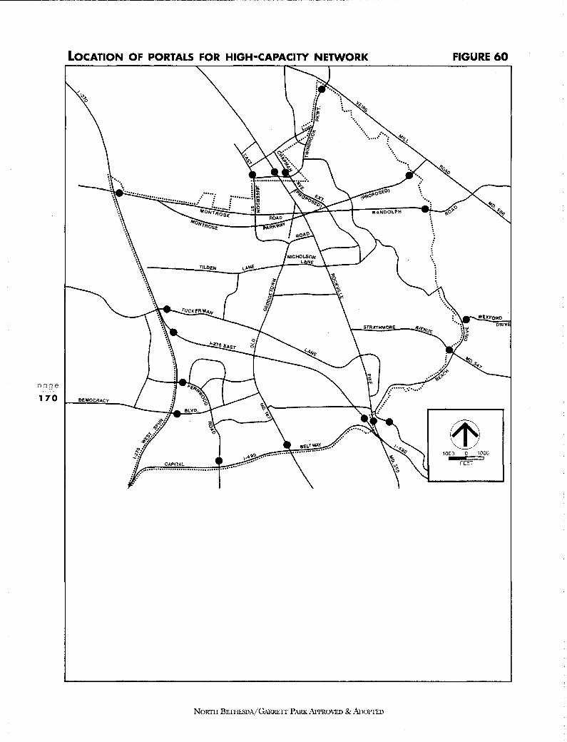
page
170
LOCATION OF PORTALS FOR HIGH-CAPACITY NETWORK
STRATHMORE
DEMOCRACY
NORTH BETHESDA/GARRETT PARK APPROVED & ADOPTED
FIGURE 60
1000 0 1000
FEET

TOTAL MORNING PEAK HOUR INBOUND TRAFFIC AT PORTALS
Thousands
1987 Conditions
36.2
a b 2010 Conditions
~ Through Trips - Local Trips
Future Scenarios
a - Regional Growth with 19 8 7 Land Use In North Bethesda
b - 1970 Master Plan and 1978 Sector Plan
c - Preliminary Draft Master Plan Land Use with TOM, Transit, and Roadway lmorovements
Source: M-NCPPC Transportation Division
NORTII BETIIESDA/GARRE1T PARKAPPROVFD & AooPTED
FIGURE 61
C
page
1 71

TRANSPORTATION PLAN
NORTH BETHESDA
page
172
The graph also shows the importance of development occurring outside North Bethesda. In scenario (a), with no additional development inside the study area, traffic coming in through the portals increases 18%, which is roughly one-third of the increase resulting from (b) and over half of the increase found in (c). To understand this, one must note the through traffic in each scenario (striped bars). For (a), more than half of the traffic entering North Bethesda (including I-270 and its spurs) continues on to other destinations. If future development within North Bethesda is limited, then through trips increase, keeping the total portal volumes high. With (c), more employment opportunities cause trips to end in North Bethesda. Only one-third of the total traffic passes through the study area. This highlights the fact that changes in local development have a limited ability to change traffic volumes on the major highways.
5.3 RESULTS OF ROAD SYSTEM ANALYSIS The most complicated portion of the transportation system analysis was that of the roadway system. It was necessary to forecast morning and evening future peak-hour volumes at intersections, while taking into account non-physical aspects such as demand management in the area. The EMME2/TRAVEL model discussed in the analysis methodology section was very valuable and formed the basis for the more detailed intersection analyses presented here. It should be noted that several assumptions go into a future analysis such as this and that the recommendations are therefore somewhat general and frequently refer to future decisions for more detailed design.
A. PORTALS The roadway system analysis included two primary aspects: the 18 portal roadway links and the intersections internal to North Bethesda. The portals were included because it was essential to ensure that at key entry points vehicles could travel both through and to North Bethesda. Also, by analyzing the portals, a better understanding was gained of some of the reasons for impacts being noted on the internal network, as identified in an earlier section.
Portals are the major roads leading into and out of North Bethesda. While they do not include all roads into and out of the area, they represent the vast majority of the capacity for entering and exiting the area. The analysis grouped portals into directions for identifying capacity constraints, since all roads serving trips from the same direction could normally be chosen by motorists from that direction. Even if one road is congested, others may be available.
The analysis showed that all directions have capacity higher than the demand (forecast future volumes) when the roads are taken together. From the east, if the Montrose Parkway is included, demand is approximately 63% of the capacity However, if the Montrose Parkway is removed from the analysis, the demand virtually equals capacity Since these are link capacities, that would be a potentially serious situation because intersections along links are usually more congested than the links themselves. This highlights a consistent finding: the proposed Montrose Parkway is critical to the North Bethesda roadway network.
NORTII BETHESDA/GARRETT PARK APPROVED & ADOPTED

INTERSECTION LEVELS OF SERVICE
DEMOCRACY
(A.M. Peak) 1989 Conditions
Level of Service
0 A-B
~ C-D
@e OF
Critical Lane Volume Ranges
0 · 1172
1173 • 1472
1473 • 1622
1623 or more
Source: North Bethesda - Garrett Park Issues Report, December 1989.
STRATHMOR
NORTII BETHESDA/GARRETT PARK APPROVED & ADOPTED
FIGURE 62
1000 0 1000
FEET
page
173
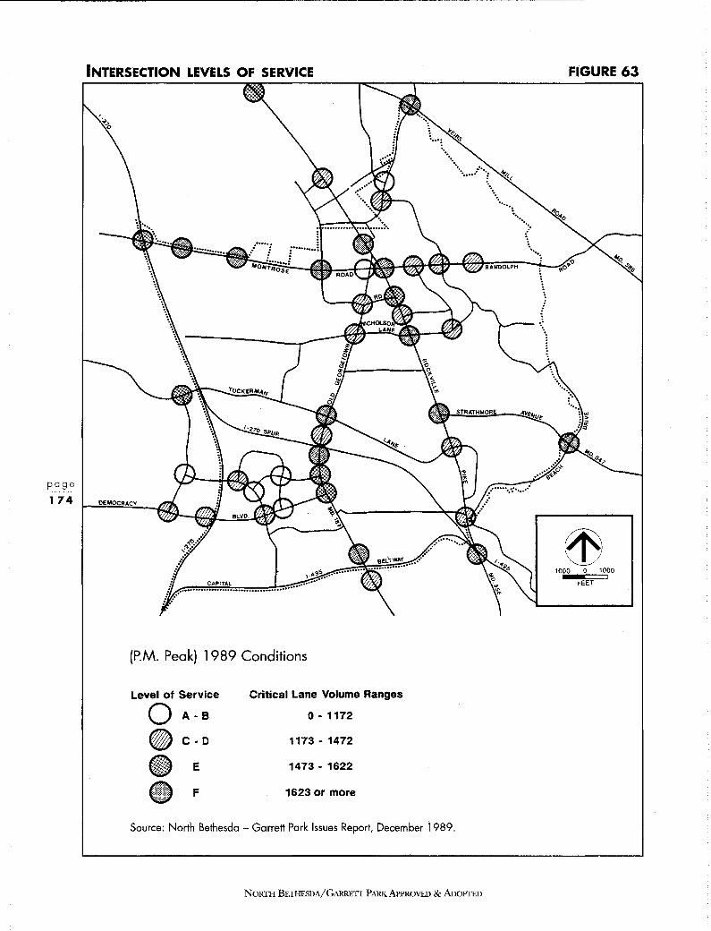
page
1 74
INTERSECTION LEVELS OF SERVICE
DEMOCRACY
(P.M. Peak) 1989 Conditions
Level of Service
0 A-B
I} C-D
~E
-F
Critical Lane Volume Ranges
0 • 1172
1173 • 1472
1473 • 1622
1623 or more
Source: North Bethesda - Garrett Park Issues Report, December 1989.
STRATHMORE
NoRTII BETHESDA/GARRETT PARK APPROVED &AnoPTED
FIGURE 63
1000 0 1000
FEET
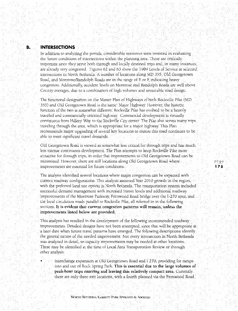
B. INTERSECTIONS In addition to analyzing the portals, considerable resources were invested in evaluating the future conditions o[ intersections within the planning area. These are critically important since they serve both through and locally destined trips and, in many instances, are already very congested. Figures 62 and 63 show the 1989 Levels of Service at selected intersections in North Bethesda. A number oflocations along MD 355, Old Georgetown Road, and Montrose/Randolph Roads are in the range of E or F, indicating heavy congestion. Additionally, accident levels on Montrose and Randolph Roads are well above County averages, due to a combination of high volumes and unsuitable road design.
The functional designation on the Master Plan of Highways of both Rockville Pike (MD 355) and Old Georgetown Road is the same: Major Highway However, the historic function of the two is somewhat different. Rockville Pike has evolved to be a heavily traveled and commercially-oriented highway Commercial development is virtually continuous from Hillery Way to the Rockville City center. The Pike also serves many trips traveling through the area, which is appropriate for a major highway. This Plan recommends major upgrading of several key locations to ensure this road continues to be able to meet significant travel demands.
Old Georgetown Road is viewed as somewhat less critical for through trips and has much less intense continuous development. The Plan attempts to keep Rockville Pike more attractive for through trips, in order that improvements to Old Georgetown Road can be minimized. However, there are still locations along Old Georgetown Road where improvements are essential for future conditions.
The analysis identified several locations where major congestion can be expected with current roadway configurations. This analysis assumed Year 2010 growth in the region, with the preferred land use option in North Bethesda. The transportation system included successful demand management with increased transit levels and additional roadway improvements of the Montrose Parkway; Femwood Road bridge over the 1-270 spur, and the local circulation roads parallel to Rockville Pike, all referred to in the following sections. It is evident that current congestion patterns will remain, unless the improvements listed below are provided.
This analysis has resulted in the development of the following recommended roadway improvements. Detailed designs have not been attempted, since that will be appropriate at a later date when future travel patterns have emerged. The following descriptions identify the general nature of the needed improvement. Not every intersection in North Bethesda was analyzed in detail, so capacity improvements may be needed at other locations. These may be identified at the time of Local Area Transportation Review or through other analysis.
• Interchange expansion at Old Georgetown Road and 1-270, providing for ramps into and out of Rock Spring Park. This is essential due to the large volumes of peak-hour trips entering and leaving this relatively compact area. Currently there are only three exit locations, with a fourth planned via the Femwood Road
NORTII BETHESDA/ GARRETT PARK APPROVED & ADOPTED
page
175
TRANSPORTATION PLAN
NORTH BETHESDA
page
176
bridge over the 1-2 70 west spur. However, SHA forecasts are that the Old Georgetown Road interchange will be severely congested in future years, exacerbated by the need for all trips using Rock Spring Drive from the 1-270 east spur to pass through the interchange. The IBM expansion makes this new ramp essential. The new ramp can well serve the additional development expected in this Master Plan. This improvement is needed in addition to the transit link to Grosvenor because of existing development and the currently limited access system.
• Ramps from the planned Fernwood Road bridge over the 1-270 spur will address similar problems to those noted above. This link is not as high a priority as the Old Georgetown Road/1-270 east spur interchange, because it would not serve as many potential trips. However, these ramps offer good potential as HOV-only, providing access for buses and ridesharing to the planned 1-270 bus/HOV lane. A general feature that should be provided is a facility for convenient transfer to either local bus service or the high capacity transit connection between Montgomery Mall and the Grosvenor Metrorail station. Previous initial engineering analysis indicated that full ramping here would be difficult, but if additional ramps other than those serving trips to and from the north on 1-270 can be accommodated, they would be appropriate for this Plan.
• Grade separation of Nicholson Lane at Rockville Pike. Rockville Pike is expected to maintain its position as a significant north-south roadway in North Bethesda. Significant new development is anticipated at Grosvenor, White Flint, and Rockville and through trips will increase as regional growth continues. The continued growth of east-west movement which is expected will make movements on Nicholson Lane important to traffic circulation. Unconstrained demand estimates for peak hour trips are well beyond the capacity of the current intersection or what could be built at-grade. Providing for grade separation here would reduce a potentially serious traffic constraint to the area.
This improvement would support the concept of keeping Rockville Pike as the high-capacity major roadway, which would attract through trips and meet demands of the White Flint area and the City of Rockville. It would also be appropriate given the additional at-grade local circulation streets parallel to the Pike being recommended in this Plan. Whether Executive Boulevard Extended can cross Rockville Pike as part of the design of the Nicholson Lane project has not been determined, but it would be desirable.
• Marinelli Road with Rockville Pike: The configuration of this intersection cannot be determined at this time. The actual mix and access locations of the developments adjacent to it will determine the demands. To the extent possible, these developments should make use of the local circulation streets recommended. Volumes on Rockville Pike are expected to be high, as noted in the Nicholson Lane findings above. Access to these new developments can generate many trips that will necessitate high turning movements that are difficult to accommodate at-grade. One key objective is ensuring that buses can move
NORTH BETIIESDA/GARRETT PARK APPROVED & ADOPTED
c.
through the area without delay, perhaps requiring some bus-priority for short sections. Pedestrians are also an essential consideration, although a pedestrian underpass of Rockville Pike is already in place on the north side of Marinelli Road.
• Old Georgetown Road at Tuckerman Lane: This intersection currently experiences high critical lane volumes because of the relatively high traffic volumes and somewhat restricted geometrics (number and type of lanes). Improvements have not been made recently because of the potential negative impact on adjacent development. This Plan does not recommend specific changes but identifies the need for improvements here. It may be that demand management, transit, and increased emphasis on Rockville Pike for many trips will reduce future volumes for some time to come, but even taking these into account, future traffic is well above current capacity. In addition to Local Area Transportation Review consequences, motorists would experience additional delay at this intersection. Provisions for safe pedestrian movements must also be included in any future designs for these intersections.
• Montrose Parkway with Rockville Pike: A grade separation of Rockville Pike with Montrose/Randolph Road has been identified as desirable for many years and has been in previous Master Plans. This Plan recommends that this be accomplished through the construction of a new roadway in the available right-of-way which would cross Rockville Pike and the railroad tracks at separate grade.
LOCAL CIRCULATION AND STREET NETWORK
Nebel Street, Chapman Avenue, and East Jefferson Street Extensions Local circulation streets parallel to Rockville Pike are an essential component of this Plan. These streets serve several valuable purposes. They provide for access and circulation to existing and new development. Creating a local street grid makes development more pedestrian-friendly and spreads the vehicle trips over several streets. This provides an alternative to Rockville Pike for many short trips, significantly reducing future volumes on the Pike. These streets are included in this Plan both to provide capacity, and as a framework for more local streets provided through subdivision of the larger parcels.
This Plan recommends placing the collector-distribution function for the north-south movement on Nebel Street, current and extended, using an alignment extending from its current terminus, to a new intersection with Chapman Avenue. This would be a four-lane Business District Street 48 feet wide, within an SO-foot right-of-way, forming a complete eastern section of the loop road from Executive Boulevard extended, to Bou Avenue. The revised configuration of the connection with Bou Avenue would emphasize the through-trip nature of this road, as opposed to the more local character of Chapman Avenue Extended.
Within the Montrose Crossing property, the alignment would follow the existing C-2 zoning line, or alternatively, follow the line of the Metro tunnel easement. The latter alignment would maximize the amount of developable area on the existing C-2 portion of the property.
NORTII BETITF..SDA/GARRETT PARK APPROVED & ADOPTED
page
177
TRANSPORTATION PLAN NORTH BETHESDA
page
178
Chapman Avenue Extended is recommended as a 40-foot-wide street with a 60-to-70 foot right-of-way (not a current standard in the Road Code), for two moving lanes with parking on each side. This would provide a route for shorter distance, local access trips, needed i.n addition to Nebel Street. Chapman Avenue Extended in this configuration would have two phases. The first phase, from Nicholson Lane to Randolph Road, would be accomplished as part of the anticipated development of adjacent parcels. The second phase, north of Randolph Road, is envisaged as very long term, possibly beyond the time frame of the Master Plan, only being constructed if and when the Montrose Crossing site is comprehensively redeveloped. The precise alignment for the segment north of Randolph Road should be determined at the time of this redevelopment, and also whether the segment should be a public or private street.
The purpose of Chapman Avenue Extended is to provide a framework for local circulation vehicle trips, including shuttles, and not to compete with Nebel Street for north-south internal trips. The intersection configurations would allow for but not emphasize through movement, the alignment of the street could contain some curvature, and the streetscaping would emphasize the more local nature of the street. The location of the exact alignment should be flexible, as it will be dependent upon future development plans for the large parcels served by this proposed street.
Extending East Jefferson Street north into the City of Rockville has been discussed several times and has been part of previous draft City plans. This extension has considerable merit but would only be feasible if the Montrose Parkway is built to provide relief to the current East Jefferson-Montrose Road intersection.
A bus-only street between the Metrorail stations at Twinbrook and White Flint, using the extended Chapman Avenue, was examined. This has not been recommended because it is incompatible with the land use and urban design objectives recommended in this Plan.
Unbuilt or Disconnected Streets This Plan recommends completion of several streets now on the Master Plan of Highways and the removal of five not believed to be needed. These are presented in the Recommendations, with the following comments addressing one specific situation.
Edson Lane: This Plan recommends that Edson Lane serve both adjacent residences and some through trips as a key link of the overall roadway travel network The street is virtually fully constructed and is fully dedicated to Montgomery County, with only a temporary barrier between the intersections with Sugarbush Lane and Woodglen Drive. This Master Plan recommends that the barrier be removed with the following conditions:
• No trucks at any time except for local access
• No through traffic to or from White Flint Mall. Prior to removal of the existing barrier, the intersection of Edson Lane and Rockville Pike should be channelized and signalized so these through movements are both legally prohibited and physically precluded to the extent possible.
NORTH BETHESDA/GARRETT PARK APPROVED & ADOPTED

• Tum restrictions during peak periods at Woodglen Drive to preclude traffic from the Security Lane office development.
In addition to restricting roadway system capacity and circulation for the adjacent residences, the existing situation limits access for police, fire, and emergency services. The cross section, alignment, and placement of adjacent development presents no unusual safety or capacity concerns when viewed in relation to normal standards. Sidewalks are present along the entire length, and sight distances are good. The recommended major restrictions to selected movements would further reduce undesirable effects on the adjacent residential areas.
Tuckerman Lane This Plan recommends that a median be constructed on Tuckerman Lane between Old Georgetown Road and Rockville Pike, if feasible.
Residential Streets This Plan recognizes a need for effective actions to control speeding and to discourage large numbers of commuter vehicles from residential streets. Such actions are recommended regardless of the particular classification of the residential street: primary, secondary, or tertiary
5.4 RESULTS OF TRANSIT SERVICES ANALYSIS Public transportation can play a key role in the transportation capacity for North Bethesda. There is already a full range of transit services available: Metrorail, Metrobus, Ride-On, private circulation shuttles, and MARC. However, the transit ridership as a percentage of trips is low compared to more urbanized sections of the County such as Bethesda or Silver Spring, particularly for workers coming to the area. This is a major factor in the roadway congestion now experienced in the area. This Plan envisions an ambitious program of increased services and supporting policies (outlined here and in the sections concerning Transportation Demand Management) to greatly improve the use of transit.
There is a moderate amount of bus service available in North Bethesda provided by Ride-On and Metrobus. Many routes operate on 30 minute headways, although some do have 15 to 20 minute headways in the peak hour. These frequencies are considered marginally attractive for an increasingly urbanized area such as this. Virtually all routes feed into the Metrorail system. Figure 64 is a transit coverage map showing the areas in North Bethesda within one quarter mile of a Metro station or with easy access to a bus line. Most areas other than low-density residential areas have service, but headways and other policies minimize its use compared to auto. A summary of current use of transit and carpools for commuting is shown in the following table (from the Metropolitan Washington Council of Governments (MWCOG) 1988 Home-Interview survey):
NORTI! BETHF.SDA/ GARRETT PARK APPROVED & ADOPIED
page
179
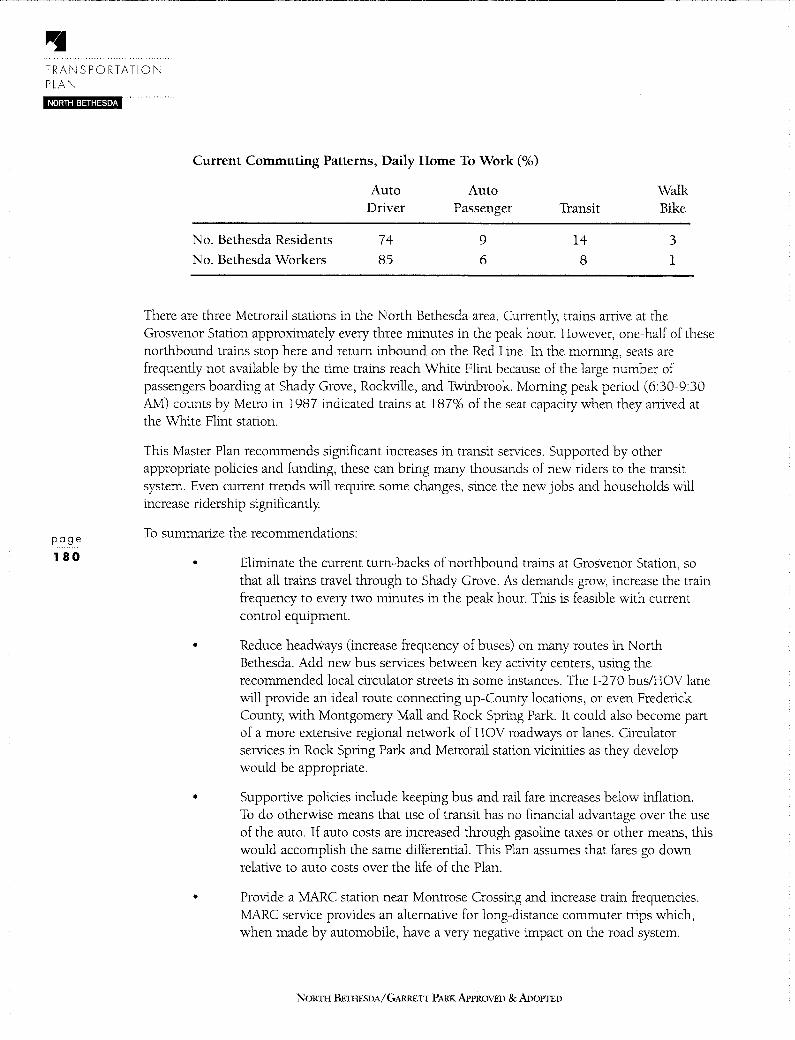
TRANSPORTATION PLAN NORTH BETHESDA
page
180
Current Commuting Patterns, Daily Home To Work (%)
Auto Auto Walk Driver Passenger Transit Bike
No. Bethesda Residents 74 9 14 3
No. Bethesda Workers 85 6 8 1
There are three Metrorail stations in the North Bethesda area. Currently, trains arrive at the Grosvenor Station approximately every three minutes in the peak hour. However, one-half of these northbound trains stop here and return inbound on the Red Line. In the morning, seats are frequently not available by the time trains reach White Flint because of the large number of passengers boarding at Shady Grove, Rockville, and Twinbrook. Morning peak period (6:30-9:30 AM) counts by Metro in 1987 indicated trains at 187% of the seat capacity when they arrived at the White Flint station.
This Master Plan recommends significant increases in transit services. Supported by other appropriate policies and funding, these can bring many thousands of new riders to the transit system. Even current trends will require some changes, since the new jobs and households will increase ridership significantly
To summarize the recommendations:
• Eliminate the current tum-backs of northbound trains at Grosvenor Station, so that all trains travel through to Shady Grove. As demands grow, increase the train frequency to every two minutes in the peak hour. This is feasible with current control equipment.
• Reduce headways (increase frequency of buses) on many routes in North Bethesda. Add new bus services between key activity centers, using the recommended local circulator streets in some instances. The 1-2 70 bus/HOV lane will provide an ideal route connecting up-County locations, or even Frederick County, with Montgomery Mall and Rock Spring Park. It could also become part of a more extensive regional network of HOV roadways or lanes. Circulator services in Rock Spring Park and Metrorail station vicinities as they develop would be appropriate.
• Supportive policies include keeping bus and rail fare increases below inflation. To do otherwise means that use of transit has no financial advantage over the use of the auto. If auto costs are increased through gasoline taxes or other means, this would accomplish the same differential. This Plan assumes that fares go down relative to auto costs over the life of the Plan.
• Provide a MARC station near Montrose Crossing and increase train frequencies. MARC service provides an alternative for long-distance commuter trips which, when made by automobile, have a very negative impact on the road system.
NORTH BE1HESDA/GARREIT PARK APPROVED & ADOPTED

PUBLIC TRANSIT COVERAGE FIGURE 64
N
+
TILDEN LANE
Scale in Miles ~-0 Y.'.
2 1
Metrorail and MARC Coverage (Quarter-Mile Radius)
Metrobus and Ride-On Coverage
NOJmI BEHIESDA/GARRETT PARK APPROVED & ADoPTED
page
1 81

TRANSPORTATION PLAN NORTH BETHESDA
page
•
•
MARC ridership increased 66% on the Brunswick line between 1987 and 1991 and these actions would reinforce this trend to the benefit of North Bethesda.
Figure 7 shows the dispersed residential patterns for DHHS employees . Assuming new development has similar patterns to that of HHS, many of the longer-distance trips originating between Martinsburg, West Virginia, and Gaithersburg could be attracted to MARC if a convenient station were available. Connection with local circulation bus services would add to its attraction.
Increase the frequency and coverage of shuttle-type services linking the Metrorail stations with nearby office, retail, and residential areas. A study by The Urban Mobility Corporation for MWCOG provides good guidance for expansion of these services. The success of this current White Flint shuttle indicates their potential and value.
An important finding from the analysis of transit services is that the physical services themselves will have minimal effects on attracting new ridership. Only by combining them with strong transit incentives and changes to auto-oriented public and private policies will transit use change significantly These policies are outlined in the following section on Transportation Demand Management.
182 5.5 RESULTS OF TRANSPORTATION DEMAND MANAGEMENT ANALYSIS Transportation Demand Management (TDM) is the general term for actions taken to reduce the number of peak-hour vehicles on the roadway network. These actions are aimed at increasing the use of non-auto driver modes, including public transportation, car and van pools, biking and walking. This Plan envisions a strong TDM program in North Bethesda, with emphasis on the Metrorail stations and Rock Spring Park areas.
The relatively low levels of transit use now in North Bethesda, and especially in the Rock Spring Park area, mean that major increases are both possible and needed. The recommendations in this Plan are estimated to significantly increase the percentages of the non-auto modes. Estimates of future use resulting from the recommended programs are in the following table, with percentage changes from current pattern percentages noted in parentheses.
Future Commuting Patterns, Daily Home to Work(%)
No. Bethesda Residents
No. Bethesda Workers
Auto Driver
70(-5%)
61(-28%)
Auto Passenger
10(+11%)
21(+250%)
Transit
15(+7%)
16(+100%)
NORTII BETHESDA/GARRETT PARK APPROVED & ADOPTED
Walk Bike
5(+67%)
2(+100%)

These patterns are ambitious, but feasible if all the recommended program aspects are available: incentives to transit and HOV and increases in the relative costs of auto use. If successful, decreases in the share of auto use compared to total commute trips of about 15% can be expected. As structured, these programs would primarily affect local trips, both work and residential, and not influence through trips except for Metrorail.
If the recommended programs were instituted on a County-wide basis, they would have positive influences on North Bethesda by reducing through trips and influencing the other end of North Bethesda-destined trips, as well as on local conditions elsewhere.
The actions in this Plan are complementary and need to be instituted as a package for optimal results. As noted above, increasing transit services without the supporting policies will have minimal effect. The policies themselves work best with improved transit providing auto alternatives. The analysis did not identify "savings" in trips from individual actions, but instead defined a future structure of demand management actions that, taken with the roadway improvements and the bike and pedest1ian changes, makes for a balanced system.
The analysis identified both transit fares and parking changes as particularly important elements of TDM efforts. Predicting future transit and HOV use is a difficult analytic task, but sensitivity of auto use to these actions has been shown in many instances historically and is a basic element in analytic procedures.
The development of the recommended actions is discussed below.
• Create one or more Transportation System Management Districts (TMDs) around, at the least, the Metrorail stations and Rock Spring Park. This recommendation forms the basis for many of the other actions, by creating an entity that can both encourage demand management and mandate compliance with certain programs and even accomplishment of some mode share goals. The current TMD in the Silver Spring CBD was the model for this recommendation. It was anticipated that each of the Districts could have these basic activities:
• traffic mitigation programs
• data collection
• information
• transportation coordinators
Implementation methods will need to be defined for each area, due to significant differences in characteristics.
• Encourage transit accessible land-use patterns. It is becoming increasingly apparent that the relationship of development to nearby transit services is an important element in the use of transit by workers, residents, and visitors. The transportation elements of this Plan recognize this link and encourage compliance with transit and pedestrian-friendly design principles. The transportation analysis assumed that the transit services provided in the future would be accessible to
No1m1 BETIIF.SDA/GARRETI PARK APPROVED & ADOPTED
page
183
TRANSPORTATION PLAN
NORTH BETHESDA
page
184
residents and employees, in part due to design changes and in part due to increased systems of pedestrian and bicycle pathways discussed in a later section.
• Hold fare increases to the minimum. Transit fares are a critical element in the decision of commuters to use transit. Most riders have a choice between transit and the auto and make this choice based on a variety of factors, with fares usually weighted very strongly. This Plan assumes that transit fares would not be raised with inflation over the life of the Plan, but would lag somewhat behind. This would mean that transit costs would drop relative to the costs of operating a car, an important element in the overall transit-use decision. It may be that auto costs will rise significantly due to increased taxes and oil prices and this would accomplish the same goal.
• Increase or institute parking charges and decrease supply There is a good deal of evidence that the cost and availability of parking is a critical variable in estimating the levels of auto versus transit use in an area. Because of this evident link and because current trends in North Bethesda tend toward charging for parking, the transportation analysis used significantly increased relative parking charges when forecasting future transit use. Sensitivity tests indicated that increased charges were a major factor in expected transit levels and that, if charges do not rise, other transit and demand management programs will be much less successful.
The actual mechanisms for instituting parking charges and eliminating free parking are not defined, since the Plan is considering only the expected final result. Many different mechanisms may be used, based on the conditions when the legislation is developed. Related actions such as providing funds collected from parking surcharges or other means to subsidize transit services would be very much in keeping with the spirit of this Plans recommendations.
5.6 RESULTS OF DEVELOPMENT REVIEW REGULATORY STANDARDS ANALYSIS Development in a Master Plan area is dependent not only upon the zoning, but upon the standards used to review development proposals. This Master Plan recommends appropriate standards for some situations which would be consistent with the actions recommended in the Plan. These standards would have to be modified through their applicable process and are not suggested to be included in the adoption process for this Master Plan.
The current (FY 91) Annual Growth Policy classifies North Bethesda within Transit Group Classification IV, which has an average area-wide level of service of D. This is appropriate given the current transit services. This Plan recommends significantly increasing both the transit services and supporting policies. Only if these recommendations are carried out would a change in the classification to V appear appropriate. This change would reflect the higher availability of transit as a transportation alternative within the area and show a commitment to encouraging transit use. Currently, Bethesda/Chevy Chase and Silver Spring/Takoma Park are in the Group V
NoRrn BETHESDA/GARRETT PARK APPROVED & ADOPTED

5.7 RESULTS OF RESERVATION OF FUTURE TRANSITWAYS ANALYSIS This Master Plan includes an alignment for a possible future transitway A transitway is a path for transit, separated from other vehicles. 1t could be theoretically for heavy rail (unlikely here), light rail, buses, or even other technologies. An interim use might be for buses and ridesharing. The alignment shown on Figure 58 follows the previous Rockville Facility Right-of-Way and would parallel the proposed Montrose Parkway along a portion of its path.
The alignment is proposed without predetermining the mode, but allowing for flexibility in future decision making. No specific recommendation about building the future service is made here, but it is recommended that the right-of-way be preserved for use should future demands warrant the service.
The transitway recommendations arise out of the Transportation Network Studies undertaken by the Planning Department. These studies prepared a conceptual network of transitways and HOV priority routes that would link many activity centers in Montgomery County with these services and also link Montgomery County with other portions of the region via transitways.
This transitway was not assumed to be in place during the life of this Master Plan and so this Plan does not provide local capacity for the network. It is an important link in a future regional network, centered on the Metrorail and MARC system. However, future availability of these links could benefit North Bethesda through improved ability to reach destinations quickly via transit and the reduction of through trips now made in automobiles. If demand should warrant building the transitway within the life of this Master Plan, that would be in keeping with the transit emphasis envisioned for this Plan.
This draft cannot definitively state the right-of-way standards needed, since this analysis has not yet been completed. More detailed recommendations will be presented during subsequent discussions with the Planning Board. The Shady Grove Master Plan did identify a 70--foot right-ofway for a similar future transitway
5.8 RESULTS OF BICYCLE AND PEDESTRIAN ANALYSIS Unlike the demand for road capacity, the demand for bicycle and pedestrian paths will only manifest itself once a safe, convenient, and well-connected system has been established. This section proposes the foundation for such a system. This Plan calls for the implementation of the Master Plan of Bikeways with the revisions and additions listed below. It also calls for an expanded system of sidewalks and increased safety for pedestrians. A listing of the bikeways plan can be found on Table 12. Refer to the Urban Design chapter of this Plan for a presentation of the details of pedestrian and bicycle-friendly design.
The following are proposed amendments to the Master Plan of Bikeways:
• Construct a bikeway along the WMATA tunnel right of way from the Grosvenor
NOR11I BE11IESDA/G,\RRETI PARK APPROVED & ADOPTED
page
185

TRANSPORTATION PLAN
NORTH BETHESDA
page
186
station north to Twinbrook station. This connection will provide much needed access to the commercial and retail establishments along the corridor, to the three Metro stations and to the city of Rockville. The path would connect with the parallel Tuckerman-White Flint bikeway running along an abandoned trolley right-of-way west of Georgetown Preparatory School.
• Designate a new right-of-way linking Democracy Boulevard and Rock Spring Park with the residential area north of 1-270 as far as Tuckerman Lane. An overpass spanning 1-270 will be required to link these areas. This connection, which might be integrated into the design of the proposed interchange at Rock Spring Park, will enhance non-auto access to employment, Walter Johnson High School, and the future transitway envisaged between Grosvenor and Montgomery Mall.
• Include right-of-way for a bikeway in the easement for the North Bethesda Transitway, along Rock Spring Drive and Femwood Road from Old Georgetown Road to Montgomery Mall. This bikeway will ultimately connect housing, shopping centers, offices, a high school, community center, and the proposed park on the Davis parcel at Rock Spring Park.
• Construct a bikeway between Veirs Mill Road and Fisher5 Lane. A segment of this bikeway could use the alignment of Aspen Hill Road extended, which this Plan proposes to delete.
• Establish a bike route along Tilden Lane and another along Luxmanor Road. These will connect the many public facilities and residences in the area with the future Montrose Parkway, Tuckerman Lane, and the Tuckerman-White Flint pathway
• Provide bike connections on either side of Rockville Pike at Edson Lane, Nicholson Lane and Executive Boulevard.
• Add bike lanes along Twinbrook Parkway, connecting Aspen Hill with Rockville and North Bethesda.
• Bike lanes are proposed for Nebel Street and Parklawn Drive to provide more alternatives for safe bike passage around the White Flint-Twinbrook area.
• Delete bikeway proposals for most of Old Georgetown Road, Montrose Road and Rockville Pike. High traffic volumes and little remaining right-of-way make it extremely difficult to create an environment that is conducive to bicycling along these roads. Safer, albeit less direct, alternative paths are available; they are detailed in Table 12 and Figure 59.
• Add bike lanes along Beach Drive from Knowles Avenue to Kensington.
NORTII BETHESDA/GARRETI PARK APPROVED &ADOPTED
• Delete the Master Plan of Bikeways trail between Tuckerman Lane and Rock Creek Trail via Weymouth Avenue. This trail, known as Trail Connector 2B, was officially deleted from the Rock Creek Stream Valley General Development Plan by the Park Commission in 1989. The deletion of this trail from the Master Plan of Bikeways would be consistent with this earlier action.
An extensive network of bikeways has been identified in the Montgomery County Bikeways Construction Program (1989) and the 1978 Master Plan of Bikeways. In addition, a bike action group assembled by the Montgomery County Department of Transportation provides up-to-date information on bikeway needs. Developer contributions to bikeway development should also play a significant role in bringing more trails to North Bethesda.
Projects which enhance access to Metrorail stations should be given first priority as they are usually less costly to implement and benefit commuters the most. In the residential areas, where slow-moving vehicles can coexist with bicycles, circulation can be enhanced through such cost effective measures as proper maintenance of residential streets and directional signs. All Class II and Class Ill bikeways should have signs warning motorists of shared use. Consideration for bike use must be carried through to the point of destination. Secure areas for bike parking, which are far less expensive to construct than parking for automobiles, could be incorporated into the design of any private or public lot or garage.
A. FUTURE SIDEWALK IMPROVEMENTS Like bikeways, sidewalks should link community facilities, rail and bus stops, and centers of commercial and employment activity with adjacent neighborhoods. With a few exceptions, sidewalks are in place along most of the major streets in North Bethesda.
The streets below, listed in order of priority, should be considered for sidewalk construction.
I. Tuckerman Lane west of Ralston Road (arterial)
2. Marcliff Road from Cushman Road to Tuckerman Lane (primary)
3. Farmland Drive south of Tilden Lane (primary)
4. Farmland Drive north of Racehorse Lane (primary)
B. PEDESTRIAN ENCOURAGEMENT ACTIONS Pedestrian-activated walk signals and clearly marked crosswalks should be installed at every intersection with a traffic signal in office/commercial areas. Bus shelters should be put in place near all activity centers such as Walter Johnson High School. Attaching schedules to bus stops would be a simple way to ease bus use for bus patrons.
Separate pick-up/drop-off bays built near the entrance should be a part of any office or commercial site design. Such a provision would reduce walk time to a carpool and increase safety, thereby strengthening the effectiveness of the TDM measures advocated in this Plan.
NORTH BETIIESDA/GARRETT PARK APPROVED & ADOPTED
page
187

~ @ t.o
i t i ::J ~ ~
i i ?:'>
i
Name Location
EXISTING BIKEWAYS
Rock Creek Park Franklin Street - Velrs Mill Road Tuckennan - White Flint Tuckennan Lane - Gulf Lane
Edson Lane - Nicholson Lane
East Jefferson Street Montrose Road - Executive Boulevard
Old Georgetown Road Rockvtlle Pike - Nebel Street
Schuylkill Road Schuylkill Road - MARC Station
Tuckerman Lane Cabin John Park - Old Georgetown Road Old Georgetown Road - Montrose Avenue
Randolph Hills Connector Macon Road - Dahill Road
Strathmore Connector Strathmore Avenue to Tuckerman Lane
PLANNED BIKEWAYS
Tuckerman - White Flint Golf Lane - Edson Lane Tuckerman - White Flint Nicholson Lane - Marinelli Road
Beach Drive Knowles Avenue - Kensington
Strathmore Rockville Pike - Weymouth Avenue via Strathmore Avenue
Rockville Pike Alternate Tilden Lane - Executive Boulevard Montgomery Road - Rollins Avenue via EastJeflerson Street
Montrose Parkway Montrose Road - Rock Creek Park Montrose Road Montrose Parkway - l-270
Randolph Road Rockvtlle Pike - Rock Creek Park
Ttldenwood Montrose Parkway - Tuckerman Lane
Femwood Capital Beltway - 1-270
Rock Spring West Access Old Georgetown Road -1-270 via Democracy Boulevard
Martnellt Old Georgetown Road - Nebel Street
via Wall Local Park Executive Boulevard East Jefferson St. - Nicholson Lane
Flanders Avenue Rockvtlle Pike - Strathmore Avenue
North Bethesda - Bethesda Tuckennan Lane - Capital Beltway vi'' '' Jl Avenue
SW = Sidewalk designed for .nd pedestrian use.
- cJ 0 00 co 00 (j)
BIKEWAYS PLAN
Clasalflcallon Name
PLANNED BIKEWAYS
I Aspen Hill Connector I Boiling Brook Parkway ISW Parklawn Drive
ISW White Flint Connector
ISW I
II PROPOSED DELETIONS
ISW Old Georgetown Road
I
I Montrose Road
Rockvtlle Pike
I I Rock Creek Connector I
Location
Rock Creek Trail - Fishers Lane Rock Creek Trail - Parklawn Drive Boiling Brook Parkway - Nicholson LanC{ Nicholson Lane - Flanders Avenue via Orleans Way
Montrose Road - Democracy Blvd. Cheshire Drive - Capital Beltway
Montrose Parkway - Rockvtlle Pike
Capital Beltway - Montrose Road
Tuckennan Lane - Rock Creek Trail
I[ BIKEWAYS RECOMMENDED IN THIS PLAN
Old Georgetown Road Democracy Boulevard - Cheshire Drive [ Grosvenor - 1\vtnbrook Grosvenor - Twlnbrook I TildenLane Hounds Way - Nicholson Lane
Luxmanor Road Tilden Lane - Tuckennan Lane I Nebel Street Parklawn Drive - Randolph Road II Executive Boulevard Huff Court - Woodglen Drive II Nicholson Lane Old Georgetown Road - Nebel Street
I /Ill Twtnbrook Parkway City of Rockville - Velrs Mill Road
II /lll Parklawn Drive Twlnbrook Parkway - Boiling Brook Pky. I Fishers Lane Aspen Hill Connector - Calvert Avenue
Edson Lane Luxmanor Road - Rockville Pike I/II via Poindexter Lane and Edson Lane
Rock Spring Park Democracy Boulevard - Lux Lane
I /II Grosvenor Transltway Montgomery Mall - Old Georgetown Road III Greentree Greentree Road - Fernwood Drive
I /lll · via Greyswood Road
Clasalflcatlon
I I I[
I
Undesignated
I/II
I
I
Ill
I II III I I
HI
II II I III
I I Ill
;: DI rm -~
While there are sidewalks along most major roads, pedestrian use is sometimes discouraged by other factors. In many areas, site designs for office and commercial buildings inhibit pedestrian access since walkways are next to busy roads while the buildings are set back and widely dispersed. The road width, traffic speed, and volume of traffic traversing major roads in North Bethesda create hazardous conditions for pedestrians whether or not crosswalks exist. Until the right-of-way which pedestrians should enjoy at crossing points is vigorously enforced, they will often be too intimidated to consider walking all but the shortest distances. One additional means of redressing this problem would be to restrict free right-tum movements during the times of day when there is the greatest chance for conflicts between pedestrians and drivers, such as the noon hour.
In addition, amenities that make walking comfortable and inviting, such as trees and benches, are lacking. These conditions are particularly acute along Old Georgetown Road and Rockville Pike. This is in contrast with the considerable attention given pedestrian amenities around North Bethesdas Metrorail stations. Efforts should be made to carry forward the successes there into adjoining neighborhoods.
NORTH BET! rESDA/GARRETT PARK APPROVED & ADOPTED
page
189

• HISTORIC RESOURCES
Chapter 6
HISTORIC RESOURCES
6. 1 OVERVIEW AND RECOMMENDATIONS
A. CHAPTER ORGANIZATION This chapter begins with a brief introduction to the historic preservation process in Montgomery County, objectives for North Bethesda-Garrett Park, a summary of recommendations of the Montgomery County Historic Preservation Commission regarding resources in the planning area, and a summary of this Plans recommendations on the historic resources. It continues in the second section with highlights of the areas history, which provides the context for the historic resources. The next portion of the chapter presents an analysis of the sites that have already been designated on the Countys Master Plan for Historic Preservation, followed by resources on the Countys Locational Atlas which are being evaluated for Master Plan designation. The chapter concludes with historic preservation designation criteria and the effects of historic designation.
B. INTRODUCTION The Master Plan for Historic Preservation and the Historic Preservation Ordinance, Chapter 24A of the Montgomery County Code, are designed to protect and preserve Montgomery County's historic and architectural heritage. When the County Council places an historic resource on the Master Plan for Historic Preservation, the adoption action officially designates the property as an historic site or historic district. It is then subject to the procedural requirements of the Historic Preservation Ordinance described at the end of this chapter.
In considering which sites should be placed on the Master Plan, the Planning Board receives recommendations from the Historic Preservation Commission (HPC); the HPCs recommendations are summarized below. However, the recommendations contained in the Final Draft Plan are those of the Planning Board.
In addition to historic preservation issues in the Town of Garrett Park, this Final Draft Plan contains recommendations regarding the creation of an overlay zone in the Town which would be designed to preserve the communitys unique park-like setting while encouraging housing diversity and compatibility Details on this overlay zone recommendation are included in the land Use and Zoning Plan section.
One resource that has been analyzed but is not pictured in this chapter is Holly Oaks; it has been demolished, and both the HPC and the Planning Board recommend that it be
NORTII BETIIESDA/GARREIT PARK APPROVED & ADOPTI:D
HISTORIC RESOURCES
NORTH BETHESOA
page
192
removed from the Atlas. Two resources that have not been analyzed in preparation of this Master Plan are Georgetown Preparatory School and Veirs Mill. This Plan recommends that the Georgetown Prep building be studied for possible designation as an historic resource in the future. The site of the former Veirs Mill will be analyzed in the Aspen Hill Master Plan.
The Higgins Cemetery, a small family burial plot located south of Twinbrook Parkway near Parklawn Drive, is another resource located in this planning area. This Plan does not recommend historic designation for this cemetery, but does strongly urge that the County-which owns the property-make a concerted effort to maintain and protect the burial site.
C. HISTORIC PRESERVATION OBJECTIVES • Highlight the values that are important in maintaining the character of
North Bethesda.
• Protect and enhance North Bethesda's historic and architectural heritage for the benefit of present and future County residents.
• Integrate historic sites into new and existing development.
D. HISTORIC PRESERVATION COMMISSION RECOMMENDATIONS • Designate the following resources on the Master Plan for Historic Preservation:
Wilkins Estate, Smokehouse, Timberlawn, and Mt. Zion Church and Cemetery.
• Delete from the Locational Atlas the following resources: Holly Oaks and Amolda Estate.
• Designate the entire Town of Garrett Park as an historic district on the Master Plan for Historic Preservation.
E. PLAN RECOMMENDATIONS • Designate the following resources on the Master Plan for Historic Preservation:
Wilkins Estate, Smokehouse, Mt. Zion Cemetery.
• Delete from the Locational Atlas the following resources: Holly Oaks, Amolda Estate, Timberlawn, Mt. Zion Church.
• Designate as a historic district a portion of the Town of Garrett Park plus several individual resources.
• Create an overlay zone for the Town of Garrett Park to preserve the unique parklike setting and to encourage housing diversity and compatibility
• Study the Georgetown Preparatory School site as a possible historic resource in the future.
NORTI-I BETIIESDA/GARREIT PARK APPROVED & ADOPTED

6.2 DEVELOPMENT OF THE NORTH BETHESDA/GARRETT PARK COMMUNITY
The North Bethesda-Garrett Park Planning Area, although generally characterized by its mid- to late-20th century development, contains a number of historic resources that reflect periods of the areas development from the late 1 700s into the early 20th century.
As was true for much of Montgomery County, the land encompassed by the North BethesdaGarrett Park Planning Area remained largely rural and in farming use through the 19th century. The influence of transportation routes on development patterns was significant. The Washington Turnpike Company received Montgomery County's first road charter for improvement work on the road from the District of Columbia to Frederick-later the Rockville Turnpike (now Old Georgetown Road and Rockville Pike); by 1828, these road improvements were completed. Existing individual historic resources in the Planning Area are nearly all located on or near these and other early routes-Old Georgetown Road, Rockville Pike, Tilden Lane, and Montrose, Randolph, and Veirs Mill Roads. (See Figure 65.)
Two structures represent the areas early farming/plantation history: Uncle Toms Cabin/Riley House (#30/6) on Old Georgetown Road, dating from the late 1700s and the Smokehouse (#30/4) on Old Bridge Road, which may also be late 18th century. The log portion of the Uncle Toms Cabin/Riley House is of particular historic importance; Josiah Henson, the former slave on the Isaac Riley Plantation whose memoirs inspired Harriet Beecher Stowes novel Uncle Tom~ Cabin, spent his nights in the cabin. The Smokehouse on Old Bridge Road is also a log structure believed to have been part of the Magruder plantation or Riley plantation.
Another important resource which serves to recall the families and heritage of North BethesdaGarrett Park's earliest period is the cemetery associated with the Mount Zion Baptist Church (10200 Old Georgetown Road, #30/18). This burial site was first used in 1864, two years after the congregations original meeting house was built; the present Gothic Revival edifice was constructed in 1910.
By the time of publication of the 1879 Hopkins Map, the North Bethesda-Garrett Park area was still sparsely settled, but there was some concentration at the community of Montrose, where the Georgetown Road and Rockville Pike intersected. The only remnant of that settlement is the tworoom Montrose School (#30/2) of 1909 on Randolph Road east of Rockville Pike.
A significant addition to the area's transportation modes in the 19th century was the Metropolitan Branch of the Baltimore and Ohio Railroad. This rail line had begun operation in 1873 and extended through Montgomery County from the southeast to northwest. New settlements grew up along the railroad throughout the County.
The community of Garrett Park (#30/13) provides an important example of the new railroad suburbs. Washington attorney Henry Copp formed the Metropolitan Investment and Building Company of Montgomery County in 1886 and purchased 500 acres for development on both sides of the tracks. The next year, the first area was subdivided and the suburb was named after B & 0 President Robert W Garrett. Winding streets were laid out and given English names.
NORTl l BF:l1IESDA/GARR£Tf PARK APPROVED & ADOPTED
page
193
HISTORIC RESOURCES
NORTH BETHESDA
page
194
Large wood frame houses were built in the picturesque Victorian styles of the period, and landscaping suggestions were made by Professor William Saunders (responsible for Baltimores Clifton Park and Philadelphias Fairmount and Hunting Parks). Road access was also available to Garrett Park, via the Rockville-Georgetown Pike and a county road running from the Pike east to Kensington.
As the automobile increased commuting ranges during the early 20th century, numerous wealthy Washingtonians built large estates along Rockville Pike, often in variations of Classical and Colonial Revival designs. Several of the areas historic resources are from this period. The Amolda Estate (#30/16, now the Bethesda Health Center) was built around 1912; however, extensive contemporary buildings now surround the original house. Parklawn Cemetery encompasses the original Wilkins Estate (#30/1), designed c.1917 by architect John Russell Pope and associated with John F Wilkins, once publisher of the Washington Post.
Also from this period is Timberlawn (#30/11), believed to have been built in the 1920s by John Joy Edson, treasurer of the National Geographic, and home in more recent years of Sargent and Eunice Kennedy Shriver. Designed in the Classical Revival format, the Strathmore Hall Arts Center (#30/12), was built in 1902 for Captain and Mrs. James Oyster. In 1914, the home was purchased and extensively renovated by Charles Israel Corby, who was prominent in the baking industry:
Montgomery County's post World War 11 boom characterizes much of the North Bethesda-Garrett Park community Nonetheless, this Planning Area retains a wide range of significant historic resources-from log cabins to the late 19th century railroad community of Garrett Park to wealthy estates of the early 20th century-which mirror the growth and development of the County as a whole.
NORTI-1 BETHESDA/GARRETT PARK APPROVED & ADOPTED

HISTORIC RESOURCES FIGURE 65
1000 0 1000
FEET
1. Montrose School (Atlas #30/2) 6. Smokehouse (Atlas #30/ 4)
2. Uncle Tom's Cabin/Riley House (Atlas #30/6) 7. Timberlawn (Atlas #30/11)
3. Corby Estate/Strathmore Hall (Atlas #30/12) a. Garrett Park Historic District (Atlas #30/13)
4. Linden Oak (Atlas #30/14) 9. Arnoldo Estate (Atlas #30/16)
s. Wilkins Estate (Atlas #30/1) 10. Mt. Zion Church and Cemetery (Atlas #30/18)
NORTH BETHESDA/GARRETT PARK APPROVED & ADOPTED
page
195

page
196
NORTH BETHESDA/GARRETT PARK APPROVED & ADoPTED

6.3 RESOURCES DESIGNATED ON THE MASTER PLAN FOR HISTORIC PRESERVATION
NAME: MONTROSE SCHOOL (ATLAS #30/2)
ADDRESS: 5721 Randolph Road
HISTORY /DESCRIPTION: Built in 1909, this two-room frame structure covered with pebble dash is a vestige of the communities of Montrose and Randolph and is illustrative of early rural educational buildings. It is the best preserved of the few remaining schools of this type, which replaced the one-room school house as the need developed for more space to serve the growing communities. With later additions of brick and cinder block, the building was used as a community school through 1960, and continued in school system use until 1970.
In 1979, Peerless Rockville Historic Preservation Ltd. purchased the Montrose School structure. Peerless Rockville raised money to rehabilitate the abandoned building, successfully nominating it for placement on the National Register of Historic Places, negotiated a lease with the State Highway Administration, and located a sympathetic tenant. Cash donations to renovate the Montrose School were supplemented by hundreds of workhours from volunteers, former students, and community organizations. Through these public and private efforts, with limited financial resources, this endangered piece of local history has been successfully restored and sympathetically reused. PO 9 e
197
CURRENT USE: Land owned by State of Maryland; structure owned by Peerless Rockville Historic Preservation Ltd., and used as the offices of History Associates Incorporated.
PLANNING ISSUES: The Montrose School, with its friendly scale and mature trees, is a green oasis for drivers, pedestrians, and wildlife. In the future, it may be appropriate to integrate the Montrose School into an open space or greenway plan. It may also be appropriate to continue its current desirable and viable commercial use. In either case, all efforts must be made to retain the structure in its present location, with an acceptable setting, even as future development occurs around it. In particular, it is important to note that the schools setting would be severely compromised by a grade separated interchange at Rockville Pike and Randolph Road and/or by use of the Montrose Parkway reservation for transportation purposes. Thus, concerted efforts must be made in the planning and design of proposed public projects to mitigate negative impacts on the resource. All appropriate parties, including the County Historic Preservation Commission and the Maryland Historic Trust-as well as the owner and the community-should be consulted on projects that may affect the Montrose School.
STATUS: On Master Plan for Historic Preservation and on National Register of Historic Places.
ENVIRONMENTAL SETTING: Entire parcel (one acre).
NORTH BETIIESDA/GARR.ETI PARKAPPROVFD &ADOPTED

page
198
NORTI-I BETHESDA/GARRETT PARK APPROVED & AooPrED

NAME: UNCLE TOM'S CABIN/RILEY HOUSE (ATLAS #30/6)
ADDRESS: 11420 Old Georgetown Road
HISTORY /DESCRIPTION: A late 18th century farmhouse which was built in several stages: a 1 1/2-story log cabin, a 1 1/2-story frame section, and a recent addition. The log cabin kitchen is associated with Josiah Henson, Harriet Beecher Stowes "Uncle Tom," who lived on the Riley plantation for 30 years as a slave. Hensons memoirs contain descriptions of slave life in Montgomery County at a time when the agricultural economy was in decline, before the introduction of an effective fertilizer (Peruvian guano) to restore the tobacco-worn soil. Henson escaped slavery around 1828, eventually establishing a colony for fugitive slaves in Canada and becoming prominent in the abolitionist movement.
CURRENT USE: Private home.
PLANNING ISSUES: The house faces Old Georgetown Road and though it is set back from and below the road level, it is affected by traffic noise. The setting would be severely compromised by further widening of the road. Evergreen screening of the parking lot at the adjacent synagogue would be desirable.
STATUS: On Master Plan for Historic Preservation.
ENVIRONMENTAL SETTING: Entire parcel (1 acre).
NORTH BETIIESDA/GARRETI' PARK APPROVED & ADOl'I'ED
page
199
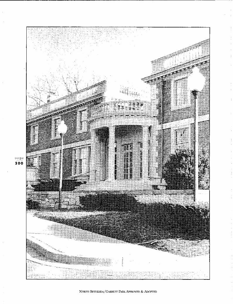
page
200
NoRm BETIIESDA/GARRErr PARK APPROVED & AnoPTED
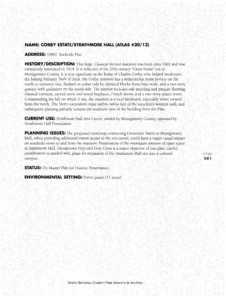
NAME: CORBY ESTATE/STRATHMORE HALL (ATLAS #30/12)
ADDRESS: 10801 Rockville Pike
HISTORY /DESCRIPTION: This large, Classical Revival mansion was built circa 1902 and was extensively renovated in 1914. It is reflective of the 20th century "Great Estate" era in Montgomery County It is also significant as the home of Charles Corby, who helped modernize the baking industry Built of brick, the Corby mansion has a semicircular stone portico on the north or entrance side, flanked on either side by identical blocks three-bays wide, and a two-story portico with pediment on the south side. The interior includes oak paneling and parquet flooring, classical cornices, carved stone and wood fireplaces, French doors, and a two-story music room. Commanding the hill on which it sits, the mansion is a local landmark, especially when viewed from the north. The Metro excavation came within twelve feet of the structures western wall, and subsequent planting partially screens the southern view of the building from the Pike.
CURRENT USE: Strathmore Hall Arts Center; owned by Montgomery County, operated by Strathmore Hall Foundation.
PLANNING ISSUES: The proposed transitway connecting Grosvenor Metro to Montgomery Mall, while providing additional transit access to the arts center, could have a major visual impact on southern views to and from the mansion. Preservation of the maximum amount of open space at Strathmore Hall, Georgetown Prep and Holy Cross is a major objective of this plan; careful coordination is needed with plans for expansion of the Strathmore Hall site into a cultural campus.
STATUS: On Master Plan for Historic Preservation.
ENVIRONMENTAL SEnlNG: Entire parcel (11 acres).
NORTII BE11IESDA/ GARRETT PARK APPROVED & ADOPTFll
page
201

page
202
NORTII BETI!ESDA/GARRETI PARK APPROVED & ADoPrED
NAME: LINDEN OAK (ATLAS #30/ 14)
ADDRESS: Rock Creek Park - Beach Drive at Rockville Pike
HISTORY /DESCRIPTION: Over 2 70 years old, this 95-foot high white oak (quercus alba) with a five-foot diameter trunk and 132 foot crown is the largest in Montgomery County and the fourth largest in the State of Maryland. It was declared a Maryland Bicentennial Tree in 1976. From its days as a young sapling in the 1 720s to the mature tree of the l 990's, this grand oak has grown and changed with the seasons along with the surrounding countryside. Judging by its open spreading shape, the oak probably stood on the edge of the wooded Rock Creek valley to the east; the cleared land to the west remained farmland for nearly two hundred years. With the "Great Estate" era of the 1920'.s, the open land north of the tree became the grounds of the Corby mansion and the Georgetown Preparatory School, which moved out from Georgetown in 1919. The oak survived the transformation of the surrounding countryside into increasingly urban suburbs in the post World War II era, with high rise apartments springing up across the Pike to
the west and garden apartments to the east. It has witnessed the transportation changes that have fueled this expansion: construction of the Rockville Turnpike from the District of Columbia to Frederick in the 1820'.s within a few feet of the tree, the railroad a mile away, in the 1870'.s, and the sleek Metro tracks fifty feet from the tree a century later (the tracks were realigned to avoid the tree).
CURRENT USE: Not applicable.
PLANNING ISSUES: Recent additions of signs and trafilc lights have an impact on views of the tree.
STATUS: On Master Plan for Historic Preservation.
ENVIRONMENTAL SETTING: Entire parcel (13.7 acres).
NOR1H BE'nIESDA/GARRETT PARK APPROVED & ADOPTED
page
203

6.4 RESOURCES EVALUATED FOR MASTER PLAN DESIGNATION
NAME: WILKINS ESTATE (ATLAS #30/ 1 )
ADDRESS: 12800 Veirs Mill Road
HISTORY /DESCRIPTION: This two-story Classical Revival house with twin chimneys was built circa 191 7 for the Wilkins family, out of stone quarried on the property. It was designed by John Russell Pope and is a fine example of early 20th century "Great Estate" architecture. John F Wilkins, publisher of the Washington Post, apparently lived at the estate, called Norwood, in summers and in Washington D. C. in winter. A servants' quarters (l 925) still stands near the main house, but the gate house, on the comer of Rockville Pike and Randolph Road, was tom down in 1976. Surrounding the house are several large mature trees and the remnants of a formal garden; the vista from the mansion to the south has been altered by the addition of several large mausolea.
CURRENT USE: Offices of Parklawn Cemetery Corporation.
PLANNING ISSUES: The grounds of the former estate, which abut Rock Creek Park on the east and are now a cemetery, are an important open space resource. Views of the Parklawn Building and its parking lot are intrusive; these views could be mitigated by evergreen planting. This Plan recommends that the extension of Aspen Hill Road, shown on the 1970 Master Plan, be deleted.
PLAN RECOMMENDATION: On Locational Atlas and recommended for designation on the Master Plan.
ENVIRONMENTAL SETIING: The recommended environmental setting includes the main house, the carriage house/servants quarters, gardens surrounding the main house, and a portion of the circular drive. It specifically excludes the 20th century mausolea at the rear of the main house. (See Figure 71.) It is not the intent of this designation or of the environmental setting to preclude additional burial sites (which would not require review through the Historic Area Work Permit process). In addition, it is not the intent of this designation to preclude the construction of additional structures - including mausolea, additions to existing structures, or creation of new parking areas - provided that appropriate Historic Area Work Permits are obtained for new construction and addition projects. In the event of new construction, additions, or creation of parking areas, special attention must be given to preserving the mature trees and wooded setting that currently surround the main house and the carriage house/servants quarters. In the event of addition to the main house, care should be given to preserving a portion of the existing formal gardens. All new construction should be designed to be compatible with the existing historic buildings, although the new work does not need to replicate the historic architectural styles. New construction within the environmental setting should also be screened and/or accented with plantings so as to preserve, as much as possible, the wooded ambiance of the setting.
NORTII BE11JF.SDA/GARRETI PARK APPROVED & ADOPTED
page
205

page
206
NORTII BETHESDA/GARRETT PARK APPROVED & AnoPTED
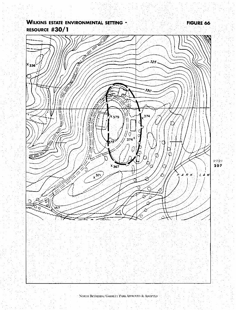
WILKINS ESTATE ENVIRONMENTAL SETIING •
RESOURCE #30/ 1
NORTH BETI-IESDA/GARRETT PARK APPROVED & AnoPTED
FIGURE 66
l LAW
/
page
207
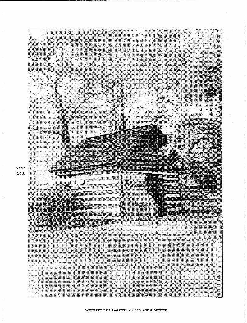
page
208
NORTII BETI-IESDA/GARRETI PARK APPROVED & AooPTED

NAME: SMOKEHOUSE (ATLAS #30/4)
ADDRESS: 12012 Old Bridge Road
HISTORY /DESCRIPTION: Possibly built in the late 18th century, this hand-hewn log smokehouse has been researched and restored by the current owner. It may be the last remnant of an early plantation or estate - possibly the Magruder or Riley plantation.
CURRENT USE: The smokehouse sits in the rear yard of a modem house in the Old Farm subdivision.
PLANNING ISSUES: None
PLAN RECOMMENDATION: On Locational Atlas and recommended for designation on the Master Plan.
ENVIRONMENTAL SETTING: Entire parcel, excluding existing 20th century house.
NORTII BETHESDA/GARRED' PARK APPROVED & ADOPTED
page
209

page
210
NORTII BETHESDA/GARRETT PARK APPROVED & ADOPTED

NAME: TIMBERLAWN (ATLAS #30/ 11)
ADDRESS: 5700 Sugarbush Lane
HISTORY /DESCRIPTION: An example of early 20th century "Great Estate" architecture, this mansion was built in the l 920's by John Joy Edson, treasurer of the National Geographic for thirty-two years. In the l 940's and S0's it was the estate of G. Calvert Bowie and then became the home of R. Sargent and Eunice Kennedy Shriver; he was former Ambassador to France and Director of the Peace Corps from 1961-1966 in the Kennedy and Johnson administrations. During their tenancy, the grounds included game and bath houses, guest cottages, swimming pool, golf course and touch football field, and served as the site of many political functions. The wooded, park-like setting gave way to a subdivision of single-family homes when the Corby family, owners of the property, sold it in 1978.
CURRENT USE: Private home.
PLANNING ISSUES: In addition to the subdivision of the property, development of the Christ Child property to the north and possible development on Edson Lane to the north-east makes the setting increasingly suburban. The former trolley right-of-way is part of the bikeway/greenway system.
PLAN RECOMMENDATION: On Locational Atlas but not recommended for designation on the Master Plan - remove from Atlas.
ENVIRONMENTAL SETTING: Not applicable.
NORTH BETHESDA/GARRETT PARK APPROVED & ADoPTED
page
211

page
212
NORTH BETHESDA/GARRETT PARK APPROVED & AnoPIED

N01rn1 BETIIESDA/GARRETI PARK APPROVED & NX)PTED
page
213

HISTORIC RESOURCES
NORTH BETHESDA
page
214
NAME: GARRETT PARK HISTORIC DISTRICT (ATLAS #30/13)
ADDRESS: Multiple
HISTORY /DESCRIPTION: Garrett Park is one of the Countys earliest and most significant railroad communities. Named after Robert Garrett, founder of the B&O Railroad and built on 154 acres of the original 500 purchased by Henry Copp in 1886, the community reflects nearly a century of diverse architectural styles. These include a good number of Victorian (primarily Queen Anne style) structures, "Chevy" houses from the 1920s (so named because of the optional garage and Chevrolet), Sears "mail order" houses from the 1930's, post-World War II Techbilt structures, and contemporary homes with Frank Lloyd Wright influences that were designed by Howard University professor Alexander Richter. The varied styles and building setbacks are unified by an original landscape plan that was directly influenced by horticulturist William Saunders. On both the meandering streets following the topography north of Strathmore and on the grid streets to the south there are dense shade trees and flowering trees and shrubs. These mature plantings and the varied species which typify Saunders' arboretum concept distinguish Garrett Park from the more homogeneous subdivisions nearby The incorporated town has its own mayor and council, who meet in the town hall (an adapted 1897 church); residents nurture a strong sense of community through encounters at the post office in the single commercial building next to the railroad tracks and through participation in many community activities.
CURRENT USE: Residential community
PLANNING ISSUES: One of the unique and significant features of Garrett Park is its strong sense of community and its autonomous identity Because of these qualities, it is essential that provisions for including the elected officials and all residents of the Town of Garrett Park in the historic preservation process and in decisions relating to preservation issues be given high priority
The Town of Garrett Park is currently within the Regional District and, thus, falls under County planning and zoning jurisdiction. Since historic designation in Montgomery County is a planning process, the creation of a locally-designated historic district in Garrett Park must be accomplished through amending the Master Plan for Historic Preservation. The administration of all designated historic sites within the Regional District in Montgomery County is governed by the Countys Historic Preservation Ordinance, Chapter 24A of the County Code. Although the Countys involvement, as described above, is legally mandated, the Town of Garrett Park must also be actively and significantly involved in all preservation issues within the community
A recommendation outside the historic preservation process that is being made for Garrett Park is the creation of an overlay zone, which would preserve the Town's unique park-like setting by retaining open space around new or expanded houses and would encourage housing of a size that would maintain both diversity within the Town as a whole and compatibility with neighboring houses. A full discussion of this overlay zone recommendation is included in the Land Use and Zoning Plan section of this Plan.
Another planning issue to be noted is Strathmore Avenue. This road is one of the few east-west connectors through the planning area and carries increasing volumes of traffic. However, widening
NoRrn BETI-!ESDA/GARRETI PARK APPROVED & AnoPrED

GARRETT PARK HISTORIC DISTRICT
HPC Recommended Boundaries • - - - Staff Recommended Boundaries
* Staff Recommended Resources A 1121 o Kenilworth Avenue B 11 0 18 Kenilworth Avenue
C D E F
FIGURE 67
Garrett Park Town Hall 10811 Kenilworth Avenue 10806 Keswick Street 10701 Keswick Street
NORTil BETIIESDA/GARRETI PARK APPROVED & AnoPTED
page
215
HISTORIC RESOURCES
NORTH BETHESDA
page
216
would have a major negative impact on the Garrett Park National Register Historic District and would physically divide the community This Plan does not recommend widening of Strathmore Avenue.
PLAN RECOMMENDATION: Designate as a historic district, the portion of the Town of Garrett Park generally bounded by the railroad tracks on the north, Strathmore Avenue on the south, Waverly Avenue to the west, and Montrose Avenue to the east and more specifically delineated on Figure 67. Also designate the following six individual resources:
10701 Keswick Street Built in 1894, the house is a transitional design, late Victorian and early Colonial Revival in its character. It was built by Owen K. and E. V Truitt and was later owned by architect Alexander Richter. Richter was responsible for subdividing the farm; the new area along Weymouth Street is known as "Richterville." Richter designed several homes in this subdivision early in the 1950s.
10806 Keswick Street The Queen Anne/Shingle Style design of this house has been well preserved since its construction c. 1892. The original owner was Garrett Park Town Council member Eppa P Norris, who served on the Council from 1902-1905; later it was the home of David Bissett (Town Council, 1906-1912, 1919-1921).
Garrett Park Town Hall This structure was originally the St. James Episcopal Chapel, built in 1897. Its construction was funded by subscription by Town residents and from the beginning served more than one religious denomination. The building was purchased by the Town and has served continuously through its history as a community meeting place.
10811 Kenilworth Avenue This house is an excellent Montgomery County example of Stick Style residential design, constructed around 1894. It was the home of W Scott Macgill who was Mayor of Garrett Park from 1920-1924.
11018 Kenilworth Avenue Built by 1892, this was the home of Eugene Brady, who was Mayor of Garrett Park from 1898-1902. The structure is also significant as one of Garrett Parks most intact late 19th century suburban dwellings, distinguished by its fine Italianate and Queen Anne architectural detailing.
11210 Kenilworth Avenue Garrett Parks first telephone was located here, and this was the home of H. Hollerith, inventor of the Hollerith code/key punch system. This system was used for the U.S. Census in 1890 and 1900. In addition to its historic associations, the house is an excellent, well-preserved example of the Queen Anne style design, in fashion at the time of Garrett Parks beginnings. This house was built in 1897.
NORTH BETHESDA/GARREIT PARK APPROVED & ADOPTED
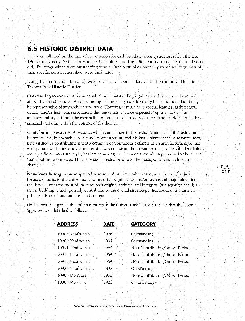
6.5 HISTORIC DISTRICT DATA Data was collected on the date of construction for each building, noting structures from the late 19th century, early 20th century, mid-20th century, and late 20th century (those less than 50 years old). Buildings which were outstanding from an architectural or historic perspective, regardless of their specific construction date, were then noted.
Using this information, buildings were placed in categories identical to those approved for the Takoma Park Historic District:
Outstanding Resource: A resource which is of outstanding significance due to its architectural and/or historical features. An outstanding resource may date from any historical period and may be representative of any architectural style. However, it must have special features, architectural details, and/or historical associations that make the resource especially representative of an architectural style, it must be especially important to the history of the district, and/or it must be especially unique within the context of the district.
Contributing Resource: A resource which contributes to the overall character of the district and its streetscape, but which is of secondary architectural and historical significance. A resource may be classified as contributing if it is a common or ubiquitous example of an architectural style that is important to the historic district, or if it was an outstanding resource that, while still identifiable as a specific architectural style, has lost some degree of its architectural integrity due to alterations. Contributing resources add to the overall streetscape due to their size, scale, and architectural character.
Non-Contributing or out-of-period resource: A resource which is an intrusion in the district because of its lack of architectural and historical significance and/or because of major alterations that have eliminated most of the resource's original architectural integrity Or a resource that is a newer building, which possibly contributes to the overall streetscape, but is out of the districts primary historical and architectural context.
Under these categories, the forty structures in the Garrett Park Historic District that the Council approved are identified as follows:
ADDRESS DATE CATEGORY
10903 Kenilworth 1926 Outstanding
10909 Kenilworth 1891 Outstanding
l 0911 Kenilworth 1964 Non-Contributing/Out-of-Period
10913 Kenilworth 1964 Non-Contributing/Out-of-Period
10915 Kenilworth 1964 Non-Contributing/Out-of-Period
10925 Kenilworth 1892 Outstanding
10904 Montrose 1963 Non-Contributing/Out-of-Period
10905 Montrose 1925 Contributing
NORTI-l BE11IE.SDA/ GARRETT PARK APPROVED & ADOPTED
page
217

HISTORIC RESOURCES
NORTH BETHESDA
page
218
(cont'd)
ADDRESS DATE CATEGORY
10909 Montrose 1925 Outstanding
10910 Montrose 1928 Outstanding
10912 Montrose 1927 Outstanding
10914 Montrose 1990 Non-Contributing/Out-of-Period
10915 Montrose 1925 Contributing
10918 Montrose 1936 Contributing
10919 Montrose 1925 Contributing
10922 Montrose 1908 Outstanding
10923 Montrose 1892 Outstanding
10926 Montrose 1903 Contributing
10933 Montrose 1926 Contributing
10934 Montrose 1894 Contributing
10935 Montrose 1926 Contributing
10937 Montrose 1926 Outstanding
10938 Montrose 1952 Non-Contributing/Out-of-Period
10941 Montrose 1926 Contributing
11005 Montrose 1890s Outstanding
Rokeby 1930's Contributing (train shed; moved here in 1980'.s)
11010 Rokeby 1926 Contributing
4 705 Strathmore 1936 Outstanding
4 709 Strathmore 1926 Contributing
4600 Waverly 1894 Outstanding
4601 Waverly 1922 Contributing
4605 Waverly 1911 Contributing
4609 Waverly 1892 Outstanding
4 700 Waverly 1962 Non-Contributing/Out-of-Period
4701 Waverly 1890 Outstanding
4 702 Waverly 1890 Outstanding
4 709 Waverly 1972 Non-Contributing/Out-of-Period
4710 Waverly 1889 Outstanding
4 711 Waverly 1889 Outstanding
4716 Waverly 1892 Outstanding
NORTH BETHESDA/GARRETT PARK APPROVED & ADOPTED
The categorizations as shown above would result in 45 percent Outstanding resources in the Garrett Park Historic District, 35 percent Contributing resources, and 20 percent NonContributing/Out-of-Period.
The six individual historic sites in Garrett Park are not included in this list. They are each designated on the Master Plan for Historic Preservation as individual landmarks and have a high level of review, as is appropriate with an individually-designated site.
This Plan recommends the future development, in conjunction with the citizens of Garrett Park, of specific Historic Preservation Review Guidelines (similar to those developed for Takoma Park).
ENVIRONMENTAL SETTING: See Figure 67 for delineation of the district/individual sites in the Town of Garrett Park
NoRTII BETI-ffSDA/GARRETI PARK APPROVED & ADOPTED
page
219

page
220
NORTH BETHESDA/GARRETT PARK APPROVED & ADOPTED
NAME: ARNOLDA ESTATE (ATLAS #30/ 16)
ADDRESS: 5721 Grosvenor Lane
HISTORY /DESCRIPTION: Possibly built in 1912 by the Edwin Luther Wilson family, this two-story Colonial Revival stone farmhouse with slate roof is an example of "Great Estate" architecture that was prevalent in Montgomery County in the early part of the 20th century The house has had a series of owners, and has been owned since 1969 by the Grosvenor Partnership. The setting of the house has been altered by the construction of a one-story corridor-plan health center complex around it.
CURRENT USE: Part of the Bethesda Health Center complex.
PLANNING ISSUES: Should the site no longer be used as a health center, future use of the property would have to be addressed. This Plan recommends retaining the existing R-90 zoning.
PLAN RECOMMENDATION: On Locational Atlas but not recommended for Master Plan designation - remove from Atlas.
ENVIRONMENTAL SETTING: Not applicable.
NORTH BErI!EBDA/G,\RRETI PARK APPROVED & ADOPTED
page
221

page
222
NORTH BETHESDA/GARRETT PARK APPROVED & AnoPTED

NAME: MT. ZION CHURCH AND CEMETERY (ATLAS #30/18)
ADDRESS: 10200 Old Georgetown Road
HISTORY /DESCRIPTION: This church on a hill above Old Georgetown Road was built in 1910 and remodeled in 1950. It houses one of the earliest Baptist congregations in the County The cemetery associated with the church has been in continuous use since 1864, and contains plots of local families including the Magruders, Veirs, Beanes, Darcys and Rileys. The structure is covered in white pebble dash, with a brick addition. Known as The Church in the Wildwood, its name is reflected in the nearby late-20th century Wildwood Shopping Center and Wildwood Manor Subdivision.
CURRENT USE: Church and cemetery
PLANNING ISSUES: The widening of Old Georgetown Road has altered the once rural setting of the church and resulted in a high retaining wall which would be visually improved with planting.
PLAN RECOMMENDATION: Designate only the Mt. Zion Cemetery on the Master Plan for Historic Preservation. Remove the Mt. Zion Church structure and other related buildings located on the site from the Locational Atlas.
ENVIRONMENTAL SETIING: Cemetery parcel only
NoRm BE11IESDA/GARRETI PARK APPROVED & ADOPTED
page
223

HISTORIC RESOURCES
NORTH BETHESDA
page
224
6.6 HISTORIC PRESERVATION DESIGNATION CRITERIA Designation of historic sites and districts serves to highlight the values that are important in maintaining the individual character of the County and its communities. It is the intent of the Countys preservation program to provide a rational system for evaluating, protecting and enhancing the Countys historic and architectural heritage for the benefit of present and future generations of Montgomery County residents. The accompanying challenge is to weave protection of this heritage into the Countys planning program so as to maximize community support for preservation and minimize infringement on private property rights.
The following criteria, as stated in Section 24A-3 of the Historic Preservation Ordinance, shall apply when historic resources are evaluated for designation in the Master Plan for Historic Preservation:
1. Historic and cultural significance:
a.
b.
C.
d.
The historic resource:
has character, interest, or value as part of the development, heritage or cultural characteristics of the County, State, or Nation;
is the site of a significant historic event;
is identified with a person or a group of persons who influenced society;
exemplifies the cultural, economic, social, political or historic heritage of the County and its communities; or
2. Architectural and design significance: The historic resource:
a. embodies the distinctive characteristics of a type, period or method of construction;
b. represents the work of a master;
c. possesses high artistic values;
d. represents a significant and distinguishable entity whose components may lack individual distinction; or
e. represents an established and familiar visual feature of the neighborhood, community, or County due to its singular physical characteristic or landscape.
NORTH BETHESDA/GARRETT PARK APPROVED & ADOPTED

6.7 EFFECTS OF HISTORIC DESIGNATION Once designated on the Master Plan for Historic Preservation, historic sites are subject to the protection of the Ordinance. Any substantial changes to the exterior of a resource or its environmental setting must be reviewed by the Historic Preservation Commission and an historic area work permit issued under the provisions of the Countys Preservation Ordinance, Section 24A-6. In accordance with the Master Plan for Historic Preservation and unless otherwise specified in the amendment, the environmental setting for each site, as defined in Section 24A-2 of the Ordinance, is the entire parcel on which the resource is located as of the date it is designated on the Master Plan.
Designation of the entire parcel provides the County adequate review authority to preserve historic sites in the event of development. It also ensures that, from the beginning of the development process, important features of these sites are recognized and incorporated in the future development of designated properties. In the case of large acreage parcels, the amendment will provide general guidance for the refinement of the setting by indicating when the setting may be reduced in the event of development; by describing an appropriate area to preserve the integrity of the resource; and by identifying buildings and features associated with the site which should be protected as part of the setting. It is anticipated that, for a majority of the sites designated, the appropriate point at which to refine the environmental setting will be when the property is subdivided.
Public improvements can profoundly affect the integrity of an historic area. Section 24A-6 of the Ordinance states that an Historic Area Work Permit for work on public or private property must be issued prior to altering an historic resource or its environmental setting. The design of public facilities in the vicinity of historic resources should be sensitive to and maintain the character of the area. Specific design considerations should be reflected as part of the Mandatory Referral review processes.
In the majority of cases, decisions regarding preservation alternatives are made at the time of public facility implementation within the process established in Section 24A of the Ordinance. This method provides for adequate review by the public and governing agencies. In order to provide guidance in the event of future public facility implementation, the amendment addresses potential conflicts existing at each site and suggests alternatives and recommendations to assist in balancing preservation with community needs.
In addition to protecting designated resources from unsympathetic alteration and insensitive redevelopment, the Countys Preservation Ordinance also empowers the Countys Department of Environmental Protection and the Historic Preservation Commission to prevent the demolition of historic buildings through neglect.
The Montgomery County Council passed legislation in September 1984 to provide for a tax credit against County real property taxes in order to encourage the restoration and preservation of privately owned structures located in the County The credit applies to all properties designated on the Master Plan for Historic Preservation (Chapter 52, Art. VI). Furthermore, the Historic Preservation Commission maintains up-to-date information on the status of preservation incentives including tax credits, tax benefits possible through the granting of easements on historic properties, outright grants and low-interest loan programs.
N01m1 BETHESDA/ GARRETT PARK APPROVED & ADOPTED
page
225
COMMUNITY FACILITIES PLAN
li[l];iiil=i,i=ili•t-1 . . Chapter 7
COMMUNITY FACILITIES PLAN
7.1 OVERVIEW AND RECOMMENDATIONS An area's community facilities help create and reinforce a sense of social cohesion-a sense of community The Commission on the Future (1988) defined a sense of community as "a feeling of belonging to a local area and having an interest and a stake in what happens there." Area residents rely on community facilities for needed services, and, ideally, they should be located in relatively close proximity to the neighborhoods they serve or, if they are user-oriented, to transit.
A. COMMUNITY FACILITY OBJECTIVES • Provide for services and facilities that meet the present and future needs of
the community
• Provide green spaces in appropriate locations.
• Broaden the range of facilities to meet the demands of a varied population, including the handicapped.
B. PLAN RECOMMENDATIONS Park and Recreation Facilities • Extend the existing Wall Local Park at Old Georgetown Road and Executive
Boulevard through parkland dedication to include the parcel to the north currently used as an automobile dealership parking lot.
• Provide 5 urban amenity open spaces, to be located at (1) Twinbrook Metro, (2) Montrose Crossing, (3) White Flint Metro, (4) Rock Spring Park, and (5) the Grosvenor Metro site.
• Maintain a significant portion of the right-of-way for the Montrose Parkway as a greenway
• Locate two new soccer fields on the state owned land west of Tildenwood Drive.
• Upgrade existing older park facilities to meet the needs of the current population.
• Keep all fields in safe, playable condition, especially fields at closed schools.
• Maintain public access to playing fields at closed schools.
NoRm BE1HESDA/GARRETI PARK APPROVED & ADoPTED

COMMUNITY FACILITIES PLAN
NORTH BETHESDA
page
228
• Improve handicapped access to existing parks by removing barriers such as steps, installing appropriate play equipment, and providing accessible picnic facilities.
• Support the Adopt-a-Green-Space program.
Community Recreation Centers • Provide a community recreation center for the North Bethesda-Garrett Park
Planning Area on the Davis parcel at Rock Spring Park.
Public Schools • Assure that safe pedestrian access is provided to all school facilities.
Libraries • Consider the expansion of the Davis Library on its present site if additional
library service is needed in the planning area in the future.
• Support the provision of satellite library service from "storefront" or kiosk-style library facilities in the future.
Cultural Facilities • Support the proposed expansion of the Strathmore Hall Arts Center as envisioned
by the Strathmore Hall Foundation. (See land use recommendations for the Grosvenor Sector Plan area).
Public Safety • Support the use of small police substations throughout the planning area as
conditions warrant. Suitable locations include Sector Plan areas and Rock Spring Park.
Post Offices • Support a new post office in the southern part of the planning area.
• Support a separate ZIP code for North Bethesda.
Elderly Housing Facilities • Support the provision of adult day-care facilities.
• Encourage the location of elderly housing and elderly support services along bus routes.
• Support the provision of affordable elderly housing through the special exception process.
• Support the consideration of land in public ownership for affordable elderly housing.
Child Day Care Facilities • Support provision of day care centers at Metro stations in the planning area.
NORTII BETHESDA/GARRETT PARK APPROVED &ADOPTED
• Encourage the provision of child day-care facilities at other appropriate locations in the planning area.
• Consider day care centers as an amenity associated with applications for optional zones.
• Require the provision of day care facilities as part of the redevelopment process in areas where redevelopment occurs.
• Support expanded use of public buildings for child care.
Housing For Special Populations • Support the provision of housing for special populations through the special
exception process.
7 .2 PARK AND RECREATION FACILITIES Public parkland and recreation facilities play an important role in the well-being of a community Parkland enhances quality of life by providing visual relief from the built environment, and provides an opportunity to experience nature within a largely urban environment. In addition, open space contributes to the natural environment by providing wildlife habitat, improving air quality, and preserving water quality, soils and slopes, and protecting fragile species.
A. EXISTING AND PROPOSED FACILITIES The Department of Parks manages 504 acres of parkland in the North Bethesda-Garrett Park Planning Area. One hundred and sixteen acres are developed for active use. (See Table 13 and Figure 68.) In addition, portions of the Rock Creek Stream Valley, as well as the entire Tilden Woods Stream Valley, are within the planning area.
Local use parks are divided into two types, "neighborhood parks" and "local parks." Neighborhood parks are relatively small, and are developed primarily to serve the residents of nearby residential communities. They generally provide play equipment, informal sitting areas, and sometimes small playfields. They may also include tennis or multi-use courts. There are four neighborhood parks in the planning area: Druid Drive, Garrett Park-Waverly, Wells, and White Flint Neighborhood Parks. Local parks are developed to serve a larger community than neighborhood parks. The major difference between neighborhood and local parks is that the latter provides athletic fields in addition to playground and picnic areas. There are nine local parks in the planning area: Farmland Drive, Fleming, Garrett Park Estates, Luxmanor, Randolph Hills, Stratton, Tilden Woods, Timberlawn, and Wall.
In addition to Montgomery County parkland, the Town of Garrett Park manages several small parks that include a softball field, a tennis court, a playground, and a hiking trail.
NORTH BETHESDA/GARRETT PARK APPROVED & ADOPTED
page
229

page
230
FIGURE 68
1000 0 1000
FEET
STREAM VALLEY PARKS 6. Garrett Park Estates NEIGHBORHOOD PARKS
1. Rock Creek 7. Luxmanor 13. Druid Drive
2. Cabin John Park 8. Randolph Hills 14. Garrett Pork-Waverly
3. Tilden Woods 9. Stratton 15. Wells
LOCAL PARKS 10. Tilden Woods 16. White Flint
4. Farmland Drive 11. Timberlawn
s. Fleming 12. Wall
NoRrn BETI-IESDA/GARRETI PARK APPROVED & ADoITED
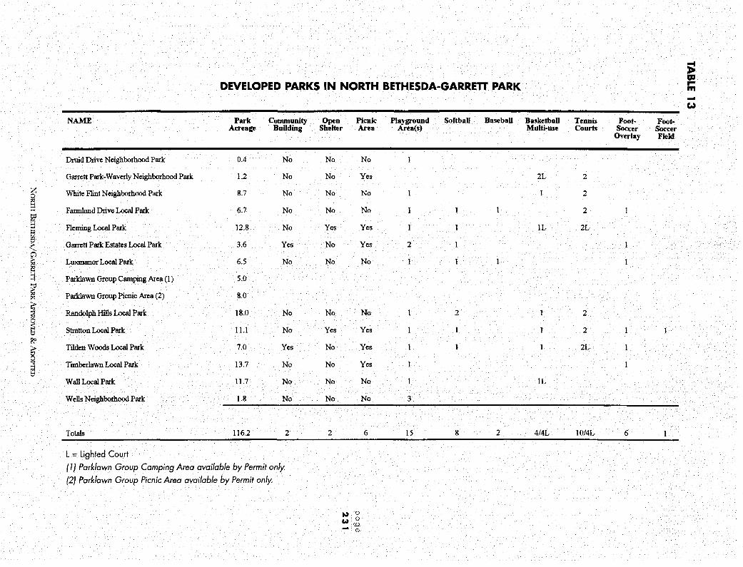
~ alt
DEVELOPED PARKS IN NORTH BETHESDA-GARRETT PARK r-ffl -e,.,
NAME Park Community Open Picnic Playground Softball Baseball Basketball Tennis Foot- Foot-Acreage Building Shelter Area Area(s) Multi-use Courts Soccer Soccer
Overlay Field
Druid Drive Neighborhood Park 0.4 No No No
Garrett Park-Waverly Neighborhood Park 1.2 No No Yes 2L 2
z White Flint Neighborhood Park 8.7 No No No 1 1 2 0
@ t:d
Farmland Drive Local Park 6.7 No No No I 1 I 2
i Fleming Local Park 12.8 No Yes Yes 1 l IL 2L
t Garrett Park Estates Local Park 3.6 Yes No Yes 2
i Luxmanor Local Park 6.5 No No No I
::j Parklawn Group Camping Area (1) 5.0
i Parklawn Group Picnic Area (2) 8.0
~ Randolph Hills Local Park 18.0 No No No 1 2 1 2 "' i Stratton Local Park 11.1 No Yes Yes 1 I 1 2 ?:'
i Tilden W cods Local Park 7.0 Yes No Yes 1 I 1 2L l
Timberlawn Local Park 13.7 No No Yes
Wall Local Park 11.7 No No No l IL
Wells Neighborhood Park 1.8 No No No 3
Totals 116.2 2 2 6 15 8 2 4/4L 10/41 6 l
L = Lighted Court ( 1) Park/awn Group Camping Area available by Permit only. (2) Park/awn Group Picnic Area available by Permit only.
t.). --0 ~: 0
: co ~: (D
COMMUNITY FACILITIES PLAN
NORTH BETHESDA
TABLE 14
NORTH BETHESDA-GARRETT PARK BALLFIELD INVENTORY, PUBLIC SCHOOLS
Active Schools Softball
Ashburton Elementary 1
Farmland Elementary 1
Garrett Park Elementary
Luxmanor Elementary 1
Tilden (holding school) 1
Walter Johnson High School 1
Woodward Intermediate 1 page
232
Closed Schools Softball
Randolph Junior High 1
Grosvenor Elementary 1
Rockinghorse Road Elementary 1
Montrose Elementary 1
Number of Fields Baseball
1
1
1
1
1
Number of Fields Baseball
1
NOR'IH BETHESDA/GARRETT PARK APPROVED & ADOPTED
Soccer/Football
1
1
1
1
1/1
1/1
Soccer/Football
1

Public schools in the planning area, both active and closed, also provide recreational facilities that may be available after school hours and on weekends. (See Table 14.) The Department of Parks has taken over the permitting of closed school fields in order to make them available for public use. A commitment from the Recreation Department and the Board of Education is needed to provide monies for the installation of goals, and for field maintenance and refurbishment.
The residents of the planning area are generally well-served by the existing open space and recreational facilities. Based on the 1990 estimated population there are approximately 15 acres of parkland per 1000 residents. This compares favorably to other downCounty planning areas, as well as to the National Recreation and Parks suggested guidelines of 6.25 to 10.5 acres of parkland per 1000 residents.
In order to serve the future population of North Bethesda, this Plan recommends the extension of the existing Wall Park at Old Georgetown Road and Executive Boulevard to include the parcel to the north currently used as an automobile dealership parking lot; locating two new soccer fields on the state owned land west of Tildenwood Drive; the preservation of a continuous portion of the Montrose Parkway right-of-way as a greenway, including hiker/ biker facilities; and five urban amenity open spaces, to be located at (1) Twinbrook Metro, (2) Montrose Crossing, (3) White Flint Metro, (4) Rock Spring Park, and (5) the Grosvenor Metro site.
B. MEASURING OPEN SPACE AND RECREATION NEEDS The need for additional recreation facilities is based on facility demand and future population projections. The 1988 Park, Recreation and Open Space Plan (PROS) identified a need for five additional soccer fields in the North Bethesda-Garrett Park planning area. Two fields were provided through the recent development of Timberlawn Local Park. A third was added during the renovation of Randolph Hills Local Park. Soccer fields, and playing fields in general, require large level areas and more space than any other local park activity The lack of suitable available land in down-County planning areas such as North Bethesda-Garrett Park is particularly acute.
C. MEETING RECREATION NEEDS IN THE PLANNING AREA Park Rehabilitation Park rehabilitation provides the opportunity to evaluate whether or not the existing facilities meet community needs and to revise facilities to reflect changes. For example, in some cases, older families are moving out and new families with children are replacing them. Several North Bethesda parks have been proposed for renovation. Fleming, Tilden Woods, and Randolph Hills Local Parks are scheduled for rehabilitation of tennis courts or multi-use courts.
Adopt-a-Green-Space Stub streets, paper streets, and other unused public rights-of-way offer opportunities for neighborhood green space. Fiscal concerns prevent the public sector from developing and
NORTII BETHESDA/GARRETT PARK.APPROVED &ADOPTED
page
233
COMMUNITY FACILITIES PLAN
NORTH BETHESDA
page
234
maintaining these small open spaces, but individual communities may wish to convert these small undeveloped areas to community maintained green spaces. Interested neighborhoods should contact the County Department of Transportation for details.
Subdivision and Dedication The subdivision process provides an opportunity to acquire parkland through dedication. Potential sites are evaluated in terms of community needs, general appropriateness, fiscal constraints, and maintenance requirements.
To meet the planning area's-and the Countys-open space needs, the traditional definition of open space as publicly owned land must be expanded. As land prices and development pressures increase, the buying power and the ability to negotiate for public land effectively decrease. Open space must also be preserved through the planning process. Open space and recreation facilities may also be dedicated by the developer to a homeowners' association. The Department of Parks recognizes this as a valuable tool in providing open space to meet the needs of new residents.
Open space can also be preserved without public cost by encouraging cluster development through the site design review process. For examples of proposals to preserve open space through the planning process, see this Plans land use and zoning recommendations for the Georgetown Preparatory School, Strathmore Hall, and Aubinoe properties.
The Plan recommends that consideration be given to the acquisition of property required for a greenway, specifically the Montrose Parkway, via conservation easements, possibly through an intermediary organization such as the Maryland Environmental Trust.
Urban Amenity Open Spaces Urban amenity open spaces serve high activity areas. They can provide landscaped sitting areas, walkways, and limited active recreational opportunities. They can provide a buffer between residential areas and other land uses. The most heavily used urban amenity open spaces are adjacent to employment centers, where they provide a place for workers to eat lunch, read, socialize, and relax. These open spaces may be less heavily used at other times, but play equipment should be available for use by neighborhood children on weekends.
Suitable locations for urban amenity open spaces include large employment centers, transit station areas, commercial areas, and high density residential areas. Occasionally, they may be located on abandoned road rights-of-way where their development as parkland fulfills a need for open space or recreation areas.
Consideration should be given to the following guidelines in locating and developing urban amenity open spaces.
NORTH BETIIBSDA/GARRETT PARK APPROVED & ADOPTED

EXISTING PUBLIC FACILITIES
Existing Public School
Closed Public School (see text)
- Group Quarters
:,:,:,:,:,:,:,:,:,:,:,:,:,:,:,:,:, Church or Synagogue ,:,'/i'.',',\',' .. ,'i',',11','i'
- Metrobus Facility
• Post Office
e Library
• Fire Station
NORTII BETHESDA/GARRETT PARK APPROVED & AooPTED
1000 0 1000
FE!:T
page
235
COMMUNITY FACILITIES PLAN
NORTH BETHESDA
page
236
1. They should be within five to ten minutes walking time of users.
2. They should include sitting areas, walkways, and landscaping.
3. Playground equipment and other small-scale active recreation facilities, such as multi-purpose courts, should be considered in areas serving a significant number of children.
4. Special consideration should be given to the needs of the elderly and the handicapped.
5. Urban amenity open spaces located on the periphery of high-intensity nonresidential areas should include facilities to serve nearby residents.
6. Design should address minimizing maintenance costs.
7. Amenity open spaces should be of a sufficient size to support appropriate use by residents or workers and the public.
8. Consideration should be given to the appropriate amount of development necessary to support both the initial cost of the development and the long-term maintenance of the amenity space.
The Montrose Parkway Right-of-Way The Montrose Parkway right-of-way comprises 145 acres of land in the planning area. Ninety-one acres are owned by the State Highway Administration. Forty-eight acres of property west of Old Georgetown Road remain in private ownership. The remainder of the right-of-way is owned by the M-NCPPC. (See Figure 70.)
The right-of-way was designated to meet a transportation need for east-west traffic movement. It also offers an opportunity to provide a pedestrian/bicycle facility through the planning area and connecting to the Rock Creek hiker-biker trail.
The Montrose Parkway right-of-way connects a number of County parks, namely the Cabin john, Old Farm and Rock Creek Stream Valley Parks, as well as the Matthew Henson State Park. An aerial view of the right-of-way presents a linear greenway This linear greenway would be a substantial addition to the Countys open space. This Plan recommends that a portion of the right-of-way be maintained as a continuous greenway, including the portion not in reservation.
The Plan also recommends locating two new soccer fields on the state owned land in reservation west of Tildenwood Drive. The right-of-way is wide enough to accommodate both a future transit use and the two ballfields.
NoRrn BETIJESDA/GARRETT PARK APPROVED &ADOPTED

MONTROSE PARKWAY • OWNERSHIP STATUS FIGURE 70
MONTROSE PARKWAY WEST
MONTROSE PARKWAY EAST
State Highway Administration - Park and Planning Commission
M-NCPPC Dedication
Private Land
NORTH BETHESDA/GARRETT PARK APPROVED & AooPTED
page
237

COMMUNITY FACILITIES PLAN
NORTH BETHESDA
page
238
7.3 COMMUNITY RECREATION CENTERS Community recreation centers provide a location for large community meetings and social gatherings, and for smaller social and programmed activities for all segments of the population. According to current Department of Recreation standards, a community recreation facility is needed for a population of 40,000 to 50,000. However, the Department of Recreation will soon begin revising its standards, and it is likely that the number of people that can be served by one center will be lowered.
These standards indicate a need for a community recreation center in the North Bethesda-Garrett Park area. The closest existing community recreation centers are the Leland Center in Bethesda, the Wheaton Center, the Bauer Drive Center in Aspen Hill, and the Potomac Center. Of these, the Wheaton Center is an older, smaller center than the others with much more limited facilities.
Community recreation facilities provide space for the following types of activities:
• Structured group and unstructured, self-directed physical activities such as weight lifting, aerobic dancing, and organized athletic programs for various age groups.
• Space for Senior Adult Programs. Recreation centers are heavily used by seniors for active and passive opportunities, particularly during the daytime.
• Space for meetings and group activities such as civic association meetings, garden clubs, scout meetings, league banquets, support groups, dances, corporate training programs, and wedding receptions.
• Public information about government and private services, programs and agencies.
• Space for special human service programs, such as food distribution and blood pressure checks, and temporary shelter in times of fire or other public emergency
• Separate but adjacent space for privately operated child care services.
New community recreation facilities should allow maximum program flexibility and should be capable of reasonably easy physical modification to adapt to changing community demographics and leisure interests. The center would ideally be comprised of a set of fixed core spaces and a series of adaptable 1600 to 1800 square foot activity spaces.
It would be desirable to locate the community recreation facility in a park-like setting where outdoor play space can complement the indoor features of the center. The center should also have good accessibility to the service area and visibility to the public. It is recognized that in highly developed, urbanized areas of the County, it may be difficult to locate the center where it is adjacent to ballfields or other major park amenities. The site selected, however, must be adequate for a 23,000 square foot facility and necessary parking.
This Plan recommends the Davis parcel in Rock Spring Park as the location for a new community recreation center.
NoRrn BETI-IESDA/GARRETI PARK.APPROVED &ADOPTED

7.4 PUBLIC SCHOOLS Public schools are an essential component of community life and should be an integral part of community structure. The need for new schools is determined by both the capacity of existing schools and the projected increase in student enrollment.
About 80 percent of the North Bethesda-Garrett Park Planning Area is within the Walter Johnson Cluster. Of the remaining 20 percent, approximately 15 percent is in the Wheaton Cluster, and five percent is in the Richard Montgomery Cluster (see Figure 71).
Four active elementary schools are located within the planning area: Ashburton, Luxmanor, Garrett Park, and Farmland. Two additional elementary schools-Wyngate in Bethesda and Kensington-Parkwood in Kensington-are located outside the area'.s boundaries but serve planning area residents. Woodward is the area'.s middle school, and Walter Johnson is its high school. Both the former Grosvenor elementary school and the former Tilden school are being used as holding schools for other County schools undergoing modernization.
The Board of Education programs capital funds for school modernizations. This program improves the quality of existing school buildings and adds classrooms or additional spaces as required. The Board of Education at times modifies service areas to balance enrollment with facility space.
The Board of Education programs new public schools, additions, and modernizations through the Capital Improvement Program, and the Approved Master Plan for Educational Facilities. The timing of additions and modernizations are evaluated annually in these documents.
The North Bethesda-Garrett Park Planning Area contains three closed schools currently being used for various other purposes. The former Rocking Horse Road School has been retained by the Board of Education and is now used by the Board of Educations staff for administrative offices and for alternative education use. The former Randolph Junior High School is leased to the Greater Washington Jewish Foundation and operated as a community center and a private school. The former Montrose School had until recently been leased to a private girls' school which has since closed. The building has been returned to Montgomery County Public Schools pending a decision on future reuse.
It may be necessary in the future to reclaim school buildings for use as operating schools if future enrollments so require. No additional school sites are currently proposed for the North BethesdaGarrett Park Planning Area.
7.5 LIBRARIES Library service is provided to North Bethesda residents by the Davis Regional Library at 6400 Democracy Boulevard. The Davis collection includes a travel literature collection. A Special Needs Library, serving handicapped citizens, is located on the lower level of the same building. The Special Needs Library provides Talking Books for the blind and physically handicapped as well as home-bound and other adapted services.
NoRrn BETI-ll'.SDA/GARRETT PARK APPROVED & ADoPrED
page
239

page
240
WALTER JOHNSON CLUSTER
Walter Johnson HS~
ewyngate ES
A High School
a Junior /Intermediate/Middle School
• Elementary School
NORTH BETHESDA/GARREIT PARK APPROVED & ADOPTED
FIGURE 71
North

Other public libraries serving this area include the Kensington Park Library on Knowles Avenue, and the Rockville, Twinbrook and Bethesda libraries. In addition, the Town of Garrett Park has a special-purpose childrens library.
A private library, the Isaac Franck Jewish Public Library, is located in the Lehrman Community Service Building (formerly the Randolph Junior High School). This library is open to the public and has a Judaic collection that is unique in the Washington metropolitan region.
According to Montgomery County Department of Public Libraries criteria, no new community library will be needed in this planning area within the next six year period. However, there is a perception of unmet needs in at least some segments of the community, particularly in respect to overcrowding during periods of high use, and in terms of distance between existing facilities. It should be noted that the Library Department is considering providing satellite library service from "storefront" or kiosk-style operations in the future.
This Plan supports the expansion of the Davis Library on its present site if additional library service is needed in the Planning Area in the future. The Plan also supports the provision of satellite library service from "storefront" or kiosk-style library facilities in the future. Suitable locations include Metro stations and other activity centers.
7.6 CULTURAL FACILITIES The Countys Strathmore Hall Arts Center is located on Rockville Pike in the Grosvenor Sector Plan Area. The County owns 11 acres and the historic structure, which has been run by a nonprofit corporation (Strathmore Hall Foundation, Inc.) since 1983. The Foundation provides year round art exhibitions, indoor and outdoor concerts, lectures, special events, a Montgomery County authors' library, and a gift shop. The mansion can be rented for special events.
Existing facilities at Strathmore Hall include the mansion house, with its 100-seat music hall; the Gudelsky Pavilion, where outdoor concerts are held; and a stage to the east of the mansion for childrens performances.
The Strathmore Hall Foundation has long-range plans to develop a cultural campus on the remainder of the site and, if possible, an additional ten acres of land that they hope to acquire from the adjacent American Speech-Hearing-Language Association property: These long-range plans include a 700-seat music hall, with an art gallery, a reception hall for up to 200 people, and possibly a museum.
This Plan supports the proposed expansion of the Strathmore Hall Arts Center as envisioned by the Strathmore Hall Foundation. (See land use recommendations for the Grosvenor Sector Plan Area.)
NORTII BETI-IESDA/GARRETI PARK APPROVED & ADOPTED
page
241

page
242
PROPOSED COMMUNITY FACILITIES
- Proposed Local Park
Montrose Greenway
Proposed Ballfields
Q Proposed Community Center
.A. Proposed Child Day Care Center
~ Proposed Cultural Center
Proposed Amenity Open Space
NoRrn BETHESDA/GARRETT PARK APPROVED & AnoI'I'ED
FIGURE 72
1000 0 1000
FEET

7 .7 PUBLIC SAFETY Bethesda Fire/Rescue Station #26 is located at 6700 Democracy Boulevard. Other facilities serving the planning area are located on Rollins Avenue in Rockville and on Veirs Mill Road in Kensington. Fire station service areas are dictated by service response times. The Bethesda-Chevy Chase Rescue Squad, located outside the planning area, provides rescue and emergency service to part of the planning area.
According to the Department of Fire and Rescue Services' Draft Fire Defense, Rescue and Emergency Medical Services Plan (May 1991), no new fire and rescue stations are planned for this area at this time. An increased need for emergency medical services is expected in the future, and future traffic conditions may cause delays in response time. These problems may be solved by deploying rescue vehicles to strategic locations during hours of high demand so that travel distances will be reduced.
Police service in the North Bethesda-Garrett Park area is provided by the Bethesda and Rockville Police Districts. The Bethesda District Station is located at 7359 Wisconsin Avenue. The Rockville District Station is located at 1451 Seven Locks Road. The Countys Bethesda Station currently covers calls and incidents originating in the area south of Tuckerman Lane, while the Rockville Station covers the area lying north of Tuckerman Lane.
The Police Department does not have any plans to increase the number of stations in this area. Changes in police district boundaries are not expected to result in a decrease of level of service to area residents because police service does not physically originate from the station where the call for assistance is received but rather from personnel already patrolling the district in cars, who are dispatched by radio. Depending on need, the Police Department may decide to use satellite stations within a district to provide decentralized service in the future.
This Plan supports the use of small police substations throughout the planning area as conditions warrant. Suitable locations include Sector Plan areas and Rock Spring Park.
7 .8 POST OFFICES Postal facilities are available at three locations in the planning area: in the White Flint Mall, in Garrett Park at 4600 Waverly Avenue, and behind the Wildwood Manor Shopping Center at 10217R Old Georgetown Road. The Rockville Pike Station at 143 Rollins Avenue in the City of Rockville is close to the planning area. Some planning area residents think that existing facilities are inadequate and inconvenient, and that a separate post office for this area would help promote community identity This Plan supports a new post office in the southern part of the planning area, and supports a separate ZIP code for North Bethesda.
NORTII BETHFSDA/GARRETT PARK APPROVED & ADoPTED
page
243

COMMUNITY FACILITIES PLAN
7.9 ELDERLY HOUSING FACILITIES According to the County'.s Draft Area Plan for Programs on Aging FY 1991, "Housing is a significant issue for the elderly .. There remains [in the County] a need for housing and services that are low to moderately priced .... " Affordable rental housing remains the most severe need.
Although the elderly are generally financially comfortable in North Bethesda, those with low incomes constitute a disproportionate share of all elderly people in the area. The elderly represent 57 percent of North Bethesda households with declared incomes under $15,000.
According to the Montgomery County Division of Elder Affairs, there is only one licensed/certified provider of group senior assisted housing for the frail elderly in the planning area, Saint Mark House, at 6305 Tuckerman Lane. This facility offers assisted housing for up to 15 persons.
The Revitz House is a subsidized senior citizen apartment complex located at 6111 Montrose Road. It contains 250 one-bedroom apartments.
The Grosvenor Health Care Center is a privately run nursing home located at 5721 Grosvenor Lane that accommodates 145 individuals.
Other elderly housing facilities include the newly constructed Ring House on East Jefferson Street in Rockville. One hundred and twenty-three units are scheduled for development by Marriott off Tuckerman Lane.
PO 9 e This Plan supports the provision of adult day-care facilities and affordable elderly housing through 2 4 4 the special exception process, and the consideration of land in public ownership for affordable
elderly housing. It should be noted, however, that the possibilities are very limited for providing land in public ownership for this use, other than at the Grosvenor Metrorail Station. The Plan encourages the location of elderly housing and elderly support services along designated bus routes or near Metrorail.
7. 10 CHILD DAY CARE FACILITIES The Planning Area has two existing child day care facilities and two prospective facilities. The Marriott Corporation at Rock Spring Park has a child day care facility that serves children of its employees. The Housing Opportunities Commission development on Tuckerman Lane also includes a child day care center.
A special exception was recently approved for a day care facility for 80 children on a parcel owned by Parklawn Cemetery This center is expected to serve children of employees at the Parklawn Building. The second NRC building at White Flint will include child day care facilities for children of employees.
Among the households in North Bethesda-Garrett Park requiring child day care, about 31 percent have paid care in their homes, compared to 19.7 percent county-wide. Relatively few, about five percent compared to the countys ten percent, report that they need to find paid care (MCPD, Demographic Model, 11/30/89).
NORTH BETHESDA/GARRETT PARK APPROVED & ADOPTED
The high number of existing and forecasted jobs in this planning area suggest a need for additional child care opportunities.
The Metro board of directors recently voted to consider day care centers on its property at Metro stations. Twinbrook, White Flint and Grosvenor are among the current stops that could accommodate day care centers. Vacant land could be donated by Metro or portions of parking lots could be designated for day care centers.
The following recommendations address future needs for child day care facility locations. The Plan supports the provision of day care centers at Metro stations in the planning area and encourages the provision of child day care facilities at other appropriate locations. The Plan supports expanded use of public buildings for child care. The Plan recommends that day care centers be provided as an amenity associated with applications for optional zones. In areas where redevelopment occurs, the provision of day care facilities should be required as part of the redevelopment process.
7.11 HOUSING FOR SPECIAL POPULATIONS People who are physically and mentally handicapped can often be cared for best in a noninstitutional setting such as home communities with others having similar special needs. Such people generally are those who need supervision or assistance to function in a larger community: This Plan supports the provision of housing for special populations through the special exception process. As long as parking does not create an adverse effect on adjoining neighbors, such homes should be appropriate for any residential community: Efforts should be made to avoid an overconcentration of such homes in a particular neighborhood.
NORTH BETIITSDA/G,\RRETI PARK.APPROVED & ADOPTED
page
245

ENVIRONMENTAL RESOURCES PLAN
1&1};1111=1,di#•t·i . Chapter 8
ENVIRONMENTAL RESOURCES PLAN
8. 1 OVERVIEW AND RECOMMENDATIONS
A major goal of this plan is to protect the natural resources and environmental qualities which are important to the residents of North Bethesda-Garrett Park. Environmental concerns within the planning area include loss of mature woodlands, degradation of stream systems, air pollution and roadway noise.
The environmental resources of North Bethesda-Garrett Park are recognized in the land use recommendations of this Plan on a site-by-site basis. The review of specific development projects in the planning area should include consideration of this Plans recommendations, and of the guidelines in the Planning Boards "Environmental Management of Development in Montgomery County, Maryland."
The Environmental Resources chapter discusses issues and makes recommendations concerning tree preservation, greenways, "green corridors," air quality, noise, stormwater management, billboards, and water and sewer service. A tree inventory is included as an appendix to this Plan.
A. ENVIRONMENTAL RESOURCE OBJECTIVES • Protect and enhance the environmental resources of North Bethesda-Garrett Park.
B. PLAN RECOMMENDATIONS Tree Preservation • Protect woodlands, green space, steep slopes and wetlands through land use
recommendations and development regulations.
• Support the adoption of a County-wide comprehensive tree program as required by State law that addresses tree preservation, maintenance, and reforestation.
• Retain mature trees as buffers in new residential development to create visual separation from major roads.
• Retain the maximum number of specimen trees on sites where they occur.
• Provide additional trees along existing streets, in median strips, and in parking lots whenever feasible.
NOR11-l BETHF.SDA/GARRETI PARK APPROVED & A:ooPTED

E NVI RONME NTAL RESOURCES PLAN
NORTH BETHESDA
page
248
• Require that every new road recommended by this Plan have a streetscape plan with an emphasis on tree planting.
• Require commercial and residential developers to plant more trees, particularly native shade trees, consistent with County tree legislation.
• Support retention of much of the existing open space resources of North Bethesda-Garrett Park, both public and private.
Greenways • Preserve a significant portion of the Montrose Parkway right-of-way as
a greenway
Green Corridors • Extend the Countys "Green Corridors Policy" along major roadways in the
planning area.
Billboards • Support necessary action to have existing billboards removed or phased out
expeditiously in accordance with the 1986 billboard law.
Air Quality • Endorse the concept of transit shuttle systems, which will reduce short trips and
diminish traffic congestion and vehicle emissions.
• Improve air quality by encouraging higher density development near transit stations and thereby placing less emphasis on the need to use the private automobile.
Noise • Provide noise attenuation walls when the I-270 spurs are widened at locations
where existing residences will be subjected to high noise levels.
• Include noise attenuation measures in the design of the proposed transitway between Rock Spring Park and Grosvenor and in the design of the Montrose Parkway
Stormwater Management • Endorse corrective measures to reduce flooding and to improve stream quality by
retrofitting developed sites.
• Implement existing stormwater management regulations through the County Department of Environmental Protection to assure that existing problems are addressed for new development and redevelopment.
• Implement a stream water quality monitoring program through local government and citizen participation.
NORTII BETHESDA/GARRETr PARK APPROVED & ADOPTED
• Support maintenance and enhancement of existing stormwater management facilities.
Water and Sewer • Design and build any new sewer or water lines to protect the areas
natural features.
8.2 TREE PRESERVATION Since 1963, the acreage or woodlands in North Bethesda has declined by approximately 30 percent. Much of the remaining mature forest in the planning area is found in stream valleys and the Montrose Parkway right-of-way. These assets are complemented by the wooded areas of large properties such as Parklawn Cemetery, the Georgetown Preparatory School and the Society of American Foresters. Mature subdivisions also make a substantial contribution to the tree resources of North Bethesda. The Town of Garrett Park leads by example and illustrates how community interest, an arboretum philosophy that encourages diversity, and good management practices can maintain a tree canopy cover that approaches 70 percent. Street trees are also a significant asset. Boulevard trees, such as the pin oaks and Bradford pears on Executive Boulevard and Democracy Boulevard, provide inspiration for what can be achieved. Tree preservation is important in retaining the character of the planning area, as well as providing a wide variety of environmental benefits, including reduced erosion, reduced flooding, shade to moderate temperature extremes, cover for wildlife and visual relief from the urban landscape.
On July 1, 1992, new legislation mandated by the State of Maryland and passed by the County requiring tree preservation and reforestation will take effect. The law will require developers to compensate for trees removed during construction by placing new trees on site or, if there is insufficient space on site, at designated off-site locations. Appropriate off-site locations for reforestation may include publicly owned land, such as stream valleys, land owned by homeowners' associations, and other open space. Adopt-a-park areas may also be appropriate locations for implementation of this program.
Many of the remaining vacant and redevelopable parcels in the planning area contain mature trees worthy of preservation. (See Appendix G, "Tree Inventory," in the Plan Appendices.) Under the provisions of the County law, these trees must be considered as tree-save candidates. Lots, roadways and utility easements should be sited to minimize unnecessary loss of healthy trees. In instances where replanting on the same site will not compensate for tree removal, and where an off-site location is unavailable, the County law requires payment of fees to the County Tree Fund. These funds will be dispensed by the County to implement tree planting when appropriate sites are located.
The Maryland Department of Natural Resources (DNR) also sponsors a "TREE-MENDOUS Tree Planting Program." This program sells small trees to be planted by citizens on public open space. The Forest, Park and Wildlife Service of DNR distributes trees to interested citizens and community groups.
NORTI-1 BETIIF.SDA/GARRETT PARK APPROVED & ADOPTED
page
249

ENVIRONMENTAL RESOURCES PLAN
NORTH BETHESDA
page
250
8.3 GREENWAYS Greenways are corridors of open space that link people, parks, and natural areas. The opportunity exists in North Bethesda-Garrett Park to delineate a network of such corridors. The proposed system includes bikeways and sidewalks and links natural areas, residential areas, commercial and employment centers, and public facilities. The system builds upon the stream valley park system, the recommendations of the 1978 Master Plan of Bikeways, existing streets, and existing rights-ofway to provide an interconnected system of greenways and trails within the planning area and connecting to a regional system.
The Rock Creek hiker-biker trail winds through the Rock Creek Regional Park on the eastern side of the planning area, and portions of the trail are within the planning area boundaries. The Waverly-Schulykill connector was recently completed, providing a trail access from the Town of Garrett Park and the Rock Creek hiker-biker trail. The Waverly-Schulykill connector also provides access to the MARC train station in Garrett Park
The Montrose Parkway right-of-way is a linear greenway that connects a number of County parks, namely the Cabin John, Old Farm and Rock Creek stream valleys parks, as well as Matthew Henson State Park This linear greenway would be a substantial addition to the Countys open space. This Plan recommends that a significant portion of the right-of-way be preserved as a greenway
The greenways system proposed by this Plan, which includes both bikeway and sidewalk recommendations, can be found in the Transportation chapter.
8.4 GREEN CORRIDORS To ensure the identity and integrity of residential areas along major roadways, and to strengthen community identity by creating attractive transportation corridors, the Plan proposes a Green Corridors policy that addresses the visual effects of roadways and abutting properties. The Green Corridors policy is recommended to protect and enhance the residential character of the Planning Area. The policy applies to the following roadways, which differ widely from one another in character:
Old Georgetown Road
Rockville Pike
Randolph Road
Montrose Road
Democracy Boulevard
Tuckerman Lane
Twinbrook Parkway
Parklawn Road
Executive Boulevard
Strathmore Avenue
Edson Lane
Grosvenor Lane
NoRTI--I BETI--IESDA/GARREIT PARK APPROVED & ADOPTED
The following is the Green Corridors policy for the North Bethesda-Garrett Park Planning Area.
l. Maintain and enhance planting of vegetation along roadsides and in medians of major highway corridors.
Design guidelines include: placing a landscaped buffer between the curb and relocated sidewalks, placing trees in medians and along curbs, screening of front yard parking, and relocating utility poles to allow for optimum tree planting and sidewalks. Visibility for highway safety must also be considered. Protection and enhancement projects will require coordination between the Maryland State Highway Administration and the Montgomery County Department of Transportation, as well as local property owners and civic associations.
2. The Board of Appeals should require full adherence to the following guidelines for special exceptions in Green Corridors.
• Require screening for parking, even when less than six parking spaces are involved.
• Retain green space, particularly when it provides trees that screen buildings.
• Screen existing buildings with plant material.
• Additions to existing buildings should be compatible with the existing residential architecture and adjoining neighborhoods. Visibility of buildings to residents of nearby communities should be taken into account. Additions should be as unobtrusive as possible, and should be landscaped to provide screening.
8.5 BILLBOARDS In 1986 the District Council enacted legislation that prohibits off-site commercial advertising within the County. Zoning Ordinance Text Amendment 86007 was enacted by the District Council on July 29, 1986.
Existing billboards in the planning area-for example, on Randolph Road-as well as in the rest of the County, are all illegal under the present Zoning Ordinance. These billboards pose significant urban design and enforcement problems. They violate Master Plan and Sector Plan objectives for attractive design and appropriate signage to identify businesses or to provide necessary directions for motorists. Billboards are a form of visual pollution; they are incompatible with the existing or planned character of development in Montgomery County, especially within highly developed down-County areas such as North Bethesda-Garrett Park. This Plan recommends enforcement of the 1986 billboard law to have existing billboards removed or phased out expeditiously.
NORTH BETIIT<SDA/GARREIT PARK APPROVED & ADOPTED
page
251
ENVIRONMENTAL RESOURCES PLAN
NORTH BETHESDA
page
252
8.6 AIR QUALITY The primary air pollution problems in this planning area are ozone and carbon monoxide. High ozone levels occur as a region-wide problem in the metropolitan Washington, D.C., area. Measures to control the production of this pollutant will, of necessity; have to be implemented on a regional or national scale.
Carbon monoxide may be found in high concentrations at major roadway intersections where there is significant traffic congestion. One such intersection is at Rockville Pike and Randolph Road. However, an air quality monitoring station set up by the State of Maryland Air Management Administration at this intersection has shown only one violation of the federal air quality standards for carbon monoxide since the start of the monitoring in January 1983. The violation occurred in 1983. The conclusion can be drawn that tighter regional emission standards appear to be compensating for increased traffic volumes.
This Plans land use and zoning recommendations aim to encourage higher density development near transit stations and place less emphasis on the need to use the private automobile, with the objective of improving air quality
8.7 NOISE Roadway traffic, railroad traffic, and Metrorail-above or at ground level-are the major sources of noise in the planning area. Noise levels in residential areas adjacent to major roadways such as 1-495, 1-270, Montrose Road, and Old Georgetown Road may be very intrusive at certain times. Unfortunately; in developed areas there are few noise mitigation options available. Most of these options require the acoustical treatment of existing buildings for interior reduction of noise levels, or the use of physical barriers.
Capital Beltway (I-495) and 1-270 noise is particularly intrusive because of large traffic volumes, greater night-time traffic activity; and higher percentages of heavy truck traffic. As part of the State Highway Administration project to widen 1-270, noise barriers have been constructed between Tuckerman Lane and Old Stage Road to protect existing houses affected by traffic noise.
This Plan endorses the ongoing effort by the State Highway Administration and residents adjacent to other sections of freeway to work out a cooperative funding mechanism to provide additional noise barriers.
Development of any undeveloped or redevelopable land adjacent to major highways should use noise-compatible land use and site design and other mitigation measures recommended in the "Staff Guidelines for the Consideration of Transportation Noise Impacts in Land Use Planning and Development."
Substantial noise mitigation measures have been implemented at the Grosvenor Mews townhouse subdivision, which is bounded by 1-270, Rockville Pike and Grosvenor Lane. These measures include berms and noise attenuation walls.
NORTH BETHESDA/GARRETT PARK APPROVED & ADOPTED

The CSX/MARC Railroad line is a noise source for residences adjacent to the railroad right-of-way Noise attenuation measures, such as low walls, may be needed to minimize noise for adjacent residences. The Department of Housing and Urban Development recommends a minimum 100-foot setback for residences from rail lines for vibration and noise purposes.
The Metro line near the Grosvenor station has created noise problems for people living nearby for several years. The high noise levels have been generated from various sources associated with the operation of the Metro line, including "flat" spots on train wheels, vibration of the rails on the aerial structure south of the Grosvenor station, train horns, and high train speeds.
WMATA has implemented measures to correct some of these noise problems, including improved wheel maintenance, the installation of noise attenuation walls, and nighttime speed restrictions. Flexible rail fasteners have been installed on the tracks of the aerial structure in order to muffle resonance. Montgomery County Department of Environmental Protection (MCDEP) Environmental Planning and Monitoring, Noise Control Division closely monitors WMATAs noise levels.
Noise attenuation walls should be provided at locations where existing residences will be subjected to high noise levels when the 1-270 spurs are widened. Noise attenuation measures should also be included in the design of the proposed transitway between Rock Spring Park and Grosvenor and in the design of the Montrose Parkway.
a.a STORMWATER MANAGEMENT The North Bethesda-Garrett Park planning area lies within the Rock Creek and Cabin John drainage basins. The location of existing regional stormwater management facilities in the planning area is shown in Figure 73.
Most of the planning area is developed, and much of this development occurred before flooding hazards were documented or controlled. Land surface that was paved for roads, parking lots and driveways is now impervious and therefore not available for water percolation. Instead, precipitation travels rapidly as surface flow, increasing the frequency and magnitude of stream flooding. The clearing of woodlands has further aggravated this situation.
Within the planning area, the main stems of Cabin john Creek and Rock Creek and some of the Old Farm Branch are within parkland. The preservation of natural stream valleys in parkland reduces the negative effects of urbanization. However, park designation does not completely preclude stream channel erosion, water quality degradation and the habitat destruction associated with storm drain outfalls, concrete or piped channels, sanitary sewer crossings, unsightly litter, and stream flow alteration.
Severe stream erosion problems occur in a tributary to the Old Farm Creek and in another tributary to Rock Creek between Strathmore and Weymouth. Streambank erosion and/or construction related sedimentation has also contributed to siltation of the ponds at Grosvenor. The Montgomery County Department of Environmental Protection (MCDEP) will be conducting a stream inventory in the Cabin john and Rock Creek watersheds in order to rectify such stream
NORTI! BET1IF.SDA/GARRETI PARK APPROVED & AnoPTFD
page
253
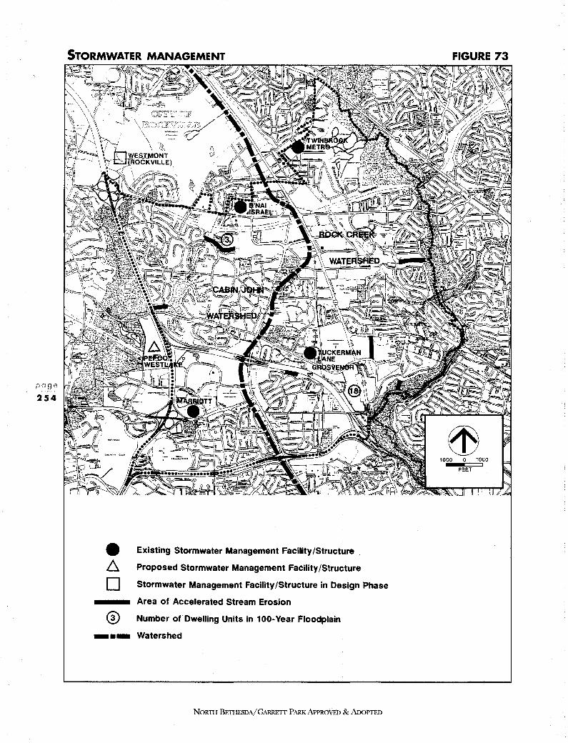
page
254
• Existing Stormwater Management Facility /Structure
~ Proposed Stormwater Management Facility /Structure
D Stormwater Management Facility /Structure in Design Phase
Area of Accelerated Stream Erosion
@ Number of Dwelling Units in 100-Year Floodplain
-•- Watershed
NORTH BETHESDA/GARRETT PARK APPROVED & ADoPTED
FIGURE 73
ffi 1000 0 1000
FEET

erosion problems. Depending upon the location and nature of streambank erosion problems, corrective measures may also be undertaken by the Montgomery County Department of Transportation (MCDOT), the M-NCPPC Department of Parks, individual homeowners' associations and developers of new construction projects.
The water quality of streams in the planning area is no longer monitored on a regular basis. A MCDEP County-wide stream monitoring program was discontinued in 1980 due to budgetary constraints.
This Plan supports the reinstitution of the MCDEP water quality monitoring program. This program is necessary to assure the existing stormwater management programs are effective. In conjunction with the MCDEP monitoring program, a citizen stream monitoring program should be established to augment local government efforts.
A general strategy for stormwater management in the Rock Creek and Cabin John watersheds is contained in the following:
Stormwater &: Water Quality Management Study for Rock Creek (CH2M Hill, 1977)
Cabin John, Rock Run and Little Falls Watershed Study (CH2M Hill, 1982)
Approved and Adopted Functional Master Plan for Conservation and Management, Rock Creek Basin, M-NCPPC, 1980
This Plan supports the recommendations contained in the Rock Creek Functional Plan and the implementation of existing state and local stormwater management regulations. As required by state and local regulations stormwater management techniques to be used in the planning area should be considered in accordance with the following hierarchy:
1. Infiltration
2. Flow&: Pollutant Attenuation
3. Retention
4. Detention
This Plan also supports continued maintenance and enhancement of existing stormwater management facilities and the efforts of MCDEP to inventory and prioritize those areas in the watershed in need of remedial measures.
NORTII BETHFBDA/GARRETT PARK APPROVED & ADOPTED
page
255
ENVIRONMENTAL RESOURCES PLAN
NORTH BETHESDA
page
256
8.9 WATER AND SEWER The North Bethesda-Garrett Park planning area lies within the Montgomery Main Zone. The planning area is served by the Potomac Water Filtration Plant.
WSSC has determined that the existing water transmission system will be adequate for the Montgomery Main Zone until approximately the year 2000. The WSSC is currently preparing a facility plan to address the adequacy of the existing water distribution system to serve the Montgomery Main, as well as other water pressure zones, beyond the year 2000. The first phase of the facility plan will address specific siting and other planning concerns, some of which may apply to the North Bethesda-Garrett Park area. The WSSC facility plan is not yet available for review.
A WSSC construction easement exists on the northern edge of the I-270 east spur. This Plan recommends that any future WSSC project to increase transmission capacity from the Potomac Water Filtration Plant to the Montgomery County Main Zone, using this easement, preserve the existing woodlands by all means possible, including tunneling.
The planning area lies within two sewer service basins, Cabin John and Rock Creek. Evaluation of sewerage capacity is ongoing. Any further improvements will be recommended as part of WSSC'.s Strategic Sewerage Plan and Capital Improvements Program.
NORTH BETIIBSDA/GARREIT PARK APPROVED & ADOPTED
Resolution No.: 12-878 Introduced: November 9, 1992 Adopted: November 9, 1992
COUNTY COUNCIL FOR MONTGOMERY COlJNTl, MARYLAND Sil'TmG AS A DISTRICT COUNCIL FOR THAT PORTION
OF THE MARYLAND-WASHmGTON REGIONAL DISTRICT WITHm MONTGOMERY COUNTY, MARYLAND
By: District Council
Subject: Approval of Fioal Draft North Bethesda-Garrett Park Master Plan
Back&round
1. On March 19, 1992, the Montgomery County Pl.amiing Board transmitted to the County Executive the Final Draft North Bethesda-Garrett Park Master Plan. The Plan recosmaenda greater development at transit accessible locations vi.th an emphasis on increasing houaing opportunities. The land use, urban design, and transportation elements of the Plan all emphasize increasing transit ridership. Significant roadway improvements are also reconmended to provide for a balanced transportation syst•.
2. The Final Draft Master Plan amends the 1970 Master Plan for North Bethesda-Garrett Park, as amended; the 1970 Aspen Bill and Vicinity Planning Area, as amended; the 1978 Sector Plans for Twinbrook, Nicholson Lane/White Flint, and Grosvenor as amended; the Master Plan of Bikeways, 1978, as amended; the Master Plan for Historic Preservation, 1979, as amended; being also an amendment to the 1969 General Plan for the Physical Development .of the Maryland-Washington Regional District; and the Master Plan of Highways within Montgomery County, Maryland as amended.
3. On May 12, 1992, the County Executive transmitted to the District Council the Final Draft North Bethesda-Garrett Park Master Plan, as prepared by the Montgomery Co'iJDty Planning Board, with a supplemental implementation report and comments concerning plan recommendations.
4. On June 25 and June 30, 1~92, the County Council held a public hearing regarding the Final Draft North Bethesda-Garrett Park Master Plan. The Master Plan was referred to the Planning, Houa~g and Economic Development COD1Dittee for review and reconmendation.
299

Resolution No. 12-878
s. On July 15, July 23, September 21, October 6, and November. 4, 1992, the Planning, Housing and Economic Development Committee held worksessions to review the issues raised in cODDection with the Final Draft Master Plan. Several revisions to the Master Plan were recommended by the comnittee.
6. On September 22, October 13, October 20, and November 9, 1992, the County Council reviewed the Final.Draft North Bethesda-Garrett Park Mast~r Plan and the recommendations of the Planning, Housing, and Economic Development Committee.
Action
The County Council for Montgomery County, Maryland, sitting as the District Council for that portion of the Maryland-Washington Regional District in Montgomery County, Maryland, app·roves the following resolution:
The Final Draft North Bethesda-Garrett Park Master Plan, dated Mareh 1992, is approved with revisions. Council revisions to the Final Draft North Bethesda-Garrett Park Master Plan are identified below. Deletions to the text of the Plan are indicat~d by [brackets], additions by underscorin1.
Page 78 and 79, revise as follows:
AREA 11
This area is bounded by Nicholson Lane, Nebel Street, Marinelli Road, the proposed extension to [Buff Court] Cb&PIDBD Avenue and the general c0D1Dercial area described in 9 above.
The area includes the Metrobus facility, a door supplier, racquetball courts, and the Nebel Office Center in the I-1 (Light Industrial) Zone and a car dealership in the C-2 (General Commercial) Zone.
In order to preserve land for light industrial purpose$, this Plan recommends retaining the existing I-1 zoning in this area.
300

Resolution No. 12-878
[The Plan also recoamends retaining the existing C-2 zoning on the 3.58-acre property in the northwest quadrant of the intersection of Nicholson Lane and Nebel Street. Currently the location of a car dealership, this property may be appropriate for the consolidation of automobile-related services-such as auto· repair, new and.used car sales, part sales and similar services combined with other automobile-related office and retail uses-for a full service "urban automobile mall." It may be necessary to review the development standards for the C-2 Zone at the time that· this ~roperty is developed to determine if the standards are sufficient to acc01111odate the use.]
The Plan also recommends retainin1 the existin& c-2 zonina as a base zone on the 3.58-acre property tu the northwest q:uadrant of the intersection of Nicholson Jane and Nebel Street, with a floatina zone of c-3, Currently the location of a car 4ealership, this property max he appropriate for the consolidation of automobile-related services-such as auto repair, new and used car sales, part sales and similar services-combined with 9ther autPIAQbile::related office and retail :uses-for a full service urban automobile maU, the Plan recoamen4a a Zoni»a Text Amendment to permit a heiaht limit waiver for a·specific use <auto-mall} within the c-3 zone,
Page 88 - 89, revise as follows:
[The Plan recommends retaining the existing R.-60 zoning as a base zone with TS-B. as a floating zone (Subject to the property owner's request and approval by the County Council). The total number of residential units to be developed under the TS-R. Zone should be limited to a maximum of 1400 including MPDU's with building heights stepping down from the north to the south and east towards the existing Parkside and Stoneybrook communities.]
[Although the TS-R. Zone allows a maximum density of 150 units per acre, the Plan recomends a maximum average denaity of 30 units per acre. For comparison purposes, Grosvenor Apartments. zoned R.-10, has a density of 43.5 units per acre. This restriction is necessary given the site's topography and the need for compatibility with the surrounding community. Development under the TS-R. Zone may include ancillary retail, to serve both local residents and c011111Uters.]
301

Resolution No. 12-878
The·land use and zoning recommendations are based on the premise that relatively high density residential development, compatible with existing development in the Grosvenor Sector Plan area, will encourage use of the Metro . system, as well as provide a suitable living environment for people in the down-Comty area. Therefore, the most intensive development is recollllllended at the center of the Sector Plan area, in close proximity to the Metro station itself. The least intensive.development is recommended for the part of the property iying to the east of Tuckerman Lane because it is at a greater distance from the Metro station entrance and has environmental and compatibility constraints.
The p~pose of the Plan's recommendations is two-fold; to provide additional housing in the Planning Area and to expand potential Metro ridership.
The Plan recommends retaining the existing R::60 zoning as a base zone with PD-25 as a floating zone, The total number of reai4,m,t;iaJ wits to be dgyelaped tm,der the PP::25 zone should be limited to a rnv;!mum of 1403 units includin&: MPDU' a, The meximupt n,pgher of units on the east side of Tuckemen J,epe should be limited ta -100, and these units sho]Jl,4 be situated in the southwest cornet of this portion of the site, south of the stream, No t,mits should be built ngrth of the stream, At the t;imc gf zgp,in1 and site plan review, some or all the 1mit1 max he shifted from the eaat to the west side of Tuc;keman in order to- satisfy environmental or compatibility constraints. The Plan recommends waivin1 the percenta1e requirements for sine:le and multi-family units for deyeloppent in the PD zone for this property in order. to respond to the constraints on the environmentally sensitive portion of the property located on the east side of Tuckerman J:en,,
Potential noise and vibration impacts on future development on these parcels must be addressed at the time of zoning (development plan) and site plan review because of their proximity to Rockville Pike, the Metro station, and the elevated section of the subway tracks. Proposed development on these parcels should incorporate noise reduction and vibration control measures in both site and building design so that acceptable noise and vibration levels are achieved in interior living spaces and any outdoor use areas.
[Future development of the east side of Tuckerman Lane must achieve compatibility with the existing Parkside and Stoneybrook cOD1DUD.ities. Measures should be taken to protect all residential c0111DU11ities· in this area, both existing and new, from coamuter parking overflow. The maximum number of large, mature trees should be preserved. In particular, the panbandle area
302

Resolution No. 12-878
east of TUCKERMAN Lane and no:r;th of Montrose Avenuet should be maintained in its present wooded condition.]
Future deyelo:gment of the east side of Tuc;kerrnan I,ane should inc;lude buffering and screeninc between this parcel and the existin1 Parkside and Stoneybrook communities, with a minimµm buildin& setbac;k of 100 feet, and with building hei&hts steppinc down from the north to the south and east towards the ex; stinc ParJufide and stonextJr:ook coamuuities. 811ildin1 beicht should he limited to four stories and factors suc;h as shadow effect, area coverage, amenit:, open spac;e, buffering and scr:ee:nin& should be reyiewed in the site plan approval process for compatibility with adjacent neighborhood&, Garden apartments and similar confi&;µrations are the appropriate housin& type, Standard tpwnhouses will not achieve the 4ensit:, with the environmental constraints and are t,mlikely to be apprpyed for the parcel. Measures should be taken to protect all reaidential c;omqnmities in this area, both existing and new, frgm c;QIIIIDlter parkine gyerflow. The maxj,mpm npmher of trees and understory should be preaerved, particularly ita the buffer areu, the stream valley and the ganbeudle area east of Tuc;kermen Lane and north of Montrose Avmme. The stream valley buffer should have a minimum widtli of zoo feet, Respgnsihilitx far: uint:enance of the major apep, spaces sbauld he shared with the residential t,mits weat 0£ Tuckemen t,mless dedicated £gr public use,
The development plan for this area should include an urban amenity open space, possibly incorporating an existing tree stand. 'I'he location and design of this amenity open space should be determined as part of the development process. [Consideration should also be given to incorporating a segment of the regional greenway system proposed by this Plan (see Transportation chapter) into the development plan for this site.]
(In order to achieve the Plan's objectives for this .. site 9 the development standards of the 'IS-R Zone may have to be amended through a zoning text amendment.]
strathmore Dall and American speech, I•Di'PAKe and Hearin& Association
Page 89 - 90' revise as follows:
['I'his Plan supports the expansion of the Stratbmore Ball complex, and the establishment of a cultural arts campus at this location that would
303

Resolution No. 12-878
incorporate part of the ASHA parcel. The Plan reconaends that the existing base zone of R-60 be confirmed for the en_tire area and a floating PCC (Planned Cuitural Center) Zone for the existing Strathmore Hall and that part of the ASHA property depicted in the 1,1s Sector Plan as the area·for a Performing Arts/Civic Center].
The flan recommends that the existins base zone of i::60 be confirmed for the· entire area., The Stratbrnote Hall property; is suitah-le far an a.pplica.tian £or the Pee {P\enned Cultural center) zone, and enx portion of the ASRA property eventually acq11ired by strathmore Hall would a.lsa be appropriate far the Pee Zone.
DY VACANT OR IEDBVELDPABLB !41CKJ,S
Page 95 - 98, revise as follows:
1. I-1 (LIGHT INDUSTRIAL) ZONE OUTSIDE SECTOll PLAN AREAS
The Plan recommends that the area zoned I-1 (Light Industrial) with the exception of the area north of Bou Avenue, be rezoned to I-4 (Low Intensity, Light Industrial). This would have the .effect of excluding general offices, except by special exception. The Plan recgnpgc,ds a zaninc text ,amendment that will permit pre-existinc uses to continue, throJJ&b. a &DIA4father clause prgyisian, an property rezoned from I-1 ta I-4,
2. MONttOSE CROSSING
All buildings on the site, with the excepti.on of a small structure on a pad, are within the I-1 (Light Industrial) Zone. The gross square footage of the larrest buildinc is 174,920 square feet, of which 157,320 square feet is leased space. Tenants include Marshall's, two clothing stores, a restaurant, liquor store, hair salon, computer store and tire store.
The Levitz furniture store, in the southeast quadrant of the site, comprises 158,009 square feet of gross floor area. This structure was originally· serviced by a railroad siding, and the original tracks are still apparent contiguous to the east side of the building.
Four other small structures have been constructed on parking lot pads. They consist of a restaurant,_florist and two banks at 10,860, 9,650, 4,640 and 3,200 square feet respectively. The total gross floor at"ea on the property extends to 361,320 square feet, with an FAil of 0.2.1.
304
Resolution No. 12-878
Several transportation rec0D1Dendations pertain to the Montrose Crossing property. A new MARC station is proposed for the east boundary, [a)~ local circulation routes (Nebel Street [[Avenue) Extended and Oha.PDeP Avenue Extended) [is] .aJ:A proposed to traverse the site, and the Montrose Parkway isp~oposed ·to fom the south boundary. The proposed extension of Nebel Street would connect this property with the Twinbrook and White Flint employment areas, the Washington Science Center, the City of Rockville's Twinbrook Performance District, and would connect the proposed MARC.station with two Metro stations. (See Figure 61.) The precise location of the station will be determined by subaeQJWDt en1ineerin1 studies, R,edevelasm,ent of the Mpntrose crosainc property should not preclude the optimal sitiuc of the station.
3. ARMSTRONG AND MERVIS
Page 98 - 99, revise as follows:.
In 1986, a zoning application was filed for four acres of the Mervis property, requesting RT-10 or RT-12 .• 5. Although the hearing examiner's report found that townhouae zoning would be compatible in terms of land use and density, the rezoning was remanded because of adverse traffic impacts. This Plan recommends R.-200/TDR-ll zoning on the Mervis property and OD tha,t part of the Armstronc property east of Old farm creek, Much of the land east of Old Farm Creek is in a floodplain and tm,dgyelopable. Extensive buffering will be necessary on both properties [this property] at the time of development in order to visually separate residential uses from the proposed Montrose Parkway.
The proposed Montrose Parkway alignment would diagonally bisect the Armstrong property (see Figure 60). This Plan recoamends that the Armstrong property be acquired in connection with the Montrose Parkway proposal and maintained as far as possible in its natural wooded state to buffer the adjacent single-family land uses.[and the proposed residential developnent on the Mervis property. The Plan recommends that the existing zoning on the Amstrong property be confirmed.]
S. WILGUS
Page 99 - 100, revise as follows:
Accordingly, this Plan recommends a base zone of R-2.0 on eight acres and C-4 on the two acres where the existing gas station is located. An optional
305
Resolution No. 12-878
floating PD-(35) 44 Zone is recommended on ten acres, -subject to a maximum of [341) .ill dwelling units, includin& the maximum percent of MPDUs and 40,000 square feet of retail space. It is more likely that full density may be achieved with a hil,her proportion of smaller wits. The Plan recommends that a tmit type percenta1e waiver be 1ranted at time-of rezonin& to maintain the maxtmum mpnber af trees gn the property. [Further, 4.3 acres are :r.ecommended_ for a floating 0-M Zone, subject to a maximum FAR of 1.0 for 187,308 square feet of developaent, and subject to the property owner's consent to incorporate the 0-M zoning at the time of Sectional Map Amendment (SMA). Absent the owner's concurrence to apply the 0-M zoning at the time of SMA, the Plan reconanends the C-5 Zone, with a maximum FAR of 0.25 on the 4.3-acre property.] Further. the base c-s Zone is reca,nmen.ded for 4.3 acres. with an optional 0:-M zcms., designatign. The Plan su;ports development of the property in; the P::M zgne with an FAR U,mitation of 1.0.
9. AND 10. EDSON LANE NOR'l'H AND soum
Page 103, revise as follows:
[This Plan reconmends that the es:isting R.-90 zoning on the south side of Edson Lane be confirmed (Parcel 10). The Plan further recommends that these parcels be designated suitable for the c~T Zone (Commercial Transition). This will provide a transition between residential aad commercial areas on land no longer considered suitable for single-family residential use. Any redevelopment at this location must achieve compatibility with the adjacent Wickford subdivision.]
[For the north side of Edson Lane (Parcel 9), the Plan rec011111ends that the existing R.-90 be confirmed as a base zone, with a floating PD-28 Zone.] lhis. Plan encouraces the assembly and unified 4e:vel0gment of the properties presently zoned a-20 north of EcisQP. J,ane, The Plan a\s0 recommends that [Any] redevelopment at this location [should] have a transition in height descending from the north and east towards the south and west in order to be compatible with existing development in the area.
for the 3, Z acre property on the nor-th side of Eds® I:ane <Parcel 9 > • the Plan recommends retainiu& the existin1 R-90 zone as a base zone, If the Cot,mty Qot,mc;il approves a pendins text amendment allowin1 ~ii,her densities in the TDR zone. this Plan recommends B-90/TDR-28 zaninc £or this property; otherwise this Plan recOD111ends PD-28 as a floating zone for the 1,9 acres c;OJlll!risin& the
306

Resolution No. 12-878
west portion of area 9, and PD-35 for the·1.s acres comprisina the east portion of area 2,
For Parcel 10 gn the south side of Edson t,ane, this Plan recpnppends retainina the e:x;istina s-20 zone, The Plan further recommends that these parcels be desia:nated suitable for the c-T Zone {Cpnppercial Transition} on a parcel by parcel basis in order to provide a transition hetveen residential and cOJPIJercial areas, The Plan recomm,:nds that the site plan approyal process for the c-t zone cive particular att!!P,tio;Q to ac;Jlievina compatibility with the adjacent Wickford subdivision, The Plan recoarumds aaainst assembiaae or resubdiyision of these parcels,
17. AUBINOE
Page 105, 107, revise as follows:
·An alternative method of development that would save a far greater proportion of the woodlands and provide a wooded buffer for the existing homes would be to cluster more intensive development in the western portign [northwest quadrant] of the site. This Plan recgrgpep,ds the R,-90/TDR,-7 Zane for the property with a mexi,rum of 160 dwellina wits, includ,inc 72 TDRs, [At an overall density of 9 units per acre, up to 200 dwelling units could be clustered in the northwest portion of the site. (See Figure 26.)] This pattern of development would preserve 50 percent of the existing woodland and provide a permanent wooded buffer with a roinimyro yidth of 250 feet for the Wildwood Manor community. [ranging in width from 400 to 700 feet] [This cluster alternative is illustrated in the following section.]
[Accordingly, this Plan recommends that the existing R.-90 zoning be confirmed as a base zone, with a floating PD-9 Zone. It is recommended that granting of the floating zone be contingent 011 a development plan that restricts development to the northwest quadrant of the site, preserves 60 percent of the existing trees, permanently restricts any future development in the remaining wooded area and does not have access from the Wildwood Manor subdivision.]
Develagment at densities ireater ·than a-20 must conform to the followini ;uidelinea:
ill A maimum of 160 dwellins units, 'the number to be reduced rather tbao prejudice any other 1-P,ideline;
.!iil. No sina;le family detached tmits;
307
Resolution No: 12-878
{iii) develo:gment to be restricted to the west of the property;
i.itl so percent of existinr woodland to be preserved;
hl a permanent restriction on future dgvelapment in the remainin& wooded area;
.!l:il a mip;imum setback of 250 feet to the property line faein& the Wildwood Manor subdivision;
(yii)
(viii)
any required stormwater mana,ement pond to be located at the west end of the wetland currently classified "intermittent," AUd.;.
no vehicular access from the' Wildwood Manor subdivision.
R-90 cluster dgvelopment would also be ap_propriate on this site. Development in the i-90 zone would require access from the uistinr Wildygod Man.or subdivision,
21. TRI-ROCK
Page 110, revise as follows:
This Plan reiterates the reconmendation of the 1970 Master Plan. It recOD1Dends the R-90 Zone as a base zone for the property, and [PD-2.2) PD-35 as a floating zone. This recODIDendation is consistent with the Plan's goal to provide additional housing in the planning area. At present, this site does not meet the criteria of areas best served by transportation infrastructure, and its current o-M zoning is inconsistent with the Plan's philosophy to limit development outside of the Metro sectors.
22. LOEBMANN'S PLAZA
Page 112, revise as follows:
This Plan recommends that both the C-1 and RT-12.5 zoned portions of Loebmann's Plaza be rezoned to C-4 (Limited Conmereial). [It is further
308
Resolution No. 12-&78
r.ecoamended that standard methQd development (below FAR. 0.25) be subject to Planning Board approval, as per the recommendations of the Task Force on Non-CBD Conmercial Zones. This Plan also rec0D1Dends that any future development on this site be subject to rigerous landscaping and screening conditions, particularly along Putnanf Drive, to buffer the residential c0111DU11ity to the east.] This Plan also recommgnds that a;c::,: future development on this site he subject to ri1orous landscapin& and screeninc conditions dµrin& the site plan apprpyal process, particularly alon& Putnam Road. The existin& planted buffer strip on the parcel should be retained alon1 the west side of Putnam Road, and $JU2plemented with a44itiona,1 screenin&, particularly at the west end of Macon Road.
Page 125, revise as follows:
PLAN RECOMMENDATIONS
o Endorse a.planned m;i;xed \1Se [residential] development under the mD [PD-44] Zone on tlte Davis parcel. Future ·development should adhere to development guidelines designed to meet Master Plan objectives.
DAVIS PARCEL
Page 134 - 141, revise as follows:
The major tmdeveloped site in Rock Spring Park is the 54-acre Davis parcel. The existing zoning is R-B (multiple family, high-rise residential). This Plan rec0111Dends [rezoning the parcel to the floating PD-44 Zone (also residential, but with different development standards), using the existing] tetainin& R-H as the base zone, and mn {Mixed Use PlaDDe4 Development} as a floatin& zone, subject to the followinc Development Guidelines;
[Earlier Plan drafts analyzed the advantages and disadvantages of three alternative land uses for the parcel: (1) office use, comparable to the rest of Rock Spring Park; (2) mixed-use. combining residential, retail and office; and (3) residential·use. Within these major land use categories, several zones and possible densities were considered: C-P and I-3 for office; two
309
Resolution No. 12-878
mixed-use combinations of uses and densities under the MXPD Zone (MXPD /11 and MXI'D #2); and PD-44 or R-B for residential use. The complete analysis is in Appendix E.]
RATIONALE FOR RECOMMENDED PD-44 RESIDENTIAL USE
Delete this section in its entirety.
DIDI,QP!IIN't QIIIOIJ,DJBS Page 138 - 141, Substitute existing language with the following:
Under the MXPD aption, careful desiiD, will ensure tha,t the 54-acre parcel becomes the urban villase center for this area of.North Bethesda, creating a more pedestrian friendly, tr;msit serviceable environment with the housing and retail on the Davis parcel linked to the offices in the reroatnder of the Park,
In order to ensure the realization of the land uses, transportation, envirmmumtal and nrhan desi19 objectives of the Plan in. a cAmPrehensive vision for the site, de;yelopgcnt should adhere to the followins 1Y,idelines;
?beeiur
.L. Defer subdivision approval until county adeqyate public facilities requirements have been met,
.2..,., Prgyide si&P,ificant residential develo:gment in the first phase of cons true tion,
Prior to the isenance of the buildins permit for the second office buildin&, a copgmmity center must be operational or its construction must have started.
Upon rezonins of the property to the MXPD Zone for the development provided for in this Plan, the landowners will airee to lease the existin& estate house to the Cotmty for use a an interim crnmnmity center, subsequently, 4£ part of the development of the site,.the Davis estate house would be used for some purpose such as a dar-care center, conference center, meetins place, or other uses to serve residents an,d/or employees consistent with the covenant upon this land.
310

s..
Resolution No. 12-878
Dedicate land that is adeqyate for the followinc facilities;
Direct access ramp{s) from r-220 near Old Georgetown Road and the roadway cgnpection from the ramp to Rockled;e Drive.
12.a. The North Bethesda, Transitwa,y. {See #18)
~ A comgnmity ccmter. 1enerally on the southern ed1e of the central woods or other apprapriate location. The site should he adequate to accOJDffl9date a 23.000 BQUBre foot st;r:ucture.
Ji.. streets lea.din& to the comgnmity recreation center and to major open spaces in order to ensure public access to these facilities and amcm,ities,
Affon!eb1e IJcmeinc
L.
Develop a proposal for a creative. employer-sponsored or su;ported employee hQusin& program, to serve employee-, of the Park and nearby locatiODs, Implmncm,tation of a pro1ram deYised in conjt.m,ction with gep.cies sw;h as the Bouainc· Opportt.mities Commisaion, the Bousin1 a4 Cgmmyp.it;y DeYelagment Depart;mep.ts of MQntcome:x Qot.m,ty or the state of Maryland is strongly encouraaed.
Require the construction of 226 MPDUs {22% of the base housinc componcm,t of 1.024 t.m,itsl as part of the Development Plan approval for the MXPD Zone,
Office and I-tail Vaes
.a... Provide appro,,rimetely 1so,ooo square feet of retail space desisned to aeae not only the residcm,ts in the deyela;gmcm,t but also the employees and residents of the surrotmdina comqn.mities, This amount MY he increased u; ta a maximum of 220,000 sq11az::e feet pz::oyided an:,ittcreaee above 1so,ooo square feet would reqyire an equal redu.ction in the office floor area, The public community recreatiOD center is not cotmted as retail or office apace,
Provide a rnaximum 200,000 square feet of office space. Incorporate site amenities and desim features which will @sure compatibility with the remainder of Rock sprina Park and with on-site, residential and retail uses,
31 1

-----------------------------------------------------
Resolution No. 12-878
Enri.roament;aJ Features and Site Areni ties
10.a. Preserve a simificant portion of the woods in the center of the site for public use and enjoyment. The woods niax be modified and enhanced but may not be removed. The Plan encouraaes location of the public cgmgnmity recreation center on the southern side of the woods or in another appropriate location,
lL. Retain the open space arotm,d the estate house (subject to an e;xistin& covenant} and utilize the house for an accessory use such as a day care center, conference center or meetinc space. Recreation uses on the site are also encoura,ed. Provide for use of the existinc estate house as an interim community center.
~ Incorporate the stream corridor into the urban desim, Use the land in the northwest earner af the site for stgrmwa,ter maun,ement.
ll.a. Develop and maintain a visual buffer of yggdlands alone r-220. appropriate to screen the new develapment,
lJi... Create a linked open space system,.subject to a public use easement. incl~dinc the starmwater rnenacement ar;ea, central woods and estate house 1rom1ds, alone the northwest to southeast dia1onal axis of the site,
~ Provide pedestrian/bicycle paths throu,h the site, linkin1 the central woods and community center with Walter Johnson Hieb School. Georaetown square Shg:gpin1 center, the Pa:vi& Library and Ashhurton nei&hborhood on the south and the Luxmanor neichborhood on the north and include a cgnnectign to a pedestrian/bicycle bridae over I-210 to be constructed as part of state Hi&lJwaY Administration intercbanae -i.m:gro;vements proposed for that area; Prpyide adesviate ri1ht-of-way on streets internal to the site to accODIQQdate bicycle routes,
16.... orcani;e the site plan arotmd the two dia1ona1 axes throuch the site which intersect in the central park. Take advanta1e of the potential to locate landmark buildincs where the view axes of north and southhptm,d Old Geor1etown Road intersect, {See Fi1J1:ce 48).
lL. Provide an open space and park system an a minimum of 40% of the site area.
312

Resolution No. 12-818
Cin::uJatiop. and Parkins
18.s. Accoqmodate the North Bethesda transitway and station in development of the site. The preferred alilP)ffleJ)t af the transitxax is on the southern ed1e of the site {alone the north ri&ht-of-way line of Feau,ood/Rock Sprin1 Drive). Flexibility should be retained for the precise alignment alone the eastern ed1e of the property, but the final 4esia,;,, should be compatible with the estate ho11se and crowds·, The station should be sited north of the Georaetown sggare Shoppin1 Center, ta serve the new deyelopnent. existina shoppina centers, ,and hi1h school. The aliammmt mw1t be shown on the Development Plan, The final aliPJment will be detcu:,nip.ed a,t site Plan review. and must be coordinated with the easement provided by IBM on the parcel to the west.
l2... Coordinate major access points with existin1 develo;gmen,t. and ensure safe inuess and e1ress to Walter Johp.son Hi&h School,
ln.&. Create a £ine-arained erid of streets open to the public at a size that will result in urban-scale blocks, Locate pa.rkine 1araee a.trances and loadin1 docks in,a manner to minimize interruptions to the retail frgnta11 aion, the streets,
1L. Provide most of the partiu1 in structures, {Some surface parkin1 will be req,uired for residential and retail uses,) Also provide some parkine AP-street in order to ensure streets with an urban character.
Jvitdjna; tacat;igp., lei a;ht;, and Vee
~ To ensure a lively pedestrian envirgpment, provide public spaces adjacent to the streets, For the most part, locate buildin1s adjacent to both sides of the street <except those on the central park),
2.3... Prgyide a mix of buildine heichts. Locate the hi&h buildincs on the central park or at the southwest corner of the site, with the hichest buildin1s on the northeast-southwest axis. Reduce hei;hts and visibility 0 £ structures tn LJpgnanor by steppine down buildinc heiehts towards 1uxrnanor and by includin1 appropriate screenin1 and architectural treatment to break up massin1,
313
Resolution No. 12-878
~ Locate a siin,ificant portion of the retail alone the southern portion of the site to relate to Georeetown Sqya.re Shoppin& ;Center •
.ZS.... The bulk of the retail should be sited in·the southeast secn,ent of the site with visibility to Rock Sprinc Drive. This retail sitin& is desi&P,ed to eubBDce the pedestrian connection alonc Rock Sprinc Drive between the offices to the west and the shops and apartments to the east and to reinforce the role of Rack Sprinc Drive as the main spine of Rock Sprinc Park, The location of retail is intended to attract the pedestrian to the central park and recreational facilities,
Page 203, revise as follows:
Provide a MARC.station [in ·the northeast corner of the B.F. Saul site] betwec Bou Avenue and the Montrose Parkwax richt-of-wa,y, The preci-se location of the statiqp. will be determiped by suhsequct encineerinc studies, care should be take so that redevelopment in the vicinity does not preclude the optirnat sitine of the statiqp., The selected site should accommodate auto. bus, bicycle, and pedestrian access, and an appropriate amotmt of parkine should also be prpyided.
Add to the end of the second paragraph:
The final alie:rwent of this transit connection should be desien,ed so that pedestrian access from Wildwood to the Davis Tract is not precluded.
[The I-270 High Occupancy Vehicles (BOV, including bus and/or carpools) lane planned by the Maryland Department of Transportati011 would be supportive of the objectives of the North Bethesda Master Plan. Since the recent widening of I-270, there has been frequent morning c011gesti011 in North Bethesda from the point where the freeway splits to the east and west spurs. The lesser number of lanes 011 each spur acts as a bottleneck, causing these backups on normal work days. At some point after those bottlenecks are eliminated, c011gesti011 would begin to recur. Bus and carpool lanes .should be implemented before- the renewed c011gestion occurs. Bus service on this lane could be limited-stop from Frederick County or upper M011tgomery Com1ty, perhaps
314

Resolution No. 12-878
stopping at Shady Grove, Tower Oaks, then to the transit center at Montgomery Mall and into Rock Spring park. The high speed nature of I-270 would make this a very attractive service for many North Bethesda workers.]
[It may also be appropriate to continue the routing of such express bus service along the Capital Beltway to Northern Virginia. In that case, transfer facilities at the Fernwood Road Bridge and ramps would be a desired feature. That could provide a high quality connection with the proposed transitway or other transit service through Rock Spring park to Grosvenor, increasing the attractiveness of both the HOV lane and these locations to carpoolers and bus riders.]
o The Maryland Depart;mt!!J)t of Transportation has annmmced its intent to add a Hi1h::Occugancy-Vehicle CHOY} lane in each direction an both the I-27O East Spur and the 1-210 ·west Spur-, and to desi19ate an existin1 lane in each direction an the I-220 mainline for HOV use as well. The subseqyent sta;in& amendment to this Plan will evaluate the impact 0£ this decision on the plamin1 area's level of service for transportation, and it will determine the amot.m,t of development that can be associated with implementation of this HOV a;ntem,
Page 204, revise as follows:
Create one or; more Transportation System Management Districts (TMD) around-..a.t. the lea,at, the Metrorail stations and Rock Spring Park[, with approximate boundaries as shown on Figure 59). These '.tHDs would have mandatory participation by all existing and future employers, similar to the current Silver Spring 'l'MD. The 'l'MDS should build upon, and not supplant, existing traffic mitigation programs in the area. '.tHDs [would] could mandate the following four types of general activities:
Page 205 Delete Figure 59.
Page 206, revise as follows:
Construct the Montrose Parkway from Montrose Road to Veirs Mill Road and maintain the remainder of the right-of-way to the west s..isifl of the connection to Montrose Raad for a possible future transitway. This Master Plan envisions a divided four-lane parkway with a wide landscaped median in a portion of the former Rockville Facility right-of-way, from east of Tildenwood Lane to Veirs
315

Resolution No. 12-878
Mill Road. The precise ali1JWent near the western terminus of the parkway will be determined in a future encineerinc study which will take into accot,mt the potential access to affected properties, environmental constraints, and appropriate road desi&P,, amons other factors, [It would go under MD 355, then over the railroad tracks to connect with Veirs Mill Road using the old right-of-way for Gaynor Road.] It would have points of access tp Rockville Pike and/or Old Georsetown Road. be grade-separated at Rockville Pike, Randolph Road. and the csx Railroad. and would CPDUect with Veirs Mill Road usins the old alianment of Gaynor Road. This recommendation also includes a configuration at Veirs Mill Road that would not allow any through movement to Parkland Drive from this new road. This Plan does not recoamend any elevated structure at the intersection of the proposed Montrose Parkway and Veirs Mill Road. This intersection will be further addressed durinc the preparation of the Aspen Hill Master Plan,
Add a new paragraph after the first full paragraph:
In the sepent of the Montrose Parkway east of Parklawn Driye, this Master Plan also endorses as an egµiyale;nt option a three-lane t,mdivided roadway eroaa-aectian, Under this option the center lane would be reversible, operatinc westbot,md in the morn.ins peak hours and eastbot,md durins the evening peak hours, The lane may be £or general uae, or it could be reserved for hish-occupancy vehicles or for buses only, Both the four-lane divided and three-lane t,mdiyided options sbauld be e;vs.luated, and the final selection should be made by resolution of the Cot,mty Cot,mcil,
[Bus use may be appropriate, but should be limited for noise control purposes.]
Page 211, revise as follows (middle of the fifth sentence in the last paragraph):
RecOD1Dended restrictions on traffic include no trucks on Edson Lanet no through movement toot from White Flint Mall and turn restrictions at Woodglen Drive at some times of the day.
Page 212t revise as follows (first sentence in the second paragraph):
This Plan recOD1Dends deleting currently unbuilt sections of roadways at [fourl fm locations, as shown on Figure 63.
Pages 213-14 Replace table 11 with following:
316

MASTER PLAN OF HIGHWAY$ NAME
Freeways
F-8 Capital Beltway (I-495)
F-1 I-270
F-la I-270 Spur
Major Hi&hwa,vs
M-6 Rockville Pike (MD 355)
M-4 Old Georgetown Road (MD 187)
M-5 Democracy Blvd.
Arterials
A-37 Twinbrook Parkway
A-64 Parklawn Drive
A-69 Nicholson Lane Parklawn Drive Randolph Road
A-71 Tuckerman Lane
A-81 Rock Spring Drive
A-85 Fera.wood Road
A-90 Montrose Road.
Randolph Road
Resolution No. 12-878
TABLE 11 NORTH BETHESDA-GARRETT PARK PLANNING AREA
HIGHWAY AND STREET CLASSIFICATIONS
LIMITS
I-270 Spur to Rockville Pike
Rockville Pike to Rockville City Limits
Capital Beltway to I-2.70
Capital Beltway to Grosvenor Lane Grosvenor Lane to Nicholson Lane Nicholson Lane to Rockville City Limits
Capital Beltway to Rockville Pike
I-270 Spur to Bells Mill Road Bells Mill Road to Old Georgetown Road
Roclcville City Limits to Ardennes Avenue Ardennes Avenue to Veirs Mill Road
Randolph Road to cul-de-sac 600' west of Twinbrook Parkway
Old Georgetown Road to Nebel Street Nebel Street to· Randolph Road Parklawn Drive to Rock Creek
I-270 to Old Georgetown Road Old Georgetown lload to Rockville Pike
Fera.wood Road to Old Georgetown Road
Democracy Boulevard to I-2.70 Spur
I-2.70 to Old Bridge Road Old Bridge Road to Rockville Pike Rockville Pike to Parklawn Drive
317
LANES*
6, divided
12., divided
6, divided
6, divided 6, divided 6, divided
6, divided
6, divided 6, divided
6 4
4
4 4 4
2 4, divided
4
4
4 4 4
MINIMUM RIGHT-OF-WAY
300 feet
300 feet
300 feet
200 feet 150 feet 134 feet
12.0 feet
150 feet 120 feet
104 feet 80 feet
80 feet
80 feet 80 feet
100 feet
80 feet 80 feet
80 feet
80 feet
300 feet 80 feet
100 feet

Resolution No. 12-87~
MASTER PLAN OF HIGHWAYS NAME LIMITS
A-270 Montrose Parkway Montrose Road to Parklawn Drive Parklawn Drive to Rock Creek Park Rock Creek Park to Veirs Mill Road***
A-271 East Jefferson Executive Boulevard to Rockville Street City I:.imits
A-272 Strathmore Avenue Rockville Pike to Beach Drive (HD 547)
Industrial & Business Streets
B-1
B-2
B-3
B-4
B-5
B-6
B-7
Fisher's Lane
Old Georgetown Rd.
Woodglen Drive
Chapman.Avenue
Huff Court
Nebel Street
Marinelli Road
Executive Blvd.
Twinbrook Metrorail Stati011 to Parklawn Cemetery
Rockville Pike to Nebel Street
Nicholson Lane to Edson Lane
Rockville City Limit to Marinelli Road Marinelli Road to Nicholson Lane Nicholson· Lane to Executive Boulevard
Nicholson Lane to Chapman Avenue
Executive Boulevard to Nebel Street
East Jefferson Street to Old Georgetown Road
Old Georgetown Road to Huff Court
B-8 Boiling Brook Pkwy Schuylkill Road to Nicholson Lane
B-9 Wicomico Avenue Connector
Primary Residential streets
P-1
Parklawn Drive to Wicomico Avenue
Tuckerman Lane to Weymouth Street
LANES* MINIMUM
RIGHT-OF-WAY
4, divided 300 feet: 3 or 4, div** 300 feet 3 or 4, div** 80 feet
4 80 feet
2 80 feet
4 80 feet
4 80 feet
4 80 feet
4 70 feet 4 60 feet 4 80 fe
4 80 feet
4· 80 feet
4, divided 120 feet
4 80 feet
4 80 feet
4 80 feet
Montrose Avenue Weymouth Street Montrose Ayenue. to Garrett Park Town Limits
2 2
60 feet 60 feet
P-2
P-3
Greentree Road
Greyswood Road
Capital Beltway to Greyswood Road
Greentree Road to Fernwood Road
318
2
2
70 feet
70 feet

MASTER PLAN OF HIGHWAYS NAME
P-4 .Lone Oak Drive
-P-5 Cheshire Drive Grosvenor Lane
P-6 · Edson Lane
P-7 Tilden Lane
P-8 Fernwood Road
P-9 Old Stage Road
P-10 Farmland Drive Old Club Road
P-11 Tildenwood Drive
P-12 Danville Drive
P-13 Marcliff Road
P-14 Flanders Avenue
Resolution No. 12-878
LIMITS· LANES*
Old Georgetown Road to Fernwood Road 2
Old Georgetown Road to Grosvenor Lane 2 Cheshire Drive to Rockville Pike 2
014 Georgetown Road to Rockville Pike 2
200' east of I-270 to Old Georgetown Road 2
Capital Beltway to Democracy-Boulevard 2
Dinwiddie Drive to Tilden Lane 2
Old Stage Road to Old Club Road 2 Farmland Drive to Tilden Woods Park 2
Montrose Road to Old Stage Road 2
Ibsen Drive to Tilden Lane 2
Tuckeman Lane to Tilden Lane 2
Rockville Pike to Stratbmore Avenue 2
P-15 Rocking Horse Road Randolph ~oad to Boiling Brook Parkway Schuylkill Road Boiling Brook Parkway to CSXT Railroad
2 2
.MINIMUM RIGHT::QF-WAY
70 feet
70 feet 70 feet
70 feet
70 feet
70 feet
70 feet
70 feet 70 feet
70 feet·
70 feet
70 feet
60 feet
70 feet 70 feet
* These are the number of planned through-travel lanes for each segment, not including lanes for turning, parking, acceleration, deceleration, or other purposes auxiliary to through travel.
** The number of lanes will be determined pending further detailed engineering study.
*** A portion of this segment is within the Aspen Hill Planning Area.
319

Page 217
Resolution No. 12-878
-Add a new section at the end of the "Over.view and Recoaanendations" section:
STAGING AMENIMENT
A sta,ini amendment will he prepared which will determine the priority and segyence of the development and the transportation elements in this· plan, For each sta,e, a level of de:irelagment will he linked ta the implementation of a set of transportation projects, prosrams, and policies, Prior to action on the sta,in& amendment, the projects, pracrama, and policies-and the assumptions behind them--will be evaluated as to; (1} effectiveness in proyidin&_ capacity and ipc;reasin1 the non-auto-driver mode sha,re; <2} cast; and CJ} likelihood of implementation,
Page 218 Revise Figure 65 to show a_Class II Bike-,,ay on Beach Drive from Knowles Avenue south to Kensington.
Page· 226, revise as f ollowa :·
[One conceptual idea for Rockville Pike would be to depress it below grade from around Montrose !load to south of Nicholson Lane. Although costly, this concept has many desirable features. It eliminates problematic at~rade crossing and provides an excellent pedestrian envir~t since walkways can be built on grade level. It could be done in place of the configurations identified for the individual intersections on Montrose Parkway, Marinelli Road, and Nicholson Lane. Further analysis of the engineering and cost feasibility and of noise and other impacts would be necessary. Until this analysis is accomplished and other recOJIIDendations developed, the following improvements are recoa111ended:]
Grade separation of Nicholson Lane at Rockville Pike. Rockville Pike is expected to maintain its position as a significant north-south roadway in North Bethesda. Significant·new development is anticipated at Grosvenor, White Flint, and llockville and through trips will increase as regional growth continues. The continued growth of east-west movement which is expected will make movements on Nicholson Lane important to traffic circulation. Unconstrained demand estimates for· peak hour trips are well beyond the capacity of the current intersection of what could be built at-grade. Providing for grade separation here[, perhaps with Aockville. Pike going under Nicholson Lane,] would reduce a potentially serious traffic constraint to the area.
320

Resolution No. 12-878
Page 227, revise as follows:
Montrose Parkway with Rockville Pike: A grade separation of Rockville Pike with Montrose/Randolph Road has been identified as desirable for many years and has been in previous Master Plans. This Plan rec011111ends that this be accomplished through the construction of a new roadway in the available right-of-way which would cross [under] Rockville Pike[,] [then span over] .ans1 the railroad tracks at se;arate ;rade. [Further work is necessary to examine ~he implications of this profile for north-south roadway and pedestrian/bikeway movement crossing the parkway.]
Page 228, revise as follows:
Chapman Avenue Extended is reconaended as a [40 feet wide street within a 70-foot right-of-way] 40-foot-wide street with a 60-to-ZO-foot ri;ht-of-way (not a current standard in the Road Code), for two moving lanes with parking on each side. This would provide a route for shorter distance, local access trips, needed in addition to Nebel Street. Chapnan Avenue Extended 'in this configuration would have two phases. The first phase, from Nicholson Lane to (Mar~elli) Randolph Road, would be accomplished as part of the·anticipated development of adjacent parcels. The second phase, north of Randolph Road, is envisaged as very long term, possibly beyond the time frame of the Master Plan, only being constructed if and when the Montrose Crossing site is comprehensiyelr redeveloped. The precise alicm«At for the aement north of Rap.dolph Road should he determined at the t;ime of this redexelo:gmen,t, and also whether the seament should be a public or private street.
Page 229, revise as follows:
[No through traffic to White fiint Mall (currently restricted)]
No throµah traffic to or frcm White Flint Mall. Prior to removal of the existi?1& ba;:rier, the interaection of Edson J,ape and Rockyille Pike should be cbeuoelized and sioialized so these throu;h lllQYelDffl1ts are both leplly prohibited and physically precluded to the extent possible.
321

Resolution No. 12-878
Page 230. revise as follows:
[STREET CLASSIFICATIONS
This Plan does not reeoamend a change in the functional classification of any of the streets in the Planning Area. Arguments have been made to reclassify Flanders Avenue between Stratbmore Avenue and Rockville Pike from a primary to. a secondary residential street. Because of the number.of homes served by Flanders Avenue, and its function as a connector between a major highway and an arterial road, reclassification as a secondary street would be inappropriate. However, this Plan recognizes a need for large numbers of e011111Uter·vehicles from Flanders Avenue, and such actions are rec01111ended regardless of the classification of the street. Further investigation into means of reducing delays on Stratbmore Avenue to eliminate the desirability of using Flanders Avenue as a bypass is also recommended.]
RESIDENTIAL STREETS
This Plan recoc:a,izes a need for effective actiop.s to cgp.trol speeding and to di1courace larre numbers cf cgmmuter ;vehicle& fr;om residential streets, Such actiop.s are recgmmended reprdless of the partic;ular classification of the residential street; priJPB;r:y, secopda;r:y, at tertiaa,
~ag~ 232, revise as follows:
Provide a MARC station [in the northeast corner of the B.F. Saul site near Randolph Road] near Montrose Crossin, and increase train frequencies. MARC service provides an alternative for long-distance commuter trips which. when made by automobile, have a very negative impact on the road system. MARC ridership bas increased 90% over the past three years. and these actions would continue and add to these trends for North Bethesda.
Page 234~ revise as follows:
Create one or more Transportation System Management Districts (TMDa) around~ at the least, the Metrorail stations and Rock Spring Park. This recommendation forms the basis for many of the other actions, by creating an entity that can both encourage demand management and mandate compliance with certain programs and even accomplishment of some mode share goals. The
322

Resolution No. 12-878
current lMD in the Silver Spring CBD was the model for this recommendation. It was anticipated that each of the District[s would] {s) could have these basic activities:
Page 239 Start the page with an addi_tional bullet:
£t Add bike lanes alan&: Beach Drive from Knowles Avenue to ,Kensine:tan,
Projects which enhance access to Metrorail stations should be given first ~riority as they are usually less costly to implement and benefit commuters the most. In the residential areas, where slow-moving vehicles can coexist with bicycles, ·circulation can be enhanced through such cost effective . . . measures as proper maintenance of residential streets and directional signs. All Class II a,nd Class III bikeways[, regardless ?f class designation,] should bave signs warning motorists of shared use. Consideration for bike use must be carried through to the point of destination. Secure areas for bike parking, which are far less expensive to construct· than parking. for automobiles, could be incorporated into the design of any private or public lot or garage.
OTBER REVISIONS
Page 151
Page 176
Revise Figure 34 by moving the pedestrian route/greenway between Grosvenor and Rock Creek Park to a southerly alignment following alongside Tuckerman Lane to Grosvenor Lane and Beach Drive.
Revise Figure 46 by removing the major pedestrian path from Strathmore Ball southeast to Rock Creek Park.
JllSTOIIC BISOOICBS
Page 244, revise as follows:
The site of the former Veira Mill will be analyzed in the Aspen Hill Master Plan. The Hia;&:ins cemetery, a small family burial plot located ·south of Twinbrook· Parkway pear Parklawn Drive, is another resource located in this
323
Resolution No. 12-878
plannin1 area. This plan does not recopppend historic desi;nation for this cemetezy. but does stronsly ur1e that the County - which owns the property -make a. concerted effort to maintain and protect ·the burial site.
Page 251, revise as follows:
.Montrose School (Atlas #30/2.)
ADDRESS: 5721 Randolph Road
HISTORY/DESCRIPTION: Built in 1909, this two-room frame structure covered with pebble dash is a vestige of the c0111DU11ities of Montrose and Randolph and is illustrative of early rural educational buildings. It is the best preserved of the few remaining schools of this type, which replaced the one-room school house as the need developed for more space to serve the growing comanmities. With later additions of brick and cinder block, the building was used as a comanmity school through 1960, and continued in school system use mtil 1970.
In 1979. Peerless Rockyille Historic Preser:vation Ltd. purch.a.sed the Montrose School structure, Peerless Roclcyille raised money to rehabilitate the abandoned buildin&, successfully nominated it for placement on the Na,tiona,l Re1ister of Historic Places, nerotiated a lease with the State Hi&hway Administration. and located a SJmpathetic tenBDt, Cash dona,tions to renovate the Montrose school were supplemented by hundreds of workhours from yglunteers, former students, and crnmmmity ar1aniza;tions, Th,roYih these public and private efforts, with limited financial resources, this en4en1ered piece of local history has been successfully restored and sympathetically reused.
CURRENT USE: Land owned by State of Maryland; structure owned by Peerless Rockville Historic Preservation Ltd., and used as the offices of History Associates Incorporated.
[PLANNING ISSUES: The school setting would be severely compromised by a grade separated interchange at Rockville Pike and Randolph Road and/or use of the Rockville Facility Reservation for transportation purposes. As this private property is on the National Register of Historic Places, consultations· on relocation would involve a number of parties, including the owners.]
324

Resolution No. 12-878
. PL4m<ING ISSUES: The Montrose school, with ·its friendly scale and mature trees. is a green oasis for drivers. pedestrians,. and wildlife. In the future, it may be appropriate to inte;rate the Montrose school into an open space or 1reem,ay plan. It may also be appropriate to continue its current desirable and viable commercial use·, In either case, all efforts must be made ta retain the st;cucture in its present iacatiQQ., with an acceptable setting, even as future development occurs around it, In particular, it is important to note that the school's settin; would be aennly compromised by a grade separated interebanae at Roc;kyille_Pike and Randolph Road and/or by use of the Rockville Facility )eserva,tiAD far transportatiAD pw:pases, Thus, concerted efforts muat be made in the planning and design of proposed public projects to miti;ate ueutm impacts AD the resource, All app;capriate parties, including the county Historic; ·Preseryation QODIQission and the Maryland Historical Trus.t - as ell as the owner and the cnmgpm,ity, should be c®sulted on projects that max affect the MQntrose School,
Garrett Park liatoric District (Atlaa #30/13)
Page 273, revise as follows:
[PLAN RECOMMENDATION: Alth.ough Garrett Park is on the Locational Atlas and on the National Register of Historic Places, the Planning Board is not forwarding a recommendation on the designation of a Garrett Park Historic District. The Board was evenly split on two options for designation: l.) creation of a smaller historic district in Garrett Park.centered on Montrose, Waverly and Kenilworth north of Stratbmore. along with six individual historic sites - see Figure 73: and 2.) no designation of any historic districts or sites in Garrett Park.]
PLAN RECOMMENDATION: Designate as a historic district, the portion of the Toyn of Garrett Park 1enera11y hounded by the railroad tracks AD the North, Strathmore Ax=ue on the South, Wgyerly Avenue to the Weet, and Montrose Avenue to the Bast and more specifically: delineated on the'ma,p AD pa1e Also designate the £ollowin1 six individual resources:
10201 Keswick St.
Built in 1894, the house is a transitional 4e&ilD, late Victorian and early Colonial Revival in its character. It was built by owen K. & E, v. Truitt and
325
Resolution No. i2-878
was later owned by architect Alexander Richter. Richter was responsible for su.bdividin& the farm; t.he new area alon& Weymouth St. is known as "Ric;hterville," Richter desimed several homes in this subdivision early in the 1950s,
10806 Keswick st.
The Queen Anne/Sh1ncle style design of thia hQuae ha& been well preserved since its construction c, 1892. The oririnal owner us Garrett Park Town Cotmc;il member Eppa P, Norris, who served on the cowcil from 19Q2-19Q5; later it was the home of David Bissett Cfown cowcil. 1906-1912, 1919-1921).
Garrett Park Town Hall
This structure was oricinally the st, James Episcoga,l Chapel, built in 1897. Its construction us fwded by ·subscription by town residents ad from the be11nninc served more tban one reliJious denomination, The buildin1 was purchased by the Toyn and has served continuou,sly throgh its history as a community meetinc place,
1os11 Kenilworth Avenue
This house is an excellent Montromer.x Cot,m.ty example of Stick Style residential desi;n, constructed around 1894, It was the home of w. Scott Macgill who was Mayor of Garrett Park from 1920-1924,
1101s Kenilworth Avenue
Built by 1892, this was the home of Eurene Brady, who was Mayor of Garrett Park from 1898-1902, The structure is also si;nificant as one of Garrett Par;k's most intact late 19th centw::y suburban dwellings, distincuished by its fine Italianate and Queen Anne architectural detailinc,
11210 Kenilworth Avenue
Garrett Park's first telephone was located here, and thi~ was the home of B. Hollerith, inventor of the Hollerith code/key pt.mch system, This system was
326
Resolution No.- 12-878
used for the u.s, Census in 1890 ,and 1900. In addition to its historic associations, the house is an excellent, well-preserved example of the Queen Anne style desi&n, in fashion at the ti.me of Garrett Park's beginnings. This hou,se was built in 1897,
JIIS1'0B.IC DISDICT DlTA
Data was collected on the date of construction for each buildin1 - noting structures from the late 19th centw:y, early 20th centw:y, mid-20th centux:y. and late 20th century (those less tban so years old). Buildinas which were outstandina from an architectural or historical-perspectm, regardless of their specific construction date, were then noted.
Using this information, buildings were placed in catecories identical to those pprov;ed for the Takoma, Park Historic District;
OUTSTANDING RESOURCE; A resource which is?£ outstandin1 ii1Piificance due to its architectural and/or historical features. An outstanding resource may date from an:r historical period and max he representative of anx architectural style. However, it PNSt have special features, architectural details, and/or historical associations that make the resource especially represen,tatiye of an architectural style. it must be especially important to the history of the district, an4L0r it must he especially 1miq,ue within the context of the district.
CONTllIBuTING :ru;soURCE; A resource which contributes to the overall character of the district and its streetscape, hut which is of secondary architectural and historical sisnific;ance. A resource may he classified as contributing if it is a common or ubiq.uitou..s example of an architectural stxle that is important to the historic district, or if it was an outstanding resource that. while still identifiable as a specific architectural style. has lost some degree of its architectural integrity due to alterations, contributing resourcei add to the overall streetscape due to their size, scale. and architectural character.
NON-CONTRIBUTING OR OUT-OF-PERIOD RESOURCE: A resource which is an intrusion in the district because of its lack of architectural and historical simificance and/or because of major alterations that have eliminated most of the resource's original architectural integrity. Or a resource that is a
327
Resolution'No. 12-878
newer building, which possibly contributes to the overall streetscape, but is out of the district's prirnaa historical a.nd architectural context.
Using these categories, the forty structures in the Garrett Park Historic District tha,t the cowcil approved are identified as follows;
ADW$$
10903 Kenilxorth 10909 Kenilworth 10911 Kenilworth 10913 Kenilworth 10915 Kenilworth 10925 Kenilworth 10904 Montrose 10905 Montrose 10910 Mgntrose 10912 Montrose 10914 Mgnt:J:ase 10915 Montrose 10918 Mgntrose 10919 Montrose 10922 Montrose 10923 Montrose 10926 Montrose 10933 Montrose 10934 Montrose 10935 Montrose 10937 Montrose 10938 Montrose 10941 Montrose 11005 Montrose -· Rokehy
11010 Rokehy 4705 Strathmore 4709 Strathmore 4600 Waverly 4601 Waverly
DATE
1926 1891 1964 1964 1964 1892 1963 1925 1928 1927 1990 1925 1936 1925 1908 1892 1903 1926 1894 1926 1926 1952 1926 1890s 1930s 1926 1936 1926 1894 1922
CATEGORY
Outstanding Outstandinc Ngn-Contributin1/Qut-of-Period Non-Contributing/Out-of-Period Non::Qontrihutin1 /Out-of-Period· Outstandin1 Non-Contrihutinc/Qut-of-Periad Contributin1 _Outs tandin1 Outsten4iu1 MQXJ-Gontributing/Qut-0£-Period Contributin1 Contributin1 Contributin1 Qutstandin1 Outstandinc Qontributinc Contributinc Qgntributing contributing Outsta,ndinc Non-contributinc/Qut-0£-Period Contributing Outstanding Contributing Ctrain shed; moved here iu 1980s) Contributin& Outsta,ndin1 Contributin& Outstanding contributing
328
Resolution No. 12-878
ADD.RESS DATE CATEGORY
4fiQS Hav1tlx l2ll contributins 4602 ilim:dX 1822. Outstandin& 4200 Ha:x1tlx 1262 Non~ontributina/Q:ut::gf-Pez.:iod 4201 ilaxe:clx 1820 Outsta,ndinc 4202 Ha:xe:clx 1820 Q:utstandin& 4202 Hau:cl:z 1222. Ntm~ontributina/Out::gf-Pe:ciod !!210 Hal!:11:lX 1882 Q:utsta,ndina 4211 HaJ.:e:clx 1882 Outstandina 4216 Ha'Y.:I :C lX 1822. Outstandins
The cateso:cizatiana a.a shown above would result in 451 Outsta,ndina :cesowces in the Ga;crett Park Historic District, 35% Contributinc resowces. and 20; Ngn-Contributins/Out::of~Period.
The au individual historic sites in Ga:crett Park are not included in this list, They are each desi&J13ted on the Master Plan for Historic Preservation a.a indiyidva,1 t;mdmarka and hue a hia;h level of review, as iS a,itprapriate with an indiyiduall,:-d,esicnated site,·
This Plan recommends the future deyelomuent, in conjunction with the citizens of Garrett Park, of specific Historic Preservation Review Guidelines (similar to those developed for Takoma Park),
ENVIRONMENTAL SETTING: See Figure for delineation of the [smaller] district/individual sites [option] in the Town of Garrett Park [considered by the Planning Board].
!It. Zi.oD Cburch aud Ceaetery (Atlas #30/18)
Page 277, revise as follows:
[PLAN RECOMMENDATION: On Locational Atlas. The Planning Board recommends the Mt. Zion Cemetery only for designation on the Master Plan. The Board rec01111ends that the Mt. Zion Church structure should not be designated and should be removed from the Atlas.]
329

Resolution No. 12-878
PLAN RECOMMENDATION; Desi;nate oniy the Mt, Zion Cemetery on the Master Plan for Historic Preservation, Remove the Mt, Zion Church structure and other related buildings located on the site from the Locational.Atlas,
URBAN AMENITY OPEN SPACES
Page 292 Revise as follows:
Consideration should be given to the following guidelines in locating and developing urban amenity open spaces.
L They should be within five to ten minutes walking time of users.
2. They should include sitting areas, walkways,and landscaping •
. 3. Playgro,md equipment and other small-scale active recreation facilitiest such as multi-purpose courts., should · be considered in areas serving a
significant number of children.
4. Special consideration should be given to the ne·eds of the elderly and the handicapped.
5. Urban amenity open spaces located on the periphery.of high intensity non-residential areas should include facilities to serve nearby residents.
6. Design should address minimizing maintenance costs.
L. Amenity apen spaces should be of a sufficient size to sJ112port appropriate use by residents or workers and the public,
B.t. consideration should be 1iven to the appropriate amosmt of development necessary to su;part both the initial cast.of the de,,elopment and the lon1-term maintenance of the amenity space, .
PUBLIC SAFETY
Page 298, revise as follows:
Bethesda Fire/Rescue Station #26 is located at 6700 Democracy Boulevard. Other facilities serving the planning area are located on Rollins Avenue in
330
Resolution No. 12-878
Rockville and on Veirs Mill Road in Kensington. Fire station service areas are dictated by service response times. The Bethesda-Chevy Chase Rescue Sg:uad, located outside the planPinK area, proyides·rescue and emeriency service to part of the plaunins area,
According to the Department of Figure and Rescue Services' Draft Fire Defense, aescue and F.mergency Medical Services Plan (May 1991), no new fire and rescue stations are planned for this area at this time. An increased need for emerg~cy medical services is expected in the future, and future traffic condi1;ions may cause delays in response time. These problems may be solved by deploying rescue vehicles to strategic locations during hours of high demand so that travel distances will be reduced. [Modifications to fire and rescue district boundaries may require other changes in operational procedures to assure that area residents are·adequately served.]
[Police service in the North Bethesda-Garrett Park area is provided by stations located outside the planning area, in Bethesda and the City of aockville. The Bethesda District StatiO'll is located at 7359 Wisconsin Avenue; the Rockville City Police station is located at 111 Maryland Avenue. The C01mty.'s Bethesda Station. responds to calls originating from the area south of Tuckerman Lane, while the City of aockville responds to the area lying to the north of Tuckerman Lane.]
Police service in the North Bethesda-Garrett Park area is provided by the Bethesda and Rockville Police Districts, The Bethesda District station is located at 7352 Wisconsin Avenue, The Roclcyille District Station is located at 1451 seven Locks Road. The County's Bethesda station currently covers calls and incidents oriiiuatius in the area sonth of Tuckerman Lane, while the Rockville station covers the area lyinK north of Tuckerman Lane,
ELDERLY HOUSING FACILITIES
Page 301, revise as follows:
[This Plan supports the provision of adult day-care facilities and affordable elderly housing through the spec~al exception process, and the consideration of land in public ownership for affordable elderly housing. It should be rioted, however, that the possibilities are very limited for providing land in public ownership for this use. The Plan encourages the location of elderly housing and elderly support services along designated bus routes.]
331

Resolution No. 12-878
This Plan swports the provision of adult day-care facilities and affordable elderly hpusin1 thrau1h the special exceptiqn process, and the cqnsideration of land in public ownership for affordable elderly housin1, It should be noted, however, tha,t the possibilities are very limited far providin1 land in public ownership for this use, other tban at the Grosvenor Metrorail station. The Plan encaura1es the lacatign of elderly b0usin1 and elderly support services alon1 desiaw,ted bw; routes or near Metrorail,
332

Resolution No. 12-878
All figures and tables are to be revised where appropriate to reflect Cotmty Cotmcil changes to the Final Draft North Bethesda-Garrett Park Master Plan. The ·text is to be revised as necessary to achieve clarity and consistency, to update factual information, and to convey the actions of the Cotmty Council. All identifying references pertain to the Final Draft Comprehensive Amendment to the North Bethesda-Garrett Park Master Plan, dated March 1992.
this is a ·correct copy of Cotmcil action.
i.EdgarC Act g Secretary of the
Approved:
Council
Neal Potter, Cotmty Executive
333

~ THE I MARYL~NO-NATIONAL
pp •c
MCPB NO. 92-26 M-NCPPC NO. 92-25
CAPITAL PARK AND PLANNING COMMISSION 8787 Georgia Avenue• Silver Spring. Maryland 20910-3760
RESOLUTION
WHEREAS, The Maryland-National Capital Park and Planning Commission, by virtue of Article 28 of the Annotated code of Maryland, is authorized and empowered, from time to time, to make and adopt, amend, extend, and add to a General Plan for Physical Development of the Maryland-Washington Regional District; and
WHEREAS, the Montgomery County Planning Board of The Maryland-National capital Park and Planning Commission, pursuant to said law, held a duly advertised public hearing on July 22, 1991, and August 1, 1991, on the Preliminary Draft North Bethesda-Garrett Park Master Plan, being also an amendment to the 1970 Master Plan for North Bethesda-Garrett Park, as amended; the 1978 Sector Plans for TWinbrook, Nicholson Lane/White Flint, and Grosvenor, as amended; the Master Plan of Bikeways, 1978, as amended, being also an amendment to the 1969 ·General Plan for the Physical Development of the Master Plan of Highways within Montgomery County, as amended; and
WHEREAS, the Montgomery County Planning Board, after said public hearing and due deliberation and consideration, on March 19, 1992, approved the Final Draft of the proposed Plan, and recommended that it be approved by the Montgomery County Executive to forward to the District Council for its approval; and
WHEREAS, the Montgomery County Executive reviewed and made recommendations on the Final Draft North Bethesda-Garrett Park Master Plan and forwarded those recommendations to the District council on May 12, 1992; and
WHEREAS, the Montgomery county council, sitting as the District Council for the portion of the Maryland-Washington Regional District lying within Montgomery county, held a public hearing on June 25, 1992, and June 30, 12992, wherein testimony was received concerning the Final Draft North Bethesda-Garrett Park Master Plan; and
WHEREAS, the District Council, on November 9, 1992, approved the Final Draft North Bethesda-Garrett Park Master Plan subject to the modifications and revisions set forth in Resolution 12-878; and
335

WHEREAS, the Montgomery County Executive approved the North Bethesda-Garrett Park Master Plan on November 19, 1992.
NOW, THEREFORE, BE IT RESOLVED, that the Montgomery county Planning Board and The Maryland-National Capital Park and Planning Commission do hereby adopt said North Bethesda-Garrett Park Master Plan, together with the General Plan, for the Physical Development of the Maryland-Washington Regional District and Master Plan of Highways within Montgomery County as approved by the Montgomery County District Council in the attached Resolution 12-878; and
BE IT FURTHER RESOLVED, that copies of said Amendment shall be certified by The Maryland-National capital Park and Planning commission and filed with the Clerk of the Circuit Court of each of Montgomery and Prince George's Counties, as required by law.
* * * * * * This is to certify that the foregoing is a true and correct
copy of a resolution adopted by the Montgomery County Planning Board of The Maryland-National Capital Park and Planning commission on motion of Commissioner Floreen, seconded by Commissioner Richardson, with Commissioners Aron, Baptiste, Bauman, Floreen and Richardson voting in favor of the motion at its regular meeting held on Thursday, December 3, 1992, in Silver Spring, Maryland.
~~~ E cut1v 01
* * * * * * This is to certify that the foregoing is a true and correct
copy of a resolution adopted by The Maryland-National capital Park and Planning Commission on motion by Commissioner Floreen, seconded by Commissioner McNeill, with commissioners Aron, Baptiste, Bauman, Brown, Floreen, McNeil!, Rhoads, stone and Sydnor voting in favor of the motion, with Commissioner Richardson being absent, at its regular meeting held on Wednesday, December 16, 1992, in Silver Spring, Maryland.
336
Resolution: Introduced: Adopted:
12-1788 Ju]:y 26, 1994 July 26 I 1994
COUNTY COUNCIL FOR MONTGOMERY COUNTY, MARYLAND SITTING AS THE DISTRICT COUNCIL FOR THAT PORTION
OF THE MARYLAND-WASHINGTON REGIONAL DISTRICT WITHIN MONTGOMERY COUNTY, MARYLAND
By: District Council
Subject: Approval of the Planning Board (Final) Draft Staging Amendment to the 1992 North Bethesda-Garrett Park Master Plan
Background
1. On December 17, 1993, the Montgomery County Planning Board transmitted to the County Executive and the County Council the Planning Board (Final) Draft Staging Amendment to the 1992 North Bethesda-Garrett Park Master Plan.
2. The Final Draft Staging Amendment amends the 1992 Master Plan for North Bethesda-Garrett Park; the Master Plan of Bikeways, 1978, as amended; and the Master Plan of Highways within Montgomery County, as amended.
3, On March 7, 1994, the County Executive transmitted to the District Council comments regarding the Planning Board (Final) Draft Staging Amendment together with a fiscal analysis.
4. On May 3, 1994, the County Council held a public hearing regarding the Planning Board (Final) Draft Staging Amendment. The Staging Amendment was referred to the Planning, Housing and Economic Development Committee for review and recommendation.
S. On June 20 and July 25, 1994, the Planning, Housing and Economic Development Committee held worksessions to review the issues raised in connection with the Planning Board (Final) Draft Staging Amendment. Several revisions to the Staging Amendment were recommended by the Committee.
6. On July 12 and July 26, 1994, the County Council reviewed the Planning Board (Final) Draft Staging Amendment to the 1992 North Bethesda-Garrett Park Master Plan and the recommendations of the Planning, Housing and Economic Development Committee.
337

----------- ------------------------------------------
Page 2. Resolution No. 12-1788
Action
The County Council for Montgomery County, Maryland, sitting as the District Council for the portion of the Maryland-Washington Regional District in Montgomery County, Maryland, approves the following resolution:
The Planning Board (Final) Draft Staging Amendment, dated December 1993, to the 1992 Master Plan for North Bethesda-Garrett Park, is approved with revisions. Council revisions to the Planning Board (Final) Draft Staging Amendment are identified below. Deletions to the text of the Plan are indicated by [brackets], additions by underscoring.
NORD BETBESDA-GARB.ET'r PARK MASTER PLAN PLANNING BOARD (FINAL) DRAFT STAGING AMENilmNT
Page 2, first heading:
c. The Effect of the [PY 94] AGP
Page 2, add a new first paragraph:
The county's Annual Growth Policy sets ceilings on the amount of development that can be approved based on the availability of public facilities and analyzes policy issues related to growth management, The growth management standards set by the County Council continually evolve, Therefore, any change in prevailing standards or policies of the AGP that have a bearing on the Stasing Amendment should be examined as part of the growth policy process.
Page 2, bullet 2:
0 Metro station policy areas are created for the Grosvenor, Twinbrook and White Flint Sector Plan areas. Peak hour levels of service exceeding critical lane volumes (CLV) of 1,800 vehicles per hour are deemed unacceptable for Local Area Transportation Review (LATR) within these areas.
Page 3, add a new paragraph as the last paragraph under the title "C.":
The resolution adopting the FY 95 AGP adjusted the standard for intersection critical lane volume for North Bethesda outside of Metro station policy areas, The standard is now 1.600 vehicles per hour and future subdivision review will take account of the new standard,
The County Council also adopted a set of staging ceilings based on a "total transportation level of service." This measure takes explicit account of transit usage. and accessibility to the region by transit in the calculation of area-wide levels of service, In this new measure, freeways are considered differently than previously, Neither of these changes has affected staging ceilings in any of the North Bethesda policy areas,
338

Page 3. Resolution.No. ]2-]288
Page 3, paragraph l, item 3:
D.
3.
Key Principles
The desire to facil~tate the location of large employers in close proximity to the White Flint or Twinbrook Metrorail stations where the zoning or proposed zoning is appropriate. Staging ceilings may be transferred between the Metrorail policy areas by the County Council to reflect changing conditions such as additions to the Capital Improvements Program or the State's Consolidated Transportation Program, changing patterns of public facility usage, changing market conditions. revised levels of public service and other relevant criteria.
Page 3, paragraph 2, item 2:
E. Staging Guidelines
2. Give priority in allocating ceiling capacity to geographic areas in proximity to existing and planned transit centers. Expansion of the Twinbrook Metro station Policy Area to the south should be considered when the proposed Montrose Crossing MARC station is programmed and within four years of completion.
PROGRAM-RELATED GUIDELINES
Page 5, Guideline 9:
9. Establish a single occupant vehicle (SOV) mode-share goal of 741, or [4%] 4 percentare points less than present, to be achieved during Stage I as a precursor to Stage II. This represents an increase in non-SOV commuting (carpools and transit) from 22 to 26 percent.
Page 5, Guideline 11:
.lL. All facilities and programs intended to reduce the auto-driver mode share shall be periodically evaluated to determine actual results achieved and to form the basis for modifications to the facilities and programs offered and/or adjustments to staring ceilings.
county. State and national experience indicates that many of the pro,rarns and facilities contemplated in this Master Plan to reduce the auto-driver mode share are difficult to model, Results actually achieved with a program in one area may prove to be very different in another due to local conditions.
Page 5 1 Guideline 12:
~ Counting of the initial capacity of the North Bethesda Transitway will not occur until. (1) the County Executive has determined that construction will begin in two years. (2) 100; of the expenditures have been appropriated and (3) the County Council has approved the projected ridership. on completion of the first full year of operation. and in all subsequent years for which staging analyses are m~de. the staging ceiling calculations shall reflect actual ridership achieved.
339

Page 4. Resolution No. 12-1788
Because of the unique nature of the North Bethesda Transitway, it is prudent to take a conservative approach in recognizing the capacity which may result from this facility.
table 1, STAGING OF MASTER PLAN DEVELOPMENT
Page 6, under 2nd column, items 3 and 5:
3. A Transportation Management Organization is to be established (FY 94 AGP);
S. Decrease single occupant vehicle mode share for employees by 4 [percent] percentage points (now estimated at 78 percent);
Page 6, under 3rd.column, item 1, paragraph 2:
Chapman Avenue - Nicholson Lane to Old Georgetown Road (60' to 70' ROW)
Page 6, under 3rd column, item 2, 1st, 2nd and new 4th paragraph:
Chapman Avenue/Huff Court - [Nicholson LanelExecutive Boulevard to Old Georgetown Road - Class III
Woodglen Drive E[eJxtended (B-3) - Nicholson Lane to Marinelli Road -Class I
B-10 - Nebel Street to Rockville Pike - Class I
Executive Boulevard - Woodglen Drive to Huff Court - Class I
Page 7, STAGE II (MID-TERM), under 2nd column, last paragraph:
- One or IDQl'..e. [both] direct access ramps to Rock Spring Park from I-270/I-270 spur, or
Page 7, under 3rd column, paragraph 1:
Aspen Hill Connector - Rock Creek Trail to [Besley Court)Twinbrook Parkway - Class I
Page 7, under 3rd column, item 3, last paragraph:
Montrose Road and East Jefferson Street
Page 7, under 3rd column, item 4, last two paragraphs:
Montrose Road and £all Jefferson Street
[Randolph Road and Rocking Horse Road]
5-i. TRANSIT S£RYICE
Re-establish express bus service along future HOV lane to and from Rock Spring Park
340

Page S. Resolution No. _ __.1_2=--J.Z~6M8 __
Increase transit and shuttle services.
Page 7, under· 3rd colwnn, item 1:
1. ROADWAYS One or more direct [Direct] access ramps from I-270/I-270 Spur to Rock Spring Park
Montrose Parkway Nebel Street Extended
Page 8, STAGE II (MID-TERM), under 2nd column, item 1:
The Montrose Parkway, or
[A high quality transit connection] The North Bethesda Transitway from Montgomery Mall to Grosvenor Metro Station via Rock Spring Park
Page 8, under 3rd column, after item 4:
.5..t. TRANSIT SERVICES
The North Bethesda Transitway
A comuter rail station {MARC) at Montrose Crossing
Increased freguency of commuter rail and metrorail service
Increased feeder bus service
Page 10, bullets and the note under paragraph 2:
a. Chapman Avenue, from Nicholson Lane to Old Georgetown Road (60' to 70' ROW)
b. Woodglen Drive Extended (B-3), from Nicholson Lane to Marinelli Road (80' ROW). May be reduced to 70' if approved as part of the Road Code (see Figures [4 and 5)6 and 7).
c. B-11, from Marinelli Road to Old Georgetown Road (70' ROW) (Figure [6]1)
d. White Flint Avenue (B-10), from Nebel Street to B-11 (80' ROW).
e. Executive Boulevard, from Woodglen Drive to Huff Court (80' ROW).
Note: The streets outlined in b, c, and dare additional streets to those already included in the 1992 Master Plan. They happen to fall within the boundaries of the White Flint Sector Plan Area because the largest tracts of undeveloped land occur there. The precise alignments of c and d {B-10 and B-11) are to be determined at the time of development approval,
341

Page 6.
BllCEWAY AND PEDESTRIAN SYSTF.M
Page 10, bullet a:
Resolution No. 12-1788
a. Chapman Avenue/Huff Court, from [Huff Court)Executive Boulevard to Old Georgetown Road (Class III)
Page 12, Figure 2, line 5:
Proposed in Staging Amendment (Precise alignments of B-10 and B-11 to be determined at the time of development approval)
Page 15, Figure 5, line land 2:
[Recommendedlillustrative Business Street with Class I Bikeway - 80' R.o.w. [Development standards are subject to final approval by MCDOT]
Page 16, Figure 6, line land 2:
[Recommended] Illustrative Reduced Width Business Street with Class I Bikeway - 70' R.o.w. [Development standards are subject to final approval by MCDOT]
Page 17, Figure 7, line 1 and 2:
[Recommended]Illustrative Business Street - 70' R.o.w. [Development standards are subject to final approval by MCDOT]
Page 18, Figure 8, line 1:
[Recommended]Illustrative Pedestrian/Bicycle Street or Easement
Page 19, bullet d and e:
d. Aspen Hill connector, from Rock Creek Trail to [Besley Court] Twinbrook Parkway (Class I)
e. Strathmore Avenue, from Rockville Pike to [Rock Creek Park] Weymouth Street (Class II)
Page 19, paragraph 1:
Include in the CIP wide, clearly demarcated pedestrian crossings at intersections listed in Table 1~ [by using s]Special paving treatment, such as pavers or colored asphalt and, wherever feasible, median islands for pedestrian refuge should be considered for crosswalks. Include wide sidewalks screened by street trees in the design of all new streets (see Figures 5-8) •
MODE SHARE
Page 19, paragraph 3, first sentence:
Decrease peak hour single occupant vehicle mode share for employees from the current estimated 78 percent to 74 percent in Stage I, reflecting a decrease of 4 [percent]percentage points.
342

Page 7. Resolution No. 12-1788
Page 21, Table 2:
Table 2
RECOMMENDED STAGE I CIP INTERSECTION PROJECTS
INTERSECTION RECOMMENDED COMMENT
Rockville Pike [Prohibit NB & SB Left Turns on rNB left uses Security & weekdays between 4:30 p.m. and -and Woodglen Nicholson Lane 6:30 p.m. once intersection SB left uses Marinelli
exceeds 1800 CLV. J Aggressive and Nebel. A short-term signing Rrogram to encourage NB solution~ and SB left turns before Nicholson Lane.
Rockville Pike Add Right to North, South, and An effective CLV & West approaches solution; however, ROW Twinbrook Add EB Through constraints costly to Parkway Add WB.Through overcome.
Also, this intersection falls within Rockville's city limits.
Old Georgetown Add NB left turn lane Some ROW Acquisition Rd & Tuckerman necessary; Sixth lane Lane poses potential negative
community impact.
Montrose Road Add NB through lane Some ROW constraints; & Add SB right lane Construction of Montrose East Jefferson Add EB through lane Parkway will provide Street substantial relief to
this intersection.
Rockville Pike Add 2 EB through lanes Some ROW constraints; & Construction of Montrose Randolph Road Parkway will provide
substantial relief to this intersection.
[Randolph Road [Add NB right lane) [Rocking Horse is & classified as a primary Rocking Horse residential street. Road) Community impact may be
unacceptable]
Rockville Pike CLV meets new Metro Station & Policy Area standard adopted in Tuckerman Lane FY 94 AGP for both
intersections. No additional lanes recommended
Rockville Pike & Grosvenor Lane
343
Page 8. Resolution No. 12-1788
Page 22, Table 3:
Table 3
NORTH BETHESDA-GARRE'l"r PARK PLANNING AREA PROPOSED REVISIONS TO MASTER PLAN OF HIGHWAYS
Streets to be added:
NAME LIMITS LANES!!,
Industrial & Business Streets
B-3 Woodglen Drive B-10 to Nicholson (4 JI Extended Lane
B-10!. White Flint Nebel Street to B-11 (4]l. Avenue B-11 to Woodglen pedestrian
Drive (41£
Woodglen Drive to Executive Boulevard
B-11!. New Street Marinelli Road to Old (4Jl Georgetown Road
B-12!. New Street B-10 to Old 4 Georgetown Road
Footnotes:
ROW
80 ft
80 ft only 35 ft
80 ft
70 ft
80 ft
* Precise alignments of B-10, B-11 and B-12 to be determined at the time of development approval.
** These are the number of planned through travel lanes for each segment, not including lanes for turning, parking, acceleration, deceleration, or other purposes auxiliary to through travel.
344
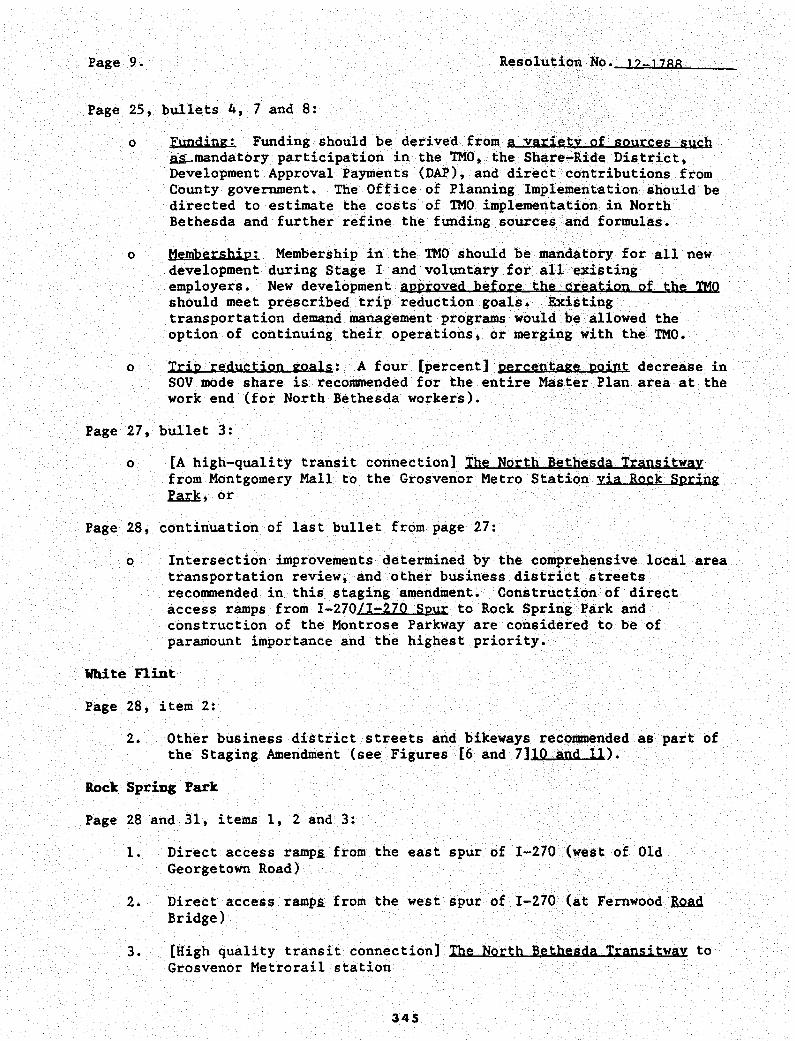
Page 9. Resolution No. J2-J288
Page 25, bullets 4, 7 and 8:
o Funding: Funding should be derived from a variety of sources such ~mandatory participation in the TMO, the Share-Ride District, Development Approval Payments (DAI'), and direct contributions from County government. The Office of Planning Implementation should be directed to estimate the costs of TMO implementation in North Bethesda and further refine the funding sources and formulas.
0 Membership: Membership in the TMO should be mandatory for all new development during Stage I and voluntary for all existing employers. New development approved before the creation of the TMO should meet prescribed trip reduction goals. Existing transportation demand management programs would be allowed the option of continuing their operations, or merging with the TMO.
o Trip reduction goals: A four [percent] percentage point decrease in SOV mode share is recommended for the entire Master Plan area at the work end (for North Bethesda workers).
Page 27, bullet 3:
o [A high-quality transit connection] The North Bethesda Transitway from Montgomery Mall to the Grosvenor Metro Station via Rock Spring ~, or
Page 28, continuation of last bullet from page 27:
o Intersection improvements determined by the comprehensive local area transportation review, and other business district streets recommended in this staging amendment. Construction of direct access ramps from I-270/I-270 Spur to Rock Spring Park and construction of the Montrose Parkway are considered to be of paramount importance and the highest priority.
White nint
Page 28, item 2:
2. Other business district streets and bikeways recommended as part of the Staging Amendment (see Figures (6 and 7]10 and 11).
Rock Spring Park
Page 28 and 31, items 1, 2 and 3:
1. Direct access ramp£ from the east spur of I-270 (west of Old Georgetown Road)
2. Direct access ramp£ from the west spur of I-270 (at Fernwood .RQAd Bridge)
3. [High quality transit connection] The North Bethesda Transitway to Grosvenor Metrorail station
345
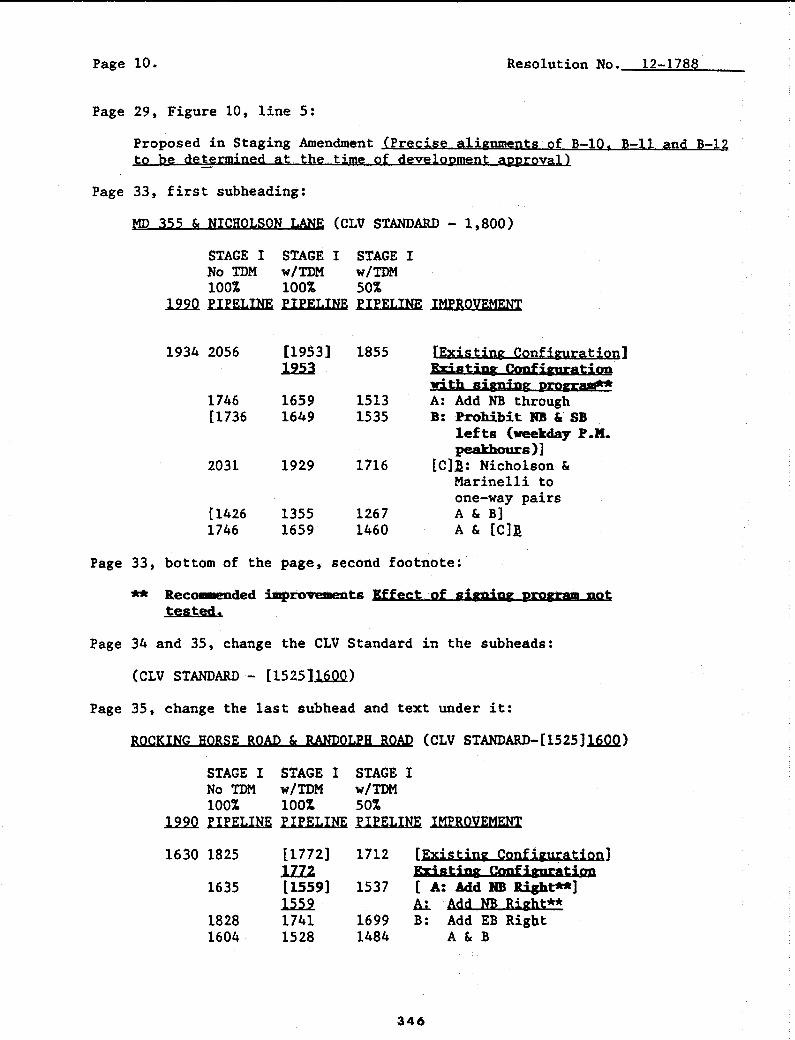
Page 10. Resolution No. 12-1788
Page 29, Figure 10, line 5:
Proposed in Staging Amendment (Precise alignments of B-10, B-11 and B-12 to be determined at the time of development approval)
Page 33, first subheading:
MD 355 & NICHOLSON LANE (CLV STANDARD - 1,800)
STAGE I STAGE I STAGE I No TDM w/TDM w/TDM 100% 100% 50%
1m PIPELINE PIPELINE PIPELINE IMPROVEMENT
1934 2056
1746 [1736
2031
[1426 1746
[1953) 1855 lill
1659 1513 1649 1535
1929 1716
1355 1267 1659 1460
[Existing Configuration] bistjpg Configuration with signing program** A: Add NB through B: Prohibit RB &. SB
lefts (weekday P.M. peakhours)]
[C]~: Nicholson & Marinelli to one-way pairs A & B] A & [C]~
Page 33, bottom of the page, second footnote:
'** ltecownded improvements Effect of signing program not tested.
Page 34 and 35, change the CLV Standard in the subheads:
(CLV STANDARD - [1525]16.QQ.)
Page 35, change the last subhead and text under it:
ROCKING HORSE ROAD & RANDOLPH ROAD (CLV STANDARD-[1525].lAQ.Q)
STAGE I STAGE I STAGE I No TDM w/TDM w/TDM 1001 100% 501
l.2..2..0. PIPELINE PIPELINE PIPELINE IMPROVEMENT
1630 1825 [1772] 1712 [Existing Qonfigu;ationl lZZ2 'RT;stipg Crmfigura,tirm
1635 [1559] 1537 [ A: Add :NB .Right**] llli Al. Add NB Right**
1828 1741 1699 B: Add EB Rigbt 1604 1528 1484 A & B
346

Page 11. Resolution No. tz..J788
All figures -and tables are to be revised where appropriate to reflect County Council changes to the Planning Board (Final) Draft Staging Amendment to the 1992 North Bethesda-Garrett Park. Master Plan. The text is to be revised as necessary to achieve clarity and consistency, to update factual information, and to convey the actions of the Cotlllty Council. All identifying references pertain to the Planning Board (Final) Draft Staging Amendment, dated December 1993, to the 1992 North Bethesda-Garrett Park Master Plan.
Amend page 60 of the Interim Reference Edition of the Approved and Adopted North Bethesda-Garrett Park Master Plan (December 1992) to add the following language after the second paragraph:
In order to provide flexibility to meet other County-wide goals, the County Council may permit. in its decision approving a local map amendment application, up to a 2.0 commercial FAR for TS-M properties in the White Flint Sector Plan area, In order for the Council to approve over a 1,0 FAR, an applicant must establish that the following criteria are met,
l..t. That the parcel is a greater than 6 acres;
~ That between a 1,0 and a 2.0 commercial FAR is necessary for an identified employment user;
.l.t.. That 1.0 FAR of residential development must be provided on-site;
!... That the employer shall provide and fund a traffic mitigation plan to mitigate all generated trips above a 1.0 commercial FAR,
This is a correct copy of Council action.
thleen A. Freedman, CMC Secretary of the Council
347
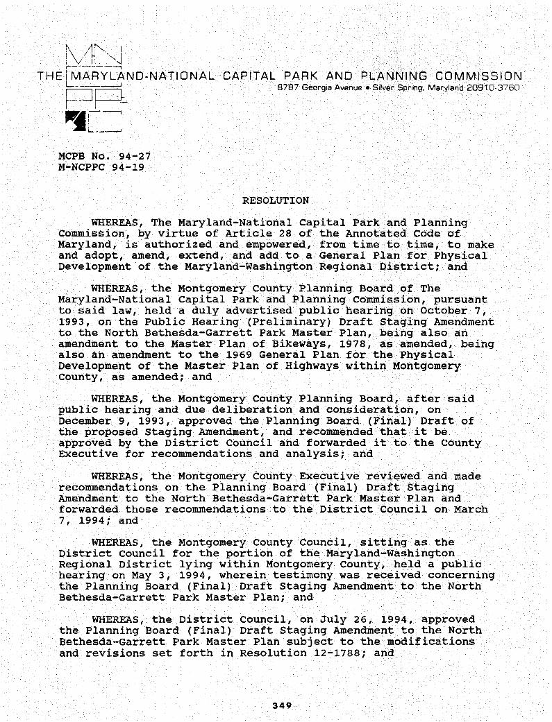
j\ /~~--- ! : V H ""1 ,---------,
THE L~ARYLAND-NATIONAL
PP'11---. MCPB No. 94-27 M-NCPPC 94-19
CAPITAL PARK AND PLANNING COMMISSION 8787 Georgia Avenue• Silver Spr,ng. Maryland 20910-3760
RESOLUTION
WHEREAS, The Maryland-National Capital Park and Planning Commission, by virtue of Article 28 of the Annotated Code of Maryland, is authorized and empowered, from time to time, to make and adopt, amend, extend, and add to a General Plan for Physical Development of the Maryland-Washington Regional District; and
WHEREAS, the Montgomery County Planning Board of The Maryland-National Capital Park and Planning Commission, pursuant to said law, held a duly advertised public hearing on October 7, 1993, on the Public Hearing (Preliminary) Draft Staging Amendment to the North Bethesda-Garrett Park Master Plan, being also an amendment to the Master Plan of Bikeways, 1978, as amended, being also an amendment to the 1969 General Plan for the Physical Development of the Master Plan of Highways within Montgomery county, as amended; and
WHEREAS, the Montgomery County Planning Board, after said public hearing and due deliberation and consideration, on December 9, 1993, approved the Planning Board (Final) Draft of the proposed staging Amendment, and recommended that it be approved by the District Council and forwarded it to the County Executive for recommendations and analysis; and
WHEREAS, the Montgomery county Executive reviewed and made recommendations on the Planning Board (Final) Draft Staging Amendment to the North Bethesda-Garrett Park Master Plan and forwarded those recommendations to the District Council on March 7, 1994; and
WHEREAS, the Montgomery County Council, sitting as the District Council for the portion of the Maryland-Washington Regional District lying within Montgomery county, held a public hearing on May 3, 1994, wherein testimony was received concerning the Planning Board (Final} Draft Staging Amendment to the North Bethesda-Garrett Park Master Plan; and
WHEREAS, the District council, on July 26, 1994, approved the Planning Board (Final) Draft Staging Amendment to the North Bethesda-Garrett Park Master Plan subject to the modifications and revisions set forth in Resolution 12-1788; and
349

NOW, THEREFORE, BE IT RESOLVED, that the Montgomery County Planning-Board and The Maryland-National Capital Park and Planning-commission do hereby adopt (nunc pro tune) said staging Amendment to the North Bethesda-Garrett Park Master Plan, together with the General Plan, for the Physical Development of the Maryland-Washington Regional District by the Montgomery County District Council in the attached Resolution 12-1788; and
BE IT FURTHER RESOLVED, that copies of said Amendment shall be certified by The Maryland-National Capital Park and Planning commission and filed with the Clerk of the Circuit court of each of Montgomery and Prince George's Counties, as required by law.
• • * * * • •
This is to certify that the foregoing is a true and correct copy of a resolution adopted by the Montgomery County Planning Board of The Maryland-National Park and Planning Commission on motion of Commissioner Baptiste, seconded by Commissioner Richardson, with Commissioners Baptiste, Richardson, Aron, Holmes, and Hussmann voting in favor of the motion at its regular meeting held on Thursday, September 29, 1994, in Silver Spring, Maryland.
* * * * • * *
This is to certify that the foregoing is a true and correct copy of a resolution adopted by The Maryland-National capital Park and Planning commission on motion by Commissioner Aron, seconded by Commissioner McNeill, with Commissioners Hussmann, Aron, McNeil!, Boone, Brown and Richardson voting in favor of the motion, with commissioners Baptiste, Dabney and Holmes being absent, and with there being one vacancy on the Commission at that time, at its regular meeting held on Wednesday, November 16, 1994, in Riverdale, Maryland.
350

Resolution No: 13-839 Introduced: April l, I 997 Adopted: April l, I 997
COUNTY COUNCIL FOR MONTGOMERY COUNTY, MARYLAND SITTING AS A DISTRICT COUNCIL FOR THAT PORTION
OF THE MARYLAND-WASHINGTON REGIONAL DISTRICT WITHIN MONTGOMERY COUNTY, MARYLAND
By: District Council
Subject: Planning Board {Final} Draft North Bethesda-Garrett Park Master Plan Amendment for a Conference Center/Hotel Complex
Background
1. On October 18, 1996, the Montgomery County Planning Board transmitted to the District Council and County Executive, the Planning Board (Final) Draft North Bethesda Garrett Park Master Plan Amendment for a conference center/hotel complex. The master plan amendment recommends Area 14, the WMATA-owned site of the Metro station on the east side of Rockville Pike be designated an appropriate location for a conference center/hotel complex. In a November 7, 1996 letter to th~ District Council, the County Executive recommended that the Planning Board (Final) Draft Master Plan Amendment be amended to locate the conference center/hotel complex at the existing WMATA-owned parking lot on the west side of Rockville Pike.
2. The Planning Board (Final) Draft Master Plan Amendment for a conference center/hotel complex is an amendment to the 1992 North Bethesda-Garrett Park Master Plan, and to the General Plan (on wedges and corridors) for the Physical Development of the Maryland-
. Washington Regional District within Montgomery and Prince George's Counties.
3. On November 7, 1996, the County Executive transmitted to the District Council: l) a statement opposing the Planning Board (Final) Draft Master Plan Amendment recommended WMATA-owned site on the east side of Rockville Pike and endorsing the WMATA-owned parking lot on the west side of Rockville Pike as the preferred location for the conference center/hotel complex; and 2) a fiscal impact analysis comparing the infrastructure costs for east site and the west site conference center sites.
351
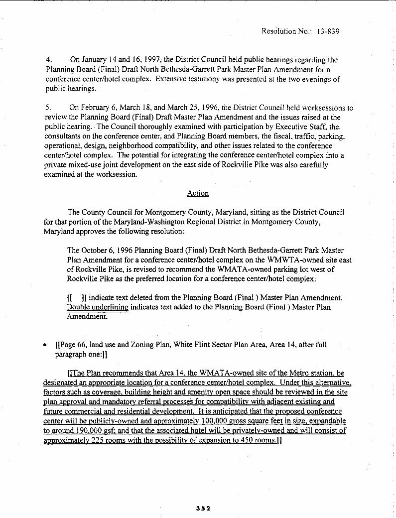
Resolution No.: 13-839
4. On January 14 and 16, 1997; the District Council held public hearings regarding the Planning Board (Final) Draft North Bethesda-Garrett Park Master Plan Amendment for a conference center/hotel complex. Extensive testimony was presented at the two evenings of public hearings.
5. On February 6, March 18, and March 25, 1996, the District Council held ,vorksessions to review the Planning Board (Final) Draft Master Plan Amendment and the issues raised at the public hearing. The Council thoroughly examined with participation by Executive Staff, the consultants on the conference center, and Planning Board members, the fiscal, traffic, parking, operational, design, neighborhood compatibility, and other issues related to the conference center/hotel complex. The potential for integrating the conference center/hotel complex into a private mixed-use joint development on the east side of Rockville Pike was also carefully examined at the worksession.
Action
The County Council for Montgomery County, Maryland, sitting as the District Council for that portion of the Maryland-Washington Regional District in Montgomery County, Maryland approves the following resolution:
The October 6, 1996 Planning Board (Final) Draft North Bethesda-Garrett Park Master Plan Amendment for a conference center/hotel complex on the WMWTA-owned site east of Rockville Pike, is revised to recommend the WMATA-owned parking lot west of Rockville Pike as the preferred location for a conference center/hotel complex:
[[ )] indicate text deleted from the Planning Board (Final ) Master Plan Amendment. Double underlining indicates text added to the Planning Board (Final ) Master Plan Amendment.
• [[Page 66, land use and Zoning Plan, White Flint Sector Plan Area, Area I 4, after full paragraph one:]]
[[The Plan recommends that Area 14, the WMATA-owned site of the Metro station, be designated an appropriate location for a conference center/hotel complex. Under this alternative, factors such as coverage. building height and amenity open space should be reviewed in the site plan approval and mandatory referral processes for compatibility with adjacent existing and future commercial and residential development. It is anticipated that the proposed conference center will be publicly-owned and approximately 100.000 gross sguare feet in size, expandable to around 190.000 gsf; and that the associated hotel will be privately-ovmed and will consist of approximately 225 rooms with the possibility of expansion to 450 rooms. JI
352

Resolution No.: 13-839
• [[Page 55, White Flint Sector Plan Area, Plan Recommendations, add:])
[[Locate a publicly-owned conference center with integral, privately-owned hotel on the east WMA TA-owned parcel (Area 14) as part of a mixed-use joint development.))
• [[Page 60, Land Use and Zoning Recommendations, correct a typographical error in line 4, as follows:})
[[of 2.(0) ~FAR])
• [[Page 2, Land Use and Urban Design recommendations, add after the fifth recommendation: I]
[(Locate a publicly-owned conference center with integral, privately-owned hotel on the east WMATA-owned parcel as part of a mixed-use joint development;])
• Page 2, Land Use and Urban Design recommendations, add after the fifth recommendation.
Locate a publicly-owned conference center with integml, privately-owned hotel on the WMA TA parking lot.
• Page 62, Land Use and Zoning Plan, White Flint Sector Plan Area, Area 2, after paragraph two:
The existing WMAT A parking lot is an ap_propriate location for a eonference center/hotel complex. Factors such as coverage. building height and amenity open space sp9uld be reviewed in the zoning, mandatory referral, ang site plan review processes for compatibility with adjacent existing and future residential development. It is anticipated that the pro_pgsed conference center will be publicly-owned and will be approximately 100,000 gross sqµare feet in size, expandable . to around 190,000 gsf; and that the associated hotel will be privately:9wned and will consist of · aimroximately 225 rooms with possibility of expansion to around 450.
353

Resolution No.: 13-839
• Page 301, Table 3, "Master Plan of Highways", North Bethesda-Garrett Park Master Plan. is revised as follows:
Table 3 Alaster Plan of Highways
Streets to be added:
Name Limits I Lanes** I ROW
Industrial & Business Streets
8-3 Woodglen Drive [(B-10 tol) 2 80 ft Extended Nicholson Lane to
Marinelli Road B-10* White Flint Nebel Street to B-11 2 80 ft
Avenue [[B-11 to Woodglen [[pedestrian [[35 ft)] Drive)I only))
[[Woodglen Drive to [[80 ft]) Executive [(21] Boulevard])
B-11* New Street Marinelli Road to 2 70 ft Old Georgetown Road
[[B-12*)1 [[New Street)] [[B-10 to Old ((4)) [[80 ft)) Georgetown Road)]
Footnotes: * Precise alignments ofB-10 [[;)) and B-11 [(and B-12)) to be determined at the time of
development approval.
•• These are the number of planned through travel lanes for each segment, not including lanes for turning, parking, acceleratio~ deceleration, or other purposes auxiliary to through travel.
The text and maps of the North Bethesda-Garrett Park Master Plan are to be revised as necessary to achieve clarity and consistency, to update factual information, and to convey the actions of the District Council.
354

Resolution No.: 13-839
This is a correct copy of Council action.
355

• t-~ .
I ·\,i h ···,f ·------
THE i MARYL~ND-NATIONAL CAPITAL PARK AND PLANNING COMMISSION 8787 Georgia Avenue • Silver Spring, Maryland 20910-3760 r----, ,---·
t__ __ j ~-N •_J !
MCPB No.97-12 M-NCPPC No. 97-14
RESOLUTION
WHEREAS, The Maryland-National Capital Park and Planning Commission, by virtue of Article 28 of the Annotated Code of Maryland, is authorized and empowered, from time to time, to make and adopt, amend, extend and add to The General Plan (On Wedges and Corridors) for the Physical Development of the MarylandWashington Regional District in Montgomery and Prince George's Counties; and
WHEREAS, the Montgomery county Planning Board of The Maryland-National capital Park and Planning Commission, pursuant to said law, held a duly advertised public hearing on July 11, 1996, on the Public Hearing (Preliminary) Draft North BethesdaGarrett Park Master Plan Amendment, being also an amendment to the North Bethesda-Garrett Park Master Plan, 1992, as amended; The General Plan (On Wedges and Corridors) for the Physical Development of the Maryland-Washington Regional District Within Montgomery and Prince George's counties, 1964, as amended; and The Master Plan of Highways within Montgomery county, as amended; and
WHEREAS, the Montgomery County Planning Board, after said public hearing and due deliberation and consideration, on October 17, 1996, approved the Planning Board (Final) Draft North Bethesda-Garrett Park Master Plan Amendment, recommended that it be approved by the District Council, and forwarded it to the County Executive for recommendations and analysis; and
WHEREAS, the Montgomery County Executive reviewed and made recommendations on the Planning Board (Final) Draft North Bethesda/Garrett Park Master Plan Amendment and forwarded those recommendations with a fiscal analysis to the District Council on November 7, 1996, and
WHEREAS, the Montgomery County Council, sitting as the District Council for the portion of the Maryland-Washington Regional District lying within Montgomery County, held public hearings on January 14 and 16, 1997, wherein testimony was received concerning the Planning Board (Final) Draft North Bethesda-Garrett Park Master Plan Amendment; and
WHEREAS, the District Council, on April 1, 1997, revised the Planning Board (Final) Draft North Bethesda-Garrett Park Master Plan Amendment with the modifications and revisions set forth in Resolution No.13-839.
357

NOW, THEREFORE, BE IT RESOLVED, that the Montgomery County Planning Board and The Maryland-National Capital Park and Planning commission do hereby adopt said North Bethesda-Garrett Park Master Plan Amendment, together with the General Plan for the Physical Development of the Maryland-Washington Regional District as amended; and as approved by the District Council in the attached Resolution No.13-839 and
BE IT FURTHER RESOLVED, that copies of said Amendment should be certified by The Maryland-National Capital Park and Planning Commission and filed with the Clerk of the Circuit Court of each of Montgomery and Prince George's counties, as required by law.
* * * * * * * * * *
This is to certify that the foregoing is a true and correct copy of a resolution adopted by the Montgomery County Planning Board of The Maryland-National Capital Park and Planning Commission on motion of Commissioner Holmes, seconded by Commissioner Richardson, with Commissioners Aron, Holmes, Richardson, and Hussmann voting in favor of the motion, and Commissioner Baptiste abstaining, at its regular meeting held on Thursday, May 8, 1997, in Silver Spring, Maryland.
* * * * * *
This is to certify that the foregoing is a true and correct copy of a resolution adopted by the Maryland-National Capital Park and Planning Commission on motion of Commissioner Richardson, seconded by Commissioner Brown, with Commissioners Baptiste, Boone, Brown, Dabney, Hewlett, Holmes, Hussmann, and Richardson voting in favor of the motion, and with Commissioners Aron and McNeill being absent, at its regular meeting held on Wednesday, June 18, 1997, in Silver Spring, Maryland.
TO LEGAL sumcmNCY
t/4W~"
358