Embed Size (px)
Citation preview

1983/35. Luina and Wombat Flat exempt areas: a review of previous exploration and a reconnaissance survey of an aeromagnetic anomaly.
P.L.F. Collins
Abstract
Exploration previously undertaken in the Luina and Wombat Flat exempt areas did not locate any highly prospective targets, but several aeromagnetic, low-order Dighem and soil geochemical anomalies have been defined over prospective geological environments and warrant further investigation. A reconnaissance ground magnetic survey and soil geochemical survey over an aeromagnetic anomaly at the Arthur Dam defined a pronounced, narrow, north-east trending linear magnetic anomaly and adjacent low-order Cu-Pb-Zn and (Sn) soil geochemical anomaly. A second, more pronounced Zn-Pb-Cu soil geochemical anomaly was located 200-250 m north-west of the magnetic anomaly.
INTRODUCTION
The Luina and Wombat Flat exempt areas are located between Luina and Waratah in north-western Tasmania (fig. 1). Access to the Luina exempt area (10 km') is afforded by the Corinna Road and Betts Track. Access to the Wombat Flat exempt area (4 km') is by the Mt Ramsay track (fig. 1). The areas are relatively flat, with Wombat Hill the principal topographic feature.
The two areas were relinquished in 1982 from exploration licence 1/63 (held by Cleveland Tin Ltd) and have been exempted from the Mining Act for an assessment of prospectivity and to establish whether previous exploration had located targets worthy of follow-up investigation by the Department of Mines. Exemption from the Mining Act was gazetted on 30 March 1983, effective from 5 April 1983 (Statutory Rule 64 of 1983).
This report reviews the economic potential and previous exploration within the exempt areas, and details a reconnaissance investigation of an aeromagnetic anomaly adjacent to the Arthur Dam.
GEOLOGY AND MINERALISATION
The exempt areas are underlain by Eocambrian-Cambrian sedimentary and mafic volcanic sequences and tectonically emplaced mafic volcanicultramafic complexes, and Devonian biotite granite (fig. 2). Tertiary basalt and basal and interflow sediments blanket the area east of Wombat Flat, and Quaternary-Recent alluvial sediments occur locally.
Cambrian sequence
The Cambrian volcano-sedimentary sequence consists predominantly of grey-brown turbiditic greywacke, siltstone, and mudstone with intercalated spilitic, tholeiitic basalt and mafic tuff (Collins, 1981). The rocks generally h&~e been folded about north-east trending axes. At Whyte Hill, in the north-west corner of the Luina exempt area, spilitic basalt and intercalated sediments are equivalent to the host sequence at the Cleveland mine, four kilometres to the south-west (Collins, 1981). The sedimentary/ mafic volcanic sequence is part of the Arthur River sequence of Groves (1968), and is correlated with the Crimson Creek Formation (Groves, 1968, Groves et al., 1972, Collins, 1981).
35-1

1
1
LUINA-WOMBAT FLAT EXEMPT AREAS LOCALITY MAP o ,
MT CJ£;'EIANO
z ,
Ri\'ff
MOUNT BISCHOFF
"
, /".,'
I WOMSA T FIA T EXEMPT AREA ,
, "L.,L...,I--~.....J " ...
,,~ " _ , lUINA EXEMPT AREA
I
,'1 I I I I
..oolDlmN I
I I I
I I
Fi gure 1.
scm
. , , HIiy, ,I 1-"\
, , , ~ , :I' 1\ Ii'
" \
35-2
GN. MN
. .
..
•
LUINA-WOMBAT EXEMPT AREA GENERAL GEOLOGY
QUATERNARY
r>~r;·/·Y.n Alluvium
TERTIARY
Ba.alt (minor sediments)
DEVONIAN
[Z] Meredith Granite (porphyry dyko)
Geological Boundary
----- Fault
Mine prospect
x Alluvial deposit
Figure 2. 35-3
CAMBRIAN
-== = ~--
Greywocke, Mudstone,Tuff. Bellit (Arthur River sequence)
Basalt/andesite/ ultramafic rock / sediments
~ Ultramafic rock
Gabbro/dolerite
GeolOQY by P. L F. Collins, A. V. Brown,
Groves (1963, 1972) and Ransom (1976).
5cm

4/28 Between Whyte Hill and Wombat Hill, the Arthur River sequence is cut
by a regionally concordant, NNE trending, fault-bounded(?) belt of intermixed mafic-ultramafic units, basalt and sediments (fig. 2), and includes high-magnesium andesite (A.V. Brown, pers. comm.). This belt is referred to here as the Whyte Hill complex. The sedimentary units consist of turbiditic greywacke, siltstone, and mudstone, similar to the enclosing Arthur River sequence. A lens of ultramafic rock on the eastern boundary of this belt crops out on Betts Track south of the Arthur Dam.
Small bodies of dolerite-gabbro intrude the Arthur River sequence north-east of the Arthur Dam and north of Godkin Ridge (fig. 2).
Devonian granite
The Cambrian rocks have been intruded by the late Devonian Meredith Granite, which consists predominantly of porphyritic, medium-grained biotite adamellite and equigranular, fine to medium-grained biotite granite/adamellite (Groves, 1968; Groves et "ai., 1972; fig. 2). Quartzfeldspar porphyry dykes intrude the Arthur River sequence north of Butlers Road (fig. 2).
Mineralisation
There are no known mineral deposits in the Luina exempt area, although small prospecting(?) pits have been excavated, apparently on quartzsiderite vein1ets in the basalt/andesite unit about one kilometre southeast of Whyte Hill (CQ689074, fig. 2). The only primary deposit in the Wombat Flat exempt area is at the old Cundy mine (fig. 2), where a short, lenticular greisen(?) body is enclosed in equigranu1ar biotite granite (Reid, 1923). Mineralisation at the Cundy mine consists of green, fluorinebearing mica and quartz with arsenopyrite, sphalerite, pyrite, chalcopyrite, molybdenite and trace cassiterite in distinct quartz veins, or as bunches in greisen (Reid, 1923). Deposits of alluvial cassiterite occur at several places in streams draining the Meredith Granite (fig. 2).
Major mineral deposits nearby include the large sulphide-cassiterite deposits at the Cleveland mine (Collins, 1981) and Mt Bischoff (Groves et ai., 1972), and the Magnet Ag-Pb-Zn deposit (Cox, 1968; 1975) (fig. 1). All deposits are genetically associated with emplacement of the Meredith Granite.
EXPLORATION POTENTIAL
The exempt areas are most prospective for either tin-tungsten or silver-lead-zinc mineralisation associated with emplacement of the Meredith Granite, occurring as:
(i) greisen (and/or vein) Sn deposits in granite (e.g. Cundy and South Bischoff deposits) ;
(ii) skarn or sulphide replacement Sn and/or W deposits in the Arthur River sequence;
(iii) fault-controlled, Sn-W or Ag-Pb-Zn mineralisation associated with major faults, such as the postulated fault between the Arthur River sequence and the Whyte Hill complex; and
(iv) stockwork vein Sn/W mineralisation.
35-4

Any undiscovered mineralisation that is present within the exempt area will most likely not crop out, and exploration should be directed at detecting subsurface mineralisation (i.e. depth >50 m) through the use of geological, geochemical, and geophysical techniques. Geological and geochemical methods should be designed and interpreted with the view of detecting alteration haloes (e.g. potassic alteration minerals, metals such as As and Pb known to occur in haloes to tin deposits). It is unlikely that intra-granitic deposits and vein deposits will give a significant geophysical response, thus placing a greater reliance upon geochemical techniques.
REVIEW OF PREVIOUS EXPLORATION
All recorded previous exploration in the exempt areas has been undertaken by the Aberfoyle Group, within Cleveland Tin Limited's exploration licence E.L. 1/63. The exempt areas have been well covered by airborne geophysical surveys (magnetic and electro-magnetic) and by reconnaissance geochemical surveys. An area to the south-east of Betts track, at Wombat Hill, has been gridded and soil geochemistry has been completed, but ground geophysical techniques have not been employed.
A regional stream sediment sampling programme undertaken in 1974 indicated that an area to the south and east of the Arthur Dam (designated the "South Magnet Dam area") is anomalous in Sn and Zn and weakly anomalous in Pb (Stuart-Smith, 1974; Palmer, 1975a). The area of anomalous Zn geochemistry is confined to streams draining the western flank of Wombat Hill south of the Arthur Dam (fig. 3).
An airborne (helicopter) magnetometer survey was flown in October 1974 over the western part of E.L. 1/63 (line spacing of 152 m and mean terrain (sensor) clearance of 76 m) , but data quality was impaired by inaccurate flight path recovery (Palmer, 1975a). The survey revealed a IInan-magnetic" "greenstone II/sediment unit west of the Arthur River (equivalent to the Whyte Hill complex) and a magnetically anomalous area to the east, but no distinct aeromagnetic anomalies were defined (Palmer, 1975b) .
During 1975 and 1976, a C horizon (?) soil sampling survey was undertaken on grids established in the IISouth Magnet Dam" and "Wombat" areas (fig. 3; Ransom, 1976a, b). Samples taken at 12.5 m intervals were analysed for Cu, Pb, Zn, and Sn by emission spectroscopy and samples with in excess of 50 ppm Sn were reanalysed for Sn by X-ray fluorescence spectrography. Sn values exceeding 50 ppm (by emission spectroscopy) were considered anomalous on the basis of previous orientation work in the Cleveland mine area (Ransom, 1976b). Most soil samples with anomalous tin geochemistry were from areas underlain by the Meredith Granite (fig. 3), and the anomalies have been attributed to a high tin background in soil over granite (Ransom, 1976b).
An area of consistent anomalous tin geochemistry at the eastern end of lines 2850N to 3075N in the "South Magnet Dam" area has coincident anomalous lead and zinc geochemistry, but much of the anomalous area appears to lie outside the Luina exempt area (fig. 3). The area of anomalous tin is underlain by granite, and the only other grid lines that extend across the Meredith Granite (1200N, 2l00N) also have sporadic elevated tin values. Several isolated anomalous tin values to the west of the granite contact were considered to be unrelated to any anomalous tin population (Ransom, 1976b).
35-5

s408000mN
1
j
0"
.'"
_ 1101 .
............. ] ' ..... "--1-",. o.p........,.Iy , TeIIO _It'S. ICttl_ ISI1 IS • ...t.o..........,. l .1iM oHoc'--'1 1
Sk_ ........ ...,.. .... Ioc ..... (_._IJ ........ -1_ >l'OO, I ' z" . • >!tOO, /t z". ~>...,"t .... 1 1C114-IOH.leIIS-lOn
.... Iooor-oool _ ...... " ]
'-"'''' ->SII, ' I loo .. oool ....... r(Ht_IIS),I{llt_1I11 I ....... __ oft.. Me ....... 1911 ICUI_ISl1 I
......... J Mor_ G._It
Figure 3.
." OEP .... UMENT Of' MINES, T .... SM .... N .....
LUINA AND WOMBAT FLAT ,~ EXEMPT AREAS S. R. 1983/64
DIGHEM ANOMALIES AND GEOCHEMICAL SURVEYS
lOG IlOO. ~
I ' "' .... ,/
."
Scm
35- 6
1408000mN
!
:
. ~

..
:z E o o o
on ~ ~
370000mE
LUINA AND WOMBAT FLAT EXEMPT AREAS
RESIDUAL TOTAL MAGNETIC INTENSITY 1981 WEST COAST AEROMAGNETIC SURVEY
DEPARTMENT OF MINES o .4km , ,
Outline of exempt areas
Figure 4. 5cm
35- 7
J6ao.olllE
0 , 0--- --0, f
a Soil .......... .....,. 1 ~50.J ' Sol _ >50 .. IU ....... __ I
Figure 5 ,' , .. San
,7J
LUINA <EXEMPT
OE~"Ut1ENT Of MINIS, tASMAN'A
AND WOMBAT FLAT AREAS S. R. 1983/64
ANOMALY LOCAUTY MAP
,7J
35- 8
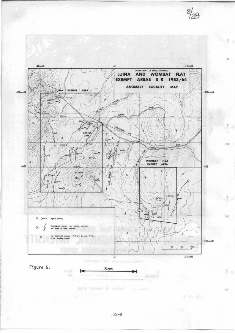
The southern half of the Luina exempt area and the ~oJonbat Flat exempt area have been covered by a Di~hem survey flown in February-March 1980 (Ellis, 1980a, b), and the remainder of the Luina exempt area has been covered by a Dighem II survey flown in February 1981 (McArthur, 1981; 1982). All EM anomalies detected are shown in Figure 3. In the Wombat Flat exempt area, several low-order EM anomalies (8B-13xF, 12C, 12D, etc.) have an associated resistivity low and probably represent bedrock conductors (Ellis, 1980b). Follow-up investigations indicated that the main anomaly (8B-13xF) coincides with the edge of Tertiary basalt, and it has been concluded that this EM anomaly is due to gravel (and associated groundwater) beneath a thin basalt cover (McArthur, 1981). The other anomalies have not been explained.
The Dighem surveys in the Luina exempt area indicate several low-order EM anomalies and possible conductors (i.e. 12P, 18G, 1xA, 6A-7xB, 6xA-7xC). Only anomaly 18G, a non-magnetic bedrock conductor, was considered worthy of fo11qw-up investigation, but this was not done as the anomaly coincides with, and has been attributed to, the wall of the Arthur Dam (McArthur, 1982; fig. 3). A series of low order EM anomalies attributed to cultural sources (e.g. telecommunication cables) closely follow the Corinna Road (fig. 3). Low order EM anomalies 2B-3A and 1B-4xB near the South Bischoff track coincide with an area of anomalous Sn soil geochemistry (fig. 3), but lie outside the Luina exempt area.
The exempt areas have also been covered by the Department of Mines 1981 west Coast aeromagnetic survey (Corbett et ai., 1982) which highlighted the NNE-trending magnetically anomalous zone on the western edge of the magnetically 'quiet' Meredith Granite in the Luina exempt area, and a similar zone east of the Meredith Granite on the eastern side of the Wombat Flat exempt area (fig. 4). The survey also confirmed the magnetically 'quiet' basalt/andesite/sediment unit (Whyte Hill complex) west of the Arthur River. Several additional features may be interpreted from the line profiles, but these are not revealed on the contour diagram (due to 'smoothing' of profiles).
Summary and recommendations
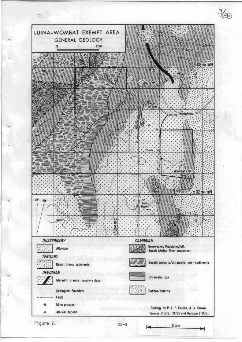
In summary, previous exploration failed to locate any readily definable targets within the exempt areas, but several geochemical anomalies, aeromagnetic anomalies, and low-order EM anomalies and possible conductors have been defined and warrant further investigation. All anomalies defined from previous exploration are listed in Table 1, and their locations are shown on Figure 5. Anomalies worthy of further investigation are indicated in Table 1 and include:
(i) An area of anomalous Sn soil geochemistry and coincident(?) Dighem anomalies on the north-east flank of Wombat Hill (LEA18, 19, 20, and 21). Although this warrants a high priority, much of the anomalous area lies outside the Luina exempt area.
(ii) A similar coincident low-order Dighem anomaly and anomalous Sn in soil in the south-east corner of the Luina exempt area (LEA28) .
(iii) Discrete linear aeromagnetic anomalies on the eastern boundary of the Whyte Hill complex and the Arthur River sequence (LEA6, 16, and 25). Although the anomalies may be due to ultramafic rocks, they are ideally placed for fault-controlled mineralisation, and at LEAl6 there is coincident anomalous Sn in soil.
35-9
w ~ I ~ 0
Table 1. LUINA AND WOMBAT FLAT EXEMPT AREAS - ANOMALIES DEFINED FROM PREVIOUS EXPLORATION
Anomaly No.
LEAl
LEA2
LEA3
LEA4
LEAS
LEA6
LEA7
LEAS
LEA9
LEA10
LEA11
LEA12
Character of anomaly
Aeromagnetic anomaly
Dighem anomaly 23P
Aeromagnetic anomaly
Aeromagnetic anomaly
Aeromagnetic anomaly
Aeromagnetic anomaly
Dighem anomaly 18G
Aeromagnetic anomaly
Aeromagnetic anomaly
Comments
South end of linear anomaly - probably due to Cambrian basalt or ultramafic rocks.
Within Whyte Hill complex.
On boundary of Whyte Hill complex and Arthur River sequence. Also, may be due to Tertiary basalt.
Western edge of Whyte Hill complex - probably due to Cambrian basalt or ultramafic rocks.
Within Whyte Hill complex - source probably similar to LEA4.
Discrete linear anomaly on boundary of Whyte Hill complex and Arthur River sequence.
Coincides with wall of Arthur Dam and attributed to dam wall (McArthur, 1982).
Pronounced, broad, north-trending anomaly -probably reflects contact metamorphism of Arthur River sequence (contains varying amounts of magnetite).
Broad linear anomaly within Whyte Hill complex - source probably similar to LEA 4 & S.
Soil geochemical anomaly ~SO g/t Sn in four samples over 60 m, line
Aeromagnetic anomaly
Aeromagnetic anomaly
3000 N. Also anomalous Pb in soil.
Pronounced, broad, north-trending anomaly -source similar to LEA8.
As for LEA11.
Follow-up investigation Priority
Ground check - low priority.
Ground check - low priority.
Reconnaissance ground magnetics and soil geochemistry.
Ground check
Ground check - repeat soil sampling (if grid line re~ocated) .
3
3
1
2
2

I ~
Table 1.
Anomaly No.
LEA13
LEA14
LEA15
LEA16
LEA17
LEA18
LEA19
LEA20
LEA21
(continued)
Character of anomaly
Aeromagnetic anomaly
Dighem anomaly 1xA
Aeromagnetic anomaly
Aeromagnetic anomaly and soil geochemical anomaly.
Aeromagnetic anomaly
Soil geochemical anomaly
Dighem anomaly 2B-3A and soil geochemical anomaly
Dighem anomaly 1B-4xB and soil geochemical anomaly.
Dighem anomaly 2xC
Comments
Discrete linear anomaly within Whyte Hill complex - source similar to LEA4, 5, & 9.
Within Whyte Hill complex, close to grid line M03.
Within Whyte Hill complex - probably due to ultramafic rocks.
Discrete, linear anomaly on boundary of Whyte Hill complex and Arthur River sequence (similar to LEA6) and adjacent/coincident soil geochemical anomaly on line 2850N (~50 g/t Sn in six samples over 100 m) .
As for LEA11, 12.
~50 g/t Sn in 20 samples (up to 500 g/t Sn; up to 210 g/t Sn by XRF) over about 200 m, line 3000N. Anomalous Sn in soil on adjoining lines. Also a slight broad magnetic anomaly. Area of anomalous So in soil is underlain by the Meredith Granite.
Underlain by the Meredith Granite. ~50 g/t Sn in soil over 50-60 m on lines 2925N and 3000N coincident with Dighem anomaly 3A.
Underlain by the Meredith Granite. Apparent coincidence of Dighern anomaly 3xA and anomalous Sn in soil on line 3075N (the only grid line to extend far enough east) .
Underlain by Meredith Granite - no obvious source.
Follow-up investigation Priority
Ground check.
Ground check (in association with LEA16).
2
3
Reconnaissance ground magnetics 1 and repeat soil sampling. Relocate grid line.
Reconnaissance ground magnetics 1 and repeat soil sampling on lines 2850N to 3075N. Relocate grid lines. Geochemical orientation survey required.
As for LEA18, but lies outside the exempt area.
As for LEA19.
As for LEA19.
1
1
1
w en I
f-" IV
Table 1. (continued)
Anomaly No.
LEA22
LEA23
LEA24
LEA25
LEA26
LEA27
LEA28
WEAl
WEA2
WEA3
WEA4
Character of anomaly
Aeromagnetic anomaly
Comments
As for LEA11, 12. Isolated anomalous Sn in soil on lines 2250N and 2400N.
Soil geochemical anomaly ~50 g/t Sn in six samples over 60 m, line 1800N. Within Whyte Hill complex.
Dighem anomaly 6A-7xB Within Whyte Hill complex - no obvious source.
Aeromagnetic anomaly
Aeromagnetic anomaly
Aeromagnetic anomaly
Dighem anomaly 6xA-7xc and soil geochemical anomaly.
Aeromagnetic anomaly
Aeromagnetic anomaly
Pronounced linear anomaly on eastern edge of Whyte Hill complex - source similar to LEAl5 and 16.
As for LEA11, 12.
As for LEAl1, 12.
X-type Dighem anomaly and adjacent anomalous Sn in soil (~50 g/t Sn in 11 samples over 150 m) on line 2100N. Underlain by Meredith Granite.
Anomaly apparently underlain by granite but may be due to Tertiary basalt. Small coincident soil geochemical anomaly.
Anomaly apparently underlain by Arthur River sequence but may be due to Tertiary basalt.
Dighem anomaly 11xA-12xC Apparently underlain by the Arthur River sequence - no obvious source.
Dighem anomaly 8B-13xF Coincides with the western edge of Tertiary basalt and has been attributed to edge effects of basalt cover (McArthur, 1981).
Follow-up investigation Priority
Ground check - reconnaissance ground magnetics and repeat soil sampling on line 1800N.
Ground check on line l500N.
2
3
Reconnaissance ground mag- 2 netics and repeat soil sampling on line 2100N.
Ground check on line 1800N. 3
Ground check.
Ground check (line 1800N) of llxA.
Ground check.
3
3
3

Table 1.
Anomaly No.
WEA5
WEA6
WEA7
WEA8
( continued)
Character of anomaly Conunents
Soil geochemical anomaly ~50 g/t Sn in 12 soil samples over about 150 m, line l200N. Underlain by the Meredith Granite.
Dighem anomaly l2C-13A
Dighem anomaly l20-l3xB
Dighem anomaly l3xC
Underlain by the Meredith Granite - no obvious source.
As for WEA6.
As for WEA6.
Follow-up investigation
Ground check - repeat soil sampling.
Ground check - line 1200N.
As for WEA6.
As for WEA6.
Priority
3
3
3
3
Compiled from reports listed in References. Anomaly priority for follow-up investigation (1 = first priority) . otherwise indicated.
locations shown on Figure 5. Priority indicates relative Soil geochemical analyses by emission spectroscopy unless

Figure 6.
lUINA EXEMPT AREA
ARTHUR DAM ANDMALY RECONNAISSANCE SURVEY
TRAVERSE LINES
December 1982
ARTHUR DAM
5cm -,
G N MN.
'>407()()umN
+---+ Gfound magnetics iJnd 5011 silmplmg (50// silmple sites)
- Gr()und magnetICs only
o 100 200m

These are the most significant anomalies and further investigation at a reconnaissance level is recommended. Several other anomalies in both the exempt areas warrant ground checking, but have a much lower priority.
Initially, it is recommended that a reconnaissance ground magnetic and soil sampling and geochemical survey of the aeromagnetic anomaly adjacent to the Arthur Dam (LEA6) be undertaken, as this will assist in interpretation of similar anomalies LEA16, 25, and 15(?). Anomaly LEA6 is referred to as the Arthur Dam anomaly (ADA) and details of a reconnaissance survey completed during preparation of this report are given below.
ARTHUR DAM AEROMAGNETIC ANOMALY
An aeromagnetic anomaly located adjacent to the north-western bank of the Arthur Dam forms a prominent north-east trending linear anomaly which shows on all aeromagnetic surveys, and is sufficiently isolated from the pronounced magnetically anomalous zone over Wombat Hill to be considered a discrete anomaly. In Aberfoyle's 1974 survey, the anomaly has a magnitude of about 280 nT and is centred about 150 m south of the Corinna Road (see Palmer, 1975a, b). The anomaly has been better defined by the 1981 Dighem survey which indicated a NNE-trending anomaly with a magnitude of about 400 nT (4000 nT enhanced magnetics) centred over the Corinna Road (see McArthur, 1981). A 'line effect' Dighem anomaly (19N) is located over the peak of the magnetic anomaly. The Department of Mines 1981 West Coast aeromagnetic survey indicated a single line anomaly with a magnitude of about 200 nT.
The aeromagnetic anomaly is located over a postulated fault boundary between the Whyte Hill complex to the west and the Arthur River sequence to the east. Contact metamorphism of Cambrian sediments underlying Wombat Hill is the likely cause of the magnetically anomalous zone adjacent to the Meredith Granite, but is unlikely to be the source of the Arthur Dam anomaly. possible sources of this anomaly include:
(i) hydrothermal, fault-controlled magnetite and/or pyrrhotiterich mineralisation;
(ii) a tectonically emplaced sliver of ultramafic rock; and
(iii) a magnetite/pyrrhotite-bearing basic dyke or basalt.
A reconnaissance survey was undertaken in December 1982 to define the anomaly on the ground and attempt to determine its origin. The survey involved cutting a base line and a 445 m grid line (line OON) across the anomaly (approximately 150 m south of the Corinna Road) followed by magnetometer traverses along the road and grid line, and soil sampling along the grid line (fig. 6).
MAGNETOMETER TRAVERSES
The total magnetic field intensity was measured with a McPhar GP-70 proton precession magnetometer, and the vertical component of the magnetic field was measured with a McPhar M700 fluxgate magnetometer. A base station was established at OON, OOE and the fluxgate magnetometer was zeroed at this point. Repeat measurements at the base station indicate an accuracy of ± 1 nT for total field measurements and ± 10 nT for the vertical field component. All readings have been corrected for diurnal variation. Results are shown in Figures 7 and 8 and profiles are included in Figures 12 and 13.
35-15
Measurements of the total magnetic field on line OON indicate a 1000 nT anomaly centred at 370-380 mE, and a single station 100 nT anomaly at 120 mE (figs 7, 12). The Corinna Road traverse revealed a pronounced 3000-3500 nT anomaly centred at 370 mE and a single station 200 nT anomaly on the flank of the main anomaly at 280 mE (figs 7, 13).
Measurement of the vertical field component gave similar results, with a 1200 nT anomaly centred at 370-380 mE on line OON, and a 130 nT anomaly at 120 mE (figs 8, 12). The road traverse indicated a pronounced 3500-4000 nT anomaly centred at 370 mE and alSO nT anomaly at 280 mE (figs 8, 13).
The magnetometer surveys therefore indicate a pronounced, northeast trending magnetic anomaly (the Arthur Dam anomaly) located 50-100 m north-west of the Arthur Dam (figs 7, 8), and which is parallel to, and coincident with, a postulated major fault. Characteristic features of the Arthur Dam anomaly are a pronounced, relatively narrow peak, a 'tailingoff' on the north-western flank, and an associated negative anomaly on the south-eastern flank (figs 12, 13). These indicate a probable vertical to steep NW dipping sheet-like body.
General features of the magnetic survey include the magnetically inactive Whyte Hill complex to the west of the Arthur Dam anomaly, and the lower magnetic response of sediments to the east (figs 12,13).
SOIL GEOCHEMISTRY
C horizon soil sampling was undertaken at 20 m intervals on line OON but sampling reduced to 10 m over the Arthur Dam anomaly. Samples were collected by hand auger at depths of between 0.4 and 1.4 m (Table 1). Samples were dried and pummelled, then a split of half of the sample was sieved with a 70# mesh (212 ~m) cloth screen. The minus 70# mesh fraction was submitted to the Department of Mines laboratories, Launceston for XRF analysis for Cu, Fb, Zn, Sn , W, Cr, and Ni. Samples were ground in a Cr-steel vessel on a swing mill and may contain some Cr and Ni as contaminants.
Analytical results are listed in Table 1 and indicated on Figures 9-11, and illustrated in profiles on Figure 12. Statistical treatment of results has not been undertaken because of the limited extent and small number of samples.
Copper
Most samples contain less than 100 g/t Cu, with possible anomalous values of 195 g/t Cu at 100 mE, 320 g/t at 120 mE, and 370 g/t at 410 mE (fig. 12).
Lead
Most samples contain less than 50 g/t Pb, with probable anomalous samples at 120-160 mE (120-255 g/t Pb) and 170 g/t at 410 mE (fig. 12).
Zinc
The majority of samples contain less than 150 g/t Zn. A pronounced anomaly of 920 g/t Zn is centred at 140 mE (spread between 120-160 mE) and coincides with anomalous Pb values (fig. 12). possible anomalous values of up to 270 g/t Zn occur between 380 and 410 mE, coincident with the
35-16

magnetic anomaly (fig. 12). A single sample with 350 gft Zn was collected at OON.
Tin
Samples range from <5 to 15 gft Sn and there are no pronounced anomalous values. However, tin values are slightly elevated at 120-160 mE (maximum 15 gft) , and between 370 and 410 mE (maximum 15 gft) coincident with the magnetic anomaly (fig. 12).
Tungsten
All samples are below the detection limit of 11 gft W, except for an enigmatic 16 gft W at 60 mE.
Chromium and nickel
Cr and Ni were analysed to determine whether the magnetic anomaly is due to ultramafic rock. The Cr and Ni values exhibit a sympathetic relationship (fig. 12) and fall into two distinct populations: a low Ni «150 gft) , low Cr «500 gft) group and a high Ni (most >300 gft) , high Cr (most >2500 gft) group. Samples with high Ni and high Cr values are probably underlain by mafic-ultramafic rocks, and the low Ni, low Cr samples (040-140 mE) probably define a sedimentary unit.
At the eastern end of line OON, Cr and Ni values decrease over the Arthur Dam anomaly but are relatively high at 420 and 440 mE, which is inconsistent with sedimentary rock east of the anomaly. The low Cr and Ni values over the magnetic anomaly indicate that it may not be caused by a mafic-ultramafic unit, but the isolated high Cr and Ni values at 400 mE coincides with lower Sn, Pb, and Zn values and may reflect a sliver of mafic-ultramafic rock within a fault zone.
The anomalous Pb and Zn zone at 120-160 mE coincides with changing Cr and Ni values and may reflect fault-controlled mineralisation.
SUMMARY
A reconnaissance survey of the Arthur Dam aeromagnetic anomaly has defined a pronounced, narrow, north-east trending magnetic anomaly (up to 3500 nT above background) attributable to a steep, north-west dipping, sheet-like magnetic body. Soil sampling indicates anomalous(?) Cu, Pb, Zn, and Sn in soil adjacent to, and north-east of, the magnetic anomaly, possibly associated with fault controlled mineralisation. A second, more pronounced Zn, Pb, and Cu anomaly is located 200-250 m north-east of the magnetic anomaly. Nickel and Cr values in soil were inconclusive in defining whether the magnetic anomaly is due to an ultramafic body.
Further investigation of the Arthur Dam anomaly and the adjacent soil geochemical anomaly(?) (or ADA), and of the second soil geochemical anomaly is warranted, though a thorough investigation of ADA is hampered by the close proximity of the Arthur Dam.
CONCLUSIONS AND RECOMMENDATIONS
The Luina and Wombat Flat exempt areas are most prospective for granite-associated Sn-W greisen, stockwork vein, and replacement styles of mineralisation and for Sn-W or Ag-Pb-Zn fault-controlled mineralisation. Previous exploration failed to locate any significant targets but several
35-17

aeromagnetic, low-order Dighem and soil geochemical anomalies have been defined and warrant further investigation.
Areas nominated for immediate further investigation are confined to the Luina exempt area and include:
(i) an area on the north-east flank of Wombat Hill which is underlain by the Meredith Granite and has anomalous Sn in soil and coincident(?) low-order Dighem anomalies; and
(ii) the major fault boundary between the Arthur River sequence and the eastern margin of the Whyte Hill complex, which is defined by linear aeromagnetic anomalies, but in one example with coincident anomalous Sn in soil.
A reconnaissance ground magne>tic and soil geochemical survey over one of the aeromagnetic anomalies a.long the Arthur River sequence/Whyte Hill complex fault boundary (Arthur Dam anomaly) defined a pronounced, north-east trending, narrow magnetic anomaly and adjacent low-order soil geochemical anomaly (Cu, Pb, Zn, and Sn). A second, more pronounced soil geochemical anomaly (Zn, Pb, Cu) was located 200-250 m north-west of the magnetic anomaly.
It is recommended that the following work be undertaken in the Luina exempt area:
(1) Arthur Dam anomaly. Establish a grid to cover the Arthur Dam anomaly and nearby soil geochemical anomaly and undertake ground magnetometer and soil geochemical surveys.
(2) Relocate Aberfoyle's grid line in the Wombat Hill area and undertake reconnaissance surveys (ground magnetics and repeat soil sampling) of anomalies LEA16 (similar to the Arthur Dam anomaly; line 2850N), LEA18 (lines 2850N-3075N) and LEA28 (line 2100N).
Any further investigation of the exempt areas will depend on the results of the above programme, though ground checking of readily accessible anomalies should also be implemented.
REFERENCES
COLLINS, P.L.F. 1981. The geology and genesis of the Cleveland tin deposit, western Tasmania : fluid inclusion and stable isotope studies. Econ.Geol. 76:365-392.
CORBETT, K.D.; RICHARDSON, R.G.; COLLINS, P.L.F.; GREEN, G.R.; BROWN, A.V. 1982. The 1981 West Coast aeromagnetic survey: a summary of information and results. Unpubl.Rep.Dep.Mines Tasm. 1982/39.
COX, R. 1968. The economic geology of the Cleveland and Magnet mines, Tasmania. Ph.D. thesis, University of Sydney.
COX, R. 1975. Magnet silver-lead-zinc orebody. Monogr.Ser.australas. Inst.Min.Metall. 5:628-631.
ELLIS, P.D. 1980a. Progress report, Exploration Licence 1/63, for six months ending February 11 1980. Unpubl.Rep.Cleveland Tin Ltd. [TCR 80-1452] .
35-18

ELLIS, P.D. 1980b. Progress report, Exploration Licence 1/63, for six months ending August 11 1980. Unpubl.Rep.Cleveland Tin Ltd. [TCR 80-1485] .
GROVES, D.I. 1968. The cassiterite-sulphide depcsits of western Tasmania. Ph.D. thesis, University of Tasmania: Hobart.
GROVES, D.I.; MARTIN, E.L.; MURCHIE, H.; WELLINGTON, H.K. 1972. A century of tin mining at Mt Bischoff, 1871-1971. Bull.geol.Surv.Tasm. 54.
McARTHUR, G.J. 1981. Progress report, Exploration Licence 1/63, for the period January 14 1981 - August 11 1981. Unpubl.Rep.Cleveland Tin Ltd. [TCR 81-1577] .
McARTHUR, G.J. 1982. period August 12 [TCR 82-1710] .
Progress report, Exploration Licence 1/63, for the 1981 - February 11 1982. Unpubl.Rep.Cleveland Tin Ltd.
PALMER, K.G. 1975a. Progress report - Exploration Licence 1/63, Cleveland Tin N.L. Six months to February 11 1975. Unpubl.Rep.Cominco Exploration Pty Ltd. [TCR 75-1072] •
PALMER, K.G. 1975b. Progress report, Exploration Licence 1/63, for six months ending August 11 1975. Unpubl.Rep.Cominco Exploration pty Ltd. [TCR 75-1115] .
RANSOM, D.M. 1976a. Progress report, Exploration Licence 1/63, for six months ending February 11 1976. Unpubl.Rep.Cominco Exploration pty Ltd. [TCR 76-1153] .
RANSOM, D.M. 1976b. Progress report on Exploration Licence 1/63 for six months ending August 11 1976. Unpubl.Rep.Cominco Exploration Pty Ltd. [TCR 76-1181].
REID, A.M. 1923. The Mount Bischoff tinfield. Bull.geol.Surv.Tasm. 34.
STUART-SMITH, P.G. 1974. Report to the Tasmanian Mines Department, Exploration Licence 1/63 for six months to August 11 1974. Unpubl.Rep. Cominco Exploration pty Ltd. [TCR 74-1036] .
[] Numbers refer to Department of Mines, Mineral Industry Unpublished Report catalogue numbers.
[10 August 1983]
35-19

.-------------~ ___ • ____________________ ~r~==_=~~ ______________________________ ~~~~ __ ~ ___
W 111 I tv o
Figure 7.
-- ----- --- -~N ---
LUINA EXEMPT AREA
ARTHUR DAM ANOMALY
..
GROUND MAGNETICS
TOTAL MAGNETIC INTENSITY
• ..
ARTHUR DAM
I'
I.
TREND OF MAGNETIC ANOMALY
Scm ~I
DAD
MAGNETOMETER: MtPhM GP·70
BASE : OON.OO£ 6lOOInT
100 o 200 m '--~---'---~~
G.N. M.N.
~07000m N
Fig 1

W In I
N ....
Figure 8.
• •
-- -- --- --- -~I!".I ---
LUINA EXEMPT AREA
ARTHUR DAM ANOMALY GROUNO MAGNETICS
VERTICAL COMPONENT
~
..
~kE.C r. ~rq/J.
~"';ss · ~/'Jlih
-....!.!!...e
>
TREND Of MAGNETIC ANOMALY
ARTHUR DAM
t
OAO
MAGNETOMETER: McPhM MIOD
BASE: DON ODE OnT {8ssignrdj
1520nT ('I"tical ctlmpoflenl of magnetic firld rr/atNt! to bUt! station)
o L ____ 4-___ '00L.~ __ L_ __ 2~OOm
I .. Scm
•
.~
G.N. MN.
SoI07{OlmN

--------.-----------------~==~------------------------~~~------------------,
W lJ1 1
IV IV
Figure 9.
1----- ---------~~ ---~
lUINA EXEMPT AREA
ARTHUR DAM ANDMAL Y CU,Pb,Zn Soil Geochemistry
ARTHUR DAM
•
Scm .,
G.N. Mil.
~07cmmN
DAD
! Cu,PIJ,ln g/ I (- 70 m,sh soil fflctlOn)
o 100 200m
f~ 9

W 1ft I
OJ W
• • • • •
lUINA EXEMPT AREA
ARTHUR DAM ANOMALY ARTHUR DAM
Sn.W. Soil Geochemistry
Figure lO.L-__________________ ~ ________________________ ~ __________ ~ ___
•
'.
G.N. M.N.
t Sn,W gf t {- 70 mesh sOll/,.ction}
o 100 200 m '--' ~~'"---~~
Fig 10
Scm

W lJ1 I
'" ...
Figure 11.
..
~---------~--
~
LUINA EXEMPT AREA
ARTHUR DAM ANOMALY ARTHUR OAM
Ni,Cr Soil Geochemistry
•
w E
~
5cm
t Md, 9111- 70 mult solllm:tlolI)
o 100 200m .
G.N. M.N.
FIg 11
..
N;
$ "'" >
'" ~ '" "'" :r ~ % W 0 tIJ ... ~ .::;
200 z·
•
..
~ e 0<>0
>
'" ~ '" % ... '!! w 0
tIJ ~
... ii! c
N .. ~. 100 Q. ,. w
2000
''''''
0
611000
~ .s 0 03"'" ~
'" ... " ~ ~ 62"'"
~ ~ ~ "000 ~ g
00000
Figure
LUINA EXEMPT AREA
ARTHUR DAM ANOMALY RECONNAISSANCE LINE CON
MAGNETIC PROFILES. SOIL GEOCHEMISTRY
Sn _w
c.
E ~ rftKtLimOW ==",--...::: ______ ~----- ____________ n __ u __ n_nuA~;.- __ ,_u/ 1",/tl, ___ ........... ____________________ . ____ 1 ' V , __ ~.tKt llll'lIt Sn
I , , i I ., iii' ii' , 0 (59/ t,
100<
-1000
03000
v 61000
ODE lOOE
12. Scm
-I 35-25

w '" I IV m
LUINA EXEMPT AREA
ARTHUR DAM ANOMALY
66000
~ c -64000 o -'
'" ;;: u >= '" z ~ ::E -,62000 ~
CORINNA ROAD TRAVERSE
MAGNETIC PROFILES
-_ ....... -
~ f2 Transmission line
60000 ooE
int.rf.r.nce
Fi gure 13.
h
looE
..
200E
\ 1\
\ ~
\ 11 I I
~
300E 400E SOOE
4000
< '" 3000 ~ n ~ r
Z 2oo0~
'" -0
n 1000 :!!
'" r o
- 1000
600E
..
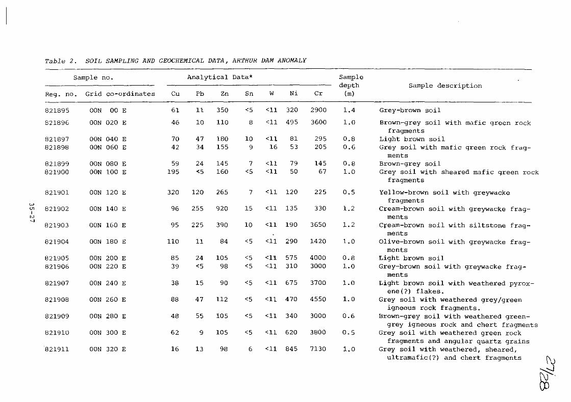
Table 2. SOIL SAMPLING AND GEOCHEMICAL DATA, ARTHUR DAM ANOMALY
Sample no .. Analytical Data* Sample depth Sample description
Reg. no. Grid co-ordinates Cu Pb Zn Sn W Ni Cr (m)
821895 OON 00 E 61 11 350 <5 <11 320 2900 1.4 Grey-brown soil
821896 OON 020 E 46 10 110 8 <11 495 3600 1.0 Brown-grey soil with mafic green rock fragments
821897 OON 040 E 70 47 180 10 <11 81 295 0.8 Light brown soil 821898 OON 060 E 42 34 155 9 16 53 205 0.6 Grey soil with mafic green rock frag-
ments 821899 OON 080 E 59 24 145 7 <11 79 145 0.8 Brown-grey soil 821900 OON 100 E 195 <5 160 <5 <11 50 67 1.0 Grey soil with sheared mafic green rock
fragments
821901 OON 120 E 320 120 265 7 <11 120 225 0.5 Yellow-brown soil with greywacke
w fragments
lJ> 821902 OON 140 E 96 255 920 15 <11 135 330 1.2 Cream-brown soil with greywacke frag-I
tv ments --J
821903 OON 160 E 95 225 390 10 <11 190 3650 1.2 Cream-brown soil with siltstone frag-ments
821904 OON 180 E 110 11 84 <5 <11 290 1420 1.0 Olive-brown soil with greywacke frag-ments
821905 OON 200 E 85 24 105 <5 <11 575 4000 0.8 Light brown soil 821906 OON 220 E 39 <5 98 <5 <11 310 3000 1.0 Grey-brown soil with greywacke frag-
ments 821907 OON 240 E 38 15 90 <5 <11 675 3700 1.0 Light brown soil with weathered pyrox-
ene (7) flakes. 821908 OON 260 E 88 47 112 <5 <11 470 4550 1.0 Grey soil with weathered grey/green
igneous rock fragments. 821909 OON 280 E 48 55 105 <5 <11 340 3000 0.6 Brown-grey soil with weathered green-
grey igneous rock and chert fragments 821910 OON 300 E 62 9 105 <5 <11 620 3800 0.5 Grey soil with weathered green rock
fragments and angular quartz grains 821911 OON 320 E 16 13 98 6 <11 845 7130 1.0 Grey soil with weathered, sheared,
ultramafic(?) and chert fragments (\J ~ ~.

Table 2. (continued)
Sample no. Analytical Data* Sample depth Sample description
Reg. no. Grid co-ordinates eu Pb Zn Sn W Ni Cr (m)
821912 DON 340 E 17 30 BS <5 <11 420 4150 O.S Green-grey soil with weathered, sheared mafic green rock fragments
821913 OON 350 E 20 36 115 <5 <11 545 5950 1.0 Grey-brown soil with green rock frag-ments and angular quartz grains
821914 OON 360 E 30 39 140 <5 <11 395 3100 0.6 Grey soil with sheared grey-green rock fragments
821915 OON 370 E 38 42 125 15 <11 280 1250 0.7 Light brown soil with large, weathered pyroxene ( ?) flakes
821916 OON 380 E 51 36 230 8 <11 205 550 0.4 Cream-brown sail with large, weathered pyroxene ( ?) flakes
821917 OON 390 E 110 21 165 10 <11 140 500 0.8 Dark brown soil with angular quartz w grains, angular chert fragments and '" 1 rounded quartz pebbles. N 00 821918 DON 400 E 57 48 150 <5 <11 395 2950 0.7 Light brown soil with chert fragments
821919 OON 410 E 370 170 275 11 <11 120 300 0.7 Light brown soil with greywacke frag-ments
821920 OON 420 E 63 11 115 <5 <11 330 3250 1.2 Light brown soil 821921 OON 440 E 35 41 135 <5 <11 390 3150 0.8 Brown soil
* Analysts M. Frith and R. Roby, Department of Mines Laboratories, Launceston.