Embed Size (px)
Citation preview
19 Marine Ecology
1HINKLEY POINT C PRE-APPLICATION CONSULTATION – STAGE 2 |
ENVIRONMENTAL APPRAISAL – VOLUME 2
19 MARINE ECOLOGY
19.1 Introduction
19.1.1 This Chapter assesses the potential impacts of the construction and operational phases of the proposed Hinkley Point C Power Station on marine ecosystems at Hinkley Point and, where appropriate, the wider Bridgwater Bay and Severn Estuary environment.
19.2 Scope of Assessment
19.2.1 The assessment of the potential impacts has been undertaken in accordance with the methods outlined in Chapter 4, Volume 2. Available published data and grey literature have been examined which includes data derived from ongoing impingement and entrainment sampling at the current HPB Station intake screens. To secure the marine science base to support consideration of this development, both in terms of environmental assessment and appropriate engineering design, a range of investigations were instigated by British Energy under the umbrella of the British Energy Estuarine and Marine Studies (BEEMS) process, now adopted by EDF. These surveys were designed to gather baseline data across appropriate temporal and spatial scales for the key ecological components of the surrounding ecosystems.
19.2.2 The geographical extent of the area of interest for the marine ecological assessment is dependent upon the particular organism, its habits, and the type of impact considered critical for it.
19.2.3 The extent of dedicated survey and assessment effort is also dependent upon an understanding of the highly dynamic physical processes that govern the ecology of the Severn Estuary and Bristol Channel (see Chapter 16).
19.2.4 The site for the proposed HPC Station is located within and adjacent to a number of international and national conservation designations that cover a range of marine ecological interests. These designations and the species and habitats for which they are designated have been of prime consideration for the assessment process. Ecological receptors with protected status have been identified. Where a species or habitat is of conservation or general ecological importance, but does not have protected status, it has been discussed in more detail.
19.2.5 Assessment of potential impacts has been undertaken for the construction and operational phases of the development. Following initial assessment, if an impact was indicated to be of moderate significance or greater, mitigation measures have, where possible, been identified to reduce predicted impacts. In some instances, mitigation measures have been an integral aspect of initial project design (e.g. jetty design or cooling water outfall location).
19.2.6 To identify the scope of the issues to be covered in the assessment of potential effects on marine ecology, an initial evaluation of the potential for interactions between defined project

19 Marine Ecology
2 | HINKLEY POINT C PRE-APPLICATION CONSULTATION – STAGE 2
ENVIRONMENTAL APPRAISAL – VOLUME 2
activities and the receiving environment was undertaken. This resulted in a number of activities being identified which were considered, on the basis of likelihood and known response of the ecological parameters, to potentially result in interactions. These interactions are identified and listed in Table 19.1. The table does not provide an exhaustive list of potential interactions, but solely those for which further assessment work was determined to be necessary.
Table 19.1: Marine Ecology - Sources of Potential Interactions with Defined Project Activities for a Range of Key Receptors
Receptor
Phyt
opla
nkto
n
Zoop
lank
ton
Epifa
una
Ben
thic
flor
a
Sub
tida
l inv
erte
brat
es
Inte
rtid
alha
bita
ts
(inc
ludi
ng S
abel
lari
a)
Fish
Mar
ine
mam
mal
s
Construction
Physical damage to habitats (e.g. construction on the seabed, dredging etc.)
Disturbance to habitats and species
Changes in water quality
Noise impacts (piling and vessels)
Operation
Loss or change in habitat caused by presence of structures
Entrainment and impingement impacts on intake screens
Water quality - temperature, flow and chemical impacts from thermal plume
Water quality - chemical discharges
Maintenance dredging
Noise impacts from

19 Marine Ecology
3HINKLEY POINT C PRE-APPLICATION CONSULTATION – STAGE 2 |
ENVIRONMENTAL APPRAISAL – VOLUME 2
maintenance vessels
a) Consultation with Regulatory Bodies
19.2.7 Consultation in relation to marine ecology has been undertaken with various stakeholders throughout project development. A summary of key meetings at which the scope of the assessment work was discussed is provided in Table 19.2. This summary does not represent a full account of all meetings held, only those where marine ecology and other marine issues relevant to the assessment process were discussed.
Table 19.2: Summary of Consultation Meetings Undertaken to Determine Scope and Nature of Marine Ecological Assessment and Survey Work
Date Attendees Consultee Discussion/Comments
20/08/08 Natural England (NE), Environment Agency & Countryside Council for Wales (CCW)
Marine ecology issues discussed – some gaps identified in initial data review. Coastal processes and coastal protection also discussed. Possible need for offshore surveys identified. Fisheries data to be requested from CCW, identification of coastal workshop attendees required, methods for offshore surveys to be discussed with NE. Environment Agency identified a lack of sufficiently detailed water quality data. Also discussed coastal monitoring and defence issues and management of discharges.
22/09/08 CCW Correspondence
Water dependant features within the assessment area should be detailed as previously suggested in consultation.
03/11/08 NE Terrestrial ecology and marine ecology scoping meeting with the purpose to discuss and agree scope of proposed surveys. The proposed sampling design for the local scale surveys was presented at this meeting. NE confirmed it was content with range and scope of proposed surveys, but requested that a full 12 month survey period was applied for certain key species, specifically fish. It was discussed that shad (protected Annex II species under the Habitats Directive, see Section 19.3) abundance tends to peak in July/August and therefore likelihood of catching this species increases during these months so sampling was extended to cover this period.
16/01/09 NE and CCW CCW comments on marine ecology methodology were received on 09/02/09. NE comments on marine ecology were received on 12/02/09. Other than extension of surveys as decided at the 03/11/08 meeting no other changes to survey design were requested.
11/03/09 CCW, NE, Environment Agency and Sedgemoor District Council (DC)
Marine Authorities Liaison Group Meeting was held to discuss consents and estuary issues.

19 Marine Ecology
4 | HINKLEY POINT C PRE-APPLICATION CONSULTATION – STAGE 2
ENVIRONMENTAL APPRAISAL – VOLUME 2
Date Attendees Consultee Discussion/Comments
24/06/09 Environment Agency, Royal Haskoning, NE, Somerset County Council, Marine and Fisheries Agency and West Somerset Council
Meeting held to discuss Marine Authorities. Discussed offshore investigations, shore access arrangements and Sea Protection Group. Also discussed, water abstraction and discharge, soil, groundwater and ground gas, surface and marine water.
28/07/09 Environment Agency, Marine Fisheries Agency, English Heritage, West Somerset Council, Somerset County Council, ARUP
Status presentation on studies regarding shore access, sea protection wall, abstraction and discharge, water quality, contaminated land, groundwater, ground gas.
19.3 Legislation
19.3.1 This section describes the main marine ecological legislative and planning policy considerations in relation to the proposed development. Such legislation and planning policy provide control to the types of development which can be conducted within the marine environment and can set out the measures and processes that should be implemented to protect designated sites and biodiversity interests.
a) Legislation and Policies Relevant to the Marine Biodiversity and Conservation Interests of the Study Area
i International Conventions
Ramsar Convention of Wetlands of International Importance 1971
19.3.2 The Convention provides the framework for national action and international co-operation for the conservation and considerate use of wetlands and their resources. Suitable wetlands are designated for inclusion in the List of Wetlands of International Importance. In order to promote the conservation of Ramsar sites, the UK implements the Convention through the Sites of Special Scientific Interest (SSSI) system, with some overlap with Special Area of Conservation (SAC) and Special Protection Area (SPA) sites (see section on ‘EC Habitats Directive’ below). The Ramsar Policy Statement 2000 offers Ramsar Sites equivalent protection to Natura 2000 sites. Of relevance to the proposed development is the Severn Estuary Ramsar designation.
19.3.3 The Severn Estuary Ramsar site is designated due to a combination of a number of attributes including; the large tidal range, presence of Annex I habitats protected under the Habitats Directive (see text for ‘EC Habitats Directive’ below), the presence of unusual estuarine communities (reduced diversity and high productivity), the run of migratory fish between the sea and river via the estuary, the fish of the whole estuarine and river system (which is one of the most diverse in Britain) and wildfowl and wader assemblages and species/populations of
19 Marine Ecology
5HINKLEY POINT C PRE-APPLICATION CONSULTATION – STAGE 2 |
ENVIRONMENTAL APPRAISAL – VOLUME 2
international importance. The Bridgwater Bay National Nature Reserve (NNR) is also designated a wetland of international importance under the Ramsar Convention.
The Convention on Biological Diversity 1992
19.3.4 This Convention focuses on the conservation of all species and ecosystems and therefore provides protection to all biodiversity. The Convention requires the development of national strategies, plans or programmes for the conservation and sustainable use of biodiversity. In accordance with this, the UK has developed Biodiversity Action Plans (BAPs). For intertidal and subtidal zones, Species, Habitat, and BAPS have been developed. These action plans provide guidance for the conservation and management of biodiversity within the natural environment. The Convention is transposed into UK law by the Countryside and Rights of Way Act (2000).
The Convention for the Protection of the Marine Environment of the North-East Atlantic (OSPAR)
19.3.5 Annex V of the Convention provides a framework for contracting parties to develop their own conservation measures. Article 2 requires parties to ‘take necessary measures to protect and conserve the ecosystems and the biological diversity of the maritime area, and to restore, where practicable, marine areas which have already been adversely affected’.
b) European Directives
i EC Directive on the Conservation of Wild Birds (79/409/EEC)
19.3.6 The ‘Birds Directive’ aims to protect all wild birds, their eggs, nests and habitats within the EC. It also provides for the protection, management and control of all species of naturally occurring wild birds that are considered rare or vulnerable within the EC as listed in Annex I of the Directive. Under the Directive the most suitable areas for the conservation of these species (land and sea) are classified SPAs. In England and Wales the Directive is implemented under the Wildlife and Countryside Act 1981 (as amended) and the Conservation (Natural Habitats, &c) Regulations 1994 (as amended). Of relevance to the proposed development is the Severn Estuary SPA.
19.3.7 The Severn Estuary qualifies as an SPA under Article 4.1 of the Birds Directive because it is classified as a wetland of international importance regularly supporting at least 20,000 waterfowl. In addition, it supports internationally important Annex I populations of over-wintering Bewick’s Swan (Cygnus columbianus bewickii), Curlew (Numenius arquata), dunlin (Calidris alpina alpina), pintail (Anas acuta), redshank (Tringa totanus) and shelduck (Tadorna tadorna), and on passage ringed plover (Charadrius hiaticula).
19.3.8 The implications of the proposed HPC development with respect to the designated interests of the SPA are covered in the chapter on terrestrial ecology (Chapter 18) and in the chapter providing the initial Habitats Regulations Assessment (HRA).
ii EC Directive on the Conservation of Natural Habitats and of Wild Fauna and Flora (92/43/EEC) (EC Habitats Directive).
19.3.9 Under the ‘Habitats Directive’, SACs can be designated to maintain or restore the habitats listed in Annex I and the species listed in Annex II of the Directive to ‘Favourable Conservation Status’. This is defined in the context of habitats, as the establishment of conditions which will ensure that the extent and range of the habitat, and the populations of the species within that habitat, will be maintained or increased over time. In relation to species, the viability, population size

19 Marine Ecology
6 | HINKLEY POINT C PRE-APPLICATION CONSULTATION – STAGE 2
ENVIRONMENTAL APPRAISAL – VOLUME 2
and range of the species should be maintained in the long term. In England and Wales the Directive is implemented under the Conservation (Natural Habitats) Regulations 1994 (as amended). Of relevance to the proposed development is the Severn Estuary Special Area of Conservation (SAC).
19.3.10 In 2009, the Severn Estuary was nominated as a SAC under the Directive. The designation is primarily due to the presence of the Annex I habitats: 'Atlantic salt meadows', 'estuaries' and 'mudflats and sandflats not covered by seawater at low tide'. The Annex I habitats: 'sandbanks which are slightly covered by seawater all the time' and 'reefs' are also present as qualifying features, but are not the primary reasons for the designation. The site is also designated due to the presence of the Annex II species: twaite shad (Alosa fallax), sea lamprey (Petromyzon marinus) and river lamprey (Lampetra fluviatilis).
19.3.11 The ecological implications of the proposed HPC development with respect to the designated interests of the SAC are dealt with in Annex 1 providing the initial Habitats Regulations Assessment (HRA).
iii The Water Framework Directive (2000/60EC)
19.3.12 The EC Water Framework Directive (WFD) requires that all inland and coastal waters within defined river basin districts must reach at least ‘good status’ (or 'good potential’, if considering a heavily modified water body) by 2015 and defines how this should be achieved through the establishment of environmental objectives and ecological targets for surface waters. Under the requirements of the Directive, the present water quality status must be assessed and any significant water quality issues identified. The overall aim is to enhance water resource quality, reduce pollution and promote sustainable use of water resources. The WFD is implemented in the UK under The Water Environment Regulations (see Section 2.1.3 below).
19.3.13 In addition to promoting improvements in water quality (e.g. by setting limits for effluent discharges) the WFD emphasises the importance of the ecological characteristics of aquatic habitats with the aim for water bodies to be classed as having 'good' ecological status/potential and 'good' surface water chemical status/potential (or better) by 2015.
19.3.14 Five components are used to assess ecological status of coastal and estuarine water bodies under the WFD: angiosperms (e.g. eelgrass), macroalgae, phytoplankton, invertebrates and fish. Marine angiosperms are absent from the section of the Severn Estuary/Bristol Channel potentially impacted by the proposed Hinkley C Power Station development.
iv EU Marine Strategy Framework Directive
19.3.15 The objective of the EU’s Marine Strategy Framework Directive is for EU marine waters to achieve good environmental status by 2021 and to protect the resource base upon which marine-related economic and social activities depend. This Directive constitutes the environmental component of the EU’s future maritime policy which has been designed to achieve the full economic potential of the oceans and seas while conserving the marine environment.
19.3.16 Under the Directive, each Member State within a marine region is required to develop strategies for their marine waters. These strategies must contain a detailed assessment of the state of the environment, a definition of “good environmental status” at a regional level and the environmental targets and the establishment of monitoring programmes. Cost-effective

19 Marine Ecology
7HINKLEY POINT C PRE-APPLICATION CONSULTATION – STAGE 2 |
ENVIRONMENTAL APPRAISAL – VOLUME 2
measures must be drawn up which include an impact assessment which details a cost-benefit analysis of the proposed measures.
19.3.17 The overall goal of the Directive is in line with the objectives of the Water Framework Directive which requires surface freshwater and ground water to be ecologically sound by 2015 for which the first review of the River Basin Management Plans should take place in 2020.
c) National Legislation and Planning Policy
i The Conservation of Habitats and Species Regulations (2010)
19.3.18 These Regulations succeed the original Conservation (Natural Habitats, &c) Regulations (1994) and consolidate all the various amendments made to the 1994 Regulations in respect of England and Wales (herein referred to as the ‘Habitats Regulations’);
19.3.19 The Regulations implement the Habitats and Birds Directives (described earlier). The Regulations make provision for the protection and management of sites, including the control of potentially damaging operations that may affect designated sites.
ii The Wildlife and Countryside Act 1981
19.3.20 The Wildlife and Countryside Act, WCA (as amended by the Countryside and Rights of Way Act 2000 (CRoW)) consolidates and amends existing legislation to implement the Bern Convention and the Birds Directive. The WCA strengthens provisions under the National Parks and Access to the Countryside Act 1949 to establish NNRs in England and Wales. The legislation provides for the designation, protection and management of NNRs which can be established on land and land covered by water, so it can therefore extend into the intertidal zone, but not below low water (e.g. the Bridgwater Bay NNR). These areas can be designated for their flora, fauna or geological interests. The Act provides for the designation of SSSIs, and Marine Nature Reserves.
19.3.21 Bridgwater Bay is a designated SSSI and comprises a wide range of habitats ranging from extensive intertidal mudflats and saltmarsh to shingle beach and grazing marsh intersected by freshwater and brackish ditches. It is important both nationally and internationally for the overwintering and passage of large numbers of migrant waders and waterfowl. Bridgwater Bay was designated a wetland of international importance under the Ramsar Convention and a NNR under Section 23 of the National Parks and Access to the Countryside Act 1949.
iii Countryside and Rights of Way Act 2000
19.3.22 The Countryside and Rights of Way Act provides for public access on foot to certain types of land, amends the law for public rights of way, increases protection for SSSIs and strengthens wildlife enforcement legislation and provides for better management of Areas of Outstanding Natural Beauty (AONB).
iv The Water Environment (Water Framework Directive) (England and Wales) Regulations 2003 SI 3242
19.3.23 The Regulations provide the mechanism to implement river basin districts within England and Wales in accordance with the WFD Directive. The Regulations require a new strategic planning process to be established for the purpose of managing, protecting and improving the quality of water resources.
19 Marine Ecology
8 | HINKLEY POINT C PRE-APPLICATION CONSULTATION – STAGE 2
ENVIRONMENTAL APPRAISAL – VOLUME 2
v Water Resources Act 1991
19.3.24 The Water Resources Act (WRA) came into effect in 1991 and replaced corresponding sections of the Water Act 1989. The WRA sets out the responsibilities of the Environment Agency in relation to water pollution, resource management, flood defence, fisheries, and in some areas, navigation. The WRA regulates discharges to controlled waters, namely rivers, estuaries, coastal waters, lakes and groundwaters. This is distinct from the drainage of water or trade effluent from trade premises into a sewer. Discharge to controlled waters is only permitted with the consent of the Environment Agency. An aim of the Act is to ensure that the polluter pays the cost of the consequences of their discharges.
vi Planning Policy Statement 9 (PPS9) Biodiversity and Geological Conservation
19.3.25 Planning Policy Statement 9 (PPS9) sets out the Government’s national planning policies on the protection of biodiversity and geological conservation through the planning system. Government objectives in relation to biodiversity and geological conservation aim to conserve, enhance and restore biodiversity, and promote sustainability. The aims and objectives of PPS9 are delivered via Regional Spatial Strategies and Local Development Frameworks implemented by the regional and local planning bodies.
19.3.26 PPS9 establishes a series of key principles that regional planning bodies and local planning authorities should adhere to in order to ensure that the potential impacts of planning decisions on biodiversity and geological conservation are fully considered. This is accompanied by Office of the Deputy Prime Minister (ODPM) Circular 06/2005 which provides administrative guidance on the application of the law relating to planning and nature conservation.
19.3.27 This guidance advises that planning policies and decisions should aim to maintain and enhance, restore or add to biodiversity and geological conservation interests. A strategic approach to the conservation, enhancement and restoration of biodiversity and geology should be taken, recognising the contribution that sites, areas and features (both individually and in combination) make to conserving these resources. Development should contribute to rural renewal and urban renaissance by enhancing biodiversity in green spaces and among developments so that they are used by wildlife and valued by people.
19.3.28 Networks of natural habitats are considered within PPS9 to represent a valuable resource. To reflect their importance, emphasis is placed upon Local Planning Authorities to maintain networks by: “avoiding or repairing the fragmentation and isolation of natural habitats through policies in plans”.
vii The Marine and Coastal Access Act 2009
19.3.29 The Marine and Coastal Access Act 2009 aims to enable better protection of marine ecosystems and prevent a decline in marine biodiversity. The Act sets out provisions for more coherent planning in the marine environment in terms of issuing consents and permits for activities in the marine and coastal environment. The Act also contains provisions to allow for the designation of Marine Conservation Zones (MCZs) and the creation of a network or Marine Protected Areas (MPAs).

19 Marine Ecology
9HINKLEY POINT C PRE-APPLICATION CONSULTATION – STAGE 2 |
ENVIRONMENTAL APPRAISAL – VOLUME 2
viii UK Biodiversity Action Plan
19.3.30 The UK BAP is the UK response to the Convention on Biological Diversity 1992. The Plan describes the UK’s biological resources and commits a detailed plan for the protection of these resources. Within the plan, a list of priority species and habitats is developed, for which specific action should be taken to conserve these species and habitats. The implementation of the BAP is the responsibility of various statutory and non-statutory organisations. This is a requirement of the Countryside Rights of Way Act (2000).
ix Salmon and Freshwater Fisheries Act
19.3.31 The Salmon and Freshwater Fisheries Act 1975 (SAFFA) applies to salmon, trout (including sea trout) and freshwater fish. The 1975 Act contains rules governing the: Prohibition of Certain Modes of Taking or Destroying Fish, Obstructions to Passage of Fish, Times of Fishing and Selling and Exporting Fish, Fishing Licences, Administration and Enforcement.
x Eel Management Plans
19.3.32 In accordance with Article 4 of Council Regulation (EC) No 1100/2007 of 18 September 2007, which established measures for the recovery of the stock of European eel, the UK submitted 15 Eel Management Plans for approval by the Commission in December 2008. These plans are set at the River Basin District level, as defined under the Water Framework Directive 2000/60/EC, covering England and Wales, Scotland and Northern Ireland.
19.3.33 Eel Management Plans have been implemented for the Severn Catchment which aim to provide an escapement of silver eel biomass that is at least equal to 40% of the potential escapement to be expected in the absence of anthropogenic influence. In addition, the European Eel Regulation requires that a system is in place to ensure that by 2013, 60% of eel less than 12 cm long which are caught commercially each year are used for restocking in suitable habitat.
d) Regional Planning Policy
i Draft Regional Spatial Strategy for the South West 2006 – 2026 (2007)
19.3.34 The objective of the Regional Spatial Strategy (RSS) is to contribute to the achievement of sustainable development. The RSS provides a broad development strategy for the region for a fifteen to twenty year period. The draft RSS for the south-west contains biodiversity targets relating to the maintenance and expansion up to the year 2020 of various habitat types. Marine and coastal habitats include:
Coastal saltmarsh; Mudflats; Coastal vegetated shingle; Sand dunes; Sabellaria reefs; Maritime cliff and slope; Saline lagoons; and Seagrass beds.
19.3.35 Of the habitats listed above, all have a maintenance target area and all, but Sabellaria reefs and seagrass beds, have targets for the years 2010 and 2020. The aforementioned habitats are described as having non-quantifiable future target areas. In addition, quantifiable maintenance and target areas are not provided for littoral sand and gravel habitats. It is stated, however,

19 Marine Ecology
10 | HINKLEY POINT C PRE-APPLICATION CONSULTATION – STAGE 2
ENVIRONMENTAL APPRAISAL – VOLUME 2
that for these habitats, the retention of the existing extent and realisation of opportunities for their expansion, is very important.
ii Somerset and Exmoor Joint Structure Plan 1996 - 2016
19.3.36 The Joint Structure Plan (JSP) provides the strategic base for all land use planning in the combined area covered by Somerset and the Exmoor National Park for the period up to 2016. The Plan has been prepared as a JSP between Somerset County Council and the Exmoor National Park Authority. The JSP policies relevant to marine ecology in the vicinity of the proposed development include Policy 1: Nature Conservation and Policy 15: Coastal Development. These are described as:
Policy 1 - Nature Conservation, states that the biodiversity of Somerset (and the Exmoor National Park) will be protected, conserved, restored, enhanced, and managed in accordance with the UK and relevant regional and local BAPs. Spatial target habitats are provided for coastal sand dune, coastal vegetated shingle, and Sabellaria alveolata reef. Maintenance target areas are set for coastal sand dune and coastal vegetated sand dune, however, the full extent of S. alveolata reef is not known. A target has been set to mitigate the natural loss of coastal sand dune, although establishment and restoration targets are ongoing for coastal vegetated shingle and S. alveolata reef.
Policy 15 - Coastal Development, predominantly considers development on the coast and emphasises the importance of protecting and enhancing natural marine resources including those afforded international protection.
e) Local Planning Policy
i West Somerset Council Local Development Framework
19.3.37 West Somerset Council is currently undertaking public consultation on the Local Development Framework Core Strategy (this ends in September 2009).
ii West Somerset Council Local Plan (2006)
19.3.38 The West Somerset Local Plan covers the administrative area of West Somerset, excluding Exmoor National Park which has a separate Local Plan.
iii Local Biodiversity Action Plan LBAP (Sedgemoor and West Somerset)
19.3.39 The Local Biodiversity Action Plan for the Sedgemoor District is currently being prepared. Under the West Somerset BAP, coastal vegetated shingle and Sabellaria alveolata reefs are identified as priority habitats.
19.4 Methodology
a) Introduction
19.4.1 Numerous studies have been conducted examining the biological assemblages of the Severn Estuary and Bristol Channel (e.g. Warwick & Uncles, 1980 (Ref. 19.1), Warwick et al., 2001 (Ref.19.2), Langston et al., 2003 (Ref. 19.3). In addition, some studies have specifically

19 Marine Ecology
11HINKLEY POINT C PRE-APPLICATION CONSULTATION – STAGE 2 |
ENVIRONMENTAL APPRAISAL – VOLUME 2
focussed on the ecology of the area surrounding Hinkley Point (e.g. Bamber, 1982 (Ref. 19.4), Bamber, 1984 (Ref.19.5), Bamber et al., 1987 (Ref. 19.6), Bamber & Irving, 1992 (Ref. 19.7) & 1993a (Ref. 19.8), and 1993b (Ref. 19.9), Martin, 1993a (Ref. 19.10) and 1993b (Ref. 19.11) and 1993c (Ref.19.12), Seaby & Somes, 2001 (Ref. 19.13), BEEMS, 2009a (Ref.19.14). An important long-term data set is also available from the monthly sampling of the intake screens at Hinkley Point B Power Station, instigated in January 1981 and continuing to this day. The collection of this data set was begun by the Central Electricity Generating Board (CEGB) and provides relative abundance data for fish (>80 species), macroinvertebrates (>20 species) and planktonic organisms (>40 species).
b) Marine studies specific to Hinkley Point C
i Introduction
19.4.2 A series of field investigations has been undertaken to provide additional baseline data and appropriate numerical modelling tools developed in order to inform both environmental assessment procedures and support considerations of appropriate engineering design. Experience of construction and operational impacts of other UK power stations indicate that the likely impacts of the proposed HPC Station development would be evident at different spatial scales. For example, construction of the cooling water intake and outfall structures would be likely to result in localised impacts, whereas the effects of a thermal plume created by cooling water discharged from the outfall could potentially extend over many kilometres. The overall aim of the field survey effort was to establish a contemporary baseline for the intertidal and subtidal species and habitats found on and around Hinkley Point, both with respect to potential localised impacts (local scale surveys) and from wider scale impacts such as the cooling water discharges (wider scale surveys).
19.4.3 A key component of the marine studies is the marine science programme established within British Energy (BEEMS – ‘British Energy Estuarine and Marine Studies’) in support of considerations of new nuclear build, subsequently adopted by EDF. As this adoption occurred early in 2009, by which time both parties had established marine surveys in the vicinity of Hinkley Point, the programme of survey efforts utilised in this appraisal reflects the process of rationalisation and integration that subsequently followed.
19.4.4 Where available, methods used for the surveys were based on best practice recommendations including those outlined in the Marine Monitoring Handbook (Davies et al., 2001 (Ref 19.15)). Aspects of the UK National Marine Monitoring Programme Green Book (NMMP 2003 (Ref. 19.16)) were also considered. These documents provide detailed standard methodologies for intertidal and subtidal sampling.
19.4.5 Additional methodologies have been developed or adapted as appropriate from past examples of best practice, utilising expert advice both from an Expert Panel established under BEEMS. These needs have occurred either where standard methodologies have been lacking in definition (e.g. for cooling water entrainment, impingement and thermal plume assessment, including numerical modelling approach) and in relation to the need to inform WFD metrics.
19.4.6 As described above, the approach and the initial extent of the survey programme was discussed in detail and agreed with stakeholders, including Natural England (NE), the Environment Agency (EA) and the Countryside Council for Wales (CCW). Subsequent developments in that programme, further to EDF’s acquisition of British Energy, have been discussed both with these

19 Marine Ecology
12 | HINKLEY POINT C PRE-APPLICATION CONSULTATION – STAGE 2
ENVIRONMENTAL APPRAISAL – VOLUME 2
bodies separately and in common forum within the HPC Marine Authorities Liaison Group (MALG), as appropriate.
ii Description of Surveys
19.4.7 Following initial review of the tidal regime of the area and likely extent of any cooling water plume related issue, a series of high resolution bathymetric surveys using sidescan and swathe sonar of a wide area of the subtidal off Hinkley Point were completed. These surveys were completed as part of the BEEMS scope of work in 2008 (BEEMS, 2009b (Ref. 19.17). In combination with high resolution Lidar (Light Detection and Ranging) survey data obtained from the Environment Agency, the results were analysed to produce detailed maps of bed morphology and habitat type (see Figure 19.1 and 19.2 for examples of outputs).
19.4.8 An initial set of offshore biological surveys was instigated in February 2008 and covered a broad area of the Severn Estuary up to 15 km from the proposed position of the new power station site at Hinkley Point (the estimated extent of any thermal influence of cooling water discharges) Figure 19.3. The programme included off-shore surveys in February, June, August and November of 2008 and May 2009 for:
Subtidal benthic infauna, sampled with a 0.1 m2 Day grab; Subtidal benthic epifauna, sampled with a 2 m beam trawl; Benthic fish, sampled with a beam trawl; Fish egg and larval abundance, as sampled by Gulf VII high speed plankton net; and Zooplankton and phytoplankton using standard plankton nets.
19.4.9 In addition, intertidal habitats were surveyed in July 2008. In order to ensure comprehensive spatial coverage of the various biotopes involved, intertidal sampling was directed by the use of existing biotope maps, where available, arising from earlier studies carried out for Natural England. The area surveyed covered both soft and hard sediments ranging from the intertidal mud and sandflats up to ~8 km north of the River Parrett estuary, to the shoreline ~15 km west of Hinkley Point. In total 55 sample sites were selected, which consisted of 40 soft sediment locations, 12 rocky shore sites and 3 sites located on saltmarsh. Sample sites were chosen to cover as wide a range of biotopes as possible within the intertidal zone in the main study area. A more detailed description of the survey programme is available in BEEMS, 2009c (Ref. 19.18), BEEMS 2009d (Ref. 19.19), BEEMS 2009e (Ref. 19.20) and BEEMS 2009f (Ref. 19.21).
19.4.10 Findings from the benthic and intertidal studies were subsequently utilised to validate a series of biotope maps on the basis of habitat mapping derived from remote sensing.
iii Surveys for Intertidal Fish and Mobile Epifauna
19.4.11 Following a review of the existing biological datasets it was recognised that there was a lack of data relating to the utilisation of the intertidal zone by fish and mobile invertebrates. The location of the proposed new nuclear build borders a large expanse of intertidal sediments. Initial work had identified that this area could fall within the footprint of the thermal plume from the cooling water discharge. A study was initiated in August 2009 with an aim of increasing the knowledge base regarding the numbers and types of species utilising these habitats on both a temporal and spatial basis. To date, four surveys have been conducted in August, October and December 2009 and February, April and June 2010.
19 Marine Ecology
13HINKLEY POINT C PRE-APPLICATION CONSULTATION – STAGE 2 |
ENVIRONMENTAL APPRAISAL – VOLUME 2
19.4.12 To gain a comprehensive understanding of the species utilising these habitats, the survey was designed to incorporate a range of techniques. Although primarily designed to target fish, mobile epifauna caught as bycatch were also recorded. The sampling strategy for fish was designed to follow the best practice WFD ‘multi-method’ approach, utilising a combination of static fyke nets and marginally deployed seine nets. Three sites were selected which were considered to provide a range of habitats and flows typical of the wider area of Bridgwater Bay Figure 19.4.
iv Fish on Screen Surveys
19.4.13 As a check on the long term fish on screens monitoring at the HPB site, an additional programme of such monitoring was established utilising a more comprehensive methodology designed to obtain a quantitative, rather than semi-quantitative assessment of the station catch over the course of a year. The methodology used was directly comparable to that used for scaling mitigation benefits associated with cooling water intake design improvements at previous nuclear power station developments in the UK.
19.5 Ecological Impact Assessment Methodology
19.5.1 The assessment framework used here has been drawn from that described in Chapter 4, Volume 1. Specific elements relating to marine ecology have been incorporated into the methodology where appropriate, as set out in the following tables.
a) Value and Sensitivity of the Receptor
19.5.2 The value of a receptor is determined based on geographical context (e.g. international, national, regional see below) and conservation designations. Where appropriate, the criteria assigned for determining the sensitivity of receptors has been based on information derived from the Marine Life Network (MarLIN). The criteria utilised are summarised in Table 19.3.

19 Marine Ecology
14 | HINKLEY POINT C PRE-APPLICATION CONSULTATION – STAGE 2
ENVIRONMENTAL APPRAISAL – VOLUME 2
Table 19.3: Site Sensitivity and Value Matrix for Marine Ecology
Definition Value and Sensitivity Guidelines
High Value
Feature/receptor possesses key characteristics which contribute considerably to the distinctiveness, rarity and character of the site/receptor e.g. Designated features of International/National designation/importance e.g. SAC, SSSI, Ramsar, SPA, BAP.
Feature/receptor possess important biodiversity, social/community value and/or economic value.
Feature/receptor is rarely sighted.
Sensitivity
Receptor populations are identified as having very low capacity to adapt to, or recover from, proposed form of change i.e. population is highly sensitive to change.
Medium Value
Feature/receptor possesses key characteristics which contribute considerably to the distinctiveness, rarity and character of the site/receptor e.g. Designated features of Regional/County designation/importance e.g. BAP, Nature Reserves.
Feature/receptor possess moderate biodiversity, social/community value and/or economic value.
Feature/receptor is occasionally sighted.
Sensitivity
Receptor is identified as having low capacity to accommodate proposed form of change i.e. is moderately sensitive.
Low Value
Feature/receptor only possess characteristics which are of District or Local importance. Feature/receptor not designated or only designated at the district or local level e.g. LNR.
Feature/receptor possess some biodiversity, social/community value and/or economic value.
Feature/receptor is relatively common.
Sensitivity
Feature/receptor is identified as having tolerance to changes within the range of natural variation i.e. is only slightly sensitive.

19 Marine Ecology
15HINKLEY POINT C PRE-APPLICATION CONSULTATION – STAGE 2 |
ENVIRONMENTAL APPRAISAL – VOLUME 2
Definition Value and Sensitivity Guidelines
Very Low Value
Feature/receptor characteristics do not make a contribution to the character or distinctiveness locally. Feature/receptor not designated.
Feature/receptor possess low biodiversity, social/community value and/or economic value.
Feature/receptor is abundant.
Sensitivity
Feature/receptor identified as being generally tolerant of the proposed change i.e. of low sensitivity.
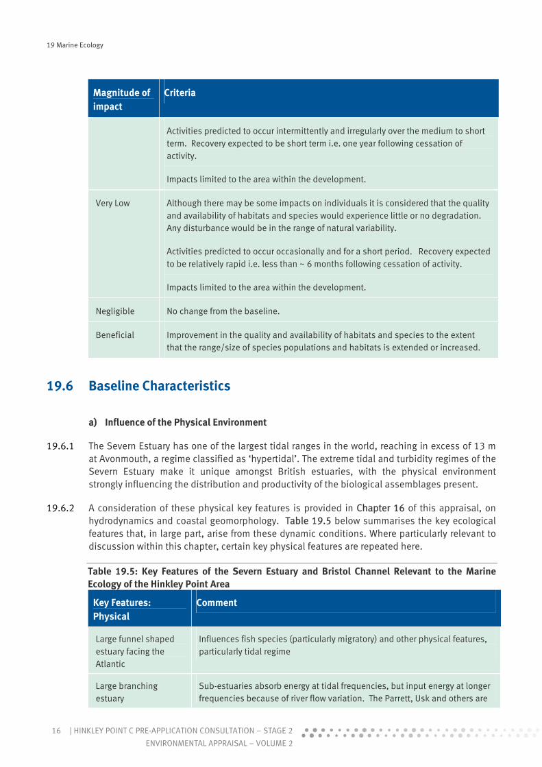
b) Magnitude of Impact
19.5.3 The criteria used to assign the magnitude of impact with specific regard to marine ecological interests is shown in Table 19.4.
Table 19.4: Criteria for Determining Magnitude of Impact for Marine Ecology
Magnitude of impact
Criteria
High The quality and availability of habitats and species are degraded to the extent that locally rare populations and habitats are destroyed and protected species and habitats experience widespread change, such that the integrity of the ecosystem and the conservation status of a designation may be compromised.
Activities predicted to occur and affect receptors continuously over the long term, and during sensitive life stages. Recovery, if it occurs, would be expected to be long term i.e. 10 years following the cessation of activity.
Impacts not limited to areas within and adjacent to the development.
Medium The quality and availability of habitats and species are degraded to the extent that the population or habitat experiences reduction in number or range.
Activities predicted to occur and affect receptors regularly and intermittently, over the medium to short term and during sensitive life stages. Recovery expected to be medium term timescales i.e. 5 years following cessation of activity.
Impacts largely limited to the areas within and adjacent to the development.
Low The quality and availability of habitats and species experience some limited degradation. Disturbance to population size and occupied area within the range of natural variability.
19 Marine Ecology
16 | HINKLEY POINT C PRE-APPLICATION CONSULTATION – STAGE 2
ENVIRONMENTAL APPRAISAL – VOLUME 2
Magnitude of impact
Criteria
Activities predicted to occur intermittently and irregularly over the medium to short term. Recovery expected to be short term i.e. one year following cessation of activity.
Impacts limited to the area within the development.
Very Low Although there may be some impacts on individuals it is considered that the quality and availability of habitats and species would experience little or no degradation. Any disturbance would be in the range of natural variability.
Activities predicted to occur occasionally and for a short period. Recovery expected to be relatively rapid i.e. less than ~ 6 months following cessation of activity.
Impacts limited to the area within the development.
Negligible No change from the baseline.
Beneficial Improvement in the quality and availability of habitats and species to the extent that the range/size of species populations and habitats is extended or increased.
19.6 Baseline Characteristics
a) Influence of the Physical Environment
19.6.1 The Severn Estuary has one of the largest tidal ranges in the world, reaching in excess of 13 m at Avonmouth, a regime classified as ‘hypertidal’. The extreme tidal and turbidity regimes of the Severn Estuary make it unique amongst British estuaries, with the physical environment strongly influencing the distribution and productivity of the biological assemblages present.
19.6.2 A consideration of these physical key features is provided in Chapter 16 of this appraisal, on hydrodynamics and coastal geomorphology. Table 19.5 below summarises the key ecological features that, in large part, arise from these dynamic conditions. Where particularly relevant to discussion within this chapter, certain key physical features are repeated here.
Table 19.5: Key Features of the Severn Estuary and Bristol Channel Relevant to the Marine Ecology of the Hinkley Point Area
Key Features: Physical
Comment
Large funnel shaped estuary facing the Atlantic
Influences fish species (particularly migratory) and other physical features, particularly tidal regime
Large branching estuary
Sub-estuaries absorb energy at tidal frequencies, but input energy at longer frequencies because of river flow variation. The Parrett, Usk and others are

19 Marine Ecology
17HINKLEY POINT C PRE-APPLICATION CONSULTATION – STAGE 2 |
ENVIRONMENTAL APPRAISAL – VOLUME 2
Key Features: Physical
Comment
not insignificant regarding freshwater influx into the system.
High salinity variation Seasonal and tidal variation – Parrett significantly adds to this in the Hinkley Point area
Hypertidal Rare at global scale – includes Bay of Fundy (Canada), Seine and Somme (France).
Periodic energy inputs Spring to Neap changes are major in magnitude, resulting in a system with a major component of fortnightly change\(as well as other tidal periods). Long periods of low winds reduce the suspended solids concentrations, at least in surface waters. The sedimentary system is therefore periodic, which directly effects light regime (hence production), the benthic habitats and thus the benthos.
Waves dominant in shallow water
In shallow areas, waves are dominant over the effects of tidal currents. Most important in the Hinkley Point area are the intertidal and shallow ‘flats’ where it is waves that are mostly responsible in terms of mobilising and/or changing the physical environment and thus affecting the biota.
Surprisingly sediment starved
The vast majority of the seabed in the Bristol Channel and Severn Estuary system is rock or coarse gravel; there is relatively little sand, and most (though not all) of the mud is in suspension or is intermittently mobilised.
Physics makes change in subtidal habitats the norm not the exception
Changes to the sediment transport system have the potential to induce major changes in habitat. Changes in sediment distribution (natural and man made) are likely and these will affect habitats – by definition.
Highly turbid – unique in UK
A lot of material (many g/l) is moving about in the system (in both permanent and temporary suspension and intermittently deposited) but there is relatively little coming in from the rivers or from the outer Bristol Channel.
Entrance to Parrett – mobile banks
The mouth of the Parrett has a variety of intertidal and subtidal banks, which consist of layered sediments and are extremely mobile. They thus tend to have low density biota.
Existing Parrett plume impact on intertidal area
Freshwater runoff peaks are significant in that they affect the extent of the thermal plume across Bridgwater Bay.
Periodic major changes in bed elevation
Erosion/deposition cycles occur naturally and periodically, especially in outer Bridgwater Bay.
Coastline and seabed near Parrett susceptible to change
The Stert Flats peninsula is susceptible to breaching in the longer term (century scale), and breaching would significantly affect cooling water flows across the (greatly changed) intertidal habitats.
Residual circulation Tidal averaging of flows shows strong outward residual flow from Flat Holm

19 Marine Ecology
18 | HINKLEY POINT C PRE-APPLICATION CONSULTATION – STAGE 2
ENVIRONMENTAL APPRAISAL – VOLUME 2
Key Features: Physical
Comment
to the south side of channel off Kilve. Recirculation cells occur to north and south. This could both trap persistent contaminants or effluent, and provides routes for fish migration. Crudely summarised as: ‘fish in north, out south’. This feature persists to Holm Island. Given the small magnitude of any residual circulation compared to the regular tidal flows, the significance of this feature is uncertain.
Benthic production dominated by intertidal compared to subtidal
Due to a combination of extreme tidally driven bed shear forces and the extreme levels of turbidity present in the water column, there is an apparent discontinuity in ecological production. There is very low apparent productivity in the subtidal areas and this contrasts greatly with the soft intertidal areas, where the productivity associated with the microphytobenthos is apparently high. The balance of primary production is thus skewed towards the intertidal zone.
Contains sub-systems which are relatively simple
The Bridgwater Bay ecosystem is relatively simple with few species dominant. Mysids, crabs and brown shrimp (Crangon) are important links in the food chain.
Migratory fish corridor Important for a number of species of conservation interest (shad, salmonids, eel, lampreys).
Impoverished subtidal benthos
Extremely poor compared to other estuaries, because of periodic highly mobile seabed.
Highly productive intertidal soft shore benthos
Stable highly productive mud flats. The mudflats are of 2 general types: (1) eroding Holocene muds and clays, which are relatively resistant to erosion and able to form a habitat for infauna, and (2) periodically layered mobile sands and muds.
19.6.3 Recent hydrographic studies show that at offshore sites (1 km to ~5km from the coast) tidal currents may reach a maximum velocity of 1.7ms-1 on Spring tides and 1.4ms-1 on Neap tides. Velocities were slightly lower at the nearshore site ~500m from the coast (peak of 1.5 m s-1 on springs and 1.0 m s-1 on neaps). Ebb currents were found to be stronger than on the flood tide at all locations.
19.6.4 An estimated 10 million tons of sediment is carried in suspension within the estuary on spring tides (Kirby & Parker (1983) (Ref. 19.22), Kirby (1986) (Ref.19.23)). In the consequent extreme turbidity levels within the estuary reduces the depth of the photic zone and limits growth of phytoplankton. Turbidity data for sites located off Hinkley Point (>1.5 km from the coast) indicate that suspended solids can reach concentrations of 1 g l-1 on both the ebb and flood of spring tides. At some locations, advective processes may be more important than local resuspension processes in terms of determining suspended solid loads.
19.6.5 Literature relating to the invertebrate fauna of the Severn Estuary and the Bristol Channel describe the benthic macrofauna of the region as impoverished, both in terms of the number of species and their abundance; this finding is supported by the recent studies around Hinkley Point. The large tidal movements result in an extremely stressful physical environment in which benthic assemblages are primarily influenced by powerful tidal shear forces and the regular

19 Marine Ecology
19HINKLEY POINT C PRE-APPLICATION CONSULTATION – STAGE 2 |
ENVIRONMENTAL APPRAISAL – VOLUME 2
resuspension of bottom sediments. This restricts the number of species able to tolerate conditions within the estuary. In addition, no macroalgae occur subtidally as a result of a predominance of muddy sediments and the high turbidity of the water. Extreme storm events can also raise turbidity levels within the estuary and result in further temporary changes to estuarine assemblages in the vicinity of Hinkley Point.
19.6.6 The major drivers influencing the macrofaunal populations and species diversity and abundance are thus the high tidal shear forces and chronic sediment surface instability combined with the high turbidity, limiting subtidal primary production. In contrast, the shallower intertidal areas where tidal shears become progressively less significant are relatively stable, providing the opportunity for algal growth that is affectively restricted within the water column itself.
b) Phytoplankton
19.6.7 Due to the high suspended sediment concentrations, the photic depth in the estuary is confined to the immediate surface waters, which greatly limits the primary production of phytoplankton (Cloern, 1987 (Ref. 19.24), Joint & Pomroy, 1981 (Ref. 19.25), Joint, 1984 (Ref. 19.26), STPG, 1989 (Ref. 19.27)). Although some phytoplankton are present in the highly turbid sections of the Bristol Channel, primary production rates are far greater in the less turbid areas. Intertidal sediments in the Severn Estuary are known to support microphytobenthic populations, which are frequently dominated by diatoms (Underwood, 1994 (Ref. 19.28)). The resuspension of these algae (and the substrates they inhabit) has been demonstrated in the Eems estuary, a large, physically dynamic estuary similar to the Severn (e.g. de Jonge & van Beusekom, 1995 (Ref. 19.29)). This strongly suggests that it is largely resuspended microphytobenthos that contributes to the the phytoplankton recorded in the Severn Estuary.
19.6.8 There is limited published information available regarding phytoplankton populations in the Bristol Channel and Severn Estuary. Rees, 1939 (Ref. 19.30) and Pybus, 2007 (Ref. 19.31)) provide some data on phytoplankton species recorded in the inner Bristol Channel. Of the diatom species indicated in these records some species are primarily benthic (e.g. Actinoptychus spp., Bacillaria paxillifer, Gyrosigma spp., Melosira arctica and all the Nitzschia species), while planktonic species include Asterionella spp., Chaetoceros spp, Ditylum brightwellii, Odontella spp. and Helicotheca tamesis. This suggests that at least some of phytoplankton component has a microphytobenthic origin.
19.6.9 In total 21 species were recorded off Hinkley Point from the phytoplankton surveys carried out between November 2008 and October 2009. The most frequently recorded species between November 2008 and July 2009 was the diatom Odontella regia which was present at all, or nearly all, of the sites on each occasion. This species also had the greatest density with the highest values recorded in July 2009 (reaching up to 1006 individuals m-3). However, this species was not recorded in the August and October 2009 samples, with Paralina sulcata being present at all sites in August and Odontella sinensis present at nearly all sites during October. The densities of phytoplankton varied among sampling periods with the highest phytoplankton densities recorded in July 2009, at a mean density of 278 individuals m-3 (which was mainly due to high numbers of O. regia). However, when compared with other British coastal waters, phytoplankton densities were relatively low, which is likely due in part to the high turbidity of the Bristol Channel (water transparency of 10 cm) (Ref. 19.27).
19.6.10 The most frequently recorded species, Odontella regia, is regarded as a planktonic form. This species was found to occur in a ‘low light’ group of algae at Helgoland in the North Sea (Gebühr

19 Marine Ecology
20 | HINKLEY POINT C PRE-APPLICATION CONSULTATION – STAGE 2
ENVIRONMENTAL APPRAISAL – VOLUME 2
et al., 2009 (Ref. 19.32) suggesting it may be capable of growth within the extreme conditions of the Severn Estuary. In contrast, G. delicatula and S. unipunctata are more typical of coastal waters, suggesting they may have been transported into the estuary.
c) Zooplankton
19.6.11 The limitation of primary production due to elevated turbidity levels within the Severn Estuary has the potential to reduce production of any zooplankton which feed on these microscopic plants (Cloern, 1987 (Ref. 19.24), Joint & Pomroy, 1981 (Ref. 19.25), Joint, 1984 (Ref. 19.26). Estuarine zooplankton, however, are primarily detritivores and it is considered that the main factor limiting zooplankton growth within this system is the need to process high levels of solids for relatively little gain.
19.6.12 Surveys of zooplankton were carried out by the Institute for Marine Environmental Research (IMER) between 1971 and 1981 (Williams, 1984 (Ref. 19.33)). Williams (1984) reviewed these data to describe the species assemblages, biomass and seasonal cycles of zooplankton in the Bristol Channel and Severn Estuary. The assemblages found were typical of estuaries in northern latitudes, both in terms of their abundance and species composition. However, species diversity of the zooplankton in the Bristol Channel, and in the Severn Estuary in particular, were found to be relatively low when compared to other coastal shelf areas around the UK (Collins & Williams 1981) (Ref. 19.34).
19.6.13 The permanent planktonic animals (holoplankton) in the Bristol Channel are predominantly copepods, as is the case for many other estuaries in the UK (Williams 1984, Ref. 19.33). The temporary plankton (meroplankton) are represented by phyla such as decapods, molluscs, echinoderms, annelids and fish (Williams 1984, Ref. 19.33). The dominant species are the calanoid copepods, which have been recorded in maximum densities in July following increases in abundance in March, April and May (Ref 19.34, Ref 19.33). Mysids (particularly Schistomysis spiritus) also constitute a large part of the total zooplankton biomass in Summer (~80%) (Ref 19.34, Ref 19.33).
19.6.14 Salinity is thought to be an important environmental variable affecting zooplankton distribution, along with temperature variation, and the powerful tidal movements also have a considerable influence (Ref 19.34). When considering the biomass of zooplankton in the Bristol Channel and Severn Estuary, Williams, 1984 (Ref 19.33) identified a gradient from high biomass at the seaward extent to low values further upstream. This gradient was more pronounced in Spring for the omnivores and in Summer for the carnivores (reflecting the pattern of food availability). Major peaks in biomass throughout the year were found in the omnivorous zooplankton. The carnivores, e.g. Sagitta spp, tended to be more abundant in the latter half of the year.
19.6.15 Entrainment sampling for zooplankton from the HPB station has recorded a total of 43 taxa between April 2007 and June 2009. Few species were recorded in samples from the intake screens at Hinkley Point during January and February 2009 which is likely to be due to reduced salinities within this area during the Winter months (Bamber & Henderson, 1994 (Ref. 19.35)). The most abundant group over this sampling period were the mysids which show a strong seasonal pattern in abundance. In addition a notable feature of the long-term data collected at Hinkley Point has been the dramatic increase in mysid abundance over the last 30 years. Peak mysid abundance is now almost six times the level observed in the 1980s and 1990s (peak of ~3000 individuals in 2008 Hinkley Point B samples in comparison with maximum of 500

19 Marine Ecology
21HINKLEY POINT C PRE-APPLICATION CONSULTATION – STAGE 2 |
ENVIRONMENTAL APPRAISAL – VOLUME 2
individuals per sample in the 1980s and 1990s). Since the commencement of sampling, the mysid assemblage has been dominated by three species, Schistomysis spiritus, Mesopodopsis slabberi and to a lesser extent Gastrosaccus spinifer.
d) Ichythoplankton
19.6.16 Zooplankton surveys conducted as part of the BEEMS programme were dedicated towards gaining an understanding of ichthyoplankton (fish larvae and egg) abundance and distribution. Overall, fish eggs from 9 taxa were recorded (anchovy (Engraulis encrasicolus), rocklings (Lotidae), gurnard (Triglidae), European sea bass (Dicentrarchus labrax), Dover sole (Solea solea), solonette (Buglossidium luteum), mackerel (Scomber scombrus) pilchard (Sardina pilchardus) scaldfish (Arnoglossus laterna)) and some unidentified eggs were also collected in June 2008 and May 2009. Larvae of herring (Clupeidae), sprat (Sprattus sprattus), sandeel (Ammodytidae), dragonet (Callionymidae), gobies (Gobiidae), Dover sole, European seabass and solenette were also recorded (BEEMS 2009d, Ref. 19.19). The majority of ichthyoplankton were caught during the May 2009 surveys.
19.6.17 The most frequently recorded component of the ichthyoplankton was anchovy eggs which were collected at over 30% of the stations, with a maximum abundance of 6.51 eggs m–2 (where abundance is standardised to the number of units under 1 m2 of sea surface). Historically, anchovy have been rarely reported in the area and its presence here (in particular, the presence of eggs, indicating local spawning) might indicate an increased northward distribution of the species from southern waters. The second most abundant ichthyoplankon group was goby larvae (eggs were collected at 35% of the stations, with a maximum abundance of 2.46 eggs m–
2) (BEEMS 2009d, Ref 19.19). High densities of seabass larvae were recorded during the May 2009 surveys whereas previously these had not been recorded. With the possible exception of anchovy, the ichthyoplankton species identified during these surveys are not uncommon in coastal or inshore waters and did not have distributions which could be construed as unusual.
e) Subtidal Benthic Infauna
19.6.18 The benthic faunal assemblage of the Severn Estuary is generally regarded as being an impoverished and predominantly opportunistic assemblage of species due to the mobile muddy sediments, high tidal shears and the highly turbid conditions (Mettam et al., 1994, Ref 19.36, Langston et al. ,2007 Ref 19.37). For example, a survey of the fauna of the deep water channel and marginal areas of the Severn Estuary between Flatholm Island and King Pool, upstream of Hinkley Point, reported that the fauna of seabed habitat supporting Sabellaria in the Severn Estuary is impoverished compared to similar habitats in the Bristol Channel and elsewhere in the British Isles (Warwick et al., 2001, Ref 19.38). Furthermore, Warwick & Davies, 1977 (Ref 19.39) collected samples of the bottom fauna at 155 stations in the Bristol Channel from Lundy Island to just above Holme Islands, and described the area around Hinkley Point as having a ‘reduced hard bottom community’ due to strong tidal scour.
19.6.19 As a result of the high tidal shears in the estuary a component of the infauna sampled in the surveys detailed below may include hyperbenthic species, which live above, but close to, the substratum within a periodically deposited suspended sediment matrix, which would not normally be considered as a component of the infauna. Reduced tidal shear, especially during particularly weak Neap tidal periods, may deposit these species into the sediment temporarily. Similarly epifauna collected via trawling can potentially include infaunal species which have been brought into suspension in the water column through tidal shear. Discussion of those

19 Marine Ecology
22 | HINKLEY POINT C PRE-APPLICATION CONSULTATION – STAGE 2
ENVIRONMENTAL APPRAISAL – VOLUME 2
species caught during each survey, which could be classed as hyperbenthic, is provided in the relevant sections below.
19.6.20 Across the five survey periods undertaken during 2008 and 2009 (site locations are provided in Figure 19.3) a total of 56 distinct macrofaunal taxa and 6 meiofaunal phyla were recorded. Of these the cumaceans Diastylis bradyi and D.rathkei, some mysid species and the amphipod Photis longicaudata could be classed as hyperbenthic species. The highest numbers of taxa were recorded in February, June and August of 2008 (26, 30 and 26 taxa respectively). During each of the surveys, several stations had no macrofauna in any of the Day Grab samples and overall species richness and macrofauana abundance was considered to be low.
19.6.21 Molluscs contributed the most to the macrofaunal biomass during each quarterly survey period (typically contributing to >90% of the total biomass), although biomass varied considerably across surveys. Distribution of biomass across the survey sites was uneven, however the dominance of molluscs (e.g. the bivalves Macoma balthica and Nucula nucleus) suggests that these taxa have an important role in the ecosystem.
19.6.22 Across all surveys, four species were consistently the most frequently sampled (i.e. found at the most sites) and were also sampled at the highest densities (i.e. mean abundance per 0.1 m2) within the macrofaunal samples. These species were N. nucleus (bivalve), (mean of 3.2 individuals m-2); M. balthica (bivalve), (mean of 2.2 individuals m-2); Nephtys hombergii (polychaete), (mean of 0.7 individuals m-2) and Diastylis rathkei (crustacean), (mean of 0.6 individuals m-2). These low densities represent a high degree of impoverishment and reflect the dynamic conditions of the estuary.
19.6.23 In general, both macrofaunal species number and densities were found to be highest in nearshore locations and were lower at the sampling sites further offshore. The macrofaunal grab sample data showed no clear link between substratum type and the assemblage present. Few colonial species were collected from the area.
19.6.24 The number of meiofaunal phyla found at most stations was relatively low. The Nematoda were dominant across surveys and sites accounting for 94% of the meiofauna present. Nematode densities were highest in November 2008, (77 +/- 130 individuals 10 cm-2 ± s.d.), and lowest in June (38 +/- 65 individuals 10 cm-2 s.d). The composition of the observed meiofaunal assemblages, with nematodes dominating, is comparable with those encountered in similar benthic environments worldwide. Meiofauna and nematode abundance was greatest at sites with mixed sediments (e.g. sandy mud) as opposed to homogenous substrates of sand and mud, a pattern which appeared unrelated to sediment depth.
19.6.25 A combination of remote sensing studies and the results of the grab surveys were used to generate a map of biotopes for the region Figure 19.6 (a) and (b). Biotopes form basic mapping units and are defined according to a combination of both the biological assemblages present and consideration of the physical characteristics of the habitat. Biotopes were defined using the marine biotope classification of Connor et al., 2004 (Ref. 19.41). It should be noted that hyperbenthos and infauna within fluid muds may be tidally redistributed over Spring/Neap cycles. Therefore, biotope descriptions based on the assemblages of organisms present could vary considerably over relatively short temporal scales and higher level descriptions based predominantly on sediment type will generally remain more consistent across temporal scales. In other words, habitat maps are generally a more reliable guide to the likely assemblage involved at any given subtidal locality.
19 Marine Ecology
23HINKLEY POINT C PRE-APPLICATION CONSULTATION – STAGE 2 |
ENVIRONMENTAL APPRAISAL – VOLUME 2
f) Sabellaria
19.6.26 There are two species of Sabellaria in the UK, Sabellaria alveolata and Sabellaria spinulosa. The two species are similar in their biology and ecology. Although individuals themselves are not protected, they can form large biogenic reefs by cementing together tubes constructed from sand. Biogenic reefs have a number of ecosystem functions: they often stabilise the sedimentary environment; provide hard substratum for other sessile organisms to attach; can provide diverse habitat types, e.g. crevices; and, can alter local hydrodynamics, leading to accumulations of food particles for other organisms (Holt et al., 1998 (Ref.19.42)). These structures are classed as Annex I biogenic habitats under the 'Reefs' feature of the EC Habitats Directive and are covered under the UK Biodiversity Action Plan.
19.6.27 Both Sabellaria alveolata and S. spinulosa, (primarily S. alveolata) were sampled in grabs but only during the February 2008 surveys at only four of the 18 grab sites Figure 19.5. The Day grab is not suited to collection of harder substrates that may support Sabellaria but other methods (remote sensing, alternate grab designs, dredges and trawls) have been applied.
19.6.28 A Sabellaria reef has been defined as a dense aggregation of worms (over 1000 per m2), generally forming a thick (2 cm or more) crust of tubes. The area covered by the habitat would generally exceed 25 m2, although there could be patchiness within this area (Warwick 2008). These structures are classed as Annex II biogenic habitats under the 'Reefs' feature of the EC Habitats Directive and are part of the UK Biodiversity Action Plan (BAP) (further information is provided in the section on Sabellaria below).
19.6.29 On no occasion have the surveys undertaken for the HPC development recorded an aggregation of Sabellaria in the subtidal area off Hinkley Point that could be described as a reef, on the basis of the criteria highlighted above. It should be noted, however, that based on remote sensing surveys and limited ground truthing the presence of Sabellaria formed reefs in some areas remains possible, but is unproven.
19.6.30 A review of MarLIN habitat preferences and the seabed surface map Figure 19.1 suggest that areas dominated by mud and sand are unlikely to support the development of Sabellaria reefs in Bridgwater Bay. The recent extensive surveys have not revealed any Sabellaria alveolata reef structures within these sandy and muddy areas and their presence in these areas of substrate is unlikely.
19.6.31 Coarser seabed habitats are most likely to support the development of Sabellaria reefs. Sabellaria presence has been recorded from some of the survey sites where such substrates are present, but not in a form that would constitute reef habitat.
19.6.32 Sabellaria is, however, present in a form that would constitute reef on the lower shore directly in front of HPA. The distribution of the reef forms on the Hinkley foreshore are directly coincident with the midfield dispersion pattern of the Hinkley Point B power station thermal plume. Surveys carried out locally on the foreshore at Hinkley (Ref 19.11, 19.12 & 19.8) report that the reefs growing within the flow of the cooling water discharge from the power station are substantially larger, commonly greater than 15cm in height and over 1m across, than those recorded elsewhere in the area. In addition, the greater size and complexity of the reefs in the outfall area have been found to support a denser and more diverse range of associated fauna. In 1990 a detailed survey programme was initiated to investigate these differential growth rates.
19 Marine Ecology
24 | HINKLEY POINT C PRE-APPLICATION CONSULTATION – STAGE 2
ENVIRONMENTAL APPRAISAL – VOLUME 2
19.6.33 The results of studies undertaken between September 1991 and March 1993 (Ref. 19.8) indicated that individual worms were neither larger nor more abundant at the outfall, they were not of a different species and displayed no differential recruitment. These factors could therefore not account for the difference in reef size. Tube building has been found to be greatest at 15 to 20ºC, lower at 10ºC and absent at 5ºC. Therefore the authors suggested that the differential growth rates could be attributed to maintenance of a higher metabolism and tube-building activity at the outfall site as a result of constant temperatures during the winter months. In addition, any frost-effects are limited at the outfall. In effect, there exists a functional relationship between the warmed plume and the distribution of the Sabellaria reefs, with the most likely explanation being that the plume, or the overlying warmed air at low tide, has protected these reefs from extremes of air temperature in the past (Ref. 19.8). Therefore, it is likely that upon cessation of Hinkley Point B Power Station cooling water effluent discharges this particular reef could be lost, if not immediately then possibly following a low temperature event. Such cyclic patterns of growth and retreat of Sabellaria, even within undisturbed habitats, are expected within the estuarine habitat.
19.6.34 Recent surveys have revisited areas of Sabellaria reef fronting the Hinkley Point site. The coverage on the lower shore the Hinkley Point A power station is relatively extensive covering lower shore bedrock. The reef in this area was generally low lying with high percentage coverage throughout its distribution, large areas were covered with a thin layer of sediment and some of the areas of the reef higher up the shore was overgrown with ephemeral algae. Overall, based on the classifications summarised in Connor, et al., 2004 (Ref. 19.41) it was considered that the reef in this area was generally of reduced quality, with some areas of moderate quality in which colonies were 10 cm in height.
g) Subtidal Epifauna
19.6.35 Epifauna consist of species living at the sediment/water interface. Some of the species recorded in the epifauna catch (e.g. the bivalve M. balthica) are not strictly epifaunal species, however, they have been included here as they were caught using trawl methods. Some of these infaunal species may have been raised to the sediment/water interface due to tidal shear and sediment resuspension.
19.6.36 Epifauna were sampled via beam trawling during five quarterly visits in 2008 and 2009 Figure 19.3. A total of 43 epifaunal species were recorded during these surveys.
19.6.37 During these surveys the epifauna at Hinkley Point was found to be dominated by just a few species (primarily the crustaceans D. rathkei and C. crangon, and the molluscs N. nucleus and M. balthica) which on occasion had very high levels of abundance (e.g mean abundance of D. rathkei was over 300 individuals 1000 m-2). However, N. nucleus and M. balthica are strictly speaking infaunal and the crustacean D. rathkei forms a component of both the infauna and plankton at different stages of its lifecycle. Some of the epifaunal species recorded form an important component of the diet of a number of other organisms. For example, D. rathkei is an important food source for bottom-feeding fish such as dab (Limanda limanda) and cod (Gadus morhua) whilst C. crangon, is also often an important prey item for bottom-feeding fish such as cod, flatfishes, and juvenile sea bass (Dicentrarchus labrax), as well as being preyed upon by seabirds. N. nucleus and M. balthica provide potential food sources for fish, other invertebrates and seabirds in intertidal environments.

19 Marine Ecology
25HINKLEY POINT C PRE-APPLICATION CONSULTATION – STAGE 2 |
ENVIRONMENTAL APPRAISAL – VOLUME 2
19.6.38 The preferred habitat for C. crangon is sandy and muddy ground with a grain size range of 125 to 710 μm (MarLin, Ref 19.46). It is considered to be highly intolerant of substratum loss, due to a decreased ability to forage and increased predation from gadoids (e.g. cod) (MarLin). However, this species exhibits rapid growth, early maturation and high fecundity, which would allow rapid population recovery (MarLin 2009, (Ref. 19.46). Similarly both N. nucleus and M. balthica inhabit the upper layers of sandy and muddy sediments and are considered to be intolerant to substratum loss (Bonsdorff 1984, (Ref. 19.45), but both exhibit high rates of population recovery (MarLin).
19.6.39 Impingement and entrainment studies carried out at the Hinkley Point B Power Station have also provided information on the epifaunal via organisms captured each month at the cooling water intake for over two decades. Of the epifauna caught, the common brown shrimp Crangon crangon was the most commonly caught species and had the greatest abundances (Henderson, et al., 2007, Ref. 19.47). The abundance of this species varied temporally with spawning occurring in Spring and high numbers of juveniles causing abundances to peak in Autumn (Bamber & Henderson 1994, Henderson (Ref. 19.35), et al., 2006 (Ref. 19.48)). Winter increases in abundance of C. crangon were also evident at Hinkley Point as some individuals move seawards to avoid low Winter salinities and females move inshore to brood (Ref. 19.35). The population size of C. crangon has been found to be positively correlated with average water temperature from January to August, and negatively correlated with the Winter North Atlantic Oscillation Index (Henderson, et al., 2006 (Ref. 19.48)). In general, the population of this species has remained relatively stable since the 1980s, although there was a year of exceptional recruitment in 2002 (Henderson, et al., 2006 (Ref. 19.48)).
19.6.40 The second most abundant species caught at the intake screens was the pelagic ghost shrimp Pasiphaea sivado (Ref. 19.48). Whilst this species is considered pelagic as opposed to strictly epifaunal it undergoes diurnal vertical migrations, moving throughout the water column during the day and resting on the bottom at night. Other common species caught at the intake screens included the demersal common prawn Palaemon serratus, and pink shrimp Pandalus montagui, which have both shown a clear gradual trend of increasing abundance in the estuary (Ref. 19.48). Due to a warm Summer in 2006, the abundance of species favouring warmer conditions was particularly high in 2007 with a record number of these organisms being captured since the commencement of sampling (Ref. 19.48). Abundance of each of these species is known to vary seasonally in relation to migrations and the timing of reproduction and the subsequent occurrence of juveniles (Bamber & Henderson, 1994, Ref. 19.35).
h) Intertidal Flora and Fauna
19.6.41 Hinkley Point is fronted by an area of intertidal rocky ledges and is flanked by further intertidal rock, with occasional pockets of sediment to the west. To the east lie the intertidal mudflats of Bridgwater Bay and the saltmarsh areas lining the River Parrett.
19.6.42 In turbid estuarine environments with a restricted light regime, phytoplankton grow poorly in the water column and microflora and macroflora of intertidal areas and saltmarshes provide the greatest contribution to primary production within the system (Radford, 1994, Ref 19.50). In addition, subtidal assemblages in the Severn Estuary and inner Bristol Channel generally have low numbers of benthic fauna and low biodiversity (Ref 19.1, Ref 19.18). Ecological activity in the Severn Estuary is thus disproportionately concentrated in the intertidal zone.
19.6.43 The Severn Estuary supports an impoverished algal flora especially in terms of red algae (Ref 19.7, 19.13 & 19.3). There are, however, small locally important red algae communities such as

19 Marine Ecology
26 | HINKLEY POINT C PRE-APPLICATION CONSULTATION – STAGE 2
ENVIRONMENTAL APPRAISAL – VOLUME 2
the Corallina spp. run-offs in Bridgwater Bay (Ref 19.7 &19.9). These coralline turf habitats can be found at Hinkley Point where they have developed on the littoral rock platforms. The green algae Ulva lactuca can also be found associated with the coralline turfs while Fucus serratus is often present around the mat edges (Ref 19.13 &19.3).
19.6.44 Coralline turf habitats are important as they can support a range of species increasing local biodiversity. Surveys of the Corallina run-offs at Hinkley were found to provide habitat for 38 species including several which have not been recorded elsewhere in the estuary such as the isopod Jaera praehirsuta, the pycnogonid Anoplodactylus pygmaeus, and the polychaete Platynereis dumerilii (Ref 19.7 & 19.9). In conservation terms, these mats and their associated communities can be considered as one of the more important intertidal habitats within the region (Refs. 19.7 &19.3). Recent survey work has demonstrated that the position of these turfs on the foreshore at Hinkley remains stable with time.
19.6.45 A further important habitat within the intertidal zone at Hinkley Point is the consolidated agglomerations of Sabellaria worm tubes, some areas of which can be considered to constitute Sabellaria reef (UK Marine SAC 2009). A description of this habitat type is covered in the previous section.
19.6.46 A number of surveys of the foreshore at Hinkley Point have been undertaken between 1982 and 2001. These included surveys which assessed the potential impacts of the construction of the proposed CEGB Hinkley Point C on the foreshore communities (Ref 19.7, 19.10). Subsequent studies have recorded the presence of the mussel Mytilus edulis whilst assessing the need for cooling water chlorination (Ref 19.4, 19.6, 19.13 & 19.11). The results of these surveys indicate a stable community with low faunal and floral diversity.
19.6.47 The following organisms were found to be dominant during the majority of these surveys: Fucus sp., Ulva lactuca, barnacles, limpets, periwinkles, top shells, dog whelks, anemones and Sabellaria. In addition, the following dominant species were recorded by Seaby & Somes, 2001 (Ref 19.13): piddocks (Pholas dactylus), Ascophyllum sp., Polysiphonia lanosa and U. lactuca.
19.6.48 The purple topshell, Gibbula umbilicalis reaches its eastern limit in the Severn Estuary at Hinkley Point, which could be related to the elevated water temperatures at this site. The presence of Corallina has also been noted during most surveys (Ref 19.5, 19.10, 19.7 &19.13).
19.6.49 The results of this continuing series of surveys indicate that the area has a very low mussel population (maximum of 10 individuals recorded in any one survey) with no naturally-occurring, breeding populations of mussels in the area (Ref 19.6). When mussels have been found, they have been in poor condition with low growth rates, again attributed to the highly turbid environment of the estuary and low scope for growth.
19.6.50 Bamber, 1984 (Ref 19.5) also undertook core sampling of the littoral fine mud substrate to the east of Hinkley Point. The dominant macrofaunal species was the bivalve M. balthica and the polychaete worm Nepthys hombergii. Juvenile gastropods and small spionid polychaetes were also frequently found within samples.
19.6.51 Underwood, 1994 (Ref 19.28) has described the intertidal epipelic (sediment surface) floral assemblages in the Severn Estuary from samples collected between 1990 and 1991. Diatoms comprised over 95% of the living cells in most of these samples and occasionally the non-flagellated euglenoid Euglena deses was also abundant. Over 60 diatom taxa were identified
19 Marine Ecology
27HINKLEY POINT C PRE-APPLICATION CONSULTATION – STAGE 2 |
ENVIRONMENTAL APPRAISAL – VOLUME 2
with 15 to 20 of these recorded regularly throughout the survey period. Nitzschia epithymoides dominated samples from the upper and mid-shore sites in the early Summer months and Navicula pargemina during the Spring and Autumn. Rhaphoneis minutissima was present in relatively high numbers throughout the year on lower shores, although in Winter, this species was more abundant on upper and mid shores. Seasonal changes in diatom assemblages were more pronounced on the upper shores of the intertidal mudflats. In general, these areas were dominated by single taxa (e.g. N. epithymoides or N. pargemina) and diversity was greatest on the lower shore.
19.6.52 Smith, 1978 (Ref 19.51) surveyed eleven intertidal sites between Kilve (downstream of Hinkley Point) and Sharpness (in the upper estuary) on the English side of the estuary. All of these sites lacked macroalgae below the limit of Mean Low Water Springs (MLWS) which is thought to be due to the effects of high turbidity and sediment scour (Ref 19.3). Zonation of algae within the intertidal areas was characteristic of that normally observed on rocky shores with species such as Pelvetia canaliculata and Fucus spiralis inhabiting areas higher on the shore and Fucus serratus and Ascophyllum nodosum present from the mid to lower shore.
19.6.53 Two communities of algae were found to be present at most of the sites surveyed. One of these was formed by the green algae Ulva intestinalis, Ulva prolifera, Blidingia minima, and Blidingia marginata and the fucoids Fucus vesiculosus and P. canaliculata which dominated between the limits of mean high water neap and spring tides. Between mean high and low water neap tides, however, a different community was formed by the dominant species A. nodosum, F. vesiculosus and F. serratus. On occasion, F. serratus was found to extend beyond the mean low water neap mark, however it was never found below the mean low water spring mark (Smith, 1978 (Ref. 19.51)).
19.6.54 There are large fringes of saltmarsh in the estuary. Spartina spp. are particularly common and are abundant in Bridgwater Bay NNR (especially around the mouth of the River Parrett) in which Spartina anglica was planted in 1929 as a flood defence measure. In Bridgwater Bay, this species now covers an area 3 km long and 0.3 to 0.45 km wide with an area of approximately 120 ha (Hubbard & Ranwell, 2006 (Ref. 19.52)). The total area of saltmarsh habitat in the Severn Estuary as a whole is reported as 1521 ha, the majority of which (75%) occurs on the English side (Ref 19.3). The saltmarshes are regarded as significant nature conservation features and contribute to the SPA, Ramsar and SAC designations.
19.6.55 During recent intertidal survey (for extent, see Figure 19.3), a total of 40 macrofaunal taxa were sampled across the 40 soft-sediment intertidal stations. There was a mean of 6.6 taxa per station and a trend of increasing species richness with increasing elevation was noticeable in places, such as Berrow Flats. Data suggest that the areas with the highest total macrofaunal densities were generally found along the higher-shore regions of Berrow Flats and near the mouth of the River Parrett. Similarly, areas with the greatest macrofaunal biomass were found to be along the upper shore region of Brean Down and Berrow Flats and at a number of stations towards the west of Stert Flats. Initial univariate analysis indicated that neither elevation nor median sediment grain size were useful predictors of macrofaunal biomass or numbers of individuals. Total biomass was disproportionately dominated by relatively few taxa i.e. M. balthica 63%, Hediste diversicolor 15%, Hydrobia ulvae 8%. The most widely distributed taxa were Hydrobia ulvae and M. balthica (each observed at 36 stations) (Ref 19.21).
19.6.56 Comparison of these data with historical data suggests that current conditions may not be universally consistent with the biotopes mapped previously (e.g. EMU 2006 (Ref. 19.53)). This may indicate the local sedimentary and biological environment is heterogeneous on a smaller

19 Marine Ecology
28 | HINKLEY POINT C PRE-APPLICATION CONSULTATION – STAGE 2
ENVIRONMENTAL APPRAISAL – VOLUME 2
scale than shown on earlier biotope maps. Inconsistencies, however, could also be due to slight differences in methodology, rather than changes in the sedimentary environment or biological assemblages themselves.
19.6.57 Cluster analysis of the data was used to characterise six macrofauna assemblages Figure 19.7. Of particular note are ‘Assemblage D’, ‘Assemblage F’ and ‘Assemblage E’ on the extreme lower shore of Stert Flats which includes S. alveolata.
19.6.58 Assemblage D was found at two stations on the south bank of the River Parrett. Assemblage D features Bathyporeia pelagica, which forms an important component of the diet of shore birds. The majority of stations (31 of 40 stations), ranging in location from the mid and upper shore regions of the Berrow and Stert Flats to the mouth of the River Parrett form part of 'Assemblage F'. This mid- to high shore mudflat assemblage is likely to provide the major food supply for the overwintering bird populations that utilise this intertidal area. Although the assemblage is typical of many UK estuaries, the very large area of habitat present at this site adds to its importance. Species of interest include H. ulvae and M. balthica.
19.6.59 The macroalgal assemblage of the rocky shore habitat present in the area was found to be associated with changes in tidal height rather than changes associated with a longitudinal gradient. A reduced seaweed flora i.e. low in species richness, is present on both sides of Hinkley Point. The intertidal seaweed community contained no rare species. However, the intertidal fucoids and red algae do form part of the classification ‘Estuarine Rocky Shores’ for which a Biodiversity Action Plan has been written.
19.6.60 The Corallina species found is provisionally described as ‘officinalis’. Although coverage was limited at the majority of sites visited, extensive bands were observed within shallow water channels or run-offs running parallel to the coastline between sites 49 & 51, approximately 1 km west of the current power station.
19.6.61 The presence of red algal turf habitat consisting primarily of Corallina is perhaps the main distinguishing feature of the Hinkley rocky foreshore. Corallina spp. or ‘coral weed’ is a species complex belonging to a group of distinctive, calcareous, branching red seaweeds within the order Corallinales. They inhabit littoral wave-exposed rocky shores and shallow sublittoral habitats, and may provide a unique niche on exposed shores for a range of small cryptic animals that are not recorded elsewhere in the estuary including the isopod J. praehirsuta, the pycnogonid A. pygmaeus, and the polychaete P. dumerilii (Langston, et al. 2003). The green algae U. lactuca can also be found associated with the coralline turfs while F. serratus is often present around the mat edges (Langston et al. 2003).
19.6.62 Corallina spp. produce upright fronds of 4- 20 cm in length from a discoid calcareous holdfast. They form dense turfs in rockpools and along lower shore gullies, sometimes extending into the sublittoral fringe if sufficient light is available. Dense, sometimes monospecific, swards of Corallina are a characteristic feature of the mid to low shore rocky ledges to the west of Hinkley Point. This species complex is found all around the UK, extending north to Norway and Iceland and south to Morocco, the Canary Islands and Argentina. Corallina spp. are considered to be of national importance although official conservation status is uncertain.
19.6.63 The conservation status of the Corallina “run offs” at Hinkley is also uncertain. It has been suggested that these features form part of the ‘red algal turf’ biotope and are recognised as nationally scarce, with possible designation under the Habitat Directive feature (Annex 1).

19 Marine Ecology
29HINKLEY POINT C PRE-APPLICATION CONSULTATION – STAGE 2 |
ENVIRONMENTAL APPRAISAL – VOLUME 2
However, the advice international rhodophyte experts has indicated (as of April 2010) that this designation has not yet been made (BEEMS 2010a (Ref. 19.55))
19.6.64 The Corallina spp. turfs at Hinkley Point may be classified as one of two existing JNCC biotope types. According to the JNCC system, both biotopes have the potential to qualify as Annex I habitat if they are connected to sublittoral rock. Officially, this sublittoral rock is either EUNIS code A3 'Infralittoral rock and other hard substrata' or A4 'Circalittoral rock and other hard substrata'. A connection between infralittoral rock and sublittoral rock does occur along parts of the rocky ledges west of Hinkley Point, hence favouring an Annex I classification. However, extreme light limitation below the level of mean low water springs (MLWS) means that no attached benthic macroalgae are found in this sublittoral zone. In other areas of the Hinkley ledges, the infralittoral rock gives way to a mud or gravelly substrate below MLWS.
19.6.65 The classification ‘Corallina officinalis, coralline crusts and brown seaweeds in shallow eulittoral rockpools’ adequately describes the occurrence of rockpools containing mainly coralline red algae on the mid- and lower-shore at Hinkley Point. This biotope contains subtypes specific to particular conditions, but the high turbidity of water found in the Hinkley Point pools reduces the diversity of seaweeds other than Corallina spp. (which mainly exist as a band around the edges of the pools, at 0-10 cm depth).
19.6.66 The survey work found that there were some extensive areas of C. officinalis present on the lower shore on Transect F and to a lesser extent Transects D and E Figure 19.11. These were often restricted to bedrock channels running parallel to the shoreline which retained some areas of water at low tide. It should be noted, however, that C. officinalis was not present throughout these channels and often was found intermittently. Preferred substrate for the colonisation of C. officinalis appeared to be boulders within the channel, as thick growth was often evident on the sides of these boulders in areas where growth was sparse or absent on the channel beds. In addition, extensive run-offs were evident between the channels at certain points with bedrock carpeted in C. officinalis. Some extensive areas of C. officinalis and some isolated rock pools containing Corallina turfs were also noted on the foreshore.
19.6.67 Intertidal surveys of the Development Site frontage using seine and fyke nets have also been undertaken. Of the species recorded, most notable were the shrimps Palaemon elegans, Palaemon longirostris and Palaemonetes varians and the opposum shrimps Mesopodopsis slabberi, Neomysis integer and Schistomysis spiritus. All these species are important prey species for the fish populations within the estuary.
19.6.68 The total numbers of epifaunal individuals recorded within fyke net samples remained relatively stable between the August and October surveys, with a peak of 1302 individuals in August, which reduced to 217 individuals in December. The most common species, the shrimp Crangon crangon represented 80-95% of the total recorded individuals on each sampling occasion. Of the seventeen taxa found in the fyke nets, four would, in other less dynamic estuaries, be classed as infaunal taxa (the lugworm, Arenicola marina, the snail, Hydrobia ulvae, the bivalve mollusc Macoma balthica, the Arctic barrel bubble Retusa obtusa) but in this system may be considered as members of the hyperbenthos.
19.6.69 The total numbers of Crangon remained stable between the August and October (1170 to 1023 individuals) but showed a marked decline in the December survey to just 181 individuals. It has previously been reported that Crangon crangon retreats from the upper Severn Estuary as temperatures decline (Ref 19.47).

19 Marine Ecology
30 | HINKLEY POINT C PRE-APPLICATION CONSULTATION – STAGE 2
ENVIRONMENTAL APPRAISAL – VOLUME 2
19.6.70 Seine nets, overall yielded a greater number of taxa than the Fykes. Of the 31 taxa recorded, nine were more typically infaunal (the annelids Arenicola marina, Eteone longa and Hediste diversicolor, the insect larvae Diptera, nematodes and the molluscs Hydrobia, Macoma and Retusa) or non-mobile epifauna (the barnacle Elminius). The yield of mobile epifauna was greater in the seines with 22 taxa versus 12 in the fyke nets.
19.6.71 The total numbers of mobile epifaunal individuals remained relatively stable between the August and October surveys, with a peak of 3212 individuals in August, which reduced to 165 individuals in December. In August, the two most common species were the opposum shrimp Mesopodopsis slabberi and the shrimp Crangon crangon which comprised 97 % of the total taxa in the seine nets (54 % attributable to Mesopodopsis and 43% to Crangon), in October this decreased to 63 % but the opposum shrimp Neomysis integer was found in very high numbers and accounted for an additional 30% of the taxa found in October. Eight of the thirty one taxa recorded in August and October were common to both surveys, whereas only Crangon crangon was common to all three surveys.
19.6.72 The total numbers of Mesopodopsis remained relatively stable between the August and October (1738 to 1848 individuals), however, this species was completely absent from the December survey. Moffat & Jones,1993, Ref. 19.49) have previously reported marked seasonal change in the abundance and distribution of Mesopodopsis slabberi in the Tamar Estuary. Such changes in abundance were found to be temperature driven with low densities during winter and higher densities in the Summer.
i) Fish and Fisheries
i Introduction
19.6.73 This section provides information on the fish assemblages and associated resource (from a commercial perspective) of the Severn Estuary. The information covers all fish species which may potentially be impacted at some stage of their lifecycle by the marine works associated with Hinkley Point C and thus includes the populations of fish which utilise the Severn Estuary as a migratory conduit between the sea and rivers flowing into the Severn Estuary, together with purely marine species which may utilise the estuary for the whole, or only part of their lifecycle.
19.6.74 When considering estuarine fish species, especially in connection with WFD requirements, it is important to understand the Ecological Use Functional Guild (EUFG) and to which different species they belong. The main ecological guilds for estuarine fish have been refined recently (Jones et al., 2000 (Ref 19.44), Potter & Hyndes 1999 (Ref 19.57), and Elliott et al. 2007 (Ref 19.58)). The categories with their abbreviations are summarised below based on the categories in Franco et al., 2008 (Ref 19.59).
19.6.75 Estuarine Species (ES): Can be resident (i.e. entire life cycle estuarine) or migrant (i.e. adults spawn in estuaries, marine larval phase, with juveniles returning to an estuary). Species with discrete populations in both estuarine and fully marine environments are included:
Marine Migrants (MM): Adults live and spawn in marine environments, with juveniles frequently found in estuaries in large numbers. Juveniles can be opportunistic (i.e. can find suitable conditions within or outside estuaries), or dependant (i.e. require estuarine types of habitat).
19 Marine Ecology
31HINKLEY POINT C PRE-APPLICATION CONSULTATION – STAGE 2 |
ENVIRONMENTAL APPRAISAL – VOLUME 2
Marine Stragglers (MS): Live and breed in the marine environment. No estuarine habitat requirements but can enter lower reaches of estuaries. These stenohaline species generally avoid areas with salinities of less than 35, which can restrict up-estuary movement.
Anadromous (A): Most growth occurs at sea, adults migrate from coastal marine areas to freshwaters to spawn (e.g. Atlantic salmon).
Catadromous (C): Adults migrate from freshwaters to marine areas to spawn, but most growth occurs within freshwaters (e.g. European eel).
Anadromous and catadromous species can be grouped together as diadromous species, i.e. migrating between marine and freshwater environments.
Freshwater Species (FS): Those freshwater species found frequently, but in moderate numbers in estuaries and whose distribution occasionally extends beyond areas of low salinity.
ii Published Information
19.6.76 Numerous studies have been conducted examining fish assemblages within the Severn Estuary and the Bristol Channel (e.g. Parker-Humphreys 2004) (Ref 19.60). As a result, information is available regarding species richness, assemblage composition and population dynamics of the Estuary and Channel (e.g. Claridge et al., 1986 (Ref 19.61), Potter et al., 2001 (Ref 19.62), Henderson, 2007 (Ref 19.63), and a number of studies have been conducted to investigate the life history and migratory movement of specific species (e.g. Holden & Williams, 1974 (Ref 19.64)), Claridge & Potter 1983 (Ref 19.65), Ellis & Shakley 1997 (Ref 19.66), Henderson & Seaby 2005 ( Ref 19.67).
19.6.77 No systematic targeted surveying or sampling of diadromous species is undertaken in the Estuary. Indeed, the paucity of diadromous species in HPB Power Station intake records indicates that these species are highly dispersed in the Estuary, and can only be sampled in meaningful numbers when aggregated for reproduction in rivers.
19.6.78 Various data sources exist for diadromous species. Due to the high recreational, commercial and conservation value of salmon, a systematic monitoring framework exists for determining the status of various salmon fisheries. Data from rod catches and in some instances fish counters is used to estimate total run size, annually, on a river-by-river basis. The population size is then expressed in terms of the percentage of a conservation limit. The conservation limit is the number of salmon required to fully populate the river with juvenile salmon and is established for each river based largely on the area of suitable juvenile habitat present.
19.6.79 The recent designation of the Wye, Usk and Tywi for shad and the Wye and Usk for sea and river lamprey has created the impetus for monitoring of these populations. Recent reports on lamprey by Harvey et al., 2006 (Ref. 19.77) and shad by Noble et al., 2007 (Ref. 19.76) provide the basis for assessment of these species. Both reports also discuss the results of surveys for these river populations in terms of the Severn Estuary. River specific datasets have been used to assess the status of riverine populations of species directly; the status of these species in the Estuary has been inferred largely from this data.
iii The Hinkley B Severn Estuary Dataset (SEDS)
19.6.80 A comprehensive source of information regarding the abundance and species richness of fish in the inner Bristol Channel is provided by the entrainment and impingement data collected at Hinkley Point B Power Station since 1981. Monthly samples have systematically been taken and recorded by Pisces Conservation Ltd. A long-term dataset of this nature is both uncommon

19 Marine Ecology
32 | HINKLEY POINT C PRE-APPLICATION CONSULTATION – STAGE 2
ENVIRONMENTAL APPRAISAL – VOLUME 2
and helpful. This dataset is primarily of use in assessing the status of purely marine species, but is also relevant to some diadaromous species, most notably eel Anguilla anguilla.
19.6.81 These data provide an insight on the impacts of recent changes in temperature and salinity on fish populations.
19.6.82 A total of 83 estuarine and marine fish species have been recorded since these surveys began. Between April 2006 and March 2007, 29 fish species were recorded and 42 species were recorded between January and December 2008 (P. Henderson pers. comm.). Prior to the relatively low species richness of the 2007 catch, the number of species caught each year ranged from a low of 33 in 1982 to a high of 46 species in 1998 (Henderson 2007 (19.63)).
19.6.83 The ten most abundant species recorded to date at the Hinkley Point B Power Station are sprat (Sprattus sprattus), whiting (Merlangius merlangus), sand goby (Pomatoschistus minutus), poor cod (Trisopterus minutus), Dover sole (S. solea), pout (Trisopterus luscus), common sea snail (Liparis liparis), bass (D. labrax), flounder (Platichthys flesus) and dab (L. limanda). Eight of these species are marine migrants with one marine straggler (dab), and one estuarine species (sand goby). In terms of abundance and diversity, marine migrants provided the greatest contribution to the fish assemblage in the Bristol Channel around Hinkley Point, and while marine straggler species richness is relatively high, they are frequently represented by a small number of individuals.
19.6.84 The routine monitoring undertaken at HPB indicates a gradual increase in the number of fish caught, related to increasing sea temperature and decreased salinity. Increased abundance was observed for species which are relatively close to their northern limits in the Bristol Channel such as sole and bass. Conversely, species relatively close to their southern limit in the Bristol Channel (i.e. relatively cold-water preferring species) e.g. dab and sea snail, have experienced a decline in abundance. An observed step change in the set of occasional visitor species (i.e. those with a northern distribution approximating with, or south of the Bristol Channel) was also related to increased sea temperatures.
j) Description of the Fish Fauna of the Severn Estuary
19.6.85 The high tidal flows and turbidity observed in the Severn Estuary create harsh environmental conditions for fauna, with the sub-tidal seabed areas being particularly impoverished in terms of invertebrates. It is often claimed that this results in a unique fish community. However, the fish community is being broadly similar in structure to that of other estuaries in the south of England (Henderson, 1989 (Ref. 19.70)).
19.6.86 The impoverished benthic fauna means that the fish productivity of the estuary is primarily derived from zooplankton, including mysids, amphipods, and euphausids, in addition to the brown shrimp, Crangon crangon (Henderson and Holmes, 1989 (Ref. 19.71)). Few fish complete their entire life cycle in the estuary. Rather, most marine species exploit the productivity of the estuary as juveniles, moving in and out of the Estuary seasonally in response to limitations of low temperature and salinity in the latter part of winter. This period also coincides with periods of lower prey availability, as observed in mysids and carideans (Bamber and Henderson, 1994 (Ref. 19.35)) and C. crangon, which are also thought to be limited by low temperature and salinity. The variable chemical and physical conditions prevalent in the Estuary, combined with low levels of small zooplankton required by larval fish, render it unsuitable for reproduction. Adult fish thus migrate offshore to waters with more stable physio-chemical conditions and

19 Marine Ecology
33HINKLEY POINT C PRE-APPLICATION CONSULTATION – STAGE 2 |
ENVIRONMENTAL APPRAISAL – VOLUME 2
abundance of planktonic prey. On maturation, many fish move offshore. Eggs and larvae then colonise the estuary via tidal movements in the Summer and Autumn, although some post-larval fish such as sprat and transparent goby may enter in early Spring.
19.6.87 Although not unique in terms of community, Henderson and Seaby, 2005 (Ref. 19.67) conclude that the extent of sheltered estuarine habitats present means that it must be considered amongst the most important nursery areas in Britain.
i Marine Species
19.6.88 The broader fish population of the Severn Estuary is of a similar species composition to that of other estuaries and coastal regions in south–west England (Ref. 19.70), comprising approximately 80 species. The most common species are sprat and whiting, which are present at an order of magnitude higher by number than the next most abundant species namely poor cod, sand goby, sea snail, pout and sole. For marine species, the estuary is primarily used as a nursery ground – the extensive areas of shallow marginal mudflat provide extensive juvenile feeding opportunities, but none of the species present completes its entire life cycle within the estuary. Studies indicate that the Estuary holds a single, mobile fish community and relative abundances observed at HPB are representative of the Estuary between Berkley and Minehead.
19.6.89 Recent years have seen a marked increase in the abundance and species richness of fish in the Estuary (Henderson and Seaby, 2000; Potter et al., 2001), which may be as much as threefold the abundance observed in the early 1980s (Refs. 19.62, 19.67). Although this is partially attributable to improved water quality, as proposed by Potter et al., 2001 (Ref. 19.62), increased temperature and decreased salinity appear to be the predominant environmental factors causing this increase.
ii Seasonality of Fish Presence, Abundance and Migration
19.6.90 Numbers of individual fish present in the Estuary, as indicated by captures at Hinkley Point B Power Station show a clear seasonal pattern with lowest numbers present in April and May rising steadily through the Summer and Autumn to a peak in December, where numbers decline in January, February and March. Species abundance follows a similar, albeit less pronounced, seasonality. Lowest annual monthly average species counts occur in May, June and July, peaks in abundance occur in October and November and then abundance declines throughout the remaining Winter months and Spring.
19.6.91 On the basis of the Hinkley B data, it is apparent that different species exhibit different patterns of abundance within the Estuary. Peak abundances for the 13 most common species (which comprise 95.6% of the total number of individuals) are illustrated in Figure 19.8. This illustrates that most species, exhibit a peak in abundance from September to January with all species being present for all, or almost all of the year. However, it is also apparent that the estuary is used to an appreciable extent at all times of the year, with no clear period when all fish species are in low abundance.
19.6.92 The majority of fish species which occur in the Severn Estuary can be regarded as opportunists, which spawn outside the Estuary. The tolerance of lower salinities of many of these opportunists enables them to exploit the higher productivity and/or lower predation risk present in parts of the estuary.

19 Marine Ecology
34 | HINKLEY POINT C PRE-APPLICATION CONSULTATION – STAGE 2
ENVIRONMENTAL APPRAISAL – VOLUME 2
19.6.93 Larvae of these species are tidally transported from offshore areas into the estuary in the late Summer and Autumn. Upon metamorphosis these then colonise progressively upstream areas for a number of months utilising selective tidal stream transport. Broadly speaking, young of the year migrate seaward again in Winter months, in response to reducing salinity (Claridge and Potter, 1986 (Ref. 19.81)) and/or temperature. In the case of a number of fish species, in particular gadoids the seaward migration is closely correlated with and in response to, abundance of C. crangon (Ref. 19.81)). This pattern of progressive colonisation in late Summer and Autumn, peak abundance in September and October, followed by reduced abundance due to seaward migration, can be seen for sand goby, sole, dab, pout and bass Figure 19.8 with similar, but delayed patterns occurring for poor cod whiting and grey mullet. Such species will undertake several years migrating between the estuary and sea, before maturing when they will adopt a purely offshore existence.
19.6.94 As discussed above, the benthic fauna of the estuary is impoverished as a whole, with the shallower margins having a relatively high benthic productivity compared to the relatively barren deeper areas (Ref. 19.36). The shallow margins are also the preferred habitat of crustacean prey, most notably the brown shrimp Crangon crangon.
19.6.95 Intertidal mudflats are therefore of primary importance to fish. Of the four most abundant flatfish in the Severn, plaice and flounder utilise tidal transport to migrate shorewards with rising tides, feeding only on intertidal areas at high tide. Dab and sole, however, also utilise subtidal habitats for feeding (Mclusky, 1989 (Ref. 19.72)) although in the case of sole, 0+ fish were found to prefer shallower regions (Riley et al., 1981 (Ref. 19.73)). This dependence on, and preference for, intertidal areas is related to prey abundance, notably C. crangon which is a key prey source (Henderson and Holmes, 1989 (Ref. 19.71)). The preference for sheltered shallow areas is also noted for gadoids (Claridge et al., 1986 (Ref. 19.61)) and bass (Kelley,1988 (Ref. 19.74)).
19.6.96 Ten marine species found within the estuary are UK BAP species: cod, herring, plaice, sole, whiting, blue whiting, hake, horse mackerel, ling and saithe (coalfish). The entire estuarine fish community of the estuary is designated under Ramsar Criterion 8 as ‘one of the most diverse in Britain’.
19.6.97 Cod and the thornback ray are listed on the OSPAR List of Threatened and/or Declining Species and Habitats, however, thornback ray is only listed as under threat and/or in decline in the Greater North Sea and not in the Bristol Channel area. Cod is rated as vulnerable on the IUCN Red List of Threatened Species (Ref. 19.69).
iii Diadromous Fish Species
19.6.98 Diadromous fish primarily utilise the Estuary for migration between their natal rivers, most notably the rivers Wye, Usk and Severn, and marine feeding grounds. Seasonal migratory utilisation of the Severn Estuary is described in Table 19.6. They may also use the estuary for feeding, e.g. in the case of juvenile shad, and river lamprey. The following sections describe the migratory species associated with the Severn Estuary and associated rivers.
19.6.99 Seven diadromous fish species are known to migrate through the Severn Estuary; Atlantic salmon Salmo salar, twaite shad A. fallax, allis shad Alosa alosa, river lamprey L. fluviatilis, sea lamprey P. marinus, sea trout Salmo trutta and European eel Anguilla anguilla. Each of the species is anadromous with the exception of the catadromous eel. All of these species, apart

19 Marine Ecology
35HINKLEY POINT C PRE-APPLICATION CONSULTATION – STAGE 2 |
ENVIRONMENTAL APPRAISAL – VOLUME 2
from sea trout and eel, are listed as Annex II species under the EC Habitats Directive (92/43/EEC). In addition, Atlantic salmon and river lamprey are listed under Annex V of the Directive. All of these diadromous species are afforded protection as UK BAP priority species. Sea lamprey and salmon are also on the OSPAR List of Threatened and/or Declining Species and Habitats and both sea and river lamprey are on the International Union for the Conservation of Nature (IUCN) Red List of threatened species (IUCN 2009). Twaite shad is on the IUCN Red List of threatened species and is listed under the 1981 Wildlife and Countryside Act. Sea trout are protected under the Salmon and Freshwater Fisheries Act 1975.
19.6.100 All seven migratory species found within the estuary together form a qualifying feature of the Severn Estuary Ramsar site. Although each of these species are present, only twaite shad, river and sea lamprey are qualifying features of the SAC designation of the Severn Estuary.
19.6.101 At least two individuals of five of the seven migratory species have been recorded at the intake screens of Hinkley Point B Power Station (the exceptions being allis shad and sea trout). In particular, relatively high numbers of juvenile twaite shad have been entrained at Hinkley Point with annual catches ranging from less than 10 in 1981, 1982, 1987, 1988, 1991 and 1993 to over 100 in 1989 (Aprahamian et al. 1998 (Ref. 19.75)). Numbers of twaite shad impinged at Hinkley Point tend to peak in July and August.
iv Estuarine Populations of Diadromous Species
19.6.102 In the context of estuarine fish species as a whole, other than eels, anadromous species of populations belonging to the adjacent rivers are rare, and infrequently recorded. For these migratory fish, the long-term data from Hinkley Point B Power Station is of more limited value, and other data are required to assess these populations which, although rare, form the basis of the statutory nature conservation designations of the Estuary and the adjacent rivers. Given that anadromous fish populations are more amenable to survey when aggregated in rivers of origin, river specific data is more meaningful due to each river representing a discrete management, (and for some species, biological) unit. Riverine survey data have been relied upon and the available data, as presented for individual species below, have been interpreted in the context of the Estuary.
19.6.103 Lamprey and shad surveys carried out on the rivers Wye and Usk indicate conditions for these rivers (Refs. 19.76, 19.77). In the absence of direct data, the Severn Estuary populations for these species can be inferred, and the validity of inferring the health of estuary populations from the adjacent rivers specifically in the context of the Severn Estuary is discussed by Harvey et al., 2006 (Ref. 19.77). The main uncertainty lies in the extent to which other rivers (most notably the Severn) contribute to the estuarine population, and the health of these populations. If, as has been suggested, lamprey populations are less faithful to their river of birth and the Severn population is therefore a more homogenous population, then the status of the species in any one river (e.g. the Wye and Usk) can be considered to be representative of the estuarine population as a whole. If this is not the case, the Usk and Wye are likely to comprise a sufficiently large proportion of the Severn Estuary population that the assumption is nonetheless correct.

19 Marine Ecology
36 | HINKLEY POINT C PRE-APPLICATION CONSULTATION – STAGE 2
ENVIRONMENTAL APPRAISAL – VOLUME 2
Table 19.6: Migratory Movements of Diadromous Species found within the Severn Estuary, showing Important Months and Directions of Movement
Species JAN FEB MAR APR MAY JUN JUL AUG SEP OCT NOV DEC
Salmon ↑
Smolt ↓
Sea trout ↑
Shad ↑
Shad (Juv.) ↓
Sea Lamprey ↑
S. Lamprey (Juv.) ↓
River Lamprey ↑
R.Lamprey (Juv.) ↓
Eel ↓
Elvers ↑
Salmon
19.6.104 Adult salmon migrate upstream primarily from July to September, with fish migrating during this time being primarily one sea-winter salmon. Adult salmon also migrate in earlier months of the year, and although inferior in number, these comprise higher numbers of multi-sea winter salmon. Multi-sea winter salmon, and those which migrate upstream in earlier months (traits partially genetically determined and co-related) are of higher conservation importance than salmon generally and have undergone disproportionately large declines. This is more pronounced in the River Wye stock than perhaps any other UK river. This is reflected in their being afforded a range of specific conservation measures of both a non-statutory and statutory nature (e.g. national spring salmon conservation byelaws).
19.6.105 Salmon smolts migrate downstream through the estuary towards marine feeding grounds between April and June. Available evidence suggests that salmon smolts migration is characterised by selective tidal stream transport on the ebb tide, near the water surface in the areas of strongest flow and takes place during the night (Moore et al., 1998 (Ref. 19.78)). This study and others also indicates that smolts pass rapidly through the estuary and do not require a significant period of acclimation to saline conditions.
19.6.106 Adult salmon migration within estuaries is characterised by utilisation of tidal flows, and prior to entry to freshwater, salmon may reside in estuaries for varying periods. Potter, 1988 (Ref. 19.79) found this to vary between 9 hrs and 190 days in the Fowey Estuary. During this time,
19 Marine Ecology
37HINKLEY POINT C PRE-APPLICATION CONSULTATION – STAGE 2 |
ENVIRONMENTAL APPRAISAL – VOLUME 2
salmon move up and down estuaries (Ref. 19.79), and progress upstream by making effective use of the flood tide and seeking refuge from outflowing tidal currents (ebb tides) by utilising more marginal, lower velocity parts of the Estuary (Ref. 19.75).
19.6.107 Residence time in estuaries is largely dependant on riverine flow and temperature with high riverine flows and low temperatures resulting in relatively quick river entry, and low flows with delayed entry whereby salmon reside in the estuary, or return to sea. An important feature of delayed entry is that this results in lower likelihood of salmon entering the river (Solomon & Sambrook, 2004 (Ref. 19.80)).
19.6.108 Atlantic salmon are considered to be in unfavourable condition within both the River Wye and Usk SACs. They are currently failing to meet their Conservation Limits (CLs) set by Salmon Action Plans (SAPs) on the Rivers Wye and Taff/Ely. Although there is some uncertainty, the Rivers Usk and Severn appear to be complying with their CL targets. Overall, it is likely that the estuary population is below the population sought by managers to maintain its conservation and fisheries objectives.
Lampreys
19.6.109 Adult river lamprey are known to enter UK rivers generally in the late Autumn although unlike sea lampreys which undertake more extensive marine migrations, river lamprey make more use of estuarine habitats throughout their marine phase (Maitland, 2003 (Ref. 19.82)). Sea lamprey migrate through the estuary and enter rivers to spawn in the early Spring.
19.6.110 Claridge et al., 1986 (Ref. 19.81) recorded peaks in abundance of downstream migrating juvenile river lamprey in the Severn Estuary between October and January.
19.6.111 The most recent condition assessment round in 2007 classified all UK SACs with the exception of the River Usk as unfavourable for river lamprey and all but the River Wye as unfavourable for sea lamprey. In the absence of a comprehensive understanding of the amount of available lamprey habitat within each of the rivers, the current conservation status assessment procedure does not enable an assessment of standing stock to be made, therefore precluding the derivation of a species population estimate. No estimates have been made of the number of returning adults or outmigrating transformers of river or sea lamprey within the tributary rivers of the Severn Estuary.
Shads – Allis Shad & Twaite Shad
19.6.112 Adult shads enter the Severn Estuary between April and June on their way to spawn in the rivers Severn, Wye and Usk, with peak immigration occurring in May.
19.6.113 Young of the year shad colonise the estuary from rivers from July, until migrating seaward in Autumn. Claridge et al., 1985 (Ref. 19.81) recorded maximum numbers of juvenile twaite shad in the Severn in August and September. Juveniles may also return to the estuary the following April to May before returning seaward again in the late Summer. This indicates that the estuary is more than merely a migration route for shad, and that it is of importance as a feeding ground for juveniles.
19.6.114 Inferring status of twaite shad populations in the Estuary from the adjacent riverine populations leads to an uncertain conclusion. Although data comparable to that of Noble et al., 2007 (Ref. 19.76) does not exist for the Severn, its status is thought to be improving. However, both twaite and allis shad are currently classified as in unfavourable status for all of their designated rivers

19 Marine Ecology
38 | HINKLEY POINT C PRE-APPLICATION CONSULTATION – STAGE 2
ENVIRONMENTAL APPRAISAL – VOLUME 2
(Usk, Wye and Tywi). Few estimates of the stock sizes of twaite or allis shad within the Bristol Channel or the Severn Estuaries tributary rivers have been made and the current conservation status sampling protocol does not enable quantitative assessments of standing stock to be made. During the derivation of the UK BAP priority species list Miran Aprahamian (EA) estimated that the twaite shad populations in the UK totalled approximately 100,000 returning adults split between the Rivers Severn, Wye, Usk and Tywi as 20,000, 50,000, 20,000 and 10,000 individuals respectively (Aprahamian pers. comm.).
Eel
19.6.115 Eels are catadromous, reproducing in the sea, and migrating to freshwaters to undertake most of their feeding and growth. The Severn Estuary and its rivers constitute the largest eel fishery in the UK; constituting 95% of all glass eels (juveniles migrating towards freshwater) caught in England and Wales. The majority of upstream migration of elvers (juveniles) takes place between April and September inclusive although closer to tidal limits this may be concentrated within the months of April to July (Solomon and Beach, 2004). The same authors suggest that peak downstream runs of adult eels take place between September and November.
19.6.116 European eel is categorised as critically endangered on the IUCN Red list of threatened species. Eel are considered to be under threat and have seen a significant decline in stocks. The International Council for the Exploration of the Sea (ICES) state that the European eel stock is outside safe biological limits. In 2007, the European Community entered into force a Europe-wide recovery plan (EC Council Regulation No. 1100/2007/) with implementation measures which began in 2009. In March 2009, eel was also added to the Convention on International Trade in Endangered Species (CITES) Appendix II list, which details species in which trade must be controlled.
19.6.117 Eel Management Plans have been implemented for the Severn Catchment which aim to provide an escapement of silver eel biomass that is at least equal to 40% of the potential escapement to be expected in the absence of anthropogenic influence. It is currently estimated that an escapement rate of approximately 34% is being achieved (Aprahamian & Walker, 2009).
19.6.118 In addition, the European Eel Regulation requires that a system is in place to ensure that by 2013, 60% of eels less than 12 cm long which are caught commercially each year are used for restocking in suitable habitat. On the basis of an estimate that the glass eel/elver fishery on the River Severn takes 10% of the stock it has been estimated that the glass eel population was within the region of 3 million individuals in 2008.
19.6.119 Data from long-term monitoring at HPB, indicates a long term exponential decline in catches from the commencement of records in 1980. This trend is also evident in the recruitment of glass eels to Europe, which has declined since the late 1970s by as much as 99% according to selected indices and the most recent observations do not indicate recovery.
Sea Trout
19.6.120 Sea trout share much of the of the Atlantic salmon’s biology as well as having a similar life history. Key differences include a higher degree of iteroparity in sea trout (i.e. individuals have a greater propensity to survive to undertake repeated spawnings), and sea trout undertake their marine phase in coastal waters rather than undertaking the more extensive marine migrations of salmon.
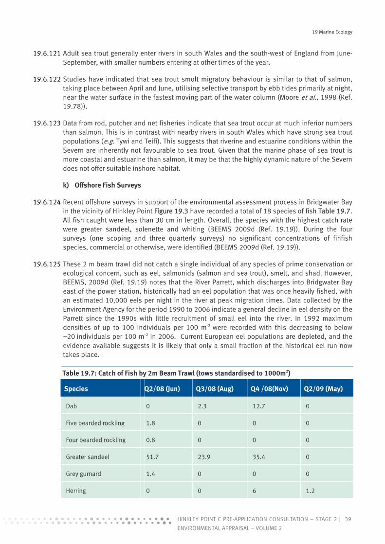
19 Marine Ecology
39HINKLEY POINT C PRE-APPLICATION CONSULTATION – STAGE 2 |
ENVIRONMENTAL APPRAISAL – VOLUME 2
19.6.121 Adult sea trout generally enter rivers in south Wales and the south-west of England from June-September, with smaller numbers entering at other times of the year.
19.6.122 Studies have indicated that sea trout smolt migratory behaviour is similar to that of salmon, taking place between April and June, utilising selective transport by ebb tides primarily at night, near the water surface in the fastest moving part of the water column (Moore et al., 1998 (Ref. 19.78)).
19.6.123 Data from rod, putcher and net fisheries indicate that sea trout occur at much inferior numbers than salmon. This is in contrast with nearby rivers in south Wales which have strong sea trout populations (e.g. Tywi and Teifi). This suggests that riverine and estuarine conditions within the Severn are inherently not favourable to sea trout. Given that the marine phase of sea trout is more coastal and estuarine than salmon, it may be that the highly dynamic nature of the Severn does not offer suitable inshore habitat.
k) Offshore Fish Surveys
19.6.124 Recent offshore surveys in support of the environmental assessment process in Bridgwater Bay in the vicinity of Hinkley Point Figure 19.3 have recorded a total of 18 species of fish Table 19.7. All fish caught were less than 30 cm in length. Overall, the species with the highest catch rate were greater sandeel, solenette and whiting (BEEMS 2009d (Ref. 19.19)). During the four surveys (one scoping and three quarterly surveys) no significant concentrations of finfish species, commercial or otherwise, were identified (BEEMS 2009d (Ref. 19.19)).
19.6.125 These 2 m beam trawl did not catch a single individual of any species of prime conservation or ecological concern, such as eel, salmonids (salmon and sea trout), smelt, and shad. However, BEEMS, 2009d (Ref. 19.19) notes that the River Parrett, which discharges into Bridgwater Bay east of the power station, historically had an eel population that was once heavily fished, with an estimated 10,000 eels per night in the river at peak migration times. Data collected by the Environment Agency for the period 1990 to 2006 indicate a general decline in eel density on the Parrett since the 1990s with little recruitment of small eel into the river. In 1992 maximum densities of up to 100 individuals per 100 m-2 were recorded with this decreasing to below ~20 individuals per 100 m-2 in 2006. Current European eel populations are depleted, and the evidence available suggests it is likely that only a small fraction of the historical eel run now takes place.
Table 19.7: Catch of Fish by 2m Beam Trawl (tows standardised to 1000m2)
Species Q2/08 (Jun) Q3/08 (Aug) Q4 /08(Nov) Q2/09 (May)
Dab 0 2.3 12.7 0
Five bearded rockling 1.8 0 0 0
Four bearded rockling 0.8 0 0 0
Greater sandeel 51.7 23.9 35.4 0
Grey gurnard 1.4 0 0 0
Herring 0 0 6 1.2
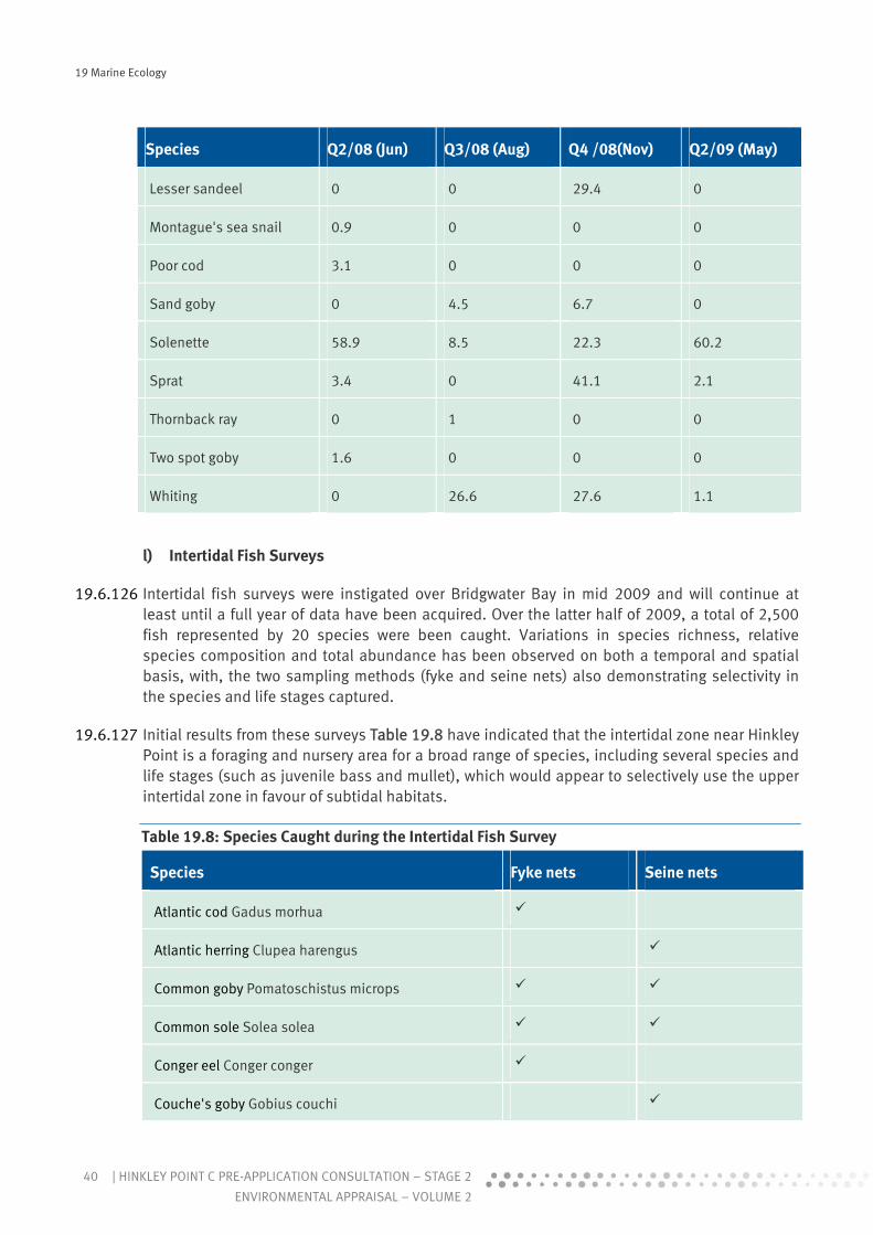
19 Marine Ecology
40 | HINKLEY POINT C PRE-APPLICATION CONSULTATION – STAGE 2
ENVIRONMENTAL APPRAISAL – VOLUME 2
Species Q2/08 (Jun) Q3/08 (Aug) Q4 /08(Nov) Q2/09 (May)
Lesser sandeel 0 0 29.4 0
Montague's sea snail 0.9 0 0 0
Poor cod 3.1 0 0 0
Sand goby 0 4.5 6.7 0
Solenette 58.9 8.5 22.3 60.2
Sprat 3.4 0 41.1 2.1
Thornback ray 0 1 0 0
Two spot goby 1.6 0 0 0
Whiting 0 26.6 27.6 1.1
l) Intertidal Fish Surveys
19.6.126 Intertidal fish surveys were instigated over Bridgwater Bay in mid 2009 and will continue at least until a full year of data have been acquired. Over the latter half of 2009, a total of 2,500 fish represented by 20 species were been caught. Variations in species richness, relative species composition and total abundance has been observed on both a temporal and spatial basis, with, the two sampling methods (fyke and seine nets) also demonstrating selectivity in the species and life stages captured.
19.6.127 Initial results from these surveys Table 19.8 have indicated that the intertidal zone near Hinkley Point is a foraging and nursery area for a broad range of species, including several species and life stages (such as juvenile bass and mullet), which would appear to selectively use the upper intertidal zone in favour of subtidal habitats.
Table 19.8: Species Caught during the Intertidal Fish Survey
Species Fyke nets Seine nets
Atlantic cod Gadus morhua
Atlantic herring Clupea harengus
Common goby Pomatoschistus microps
Common sole Solea solea
Conger eel Conger conger
Couche's goby Gobius couchi

19 Marine Ecology
41HINKLEY POINT C PRE-APPLICATION CONSULTATION – STAGE 2 |
ENVIRONMENTAL APPRAISAL – VOLUME 2
Species Fyke nets Seine nets
European eel Anguilla Anguilla
Flounder Platichthys flesus
Sand goby Pomatoschistus minutus
Sea bass Dicentrarchus labrax
Smooth hound Mustelus mustelus
Sprat Spratus sprattus
Pollack Pollachius virens
Poor cod Trisopterus minutus
Thinlip mullet Liza ramada
Transparent goby Aphia minuta
Whiting Merlangius merlangus
5-Bearded rockling Ciliata mustela
3-Spined stickleback Gasterosteus aculeatus
15-Spined stickleback Spinachia spinachia
m) Fish Impingement at the Hinkley Point B Power Station in 2008 and 2009
19.6.128 Forty two species of fish were recorded from the monthly impingement samples between January 2008 and June 2009. As is normal for the Bristol Channel, whiting and sprat were the most abundant fish species. A notable feature was the large number of snake pipefish impinged on the screens (this was the first time large numbers of this species have been recorded over a sampling period extending over the last 30 years). It is likely that many snake pipefish were able to penetrate the 1 cm mesh and therefore passed through the cooling water circuit. This suggests that this pelagic pipefish has recently become extremely abundant in the estuary.
19.6.129 A comparison of the relative abundances of fish impinged upon the power station screens and those sampled offshore showed that sprat and whiting dominate the fish fauna at all sampled localities. Furthermore, of the 18 recorded species impinged on the screens in 2008, 13 were also caught in one or more of the offshore samples. A comparison of the fish species and relative abundances recorded offshore and from the power station screens, showed that herring, sprat and whiting dominated the fish fauna at all localities.
19.6.130 Sixteen species of fish were recorded from the monthly impingement samples in May and June 2009. As is normal for this locality at this time of year, the catch was dominated by whiting, with Dover sole and flounder also common (737, 217 and 90 individuals caught respectively). Late

19 Marine Ecology
42 | HINKLEY POINT C PRE-APPLICATION CONSULTATION – STAGE 2
ENVIRONMENTAL APPRAISAL – VOLUME 2
Spring and early Summer is the time of year when fish abundance and species richness is at the minimum for the year. A notable feature of the June 2009 sample was the unusually large number of 0+ cod impinged. This was the largest number yet recorded in a 6 hour sample since sampling began in 1981 and reflects a previously recognised trend of increasing cod abundance in the region.
19.6.131 Of the 32 species impinged during the survey period (November 2008 to October 2009), 21 were sampled offshore. In addition, four species were sampled offshore which were not recorded at the intake during this period (anchovy, pearlside, sand eel, and solenette).
n) Commercial Fishing
19.6.132 This section provides baseline information on commercial fisheries within the Severn Estuary and Inner Bristol Channel area (i.e. the area around Hinkley). The source of this information is BEEMS, 2010b (Ref. 19.88). It considers the fisheries resources present in the area and those that depend on it in the commercial fishing sector. The catching sector supports a range of associated upstream activities such as vessel and gear suppliers, and downstream activities such as marketing, processing and distribution. Because of the estuarine nature of the area and importance of commercial fisheries for migratory species such as eels and salmonids, these are also discussed in this section.
19.6.133 An expert review of commercial fishing activity in the vicinity of the proposed Hinkley Point C Power Station has been undertaken and a number of data sources examined, including:
Radiological habits survey (Clyne et al. 2007 (Ref. 19.84)). Coastal Fisheries of England and Wales (Walmsley & Pawson 2007 (Ref. 19.85)). Landing statistics from the Marine and Fisheries Agency. Communications with Industry Liaison Officers, North Devon Fisherman’s Association and
South Wales Sea Fisheries Committee. Data from the Environment Agency.
i Overview of Fishing Activity in the Bristol Channel and Severn Estuary
19.6.134 Commercial fishing effort in the Outer Bristol Channel is extensive with vessels from the North Devon, Cornish and south Wales coastlines targeting a variety of species throughout the year. Fisheries include potting for lobsters, crabs and whelks, with netting and trawling targeting the ray and mixed fisheries. Targeted fisheries for squid and bass also occur during the Summer months with some North Devon boats fishing off the sand banks in the Bristol Channel.
19.6.135 There are also commercial fisheries for migratory species including salmon, sea trout and eels in the Severn Estuary and surrounding rivers. However, the value of rod fisheries dwarfs those of netting, and is mainly concentrated in the River Wye, targeting salmon. An Agency study (Spurgeon et al., 2001) estimated the market value of fishing rights for salmon rod fisheries in England and Wales to be £128 million. This was based on an average rod catch of 15,200 fish and an average value of £8,400 per salmon caught. In contrast, the same study concluded that in 2001 the net economic capital value of salmon net fisheries in England and Wales was around £3 million.
ii Marine Fisheries
19.6.136 The level of commercial fishing activity in the Severn Estuary and Inner Bristol Channel (BEEMS 2010b (Ref. 19.88)) is generally much lower than on grounds to the west, principally as a result

19 Marine Ecology
43HINKLEY POINT C PRE-APPLICATION CONSULTATION – STAGE 2 |
ENVIRONMENTAL APPRAISAL – VOLUME 2
of the strong tides, together with the low density of fish above the Minimum Landing Size (MLS). The Estuary acts as important nursery grounds for many commercially valuable species including sole and bass and as a result, the majority of the fish found within the Estuary are juveniles.
19.6.137 During the surveys undertaken by Clyne et al., 2007 (Ref. 19.84), it was noted that the level of commercial fishing was relatively low, with five full-time commercial fishers active in the area, three at Stert Flats at Stolford using stake- and setnets, two at Blue Anchor also using stakenets and a further two fishers that had commercial licences but were not using them, but based out of Watchet. Commercial fishing for crustaceans was only identified at Stolford. There, two fishers were setnetting over mud mainly for brown shrimps, Crangon crangon. To the east of Hinkley Point two fishermen maintain ranks of fixed stowe or stake-nets on the Steart Flats, catching shrimps, mullet, rays and sole from July to October (Warmsley & Pawson, 2007 (Ref. 19.85)), and molluscs are gathered by hand.
19.6.138 Many of the commercial fishing vessels operating out of the north Somerset and south Wales coastal areas are under 10m in length and operate on a part-time basis supplementing income with charter angling trips, especially for cod which have remained relatively abundant in the area. The under 10m fishing fleet is not required to submit logbooks to Defra detailing catch levels, and as a result direct landings figures for this sector are not available. There are three <10m vessels working part time from the Usk at Newport, using small beam trawls for flatfish and brown shrimps which are also taken in Cardiff Bay (Ref. 19.85). There are two part-time boats operating out of Minehead, setting pots and taking out angling parties with several part-time boats also setting pots and nets close inshore between Highbridge and Burnham-on-Sea. Two angling charter boats operate from Watchet harbour, taking regular inshore angling trips along the coast between Blue Anchor and Stert Flats. It would appear from the available data that trawling and driftnetting are no longer being practiced by anyone in the waters off Hinkley Point.
19.6.139 Marine and Fisheries Agency landings statistics cover the relevant ICES statistical rectangles (31E6), a summary of which is presented in Table 19.9 below, taken from BEEMS 2009g (Ref. 19.87).
19.6.140 Table 19.9 shows the average weight (kg) per year for certain species and their value in pounds. The species with the greatest value per kilogram is sole, followed by sea bass and then cod. When actual catches are looked at, sea bass is most valuable, followed by crab and then plaice. Overall, sea bass is considered the more commercially important species followed by sole and crab. The catches and price of the other species make them profitable, but not the main area of focus. These data are well reflected in the types of gear used in the area, driftnets and fixed nets to catch sea bass and cod, pots to catch crabs and trawling for sole and plaice.
19.6.141 The data represent the landings for the whole of statistical rectangle 31E6, and they cover a large area, including some commercially active ports such as Swansea and Port Talbot. Therefore, the actual level of commercial fishing around Hinkley Point cannot be calculated accurately.

19 Marine Ecology
44 | HINKLEY POINT C PRE-APPLICATION CONSULTATION – STAGE 2
ENVIRONMENTAL APPRAISAL – VOLUME 2
Table 19.9: Average Annual (between 2004 and 2008) Weights (kg) and Values (£) of Fish Landings by ICES Statistical Rectangle. Values are either the actual value at the time of sale or, where this was not available, an estimate is based on average prices maintained locally by MFA.
31E6 Sea bass Cod Conger Crab Herring Plaice Sole Sprat Whiting
Weight (kg) 6, 335 1, 342 168 4, 847 1,450 1,427 153
Value (£) 34, 585 2 992 136 6 , 401 2,692 12,298 111
Value (£/kg) 5.74 1.93 0.75 1.51 0.59 1.38 7.75 0.41 0.60
19.6.142 Consultation with the MFA and local fisheries officers corroborates the view that commercial activity in the Hinkley area is very limited. There have been no industry observer trips out of Watchet or Minehead, because there is no large-scale fishing activity there, and the only port nearby with commercial-scale landings is Ilfracombe.
19.6.143 The representative of the North Devon Fishermen’s Association (NDFA) stated that none of its members operated as far up the Channel as Hinkley Point and they have no large-scale commercial activity east of Lynmouth. There are no trawlers or potters from the NDFA that work that ground. It was also stated that, because of the extremely strong tidal currents around Hinkley Point and further up the Bristol Channel, there would be little if any commercial trawling or driftnetting.
19.6.144 The representative from the South Wales Sea Fisheries Committee (SWSFC) said that boats do use a lot of the Channel but would not operate as far up as Hinkley Point on any large scale.
iii Migratory Fisheries
19.6.145 Fisheries for migratory species are of significant economic value, particularly in rural areas. However, overall salmon and sea trout netting is declining, in response to the phasing out of mixed stock fisheries and falling demand for wild salmon. Eel and elver net fishing in recent years has fluctuated in response to market forces.
19.6.146 Migratory species that are targeted commercially in the Severn Estuary and surrounding rivers include salmon, sea trout and eels. Both allis and twaite shad are also present in the Severn Estuary and were formerly fished commercially before numbers declined and the fishery collapsed. In the middle of the 19th century the value of shad rivalled that of salmon, and in the River Severn, shad made up about one-third of all catches.
19.6.147 Many of the net fishing methods used to target migratory species on the Severn Estuary are unique to the area and have a long history, notably lave netting (using a 'Y' shaped net and 'stalking' or 'cowering' in the shallows to catch the salmon migrating), and putcher nets (rows of baskets which use the ebb tide to trap salmon).
Salmon and Sea Trout
19.6.148 The Estuary fisheries exploit mixed stocks of salmon originating from at least 7 rivers entering the Estuary, most notably the Severn, Wye and Usk. Net licences issued for catching salmon also allow the fishermen to take sea trout. Hence, it is impossible to distinguish the allocation
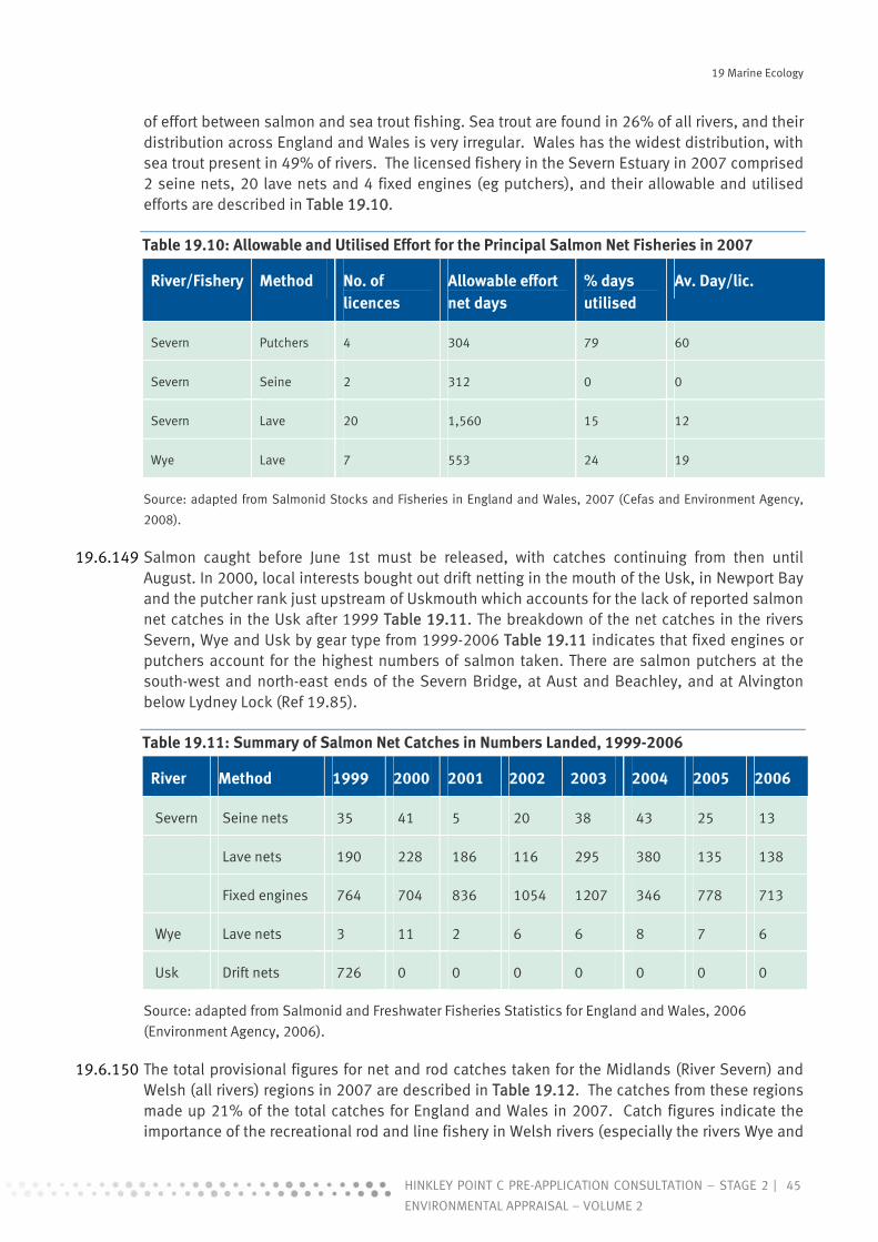
19 Marine Ecology
45HINKLEY POINT C PRE-APPLICATION CONSULTATION – STAGE 2 |
ENVIRONMENTAL APPRAISAL – VOLUME 2
of effort between salmon and sea trout fishing. Sea trout are found in 26% of all rivers, and their distribution across England and Wales is very irregular. Wales has the widest distribution, with sea trout present in 49% of rivers. The licensed fishery in the Severn Estuary in 2007 comprised 2 seine nets, 20 lave nets and 4 fixed engines (eg putchers), and their allowable and utilised efforts are described in Table 19.10.
Table 19.10: Allowable and Utilised Effort for the Principal Salmon Net Fisheries in 2007
River/Fishery Method No. of licences
Allowable effort net days
% days utilised
Av. Day/lic.
Severn Putchers 4 304 79 60
Severn Seine 2 312 0 0
Severn Lave 20 1,560 15 12
Wye Lave 7 553 24 19
Source: adapted from Salmonid Stocks and Fisheries in England and Wales, 2007 (Cefas and Environment Agency,
2008).
19.6.149 Salmon caught before June 1st must be released, with catches continuing from then until August. In 2000, local interests bought out drift netting in the mouth of the Usk, in Newport Bay and the putcher rank just upstream of Uskmouth which accounts for the lack of reported salmon net catches in the Usk after 1999 Table 19.11. The breakdown of the net catches in the rivers Severn, Wye and Usk by gear type from 1999-2006 Table 19.11 indicates that fixed engines or putchers account for the highest numbers of salmon taken. There are salmon putchers at the south-west and north-east ends of the Severn Bridge, at Aust and Beachley, and at Alvington below Lydney Lock (Ref 19.85).
Table 19.11: Summary of Salmon Net Catches in Numbers Landed, 1999-2006
River Method 1999 2000 2001 2002 2003 2004 2005 2006
Severn Seine nets 35 41 5 20 38 43 25 13
Lave nets 190 228 186 116 295 380 135 138
Fixed engines 764 704 836 1054 1207 346 778 713
Wye Lave nets 3 11 2 6 6 8 7 6
Usk Drift nets 726 0 0 0 0 0 0 0
Source: adapted from Salmonid and Freshwater Fisheries Statistics for England and Wales, 2006 (Environment Agency, 2006).
19.6.150 The total provisional figures for net and rod catches taken for the Midlands (River Severn) and Welsh (all rivers) regions in 2007 are described in Table 19.12. The catches from these regions made up 21% of the total catches for England and Wales in 2007. Catch figures indicate the importance of the recreational rod and line fishery in Welsh rivers (especially the rivers Wye and

19 Marine Ecology
46 | HINKLEY POINT C PRE-APPLICATION CONSULTATION – STAGE 2
ENVIRONMENTAL APPRAISAL – VOLUME 2
Usk) with reported catches 7 times higher than those of the net fishery. These figures do not take account of catches of salmon which go unreported (including those taken illegally), and it is estimated that there may have been a total of 22 t of additional fish caught in 2007 (Cefas and Environment Agency, 2008).
Table 19.12: Provisional Net and Rod Salmon Catches (including released fish) by Region for the 2007 Season
Region Net catch Rod catch Total catch
No. Weight (kg)
No. Weight (kg)
No. Weight (kg)
Midlands 676 3,184 261 1,112 937 4,296
Welsh 613 2,022 4,488 16,239 5,101 18,261
Total 1,289 5,206 4,749 17,351 6,038 22,557
Source: adapted from Salmon Stocks and Fisheries in England and Wales, 2007 (Cefas and Environment Agency,
2008).
Eels
19.6.151 Eels are found in all European countries bordering or connected to the North Atlantic. They are caught as elvers (juveniles returning from the sea) or adults in a variety of fisheries each with different levels of exploitation. Over the past two decades, catch data from across Europe show glass eel populations declining rapidly from the high levels of the 1970s, while 2001 produced a record minimum of just one percent of previous peak levels, and most recent data show a continued decrease and no significant recovery from the 2001 all-time low.
19.6.152 Only hand-held dip nets are permitted for the capture of glass eels or elvers, and fishing is concentrated where the fish are plentiful and easy to catch, principally in estuaries of the Severn and other rivers draining into the Bristol Channel such as the Parrett. Catch returns from these fisheries have been compulsory over the past few years and provide a good indication of the trend in eel recruitment. The fishing season is short, coinciding with the elvers entering rivers on spring tides in April and May (Environment Agency, 2004).
19.6.153 The number of licenses issued to fish for glass eel/elver in the Severn Estuary and Bristol Channel ranged from 487 to 577 between 2002 and 2004. Elvers are known to be targeted during their landward migration between November and March using dipnets within the area just seaward of Bridgwater Bay. The national 2007 catch was 2,051 Kg of which the Severn Estuary and Bristol Channel is estimated to represent 95% equating to a catch of 1,948 Kg. Based on an average individual weight per elver of approximately 0.5 g this would equate to 3,896,000 individuals. Only a small proportion of elvers caught are for domestic consumption, the majority are sold for re-seeding eel farms in Asia.
19.6.154 Eels are caught commercially in a number of locations and by a variety of instruments including fyke nets, putcheons and weir traps. The level of eel fishing effort is measured as the number of licensed instruments of all types. Licence sales in England and Wales have fluctuated between 1500 and 2700, (per year) most likely in response to market price fluctuations. Many rivers

19 Marine Ecology
47HINKLEY POINT C PRE-APPLICATION CONSULTATION – STAGE 2 |
ENVIRONMENTAL APPRAISAL – VOLUME 2
throughout the Severn Estuary catchment support eel fyke net fisheries between Spring and Autumn. Fyke nets fished on the Wye take yellow eels in Spring and Summer and silver eels in Autumn.
19.6.155 Between 2002 and 2004 the number of licenses issued for this fishery reduced from 80 to 47 although catches in fact rose over this period from 156 Kg in 2002 to 980 Kg in 2003 followed by a slight decline in 2004 to 569 Kg. The 2007 annual adult eel catch for Wales, South West England and the Midlands was 2,396 Kg (data provided by the Exvironment Agency). The 2004 catch indicates that the Severn Estuary represents approximately 12% of this regional catch. As such, the 2007 adult eel catch for the Severn Estuary is estimated at approximately 288 Kg. Based on empirical data there is presumed to be a 20:1 ratio of male to female eel in the Severn Estuary. Male and female eel reach maturity and migrate at different ages and as such will vary in weight. Taking an average weight however for male silver eel of 90 g and 580 g for females (based on the most common ages at maturity) the adult eel catch for the Severn Estuary and Bristol Channel would equate to 3,040 males and 24.8 females.
Recreational fishing
19.6.156 Recreational angling accounts for the highest amount of fishing effort within the Severn Estuary and Inner Bristol Channel. Anglers fish from the shores along much of the Estuary targeting cod in the winter and bass in the summer, with other species such as whiting, flounder, eels, rays, sole and conger also caught. Angling is also carried out from charter vessels, and both forms represent an important recreational use of the Estuary, even though the quantities and values of fish taken are small compared to commercial fisheries.
o) Marine Mammals
19.6.157 A desk-based review of available data was conducted for marine mammals within the Severn Estuary and Bristol Channel. No project specific surveys for marine mammals were undertaken for the purposes of this appraisal.
19.6.158 Data are available from a number of surveys carried out in the Bristol Channel by the Marine Conservation Society (MCS), the Whale and Dolphin Society (WDCS) and Greenpeace, as well as public sightings recorded by the Sea Watch Foundation (SWF). Data are also available from the ‘Atlas of Cetacean Distribution in North-West European Waters’ (Reid et al. 2003 (Ref. 19.89)).
19.6.159 The coastal waters of Wales and southwest England are important for whales and dolphins and are relatively rich in terms of the cetacean species present (Ref. 19.89 & Boer & Simmonds 2003 (Ref. 19.90)). The diversity and abundance of marine mammals, however, decreases within increased proximity to the Severn Estuary (SWF 2009a (Ref. 19.91)). Sparse data are available for marine mammals in the Severn Estuary and no information is available regarding baseline marine mammal assemblages off Hinkley Point. Based on available data, however, it is likely that marine mammals are largely absent from this area.
19.6.160 It is considered that there are no resident populations of marine mammals within the estuary (Watkins & Colley 2004 (Ref. 19.92)). However, a number of species are thought to use the estuary as a feeding area during different times of the year, namely the harbour porpoise Phocoena phocoena, Risso’s dolphin Grampus griseus, common dolphin Delphinus delphis, bottlenose dolphin Tursiops truncates and grey seal Halichoerus grypus (Reid et al. 2003 (Ref. 19.89)). Harbour porpoise, bottlenose dolphin and grey seal are Annex II species under the Habitats Directive, but are not mentioned in the SAC site designation for the Severn Estuary.

19 Marine Ecology
48 | HINKLEY POINT C PRE-APPLICATION CONSULTATION – STAGE 2
ENVIRONMENTAL APPRAISAL – VOLUME 2
19.6.161 The marine mammal species most commonly recorded in the Bristol Channel is the harbour porpoise. The harbour porpoise (otherwise known as the common porpoise) is the smallest and the most numerous of the cetaceans found in North-Western European waters (Walton 1997 (Ref.19.93)). The coastal waters of south Wales are thought to provide important foraging grounds for this species. Harbour porpoises are recorded in the Bristol Channel year round with numbers tending to peak in the summer months (Reid et al. 2003 (Ref. 19.89)). In addition to harbour porpoise, small numbers of common, bottlenose and Risso’s dolphin have been recorded within the Bristol Channel. Rare visitors to offshore waters of the Bristol Channel have also included the minke whale Balaenoptera acutorostrata and killer whale Orcinus orca (Ref. 19.89).
19.6.162 In 2002, the WDCS, in association with Greenpeace, carried out a cetacean survey off the coast of Wales and Southwest England (Boer & Simmonds 2003, Ref. 19.90). The survey recorded 147 separate sightings of an estimated 380 dolphin and porpoises over 28 survey days. Four cetacean species were identified: harbour porpoise, common dolphin, bottlenose dolphin and Risso’s dolphin. When considering the number of individuals recorded for each sighting it was found that the greatest abundances of these species were recorded within the Bristol Channel.
19.6.163 More recent surveys of the outer Bristol Channel were conducted by the MCS in 2007 (Solandt 2007, Ref. 19.94). Over 90 hours of surveys were carried out within the Outer Bristol Channel throughout Spring and Summer. These surveys did not extend into the estuary as far as Hinkley Point with the furthest upstream survey transect running from Padstow to Swansea. Harbour porpoise was the most commonly observed species during these surveys which mainly occurred close to, or within, coastal waters with sightings focussed around the coast of Pembrokeshire. Common dolphins were generally found further offshore and were found to occur in larger pods than the harbour porpoise. Three sightings of grey seal were also recorded during the survey period in the Bristol Channel Table 19.13.
19.6.164 Sightings reported by the public to the Sea Watch Foundation indicate that the harbour porpoise is frequently reported in the Bristol Channel off Ilfracombe, approximately 45 miles west along the coast from Hinkley Point. Between September 2008 and 4th January 2009 a total of 57 sightings of harbour porpoise and 12 common dolphin have been recorded on the database (SWF 2009b).
Table 19.13: Number of Marine Mammals Sighted during the MCS Megafauna Survey) * species recorded ‘off transect,’ but in the Bristol Channel region
Species/taxa Number of sightings Number of individuals
Harbour porpoise 28 42
Common dolphin 9 66
Other dolphin species 3 10
Seals 3 3
Humpback whale* 1 1
Total 42 120
19 Marine Ecology
49HINKLEY POINT C PRE-APPLICATION CONSULTATION – STAGE 2 |
ENVIRONMENTAL APPRAISAL – VOLUME 2
19.6.165 Given that there are no resident sea mammal populations in the Severn Estuary in the vicinity of Hinkley Point and very low reported numbers of animals using the offshore area it is considered highly unlikely that the project would have any adverse impact upon sea mammals. As a consequence detailed assessment of potential effects on sea mammals has not been undertaken other than for those activities where it is known that potential impacts on sea mammals are of concern and have been highlighted through previous studies. Specifically, the only activity that merits further evaluation is the potential effect of underwater noise generated during the construction works for the power station.
19.7 Assessment of Impacts
a) Introduction
19.7.1 The elements of the proposed Hinkley Point C power station development which could lead to potential effects on the marine environment are likely to be the construction and operation of the following:
the cooling water system; the temporary jetty; the seawall; and land-based discharges.
19.7.2 For each of these a number of potential impacts have been identified. Generally, these impacts can be grouped into several broader categories (e.g. habitat loss and disturbance).
b) Cooling Water System
i Construction of the Vertical Shafts Offshore
19.7.3 The construction of the cooling water system, involving the construction of vertical shafts approximately 1.8 km offshore for the placement of outfall structures and 3.3 km offshore for intake structures, has the potential to generate the following changes which could have an impact on marine habitats and species:
temporary and permanent loss of seabed habitat; pysical disturbance to the seabed around each drilling site; water quality alterations due to discharges from dewatering activities and from platforms
and support vessels, waste materials, chemicals associated with drilling operations; water quality alterations due to sediment disturbance and potential contaminant
mobilisation; noise and vibration associated with both pile driving (for anchorage of platforms) and
vessel movements; and artificial lighting if offshore construction works continue during the hours of darkness.
ii Construction of the Horizontal Tunnels
19.7.4 The main cooling water tunnels connecting the power station itself to the cooling water intakes, via the shafts described above, will be drilled beneath the intertidal shore and seabed from land. All waste arisings will thus be managed, at least initially, onshore. These activities have
19 Marine Ecology
50 | HINKLEY POINT C PRE-APPLICATION CONSULTATION – STAGE 2
ENVIRONMENTAL APPRAISAL – VOLUME 2
the potential to generate the following changes which could have an impact on marine habitats and species:
water quality changes due to discharge of waste water from tunnel drilling. If mud-assisted drilling is used this could contain suspended solids (including bentonite), organic polymer, and waste salts following the use and subsequent treament of hydrochloric acid; and
vibration and noise.
c) Temporary Jetty
19.7.5 A temporary jetty would be constructed and operated during the overall construction phase for the Hinkley Point C project. As a temporary structure, the potential effects of jetty construction, operation and dismantling are considered as a part of the construction stage of the project. These activities have the potential to generate the following changes which could have an impact on marine habitats and species:
intertidal and subtidal habitat loss and disturbance due to piling, construction and maintenance activities;
physical disturbance to habitats due to alterations in longshore current patterns caused by both the jetty structures themselves and dredging (including maintenance dredging) of the berthing pocket;
alterations in water quality due to run-off from the jetty and its constituent materials during construction and dismantling;
noise and vibration due to piling and vessel movements; and artificial lighting during construction and operation.
d) Construction of the Sea Wall
19.7.6 A new sea wall will be constructed for coastal protection purposes on the line of the existing cliffs fronting the Development Site, at the top of the intertidal shore. These activities have the potential to generate the following changes which could have an impact on marine habitats and species:
loss of upper shore habitat and modification to slope of intertidal zone; physical disturbance to the upper shore during construction (machinery access and
trampling by people); water quality alterations on the shore via run-off from works and other potential
contaminant release; noise and vibration caused by operation of machinery and rock removal; and artificial lighting during 24 hour construction of the sea wall.
e) Land Based Discharges
19.7.7 These activities have the potential to generate the following changes which could have an impact on marine habitats and species:
water quality changes due to discharges from the Development Site during construction and operation.
f) Accidents and Incidents
19.7.8 There is the risk of impacts due to accidents occurring during construction (e.g. water quality changes due to chemical spillages and surface water discharges containing spilled/leaked contaminants). It is not possible to assess the potential impact of such incidents/accidents as

19 Marine Ecology
51HINKLEY POINT C PRE-APPLICATION CONSULTATION – STAGE 2 |
ENVIRONMENTAL APPRAISAL – VOLUME 2
they could vary significantly in scale, location and type with variable outcomes on potential receptors. However, potential pollutants and discharges to the marine environment during construction could pose a risk to some environmental receptors.
19.7.9 The implementation of best practice management measures during construction would be the mechanism by which the potential risk of accidents occuring is managed and any consequential impacts are either eliminated or minimised.
19.8 Assessment of Potential Impacts during the Construction Phase
a) Habitat Loss and Change
19.8.1 A number of components of the construction works and activities will lead to small scale habitat loss and/or change in existing habitat conditions. This section covers those activities that will lead to permanent loss of marine habitat (intertidal and subtidal) and/or permanent change. Temporary disturbance to habitat during construction is covered under the section on physical disturbance.
i Subtidal Habitat Loss as a Result of the Construction of the Vertical Shafts for the Cooling Water System
19.8.2 Habitat loss would occur due to excavation of the seabed for the construction of vertical shafts connecting to the horizontal (intake and outfall) tunnels. Habitat loss/modification would be permanent for the area of the estuary bed required for the vertical shaft openings. It would be temporary at the anchoring locations (wet drill operation) and for the area around the vertical shaft opening.
19.8.3 The benthos of this area is typical of the extensive muddy plain that makes up most of the local seabed. Population densities are low due to the extreme tidal conditions. Typical taxa include annelid worms, crustaceans, molluscs and bryozoans. The most prevalent species around the proposed vertical shaft sites are the oligochaete Tubificoides amplivasatus and the polychaete Nephtys. All species identified are commonly found at a national level. The biotope concerned is 'Nephtys hombergii and Macoma balthica in infralittoral sandy mud’ which covers approximately 76 km2 out of the total of 94 km2 surveyed (BEEMS 2009a (Ref. 19.14)). The habitat type which is likely to be lost is thus locally common and widespread as well as being common throughout estuaries in the UK.
19.8.4 The vertical intake shafts in total would represent a loss of subtidal habitat of approximately 58 m2. The area of the opening of the outfall vertical shafts would be approximately 39 m2. This represents significantly less than 0.1% of the area of the 'Nephtys hombergii and Macoma balthica in infralittoral sandy mud’ within Bridgwater Bay. In addition, during wet drilling, there would be temporary loss of habitat around the anchor sites, which would again probably be in the region of 0.1% of the area of the dominant biotope in Bridgwater Bay. The percentage of this habitat lost due to construction of the vertical shafts in relation to its local extent is thus negligible.
19.8.5 The predominant epifauna within the area is the brown shrimp Crangon crangon. As both this species and other epifauana are mobile they would be able to move away from the area to seek suitable nearby habitat and would be less affected by the habitat loss.

19 Marine Ecology
52 | HINKLEY POINT C PRE-APPLICATION CONSULTATION – STAGE 2
ENVIRONMENTAL APPRAISAL – VOLUME 2
19.8.6 In the areas of disturbance around the shafts (through either construction approach), a typical faunal assemblage would very quickly become re-established due to tidal mobilisation of surface sediments. Even in less dynamic systems the evidence from studies of recovery rates in subtidal benthic communities of the type present within the footprint of the works clearly demonstrates that soft-sediment, bivalve-annelid dominated communities are able to recover from disturbance events within 1-2 years (Newell et al. 1998 (Ref. 19.96).
19.8.7 Overall, given that recovery of affected areas within areas disturbed during construction would be expected, the impact of this activity would be solely related to the small-scale habitat loss. At an approximate area of 39m2, it is considered that this total area of habitat loss would be predicted to have a negligible impact upon the extent and functioning of the affected subtidal communities.
19.8.8 The small loss of subtidal habitat that would occur during construction of the shafts would not be expected to have any impact on prey availability for fish.
19.8.9 Although there is the possibility that subtidal Sabellaria may be present at the vertical shaft sites this, given the local habitat type involved, would not include any reef formations. Given that absence, the overall significance of this effect with regard to Sabellaria is assessed to be negligible.
ii Intertidal Habitat Loss as a Result of Construction of the Temporary Jetty
19.8.10 The location of the jetty in relation to the foreshore is indicated in Figure 19.9. The installation of piles to support the jetty would result in direct habitat loss in the intertidal area. Some 52 piles would be installed across the intertidal area and the footprint of these piles would cover an area of approximately 34 m2. These would be installed using land-based plant gaining access across the shore.
19.8.11 The Hinkley foreshore supports intertidal communities that, in terms of species composition, may be considered typical of such coastlines around much of the UK. The fucoids Fucus spiralis and F. vesicolosus in particular are typical of sheltered to moderately exposed shores and occupy much of the foreshore at Hinkley Point. These species are widespread in their distribution, are not considered as threatened, and are not species of conservation concern.
19.8.12 There are no areas of intertidal or subtidal Sabellaria reef in close proximity to the proposed jetty location. That this is true of the rocky area of seabed across which the proposed jetty would run was confirmed both by an acoustic seabed survey and subsequent ground-truthing carried out specifically to check this understanding locally (BEEMS 2009h (Ref19.97)). The nearest area of Sabellaria reef is a small section within the intertidal >500 m to the east (in front of HPA). As no Sabellaria reef habitat is located close to the jetty it is not anticipated that there would be any impact on this interest feature as a result of the placement of the jetty across the foreshore and into the shallow subtidal.
19.8.13 While it is clear that some small-scale habitat loss would occur, the footprint of the jetty piles is negligible in relation to the area of the intertidal zone Figure 19.10. In addition the majority of the habitats represented on the foreshore are common and the species involved are widely dispersed across the Hinkley Point foreshore and throughout the UK. Taking these factors into account, the impact of this small scale loss is considered negligible with regard to the majority

19 Marine Ecology
53HINKLEY POINT C PRE-APPLICATION CONSULTATION – STAGE 2 |
ENVIRONMENTAL APPRAISAL – VOLUME 2
of the intertidal communities present on the foreshore. The presence of Corallina turf in the area, however, merits further consideration.
19.8.14 The locations of channels with Corallina and associated run-offs were mapped during recent surveys. The location of the Corallina turf distribution in relation to the proposed jetty is shown in Figure 19.11, where it can be seen that the jetty would be located in the vicinity of the western extent of the channels supporting Corallina but deliberately between, rather than over, mapped areas of spillway heavily colonised by this species.
19.8.15 Given the significance of the Corallina biotope, it is rated as of medium value. Any impact on this habitat would be direct and most likely temporary (if recolonisation of affected areas were to occur following removal of the jetty). Given the siting of the temporary jetty the scale of potential direct loss of habitat is very small and due to the potentially temporary nature of the effect the magnitude is predicted to be very low. Consequently, the significance of this potential impact is assessed to be of minor adverse significance.
iii Intertidal Habitat Change as a Result of Construction of the Seawall
19.8.16 The upper area of the shore where the seawall would be constructed is effectively unoccupied by marine species and dominated by cobble/shingle material associated with both washout from the cliff and storm-driven longshore transport. Within the construction area itself, no direct impact upon marine fauna or flora would thus occur. Consequently, it is assessed that there would be a negligible impact.
b) Physical Disturbance
i Disturbance to Intertidal Habitats during Construction of the Temporary Jetty
19.8.17 Several activities associated with the construction of the jetty may cause disturbance to the intertidal area within and adjacent to its footprint. Piling works (the drilling/piling and use of land-based jack-up rigs) has the greatest potential to cause disturbance, along with the machinery movements required to emplace the jetty infrastructure. These activities may lead to the generation of debris (e.g. from drilling), channel blocking, smothering and the abrasion of rock surfaces supporting intertidal communities.
19.8.18 The direct footprint of disturbance would be confined to a construction corridor immediately flanking the jetty structure itself, particularly in the vicinity of the piling works, and along the access route to the works. This zone of potential disturbance cannot be specifically defined at this stage.
19.8.19 The volumes of fine sediment generated during drilling and through disturbance by machinery of foreshore sediments are likely to be negligible in comparison to the existing high sediment loadings present in the water column routinely transported across the foreshore under normal tidal conditions.
19.8.20 Disturbance to intertidal habitat in the vicinity of the jetty would be unlikely to affect the continuing presence of many of the intertidal species present (e.g. fucoid dominated communities). Given the species involved, the recolonisation of any disturbed areas would be expected to be relatively rapid (1-2 years). No long term effects with respect to the extent, composition and function of the fucoid-dominated communities present on the foreshore at Hinkley Point and within the construction footprint (other than the area directly lost to the piled structure) would therefore be expected.

19 Marine Ecology
54 | HINKLEY POINT C PRE-APPLICATION CONSULTATION – STAGE 2
ENVIRONMENTAL APPRAISAL – VOLUME 2
19.8.21 As stated earlier, Corallina turf is considered to be of importance as it provides a habitat for many other organisms and its presence increases foreshore biodiversity. The potential area of this community that could be affected by the jetty works cannot be established with certainty. However, on the basis of the mapping work undertaken it is apparent that along the Hinkley foreshore the Corallina biotope intermittently occurs within an area of some 500 m x 50m. The jetty would be located at the far western end of the extent of the known distribution of Corallina. Even if the jetty works were to extend further than 20m from the actual alignment of the jetty itself, this suggests that in total an area of less than 4% of Corallina biotope would be present within the footprint of the works. This would represent a relatively small area and indicates that even if all of the Corallina biotope within this area were disturbed, which would be highly unlikely, this change would be of low magnitude and of minor adverse impact.
19.8.22 As noted above, the Corallina turf dominated ‘spillways’ are associated with extensive longitudinal drainage pathways across the shore so there is a potential for more widespread impact to occur as a result of interruptions to that drainage during construction of the jetty itself, or in the event of spillage of materials onto the shore during construction.
19.8.23 Potentially, the combined effect of direct disturbance and alteration of drainage patterns on the foreshore could be of greater significance to the Corallina community than the effects in isolation. It is apparent that both effects are likely to be of low magnitude and each one affects a relatively small area of the Corallina biotope involved. It is however unlikely that the combined effect would be so much greater that it would be classified as of medium magnitude in extent and overall the level of habitat disturbance during construction would still be of minor adverse impact.
19.8.24 There is no observed occurrence of intertidal or subtidal habitat supporting Sabellaria within 500 m of the jetty and therefore the likelihood of this interest feature being directly impacted by the jetty construction works is considered highly unlikely. Although there is the potential for some sediment disturbed during construction to be transported into intertidal areas supporting Sabellaria, it is considered that the overall volumes would be negligible in the context of the high volumes of sediment routinely present in the water column. As such, a negligible impact on Sabellaria is predicted with respect to this aspect of the temporary jetty construction works.
19.8.25 An expert assessment of the level of sediment scour (see Chapter 16 for further information) that would be associated with the jetty piles due to waves and tidal streams has shown that soft sediments would be scoured to a depth of no more than 1.3 m in the immediate vicinity of the piles themselves.
19.8.26 The top width of a scour hole in non-cohesive sediments has been found to be a function of the scour depth and the angle of repose of the sediment involved. As a conservative measure, the angle of repose associated with a loose fine sand would be in the order of 26-28o which translates into a width of no more than a couple of metres.
19.8.27 This impact on sediment distribution would be limited to the length of the jetty that extends across the muddy seabed. The extent of this disturbance feature around the piles themselves is predicted to be very limited and would be confined to a habitat type (i.e. soft sediment) that is subject to continual remobilisation due to tidal forces. The sediment transport processes associated with scour are normal to this hypertidal habitat and the impact associated with this element of disturbance is thus assessed as negligible.

19 Marine Ecology
55HINKLEY POINT C PRE-APPLICATION CONSULTATION – STAGE 2 |
ENVIRONMENTAL APPRAISAL – VOLUME 2
19.8.28 The effect described above would not be expected to occur in association with the piles introduced across the exposed rocky platform of the intertidal shore or the exposed rock that the line of the jetty will cross in the near subtidal area. Shear forces aound the foot of these structures will be increased and could result in a loss of fauna and flora in the immediate area around each. Again the extent of this disturbance feature around the piles themselves is predicted to be very limited and any loss of associated flora and fauna of very low magnitude. The impact associated with this element of disturbance is thus assessed as negligible.
ii Foreshore Disturbance Associated with Construction of the Sea Wall
19.8.29 Under the existing coastline configuration the alignment of the proposed seawall places it above the Spring tide mean high water mark.
19.8.30 The construction works would require that machinery for the excavation works and actual placement of the sea wall are located in this zone, either on a permanent or temporary basis depending on whether tidal conditions permit. Given that rock from the foreshore would be removed during excavation (this impact is covered under the section on habitat loss/change, see above), further disturbance would therefore be limited to any additional effect that machinery tracking along the shore would have on existing intertidal communities.
19.8.31 This supratidal area is characterised by small boulders and rocks and is practically devoid of fauna and flora apart from some uppershore lichen species. No significant ecological effects as a result of the disturbance, as long as the works are confined to the construction area, are therefore predicted.
19.8.32 The observed distribution of the Corallina biotope shows that the nearest occurrence is approximately 75m from the site of the proposed seawall. Given the distance between the seawall and the presence of Corallina it is considered unlikely that the seawall works would have the potential to impact upon this interest. As a consequence no impact on Corallina as a result of the construction works for the seawall is anticipated.
iii Disturbance to Subtidal Habitats during Construction of Vertical Shafts for the Cooling Water System
19.8.33 Drilling of the shafts would physically disturb sediment on the estuary bed. The method of anchoring during a wet drill approach would result in varying degrees of disturbance; for example, simple anchors would result in a lesser impact than those requiring piling, and the drilling of these would disturb bottom sediments.
19.8.34 The level of seabed sediment scour around the construction site is likely to be sufficient to remove the 2m of silt overlying the rock surface locally. Given the existing tidal and sediment transport regime this impact, in sediment transport terms, will be of little consequence.
19.8.35 The main impact of this disturbance would be a localised alteration in habitat type away from soft mud to exposed rock. The scale of this disturbance in relation to the widespread nature of the existing muddy plain that extends widely around this location would be inconsequential and would thus be assessed as negligible.
19.8.36 It is considered highly unlikely that the drilling works would produce levels of suspended solids or bedloads that would be greater than levels that occur under natural conditions. As a consequence no impact as a result of this effect is forseen with regard to either subtidal fauna

19 Marine Ecology
56 | HINKLEY POINT C PRE-APPLICATION CONSULTATION – STAGE 2
ENVIRONMENTAL APPRAISAL – VOLUME 2
or estuarine fish populations as these species are adapted to conditions of high suspended sediment concentrations.
c) Changes in Water Quality
i Drilling of the Vertical Shafts for the Cooling Water System
19.8.37 During drilling the excavated materials would be mixed with seawater and they would be separated at the water surface. Cuttings larger than 100 microns would be sent to a barge, sludge would be re-injected until it reached a required density and would then be stored in a sludge treatment barge. Filtering would separate solids and seawater, with the seawater being recycled and then released back into the estuary.
19.8.38 During the drilling works, some sediment from beneath the mobile sediment layer may potentially be disturbed and resuspended. The volume of sediment likely to be mobilised in this manner is considered to be negligible within the context of existing suspended sediment and bedload concentrations.
19.8.39 Data available from previous studies indicates that contaminant levels within the Severn Estuary are relatively evenly spread due to the dynamic tidal flow conditions and continuous resuspension. This aspect is further detailed in Chapter 17 on marine water and sediment quality. In this context, and given the low volumes that would be involved, it is anticipated that the impact on water quality would be negligible.
ii Discharges Associated with the Drilling of the Horizontal Tunnels
19.8.40 For the purposes of assessment it has been assumed that horizontal tunnels would be drilled using mud-assisted drilling methods with arisings recovered to land where they would be treated to separate waste solids from waste water and drilling fluids. It is assumed at this stage that waste water from the drilling activities would be discharged to the foreshore and solids would be used as fill on the main development site. Waste drilling fluids and associated chemicals would be separated from waste water and the drill cuttings before treatment and disposal at an onshore disposal site which is yet to be identified. Treatment and disposal of waste drilling fluids would be detailed in the construction Waste Management Plan.
19.8.41 The locations of the horizontal tunnels are indicated in Figure 19.10 and details of dimensions and depth of the tunnels are described in Chapter 3 of this Appraisal. An earth pressure tunnelling machine could be used instead of a mud-assisted tunnelling machine (which would require the use of bentonite). The earth pressure method would generate less waste than the mud-assisted approach. However, a decision on what method is to be used has yet to be made and consequently a precautionary approach has been taken here which assumes use of the mud-assisted drilling method.
19.8.42 The volume of extracted material in drilling these tunnels would be approximately 577,000 m3 to 650,000 m3 depending on the expansion factor used. While the tunnel machine digs, the bentonite slurry would be sent to the cutting face, become loaded with materials and would then be returned to a separation unit where it would be treated to remove drill cuttings. Dilution water would need to be added to the bentonite and the volume needed for this would be about 60 m3 per hour for the three tunnels, therefore a similar quantity would be discharged. This drilling waste could include release of drilling compounds such as bentonite and other chemicals (e.g. organic polymer and residual salt compounds from the use of hydrochloric
19 Marine Ecology
57HINKLEY POINT C PRE-APPLICATION CONSULTATION – STAGE 2 |
ENVIRONMENTAL APPRAISAL – VOLUME 2
acid). It is considered that within discharge water likely levels of suspended matter would be 1000 mg/l (including 5% bentonite) and 0.7 ppm of organic polymers.
19.8.43 The discharge of the drilling waste has the potential to impact upon intertidal ecology, largely through the increase in suspended sediment concentration, but also through potential smothering as a result of accretion of fine sediment. Data from existing sources indicates that suspended sediment concentrations in surface waters in the nearshore zone are typically in the order of 250 mg/l but can be as high as 1000 mg/l dependent on tidal conditions.
19.8.44 Baseline studies indicate that Corallina is present within distinctive channels along the lower intertidal area, and since any cross-shore discharges could enter these channels and remain there at low tide, a smothering impact is possible. It is apparent that Corallina is subject to significant suspended sediment concentrations. Consequently, the pre-mitigation significance of the impact is assessed to be minor adverse for this receptor.
19.8.45 Habitat that supports Sabellaria is present on the lower intertidal area and so the potential for discharge from the upper shore to affect this area is considered unlikely. Given that discharge waters would be unlikely to reach the area the overall magnitude of the impact is predicted to be very low and the significance of the impact is assessed to be negligible for this receptor.
19.8.46 The increase in SSC associated with the discharge from the drilling works could have the potential to decrease water quality in the vicinity. Potentially this could affect fish that may be present in the water column within the plume of increased SSC. As discussed previously, the fish assemblage of the Severn is inevitably well adapted to the existing high turbidity regime and any such alterations to this regime would thus appear to be inconsequential. While the SSC levels associated with the discharge would be above background levels it would be expected that dispersion to background would occur over a relatively short distance. Given that fish are also mobile and would be able to move rapidly out of any waters that are of poor quality, it is expected that the discharge would not have a significant effect on the fish fauna and as a consequence the magnitude of the effect is assessed as very low and the overall impact significance as negligible.
iii Temporary Jetty Construction
19.8.47 Capital and, potentially, maintenance dredging, would be required at the seaward end of the jetty to establish and maintain a berthing pocket. Dredging would mobilise sediments and resuspend particulates in the water column, leading to a temporary and localised increase in SSC and reduction in water quality. Information on existing contaminant loadings within the sediment to be dredged (see Chapter 17) indicates that there would be a negligible effect on water quality through the mobilisation of this material.
19.8.48 Although this dredging activity would occur in relatively close proximity to the low water mark and the Corallina turf areas of the lower shore, given the existing tidal regime any levels of suspended solids in excess of normal levels would be advected by the tides and carried elsewhere. No impact on the local intertidal interest would be anticipated.
19.8.49 The site of the berthing pocket is located >500 m away from any areas of intertidal Sabellaria reef. Therefore the likelihood of Sabellaria being impacted by an increase in SSC that would be great enough to have a significant effect upon this species is considered highly unlikely. Any dredging activity would be temporary, lasting for a maximum of a few days. As a consequence, given the distance from the potential source of impact, its temporary nature and the general
19 Marine Ecology
58 | HINKLEY POINT C PRE-APPLICATION CONSULTATION – STAGE 2
ENVIRONMENTAL APPRAISAL – VOLUME 2
tolerance of Sabellaria to fluctuations in SSC, it is considered that the dredging works would have a negligible impact upon that species.
iv Construction of the Seawall
19.8.50 During construction of the sea wall there are a number of activities and processes that may lead to a reduction in water quality as a result of discharge of potentially contaminated water to the foreshore. The footings for the sea wall may need to be dewatered and discharge to the foreshore is likely to be the main proposed route of disposal. This discharge and the excavation works may lead to an increase in suspended sediment concentrations.
19.8.51 Large volumes of concrete will be used in the construction of the sea wall, with, due to the alkalinity of fresh concrete, the potential for a significant increase in water pH to occur should concrete spillage occur. The risk of such incidents occurring and the management of them to minimise potential environmental harm will be dealt with through the application of specific construction management guidance and as such this issue is not treated as a construction impact.
19.8.52 The location of the sea wall works on the uppermost part of the shoreline and above MHWS, suggests that the potential for any significant effect on water quality in the nearshore zone is unlikely. Under high tide conditions, any discharges from the construction area, even if containing relatively high suspended sediment concentrations, would be rapidly dispersed and it is anticipated that background conditions would be achieved close to the points of discharge.
19.8.53 Under low tide conditions, discharges across the intertidal area would probably infiltrate the existing substrates (as they are permeable) and any fine sediment would probably be washed into the upper beach fabric or deposited in existing areas of mud. Although it depends on the volume of the discharges, it is considered unlikely that they would be of sufficient strength to reach the Corallina community present on the lower-mid shore. Even if discharge were to reach this area and the drainage collected in channels containing Corallina, such events occur naturally with rainwater draining off the foreshore and with the effects of tidal shear these materials would be quickly resuspended and transported elsewhere.
19.8.54 Overall, taking these aspects into consideration the magnitude of the impact on foreshore communities, and in particular Corallina, is predicted to be low. Corallina is known to be relatively insensitive to changes in salinity (MarLIN) and is adapted to the changes that may occur as a result of natural exposure to extreme salinity variations. Consequently, the significance of the impact is assessed to be negligible for this receptor.
19.8.55 Sabellaria reef is currently present on the lower shore several hundreds of metres away from the construction area on the upper shore Figure 19.10. It is therefore unlikely that any discharge from the sea wall construction works would reach the foreshore area supporting Sabellaria and even if discharge water were to reach this area any such discharge would be diluted or greatly dispersed. Consequently, although the potential exists, it is considered that the significance of this impact is negligible.
19.8.56 While fish may be present in the vicinity of the discharged waters, it is not anticipated that they would be affected by the discharges as they are fully mobile and able to respond rapidly to an adverse increase in either suspended sediment concentration levels and/or contaminant levels. Given their mobility no impact with respect to fish populations is anticipated.
19 Marine Ecology
59HINKLEY POINT C PRE-APPLICATION CONSULTATION – STAGE 2 |
ENVIRONMENTAL APPRAISAL – VOLUME 2
d) Noise and Vibration
19.8.57 A number of construction activities have the potential to generate a significant increase in background noise and vibration levels in marine waters. These aspects of the construction works include: the drilling works for the intake and outfall shafts, construction, operation and dismantling of the temporary jetty and construction of the seawall.
19.8.58 During construction of the shafts for the intake and outfall tunnels the main sources for the generation of noise and vibration would arise from any piling works and vessel movements around the construction area. For the purposes of assessment it has been assumed that pile driving would be required. There is no information currently available regarding the types of piling expected to be used (e.g. impact, rotary or vibro piling). Therefore, as a worst case, it is assumed that percussion piling would be used. Vessel movement noise would be generated regardless of whether piling is used or not.
19.8.59 For the temporary jetty, piling works as well as general construction works would be the main sources of noise and vibration during construction and vessel noise during operation. Details of the construction methodology for the temporary jetty are presented in Volume 2, Chapter 2.
19.8.60 General activities, including the reprofiling of the cliff face, will generate noise during construction of the seawall. However, given that these works would occur above MHWS the potential for causing an effect to marine species sensitive to acoustic disturbance within the water column is considered negligible. As such the potential impact of noise generated during construction of the seawall is not considered any further in this assessment. The potential effect of noise disturbance on birds that may be utilising the foreshore during construction of the seawall is covered in Chapter 18 on terrestrial ecology.
i Piling Noise – Intake and Outfall Structures and Temporary Jetty
19.8.61 No specific values for the predicted noise levels which could be generated by pile driving during the construction phase for the proposed HPC are available as this depends on the technique and equipment to be used. However, a number of previous studies have examined noise levels during construction of coastal developments requiring pile driving. For example, pile driving has been found to generate sound pressures significantly greater than 192 dB re: 1 μPa (Carlson et al. 2001) (Note: the SI unit for the measurement of sound in water is decibels relative (dB re:) to a reference pressure (1 μPa)). The level of sound generated can vary in relation to different factors including the size of piles and the scale of the operation (Feist et al. 1992 (Ref. 19.105)).
19.8.62 Studies by Nedwell et al., 2003 (Ref. 19.106) measuring the noise levels generated by impact piling found variation in peak to peak pressure changed from 195 dB at the pile driver, to approximately 152 dB at a distance of about 240 m, with a linear decline in sound pressure with distance (measured in metres). 150 dB is considered the safe threshold for no physical effects.
19.8.63 A study in Southampton Harbour found that at a distance of about 400 m from the source of the sound no signal of vibratory piling could be detected, as it was drowned by shipping noise (Ref. 19.106). This study also found no evidence that trout reacted to vibro-piling at even a close range of less than 50 m. It is probable that the lack of behavioural responses was largely due to the sound energy from the piling being at frequencies at which the fish were relatively insensitive.
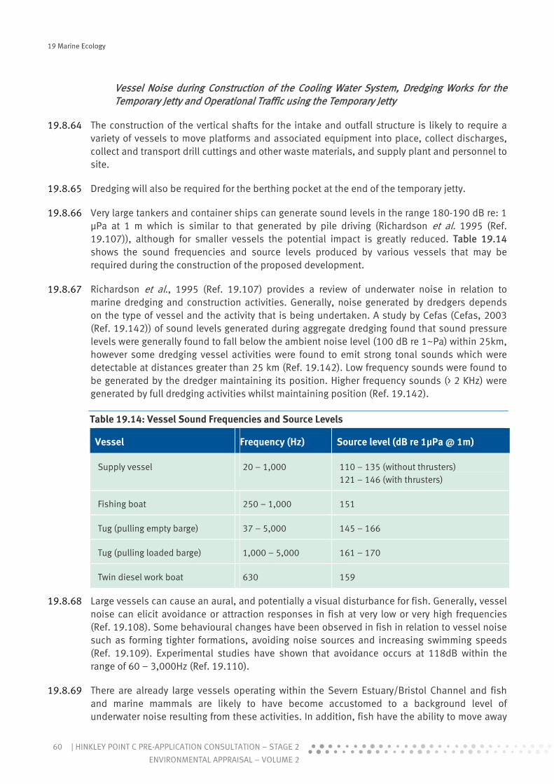
19 Marine Ecology
60 | HINKLEY POINT C PRE-APPLICATION CONSULTATION – STAGE 2
ENVIRONMENTAL APPRAISAL – VOLUME 2
Vessel Noise during Construction of the Cooling Water System, Dredging Works for the Temporary Jetty and Operational Traffic using the Temporary Jetty
19.8.64 The construction of the vertical shafts for the intake and outfall structure is likely to require a variety of vessels to move platforms and associated equipment into place, collect discharges, collect and transport drill cuttings and other waste materials, and supply plant and personnel to site.
19.8.65 Dredging will also be required for the berthing pocket at the end of the temporary jetty.
19.8.66 Very large tankers and container ships can generate sound levels in the range 180-190 dB re: 1 μPa at 1 m which is similar to that generated by pile driving (Richardson et al. 1995 (Ref. 19.107)), although for smaller vessels the potential impact is greatly reduced. Table 19.14 shows the sound frequencies and source levels produced by various vessels that may be required during the construction of the proposed development.
19.8.67 Richardson et al., 1995 (Ref. 19.107) provides a review of underwater noise in relation to marine dredging and construction activities. Generally, noise generated by dredgers depends on the type of vessel and the activity that is being undertaken. A study by Cefas (Cefas, 2003 (Ref. 19.142)) of sound levels generated during aggregate dredging found that sound pressure levels were generally found to fall below the ambient noise level (100 dB re 1~Pa) within 25km, however some dredging vessel activities were found to emit strong tonal sounds which were detectable at distances greater than 25 km (Ref. 19.142). Low frequency sounds were found to be generated by the dredger maintaining its position. Higher frequency sounds (> 2 KHz) were generated by full dredging activities whilst maintaining position (Ref. 19.142).
Table 19.14: Vessel Sound Frequencies and Source Levels
Vessel Frequency (Hz) Source level (dB re 1μPa @ 1m)
Supply vessel 20 – 1,000 110 – 135 (without thrusters) 121 – 146 (with thrusters)
Fishing boat 250 – 1,000 151
Tug (pulling empty barge) 37 – 5,000 145 – 166
Tug (pulling loaded barge) 1,000 – 5,000 161 – 170
Twin diesel work boat 630 159
19.8.68 Large vessels can cause an aural, and potentially a visual disturbance for fish. Generally, vessel noise can elicit avoidance or attraction responses in fish at very low or very high frequencies (Ref. 19.108). Some behavioural changes have been observed in fish in relation to vessel noise such as forming tighter formations, avoiding noise sources and increasing swimming speeds (Ref. 19.109). Experimental studies have shown that avoidance occurs at 118dB within the range of 60 – 3,000Hz (Ref. 19.110).
19.8.69 There are already large vessels operating within the Severn Estuary/Bristol Channel and fish and marine mammals are likely to have become accustomed to a background level of underwater noise resulting from these activities. In addition, fish have the ability to move away

19 Marine Ecology
61HINKLEY POINT C PRE-APPLICATION CONSULTATION – STAGE 2 |
ENVIRONMENTAL APPRAISAL – VOLUME 2
from the sources of vessel noise. As the UK BAP species are all marine migrants moving through the Hinkley Point area from the Bristol Channel, Irish Sea and further afield it would be expected that they would be frequently exposed to vessel noise during their lifetime. Young-of-the-year migratory Annex II species (Atlantic salmon, twaite shad, allis shad, river lamprey, sea lamprey) passing through the estuary, however, would be less acclimatised to vessel noise.
Effect of Construction Noise on Fish
19.8.70 In order to assess potential impacts of noise on fish an understanding of the hearing abilities of fish is required. Fish use three organs to detect sound; the lateral line, the ear and the swim bladder. The presence/absence and characteristics of these organs determine the hearing abilities of fish species which can be considered to be hearing non-specialists, specialists or generalists (Bone et al. 1995 (Ref. 19.110)), Hastings & Popper 2005 (Ref. 19.111). Non-specialist fish are those with no swim bladder e.g. lamprey, plaice, dab and sole. Clupeiformes (e.g. sprat, herring and shad) fall within the specialist category and as such can hear sounds over a far greater range than other species (e.g. Higgs et al. 2004 (Ref. 19.112)). Species of conservation importance which are considered to be hearing generalists, and are potentially present near the study area, include salmon and eel.
19.8.71 In addition to auditory problems, more severe impacts could include the perforation of swim bladders by high-energy underwater noises (Gisner 1998 (Ref. 19.113)) which can cause fish to sink, lose the ability to orientate themselves, or lead to internal bleeding and fatality. Noise levels within 5m of pile driving operations can exceed levels that can harm or kill fish, with peak values quoted at around 218 dB. However, it is unlikely that either impact or vibratory piling will cause instantaneous death, as the pressure changes are insufficient even at close range. The sound pressure levels which may cause harm to fish differs between species and is largely dependent on the presence or absence of a swimbladder. Underwater noise may also create disturbance to local fish populations, although fish are known to rapidly acclimatise to background noise.
19.8.72 Audiograms indicate hearing ranges for some of the species of conservation importance known to be present within the Severn Estuary/ Bristol Channel (Nedwell et al., 2004, (Ref. 19.106)). See Table 19.15).
Table 19.15: Hearing Frequency Range for Fish Species of Conservation Importance in the Area around Hinkley Point. Where data are lacking for specific species other data are presented where possible for other species of similar physiology
Common Name
Legislative Protection
Hearing Category
Frequency Range (Hz)
Hearing Threshold Range over this Frequency Range (dB re 1μ Pa)
Reference
Atlantic salmon
Annex II and V (Habitats Directive)
UK BAP
Generalist 30-350 95-130 Nedwell et al. 2004

19 Marine Ecology
62 | HINKLEY POINT C PRE-APPLICATION CONSULTATION – STAGE 2
ENVIRONMENTAL APPRAISAL – VOLUME 2
Common Name
Legislative Protection
Hearing Category
Frequency Range (Hz)
Hearing Threshold Range over this Frequency Range (dB re 1μ Pa)
Reference
Shad – American shad
Not present in Severn Estuary
Specialist Up to 180000
140-185 Higgs et al. 2004
Shad – Twaite shad
Annex II (Habitats Directive)
UK BAP
Specialist 30000-60000
190-198 APEM 2008
River lamprey
Annex II and V (Habitats Directive)
UK BAP
Non-specialist
Unavailable Unavailable NA
Sea lamprey Annex II (Habitats Directive)
UK BAP
Non-specialist
Unavailable Unavailable NA
Sea trout
UK BAP
Generalist 30-350 95-130 Nedwell et al. 2004
Common or Atlantic sturgeon
Annex IIa and IVa (Habitats Directive), UKBAP
Bern Convention Appendix III, CITIES Appendix I, WCA Sch. 5.
Potential specialist
100 – 2000 Unavailable Meyer & Popper 2002
Eel UK BAP Generalist 10-300 Unavailable Jerkø et al. 1989
Cod UK BAP Generalist 10-500 65-140/75-110/95-120
Nedwell et al. 2004
Herring UK BAP Specialist 20-4000 75-135 Nedwell et
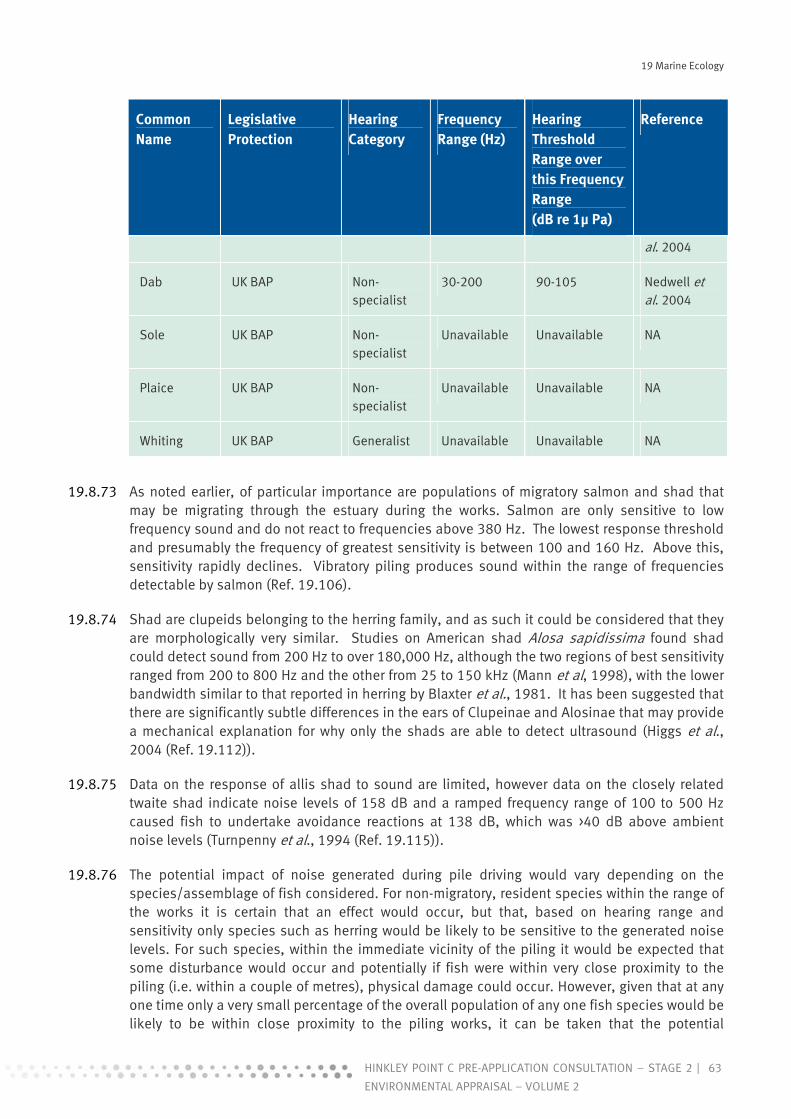
19 Marine Ecology
63HINKLEY POINT C PRE-APPLICATION CONSULTATION – STAGE 2 |
ENVIRONMENTAL APPRAISAL – VOLUME 2
Common Name
Legislative Protection
Hearing Category
Frequency Range (Hz)
Hearing Threshold Range over this Frequency Range (dB re 1μ Pa)
Reference
al. 2004
Dab UK BAP Non-specialist
30-200 90-105 Nedwell et al. 2004
Sole UK BAP Non-specialist
Unavailable Unavailable NA
Plaice UK BAP Non-specialist
Unavailable Unavailable NA
Whiting UK BAP Generalist Unavailable Unavailable NA
19.8.73 As noted earlier, of particular importance are populations of migratory salmon and shad that may be migrating through the estuary during the works. Salmon are only sensitive to low frequency sound and do not react to frequencies above 380 Hz. The lowest response threshold and presumably the frequency of greatest sensitivity is between 100 and 160 Hz. Above this, sensitivity rapidly declines. Vibratory piling produces sound within the range of frequencies detectable by salmon (Ref. 19.106).
19.8.74 Shad are clupeids belonging to the herring family, and as such it could be considered that they are morphologically very similar. Studies on American shad Alosa sapidissima found shad could detect sound from 200 Hz to over 180,000 Hz, although the two regions of best sensitivity ranged from 200 to 800 Hz and the other from 25 to 150 kHz (Mann et al, 1998), with the lower bandwidth similar to that reported in herring by Blaxter et al., 1981. It has been suggested that there are significantly subtle differences in the ears of Clupeinae and Alosinae that may provide a mechanical explanation for why only the shads are able to detect ultrasound (Higgs et al., 2004 (Ref. 19.112)).
19.8.75 Data on the response of allis shad to sound are limited, however data on the closely related twaite shad indicate noise levels of 158 dB and a ramped frequency range of 100 to 500 Hz caused fish to undertake avoidance reactions at 138 dB, which was >40 dB above ambient noise levels (Turnpenny et al., 1994 (Ref. 19.115)).
19.8.76 The potential impact of noise generated during pile driving would vary depending on the species/assemblage of fish considered. For non-migratory, resident species within the range of the works it is certain that an effect would occur, but that, based on hearing range and sensitivity only species such as herring would be likely to be sensitive to the generated noise levels. For such species, within the immediate vicinity of the piling it would be expected that some disturbance would occur and potentially if fish were within very close proximity to the piling (i.e. within a couple of metres), physical damage could occur. However, given that at any one time only a very small percentage of the overall population of any one fish species would be likely to be within close proximity to the piling works, it can be taken that the potential

19 Marine Ecology
64 | HINKLEY POINT C PRE-APPLICATION CONSULTATION – STAGE 2
ENVIRONMENTAL APPRAISAL – VOLUME 2
magnitude of the impact would be low at best. Consequently, mainly considering potential impacts on herring and individual fish close to the noise source at the commencement of pile driving, it is assessed that there would be a minor adverse impact. Once pile driving is initiated then the potential for physical damage effectively ceases as any fish within the zone of influence (ensonification) would move out of the area to avoid the increase in noise levels/pressure.
19.8.77 There is still considerable uncertainty about the effects of piling noise on migratory fish species, although the available data suggests that levels sufficient to cause serious injury or death are unlikely to occur at distances of less than 5 m from the source, and at >400m it is unlikely that salmon or trout would react at all to vibratory piling. Based on salmonid and clupeid hearing it could be anticipated that migratory fish in the vicinity of piling activities would be expected to show avoidance behaviour to noise levels above 90 dB depending on the intensity of background noise.
19.8.78 Anadromous species migrating seaward are unlikely to be prevented from migrating by noise impacts as the size of seaward migrating salmon (smolts), shads and lamprey means that their swimming speeds are typically lower than tidal stream velocities. The movements of juveniles of anadromous species will thus be determined by tidal transport, which means that individuals will tend to pass the area of disturbance fairly rapidly. In the case of salmon smolts, the utilisation of the fastest flowing portion of the estuary would ensure animals are rapidly conveyed past any area subject to disturbance impacts.
19.8.79 The estuary is a known migratory route and given the designated status and importance of the migratory fish populations the disturbance and potential physical impact of piling could be considered to be of moderate significance. However, given the estuary is approximately 20km wide at the point of disturbance and that it is unlikely that elevated noise levels that would lead to avoidance would extend beyond 400m there would be sufficient space for any displaced migratory fish to continue migration. Given the relatively small area of the estuary that would be impacted during the construction and piling phase it is therefore considered that there would be a minor adverse impact.
19.8.80 Comparing the data on vessel noise generation with the hearing capabilities of the fish species detailed in Table 19.15, it can be seen that supply vessels, fishing boats and tugs (pulling empty barge), can generate sound within the hearing frequency range of most species, the only exception being twaite shad. A tug pulling a loaded barge however can generate sound at much higher frequencies (1,000 – 5,000 Hz) which lies outside the range of the majority of fish species (salmon, twaite shad, sea trout, eel, cod and dab). Similarly the frequency of sound generated by a twin diesel work boat is outside the hearing range of these species.
19.8.81 For fish species to hear the vessels and demonstrate an avoidance reaction both the frequency and noise level indicated in Table 19.15 would need to be within the range of a particular species. However, attenuation of sound means that as distance from the vessel increases, noise levels would reach values less than those indicated to be source noise levels in Table 19.15. e.g. a tug pulling an empty barge has a source level of 145-166 dB re 1μPa @ 1m but at a greater distance the noise level may be detectable by e.g. salmon (upper hearing threshold of 130 dB re 1μPa).
19.8.82 The impact of vessel noise would be expected to be smaller than that associated with pile driving, even though vessel noise may be of a more continuous nature. While it might be
19 Marine Ecology
65HINKLEY POINT C PRE-APPLICATION CONSULTATION – STAGE 2 |
ENVIRONMENTAL APPRAISAL – VOLUME 2
anticipated that there could be a greater effect due to the combination of vessel plus piling noise, it is considered unlikely that the significance of this cumulative effect would be any greater than that for piling alone. This is again due to the fact that any fish within the zone of influence would no longer be present in the affected area or would avoid it while noise levels were raised.
19.8.83 With regard to drilling noise during the construction of the horizontal tunnels, the depth of the drilling within the bedrock (40-20m depth) suggests that the propagation of sound waves into the water column would be limited. Flatfish, which are sensitive to vibration and low frequency sound, are likely to be able to feel the vibration from the approach of drilling activity through the seabed and would therefore have the opportunity to move from the area before noise levels increased. Any avoidance reaction in fish would be likely to be confined to the immediate corridor above the tunnel and it is considered that there would be a negligible sound level within the water column at a distance of >1 km from the source.
Effect of Construction Noise on Marine Mammals
19.8.84 Although there is no conclusive evidence regarding the sound pressure levels (SPL) harmful to marine life other than fish, the National Marine Fisheries Service in the US (NMFS) considers that underwater SPLs above 190dB re: 1 μPa RMS (impulse) could cause temporary hearing impairment in harbour seals and SPLs above 180dB re: 1 μPa RMS (impulse) could cause temporary hearing problems in whales.
19.8.85 As discussed in the baseline section, although marine mammals are present in the Severn Estuary, they are not commonly observed and unlikely to be present on a regular basis. As with fish, mammals are capable of avoiding areas of noise disturbance and, given the extensive area available for any individuals present in the area of the works, to move into, with the fact that seals and cetaceans are uncommon near to the site of the proposed works, the potential significance of impact due to noise disturbance is considered negligible.
19.8.86 Following the cessation of activities causing noise disturbance underwater, it would be expected that aquatic organisms which may have exhibited avoidance behaviour (including the most sensitive species) would return to the area or pass through it.
e) Artificial Lighting
19.8.87 The construction works may require that night time working is undertaken, in which case powerful artificial lighting will be needed. This may apply to the drilling works for the intake and outfall shafts, construction and dismantling of the temporary jetty and construction of the seawall. For the purposes of assessment it is presumed that lighting will be required. Lighting will also be required for the temporary jetty during its operation.
19.8.88 The effect of artificial lighting has been considered in relation to two broad habitat types and the species that utilise these habitats – namely intertidal areas and the water column.
i Lighting Effects on Intertidal Areas
19.8.89 This effect only applies with regard to the temporary jetty. While it is possible that lighting may be used during construction of the seawall (tidal conditions permitting) there are no intertidal communities of significance (e.g. Corallina turfs) within 100m of the location for the seawall.
19 Marine Ecology
66 | HINKLEY POINT C PRE-APPLICATION CONSULTATION – STAGE 2
ENVIRONMENTAL APPRAISAL – VOLUME 2
19.8.90 The organisms present on the foreshore are likely to be tolerant to exposure from artificial light as clearly these communities are subject to intense light levels on a daily basis. Artificial lighting would also only have an effect during low tidal conditions, which effectively means that due to attenuation through the water column, communities would not be subject to a 24hr increase in light levels.
19.8.91 Of the Corallina dominated biotope present on the foreshore at Hinkley only a relatively small area falls within the footprint of the temporary jetty. Of this small area it can also be stated that potential lightfall from artificial lighting would only affect a proportion of the Corallina biotope present, as light levels would rapidly drop off from the source. Although an increase in light levels could potentially promote growth of Corallina it is highly unlikely that the overall increase that some isolated areas of Corallina might be subject to would promote growth such that it was of significance or potentially interfere with other physiological processes.
ii Lighting Effects on the Water Column
19.8.92 In the case of the construction phase, lighting of the works for drilling of the vertical shafts for the intake/outfall structures and for the temporary jetty may influence the water column. Lightfall into the water column will also occur during operation of the temporary jetty.
19.8.93 The key variable to take into account when assessing light attenuation through water is the suspended sediment load of the water. Due to the very high turbidity levels within the Severn Estuary there would be limited penetration of the artificial light into the water column, and it is considered that light levels would be negligible after 1-2m of passage though water. Consequently, only organisms near the water surface may potentially be affected by this night time lighting and benthic organisms on the estuary bed would not be expected to be influenced.
19.8.94 Light is known to have a strong influence on fish behaviour, with photoperiod and artificial manipulation of this acting as an environmental cue in relation to reproduction, and also as a factor determining migration. Changes in natural reproductive development rates as a result of artificial light regimes have been demonstrated for a range of fish species. However, this has generally been where the light environment experienced by fish is overwhelmingly determined by that artificial source (e.g. in aquaria, laboratories or fish farm facilities).
19.8.95 Light has also been demonstrated to influence fish migration, with species such as salmon and sea trout migrating predominantly at night rather than day. Similarly, various species have been demonstrated to either be attracted to or repelled by light, with the majority being repelled.
19.8.96 While it is possible that some fish species may be present within the area affected by artificial light, the potential magnitude of change associated with this effect (for the reasons given above) is considered to be very low. Given that it is likely that only a very small percentage of the estuary area would be affected, for both the temporary jetty and the shaft drilling works, and that many species, including migrating fish, would avoid any lit areas the overall effect on fish movement is anticipated to be of negligible impact for the construction phase (drilling works and jetty) and operational phase for the temporary jetty.
f) Summary of Effects on Receptors as a Whole during the Construction Process
19.8.97 Due to the existing hypertidal and equally extreme turbidity regime, associated with high levels of bed sediment resuspension, together with the scale of the systems involved and the relative
19 Marine Ecology
67HINKLEY POINT C PRE-APPLICATION CONSULTATION – STAGE 2 |
ENVIRONMENTAL APPRAISAL – VOLUME 2
impoverishment of the subtidal areas, the majority of impacts identified above have been identified as either minor or negligible.
19.8.98 Only in a few circumstances, where species of conservation interest are involved, have impacts been suggested where an additional level of care may be required. Even here, however, that same hypertidal regime strongly suggests that the level of sensitivity of harm to factors as simple as variations in salinity or suspended solids, for species which routinely inhabit such waters, will be very low. Nonetheless, where there are obvious means of providing mitigation of potential harm to these species through appropriate management of the works involved, these measures would be applied.
19.9 Mitigation Measures during Construction
19.9.1 This section of the report provides details of the mitigation measures that are being proposed during the construction phase in order to minimise potential adverse effects on the marine environment. Mitigation comprises a number of different types of measures, including:
appropriate design of the development and its component structures; appropriate construction techniques and methods; appropriate working practices; use of physical structures and no-go areas to protect sensitive receptors during
construction works; appointment of personnel whose responsibilities are to carry out inspections and to
implement mitigation measures and to manage the Environmental Monitoring and Management Plan (EMMP) for the development;
monitoring to ensure that mitigation measures are working; and documentation to maintain a record of the implementation of mitigation measures.
a) Application of Good Practice and Management during Construction
19.9.2 The vast majority of impacts identified are of negligible to minor adverse significance and specific measures are therefore not deemed necessary. However, given that many of the identified effects could be occurring to the same receptors and therefore have the potential to act cumulatively it is appropriate to ensure that measures are adopted that have the potential to either avoid or reduce potential impacts to lesser levels during the construction process.
19.9.3 Such measures are generally classified as ‘good working practice’ and follow available guidance, criteria and regulations. The following measures fall into these categories and it is proposed that they would be employed during construction works in the marine environment:
adherence of all offshore works and operations to the requirements of the OSPAR Convention;
compliance with the conditions of all discharge consents, including quantity, quality, location of discharge and any temporal requirements (such as freshwater discharges or discharges from testing of the cooling water system, only at high tide);
adherence to a Waste Management Plan which specifies methods for containment, collection and disposal of all dredged materials, drill cuttings and all other construction waste materials, as well as management and disposal of all domestic waste;

19 Marine Ecology
68 | HINKLEY POINT C PRE-APPLICATION CONSULTATION – STAGE 2
ENVIRONMENTAL APPRAISAL – VOLUME 2
designation of protective “no-go” areas, and associated buffer zones, around all identified sensitive receptors such as sensitive habitats on the foreshore, intertidal and subtidal zones;
delimiting buffer zones around all construction sites in foreshore, intertidal and subtidal areas, within which all materials laydown, vehicle, equipment and workforce activities must be contained;
providing training for the construction workforce in relation to the value and sensitivity of the marine environment and marine ecological receptors;
providing training for the construction workforce on accident and incident response and cleanup procedures, particularly in relation to the marine environment; and
on-going updating of the mitigation plan and monitoring programme for the marine environment as part of the overall EMM for the site.
19.9.4 It is proposed that the EMMP will contain measures specifically designed to deal with potential issues such as incidents during construction and the management of construction materials. These aspects are detailed in the Chapters 2 and 3, but brief details on measures that will be applied in respect of works in the marine environment are provided below. The majority of these measures will be implemented in order to avoid incidents that could lead to either direct damage or disturbance to habitats or indirect impacts on ecological interests via adverse changes in supporting parameters such as water quality.
i Management of Spillages and Leakages of Oils, Fuels and Chemicals
19.9.5 If there are any spillages or leaks of oils, fuels, concrete or other chemicals during construction activities, these have the potential to enter surface water drainage and discharge to the marine environment, causing changes in marine water quality and resultant adverse impacts on marine ecological receptors.
19.9.6 In addition, in the event of a fire, firewater, which could contain fuels, chemicals and charred particulate debris, would be discharged onto the foreshore, with resultant changes in marine water quality and subsequent potential adverse impacts on marine ecological receptors, particularly Corallina turf habitat.
19.9.7 A suite of mitigation measures would be put in place to deal with any potential accidents and incidents of this nature. These will be detailed in the EMMP and include:
compliance with Environment Agency PPGs, particularly PPG18 which deals with managing firewater and major spillages;
appropriate site rules for storage, handling, transportation, security and emergency procedures in relation to fuels, chemicals and materials;
management of the surface water drainage system for the retention of firewater, and appropriate treatment and disposal of firewater, as agreed with the statutory regulators;
compliance with the criteria of all discharge consents, as agreed with the statutory regulators; and
design and implementation of a training programme to ensure all staff are able to detect spills and leaks and take appropriate action in the event of an accident or incident i.e. all staff to be trained in the correct use of PPE, containment techniques and use of spill kits and other equipment.

19 Marine Ecology
69HINKLEY POINT C PRE-APPLICATION CONSULTATION – STAGE 2 |
ENVIRONMENTAL APPRAISAL – VOLUME 2
ii Materials Storage and Handling and Waste Management
19.9.8 Materials storage and waste management would also be covered under the EMMP. Procedures would be detailed relating to:
containment, handling, transport and treatment of drill cuttings; transport, storage and handling of all drilling muds and chemicals; storage, transport, recycling or disposal of liquid waste; disposal of waste waters and dredging wastes to sea; transport. storage and disposal of waste generated during all land based activities; transport storage and disposal of waste generated during all intertidal and subtidal
activities; and material storage and handling to be used for all construction activities.
19.9.9 Drill cuttings would be recovered to the surface via a riser to the drilling platform. To ensure that all cuttings are contained, subsea equipment would be inspected regularly by scuba divers to ensure equipment is functioning effectively and no faults are present. Procedures would be in place to specify how contained cuttings should be handled and transported to an appropriate disposal site. The transport of cuttings would also be covered in the procedures for preventing and dealing with accidental spillages.
19.9.10 Procedures for the transport of drilling muds and chemicals to the drilling rig, and their storage and handling once offshore would be detailed to ensure their use is limited and the risk of accidental loss to sea is reduced.
19.9.11 Similarly, the storage, transport and recycling or disposal of waste including liquid waste would be specified, including appropriate containers, methods and equipment required to transport the waste and the appropriate material end point destination. Disposal or discharge of any material to sea would require a licence from the statutory regulator.
19.9.12 Specific areas would be designated for the storage of materials on site. Storage in areas outside these areas would be prohibited. Storage areas would be clearly marked and training would be undertaken to ensure that all personnel are aware of the location of storage areas.
19.9.13 All personnel responsible for the transport, storage and handling of materials onshore and offshore and wastes generated onshore and offshore would be made aware of the procedures above during their site induction. Personnel would undergo refresher courses to strengthen their understanding of the procedures that must be adhered to.
19.9.14 Regulatory requirements and compliance would be the responsibility of the Health, Safety and Environment Officer for the site. It would be their responsibility to ensure that all personnel working on activities which would need regulatory approval are aware of the legislative constraints of the activities for which they are responsible.
b) Specific Mitigation Measures
19.9.15 As discussed above, the implementation of general good practice measures during construction should ensure that the majority of potential impacts on marine ecological interests are either avoided or minimised to such a level as to be of negligible-minor significance. There are, however a number of impacts that have been identified that cannot be addressed solely through the use of such generic mitigation and specific measures are proposed to reduce the potential significance of the identified impacts. Some of these measures have already been

19 Marine Ecology
70 | HINKLEY POINT C PRE-APPLICATION CONSULTATION – STAGE 2
ENVIRONMENTAL APPRAISAL – VOLUME 2
considered through the design process while others will need to be implemented during construction itself. The following sections provide a description of the proposed measures in relation to the environmental aspects that they relate to and the activities for which they are considered.
i Habitat Loss and Disturbance
Drilling of Vertical Shafts for the Cooling Water System
19.9.16 No mitigation measures are considered necessary given the predicted negligible scale of the potential impact.
Temporary Jetty
19.9.17 The alignment of the temporary aggregate jetty has been positioned so as to avoid significant areas of Corallina turf on the lower shore. Recent surveys have shown that Sabellaria reef is absent both in the intertidal area concerned and the near subtidal.
19.9.18 Although the alignment of the jetty would avoid the significant areas of algal turf themselves these features do have a dependency on longshore drainage channels and there is a risk that either construction activities or the siting of individual piles will compromise one or more of these. If any such channels do need to be crossed they would be bridged in order to avoid drainage constraint. A limited working corridor flanking the line of the jetty would also avoid the risk of more widespread disturbance to the habitat involved. The implementation of these mitigation measures would reduce the potential for damage and physical disturbance to Corallina turf habitat such that overall a minor adverse impact would be predicted.
Construction of the Sea Wall
19.9.19 The construction of the sea wall would involve accessing the foreshore and operating heavy plant along the seaward edge of the existing sea cliff to remove rock and debris to create the new sea wall alignment. Given the width of the intertidal shore involved there is a significant distance between the area of these works and the sensitive receptors (primarily the Corallina turf assemblages) on the lower shore. Best practice measures which would be implemented would include:
all rock waste would be recovered and either used as backfill for the wall or used elsewhere on the main development site as fill;
access to the shore would be limited to two access ramps from the cliff to the shore, which would be sited on existing bed rock;
an access and working zone would be delimited to prevent access beyond the top of the intertidal zone; and
no laydown of materials or wastes would be permitted on the intertidal zone.
19.9.20 These measures would be integrated into the works. On this basis, disturbance and damage of Corallina turf would be of negligible impact.
ii Water Quality
Drilling of Vertical Shafts
19.9.21 Good practice measures applicable to offshore drilling activities would limit the potential impacts described previously. These include:

19 Marine Ecology
71HINKLEY POINT C PRE-APPLICATION CONSULTATION – STAGE 2 |
ENVIRONMENTAL APPRAISAL – VOLUME 2
treatment and disposal of waste drilling arisings; containment and treatment of drilling mud and associated chemicals; and control and treatment of vessel ballast waters.
19.9.22 With the implementation of these measures, sediment generation and the potential release of contaminants during construction would be limited such that the overall water quality impact of these works on marine ecological receptors would be negligible.
Horizontal Tunnels
19.9.23 Discharge waters would be subject to treatment as appropriate in accord with best practice in order to deal with any significant chemical contaminants or solids. The impact on Corallina and other intertidal flora and fauna has been assessed as of minor adverse significance. With treatment, the potential for increase in SSC and for temporary sediment accumulation to occur would still prevail. As such the impact is still rated as of minor adverse impact.
Temporary Jetty and Seawall
19.9.24 Water quality issues associated with the construction of the temporary jetty and the seawall would be managed through the implementation of best practice methods during construction.
iii Noise and Vibration
Drilling and Piling during Construction for the Vertical Shafts (cooling water system) and the Temporary Jetty
19.9.25 The assessment of noise levels associated with piling has been undertaken with the assumption that percussive piling would be used, which may or may not prove practicable given the rocks involved. Although not considered necessary from an environmental perspective, potential noise levels generated during the works could be lessened using vibro-piling or drill and drive piling techniques. A ‘soft start’ approach could also be undertaken to give fish a chance to detect the noise at lower levels and leave the area before normal operational levels are attained. While these measures are not certain means of preventing any localised impact on fish, their implementation would ensure that the noise associated with the works would be reduced to levels that would be of minor impact at worst for all fish populations present within the area.
19.10 Assessment of Potential Impacts during the Operational Phase
a) Introduction
19.10.1 This section covers the range of impacts that would occur as a result of operational activities. The key aspects and the receptors that these could affect are listed below.
i Cooling Water System
19.10.2 The operation of the cooling water system and process discharges put to this route has the potential to generate:
both impingement and entrainment impacts on fish and other marine biota associated with the offshore abstraction of cooling water and its subsequent passage through power station cooling water circuits prior to discharge;

19 Marine Ecology
72 | HINKLEY POINT C PRE-APPLICATION CONSULTATION – STAGE 2
ENVIRONMENTAL APPRAISAL – VOLUME 2
water quality impacts on the local receiving water and associated habitats, due to discharges from: o commissioning phase chemicals; o operational phase chemicals including those used to control biological fouling of the
cooling water circuits, if necessary; thermal impacts on the local receiving water and associated habitats due to the thermally
buoyant tidally oscillating cooling water plume that would be discharged offshore; and physical disturbance to the seabed associated with the rate and volume of discharge flow.
ii The sea wall
19.10.3 The presence of the new seawall may lead to:
physical disturbance and change of substrate and local habitat resulting from changes to the coastal geomorphology and hydrodynamic regime of the region.
iii Land-based Discharges
19.10.4 Drainage from the site may lead to:
water quality impacts on the local receiving water and associated habitats.
b) Impacts Associated with Changes in Water Quality
i Chemical Discharges Associated with the Cooling Water System
19.10.5 Cooling water would be abstracted from a series of near-seabed intakes some 3.3 km offshore. During normal operation of both EPR units seawater would be abstracted at rates in the range of 116-134 m3.sec-1 (‘cumecs’), depending upon tidal conditions, and subsequently discharged at the same rate through a pair of outfall headworks, again mounted on the seabed, some 1.8 km offshore. The locations of the intake and outfall tunnels are indicated in Figure 19.9.
19.10.6 Detailed information on non-radioactive discharges during construction, commissioning and operation of the Hinkley Point C EPRs is provided in the marine water and sediment quality chapter (Chapter 17) of this Appraisal.
19.10.7 The following assessment of likely effects on marine ecology is based on an understanding of expected chemical discharges, extensive field surveys in the locality carried out in order to secure an understanding of the physical, chemical and biological environments concerned, a series of descriptive and predictive numerical models, and an understanding of environmental regulatory expectations.
19.10.8 Potentially, a range of chemicals may be released to the marine environment during both commissioning and operation. These are described below in order to provide the context for the assessment that follows.
19.10.9 The commissioning period is expected to last 2 years. Chemicals released during this phase include:
effluent from desalination (if used) and demineralisation plants; chemicals used for the conditioning of a range of circuits within the EPR units; and chlorination residuals following testing of the cooling water chlorination systems.

19 Marine Ecology
73HINKLEY POINT C PRE-APPLICATION CONSULTATION – STAGE 2 |
ENVIRONMENTAL APPRAISAL – VOLUME 2
19.10.10 Initial screening assessments (H1 – see Chaper 20 on marine water quality) have shown that during the commissioning phase the following chemicals in the discharge could be of significance and would need further assessment:
Phosphates. Total Residual Oxidants (TRO). Morpholine. Hydrazine.
Phosphates
19.10.11 The highest level that would be expected for phosphates is for 24 hour discharges during the commissioning phase. Using a 100 m dilution factor, this value equates to 47.5% of the mean baseline concentration. In terms of nutrient enrichment, phosphate is of relatively low importance in marine systems, consequently this discharge has been assessed to be of low significance.
Total Residual Oxidants (TRO)
19.10.12 Where biological fouling of marine cooling water circuits by species such as mussels (Mytilus edulis) and tube worms (including Sabellaria) is known to be a risk the technique widely acknowledged to be the Best Available Technique is continuous low level chlorination. This is employed with a number of other means of mitigation, sometimes described as ‘screening, cleaning, and dosing to defer the need for cleaning’. For reasons of efficiency, and to avoid the risk of sudden blockage following dosing, when used, dosing levels are deliberately maintained below acutely toxic levels within the cooling water circuit itself and thus, intentionally, have an impact on the ‘scope for growth’ of organisms that have settled there – i.e. their growth rates are slowed.
19.10.13 In the UK, risk-based protocols are applied, meaning that chlorination is only applied where the risk of fouling is actually observed. Operational experience at HPA and HPB stations has shown that the need for active dosing at this site is infrequent. This has in part been due to the hydrodynamic design of the cooling water circuits involved – where high rates of flow are maintained throughout, effectively limiting the probability of larval settlement and subsequent success, and the level of suspended solids entrained which themselves have a direct impact on ‘scope for growth’.
19.10.14 Operational experience at both Hinkley Point and other Severnside stations has also shown, however, that conditions can change and that biological fouling can then occur. Currently, the greatest likelihood of change would be associated with a change in the operational regime rather than the external environment. For example, reduced rates of flow through the cooling water system which could occur for several reasons including plant maintenance would greatly increase the probability of successful biological settlement and growth. As a result, even though the level of fouling risk is regarded as very low under normal operational conditions the means of dosing would need to be available as a matter of contingency, as is currently the case at HPB.
19.10.15 When required, chlorination would be applied either by use of a seawater electrochlorination plant or dosing of sodium hypochlorite solution. Either means would evoke a very similar if not identical chemistry in the cooling water flow.
19.10.16 As with any subsequent operational use, the testing of the ‘chlorine’ dosing system during commissioning would produce both residual oxidants and non-oxidising chlorinated by-
19 Marine Ecology
74 | HINKLEY POINT C PRE-APPLICATION CONSULTATION – STAGE 2
ENVIRONMENTAL APPRAISAL – VOLUME 2
products (CBPs, primarily bromoform). The standard low level chlorination residual oxidant level most commonly used at UK coastal nuclear power stations is 0.2 mg/l.
19.10.17 The levels of CBPs associated with this level of TRO are generally understood to be very low, with even the most significant of these (most commonly bromoform) only being present at concentrations of a few 10s of g/l at most. These levels are well below those considered to be harmful in the marine environment and, as a result, levels of protection tend to be set by control of the TRO level itself.
19.10.18 The GETM (General Estuarine Transport Model) was used to predict TRO levels in the receiving water. The model used an operational TRO level of 0.2 mg l-1. Simulations were run for an April–May period to represent the most typical time when chlorination might be applied. The results indicate that the area of exceedance of the EQS would be small on average and would not extend to the ecologically sensitive areas of the intertidal habitat.
19.10.19 The Environmental Quality Standard for TRO is set on a precautionary basis for the protection of all marine life and takes into account the presence of low level CBPs. On this basis the receiving water impact associated with the testing of such a system during commissioning, which would be limited to confirming that an appropriate residual level could be maintained within the operational cooling water circuits and thus relatively short in duration, would be low.
Morpholine
19.10.20 The H1 Assessment (see Marine Water and Sediment Quality, Chapter 20) has shown that concentrations of morpholine in the discharge would not be of environmental significance during the commissioning phase.
Hydrazine
19.10.21 The H1 Assessment of hydrazine has shown that 24 hr discharges (but not annual discharges) may produce levels at 100 and 500 m from the discharge point that may be of environmental significance. For operational reasons hydrazine release would tend to be over short time periods rather than continual, so a 24 hr figure would be more representative of operational practice than a longer term average.
19.10.22 The degradation rate of hydrazine is dependent on a wide variety of factors e.g. the presence of certain chemicals (organic and inorganic), hardness, pH and temperature, as well as the initial concentration of the hydrazine itself (Slonim & Gisclard, 1976 (Ref. 19.114)). As a result rapid breakdown to ammonia is generally expected to occur within the marine environment following discharge.
19.10.23 Experimental studies have estimated the half-life of hydrazine to be in the order of hours, i.e. 5.4 to 8.1 hours at initial concentrations of 2 μg l-1 and 12 μg l-1 respectively, and may be reduced further at lower concentrations.
19.10.24 Further laboratory studies to confirm the rates applicable to sea water off Hinkley are currently underway and, if appropriate, the results will then be incorporated within the existing numerical models to inform the assessment process.
19.10.25 It is unclear at this stage whether mitigation measures would be required in excess of the effluent pre-treatment already intended.

19 Marine Ecology
75HINKLEY POINT C PRE-APPLICATION CONSULTATION – STAGE 2 |
ENVIRONMENTAL APPRAISAL – VOLUME 2
ii Discharges during Operation
19.10.26 A range of non-radioactive contaminants would be associated with discharges from the operational EPR units. These are detailed in Chapter 17, marine water quality. The contaminants associated with non-radioactive discharges would arise from a variety of sources including site surface drainage, effluents from desalination or demineralisation plant, and any residuals arising from low level chlorination of the cooling water circuit itself. Where a description of the activity itself and its environmental characteristics has been described above this is not repeated here.
19.10.27 Screening via the H1 Assessment process (see Marine Water Quality, Chapter 20) has shown that, during the operational phase, the following chemicals could be of significance and would need further assessment:
Phosphates: 24 hour discharge levels 500 m from point of discharge. Total Residual Oxidants: 24 hour discharge levels, 500 m from the point of discharge. Total nitrogen: Operational 24 hour discharge levels at 100 m distance. Unionised ammonia: Operational 24 hour discharge levels, 500m from the discharge point. Iron: 24 hour discharge levels, at 100 m distance. Morpholine: 24 hour discharge levels, at 500 m distance, and for annual discharges at a
distance of 100m from the discharge point. Hydrazine: 24 hour and annual discharge levels, at 500 m distance.
19.10.28 The potential significance of phosphates, TROs and CBPs are discussed in the relevant sections above.
Total Nitrogen
19.10.29 There is no EQS value for dissolved inorganic nitrogen in seawater therefore the process contribution was assessed against mean baseline concentration. Exceedance for dissolved inorganic nitrogen was noted with a PC of 13.4 g l-1 for the 24 hour discharges and the 100 m dilution factor. This equates to 1.37% of the mean baseline concentration and it is thus considered that at this concentration it would not change the nutrient quality status of the area.
Unionised Ammonia
19.10.30 Based on mean baseline concentrations the PEC for the 24 hour operational discharge would be 0.442 g l-1 with a 100 m dilution factor and 0.272 g l-1 with a 500 m dilution factor, indicating that the discharges would not be significant. It should be noted that the elevated temperatures associated with the thermal discharges, however, would tend to cause a shift of ammonia towards its unionised form.
19.10.31 The interaction of pH and temperature with ammonia was thus considered, because this influences the toxicity of ammonia, with increased temperatures affecting both the rate of uptake of ammonia and the form of ammonia to which organisms are exposed. Based on historical and more recent measurement data for ammonia, the concentrations in Bridgwater Bay and the Parrett Estuary are not high and the temperature elevation is not considered to be sufficient to create localised areas where conditions are more stressful and would thus form barriers to the passage of fish.

19 Marine Ecology
76 | HINKLEY POINT C PRE-APPLICATION CONSULTATION – STAGE 2
ENVIRONMENTAL APPRAISAL – VOLUME 2
Dissolved Iron
19.10.32 As the EQS value for iron is known, the percentage of the EQS represented by the PEC was calculated. This was found to be 2.4% which is significantly below the 70% level where further evaluation is required.
Morpholine
19.10.33 During the operational phase the H1 assessment indicates that the morpholine concentration for the 24 hour discharge at 100 and 500 m dilution and annual discharge at 100 m dilution would not be expected to be of environmental significance.
Hydrazine
19.10.34 The H1 assessment suggests that hydrazine could be a significant discharge during operation, and that further detailed modelling should be performed once site-specific degradation rates have been confirmed.
iii Impact of Contaminants and Change in Water Quality on Marine Life
19.10.35 Given that the EQS for TRO is met at the edge of a limited mixing zone and that (a) this does not extend across areas of potential sensitivity within Bridgwater Bay and (b) this level of protection is sufficient for the very much lower concentrations of CBPs involved, the impact concerned would be considered to be low.
19.10.36 There remains some uncertainty over the likely behaviour of hydrazine in the receiving water and thus the likely extent of the zone within which a regulatory standard might be met. Final assessment awaits the outcome of further laboratory and modelling studies, which are in hand. On the basis of past experience at other operational sites an interim presumption is made here that any impact concerned would be considered to be low.
c) Effects of Thermal Change Associated with the Cooling Water System
i Numerical Modelling Requirements
19.10.37 As described above, the exhalent cooling water stream would be discharged into the sea from two seabed mounted outfall structures positioned approximately 1.8 km offshore.
19.10.38 Such a discharge typically produces a thermally buoyant tidally oscillating plume – with the warmed water causing a degree of vertical stratification in the water column and the higher temperatures, as a result, being encountered at the surface.
19.10.39 The efficiency of the ‘heat sink’ that the discharge to sea and subsequent loss to atmosphere provides, is fundamental to the efficient operation of the power station. The needs of environmental protection coincide in the appropriate selection of intake and outfall positions and as a result considerable effort is applied to the acquisition of sufficient high quality environmental data and the development, calibration and validation of predictive numerical hydrodynamic models.
19 Marine Ecology
77HINKLEY POINT C PRE-APPLICATION CONSULTATION – STAGE 2 |
ENVIRONMENTAL APPRAISAL – VOLUME 2
ii Behaviour of the Hinkley Point C Station Plume
19.10.40 Thermal plume modelling is being undertaken using the GETM (see BEEMS 2010c, (Ref. 19.119)) and Delft 3D (see BEEMS, 2009i (Ref. 19.116), BEEMS, 2009j (Ref. 19.117)) models. The models are used as an ’ensemble’ utilising the same physical data inputs but different algorithms for the solution of a range of variables in order to gain greater confidence in the degree of predictive uncertainty involved. Both models have been subject to the same degree of independent peer review, and identical requirements of calibration and validation.
19.10.41 Model outputs used to inform this particular appraisal have been obtained primarily from the General Estuarine Transport Model (GETM) which, from experience in its use together with other models in similar circumstances, is known to predict higher seawater temperatures in the mid to far field area of the thermal plume. The GETM outputs thus provide an indication of the upper bound of the temperature range likely to experienced, whilst the other model (Delft 3D) outputs can be considered to be more reflective of a lower bound. The outputs described here are provided in order to illustrate the extent of the thermal plume across the whole tidal cycle for Neap and Spring tides.
19.10.42 The sea temperature of Bridgwater Bay and the River Parrett estuary is known to range naturally from 2-23ºC (Langston et al. 2007). Key modelling outputs required to inform the assessment indicating modelled increases above ambient temperature due to the thermal plume are provided in the Marine Sediment and Water Quality chapter Chapter 20 and briefly summarised below.
19.10.43 The number of environmental and operational scenarios tested via these models has been extensive and only those most pertinent to this current appraisal are presented here in order to demonstrate the means by which the preferred intake and outfall locations were selected. Other simulations have considered a variety of operational conditions at the power stations themselves and yet others consider the performance of the ‘heat sink’ across a range of different long term scenarios reflecting either current trends in regional geomorphology or flood defence management or other infrastructural development. More than one model has been used to address these needs in order to reduce the level of uncertainty involved in estimates as far as practicably possible.
19.10.44 Pending the completion of these studies, where numerical values are expressed below they should be regarded as provisional and yet to be fully validated.
19.10.45 As the key environmental sensitivities associated with the behaviour of the thermal plume are the designated Habitats sites, primarily those associated with the intertidal areas of Bridgwater Bay, the extent of plume intrusion into these areas has been taken to be the key indicator of environmental impact when screening possible intake and outfall locations. Again, the assessment presented here must be regarded as provisional as further studies are under way in order to provide greater certainty with respect to delimiting the behaviour and influence of the plume.
19.10.46 Three initial scenarios for the Hinkley Point C intake and outfall configurations were tested to simulate the range of potential locations and their effects on the environment. The range of intake and outfall positions tested is illustrated by Figure 19.12.
19.10.47 Allowing the cooling water of Hinkley Point ‘C’ to discharge directly onto the foreshore west of Hinkley Point (termed ‘Configuration 2’) was found to result in a transport of heated water to the

19 Marine Ecology
78 | HINKLEY POINT C PRE-APPLICATION CONSULTATION – STAGE 2
ENVIRONMENTAL APPRAISAL – VOLUME 2
east, close to shore, resulting in an area of 1.4 km2 of intertidal habitat exposed to an annual uplift in water temperature of >2 C. Moving the outfall a moderate distance offshore (‘Configuration 3’) reduced this impact to 0.4 km2 and moving it a long distance offshore reduced the area of habitat subject to >2C uplift to zero (‘Configuration 1’).
19.10.48 The initial ‘Configuration 1’ thus produced the least thermal effect on the intertidal habitat and so became subject to engineering refinement in order to capture a realistic flow regime, a refined inlet design and modified intake/outfall locations informed by subsea geology, resulting in test ‘Configuration 5a’. On testing, this configuration maintained the area of habitat subject to >2C annual temperature uplift at essentially zero.
19.10.49 Modelling was then undertaken to predict the combined effect of the proposed Hinkley Point C station using ‘Configuration 5a’, with the existing Hinkley B station at its current loading. This in-combination configuration (termed ‘Configuration 6a’) produced a large intersect between thermal plume and intertidal habitat. For this simulation, an area of 2.55 km2 (2550 ha) of Stolford Bay and Stert Flats would be exposed to temperature increases of >2 C. This comprises 2.3 km2 of ‘low quality’ and 0.24 km2 of ‘medium quality’ habitat, based on a formal classification of the invertebrate populations involved and their availability as prey to higher trophic levels.
19.10.50 Such an in-combination impact would only occur over a period in which both HPB and HPC power stations were operational.
19.10.51 The HPB power station is currently scheduled to cease operation in 2016. If it does so then there will be no overlap between the operation of HPB and HPC power stations and therefore no opportunity for a potential in-combination impact involving the exhalent thermal plumes would arise Figure 19.13 and Table 19.16 (derived from BEEMS 2010c (Ref. 19.119)). If the operator of the HPB station, in agreement with the regulatory authorities, is able to extend the life of that operational site beyond 2016 then there would be an in-combination impact, albeit for a very limited number of years Figure 19.14 and Table 19.17. This operational uncertainty will probably not be resolved for several years.
19.10.52 Pending the outcome of the ongoing studies and the operational uncertainty described above, although current modelling suggests no likely impact of a Hinkley Point C power station plume alone in relation to intertidal interests across Bridgwater Bay, it is not yet possible to state whether or not there will be an in-combination impact of the thermal plume associated with that of Hinkley Point C power station.
19.10.53 Should the baseline condition be that described by the operation of Hinkley Point B at 100% load the estimates provided in Table 19.16 suggest that the operation of Hinkley Point C alone, using the distribution of the >2 C uplift, would effectively have no impact over potentially sensitive areas. Again, such considerations must be regarded as provisional and the matter is subject of further investigations.

19 Marine Ecology
79HINKLEY POINT C PRE-APPLICATION CONSULTATION – STAGE 2 |
ENVIRONMENTAL APPRAISAL – VOLUME 2
Table 19.16: Total Estimated Areas (in km2) of Mean Annual Temperature Uplift due to Thermal Plumes from Different Power Station Intake/Outfall Configurations and Operational Regimes
Configuration under test Thermal uplift (oC)
Hinkley Point C load
Hinkley Point B load
>1 >2 >3 >4 >5 >6
Tests for initial selection of Hinkley Point C discharge location – with simulated cooling water volumes of 120m3/sec at T 12.2oC
Cross shore discharge; 100%
0% 22.6 6.22 1.502 0.377 0.166 0.053
Intermediate discharge; 100%
0% 27.2 4.10 0 0 0 0
Offshore discharge; 100%
0% 25.2 0.43 0 0 0 0
Tests using refined engineering information on selected offshore discharge location – with simulated cooling water volumes of 125m3/sec at T 11.6oC and, for Hinkley Point B station (100% load) 53m3/sec at T 10oC
0% 100% 6.9 1.35 0.036 0 0 0
0% 70% 4.0 0.05 0 0 0 0
100% 70%
40.3 11.42 0.471 0.007 0 0
100% 0% 29.6 2.86 0.003 0 0 0

19 Marine Ecology
80 | HINKLEY POINT C PRE-APPLICATION CONSULTATION – STAGE 2
ENVIRONMENTAL APPRAISAL – VOLUME 2
Table 19.17: Estimated Areas (in km2) of Intertidal Habitat Impacted by Mean Annual Temperature Uplift Due to Thermal Plumes from Different Power Station Operational Regimes,
Utilising Offshore Hinkley Point C Discharge Location. TPA is ‘total prey availability’ – see text for explanation.
Operational regime TPA Class Thermal uplift (oC)
Hinkley Point C Hinkley Point B >1 Area (km)
>2 Area (km)
>3 Area (km)
0% 100% Low 1.67 0.61 0
Medium 0.45 0 0
High 0.57 0 0
Very high 0.29 0 0
0% 70% Low 1.30 0 0
Medium 0.18 0 0
High 0.15 0 0
Very high 0.09 0 0
100% 70% Low 4.59 2.31 0.10
Medium 2.78 0.24 0
High 0.68 0 0
Very high 0.29 0 0
100% 0% Low 3.74 0.03 0
Medium 1.20 0 0
High 0.10 0 0
Very high 0 0 0
iii General Understanding of the Ecological Effects of a Thermal Plume
19.10.54 A review of available literature and research findings has been undertaken to ascertain the potential effects that the change in the thermal regime associated with the cooling water discharge may have on the marine environment. The material reviewed relates to a range of situations in which thermal impacts have been investigated in a range of geographical locations. Sources of information that have been used to inform this appraisal include a body of information generated during the BEEMS programme of scientific studies. These reports include:

19 Marine Ecology
81HINKLEY POINT C PRE-APPLICATION CONSULTATION – STAGE 2 |
ENVIRONMENTAL APPRAISAL – VOLUME 2
Impact of new nuclear build at Hinkley Point on food availability for birds (BEEMS 2010c (Ref. 19.119)).
The combined effects of Hinkley Point B+C and refuelling scenarios (BEEMS 2009 (Ref. 19.120)).
The effects of new nuclear build on the marine ecology of Hinkley Point and Bridgwater Bay (BEEMS 2009a (Ref. 19.14)).
Predicted effects of new nuclear build on water quality at Hinkley Point (BEEMS 2010d (Ref. 19.143)).
Hinkley Point nearshore communities: results of the day grab surveys 2008 – 2009 (BEEMS 2009c (Ref. 19.18)).
19.10.55 A large number of studies have been undertaken over the previous 30-40 years to investigate the impacts of thermal effluent discharges on aquatic ecosystems around the world. Previous studies have indicated that long term discharge of thermal effluent into the coastal environment can result in significant community changes (Schiel et al. 2004) and have the potential to affect all components of estuarine ecosystems. The baseline surveys undertaken as part of this study investigated a range of ecosystem components on various spatial scales including phyto- and zooplankton, epifauna, benthic flora, intertidal habitats, benthic fauna, and fish. Potential impacts have been considered for intertidal and subtidal assemblages.
19.10.56 Information on the nature of the receiving environment and thermal plume behaviour indicate that the water column of the Severn Estuary is well mixed in terms of temperature and that temperature stratification of a plume is predicted to vary depending on other environmental conditions such as temperature of the surrounding water and meteorological conditions. For example, during a heat wave scenario the buoyant surface plume may be warmer than the seabed plume caused by a lack of heat transfer to the air due to elevated air temperatures. High winds can also have an influence by facilitating transfer of heat to the air which results in warmer seabed plume temperatures.
19.10.57 The potential impacts of a thermal discharge can be classed as direct or indirect impacts. The direct potential temperature impacts of thermal plume discharge can be split into four categories (Bamber 1995b (Ref. 19.122)):
the mean temperature in relation to normal temperature; the absolute temperature (as it may approach lethal levels); short term fluctuations in temperature; and barriers to fish migration.
19.10.58 Discharge of thermal effluent could initiate a range of physiological and behavioural responses throughout a variety of taxa including disruption to feeding and breeding behaviour, initiation of metabolic and cellular stress, and disruption to growth rate.
19.10.59 Changes in temperature can prompt eutrophication, an extension of the breeding season and changes in assemblage structure. In addition increases in temperature could potentially result in conditions more suitable for the introduction and survival of introduced and invasive species. The most apparent widespread changes, in response to the input of thermal effluent are likely to be for species living at the northern or southern extent of their range.
19.10.60 In terms of impacts of thermal plumes it is generally accepted that an increase of 2ºC represents a threshold above which impact may be significant for marine organisms. This figure is derived from the standards specified in the EC Shellfish Directive (Turnpenny & Liney 2007 (Ref. 19.123)). Standards are also being developed as part of the Water Framework Directive

19 Marine Ecology
82 | HINKLEY POINT C PRE-APPLICATION CONSULTATION – STAGE 2
ENVIRONMENTAL APPRAISAL – VOLUME 2
(Directive 2000/60/EC), however, these are at an early stage of development. The temperature range of 34-36ºC is considered to be at or close to the critical tolerance level for most marine species (Hoffmeyer et al. 2005 (Ref. 19.124)) and temperatures above this range can illicit lethal responses in marine organisms.
19.10.61 In relation to HPC, modelling outputs indicate that temperature increases are predicted during normal operation (up to 8°C above mean sea temperature). Based on these predictions the temperature range in the Bridgwater Bay could increase to between 10–33°C during normal operation. Based on the temperature range considered to be at or close to the critical tolerance level for most marine species of 34-36°C (Hoffmeyer et al., 2005(Ref.19.124)), normal operational discharges would be expected to remain below these tolerance levels.
19.10.62 The impacts of discharged effluent can be localised or widespread and can be determined by other properties of the plume such as salinity, weather conditions and the time of year of the discharge (e.g. impacts and heat dissipation will be affected by whether the heated effluent remains on the surface or flows along the seabed which may occur during periods of heavy rain in areas of shallow water close to the coast). Heat is progressively lost via mixing with the receiving water and radiation to both water and air. In some circumstances seasonal riverine input can cause the thermal plume to remain below the water surface and therefore decrease the transfer of heat to the atmosphere. Windy conditions can dissipate heat from the heated water at a faster rate due to agitation of the water.
19.10.63 The species present within the potential influence of the thermal plume will already be subject to, and adapted to, variable local conditions encountered within Bridgwater Bay and the Severn Estuary. These estuarine species are therefore likely to be able to tolerate the stress that would be induced by a thermal discharge. In addition, both mobile and sessile organisms (in their larval stages) are likely to move around the Severn Estuary/Bristol Channel with the tides and therefore would be less prone to prolonged exposure to localised impacts.
19.10.64 Bridgwater Bay is currently influenced by a number of industrial activities within the Severn Estuary. The currently operating HPB Station also discharges cross-shore thermal effluents. Therefore the habitats and species currently present within certain areas of the intertidal zone and to a lesser extent the subtidal zone are already influenced by thermal effluents, as shown by the modelling outputs above.
iv Impact of the Thermal Regime Change on Non-migratory Fish
19.10.65 Indications of fish assemblages likely to be present in the vicinity of the predicted mixing zone have been obtained from sampling at sea (BEEMS 2009d (Ref. 19.19)) and from impingement data collected at HPB Station. The dominant species recorded include sprat, whiting, herring, sole and flounder. Both the sampling at sea and the impingement data reveal a wide range of fish species including a number of commercially important species.
19.10.66 Potential impacts on fish assemblages attributable to the discharge of thermal effluent may include changes to spawning season, reproductive capacity (Lukšiene et al. 2000 (Ref. 19.125)), feeding behaviour changes and recruitment impacts. Responses of fish to changes in temperature have been extensively studied, particularly in relation to commercially important species and protected species and in relation to community changes in response to regional climate change (Genner et al. 2004 (Ref. 19.126)). It is most likely that egg and embryonic life stages could be most at risk from increases in temperature and the significance of this risk will

19 Marine Ecology
83HINKLEY POINT C PRE-APPLICATION CONSULTATION – STAGE 2 |
ENVIRONMENTAL APPRAISAL – VOLUME 2
depend in large part upon their relative abundance within the area and the significance of these larval stages in terms of recruitment, as well as the degree to which they are actually exposed. In practice, recent ichthyoplankton studies carried out off Hinkley point suggest that fish egg and larval abundances off Hinkley Point are chronically low. Adults would be expected to move away from an area of higher temperature therefore reducing the likelihood of exposure.
19.10.67 While fish will undoubtedly be present within the area affected by the thermal plume, the overall effect is difficult to quantify due to the composition of the fish assemblage. Whatever the level of effect on different species it is obvious that fish would have the capacity to move in and out of the thermal plume and therefore no direct mortality would be expected. It is known that certain species such as sea bass congregate near thermal plumes and therefore the presence of the thermal plume may be beneficial for this species. Increased temperature may also be beneficial for Mediterranean species present in the Severn Estuary, but potentially of some detriment for species nearer the southern extent of their range e.g. cod. However, given that the predicted warming would cover a relatively small area of the Severn Estuary, it is apparent that no large-scale changes in the fish assemblage as a result of the predicted temperature change would occur.
19.10.68 Potentially, there could be small-scale changes in the composition of the epibenthic fish assemblage within the footprint of the thermal plume. But again, as the vast majority of the species present are tolerant to temperature variations within the range predicted for the thermal plume it is unlikely that any shift in the composition of the assemblage would be significant either within the confines of the affected area itself and certainly not at the Bridgwater Bay-Estuary level.
19.10.69 Taking the above points into account, while it is possible that some small-scale changes to the fish fauna within the footprint of the plume may occur, overall the fish assemblage would retain its existing composition. Only through estuary-wide alteration in water temperature would the composition of the fauna be likely to change, as evidenced by the long term data series collected from the intake screens at the Hinkley Point B power station, described earlier in this chapter, and such temperature change could not occur as a result of the thermal discharge into a relatively localised area of the estuary. The conclusion is thus that although temperature sensitivities exist among the fish fauna, the predicted extent and magnitude of the thermal discharge would not lead to significant change in either species composition or population levels in the estuary and overall a localised, long term and minor adverse impact would be anticipated.
v Impact of the Thermal Regime Change on Migratory Fish
19.10.70 Migratory fish may be influenced by thermal change through a number of potential pathways (as for other, resident fish), but it is perhaps the potential for migratory behaviour to be affected that is of greatest importance. For those species for which the Severn Estuary is of importance, the following aspects of are significance:
River lamprey migrate from estuaries to spawn in rivers when water temperature reaches 10 - 11ºC, usually in March and April (Morris and Maitland, 1987 (Ref. 19.127)) however spawning may continue at higher temperatures (Hardisty 1986).
Sea lamprey usually migrate from the sea and spawn in British rivers in late May or June, when the water temperature reaches at least 15ºC (Maitland 2003 (Ref. 19.129)). Adult sea lamprey have been shown to survive in a wide range of temperatures from 4-20ºC (Farmer et al. 1977 (Ref. 19.130)).

19 Marine Ecology
84 | HINKLEY POINT C PRE-APPLICATION CONSULTATION – STAGE 2
ENVIRONMENTAL APPRAISAL – VOLUME 2
Migration of shad from the sea to estuaries appears to be triggered by temperature (Maitland 2003 (Ref. 19.129)). Temperature requirements for both twaite and allis shad migration have been shown by a number of workers to be similar and range from 10 - 16ºC (Maitland 2003 (Ref. 19.129)). Allis shad eggs have been shown to be sensitive to water temperatures below 16 - 18ºC, therefore it has been hypothesised that climate change may make some British rivers more favourable for allis shad than in the past (Maitland 2003
(Ref. 19.129)). Temperature has been shown to affect larvae development and year class strength in that temperatures at the higher end of the range have encouraged spawning activity and enhanced subsequent larval survival and growth (Maitland 2003 (Ref. 19.129)). Temperature preferences for larvae are dependent on size to some degree with preferences between 17 and 21.5ºC identified by Gerkens & Thiel, 2001 (Ref. 19.131) in the Elbe estuary. Overall, an increase in temperature may be beneficial for Mediterranean species such as shad.
Fish are known to migrate into and out of thermal effluent discharges, and it is reported that greater fish abundances can be found at outfall locations than at adjacent locations, however this is influenced by seasonal migrations (GESAMP 1984 Ref. 19.132). The presence of thermal effluent discharges could potentially locally exclude some species with low tolerance to temperature which may result in local changes in species composition and community structure (GESAMP 1984 (Ref. 19.132)). Bamber (1995b) demonstrated that salmon migrating at sea and eels in estuaries use temperature fronts, however there appears to be little evidence to suggest that thermal effluent discharges can interrupt migration (Bamber 1995b (Ref. 19.122)). Turnpenny et al., 2006 (Ref. 19.133) reviewed evidence of thermal barriers to fish and was unable to find firm evidence of the reality of thermal barriers in rivers and estuaries, except near to the lethal limit. There remains potential, however, for avoidance behaviour within some species when undesirable temperatures are encountered, for example sea trout smolts are known to avoid thermal effluents (Clough et al. 2002 (Ref. 19.134)).
19.10.71 Therefore, possible thermal occlusion of migratory pathways remains one of the primary considerations when assessing thermal effluent effects on diadromous fish. With regard to minimising temperature increases that may affect migratory fish species Turnpenny et al., 2006 (Ref. 19.133) recommends that “in a river or estuarine channel, the plume should not occupy more than a certain percentage of the channel cross-section for more than a stated percentage of the time” and "this limit should also be included in UK standards, such that the mixing zone should be contained within 25% of the channel cross-sectional area for 95% of the time.”
19.10.72 Within their review of temperature standards for marine and freshwater environments Turnpenny et al. 2006 (Ref. 19.133) recommends that “for water of high ecological status an uplift of 2C is applied” which is consistent with that set as a maximum allowable temperature for the edge of the plume mixing zone for SACs which include sensitive migratory species such as salmonids. The temperature modelling assessment undertaken therefore considered thermal barriers to fish migration by assessing the cross-sectional area of the estuary that would be affected by a temperature increase of >2C across >25% of a cross section for >5% of the time. Recent thermal modelling results have indicated that the Severn Estuary passed these limits at all times. Although the western channel of the Parrett estuary was sometimes affected the eastern channel would be free of potential thermal barriers at all times. Therefore, migratory fish passage is not predicted to be hindered in the Severn Estuary or the River Parrett and both water bodies are predicted to remain passable at all states of the tide.

19 Marine Ecology
85HINKLEY POINT C PRE-APPLICATION CONSULTATION – STAGE 2 |
ENVIRONMENTAL APPRAISAL – VOLUME 2
19.10.73 While it is therefore possible that the predicted thermal change could lead to an alteration in the behaviour of migratory fish, it is not considered likely that this would have any significant effect on either their ability to migrate or influence their cues for migration. The expected temperature change would not be sufficient to block migratory pathways through the estuary or rivers draining into the estuary (e.g. the Parrett, Wye, Usk). It is clear that the migratory fish populations (both from a conservation and fisheries perspective) are of importance. However, given their overall tolerance to temperature change, their ability to avoid any areas of enhanced temperature and the relatively localised nature of the predicted >2oC change, it is considered that the potential magnitude of change is low and that overall the impact on migratory fish would be of minor adverse impact.
vi Influence of the Thermal Plume on Benthic Invertebrate Communities
19.10.74 If the thermal plume impinges upon intertidal or shallow subtidal areas, there is the potential for a shift in the existing benthic macrofaunal community to occur as a result of preferential selection of those species that are tolerant to the predicted change and a reduction in abundance or loss of species that are sensitive to the temperature rise.
19.10.75 Evaluation of the benthic fauna that occurs within the vicinity of the plume suggests that there are a number of species and ecological processes that may be sensitive to an uplift of temperature at the threshold of a greater than 20C annual rise. These are:
a direct effect on the bivalve Macoma balthica; a direct effect on the productivity of the shrimp Crangon crangon; and a change in net primary production.
19.10.76 These potential changes and consequences for the existing marine communities within Bridgwater Bay are discussed and assessed below. Note, as discussed above when describing the intake and outfall selection process, this particular interest was to the fore. Further studies to inform the allied Appropriate Assessment process where these impacts potentially bear on designated Habitats sites, are in hand. As a result any conclusions offered here are provisional.
19.10.77 The bivalve M balthica was found to be the most dominant infaunal species during both intertidal and subtidal baseline surveys (BEEMS 2009c (Ref. 19.18), BEEMS 2009f (Ref. 19.21)). This species is also considered to be an important prey item for birds and benthic fish species (BEEMS 2010c (Ref. 19.119)).
19.10.78 There is some conflicting evidence within the literature in relation to the tolerance of M. balthica to temperature changes. For example, M. balthica has a wide geographic range and is thought to become locally adapted to temperature (MarLIN/Ref. 19.46), and MarLIN (Ref. 19.46)
considers it to be tolerant of elevated temperatures with very low sensitivity to temperature increases and very high recoverability. In contrast to this Beukema et al., 2009 (Ref. 19.144) determined that M.balthica has a relatively low tolerance to elevated temperatures.
19.10.79 Studies undertaken in the Finbo archipelago in the Baltic Sea indicated that within an area influenced by a thermal discharge there was a shift in soft bottom assemblages. These assemblages normally dominated by M. balthica were found to be dominated by the amphipod Corophium volutator, the mollusc Potamopyrgus antipodarum and Oligochate worms following discharge of effluent at temperatures 10ºC above ambient (Sandström 1990 (Ref. 19.135). M. balthica was still found within the area however, this was attributed to recruitment into the area directly influenced by the discharge. The optimum temperature for metabolic activity for M. balthica is considered to be 10ºC (Freitas et al, 2007 (Ref. 19.136)).

19 Marine Ecology
86 | HINKLEY POINT C PRE-APPLICATION CONSULTATION – STAGE 2
ENVIRONMENTAL APPRAISAL – VOLUME 2
19.10.80 M. balthica present in the study area are likely to be locally adapted to current conditions, however, as indicated there remains uncertainty surrounding the manner in which M.balthica may respond to temperature changes.
19.10.81 The shrimp Crangon crangon was found to be one of the most abundant epifaunal species around Hinkley Point during the baseline surveys (BEEMS, 2009d (Ref. 19.19)). C. crangon is considered to have a high tolerance to increased temperature (BEEMS, 2009d (Ref. 19.19), Freitas et al. 2007 (Ref. 19.136), MarLIN (Ref. 19.46)) and can survive at temperatures between 6 and 30ºC (MarLIN, (Ref.19.46)). In the Wadden Sea, shrimp abundance is higher after mild winters and laboratory experiments have shown a temperature optimum above 20 C (Freitas et al. 2007 (Ref. 19.136)).
19.10.82 Results from impingement studies on the cooling water intake of Hinkley B have shown that C. crangon populations have increased in the 5 years from 2004 to 2008, confirming a previously-reported trend relative to inshore fishes and other crustaceans (Henderson et al. 2006 (Ref. 19.48). These studies sample subtidal populations drawn into the power station from some distance offshore and not those on the intertidal flats. Whilst 5-year mean populations have increased by approximately 70% since 1981-1985 this has been concentrated in the period of August to October and numbers caught in May and in June have essentially not changed. The variation in intertidal populations is not known. This increase in population may, in part, be linked to the observed increase in annual mean sea surface water temperature in the south-west of England.
19.10.83 This work suggests that with further warming that there could be further expansion in the population level of Crangon crangon. While this may be of benefit to those species of fish that prey upon C. crangon, such an increase would have consequences for those species that C. crangon preys upon. In particular, as adult C. crangon move onto the intertidal areas with the incoming tide they predate upon recently-settled and juvenile M. balthica. Predator populations in the May and June period are the most important factor in Macoma spat survival. Between-year variability in shrimp biomass on tidal flats in the Wadden Sea in May explains ~50% of the year-to-year variability in the magnitude of M. balthica recruitment as assessed in the subsequent summer (Beukema, et al (Ref. 19.144)).
19.10.84 A third, and less likely impact of increased water temperatures, affects the base of the intertidal food chain. Increased temperature would increase metabolic rates of benthic microalgae during periods of immersion, as enzymatic reactions are strongly temerature-dependent. In Bridgwater Bay, this increase in metabolic rate would not be compensated by increased photosynthetic rates, as the high turbidity of the water column means that photosynthesis only occurs during periods of emersion. Therefore, the internal respiration of stored metabolites would increase whilst the daily integral of photosynthetically-fixed carbon would remain the same. This could lead to a slight loss of algal production.
19.10.85 Taking the above points into consideration as a whole it is apparent that a predicted increase in temperature could lead to a decrease in the abundance of M. balthica that inhabits much of the intertidal and shallow subtidal areas adjacent to Hinkley Point, notably the western part of Bridgwater Bay. The consequences of this on the community as a whole is presently uncertain, but potentially any reduction in the abundance of M.balthica could lead to an increase in other infaunal species such as polychaete and oligochaete worms.
19 Marine Ecology
87HINKLEY POINT C PRE-APPLICATION CONSULTATION – STAGE 2 |
ENVIRONMENTAL APPRAISAL – VOLUME 2
19.10.86 The above situation only applies in the situation where the > 20C deg uplift in temperature would impinge upon intertidal areas. The modelling work undertaken to date, however, indicates that under the intake-outfall Configuration 1, which is the preferred option for Hinkley C, none of the intertidal zone would be subject to a >2°C temperature rise (BEEMS 2010c (Ref. 19.119). This suggests that the potential for any direct or indirect effect upon the population dynamics of M.balthica and the intertidal assemblage as a whole may be limited or not occur.
19.10.87 Based on the modelling outputs it is apparent that the extent of the thermal plume for HPC alone would have no greater influence than that of HPB on the Hinkley shore. This suggests that both existing Corallina and Sabellaria communities would not be subject to an increase in thermal load and consequently no impact with regard to these ecological interests is anticipated.
19.10.88 Should there be an in combination influence of HPB and HPC operating together then average temperatures on the Hinkley frontage would be increased. Available data on both Corallina and Sabellaria (e.g. see Bamber 1995b (Ref. 19.122) and BEEMS, 2010e (Ref. 19.145) suggests that such an increase would be unlikely to have any ecological consequence for these species.
vii Compliance with Water Temperature Standards
19.10.89 Water temperature changes within protected and designated sites have the potential to affect the features for which the site is designated and the wider ecological integrity of the site. Good practice guidance and relevant national and international legislation set temperature standards for maximum temperatures and the allowable deviation from ambient. These standards would be relevant to the sites designated under the Habitats Directive and the waters classified under the Water Framework Directive e.g. the transitional water of the Parrett Estuary and the coastal water body of Bridgwater Bay; currently both classified as having moderate ecological status.
19.10.90 As described earlier, two models were used to predict the extent of the thermal discharge of the new build power station for four potential intake and discharge configurations, and the output from these was used to challenge a number of temperature thresholds in relation to recommended guidance values and regulatory standards. Related to guidance on Marine Protected Areas, the first assessment concerned the maximum temperature increase at the edge of the mixing zone of the thermal plume compared with a recommended value of 2oC. To assess the likelihood that this guidance value could be achieved, the maximum temperature at seabed was assessed for a range of sampling points associated with different habitats within Bridgwater Bay and the mouth of the River Parrett in the immediate vicinity of the potential discharge point. Both models indicated that a number of points would exceed a value of 2oC for all configurations. Configurations 1 and 3 came closest to meeting the temperature threshold value. For these configurations, both models predicted maximum excess temperatures of between 4 and 8oC. The highest temperatures were predicted for the intertidal areas to the east and west of the discharge point. Although this did not meet the guidance value, it is uncertain whether this will result in an impact upon the species exposed to these changes; to address this gap, additional studies are being undertaken.
19.10.91 The second assessment of temperature criteria in relation to Habitat designations relates to the thermal influence upon the cross-sectional area of a water body and its potential to impact migratory species. In this case the thermal influence upon the Severn Estuary and the Parrett Estuary were considered. Four cross sections were considered, one across the Severn Estuary itself (section A) and three across the Parrett Estuary (sections B–D), one at its mouth and two slightly upriver. This assessment relates to guidance that states that a maximum excess

19 Marine Ecology
88 | HINKLEY POINT C PRE-APPLICATION CONSULTATION – STAGE 2
ENVIRONMENTAL APPRAISAL – VOLUME 2
temperature of >2˚C should not pr evail across more than 25% of a water body subject to the passage of migratory fish for more than 5% of the time. Owing to the size of the Severn Estuary (section A) compared with the magnitude of thermal input, the guidance criteria are here easily met. For the Parrett Estuary the Delft3D model indicates compliance for configuration 3 for all relevant cross sections (B–D). Configuration 1 complied for all cross sections and scenarios tested, with the exception of a scenario with strong westerly winds when there was some exceedance for cross section B. Configuration 2 failed for cross sections B and C under two scenarios. For the GETM model that has longer run capability this is not the case, with all configurations failing to meet the guidance value for cross-sections B and C , with on occasions >50% of the cross sections influenced by excess temperatures >2˚C. Although this guidance value is not met, the excess temperatures in some parts of cross section B and C that fail are predicted to be <0.25˚C above 2˚C. This guidance is particularly aimed at migratory species and although there is predicted exceedance it is uncertain whether the temperature increase predicted will deter the passage of fish. Salmonids appear more sensitive in this respect than eels.
19.10.92 The third assessment of the thermal input considered temperature elevation. The more stringent of the Habitats criteria guidance values not >21.5C as 98 percentile is not predicted to be met for any configuration by either model. However it should be noted that the natural background temperatures for this area expressed as a 98 percentile range between 19 and 20.4C. The lowest predicted exceedance of this value is for configuration 1, at around 4.5C. This guidance is particularly directed to the protection of migratory species and as discussed in relation to effects upon cross sections, it is uncertain how much influence this has on different species, particularly those that are relevant to the Parrett Estuary.
19.10.93 Thermal increase across water bodies as defined by the Water Framework Directive also forms an important part of the overall assessment. The two water bodies concerned are the Coastal Water Bridgwater Bay and the Transitional Water Parrett Estuary. Two main assessments were made, and these were in terms of average maximum temperature increase across the water body and the predicted 98 percentile value, both based on historical temperature data and modelled excess values. Based on Water Framework standards, predicted 98,percentile values fall within the “Good” status criteria.
19.10.94 Future climate change predictions are likely to influence compliance with Water Framework Directive status, but it is understood that temperature standards for different water bodies will be regularly reappraised by the Environment Agency to take account of climate change.
viii Provisional Assessment
19.10.95 On the basis of these findings and noting the degree of both receptor related uncertainty and operational uncertainty involved, and the fact that works are in hand in order to better understand the degree of actual thermal plume impact involved, at this time only a provisional assessment can be made. The impact on intertidal ecology and fish, of the thermal plume arising from HPC operating alone is assessed as minor, whilst the impact of HPC power station operating in combination with HPB is considered moderate. It should be noted that this provisional assessment takes benefit of the significant degree of mitigation that would be derived through the intake and outfall positions selected.
19 Marine Ecology
89HINKLEY POINT C PRE-APPLICATION CONSULTATION – STAGE 2 |
ENVIRONMENTAL APPRAISAL – VOLUME 2
d) Impingement and Entrainment of Fish as a Result of Cooling Water Abstraction
19.10.96 The abstraction of cooling water from the Bristol Channel for the proposed HPC Station will carry with it the risk of fish impingement and entrainment resulting in the loss of fish from estuarine populations.
19.10.97 Comparison of data from the fish trawling sites surveyed during 2008-2009 indicated that overall, when taking the full catch across surveys as a whole, there was little difference in terms of the fish catch between offshore and nearshore zones. A provisional assessment of impingement (APEM, 2010 (Ref. 19.146)) has involved the use of this dataset together with examination of the current HPB Station sampling data set and the PISCES Expert System (PISCES 2009 -see BEEMS 2009e (Ref. 19.20)). Available data were used to generate estimates of impingement rates for a range of epifauna and fish species.
19.10.98 The assessment work undertaken and detailed below has been based upon the following assumptions:
a low velocity at the intake head; no chlorination at the intake, within the intake tunnels; continual low dose chlorination into the Cooling Water flow from the pumping station
onwards; and no fish return system.
19.10.99 In relation to the first point above, an intake design is being developed specifically for use in the high tidal current regime of the estuary in order to limit the abstraction of fish. The design intent of the intake structures is that they will maintain an intake port velocity of no more that 0.3 m/s, no matter what the tidal velocity past the structure is at any given time. The design benefit assumed here is provisional and awaits completion of design study and expert assessment of its likely benefit.
e) Assessment of Impingement Losses
19.10.100 Due to their high relative abundance within inshore waters and their by relatively poor swimming performance in comparison to adults, the majority of fish abstracted by power station intakes are the egg, larval and juvenile life stages. Although of no direct value to commercial fisheries, these individuals are important features of the populations both in terms of their protected status and their subsequent contribution to the adult fish assemblage. Egg, larvae and juvenile life stages do however, exhibit high natural mortality rates and relatively few of the individuals lost as a result of impingement and entrainment would likely have survived through to adulthood. To give an indication of the relative value of juvenile life stages to the adult population, Horst, 1975 (Ref. 19.138) and Goodyear, 1978 (Ref. 19.139) developed a technique known as ‘equivalent adult value’ (EAV) defined as ‘the fraction of the adult lifetime fecundity of an adult that has just reached maturity which is required to replace that juvenile’ (Turnpenny, 1988 (Ref. 19.140)). On this basis Turnpenny, 1988 (Ref. 19.144) developed this technique for application within the assessment of power station impact assessment.
19.10.101 There are a number of limitations associated with the use of EAV and it is generally accepted that due to these that over or under estimates of losses may result. For the purposes of this assessment work a precautionary approach has been adopted with respect to the use of EAV.

19 Marine Ecology
90 | HINKLEY POINT C PRE-APPLICATION CONSULTATION – STAGE 2
ENVIRONMENTAL APPRAISAL – VOLUME 2
i Commercial Species
19.10.102 Turnpenny, 1988 (Ref. 19.140) produced EAV curves for herring, sole, dab, cod and whiting. Impinged fish from a total of four power stations inclusive of HPB and assigned age classes through the use of Peterson analysis based length-frequency distributions and length at age data. The data used for these age determinations represent a subset of the 29 years of impingement monitoring data available for Hinkley Point B Tables 19.18 and 19.19 illustrate the predicted EAV values for HPC.
Table 19.18: EAV for the Key Commercial Impinged Species for which curves have been developed on a drum screen mesh size of 10mm (age class values and ratios determined from information presented by Turnpenny 1988)
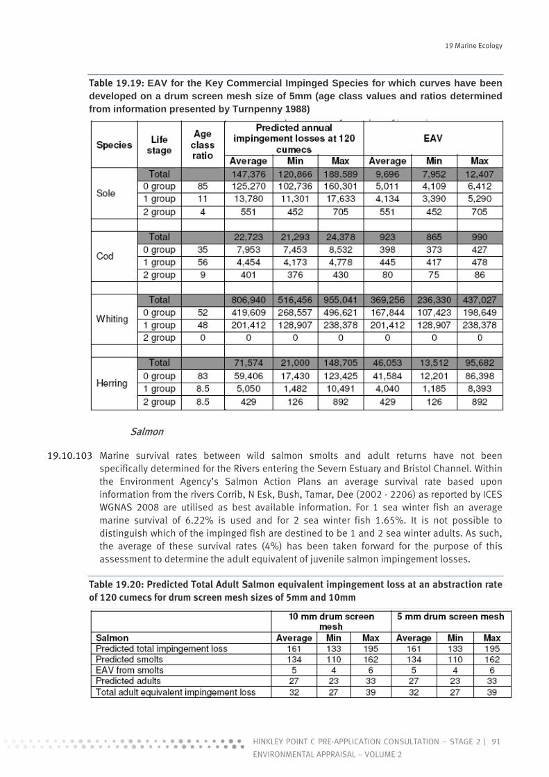
19 Marine Ecology
91HINKLEY POINT C PRE-APPLICATION CONSULTATION – STAGE 2 |
ENVIRONMENTAL APPRAISAL – VOLUME 2
Table 19.19: EAV for the Key Commercial Impinged Species for which curves have been developed on a drum screen mesh size of 5mm (age class values and ratios determined from information presented by Turnpenny 1988)
Salmon
19.10.103 Marine survival rates between wild salmon smolts and adult returns have not been specifically determined for the Rivers entering the Severn Estuary and Bristol Channel. Within the Environment Agency’s Salmon Action Plans an average survival rate based upon information from the rivers Corrib, N Esk, Bush, Tamar, Dee (2002 - 2206) as reported by ICES WGNAS 2008 are utilised as best available information. For 1 sea winter fish an average marine survival of 6.22% is used and for 2 sea winter fish 1.65%. It is not possible to distinguish which of the impinged fish are destined to be 1 and 2 sea winter adults. As such, the average of these survival rates (4%) has been taken forward for the purpose of this assessment to determine the adult equivalent of juvenile salmon impingement losses.
Table 19.20: Predicted Total Adult Salmon equivalent impingement loss at an abstraction rate of 120 cumecs for drum screen mesh sizes of 5mm and 10mm

19 Marine Ecology
92 | HINKLEY POINT C PRE-APPLICATION CONSULTATION – STAGE 2
ENVIRONMENTAL APPRAISAL – VOLUME 2
Twaite shad
For twaite shad no values for EAV or juvenile to adult mortality are available within the published literature. For the purpose of this assessment, however, an indication of EAV has been produced (Aprahamian pers. comm.) based upon a spawning mortality of 0.6651, a natural daily mortality of 0.0059, a 10 year age structure, the fecundity of 3 to 10 year old fish from Severn Estuary data sets held (APEM, 2010 (Ref. 19.146), the propensity of females of the different age classes to repeat spawn and the number of mature females of each age class. The 0+ individuals have been taken as on average 120 days old and the 1+ as 300 days old (Aprahamian pers. comm.).
Table 19.21: Predicted Total Adult Twaite Shad equivalent impingement loss at an abstraction rate of 120 cumecs for drum screen mesh sizes of 5mm and 10mm
Eel
19.10.104 Mortality rates during the transition between Yellow and Silver eel stages is estimated to be around 75% (APEM, 2010 (Ref. 19.146)). This mortality rate will be taken forward within this assessment to provide an indication of the total equivalent loss to the silver eel population.
Table 19.22: Predicted Total Adult Silver Eel equivalent impingement loss at an abstraction rate of 120 cumecs for drum screen mesh sizes of 5mm and 10mm
River and Sea Lamprey
19.10.105 Unlike many anadromous fishes which make regular migrations in the sea before homing to their natal river, both river and sea lamprey do not home, but rather exhibit regional panmixia and a novel ‘suitable river’ strategy to complete their life-cycle (Waldman et al. 2008 (Ref. 19.141)). As such, the survival of lamprey transformers does not have any direct bearing upon the number of returning adults to the natal rivers populations. No information is available regarding the survival of transformers at sea and it is not therefore possible or appropriate to convert transformer losses to equivalent adult values to determine losses to the two lamprey species populations.

19 Marine Ecology
93HINKLEY POINT C PRE-APPLICATION CONSULTATION – STAGE 2 |
ENVIRONMENTAL APPRAISAL – VOLUME 2
Table 19.23: Predicted Total River Lamprey Transformer and adult impingement loss at an abstraction rate of 120 cumecs for drum screen mesh sizes of 5mm and 10mm
Table 19.24: Predicted Total Sea Lamprey Transformer and adult impingement loss at an abstraction rate of 120 cumecs for drum screen mesh sizes of 5mm and 10mm
f) Entrainment
19.10.106 Of the seven protected fish species designated under the Severn Estuary, River Wye and River Usk SACs, six are anadromous; Atlantic salmon, twaite shad, allis shad, river lamprey, sea lamprey and sea trout. Being anadromous the early life stages of the SAC species salmon, and the BAP species, sea trout, are not likely to be vulnerable to entrainment as they will remain within freshwater during this life stage.
19.10.107 In addition, the juvenile life stages of these species present within the Estuary will be of sufficient size to occlude their passage through the travelling screen mesh and would thus be subject to impingement mortality instead. Lamprey transformers, glass eel, elvers and juvenile shad however could be vulnerable to entrainment as they may be present in the estuary at a size small enough to allow them to pass through a travelling screen mesh size of either 5 or 10mm.
19.10.108 The previous entrainment studies at Hinkley Point B and plankton studies within the vicinity of the site suggest that the eggs and larvae of the following key species are potentially at risk of being entrained through the cooling water system; bass, cod, eel, flounder, haddock, herring, lemon sole, plaice, pout, sole, sprat, gobies and whiting.
i Entrainment of Juveniles
19.10.109 The percentage of Hinkley Point B impinged individuals of a size small enough to allow them to be entrained through each of the two mesh sizes has been determined with the use of the lengths of fish recorded from the available dataset and the mesh size curves. A 50:50 impingement/entrainment ratio for a 5 mm and 10 mm drum screen mesh size has been used in the assessment.
ii Entrainment of Larvae and Eggs
19.10.110 In addition to juvenile fish, larval fish and eggs are also at risk of becoming entrained through the travelling screen mesh and into the cooling water system. These individuals will be of a size small enough that they will not have been recorded within the long-term impingement samples from Hinkley Point B. No indication of their entrainment into the cooling water

19 Marine Ecology
94 | HINKLEY POINT C PRE-APPLICATION CONSULTATION – STAGE 2
ENVIRONMENTAL APPRAISAL – VOLUME 2
system can therefore be made from the impingement data. The entrainment data collected from Hinkley Point B although giving an indication of the species likely to be entrained cannot be extrapolated to predict the number of individuals at risk of being entrained as the sampling is semi-quantitative only.
19.10.111 Estimates for entrainment have therefore been were derived through the extrapolation of densities of fish eggs and larvae recorded within plankton net samples within the vicinity of Hinkley Point in particular the Trevose spawning area. Entrainment extrapolations for sea bass eggs, Dover sole eggs and larvae and sprat larvae were determined on the basis that they would be drawn into the intake and through the travelling screen mesh in direct volumetric proportion to their densities within the Bristol Channel within the vicinity of Hinkley Point.
19.10.112 It is considered that the limitations of the available ichthyoplankton survey data with regards to the low densities and species number recorded renders the data unsuitable for extrapolation to entrainment predictions. It should be noted however, that the low densities of fish eggs and larvae recorded within the Bristol Channel at Hinkley Point would indicate that entrainment into the cooling water of these life stages is likely to be relatively low in comparison to the entrainment of juveniles of a size small enough to allow their passage through the travelling screen mesh.
iii Entrainment Survival
19.10.113 Aquatic organisms entrained through the travelling screen mesh and into the cooling water system are at risk of a number of mechanical, hydraulic, pressure, temperature and chemical related stressors during this passage. Environmental assessments regarding the entrainment of plankton within cooling water often assume 100% mortality of these planktonic organisms as a worst case scenario. The survival of entrained individuals is dependent upon the species, their developmental stage and size, physiological condition and the design of the cooling water system. A comprehensive review of entrainment survival for over 20 power stations in the USA determined a mean survival rate for a range of aquatic organisms and lifestages of over 50% (EPRI, 2000). Survival rates were highest for macroinvertebrates (72 to 92%) and lowest for sensitive fish species such as herring (mean values approaching 25%). Effects from physical, temperature and chemical stressors differed between the species. As would be expected survival was lowest for the delicate early larval stages and highest in early juveniles. For clupeids survival rates of juveniles ranged from zero to 81.5% with an average of 25%. Similar survival rates were also observed for clupeid larvae ranging from zero to 70%.
19.10.114 For the purpose of this assessment it is considered that an approach of assigning 100% mortality would give an over pessimistic view of entrainment risk. As a worst case assumption (in practice most unlikely given past operational experience at this site) it has been assumed that low dose chlorination would be continually introduced to the pumping station and therefore be present within the cooling water flow. The assessment of entrainment losses set out below has therefore taken into consideration temperature, pressure and chlorination. The following entrainment mortality rates have been taken forward in the assessment, as informed from available research;
Pelagic – herring, sprat, shad and salmon – 75%; Demersal – cod, whiting, bass, pout and haddock – 50%; and Epibenthic – eel, lamprey, flounder, lemon sole, plaice, sole, brown shrimp, glass shrimp,
pink shrimp and Atlantic prawn – 25%.
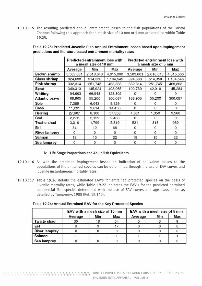
19 Marine Ecology
95HINKLEY POINT C PRE-APPLICATION CONSULTATION – STAGE 2 |
ENVIRONMENTAL APPRAISAL – VOLUME 2
19.10.115 The resulting predicted annual entrainment losses to the fish populations of the Bristol Channel following this approach for a mesh size of 10 mm or 5 mm are detailed within Table 19.25.
Table 19.25: Predicted Juvenile Fish Annual Entrainment losses based upon impingement predictions and literature based entrainment mortality rates
iv Life Stage Proportions and Adult Fish Equivalents
19.10.116 As with the predicted impingement losses an indication of equivalent losses to the populations of the entrained species can be determined through the use of EAV curves and juvenile instantaneous mortality rates.
19.10.117 Table 19.26 details the estimated EAV’s for entrained protected species on the basis of juvenile mortality rates, while Table 19.27 indicates the EAV’s for the predicted entrained commercial fish species determined with the use of EAV curves and age class ratios as detailed by Turnpenny, 1988 (Ref. 19.140).
Table 19.26: Annual Entrained EAV for the Key Protected Species

19 Marine Ecology
96 | HINKLEY POINT C PRE-APPLICATION CONSULTATION – STAGE 2
ENVIRONMENTAL APPRAISAL – VOLUME 2
Table 19.27: Annual entrained EAV for the key commercial species for which curves have been developed (age class ratios and EAV values determined from information presented by Turnpenny (1988))
g) Fish Loss Predictions in Context of Populations and Stocks
19.10.118 Pending the completion of engineering design appraisals and further assessment, the fish loss predictions in the context of fish stocks provided below have been determined on the basis of impingement and entrainment losses calculated on the basis of an early understanding of Hinkley Point C power station design (Apem 2010 (Ref. 19.146)). For the purposes of this initial appraisal the benefit of the primary means of mitigation, the use of very low velocity intake structures positioned on the seabed far offshore, has not been fully taken account.
i Protected Species
19.10.119 For those species such as twaite shad and salmon for which estimates can be made of their populations within the Bristol Channel it is possible to determine an estimate of the predicted loss to their populations that could result from abstraction of cooling water into the proposed Hinkley Point C power station intake.
Twaite shad
19.10.120 The twaite shad population within the Bristol Channel is estimated at approximately 100,000 returning adults. Predicted annual impingement/entrainment EAV losses for a drum screen mesh size of 10 mm have been estimated based on the assumptions detailed within this assessment as between 46 and 138 adult individuals. This loss would represent between 0.046 and 0.138 % of this predicted population estimate. Evaluation of impingement/entrainment impact upon twaite shad with a drum screen mesh of 10 mm is therefore considered to be of minor adverse impact.

19 Marine Ecology
97HINKLEY POINT C PRE-APPLICATION CONSULTATION – STAGE 2 |
ENVIRONMENTAL APPRAISAL – VOLUME 2
19.10.121 For a drum screen mesh size of 5 mm the impingement/entrainment EAV loss has been estimated to be between 51 and 153 adult individuals. This loss would represent between 0.051 and 0.153% of the predicted population estimate and is considered to also be of minor adverse impact.
Atlantic salmon
19.10.122 The returning adult salmon population to the tributary rivers of the Severn Estuary has been estimated at approximately 20,000 individuals. Predicted adult equivalent impingement/entrainment losses have been estimated for a drum screen mesh size of 10 mm or 5 mm to be between 28 and 40 adult individuals. This would equate to a population loss of between 0.14 and 0.2%. Evaluation of impingement/entrainment impact upon salmon for a drum screen mesh size of either 10 mm or 5 mm is therefore considered to be of minor adverse impact.
Eel
19.10.123 There are currently no published estimates of the size of the silver eel population within the Bristol Channel from which impingement/entrainment population losses could be determined. There are very few life cycle models in operation for eel or alternative methods by which population estimates of eel can be determined for the Severn or other river basin districts. The impingement/entrainment losses can however, be assessed in context with the silver eel fishery within the Estuary with an estimated annual catch in 2004 of approximately 3,065 individuals. The proportion of the silver eel population that this fishery exploits is currently unknown.
19.10.124 Predicted adult equivalent impingement/entrainment losses have been estimated for a drum screen mesh size of 10 mm to be between 583 and 3,275 silver eel individuals. This impingement/entrainment loss represents between 19 and over 100% of this predicted annual catch. Evaluation of impingement/entrainment impact upon the silver eel population of the Severn River Basin District is considered to be negative. However, the scale of this negative impact cannot be definitively determined in the absence of an understanding of the Bristol Channel population and as such a precautionary approach is taken and a moderate adverse impact is assigned to this species for a drum screen mesh size of 10 mm.
River and Sea Lamprey
19.10.125 Due to an absence of natal homing behaviour and paucity of information regarding marine survival in both river and sea lamprey populations it is not possible to determine adult equivalent values or population estimates within the scope of this assessment. There have been very few estimates of river lamprey populations both within the UK and outwith. It is therefore considered impractical at this time to make any estimate of population within the Bristol Channel. It is considered, however, that the impingement/entrainment of both river and sea lamprey into the proposed Hinkley Point C power station intake would have a negative impact upon their populations. In the absence of population information a precautionary approach is taken and a moderate adverse impact is assigned to this species.

19 Marine Ecology
98 | HINKLEY POINT C PRE-APPLICATION CONSULTATION – STAGE 2
ENVIRONMENTAL APPRAISAL – VOLUME 2
Table 19.28: Total Predicted Protected Fish Losses Resulting from the Impingement/ Entrainment by HPC Station Cooling Water Intake
ii Commercial Species
19.10.126 The commercial fish losses can be put into perspective of the Severn Estuary and Bristol Channel populations through comparison with the landings for the ICES rectangle.
Sole - the predicted adult equivalent impingement/entrainment losses into the proposed HPC power station intake represent between 0.48 and 0.74% of the total landings (267,971 Kg) with a drum screen mesh size of 10 mm and between 0.57 and 0.89% with a mesh size of 5 mm. Evaluation of impingement/entrainment impact upon sole is considered to be a minor adverse impact;
Cod - the predicted adult equivalent impingement/entrainment losses into the proposed HPC power station intake represent between 4.8 and 5.9% of the total landings (58,990 Kg) with a drum screen of 10 mm and between 5.2 and 5.9% with a mesh size of 5 mm. It is considered, however, that the impact upon the cod population as a whole is likely to be a minor adverse impact;

19 Marine Ecology
99HINKLEY POINT C PRE-APPLICATION CONSULTATION – STAGE 2 |
ENVIRONMENTAL APPRAISAL – VOLUME 2
Whiting - the predicted adult equivalent impingement/entrainment losses into the proposed HPC power station intake represent between 53 and 97% of the total landings (55,566 Kg) with a drum screen mesh size of 10 mm and between 61 and over 100% with a mesh size of 5 mm. It should be noted however that the whiting landings within the Severn Estuary and Bristol Channel are relatively low and the dominance of this species within the impingement numbers would suggest that they are a dominant species within the Bristol Channel it is therefore considered that the impact upon the whiting population as a whole is likely to be a minor adverse impact; and
Herring - the predicted adult equivalent impingement/entrainment losses into the proposed Hinkley Point C power station intake represent between 0.69 and 4.86% of the total landings (212,270 Kg) with a drum screen mesh size of 10 mm and between 0.77 and 5.45% with a mesh size of 5 mm. It should be noted however that this impact is in relation to the landings of herring within the Severn Estuary and Bristol Channel. It is considered that the impact upon the herring population as a whole is likely to be of minor adverse impact.
19.10.127 There have been no reported landings of brown, pink or glass shrimp within the Severn Estuary or Bristol Channel within the last 9 years. Although there have been some reported landings of Atlantic prawn they are on the whole very small in number.
19.10.128 An estimate has been made of the brown shrimp population within the Severn Estuary and Bristol Channel as being within the region of 1,220,000 Kg. The total predicted impingement/entrainment loss in to HPC power station intake with a drum screen mesh size of 10 mm or 5 mm has been estimated to represent between 1.07 and 1.97 %. Evaluation of impingement/entrainment impact upon the brown shrimp population is considered to be of minor adverse impact.
19.10.129 No estimates of the glass shrimp, pink shrimp, Atlantic prawn or swimming crab populations are available for the Severn Estuary and Bristol Channel. It is considered however that the impingement/entrainment of each of these species into the proposed Hinkley Point C power station intake would have a negative impact upon their populations.

19 Marine Ecology
100 | HINKLEY POINT C PRE-APPLICATION CONSULTATION – STAGE 2
ENVIRONMENTAL APPRAISAL – VOLUME 2
Table 19.29: Total Predicted Commercial Fish Losses Resulting from the Impingement/ Entrainment by HPC Station Cooling Water Intake (mean weight for each species (kg)
19.11 Mitigation Measures during Operation
19.11.1 This section contains a description of generic mitigation measures considered appropriate, along with specific mitigation for each operation activity, where required, to reduce identified significant adverse impacts to acceptable levels.
a) Generic Mitigation Measures
19.11.2 As for the construction phase, a number of generic mitigation measures would be applied. These measures would be included in the EMMP and potentially a separate EMP specifically in

19 Marine Ecology
101HINKLEY POINT C PRE-APPLICATION CONSULTATION – STAGE 2 |
ENVIRONMENTAL APPRAISAL – VOLUME 2
relation to activities that could have an effect upon the marine environment. The factors covered would be similar, but not limited, to, those listed in the mitigation section for construction.
b) Mitigation Measures for Operation of Cooling Water System
i Changes to Water Quality
19.11.3 The potential for commissioning phase and operation phase chemicals to be present within the cooling water system has been discussed above. The only contaminant considered to be present at a significant level during routine operation is hydrazine which is toxic to aquatic organisms including fish, even at very low concentrations. There is uncertainty over the rate of degradation that will apply to this substance and as a result site-specific tests are in hand that will lead to greater confidence in predictive modelling and allow informed discussion on the extent of an appropriate mixing zone (see Marine Water and Sediment Quality, Chapter 17). Should the extent of that zone be exceeded the potential for further treatment in relation to the source term on site would be considered.
ii Entrainment/Impingement
19.11.4 The impact of entrainment on fish and crustacea has been assessed in detail. It is primarily the loss of sea and river lamprey and eel that is of concern. Reducing potential losses of these, and all other species, is considered to be of benefit. As such, further engineering design considerations are in hand.
19.12 Significance of Residual Effects
19.12.1 Impacts have been assessed after taking into consideration aspects of project design and management and generic mitigation measures which would be required as part of the development. Following this approach the vast majority of impacts have been determined as of negligible-minor significance, although a couple of impacts are considered to be of moderate significance before mitigation. In these instances specific mitigation has been identified as discussed in Sections 19.10-11, or further work is in progress to determine the most appropriate mechanisms for dealing with the identified effects. The predicted residual effects as they stand are presented in Tables 19.30 and 19.31 below.
a) Construction
19.12.2 Residual significance following mitigation of potential construction phase impacts identified for the Hinkley C Power Station development are indicated in Table 19.30

19 Marine Ecology
102 | HINKLEY POINT C PRE-APPLICATION CONSULTATION – STAGE 2
ENVIRONMENTAL APPRAISAL – VOLUME 2
Table 19.30: Assessed Impacts of Significance during the Construction Phase
Significance Pre-mitigation
Reason Mitigation Residual Significance
Piling works for the offshore structures and temporary jetty
Noise and vibration
Fish Minor
Pile driving can generate underwater noise which can cause avoidance reactions or physical injury to fish
Use of vibro-piling or rotary piling and 'soft start' approach could be utilised
Minor
Construction of temporary aggregate jetty
Habitat loss and physical disturbance
Corallina turf Minor Due to pile driving activity and plant movement on the foreshore.
Delimit a narrow access and working corridor across the intertidal zone avoiding Corallina. Have temporary, floating tracks across the intertidal zone (affixed to the bed) to traverse areas of Corallina if required. Ensure careful selection of material laydown sites.
Minor
Construction of horizontal tunnels
Water quality
Corallina Minor Due to increased SSC and potential for sediment accumulation on the foreshore.
Discharge will be treated prior to release.
Minor
b) Operation
19.12.3 Residual significance following mitigation of potential operational phase impacts identified for the Hinkley C Power Station development are indicated in Table 19.31.

19 Marine Ecology
103HINKLEY POINT C PRE-APPLICATION CONSULTATION – STAGE 2 |
ENVIRONMENTAL APPRAISAL – VOLUME 2
Table 19.31: Assessed Impacts of Significance during the Operational Phase
Significance Pre-mitigation
Reason Mitigation Residual Significance
Operation of the cooling water system
Entrainment and impingement
Sea lamprey; River lamprey; Eel
Moderate Entrainment and impingement of fish at the intake.
Further consideration of engineering design being undertaken
Unknown at present
Other fish species
Moderate Entrainment and impingement of fish at the intake.
Design of intake head.
Minor
Effects of the thermal plume
Intertidal and shallow subtidal invertebrate communities
In combination, impact of B + C station would potentially be moderate; withourt combination, impact of C station alone would be low.
Potential for changes to occur to intertidal and shallow subtidal infaunal communities, particularly to the abundance of Macoma balthica.
Not assessed at present time as studies ongoing.
Unknown at present

19 Marine Ecology
104 | HINKLEY POINT C PRE-APPLICATION CONSULTATION – STAGE 2
ENVIRONMENTAL APPRAISAL – VOLUME 2
References
19.1 Warwick, R. M. & Uncles, R. J., 1980. Distribution of Benthic Macrofauna Associations in the Bristol Channel in Relation to Tidal Stress. Marine Ecology Progress Series, 3:97-103.
19.2 Warwick R., Henderson P. A., Fleming J. M. & Somes J. R.’ 2001. The impoversished fauna of the deep water channel and marginal areas between Flatholm Island and King Road, Severn Estuary. Pisces Conservation Ltd, 21pp.
19.3 Langston, W. J., Chesman B. S., Burt G. R., Hawkins S. J., Readman J. & Worsfold P., 2003. Characterisation of the South West Marine Sites: The Severn Estuary pSAC, SPA. Occasional Publications. Marine Biological Association of the United Kingdom (13) 205p.
19.4 Bamber, R.N., 1982. Mussel fouling at Hinkley Point: Hinkley Point Foreshore Survey. CERL CEGB.
19.5 Bamber, R.N., 1984. Hinkley Point EIS Studies – The Foreshore and Littoral Environment. CERL CEGB.
19.6 Bamber, R.N., Whitehouse J.W. and Coughlan, J., 1987. Hinkley Point Mussel Monitoring 1983-1986. CERL CEGB.
19.7 Bamber, R.N. & Irving, P.W., 1992. Littoral Studies at Hinkley Point 1: Corallina run-offs. Report to Nuclear Electric.
19.8 Bamber, R.N. & Irving, P.W., 1993a. Littoral Studies at Hinkley Point The Growth of Sabellaria Reefs. Report to Nuclear Electric.
19.9 R.N., & Irving P.W., 1993b. The Corallina run-offs of Bridgewater Bay. Porcupine Newsletter 5. pp. 190 – 198.
19.10 Martin, K., 1993a. Initial survey of the foreshore adjacent to Hinkley Point. Report to Nuclear Electric.
19.11 Martin, K., 1993b. An ecological survey of species with cooling water system fouling potential at Hinkley Point. Report to Nuclear Electric.
19.12 Martin, K., 1993c. A detailed survey of the lower shore adjacent to Hinkley Point. Report to Nuclear Electric.
19.13 Seaby, R.M.H. and Somes, J.R., 2001. Beach survey for mussel populations at Hinkley Point and adjoining shores, September 2001. Report to British Energy.
19.14 BEEMS, 2009a. The effects of new nuclear build on the marine ecology of Hinkley Point and Bridgwater Bay V2. EDF BEEMS (Cefas) Technical Report TR068.
19.15 Davies, J., Baxter J., Bradley M., Connor D., Khan J., Murray E., Sanderson, W., Turnbull C. & Vincent M., 2001. Marine monitoring Handbook. Joint Nature Conservation committee. P.405.
19 Marine Ecology
105HINKLEY POINT C PRE-APPLICATION CONSULTATION – STAGE 2 |
ENVIRONMENTAL APPRAISAL – VOLUME 2
19.16 NMMP (UK National Marine Monitoring Programme) (2003). Green Book (Version 7).
19.17 BEEMS, 2009b. Hinkley Point seabed habitat mapping. Interpretation of swath bathymetry, side-scan sonar and ground-truthing results. Draft 2. EDF BEEMS (Cefas) Technical Report TR039.
19.18 BEEMS, 2009c. Hinkley Point Nearshore Communities: Results of the Day Grab Surveys 2008-2009. Draft 2 EDF BEEMS (Cefas) Technical Report TR067.
19.19 BEEMS, 2009d. Hinkley Point Nearshore Communities: Results of the 2 m Beam Trawl and Plankton Surveys 2008–2009 V2. EDF BEEMS (Cefas) Technical Report TR083.
19.20 BEEMS, 2009e. Initial predictions of Impingement and entrainment by new nuclear power station at Hinkley Point in relation to adjacent fish populations and fisheries. EDF BEEMS (Cefas) Technical Report TR065.
19.21 BEEMS, 2009f. Ecological Characterisation of the Intertidal Region of Hinkley Point, Severn Estuary: Results from the 2008 Field Survey and Assessment of Risk. EDF BEEMS (Cefas) Technical Report TR029.
19.22 Kirby. P. & Parker W. R., 1983. Distribution and behaviour of fine sediment in the Severn Estuary and inner Bristol Channel, U.K. Canadian Journal of Fisheries and Aquatic Science 40 (Supplement), pp. 83-95.
19.23 Kirby, R., 1986. Suspended fine cohesive sediment in the Severn Estuary and inner Bristol Channel, U.K. Department of Energy, Energy Technology Support Unit, Rep/ ETSU-STP-4042.
19.24 Cloern, J. E., 1987. Turbidity as a control on phytoplankton biomass and productivity in estuaries. Continental Shelf Research, 7 (11/12): pp. 1367-1381.
19.25 Joint I. R. & Pomroy A. J., 1981. Primary Production in a Turbid Estuary. Estuarine, Coastal and Shelf Science, 13(3): pp. 303-316.
19.26 Joint I. R., 1984. The Microbial Ecology of the Bristol Channel. Marine pollution Bulletin, 15(2): pp. 62-66.
19.27 STPG, 1989. Review of phytoplankton and its relevance to post barrage conditions. Severn Tidal Power Group Report p. 88.
19.28 Underwood G. J. C., 1994. Seasonal and spatial variation in epipelic diatom assemblages in the Severn estuary. Diatom Research, 9: pp. 451-472.
19.29 De Jonge, V.N. & van Beusekom, J.E.E., 1995. Wind- and tide-induced resuspension of sediment and microphytobenthos from tidal flats in the Ems estuary. Limnology & Oceanography, 40(4): pp. 766-788.
19.30 Rees, C. B., 1939. The plankton in the upper reaches of the Bristol Channel. Journal of the Marine Biological Association of the United Kingdom, 23 (2): pp. 397-425
19.31 Pybus, C., 2007. Pre-bloom phytoplankton in the surface waters of the Celtic Sea and some adjacent waters, Biology and Environment. Proceedings of the Royal Irish Academy, 107: pp. 43-53.

19 Marine Ecology
106 | HINKLEY POINT C PRE-APPLICATION CONSULTATION – STAGE 2
ENVIRONMENTAL APPRAISAL – VOLUME 2
19.32 Gebühr, C., Wiltshire, K.H., Aberle, N., Beusekom, J.E.E. & Gerdts, G., 2009. Influence of nutrients, temperature, light and salinity on the occurrence of Paralia sulcata at Helgoland Roads, North Sea. Aquatic Biology, 7: pp. 185-197.
19.33 Williams, R., 1984. Zooplankton of the Bristol Channel and Severn Estuary. Marine Pollution Bulletin, 15: 66-70.
19.34 Collins, N. R., Williams R., 1981. Zooplankton of the Severn Estuary and Bristol Channel. The distribution of four copeopods in relation to salinity. Marine Biology, 64: pp. 273-283.
119.35 Bamber, R. N. & Henderson P. A., 1994. The seasonality of caridean decapods and mysid distribution and movements within the Severn Estuary and Bristol Channel. Biological Journal of the Linnean Society, 51: pp. 83-91.
19.36 Mettam, C., Conneely M.E. & White S.J., 1994. Benthic macrofauna and sediments in the Severn Estuary. Biological Journal of the Linnean Society, 51: pp. 71-81.
19.37 Langston, W. J., Chesman B.S., Burt G.R., Campbell M., Manning A. & Jonas P. J. C., 2007. The Severn Estuary: Sediments, contaminants and biota. Marine Biological Association Occasional Publication No. 19.
19.38 Warwick R., Henderson, P. A., Fleming J. M. & Somes J. R., 2001. The impoversished fauna of the deep water channel and marginal areas between Flatholm Island and King Road, Severn Estuary. Pisces Conservation Ltd, pp21.
19.39 Warwick, R. M, Davies, J. R., 1977. The distribution of sublittoral macrofauna communities in the Bristol Channel in relation to the substrate. Estuarine, Coastal & Marine Science, 5: pp. 267-288.
19.40 Warwick R., 2008. Subtidal Sabellaria alveolata reefs in the Severn Estuary. Response to issues raised by consultees following submission of the Harbour Revision Order and Environmental Statement.
19.41 Connor, D. W., Allen, J. H., Golding, N., Howell, K. L., Lieberknecht, L. M., Northen, K. O., & Reker, J. B., (2004). The Marine Habitat Classification for Britain and Ireland Version 04.05 JNCC, Peterborough.
19.42 Holt, T. J., Rees, E. I., Hawkins, S. J. & Seed. R., 1998. Biogenic Reefs (volume IX). An overview of dynamic and sensitivity characteristics for conservation management of marine SACs. Scottish Association for Marine Science (UK Marine SACs Project), p170.
19.43 Wilson, D.P., 1971. Sabellaria colonies at Duckpool, North Cornwall, 1961-1970, Journal of the Marine Biological Association of the UK, 51: pp. 509-580.
19.44 Jones, L. A., Hiscock, K. & Connor D. W., 2000. Marine habitat reviews. A summary of ecological requirements and sensitivity characteristics for the conservation and management of marine SACs. Peterborough, Joint Nature Conservation Committee. UK Marine SACs Project report.
19.45 Bonsdorff, E., 1984. Establishment, growth and dynamics of a Macorna balthica (L.) population. Limnologica, 15: pp. 403-405.

19 Marine Ecology
107HINKLEY POINT C PRE-APPLICATION CONSULTATION – STAGE 2 |
ENVIRONMENTAL APPRAISAL – VOLUME 2
19.46 MarLIN Database: http://www.marlin.ac.uk/habitats.php
19.47 Henderson, P. A., Seaby, R. M. H. & Soames, R., 2007. Fish and crustacean captures at Hinkley Point B Nuclear Poer Station: Report for the year April 2006 to March 2007.
19.48 Henderson, P. A., Seaby, R. M. H. & Soames, R., 2006. Fish and crustacean captures at Hinkley Point B Nuclear Poer Station: Report for the year April 2005 to March 2006.
19.49 Moffat, A. M. and Jones, M. B., 1993. Correlation of the distribution of Mesopodopsis slabberi (Crustacea, Mysidacea) with physico-chemical gradients in a partially-mixed estuary (Tamar, England). Vol 27, pp. 155-162.
19.50 Radford P. J., 1994. Pre- and post-barrage scenarios of the relative productivity of benthic and pelagic subsystems of the Bristol Channel and Severn Estuary. Biological Journal of the Linnean Soiety, pp. 51: 5-16.
19.51 Smith, L. P., 1978. The distribution of common intertidal rocky shore algae along the south coast of the Severn Estuary. Proceedings of the Bristol Naturalists Society, pp. 38: 69-76.
19.52 Hubbard J. C. E & Ranwell D. S., 2006. Cropping Spartina salt marsh for silage. Grass and Forage Science, 21 (3): pp. 214-217.
19.53 EMU. 2006. Severn Estuary Intertidal Biotope Mapping Baseline Phase I Study. A report Commissioned by Natural England.
19.54 Langston, W. J., Chesman, B. S., Burt, G. R., Hawkins, S. J., Readman, J., & Worsfold, P., 2003. The Severn Estuary pSAC, SPA. Occasional Publications. Marine Biological Association of the United Kingdom (13)p 205.
19.55 BEEMS, 2010a. Distribution of coralline turfs at Hinkley Point with respect to new nuclear build. EDF BEEMS (Cefas) Technical Report TR 068B.
19.56 Elliott, M. & Dewailly F., 1995. The structure and components of European estuarine fish assemblages. Netherlands Journal of Aquatic Ecology, 29(3-4): pp. 397-417.
19.57 Potter, I. C. & Hyndes G. A., 1999. Characteristics of the ichthyofaunas of southwestern Australian estuaries, including comparisons with holarctic estuaries and estuaries elsewhere in temperate Australia: A review. Australian Journal of Ecology, 24(4):pp. 395-421.
19.58 Elliott M., Whitfield A. K., Potter I. C., Blaber S. J. M., Cyrus D. P., Nordlie F. G. & Harrison T., 2007. The guild approach to categorising estuarine fish assemblages: a global review. Fish and Fisheries, 8:pp. 241-268.
19.59 Franco, A., Elliott, M., Franzoi, P. & Torricelli P., 2008. Life strategies of fishes in European estuaries: the functional guild approach. MEPS, 354:pp. 219-228.
19.60 Parker - Humphreys M. 2004. Distribution and relative abundance of demersal fishes from beam trawl surveys in the British Channel (ICES division VIIf) 1993- 2001. CEFAS Science series Technical report No. 123.

19 Marine Ecology
108 | HINKLEY POINT C PRE-APPLICATION CONSULTATION – STAGE 2
ENVIRONMENTAL APPRAISAL – VOLUME 2
19.61 Claridge, P. N., Potter I. C. & Hardisty M. W., 1986. Seasonal changes in movements, abundance, size composition and diversity of the fish fauna of the Severn Estuary. Journal of the Marine Biological Association of the United Kingdom, 66: pp. 229-258.
19.62 Potter, I. C., Bird D. J., Claridge P. N., Clarke K. R., Hyndes G. A. & Newton L. C., 2001. Fish fauna of the Severn Estuary. Are there long- term changes in abundance and species composition and are the recruitment patterns of the main marine species correlated? J. Exp. Mar. Biol. Ecol., 258: pp. 15- 37.
19.63 Henderson, P. A., 2007. Discrete and continuous change in the fish community of the Bristol Channel in response to climate change. Journal of the Marine Biological Association of the United Kingdom, 87:pp. 589 – 598.
19.64 Holden, M. J. & Williams T., 1974. The biology, movements and population dynamics of bass, Dicentrarchus labrax, in English Waters Journal of the Marine Biological Association of the United Kingdom, 54: pp. 91- 107.
19.65 Claridge P. N. & Potter I. C., 1983. Movements, abundance, age composition and growth of bass, Dicentrarchus labrax, in the Severn Estuary and inner Bristol Channel. Journal of the Marine Biological Association of the United Kingdom, 63:pp. 871- 879.
19.66 Ellis, J. R. & Shackley S.E., 1997. The reproductive biology of Scyliorhinus canicula in the Bristol Channel,U.K. Journal of Fish Biology, 51: pp. 361-372.
19.67 Henderson, P. A. & Seaby, R. M. H., 2005. The role of climate in determining the temporal variation in abundance, recruitment and growth of sole, solea solea in the Bristol Channel. Journal of the Marine Biological Association of the United Kingdom, 85:pp. 197-204.
19.68 Defra. 2009. Shoreline Management Plans. http://www.defra.gov.uk/environ/fcd/guidance/smp.htm
19.69 IUCN. 2009. http://www.iucnredlist.org/
19.70 Henderson, P. A., 1989. On the structure of the inshore fish community of England and Wales. J. Mar. Biol. Ass. UK. 69, pp. 145-163.
19.71 Henderson, P. A. & Holmes, 1989. Whiting migration in the Bristol Channel: a predator-prey relationship. J. Fish Biol. 34, pp. 409-416.
19.72 McLusky, D.S., 1989. The Estuarine Ecosystem, 2nd edition. Blackie, USA: Chapman and Hall, New York.
19.73 Riley, J. D., Symonds, J. D., & Woolner, L. E., 1981. On the factors influencing the distribution of O-group demersal fish in coastal waters. Rapp. P.-v. Reun. Cons. Int. Explor. Mer, 178, pp 223-228.
19.74 Kelley, D. F., 1988. The importance of estuaries for sea bass Dicentrarchus labrax (l.). Journal of Fish Biology 33:pp. 25-33 (supplement A).
19.75 Aprahamian, M. W. S., Lester M. & Aprahamian, C. D., 1998a. Shad conservation in England and Wales. Environment Agency, R&D Technical Report W110. Bristol, UK.
19 Marine Ecology
109HINKLEY POINT C PRE-APPLICATION CONSULTATION – STAGE 2 |
ENVIRONMENTAL APPRAISAL – VOLUME 2
19.76 Noble, R. A. A., Nunn, A. D., Harvey, J. P. and Cowx, I. G., 2007. Shad monitoring and assessment of conservation condition in the Wye, Usk and Tywi SACs. Report to Countryside Council for Wales, B100.
19.77 Harvey, J. P., Noble, R. A. A., Cowx, I. G., Nunn, A. D. and Taylor, R. J., 2006. Monitoring of lamprey n the River Wye and Usk SACs 2005-2006. Report to Countryside Council for Wales, p 91
19.78 Moore, A. Ives, S., Mead, T. A. and Talks, L., 1998. The migratory behaviour of wild Atlantic salmon (Salmo salar L.) smolts in the River Test and Southampton Water, Southern England. Hydrobiologia, Vol. 371-372, pp. 295-304.
19.79 Potter, E C E., 1988. Movements of Atlantic salmon, Salmo salar L., in an estuary in south-west England. Journal of Fish Biology, Volume 33 Issue sA, pp. 153 – 159.
19.80 Solomon, D. J. and Sambrook, H. T., 2004. Effects of hot dry summers on the loss of Atlantic salmon, Salmo salar, from estuaries in South-West England. Fisheries Management and Ecology, 11, pp. 353-363.
19.81 Claridge, P. N., Potter, I. C., Hardisty, M. W., 1986. Seasonal changes in movements, abundance, size composition and diversity of the fish fauna of the Severn Estuary. J. mar. biol. Ass. U. K. 66: pp. 229-258.
19.82 Maitland, P. S., 2003. Ecology of the river, brook and sea lamprey. Conserving Natura 2000 Rivers. Ecology Series No. 5. English Nature, Peterborough.
19.83 Noble, R. A. A., Nunn, A. D., Harvey, J. P. and Cowx, I. G., 2007. Shad monitoring and assessment of conservation condition in the Wye, Usk and Tywi SACs. Report to Countryside Council for Wales, p100.
19.84 Clyne F. J., Tipple J. R. & McTaggart K. A., 2007. Radiological Habits Survey: Hinkley Point, 2006, p. 134.
19.85 Walmsley S. A. & Pawson M. G., 2007. The coastal fisheries of England and Wales. A review of their status 2005-06. Science Series Technical Report, Cefas Lowestoft, pp. 140: 83.
19.86 Spurgeon, J., Colurullo, G., and Tinglet, D., 2001. Evaluation of inland fisheries. Environment Agency R & D Project W2-039/PR/2 (Module B), pp. 162.
19.87 BEEMS, 2009g. Initial predictions of impingement and entrainment by new nuclear power station at Hinkley Point in relation to adjacent fish populations and fisheries. EDF BEEMS (Cefas) Technical Report TR0065
19.88 BEEMS, 2010b. Review of Commercial Fisheries in the vicinity of Hinkley Point power station. Ed. 3. EDF BEEMS (Cefas) Technical Report TR071.
19.89 Reid, J.B., Evans, P.G.H., & Northridge, S.P., 2003. Atlas of Cetacean distribution in north-west European waters. P. 76 pp.
19.90 Boer, M. N. de & Simmonds, M. P., 2003. WDCS/Greenpeace Survey Report Small cetaceans along the coasts of Wales and Southwest England. WDCS Science Report.

19 Marine Ecology
110 | HINKLEY POINT C PRE-APPLICATION CONSULTATION – STAGE 2
ENVIRONMENTAL APPRAISAL – VOLUME 2
19.91 SWF (Sea Watch Foundation), 2009a. Cetacean of South-West England. Regional Fact Sheet.
19.92 Watkins, H. & Colley, R., 2004. Harbour Porpoise Phocoena phocoena Occurrence. Carmarthen Bay - Gower Penninsula - Swansea Bay.
19.93 Walton, M. J., 1997. Population structure of harbour porpoises Phocoena phocoena in the seas around the UK and adjacent waters. Proc. Royal Soc. London. B, 264: pp. 89-94.
19.94 Solandt, J. L., 2007. Marine Conservation Society Outer Bristol Channel Megafauna Surveys 2007. A collaborative project between the EA and the MCS.
19.95 SWF (Sea Watch Foundation), 2009b. Recent Sightings www.seawatchfoundation.org.uk/recentsightings.php
19.96 Newell, R. C., Seiderer, L J, Hitchcock D. R., 1998. The impact of dreding works in coastal waters: a review of the sensitivity to disturbance and subsequent recovery of biological resources on the sea bed. Oceanography and Marine Biology: an Annual Review. 36. pp. 127-78.
19.97 BEEMS, 2009h. Hinkley Point Sabellaria Assessment: Analysis of Survey Data 2009. EDF BEEMS Technical Report TR104, Cefas.
19.98 Rendel, 1986. Coastal Physiography Study for Hinkley Point C Power Station. Palmer and Tritton Ltd.
19.99 Simenstad, C. A., 1988. Effects of Dredging on Anadromous Pacific Coast Fishes. Summary and Conclusions from Workshop and Working Group Discussions.
19.100 Gibson, A. M., 1933. Construction and operation of a tidal model of the Severn Estuary. London, H.M.S.O.
19.101 OSPAR Commission 2000. Quality Status Report 2000. Region III – Celtic Seas. OSPAR Commission, London. Pp. 116 + xiii.
19.102 Clarke, R. B., 1986. Marine Pollution. Oxford: Oxford Science Publications.
19.103 Crompton, T. R., 1997. Toxicants in the aqueous system. New York: John Wiley and Sons.
19.104 Carlson, T.J., Ploskey G., Johnson R.L., Mueller R.P., Weiland M.A. & Johnson P.N., 2001. Observations of the behavior and distribution of fish in relation to the Columbia River navigation channel and channel maintenance activities. Prepared for the U.S. Army, Corps of Engineers, Portland District by Pacific Northwest National Laboratory, U.S. Department of Energy, Richland, WA.
19.105 Feist, B. E., Anderson J. J. & Miyamoto, R., 1992. Potential impacts of pile driving on juvenile pink (Oncorhynchus gorbuscha) and chum (O. keta) salmon behavior and distribution. Pound Sounds Final Report. May 1992. Seattle, WA.
19.106 Nedwell J., Turnpenny A., Langworthy J. & Edwards B., 2003a. Measurements of underwater noise during piling at the Red Funnel Terminal, Southampton, and observations of its effect on caged fish. Subacoustech Ltd. Report Reference: 558 R 0207.
19 Marine Ecology
111HINKLEY POINT C PRE-APPLICATION CONSULTATION – STAGE 2 |
ENVIRONMENTAL APPRAISAL – VOLUME 2
19.107 Richardson, W.J., Thomson D.H., Green, C.R. Jr., & Malme C.I., 1995. Marine mammals and noise. Academic Press, New York.
19.108 Vella, G., Rushforth I., Mason E., Hough A., England R., Styles P., Holt T & Thorne P., 2001. Assessment of the effects of noise and vibration from offshore wind farms on marine wildlife. A report for the DTI by ETSU, W/13/00566/REP: DTI/Pub URN 01/1341.
19.109 McCauley R.D., 1994. Seismic surveys In: Swan, J.M., Neff, J.M. Young P.c. (eds) Environmental Implications of Offshore Oil and Gas Development in Australia – the findings of an independent scientific review. APEA, Sydney.
19.110 Engas A., Misund O.A., Soldal A.V., Horvei B., & Solstad A., 1995. Reactions of penned herring and cod to playback of original frequency filtered and time smoothed vessel sound. Fisheries Research, 22: pp. 243 – 252.
19.110 Bone, Q., Marshall, N.B. & Blaxter, J. H. S. 1995. Biology of Fishes. 2nd ed. Chapman and Hall.
19.111 Hastings, M.C. & Popper, A., 2005. Effects of sound on fish. Report for the California Department of Transportation.
19.112 Higgs, D. M., Plachta, D. T. T., Rollo A. K, Singheiser M., Hastings M. C. & Popper A. N., 2004. Development of ultrasound detection in American shad (Alosa sapidissima) Journal of Experimental Biology 207,pp 155-163.
19.113 Gisner, R.C. (ed.), 1998. Workshop on the effects of anthropogenic noise in the marine environment, 10-12 February 1998. Marine Mammal Science Program, Office of Naval Research, Arlington, VA. p.141.
19.114 Slonim, A. R. & GIisclad, J.B., 1976. Hydrazine degradation in aquatic systems. Bull. environ. Contam. Toxicol., 16: pp 301-309.
19.115 Turnpenny, A. W. H., Wood, R., & Thatcher, K.P., 1994. Fish Deterrent Field Trials at Hinkley Point Power Station, Somerset, 1993-1994. ETSU T/04/00198/REP.
19.116 BEEMS, 2009i. Thermal plume dispersion at Hinkley Point in the Severn Estuary by Delft3D: Stage 2 – modelling results. EDF BEEMS (Cefas) Technical Report TR085.
19.117 BEEMS, 2009j. Thermal plume recirculation for Hinkley Point: Two models and four configurations. EDF BEEMS (Cefas)Technical Report TR040.
19.118 BEEMS, 2009k. Thermal plume recirculation for Hinkley Point: Two models and four configurations. EDF BEEMS (Cefas)Technical Report TR040.
19.119 BEEMS, 2010c. Impact of new nuclear build at Hinkley Point on intertidal food availability for birds. EDF BEEMS (Cefas) Technical Report TR068a.
19.120 BEEMS 2009l. The combined effects of Hinkley B + C and refuelling scenarios. EDF BEEMS (Cefas) Technical Report TR088, Cefas.
19.121 Schiel, D. R., Steinbeck, J. R & Foster M. S., 2004. Ten years of induced ocean warming causes comprehensive changes in marine benthic communities. Ecology. Vol. 85. no. 7. pp 1833 – 1839.

19 Marine Ecology
112 | HINKLEY POINT C PRE-APPLICATION CONSULTATION – STAGE 2
ENVIRONMENTAL APPRAISAL – VOLUME 2
19.122 Bamber, R. N., 1995b. The influence of rising background temperature on the effects of marine thermal effluents. J. Therm. Biol. Vol. 20. No. 1/2. p. 105 – 110.
19.123 Turnpenny, A. W. H. & Liney K. E., 2007. Review and development of temperature standards for marine and freshwater environments. Jacobs report for SNIFFER. Job no. 21960.
19.124 Hoffmeyer, M. S., Biancalana, F. & Berasategui, A., 2005. Impact of a power plant cooling system on copepod and meroplankton survival (Bahía Blanca estuary, Argentina). Iheringia, Sér. Zool., Porto Alegre. Vol. 95. No. 3. pp. 311 – 318.
19.125 Lukšiene D., Sandström O., Lounasheimo L. & Andersson J., 2000. The effects of thermal effluent exposure on the gametogenesis of female fish. J. Fish. Biol. Vol. 56 pp. 37 – 50.
19.126 Genner, M. J., Sims D. W., Wearmouth V. J., Southall E. J., Southward A. J., Henderson P. A. & Hawkins, S. J., 2004. Regional climatic warming drives long-term community changes of British marine fish. Proceedings of the Royal Society of London B 271:pp. 655–661.
19.127 Morris, K. H. & Maitland P.S., 1987. A trap for catching adult lampreys (Petromyzonidae) in running water. J Fish. Biol. Vol. 31 pp. 513 – 516.
19.128 Hardisty, M. W., 1986. Petromyzontiforma. In: Holcik, J. (ed). The freshwater fishes of Europe. Aula – Verlag, Wiesbaden.
19.129 Maitland P., 2003. Ecology of the River, Brook and Sea Lamprey. Conserving Natura 2000 Rivers. Ecology Series No. 5.
19.130 Farmer, G. F., Beamish, F. W. H. & Lett P. F., 1977. Influence of water temperature on the growth rate of the landlocked sea lamprey (Petromyzon marinus) and the associated rate of host mortality. J. Fish. Res. Board. Canada Vol. 34 pp. 1373 – 1378.
19.131 Gerkens, M. & Thiel, R., 2001. A comparison of different habitats as nursery area for twaite shad (Alosa fallax Lacépède) in the tidal freshwater region of the Elbe River Germany. Bulletin Français de la Pêche et de la Pisciculture 362/363. pp. 773 – 784.
19.132 GESAMP, 1984. Thermal discharges in the marine environment. UNEP Regional Seas Reports and Studies No. 45.
19.133 Turnpenny, A. W. H., Coughlan J. and Liney K.E. 2006. Review of Temperature and Dissolved Oxygen Effects on Fish in Transitional Waters. Jacobs Engineering Consultancy. Report No. 21960/01.
19.134 Clough, S. C., Turnpenny, A. W. H. & Holden, S. D. J., 2002. Experimental measurement of thermal preferenda in sea trout smolts. J. Fish. Biol. Vol. 61 Suppl. A. pp. 60 – 63.
19.135 Sandström, O., 1990. Environmental monitoring at the Forsmark nuclear power plant. National Swedish Environmental Protection Board. Report 3868.
19.136 Freitas, V., Campos, J., Fonds M., & Van der Veer H. W., 2007. Potential impact of temperature change on epibenthic predator – bivalve prey interactions in temperate estuaries. J. Ther. Biol. Vol. 32 pp 328 – 340.

19 Marine Ecology
113HINKLEY POINT C PRE-APPLICATION CONSULTATION – STAGE 2 |
ENVIRONMENTAL APPRAISAL – VOLUME 2
19.137 Henderson, P. A., Seaby R. M. & Somes J. R., 2006. A 25-year study of climatic and density –dependent population regulation of common shrimp Crangon crangon (Crustacea: Caridea) in the Bristol Channel. J. Mar. Biol. Ass. U.K. Vol. 86 pp. 287 – 298.
19.138 Horst, T. J., 1975. The assessment of impact due to entrainment of ichthyoplankton, In: 'Fisheries and Energy Production: a Symposium' (Ed. S.B. Saila), D.C. Heath, Lexington, Mass., pp 107-118.
19.139 Goodyear, C. P., 1978. Entrainment impact estimates using the equivalent adult approach, US Dept. of the Interior, Fish Wi1d1. Servo Rpt. FWS/OBS-78/65p. p14.
19.140 Turnpenny, A. W. H., 1988. The behavioural basis of fish exclusion from coastal power station cooling water intakes, CEGB CERL Report No. RD/L/3301/R88.
19.141 Waldman, J., Grunwald, C., & Wirgin, I., 2008. Sea lamprey Petromyzon marinus: an exception to the rule of homing in anadromous fishes. Biol. Lett. 23 vol. 4 no. 6 pp. 659-662.
19.142 Cefas, 2003. Preliminary investigation of the sensitivity of fish to sound generated by aggregate dredging and marine construction. Defra R&D project AE0914.
19.143 BEEMS, 2010d. Predicted effects of new nuclear build on the water quality at Hinkley Point. Ed. 3. EDF BEEMS (Cefas) Technical Report TR070.
19.144 Beukema J. J., Dekker R. & Jansen J. M. 2009. Some like it cold: populations of the tellinid bivalve Macoma balthica (L.) suffer in various ways from a warming climate. Mar. Ecol. Prog. Ser. Vol. 384 pp. 135 – 145.
19.145 BEEMS, 2010e. Coralline algae thermal sensitivity report. EDF BEEMS (Cefas) Technical Report TR110.
19.146 Apem, 2010. Provisional assessment of impingement and entrainment for the cooling water intakes for the new proposed Hinkley C Power Station. Report to EDF.


1HINKLEY POINT C PRE-APPLICATION CONSULTATION – STAGE 2 |
Chapter 19 Annex 1
REPORT ON THE HABITATS REGULATIONS ASSESSMENT (HRA) PROCESS A.1 Introduction
A.1.1 The proposed Hinkley Point C power station (HPC) is located on the margins of the Severn Estuary, an area that is of national and international importance in terms of its nature conservation interests. This is recognised through the formal designation of much of this estuarine area under two European Directives.
A.1.2 Council Directive 79/409/EEC on the conservation of wild birds (commonly referred to as the ‘Birds Directive’) provides for the protection of wild birds through the designation of Special Protection Areas (SPA). The Severn Estuary as a whole is designated under this Birds Directive as a SPA, thus providing protection to the designated bird populations that are present within the estuary and the habitats that support them.
A.1.3 Council Directive 92/43/EEC on the conservation of natural habitats and of wild flora and fauna (commonly referred to as the ‘Habitats Directive’) allows for the establishment of Special Areas of Conservation (SAC) for habitats and species listed in Annexes I and II to that Directive. The Severn Estuary as a whole is designated under this Habitats Directive as a SAC, thus providing protection for a unique and diverse range of estuarine habitats, as well as its associated migratory fish populations.
A.1.4 The Severn Estuary has also been formally designated as a Wetland of International Importance under the Ramsar Convention. This designation applies to the physical habitats of the estuary and the species that these habitats support, in particular waterbird populations.
A.1.5 A map showing the boundaries of the SAC, SPA and Ramsar Site in the vicinity of Hinkley Point is provided in the Environmental Appraisal, Volume 2 Chapter 18 on Terrestrial Ecology, as Figure 18.17.
A.1.6 The Habitats Directive was first implemented in the UK through the Conservation (Natural Habitats &c.) Regulations 1994 (the ‘Habitats Regulations’). Subsequently, a number of amendments to the Habitats Regulations have been made and in 2010 these were consolidated and amended by the Conservation of Habitats and Species Regulations 2010. These Regulations incorporate all SPAs into the definition of ‘European sites’, and consequently the protections afforded to European sites under the Habitats Directive, through the 1994 Regulations, also apply to SPAs designated under the Birds Directive.

2 | HINKLEY POINT C PRE-APPLICATION CONSULTATION – STAGE 2
A.2 The Habitats Regulation Assessment Process
A.2.1 As described in the Terrestrial Ecology and Marine Ecology Chapters (Chapters 18 and 19) of this Environmental Appraisal, it is apparent that the proposed development of HPC has the potential to interact with and have an effect upon a range of ecological interests that form part of the designated features of the Severn Estuary SAC, SPA and Ramsar Site.
A.2.2 Regulation 48 of the Habitats Regulations defines the procedure for the assessment of the implications of plans or projects for European sites. Under this Regulation, if the proposed development is unconnected with site management and is likely to significantly affect the designated site, the decision-maker must undertake an ‘Appropriate Assessment’.
A.2.3 Guidance on Planning for the Protection of European Sites: Appropriate Assessment (consultation document) (DCLG, 2006 (Ref. A1.1) recommends a three stage process:
Screening: Determining whether the plan ‘either alone or in-combination with other plans or projects’, is likely to have a significant effect on a European site.
Appropriate Assessment: Determining whether, in view of the site’s conservation objectives, the plan ‘either alone or in combination with other plans or projects’ would have an adverse effect (or risk of this) on the integrity of the site. If not, the plan can proceed.
Mitigation & Alternatives: Where the plan is assessed as having an adverse effect (or risk of this) on the integrity of a site, there should be an examination of mitigation measures and alternative solutions. If it is not possible to identify mitigation and alternatives, it will be necessary to establish the 'imperative reasons of overriding public interest' (IROPI). This is not considered a standard part of the process and will only be carried out in exceptional circumstances.
A.2.4 All three stages of the process are referred to cumulatively as a Habitat Regulations Assessment (HRA), to clearly distinguish the whole process from the step within it referred to as the Appropriate Assessment.
A.2.5 The aim of an Appropriate Assessment is to ascertain whether the proposed plan or project, either alone or in-combination with other plans or projects, would adversely affect the integrity of a European site, in light of the conservation objectives for the site. The undertaking of an Appropriate Assessment is the responsibility of the competent authority. An adverse impact is considered to be one that adversely affects the ‘coherence of the site’s ecological structure and function across its whole area or the habitats, complex of habitats and/or populations of species for which the site has been classified’.
A.2.6 An adverse effect on integrity, therefore, is likely to be one which prevents the site from making the same contribution to favourable conservation status for the relevant feature as it did at the time of designation. Appropriate Assessment is thus singularly concerned with the potential for the designated features of European nature conservation interest to be adversely affected by the proposed development, either alone or in combination with other plans or projects.
A.2.7 English Nature’s (now Natural England) Habitats Regulations Guidance Note (HRGN) ‘The Appropriate Assessment (Regulation 48)’ (English Nature, 1997 (Ref. A1.2) describes how an Appropriate Assessment should be undertaken. This guidance describes the assessment as a series of nine key steps. These steps include consultation, data collection, impact identification and assessment, recommendation of project modification and/or restriction and reporting. Table A1.2.1 sets out these steps.

3HINKLEY POINT C PRE-APPLICATION CONSULTATION – STAGE 2 |
Table A1.2.1 Recommended steps in the preparation of information to inform an Appropriate Assessment
Step Description of requirements
1 Defining the need for Appropriate Assessment
2 Consultation with relevant nature conservation agency(ies)
3 Consultation with other organisations (e.g. Environment Agency etc.)
4 Definition of the designated status of the site, the qualifying interests and the site’s conservation objectives
5 Provision of further information – this information includes information already available, new information from surveys and assessments of a technical nature
6 Consideration of the potential effects
7 Assessment of the influence of any potential impacts on the integrity of the site
8 Avoiding adverse effects
9 Conclusion regarding the potential for the scheme to adversely affect the integrity of the designated site
A.2.8 This Annex to Chapter 19 of the Environmental Appraisal describes the process that is being followed in order to support the HPC HRA and provides reference to the initial information that has been obtained and analysed to date. Reference is made to the information contained within the Environmental Appraisal chapters provided in Volumes 2 and 3, with particular emphasis on Marine Ecology (Volume 2 Chapter 19) and Terrestrial Ecology (Volume 2 Chapter 18) for the main HPC Development Site (Volume 2). Relevant information is also contained in Volume 3 of the Appraisal in relation to proposed works at Combwich Wharf, which is adjacent to the River Parrett, which, at this location, is included within the designated boundaries of the Severn Estuary SAC, SPA and Ramsar Sites.
A.2.9 As the assessment of potential effects of the HPC Development on the environment is not yet fully realised, it is not appropriate at this stage to provide an assessment of likely effects on the integrity of the designated sites in question. There are also a number of assumptions and areas of ongoing work that are of potential importance to resolving a number of environmental issues of relevance to the Appropriate Assessment process (e.g. further work on the potential influence of the cooling water thermal plume on intertidal ecology). As discussed in Chapters 18 and 19, work to resolve these issues is being advanced and will be reported upon as part of the final DCO submission.
A.2.10 Due to the potential for the influence of the proposed development to cross the England/Wales boundary in terms of impacts, both Natural England (NE) and the Countryside Council for Wales (CCW) will advise Government on matters relating to nature conservation.

4 | HINKLEY POINT C PRE-APPLICATION CONSULTATION – STAGE 2
A.3 Defining the need for appropriate assessment
A.3.1 Step 1 in the assessment process is concerned with determining the need for Appropriate Assessment, that is, whether or not the proposed development has the potential to have a significant effect on a European Site. In this case, the Infrastructure Planning Committee (IPC), as the Competent Authority, has already made a recommendation. In its scoping opinion for the HPC development (IPC, 2010 (Ref. A1.3)) the IPC has stated that on the basis of the information presented at the scoping stage, the potential exists for a significant effect on the designated status of the Severn Estuary SPA and SAC to arise as a result of the scheme, and that Appropriate Assessment should be undertaken.
A.3.2 The National Policy Statement (NPS) on nuclear power generation (DECC, 2009 (Ref. A1.4)) also provides a strategic HRA for the Hinkley Point site. This strategic HRA screened the potential designated European (and Ramsar) sites within 20 km of the proposed HPC in order to determine whether or not the proposals could have a likely significant effect. The outcome of this assessment is provided in Table A1.3.1.
Table A1.3.1 Summary of Likely Significant Effect screening for Hinkley Point C (from DECC, 2009).
European sites Water resources and quality
Habitat loss and fragmentation
Coastal squeeze
Disturbance (noise, light and visual)
Air quality
Exmoor and Quantocks Oakwoods SAC
X X X X X
Hestercombe House SAC
X X X X X
Mendip Limestone Grasslands SAC
X X X X X
River Usk SAC X X
River Wye SAC X X
Severn Estuary SAC ?
Severn Estuary SPA ?
Severn Estuary Ramsar
?
Somerset Levels and Moors SPA
X X X X
Somerset Levels and X X X X

5HINKLEY POINT C PRE-APPLICATION CONSULTATION – STAGE 2 |
Moors Ramsar
likely significant effect – Appropriate Assessment required
X no further Appropriate Assessment required
? precautionary – further Appropriate Assessment required
A.3.3 As can be seen from Table A1.3.1, the conclusion of the NPS HRA screening assessment is that Appropriate Assessment of the HPC Development proposals is required in relation to a number of designated sites in the vicinity of Hinkley Point.
A.3.4 Although the River Usk SAC and River Wye SAC lie outside of the 20 km search radius around Hinkley Point, the NPS HRA makes the point that specific designated features of these two European sites (in this instance migratory fish populations) are intrinsically linked to those of the Severn Estuary SAC. It was therefore concluded in the NPS HRA, that the potential for a significant effect upon these two river SACs could occur and that they should be included in any further Appropriate Assessment.
A.3.5 Based on the scoping opinion given by the IPC and the outcomes of the NPS HRA for HPC, the need for Appropriate Assessment of the HPC Development has thus been confirmed. The screening outcome of the HRA NPS for HPC will now be taken forward to inform the project-specific Appropriate Assessment for the HPC Development. This reflects the fact that the screening process for the NPS has been derived through extensive consultation with the various authorities and includes the views and comments made by the relevant nature conservation agencies.
A.3.6 For the purposes of informing the Appropriate Assessment at this stage in the HPC Development application, it has been assumed that the main focus of the provision of information relates to the ecology and physical processes of the Severn Estuary, and therefore of the Severn Estuary SAC, SPA and Ramsar Site. Specific information on the designated features of the other identified European sites for which a significant effect could be manifested is not considered to be a necessary or relevant element of the assessment until the significance of any effects with respect to the Severn Estuary SAC, SPA and Ramsar can be determined. This is due to the fact that the significant effect on the other European sites arises because of the interlinkages between them and the designated features of the Severn Estuary sites (e.g. shared migratory fish populations, bird populations and potentially hydrological processes). In reality, if it can be demonstrated that an adverse effect on the integrity of the designated features of the Severn Estuary SAC, Severn Estuary SPA and Severn Estuary Ramsar Site would not arise, then it can also be assumed that such an adverse effect would also not arise with respect to the designated features of the other linked European sites for which a potential significant effect has been identified. The potential linkages between these sites are recognised and the assessment of potential effects of the HPC Development on interest features and ecological processes in common will form part of the Appropriate Assessment. The issues that are being addressed in this context, and for each of the defined European sites in turn, are listed in Table A1.8.1 of this report.
A.3.7 The IPC, as the competent authority in this instance, has a responsibility to undertake the Appropriate Assessment whilst the applicant is responsible for providing the information required to inform that assessment. This current Report, as previously stated, provides an initial overview of the HRA process for the HPC Development and sets out the draft content for the Appropriate Assessment that will be provided up until the DCO application.

6 | HINKLEY POINT C PRE-APPLICATION CONSULTATION – STAGE 2
A.4 In-Combination Effects
A.4.1 The NPS HRA for Hinkley Point sets out a number of plans and projects that have the potential for in combination effects with the HPC Development to occur for designated features of the Severn Estuary SPA/SAC and other European sites listed above. These plans and projects are:
Bristol Deep Sea Container Terminal (habitat loss / change, water quality, disturbance); Decommissioning of Hinkley Point A and B (water quality, disturbance, air quality); National Grid upgrade of transmission line into Hinkley Point (habitat loss / change,
disturbance); Decommissioning of Oldbury A; Proposed new nuclear power station at Oldbury (Oldbury B); Steart managed realignment scheme; North Devon and Somerset Shoreline Management Plan (habitat loss / change).
A.4.2 The approach to dealing with in-combination effects will be to determine potential environmental parameters where spatial and temporal overlap between projects may occur (i.e. scoping of potential interactions). For these identified interactions, the likelihood of any increase (or possibly decrease) in the level of assessed impact significance for the relevant environmental parameter will then be determined and assessed against the relevant conservation objectives for the designated feature.
A.4.3 At this stage, an in-combination assessment with the outline Severn Tidal Power schemes is not proposed. These are still options for which no formal proposal has been put forward and although an HRA has been produced, this is for initial screening of options rather than an identified scheme.
A.5 Consultation
A.5.1 Consultation is considered to be an essential part of the Appropriate Assessment process.
A.5.2 To date, consultation has been undertaken across a range of issues with Natural England (NE), the Countryside Council for Wales (CCW) and the Environment Agency (EA) regarding project effects and ecological interests. This consultation has been facilitated via a number of meetings, including regular attendance and discussion of marine related project issues at the HPC Marine Authorities Liaison Group (MALG) and specific meetings to set out the issues that could potentially affect designated interests and that may require assessment.
A.5.3 The ornithological component of the assessment work has been discussed and agreed with relevant parties, including the Royal Society for the Protection of Birds (RSPB). This consultation is reported upon in the Terrestrial Ecology chapter (Chapter 18) of this Environmental Appraisal.
A.5.4 Further consultation will be undertaken as the development of material to inform the Appropriate Assessment is progressed, both during the HPC Stage II consultation process and as additional technical information becomes available.
A.6 Information on the designated sites and interests
A.6.1 The following sections provide a general description of each designated site in turn and the supporting features that could potentially be affected by the HPC Development. As discussed, the potential effects of the Project would be manifested upon the Severn Estuary and the

7HINKLEY POINT C PRE-APPLICATION CONSULTATION – STAGE 2 |
immediate hinterland of the HPC Development site. As such, the information for assessment focuses on the interests of these immediate sites (Severn Estuary SAC, SPA and Ramsar Site).
A.7 The Severn Estuary SPA
A.7.1 The following text and Tables A1.7.1 to A1.7.3 provide a summary of the designated interests of the Severn Estuary SPA.
A.7.2 The Severn Estuary qualifies as a SPA under Article 4.1 of the Birds Directive (see Table A1.7.1) by supporting internationally important populations of regularly occurring Annex 1 species (i.e. regularly supports numbers of birds over 1% of the national population).
Table A1.7.1 – Annex I qualifying species for the Severn Estuary SPA
Annex 1 species 5 year peak mean % of GB population
Bewick’s swan Cygnus columbianus bewickii
289 birds (1988/9 to 1992/3)
4.1 (1.7% North West Europe)
A.7.3 In addition, the SPA also supports internationally important populations of regularly occurring migratory species (i.e. the SPA is used regularly by 1% or more of the biogeographical population of the following migratory species), as set out in Table A1.7.2.
Table A1.7.2 – Non-Annex I migratory species for which the Severn Estuary has been designated a SPA
Non- Annex 1 migratory species
5 year peak mean (1988/9 to 1992/3)
% of population
Shelduck Tadorna tadorna 2892 birds 1.2% North West Europe
Dunlin Calidris alpina alpina 41683 2.9% East Atlantic Flyaway
Redshank Tringa totanus 2013 1.3% East Atlantic Flyaway
European white-fronted goose Anser albifrons albifrons
3002 1.0% North West Europe
A.7.4 The SPA further qualifies as it is used regularly by over 20,000 waterbirds or 20,000 seabirds in any one season (see Table A1.7.3). The Severn Estuary supported 68,026 individual birds over the period 1998/89 to 1992/93. In addition to the above, the SPA also supports national important populations of a number of waterbirds as listed below:
Table A1.7.3. Qualifying waterbird population levels for the Severn Estuary SPA.
Species 5 year peak mean (1988/9 to 1992/3)
% of GB population
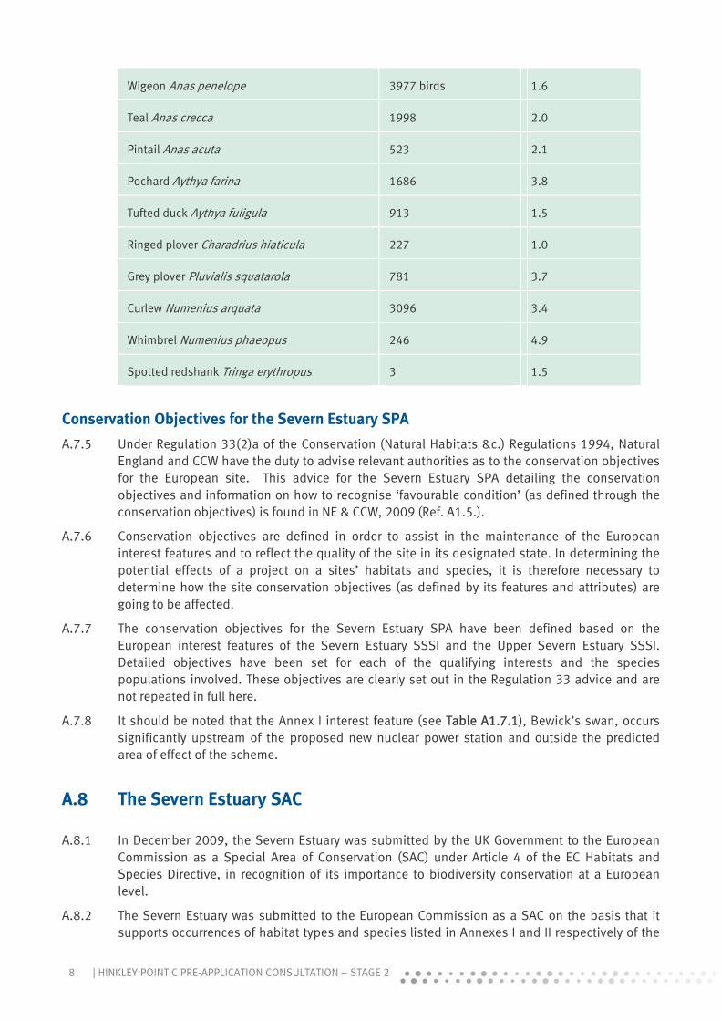
8 | HINKLEY POINT C PRE-APPLICATION CONSULTATION – STAGE 2
Wigeon Anas penelope 3977 birds 1.6
Teal Anas crecca 1998 2.0
Pintail Anas acuta 523 2.1
Pochard Aythya farina 1686 3.8
Tufted duck Aythya fuligula 913 1.5
Ringed plover Charadrius hiaticula 227 1.0
Grey plover Pluvialis squatarola 781 3.7
Curlew Numenius arquata 3096 3.4
Whimbrel Numenius phaeopus 246 4.9
Spotted redshank Tringa erythropus 3 1.5
Conservation Objectives for the Severn Estuary SPA
A.7.5 Under Regulation 33(2)a of the Conservation (Natural Habitats &c.) Regulations 1994, Natural England and CCW have the duty to advise relevant authorities as to the conservation objectives for the European site. This advice for the Severn Estuary SPA detailing the conservation objectives and information on how to recognise ‘favourable condition’ (as defined through the conservation objectives) is found in NE & CCW, 2009 (Ref. A1.5.).
A.7.6 Conservation objectives are defined in order to assist in the maintenance of the European interest features and to reflect the quality of the site in its designated state. In determining the potential effects of a project on a sites’ habitats and species, it is therefore necessary to determine how the site conservation objectives (as defined by its features and attributes) are going to be affected.
A.7.7 The conservation objectives for the Severn Estuary SPA have been defined based on the European interest features of the Severn Estuary SSSI and the Upper Severn Estuary SSSI. Detailed objectives have been set for each of the qualifying interests and the species populations involved. These objectives are clearly set out in the Regulation 33 advice and are not repeated in full here.
A.7.8 It should be noted that the Annex I interest feature (see Table A1.7.1), Bewick’s swan, occurs significantly upstream of the proposed new nuclear power station and outside the predicted area of effect of the scheme.
A.8 The Severn Estuary SAC
A.8.1 In December 2009, the Severn Estuary was submitted by the UK Government to the European Commission as a Special Area of Conservation (SAC) under Article 4 of the EC Habitats and Species Directive, in recognition of its importance to biodiversity conservation at a European level.
A.8.2 The Severn Estuary was submitted to the European Commission as a SAC on the basis that it supports occurrences of habitat types and species listed in Annexes I and II respectively of the

9HINKLEY POINT C PRE-APPLICATION CONSULTATION – STAGE 2 |
Habitats Directive that are considered important in a European context, and meet the criteria in Annex III of the Directive. The interest features of the SAC are listed in Table A1.8.1 below.
Table A1.8.1. Designated interest features for the Severn Estuary SAC
Common name Scientific term
Annex I habitat types
Estuaries Estuaries
Subtidal sandbanks Sandbanks which are slightly covered by seawater all the time
Intertidal mudflats and sandflats Mudflats and sandflats not covered by seawater at low tide
Atlantic salt meadows Atlantic salt meadows (Glauco puccinellietalia maritimae)
Reefs Reefs
Annex II species
River lamprey Lampetra fluviatilis
Sea lamprey Petromyzon marinus
Twaite shad Alosa fallax
Conservation objectives
A.8.3 Under Regulation 33(2)a of the Conservation (Natural Habitats &c.) Regulations 1994, Natural England and CCW have the duty to advise relevant authorities as to the conservation objectives for the European site. This advice for the Severn Estuary SAC detailing the conservation objectives was published as a package of material in 2009 (Ref. A1.5).
A.8.4 Natural England and CCW note in this Regulation 33 package that because of the large, varied, dynamic nature of the processes operating in the estuary and the variety of pressures affecting the system, it is difficult to precisely define what constitutes favourable condition with respect to the designated features. It is therefore stated that, in general, the conservation objectives are based on a working assumption that the current condition of the features is favourable for most attributes. It is noted, however, that there are instances where this assumption does not necessarily apply, e.g. coastal squeeze of intertidal habitats. In such instances, where existing problems have been identified, they have been reflected in the relevant objectives.
A.8.5 The conservation objectives for each of the designated features in turn is provided below. Significant detail and additional information is provided in the Regulation 33 package itself (Ref. A1.5), particularly with regard to favourable condition and the attributes of the features that contribute towards this. This information is not repeated here but will be fully utilised in supporting the Appropriate Assessment for the HPC Development.

10 | HINKLEY POINT C PRE-APPLICATION CONSULTATION – STAGE 2
Estuaries feature
A.8.6 The conservation objective for the “estuaries” feature of the Severn Estuary SAC is to maintain the feature in favourable condition. The feature will be considered to be in favourable condition when, subject to natural processes, each of the following conditions are met:
The total extent of the estuary is maintained; The characteristic physical form (tidal prism/cross sectional area) and flow (tidal regime) of
the estuary is maintained; The characteristic range and relative proportions of sediment sizes and sediment budget
within the site is maintained; The extent, variety and spatial distribution of estuarine habitat communities within the site
is maintained; The extent, variety, spatial distribution and community composition of notable communities
is maintained; The abundance of the notable estuarine species assemblages is maintained or increased; The physico-chemical characteristics of the water column support the ecological objectives
described above; and Toxic contaminants in water column and sediment are below levels which would pose a risk
to the ecological objectives described above.
Subtidal sandbanks feature
A.8.7 The conservation objective for the “subtidal sandbanks” feature of the Severn Estuary SAC is to maintain the feature in favourable condition. The feature will be considered to be in favourable condition when, subject to natural processes, each of the following conditions are met:
The total extent of the subtidal sandbanks within the site is maintained; The extent and distribution of the individual subtidal sandbank communities within the site
is maintained; The community composition of the sub tidal sandbank feature within the site is maintained; The variety and distribution of sediment types across the subtidal sandbank feature is
maintained; and The gross morphology (depth, distribution and profile) of the subtidal sandbank feature
within the site is maintained.
Mudflats and sandflats feature
A.8.8 The conservation objective for “mudflats and sandflats” feature of the Severn Estuary SAC is to maintain the feature in favourable condition. The feature will be considered to be in favourable condition when, subject to natural processes, each of the following conditions are met:
The total extent of the mudflats and sandflats feature is maintained; The variety and extent of individual mudflats and sandflats communities within the site is
maintained; The distribution of individual mudflats and sandflats communities within the site is
maintained; The community composition of the mudflats and sandflats feature within the site is
maintained; and The topography of the intertidal flats and the morphology (dynamic processes of sediment
movement and channel migration across the flats) are maintained.
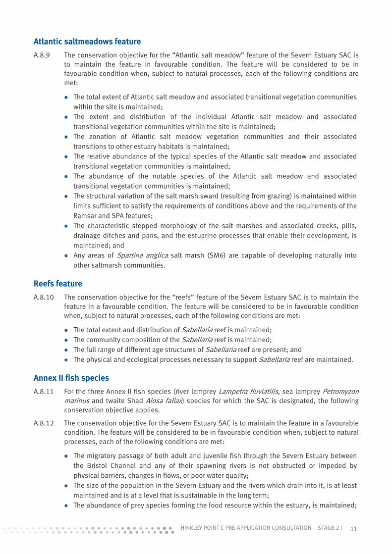
11HINKLEY POINT C PRE-APPLICATION CONSULTATION – STAGE 2 |
Atlantic saltmeadows feature
A.8.9 The conservation objective for the “Atlantic salt meadow” feature of the Severn Estuary SAC is to maintain the feature in favourable condition. The feature will be considered to be in favourable condition when, subject to natural processes, each of the following conditions are met:
The total extent of Atlantic salt meadow and associated transitional vegetation communities within the site is maintained;
The extent and distribution of the individual Atlantic salt meadow and associated transitional vegetation communities within the site is maintained;
The zonation of Atlantic salt meadow vegetation communities and their associated transitions to other estuary habitats is maintained;
The relative abundance of the typical species of the Atlantic salt meadow and associated transitional vegetation communities is maintained;
The abundance of the notable species of the Atlantic salt meadow and associated transitional vegetation communities is maintained;
The structural variation of the salt marsh sward (resulting from grazing) is maintained within limits sufficient to satisfy the requirements of conditions above and the requirements of the Ramsar and SPA features;
The characteristic stepped morphology of the salt marshes and associated creeks, pills, drainage ditches and pans, and the estuarine processes that enable their development, is maintained; and
Any areas of Spartina anglica salt marsh (SM6) are capable of developing naturally into other saltmarsh communities.
Reefs feature
A.8.10 The conservation objective for the “reefs” feature of the Severn Estuary SAC is to maintain the feature in a favourable condition. The feature will be considered to be in favourable condition when, subject to natural processes, each of the following conditions are met:
The total extent and distribution of Sabellaria reef is maintained; The community composition of the Sabellaria reef is maintained; The full range of different age structures of Sabellaria reef are present; and The physical and ecological processes necessary to support Sabellaria reef are maintained.
Annex II fish species
A.8.11 For the three Annex II fish species (river lamprey Lampetra fluviatilis, sea lamprey Petromyzon marinus and twaite Shad Alosa fallax) species for which the SAC is designated, the following conservation objective applies.
A.8.12 The conservation objective for the Severn Estuary SAC is to maintain the feature in a favourable condition. The feature will be considered to be in favourable condition when, subject to natural processes, each of the following conditions are met:
The migratory passage of both adult and juvenile fish through the Severn Estuary between the Bristol Channel and any of their spawning rivers is not obstructed or impeded by physical barriers, changes in flows, or poor water quality;
The size of the population in the Severn Estuary and the rivers which drain into it, is at least maintained and is at a level that is sustainable in the long term;
The abundance of prey species forming the food resource within the estuary, is maintained;

12 | HINKLEY POINT C PRE-APPLICATION CONSULTATION – STAGE 2
and Toxic contaminants in the water column and sediment are below levels which would pose a
risk to the ecological objectives described above.
A.9 The Severn Estuary Ramsar Site
A.9.1 The Severn Estuary was classified as a Ramsar Site on 13 July 1995 (subsuming a previously designated Upper Severn Estuary Ramsar Site). The 1995 citation is the basis for the advice issued in this document as this defines the legally protected species covered by the Ramsar designation at this time. A number of changes have been made to the criteria since the listing of the Severn Estuary Ramsar Site and it is these new (2005) criteria which are now presented on the JNCC website used by many authorities as a reference source.
A.9.2 As a matter of policy, the UK Government has chosen to apply the same procedures and levels of protection afforded to SPAs and SACs under the Habitats Regulations to Ramsar Sites (ODPM Circular 06/2005 (Ref. A1.6)).
A.9.3 The qualifying interest features of the Severn Estuary Ramsar Site are set out in detail in the Regulation 33 package. A summary of the qualifying features is provided below.
Criterion 1 : qualifies due to immense tidal range (second-largest in world), this affects both the physical environment and biological communities.
Criterion 3 : qualifies due to its unusual estuarine communities, reduced diversity and high productivity.
Criterion 4 : qualifies as it is important for the run of migratory fish between sea and river via the estuary. Species include Salmon Salmo salar, sea trout S. trutta, sea lamprey Petromyzon marinus, river lamprey Lampetra fluviatilis, allis shad Alosa alosa, twaite shad A. fallax, and eel Anguilla Anguilla.
Criterion 8 : qualifies as the fish assemblage of the whole estuarine and river system is one of the most diverse in Britain, with over 110 species recorded.
Criterion 6 : qualifies as it regularly supports 1% of the individuals in a population of one species or subspecies of waterbird.
Species with peak counts in winter - at designation:
o Tundra/Bewick’s swan o Greater /European white-fronted goose o Dunlin o Common redshank o Common shelduck o Gadwall
Populations identified subsequent to designation:
o Ringed plover (spring/autumn) o Eurasian teal (winter) o Northern pintail (winter) o Lesser black-backed gull (breeding)
Criterion 5 : qualifies as it supports an assemblage of international importance - (1998/99-2002/2003 5 year peak mean was 70,919 waterfowl.

13HINKLEY POINT C PRE-APPLICATION CONSULTATION – STAGE 2 |
Criterion 1 and 3 - Estuaries
A.9.4 The conservation objective for the “estuaries” feature of the Severn Estuary Ramsar Site is to maintain the feature in favourable condition, as defined by the conservation objective for the SAC “estuaries” feature (refer to Section 4.1.1 and Table 8 of this document), in so far as these objectives are applicable to the area designated as Ramsar Site.
Criterion 4 and 8 – Fish assemblage
A.9.5 The conservation objective for the “assemblage of migratory fish species” feature of the Severn Estuary Ramsar Site is to maintain the feature in favourable condition, as defined below. The feature will be considered to be in favourable condition when, subject to natural processes, each of the following conditions are met:
the migratory passage of both adults and juveniles of the assemblage of migratory fish species through the Severn Estuary between the Bristol Channel and any of their spawning rivers is not obstructed or impeded by physical barriers, changes in flows, or poor water quality;
the size of the populations of the assemblage species in the Severn Estuary and the rivers which drain into it, is at least maintained and is at a level that is sustainable in the long term;
the abundance of prey species forming the principle food resources for the assemblage species within the estuary, is maintained; and
toxic contaminants in the water column and sediment are below levels which would pose a risk to the ecological objectives described above.
Criterion 6 and 5 – Bird assemblage
A.9.6 The conservation objective for the internationally important populations of waterfowl (defined species populations – Bewick’s swan, European white-fronted goose, dunlin, redshank, shelduck and gadwall) for the Severn Estuary Ramsar Site is to maintain the feature in favourable condition, as defined by the conservation objectives for the SPA internationally important populations of waterfowl.
A.9.7 The conservation objective for the “internationally important assemblage of waterfowl” feature of the Severn Estuary Ramsar Site is to maintain the feature in favourable condition, as defined by the conservation objective for the SPA “internationally important assemblage of waterfowl” feature.

14 | HINKLEY POINT C PRE-APPLICATION CONSULTATION – STAGE 2
A.10 Provision of relevant information
Introduction
A.10.1 Significant information relating to the potential effects of the HPC Development is provided in this Environmental Appraisal. With regard to the designated features of the European sites, this information is contained within the chapters on Terrestrial Ecology (which includes information on coastal ornithology) and Marine Ecology for both the HPC main site and, where relevant, analogous sections on the Off-site Associated Development.
A.10.2 At this stage in the assessment and consultation process, a full and detailed analysis of the effects of the HPC Development on the designated features of the relevant European sites has not been advanced. This is due to the need to ensure that the information, as provided in this Environmental Appraisal, is consulted upon, and views and comments provided during this process are taken on board prior to determining the final assessment. There are also several areas of ongoing work that are of critical importance to determining the significance of some effects, notably the effect of the thermal plume from the cooling water system on estuarine ecology.
A.10.3 The assessment is an iterative process and until complete it is considered inappropriate to provide a view on the effect of the HPC Development on the integrity of the designated features of the European sites that are of relevance to the project.
A.10.4 For the purposes of this Stage II consultation exercise, and in line with the overall HRA process as described above, one function of this Appraisal is to ensure that the right level of information to cover the issues of relevance to the Appropriate Assessment is being provided.
A.10.5 Whilst the relevant information contained in this Appraisal has not been explicitly linked to the designated features of the European sites or assessed in connection with the relevant conservation objectives for these features, it can be readily utilised to determine both the potential for an effect to occur and the likely scale and significance of any effect.
A.10.6 The following sections of this Annex thus provide an overview of the relevant information, its applicability to the designated features and, most importantly, a review of the likely effects of the HPC Development on the designated features and, lastly, where information in the Environmental Appraisal relevant to these issues can be located.
A.10.7 Following the HPC Stage 2 consultation process and through further consultation (as required) with the relevant authorities, the information in order to inform the Appropriate Assessment will be produced in parallel with the DCO Application for the HPC Development. This will provide a detailed analysis of the information in relation to the designated features of the relevant European sites and their conservation objectives.
Information on the Severn Estuary
A.10.8 The following sections of text provide an overview of the ecology of the Severn Estuary with an emphasis on the features for which the Severn Estuary SAC, SPA and Ramsar site have been designated. This is primarily provided in order to set the context for the assessment that will follow, but also to provide background to the list of HPC Development effects provided in Table A1.10.1 below.
15HINKLEY POINT C PRE-APPLICATION CONSULTATION – STAGE 2 |
Estuarine habitats
A.10.9 The Severn Estuary is one of the largest estuaries in Britain with an area of 557 km2 including an intertidal area of 100 km2. The Severn also experiences one of the largest tidal ranges in the world which can be in excess of 14.5 m. The habitats of the estuary are largely defined by the distribution of tidal shear forces and the tidally-dominated sediment transport processes which result in both continual cycles of suspension/deposition/resuspension of superficial bed sediments and very high turbidity levels throughout the water column. These, and other Key Features and their significance, are reviewed in Chapters 16 and 19 of this Appraisal.
A.10.10 Phytoplankton growth is severely inhibited in the open waters of the Severn Estuary due to this high turbidity regime. Macroalgal is also reduced, particularly below MLWS. Research has suggested that the lack of macroalgae below MLWS is not due to turbidity alone as the scouring effect of the silt under high levels of shear may interfere with the settlement of algal spores (Langston et al., 2003 (Ref. A1.7)).
A.10.11 Whilst the algal flora is generally impoverished, there are isolated locally important red algal communities such as Corallina officinalis run-offs which grow on the rock platforms at Hinkley Point, Bridgwater Bay (Bamber & Irving, 1993 (Ref. A1.8)). These run-offs are interesting as they are more often found in a constantly submerged environment, and they support a diversity of fauna not common elsewhere in the Estuary.
A.10.12 The subtidal benthos is generally impoverished due to the combination of high turbidity, shear stresses and continual bed resuspension but intertidal productivity is higher where the presence of microphytobenthos is significant.
A.10.13 A large amount of the Estuary is subtidal and this includes habitat that supports the only extensive subtidal Sabellaria alveolata reef in Britain. The intertidal rock platforms support a wide variety of invertebrate species whilst large fringes of saltmarsh support swathes of Spartina; a Zostera bed is also present near the maximum turbidity zone.
Overview of mudflats and sandflats
A.10.14 The extensive mudflats and sandflats in the Severn Estuary cover an area of approximately 21,000 ha (NE & CCW, 2009 (Ref. A1.5)). The presence and absence of marine flora and fauna is related closely to the physical characteristics of the Estuary. Both intertidal and subtidal invertebrate communities are important for the functioning of the estuarine system, partly because they form a fundamental part of the food web leading to higher consumers such as the waterfowl, and fish populations. Intertidal invertebrates are preyed upon directly by waterfowl whereas the relatively highly impoverished subtidal invertebrate assemblages may contribute relatively little by way of recruitment towards intertidal community abundance and diversity. In general, the Severn Estuary littoral zone supports a relatively low density and diversity of plant and animal species compared with other UK estuaries as extreme physical conditions limit the range of some of the more ‘usual’ estuarine organisms (Langston et al., 2003 (Ref. A1.7).
A.10.15 Invertebrates can be broadly classified into two groups, depending on their mode of feeding, into suspension (or filter) feeders and deposit feeders. Suspension feeders feed by filtering material from the water column, whereas deposit feeders feed on detrital material contained within the sediments within the bed of the estuary. Warwick et al.,1989 (Ref. A1.9) conducted a comparative study of the intertidal benthic invertebrate communities at 40 estuaries (including the Severn) in SW England. Multivariate analysis of species abundance and biomass data showed that the fauna of the Severn Estuary was distinct from all the other estuaries and had a number of features which set it apart from others. The differences were thought to result from the high turbidity and sediment instability. There is a distinct lack of suspension feeders (both bivalves and other invertebrates) and, again, this is attributed to the high turbidity levels and

16 | HINKLEY POINT C PRE-APPLICATION CONSULTATION – STAGE 2
scouring associated with the sediment. By contrast, physically robust species that are not suspension feeders are present in higher abundances, e.g. the small gastropod mollusc Hydrobia ulvae in the muds and the shrimp Bathyporeia in the sands. Populations of several invertebrate species, notably Nephtys, Macoma and Hydrobia and to a lesser extent Nereis, were dominated by small individuals suggesting a shorter lifespan, indicative of high levels of disturbance-related stress. In some locations, there were high densities of particular species, such as the marine worms Hediste diversicolor and Haustorius arenarius, and such patches may contribute to the importance of these mudflats as feeding grounds for waterbirds.
A.10.16 The intertidal mudflats and sandflats are an interest feature of the SAC and a supporting habitat of the SPA that could potentially be affected by the HPC Development. Such impacts might arise through:
Habitat loss and disturbance during construction; and Effects on water quality, notably through the cooling water thermal plume.
A.10.17 These effects are covered in the Marine Ecology chapter (Chapter 19, Volume 2) for the HPC Development Site and also the Ecology section for Combwich Wharf (within Volume 3 of this Appraisal).
Overview of Saltmarsh
A.10.18 Saltmarsh covers approximately 1,400 ha in the Severn Estuary, the majority of which (1,150 ha) is on the SE (English) side of the Estuary. The distribution of saltmarsh within the Severn Estuary is given in the Regulation 33 Advice for the Severn Estuary SAC. Arlingham represents the upper limit for saltmarsh and it extends seawards as far as Catsford Common in Bridgwater Bay on the east side, and Lamby in Wales, extending up the Rhymney River. There has been a substantial reduction in the area of saltmarsh (Spartina anglica) in the outer Estuary since the late 1970s, together with an increase in the central and upper Estuary.
A.10.19 The Severn Estuary saltmarshes are generally grazed by sheep and/or cattle; this is a significant factor determining the plant communities found in them. The extreme tidal range in the Severn Estuary has led to extensive saltmarsh community development with expanded zonation. This includes upper marsh transitions to terrestrial and freshwater habitats that support rare and uncommon species. Another important feature is a series of micro-cliffs or steps that have developed as a result of past cycles of erosion and deposition. These add diversity to the saltmarsh by initiating new patterns of species zonation. Steep banked creeks cross the saltmarsh which provide shelter from the prevailing south westerly winds. The grazed saltmarsh is dominated by the common saltmarsh grass Puccinellia maritima and red fescue Festuca rubra. Some of the saltmarshes show a sequence of saltmarsh cliffs related to past cycles of accretion and erosion. Recent monitoring has identified that there is a complicated present day pattern of erosion and accretion of the saltmarshes throughout the Estuary and some parts appear to be exhibiting the effects of coastal squeeze (ABPmer, 2007 (Ref. A1.10)).
A.10.20 The Severn Estuary saltmarshes provide an input of organic matter into the estuary water column which is important, given the restricted macroalgal growth. Saltmarsh provides a feeding area for waterfowl and the upper saltmarsh, in particular, may provide conditions suitable for use by roosting waterbirds. They also have an important physical role, acting as a sediment store to the Estuary as a whole.
A.10.21 There is no saltmarsh vegetation along the frontage of the proposed HPC Development. The nearest saltmarsh is found fronting Catsford Common, some 3.5 km to the east. There would be no direct effects on this interest feature as a result of the development. While it is considered highly unlikely, the potential exists for water quality effects (thermal upload of the water
17HINKLEY POINT C PRE-APPLICATION CONSULTATION – STAGE 2 |
column) to impinge upon the intertidal area close to Catsford Common. Therefore, the potential for an effect on saltmarsh vegetation cannot be ruled out.
Overview of subtidal habitats and associated sediments
A.10.22 The subtidal sediments of the Severn Estuary, including sandbanks, vary from gravely to muddy sediments and their distribution is dominated by the prevailing tidal regime. The mobility of these sediments means that they only support animals that can tolerate the shifting seabed and constant levels of tidal scour. The faunal assemblages thus reflect the high turbidity regime and the strong tidal shear forces involved.
A.10.23 The subtidal sandbanks within the Estuary are an Annex I habitat type and as such, form one of the designated features of the Severn Estuary SAC. The sandbanks of the Middle and Welsh Grounds are relatively permanent features in the Severn Estuary, along with other long-established sandbank features at Cardiff Grounds and in Bridgwater Bay. The tops of these banks are intertidal. More ephemeral sandbanks also occur in the Estuary, including areas offshore from Avonmouth and at English Grounds (near Clevedon). The relatively long-established subtidal sandbanks are also associated with a fringe of other sediments; these are linked by sediment transport processes and are considered to be an integral part of the sandbanks feature. An example of an area of associated sediment is Holm sands (located in the middle of the Estuary between Cardiff and Weston-super-Mare. Comprising medium to coarse sand with a low silt content, Holm sands supports a sparse fauna of small polychaetes (Mettam et al., 1994 (Ref. A1.11)).
A.10.24 Due to the dynamic nature of these sediments, the subtidal sandbanks of the Severn Estuary are highly impoverished compared to similar habitats further seaward in the Bristol Channel and elsewhere in the British Isles. Work undertaken by Mettam et al., 1994 (Ref. A1.11) found that many subtidal sites in the Estuary with sandy sediment type were without fauna. This was also noted in work undertaken by Warwick et al., 2001 (Ref. A1.12) which consisted of a number of grab samples within the deepwater channel of the Severn Estuary. Of the 62 grab samples collected, 22 contained no animals. In the remainder, where sandy substrate was recorded, the maximum number of infaunal species was only two. Only subtidal muddy gravels and pebble areas surveyed in the Cardiff Bay area by Mettam, et al., 1994 (Ref. A1.11) yielded relatively high numbers of species. Both surveys recognise that where fauna are recorded, species are commonly recorded across the British Isles. Due to the lack of abundance of small prey species living in and on the sandbank features in the Severn Estuary, they are not considered to support important populations of fish or seabirds.
A.10.25 In addition to the sand and gravel substrates, the Severn Estuary also contains extensive areas of subtidal mud. Due to the high turbidity and strong tidal currents, this mud tends to have a high water content and is extremely mobile. Hydrodynamic studies in the Hinkley Point area have indicated that the ‘fluid’ mud in the Severn Estuary is entrained up into the water column on most tides, and re-deposited only during the weakest neaps. The two main areas within the Estuary where this mud is present are Bridgwater Bay, near Burnham-on-sea, and Peterstone Flats, between Cardiff and Newport. Due to the lack of stability in these sediments, and the associated difficulty in sampling it, infauna is understood to be both impoverished and transient. These areas are almost contiguous with areas of muddy sand substrates where the fauna is marginally richer yet still impoverished. The muddy sand supports low numbers of cirratulids, capitellids and oligochaetes.
A.10.26 The subtidal sandbanks are an interest feature of the SAC. The nearest such area is located approximately 3 km to the north-east of Hinkley Point, in Bridgwater Bay. It is considered highly unlikely that the HPC Development would have a direct or indirect impact upon this feature.

18 | HINKLEY POINT C PRE-APPLICATION CONSULTATION – STAGE 2
However, the potential for the following project effects to impact upon the feature will be considered in support of the Appropriate Assessment:
Habitat loss and disturbance during construction / operation; and Effects on water quality, notably the cooling water thermal plume.
A.10.27 These effects are covered in the Marine Ecology chapter (Chapter 19, Volume 2) for the main site and also the Ecology section for Combwich Wharf (within Volume 3 of this Appraisal).
Biogenic reefs
A.10.28 The subtidal environment of the Severn Estuary also supports a patchy distribution of biogenic reefs, composed of tubes built by small worms (Sabellaria spp.) forming honeycomb-like structures.
A.10.29 Although Sabellaria use sand particles to build their tubes, they require a relatively stable substrate on which to settle such as the exposed bedrock and gravelly substrates found in some parts of the Severn Estuary. Sabellaria alveolata is predominantly an intertidal species but the Severn Estuary is one of the few places in the UK where S. alveolata occurs extensively in the subtidal as well as the intertidal, although most commonly not in the form of reef.
A.10.30 There are patches of intertidal S. alveolata reef throughout the Estuary although it tends to be more common on the English side. The subtidal S. alveolata tends to be in the outer parts of the Estuary, southwest of Clevedon and Newport. These biogenic reefs, in combination with the harder substratum on which they are built, tend to increase habitat diversity for other species leading to higher species diversity within the reefs compared to the surrounding sediment or rock. Epifaunal species such as hydrozoans, anthozoans, tunicates and bryozoans can attach to the surfaces of larger stable gravel particles whilst crevice fauna, such as the scale worm Harmothoe, can exist between the larger substrate materials. Sediment pockets between gravel and cobble particles may also provide habitat for infaunal species such as the polychaete worm Mediomastus fragilis.
A.10.31 Sabellaria alveolata (the ‘honeycomb worm’) was the most abundant benthic animal in the surveys reported by Mettam, et al., 1994 (Ref. A1.11) and Warwick et al., 2001 (Ref. A112). Sabellaria was found on hard substrates in the lower intertidal and subtidal areas of the estuary in a variety of forms, ranging from individual worms in single or multiple tubes encrusting the surfaces of pebbles, to colonies forming large reefs.
A.10.32 The S. alveolata reefs are considered to be relatively species-rich compared with other subtidal habitats in the Severn, although it should be noted that in relation to Sabellaria reefs seaward of the Bristol Channel and throughout the British Isles, those within the Severn Estuary are impoverished (MBA, 2003 (Ref. A1.13) and Warwick et al., 2001 (Ref. A1.12)). Colonies within the Estuary are readily subject to burial because of the shifting nature of the bottom sediments, and so reefs are often ephemeral in nature. The most extensive survey of Sabellaria covering the whole Estuary was undertaken by Mettam, et al., 1994 (Ref. A1.11).
A.10.33 S. alveolata is known to have a very variable recruitment and the cover in any one area may vary greatly over a number of years. S. alveolata reefs also cycle through different phases, from newly settled worms through vigorous fast growing reef to older hummocks. For the purposes of the conservation objectives associated with the Severn Estuary SAC, a reef is defined (NE & CCW, 2009 (Ref. A1.5) as a dense aggregation of worms (over 1000 per m2), generally forming a thick (2 cm or more) crust of tubes. The area covered by the habitat would generally exceed 25 m2 although there could be patchiness within this area. Such a habitat will be considered to be in favourable condition if the full range of different age structures are present (NE & CCW, 2009 (Ref. A1.5).

19HINKLEY POINT C PRE-APPLICATION CONSULTATION – STAGE 2 |
A.10.34 Intertidal Sabellaria reefs are known to occur in Bridgwater Bay, both fronting the Hinkley Point A site on the lower shore, 5-6km to the east of Hinkley Point, and off Benhole Point, approximately 500 m West of the SSA boundary. Tubes of Sabellaria were recorded intermittently during recent surveys but no indication of actual reef form has been found in the nearby subtidal area, although habitat mapping suggests some potential (see Chapter 19, above). Given this distribution pattern, the potential for an effect on Sabellaria reef is considered to be a possibility and the following project effects would need to be assessed in relation to this feature in support of the Appropriate Assessment:
Habitat loss and disturbance during construction / operation; Alteration of hydrodynamic regime; Discharges to the foreshore during construction and operation; and Effects on water quality, notably associated the cooling water thermal plume.
A.10.35 These effects are covered in the Marine Ecology chapter (Chapter 19, Volume 2).
The Severn Estuary fish community
A.10.36 The high tidal flows and turbidity observed in the Severn Estuary create harsh environmental conditions for fauna, with the sub-tidal seabed areas being particularly impoverished in terms of invertebrates. It is often claimed that this results in a unique fish community. However, the fish community is broadly similar in structure to that of other estuaries in the south of England (Henderson, 1989 (Ref. A1.14)).
A.10.37 The impoverished benthic fauna means that the fish productivity of the estuary is primarily dependant upon hyperbenthic species and mobile (and predominantly intertidal) crustacea including mysids and amphipods, and the brown shrimp Crangon crangon (Henderson & Holmes, 1989 (Ref. A1.15)).
A.10.38 Few fish complete their entire life cycle in the Estuary. Rather, most marine species exploit the Estuarine conditions as juveniles, moving in and out of the Estuary seasonally in response to limitations of low temperature and salinity in the latter part of winter. Whilst in some UK estuaries, the benefit of this behaviour may be a combination of food availability and energetic advantage, food availability is a less likely benefit in the Severn although the very high turbidity levels may limit predation. The variable chemical and physical conditions prevalent in the Estuary, combined with low levels of small zooplankton required by larval fish, render it unsuitable for growth. Post-juvenile fish thus migrate offshore to waters with more stable physico-chemical conditions and a greater abundance of planktonic prey. On maturation, many fish move offshore. Eggs and larvae are then flushed back into the estuary via tidal movements in the summer and autumn, although some post-larval fish such as sprat and transparent goby may enter in early spring.
A.10.39 Although not unique in terms of its community, Henderson & Seaby, 2000 (Ref. A1.16) conclude that the extent of sheltered estuarine habitats present means that it must be considered to be one of the more important nursery areas in Britain.
Marine fish species
A.10.40 The broader fish population of the Severn Estuary is of a similar species composition to that of other estuaries and coastal regions in south–west England (Henderson, 1989), comprising approximately 80 species. The most common species are sprat and whiting, which are present at an order of magnitude higher by number than the next most abundant species namely poor cod, sand goby, sea snail, pout and sole. For marine species, the Estuary is primarily used as a
20 | HINKLEY POINT C PRE-APPLICATION CONSULTATION – STAGE 2
nursery ground – the extensive areas of shallow marginal mudflat provide extensive juvenile feeding opportunities, but none of the species present completes its entire life cycle within the estuary. Studies indicate that the estuary holds a single, mobile fish community and relative abundances observed at HPB are representative of the Estuary between Berkeley and Minehead.
A.10.41 Recent years have see a marked increase in the abundance and species richness of fish in the Estuary (Henderson and Seaby, 2000 (Ref. A1.16), which may be as much as threefold the abundance compared with numbers observed in the early 1980s (Ref. A1.16). Although this is partially attributable to improved water quality, as proposed by Potter et al., 2001 (Ref. A1.18), the annual monitoring undertaken at Hinkley Point B Power Station, summarised most recently in Henderson et al., 2007 (Ref. A1.19), suggests that the gradual increase in the number of fish caught could be related to increasing sea temperature and decreased salinity. Increased abundance was observed for species which are relatively close to their northern limits in the Bristol Channel such as sole and bass. Conversely, species relatively close to their southern limit in the Bristol Channel (i.e. relatively cold-water preferring species) e.g. dab and sea snail, have experienced a decline in abundance. An observed step change in the set of occasional visitor species (i.e. those with a northern distribution approximating with, or south of the Bristol Channel) was also related to increased sea temperatures.
A.10.42 The majority of fish species which occur in the Severn Estuary can be regarded as opportunists, which spawn outside the Estuary. The tolerance of lower salinities of many of these opportunists enables them to exploit the higher productivity and/or lower predation risk present in parts of the estuary.
A.10.43 Larvae of these species are tidally transported from offshore areas into the estuary in the late summer and autumn. Upon metamorphosis, these then colonise progressively upstream areas for a number of months utilising selective tidal stream transport. Broadly speaking, young of the year migrate seaward again in winter months, in response to reducing salinity (Claridge & Potter, 1984 (Ref. A1.20)) and/or temperature. In the case of a number of fish species, in particular gadoids, the seaward migration is closely correlated with, and in response to, abundance of C. crangon (Ref. A1.20). This pattern of progressive colonisation in late summer and autumn, peak abundance in September and October, followed by reduced abundance due to seaward migration, can be seen for sand goby, sole, dab, pout and bass, with similar, but delayed patterns occurring for poor cod whiting and grey mullet. Such species will undertake several years migrating between the estuary and sea, before maturing when they will adopt a purely offshore existence.
A.10.44 Intertidal mudflats are of primary importance to fish. Of the four most abundant flatfish in the Severn, plaice and flounder utilise tidal transport to migrate shorewards with rising tides, feeding only on intertidal areas at high tide. Dab and sole, however, also utilise subtidal habitats for feeding. This dependence on, and preference for, intertidal areas is related to prey abundance, notably C. crangon which is a key prey source (Ref. A1.15). The preference for sheltered shallow areas is also noted for gadoids (A1.20) and bass.
Migratory fish species
A.10.45 Migratory (diadromous) fish species primarily utilise the Estuary for migration between their natal rivers, most notably the rivers Wye, Usk and Severn, and marine feeding grounds. They may also use the Estuary for feeding, e.g. in the case of juvenile shad, and river lamprey.
A.10.46 No systematic targeted surveying or sampling of diadromous species is undertaken in the Estuary. Indeed, the paucity of diadromous species in Hinkley Point B Power Station intake
21HINKLEY POINT C PRE-APPLICATION CONSULTATION – STAGE 2 |
records indicates that these species are highly dispersed in the Estuary, and can only be sampled in meaningful numbers when aggregated for reproduction in rivers.
A.10.47 Various data sources exist for diadromous species. Due to the high recreational, commercial and conservation value of salmon, a systematic monitoring framework exists for determining the status of various salmon fisheries. Data from rod catches and in some instances fish counters is used to estimate total run size, annually, on a river-by-river basis.
A.10.48 The designation of the Wye, Usk and Tywi for shad and the Wye and Usk for sea and river lamprey has created the impetus for monitoring of these populations. Recent reports on lamprey by Harvey et al., 2006 (Ref. A1.21) and shad by Noble et al., 2007 (Ref. A1.22) provide the basis for assessment of these species. Both reports also discuss the results of surveys for these river populations in terms of the Severn Estuary. River specific datasets have been used to assess the status of riverine populations of species directly; the status of these species in the Estuary has been inferred largely from this data.
A.10.49 Lamprey and shad surveys carried out on the rivers Wye and Usk indicate conditions for these rivers (Refs. A1.21 and A1.22). In the absence of direct data, the Severn Estuary populations for these species can be inferred, and the validity of inferring the health of Estuary populations from the adjacent rivers specifically in the context of the Severn Estuary is discussed by Harvey et al., 2006 (Ref. A1.21). The main uncertainty lies in the extent to which other rivers (most notably the Severn) contribute to the estuarine population and the health of these populations. If, as has been suggested, lamprey populations are less faithful to their river of birth and the Severn population is therefore a more homogenous population, then the status of the species in any one river (e.g. the Wye and Usk) can be considered to be representative of the estuarine population as a whole. If this is not the case, the Usk and Wye are likely to comprise a sufficiently large proportion of the Severn Estuary population that the assumption is nonetheless correct.
A.10.50 It is apparent from the data collected over many years from the HPB station that the designated Annex II fish populations occur within the area that could be affected by the HPC development. A number of potential effects could be manifested. These include:
Habitat loss and change; Water quality effects, particularly the role that the cooling water thermal plume may play in
influencing migratory behaviour; Entrainment and impingement of fish at all stages of their life cycles.
A.10.51 These effects are covered in the Marine Ecology chapter (Chapter 19, Volume 2).
Marine and estuarine ornithology
A.10.52 The diverse and extensive habitats of the Severn Estuary, particularly intertidal mudflats and sandflats, provide feeding habitat for large numbers of waterbirds that move along the west coast of Europe during the spring and autumn migration period, as well as for wintering populations of swans, geese, ducks and waders.
A.10.53 Subsequent to the original designation of the SPA, the JNCC has undertaken a review of the SPA network on behalf of the various country nature conservation agencies (JNCC, 2001 (Ref. A1.23)). The review updates the assessment of UK SPAs published in 1992 and takes account of a number of new ornithological surveys undertaken throughout the UK and up to date abundance and distribution data for a wide number of species (e.g. Wetland Bird Survey (WeBS)). Through the review of the SPA network, the JNCC recommended to Government a definitive list of sites, identified against explicit selection guidelines.

22 | HINKLEY POINT C PRE-APPLICATION CONSULTATION – STAGE 2
A.10.54 Most notable is the reduction in the wintering population of European white-fronted geese which has resulted in the Severn no longer being internationally important for this species. The wintering population, which is largely confined to the upper estuary in the vicinity of Slimbridge, has declined in recent years as more birds remain at sites in the Netherlands and to the east. The Severn, though, still remains the most important site in Britain for the wintering Russian (European) population of this species.
A.10.55 Two species, curlew Numenius arquata and pintail Anas acuta reached the international qualifying threshold and the Severn now also qualifies for these species. The site also reached the threshold for international importance for its population of ringed plover Charadrius hiaticula on passage (designated as of national importance in the original designation). Between 92/93 and 95/96 the Estuary/SPA also showed a significant increase in the total wintering waterbird population with the 5 year peak mean rising from 68,026 to 93,986.
A.10.56 In addition to the nationally important species, the Estuary also supports important (but not meeting national 1% levels) populations of wintering Lapwing Vanellus vanellus, Mallard Anas platyrhynchos and Grey Plover Pluvialis squatarola.
A.10.57 For the Severn Estuary, alerts are in place for two species, for which the estuary is of international/national importance. A medium- and long-term High Alert and short-term Medium Alert are in place for European white-fronted goose and a short-term Medium Alert is in place for pintail. For pintail, the alert is considered to be of limited concern as this species is prone to short-term fluctuations in numbers. The sustained decline in European white-fronted goose populations in England (and Great Britain) may reflect changes in the preferred wintering locations for this species rather than any actual population declines.
A.10.58 Although the Severn Estuary does not support nationally important numbers of mallard, it still supports a significant wintering population. A long-term Medium Alert for this species is currently in place as mallard populations in England and Great Britain have shown a steady decline since the early 1980’s. This noted decline may be due to a reduction in the number of continental immigrants coming to England and also a general increase in winter temperatures in central Europe.
A.10.59 Bird data collected for the HPC Development assessment work demonstrates that while usage of the Hinkley Point frontage is limited, some use of the area by SPA designated bird populations occurs. The extensive mudflats to the east of Hinkley Point are well used by a range of waterfowl, which contribute to the overall population levels of individual species and the assemblage as a whole. These birds feed on the macrofauna of the mudflats. Works at Combwich Wharf also have the potential to influence birds that utilise the mudflats in this stretch of the River Parrett and which form part of the designated SPA / Ramsar site.
A.10.60 Several effects have been identified that could potentially affect the SPA populations. These are:
Intertidal habitat loss and disturbance; Disturbance to birds (e.g. noise, human activity) during construction and operation; and Water quality changes, particularly the influence of the cooling water thermal plume on the
invertebrate communities of the mudflats to the east of the proposed HPC site;
A.10.61 These effects are covered in the Terrestrial Ecology chapter for the Hinkley Point Development Site (Volume 2 Chapter 18), the Marine Ecology chapter (Volume 2 Chapter 19) and Chapter 2 Volume 3 for Combwich Wharf.
23HINKLEY POINT C PRE-APPLICATION CONSULTATION – STAGE 2 |
A.11 Consideration of effects and related information
Introduction
A.11.1 A number of potential project activities and effects and their potential environmental impacts have been identified within this Environmental Appraisal that are of relevance to the designated status of the Severn Estuary SPA, Ramsar Site, SAC and the SSSIs which form the basis of these designations. These impacts derive from the effects of the proposed development on the interest features themselves (e.g. SAC designated habitats, and fish populations, SPA bird populations) or the habitats that contribute towards supporting the interest features of the site (e.g. habitats that support SPA designated bird populations).
A.11.2 Table A1.11.1 provides a summary of the relevant project activities and the designated features that these could impact upon. The range of issues highlighted here is based on the assessment work that has been undertaken to date. The activities and issues as set out in the table also take into account those raised in the HRA for Hinkley produced for the Nuclear Energy NPS. As stated above, however, the focus here is primarily on determining the potential impacts of the HPC Development and Off-site Associated Development on the designated features of the Severn Estuary SAC, Severn Estuary SPA and Ramsar Site; the other European sites identified in the HRA for the NPS are all linked to the Severn Estuary via the designated populations.
A.11.3 Within Table A1.11.1, information / data requirements required in order to inform the Appropriate Assessment are listed for each of the main issues. The analysis process required to determine the likely significance of effect is not set out but would, as previously stated, follow the standard Appropriate Assessment method of comparing predicted change / impact against conservation objectives and in relation to defined favourable conditions for the potentially affected designated features. The list of issues presented here may not be complete and further data requirements may come to light as the assessment process continues.

Table A1.11.1 Hinkley Point C Development - Potential impacts on designated features and data / analysis requirements in order to inform the Appropriate Assessment.
Activity and / or effect
Designated features potentially affected
Information requirements Location of information in the EnvApp
Comments
Severn Estuary SAC – HPC main site
1 Loss / alteration of foreshore and subtidal habitat.
Estuaries;
Intertidal mudflats and sandflats;
Reefs.
Location and extent (in m2) of any habitat loss / change from within the intertidal and subtidal areas of the designated SAC. Intertidal area includes: seawall footprint, and piled area of temporary jetty. Subtidal includes - outfall and intake structures and dredged berth for temporary jetty. Will take account of predicted change to foreshore and subtidal habitats as a result of any alteration in hydrodynamic and sedimentary processes associated with the presence of structures in intertidal and subtidal areas.
Project description and construction, Chapters 2 and 3 of Volume 2;
Hydrodynamics: Volume 2, Chapter 16;
Marine ecology: Volume 2, Chapter 19.
Sandbanks and saltmarsh features would not be affected by this potential impact.
Composition of marine communities within areas where habitat loss / change is predicted to occur. Particular emphasis is placed on the presence / absence of Sabellaria and characteristics of presence of this species (e.g. occurrence at density and extent that would constitute ‘reef’ habitat).
Calculation of likely loss / alteration for those affected habitats that form part of the designated interest features.
Determination of any loss / change with respect to ecological function of designated habitats (e.g. reduction in trophic function, recruitment capacity etc.).
Marine ecology: Volume 2, Chapter 19.
2 Changes in water quality Estuaries; Information on temporary (i.e. construction period only) discharges Project description and

HINKLEY POINT C PRE-APPLICATION CONSULTATION – STAGE 2 |
during construction as a result of discharge of waters to the marine environment and disturbance to seabed sediments.
Intertidal mudflats and sandflats;
Reefs;
Annex II fish populations.
(volume, potential chemical constituents, physical parameters etc.).
Data on protected fish species (sea lamprey, river lamprey and twaite shad) present within areas likely to be affected by discharges and altered conditions. Required information to include: observed occurrence of species from existing datasets (e.g. Hinkley Point A/B and specific studies for Hinkley Point C, fisheries, available EA data), information on migratory behaviour and general ecology, estimate of population size and trends.
Predicted release of sediment (volume and composition) into the water column during construction of aggregates jetty and intake / outfall structures, dredging of berth for the aggregates jetty and the disposal of any arisings from construction and the potential for this sediment to contain contaminants that may occur above threshold levels.
Potential sensitivities of intertidal and subtidal marine communities to contaminants in discharges, sediment generated during construction works, changes in nutrient loadings etc., and predicted consequences of exposure.
construction, Chapters 2 and 3 of Volume 2;
Marine water quality, Volume 2, Chapter 19;
Marine ecology: Volume 2, Chapter 18.
3 Changes in water quality during operation as a result of discharge of waters to the marine environment from the cooling water system and surface water drainage.
Estuaries;
Intertidal mudflats and sandflats;
Reefs;
Annex II fish species.
Information on discharges during operation (thermal plume characteristics and impingement upon intertidal/subtidal areas), chlorination, de-salination and radiological parameters). Description of surface water drainage system and of any operational discharges to the marine environment.
Predicted alteration of chemical and thermal conditions within the Estuary as a result of discharges. This includes extent of thermal plume and analysis of likely change in water temperature potential; reduction in dissolved oxygen levels as a result of temperature increase within the thermal plume; increase in potential nutrient inputs and chemical alteration as a result of discharges (e.g. chlorination) during operation and any changes to physical properties of substrates within area of discharge(s).
As for issue 2 with regard to marine communities and fish populations.
Project description and construction, Chapters 2 and 3 of Volume 2;
Marine water quality, Volume 2, Chapter 19;
Marine ecology: Volume 2, Chapter 19.

4 Disturbance to designated SAC fish species during construction and operation as a result of increased levels of underwater generated noise and vibration.
Annex II fish species.
Data on potential noise generating activities (e.g. piling), including predicted noise levels, duration, timing, frequency and location.
Sensitivities of designated fish species to noise / vibration levels, including likely behavioural responses.
As for issue 2 with regard to data on fish species.
5 Potential for activities (during construction and operation) to influence migratory fish species at breeding, feeding and resting locations. Changes in water levels and flows.
Annex II fish species.
Description of location, size and design elements that may cause a structure to have an effect on migration of fish species.
Influence of marine infrastructure on hydrodynamic and sediment transport processes.
Likely propagation of light within the water column within areas where increased levels are predicted.
Information on likely sensitivities of designated fish species to increased light levels and likely behavioural response of fish.
As for issue 2 with regard to data on fish species.
Project description and construction, Chapters 2 and 3 of Volume 2;
Hydrodynamics: Volume 2, Chapter 16;
Marine Ecology: Volume 2, Chapter 19.
6 Impingement and entrainment of designated SAC fish species (life cycle stages).
Annex II fish species.
Design parameters for the cooling water system and predicted (typical) level of fish mortality for designated SAC species.
Information on the water intake – return cycle and predicted mortality for fish eggs / larvae contained within the water column.
Information on ecology and behaviour for each of the designated species in the Severn, in particular patterns of migratory behaviour.
Data on composition of fish fauna of the Estuary, population levels (and trends) and distribution of SAC designated species (including adults, juveniles, larvae and eggs, where relevant).
Information obtained from monitoring of fish impingement on Hinkley Point B intake screen and other available datasets.
Assessment of likely behaviour of juvenile/adult fish (e.g. avoidance
Project description and construction, Chapters 2 and 3 of Volume 2;
Marine Ecology: Volume 2, Chapter 19.

HINKLEY POINT C PRE-APPLICATION CONSULTATION – STAGE 2 |
behaviour etc.).
Calculation / estimation of predicted mortality as a % or component of population for each designated species.
Severn Estuary SAC – Off-site Associated Development (Combwich Wharf)
7 Loss of / alteration to foreshore habitat and implications for marine communities as a result of works at Combwich.
Estuaries;
Intertidal mudflats and sandflats.
Information requirements as for issue 2, but specific to this location.
Location and extent (in m2) of any habitat loss / change from within the intertidal area of the designated SAC (mudflat / saltmarsh at Combwich).
Composition of marine intertidal communities within areas where habitat loss / change is predicted to occur.
Project description and construction, Chapters 2 and 3 of Volume 2;
Combwich Wharf – Chapter 2, Volume 3;
Chapter 2, Volume 3, section 2.10, Marine Ecology.
8 Changes in water quality during construction as a result of discharge of waters to the marine environment and disturbance to seabed sediments.
Estuaries;
Intertidal mudflats and sandflats;
Annex II fish species.
Information on temporary (i.e. construction period only) discharges (volume, potential chemical constituents, physical parameters, etc.).
Predicted release of sediment (volume and composition) into the water column during construction of new berth and any dredging works and the potential for this sediment to contain contaminants that may occur above threshold levels.
Potential sensitivities of intertidal and subtidal marine communities to contaminants in discharges, sediment generated during construction works, changes in nutrient loadings etc., and predicted consequences of exposure.
As for issue 2 with regard to data on fish species.
Project description and construction, Chapters 2 and 3 of Volume 2;
Combwich Wharf – Chapter 2, Volume 3.
9 Disturbance to designated SAC fish species during construction and operation as a result of
Annex II fish species.
See issue 4. Project description and construction, Chapters 2 and 3 of Volume 2;
Marine Ecology,
Unlikely to be a significant issue as Parrett not an important river for the

increased levels of underwater generated noise and vibration.
Chapter 19, Volume 2;
Combwich Wharf – Chapter 2, Volume 3.
designated Annex II species.
10 Potential for activities (during construction and operation) to influence migratory fish species at breeding, feeding and resting locations. Changes in water levels and flows.
Annex II fish species.
See issue 5. Project description and construction, Chapters 2 and 3 of Volume 2;
Marine Ecology, Chapter 19, Volume 2;
Combwich Wharf – Chapter 2, Volume 3.
Unlikely to be a significant issue as Parrett not an important river for the designated Annex II species.
Severn Estuary SPA - HPC
11 Disturbance to waterbirds using foreshore and adjacent cliff-top fields during construction.
SPA designated bird populations.
Total bird numbers using foreshore and fields – peak numbers and mean peaks from counts undertaken.
Presence / absence of SPA designated species and areas in which these species occur.
Information on sensitivity (including known behaviour on site – e.g. roosting, feeding) of species present to activities likely to cause disturbance (e.g. noise levels, human activity).
Location, proposed timing / duration and nature of construction works along the foreshore (e.g. seawall, aggregates jetty, site preparation works etc.), likely generated noise levels.
Determination of availability of suitable alternative habitat for any birds that may be displaced due to construction disturbance.
Project description and construction, Chapters 2 and 3 of Volume 2;
Terrestrial Ecology, Chapter 18, Volume 2.
The Annex I designated population of Bewick’s swans occurs significantly upstream of the HPC development and outside the predicted area of effect of the scheme.
12 Disturbance and displacement of waterbirds due to operational activities.
SPA designated bird populations.
As for issue 11 with regard to information on bird numbers, distribution and sensitivities. In this case, sensitivities would include, lighting and general noise (general, operational background levels).
Design information on lighting proposals for structures such as the temporary aggregate jetty and power station buildings.
Project description and construction, Chapters 2 and 3 of Volume 2;
Terrestrial Ecology, Chapter 18, Volume 2.
The Annex I designated population of Bewick’s swans occurs significantly

HINKLEY POINT C PRE-APPLICATION CONSULTATION – STAGE 2 |
Availability of alternative habitat / sites for any birds that may be displaced.
upstream of the HPC development and outside the predicted area of effect of the scheme.
13 Loss of and change to habitat (coastal and marine) and implications for bird usage.
SPA designated bird populations and the habitats that support them.
Information relevant to issue 1.
Likely use of affected areas of foreshore by SPA designated species, if present, and information on the ecological (food) requirements of these species.
Marine Ecology, Chapter 19, Volume 2.
14 Loss of and change to habitat (terrestrial) and implications for bird usage.
SPA designated bird populations and the habitats that support them.
Data on use of terrestrial habitats within the Development Site by SPA designated species.
Data on bird species using fields of Wick Moor (within the SPA).
Proposed changes to the drainage system within the Development Site and implications of any change on downstream hydrology.
Information on sensitivity (including known behaviour on site – e.g. roosting, feeding) of species present to any predicted hydrological changes.
Terrestrial Ecology, Chapter 18, Volume 2.
15 Changes in water quality during construction and operation and implications for intertidal habitats utilised by birds.
SPA designated bird populations and the habitats that support them
Data requirements as for issue s 2 and 3.
Determination of consequences of any predicted effects of the cooling water thermal plume on marine communities on bird usage of intertidal areas (e.g. adverse alteration in community composition, reduction in available food resources, potential for bioaccumulation of contaminants (if present)).
Information on the ecological requirements (prey preferences) of the bird species that are known to be present in the areas in which potential intertidal community change may occur.
Marine Water Quality, Volume 2, Chapter 17;
Marine Ecology: Volume 2, Chapter 19.
It is not considered that open water species (i.e. fish) are a key prey item for the SPA designated populations and therefore the focus of this element of assessment will

be on intertidal and shallow subtidal areas (i.e. habitat available to birds or areas that may support the functionality of the exposed intertidal.
16 Potential for any localised changes in air quality to influence.
SPA designated bird populations and the habitats that support them.
Consideration to be given to the potential for this effect to occur in locations where a reduction in air quality is predicted during construction and/or operation. This may also need to include a statement regarding the radiological emissions to air and the risk associated with any such occurrence.
Severn Estuary SPA – Off-site Associated Development
17 Disturbance during construction to waterbirds using foreshore at Combwich and fields adjacent to Cannington bypass (eastern option only).
SPA designated bird populations.
Total bird numbers using foreshore and fields – peak numbers and mean peaks from all counts undertaken.
Presence / absence of SPA designated species and areas in which these species occur.
Information on sensitivity (including known behaviour on site – e.g. roosting, feeding) of species present to activities likely to cause disturbance.
Location, proposed timing and nature of construction works.
Availability of alternative habitat for any birds that may be displaced due to construction disturbance.
Terrestrial Ecology, Chapter 18, Volume 2;
Combwich Wharf – Chapter 2, Volume 3.
18 Displacement of waterbirds due to operational activities (Combwich Wharf and
As for issue 17 with regard to information on bird numbers, distribution and sensitivities. In this case, sensitivities would include lighting and general noise (general, operational background levels).
Terrestrial Ecology, Chapter 18, Volume 2;
Combwich Wharf –

HINKLEY POINT C PRE-APPLICATION CONSULTATION – STAGE 2 |
Cannington bypass (eastern option only).
Design information on lighting proposals.
Information on overall operational noise levels for activities at Combwich and traffic noise along bypass.
Availability of alternative habitat / sites for any birds that may be displaced.
Chapter 2, Volume 3.
19 Loss of / alteration to foreshore habitat and implications for bird usage.
Location and extent (in m2) of any habitat loss / change from within the intertidal area of the designated SPA (mudflat / saltmarsh at Combwich).
Composition of marine intertidal communities within areas where habitat loss / change is predicted to occur and data on abundance of potential bird prey species.
Likely use of affected areas of foreshore by SPA designated species (as for issues 17 and 18 above) and their ecological (prey) requirements.
Terrestrial ecology, Chapter 18, Volume 2;
Combwich Wharf – Chapter 2, Volume 3.
Severn Estuary Ramsar Site
20 Issues largely covered under SPA (waterfowl and supporting habitats) and SAC (habitats and species) as noted above. There are some key differences however, as listed below.
Marine habitat component (i.e. estuary feature) is confined to intertidal and terrestrial areas (no subtidal features).
The fish assemblage covered by the Ramsar designation, includes:
river and sea lamprey, twaite and allis shad; and
salmon, sea trout and common eel.
Species typically occurring and breeding in estuaries.
Marine species occurring in large numbers in estuaries.
Predominantly marine species occurring infrequently in the Severn.
Species typically occurring and breeding in freshwater and recorded within the Severn.
As for issues on marine ecology and ornithology given above.

Bird assemblage is as for the SPA, but also including:
Nationally important bird populations - wigeon, teal, pintail, pochard, tufted duck, ringed plover, grey plover, curlew, whimbrel and spotted redshank, lesser black-backed gull.
Somerset Levels and Moors SPA and Ramsar Site This SPA is located someway inland (approx 15 km) of the Severn Estuary. However, the wetland habitats included within the site may be utilised by birds that also feed over intertidal habitats within the Severn Estuary.
21 Issues are similar to those that have been highlighted for the Severn Estuary SPA.
Designated SPA populations.
Consideration of potential ornithological linkages between the two SPAs. Information on commonality of populations and behaviour of species (e.g. flight patterns) required.
With respect to the Somerset Levels and Moors this is an indirect effect. Potential impacts would be limited to bird species that may utilise the Severn Estuary SPA for feeding but which roost or breed in the Levels SPA or vice versa.
N/A. The potential for significant interaction between the two SPAs is considered to be unlikely as both the sites are designated for support different species populations and are likely to have differing resource requirements.
River Usk SAC and River Wye SAC
22 Alteration of chemical and thermal conditions within the Estuary.
Designated Annex II fish populations.
Will be informed by outputs from issue 3.
In the context of the HPC development, the designated interests of the Wye SAC and the Usk SAC relate to
23 Disturbance during construction as a result of increased levels of underwater generated
Designated Annex II fish populations.
Will be informed by outputs from the assessment work undertaken in relation to issue 4.
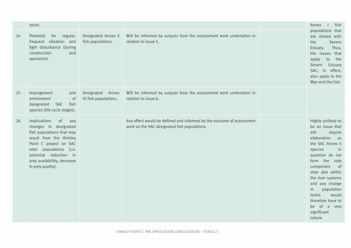
HINKLEY POINT C PRE-APPLICATION CONSULTATION – STAGE 2 |
noise. Annex I fish populations that are shared with the Severn Estuary. Thus, the issues that apply to the Severn Estuary SAC, in effect, also apply to the Wye and the Usk.
24 Potential for regular, frequent vibration and light disturbance (during construction and operation).
Designated Annex II fish populations.
Will be informed by outputs from the assessment work undertaken in relation to issue 5.
25 Impingement and entrainment of designated SAC fish species (life cycle stages).
Designated Annex IO fish populations.
Will be informed by outputs from the assessment work undertaken in relation to issue 6.
26 Implications of any changes in designated fish populations that may result from the Hinkley Point C project on SAC otter populations (i.e. potential reduction in prey availability, decrease in prey quality).
Any effect would be defined and informed by the outcome of assessment work on the SAC designated fish populations.
Highly unlikely to be an issue that will require elaboration as the SAC Annex II species in question do not form the sole component of otter diet within the river systems and any change in population levels would therefore have to be of a very significant nature.

35HINKLEY POINT C PRE-APPLICATION CONSULTATION – STAGE 2 |
A.12 References
A1.1 DCLG, 2006. Planning for the Protection of European Sites: Appropriate Assessment - Guidance For Regional Spatial Strategies and Local Development Documents (consultation documents). UK DCLG.
A1.2 English Nature, 1997. Habitats Regulation Guidance Note 1 relating to Appropriate Assessment (Regulation 48) of the Conservation (Natural Habitats & C.) Regulations, 1994.
A1.3 IPC, 2010. Scoping opinion for proposed nuclear development at Hinkley Point C, Somerset. Infrastructure Planning Committee, 2010.
A1.4 DECC, 2009. Habitats Regulation Assessment: Site Report for Hinkley Point. National Policy Statement for Nuclear Power Generation.
A1.5 NE & CCW, 2009. The Severn Estuary / Môr Hafren candidate Special Area of Conservation European marine site Natural England & the Countryside Council for Wales’ advice given under Regulation 33(2)(a) of the Conservation (Natural Habitats, &c.) Regulations 1994, as amended. Natural England & Countryside Council for Wales. June 2009.
A1.6 ODPM, 2005. Biodiversity and geological conservation - Statutory obligations and their impact within the planning system. Circular 05/06. Office of the Deputy Prime Minister.
A1.7 Langston, W. J., Chesman, B. S., Burt, G. R., Hawkins, S. J., Readman, J. & Worsfold, P., 2003. Site Characterisation of the South West European Marine Sites. Severn Estuary pSAC, SPA. Marine Biological Association Occasional Publication No.13.
A1.8 Bamber, R. N. & Irving, P.W., 1993. The Corallina run-offs of Bridgwater Bay. Porcupine Newsletter 5. pp. 190 – 198.
A1.9 Warwick, R., George, C. L., Pope, N. D. & Rowden, A. A., 1989. The prediction of post-barrage densities of shorebirds. Volume 3. Invertebrates. Harwell, Dept. of Energy, 112 pp.
A1.10 ABPMer, 2007. Severn Estuary Coastal Habitat Management Plan (CHaMP). Interactive website. EA/ABPmer Ltd.
A1.11 Mettam, C., Conneely, M. E. & White, S.J., 1994. Benthic macrofauna and sediments in the Severn Estuary. Biological Journal of the Linnean Society, 51: 71-81.
A1.12 Warwick, R., Henderson, P. A., Fleming, J. M. & Somes, J. R., 2001. The impoversished fauna of the deep water channel and marginal areas between Flatholm Island and King Road, Severn Estuary. Pisces Conservation Ltd, 21pp.
A1.13 MBA, 2003. Marine Biological Association Occasional Publication No.13. Site Characterisation of the South West European Marine Sites. Severn Estuary pSAC, SPA.
A1.14 Henderson, P. A., 1989. On the structure of the inshore fish community of England and Wales. J. Mar. Biol. Ass. UK. 69, 145-163.
A1.15 Henderson, P. A. & Holmes, 1989. Whiting migration in the Bristol Channel: a predator-prey relationship. J. Fish Biol. 34, 409-416.
A1.16. Henderson, P. A., & Seaby, R. M. H., 2000. Fish and crustacean captures at Hinkley Point B Nuclear Power Station: Report for the year April 2000 to March 2001. Pisces Conservation Ltd.
A1.17 Potts G. W. & Swaby, S. E., 1993. Marine fishes of the EC Habitats and Species Directive. Joint Nature Conservation Committee.
A1.18 Potter, I. C., Bird, D. J., Claridge, P. N., Clarke, K. R., Hyndes, G. A. & Newton, L. C., 2001. Fish Fauna of the Severn Estuary. Are there long-term changes in abundance and species composition and are the

36 | HINKLEY POINT C PRE-APPLICATION CONSULTATION – STAGE 2
recruitment patterns of the main marine species correlated. Journal of Experimental Marine Biology and Ecology. Volume 258 (1) p15-37.
A1.19 Henderson, P. A., Seaby, R. M. H., & Soames, R., 2007. Fish and crustacean captures at Hinkley Point B Nuclear Power Station: Report for the year April 2006 to March 2007.
A1.20 Claridge, P. N. & Potter, I. C., 1984. Abundance, movements and size of gadoids (Teleostei) in the Severn Estuary. J. mar. biol. Ass. U. K. 64: 771-790.
A1.21 Harvey, J. P., Noble, R. A. A., Cowx, I. G., Nunn, A. D. & Taylor, R. J., 2006. Monitoring of lamprey in the River Wye and Usk SACs 2005-2006. Report to Countryside Council for Wales, 91pp.
A1.22 Noble, R. A. A., Nunn, A. D., Harvey, J. P. and Cowx, I. G., 2007. Shad monitoring and assessment of conservation condition in the Wye, Usk and Tywi SACs. Report to Countryside Council for Wales, 100pp.
A1.23 JNCC, 2001. Stroud, D. A., Chambers, D., Cook, S., Buxton, N., Fraser, B., Clement, P., Lewis., P., McLean, I., Baker, H. & Whitehead, S. (Eds), 2001. The UK SPA network: its scope and content. JNCC, Peterborough.