Embed Size (px)
Citation preview

Charles and Sharon Vetsch Brad and Kelli Vetsch
180 IBLA 82
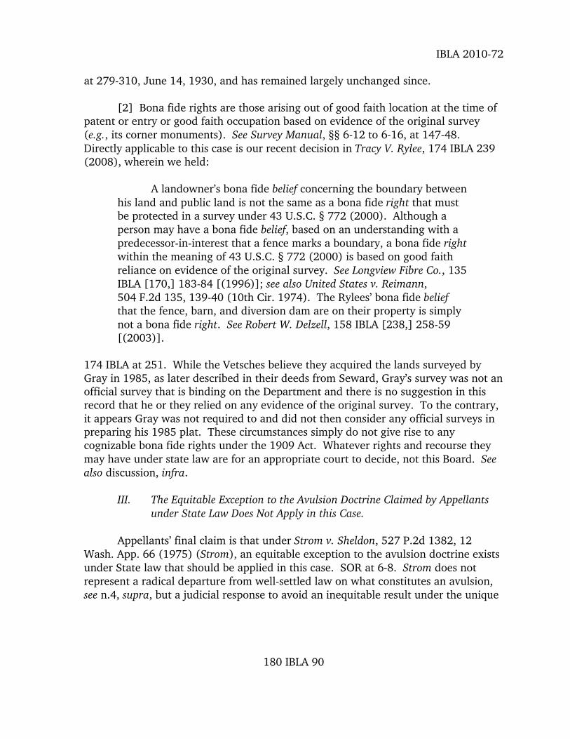
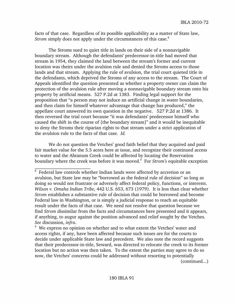
This case involves the north boundary of the Yakama Indian Reservation in Washington State. The boundary is defined in the 1855 Treaty as “thence westerly along said Attah-nam River to the forks”. The Attah-nam River is now named Ahtanum Creek. Both banks of the creek were meandered in the original surveys. In 1976 (1976-87 survey) an investigation and survey identified several avulsions along the creek, but in this area creek movement was determined to be due to erosion and accretion. An informative traverse of both banks was surveyed and reported in the field notes of the 1976-87 survey. Subsequent to the 1976-87 survey the land owner to the north of the creek moved the creek southerly and claimed the land between the old channel and the new, manmade channel. The dispute centers on ownership of the land between the two channels and the location of the boundary of the Reservation. This case has a good discussion of what constitutes “positive evidence” of an avulsion.

2002 Photo
Location 1 Section 16 T12N., R17W
Original Govt. Lot 2
Original Govt. Lot 7
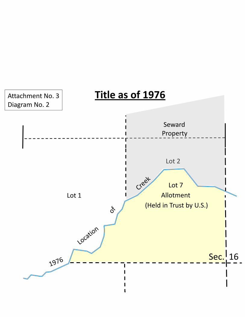
Lot 7
Lot 2
Lot 1
Sec. 16
Allotment
Seward Property
Title as of 1976
(Held in Trust by U.S.)
Attachment No. 3
Diagram No. 2
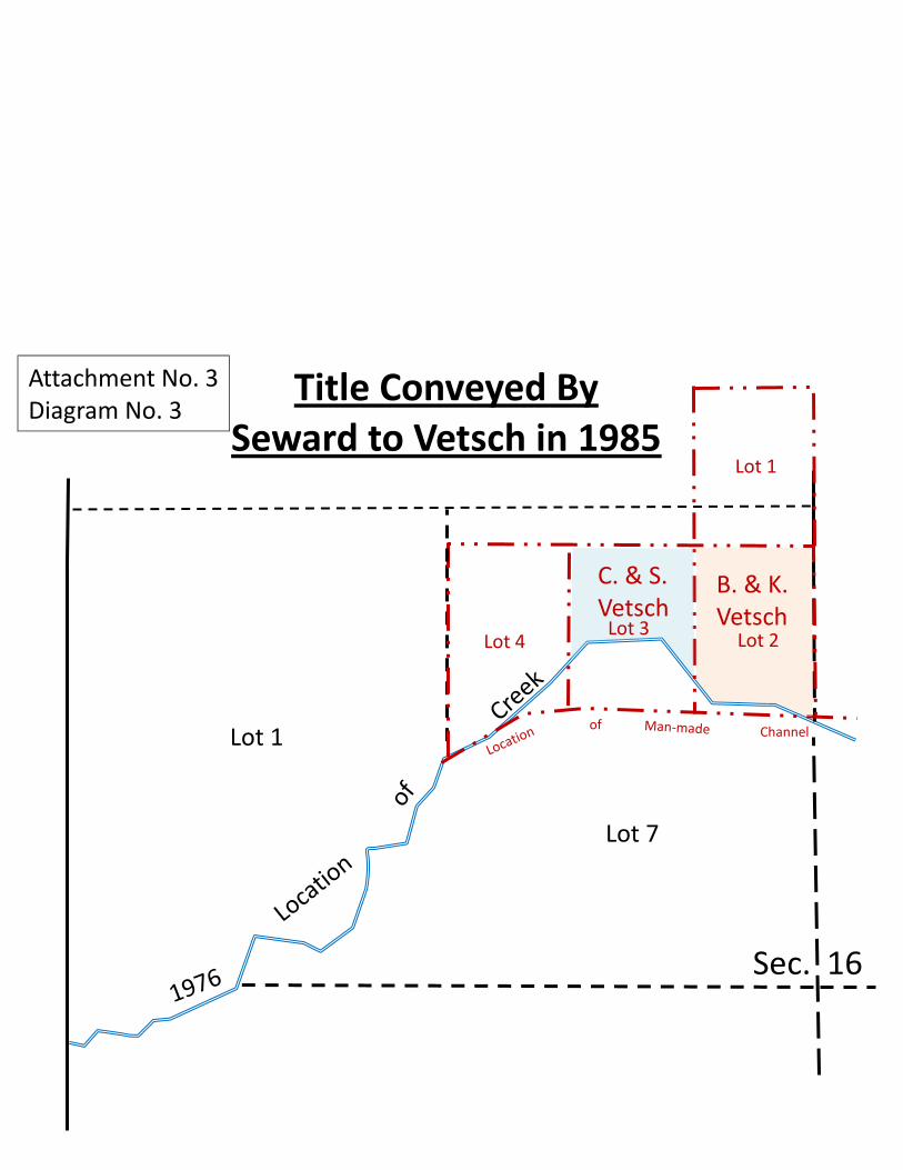
Lot 1
Lot 1
Lot 4
Sec. 16
Lot 2 Lot 3
Lot 7
B. & K. Vetsch
C. & S. Vetsch
Title Conveyed By
Seward to Vetsch in 1985
of Channel
Attachment No. 3
Diagram No. 3

Original Govt. Lot 2
Original Govt. Lot 7

Original Govt. Lot 2
Original Govt. Lot 7

Original Govt. Lot 7
Original Govt. Lot 2

CHARLES AND SHARON VETSCH
180 IBLA 82 Decided: September 24, 2010

United States Department of the InteriorOffice of Hearings and Appeals
Interior Board of Land Appeals801 N. Quincy St., Suite 300
Arlington, VA 22203
CHARLES AND SHARON VETSCHBRAD AND KELLI VETSCH
IBLA 2010-72 Decided: September 24, 2010
Appeal of a decision by the State Director, Oregon State Office, Bureau ofLand Management, dismissing a protest to the acceptance of a corrective dependentresurvey, a dependent resurvey, and a metes and bounds survey of the fixed andlimiting boundaries for a portion of the Yakama Indian Reservation. Group No. 591,Washington.
Affirmed.
1. Avulsion--Survey of Public Lands: Generally
The Manual of Instructions for the Survey of the Public Lands ofthe United States 1973 requires “positive evidence” of avulsion,which must be direct, affirmative, and definite but does notinclude circumstantial evidence, conjecture, or indirect evidenceif susceptible to differing interpretations. Aerial photographsand similar evidence of channel location are positive evidence ofavulsion if they show changes over a relatively short period oftime that are inconsistent with erosion and accretion.
2. Surveys of Public Lands: Generally
A landowner’s bona fide belief concerning the boundarybetween his lands and public lands is not necessarily thesame as a bona fide right that must be protected in asurvey under 43 U.S.C. § 772 (2006). A belief based on adeed that relied on an unofficial survey, not evidence ofthe original survey, does not constitute a bona fide rightunder Federal law.
APPEARANCES: J. Jay Carroll, Esq., Yakima, Washington for appellants; Mary J. M.Hartel, Chief Cadastral Surveyor of Washington, Portland, Oregon, for the Bureau ofLand Management.
180 IBLA 82
IBLA 2010-72
OPINION BY ADMINISTRATIVE JUDGE JACKSON
Charles and Sharon Vetsch and Brad and Kelli Vetsch have appealed aDecember 15, 2009, decision by the State Director of the Oregon State Office, Bureauof Land Management (BLM), dismissing their protest of a proposed decision to accepta corrective dependent resurvey, a dependent resurvey, and a metes and boundssurvey of the fixed and limiting boundaries for a portion of the Yakama IndianReservation that was executed by John D. McCauley, Cadastral Surveyor, underGroup 591, Washington (Decision). Their protest specifically challenged the metesand bounds survey, which was based on a proposed finding that the northernboundary of the Yakama Indian Reservation in section 16, T. 12 N., R. 17 E.,Willamette Meridian, Yakima County, Washington,1 is defined by the position ofAhtanum Creek before it avulsively moved to its present location in the N½ SW¼ NW¼ of that section. For the reasons discussed below, we affirm BLM’sdecision.2
BACKGROUND
The June 9, 1855, treaty between the United States and various confederatedtribes and bands of Indians, denoted as the Yakama Nation, reserved to them landsfrom “the mouth of the Attah-nam River; thence westerly along said Attah-nam Riverto the forks; thence along the southern tributary to the Cascade Mountains.” Treatywith the Yakama (1855 Treaty), 12 Stat. 951, 952 (1863). Thus, the Attah-namRiver, now named Ahtanum Creek and sometimes referred to as Athanum Creek,defined the northern boundary of the Yakama Reservation, which was to “be setapart and, so far as necessary, surveyed and marked out for the exclusive use andbenefit of said confederated Tribes and bands of Indians.” Id.
Over the years, a number of surveys were made of the township’s subdivisionlines and the meanders of both the north and south banks of Ahtanum Creek. Deputy Surveyor Jesse Richardson meandered the left (north) bank in 1867, andDeputy Surveyor George C. Mills meandered the right (south) bank in 1893. BLM 1 All sections references used herein are to this township. 2 The record on appeal includes a series of attachments submitted with BLM’sAnswer, hereinafter referred to as “BLM Attachment X.” BLM Attachment 5 is alooseleaf notebook containing a report by McCauley entitled “Investigation ofChanges in the location of the Main Channel of Ahtanum Creek Across Sections 15and 16 of T. 12N., R. 17E., Willamette Meridian, Washington” (McCauley Report),and 71 tabbed documents (hereinafter, “BLM Tab Y”): Tabs 1-4 are the report’sappendices; Tabs 5-44 appear to have been compiled when preparing that report;and Tabs 45-71 postdate the McCauley Report.
180 IBLA 83

IBLA 2010-72
Attachments 6 (Richardson), 7 (Mills). Various sections were later surveyed andsubdivided by Indian Allotting Agents, but the only remaining records of their surveysare township diagrams. See BLM Tab 1 at 11. More recently, Cadastral SurveyorsRonald W. Scherler and Thomas E. Caster conducted a dependent resurvey in 1976that included adjusted record meanders of the right bank of Ahtanum Creek and aninformative traverse of both its left and right banks in sections 12 through 18.
The Department’s Office of the Special Trustee (OST) later receivedinformation suggesting that Ahtanum Creek may have avulsively moved sometimeafter the Scherler survey, which precipitated a request by the Superintendent, YakimaAgency, Bureau of Indian Affairs (BIA), for an investigation. See BLM memorandadated May 4, 2006, and Aug. 26, 2005; e-mail to OST on August 24, 2004. Bymemorandum dated November 2, 2005, BLM directed McCauley to investigate “themovement of Ahtanum Creek through sections 15 and 16” by reviewing aerialphotographs, historic maps, and other records and by interviewing affected parties todetermine the “method of the creek[’]s movement.” BLM Tab 45. McCauleycompleted his investigation by issuing a report on March 22, 2006, which determinedthat avulsive changes had occurred at three locations and recommended that anofficial survey be conducted “to locate and document the avulsive changes” and tomonument the “Fixed and Limiting Boundary” of the Yakama Indian Reservation. McCauley Report at 9.
BIA requested the resurvey recommended by McCauley, which BLM respondedto by issuing Special Instructions (Group 591) on September 22, 2006. See BLM Tabs 46, 69; McCauley Report at 9. These instructions were for a dependentresurvey of subdivision lines, retracing adjusted record meanders on the right bank ofAhtanum Creek through sections 15 and 16, an information traverse of its left andright banks, and a metes-and-bounds survey of the fixed and limiting boundary of theYakama Indian Reservation in sections 15 and 16. BLM Tab 46. This work wasassigned to McCauley. See BLM Tab 47.
During the course of that resurvey, McCauley reported he had “recoveredoriginal corners and corners established by the United States Indian Allotting Servicein the vicinity of the corner of sections 15, 16, 21, and 22” and that Scherler had“erroneously accepted” that corner on the April 1, 1994, official plat of survey. BLMTab 48. BLM suspended that plat and then issued Supplemental Special Instructionson July 11, 2007, to include as part of Group 591 a corrective dependent resurvey ofthe line between sections 15 and 16, a survey of new meanders of the right bank ofAhtanum Creek through sections 15 and 16, and a resurvey of all necessary controllines. BLM Tabs 48, 49.
180 IBLA 84

IBLA 2010-72
After McCauley completed his work, BLM sent copies of his field notes andplat to Appellants and their attorney and published a notice in the Federal Registerstating that this plat would be officially filed in 30 days. 74 Fed. Reg. 53294 (Oct. 16, 2009). Appellants’ attorney responded by letter dated November 19, 2009,stating:
As I tell my kids all the time, it is what it is. The creek is whereit is. The Treaty with the Yakama Nation defines the boundary of theReservation as Ahtanum Creek. The Treaty does not fix that boundaryat the time of the signing of the Treaty. The BLM does not have theright to re-create what it thinks the boundary should be. The boundaryis Ahtanum Creek, where it might be. If you have some sort ofevidence that Ahtanum Creek has been artificially manipulated, myclients would love to hear it. My clients certainly engaged in no suchendeavor. They purchased this property with the knowledge andunderstanding that the creek was the boundary of the property thatthey were purchasing.
If the BLM is intending to use this survey to “establish” theboundaries of the Yakama nation as of the date of the survey, such anattempt is both legally and factually insufficient. My clients object.
BLM treated this letter as a protest that raised three issues: the location of theReservation’s boundary; BLM’s authority to survey and define that boundary; and thesufficiency of the record facts relied upon by BLM. See Decision at 1-2.3
The State Director responded to each identified issue as follows:
• While BLM agreed the 1855 Treaty did not fix the Reservation boundary alongAhtanum Creek where it was then located, it disagreed with the assertion thatthis meant the boundary was wherever the creek is:
[I]t is not necessarily true that “The creek is where it is.” Whena stream moves due to an avulsive act,[3] the law addresses how
3 BLM enclosed copies of the McCauley Report, a BIA memorandum dated March 25,1987 (BIA Memorandum), and aerial photographs with its decision. 4 The Manual of Instructions for the Survey of the Public Lands of the United States1973 (Survey Manual), § 7-71, at 172 states: “‘Avulsion’ is the sudden and rapidchange of channel of a boundary stream, or a comparable change in some other bodyof water forming a boundary, by which an area of land is cut off.” See also Philadelphia Co. v. Stimson, 223 U.S. 605, 624 (1912), and cases cited. Washington
(continued...)
180 IBLA 85

IBLA 2010-72
the change will affect boundaries. “It is equally well settled, thatwhere a stream, which is a boundary, from any cause, suddenlyabandons its old and seeks a new bed, such change of channelworks no change of boundary; and that the boundary remains asit was, in the center of the old channel, although no water maybe flowing therein. This sudden and rapid change of channel istermed, in the law, ‘avulsion.’” State of Nebraska v. State of Iowa,143 U.S. 359[, 361 (1892)].
Decision at 1
• The State Director responded to counsel’s claim that BLM “does not have theright to re-create what it thinks the boundary should be,” by stating that 25U.S.C. § 176 (2006) grants BLM “full legal authority to survey or resurvey the boundaries of Indian lands” and that this survey was conducted inaccordance with the Survey Manual, Special Instructions, and SupplementalSpecial Instructions.5 Decision at 2.
• As to the sufficiency of the record, the Director averred that the proposeddecision is “clearly” supported by aerial photos showing “the creek moved
4 (...continued)courts have long followed a virtually identical rule:
[W]hen a stream, which is a boundary, from any cause suddenlyabandons its old channel and creates a new one, or suddenly washesfrom one of its banks a considerable body of land and deposits it on theopposite bank, the boundary does not change with [the] changedcourse of the stream, but remains as it was before. This sudden andrapid change is termed in law an avulsion, and differs from an accretionin that the one is violent and visible, while the other is gradual andperceptible only after a lapse of time.
Harper v. Holston, 119 Wash. 436, 441, 205 P. 1062, 1064 (1922); see Rose v.Riedinger, 13 Wash. App. 222, 534 P.2d 146, 150 (1975); Parker v. Farrell, 74 Wash.2d 553, 445 P.2d 620, 622 (1968); Hirt v. Entus, 37 Wash. 2d 418, 422, 224 P.2d620, 623-24 (1950). Avulsion can result from natural forces or can be caused byartificial or man-made endeavors. See e.g., State of Arkansas v. State of Tennessee, 246 U.S. 158, 173 (1918); Palo Verde Valley Color of Title Claims, 72 I.D. 409, 411(1965). 5 25 U.S.C. § 176 (2006) provides: “Whenever it becomes necessary to survey anyIndian or other reservations, or any lands, the same shall be surveyed under thedirection and control of the Bureau of Land Management, and as nearly as may be inconformity to the rules and regulations under which other public lands are surveyed.”
180 IBLA 86

IBLA 2010-72
from its natural channel to a new channel between 1979 and 1985.” Decisionat 2.6 He added that BIA documents “provide positive evidence that thechange was the result of the water being diverted into a man-made channel,”and that while a 1985 survey by a registered surveyor, Douglas S. Gray,erroneously located the Vetches’ boundary along that man-made channel, itappears they “had no part in diverting the creek from its natural bed to theman-made channel; they simply bought the land based on the Gray survey.” Id.
The decision then concludes: “The facts prove that a man-made avulsion did takeplace, the avulsion does not change the boundary, and our survey has properlylocated the northerly boundary of the Reservation and the Indian lands.” Decision at2. The Vetsches timely filed their notice of appeal and statement of reasons (SOR).
To clarify who, why, and what is at issue, we note BIA records show OrvilleSeward leased Allotment 903A (Government Lot 7) between 1972 and 1987, whichwas “immediately south and across the Creek from property owned by Mr. Seward,”and that Gray’s 1985 survey was executed for Seward. McCauley Report at 3, 4; seeBLM Tabs 29-31. Gordon E. Bueling, BIA Agricultural Engineer, described the Graysurvey in a memorandum dated February 21, 1990, as subdividing “Government Lots1 and 2 north of the Creek into 4 new Lots,” with Lots 2, 3, and 4 using “therelocated channel as their south boundary.” McCauley Report at 4; see BLM Tab 33. McCauley reported that Seward was named by BIA “as the person having altered thecreek[’]s location.” McCauley Report at 4 (citing the BIA and Bueling Memoranda). Bradley Vetsch thereafter acquired Lot 2 from Seward by warranty deed, which hereconveyed to himself and his wife, Kelli, on November 15, 1994; Charles and SharonVetsch acquired Lot 3 from Seward by warranty deed dated April 7, 2005. BLM Tabs36, 37, 41. Thus, if the southern boundary of their lots is the new location ofAhtanum Creek, the Vetches would retain roughly 5.5 acres of what had been part ofAllotment 903A; but if it is bounded by the location of the creek before it moved,they will lose acreage they thought they acquired from Seward. See SOR at 3.
DISCUSSION
A party challenging the proposed filing of a plat on resurvey has the burden ofdemonstrating by a preponderance of the evidence that the resurvey is not an 6 The Director explained: “[T]he 1985 photograph clearly shows both the man-madechannel and the abandoned channel. Notice that the man-made channel is straightfor approximately 1000 feet while the natural channel in the 1985 photograph andalong the rest of the creek is a series of S-shaped curves. These S-shaped curves arewhat you would normally expect to see with this size stream, soil type, and gradient.” Decision at 1-2.
180 IBLA 87

IBLA 2010-72
accurate retracement and reestablishment of the lines of the original survey. HowardVagneur, 159 IBLA 272, 278 (2003); Mark Einsele, 147 IBLA 1, 11 (1998); RodneyCourville, 143 IBLA 156, 163 (1998), and cases cited. An appellant may meet thisburden by showing, inter alia, that the resurvey was not executed in conformity with the Survey Manual. See, e.g., James R. and Charlene K. Hasenyager, 176 IBLA 252(2008). The Vetsches do not dispute the manner in which McCauley executed thisresurvey, but challenge the metes and bounds survey of the fixed and limitingboundary of the Yakama Indian Reservation in section 16, which is based on BLM’sfinding that the Ahtanum Creek avulsively moved between 1976 and 1985 and itsresulting determination that the Reservation boundary remained where it had beenbefore that avulsion occurred. They raise three principal issues on appeal: whetherthe record supports BLM’s finding of an avulsive change; whether such a finding onresurvey can affect their bona fide rights under Federal law; and whether anequitable exception to the avulsion rule under State law applies to this case. Each isdiscussed separately below.
I. The Record Supports BLM’s Finding of an Avulsive Change
Appellants contend “there is no evidence” of avulsive change, claiming thatmerely because “the course of the creek may have changed between 1976 and 1985does not, without more, make for an avulsion.” SOR at 6. The Survey Manual, § 7-73, at 172 unequivocally states: “An avulsive change cannot be assumed to haveoccurred without positive evidence. When no such showing can be made, it must bepresumed that the changes have been caused by gradual erosion and accretion.” InQuinton Douglas, 166 IBLA 257, 264 (2005), a case that also involved boundariesunder the 1855 Treaty, we interpreted and applied the “positive evidence”requirement by stating: “Such evidence must be direct, affirmative, and definite,such as eyewitness testimony that an event occurred, and does not includecircumstantial evidence, conjecture, or indirect evidence subject to differentinterpretations.” We necessarily apply that same standard here.
[1] BLM contends the aerial photographs between 1939 and 1979 show thecreek “in essentially the same location” and that the 1985 photos “show the remainsof the natural channel and the creek flowing in the man-made channel,” a lack ofvegetation along the new channel indicating it “had not been in this location verylong,” and that the land between the old and new channel is substantiallyunchanged. Answer at 6. While aerial photographs are circumstantial evidence ofwhat occurred, they are “positive evidence” of avulsion if not susceptible to adifferent interpretation, as by depicting changes that could have been caused bygradual erosion and accretion. See Quinton Douglas, 166 IBLA at 264-65. Theappearance of lands immediately south of Ahtanum Creek in 1979, their appearanceafter the creek was relocated into a new, straight channel, as depicted by 1985 aerialphotos, and the relative short period that elapsed between those snapshots in timebelie any
180 IBLA 88

IBLA 2010-72
suggestion that this new channel was the result of erosion and accretion. CompareBLM Attachment 10A, 10B (1979 photos) with BLM Attachment 12A, 12B, 12C (1985photos). Since Appellants proffer no evidence to the contrary or a differentinterpretation of these photos, we find they are positive evidence of avulsion and,therefore, affirm BLM’s determination that an avulsive change occurred between1979 and 1985.7
II. Appellants’ Bona Fide Rights Under the 1909 Act Were Unaffected by thisDependent Resurvey.
Appellants’ contend their rights were adversely affected on resurvey and thatthey may have a takings claim if the Reservation boundary along Ahtanum Creek isaccepted because it would reduce the acreage they thought they owned. SOR at 4-5(quoting Mannatt v. Unites States, 48 Fed. Cl. 148 (2000)). Although the FederalCourts have authority to adjudicate takings claims, this Board does not. We reviewDepartmental decisions and determine the rights of appellants to the property atissue, a necessary prerequisite to their seeking relief or compensation elsewhere. SeeMaurice Tanner, 141 IBLA 373, 384 (1997); Mannatt v. Unites States, 48 Fed. Cl. at152, 155-56; see also United States v. Freeman, 179 IBLA 341, 343 (2010) (on remandto determine the validity of a mining claim before the Court of Claims couldadjudicate whether there was a taking of that claim). Our review in this case is ofBLM’s decision to accept the McCauley resurvey and whether that resurvey properlydetermined that an avulsive change occurred or otherwise impaired the Vetsches’bona fide rights under the Act of March 3, 1909, 35 Stat. 845 (1909 Act), 43 U.S.C. § 772 (2006). Having concluded that an avulsion occurred, see discussion, supra, wenow turn to the Vetches’ claimed impairment of their bona fide rights under the 1909 Act.
The 1909 Act authorizes the Department to execute resurveys of the publiclands, but since Congress recognized they could result in new boundaries affectingthe rights of those then occupying the land, it acted to protect them by specifyingthat no resurvey “shall be so executed as to impair the bona fide rights or claims ofany claimant, entryman, or owner of lands affected by such resurvey or retracement.”
35 Stat. 845; 43 U.S.C. § 772 (2006). The Department’s view on what are bona fiderights and how they would be protected was first articulated in the Manual ofInstructions for the Survey of the Public Lands of the United States, Chap. VI 7 Although BLM found this avulsion was man-made, appellants do not challenge thatfinding and recognize that the evidence considered by McCauley showed “the courseof the Ahtanum creek was altered by the lessee of Indian property.” SOR at 8. Theyspeculate that Seward may have done so to more easily irrigate the lands hecontrolled and contend that they had nothing to do with those stream alterations. Id.BLM does not dispute or disagree with their position on appeal. See Answer at 8.
180 IBLA 89
IBLA 2010-72
at 279-310, June 14, 1930, and has remained largely unchanged since.
[2] Bona fide rights are those arising out of good faith location at the time ofpatent or entry or good faith occupation based on evidence of the original survey(e.g., its corner monuments). See Survey Manual, §§ 6-12 to 6-16, at 147-48. Directly applicable to this case is our recent decision in Tracy V. Rylee, 174 IBLA 239(2008), wherein we held:
A landowner’s bona fide belief concerning the boundary betweenhis land and public land is not the same as a bona fide right that mustbe protected in a survey under 43 U.S.C. § 772 (2000). Although aperson may have a bona fide belief, based on an understanding with apredecessor-in-interest that a fence marks a boundary, a bona fide rightwithin the meaning of 43 U.S.C. § 772 (2000) is based on good faithreliance on evidence of the original survey. See Longview Fibre Co., 135IBLA [170,] 183-84 [(1996)]; see also United States v. Reimann,504 F.2d 135, 139-40 (10th Cir. 1974). The Rylees’ bona fide beliefthat the fence, barn, and diversion dam are on their property is simplynot a bona fide right. See Robert W. Delzell, 158 IBLA [238,] 258-59[(2003)].
174 IBLA at 251. While the Vetsches believe they acquired the lands surveyed byGray in 1985, as later described in their deeds from Seward, Gray’s survey was not anofficial survey that is binding on the Department and there is no suggestion in thisrecord that he or they relied on any evidence of the original survey. To the contrary,it appears Gray was not required to and did not then consider any official surveys inpreparing his 1985 plat. These circumstances simply do not give rise to anycognizable bona fide rights under the 1909 Act. Whatever rights and recourse theymay have under state law are for an appropriate court to decide, not this Board. Seealso discussion, infra.
III. The Equitable Exception to the Avulsion Doctrine Claimed by Appellantsunder State Law Does Not Apply in this Case.
Appellants’ final claim is that under Strom v. Sheldon, 527 P.2d 1382, 12Wash. App. 66 (1975) (Strom), an equitable exception to the avulsion doctrine existsunder State law that should be applied in this case. SOR at 6-8. Strom does notrepresent a radical departure from well-settled law on what constitutes an avulsion,see n.4, supra, but a judicial response to avoid an inequitable result under the unique
180 IBLA 90
IBLA 2010-72
facts of that case. Regardless of its possible applicability as a matter of State law,Strom simply does not apply under the circumstances of this case.8
The Stroms sued to quiet title in lands on their side of a nonnavigableboundary stream. Although the defendants’ predecessor-in-title had moved thatstream in 1954, they claimed the land between the stream’s former and currentlocation was theirs under the avulsion rule and denied the Stroms access to thoselands and that stream. Applying the rule of avulsion, the trial court quieted title inthe defendants, which deprived the Stroms of any access to the stream. The Court ofAppeals identified the question presented as whether a property owner can claim theprotection of the avulsion rule after moving a nonnavigable boundary stream onto hisproperty by artificial means. 527 P.2d at 1383. Finding legal support for theproposition that “a person may not induce an artificial change in water boundaries,and then claim for himself whatever advantage that change has produced,” theappellate court answered its own question in the negative. 527 P.2d at 1386. Itthen reversed the trial court because “it was defendants’ predecessor himself whocaused the shift in the course of [the boundary stream]” and it would be inequitableto deny the Stroms their riparian rights to that stream under a strict application ofthe avulsion rule to the facts of that case. Id.
We do not question the Vetches’ good faith belief that they acquired and paidfair market value for the 5.5 acres here at issue, and recognize their continued accessto water and the Ahtanum Creek could be affected by locating the Reservationboundary where the creek was before it was moved.9 For Strom’s equitable exception 8 Federal law controls whether Indian lands were affected by accretion or anavulsion, but State law may be “borrowed as the federal rule of decision” so long asdoing so would not frustrate or adversely affect federal policy, functions, or interests. Wilson v. Omaha Indian Tribe, 442 U.S. 653, 673 (1979). It is less than clear whetherStrom establishes a substantive rule of decision that could be borrowed and becomeFederal law in Washington, or is simply a judicial response to reach an equitableresult under the facts of that case. We need not resolve that question because wefind Strom dissimilar from the facts and circumstances here presented and it appears,if anything, to augur against the position advanced and relief sought by the Vetches. See discussion, infra.9 We express no opinion on whether and to what extent the Vetches’ water andaccess rights, if any, have been affected because such issues are for the courts todecide under applicable State law and precedent. We also note the record suggeststhat their predecessor-in-title, Seward, was directed to relocate the creek to its formerlocation but no action was then taken. To the extent the parties may agree to do sonow, the Vetches’ concerns could be addressed without resorting to potentially
(continued...)
180 IBLA 91

IBLA 2010-72
to apply, there must be evidence that the party (or his predecessor-in-title) whowould otherwise benefit under the avulsion rule precipitated or caused that avulsiveevent. A case comparable to Strom would be here presented if the allotment lessorwere responsible for moving Ahtanum Creek and then denied access to Sewardand/or the Vetches, but such is not this case. Rather, the Vetches seek to benefitfrom the actions of others (presumably Seward), to the disadvantage of a lessor thathas taken no such action,10 a circumstance apparently precluded under the equitableconsiderations identified in Strom. Thus, even if Strom established a substantive ruleof decision that could be borrowed as Federal law, we are unpersuaded that itsequitable exception applies under the facts and circumstances here presented.
In sum, we affirm’s BLM’s finding that there was an avulsive change toAhtanum Creek and its conclusion that the Reservation boundary along that creek iswhere it was located before that change occurred. We find no evidence in the recordthat the Vetches’ bona fide rights under the 1909 Act were impaired on resurvey orthat an equitable exception to the avulsion rule applies or should apply in this case. To the extent the parties have made other arguments that have not been expresslydiscussed herein, they have been considered and rejected as without basis in law orfact.
9 (...continued)protracted and expensive litigation.10 Seward (and the Vetches) would not gain, and the Reservation would not lose anyacreage under the avulsion rule; but if the accretion rule applied under the Strom“exception,” Seward and his successors-in-title would benefit by the Reservation thenlosing the 5.5 acres between the current and former channel of Ahtanum Creek. Weneed not speculate on what a state court could or might do, as it suffices for ourpurposes to conclude that neither the facts of this case nor Strom suggest, let alonerequire, that an equitable exception to the avulsion rule be here recognized for thebenefit of the Vetches.
180 IBLA 92

IBLA 2010-72
Accordingly, pursuant to the authority delegated to the Board of Land Appealsby the Secretary of the Interior, 43 C.F.R. § 4.1, the December 15, 2009, decision bythe State Director, Oregon State Office, is affirmed.
/s/ James K. JacksonAdministrative Judge
I concur:
/s/ Bruce R. HarrisDeputy Chief Administrative Judge
180 IBLA 93


![CHRISTOPHER L. MULLIKIN 180 IBLA 60 Decided September … · 6 Although in her declaration, Smyth used the term “decision,” i.e. “[w]hen writing the decision relating to the](https://img.dokumen.tips/doc/110x75/5c11586509d3f23d3a8be45d/christopher-l-mullikin-180-ibla-60-decided-september-6-although-in-her-declaration.jpg)