Embed Size (px)
Citation preview

www.ck12.org
CHAPTER 14 Earth’s OceansChapter Outline
14.1 INTRODUCTION TO THE OCEANS
14.2 OCEAN MOVEMENTS
14.3 OCEAN’S RESOURCES
14.4 OCEAN LIFE
14.5 REFERENCES
Phytoplankton bloom in spring when sunlight hits the water. The green color is from chlorophyll, the pigment needed
for photosynthesis. The blue color is from the reflective plating around coccolithophores, a type of phytoplankton.
The Chatham Rise is an underwater plateau that causes deep water to rise, bringing up nutrients. The feature is
located where cold Antarctic currents meet warmer, subtropical water. The mixing of water and the nutrients foster
large phytoplankton blooms.
Phytoplankton are the base of the marine food web and so they are food to nearly all other marine organisms.
By using carbon dioxide for photosynthesis, phytoplankton help to reduce the buildup of greenhouse gases in the
atmosphere.
284

www.ck12.org Chapter 14. Earth’s Oceans
14.1 Introduction to the Oceans
Lesson Objectives
• Explain the significance of the oceans.
• Describe the composition of ocean water.
• Define the parts of the water column and oceanic divisions.
Vocabulary
• aphotic zone
• biomass
• intertidal zone
• neritic zone
• oceanic zone
• photic zone
• salinity
• water column
Introduction
As terrestrial creatures, humans think of the importance of the planet’s land surfaces. But Earth is mostly a water
planet. From space, the dominance of water is obvious (Figure 14.1). Most of Earth’s water is in the oceans.
Because all of Earth’s oceans are somehow connected, should this chapter be titled “Earth’s Ocean” or “Earth’s
Oceans?” Try to decide by the end of the chapter.
Significance of the Oceans
Earth would not be the same planet without its oceans.
Moderates Climate
The oceans, along with the atmosphere, keep temperatures fairly constant worldwide. While some places on Earth
get as cold as -70oC and others as hot as 55oC, the range is only 125oC. On Mercury temperatures go from -180oC
to 430oC, a range of 610oC.
The oceans, along with the atmosphere, distribute heat around the planet. The oceans absorb heat near the equator
and then move that solar energy to more polar regions. The oceans also moderate climate within a region. At the
same latitude, the temperature range is smaller in lands nearer the oceans than away from the oceans. Summer
temperatures are not as hot, and winter temperatures are not as cold, because water takes a long time to heat up or
cool down.
285

14.1. Introduction to the Oceans www.ck12.org
FIGURE 14.1About 71% of the Earth’s surface is cov-ered with water, mostly by the oceans.
Water Cycle
The oceans are an essential part of Earth’s water cycle. Since they cover so much of the planet, most evaporation
comes from the ocean and most precipitation falls on the oceans.
Biologically Rich
The oceans are home to an enormous amount of life. That is, they have tremendous biodiversity. Tiny ocean plants
create the base of a food web that supports all sorts of life forms. Marine life makes up the majority of all biomass
on Earth. (Biomass is the total mass of living organisms in a given area.) These organisms supply us with food and
even the oxygen created by marine plants.
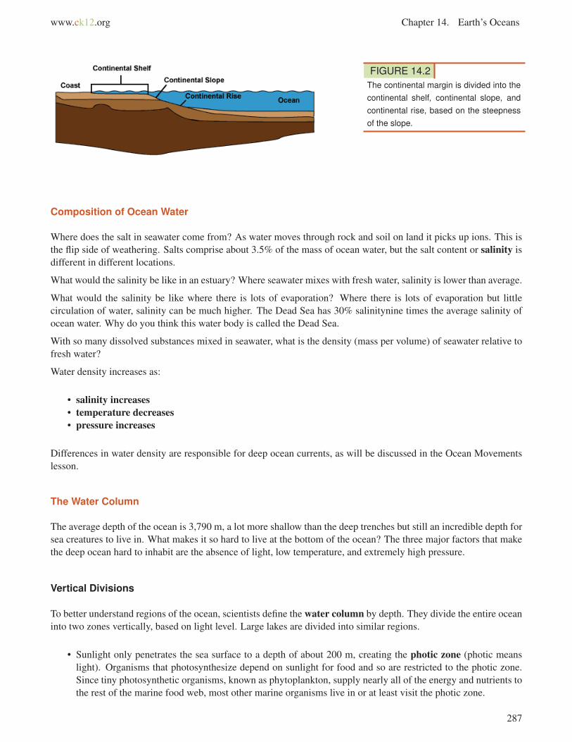
Continental Margin
Recall from the Plate Tectonics chapter that the ocean floor is not flat: mid-ocean ridges, deep sea trenches, and
other features all rise sharply above or plunge deeply below the abyssal plains. In fact, Earth’s tallest mountain is
Mauna Kea volcano, which rises 10,203 m (33,476 ft.)meters) from the Pacific Ocean floor to become one of the
volcanic mountains of Hawaii. The deepest canyon is also on the ocean floor, the Challenger Deep in the Marianas
Trench, 10,916 m (35,814 ft).
The continental margin is the transition from the land to the deep sea or, geologically speaking, from continental
crust to oceanic crust. More than one-quarter of the ocean basin is continental margin. (Figure 14.2).
286
www.ck12.org Chapter 14. Earth’s Oceans
FIGURE 14.2The continental margin is divided into thecontinental shelf, continental slope, andcontinental rise, based on the steepnessof the slope.
Composition of Ocean Water
Where does the salt in seawater come from? As water moves through rock and soil on land it picks up ions. This is
the flip side of weathering. Salts comprise about 3.5% of the mass of ocean water, but the salt content or salinity is
different in different locations.
What would the salinity be like in an estuary? Where seawater mixes with fresh water, salinity is lower than average.
What would the salinity be like where there is lots of evaporation? Where there is lots of evaporation but little
circulation of water, salinity can be much higher. The Dead Sea has 30% salinitynine times the average salinity of
ocean water. Why do you think this water body is called the Dead Sea.
With so many dissolved substances mixed in seawater, what is the density (mass per volume) of seawater relative to
fresh water?
Water density increases as:
• salinity increases• temperature decreases• pressure increases
Differences in water density are responsible for deep ocean currents, as will be discussed in the Ocean Movements
lesson.
The Water Column
The average depth of the ocean is 3,790 m, a lot more shallow than the deep trenches but still an incredible depth for
sea creatures to live in. What makes it so hard to live at the bottom of the ocean? The three major factors that make
the deep ocean hard to inhabit are the absence of light, low temperature, and extremely high pressure.
Vertical Divisions
To better understand regions of the ocean, scientists define the water column by depth. They divide the entire ocean
into two zones vertically, based on light level. Large lakes are divided into similar regions.
• Sunlight only penetrates the sea surface to a depth of about 200 m, creating the photic zone (photic means
light). Organisms that photosynthesize depend on sunlight for food and so are restricted to the photic zone.
Since tiny photosynthetic organisms, known as phytoplankton, supply nearly all of the energy and nutrients to
the rest of the marine food web, most other marine organisms live in or at least visit the photic zone.
287

14.1. Introduction to the Oceans www.ck12.org
• In the aphotic zone there is not enough light for photosynthesis. The aphotic zone makes up the majority of
the ocean, but has a relatively small amount of its life, both in diversity of type and in numbers. The aphotic
zone is subdivided based on depth (Figure 14.3).
FIGURE 14.3Oceanographers divide the ocean intozones both vertically and horizontally.
Horizontal Divisions
The seabed is divided into the zones described above, but ocean itself is also divided horizontally by distance from
the shore.
• Nearest to the shore lies the intertidal (littoral) zone, the region between the high and low tidal marks. This
hallmark of the intertidal is change: water is in constant motions in waves, tides, and currents. The land is
sometimes under water and sometimes is exposed.
• The neritic zone is from low tide mark and slopes gradually downward to the edge of the seaward side of the
continental shelf. Some sunlight penetrates to the seabed here.
• The oceanic zone is the entire rest of the ocean from the bottom edge of the neritic zone, where sunlight does
not reach the bottom. The sea bed and water column are subdivided further, as seen in the figure above.
Lesson Summary
• The oceans help to moderate Earth’s temperatures.
• The main elements in seawater are chlorine, sodium, magnesium, sulfate, and calcium.
• The average salinity of the oceans is about 3.5%.
• In seawater, if evaporation is high, salinity is high. If fresh water mixes in, salinity is low.
• In the photic zone there is enough available light for photosynthesis.
• The vast majority of the ocean lies in the aphotic zone, where there is not enough light for photosynthesis.
• The ocean floor averages about 3,790 m but ocean trenches are as deep as 10,910 m.
• The neritic zones are nearshore areas, including the intertidal zone. The oceanic zones are offshore regions of
the ocean.
288
www.ck12.org Chapter 14. Earth’s Oceans
Review Questions
1. What percent of the Earth’s surface is covered by water?
2. How do the oceans help to moderate Earth’s temperatures?
3. What is the most common substance that is dissolved in ocean water?
4. Define density. Why is density important to the water column?
5. Compare and contrast the photic and aphotic zones.
6. Briefly describe the types of organisms found in the intertidal, neritic, and oceanic zones.
Points to Consider
• How do water motions such as tides and waves affect living creatures in and near the sea?
• Is it possible to have a river in the middle of the ocean?
• What factors affect the movement of ocean water? How do these factors affect the world’s climate and the
ocean’s ecosystem?
289
14.2. Ocean Movements www.ck12.org
14.2 Ocean Movements
Lesson Objectives
• Define waves and explain their formation.
• Describe what causes tides.
• Describe how surface currents form and how they affect the world’s climate.
• Describe the causes of deep currents.
• Relate upwelling areas to the food chain.
Vocabulary
• Coriolis effect
• downwelling
• gyre
• high tide
• longshore current
• low tide
• neap tide
• rip current
• spring tide
• storm surge
• surface current
• thermohaline circulation
• tidal range
• tide
• upwelling
• wave
Introduction
Ocean water is constantly in motion: north-south, east-west, alongshore, and vertically. Seawater motions are the
result of waves, tides, and currents. Ocean movements are the consequence of many separate factors: wind, tides,
Coriolis effect, water density differences, and the shape of the ocean basins. Water movements and their causes will
be discussed in this lesson.
Waves
Waves have been discussed in previous chapters in several contexts: seismic waves traveling through the planet,
sound waves traveling through seawater, and ocean waves eroding beaches. Waves transfer energy and the size of a
wave and the distance it travels depends on the amount of energy that it carries.
290

www.ck12.org Chapter 14. Earth’s Oceans
Wind Waves
This lesson studies the most familiar waves, those on the ocean’s surface. Ocean waves originate from wind blowing
–steady winds or high storm winds - over the water. Sometimes these winds are far from where the ocean waves are
seen. What factors create the largest ocean waves?
The largest wind waves form when the wind
• is very strong
• blows steadily for a long time
• blows over a long distance
The wind could be strong, but if it gusts for just a short time, large waves won’t form.
Wind blowing across the water transfers energy to that water. The energy first creates tiny ripples that create an
uneven surface for the wind to catch so that it may create larger waves. These waves travel across the ocean out of
the area where the wind is blowing.
Remember that a wave is a transfer of energy. Do you think the same molecules of water that starts out in a wave in
the middle of the ocean later arrive at the shore?
Water molecules in waves make circles or ellipses (Figure 14.4). Energy transfers between molecules but the
molecules themselves mostly bob up and down in place.
FIGURE 14.4The circles show the motion of a watermolecule in a wind wave. Wave energyis greatest at the surface and decreaseswith depth. A shows that a water moleculetravels in a circular motion in deep water.B shows that molecules in shallow watertravel in an elliptical path because of theocean bottom.
When does a wave break? Do waves only break when they reach shore? Waves break when they become too tall to
be supported by their base. This can happen at sea but happens predictably as a wave moves up a shore. The energy
at the bottom of the wave is lost by friction with the ground so that the bottom of the wave slows down but the top
of the wave continues at the same speed. The crest falls over and crashes down.
Some of the damage done by storms is from storm surge. Water piles up at a shoreline as storm winds push waves
into the coast. Storm surge may raise sea level as much as 7.5 m (25 ft), which can be devastating in a shallow land
area when winds, waves, and rain are intense.
291
14.2. Ocean Movements www.ck12.org
Tsunami
Tsunami are described in the Earthquakes chapter as damaging waves that result from the sharp jolt to the water
from an undersea earthquake. Landslides, meteorite impacts, or any other jolt to ocean water may form a tsunami.
Tsunami can travel at speeds of 800 kilometers per hour (500 miles per hour).
Tsunami have small wave heights and long wavelengths so they are usually unnoticed at sea. As the wave rides up
the continental shelf the wave height increases.
The wave speed of a tsunami is also slowed by friction with the shallower ocean floor, which causes the wavelength
to decrease, creating a much taller wave.
Many people caught in a tsunami have no warning of its approach. Since the wavelength is long, a long time can
pass between crests or troughs onshore. In 1755 in Lisbon, an offshore earthquake caused a great deal of damage
on land. People rushed to the open space of the shore and discovered that the water was flowing seaward fast. The
trough of the tsunami wave reached shore first. People who went out onto the open beach were drowned when the
crest of the wave reached shore.
Tides
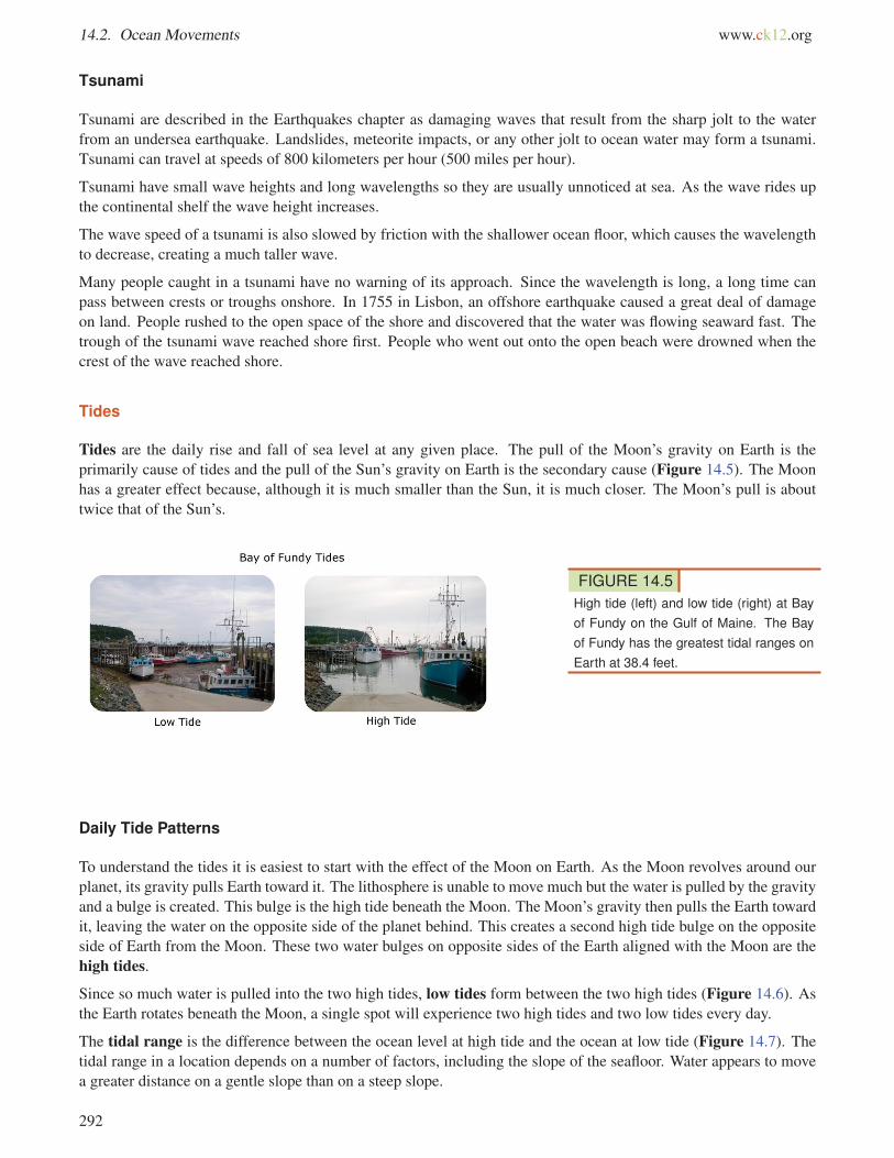
Tides are the daily rise and fall of sea level at any given place. The pull of the Moon’s gravity on Earth is the
primarily cause of tides and the pull of the Sun’s gravity on Earth is the secondary cause (Figure 14.5). The Moon
has a greater effect because, although it is much smaller than the Sun, it is much closer. The Moon’s pull is about
twice that of the Sun’s.
FIGURE 14.5High tide (left) and low tide (right) at Bayof Fundy on the Gulf of Maine. The Bayof Fundy has the greatest tidal ranges onEarth at 38.4 feet.
Daily Tide Patterns
To understand the tides it is easiest to start with the effect of the Moon on Earth. As the Moon revolves around our
planet, its gravity pulls Earth toward it. The lithosphere is unable to move much but the water is pulled by the gravity
and a bulge is created. This bulge is the high tide beneath the Moon. The Moon’s gravity then pulls the Earth toward
it, leaving the water on the opposite side of the planet behind. This creates a second high tide bulge on the opposite
side of Earth from the Moon. These two water bulges on opposite sides of the Earth aligned with the Moon are the
high tides.
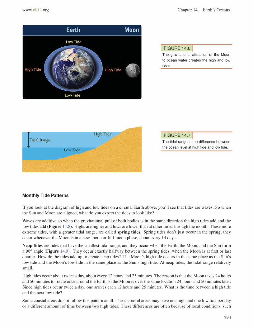
Since so much water is pulled into the two high tides, low tides form between the two high tides (Figure 14.6). As
the Earth rotates beneath the Moon, a single spot will experience two high tides and two low tides every day.
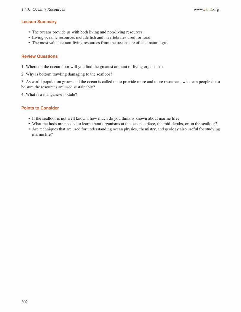
The tidal range is the difference between the ocean level at high tide and the ocean at low tide (Figure 14.7). The
tidal range in a location depends on a number of factors, including the slope of the seafloor. Water appears to move
a greater distance on a gentle slope than on a steep slope.
292
www.ck12.org Chapter 14. Earth’s Oceans
FIGURE 14.6The gravitational attraction of the Moonto ocean water creates the high and lowtides.
FIGURE 14.7The tidal range is the difference betweenthe ocean level at high tide and low tide.
Monthly Tide Patterns
If you look at the diagram of high and low tides on a circular Earth above, you’ll see that tides are waves. So when
the Sun and Moon are aligned, what do you expect the tides to look like?
Waves are additive so when the gravitational pull of both bodies is in the same direction the high tides add and the
low tides add (Figure 14.8). Highs are higher and lows are lower than at other times through the month. These more
extreme tides, with a greater tidal range, are called spring tides. Spring tides don’t just occur in the spring; they
occur whenever the Moon is in a new-moon or full-moon phase, about every 14 days.
Neap tides are tides that have the smallest tidal range, and they occur when the Earth, the Moon, and the Sun form
a 90o angle (Figure 14.9). They occur exactly halfway between the spring tides, when the Moon is at first or last
quarter. How do the tides add up to create neap tides? The Moon’s high tide occurs in the same place as the Sun’s
low tide and the Moon’s low tide in the same place as the Sun’s high tide. At neap tides, the tidal range relatively
small.
High tides occur about twice a day, about every 12 hours and 25 minutes. The reason is that the Moon takes 24 hours
and 50 minutes to rotate once around the Earth so the Moon is over the same location 24 hours and 50 minutes later.
Since high tides occur twice a day, one arrives each 12 hours and 25 minutes. What is the time between a high tide
and the next low tide?
Some coastal areas do not follow this pattern at all. These coastal areas may have one high and one low tide per day
or a different amount of time between two high tides. These differences are often because of local conditions, such
293

14.2. Ocean Movements www.ck12.org
FIGURE 14.8Spring tides occur the tidal bulges fromthe Moon and Sun are aligned. The Moonis full in this image; in the bottom imagethe Moon would appear as a new Moon
as the shape of the coastline that the tide is entering.
Surface Currents
Ocean water moves in predictable ways along the ocean surface. Surface currents can flow for thousands of
kilometers and can reach depths of hundreds of meters. These surface currents do not depend on weather; they
remain unchanged even in large storms because they depend on factors that do not change.
Surface currents are created by three things:
• global wind patterns
• the rotation of the Earth
• the shape of the ocean basins
Surface currents are extremely important because they distribute heat around the planet and are a major factor
influencing climate around the globe.
Global Wind Patterns
Winds on Earth are either global or local. Global winds blow in the same directions all the time and are related to
the unequal heating of Earth by the Sun – that is, more solar radiation strikes the equator than the polar regions —
and the rotation of the Earth – that is, the Coriolis effect. The causes of the global wind patterns will be described
in detail in the Earth’s Atmosphere chapter.
294

www.ck12.org Chapter 14. Earth’s Oceans
FIGURE 14.9Neap tides occur when the Earth, theSun, and the Moon form a right angle; theMoon is in its first or third quarter.
Water in the surface currents is pushed in the direction of the major wind belts:
• trade winds: east to west between the equator and 30oN and 30oS
• westerlies: west to east in the middle latitudes
• polar easterlies: east to west between 50o and 60o north and south of the equator and the north and south pole
Earth’s Rotation
Wind is not the only factor that affects ocean currents. The Coriolis effect describes how Earth’s rotation steers
winds and surface ocean currents (Figure 14.10). Coriolis causes freely moving objects to appear to move to the
right in the Northern Hemisphere and to the left in the Southern Hemisphere. The objects themselves are actually
295

14.2. Ocean Movements www.ck12.org
moving straight, but the Earth is rotating beneath them, so they seem to bend or curve.
An example might make the Coriolis effect easier to visualize. If an airplane flies 500 miles due north, it will not
arrive at the city that was due north of it when it began its journey. Over the time it takes for the airplane to fly 500
miles, that city moved, along with the Earth it sits on. The airplane will therefore arrive at a city to the west of the
original city (in the Northern Hemisphere), unless the pilot has compensated for the change. So to reach his intended
destination, the pilot must also veer right while flying north.
As wind or an ocean current moves, the Earth spins underneath it. As a result, an object moving north or south along
the Earth will appear to move in a curve, instead of in a straight line. Wind or water that travels toward the poles
from the equator is deflected to the east, while wind or water that travels toward the equator from the poles gets bent
to the west. The Coriolis effect bends the direction of surface currents to the right in the Northern Hemisphere and
left in the Southern Hemisphere.
FIGURE 14.10The Coriolis effect causes winds and cur-rents to form circular patterns. The di-rection that they spin depends on thehemisphere that they are in.
Shape of the Ocean Basins
When a surface current collides with land, the current must change direction (Figure 14.11). In the figure below, the
Atlantic South Equatorial Current travels westward along the equator until it reaches South America. At Brazil, some
of it goes north and some goes south. Because of Coriolis effect, the water goes right in the Northern Hemisphere
and left in the Southern Hemisphere.
You can see on the map of the major surface ocean currents that the surface ocean currents create loops called gyres(Figure 14.12). The Antarctic Circumpolar Current is unique because it travels uninhibited around the globe. Why
is it the only current to go all the way around?
296

www.ck12.org Chapter 14. Earth’s Oceans
FIGURE 14.11The major surface ocean currents.
FIGURE 14.12The ocean gyres. Why do the NorthernHemisphere gyres rotate clockwise andthe Southern Hemisphere gyres rotatecounterclockwise?
Local Surface Currents
The surface currents described above are all large and unchanging. Local surface currents are also found along
shorelines (Figure 14.13). Two are longshore currents and rip currents.
FIGURE 14.13Longshore currents move water and sed-iment parallel to the shore in the directionof the prevailing local winds.
297

14.2. Ocean Movements www.ck12.org
Rip currents are potentially dangerous currents that carry large amounts of water offshore quickly. Each summer in
the United States at least a few people die when they are caught in rip currents.
Effect on Global Climate
Surface currents play an enormous role in Earth’s climate. Even though the equator and poles have very different
climates, these regions would have more extremely different climates if ocean currents did not transfer heat from the
equatorial regions to the higher latitudes.
The Gulf Stream is a river of warm water in the Atlantic Ocean, about 160 kilometers wide and about a kilometer
deep. Water that enters the Gulf Stream is heated as it travels along the equator. The warm water then flows up the
east coast of North America and across the Atlantic Ocean to Europe (Figure 14.14). The energy the Gulf Stream
transfers is enormous: more than 100 times the world’s energy demand.
The Gulf Stream’s warm waters raise temperatures in the North Sea, which raises the air temperatures over land
between 3 to 6oC (5 to 11oF). London, U.K., for example, is at the same latitude as Quebec, Canada. However,
London’s average January temperature is 3.8oC (38oF), while Quebec’s is only -12oC (10oF). Because air traveling
over the warm water in the Gulf Stream picks up a lot of water, London gets a lot of rain. In contrast, Quebec is
much drier and receives its precipitation as snow.
FIGURE 14.14In a satellite image of water temperaturein the western Atlantic it is easy to pickout the Gulf Stream, which brings warmerwaters from the equator up eastern NorthAmerica.
Deep Currents
Thermohaline circulation drives deep ocean circulation. Thermo means heat and haline refers to salinity. Dif-
ferences in temperature and in salinity change the density of seawater. So thermohaline circulation is the result of
density differences in water masses because of their different temperature and salinity.
What is the temperature and salinity of very dense water? Lower temperature and higher salinity yield the densest
water. When a volume of water is cooled, the molecules move less vigorously so same number of molecules takes
up less space and the water is denser. If salt is added to a volume of water, there are more molecules in the same
volume so the water is denser.
298

www.ck12.org Chapter 14. Earth’s Oceans
Changes in temperature and salinity of seawater take place at the surface. Water becomes dense near the poles. Cold
polar air cools the water and lowers its temperature, increasing its salinity. Fresh water freezes out of seawater to
become sea ice, which also increases the salinity of the remaining water. This very cold, very saline water is very
dense and sinks. This sinking is called downwelling.
Two things then happen. The dense water pushes deeper water out of its way and that water moves along the bottom
of the ocean. This deep water mixes with less dense water as it flows. Surface currents move water into the space
vacated at the surface where the dense water sank (Figure 14.15). Water also sinks into the deep ocean off of
Antarctica.
FIGURE 14.15Cold water (blue lines) sinks in the NorthAtlantic, flows along the bottom of theocean and upwells in the Pacific or Indian.The water then travels in surface currents(red lines) back to the North Atlantic.Deep water also forms off of Antarctica.
Since unlimited amounts of water cannot sink to the bottom of the ocean, water must rise from the deep ocean to the
surface somewhere. This process is called upwelling (Figure 14.16).
FIGURE 14.16Upwelling forces denser water from belowto take the place of less dense water atthe surface that is pushed away by thewind.
Generally, upwelling occurs along the coast when wind blows water strongly away from the shore. This leaves a
void that is filled by deep water that rises to the surface.
Upwelling is extremely important where it occurs. During its time on the bottom, the cold deep water has collected
nutrients that have fallen down through the water column. Upwelling brings those nutrients to the surface. Those
299

14.2. Ocean Movements www.ck12.org
nutrient support the growth of plankton and form the base of a rich ecosystem. California, South America, South
Africa, and the Arabian Sea all benefit from offshore upwelling.
Upwelling also takes place along the equator between the North and South Equatorial Currents. Winds blow the
surface water north and south of the equator so deep water undergoes upwelling. The nutrients rise to the surface
and support a great deal of life in the equatorial oceans.
Lesson Summary
• Ocean waves are energy traveling through the water.
• Most ocean waves are generated by wind. Tsunami are exceptionally long wavelength waves usually caused
by earthquakes.
• Tides are produced by the gravitational pull of the Moon and Sun.
• Spring tides have large tidal ranges and occur at full and new moons, when Earth, Moon, and Sun are all
aligned.
• Neap tides have low tidal ranges and occur at first and last quarter moons, when the Moon is at right angles to
the Sun.
• Ocean surface currents are produced by global winds, the Coriolis effect and the shape of each ocean basin.
• The Pacific and Atlantic Oceans have a circular pattern of surface currents called gyres that circle clockwise in
the Northern Hemisphere and counterclockwise in the Southern. The Indian Ocean only has a counterclock-
wise gyre.
• Surface ocean circulation brings warm equatorial waters towards the poles and cooler polar water towards the
equator.
• Thermohaline circulation drives deep ocean currents.
• Upwelling of cold, nutrient-rich waters creates biologically rich areas where surface waters are blown away
from a shore, or where equatorial waters are blow outward.
Review Questions
1. What factors of wind determine the size of a wave?
2. Tsunami are sometimes incorrectly called “tidal waves.” Explain why this is not correct.
3. Describe what causes the tides.
4. What is a tidal range? In what types of tides is the tidal range greatest? Lowest?
5. Why do some places have a greater tidal range than other places?
6. What causes the patterns of surface currents in the ocean?
7. How do ocean surface currents affect climate?
8. What is the Coriolis effect?
9. What process can make deep, dense water rise to the surface?
10. Why are upwelling areas important to marine life?
Points to Consider
• Some scientists have hypothesized that if enough ice in Greenland melts, the Gulf Stream might be shut down.
Why might this happen?
• If the Gulf Stream shuts down, what would be the result on climate in Europe?
• How do the movements of ocean water contribute to the ocean’s life?
300

www.ck12.org Chapter 14. Earth’s Oceans
14.3 Ocean’s Resources
Lesson Objectives
• List the living and non-living resources that people use from the seafloor.
Vocabulary
• bottom trawling
• manganese nodule
Introduction
Oceanographers like to say that we know more about the dark side of the Moon than we do about the oceans. That
statement is doubly true of the seafloor. Although modern technology has allowed us to learn more about the seafloor,
vast regions remain unexplored.
Ocean Resources
The ocean provides important living and non-living resources. To be maintained for future use, these resources must
be managed sustainably.
Living Resources
Most fish are caught by lines or nets as they swim in the open waters of the ocean. Some species of fish are being
overharvested, which means their rate of reproduction cannot keep up with the rate at which people consume them.
Bottom trawling is a method of fishing that involves towing a weighted net across the seafloor to harvest fish. In
many areas where bottom trawling is done, ecosystems are severely disturbed by the large nets. For this reason, in a
few areas in the world, laws limit bottom trawling to waters not more than 1,000 m deep or waters far from protected
and sensitive areas. Still these actions protect some of the seafloor. Besides food, ocean organisms have other uses.
Some provide us with medications.
Non-living Resources
Oil and natural gas are the most valuable non-living resources taken from the ocean. Extracting these resources
requires drilling into the seafloor. Oil platforms have dozens of oil wells that are drilled in places where the ocean is
sometimes 2,000 m deep. A description of the Deepwater Horizon oil spill affecting the Gulf of Mexico is located
in the Human Actions and Earth’s Waters chapter.
he seafloor has some valuable minerals. Manganese nodules containing manganese, iron, copper, nickel, phosphate,
and cobalt may be as small as a pea or as large as a basketball. Estimates are that there may be as much as 500
billion tons of nodules on the seafloor. The minerals in manganese nodules have many uses in the industrial world,
but currently they are not being mined. Think back to the discussion of ore deposits in the Earth’s Minerals chapter.
Why do you think these seafloor resources are not being mined?
301
14.3. Ocean’s Resources www.ck12.org
Lesson Summary
• The oceans provide us with both living and non-living resources.
• Living oceanic resources include fish and invertebrates used for food.
• The most valuable non-living resources from the oceans are oil and natural gas.
Review Questions
1. Where on the ocean floor will you find the greatest amount of living organisms?
2. Why is bottom trawling damaging to the seafloor?
3. As world population grows and the ocean is called on to provide more and more resources, what can people do to
be sure the resources are used sustainably?
4. What is a manganese nodule?
Points to Consider
• If the seafloor is not well known, how much do you think is known about marine life?
• What methods are needed to learn about organisms at the ocean surface, the mid-depths, or on the seafloor?
• Are techniques that are used for understanding ocean physics, chemistry, and geology also useful for studying
marine life?
302
www.ck12.org Chapter 14. Earth’s Oceans
14.4 Ocean Life
Lesson Objectives
• Describe the different types of ocean organisms.
• Describe the interactions among different ocean organisms.
Vocabulary
• chemosynthesis
• hydrothermal vent
• invertebrate
• phytoplankton
• plankton
• primary productivity
• reef
• vertebrate
• zooplankton
Introduction
Oceans are a harsh placed to live. In the intertidal zone, conditions change rapidly as water covers and uncovers the
region and waves pound on the rocks. Most of the environments at sea are cold and at just about any depth below
the surface the pressure is very high. Beyond the photic zone, the ocean is entirely black. Organisms have adapted
to these conditions in many interesting and effective ways. The size and variety of different habitats means that the
oceans are home to a large portion of all life on Earth.
Types of Ocean Organisms
The smallest and largest animals on Earth live in the oceans. Why do you think the oceans can support large animals?
Marine animals breathe air or extract oxygen from the water. Some float on the surface and others dive into the
ocean’s depths. There are animals that eat other animals, and plants generate food from sunlight. A few bizarre
creatures break down chemicals to make food! The following section divides ocean life into seven basic groups.
Plankton
Plankton are organisms that cannot swim but that float along with the current. The word "plankton" comes from the
Greek for wanderer. Most plankton are microscopic, but some are visible to the naked eye.
Phytoplankton are tiny plants that make food by photosynthesis. Because they need sunlight, phytoplankton live
in the photic zone. Phytoplankton are responsible for about half of the total primary productivity (food energy) on
Earth. Like other plants, phytoplankton release oxygen as a waste product.
Zooplankton, or animal plankton, eat phytoplankton as their source of food. Some zooplankton live as plankton all
their lives and others are juvenile forms of animals that will attach to the bottom as adults. Some small invertebrates
303

14.4. Ocean Life www.ck12.org
live as zooplankton.
Plants and Algae
The few true plants found in the oceans include salt marsh grasses and mangrove trees. Although they are not true
plants, large algae, which are called seaweed, also use photosynthesis to make food. Plants and seaweeds are found
in the neritic zone where the light they need penetrates so that they can photosynthesize.
Marine Invertebrates
The variety and number of invertebrates, animals without a backbone, is truly remarkable. Marine invertebrates
include sea slugs, sea anemones, starfish, octopi, clams, sponges, sea worms, crabs, and lobsters. Most of these
animals are found close to the shore, but they can be found throughout the ocean.
Fish
Fish are vertebrates; they have a backbone. What are some of the features fish have that allows them to live in the
oceans? All fish have most or all of these traits.
• Fins with which to move and steer.
• Scales for protection.
• Gills for extracting oxygen from the water.
• A swim bladder that lets them rise and sink to different depths.
• Ectothermy (cold-bloodedness) so that their bodies are the same temperature as the surrounding water.
• Bioluminescence: light created from a chemical reaction that can attract prey or mates in the dark ocean.
Included among the fish are sardines, salmon, and eels, as well as the sharks and rays (which lack swim bladders).
Reptiles
Only a few types of reptiles live in the oceans and they live in warm water. Why are reptiles so restricted in their
ability to live in the sea? Sea turtles, sea snakes, saltwater crocodiles, and marine iguana that are found only at the
Galapagos Islands sum up the marine reptile groups. Sea snakes bear live young in the ocean, but turtles, crocodiles,
and marine iguanas all lay their eggs on land.
Seabirds
Many types of birds are adapted to living in the sea or on the shore. A few are shown: (Figure 14.17).
Marine Mammals
What are the common traits of mammals? Mammals are endothermic (warm-blooded) vertebrates that give birth to
live young; feed them with milk; and have hair, ears, and a jaw bone with teeth.
What traits might mammals have to be adapted to life in the ocean?
• For swimming: streamlined bodies, slippery skin or hair, fins.
• For warmth: Fur, fat, high metabolic rate, small surface area to volume, specialized blood system.
304

www.ck12.org Chapter 14. Earth’s Oceans
FIGURE 14.17(a) With their long legs for wading and long bills for digging in sand for food, shorebirds are well adapted for theintertidal. (b) Many seabirds live on land but go to sea to fish, such as gulls, pelicans, and this frigate bird. (c)Albatross spend months at sea and only come on shore to raise chicks.
• For salinity: kidneys that excrete salt, impervious skin.
The five types of marine mammals are pictured here: (Figure 14.18).
FIGURE 14.18(a) Cetaceans: whales, dolphins, and porpoises. (b) Sirenians: manatee and the dugong. (c) Mustelids: Seaotters (terrestrial members are skunks, badgers and weasels). (d) Pinnipeds: Seals, sea lions, and walruses. (e)Polar bear.
305

14.4. Ocean Life www.ck12.org
Interactions Among Ocean Organisms
The previous section briefly discussed the adaptations different types of organisms have to live in the ocean. A look
at a few of the different habitats organisms live in can focus even more on these important adaptations.
The Intertidal
A great abundance of life is found in the intertidal zone. High energy waves pound the organisms that live in this
zone and so they must be adapted to pounding waves and exposure to air during low tides. Hard shells protect from
pounding waves and also protect against drying out when the animal is above water. Strong attachments keep the
animals anchored to the rock.
In a tide pool, as in the photo, what organisms are found where and what specific adaptations do they have to that
zone? The mussels on the top left have hard shells for protection and to prevent drying because they are often not
covered by water. The sea anemones in the lower right are more often submerged and have strong attachments but
can close during low tides.
Many young organisms get their start in estuaries and so they must be adapted to rapid shifts in salinity.
Reefs
Corals and other animals deposit calcium carbonate to create rock reefs near the shore. Coral reefs are the “rain-
forests of the oceans” with a tremendous amount of species diversity.
Reefs can form interesting shapes in the oceans. Remember that hot spots create volcanoes on the seafloor. If these
volcanoes rise above sea level to become islands, and if they occur in tropical waters, coral reefs will form on them.
Since the volcanoes are cones, the reef forms in a circle around the volcano. As the volcano comes off the hot spot,
the crust cools. The volcano subsides and then begins to erode away.
Eventually, all that is left is a reef island called an atoll. A lagoon is found inside the reef.
Coral reef are near shore and so are subject to pollution from land. The coral animals are very sensitive to temperature
and reefs around the world are stressed from rising ocean temperatures.
Oceanic Zone
The open ocean is a vast area. Food either washes down from the land or is created by photosynthesizing plankton.
Zooplankton and larger animals feed on the phytoplankton and on each other. Larger animals such as whales and
giant groupers may live their entire lives in the open water.
How do fish survive in the deepest ocean? The few species that live in the greatest depths are very specialized
(Figure 14.19). Since it’s rare to find a meal, the fish use very little energy; they move very little, breathe slowly,
have minimal bone structure and a slow metabolism. These fish are very small. To maximize the chance of getting a
meal, some species may have jaws that unhinge to accept a larger fish or backward-folding teeth to keep prey from
escaping.
Hydrothermal Vents
At mid-ocean ridges at hydrothermal vents, bacteria that use chemosynthesis for food energy are the base of a
unique ecosystem. This ecosystem is entirely separate from the photosynthesis at the surface. Shrimp, clams, fish,
and giant tube worms have been found in these extreme places.
306

www.ck12.org Chapter 14. Earth’s Oceans
FIGURE 14.19An 1896 drawing of a deep sea anglerfish with a bioluminescent “lure” to attractprey.
Lesson Summaries
• The oceans have a tremendous diversity of life: bacteria, plankton, invertebrates, and vertebrates, which
include fish, reptiles, seabirds, and mammals.
• Photosynthesis and chemosynthesis create food energy in two very different ways.
• Plankton are tiny freely floating plants (phytoplankton) or animals (zooplankton).
• All marine organisms must be specialized for the harsh conditions of the ocean environment in which they
live.
Review Questions
1. What is an invertebrate? Name two types.
2. What is the role of phytoplankton in ocean ecosystems?
3. If fish require oxygen to live, why can’t they survive on land?
4. Are polar bears marine mammals or land animals like all other bears. What is your opinion?
5. What are four major habitats of ocean organisms?
6. Describe adaptations that an organism that lives in a reef might have. How might these adaptations be different
from an organism that lives in the open ocean?
7. Describe the importance of maintaining the ocean ecosystems.
Points to Consider
• How does the ocean interact with the atmosphere?
• How is energy transferred around the planet and how does this affect life on Earth?
• What would be the effect of pollution on the oceans?
Opening image courtesy of Norman Kuring/NASA’s Earth Observatory. http://earthobservatory.nasa.gov/IOTD/vi
ew.php?id=42099. Public Domain.
307

14.5. References www.ck12.org
14.5 References
1. Courtesy of NASA. http://commons.wikimedia.org/wiki/File:Earth_Western_Hemisphere.jpg. Public Domain
2. Courtesy of the US Navy. http://commons.wikimedia.org/wiki/File:Continental_shelf.png. Public Domain
3. CK-12 Foundation. . CC-BY-NC-SA 3.0
4. Both images from Dylan Kereluk. (left) https://commons.wikimedia.org/wiki/File:Bay_of_Fundy_-_Tide_O
ut.jpg; (right) https://commons.wikimedia.org/wiki/File:Bay_of_Fundy_-_Tide_In.jpg. Both images are un-
der CC-BY 2.0
5. Earth and moon image copyright Ioannis Pantziaras, 2010, modified by CK-12 Foundation. http://www.shutt
erstock.com/. Earth and moon image used under license from Shutterstock.com
6. Jared. http://en.wikipedia.org/wiki/File:Tidal_Range.jpg. Public Domain
7. CK-12 Foundation. . CC-BY-NC-SA 3.0
8. CK-12 Foundation. . CC-BY-NC-SA 3.0
9. CK-12 Foundation. . CC-BY-NC-SA 3.0
10. Courtesy of Rick Lumpkin, NOAA/AOML. http://en.wikipedia.org/wiki/File:Ocean_surface_currents.jpg. Pub-
lic Domain
11. Courtesy of National Oceanic and Atmospheric Administration. http://en.wikipedia.org/wiki/File:Oceanic_gy
res.png. Public Domain
12. Yefi. http://en.wikipedia.org/wiki/File:Longshore_drift.svg. Public Domain
13. Sommerstoffel. http://en.wikipedia.org/wiki/File:Golfstrom.jpg. Public Domain
14. Courtesy of Robert Simmon, NASA, and minor modifications made by Robert A. Rohde. http://en.wikipedia.
org/wiki/File:Thermohaline_Circulation_2.png. Public Domain
15. Image courtesy of Sanctuary Quest 2002, NOAA/OER. http://oceanexplorer.noaa.gov/explorations/02quest/b
ackground/upwelling/media/Fig1_cartoon.html. Public Domain
16. (a) Image copyright Clinton Moffat, 2010; (b) Courtesy of Duncan Wright, US Fish and Wildlife Service;
(c) Courtesy of Duncan Wright, US Fish and Wildlife Service. (a) http://www.shutterstock.com; (b) htt
p://en.wikipedia.org/wiki/File:Frigatebird_snatch.JPG; (c) http://commons.wikimedia.org/wiki/File:BFAL_S
OTE_shade.JPG. (a) Used under license from Shutterstock.com; (b) Public Domain; (c) Public Domain
17. (a) Image copyright Christian Musat, 2010; (b) Image copyright Wayne Johnson, 2010; (c) joemess; (d) David
Corby; (e) Ansgar Walk. (a) http://www.shutterstock.com; (b) http://www.shutterstock.com; (c) http://com
mons.wikimedia.org/wiki/File:Sea_otters_holding_hands.jpg; (d) http://en.wikipedia.org/wiki/File:Sealion0520
06.JPG; (e) http://commons.wikimedia.org/wiki/File:Eisb%C3%A4r_1996-07-23.jpg. (a) Used under license
from Shutterstock.com; (b) Used under license from Shutterstock.com; (c) CC-BY 2.0; (d) CC-BY 2.5; (e)
CC-BY 2.5
18. G Brown Goode and Tarleton H Bean. http://en.wikipedia.org/wiki/File:Ceratias_holboelli.jpg. Public Do-
main
308