Embed Size (px)
Citation preview
13. Roestown 2, Co. Meath: an excavation on the M3Clonee to North of Kells motorway schemeRobert O’Hara
Roestown 2 in County Meath is one of approximately 160 archaeological sites discoveredto date along the proposed route of the M3 Clonee to North of Kells motorway scheme.The site is a multiperiod archaeological complex focused on a multiphased, D-shapedenclosure of early medieval origin with limited occupation during the Norman period andalso with evidence of prehistoric activity.
Landscape and history
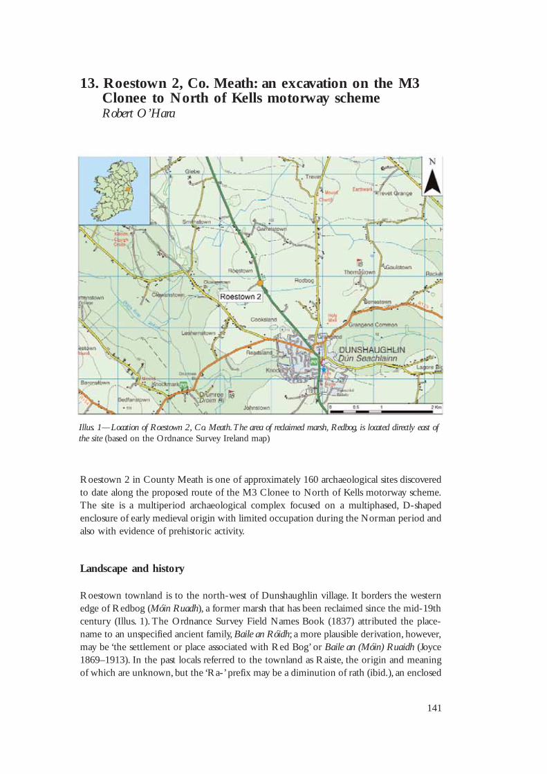
Roestown townland is to the north-west of Dunshaughlin village. It borders the westernedge of Redbog (Móin Ruadh), a former marsh that has been reclaimed since the mid-19thcentury (Illus. 1). The Ordnance Survey Field Names Book (1837) attributed the place-name to an unspecified ancient family, Baile an Róidh; a more plausible derivation, however,may be ‘the settlement or place associated with Red Bog’ or Baile an (Móin) Ruaidh (Joyce1869–1913). In the past locals referred to the townland as Raiste, the origin and meaningof which are unknown, but the ‘Ra-’ prefix may be a diminution of rath (ibid.), an enclosed
141
Illus. 1—Location of Roestown 2, Co. Meath. The area of reclaimed marsh, Redbog, is located directly east ofthe site (based on the Ordnance Survey Ireland map)
New Routes to the Past
142
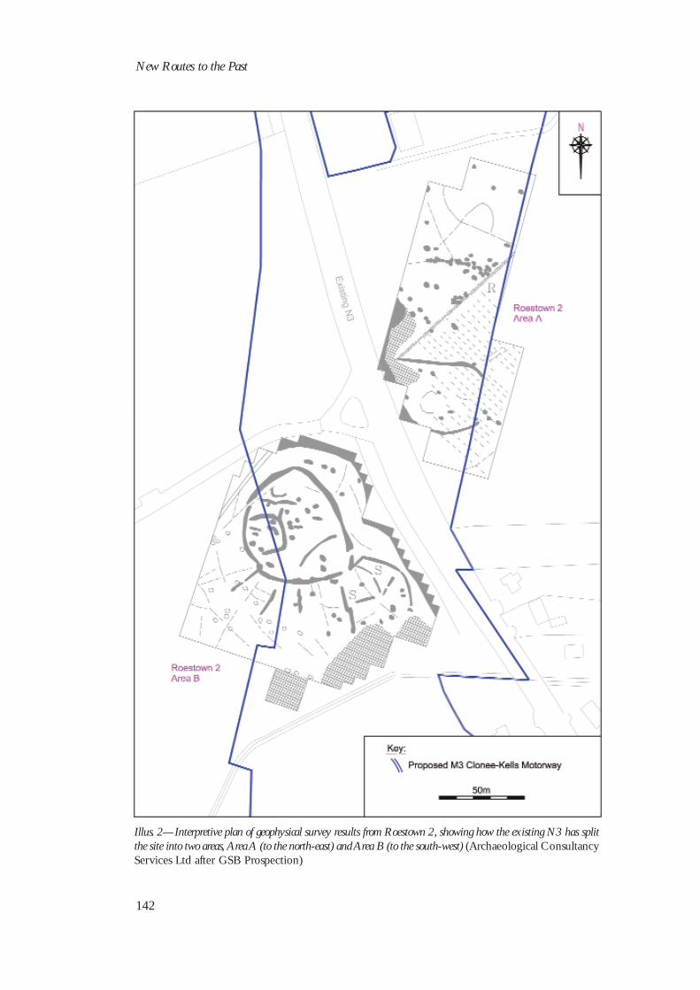
Illus. 2—Interpretive plan of geophysical survey results from Roestown 2, showing how the existing N3 has splitthe site into two areas, Area A (to the north-east) and Area B (to the south-west) (Archaeological ConsultancyServices Ltd after GSB Prospection)
farmstead commonly known as a ringfort, a monument type that had a widespreaddistribution, particularly from the sixth to the 10th century AD (Stout 1997).
The site at Roestown lay within the kingdom of Deiscert Brega (Southern Brega),approximately 3 km north-west of Loch Gabair (Lagore crannog), the chief residence ofClann Chernaig Sótail, kings of Deiscert Brega, between the seventh and 10th centuries AD(Bhreathnach 1999; Cogan 1874; Hencken 1950). The crannog was in a shallow lake (nowreclaimed), on the western shore of which was the monastic settlement of Dún Seachlainn(Dunshaughlin), founded in the fifth century by the Gaulish bishop Secundius (orSeachnaill) (Bradley & King 1985). The monastery was an important establishment from theeighth to the 11th century, particularly to Síl nÁedo Sláine and Clann Chólmáin, the twoprincipal lineages that made up the dynasty known as the Southern Uí Neill. They bothadopted the name ‘Seachnaill’—Gilla (devotee) and Máel (servant of) respectively—in theirfamily names, most famously Máel Seachnaill mac Domhnaill of Clann Chólmáin, whodied as high king in AD 1022. A second monastery, Trevet, developed to the north-east ofRoestown in the eighth century at the reputed burial site of Art, son of Conn of theHundred Battles. One of its abbots, Cuanan (d. AD 734), is believed to have been the authorof the Book of Cuana, a possible source for some entries in the Annals of Ulster (Cogan1874).
Roestown 2 was initially revealed during an extensive geophysical survey by GSBProspection (Illus. 2) carried out as part of an environmental impact assessment of this partof the M3 road scheme by Margaret Gowen & Co. Ltd. Test excavations in 2004 byArchaeological Consultancy Services Ltd (ACS Ltd) confirmed the survival of subsurfacearchaeological features at the site, as well as uncovering Bronze Age burnt mounds orfulachta fiadh (Roestown 1 and Cooksland 3) and a charcoal production kiln (Cooksland 1)in adjacent fields. Roestown 2 (NGR 295793, 253824; height 106 m OD; ministerialdirection no. A008/002) was subsequently excavated by ACS Ltd on behalf of MeathCounty Council and the Nationals Roads Authority (NRA).
Excavation results
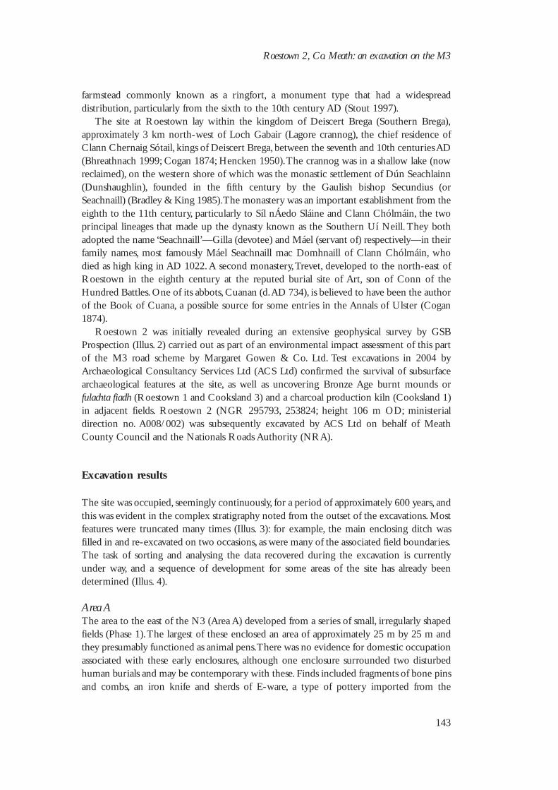
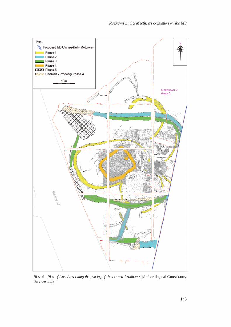
The site was occupied, seemingly continuously, for a period of approximately 600 years, andthis was evident in the complex stratigraphy noted from the outset of the excavations. Mostfeatures were truncated many times (Illus. 3): for example, the main enclosing ditch wasfilled in and re-excavated on two occasions, as were many of the associated field boundaries.The task of sorting and analysing the data recovered during the excavation is currentlyunder way, and a sequence of development for some areas of the site has already beendetermined (Illus. 4).
Area AThe area to the east of the N3 (Area A) developed from a series of small, irregularly shapedfields (Phase 1). The largest of these enclosed an area of approximately 25 m by 25 m andthey presumably functioned as animal pens. There was no evidence for domestic occupationassociated with these early enclosures, although one enclosure surrounded two disturbedhuman burials and may be contemporary with these. Finds included fragments of bone pinsand combs, an iron knife and sherds of E-ware, a type of pottery imported from the
Roestown 2, Co. Meath: an excavation on the M3
143
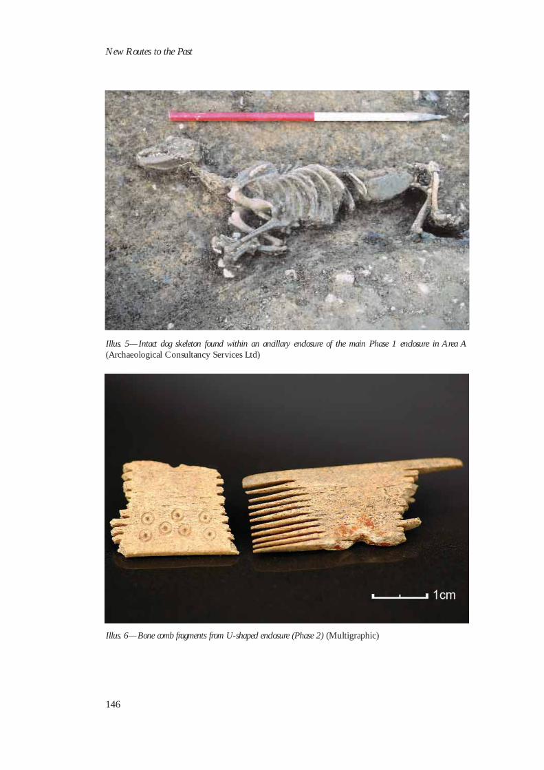
European mainland in the sixth and seventh centuries and found in increasing numbers onearly medieval ‘high-status’ sites (Wooding 1996, 81; Edwards 1990, 68–9). A complete dogskeleton (Illus. 5) belonging to this phase was radiocarbon-dated to AD 630–710 (Beta-219003; see Appendix 1 for details).
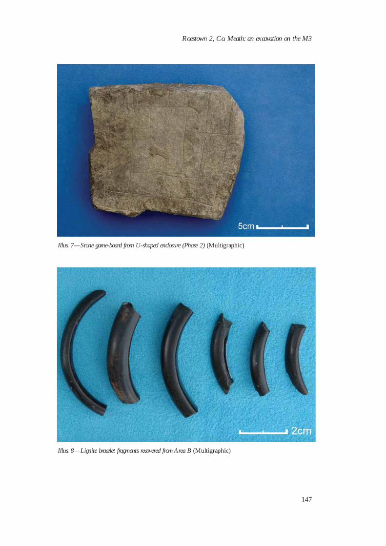
Phase 1 came to an end with a massive restructuring of the area. The earlier featureswere backfilled and levelled and then replaced by a substantial, U-shaped enclosure,approximately 40 m by 30 m (Phase 2). This enclosure was associated with a number ofradiating ditches, all of which contained significant quantities of animal bone. The findsfrom this phase were typically early medieval and included bone pins, iron knives and bonecomb fragments (Illus. 6). Less common artefacts included two flat stones with crudechequered patterns on them (Illus. 7), which represent an early example of an abstractstrategy board-game known as ‘Nine Men’s Morris’, or merels, and are similar to adecorated piece of mudstone uncovered at Lagore (Hencken 1950, 177, fig. 92, no. 1492)and to an incised, flat, sandstone slab from Garryduff, Co. Cork (O’Kelly 1962, 88, fig. 19).Animal bone from the U-shaped enclosure produced radiocarbon dates of AD 650–780 andAD 620–690 (Beta-219002 and Beta-219005) for this phase.
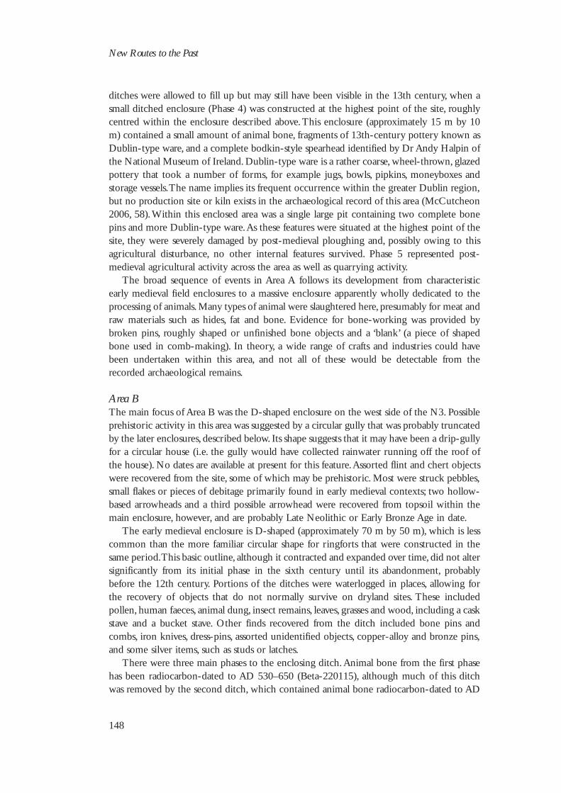
This enclosure was eventually backfilled and recut, in some areas completely removingthe earlier ditch. The alteration of the enclosure from U-shaped to rectangular may haveoccurred during this phase (Phase 3), and many of the radial or associated ditches may alsohave been recut at this time. Animal bone was still found in large quantities. Among thenotable artefacts were a strip of decorated bronze, a fragment of silver presumably cut off alarger object, a lignite bracelet fragment (e.g. Illus. 8), and a possible bone flute. Phase 3 hasnot yet been radiocarbon-dated; an eighth- to 11th-century date is likely, however. The
New Routes to the Past
144
Illus. 3—Aerial view of excavated features from north (with Area A on the left; Area B on the right) (StudioLab)
Roestown 2, Co. Meath: an excavation on the M3
145
Illus. 4—Plan of Area A, showing the phasing of the excavated enclosures (Archaeological ConsultancyServices Ltd)
New Routes to the Past
146
Illus. 5—Intact dog skeleton found within an ancillary enclosure of the main Phase 1 enclosure in Area A(Archaeological Consultancy Services Ltd)
Illus. 6—Bone comb fragments from U-shaped enclosure (Phase 2) (Multigraphic)
Roestown 2, Co. Meath: an excavation on the M3
147
Illus. 7—Stone game-board from U-shaped enclosure (Phase 2) (Multigraphic)
Illus. 8—Lignite bracelet fragments recovered from Area B (Multigraphic)
ditches were allowed to fill up but may still have been visible in the 13th century, when asmall ditched enclosure (Phase 4) was constructed at the highest point of the site, roughlycentred within the enclosure described above. This enclosure (approximately 15 m by 10m) contained a small amount of animal bone, fragments of 13th-century pottery known asDublin-type ware, and a complete bodkin-style spearhead identified by Dr Andy Halpin ofthe National Museum of Ireland. Dublin-type ware is a rather coarse, wheel-thrown, glazedpottery that took a number of forms, for example jugs, bowls, pipkins, moneyboxes andstorage vessels. The name implies its frequent occurrence within the greater Dublin region,but no production site or kiln exists in the archaeological record of this area (McCutcheon2006, 58). Within this enclosed area was a single large pit containing two complete bonepins and more Dublin-type ware. As these features were situated at the highest point of thesite, they were severely damaged by post-medieval ploughing and, possibly owing to thisagricultural disturbance, no other internal features survived. Phase 5 represented post-medieval agricultural activity across the area as well as quarrying activity.
The broad sequence of events in Area A follows its development from characteristicearly medieval field enclosures to a massive enclosure apparently wholly dedicated to theprocessing of animals. Many types of animal were slaughtered here, presumably for meat andraw materials such as hides, fat and bone. Evidence for bone-working was provided bybroken pins, roughly shaped or unfinished bone objects and a ‘blank’ (a piece of shapedbone used in comb-making). In theory, a wide range of crafts and industries could havebeen undertaken within this area, and not all of these would be detectable from therecorded archaeological remains.
Area BThe main focus of Area B was the D-shaped enclosure on the west side of the N3. Possibleprehistoric activity in this area was suggested by a circular gully that was probably truncatedby the later enclosures, described below. Its shape suggests that it may have been a drip-gullyfor a circular house (i.e. the gully would have collected rainwater running off the roof ofthe house). No dates are available at present for this feature. Assorted flint and chert objectswere recovered from the site, some of which may be prehistoric. Most were struck pebbles,small flakes or pieces of debitage primarily found in early medieval contexts; two hollow-based arrowheads and a third possible arrowhead were recovered from topsoil within themain enclosure, however, and are probably Late Neolithic or Early Bronze Age in date.
The early medieval enclosure is D-shaped (approximately 70 m by 50 m), which is lesscommon than the more familiar circular shape for ringforts that were constructed in thesame period. This basic outline, although it contracted and expanded over time, did not altersignificantly from its initial phase in the sixth century until its abandonment, probablybefore the 12th century. Portions of the ditches were waterlogged in places, allowing forthe recovery of objects that do not normally survive on dryland sites. These includedpollen, human faeces, animal dung, insect remains, leaves, grasses and wood, including a caskstave and a bucket stave. Other finds recovered from the ditch included bone pins andcombs, iron knives, dress-pins, assorted unidentified objects, copper-alloy and bronze pins,and some silver items, such as studs or latches.
There were three main phases to the enclosing ditch. Animal bone from the first phasehas been radiocarbon-dated to AD 530–650 (Beta-220115), although much of this ditchwas removed by the second ditch, which contained animal bone radiocarbon-dated to AD
New Routes to the Past
148
710–960 (Beta-220114). The main difference between these two phases is the nature of theentrance. The first ditch was a complete circuit, presumably spanned by a bridge. The secondditch was entered through a causeway, approximately 2 m wide and stone-lined. There wasno evidence for any structures associated with these entrances, although a gatehouse couldhave been incorporated into the surrounding bank if it had been required. The final phaseof the ditch has been radiocarbon-dated to AD 770–980 (Beta-220116).
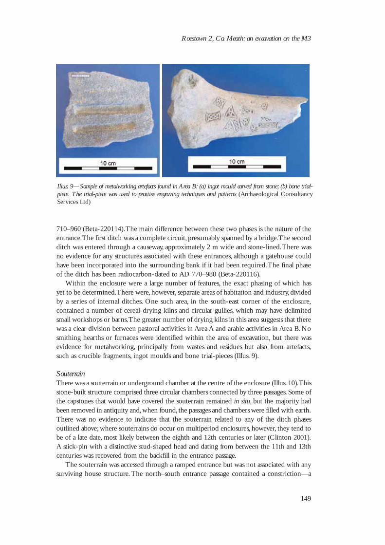
Within the enclosure were a large number of features, the exact phasing of which hasyet to be determined. There were, however, separate areas of habitation and industry, dividedby a series of internal ditches. One such area, in the south-east corner of the enclosure,contained a number of cereal-drying kilns and circular gullies, which may have delimitedsmall workshops or barns. The greater number of drying kilns in this area suggests that therewas a clear division between pastoral activities in Area A and arable activities in Area B. Nosmithing hearths or furnaces were identified within the area of excavation, but there wasevidence for metalworking, principally from wastes and residues but also from artefacts,such as crucible fragments, ingot moulds and bone trial-pieces (Illus. 9).
SouterrainThere was a souterrain or underground chamber at the centre of the enclosure (Illus. 10). Thisstone-built structure comprised three circular chambers connected by three passages. Some ofthe capstones that would have covered the souterrain remained in situ, but the majority hadbeen removed in antiquity and, when found, the passages and chambers were filled with earth.There was no evidence to indicate that the souterrain related to any of the ditch phasesoutlined above; where souterrains do occur on multiperiod enclosures, however, they tend tobe of a late date, most likely between the eighth and 12th centuries or later (Clinton 2001).A stick-pin with a distinctive stud-shaped head and dating from between the 11th and 13thcenturies was recovered from the backfill in the entrance passage.
The souterrain was accessed through a ramped entrance but was not associated with anysurviving house structure. The north–south entrance passage contained a constriction—a
Roestown 2, Co. Meath: an excavation on the M3
149
Illus. 9—Sample of metalworking artefacts found in Area B: (a) ingot mould carved from stone; (b) bone trial-piece. The trial-piece was used to practise engraving techniques and patterns (Archaeological ConsultancyServices Ltd)
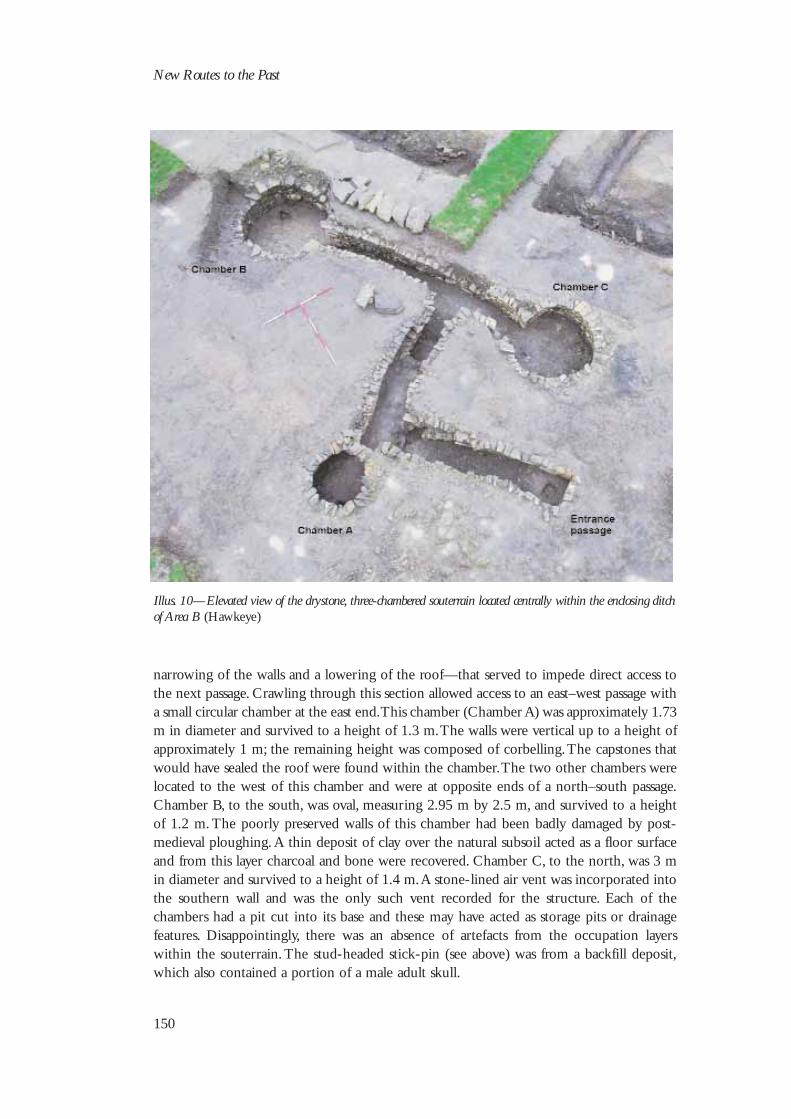
narrowing of the walls and a lowering of the roof—that served to impede direct access tothe next passage. Crawling through this section allowed access to an east–west passage witha small circular chamber at the east end. This chamber (Chamber A) was approximately 1.73m in diameter and survived to a height of 1.3 m. The walls were vertical up to a height ofapproximately 1 m; the remaining height was composed of corbelling. The capstones thatwould have sealed the roof were found within the chamber. The two other chambers werelocated to the west of this chamber and were at opposite ends of a north–south passage.Chamber B, to the south, was oval, measuring 2.95 m by 2.5 m, and survived to a heightof 1.2 m. The poorly preserved walls of this chamber had been badly damaged by post-medieval ploughing. A thin deposit of clay over the natural subsoil acted as a floor surfaceand from this layer charcoal and bone were recovered. Chamber C, to the north, was 3 min diameter and survived to a height of 1.4 m. A stone-lined air vent was incorporated intothe southern wall and was the only such vent recorded for the structure. Each of thechambers had a pit cut into its base and these may have acted as storage pits or drainagefeatures. Disappointingly, there was an absence of artefacts from the occupation layerswithin the souterrain. The stud-headed stick-pin (see above) was from a backfill deposit,which also contained a portion of a male adult skull.
New Routes to the Past
150
Illus. 10—Elevated view of the drystone, three-chambered souterrain located centrally within the enclosing ditchof Area B (Hawkeye)
Conclusions
The early medieval farmstead at Roestown was occupied, almost certainly continuously,from the sixth to the 12th century AD. Its proximity to important early medieval monasticsettlements at Dunshaughlin and Trevet, as well as the crannog at Lagore, is significant. Theprovisional radiocarbon dates quoted above suggest that all three sites were contemporary.It is probable that there was a connection between Roestown and either of the monasticsettlements. Abbots were usually from royal stock, and the leading clerics of Trevet andDunshaughlin would certainly have been related to the kings of Lagore (Cogan 1874). Themodern agricultural surroundings do little to evoke the appearance of the early medievallandscape. This large enclosure at Roestown, situated on a prominent rise flanked by amarsh and a stream, defended by deep waterlogged ditches, was the focal point of adeveloped agricultural industry, the extent of which we are only beginning to unravel. Thetask of sorting the large amount of information retrieved during the course of theexcavation has only begun. Specialist examination of the environmental samples taken fromthe site, as well as of the animal remains and the artefacts, should, when complete, give adetailed picture of a prosperous farmstead in the early medieval period.
Acknowledgements
Thanks are due to all those involved in the excavation of Roestown 2, in particular sitesupervisors Ken Smith and Leigh Barker and senior archaeologists Donald Murphy andJohn Harrison. Thanks also to the Meath County Council archaeologists Mary Deevy,Maria FitzGerald and Claire Crowley; to Dr Eoin Grogan and Vicky Ginn for advice andcomments; and to Killian Murray for his work on the illustrations.
Roestown 2, Co. Meath: an excavation on the M3
151


![Meath Earthquakes 1 1 1 [1]](https://img.dokumen.tips/doc/110x75/54967439b47959507a8b466d/meath-earthquakes-1-1-1-1.jpg)


