Embed Size (px)
Citation preview
64
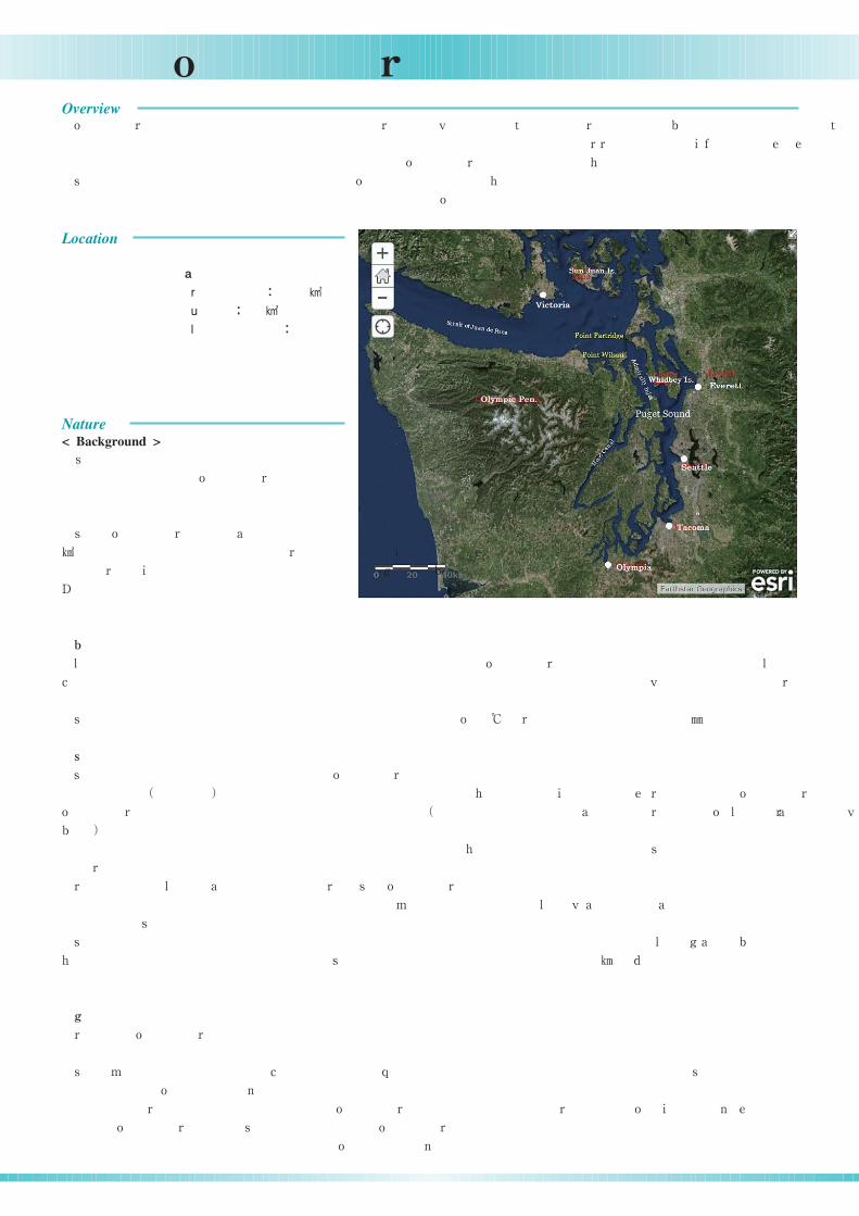
12 Puget SoundPuget Sound located in northwest Washington State of the United States near the border of Canada and the United States
is part of a single large ecosystem that includes the Strait of Juan de Fuca and the Strait of Georgia For this Guidebook
we have delineated the area of Puget Sound by the northern entrance of Admiralty Inlet
This basin was carved during the Pleistocene Ice Age by at least one large and probably several small glaciers The Sound
itself is really an estuary where saltwater from the Pacific mixes with freshwater from a multitude of rivers
The glacial carving that shaped the deep
channels of Puget Sound also helped shape the
steep coastal bluffs beaches and relatively narrow
shallow marine terraces
The Puget Sound Basin covers about
encompassing the Strait of Juan de Fuca
the San Juan archipelago and Hood Canal
% of the basin is composed of land and % is
made of water
Maritime air masses have a moderating effect in south Puget Sound year round creating a modified Mediterranean climate
During the fall and spring seasons the climate is relatively mild Winters are usually wet and mild Summers are generally
cool and dry
The average temperature for the Puget Sound lowlands was and total precipitation was
The bottom topography of Puget Sound is characterized by a series of basins and sills which were created by glacial action
A shallow sill m deep at Admiralty Inlet separates the waters of the Strait of Juan de Fuca from Puget Sound proper
Puget Sound proper is divided into interconnected basins Main Basin Whidbey Basin South Puget Sound and Hood
Canal and most of them are separated from each other by shallow sills The largest and deepest basin is Main Basin
which is located south of Admiralty Inlet and extends southward for approximately km The maximum depth occurs north
of Seattle at around m
South of Main Basin lies South Puget Sound They are separated by a shallow sill of approximately m depth This basin
is shallow and has numerous islands and inlets North and east of Main Basin lies Whidbey Basin but it is not separated by
a sill This basin is relatively deep ranging between and m in depth
The smallest of the four basins in terms of area is the Hood Canal which branches from Main Basin south of Admiralty
Inlet by a m deep sill This basin is long and narrow extending southward about Except for the central region
and entrance this basin is less than m deep
South Puget Sound oceanographic circulation processes are typical of a fjordal estuary with landward flow at depth and
seaward flow at the surface
The Nisqually and Deschutes Rivers deliver freshwater which usually flows seaward on the surface The incoming water
from the Pacific Ocean is colder and more saline than the freshwater causing it to be denser and flow landward along the
bottom Salt water in the Puget Sound enters from the Pacific Ocean through the Strait of Juan de Fuca then diverges south
into Puget Sound Tides in the Puget Sound are semi diurnal with two unequal high tides and two unequal low tides daily
As the distance from the Pacific Ocean increases mean tidal range in the Sound also increases
, ,
. ,
.
.
.
, , ,
.
44,000
, ,
, . 80
20
.
, .
, . .
.
2013 10.4 972 .
, .
65 .
4 , , ,
, . ,
96 .
300 .
. 45 .
. ,
. , 100 200 .
, , , ,
, 50 . , 90 .
40 .
,
.
.
,
.
. - , .
, .
1
2,13
2
2
3
4
2
1,4
Basic information
Surface areaVolumeMaximum depth m
::
:
2,600169
300
裄
裝
裄
襄 袢
袰
Climate
Topography
Hydrology
( )
(
)
Overview
Location
Nature< Background >
65
12 Puget Sound
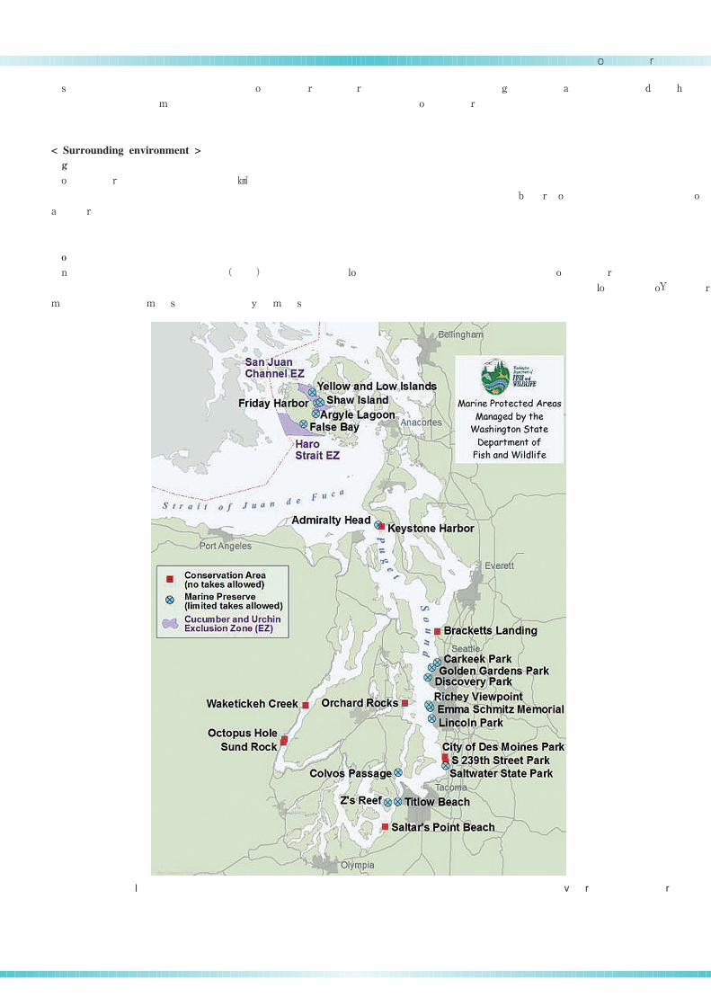
Marine protected areas that are managed by the Washington State Fish and Wildlife Service8
5
6
7
Tidal currents are muted within South Puget Sound particularly within protected Henderson Budd and Eld Inlets The
edge of the Nisqually estuary touching Puget Sound is the most exposed portion of the marine shoreline and tidal currents
here are typically stronger and directed to the northwest
Puget Sound has approximately of seagrass A significant proportion of the seagrass is found on flat bottoms such
as in large shallow bays and small pocket beaches Close to one fifth of all the seagrass in Puget Sound grows in the Padilla
Bay Seagrass beds are also found as narrow fringing beds along steep shorelines and this type of seagrass bed is commonly
used as a migration corridor by salmon
Over marine protected areas MPA designated by state and federal agencies exist in Puget Sound for a variety of
goals and objectives with varying levels of restrictions MPAs in Puget Sound are mainly categorized into protection levels:
No Access No Take and Zone with No Take Areas
, , , .
.
104 . ,
.
. ,
.
100 , ,
, . 3
, , .
Habitat
Protected Areas
裄
( )
< Surrounding environment >
66
12 Puget Sound
The oldest sites of human habitation in the region date back to to years ago not long after the last glacial
period The earlier glacial people were gradually replaced by the Salish tribes native americans The Salish tribes relied
heavily on native salmon for nutrition
In Captain George Vancouver charted and explored the bays harbors and islands of Puget Sound Then in the s
white settlers moved into the region attracted by the abundant resources Logging and fishing became popular industries
until the th century
Salmon is a major icon of Puget Sound and has been central to the history and culture of the region The native tribes
geared their food gathering cycle to the salmon runs and they traditionally celebrated the first salmon catch of the year with
the First Salmon Ceremony Nowadays several organizations and tribes work together in the fall to put on a Salmon Homecom
ing festival on the Seattle waterfront The festival celebrates the return of spawning salmon to the rivers and streams of
Puget Sound
The central Puget Sound region grew by % between and as the region added new people and total
population reached This marks the third consecutive year of increased annual growth
The catchment area of Puget Sound is comprised from mountains and coastal lowlands Urban and agricultural lands cover
about % and % of the catchment area respectively and are concentrated in the lowlands Most parts of the catchment
area are dominated by forestland concentrated in the foothills and mountains
Various industries are established in the Puget Sound region Key industries in the region include aerospace e g Boeing
advanced technology e g Microsoft international trade general manufacturing shipping and tourism These industries
are mainly concentrated in the urban areas Major industries in the rural areas are fishing oyster and salmon aquaculture
agriculture forestry and wood products manufacturing
The fishing and aquaculture industries are heavily dependent on the waters of Puget Sound The aquaculture industries
mainly cultivate salmon clams and oysters Oysters are particularly important and the area is one of two major cultivation
regions in the United States Herring cod trout perch sole and flounder as well as algae sea urchin roe and sea cucumbers
are also harvested from the Sound In the total revenue from commercial fish harvesting in Puget Sound was more
than million US dollars and the industry employed nearly people Also revenues from commercial shell fishing in the
same year hit the million US dollars mark and the industry employed approximately people Furthermore many
tribes in the region rely on the harvest of fish and shellfish as an important part of their food supply and revenue
According to the state Department of Ecology monitoring program water quality in Puget Sound is reasonably good
However several locations within Puget Sound have water quality problems associated with low dissolved oxygen and high
fecal coliform bacteria contamination and some areas are sensitive to eutrophication These areas are generally located near
urban areas and large rivers and are characterized by having high river runoff low mixing and anthropogenic inputs of
nutrients and sewage The areas of highest concern are in Southern Hood Canal Budd Inlet Penn Cove Commencement
Bay Elliott Bay Possession Sound Saratoga Passage and Sinclair Inlet
Another water quality problem found in Puget Sound is chemical contamination As an indicator of chemical contamination
the toxic contamination levels inside mussels harbor seals and English sole are monitored in Puget Sound According to the
mussel monitoring concentrations of the long banned pesticides chlordane and DDT and several metals such as lead and
mercury are declining
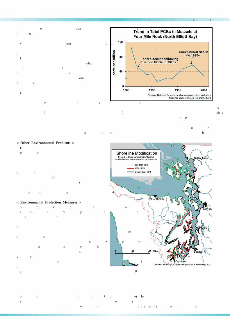
Although the concentration of PCBs began declining after their ban in the s they showed a sudden rise in the mid
s at many monitoring stations According to the NOAA's National Mussel Watch Program during PCB concentra
tion of up to ng g was detected at Four Mile Rock North Elliot Bay near Seattle the major source of PCBs for the
10,000 12,000 ,
. .
.
1792, , . , 1850
, .
20 .
.
-
. , -
.
.
1.4 2013 2014 54,550
3,835,450. .
.
9 6 , , .
.
. . . ,
. . , , , .
. , ,
, .
.
, . ,
. , , , , , ,
. 1998,
12 , 900 .
40 , 1,800 . ,
.
, .
,
, .
, ,
. , , ,
, , , , .
. ,
, .
, - , ,
, .
1970 , -
1990 . 1997-98, -
533 / ,
( )
( )
( )
( )
9
10
11
6
10
6
Fisheries
Water quality
History and Culture
Social Environment
Environmental Problems
< History >
< Culture >
< Population >
< Land use >
< Industry >
< Water and sediment quality >
67
12 Puget Sound
Human alteration of the coastline4
6
6
6
6,12
11
6,7
6,11
7
7
region Fortunately the PCB concentration in Four
Mile Rock started to decline again between and
Within the same NOAA program PAHs concentra
tion in mussels were one of the highest in the United
States
Monitoring of harbor seal blubber in showed
high concentrations of PCBs and was significantly high
er approximately times compared to Strait of
Georgia harbor seals These differences probably reflect
the high levels of industrial PCB usage in the Puget
Sound Basin before its ban in the 's
According to a survey conducted between
by the Washington State's Department of Ecology
compounds or compound groups were measured in concentrations above sediment quality standards These included six
pollutant metals arsenic copper mercury lead silver and zinc PAHs PCBs and other contaminants Compared with
past surveys concentrations of some contaminants such as naphthalene and other small PAHs showed an increase while
concentrations of metals such as copper and mercury have decreased significantly
As expected contamination was most serious in urban and industrial areas with the central Puget Sound region being the
most contaminated followed by Whidbey Basin The least contaminated area was in the Admiralty Inlet region
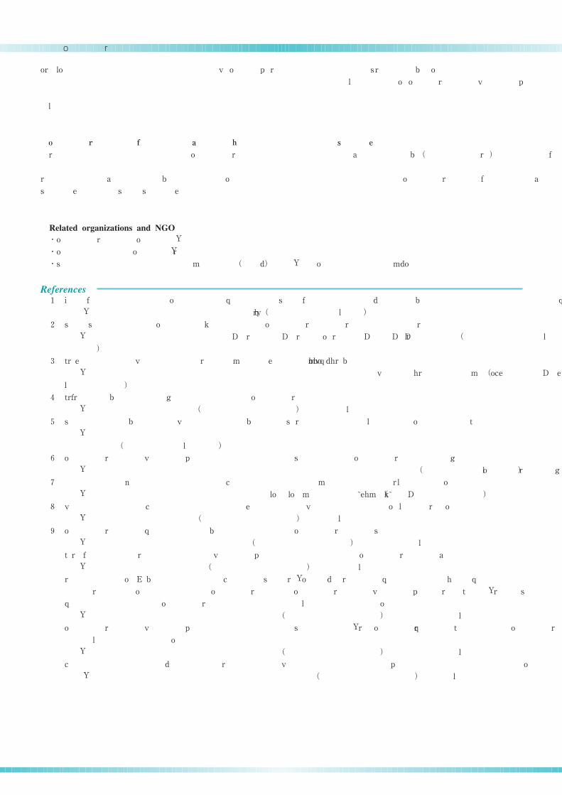
Puget Sound has experienced significant physical
changes to its nearshore habitat through human development
of port facilities piers bulkheads and other shoreline
armoring structures Approximately one third of the
Puget Sound shoreline has been modified and an
estimated % of tidally influenced wetlands have been
lost in the past century The most modified areas
are in the large river deltas such as in Commencem
ent Bay Puyallup River areas and Elliot Bay
The Puget Sound Water Quality Management Plan
is Washington State's strategy for protecting and enhanc
ing the water quality and biological resources of Puget
Sound and also serves as a comprehensive conservation
and management plan under the federal National Estuary
Program The management plan is prepared and
regularly amended by the Puget Sound Water Quality
Action Team and Puget Sound Council Also every
two years the Action Team develops the Puget Sound
Work Plan to identify actions needed to gain a cleaner
and healthier Sound which are guided by the Management
Plan's long term goals and specific priorities
The management plan covers aspects such as aquatic
nuisance species contaminated sediments and dredging marine and freshwater habitat protection municipal and industrial
discharge non point source pollution shellfish protection spill prevention and response storm water and combined sewer
overflows
To protect the water quality of Puget Sound various state local and federal agencies are involved in a wide range of
monitoring programs through the Puget Sound Ambient Monitoring Program PSAMP The direction scope and design of
. ,
1999
2000.
, -
.
2002
-
8
.
1970 .
1997 -
1999 ,
22 .
, , , , , , .
, ,
, , .
, ,
, . .
, ,
. -
70
.
-
, .
-
,
.
. ,
,
- .
, , ,
, - , , ,
.
, ,
. ,
( )
( )
( )
Sediment quality
Shoreline modification
Puget Sound Water Quality Management Plan
Puget Sound Ambient Monitoring Program PSAMP( )
< Other Environmental Problems >
< Environmental Protection Measures >
68
12 Puget Sound
PSAMP are determined by the Puget Sound Water Quality Action Team and Puget Sound Council and the results of the
monitoring program are communicated back to the Puget Sound Water Quality Management Plan
Monitoring includes fresh and marine water quality sediment quality fish and shellfish nearshore habitat marine birds
marine mammals and so on
Since the health of Puget Sound is interconnected with the inland waters of British Columbia Strait of Georgia and to
ensure the protection conservation and enhancement of these shared resources a joint organization between Washington
State and British Columbia Province was established in appropriately named as the Puget Sound Georgia Basin International
Task Force The Task Force will research issues affecting the shared marine waters adopt joint policies and implement
actions provide cross border information exchange and organize workshops
Puget Sound Partnership <http: www psp wa gov >
People for Puget Sound <http: pugetsound org >
The Association of National Estuary Programs ANEP <http: nationalestuaries org >
Jan Goggans Pacific Region The Greenwood Encyclopedia of American Regional Cultures
https: books google co jp books?id= c tgoSZkC accessed March
The Trust for Public Land Puget Sound Shoreline Strategy
http: www tpl org sites default files Puget% Sound% Shoreline% Strategy% Update% pdf accessed March
US Fish and Wildlife Service Nisqually NWR Final CCP EIS Chapter
http: www fws gov pacific planning main docs WA nisqually Nisqually% Final% CCPEIS chapter PDF accessed
March
USGS Coastal Habitats in Puget Sound
http: puget usgs gov psnrp pdf accessed March
Thurston County Washington Thurston County Shoreline Master Program Update
http: www co thurston wa us planning shoreline documents inventory appendix f ecosystem processes characterization
methods pdf accessed March
Puget Sound Water Quality Action Team Puget Sound's Health
http: blog pugetsoundinstitute org wp content uploads PugetSoundHealth pdf accessed March
Allison Osterberg Developing a Network of Marine Protected Areas in Puget Sound
http: www psp wa gov downloads MPA MPANetwork_FINAL_ % copy pdf accessed March
Washington Department of Fish and Wildlife Marine Protected Areas within Puget Sound
http: wdfw wa gov fishing mpa accessed March
Puget Sound Regional Council Puget Sound Trends
http: www psrc org assets trend d pdf accessed March
U S Geological Survey Water Quality in the Puget Sound Basin
http: pubs usgs gov circ circ accessed March
Sommers P & Canzoneri D The Sound Economy: Puget Sound Region's Industries and their Relationship to
the Sound People for Puget Sound Puget Sound Water Quality Action Team Puget Sound Update: Seventh
Report of the Puget Sound Ambient Monitoring Program
http: wdfw wa gov publications wdfw pdf accessed March
Puget Sound Water Quality Action Team Puget Sound Update: Seventh Report of the Puget Sound Ambi
ent Monitoring Program
http: wdfw wa gov publications wdfw pdf accessed March
Department of Ecology State of Washington Quality Assurance Project Plan
https: fortress wa gov ecy publications publications pdf accessed March
,
.
, , , , ,
.
, ,
1993, /
. ,
, - .
// . . . /
// . /
// . /
. , 2004. ,
// . . . / 8-6 1 , 31, 2015
. , 2013. 2013
// . . / / / / 20 20 20 20 202013. ,
31, 2015
. , 2004. / 3
// . . / / / / / / / 20 20 / 3. ,
31, 2015
. , 2006.
// . . / . , 31, 2015
. , 2013.
// . . . . / / / / / - - - - -
. , 31, 2015
. , 2002. 2002.
// . . / - / /2011/12/ 2002. , 31, 2015
. , 2012.
// . . . / / / 0928 20 . , 31, 2015
. , 2015. .
// . . / / / 31, 2015
. , 2015. .
// . . / /2782/ - 3. , 31, 2015
10. . . , 2000.
// . . / / 1216/, 31, 2015
11. , . , ., 1996.
. . . 2000. 2000
.
// . . / /01027/ 01027. , 31, 2015
12. . 2000. 2000 -
.
// . . / /01027/ 01027. , 31, 2015
13. . 2009. .
// . . / / / /0903121. 31, 2015
7
7
7
Puget Sound Georgia Basin International Task Force/
( )
・
・
・ ( )
( )
(
)
(
)
( )
( )
( )
( )
( )
( )
( )
( )
( )
( )
1
2
3
4
5
6
7
8
9
Related organizations and NGO
References