Embed Size (px)
Citation preview

SPECIALIST CONSULTANT STUDIES 5 - 15 NARRABRI COAL OPERATIONS PTY LTD Part 5 – Aboriginal Heritage Assessment Narrabri Coal Mine – Stage 2 Longwall Project Report No. 674/17
Archaeological Surveys & Reports Pty Ltd
Whilst it was recognised there is less certainty about the long term layout for Panels 8 to 26, it was considered appropriate to undertake sufficient investigations to accurately predict the impacts of the overall project. Rather than undertaking a detailed survey across Panels 8 to 26, it was determined to commence with a desktop assessment for Panels 8 to 26 reflecting the information gained from the detailed survey of the Panels 1 to 7 Survey Area (hereafter referred to the “Panels 8 to 26 Survey Area”). The objective of the desktop survey was to compile a predictive model of Aboriginal site occurrence over the Panels 8 to 26 Survey Area which would be used to develop a field survey methodology for this larger survey area. Following discussion regarding the appropriate approach to the field survey, the reconnaissance survey of those areas of the Panels 8 to 26 Survey Area with a higher probability for Aboriginal site identification was undertaken. Following a review of the dewatering requirements of the Longwall Project, NCOPL advised that a Brine Storage Area of up to 160ha in area could be required to store the waste water (brine) produced by the reverse osmosis treatment of this water. In addition, a pipeline would be required to transfer and discharge the surplus fresh water (raffinate) produced by the reverse osmosis treatment of this water. The scope of the archaeological investigations was subsequently extended to include a detailed archaeological investigation of the designated Brine Storage Area and proposed water pipeline route between the Mine Site and the Namoi River. 1.2.2 Report Objectives The objectives of this report are to describe the consultation process and the archaeological investigation of the Survey Areas and to record the archaeological relics and sites that were identified. Further, the report documents the participation of the Aboriginal stakeholders, and their recommendations as to the future management of the sites identified during the investigation. In addition, the report includes a discussion of the results of the investigation in the context of other known sites in the area. Finally, the report includes a statement as to the recommendations for the future development of Narrabri Coal Mine. 1.2.3 Report Format The report is presented in the following format: i Executive summary
ii Contents
1. Introduction
2. Aboriginal Consultation
3. The Environmental Context
4. The Archaeological Record
5. Models for Site Location
6. The Surveys
7. The Results
8. Discussion
9. Significance Assessment
10. Recommendations.
NARRABRI COAL OPERATIONS PTY LTD 5 - 16 SPECIALIST CONSULTANT STUDIES Narrabri Coal Mine – Stage 2 Longwall Project Part 5 – Aboriginal Heritage Assessment Report No. 674/17
Archaeological Surveys & Reports Pty Ltd
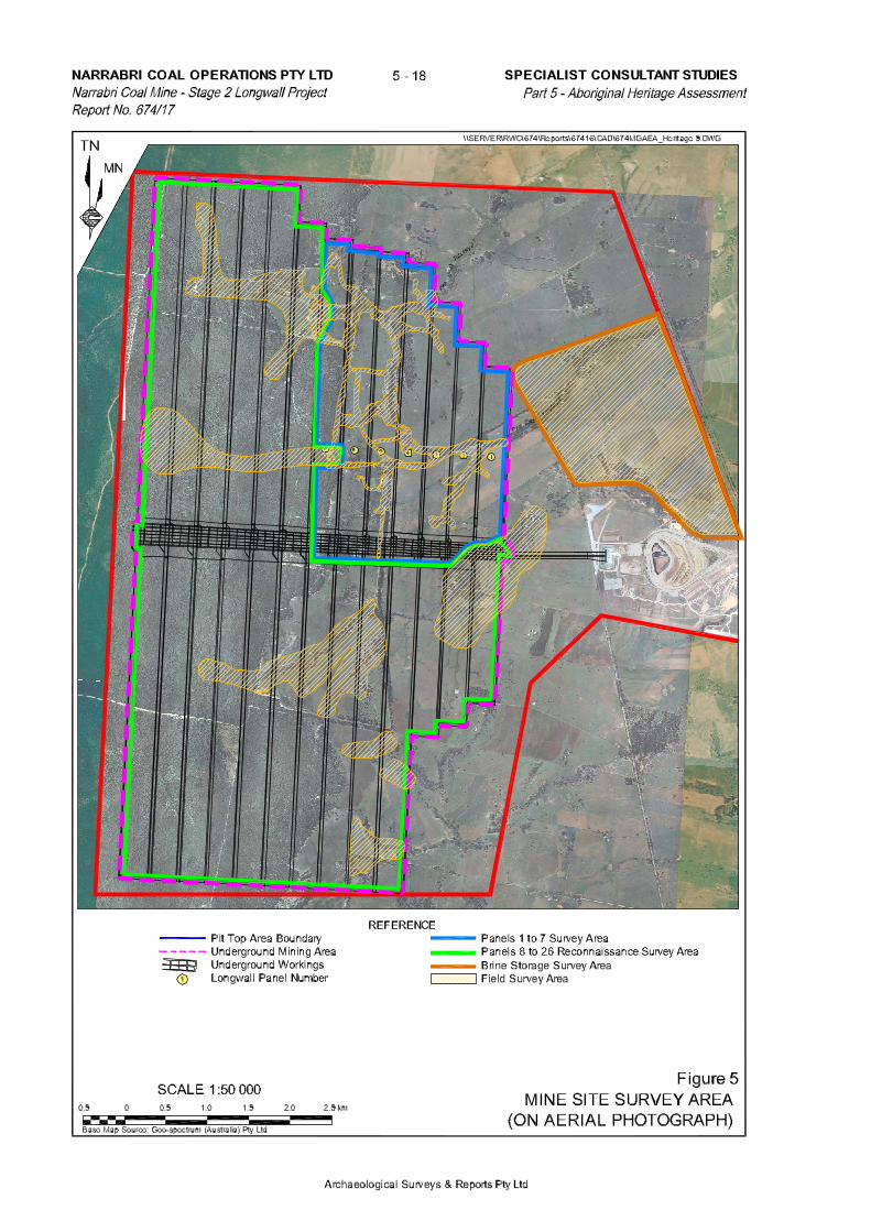
1.3 The Mine Site, Mining Area and Survey Areas The Narrabri Coal Mine is located approximately 30km south-southeast of Narrabri and 10km north-northwest of Baan Baa, on the north-western slopes of the Northern Tablelands in New South Wales. In this report the Mine Site corresponds with ML 1609, the Mining Area corresponds with the total area overlying and corresponding with the proposed 26 longwall panels to be mined over the projected 27 year life of the mine, and the Survey Areas subject of this report corresponds with the underground footprint of Panels 1 to 7 (Panels 1 to 7 Survey Area), the areas of higher probability for site identification over the remainder of the Mining Area (Panels 8 to 26 Survey Area), the Brine Storage Area and the water pipeline route between the Mine Site and the Namoi River. The Mining Area occurs over a number of properties, the majority of which are owned by NCOPL. With the exception of a small portion of the “Newhaven” property owned by K. and J. Scott, the Panels 1 to 7 Survey Area occurs entirely on land owned by NCOPL. Figure 4 shows the survey areas of Panels 1 to 7, Panels 8 to 26 and the Brine Storage Area relative to the Mining Area and superimposed on the topographic mapping of the Mine Site. Figure 5 shows the three survey areas superimposed over an aerial photograph of the Mine Site. The survey area of the Water Pipeline Route, which included all relevant road easements and the nominated alignment of the pipeline route on the "Broadwater" property, is not presented. 1.4 Potential Impacts of the Longwall Project Two sources of potential impact to the archaeological and cultural record have been identified as being associated with the proposed Longwall Project, namely:
• clearing associated with drilling and operation of ventilation, pre-drainage and goaf gas drainage sites (and associated access and power line corridor construction); and
• surface subsidence resultant from the longwall mining method. Both effects are complex and technical but for the purposes of this review they have been reduced to simple issues. Construction and Operation of Gas Drainage Sites and Ventilation Shaft Areas Tests conducted by GeoGas Pty Ltd established that gas composition within the mine varies considerably (RWC, 2009). As a consequence, it will be necessary to install a comprehensive mine ventilation system to manage seam gas generated within the mine and to provide a safe working environment for the mine’s workforce. To achieve this outcome, gas within the coal seam will have to be pre-drained, gas accumulating within the collapsed goaf of each completed longwall panel removed and the mine ventilated. Gas pre-drainage would require a number of medium radius diameter Surface to In-seam (SIS) boreholes to be drilled (across the width of each longwall panel) into and then along the length of the coal seam. An area of approximately 80m x 80m would be required for each SIS Borehole Drill Site (0.64ha), however, as with other surface drilling sites, mature trees and other vegetation would be retained where practicable within each site. At the extremity of each set of SIS boreholes, a medium radius vertical pump well would be constructed to intersect each SIS borehole. The current pre-drainage arrangement provides for seven pump wells at each Gas Production Site, requiring an area of approximately 2.9ha. On the basis that three Pre-Drainage Sites would be required for Longwall Panels LW3 to LW24, and two would be required for LW1, LW2, LW25 and LW26, the total area of disturbance would be up to 259ha (66.5ha of which would be incurred within the Panels 1 to 7 Survey Area).

SPECIALIST CONSULTANT STUDIES 5 - 19 NARRABRI COAL OPERATIONS PTY LTD Part 5 – Aboriginal Heritage Assessment Narrabri Coal Mine – Stage 2 Longwall Project Report No. 674/17
Archaeological Surveys & Reports Pty Ltd
A conceptual goaf drainage design has 250mm internal diameter cased boreholes located about 30m off the tailgate corner of the active goaf at approximately 200m intervals. To provide access for the drilling rigs and vehicles, as well as pipelines and other services, a corridor of 10m would be required between each goaf gas drainage hole. Up to 400 goaf gas drainage sites would be required over the Mining Area, requiring surface disturbance of up to 100ha. Ventilation shafts of up to 6m in diameter would be constructed to provide for air intake to or ventilation from the underground workings. The preferred construction technique is as blind bores, ie. bored from the surface into the underground workings to depths of between approximately 170m and 320m below surface. The technique involves the drilling of the shaft to the coal seam prior to the development of the roadways in the coal with these roadways intersection the shafts after their final completion. The construction area for each Ventilation Shaft Area would be of maximum dimensions 200m x 250m (5.0ha). The location and number of surface ventilation locations is based on a conservative assessment of ventilation requirements and is therefore likely to provide for more ventilation capacity then may be required, ie. the number of surface ventilation points, and therefore area of surface disturbance is unlikely to exceed that illustrated on Figure 2. Figure 2 provides for ventilation from the West Mains from Maingates 2, 7 and 8, and rear of panels LW2, LW5, LW9, LW12, LW14, LW19 and LW21. Therefore, on the basis that each ventilation shaft area would disturb up to 5.0ha, up to 55.0ha of the Mine Site would be disturbed to accommodate the ventilation requirements of the Longwall Project over the life of the mine. It is worthy of note that the estimated areas of disturbance provided for represents a maximum area of disturbance. NCOPL would reduce, or consolidate areas of disturbance associated with other activities (eg. access roads). There is a potential for any archaeological contexts occurring within the footprint of any of the impacts described above, to be severely impacted upon. Subsidence NCOPL engaged Ditton Geotechnical Services Pty Ltd (DGS, 2009) to predict and report on the potential impacts from subsidence from longwall mining. In summary, DGS (2009) predicts that while subsidence would occur to varying degrees across the Mine Site the maximum predicted subsidence of 1.6m would occur towards the eastern section of the Mining Area, and up to 2.4m would occur in the western section (DGS, 2009). The impacts from subsidence are likely to be two-fold: firstly there is the likelihood of differential lowering of the ground surface over large areas; and secondly there is the likelihood that cracking may occur both along the margins of the subsidence, above the line of longwall panels, and within the area of subsidence from differing degrees of subsidence. As a subsequent result of the cracking, further impacts may be caused if material is required to be transported to the location of the cracking to fill and repair the cracks. The vertical displacement of an archaeological site from subsidence is unlikely to result in damage or alteration to most archaeological sites, however, any lateral displacement caused by variable subsidence across a site containing many artefacts might have significant impact on the integrity of the site and cause displacement of artefacts within the assemblage. Any lateral movement or migration of drainage lines and creek resulting from variable subsidence also has the potential to impact on any scarred or carved trees along the creek banks that might be undermined by a change in channel profile. In addition, there is the possibility that subsidence could cause fracturing or breakage of any sandstone platforms on which grinding grooves occur.

NARRABRI COAL OPERATIONS PTY LTD 5 - 20 SPECIALIST CONSULTANT STUDIES Narrabri Coal Mine – Stage 2 Longwall Project Part 5 – Aboriginal Heritage Assessment Report No. 674/17
Archaeological Surveys & Reports Pty Ltd
Naturally, all efforts to try to avoid impacting on Aboriginal sites wherever and whenever possible would be undertaken by NCOPL, however, in some circumstances total avoidance is not possible, and all that can be practically achieved is to minimise the impact or to mitigate the effects of the impact. In this instance, the frequency and location of gas drainage and ventilation infrastructure is dictated by a requirement to maintain the safety of the underground mine, ie. the coal seam gas poses an extremely high risk to the safety of mine personnel if not removed, and to effectively remove the gas and ventilate the mine requires the specific placement of boreholes for gas drainage or ventilation purposes. As a consequence it may not be possible to avoid impacting upon some of the Aboriginal sites, in which case it will be necessary to salvage the artefacts from those particular sites and to remove them to a secure place agreed to by Narrabri LALC, Gomeroi, and the Department of Environment and Climate Change (DECC).
Additional Note Under Part 3A of the EP&A Act, a “Project Approval” overrides or negates any protection or conditions that might otherwise have applied, such as under Section 90 of the National Parks and Wildlife Act 1974 (as amended) (NPW Act), if approval had not been sought under Part 3A of the EP&A Act. Hence, a Section 90 Consent under the NPW Act is not required to enable the development of or disturbance to an archaeological site once a project approval has been issued. However, before the Department of Environment, Climate Change and Water (DECCW) will notify the consent authority (the Minister for Planning) of its satisfaction with the proposed actions, DECCW generally requires that a Management Strategy is developed to manage the archaeological record. This Management Strategy would provide information on the proposed management of identified sites (or sites identified in the future), whether it is to avoid sites, or to mitigate the damage to sites, or to minimise the potential impact to a site, or to record the details, salvage the artefacts, and provide for the safe custody of the salvaged material. As a consequence of this survey, it is unlikely that the same area will ever be surveyed again, thus from an archaeological perspective, this was an opportunity to observe and record any sites that might be present, and to propose a strategy for the management of any known or potential archaeological and/or cultural material in the future development of the area. 2 ABORIGINAL CONSULTATION In accordance with the “Guidelines For Aboriginal Cultural Heritage Impact Assessment and Community Consultation” (DECC 2004), an advertisement was placed in the Narrabri Courier on 26th August 2008 inviting all Aboriginal stakeholders with an interest in the project to register their interest. A copy of the advertisement as it appeared in the newspaper is included as Appendix i. The only responses to the advertisement were from Lyn Trindall, CEO, Narrabri Local Aboriginal Land Council (LALC) – included as Appendix ii, and Brad Trindall on behalf of Narrabri Gomeroi Traditional Owner Group (Gomeroi) – included as Appendix iii. ASR then contacted Narrabri LALC to arrange a date for the field investigation of the Panels 1 to 7 Survey Area, and then tried to contact Mr Brad Trindall to confirm that the date was also convenient for Gomeroi. However, Mr Brad Trindall could not be contacted, and Lyn Trindall advised ASR to contact Mr Craig Trindall who had taken over as the Gomeroi representative.

SPECIALIST CONSULTANT STUDIES 5 - 21 NARRABRI COAL OPERATIONS PTY LTD Part 5 – Aboriginal Heritage Assessment Narrabri Coal Mine – Stage 2 Longwall Project Report No. 674/17
Archaeological Surveys & Reports Pty Ltd
Craig Trindall informed ASR that Gomeroi had signed a Deed of Agreement with NCOPL, and that before Gomeroi would agree to the investigation it would need to consider the proposed survey methodology. Subsequently, ASR forwarded a copy of the “Proposed Investigative Strategy for the Archaeological Investigation of the Project Site” to both Narrabri LALC and Gomeroi, a copy of which is included as Appendix iv. Eventually, and after a protracted period of consultation involving NCOPL, Gomeroi, Narrabri LALC and ASR, it was agreed that the field investigation could commence in accordance with the proposed survey strategy. Accordingly, Narrabri LALC arranged for several members to attend a site induction at the mine, Gomeroi having previously had several members inducted for the 2007 investigation for the Pit Top Area. Subsequently, Kristie Toomey, Sites Officer, Narrabri LALC, and Mick Trindall, Sites Officer, Gomeroi assisted Appleton (ASR) in the survey which commenced on 30th March 2009. The investigation was undertaken over five days, from 30th March to 1st April, and on the 7th and 8th April. Both Kristie Toomey and Mick Trindall were present during all stages of the five day investigation. Craig Trindall accompanied the group on the morning of 30th March, and assisted in the identification and recording of the first two sites. Both prior to and during the survey, Kristie Toomey, Mick Trindall and the archaeologist John Appleton discussed the potential for particular site types to be present, and the particular environments in which they might occur. The survey strategy and results were considered and discussed throughout the survey and at the completion of each survey unit. At the conclusion of the survey, the results were discussed as were the possible outcomes in view of the potential impacts from the proposed goaf boreholes and access roads. Following the completion of the field investigation of the Panels 1 to 7 Survey Area, ASR contacted Ms Lyn Trindall of Narrabri LALC and Mr Craig Trindall of Gomeroi regarding the completion of a further survey over the remaining areas of the Mining Area where the probability of site occurrence and identification is higher (based on the archaeological record of the Panels 1 to 7 Survey Area and predictive modelling). It was subsequently agreed that the field investigation over the “Panels 8 to 26 Survey Area” could commence in accordance with a survey strategy proposed by ASR. The investigation was undertaken over seven days, from 6th to 14th July, with Matt Trindall and Tahnesha Trindall - on different days (of Narrabri LALC) and Mick Trindall and Patrick Sevil (of Gomeroi) present during all stages of the seven day investigation. Both prior to and during the survey, discussions were held regarding the potential for particular site types to be present, and the particular environments in which they might occur. The survey strategy and results were considered and discussed throughout the survey and at the completion of each survey unit. At the conclusion of the survey, the results were discussed as were the possible outcomes in view of the potential impacts from the Longwall Project. Subsequently, a listing of all 112 sites recorded during both investigations, together with a conversion of their map references (from GDA66 to AGD96), were forwarded to both Narrabri LALC and Gomeroi, to provide them with the information on which they could base any recommendations they might have as to the future management of the identified cultural record. A copy of correspondence providing the Land Council’s recommendations is included as Appendix v, and the response from Gomeroi is included as Appendix vi. Following the investigation of the “Panels 8 to 26 Survey Area” NCOPL engaged ASR to undertake an investigation of the Brine Storage Area. Both Narrabri LALC and Gomeroi were consulted over the proposed survey strategy with both stakeholder groups agreeing to the proposed survey strategy and both confirming the attendance of a sites monitor for the survey.

NARRABRI COAL OPERATIONS PTY LTD 5 - 22 SPECIALIST CONSULTANT STUDIES Narrabri Coal Mine – Stage 2 Longwall Project Part 5 – Aboriginal Heritage Assessment Report No. 674/17
Archaeological Surveys & Reports Pty Ltd
3 THE ENVIRONMENTAL CONTEXT Any discussion of the likely presence of Aboriginal cultural remains or of the basis why such remains might be discovered must be within the context of the environment and the resources that would have been available to any Aboriginal occupants of the area.
3.1 General Geology and Topography The Mine Site is located within the Permo-Triassic Gunnedah Basin, which forms the central part of the north-south elongate Sydney-Gunnedah-Bowen Basin System. The Mining Area is located near to the northern and western boundaries of the Gunnedah Basin and the eastern margin of the Surat Basin, a sub-basin of the larger Great Artesian Basin (RWC, 2009). The rocks of the Mine Site generally strike north-south and dip gently to the west. Minor variations to the north-south strike may be the result of variable thickness and compaction of the sedimentary units being draped over the faulted and uneven surface on the underlying Boggabri Volcanics. Undifferentiated Quaternary alluvial gravel, sand, silt and clay overly the Jurassic and Triassic sediments (RWC, 2009) associated with the Namoi River. The two formations of most relevance to the current archaeological investigation are the Pilliga Sandstone and the Purlawaugh Formation. The Pilliga Sandstone outcrops over the western half of the Mining Area. It consists of medium bedded, cross-bedded, well sorted fine to coarse grained quartz sandstone. The Purlawaugh Formation outcrops over the majority of the eastern half of the Mining Area, and consists of thinly bedded, generally fine grained, silty lithic sandstone, siltstone and minor claystone (RWC, 2009).
Panels 1 to 7 Survey Area For the purposes of provenancing descriptions to locations on the two creek systems that drain from west to east through the Panels 1 to 7 Survey Area, both of which are tributaries of Pine Creek, these are made with reference to Pine Creek Tributary 2 (in the north)1, and Pine Creek Tributary 1 (in the south)1. It was observed during the investigation that surface deposits throughout the Panels 1 to 7 Survey Area were dominated by loamy, fine grained soils derived from weathered fine-grained sandstone. Large areas of degrading gravelly lag deposits were also observed in erosion gullies at isolated sections of both Pine Creeks 1 and 2 (and their tributaries). A “tessellated” metamorphosed sedimentary bedrock platform was exposed in the creek bed at a track crossing of a tributary of Pine Creek 2, and decomposing sedimentary bedrock was exposed in the creek bed in a minor tributary of Pine Creek 1. Ironstone (or indurated sandstone) gravels were observed in exposures in the southern creek bank in the upper reaches of Pine Creek 2, and in an isolated section of Pine Creek 1. Of significant archaeological interest was an intermittently visible sandstone “reef” running north-south above longwall panel 5, formed by floaters above strata uplift. The same formation was also visible beside a gateway 1,300m to the south, and again in the head of an erosion gully 50m further again to the south. This was the only visible evidence of any naturally
1 It is noted that the referencing of the Pine Creek tributaries reflects the nomenclature used during the field survey
but is the opposite of the referencing used in the Environmental Assessment, ie. Pine Creek Tributary 1 in the Environmental Assessment is located to the north.

SPECIALIST CONSULTANT STUDIES 5 - 23 NARRABRI COAL OPERATIONS PTY LTD Part 5 – Aboriginal Heritage Assessment Narrabri Coal Mine – Stage 2 Longwall Project Report No. 674/17
Archaeological Surveys & Reports Pty Ltd
occurring rock in the Panels 1 to 7 Survey Area that might have been useful to the Aboriginal occupants of the area in the past.
Elevations in the Panels 1 to 7 Survey Area descend from 330m AHD in the Pilliga in the south-western corner, and 300m AHD on the rise in the north-western corner, down to 276m AHD in the creek bed of Pine Creek 2 on the western boundary and 266m AHD where Pine Creek 2 crosses the eastern boundary (of longwall panel 1). In the south-eastern corner (of longwall panel 1) Pine Creek 1 descends to 272m AHD. Panels 8 to 26 Survey Area For the purposes of provenancing descriptions to locations on the four creek systems that drain from west to east through the Panels 8 to 26 Survey Area, the two in the northern panels, Panels 8 to 13; both of which are tributaries of Pine Creek, are made with reference to Pine Creek Tributary 2 (in the north)2, and Pine Creek Tributary 1 (in the south). And the two in the south that drain through Panels 14 to 26, are made with reference to Kurrajong Creek Tributary 1, and Kurrajong Creek further to the south. Panels 8 to 13 occur in Pilliga Forest. Surface deposits in this area are of deep, weathered sands derived from the sandstone high-ground at the western end of the area. In several places along the western boundary the slopes rise to low sandstone ridges and knolls of weathering sandstone bedrock, the knolls consisting of “tor-like” piles of sandstone boulders resting on exposed sandstone bedrock. Similarly, Panels 14 to 18 and parts of Panels 19 and 20 occur in Pilliga Forest. Panels 20 to 26 occur on cleared, rolling slopes bisected by ribbons of predominantly eucalypt riparian vegetation along the creek banks. For the most part deposits in these panels are of sandy soils derived from weathering sandstone but the upper slopes and crests of the rises in Panels 21 and 22 are littered with lag deposits of angular to sub-angular metasedimentary rock, while downstream in a tributary of Kurrajong Creek Tributary 1 there are extensive exposures of metasedimentary sub-angular to rounded cobbles (60-200mm), and there are exposures of indurated sandstone bedrock in the creek bed. Elevations in the Panels 8 to 13 Survey Area descend from 346m AHD in the Pilliga on the western boundary, down to 280m AHD in the creek bed of Pine Creek. Elevations in the Panels 14 to 26 Survey Area descend from 348m AHD on the western boundary, down to 290m AHD in the creek bed of Kurrajong Creek Tributary 1 at the eastern edge of Panel 26. Brine Storage Area The proposed Brine Storage Area occurs in an “amphitheatre-like” basin on the flood plain of Kurrajong Creek Tributary 1, immediately to the north of the creek between the Pit Top Area and the North Western Branch Railway Line. Soils in the area comprise of sandy deposits derived from the sandstone slopes immediately to the north. Very little stone occurs in the survey area, however there were some minor lag deposits of rounded, water-worn cobbles in the western section.
2 It is noted that the referencing of the Pine Creek tributaries reflects the nomenclature used during the field survey
but is the opposite of the referencing used in the Environmental Assessment, ie. Pine Creek Tributary 1 in the Environmental Assessment is located to the north.

NARRABRI COAL OPERATIONS PTY LTD 5 - 24 SPECIALIST CONSULTANT STUDIES Narrabri Coal Mine – Stage 2 Longwall Project Part 5 – Aboriginal Heritage Assessment Report No. 674/17
Archaeological Surveys & Reports Pty Ltd
Elevations in the area descend from 252m AHD on the upper rim of the basin down to approximately 246m AHD close to the creek bank. Water Pipeline Route Soils in the area comprise of sandy deposits derived from the weathering of the underlying sandstone bedrock. Minor lag deposits of angular to sub-angular metasedimentary pebbles occur on the upper slopes and rises above about the 255m AHD contour, but from the evidence of roadside exposures, this gives way to angular gravelly pebbles further down slope. Similarly, the scalded surfaces of the road verges along the western end of Turrawan Road (above about the 238m AHD contour) are littered with a lag deposit of angular and sub-angular medium to large pebbles (6-60mm). Elevations along the route descend from 260m AHD where the pipeline leaves the Pit Top Area, down to 220m AHD on the bank of the Namoi River 3.2 Vegetation An ecological survey and assessment of the Mine Site completed by Ecotone Ecological Consultants (2009) identified four natural or predominantly natural vegetation community types and one artificial vegetation community type occur within the Study Area as follows. Natural Communities
1. Brown Bloodwood / Pilliga Grey Box / Red Ironbark Sandstone Slopes and Ridgetop Woodland
2. Inland Grey Box / Bimble Box / Blakely’s Red Gum Lower Flats and Floodplain Woodland
3. River She Oak / Belah Riparian Forest
4. Callitris Forest Artificial Community
5. Cleared open pasture with or without scattered native trees or cultivated cropland or gardens
Community 1 (locally referred to as Pilliga Scrub) generally occupies the western part of the Mine Site, whilst Communities 2, 3 and 4 occur in the eastern part of the Mine Site. Community 5 is the largest single community in area, and makes up the balance of the eastern part of the Mine Site. Panels 1 to 7 Survey Area Within the Panels 1 to 7 Survey Area, with the exception of the remnant woodland on the rise at the northern end (Community 2), the natural communities consists primarily of riparian ribbon-like woodland along the Buffer Zones and upper Bank Zones of both creeks (Community 3). Vegetation in these areas comprise a mixture of River Oak (Casuarina cunninghamiana), White Cedar (Melia azedarach), Rough-barked Apple (Angophora floribunda), White Box (Eucalyptus albens) – particularly along the upper reaches of Pine Creek 1, River Red Gum (E. Camaldulensis), Yellow Box (E. Melliodora), White Ribbon Gum (E. Viminalis), Western Rosewood, (Alectryon oleifolius), and minor Kurrajong (Brachychiton populneus). Acacia sp. dominate the understorey, which includes River Bottlebrush (Callistemon sieberi), and Blackthorn (Bursaria spinosa).

SPECIALIST CONSULTANT STUDIES 5 - 25 NARRABRI COAL OPERATIONS PTY LTD Part 5 – Aboriginal Heritage Assessment Narrabri Coal Mine – Stage 2 Longwall Project Report No. 674/17
Archaeological Surveys & Reports Pty Ltd
Cypress pine regrowth has recolonised the cleared upper slopes below the Pilliga boundary fence, and in some cropped areas along the upper drainage depressions of both creeks. Panels 8 to 19 Survey Area Panels 8 to 19 occur in Pilliga Forest. Pilliga Forest typically contains Cypress Pine (Callitris spp.), and Casuarinas, while Eucalypts dominate the canopy throughout the forest. Panels 20 to 26 Survey Area Panels 19 to 26 occur on cleared pasture land all but for ribbons of riparian vegetation along the creek banks, and for stands of Cypress Pine that have colonised a high knoll in the northern ends of Panels 25 and 26. Brine Storage Area
With the exception of a small patch of the remnant woodland on a small rise to the immediate north of Kurrajong Creek Tributary 1, the vegetation of the Brine Storage Area is cleared paddocks with occasional and isolated mature trees. Riparian ribbon-like woodland occurs along the banks of Kurrajong Creek Tributary 1 to the south of the Brine Storage Area and remnant woodland with the road easement to the east of the Brine Storage Area. Water Pipeline Route The vegetation along the water pipeline route varies between remnant woodland dominated by Grey Box and Cypress Pine, small patches of Weeping Myall community and cleared areas dominated by exotic pasture and weeds. 3.3 Water Resources It should be noted that the depiction of drainage lines in blue on Figure 4 is not indicative of the water they contain. In fact, it is reasonable to conclude that all drainage lines indicated in blue where there is not a riparian strip of woodland, are merely shallow drainage depressions, barely visible in the field other than as shallow swales. As described in Section 3.1, the Panels 1 to 7 Survey Area is bisected by the two major tributaries of Pine Creek, referred to in this report as Pine Creek 2 and Pine Creek 1. In effect, neither creek line retains water and any surface run-off is rapidly discharged downstream. However, it was observed during the investigation that took place after recent rain, that a minor waterhole had filled upstream of the tessellated platform in the minor tributary of Pine Creek 2, and that there was a second small water hole, probably created by wild pigs, in a tributary of Pine Creek 1. Similarly, no reliable water source was observed in the investigation of the Panels 8 to 26 Survey Area. The lack of a reliable water source may have deterred Aboriginal people from staying in the area for long in the past, however, it is possible that other water holes existed prior to them having become silted up with the loamy colluvial soils released by land clearing, cropping and grazing following the arrival of European settlers.

NARRABRI COAL OPERATIONS PTY LTD 5 - 26 SPECIALIST CONSULTANT STUDIES Narrabri Coal Mine – Stage 2 Longwall Project Part 5 – Aboriginal Heritage Assessment Report No. 674/17
Archaeological Surveys & Reports Pty Ltd
The Brine Storage Area occurs adjacent to Kurrajong Tributary 1, however, it is unlikely that the creek ever contained potable water except for a few hours after a heavy downpour. The Water Pipeline Route follows road easements, none of which cross a reliable water source. The Namoi River at the eastern end of the route would have been a reliable source, although the water would have required filtering before it could be drunk. 3.4 Stone Resources Panels 1 to 7 Survey Area As referred to in Section 3.1, the only stone resource that might have been useful to the Aboriginal occupants of the area occurring in the Panels 1 to 7 Survey Area, were the sandstone floaters, which might have been, and were, used for sharpening stone axes. It follows therefore that any artefactual material within the Survey Area was probably sourced from elsewhere, perhaps from pebbles in the river bed downstream. Panels 8 to 26 Survey Area The metasedimentary lag deposits referred to previously as occurring on the crests of the rise in Panels 21 and 22 included siliceous material that could have been used for knapping into tools or weapons. Brine Storage Area Minor lag deposits of water-worn pebbles and cobbles were evident on the western rim of the basin, some of which had been utilised to manufacture steep-edged scrapers, while others were used as cores. Water Pipeline Route Minor lag deposits of angular to sub-angular metasedimentary pebbles occur on the upper slopes and rises above about the 255m AHD contour, but from the evidence of roadside exposures, this gives way to angular gravelly pebbles further down slope. Similarly, the scalded surfaces of the road verges along the western end of Turrawan Road (above about the 238m AHD contour) are littered with a lag deposit of angular and sub-angular medium to large pebbles. While some of this material might have been utilised it was generally too small to knap successfully. 3.5 Previous Impacts Panels 1 to 7 Survey Area As the aerial photograph in Figure 5 shows, and as referred to in Section 3.2, the vast majority of the Survey Area has been cleared for pasture. However, the impact has not stopped there, as continuous grazing of poor grasses in an area of low rainfall has resulted in the active degradation and erosion of most if not all exposed surface deposits. Other impacts have been caused by property tracks, dams, and active gullying in what were once only drainage depressions. Grazing along the creek banks has also caused massive gullying of the creek banks, bank-slumping, and significant wash outs, particularly along the southern bank of the upper reaches of Pine Creek 2, and a minor tributary of Pine Creek 1.
SPECIALIST CONSULTANT STUDIES 5 - 27 NARRABRI COAL OPERATIONS PTY LTD Part 5 – Aboriginal Heritage Assessment Narrabri Coal Mine – Stage 2 Longwall Project Report No. 674/17
Archaeological Surveys & Reports Pty Ltd
The fragility of the soils is also evident in several collapsed dam walls along Pine Creek 1 and the gullying of the drainage channel into one of the dams, and in the gullying of creek banks and extensive wash-out areas. Although a number of contour banks have been constructed across the slopes of the paddocks they have only served to channel the run-off into more concentrated and destructive drainage courses.
Panels 8 to 19 Survey Area There have been only limited impacts in the Pilliga Forest in the Panels 8 to 19 survey area (see Figure 5), most of which have been caused in the construction of dams, or in clearing access tracks to the dams and to fence-lines, however, it was clear from the tree stumps and the relatively open areas, particularly in Panels 9 to 12 that there has been extensive tree-felling or logging in the past. And in the absence of tree toppings it would appear that the trees were felled for something other than fence-posts and strainer posts. Nor is it likely that the trees were felled for firewood. Similar logging has taken place in Panels 14 to 17. The presence of the dams might suggest that the logging was to open up the forest for pasture improvement, but there was no evidence of piles of ash of partly burnt logs that there would have been if the logging was merely to remove trees.
Panels 20 to 26 Survey Area Most of the vegetation in the Panels 20 to 26 survey area has been cleared for pasture, and in some places such as on the crest of the rise in Panels 21 and 22 the paddocks had been recently disc-ploughed to improve pasture growth (see Figure 5). Similarly, paddocks in Panels 23 and 24 had been disc-ploughed not quite so recently and were under new growth at the time of the survey.
Brine Storage Area The Brine Storage Area has been cleared for pasture (see Figure 5). Currently impacts are occurring as scalding on the flat bottom of the basin, and bank-slumping and slope-wash around the rim. Unfortunately contour banking above the rim does not follow the natural contour, dipping slightly towards the east. As a consequence instead of the contour banking retaining the run-off to stimulate grass growth, the effect has been to channel the water to the eastern ends of the banks where the concentrated mass of water has discharged down-slope causing extensive gullying and scouring.
Water Pipeline Route For the most part the proposed route utilises either the road easement or the railway maintenance track. The road is a metalled surface with deep side drains and as a consequence the banks to either side are artefacts of drain shaping with battered slopes of 3m to 4m wide. The railway maintenance track at the higher elevations occurs on sandy deposits which have been graded to various depths but seldom more than 5cm to 10cm deep. At lower elevations the deposits are less sandy and grading has been mostly only to level the track. East of Turrawan the road is sealed with deep side gutters, the outer batters of which have impacted on the natural profile for up to 10m to either side of the road. From the road to the Namoi River the land has been cleared and linear features marking subsurface irrigation pipes attest to the paddocks having once been used for crops, although currently the paddocks are carrying stock.
NARRABRI COAL OPERATIONS PTY LTD 5 - 28 SPECIALIST CONSULTANT STUDIES Narrabri Coal Mine – Stage 2 Longwall Project Part 5 – Aboriginal Heritage Assessment Report No. 674/17
Archaeological Surveys & Reports Pty Ltd
4 THE ARCHAEOLOGICAL RECORD The result of the search of the Aboriginal Sites Register (Aboriginal Heritage Information Management System – AHIMS) for all sites within the references Eastings 768000-784000, Northings 6612000-6628000 resulted in a listing of only one site in the 256km2 search area. The site, Site #19-3-0010 was recorded as scarred tree, “Laluba: Bunda Wallah Waterhole”. However, the site is nearly four kilometres to the north of the Panels 1 to 7 Survey Area. Details of the search are included as Appendix vii. Earlier, reference was made to the archaeological investigation for the Pit Top Area (AASC, 2007) which reported that seven archaeological sites had been recorded (including a Wild Orange Tree of no known direct cultural association). Unfortunately none of those sites appear on the AHIMS Site Register, however, the locations of the sites are shown in Figure 6. Of the six (non-resource) archaeological sites, two were isolated artefacts (one of which was described as containing three flakes), there were two scarred trees, and two artefact scatters, one of “12 flakes”, and the other of “>10 artefacts ... including flakes and cores”. None of the seven identified sites have been disturbed with specific site measures provided for within the Aboriginal Cultural Heritage Management Plan (ACHMP) developed by NCOPL in consultation with Narrabri LALC and Gomeroi. The generally low count of sites within the AHIMS search area should not be interpreted as representing the frequency or distribution of sites in the area. Apart from the sites recorded in the late 1970s, sites are usually only found and recorded during investigations for proposed developments, and as there have been no new developments in the search area since before the 1970s no sites have been found. Also, unfortunately, many of the site references on the AHIMS Site Register are inaccurate. Since the first sites were recorded on the Sites Register in 1974, the computer programme written for the site register has been rewritten and/or upgraded at least three times, and each time the data was re-entered into the system there were errors, both in site names and in map references. Also during that time, there were considerable changes to the maps available to field workers, firstly from 1:63,360 (inch) scale (Imperial) military topographic maps, to 1:250,000 military topographic maps (printed in 1942), and then to 1:250,000 scale topographic maps (printed at various times), and then to 1:100,000 and 1:50,000 scale Topographic maps (printed in 1983), and then more recently to 1:25,000 scale maps (printed in 2001). It is recognised the only maps available for the “Baan Baa” area are 1:50,000 scale maps printed in 19853. Archaeologists have used various strategies to locate sites on maps, from compass and line-of-site, to sight referencing to topographic features, to using hand-held or vehicle-mounted Global Positioning Systems of varying degrees of accuracy. The current (2001) Topographic Map Series warns that “Satellite (GPS) derived values may be in error by up to 20 metres”, but during the late 1980s and 1990s the satellite signals were deliberately ‘warped’ by the American controllers, to avoid the use of the satellites by enemy forces, and GPS readings during that period were out by as much as 200m. While there were computer programmes that could correct the warped references very few people went to the trouble to correct them. 3 As the only maps available for the Baan Baa area were drawn to AGD 66 format all GPS readings taken during
the current investigation were recorded as AGD 66 references, however, NCOPL provided aerial photographs to assist in the survey that were gridded to GDA 94 format. Consequently it was necessary to provide a conversion table converting the AGD 66 readings to GDA 94 references to enable the mine to accurately plot the locations of the sites on its working plans. When Site Recording Forms for the sites are lodged with DECC to list them on the AHIMS Site Register they will show the AGD 66 references to enable other researchers to plot the sites onto the current Topographic maps, but a copy of the converted reference will be attached to the forms for the benefit of other users. A copy of the map reference conversion table is included as Appendix vii.


NARRABRI COAL OPERATIONS PTY LTD 5 - 30 SPECIALIST CONSULTANT STUDIES Narrabri Coal Mine – Stage 2 Longwall Project Part 5 – Aboriginal Heritage Assessment Report No. 674/17
Archaeological Surveys & Reports Pty Ltd
5 MODELS FOR SITE LOCATION
5.1 Site Types and Location In order to design an investigative strategy, it is firstly necessary to develop a predictive model for site location. This is not to determine where the investigation should be conducted, but to establish a theoretical model for the distribution of archaeological material against which the effectiveness and subsequent analysis of the survey results can be tested, compared and reasoned. The basis upon which the predictive model is derived must, however, be one of consideration of which archaeological material might realistically be expected to not only be present, but also detectable. The first objective of any archaeological investigation must be to observe and record sufficient of the archaeological record that is present to be able to propose that it is representative of the record as a whole. The investigative strategy is therefore directed and designed to detect that which is representative of the record in the particular study area, and naturally, as different study areas will comprise variations in environment, vegetation, topography, etc., so the investigative strategy must be designed to best suit the circumstances. The objective must be to detect material evidence, and so it is necessary to consider the extent to which artefactual material may be present, and the degree to which it is visible or might be discovered. There are several factors, which are likely to affect, firstly, where Aboriginal people are most likely to have been, secondly, where they have left evidence of their activities, and thirdly, the degree to which that evidence is observable in the present record. People visited places mainly to obtain resources, and in general places that were richest in resources were more likely to have been visited by people than those places with fewer resources. Important resources were permanent water, ephemeral water, food resources, stone raw material sources, shelter (from sun, wind, and rain), and perhaps suitable surfaces for rock art, and proximity to mythological natural features. Those resources may have been a factor in the suitability of a location for particular ceremonial activities but cultural boundaries also influenced the choice of ceremonial grounds. Alternatively, sites frequently occurred along preferred access routes and particularly where that route coincided with a watercourse. However, the attractions of such an environment frequently resulted in the archaeological record becoming discontinuous or significantly disturbed, as stock and vehicles impacted upon it in the post-European contact phase. Frequency of visits and use of particular locations was also determined by the ‘accessibility’ or freedom from environmental constraints in the area. For example, whether there were alternative, preferred or easier ways to travel around or over natural barriers, be they geological, geographical, cultural, or imposed by fauna or flora, or whether they were only seasonally accessible, such as mounds on flood terraces, or the availability of water during periods of drought, or whether or not floods, fire or snow hindered access. Few past Aboriginal activities are represented by surviving material evidence. This in part is because many activities did not leave material evidence (eg. tools were reused), but it is also because very little cultural material survived. An exception to this was shellfish, which was very durable.
SPECIALIST CONSULTANT STUDIES 5 - 31 NARRABRI COAL OPERATIONS PTY LTD Part 5 – Aboriginal Heritage Assessment Narrabri Coal Mine – Stage 2 Longwall Project Report No. 674/17
Archaeological Surveys & Reports Pty Ltd
The survival of material that is durable was also affected by recent European land use. Cultivation has destroyed many archaeological sites. However, cultivation can also help expose sites that might otherwise be covered. This brings us to the other important point about site distribution, which is that to a great extent site distribution recorded by archaeologists reflects the distribution of places where the ground surface is sufficiently eroded to expose artefactual material. By far, the majority of recorded sites have been stone artefact scatters or isolated stone artefacts, and in the vast majority of sites they were found in one or more of the following contexts:
i) On or adjacent to deposits containing quartz, quartzite, jasper, silcrete, chert, chalcedony, metamorphosed greywacke, and other indurated or siliceous sedimentary rocks, or redeposited fine-grained volcanics, or
ii) On river banks or adjacent to river banks where the watercourse contains river pebbles of quartz, quartzite, jasper, silcrete, chert, fine-grained volcanics, basalts, etc., and particularly at the junctions of watercourses, or
iii) On ridges and spurs overlooking watercourses or on high vantage points affording uninterrupted views of swamps, water holes, saddles, passes, and any other likely access path into the observer’s area, or
iv) In the vicinity of outcrops of suitable raw material such as basalt, silcrete, chert, or other highly silicified sedimentary rock.
Other site types do occur and perhaps because of their lower and less predictable profile, are present in far greater numbers than we are aware of. People die but there are few recorded burials. One reason may be that in many instances the soils are too acid for the preservation of bone, but a far more likely reason is simply that burial frequently entailed subsurface internment, and a surface survey will only discover a burial where there has been erosion of significant disturbance to the surface deposits. As a consequence many burials have only been discovered when exposed by erosion of a sand body or river terrace. Other site types such as carved trees, scarred trees, stone arrangements, Bora rings, etc., may once have been present, but are unlikely to have survived in easily accessible country from the attention of non-indigenous people. Thus, much of what might have existed is now lost or destroyed, and the archaeological record has become biased by the post-contact utilisation of resources, and by the selective exploitation and preservation of particular environments. Other factors which affect the degree to which sites are recorded during an investigation include the time of year at which the fieldwork is performed (the seasonality of some vegetation growth) and the conditions under which the survey is performed – (wet, dry, cold, windy, poor light, etc.). A brief description of site types such as isolated artefacts, open scatters, camp sites, knapping floors, quarries, middens, mounds, hearths, carved trees, scarred trees, stone arrangements, Bora rings, burials, engravings, paintings, grinding grooves, occupation deposits (and Potential Archaeological Deposits(PAD)), and ceremonial and mythological sites is included as Appendix viii.
NARRABRI COAL OPERATIONS PTY LTD 5 - 32 SPECIALIST CONSULTANT STUDIES Narrabri Coal Mine – Stage 2 Longwall Project Part 5 – Aboriginal Heritage Assessment Report No. 674/17
Archaeological Surveys & Reports Pty Ltd
5.2 A Predictive Model for the Survey Areas Based on all of the above, the following model for site distribution was proposed for the Panels 1 to 7 Survey Area, in which there was no reliable water source, few exposures of sandstone bedrock, and no rock overhangs, and which in the absence of both water and shelter, there were unlikely to be any places where PADs were likely to occur.
• Isolated artefacts may be present and visible in erosion features. • Low-density artefact scatters may be present and visible in erosion features, but
it is unlikely that any debitage will be visible • There is a potential for trees more than 150 years old to exhibit scarred surfaces • There is a potential for any trees more than 150 years old to exhibit carved
surfaces • There are unlikely to be any engravings, and/or grinding grooves. • There are unlikely to be any PADs. • In the absence of shelters or overhangs there is no potential for shelters to exist
and therefore no potential for art sites, and therefore no potential for undisturbed occupation deposits.
• There will be no Aboriginal stone quarries. • There will be no shell middens • There will be no visible evidence of burials • There will be no surviving Bora rings • There will be no stone arrangements • There are no known cultural associations with the area.
6 THE SURVEYS 6.1 The Survey Strategies 6.1.1 Panels 1 to 7 Survey Area Having studied the topographic map and the aerial photograph, it was determined that the objectives of the investigation were to undertake as full and as comprehensive a survey as possible. There was easy access to all parts of the area that were to be surveyed, and so the only constraints to an effective survey would be any constraint the groundcover would be to archaeological visibility. The investigators walked the Panels 1 to 7 Survey Area, three-abreast, thereby covering a corridor of up to 50m wide. Figures 4 and 5 identify the area of the Panels 1 to 7 Survey Area covered by this pedestrian survey. Some areas where regrowth and grass groundcover were a constraint to archaeological visibility, were not surveyed, but close attention was paid to all creek banks, erosion features, tracks, gateways, dam walls and animal pads. In addition, all large-girth trees were examined for scars and scarring.

SPECIALIST CONSULTANT STUDIES 5 - 33 NARRABRI COAL OPERATIONS PTY LTD Part 5 – Aboriginal Heritage Assessment Narrabri Coal Mine – Stage 2 Longwall Project Report No. 674/17
Archaeological Surveys & Reports Pty Ltd
6.1.2 Panels 8 to 26 Survey In order that a more definitive statement could be made regarding the likely site numbers and distribution within the Mining Area over Panels 8 to 26, a field ‘reconnaissance’ survey was undertaken targeting those places in which it was predicted from the results of the survey of the Panels 1 to 7 Survey Area, sites were most likely to occur. Figures 4 and 5 identify the area of the Panels 1 to 7 Survey Area covered by this pedestrian survey. As the Panels 8 to 26 Survey Area is unlikely to be disturbed for at least seven years, it is probable that many of the sites recorded on aggrading surfaces will have been covered, and different sites will become exposed on degrading surfaces in the meantime. The survey was undertaken, therefore, not for the purpose of recording every site there might be in the area, but to provide a firmer basis on which to assess the cumulative impact of salvaging sites in the Panels 1 to 7 Survey Area. The areas that were surveyed for the reconnaissance were along the banks of Kurrajong Creek and its tributaries, and in some instances, the slopes immediately above the creek lines. Only a brief survey was made of Pine Creek and its tributaries in the Pilliga Forest area within the Mining Area over Panels 8 to 12. The forest extends over the Mining Area above Panels 8 to 17, and comprises over 60% of the total Mining Area above Panels 8 to 26. Based on this survey effort, less than 5% of the Pilliga Forest area was surveyed. However, from the brief survey that was made in the Pilliga Forest it was clear that although there were numerous areas in which there was no groundcover, the fine-grained sandy deposits concealed any artefactual material that might have been present. No sandstone bedrock was observed in the creek lines that might have been used for sharpening axes. The survey team also examined the central knoll (above Panel 17) in the Pilliga and found that the knoll of weathering sandstone bedrock contained no overhangs or surfaces suitable for engraving or for use as a grinding surface. This was a similar finding to that predicted after seeing several other knolls during a familiarisation drive around the property on the first day of the survey of Panels 1 to 7 Survey Area. 6.1.3 Brine Storage Area Survey The Brine Storage Area Survey was a relatively small area and with easy access. So the survey strategy was to walk the entire area (see Figures 4 and 5), targeting any ground surface exposures and in particular the rim of the basin – elevated areas overlooking flood plains are often found to contain Indigenous sites, and in walking between these places, walking through connecting areas of poor archaeological visibility. 6.1.4 Water Pipeline Survey Area At the time of the investigation it had not been determined whether the water pipeline route would utilised the road easement between the mine and the railway crossing point, or whether in order to avoid impacting upon the roadside vegetation, to use the railway maintenance track. Therefore, both were surveyed. Beyond Turrawan the investigators inspected the banks to either side of the road to the point where there was no ground surface visibility, which corresponded with the descent of the road to the river floodplain. However the road easement across the floodplain contained a number of trees with scars. These were closely examined, and two were found to exhibit surveyors’ stamped letters and numerals, but none were identified as being of Indigenous origin.

NARRABRI COAL OPERATIONS PTY LTD 5 - 34 SPECIALIST CONSULTANT STUDIES Narrabri Coal Mine – Stage 2 Longwall Project Part 5 – Aboriginal Heritage Assessment Report No. 674/17
Archaeological Surveys & Reports Pty Ltd
6.2 Details of the Survey 6.2.1 Panels 1 to 7 Survey The field survey was undertaken by Appleton (ASR), assisted by Kristie Toomey, Sites Officer, Narrabri LALC, and Mick Trindall, Sites Officer, Gomeroi. The survey took five days, or over approximately 135 person-hours, on 30th and 31st March, 1st, 7th and 8th of April 2009. The survey was made on foot, in dry conditions, in light ideal for observing any artefactual material present and observable. All of the areas shown shaded in yellow in Figure 4 were surveyed on foot. 6.2.2 Panels 8 to 26 Survey The reconnaissance field survey was undertaken by Appleton (ASR), assisted by Matt Trindall and Tahnesha Trindall (on different days), Sites Officers, Narrabri LALC, and Patrick Sevil and Mick Trindall, Sites Officers, Gomeroi. The survey took seven days, from 6th to 10th and 13th and 14th July. The survey was made on foot, with a vehicle used to move from locations of higher archaeological potential, in dry conditions, in light ideal for observing any artefactual material present and observable. All of the areas shown shaded in yellow in Figure 4 were surveyed on foot. 6.2.3 Brine Storage Area Survey The field survey was undertaken by Appleton (ASR), assisted by Matt Trindall, Sites Officer, Narrabri LALC, and Patrick Sevil and Mick Trindall, Sites Officers, Gomeroi. The survey took place on 29 July 2009. The survey was made on foot, in light ideal for observing any artefactual material present and observable. All of the areas shown shaded in yellow in Figure 4 were surveyed on foot. 6.2.4 Water Pipeline Route Survey The field survey was undertaken by Appleton (ASR), assisted by Matt Trindall, Sites Officer, Narrabri LALC, and Patrick Sevil and Mick Trindall, Sites Officers, Gomeroi. The survey took place on 30th July 2009. The survey along the road easement and railway maintenance track to the railway crossing point was made on foot. From Turrawan to the junction opposite the “Broadwater” turn-off the investigators travelled by vehicle, frequently stopping to inspect erosion features and mature trees wherever they occurred. From the road to Namoi River the investigators travelled on foot. The light on the day was ideal for observing any artefactual material present and observable.