Embed Size (px)
Citation preview

GEOGRAPHY LESSON 1
GRADE : 12
DATE……………….. DURATION 6 HRS
TOPIC: GLOBAL AIR CIRCULATION AND RESULTANT WEATHER PATTERNSKEY FOCUS AREAS:
Changes in energy balance-four pressure belts (distribution, the reason for their existence and associated weather). Relationship between temperature, atmospheric pressure and wind. Pressure gradient and geostrophic flow. Primary circulation:
Movement of air between equator and poles Horizontal and vertical air movements Forces affecting horizontal air movements: coriolis force; pressure gradient force & frictional force Tricellular arrangement of circulation: Identification; formation and characteristics of each cell.
Secondary circulation: Identification, formation and characteristics of tropical easterlies, westerlies, polar easterlies, ITCZ & Monsoons.
Tertiary circulation Formation characteristics of and basic weather associated with : land and sea breezes, mountain and valley breezes and Föhn winds
LO 1The Learner will be able to demonstrate a range of geographical skills and techniques.
LO 2The learner is able to demonstrate knowledge and understanding of processes and spatial patterns dealing with interactions between humans and the environment.
LO 3The learner is able to apply geographical skills and knowledge to environmental issues and challenges, recognize values and attitude and demonstrate the ability to recommend solutions and strategies.
ASSESSMENT STANDARDS ASSESSMENT STANDARDS ASSESSMENT STANDARDS
■ Plan a geographical research project of limited extent in a familiar context.
■ Integrate information from a variety of sources. X
■ Explain the influence of processes and associated spatial patterns in a range of places and regions.■ Account for the similarities and differences in processes and spatial patterns between place and between regions.
X
X
■ Apply skills and knowledge to a range of phenomena, issues and challenges at local and national scales.■ Examine values and attitudes held by individuals and groups associated with

■ Compare and contrast information from a variety of sources.
■ Analyse the acquired information in order to answer the initial question.
■ Substantiate findings in written, oral or illustrative form.
X
X
X
■ Explore possible responses to issues and challenges arising from human and environment interactions in a local and national context.■ Examine different approaches used to sustain the environment that take into account different knowledge systems in a variety of contexts.
processes, spatial patterns and human environment interactions at local and national scales.
KEY QUESTIONS1. Why are temperatures higher within the tropical than Polar Regions?2. Explain the relationship between temperature and global temperature distribution?3. What is the relationship between pressure differences, wind direction, and wind speed?4. Why are global air circulation patterns important?5. What weather patterns occur as a result of global air circulation?
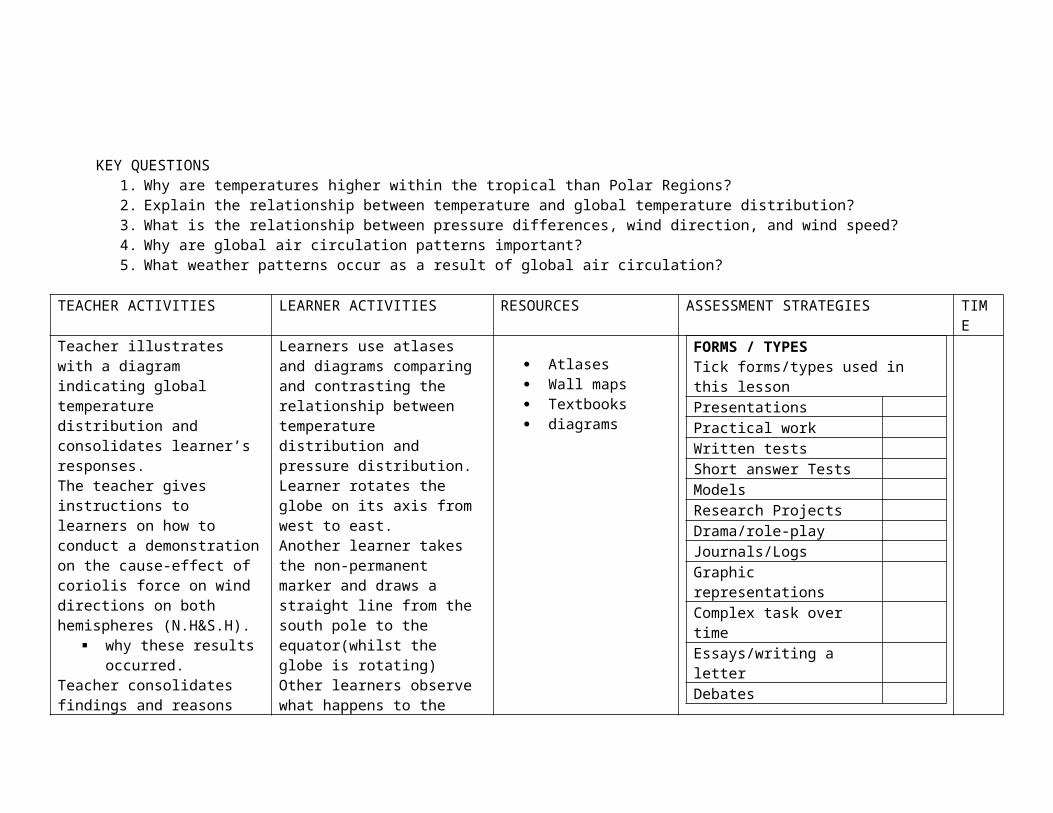
TEACHER ACTIVITIES LEARNER ACTIVITIES RESOURCES ASSESSMENT STRATEGIES TIMETeacher illustrates with a diagram indicating global temperature distribution and consolidates learner’s responses. The teacher gives instructions to learners on how to conduct a demonstration on the cause-effect of coriolis force on wind directions on both hemispheres (N.H&S.H).
why these results occurred.
Teacher consolidates findings and reasons thereof.The teacher provide a diagram indicating the latitudinal positions of global distribution of pressure zones depicting surface wind directions and tri-cellular cells.Teacher explains characteristics of surface winds and makes a link between their characteristic features (temperature, density, humidity etc) and associated weather conditions where various air masses meet.The teacher provide a diagram indicating the latitudinal positions of global distribution of pressure zones depicting surface wind directions and tri-cellular cells.Teacher explains characteristics of surface winds and makes a link between their characteristic features (temperature, density, humidity etc) and associated weather conditions where various air masses meet.
Learners use atlases and diagrams comparing and contrasting the relationship between temperature distribution and pressure distribution. Learner rotates the globe on its axis from west to east.Another learner takes the non-permanent marker and draws a straight line from the south pole to the equator(whilst the globe is rotating)Other learners observe what happens to the line drawnThe third learner repeats the same process starting from North Pole to the equator.In groups learners discuss their findings on what happened to the straight line in each hemisphere and explainIn groups, the learners practice to draw and label the sketch of a tri-cellular model.In groups, the learners practice to draw and label the sketch of a tri-cellular model
Atlases Wall maps Textbooks diagrams
FORMS / TYPESTick forms/types used in this lessonPresentationsPractical workWritten testsShort answer TestsModelsResearch ProjectsDrama/role-playJournals/LogsGraphic representationsComplex task over timeEssays/writing a letterDebatesInterviewsGallery walkFieldwork

GEOGRAPHY LESSON 2
GRADE : 12
DATE……………….. DURATION 3HRS
TOPIC: Mid Latitude Cyclone
KEY FOCUS AREAS: Concepts: cyclone; cyclogenesis; cyclone families. Various stages of mid-latitude cyclones Associated weather patterns: cold front, warm front & occluded front conditions. Identification of mid latitude cyclones on synoptic maps and satellite images (refer to symbols and
appearance respectively.) Their impact on human activities in South Africa
LO 1The Learner will be able to demonstrate a range of geographical skills and techniques.
LO 2The learner is able to demonstrate knowledge and understanding of processes and spatial patterns dealing with interactions between humans and the environment.
LO 3The learner is able to apply geographical skills and knowledge to environmental issues and challenges, recognize values and attitude and demonstrate the ability to recommend solutions and strategies.
ASSESSMENT STANDARDS ASSESSMENT STANDARDS ASSESSMENT STANDARDS
■ Plan a geographical research project of limited extent in a familiar context.
■ Integrate information from a variety of sources.
■ Compare and contrast information from a variety of sources.
■ Analyse the acquired information in order to answer the initial question.
■ Substantiate findings in written, oral or illustrative form.
X
X
■ Explain the influence of processes and associated spatial patterns in a range of places and regions.■ Account for the similarities and differences in processes and spatial patterns between place and between regions.■ Explore possible responses to issues and challenges arising from human and environment interactions in a local and national context.■ Examine different approaches used to sustain the environment that take into account different knowledge systems in a variety of contexts.
X
X
X
■ Apply skills and knowledge to a range of phenomena, issues and challenges at local and national scales.■ Examine values and attitudes held by individuals and groups associated with processes, spatial patterns and human environment interactions at local and national scales.
X
X

Key Questions1. What are mid latitude cyclones?2. Where do they occur?3. How do they form?4. Differentiate between the weather changes that occur before and after the passage of cold and warm fronts at an observation
weather station.5. How are mid-latitude cyclones depicted on synoptic maps and satellite images?6. How do they influence South African weather?7. How do they impact on Human activities in South Africa?
GEOGRAPHY LESSON 3
GRADE : 12
TEACHER ACTIVITIES LEARNER ACTIVITIES RESOURCES ASSESSMENT STRATEGIES TIMETeacher moves around helping learners come up with the definition.Using the diagram the teacher explains all processes involved during the formation of a mid latitude cyclone and the various stages of development of a mid latitude cyclone.Teacher provides learners with synoptic maps and satellite images and divides learners in groups & makes contrast between synoptic and satellite images.Teacher gives an appropriate extract depicting/showing the influence of mid-latitude cyclones. Learners answer questions based on the case study to understand how mid latitude cyclones influence South African weather and how they impact on human activities in South Africa
Learners divided into groups given different textbooks/sources to read and come up with the definition of what a mid latitude cyclone is. Using the map of the world the learners identify the location of mid latitude cyclone
Textbooks Maps of the world Diagram showing
a mid latitude cyclone
Outline of South African map
Synoptic weather chart
FORMS / TYPESTick forms/types used in this lessonPresentationsPractical workWritten testsShort answer TestsModelsResearch ProjectsDrama/role-playJournals/LogsGraphic representationsComplex task over timeEssays/writing a letterDebatesInterviewsGallery walkFieldwork

DATE……………….. DURATION 3HRS
TOPIC: Tropical Cyclones:
KEY FOCUS AREAS: Concepts: Tropical cyclones(various names used in different parts of the world) General characteristics: conditions needed for their formation; general movement and air circulation in both hemispheres. Developmental stages Identification of these weather phenomena on synoptic maps & satellite image. With reference to: size, symbols, appearance and air
circulation. Associated weather characteristics of each stage; impact on human activities and possible pre-cautionary measures and management
strategies.
LO 1The Learner will be able to demonstrate a range of geographical skills and techniques.
LO 2The learner is able to demonstrate knowledge and understanding of processes and spatial patterns dealing with interactions between humans and the environment.
LO 3The learner is able to apply geographical skills and knowledge to environmental issues and challenges, recognize values and attitude and demonstrate the ability to recommend solutions and strategies.
ASSESSMENT STANDARDS ASSESSMENT STANDARDS ASSESSMENT STANDARDS
■ Plan a geographical research project of limited extent in a familiar context.
■ Integrate information from a variety of sources.
■ Compare and contrast information from a variety of sources.
■ Analyse the acquired information in order to answer the initial question.
X
■ Explain the influence of processes and associated spatial patterns in a range of places and regions.■ Account for the similarities and differences in processes and spatial patterns between place and between regions.■ Explore possible responses to issues and challenges arising from human and environment interactions in a local and national context.■ Examine different approaches used to sustain the environment that take into account
X
X
X
■ Apply skills and knowledge to a range of phenomena, issues and challenges at local and national scales.■ Examine values and attitudes held by individuals and groups associated with processes, spatial patterns and human environment interactions at local and national scales.

■ Substantiate findings in written, oral or illustrative form.
X different knowledge systems in a variety of contexts.
Key Questions
1. What are tropical cyclones?2. Where and how do they occur?3. Identify the stages in the development of tropical cyclones.4. Distinguish between weather conditions associated with each stage of a tropical cyclone.5 How do they influence the weather of Southern Africa?6 How do they impact on Human activities in Southern Africa?7 What precautionary measures should people take as the cyclone approaches?8 How do the people manage the systems (before and after)?

GEOGRAPHY LESSON 4
TEACHER ACTIVITIES LEARNER ACTIVITIES RESOURCES ASSESSMENT STRATEGIES TIME
Teacher moves around helping learners come up with the definition.Using the diagram the teacher explains all processes involved during the formation of a tropical cyclone and the various stages of development of a tropical cyclone.Teacher gives learners an extract on the influence of this system in Southern Africa.
Learners divided into groups given 2 different textbooks to read and come up with the definition of what a mid tropical cyclone is. Using the map of the world the learners identify the location of tropical cyclones.Learners answer questions based on the case study to understand how tropical cyclones influence South African weather and how they impact on human activities in South Africa
Maps of the world Diagram showing a
tropical cyclone Outline of South
African map Newspapers Video clips Weather reports
FORMS / TYPESTick forms/types used in this lessonPresentationsPractical workWritten testsShort answer TestsModelsResearch ProjectsDrama/role-playJournals/LogsGraphic representationsComplex task over timeEssays/writing a letterDebatesInterviewsGallery walkFieldwork
GRADE : 12
DATE……………….. DURATION 6 HRS
TOPIC: ANTICYCLONES AND THE RESULTANT WEATHER OVER SOUTH AFRICA
KEY FOCUS AREAS: Factors determining the weather of South Africa:
Influence of oceans The effect of interior plateau The influence of latitudinal position of the sub-continent
Anti-cyclonic circulation: Identification and location of the three pressure cells i.e. S A H P C/ St. Helena High ; S I H P C / Mauritius High;
Kalahari/continental/Inland High Resultant weather associated with the above-mentioned Highs.
Traveling disturbances Development of: moisture front & line thunderstorms; coastal low pressure; South African Berg wind and associated weather
conditions.
LO 1The Learner will be able to demonstrate a range of geographical skills and techniques.
LO 2The learner is able to demonstrate knowledge and understanding of processes and spatial patterns dealing with interactions between humans and the environment.
LO 3The learner is able to apply geographical skills and knowledge to environmental issues and challenges, recognize values and attitude and demonstrate the ability to recommend solutions and strategies.
ASSESSMENT STANDARDS ASSESSMENT STANDARDS ASSESSMENT STANDARDS
■ Plan a geographical research project of limited extent in a familiar context.
■ Explain the influence of processes and associated spatial patterns in a range of
X ■ Apply skills and knowledge to a range of phenomena, issues and challenges at
X

■ Integrate information from a variety of sources.
■ Compare and contrast information from a variety of sources.
■ Analyse the acquired information in order to answer the initial question.
■ Substantiate findings in written, oral or illustrative form.
X
X
X
X
places and regions.■ Account for the similarities and differences in processes and spatial patterns between place and between regions.■ Explore possible responses to issues and challenges arising from human and environment interactions in a local and national context.■ Examine different approaches used to sustain the environment that take into account different knowledge systems in a variety of contexts.
X
X
local and national scales.■ Examine values and attitudes held by individuals and groups associated with processes, spatial patterns and human environment interactions at local and national scales.
X
Key Questions1. Identify and explain factors determining the weather and climate of South Africa?2. Identify the latitudinal location and name three anticyclones occurring over the sub-continent of Southern Africa.3. How and why do the anticyclones change position in summer and winter?4. How do they affect the weather of South Africa?5. How do the following weather phenomena influence the weather and climate of South Africa?
Position of the moisture front Line thunderstorms Coastal low and Berg winds.
GEOGRAPHY LESSON 5
TEACHER ACTIVITIES LEARNER ACTIVITIES RESOURCES ASSESSMENT STRATEGIES TIME
Teacher moves around helping learners to identify the position, name and explain the three main climatic factors. Teacher consolidates the learner’s responses.Teacher divides learners into groups & provides the learners with two isobaric maps showing summer and winter positions of the High pressure cells. The learners compare and contrast the summer as well as winter maps on the position of High pressures cells and account for their associated weather conditions.Teacher consolidates responses of the learners. Using the outline map of Southern Africa, the teacher explains the concepts of moisture front, line thunderstorms, coastal low and Berg winds.
Learners divided into groups given Relief map of Southern Africa to identify and explain the factors determining weather and climate of Southern Africa..
The learners listen and copy the table/outline map showing the location and the path taken by the above-mentioned weather phenomena.
Maps of Southern Africa ( Relief map)
Atlas Diagram showing
the position of the three anticyclones
Outline of South African map.
Newspapers supplements
FORMS / TYPESTick forms/types used in this lessonPresentationsPractical workWritten testsShort answer TestsModelsResearch ProjectsDrama/role-playJournals/LogsGraphic representationsComplex task over timeEssays/writing a letterDebatesInterviewsGallery walkFieldwork

GRADE : 12
DATE……………….. DURATION 3 HRS
TOPIC: SYNOPTIC WEATHER MAPS AND SATELLITE IMAGE READING
KEY FOCUS AREAS: The use of international symbols Read and interpret synoptic charts
Mid latitudes, tropical cyclones, pressure cells Station models
Interpret information about weather from satellite images Understand the importance of synoptic charts and satellite images
LO 1The Learner will be able to demonstrate a range of geographical skills and techniques.
LO 2The learner is able to demonstrate knowledge and understanding of processes and spatial patterns dealing with interactions between humans and the environment.
LO 3The learner is able to apply geographical skills and knowledge to environmental issues and challenges, recognize values and attitude and demonstrate the ability to recommend solutions and strategies.
ASSESSMENT STANDARDS ASSESSMENT STANDARDS ASSESSMENT STANDARDS
■ Plan a geographical research project of limited extent in a familiar context.
■ Integrate information from a variety of sources.
■ Compare and contrast information from a variety of sources.
■ Analyse the acquired information in order to answer the initial question.
X
X
X
■ Explain the influence of processes and associated spatial patterns in a range of places and regions.■ Account for the similarities and differences in processes and spatial patterns between place and between regions.■ Explore possible responses to issues and challenges arising from human and environment interactions in a local and national context.■ Examine different approaches used to sustain the environment that take into account different knowledge systems in a variety
X
X
■ Apply skills and knowledge to a range of phenomena, issues and challenges at local and national scales.■ Examine values and attitudes held by individuals and groups associated with processes, spatial patterns and human environment interactions at local and national scales.
X
X

■ Substantiate findings in written, oral or illustrative form.
X of contexts.
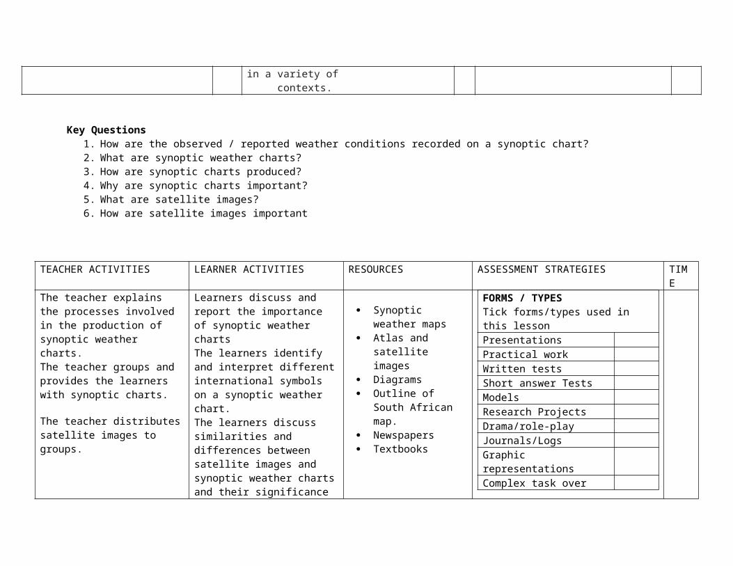
Key Questions1. How are the observed / reported weather conditions recorded on a synoptic chart?2. What are synoptic weather charts?3. How are synoptic charts produced?4. Why are synoptic charts important?5. What are satellite images?6. How are satellite images important
TEACHER ACTIVITIES LEARNER ACTIVITIES RESOURCES ASSESSMENT STRATEGIES TIMEThe teacher explains the processes involved in the production of synoptic weather charts. The teacher groups and provides the learners with synoptic charts.
The teacher distributes satellite images to groups.
Learners discuss and report the importance of synoptic weather chartsThe learners identify and interpret different international symbols on a synoptic weather chart.The learners discuss similarities and differences between satellite images and synoptic weather charts and their significance in climatology.
Synoptic weather maps
Atlas and satellite images
Diagrams Outline of South
African map. Newspapers Textbooks
FORMS / TYPESTick forms/types used in this lessonPresentationsPractical workWritten testsShort answer TestsModelsResearch ProjectsDrama/role-playJournals/LogsGraphic representationsComplex task over timeEssays/writing a letterDebatesInterviewsGallery walkFieldwork

GEOGRAPHY LESSON 6
GRADE : 12
DATE……………….. DURATION 3 HRS
TOPIC: CLIMATE AT LOCAL SCALE
KEY FOCUS AREAS: Valley climates : aspects and temperature variations Development of :Anabatic& Katabatic flow, inversion layer, frost pocket and radiation fog The influence of human activities ( settlement, farming ) Urban climate
LO 1The Learner will be able to demonstrate a range of geographical skills and techniques.
LO 2The learner is able to demonstrate knowledge and understanding of processes and spatial patterns dealing with interactions between humans and the environment.
LO 3The learner is able to apply geographical skills and knowledge to environmental issues and challenges, recognize values and attitude and demonstrate the ability to recommend solutions and strategies.
ASSESSMENT STANDARDS ASSESSMENT STANDARDS ASSESSMENT STANDARDS

■ Plan a geographical research project of limited extent in a familiar context.
■ Integrate information from a variety of sources.
■ Compare and contrast information from a variety of sources.
■ Analyse the acquired information in order to answer the initial question.
■ Substantiate findings in written, oral or illustrative form.
X
X
X
X
■ Explain the influence of processes and associated spatial patterns in a range of places and regions.■ Account for the similarities and differences in processes and spatial patterns between place and between regions.■ Explore possible responses to issues and challenges arising from human and environment interactions in a local and national context.■ Examine different approaches used to sustain the environment that take into account different knowledge systems in a variety of contexts.
X
X
X
■ Apply skills and knowledge to a range of phenomena, issues and challenges at local and national scales.■ Examine values and attitudes held by individuals and groups associated with processes, spatial patterns and human environment interactions at local and national scales.
X
X
Key Questionso What do the following concepts mean?
Micro-climatology Aspect Anabatic & katabatic flow Berg wind and heat island
o How does a valley influence local climate?o Describe and explain the influence of valley climate on human activitieso What causes heat island?o What effect do heat islands have on human activities?
TEACHER ACTIVITIES LEARNER ACTIVITIES RESOURCES ASSESSMENT STRATEGIES TIMEThe teacher groups learners. Using textbooks and other relevant resources, learners read and define concepts like micro-climate, aspect, and shadow zone, heat island, and thermal belt, anabatic and katabatic wind/flow and explain their influence on local climate.Teacher takes the learners out on local field work to observe the distribution of settlement and vegetation patterns within valley environment.Learners observe and record their findings and account for the differences thereof.Using the isotherm map, describe and account for the variations in temperatures in and around the city environment.Teacher supplies learners with an extract, a Case study about pollution in the city.
Learners observe and record their findings and account for the differences thereof.Using the isotherm map, describe and account for the variations in temperatures in and around the city environment.Learners read and answer questions based on a/an extract / case study.
Textbooks Newspaper extracts Sketches Thermal/isotherm
map.
FORMS / TYPESTick forms/types used in this lessonPresentationsPractical workWritten testsShort answer TestsModelsResearch ProjectsDrama/role-playJournals/LogsGraphic representationsComplex task over timeEssays/writing a letterDebatesInterviewsGallery walkFieldwork

GEOGRAPHY LESSON 7
GRADE : 12
DATE……………….. DURATION 3 HRS
TOPIC: CLIMATE HAZARDS
KEY FOCUS AREAS: Concept of climate hazard Basic understanding of global warming, drought, floods, storm surges, lightning, hail, tornadoes. Climate change (concept, measures to prevent, climatic changes in Africa and its effects on Africans Kyoto Protocol Reducing the effects of climate changes in Africa and developing nations.
LO 1The Learner will be able to demonstrate a range of geographical skills and techniques.
LO 2The learner is able to demonstrate knowledge and understanding of processes and spatial patterns dealing with interactions between humans and the environment.
LO 3The learner is able to apply geographical skills and knowledge to environmental issues and challenges, recognize values and attitude and demonstrate the ability to recommend solutions and strategies.
ASSESSMENT STANDARDS ASSESSMENT STANDARDS ASSESSMENT STANDARDS
■ Plan a geographical research project of limited extent in a familiar context.
■ Integrate information from a variety of sources.
■ Compare and contrast information from a variety of sources.
X
X
■ Explain the influence of processes and associated spatial patterns in a range of places and regions.■ Account for the similarities and differences in processes and spatial patterns between place and between regions.■ Explore possible responses to issues and challenges arising from human and environment interactions in a local and national context.
X
X
X
■ Apply skills and knowledge to a range of phenomena, issues and challenges at local and national scales.■ Examine values and attitudes held by individuals and groups associated with processes, spatial patterns and human environment interactions at local and national scales.
X
X

■ Analyse the acquired information in order to answer the initial question.
■ Substantiate findings in written, oral or illustrative form.
X
X
■ Examine different approaches used to sustain the environment that take into account different knowledge systems in a variety of contexts.
Key Questionso What do the following concepts mean?
Global warming Drought Floods Storm surges Lightning Hail storms Thunderstorms
o Why are climatic hazards important to study?o How can people/nations deal with these problems?

TEACHER ACTIVITIES LEARNER ACTIVITIES RESOURCES ASSESSMENT STRATEGIES TIME Teacher groups learners and ask them to define concepts using textbooks and other relevant sources. Teacher consolidates learners’ responses.Teacher provides a case study/article on climate change hazard. Learners discuss causes and effects of climate hazards and their impact on humans.Teacher provides a case study on solutions /human responses to climate hazards. E.g. Load shedding, use of alternative sources of energy.Learners discuss and report findings on case study/ do role play representing rich and poor oil producing /emerging nations.
Learners discuss and report findings on case study/ do role play representing rich and poor oil producing /emerging nations.
Textbooks Newspaper
extracts/articles on climate change & Kyoto Protocol
Case study on any climate hazard.
FORMS / TYPESTick forms/types used in this lessonPresentationsPractical workWritten testsShort answer TestsModelsResearch ProjectsDrama/role-playJournals/LogsGraphic representationsComplex task over timeEssays/writing a letterDebatesInterviewsGallery walkFieldwork

GEOGRAPHY LESSON 8
GRADE : 12
DATE……………….. DURATION 3 HRS
TOPIC: FLUVIAL PROCESSES.
KEY FOCUS AREAS: Concepts : Drainage basin, catchment area, river system ,tributary, confluence, watershed , interfluve, river mouth, drainage density Sources of water supply: ( surface run-off, ground water, water table, Factors influencing run-off and infiltration (precipitation, soil moisture, porosity and permeability). Types of rivers and stream channel patterns(permanent, periodic, episodic & exotic) (braided, meandering & rock – controlled channels) River discharge: Laminar and turbulent flow, discharge volume, flow hydrographs & types and associated concepts i.e. flood peak, time lag
and base flow.
LO 1The Learner will be able to demonstrate a range of geographical skills and techniques.
LO 2The learner is able to demonstrate knowledge and understanding of processes and spatial patterns dealing with interactions between humans and the environment.
LO 3The learner is able to apply geographical skills and knowledge to environmental issues and challenges, recognize values and attitude and demonstrate the ability to recommend solutions and strategies.
ASSESSMENT STANDARDS ASSESSMENT STANDARDS ASSESSMENT STANDARDS
■ Plan a geographical research project of limited extent in a familiar context.
■ Integrate information from a variety of sources.
■ Compare and contrast information from a variety of sources.
X
X
■ Explain the influence of processes and associated spatial patterns in a range of places and regions.■ Account for the similarities and differences in processes and spatial patterns between place and between regions.■ Explore possible responses to issues and challenges arising from human and
X
X
■ Apply skills and knowledge to a range of phenomena, issues and challenges at local and national scales.■ Examine values and attitudes held by individuals and groups associated with processes, spatial patterns and human
X
X
■ Analyse the acquired information in order to answer the initial question.
■ Substantiate findings in written, oral or illustrative form.
X
X
environment interactions in a local and national context.■ Examine different approaches used to sustain the environment that take into account different knowledge systems in a variety of contexts.
environment interactions at local and national scales.
Key Questionso Define the following concepts associated with the drainage basin (catchment area, river system, confluence,
tributary, watershed, interfluve and drainageo How is water supplied to a drainage basin?o What types of patterns do drainage basins form?o Describe and account for different characteristics of drainage basins.o Distinguish between the four types of riverso Identify and account for different stream channelso Describe and account for flow changes of a hydrograph ( which factors influence the shape of hydrograph )

GEOGRAPHY LESSON 9
GRADE : 12
DATE……………….. DURATION 3 HRS
TOPIC: RIVER CAPTURE / STREAM PIRACY.
TEACHER ACTIVITIES LEARNER ACTIVITIES RESOURCES ASSESSMENT STRATEGIES TIME The teacher groups and provides a sketch map/diagram of a drainage basin to learners. The teacher provides a copy showing hydrological cycle.The teacher groups learners and provides a table explaining the types of drainage patterns and un-matching sketches.
Teacher explains different types of rivers and learners look for different types of rivers using atlases. Teacher consolidates responses of learners.Teacher explains and later provides learners with sketches of hydrographs with un-corresponding explanatory information and the learners study sketches with information provided.
Learners mark/insert features associated with drainage basin and write their own definitions.Learners draw and label the components of a hydrological cycle.
Learners study the provided sketch and match information to the corresponding drainage patterns.
Using the drainage network provided by the teacher, learners grade the according to their correct stream order.
Learners study sketches with information provided.
Textbooks Wall map of RSA
showing drainage basins
Atlases Wall charts Koki pens
FORMS / TYPESTick forms/types used in this lessonPresentationsPractical workWritten testsShort answer TestsModelsResearch ProjectsDrama/role-playJournals/LogsGraphic representationsComplex task over timeEssays/writing a letterDebatesInterviewsGallery walkFieldwork

KEY FOCUS AREAS: Concepts: Abstraction, River Capture, Misfit, Captured stream, Elbow of Capture, Wind Gap. Identification and description of Fluvial land form features (undercut, slip-off meander, ox-bow lake, braided stream, flood plain, waterfalls and
rapids, deltas and sand islands) River profiles (base levels, long and cross profiles, graded & un-graded streams, river rejuvenation & its features). Catchment and river management (impact of humans on catchment areas, importance of managing catchment areas, strategies to manage
catchment areas.) LO 1The Learner will be able to demonstrate a range of geographical skills and techniques.
LO 2The learner is able to demonstrate knowledge and understanding of processes and spatial patterns dealing with interactions between humans and the environment.
LO 3The learner is able to apply geographical skills and knowledge to environmental issues and challenges, recognize values and attitude and demonstrate the ability to recommend solutions and strategies.
ASSESSMENT STANDARDS ASSESSMENT STANDARDS ASSESSMENT STANDARDS
■ Plan a geographical research project of limited extent in a familiar context.
■ Integrate information from a variety of sources.
■ Compare and contrast information from a variety of sources.
■ Analyse the acquired information in order to answer the initial question.
■ Substantiate findings in written, oral or illustrative form.
X
X
X
x
■ Explain the influence of processes and associated spatial patterns in a range of places and regions.■ Account for the similarities and differences in processes and spatial patterns between place and between regions.■ Explore possible responses to issues and challenges arising from human and environment interactions in a local and national context.■ Examine different approaches used to sustain the environment that take into account different knowledge systems in a variety of contexts.
X
X
■ Apply skills and knowledge to a range of phenomena, issues and challenges at local and national scales.■ Examine values and attitudes held by individuals and groups associated with processes, spatial patterns and human environment interactions at local and national scales.
X
X
Key Questions
o Define the following concepts associated with river capture ( Abstraction, stream piracy, misfit stream, elbow of capture, wind gap, captured stream, captor stream )
o Distinguish between long profile and cross profile, temporary and permanent base level of erosion, graded & un-graded streams
o Account for the relationship between long and cross profiles of upper, middle & lower course of a river.o Identify and describe the following ( undercut and slip-off slope, ox-bow lake, sand island, waterfalls & rapids,
braided stream, natural levee, flood plain & delta)o What impact do humans have on catchment areas?o What management strategies can be employed to reduce the impact of humans on catchment areas?
TEACHER ACTIVITIES LEARNER ACTIVITIES RESOURCES ASSESSMENT STRATEGIES TIME The teacher groups and provides a sketch map/diagram of stream piracy to learners, and explains what river capture is. The teacher asks the learners to draw the profiles, identifying the upper, middle, lower course, source and the mouth of a river.The teacher provides the learners with diagrams showing all fluvial landforms and explains each land form. With reference to a case study provided to learners, the teacher asks the learners to evaluate the impact of humans on catchment areas and describe strategies employed to manage them.
The learners identify features of river capture from the diagram provided
The learners, using wall charts, identify all the river courses, source & mouth. Learners identify and describe all fluvial land forms and how they are formed.Learners discuss in groups, ask and answer questions based on the case study.
Textbooks Diagrams Atlases Wall charts Koki
pens
FORMS / TYPESTick forms/types used in this lessonPresentationsPractical workWritten testsShort answer TestsModelsResearch ProjectsDrama/role-playJournals/LogsGraphic representationsComplex task over timeEssays/writing a letterDebatesInterviewsGallery walkFieldwork
GEOGRAPHY LESSON 10
GRADE : 12
DATE……………….. DURATION 3 HRS
TOPIC: STRUCTURAL LANDFORMS, SLOPE ELEMENTS/FORMS AND MASS MOVEMENT.KEY FOCUS AREAS:Topography associated with horizontal, tilted/inclined strata, and massive igneous rocks.
Concepts of horizontal and tilted strata and massive igneous rock Characteristics and processes associated with the development of landforms of horizontal and inclined strata, and massive igneous
rocks. Utilization of the above mentioned landscape by humans.
Slope elements/slope forms: Identification and characteristics of slope elements Significance of four slope elements for human activity.
Mass movement:

Concepts of mass movement Identification and reasons for the development of types of mass movement (soil creep, land slides, rock falls, and mud flows) Human responses to mass movement and preventative measures
LO 1The Learner will be able to demonstrate a range of geographical skills and techniques.
LO 2The learner is able to demonstrate knowledge and understanding of processes and spatial patterns dealing with interactions between humans and the environment.
LO 3The learner is able to apply geographical skills and knowledge to environmental issues and challenges, recognize values and attitude and demonstrate the ability to recommend solutions and strategies.
ASSESSMENT STANDARDS ASSESSMENT STANDARDS ASSESSMENT STANDARDS
■ Plan a geographical research project of limited extent in a familiar context.
■ Integrate information from a variety of sources.
■ Compare and contrast information from a variety of sources.
■ Analyse the acquired information in order to answer the initial question.
■ Substantiate findings in written, oral or illustrative form.
X
X
X
■ Explain the influence of processes and associated spatial patterns in a range of places and regions.■ Account for the similarities and differences in processes and spatial patterns between place and between regions.■ Explore possible responses to issues and challenges arising from human and environment interactions in a local and national context.■ Examine different approaches used to sustain the environment that take into account different knowledge systems in a variety of contexts.
X
X
■ Apply skills and knowledge to a range of phenomena, issues and challenges at local and national scales.■ Examine values and attitudes held by individuals and groups associated with processes, spatial patterns and human environment interactions at local and national scales.
X
X

Key Questionso What are characteristics of land form associated with horizontal, inclined strata and massive igneous rocks?o What effect do they have on humans?o What are the characteristic features of the main slope elements?o How do they impact on human activities?o What is meant by mass movement?o What are differences between the types of mass movement?o What impact do they have on the people?
TEACHER ACTIVITIES LEARNER ACTIVITIES RESOURCES ASSESSMENT STRATEGIES TIME The teacher groups and distributes maps & photographs of Karoo landscape.
Learners, with the aid of available resources define the concepts associated with horizontal, inclined and massive igneous rocks. Using the photographs of Karoo landscape learners identify and distinguish four main types of slope elements. Learners report findings and the teacher consolidates.
Textbooks Atlases Wall charts &Koki
pens Wall maps Photographs ( Karoo
landscape) & topographical maps
Newspaper articles on mass movements( landslides – people buried alive, village swept away by mud flow)
FORMS / TYPESTick forms/types used in this lessonPresentationsPractical workWritten testsShort answer TestsModelsResearch ProjectsDrama/role-playJournals/LogsGraphic representationsComplex task over timeEssays/writing a letterDebatesInterviewsGallery walkFieldwork

GEOGRAPHY LESSON 11
GRADE : 12
DATE……………….. DURATION
TOPIC: PEOPLE AND PLACES: PROCESSES AND SPATIAL PATTERNS.
KEY FOCUS AREAS: Concepts: Settlement; site; situation; Classification of settlements according to: Size and complexity; pattern and function. Factors influencing site and situation in both rural and urban settlements. Rural settlement:
Factors influencing site and situation Classification according to pattern; function; shape (round, cross road, linear and T- shape).
LO 1The Learner will be able to demonstrate a range of geographical skills and techniques.
LO 2The learner is able to demonstrate knowledge and understanding of processes and spatial patterns dealing with interactions between humans and the environment.
LO 3The learner is able to apply geographical skills and knowledge to environmental issues and challenges, recognize values and attitude and demonstrate the ability to recommend solutions and strategies.
ASSESSMENT STANDARDS ASSESSMENT STANDARDS ASSESSMENT STANDARDS

■ Plan a geographical research project of limited extent in a familiar context.
■ Integrate information from a variety of sources.
■ Compare and contrast information from a variety of sources.
■ Analyse the acquired information in order to answer the initial question.
■ Substantiate findings in written, oral or illustrative form.
X
X
X
X
X
■ Explain the influence of processes and associated spatial patterns in a range of places and regions.■ Account for the similarities and differences in processes and spatial patterns between place and between regions.■ Explore possible responses to issues and challenges arising from human and environment interactions in a local and national context.■ Examine different approaches used to sustain the environment that take into account different knowledge systems in a variety of contexts.
X
X
■ Apply skills and knowledge to a range of phenomena, issues and challenges at local and national scales.■ Examine values and attitudes held by individuals and groups associated with processes, spatial patterns and human environment interactions at local and national scales.
Key Questions:o What is settlement?o Distinguish between rural and urban settlement.o How are settlements classified?o Which factors influence the site and situation of rural and urban settlement?o Compare and contrast between rural and urban settlements on the basis of: size and complexity, function,
situation and shape.

TEACHER ACTIVITIES LEARNER ACTIVITIES RESOURCES ASSESSMENT STRATEGIES TIMEThe teacher groups learners and instructs them to brainstorm the meaning of settlement. The teacher provides a variety of pictures showing rural and urban settings .
.Learners, working in their respective groups, discuss similarities and differences between rural and urban settlement.Using resources provided, learners compare rural and urban settlement in terms of size and complexity, pattern, shape, and functions. They represent the answers in a tabular form. The teacher guides and consolidates learners’ responses.Using the pictures and topographic maps provided by the teacher, learners come up with possible factors that might have led to the location of settlements shown. They also debate on possible activities around which the economy of the settlement is based.
Photographs pictures textbooks topographical maps
FORMS / TYPESTick forms/types used in this lessonPresentationsPractical workWritten testsShort answer TestsModelsResearch ProjectsDrama/role-playJournals/LogsGraphic representationsComplex task over timeEssays/writing a letterDebatesInterviewsGallery walkFieldwork

GEOGRAPHY LESSON 12
GRADE : 12
DATE……………….. DURATION
TOPIC: HUMAN-ENVIRONMENT INTERACTIONS AND SUSTAINABILITY RELATED STRATEGIES.
KEY FOCUS AREAS: Concepts: Rural –urban migration, rural depopulation, governance, Agenda 21, local authorities, sustainability, xenophobia, land
redistribution, HIV & AIDS & refugees. Cause, consequences and possible solutions to rural depopulation. Governance of rural settlement ( local authorities and Agenda 21) Sustainability- related strategies
LO 1The Learner will be able to demonstrate a range of geographical skills and techniques.
LO 2The learner is able to demonstrate knowledge and understanding of processes and spatial patterns dealing with interactions between humans and the environment.
LO 3The learner is able to apply geographical skills and knowledge to environmental issues and challenges, recognize values and attitude and demonstrate the ability to recommend solutions and strategies.
ASSESSMENT STANDARDS ASSESSMENT STANDARDS ASSESSMENT STANDARDS
■ Plan a geographical research project of limited extent in a familiar context.
■ Integrate information from a variety of sources.
X
X
■ Explain the influence of processes and associated spatial patterns in a range of places and regions.■ Account for the similarities and differences in processes and spatial patterns between place and between regions.
X
■ Apply skills and knowledge to a range of phenomena, issues and challenges at local and national scales.■ Examine values and attitudes held by individuals and groups associated with
X
X
■ Compare and contrast information from a variety of sources.
■ Analyse the acquired information in order to answer the initial question.
■ Substantiate findings in written, oral or illustrative form.
X
X
X
■ Explore possible responses to issues and challenges arising from human and environment interactions in a local and national context.■ Examine different approaches used to sustain the environment that take into account different knowledge systems in a variety of contexts.
X processes, spatial patterns and human environment interactions at local and national scales.
Key Questions:o Define the following concept: rural-urban migration, depopulation, xenophobia, refugees, land redistribution,
land restitution.o What issues does Agenda 21 focus on?o Why are fewer people found in rural areas than urban areas? Explain what impact does each situation have in
both rural and urban areas?o Rural areas are faced with serious challenges of meeting the basic needs for all. These challenges include:
sanitation, lack supply of clean water, sanitation etc. What strategies do local and national authorities employ to address these challenges

GEOGRAPHY LESSON 13
GRADE : 12
DATE……………….. DURATION
TOPIC: PEOPLE AND PLACES; URBAN SETTLEMENT
KEY FOCUS AREAS: Identification, function and reasons for development ( central place, trade and transport , break-of-bulk points, specialized cities,
function towns gateway/gap towns ) Urban hierarchies
TEACHER ACTIVITIES LEARNER ACTIVITIES RESOURCES ASSESSMENT STRATEGIES TIME The teacher provides cartoons or photos/ pictures of rural and urban areas and asks the learners to compare and contrast the two settlements with respect to the causes, effects and the consequences of rural-urban migration in both settlements.The teacher guides to plan an investigation into the challenges facing people as the result of rural-migration and how local and national governments /authorities respond to them.
Using background knowledge from grade 10, learners define concepts such as rural-urban migration, rural depopulation, Xenophobia, HIV &AIDS, refugees etc. The teacher consolidates the responses from learners.
Textbooks Newspaper cuttings SA legislation pre
and post democracy (land tenure system )
Documentation : Agenda 21
Flip charts
FORMS / TYPESTick forms/types used in this lessonPresentationsPractical workWritten testsShort answer TestsModelsResearch ProjectsDrama/role-playJournals/LogsGraphic representationsComplex task over timeEssays/writing a letterDebatesInterviewsGallery walkFieldwork

LO 1The Learner will be able to demonstrate a range of geographical skills and techniques.
LO 2The learner is able to demonstrate knowledge and understanding of processes and spatial patterns dealing with interactions between humans and the environment.
LO 3The learner is able to apply geographical skills and knowledge to environmental issues and challenges, recognize values and attitude and demonstrate the ability to recommend solutions and strategies.
ASSESSMENT STANDARDS ASSESSMENT STANDARDS ASSESSMENT STANDARDS
■ Plan a geographical research project of limited extent in a familiar context.
■ Integrate information from a variety of sources.
■ Compare and contrast information from a variety of sources.
■ Analyse the acquired information in order to answer the initial question.
■ Substantiate findings in written, oral or illustrative form.
X
X
X
X
X
■ Explain the influence of processes and associated spatial patterns in a range of places and regions.■ Account for the similarities and differences in processes and spatial patterns between place and between regions.■ Explore possible responses to issues and challenges arising from human and environment interactions in a local and national context.■ Examine different approaches used to sustain the environment that take into account different knowledge systems in a variety of contexts.
X
X
■ Apply skills and knowledge to a range of phenomena, issues and challenges at local and national scales.■ Examine values and attitudes held by individuals and groups associated with processes, spatial patterns and human environment interactions at local and national scales.
X
X
Key Questions:1. Classify urban settlement areas according to size.2. Define the following concepts: central place, trade and transport, specialized, break-of-bulk point, junction towns,
gateway/gap settlement, sphere of influence, threshold population, range, urban sprawl, rate of urbanization, urban expansion, level of urbanization, urban growth, urban profile.
3. Classify urban settlements according to their hierarchical/ functional order.4. What are the reasons for the shape of urban profile?5. Identify street plans as well as advantages and disadvantages.
6. What are the characteristics of each zone of the following functional zones of the city and which factors influence the location of each?
7. How did the proponents of different models explain different land use zones?
TEACHER ACTIVITIES LEARNER ACTIVITIES RESOURCES ASSESSMENT STRATEGIES TIME Teacher provides unlabelled settlement pyramid and asks learners to classify urban settlements according to size and complexity. Teacher provides a Topo. Map and a table depicting mixed descriptions of street plan with advantages and disadvantages. Learners discuss and identify the corresponding answer next to appropriate street plans.Teacher supplies a picture of a side view of urban area to study. The teacher consolidates their responses.
Learners classify and write down responses on the flip chart for later presentation
With the aid of textbooks, learners define concepts listed in key question 2.The teacher consolidates their responses and proceed with introducing the concept of urban hierarchy and asks the learners to urban settlements according to their hierarchy.Learners identify and describe characteristics of different land-use zones. Learners identify the model that best suits that particular city.
Textbooks Diagrams Photos Flip charts Topographic maps
and orthophotos
FORMS / TYPESTick forms/types used in this lessonPresentationsPractical workWritten testsShort answer TestsModelsResearch ProjectsDrama/role-playJournals/LogsGraphic representationsComplex task over timeEssays/writing a letterDebatesInterviewsGallery walkFieldwork

GEOGRAPHY LESSON 14
GRADE : 12
DATE……………….. DURATION
TOPIC: URBAN SETTLEMENT PEOPLE AND PLACES: HUMAN-ENVIRONMENTAL INTERACTIONS & SUSTAINABILITY RELATED STRATEGIES
KEY FOCUS AREAS:
Urban settlement issues: Inner city problems, urban blight, pollution, congestion, land-use conflict/by-laws, political influence, informal settlements
Governance : Urban settlement ( changing urban settlements, local authorities, Agenda 21) Sustainability- related strategies : Sustainable strategies to maintain expanding urban settlements, Inner city renewal, Urban planning, Concepts: New towns, self-help cities and future urban settlements.
LO 1The Learner will be able to demonstrate a range of geographical skills and techniques.
LO 2The learner is able to demonstrate knowledge and understanding of processes and spatial patterns dealing with interactions between humans and the environment.
LO 3The learner is able to apply geographical skills and knowledge to environmental issues and challenges, recognize values and attitude and demonstrate the ability to recommend solutions and strategies.
ASSESSMENT STANDARDS ASSESSMENT STANDARDS ASSESSMENT STANDARDS
■ Plan a geographical research project of limited extent in a familiar context.
■ Integrate information from a variety of sources.
X
X
■ Explain the influence of processes and associated spatial patterns in a range of places and regions.■ Account for the similarities and differences in processes and spatial patterns between
X
■ Apply skills and knowledge to a range of phenomena, issues and challenges at local and national scales.■ Examine values and attitudes held by individuals and groups associated
X
X
■ Compare and contrast information from a variety of sources.
■ Analyse the acquired information in order to answer the initial question.
■ Substantiate findings in written, oral or illustrative form.
X
X
X
place and between regions.■ Explore possible responses to issues and challenges arising from human and environment interactions in a local and national context.■ Examine different approaches used to sustain the environment that take into account different knowledge systems in a variety of contexts.
X
with processes, spatial patterns and human environment interactions at local and national scales.
Key Questions:1. Define the following concepts: Inner city, urban blight, congestion, pollution, Agenda 21, political influence, informal
settlements and by-laws.2. Discuss various urban problems /issues and suggest possible solutions to the problems identified.3. How are urban centers governed?4. How can settlements issues be solved in the context of sustainable development/
GEOGRAPHY LESSON 15
GRADE : 12
DATE……………….. DURATION
TOPIC: GEOGRAPHICAL SKILLS AND TECHNIQUES
KEY FOCUS AREAS: Gradient Cross-section Intervisibility Vertical exaggeration
TEACHER ACTIVITIES LEARNER ACTIVITIES RESOURCES ASSESSMENT STRATEGIES TIMETeacher groups learners and hands out a case study on how local and national authorities address the question of urban development.
The learners are grouped and provided with hand-outs on concepts and are asked to define concepts in key question 1Learners read, discuss and report findings and also questions posed.Learners are provided with a typical low-cost house by Sustainable Design Group and they answer questions based on it.
Textbooks Cartoons Newspaper articles Maps(cadastral) on
distribution of urban centers
Flip charts
FORMS / TYPESTick forms/types used in this lessonPresentationsPractical workWritten testsShort answer TestsModelsResearch ProjectsDrama/role-playJournals/LogsGraphic representationsComplex task over timeEssays/writing a letterDebatesInterviewsGallery walkFieldwork

LO 1The Learner will be able to demonstrate a range of geographical skills and techniques.
LO 2The learner is able to demonstrate knowledge and understanding of processes and spatial patterns dealing with interactions between humans and the environment.
LO 3The learner is able to apply geographical skills and knowledge to environmental issues and challenges, recognize values and attitude and demonstrate the ability to recommend solutions and strategies.
ASSESSMENT STANDARDS ASSESSMENT STANDARDS ASSESSMENT STANDARDS
■ Plan a geographical research project of limited extent in a familiar context.
■ Integrate information from a variety of sources.
■ Compare and contrast information from a variety of sources.
■ Analyse the acquired information in order to answer the initial question.
■ Substantiate findings in written, oral or illustrative form.
X
X
X
X
■ Explain the influence of processes and associated spatial patterns in a range of places and regions.■ Account for the similarities and differences in processes and spatial patterns between place and between regions.■ Explore possible responses to issues and challenges arising from human and environment interactions in a local and national context.■ Examine different approaches used to sustain the environment that take into account different knowledge systems in a variety of contexts.
■ Apply skills and knowledge to a range of phenomena, issues and challenges at local and national scales.■ Examine values and attitudes held by individuals and groups associated with processes, spatial patterns and human environment interactions at local and national scales.
X
X
Key Questions1. Define the following concepts: Gradient, Cross-section, Intervisibility and Vertical Exaggeration 2. What is the importance of calculating gradient to humans?3. How do you calculate gradient?4. Distinguish between horizontal and vertical scale.5. Draw a cross- section and describe features along it.6. State whether one, standing at /on slope X can see a feature/s on slope Y.7. What is the importance of exaggerating a vertical scale on a Topographic Map?

TEACHER ACTIVITIES LEARNER ACTIVITIES RESOURCES ASSESSMENT STRATEGIES TIME The teacher groups learners and asks them to give general definition of concepts in key question 1 and then answer question 2,3 and 4.Using their textbooks and other available sources, attempt to answer. The teacher consolidates by using sketches/illustration.The teacher outlines the procedures followed in drawing a cross-section and shows the learners with an example. The teacher supervises and attends to questions arising from learners.The teacher guides and asks learners if they can identify which feature/s are inter-visible and which are not along a cross section The teacher asks learners to discuss problems encountered in identifying intervisible features and learners suggest some solutions e.g. expanding/enlarging a vertical scale.The teacher consolidates the discussions of learners and works out an example on how to calculate vertical exaggeration. Learners are given different map scales to calculate vertical exaggerations.
Learners draw a cross-section using a topographic map and identify features.
The ruler Plane piece of
paper Lead pencil Topographic map Calculator
FORMS / TYPESTick forms/types used in this lessonPresentationsPractical workWritten testsShort answer TestsModelsResearch ProjectsDrama/role-playJournals/LogsGraphic representationsComplex task over timeEssays/writing a letterDebatesInterviewsGallery walkFieldwork