Embed Size (px)
Citation preview

1
DISTRIBUTION STATEMENT A. Approved for public release; distribution is unlimited.
Development and Testing of Physically-Based Methods for Filling Gaps in Remotely Sensed River Data
Jonathan M. Nelson
US Geological Survey National Research Program Geomorphology and Sediment Transport Laboratory
4620 Technology Drive, Suite 400 Golden, CO 80403
phone: (303) 278-7957 fax: (303) 279-4165 email: [email protected]
Award Number: N0001411IP20051 http://wwwbrr.cr.usgs.gov/gstl
LONG-TERM GOALS The long-term goal of the work described here is to develop and test a general methodology for predicting unmeasured river characteristics using a variety of potentially incomplete remotely sensed data sets. Rather than addressing the problem using various geostatistical techniques to interpolate and extrapolate the remotely sensed data, we are developing two physically based techniques, each of which can be used to fill in missing or incorrect segments of remotely sensed data sets. The first method is based on using the conservation equations for mass and momentum to fill in various kinds of missing information and the second is based on using computational morphodynamics (coupled flow and bed evolution predictions) to identify and fix errors in remotely sensed bathymetry. Both methods develop estimates of hydraulic and morphologic variables that satisfy conservation of mass and momentum. Importantly, we believe these methods can integrate a variety of different kinds of information, rather than concentrating on a single input data set or a desired output variable. Thus, although most of our initial work is aimed at resolving bathymetry, our goals are more general. Our work in this area has been motivated by our earlier efforts in characterizing errors in bathymetric data in rivers collected using remote sensing (i.e., bathymetric LiDAR and various optical correlation techniques using multi- and hyperspectral scanning, as reported in Wright and Brock (2002), Kinzel et al., (2007), Legleiter and Roberts (2005), and Legleiter et al., 2004) ). Comparison of the remotely sensed techniques with ground truth data obtained using conventional surveying techniques showed systematic errors that are associated with missing and/or incomplete information, especially in deeper areas where our remote sensing techniques fail due to attenuation in the case of LiDAR and due to a simple lack of resolution for the optical scanning techniques. In both cases, we could see that the bathymetric errors could probably be detected and potentially fixed using some simple post processing techniques involving conservation of flow momentum and morphodynamics modeling of the river bed. Thus, our initial efforts in this area have been directed at correcting bathymetry, but as we explored those possibilities and were also exposed to other types of remotely sensed data, we realized that the methods could potentially be generalized to include other kinds of remotely sensed data, including surface velocity, water-surface elevations, water’s edge locations, or Lagrangian drifter tracks. With these ideas in mind, our goals for this two-year effort are to develop the two approaches and to test them with appropriate field and laboratory data.

2
OBJECTIVES The specific objectives of the research work carried out under this grant are to develop and test two methods for filling in gaps in remotely sensed river data. The first method is based on developing a new numerical method to fill in missing information in remotely sensed data sets using the equations expressing conservation of mass and momentum. The second method is based on using existing models for coupled computations of flow, sediment transport, and bed evolution to predict where remotely sensed data is likely to be incorrect and to repair errors using predictions of morphologic evolution of the bed. This method is directed primarily at errors in bathymetry, although we believe it could potentially be used in conjunction with the first method to repair other kinds of remotely sensed information. For the first year of this grant, our goals were (1) to develop and test the second method by using existing river bathymetry data sets to evaluate the capability of morphodynamics models for finding and correcting errors, (2) to collect data sets in the laboratory suitable for testing the first method, and (3) to collect at least one large-scale field data set for testing the second method.
APPROACH Our first objective for year 1 of this grant was to test the idea of using morphodynamics to find and correct errors in remotely sensed data. Achieving this goal was relatively straightforward, as we had pre-existing river surveys including both remotely sensed and conventionally surveyed data, as well as a suite of well-known morphodynamics models to apply. Thus, we simply applied our morphodynamics models to remotely sensed bathymetry that we knew had typical systematic errors. In this method, we compute flow fields from the measured remotely sensed bathymetry and use those results to compute sediment transport and the evolution of the bed. Choosing some appropriate flow (or hydrograph), we can step forward in time and any areas of the bed that are not in equilibrium will be corrected through erosion and deposition toward a more stable bathymetric configuration. There are many potential issues with this approach. The channel may in fact not be in equilibrium, and it may not even be completely alluvial. In such cases, we cannot expect this approach to give good results. Furthermore, the method requires the selection of an appropriate discharge or hydrograph, knowledge about sediment properties, and the choice of a time scale over which bed evolution will be allowed to occur, none of which may be known precisely. However, if the channel is truly alluvial with no bedrock or other structural control, this method is relatively straightforward and might possibly find and improve errors in the remotely sensed bathymetry. The choice of discharge and time scale can be guided by natural processes although the choice is still somewhat subjective. Following the guidance of geomorphologists working on characterizing river channels, using the discharge and duration of the mean annual flood (or the so-called bankfull flow) seem like reasonable choices. For situations where a long period of discharge gaging data is available, defining these quantities is fairly straightforward. However, in many cases such data do not exist, in which case we would propose using simple hydraulic geometry relations to empirically estimate bankfull flows based on slope and channel width and using similar empirical techniques to estimate flood durations. These estimates are not precise, but we believe they are appropriate for the relatively crude nature of the technique proposed here. For the examples presented below, the Flow and Sediment Transport with Morphologic Evolution of Channels (FaSTMECH) computational flow and morphodynamics model (Nelson and McDonald, 1996) was employed. This model is quasi-three-dimensional, meaning that it solves the vertically averaged equations for flow routing in the channel and then uses an assumed vertical flow similarity structure (or, equivalently, a similarity eddy viscosity structure) to compute vertical structure along the streamlines of the vertically averaged flow and secondary flows perpendicular to those streamlines.

3
Sediment transport is computed using a choice of a few bedload and total load equations, and bed evolution is computed in the standard manner using conservation of sediment volume (the Exner equation). FaSTMECH (Nelson and McDonald, 1996; Nelson, Bennett and Wiele, 2003) is freely available along with several other riverine flow and morphodynamics models in the International River Interface Cooperative (iRIC) software available at www.i-ric.org or at www.brr.cr.usgs.gov/gstl along with educational materials and user’s guide (McDonald et al., 2006). Although the FaSTMECH model is simple, it is computationally efficient and can be used to simulate morphologic change for fairly long river reaches over relatively long periods of time, so it is well suited to the problem at hand. Our second goal for year one of this grant was to design and construct a lab facility for collecting detailed data sets (bathymetry, velocity, water-surface elevation) for simple channel flows and to use that facility to collect a suite of such data sets for testing our first method and, to a lesser extent, for testing our second method. These types of data sets are required for testing any kind of algorithm for extending incomplete river data sets to fill in unmeasured or incorrectly measured information. Because we can easily divide up the complete data sets in a variety of ways, each set of measurements potentially allows us to apply inversion models to a number of different incomplete data sets and to compare the results to ground truth data. The approach we used to meet this goal was to use one of our existing flumes instrumented with optical and acoustic sensors to measure the evolution of simple channel forms to some equilibrium condition. For these experiments, equilibrium means that bar heights and wavelengths were in statistical equilibrium but the bed was typically still mobile and bars were migrating. Flow and sediment feed rates were carefully controlled and recorded, and detailed water-surface elevations were measured for the equilibrium bed configurations. Our third goal for the first year of this project was to collect a field data set for testing of the morphologic evolution method. Our approach was to choose a site where other research work was being carried out for a comprehensive suite of multibeam acoustic measurements of topography. We specifically chose a physically large site because our intent was to rely only on satellite information to try to predict the bathymetry using morphodynamic modeling and only those physical measurements that we could readily obtain from satellite imagery. This site chosen for this work was the Hong-Luoc Junction on the Red River Delta in Vietnam. Our group is already working on a bank stability issue near this site in cooperation with the Water Resources University in Hanoi, so we did not rely on ONR funding for any foreign travel or field expenses. In addition, this site was desirable because if the morphologic method worked adequately to reproduce the measured bathymetry, it would potentially be feasible to extend this to the other major bifurcations on the Red River Delta and develop a flow and sediment routing model for the entire area. WORK COMPLETED Based on research efforts over the first 9 months of this ONR grant, the following tasks are complete: (1) We used morphologic evolution techniques to correct remotely sensed topography on two rivers.
(2) We carried out detailed lab experiments to provide truth data for testing our approaches.
(3) We made a detailed set of field bathymetry measurements on the Red River near the Hong-Luoc Junction.

4
Figure 1. Maps of depth for a short reach of the Colorado River near Kremmling as defined by (top)
conventional surveying data, and (bottom) bathymetric LiDAR. RESULTS As noted in the discussion of errors in remotely sensed bathymetry above, the principle issue to be addressed here is poor resolution of deeper areas. Figure 1 shows two depth maps developed from the raw ground survey and remotely sensed LiDAR data on the Colorado River. Because these two plots show depth, not elevation, any simple elevation shift is essentially removed and the most noticeable errors are the missing pool region and some mismatch in very shallow areas. The mismatch in shallow areas is a result of near-surface and near-bed returns overlapping due to the shallow water, and can be dealt with to some degree in processing, but the missing pool is a product of missing or weak returns which are not easily recovered. FaSTMECH was applied to this reach using a discharge of 88 m3/s (two-year recurrence interval flood) over a period of 30 days using the Engelund-Hansen total load equation. The grain size was evaluated and a single value of 0.25mm was used throughout the reach. Although there was some spatial variability in the size, this was judged to be appropriate given the other assumptions driving the model. The boundary condition at the bottom of the reach was set from bankfull elevations and the upstream velocity profile was crudely set by observations normalized to the prescribed discharge. The roughness was determined through calibration using water-surface elevations from a somewhat lower flow (the flow present when the ground survey was carried out). Figure 2 shows the conventional and LiDAR bathymetric surveys mapped onto a model grid along with the results of the evolution calculation. Although the evolved topography in the bottom pane of Figure 2 is not a perfect match to that in the top panel, it is clearly a better match than provided by the middle panel. Most importantly, the model does find and replace (to at least some degree) the missing pool area in the bathymetric LiDAR data set. The depth of that pool is still slightly underpredicted and

5
the location is slightly downstream and further from the right bank than the truth data. Nevertheless, given the crude assumptions that drive the approach, this is a good result and shows that the method has some promise.
Figure 2. Bathymetry mapped onto model grids for (top) the conventionally surveyed bathymetry, (middle) the bathymetric LiDAR bathymetry, and (bottom) the bathymetric LiDAR bathymetry after
morphodynamic evolution for 30 days at 88m3/s assuming the bed was made up of 0.25mm sand. To further investigate and test the approach, another reach was chosen for the same field site. This reach is on the Blue River just upstream of the confluence with the Colorado, as shown in Figure 3. As in the case shown in Figure 1, the error in the bathymetric LiDAR data was a missing pool, but this pool was somewhat unusual and, at first glance, anomalous. The raw conventional and bathymetric LiDAR surveys are shown in Figure 3. Comparison shows a missing pool relatively close to the inner bank near the apex of the very sharp bend in the center of the reach. When originally noted in the data, investigators were surprised at the location of the pool, as it is not in the location normally associated with meander bends.

6
Figure 3. Raw (left) conventional survey bathymetry and (right) LiDAR bathymetry. Note missing
pool at bend apex. FaSTMECH was employed to investigate the morphodynamics of the bathymetric LiDAR data using the Engelund-Hansen equation a bankfull flow of 30m3/s, duration of one day, and the same 0.25mm grain size. The result is shown in Figure 4. As in the case of the Colorado, the morphodynamics computation identified the location of the pool reasonably well, although the depth is similarly underpredicted. The pool is also somewhat longer in streamwise extent that that seen in the ground survey data. The magnitude and duration of the evolution flows were chosen using gauge records and were not adjusted to provide a better match to the measured topography. In both cases, it seems likely that longer flow duration might provide better predictions (i.e., deeper pools). However, in order to make an honest assessment of the accuracy, this adjustment was avoided. This work was reported in a River, Coastal, and Estuarine Morphodynamics paper by Nelson et al. (2011a).

7
Figure 4. Bathymetry mapped onto model grids for (top) the conventionally surveyed bathymetry,
(middle) the bathymetric LiDAR bathymetry, and (bottom) the bathymetric LiDAR bathymetry after morphodynamic evolution for 1 day at 30m3/s assuming the bed was made up of 0.25mm sand.
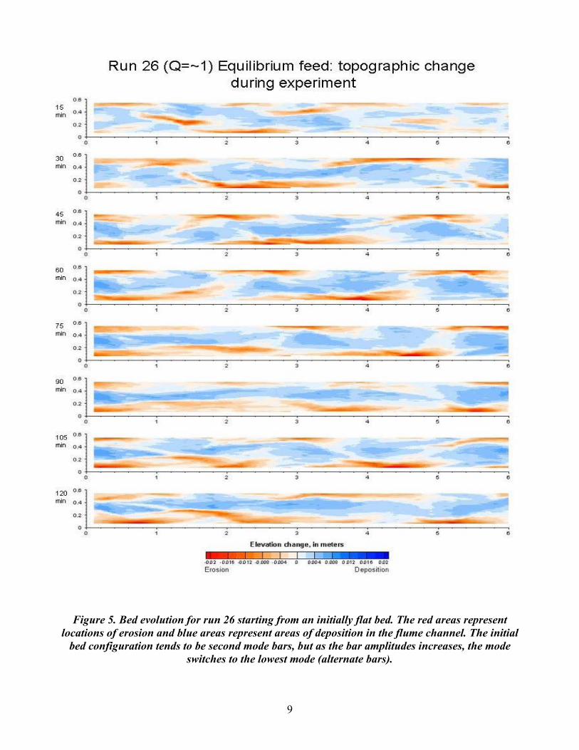
Our laboratory experiment concentrated on bathymetry and morphologic change in simple, straight channels for various flow and sediment supply rates. Table 1 shows geometric, flow, and sediment feed characteristics for the experiments. Figure 5 shows a typical suite of bathymetric measurements over the course of an experimental run. For the conditions of this run, bars form and migrate down the experimental channel. These data are being used to develop and test our algorithms for filling in missing or incorrect data in remotely sensed river data sets.

8
Table 1. Experimental Conditions
Run Q (L/s) Sediment Supply Duration
(min) 1 1 None 60 2 1 None 60 3 1 None 60 4 1 None 60 5 1 None 60 6 1 None 60 7 0.5 None 60 8 0.5 None 60 9 0.5 None 60
10 0.5 None 60 11 1 None 60 12 0.5 None 60 13 0.5 Equilibrium Rate 60 14 0.5 Equilibrium Rate 60 15 1 Equilibrium Rate 60 16 NA NA NA 17 Variable Hydrograph None 60 18 Variable Hydrograph None 60 19 Variable Hydrograph None 75 20 Variable Hydrograph None 75 21 1 Over Supply 133% 75 22 0.38 None 60 23 1 Over Supply 133% 120 24 1 None 120 25 1 Equilibrium Rate 120 26 1 Equilibrium Rate 120 27 1 Over Supply 133% 120 28 1 Over Supply 166% 120 29 NA NA NA 30 1 Over Supply 200% 120 31 Variable Hydrograph Equilibrium Rate 120 32 2 Variable 105 33 Variable Hydrograph Equilibrium Rate 120
9
Figure 5. Bed evolution for run 26 starting from an initially flat bed. The red areas represent
locations of erosion and blue areas represent areas of deposition in the flume channel. The initial bed configuration tends to be second mode bars, but as the bar amplitudes increases, the mode
switches to the lowest mode (alternate bars).
10
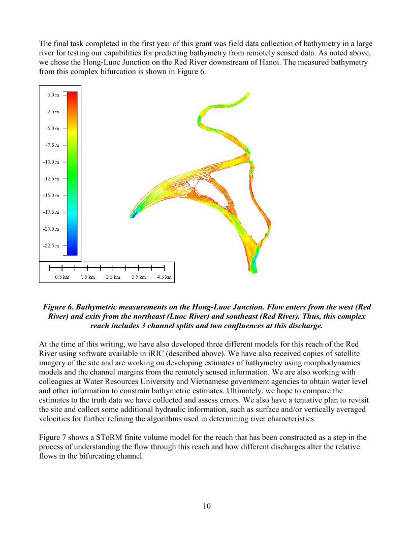
The final task completed in the first year of this grant was field data collection of bathymetry in a large river for testing our capabilities for predicting bathymetry from remotely sensed data. As noted above, we chose the Hong-Luoc Junction on the Red River downstream of Hanoi. The measured bathymetry from this complex bifurcation is shown in Figure 6.
Figure 6. Bathymetric measurements on the Hong-Luoc Junction. Flow enters from the west (Red
River) and exits from the northeast (Luoc River) and southeast (Red River). Thus, this complex reach includes 3 channel splits and two confluences at this discharge.
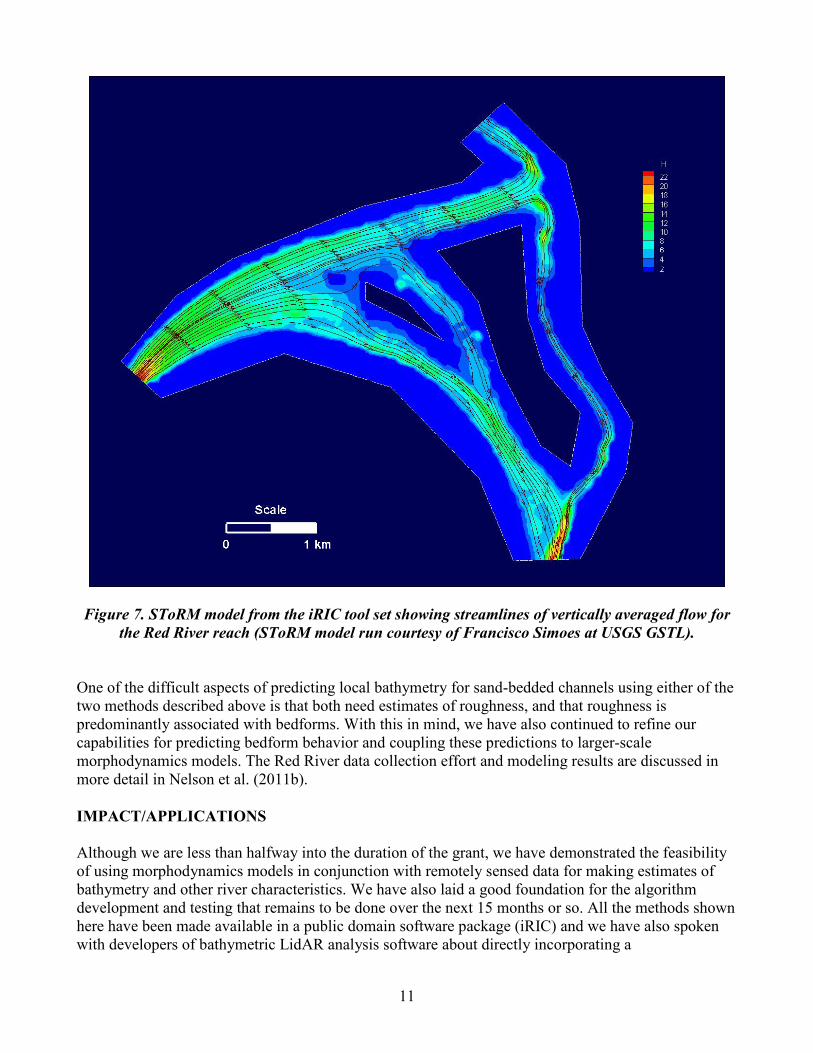
At the time of this writing, we have also developed three different models for this reach of the Red River using software available in iRIC (described above). We have also received copies of satellite imagery of the site and are working on developing estimates of bathymetry using morphodynamics models and the channel margins from the remotely sensed information. We are also working with colleagues at Water Resources University and Vietnamese government agencies to obtain water level and other information to constrain bathymetric estimates. Ultimately, we hope to compare the estimates to the truth data we have collected and assess errors. We also have a tentative plan to revisit the site and collect some additional hydraulic information, such as surface and/or vertically averaged velocities for further refining the algorithms used in determining river characteristics. Figure 7 shows a SToRM finite volume model for the reach that has been constructed as a step in the process of understanding the flow through this reach and how different discharges alter the relative flows in the bifurcating channel.
11
Figure 7. SToRM model from the iRIC tool set showing streamlines of vertically averaged flow for
the Red River reach (SToRM model run courtesy of Francisco Simoes at USGS GSTL). One of the difficult aspects of predicting local bathymetry for sand-bedded channels using either of the two methods described above is that both need estimates of roughness, and that roughness is predominantly associated with bedforms. With this in mind, we have also continued to refine our capabilities for predicting bedform behavior and coupling these predictions to larger-scale morphodynamics models. The Red River data collection effort and modeling results are discussed in more detail in Nelson et al. (2011b). IMPACT/APPLICATIONS Although we are less than halfway into the duration of the grant, we have demonstrated the feasibility of using morphodynamics models in conjunction with remotely sensed data for making estimates of bathymetry and other river characteristics. We have also laid a good foundation for the algorithm development and testing that remains to be done over the next 15 months or so. All the methods shown here have been made available in a public domain software package (iRIC) and we have also spoken with developers of bathymetric LidAR analysis software about directly incorporating a

12
morphodynamics model as a filter to detect and possibly repair areas of incorrect data. We believe this approach can rapidly be incorporated, as it is fairly simple and computationally efficient. RELATED PROJECTS Project personnel coordinated with Arete Associates prior to and during deployment of their RiverEye/AROSS system. Our project along with USGS personnel in Grand Junction provided field support for Arete’s collections in Colorado. The field support included coincident in situ measurements of bathymetry and velocity in the Blue, Colorado, and Yampa Rivers with ADCP and ADV instrumentation. The acoustic measurements of velocity made at these sites will be compared to Arete’s remotely sensed surface currents. Additional ancillary data including streamflow, river stage, gage datums, and bathymetry was provided to support Arete’s collections on the Kootenai, Green, and Columbia Rivers. A comprehensive multibeam bathymetric survey was acquired in June of 2011 on the Yampa River near Deerlodge Park to support a USGS surface-water modeling study. Similar modeling projects on the San Joaquin and Sheboygan River were aided this year by multibeam bathymetric mapping expertise provided by project personnel. These new projects further expand the existing catalog of high resolution hydrographic surveys available for comparison to remotely sensed bathymetry. Our project continues to make our data holdings available to collaborators and students like Lt. Matthew Pawlenko at the Naval Postgraduate School, who made use of our Trinity River data for his thesis. REFERENCES
Kinzel, P.J., Wright, C.W., Nelson, J.M. and Burman, A.R., 2007. Evaluation of an Experimental
LiDAR for Surveying a Shallow, Braided, Sand-Bedded River. Journal of Hydraulic Engineering, 133(7): 838-842.
Legleiter, C.J. and Roberts, D.A., 2005. Effects of channel morphology and sensor spatial resolution on image-derived depth estimates. Remote Sensing of Environment, 95(2): 231-247.
Legleiter, C.J., Roberts, D.A., Marcus, W.A. and Fonstad, M.A., 2004. Passive optical remote sensing of river channel morphology and in-stream habitat: Physical basis and feasibility. Remote Sensing of Environment, 93(4): 493-510.
McDonald, R.R., Bennett, J.P., and Nelson, J.M., 2006, Multi-dimensional surface water modeling system user's guide: U.S. Geological Survey Techniques and Methods, book 6, chap.B2, 156 p.
Nelson, J.M., Bennett, S.J. and Wiele, S.M., 2003. Flow and sediment transport modeling. In: G.M. Kondolf and H. Piegay (Editors), Tools in Fluvial Geomorphology. Wiley, New York, pp. 539-576.
Nelson, J.M., and McDonald, R.R., Mechanics and modeling of lateral separation eddies, 1996, Glen Canyon Environmental Studies Report, available at: www.gcmrc.gov/library/reports/GCES/Physical/hydrology/Nelson1996.pdf
Wright, C.W. and J.C. Brock, 2002. EAARL: A LIDAR for mapping coral reefs and other coastal environments. Seventh International Conference on Remote Sensing for Marine and Coastal Environments, National Oceanic and Atmospheric Administration, Miami, Florida. 8p.

13
ONR-RELATED PUBLICATIONS (* = First 9 months of this grant, 1/2011-9/2011) *Bailly, J.S., Kinzel, P.J., Allois, T., Feurer, D. and Y. Le Coarer, (In press), Airborne LiDAR Methods Applied to Riverine Environments, in Remote Sensing of Rivers: Management and Applications, edited by P. Carbonneau and H. Piegay, [in press, refereed] *Kinzel, P.J., Legleiter, C.J., and Nelson, J.M., (In review), Mapping river bathymetry with a small footprint green LiDAR: Applications and challenges, Remote Sensing and the Environment. 48 p. [in review, refereed] Kinzel, P.J., Nelson, J.M., McDonald, R.R. and Logan, B.L., 2010, Topographic evolution of sandbars: laboratory experiment and computational modeling, in Proceedings of the Joint 9th Federal Interagency Sedimentation Conference and 4th Federal Interagency Hydrologic Modeling Conference, June 27 – July 1, 2010, Las Vegas, Nevada, 8p. . [published, refereed] Kinzel, P.J., 2009, Advanced tools for river science: EAARL and MD_SWMS, American Society for Photogrammetry and Remote Sensing, Proceedings of the 2008 Annual Conference –PNAMP Special Session: Remote Sensing Applications for Aquatic Resources , 8p. [published, refereed] *Legleiter, C.J., P.J. Kinzel, and B.T. Overstreet, 2011, Evaluating the potential for remote bathymetric mapping of a turbid, sand-bedded river 1. Field spectroscopy and radiative transfer modeling, Water Resources Research. v. 47, W09531, doi:10.1029/2011WR010591. *Legleiter, C.J., P.J. Kinzel, and B.T. Overstreet, 2011, Evaluating the potential for remote bathymetric mapping of a turbid, sand-bedded river 2. Application to hyperspectral image data from the Platte River, Water Resources Research, v. 47, W09532, doi:10.1029/2011WR010592. Legleiter, C.J., Roberts, D.A., and Lawrence, R.L., 2009, Spectrally based remote sensing of river bathymetry, Earth Surface Processes and Landforms, v. 34, 1039-1059.[published, refereed] *Legleiter, C.J., Kyriakidis, P.C., McDonald, R.R., and Nelson, J.M., 2011, Effects of uncertain topographic input data on two-dimensional flow modeling in a gravel-bed river: Water Resources Research, v. 47, W03518, doi:10.1029/2010WR009618. *Nelson, J.M., Logan, B.L., Kinzel, P.J., Shimizu, Y., Giri, S., Shreve, R.L., and McLean, S.R., Bedform response to flow variability, Earth Surface Processes and Landforms. [in press, refereed] *Nelson, J.M., McDonald, R.R., Kinzel, P.J., and Legleiter, C.J., 2011a, Using computational models to improve remotely sensed estimates of river bathymetry, Proceedings of the 2011 River, Coastal and Estuarine Morphodynamics Meeting, Beijing, China. [published, refereed]. *Nelson, J.M., Kinzel, P.J.,Thanh, M.D., Toan, D.D., Shimizu, Y. and McDonald, R.R., 2011b, Mechanics of flow and sediment transport in delta distributary channels, p. 8-14, in: Proceedings of The 1st EIT International Conference on Water Resources Engineering, Engineering Institute of Thailand, Bangkok, 337pp. [Keynote paper/speech, published, refereed].

14
Nelson, J.M., Shimizu, Y., Takebayashi, H., and McDonald, R.R., 2010, The international river interface cooperative (iRIC): Public domain software for river modeling, in: Proceedings of the 2nd Joint Federal Interagency Conference, June 27-July 1, 8p. [published] Nelson, J.M., Shimizu, Y., Giri, S., and McDonald, R.R., 2010, Computational modeling of bedform evolution in rivers with implications for predictions of flood stage and bed evolution, in: Proceedings of the 2nd Joint Federal Interagency Conference, June 27-July 1, 8p. [published] Nelson, J.M., Shimizu, Y. and McDonald, R.M., 2010, Integrating bedform dynamics with large-scale computational models for flow and morphodynamics in rivers, in: Proceedings of the 17th Annual Conference of the Asia and Pacific Division of the International Association of Hydraulic Engineering and Research, February 22-24, 2010, Auckland, New Zealand, 8 p., (digital media).[published] Nelson, J.M., Shimizu, Y., McDonald, R.M., and Logan, B., 2009, Integrating computational models for bedform development with reach-scale flow and morphodynamics models for rivers, in Vionnet, C., Garcia, M.H., Latrubesse, E.M., and Perillo, G.M.E., eds, River, Coastal, and Estuarine Morphodynamics: London, CRC Press, p. 625-636.[published, refereed] Shimizu, Y., Giri, S., Yamaguchi, S., and Nelson, J., 2009, Numerical simulation of dune-flat bed transition and stage-discharge relationship with hysteresis effect: Water Resources Research, v. 45, W04429. doi:10.1029/2008WR006830. [published, refereed]

![Targeted Testing for Reliability Validationenikolai/research/Targeted-testing-Web.pdf · Targeted Testing for Reliability Validation ... [16] describes the basic ... physically test](https://img.dokumen.tips/doc/110x75/5b72e2127f8b9a740f8d557f/targeted-testing-for-reliability-enikolairesearchtargeted-testing-webpdf.jpg)


