Embed Size (px)
Citation preview
11
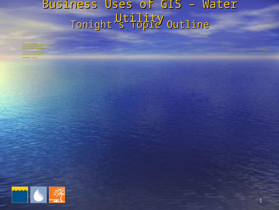
Tonight’s Topic OutlineTonight’s Topic Outline
• Overview of Business Units & Use CasesOverview of Business Units & Use Cases• Sample Schemas and ModelsSample Schemas and Models• Routine Mapping RequirementsRoutine Mapping Requirements
(15 minutes)(15 minutes)
• Problem Solving GIS Analyses Problem Solving GIS Analyses • Applications Using GIS DataApplications Using GIS Data
(30 minutes)(30 minutes)
• Questions / AnswersQuestions / Answers
Business Uses of GIS – Water UtilityBusiness Uses of GIS – Water Utility
22
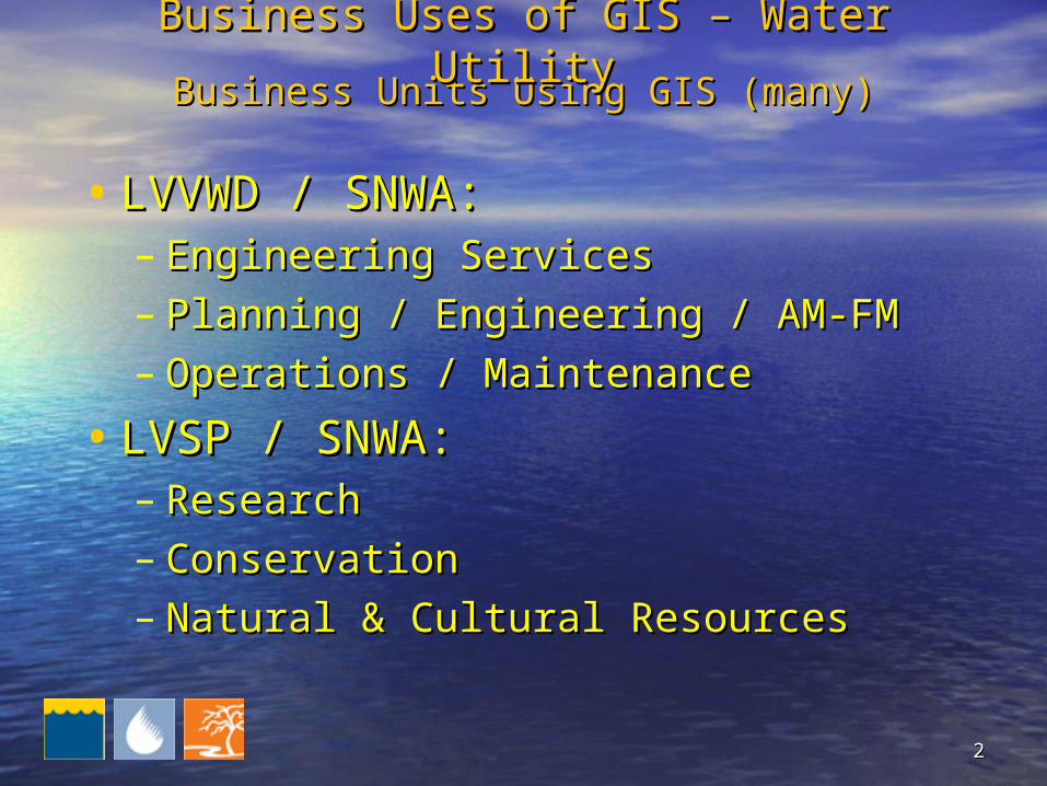
• LVVWD / SNWA: LVVWD / SNWA: – Engineering ServicesEngineering Services– Planning / Engineering / AM-FMPlanning / Engineering / AM-FM– Operations / MaintenanceOperations / Maintenance
• LVSP / SNWA:LVSP / SNWA:– ResearchResearch– Conservation Conservation – Natural & Cultural ResourcesNatural & Cultural Resources
Business Units Using GIS (many)Business Units Using GIS (many)Business Uses of GIS – Water UtilityBusiness Uses of GIS – Water Utility

33
Use Cases for GISUse Cases for GISBusiness Uses of GIS – Water UtilityBusiness Uses of GIS – Water Utility
• Automated Mapping Automated Mapping
• Facilities Management (Maintenance)Facilities Management (Maintenance)
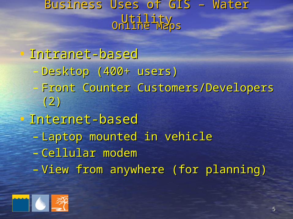
• Online Maps (Desktop, Counter, Online Maps (Desktop, Counter, Vehicle)Vehicle)
• GIS Analyses to Optimize WorkGIS Analyses to Optimize Work
• Integration of GIS and Other Integration of GIS and Other TechnologyTechnology

44
• Facility Locations; Maintenance WorkFacility Locations; Maintenance Work
• Capital and Private DevelopmentCapital and Private Development
• Right of Way, PermittingRight of Way, Permitting
• Customer Serving, Billing, Customer Serving, Billing, ConservationConservation
Automated Mapping / Facilities MgmtAutomated Mapping / Facilities MgmtBusiness Uses of GIS – Water UtilityBusiness Uses of GIS – Water Utility
55
• Intranet-basedIntranet-based– Desktop (400+ users)Desktop (400+ users)– Front Counter Customers/Developers (2)Front Counter Customers/Developers (2)
• Internet-basedInternet-based– Laptop mounted in vehicleLaptop mounted in vehicle– Cellular modemCellular modem– View from anywhere (for planning)View from anywhere (for planning)
Online MapsOnline MapsBusiness Uses of GIS – Water UtilityBusiness Uses of GIS – Water Utility
66
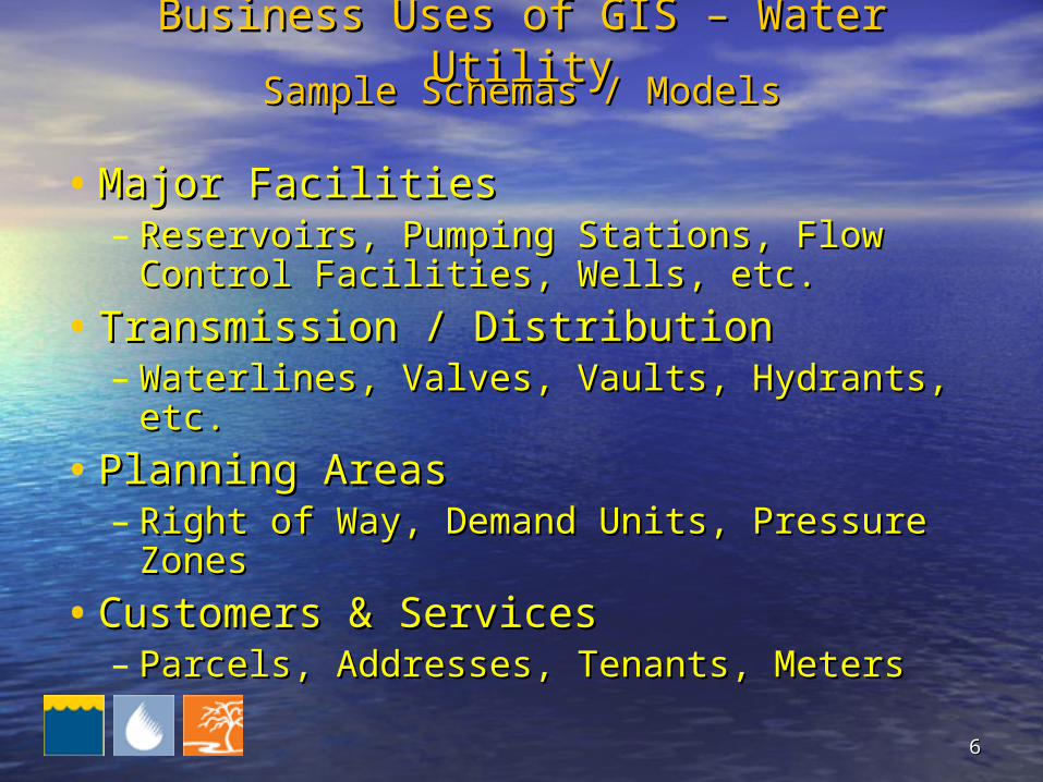
• Major FacilitiesMajor Facilities– Reservoirs, Pumping Stations, Flow Reservoirs, Pumping Stations, Flow
Control Facilities, Wells, etc.Control Facilities, Wells, etc.
• Transmission / DistributionTransmission / Distribution– Waterlines, Valves, Vaults, Hydrants, etc.Waterlines, Valves, Vaults, Hydrants, etc.
• Planning AreasPlanning Areas– Right of Way, Demand Units, Pressure Right of Way, Demand Units, Pressure
ZonesZones
• Customers & ServicesCustomers & Services– Parcels, Addresses, Tenants, MetersParcels, Addresses, Tenants, Meters
Sample Schemas / ModelsSample Schemas / ModelsBusiness Uses of GIS – Water UtilityBusiness Uses of GIS – Water Utility
77
Business Uses of GIS – Water UtilityBusiness Uses of GIS – Water Utility
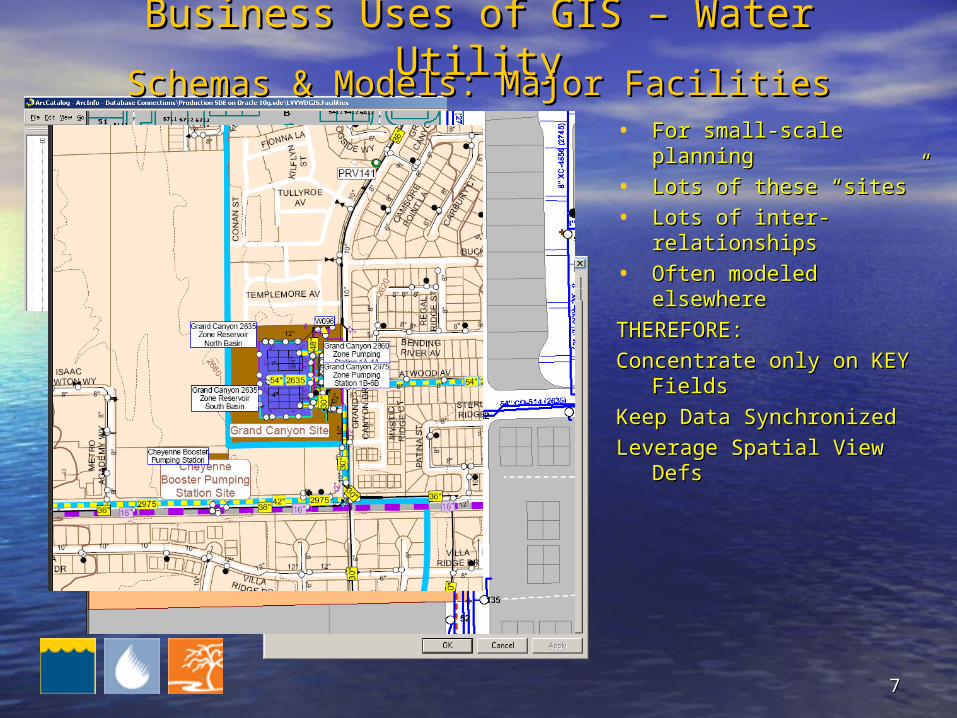
• For small-scale planningFor small-scale planning
• Lots of these “sites”Lots of these “sites”
• Lots of inter-relationshipsLots of inter-relationships
• Often modeled elsewhereOften modeled elsewhere
THEREFORE: THEREFORE:
Concentrate only on KEY Concentrate only on KEY Fields Fields
Keep Data SynchronizedKeep Data Synchronized
Leverage Spatial View DefsLeverage Spatial View Defs
Schemas & Models: Major FacilitiesSchemas & Models: Major Facilities
88
Business Uses of GIS – Water UtilityBusiness Uses of GIS – Water Utility
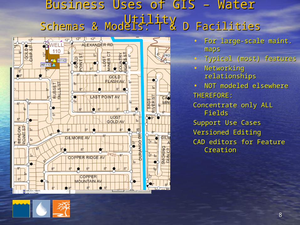
• For large-scale maint. For large-scale maint. mapsmaps
• Typical (most) featuresTypical (most) features
• Networking relationshipsNetworking relationships
• NOT modeled elsewhereNOT modeled elsewhere
THEREFORE: THEREFORE:
Concentrate only ALL Fields Concentrate only ALL Fields
Support Use CasesSupport Use Cases
Versioned EditingVersioned Editing
CAD editors for Feature CAD editors for Feature CreationCreation
Schemas & Models: T & D FacilitiesSchemas & Models: T & D Facilities
99
Business Uses of GIS – Water UtilityBusiness Uses of GIS – Water Utility
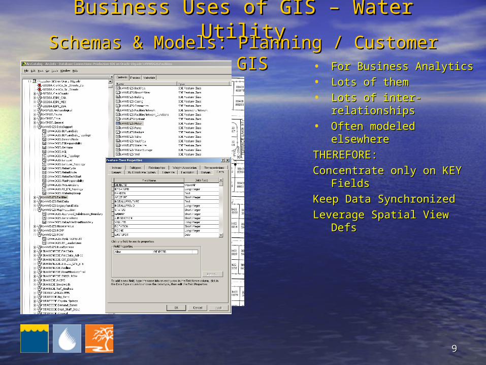
• For Business AnalyticsFor Business Analytics
• Lots of themLots of them
• Lots of inter-relationshipsLots of inter-relationships
• Often modeled elsewhereOften modeled elsewhere
THEREFORE: THEREFORE:
Concentrate only on KEY Concentrate only on KEY Fields Fields
Keep Data SynchronizedKeep Data Synchronized
Leverage Spatial View DefsLeverage Spatial View Defs
Schemas & Models: Planning / Customer GISSchemas & Models: Planning / Customer GIS
1010
Business Uses of GIS – Water UtilityBusiness Uses of GIS – Water Utility
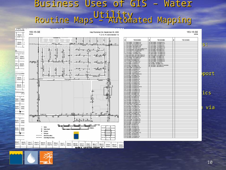
• First Use Cases First Use Cases CompletedCompleted
• Primary Customers:Primary Customers:– MaintenanceMaintenance– EngineeringEngineering
THEREFORE: THEREFORE:
Define model to support Define model to support mapsmaps
Create Create symbology/thematicssymbology/thematics
Save templatesSave templates
Automate production via Automate production via scriptsscripts
Routine Maps – Automated MappingRoutine Maps – Automated Mapping
1111
Business Uses of GIS – Water UtilityBusiness Uses of GIS – Water Utility
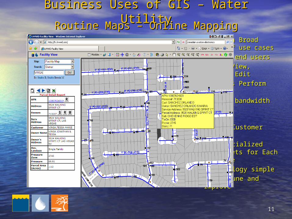
• Covers a Broad Range Covers a Broad Range of use casesof use cases
• Lots of end usersLots of end users
• Query, View, Report, Query, View, Report, EditEdit
• Desktops Perform BestDesktops Perform Best
• Laptops bandwidth Laptops bandwidth limitedlimited
THEREFORE: THEREFORE:
Determine Customer Determine Customer NeedsNeeds
Deploy Specialized Layer Deploy Specialized Layer Sets for Each Use Case Sets for Each Use Case
Keep symbology simpleKeep symbology simple
Iterate, Tune and ImproveIterate, Tune and Improve
Routine Maps – Online MappingRoutine Maps – Online Mapping
1212
Business Uses of GIS – Water UtilityBusiness Uses of GIS – Water Utility
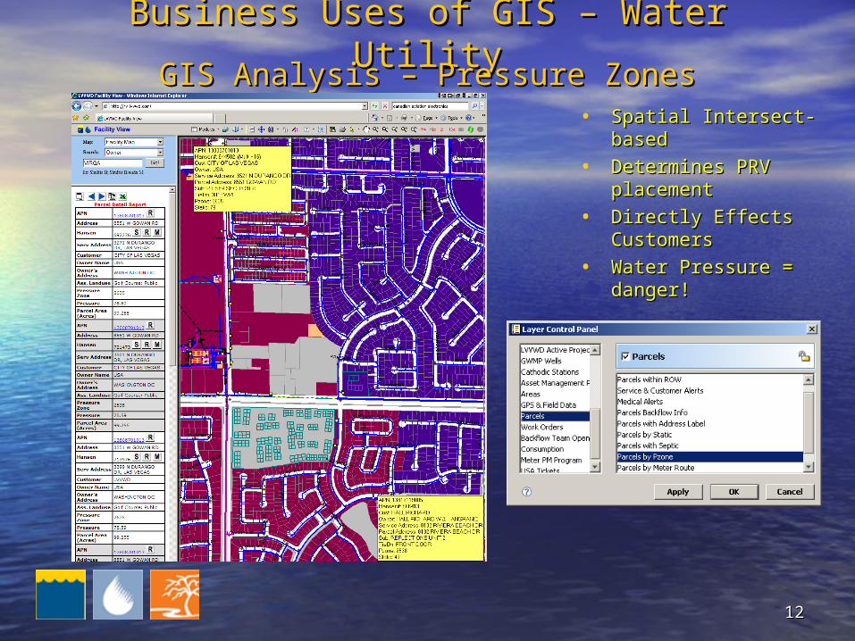
• Spatial Intersect-basedSpatial Intersect-based
• Determines PRV Determines PRV placementplacement
• Directly Effects Directly Effects CustomersCustomers
• Water Pressure = Water Pressure = danger!danger!
GIS Analysis – Pressure ZonesGIS Analysis – Pressure Zones
1313
Business Uses of GIS – Water UtilityBusiness Uses of GIS – Water Utility
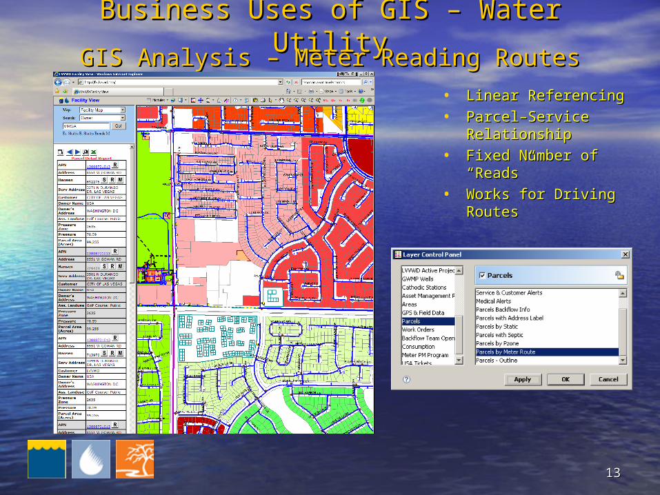
• Linear ReferencingLinear Referencing
• Parcel–Service Parcel–Service RelationshipRelationship
• Fixed Number of Fixed Number of “Reads”“Reads”
• Works for Driving Works for Driving RoutesRoutes
GIS Analysis – Meter Reading RoutesGIS Analysis – Meter Reading Routes
1414
Business Uses of GIS – Water UtilityBusiness Uses of GIS – Water Utility
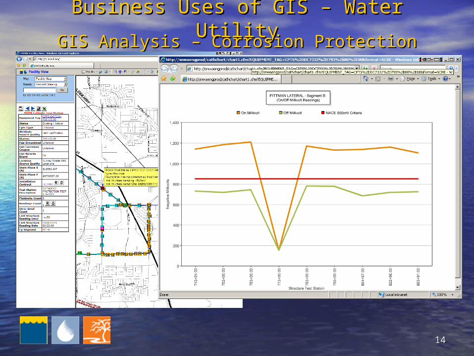
• Pipelines and Protection Pipelines and Protection DevicesDevices
• Relationship is Spatial Relationship is Spatial i.e. connectivityi.e. connectivity
• Results Measured in the Results Measured in the FieldField
• Supported in Online Supported in Online MapsMaps
GIS Analysis – Corrosion ProtectionGIS Analysis – Corrosion Protection
1515
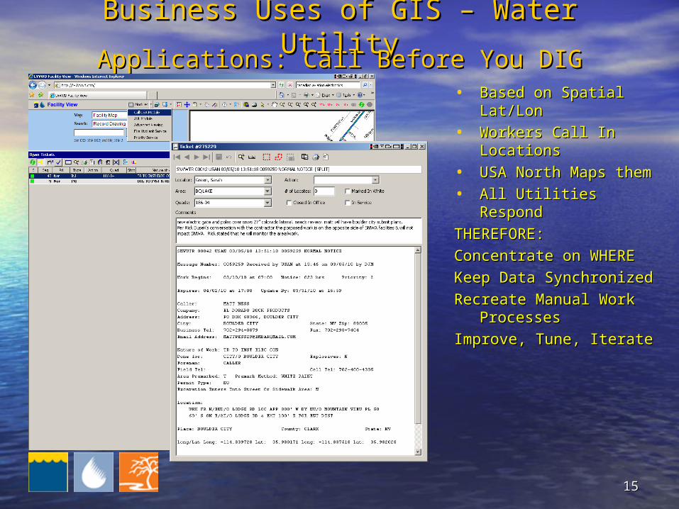
Business Uses of GIS – Water UtilityBusiness Uses of GIS – Water Utility
• Based on Spatial Based on Spatial Lat/LonLat/Lon
• Workers Call In Workers Call In LocationsLocations
• USA North Maps themUSA North Maps them
• All Utilities RespondAll Utilities Respond
THEREFORE: THEREFORE:
Concentrate on WHERE Concentrate on WHERE
Keep Data SynchronizedKeep Data Synchronized
Recreate Manual Work Recreate Manual Work ProcessesProcesses
Improve, Tune, IterateImprove, Tune, Iterate
Applications: Call Before You DIGApplications: Call Before You DIG

1616
• Lots of Variety in End Users & Use Lots of Variety in End Users & Use CasesCases
• Only Support a Use Case if:Only Support a Use Case if:– the users (or bosses) ask for itthe users (or bosses) ask for it– it saves money, time or livesit saves money, time or lives
• Automated Mapping good 1Automated Mapping good 1stst Use Case Use Case
• Support for Field Staff tough Use CaseSupport for Field Staff tough Use Case
• GIS is Useful, based in ScienceGIS is Useful, based in Science
• Makes for a Rewarding CareerMakes for a Rewarding Career
SummarySummaryBusiness Uses of GIS – Water UtilityBusiness Uses of GIS – Water Utility
1717
• Pop QuizPop Quiz– Name TWO Use Cases for HName TWO Use Cases for H22O Utility GIS.O Utility GIS.– Name ONE Physical object modeled in GIS. Name ONE Physical object modeled in GIS.
• Your Turn (Questions for Me?)Your Turn (Questions for Me?)
• My Contact Info:My Contact Info:[email protected]@snwa.com
702-691-5395702-691-5395
Questions / AnswersQuestions / AnswersBusiness Uses of GIS – Water UtilityBusiness Uses of GIS – Water Utility