Embed Size (px)
Citation preview

1
ESTUA
RY S
CIE
NC
E •
RE
ST
OR
AT
ION
• W
AT
ER
SH
ED
• P
OL
ITIC
S •
SP
EC
IES
• B
AY
SFEP Move . . . . . . . . . . . . . . . . . .2Atmospheric Rivers . . . . . . . . . . .3Herring . . . . . . . . . . . . . . . . . . . . .5Rutherford Reach . . . . . . . . . . . . .6RMP Margins . . . . . . . . . . . . . . . .8Richmond Transitions . . . . . . . . .9Sailing Schools . . . . . . . . . . . . . .11Living Shorelines . . . . . . . . . . . .13Environmental Art . . . . . . . . . . .16Buckler . . . . . . . . . . . . . . . . . . . .18South Bay Levee . . . . . . . . . . . . .19
NEWSMARCH 2018
VOL. 27, NO. 1
San Francisco Estuary Partnership
Chasing Rivers in the Sky
Vintners Give Acres Back to Napa River
Sailing for Sport or Life Skills?
North Richmond in Transition
California and Washington Compare Shoreline Softening Techniques
Contaminants Higher in Bay Margins
Three Artists Portray Restoration Themes
Permits and Funds Percolating for South Bay Levee

MARCH 2018ESTUARY NEW
S
2
Staff of the San Francisco Estuary Partnership are hopeful that the or-ganization’s January move across the Bay into the Metropolitan Transpor-tation Commission’s San Francisco offices will promote greater coopera-tion among agencies as they confront pressing regional challenges. The move results from last July’s con-solidation of the staff of MTC and the Association of Bay Area Governments. The latter has long served as the ad-ministrative host for the Partnership. Now they are all under the same roof at the Bay Area Metro Center, which is also home to the Bay Area Air Qual-ity Management District and the Bay Area Regional Collaborative.
“Being physically in the same space as all these other agencies gives us a great opportunity to tackle thorny re-gional issues on a much more holistic level,” says the Partnership’s Direc-tor, Caitlin Sweeney. “At least at the staff level, we now have the building blocks of a fully merged regional plan-ning agency that takes a systematic approach to the transportation, land use planning, and water and habitat management challenges ahead for the Bay Area. I’m excited to see what we can accomplish together.” Increasing extreme climate events, together with the ever-present threat of drought,
mean that future land use decisions, both on metropolitan shorelines and up in the watersheds, will need to incorporate water and flood manage-ment much more than they have in the past. As a seasoned 12-county collaborator on these types of issues, the Partnership is poised to bring its expertise in the water world to the regional table.
MTC’s Andrew Fremier also sees the move as a way to facilitate partnerships between the agencies. “I’m intrigued by the opportunities that are starting to pop out in front of us. Especially when we get into the areas of resiliency and climate change preparation, we have a lot of synergies,” he says.
Although sad to see the San Fran-cisco Estuary Partnership leave their shared offices in Oakland, Tom Mum-ley of the San Francisco Bay Regional Water Quality Control Board says he is also optimistic about the change. “I look at it as a chance to build a stron-ger regional platform for integrating all our efforts.”
As the Bay Area confronts rising sea levels, shrinking public budgets, and increasing social inequities, there is widespread hunger for such integration, both at the policy level and geographically. “In the climate adaptation world, where good prac-
tices and best practices are still being formed, a collaboration that brings local government folks together with regulatory and planning agencies can be very powerful,” says the San Francisco Public Utilities Commis-sion’s David Behar. “We need to learn from one another, improve practices for planning under uncertainty, and coordinate projects, especially around shoreline resilience.”
Local governments are trying to do something similar, but across brick and mortar boundaries, says Kif Scheuer of the Local Govern-ment Commission and the Alliance of Regional Collaboratives for Climate Adaptation. The endeavor – now in “the very nascent stages” of explora-tion – could offer local government staff working on adaptation a new forum for peer network support and collaboration. The forum would work in parallel with many of the other ac-tivities going on, he says, citing BARC, Measure AA, and Resilient by Design as examples. “Ideally the forum could help streamline engagement of local government staff in that work,” says Scheuer.
The next update to Plan Bay Area, due in 2021, will provide an opening to put integrated governance front and center. “The update is a good place to strengthen our regional com-mitment to climate change resiliency and to recognize how protecting and expanding our natural habitats can help us meet a variety of objectives,” says Sweeney.
In the meantime, the collaborative potential of having many agencies under one roof is very promising, says Brad McCrea of the San Francisco Bay Conservation and Development Commission, which is also trying to move into Metro Center. BCDC’s regu-latory and planning staff often play central roles in working through the permitting and policy considerations of various projects in the Bay Area planning pipeline. “Being with our regional partners at Metro Center is exactly the right idea,” says McCrea. “If BCDC can get there too, that would be terrific.” CHTCONTACT [email protected]; [email protected]
R E G I O N
Moving West for the Greater Good?
SFEP staff Adrien Baudrimont, Natasha Dunn, and James Muller hold a rooftop meeting in their new San Francisco offices at the Bay Area Metro Center. Photo: SFEP
3
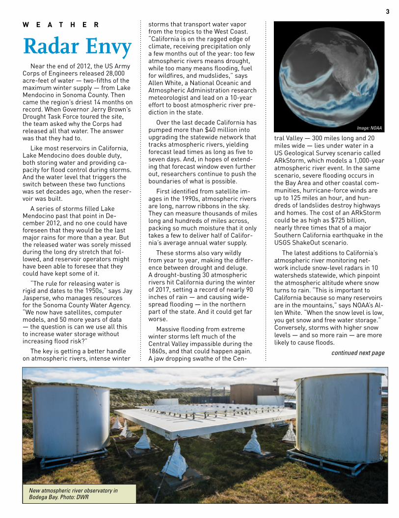
Near the end of 2012, the US Army Corps of Engineers released 28,000 acre-feet of water — two-fifths of the maximum winter supply — from Lake Mendocino in Sonoma County. Then came the region’s driest 14 months on record. When Governor Jerry Brown’s Drought Task Force toured the site, the team asked why the Corps had released all that water. The answer was that they had to.
Like most reservoirs in California, Lake Mendocino does double duty, both storing water and providing ca-pacity for flood control during storms. And the water level that triggers the switch between these two functions was set decades ago, when the reser-voir was built.
A series of storms filled Lake Mendocino past that point in De-cember 2012, and no one could have foreseen that they would be the last major rains for more than a year. But the released water was sorely missed during the long dry stretch that fol-lowed, and reservoir operators might have been able to foresee that they could have kept some of it.
“The rule for releasing water is rigid and dates to the 1950s,” says Jay Jasperse, who manages resources for the Sonoma County Water Agency. “We now have satellites, computer models, and 50 more years of data — the question is can we use all this to increase water storage without increasing flood risk?”
The key is getting a better handle on atmospheric rivers, intense winter
storms that transport water vapor from the tropics to the West Coast. “California is on the ragged edge of climate, receiving precipitation only a few months out of the year: too few atmospheric rivers means drought, while too many means flooding, fuel for wildfires, and mudslides,” says Allen White, a National Oceanic and Atmospheric Administration research meteorologist and lead on a 10-year effort to boost atmospheric river pre-diction in the state.
Over the last decade California has pumped more than $40 million into upgrading the statewide network that tracks atmospheric rivers, yielding forecast lead times as long as five to seven days. And, in hopes of extend-ing that forecast window even further out, researchers continue to push the boundaries of what is possible.
First identified from satellite im-ages in the 1990s, atmospheric rivers are long, narrow ribbons in the sky. They can measure thousands of miles long and hundreds of miles across, packing so much moisture that it only takes a few to deliver half of Califor-nia’s average annual water supply.
These storms also vary wildly from year to year, making the differ-ence between drought and deluge. A drought-busting 30 atmospheric rivers hit California during the winter of 2017, setting a record of nearly 90 inches of rain — and causing wide-spread flooding — in the northern part of the state. And it could get far worse.
Massive flooding from extreme winter storms left much of the Central Valley impassible during the 1860s, and that could happen again. A jaw dropping swathe of the Cen-
tral Valley — 300 miles long and 20 miles wide — lies under water in a US Geological Survey scenario called ARkStorm, which models a 1,000-year atmospheric river event. In the same scenario, severe flooding occurs in the Bay Area and other coastal com-munities, hurricane-force winds are up to 125 miles an hour, and hun-dreds of landslides destroy highways and homes. The cost of an ARkStorm could be as high as $725 billion, nearly three times that of a major Southern California earthquake in the USGS ShakeOut scenario.
The latest additions to California’s atmospheric river monitoring net-work include snow-level radars in 10 watersheds statewide, which pinpoint the atmospheric altitude where snow turns to rain. “This is important to California because so many reservoirs are in the mountains,” says NOAA’s Al-len White. “When the snow level is low, you get snow and free water storage.” Conversely, storms with higher snow levels — and so more rain — are more likely to cause floods.
continued next page
W E A T H E R
Radar Envy
6378
New atmospheric river observatory in Bodega Bay. Photo: DWR
Image: NOAA

MARCH 2018ESTUARY NEW
S
4
Also new is a set of four of atmo-spheric river observatories along the coast, including one in Bodega Bay. These observatories monitor storms as they strike land, measuring fac-tors such as windspeed, temperature and water vapor that help predict precipitation in the mountains and elsewhere. Rounding out the recent upgrades are 43 soil moisture sen-sors across the state, which help pre-dict runoff from storms. The wetter the ground, the less capacity it has to absorb more water, and the greater the risk of flooding.
All this adds up to more accurate forecasts of exactly when and where atmospheric rivers will hit, and how intense their impact will be. And that
gives hope for keeping more water in reservoirs — like Lake Mendocino — than current US Army Corps of Engineers rules allow. Last summer, a modeling study found that Lake Mendocino could hold up to 36 percent more water while also decreasing the flood risk. “Now we’re working with the Corps to test it,” says Sonoma’s Jasperse. The ultimate goal is to formally update the rules that dictate water releases from the reservoir.
Of course, there’s still room for improvement, and the San Francisco Bay Area has moved forward on its own. Current National Weather Ser-vice radars were designed for Mid-west thunderstorms and tend to miss rain that falls in the hilly terrain of the California coast. So the Bay Area is installing a $20 million radar system customized to the region.
US Geological Survey research hydrologist Michael Dettinger hopes this sparks other communities to do the same. “Maybe Los Angeles will develop some radar-envy and buy some, and then maybe Sacramento or elsewhere will follow suit, and eventually large parts of the state get upgraded,” he says.
And then there’s what Dettinger calls the “really wild-eyed stuff,” like offshore reconnaissance flights to atmospheric rivers before they reach land. “This would be our West Coast equivalent of the Hurricane Hunters, who are now absolutely just the cost of doing business on the East Coast these days,” he says. NOAA’s Hur-ricane Hunters fly towards tropical cyclones near the southeast US to, for example, find the center of the storm and measure the pressure and wind around the eye.
Such reconnaissance flights could help fill another huge blank spot in today’s atmospheric river monitoring: the Pacific Ocean. “We don’t know exactly how they start and how they evolve,” says Scripps Institution of Oceanography environmental engi-neer Anna Wilson. “The landfall loca-tion a couple of days out can be off by a watershed.”
In a pilot program over the last few winters, researchers have flown out to meet incoming atmospheric rivers, soaring high above them at up to 45,000 feet and dropping as many as 40 sensors through them per flight. Called dropsondes, the sensors are outfitted with little parachutes that slow their travel time to the ocean to about 15 minutes. All the way from release to splashdown, the drop-sondes measure temperature, mois-ture and windspeed, reporting these data back to the aircraft four times per second.
Wilson went on her first recon-naissance flight this February, hardly noticing the nearly eight hours and 3,350 nautical miles it took. “It went by really fast because there was so much to see,” she recalls. “We were over everything — it was awesome!” RMCONTACT [email protected]; [email protected]; [email protected]; [email protected]
The US Air Force helps parachute these NOAA dropsondes into advancing weather systems to measure conditions. Photo: Staff Sergeant Randy Redman, US Air Force
Floating Sentinels Two banana-yellow buoys anchored
along the Tiburon shore will be San Francisco Bay’s sentinels against shifts in water chemistry due to climate change. Known as the Bay Ocean Buoy (BOB) and the Marine Acidification Research Inquiry (MARI), the permanent moorings will provide long-term monitoring of acidity and carbon dioxide levels—key indicators of how the changing ocean will impact Bay chemistry.
In previous years, scientists have fo-cused on how runoff from rivers, streets, and other terrestrial sources have af-fected Bay waters. But climate change is making ocean water a potential liability to Bay conditions. As the warming atmo-sphere forces ever more carbon dioxide into the oceans, oceans are growing more acidic. The lower pH makes it tougher for shellfish, sea stars, and other marine organisms to make and maintain shells, skeletons, and exoskeletons.
The buoys take measurements both at the surface and at a depth where currents carry ocean waters into the bay. A suite of sensors measures carbon dioxide in the air and in the water, dissolved oxygen, pH, chlorophyll-a (indicative of phytoplankton concentrations), water clarity, tempera-ture, and salinity.
Ocean influences on estuarine chem-istry have long been on the San Francisco Estuary Partnership’s radar. “The Ocean Connection” section in the Partnership’s 2015 State of the Estuary Report reviews ecological changes offshore, such as the warm water blob and disappearance of krill and rockfish in seabird diets in the winter of 2014-2015, as well the intrusion of cold salty oxygen-deficient water from the ocean into the South Bay in 2011. “In a changing world, both land and sea influences may be driving the Bay toward a more acidic and less oxygenated state,” says UC Davis oceanographer John Largier.
Over the long term, the data will help scientists evaluate how ocean waters are affecting the Bay’s long-term health. Snapshot readings will help researchers gauge how local water quality projects and restoration efforts are affecting Bay chemistry. The information will be made available via the Central and Northern California Ocean Observing System (CeN-COOS). The system and NOAA, together with the U.S. Environmental Protection Agency and the San Francisco Estuary Partnership, funded the new buoys. KW
CLIMATECHANGE

5
“Follow the birds,” says Ryan Bartling, gesturing to a gathering of aquatic fowl squawking amongst Sau-salito’s anchorage. “If you want to find a herring spawn, they’ll do it for you.” Bartling, project lead of the California Fish and Wildlife Department’s her-ring fishery management program, carefully guides his workskiff towards the latest spawn. It’s a mild Thursday morning in late February and while the fishing season has nearly con-cluded, the herring continue their yearly cycle.
Bartling steps over to the edge of his craft and tosses “the rake” into the water. He pulls the heavy, multi-pronged instrument along the muddy bay floor, then hauls it back in. Twisted up amongst the metal teeth are lengths of eelgrass lightly dot-ted with translucent beads about the size of a pinhead. “The eggs are just beginning to stick,” he says. It’s a light enough coating that an untrained eye could easily miss it, but these eggs, or roe, are the legacy of one of the oldest urban fisheries in California.
Later, in Belvedere Cove, Bartling meets up with Harry Vogl, a long-time herring fisherman. Vogl passes a cooler from his craft to Bartling’s. Within the cooler are several ziploc bags full of eelgrass samples — simi-lar to the ones Bartling pulled from the Sausalito anchorage, but much thicker with roe — these ones from
a spawn north of the Richmond-San Rafael bridge. “I started diving for this stuff five years before they even started fishing for herring,” says Vogl of the samples he collected.
Vogl is referring to roe-on-kelp, as it is known by the fishery. It was considered a delicacy and, along with the eggs harvested from spawning females, drove the rise of the herring fishery into the latter 20th century. The price per ton for herring roe peaked at between three and four thousand dollars, and over one hundred boats took to the bay each winter in those days.
The fishery has since found darker waters. The Coco Busan oil spill in 2007, while not directly responsible for a decline in herring biomass, exacer-bated an already delicate situation. The fishery closed for the 2009-10 season to allow the popu-lation to recover, and the San Francis-co Bay Herring Research Association was established and works closely with state Fish and Wildlife to monitor the herring population. Demand for herring roe abroad, meanwhile, has dropped sharply. The fleet of herring boats has all but disappeared, leaving less than 10 boats on the water this last season.
Following the closure, the fishery bounced back almost immediately, peak-ing at nearly 80 thousand tons of estimated biomass in the 2012-13 season. Since then, low productiv-ity in the northeast Pa-cific Ocean has brought populations back down to below average levels, but Bartling remains optimis-tic: “We saw a significant increase over a number of years,” he says, and the recent drop “isn’t unex-pected given recent condi-tions.”
Looking forward into an uncertain future, Bartling and state Fish and Wild-life are in the process of
drafting a new management plan for herring. The plan involves collabo-ration with the fishing industry and conservation groups and aims to bring ecosystem-wide considerations into management and continue to support the commercial fishery. “It’s a chal-lenge,” Bartling says regarding the pace at which new climate change data is published. “Sometimes stake-holder driven processes don’t move at the speed you want them to.” The plan should be finalized late this year.
When I introduced myself to Harry Vogl out in Belvedere Cove that Feb-ruary morning, he smiled and said “you’re looking for someone who knows something about herring? I wonder where you’ll find someone like that.” It was tongue-in-cheek, but his deadpan tone implied that, even after decades of experience with her-ring, these tiny fish remain magnetic and mysterious.
The fishery may no longer be an economic powerhouse, but herring still return to the Bay and spawn, and locals can still see their eggs plas-tered on many shores, seawalls and eelgrass blades. Bartling is optimistic that the data for the 2017-18 run will show a similar, if not larger, biomass than last year’s. Humans have moved on to new delicacies, but, judging from the cacophony that was the wild-life feasting at the Sausalito anchor-age, the spawning cycle remains a vital part of the Estuary ecosystem. I guess there’s no accounting for taste. MHACONTACT [email protected]
F I S H E R I E S
Hopeful Outlook for Pacific Herring
Harry Vogl (right) hands over herring roe samples to CDFW’s Ryan Bartling. Photos: Michael Adamson.

MARCH 2018ESTUARY NEW
S
6
From the riverbank on his prop-erty, Michael Honig of Honig Winery & Vineyard can see beavers swimming, turtles sunning themselves on fallen trees, and even salmon making their way up the Napa River to spawn. “We really enjoy it in springtime,” he says. “Sometimes we’ll even get some rub-ber tires and float down the river.” But it wasn’t always this way. Until recently, Honig’s stretch of the river — called the Rutherford Reach — was choked with silt and invasive plants. Then, in 2002, as the river reached a mo-ment of crisis, Honig and his neighbors did something re-markable: rather than call the authorities to complain, they banded together to restore it.
While the Rutherford project was neither the first of its kind in California nor the biggest, it is noteworthy in that it was a brainchild of the landowners themselves. They voluntarily gave up land on which many of them grow grapes and set up a self-as-sessed tax that will maintain the new reach for the fore-seeable future. Vintners who participated in the project say they felt they owed it to the river — and that their cooper-ative, flexible approach to res-toration on private land could be an example to others.
Before the restoration, the river was a constant threat, one that might spill over and destroy its neighbor-ing agricultural land any given winter. Levees were a necessity —“It became kind of a competition, I build my levee up to five feet, the person across from me has to build theirs five-and-a-half feet,” Honig says — and so the river began to channelize, running deeper and faster; sloughing off its banks and filling with sediment.
In fact, in 2002 the San Francisco Bay Regional Water Quality Control Board was prepared to list the river as “impaired” by fine sediment, imple-
menting a “total maximum daily load” of that sediment and requiring area landowners to comply with new river use limits to help nurse their sick waterway. Anticipating those limits and thinking ahead, Rutherford Reach landowners John Williams and Davie Piña started talking to their neighbors
about possible solutions. The result: years of neighborhood meetings and partnership with Napa County bore fruit in the form of the $20 million res-toration project reconnecting the river to its floodplain at strategic locations and featuring reintroduced native plants, salmon spawning habitat, and contoured banks specially designed to redistribute and slow down the river when the water is high.
But that fruit came at the cost of another. Honig’s winery gave up an acre-and-a-half of land to the res-toration. That might not sound like much, “but it’s our most valuable land
that makes the most expensive wine we produce,” he says. His neigh-bor, Bruce Cakebread of Cakebread Cellars, also gave up an acre to the project; he calculates that means sacrificing 90 tons of grapes — or some 54,000 bottles of wine — over the course of the vineyard’s lifetime. Most landowners in the group gave up similar acreage. (Photos left show Honig, top, and Cakebread, bottom)
What makes vintners in a competi-tive market voluntarily give up that kind of income is a complex mix of principles, pragmatic thinking, and long-term consideration, Honig and Cakebread say. Both were keenly aware that the river-as-it-used-to-be
presented challenges and risks. There was the water quality listing, which meant they would have to change agricultural practices on their land, regardless. And the river by Cakebread’s house was so channelized that erosion was bound to become a problem, he says. He calls the decision to give up land for the resto-ration project a “no brainer”: addressing the issue as a group was both the best thing for the river and the most cost effective option.
Honig was also motivated by fear of flooding. “It’s a generational business; we hope to have the land for another 100 years,” he says. “So many businesses focus on this quarter, this year. When you’re a winery, you’re focused on a much longer time.” With that mindset, even a once-a-decade-flood is too often.
Both men emphasize that part of their decision-making was a matter of principle, a
sense that the river gave them what they have — including the rich soil that they use to grow grapes — and now was the time to give back. “We’re just caretakers of the land,” Cake-bread says, pointing out that Napa’s hillside ordinance makes sure that “not every piece of ground has to have a grapevine in it. This is just adjusting the balance.”
The restoration wasn’t just about one-sided sacrifice. Two liaisons helped facilitate communication between the County and landowners, smoothing the regulatory process, says Jeremy Sarrow, a watershed ecologist
R E S T O R A T I O N
Locals Trade Vines for Resilient River
Large wood habitat structure and restored floodplain on Cakebread riverfront designed by ESA. Photo: Jorgen Blomberg

7
for Napa County. They helped identify needs on both sides that might serve as negotiating points. For example, participating landowners struggling with Pierce’s disease, a bacteria that affects grapevine growth, received assistance in managing the blight as an added benefit of signing on to the restoration project.
Listening for and anticipating these sorts of individual needs was the key to getting all the landowners on board, Honig says. He remembers one ambiv-alent landowner, among the last to sign onto the project, who was concerned about losing one specific lawn near the river—and so designers tweaked the restoration plans around it. Honig was similarly concerned about an old oak tree on the property he was ceding. “Over the last 50 years, my brothers all buried our animals there; we had a rope swing over the river,” he says. “I said: ‘I will give up this land, but I want that tree protected.’”
Once the landowners’ concerns had been resolved, Sarrow worked with them to create a new Maintenance Assessment District for the reach. Sarrow finds this particularly extraor-dinary: not only did Honig, Cakebread, and their colleagues give up signifi-cant income for the river, but for the next twenty years they will voluntarily pay a small amount toward clean-ing up invasive species and repairing stream bank erosion — a collective choice that renders the restoration sustainable in the long-term.
Sarrow sees the flexibility and good-will on both sides of the Rutherford
Reach restoration as major factors in the project’s success, in addition to the particulars of Napa and its river. He points to the pending water quality list-ing as a surprisingly helpful element. Knowing they’d have to make changes anyway helped some hesitant land-owners take the proverbial plunge, and the listing made the project a higher priority for grant funding in a way it wouldn’t have been otherwise.
Both the project and the river’s scale — a few dozen parcels and a County with fewer than 150,000 inhabitants — also helped, Sarrow says. The new “Rutherford Reach” restoration model “lends itself to more small-to-medium sized watersheds, where you don’t have a billion different stakeholders,” he says. Indeed, the project has gotten significant atten-tion as a potential template for other river restorations, and it’s already being replicated down the river; nine miles of the Oakville to Oak Knoll Reach have been under con-struction for the past two years.
As for Honig, he’s happily reaping the benefits of his choice to give up his property. During last year’s heavy rains, the river was noticeably slower and pooled in the amphitheaters designed for that purpose, settling in the newly constructed floodplains and then draining back down.
“It worked exactly like it was sup-posed to,” he says. ALG
CONTACT [email protected]
Restored floodplain, willow baffles, and preserved riparian structure on Honig riverfront designed by ESA. Photo: Jorgen Blomberg
Restored floodplain, high flow alcove and native revegetation on Laird Family Estate designed by ESA. Photo: Jorgen Blomberg

MARCH 2018ESTUARY NEW
S
8
Bay margins are often mucky, fer-tile, out-of-the-way places. Too shal-low to visit by most boats at high tide and too muddy to walk in at low tide, they are largely left to the shorebirds and shellfish.
But in the last decade, the edges of San Francisco Bay have caught the attention of San Francisco Estuary Institute (SFEI) scientists as unex-pected sources of pollution — and, potentially, of solutions.
“The idea that you could make a big difference by just cleaning up the margins is a radical one, and it’s quite attractive because it scales the problem down quite a bit,” says Phil Trowbridge, program manager of the Regional Monitoring Program (RMP), which has been monitoring water quality in the Bay since 1993.
Historically, scientists considered the Bay akin to a massive bathtub: water pours in, mixes up, and bathes all its contents equally. But gradually data were collected that hinted at a more complex picture. A major turn-ing point was a 2010 study that made the surprising discovery that small fish living in the margins had higher concentrations of PCBs than larger, open water fish — even though the latter were higher up the food chain and hence expected to bioaccumulate more of these compounds from their diet. The difference? The big fish lived in deeper waters, farther from where water is dumped into the Bay’s edge by creeks and storm drains.
“The contaminants come in from the watershed and they settle out right there where they entered,” says Trow-bridge. “These studies changed how we think about how the Bay behaves.”
The RMP’s PCB Strategy was updated in 2014 to reflect this new understanding, calling for a multi-
year effort based on the new con-ceptual model. Researchers shifted to a smaller vessel, a two-person Boston whaler, to gather samples. The samples confirmed that the 15% of the Bay defined as margin areas do accumulate pollutants at a higher rate. Baseline PCB levels for the mar-gins of the Central Bay are an average of 3 to 5 times higher than the deeper open waters farther out.
“Margins are very important biolog-ically: they are productive areas where a lot of aquatic organisms live and where a lot of people fish,” says Jay Davis, the lead scientist for the RMP.
The fact that the margin habitats contribute a disproportionate amount of the PCB contamination within the Bay also means that they could be a key to reducing future loads. This could happen if PCB loads in the margins are high because of continued input from the watershed — and not as a result of legacy pollution that is stored in the mudflats. An SFEI model indicated that reducing inputs from the watershed surrounding the Emeryville Crescent could result in reduced PCB concentrations in sediment and in the food web within a decade.
“It would be really nice to have a major cleanup action somewhere that will reduce the inputs, and then we can do the experiment and see if we can actually detect a change,” says Davis.
At present, SFEI is well on its way to having conceptual models and baseline monitoring in place for several key margin areas, so they can track changes over time — and hope-fully correlate any improvements to upstream remediation.
However even if watershed cleanup does prove to alleviate PCB loads in the Bay, plenty of challenges remain. PCBs — inflammable manmade compounds
— were so widely used that despite being banned in 1979 they still exist in buildings, transformers and other electrical equipment, landfills, and also persist in the environment. Both loca-tion and cleanup of PCB hotspots within watersheds can be a challenge.
But at least scientists are now looking for the results of their ef-forts in the right place. “A couple of decades ago we were only looking at the open bay, but that is the last place that is going to respond,” Davis says. “You could be doing a lot of good work and not really seeing any improve-ment. If the Bay is actually improving we want to be able to give that posi-tive feedback to the managers and the people of the Bay Area.” JCCONTACT [email protected]; [email protected]
M O N I T O R I N G
Scrutinizing the Margins75th PercentileConcentration
MedianConcentration
80
70
60
50
40
30
20
10
0Open Bay Margins
Sum
of PC
Bs (p
pb dw
)
Small boat monitoring in the margins. Photo: Don Yee
Distribution of PCB concentrations in the open bay and the margin areas of the Central Bay, not including Marin county. Units: sum of 40 PCBs (ppb dry weight).

9
Today’s North Richmond shoreline looks much different from its historic blend of baylands, mudflats, and wet meadows. A lot of the land has been filled, or else fragmented by transit and industry. The region’s three creeks — the Rheem, the San Pablo, and the Wildcat — are mostly behind levees for flood control (the San Pablo and Wildcat Creek levees were raised in late 2017). The shoreline, and the 500 meters inland where the optimal marsh-upland transition zone could exist, is bounded on one end by Chevron’s Richmond Refinery and on the other end by an Ama-zon distribution center.
Existing inside these narrow confines are a landfill, a wastewater treatment plant, Point Pinole Regional Shore-line, a shooting range, a flea market, and stor-age yards. There are also neighborhoods, such as North Richmond, Shields-Reid, and Parchester Village.
Over the past year, a project led by the San Francisco Estuary Partner-ship collaborated with the San Francisco Estuary In-stitute and The Watershed Project, a Richmond-based organization, to get input from community members and local residents on a North Richmond Shoreline Vision. “We have seen a lot of shoreline projects proceed without thinking about the people who live there, so we were trying to not do that in this process,” says Heidi Nutters, an en-vironmental planner with the Partner-ship and one of the leads on the vision project along with Joshua Bradt.
In North Richmond there are few ball fields and no large grocery stores, but there are brownfields and junk-
yards. The 2010 Census data shows that the shoreline study area is made up mostly of people identifying as African-American, Latino, or Pacific Is-lander. According to statewide data, the North Richmond area has a higher than average poverty rate, and is exposed to a disproportionate amount of chemical toxins and emissions.
So, put simply, the worrying about forage and cover for the salt marsh harvest mouse or thinking about flood-ing that may happen a couple of de-cades from now ranks lower than more immediate needs for this community.
And that’s exactly the challenge that the North Richmond Shoreline Vision wanted to start to address. “How can we draw attention to tran-sition zones while also addressing critical equity concerns in com-munities?” asks Nutters. “How can we marry resource protection with environmental justice?”
Making this leap is important to the Estuary Partnership and other entities who sometimes get lost in the technical details of the planning or restoration process. Many of these agen-cies and organizations are awakening to the fact that sustainable and resilient design of landscapes and natural systems needs to be in-clusive of people, and in particular to voices that are traditionally left out of the planning process.
As Jeremy Lowe, a geomorphologist with the Estuary Institute who was involved in study-ing the North Richmond Shoreline’s transition zones puts it, “Often in the Bay Area, we spend a lot of time thinking about what we can do bayward of the levee. As soon as you start looking on the landward side of the levee, which we’ve built up, you have to start talking to people. And it’s time we started thinking about those areas more and more.”
But gaining meaning-ful insights about what people actually want, and
then figuring out how compatible those ideas are with what scientists and planners say should happen, is not an easy task. That’s where the Watershed Project comes in.
C O M M U N I T Y
Human-Centered Conservation for North Richmond
continued on next page
Map: SFEI/SFEP

MARCH 2018ESTUARY NEW
S
10
Juliana Gonzalez, the executive direc-tor of the community education organi-zation, outlines The Watershed Project’s two-step approach. First they talked to all of the known stakeholders to capture their ideas about the shoreline (stake-holders like the East Bay Regional Park Service or Contra Costa County already have long-term plans). To get the in-formation so far left out of these plans, Watershed Project staff developed what Gonzalez calls a “recreational survey,” meaning it wasn’t designed to explain the various issues facing the shoreline’s transition zones, or threat of sea level rise. Instead the survey was intended to
figure out what residents wanted. “We went to where people were gathering, like PTA meetings, or neighborhood councils, or church groups,” Gonzalez says. “We reached 300 residents and asked them for their opinion.”
What the survey revealed is that the residents of the North Rich-mond’s neighborhoods feel re-moved from the shoreline. Despite their proximity, access by way of good pedestrian or bike trails is lacking. Crossing rail tracks, or
the parkway (which includes an under-pass often filled with mud or stagnant water) is enough of a barrier to prevent frequent visits. Residents also want to have more reason to visit the shoreline, like to check out an environmental education or natural history interpreta-tion center.
In some instances, these kinds of opportunities and projects align nicely with stakeholder visions of the shore-line. East Bay Parks, for instance, just opened the restored Dotson Family Marsh, with another 1.5 miles of bike trail and future Bay Trail. The new trail
effectively connects Parchester Vil-lage with the 2,500 acre Point Pinole Regional Shoreline. Other projects, still in the planning phase, also overlap with what the community wants. Gonzalez points to the West County Wastewater Treatment Plant’s proposal for a hori-zontal levee as an example. Horizontal, versus conventional vertical and rip rapped levees, have broader shoulders and can provide space for native plants, habitats and other amenities. “It’s not so much that people want a horizontal levee,” she says, “as much as it is the recreational opportunities and access that it will bring.”
One of the outcomes of the North Richmond Shoreline Vision project is that several areas of prime upland transition zone were identified for fur-ther study. These present opportuni-ties for restoration work in the future. But what, exactly, future projects along the North Richmond Shoreline will look like is still unclear.
“When people have very immediate concerns about food and housing it’s hard to think about long-term im-pacts like sea level rise,” says Nathan Bickart, who works on the Basins of Relations program, an education proj-ect that is part of the Richmond-based Urban Tilth. “So when you give people an open-ended question like: ‘what do you want to see on the shoreline,’ it creates an interesting dynamic.The people living there are saying we need affordable housing, and the science is saying that we need transition zones. So what happens when the community need doesn’t map one-to-one to what a scientist would devise in the absence of those needs?”
All involved with the North Rich-mond Shoreline Vision agree that it is just the beginning of what needs to be an ongoing conversation. “We have to learn to talk to each other,” says Jeremy Lowe. “Scientists are not the best people to do that, we all have to learn some common vocabulary and understand other perspectives. In an urbanized estuary, we may not be able to have a perfect marsh. What we need is a 21st century marsh that can exist alongside people. We need to figure out what that looks like.” DMCONTACT [email protected]; [email protected]; [email protected]
HYDRODYNAMICS
Franks Tract Refresher
There’s a big lake in the middle of the California Delta that anglers like to fish for Mississippi black bass. It’s not like any natural bass fishing lake — it’s actu-ally a former tidal marsh. Farmers diked it long ago to grow potatoes, but it flooded in the 1930s after a series of breaches. Since then this big expanse of what boaters call “fast” water has become an international fishing tournament destina-tion as well as a handy shortcut through various levee breaches, cuts and sloughs from Bethel Island and Discovery Bay to the central and western Delta.
While all this may sound like a Delta daydream, there are problems. Scien-tists, resource managers, and water quality experts charged with keeping the Delta healthy for native fish, as well as the in-Delta water supply suitable for exports, irrigation and drinking, have long identified this flooded island called Franks Tract as a troublemaker. Not only is the Tract full of non-native submerged and floating aquatic weeds, it’s also a place where endangered Delta smelt and other native fish find little food and lots of hungry predators (bass). In addition,
the Tract offers salt water from the San Joaquin River a short cut — courtesy powerful tidal pumping — straight into Old River. Old River carries a lot of pre-cious, clean, high quality Sacramento River water down to the state and federal export pumps, and nobody wants it mixing along the way with the salty stuff coming out of Franks Tract.
Back in 2015, the multi-year drought had exacerbated this salinity intrusion problem so much they actually had to build a temporary barrier on the chan-nel feeding San Joaquin River tides into Franks Tract. It cost more than $37 million total to put these 150,000 tons of rock into False River and take them back out again.
The good news is that rather than con-tinuing to scratch their heads over what to do with Franks Tract the California Department of Fish & Wildlife, as part of the Delta Smelt Resiliency Plan, is final-izing a feasibility study for restoring it. The restoration would permanently block the False River with new tidal marsh and habitat stretching halfway out into the “lake.” In the process, it would also deepen and improve the fast water so there are fewer weeds and more stripers. Feasibility reports and modeling of the improved hydrodynamics should be avail-able to the public by early June. ARO
Don’t miss our online extended story and slide show at www.sfestuary.org/estuary-news/north-richmond-transi-tions/

11
Around the Bay, people who love to sail are sharing the sport with young people. Tucked into marinas and coves, and working out of por-table classrooms and small offices, yacht club volunteers and nonprofit staff are working hard to get youth out on the Bay in sailboats. They don’t expect to make sailors out of the kids but they do believe that getting a kid on the water, even for a few hours, has value. They know that being on a boat pushed through the water by wind teaches science and math; builds camaraderie, confidence, and teamwork; inspires environmental stewardship; and encourages the habit of saying “yes” to life.
“I enjoy sailing because it’s a sport that challenges you mentally as much as physically,” says 14-year-old Declan Donovan, who participates in a program where students learn to race on the Bay. He likes the Bay’s constant wind patterns. “It’s good for any kind of sailing, from a casual cruise to the America’s Cup.”
It’s not surprising to find a youth sailing program at the San Francisco Maritime National Historical Park, where every semester 25 students from the city’s Downtown High School spend one day a week building a boat and learning to sail. In partnership with the maritime park association, the continuation school is working with students in danger of dropping out due to habitual truancy or lack of credits.
“They show up on the first day with arms folded and not making eye con-tact,” says Glenn Howe, San Francisco Maritime’s education director. “These are a lot of at-risk kids looking too cool for school. It’s not safe to care about things when the system doesn’t seem to care about you.”
As part of the high school’s GOAL program, the 11th- and 12th-graders rotate between a boat-building shop, sailing lessons in Aquatic Cove, and a classroom for traditional schoolwork. By the end of the semester, the class has built a Pacific Pelican, a four-person, one-mast sailboat that was
designed in the 1950s to handle the challenges of the San Francisco Bay. Even experienced sailors are tested by the wind and currents funneling in and out of the gate. “It’s no mill pond,” said author Jack London, who spent his life sailing the bay.
At the end of the semester, the students celebrate their accomplish-ments on Launch Day when they receive awards and launch and sail their freshly-finished boat.
“They have big smiles, enthusi-asm, and clearly have life in them again,” says Howe. “It doesn’t turn them into sailors or saints, but with skills learned and self-confidence gained, it gives them tools to take next steps.”
Crossing the Golden Gate, we land in Sausalito where the Call of the Sea gets about 5,000 students on the water every year. Call of the Sea uses sailing and experiential education to inspire environmental stewardship in young people.
continued on next page
S A I L I N G
Dying Sport or Character Builder?
Photo courtesy Treasure Island Sailing Center

MARCH 2018ESTUARY NEW
S
12
From April to November each year, 4th- and 5th-grad-ers walk the gangway for a three-hour sail on the 82-foot schooner Seaward. It is estimat-ed that five percent of students who live in the Bay Area have never been out on the water, says program director Mary Rutz, herself a licensed cap-tain.
“They are holding onto the gangway, and there’s lots of chatter and squeals,” says Rutz. “I’ve seen kids crying they are so nervous.”
That changes over the course of a three-hour sail around the Central Bay where the students help steer the boat, lift the sails, and listen to the wind and water during a five-minute, silent sail. They learn about seamanship, maritime history, and navigation. They explore the world of plankton and microplas-tics by using oceanography tools and the scientific method.
“It’s a total transformation,” says Rutz. “They are literally dancing as they go back up the gangway to leave.”
Public sunset sails help support the education program and individual donors and grants provide scholarship funding. Adopt-a-School sponsors pay $2,500 for a class of 40 underserved youth from Title I schools to get out on the Bay, which includes transportation and lunch. Last year, Google Field Trip Days enabled 20 classes to set sail.
Call of the Sea expects to be able to serve up to 15,000 kids per year with the help of its new ship the Matthew Turner, a traditional wooden tall ship built by volunteers. The sustainably-built boat with regenerative electric propulsion will sleep 38 people and accommodate 70 on day trips.
Out in the middle of the Bay is the Treasure Island Sailing Center. Look-ing skyward to the new Bay Bridge, the Center is tucked into Clipper’s Cove on the east side of Treasure Island. With support from the St. Francis Sailing Foundation, they launched the Set Sail Learn program that puts about 1,300 kids in boats each year. About 85% of the kids that come are on scholarship, and transportation (a $500 value) is offered for free to schools in the San Francisco Unified School District.
Set Sail Learn introduces 4th-grad-ers to the concepts of science, technol-
ogy, engineering, and math by putting them on the water in small sailboats where they feel the power of the wind and see the ecology of the bay.
They also run junior sailing pro-grams. “It is character building in the guise of a sailing school,” says director Travis Lund. “We feel that sailing, and learning to sail, is the best way to de-velop life skills such as decision mak-ing, communication, and teamwork.”
Others agree. In 2014, Anthony Sandberg, the founder and owner of the Olympic Circle Sailing Club in Berkeley, offered to sponsor every student at Oakland’s Envision Acad-emy of Arts and Technology who wanted to learn how to sail and join a competitive sailing team. First, he took 200 students sailing in groups of 50. Those who wanted to go fur-ther were offered swimming lessons (if they didn’t already know how to swim). One hundred students took swimming lessons and 50 or 60 took sailing lessons at the Treasure Island center. A handful raced in regattas.
Those kids have since graduated and it’s been difficult to recruit new students. “We had high hopes for the program. The model looked good and the money was there. I don’t know why it hasn’t taken off,” says Lund.
One reason could be the lack of diversity among the instructors, says Lund, adding that the lack may speak to the culture of sailing. “I would rel-ish the day my staff is more diverse. It would be easier to attract more diverse kids to the sport.” He adds that it’s worth the time, effort, and
expense to reach out to diverse kids, because those kids may eventually attract a fresh demo-graphic to the sport.
Dale Anderson, the volunteer director for the Learn to Sail program at the Vallejo Yacht Club says it’s not easy to get kids, or adults, involved. One year, they didn’t have anybody younger than 65 in a small-boat sailing class.
“Sailing is a dying sport,” he says, explaining that it has competition from other sports, isn’t popular on TV, and isn’t highlighted in schools as a pos-sible career launch. “There are lots of other careers that start on the water, and pretty well-paying ones,” he says, citing welding, engineering, and tug-boat opera-tor as examples.
Sandberg says he can’t remember a time in his life when he didn’t know how to swim and sail. His family was lower, middle class, so the sport isn’t just for rich people. “It seems such a shame to let your life end at the shore,” says Sandberg. “If I have a goal [with kids] it is to expand their world. By saying yes to a foreign experience and being well-treated, I bet in the process of living, when another op-portunity pops up, they say yes, I’ll give it a try.”
While he and the others aren’t necessarily trying to make sailors out of their young charges, they know that there will be those who feel the call, and each of them expressed a willing-ness to help interested youth find a path on the water. It’s not for every-body, they say, but for some there’s something about sailing, something about slicing a boat through the water based on your knowledge of tides, currents, and winds; about testing yourself in the elements; and about the simplicity of the silence. These things can make you feel alive and relieve the stress and complexity of contemporary living. These are the things that bring you back, again and again, to the water. AMGMORE: www.callofthesea.org; www.maritime.org; www.tisailing.org; www.ocscsailing.com; www.vallejoyc.org
San Francisco high schoolers build a sail boat from scratch. Photo courtesy SF Maritime National Park Association
Don’t miss our online extended story and slide show at www.sfestuary.org/estuary-news/three-sailing-schools/

13
For two cold clear days in Feb-ruary, scientists, engineers, and other specialists from all three North American coasts gathered at the Oak-land Airport Hilton, in what a local speaker called “the least interest-ing part of Oakland,” for the second national Living Shorelines Technol-ogy Transfer Workshop. The event, co-sponsored by Restore America’s Estuaries, the California Coastal Con-servancy, and Save the Bay, featured talks and interactive sessions on this emerging approach to coastal protec-tion that went well beyond technol-ogy. Referred to by some practitio-ners as “soft shorelines” or “green shorelines,” living shorelines projects deploy a range of environmentally friendly alternatives to armoring shores against rising seas and stronger storm surges, along a gray-to-green continuum (see Exchange p. 15).
As speakers described challenges encountered and progress made from the San Juan Islands to North Carolina’s New River estuary, distinct regional flavors emerged. “We all live in unique systems,” Hugh Shipman of the Washington State Department of Ecology noted. East and Gulf Coast living shorelines projects have been hailed as models, but their lessons may not translate to the Pacific Coast, where significant regional dif-ferences also surfaced. San Francisco Bay and Puget Sound, the coast’s two great urbanized estuaries, have much in common — hipster scenes, high-tech fortunes, coffee cults, earth-quake anxiety — but, as Shipman and two other Washington State panelists made clear, they diverge in the op-portunities and constraints they pres-ent for living shoreline initiatives.
For one thing, Puget Sound, un-like San Francisco Bay, is a glacial fjord system. Its waters are deep, its shores mostly steep and its beaches narrow, with some river delta marsh-land on the east side. The tidal amplitude is greater and wave energy is higher. Sediment moves around mainly within the system rather than down from an interior watershed. Coarse sediment and large pieces of wood are key components. Aquatic vegetation is different; cordgrass, for example, is absent.
Armoring this shoreline has had a suite of impacts such the loss of upper beach habitat, reduction in sediment supply, and disruption of continuity between marine and upland forest ecosystems. “Shoreline erosion is an important ecosystem process, driving ecological func-tions,” Shipman explained. Promoted by state and local regulations, the goal of what Washingtonians prefer to call soft shorelines is to reduce erosion while maintaining those func-tions. The state’s administrative code requires property owners to dem-onstrate that soft approaches won’t work before permitting hard options.
C O N F E R E N C E
Two Urban Estuaries Soften Shorelines
Lawns on Lake Washington in Kirkland replaced with softer shoreline. Photos: Watershed Company (top), Nicole Faghin (bottom).
Photo: Ste
continued next page
Creosote timber bulkhead removed at Cornet Bay in Deception Pass State Park, Puget Sound. Photo: Hugh Shipman

MARCH 2018ESTUARY NEW
S
14
“There’s no single template, but a tool box,” Shipman said. Small-scale beach nourishment has been the most com-monly used tool. Backshore (not beach) planting and the structural use of large wood are also part of the repertoire, with multiple techniques and hybrid designs in play. Supported by federal and state funding, some beaches have been restored by removing hardened erosion control structures.
Shipman acknowledged mixed results: “Some projects have worked very poorly. Some haven’t dealt with underlying causes of erosion like the sediment deficit.” He also points to “a dearth of good contractor and designer
experience” and a lack of long-term study and follow-up: “There’s been more monitoring done than evaluation and synthesis.” Limited confidence in the soft shore approach among proper-ty owners remains a constraint. How-ever, other projects have performed well in the short run. “We’re all thinking about how sea level rise will change the world enormously,” Shipman said. “Our projects are going to look different. Long-term resilience needs space and sediment.”
Almost a third of Puget Sound’s 2,500 miles of shoreline is already armored; living shorelines advocates want to keep that proportion from
increasing. That means getting buy-in from shoreline landowners. According to Nicole Faghin of Washington Sea Grant, half of the sound’s shoreline prop-erties are the sites of single-family homes, whose owners are anxious to protect their beaches and may be dubi-ous about novel approaches. “Homeowners are concerned about erosion and the cost of having to do something, and terrified of the permit pro-cess,” she said, summarizing survey results. Faghin sees social market-ing as a way of making this target audience more recep-tive to living shorelines, with “Shore Friend-ly” branding, LEED-inspired certification programs, and “homeowner ambassadors” for peer-to-peer credibility.
That also goes for key influencers like contractors, who can be offered specialty certification and preferred provider lists, and realtors, who may respond to continuing education cred-its. Streamlined permitting is part of the incentive mix.
Puget Sound also has shoreline communities with no exact Bay Area parallel. Todd Woodard described his beach restoration work with the Samish Indian Nation’s Department of Natural Resources, whose Samish name translates as “House of Watch-ing Over All the Territory.” “There’s a deep cultural connection to the sea,” Woodard said. “There’s a Samish say-ing: ‘When the tide is out, the table is set.’ It’s impossible to distinguish cultural from natural resources.”
Woodward’s projects with the Samish at Weaverling Spit near Ana-cortes have addressed the recovery of shellfish and forage fish habitat and access for annual canoe festivals as well as winter storm effects. He’s con-sulted traditional ecological knowledge to inform shoreline planting: “We’ve talked to local folks about how their culture used plants, tried to look out-side the landscapers’ standard menu.” Local nurseries have been propagating culturally important native plants for restoration projects.
Katharyn Boyer of San Francisco State University’s Estuary & Ocean Sci-ence Center, with deep experience in intertidal habitat restoration, sees dif-ferences on both policy and operation-al levels between Puget Sound and the Bay. Unlike Washington and some Gulf and East Coast states, California has no state or regional policy requirement for living shorelines to be considered before implementing harder alterna-tives. Local projects have done less with coarse sediment and woody ma-terial, but that may be changing. Pilot projects at San Francisco’s Pier 94 and Aramburu Island in Richardson Bay have already used coarse sediment. Aramburu also incorporates wooden groins. “There are other places where woody material would work, with placement and degree of anchor-ing dependent on the direction of the waves hitting the shore,” says Boyer. Properly placed, it would help pro-mote sediment accumulation. The San Francisco Estuary Institute is involved in developing operational guidelines. She also notes that unlike San Fran-cisco Bay, Washington is not looking at vegetation to protect shorelines.
COASTAL ARMOR (IN RED) AROUND PUGET SOUND

15
Ownership of shoreline land and subtidal acreage is another consid-eration. “Coordination here may be easier with larger parcels and fewer owners,” Boyers says, contrasting
Puget Sound’s many private shoreline properties with the huge stretches of Bayshore in the East Bay Regional Park system. A complication in San Francisco Bay is the pattern of private
ownership of subtidal parcels. “It’s not necessarily the same landowners as at the shore’s edge,” she adds—a mosaic of corporate, nonprofit, and individually owned lands. “Marin County Open Space owns parcels out in the middle of Corte Madera Bay.” Boyer’s oyster-reef project off San Rafael is sited on a Nature Conser-vancy parcel; expanding it would run up against private ownership.
Events like the Oakland workshop, with additional sessions addressing outreach, funding, permitting, and other areas, foster the exchange of ideas and techniques among regions. Boyer says it has already inspired fur-ther discussion with folks in Washing-ton State: “There’s more we can learn from them.” JECONTACT [email protected]
Coasts Grapple with Advancing Oceans
For once California is playing catch-up. Living shorelines — cer-tainly in name, but also in concept — have long been more common along the East Coast than the West. Now that may be changing, especially after a two-day national conference in Oakland dedicated to the evolving practice.
The term “living shorelines” refers to nature-based shoreline protection: man-made coastal infrastructure and landscape design that offers a range of benefits both physical (ero-sion control, flood protection) and ecological (supporting habitat and natural processes). It’s perhaps best defined by what it’s not: seawalls, bulkheads, and riprap, all of which use concrete and stone to delineate or reinforce the shoreline. Riprap is ubiquitous along the Bay shore, and seawalls and bulkheads, while less common here than in some other coastal regions, are increasingly being considered at vulnerable loca-tions to hold back rising waters.
Living shorelines, by contrast, use more natural and varied materials like sand, wood, smaller rocks, and oyster shells; maintain a more natural slope; and provide a range of inter-tidal and upland habitat types — all while reducing or optimizing coastal erosion processes and protecting inland development from flooding, storm surges, and sea-level rise.
This approach is not only greener, but also sometimes cheaper and more reliable than so-called “hard” infrastructure, which marks thou-sands of miles of our nation’s shores. In recent decades living shorelines have been embraced as the preferred alternative to concrete seawalls and bulkheads in many East Coast cities and states, and more recently the concept has gained momentum along the West Coast, particularly in California and the Puget Sound region of Washington (see page 13).
Oakland-based Coastal Con-servancy project manager Marilyn Latta played a key role pulling the conference together. She leads the Bay Area’s most prominent “living shorelines” project, a multi-year effort evaluating the potential of us-ing offshore eelgrass plantings and oyster beds to protect shorelines while creating diverse habitat that is resilient to environmental change.
Sitting on a plenary panel during the conference’s second day, Latta said that while the term “living shore-lines” may be foreign to some in the Bay Area, the ideas behind it are not.
Other local presenters included Letitia Grenier of the San Francisco Estuary Institute, Donna Ball of Save the Bay, and Kathy Boyer of San Francisco State University. The con-sulting firm Environmental Science Associates (ESA) was another promi-nent presence, with current living-shorelines projects at Martinez’s Lower Walnut Creek and Richmond’s Giant Marsh, as well as in Florida.
In all about 230 people from 17 states and Canadian provinces at-tended, said Suzanne Simon of con-ference organizer Restore America’s Estuaries. Virginia-based nonprofit’s president and CEO, Jeff Benoit, de-livered the closing remark, a fitting summary of the living-shorelines ethos: “Our end goal is to build habitat, not walls.” NSCONTACT www.estuaries.org
EXCHANGE
SeaGrant talks to property owners about rethinking their waterfront lawns and seawalls. Photo: Nicole Faghin
Don’t miss the extended online story and links at www.sfestuary.org/estuary-news/urban-estuaries-living-shores/

MARCH 2018ESTUARY NEW
S
16
Art and science can seem like distant worlds, but the arts can reach people in ways that facts and figures can’t. Take me, for instance. Even though I write about water, I didn’t pay close attention to my own use until I saw an art installation tracing river routes from headwaters to mouth. Seeing where my water comes from here in Fairfield (the Northern Coast Ranges) spurred me to start tracking how much I use.
“Even if you have the knowledge, there’s an element of activation,” says Nicole Ardoin, a Stanford researcher who studies environmental behav-ior. “Art can be incredibly powerful, speaking to people on an emotional level that can create that spark.”
This is particularly true for climate change, the impetus for a sculpture by Fairfax-based artists Daniel Mc-Cormick and Mary O’Brien. Called Submerged, the sculpture is an array of rounded cones designed to trans-
form into an oyster reef that will help protect the shore of the San Francisco Bay from rising seas. The artists har-vest “black, inky, stinky” clay from the Bay, clean it, and shape it into cones up to two feet tall. Then they fire the cones for 20 hours at 2,100-2,200°F. “The clay vitrifies with a gorgeous patina of yellow-ochre-orange from the salt and dark red brown from the iron,” O’Brien says.
Working alongside UC Davis re-searchers, McCormick and O’Brien have documented that oyster recruit-ment on their sculpture is similar
to that on other artificial reefs. “We straddle the science and art worlds,” O’Brien says. “We want to invite them into our world, and to be invited into theirs.” The artists have partnered with The Nature Conservancy and were featured at the 2017 UC Davis Riparian Summit.
McCormick and O’Brien also invited community members to help them harvest clay and install the cones in the subtidal zone. “Getting people into the environment is empowering,” McCormick says. “It shows them there can be an aesthetic approach to global environmental issues, that they have local control.”
Next the pair hopes to find a perma-nent home for their sculpture, ideally in a community working on a living shoreline. “A lot of scientific work is expedient,” McCormick says. “But we have a beautiful estuary and it deserves beautiful solutions. We want to repair the environment with grace.”
San Francisco-based artist Renée Rhodes is fascinated with the sand cycle and loves the science behind it as much as she loves art. “The sci-ence can be so enthralling that it can be hard to remember to make art,” she says. Like McCormick and O’Brien, Rhodes taps the expertise of research-ers. She is particularly grateful to UC Santa Cruz earth scientist Gary Griggs for taking the time to explain the sources and delivery routes for coastal sand in the Bay Area. “I want to make sure I get my facts straight, and that my imagination has grown from know-ing this complex ecosystem as it truly is,” she says.
Rhodes, who was featured in the 2017 State of the Estuary Conference, is particularly concerned about erosion along San Francisco’s Ocean Beach, calling the sand dunes there the last edge of the wild in the city. She’s working on a video that uses dance to interpret the sand cycle, with human characters moving through the vari-ous landscapes as sand makes its way from the Sierra Nevada, down the San Joaquin River, through the Estuary, and finally to the sea.
She plans to choreograph the danc-ers to mimic the geological processes in each sand cycle landscape. In Ocean Beach, for example, she’ll highlight the section where the Great High-way is closed due to coastal erosion. “There’s lots of crumbling asphalt and concrete that’s tumbling into the sand, tumbling into the sea,” she says. She envisions a group of people choreo-graphed to mimic individual grains of sand blown by the wind, rolling around and piling up with one another.
“Sand is taken for granted,” Rhodes says. “I would like to increase the conversation of sand as a delicate and important part of the ecosystem. Sand is a protective barrier — we don’t want the ocean at our doorstep, we need that distance.”
Like Rhodes, Jane Ingram Allen draws inspiration from the cycles of the natural world. Allen, who lives in Santa Rosa, had to evacuate during the Tubbs Fire of October 2017. While her city remains devastated, she finds hope in the recovery of nature around her. “I’m seeing spring — green grass and new buds on trees,” she says.
To contribute to her community’s healing after the wildfire, Allen created a paper quilt based on a traditional pat-tern of wild geese in flight. “I saw them in the sky after the fire,” she says. “They’re a symbol of recovery.” The geese are depicted as blue triangles on a white background, with orange borders. Allen made the paper by hand, incorporating seeds of wildflowers that match the colors of the quilt. The blue geese are embedded with California bluebell seeds, for example, while the orange borders are embedded with California poppy seeds.
V I S U A L S
The Art of Environmental Restoration
Submerged. Photo by Mary A. O’Brien

17
Allen plans to install her quilt next spring in Santa Rosa’s Rincon Ridge Park, which is in an area that was hit particularly hard by wildfire. She’ll place the king-sized quilt on a raised “mattress” of soil, and then weave branches into head and foot boards to complete the bed. As it rains, the paper quilt will gradually dissolve into the earth, ultimately return-ing as wildflowers blooming in the
same colors as the quilt. “It will last for years,” she says. “The flowers will keep coming back, getting more abstract as they mix together.”
Her goal is to celebrate the joy and beauty of the renewal of life. “Art can raise awareness,” Allen says. “It can make people think about environ-mental issues without knocking them over the head.” RM
CONTACTS [email protected]; [email protected]; [email protected]; [email protected]
Flying geese quilt. Photo by Timothy S. Allen
Sand Dunes. Photo by Renée Rhodes

MARCH 2018ESTUARY NEW
S
18
The battle of Point Buckler Is-land isn’t over yet. In January the Bay Conservation and Development Commission (BCDC) and the San Francisco Bay Regional Water Quality Control Board (Regional Board) ap-pealed December decisions by Solano County Superior Court Judge Harry S. Kinnicutt voiding $3.6 million in fines and cleanup and restoration require-ments that the two agencies imposed on John Sweeney, who bought the
39-acre island in 2011, for dumping excavation spoil in Suisun Bay and draining tidal wetland without autho-rization. The agencies held that due to the failure of previous owners to maintain levees, the interior of the island had become tidal marsh and could no longer be treated as man-aged wetland. Sweeney and his attor-ney Lawrence Bazel contended that permits issued to previous owners remained in force despite a long lapse in maintenance. Although they claim the site is being restored to its former function as a duck club, Sweeney promoted the venture as a kite-sailing resort and took no visible steps to manage the island for waterfowl.
The judge accepted the plaintiff’s contention that the Regional Board was “hostile to duck clubs and the protection of waterfowl” and that BCDC had acted vindictively in fin-ing Sweeney. He also ruled that the interior of the island was “dry land rather than waters of the state,” thus not subject to the Regional Board’s regulatory jurisdiction, and that the fines imposed by the agencies were excessive.
Erica Maharg of San Francisco Baykeeper, which provided testimony at the agencies’ administrative hear-ings, says the nonprofit was “extremely disappointed and shocked by the trial court decision.” Although Baykeeper is not a party to the litigation, Maharg, an attorney, has been following the case closely. She stresses the value of the destroyed wetlands as habitat for endangered and threatened wildlife species, and of tidal wetland in general as protection against storm surges as sea levels rise—an ecosystem the state and region have made a huge invest-ment in protecting and restoring. “If this decision sets a precedent, we’re in real trouble,” she adds. “It would mean that our agencies don’t have the authority to protect these ecosystems.”
According to Maharg, it appears that McKissick adopted the proposed order drafted by Sweeney’s attorney verbatim and issued it as his deci-sion, a practice not uncommon at the trial court level. “The decision leaves the impression that the judge bought Sweeney’s argument hook, line, and sinker,” she says. This included some unorthdox interpretations of federal and state law. Among other points, McKissick accepted the plaintiff’s ar-gument that the technical assessment on which the agencies relied lacked credibility because of inconsistent de-scriptions of tidal effects on the island, and that the agencies had therefore not established regulatory jurisdiction over the island’s marsh. Maharg points to “a foundational US Supreme Court ruling in United States v. Riverside Bayview that wetlands abutting navi-gable waters are protected and subject to regulation.” The judge’s finding that the dredged material dumped into the marsh was not a pollutant also seems at variance with the federal Clean Water Act.
As for the $3.6 million in fines, Maharg says the amount is consistent with Clean Water Act guidelines: “It’s not pocket change. But actions like Mr. Sweeney’s need to be deterred, not just given a slap on the wrist.” She notes that he knew that his planned actions required permits and chose not to obtain them. “Even though Mr. Sweeney owns the island, he does not have the right to ignore laws that all other property owners have to follow,” she adds.
Beyond the courtroom, Maharg finds Sweeney’s use of social media to attack individual agency staff and con-sultants involved in the Point Buckler actions “disturbing and inappropriate.”
The agencies’ appeal will be heard by a three-judge panel, on a date not yet determined. Maharg says she is “optimistic that the court of appeals will make a better decision based on the facts of the case.” In reference to the appeal, the Regional Board’s George Kostyrko says the agency “will pursue any action available to it to make sure the damage is remedied.” JECONTACT: Erica Maharg, [email protected]
O P I N I O N
Not the Last Word on Buckler
Northern Shoveler. Photo: Rick Lewis

19
After more than a decade of study and planning, the first part of a critical flood protection and environmental restoration project is creeping toward construction near the town of Alviso. This winter, the Regional Water Qual-ity Control Board and the Bay Conser-vation and Development Commission gave their blessing to the South Bay Shoreline Project, which will eventu-ally include over four miles of new levees, up to 2900 acres of restored tidal wetlands and upgrades to the iconic Bay Trail.
“Almost two-thirds of the new levee will include an ecotone bench—a transition zone on the water side with a 30-1 slope that accomodates sea level rise and allows refuge for endan-gered species,” says Army Corps of Engineers’ Lt. Col. David Kaulfers. The project is a partnership between the Corps, the Santa Clara Valley Water District, the Coastal Conservancy and the U.S. Fish and Wildlife Service, and is closely tied to the South Bay Salt Pond Restoration Project. It will protect a stretch of Santa Clara County shore-line that includes the town of Alviso and the Regional Wastewater Facility. Planners identified the area as being at high risk for flooding long before sea level rise became a serious concern for communities at the Bay’s edge, but current projections make protection of the area increasingly urgent.
The project will be completed in phases to be designed and built sequentially. The first 4,200-foot-long, 15-foot-high section will stretch from the Alviso Marina to the Union Pa-cific Railroad tracks, alongside salt ponds slated for restoration. Subse-quent sections, which have yet to be designed, will extend east to Coyote Creek. Once the levee is complete, berms separating the salt ponds from the Bay will be breached, and the ponds restored to tidal action.
Funding for the project, which was authorized under legislation signed by President Barack Obama during his final weeks in office, is now await-ing federal appropriation. Although it does not appear in the President’s FY 19 budget, Kaulfers is hopeful that the project will be funded through a work plan, which “gives the Corps the abil-ity to fund projects that are not fully
funded in the president’s budget.” A work plan announcement can’t come until Congress approves a budget for the current fiscal year, however. As-suming Congress can pass a budget when the continuing resolution ex-pires in late March, Kaulfers is hope-ful that work on the first section might begin later this year.
While the Corps waits on financing, other project partners are focused on getting ducks in a row, such as coor-dinating access with adjacent property owners, lining up sources for the 500,000 cubic yards of dirt the proj-ect will require, and communicating with the local community. “There will be trucks going through Alviso, and impacts to the people who live there—noise, vibration and dust,” says the Water District’s Rechelle Blank. “It’s to the community’s benefit to get flood protection, but outreach cuts down on complaints.”
Despite the project’s flood protec-tion, environmental and recreational benefits, obtaining environmental approval took the best part of a year. “Here we are trying to do all this good work — return salt ponds to tidal action and create ecotone habitat for endangered species, and the Water Board said that because we were putting fill in waters of the state, we have to mitigate,” says Kaulfers. “That was a big hang up for us — the Corps doesn’t mitigate.”
According to the Board’s Keith Lichten, most of impact to the Bay, in terms of potential fill, stemmed from the planned alignment of some sec-tions of the levee around, rather than across, wastewater facility property occupied by abandoned biosolids ponds.
“We have land there that potentially could support the levee. An alignment over it would potentially result in less fill into the Bay, might require less fill material, and [could allow con-struction] in a dryer area. This would reduce overall project costs and make it easier to build,” says Lichten.
Ultimately the Board issued an umbrella order allowing construction of the entire project, with the condi-tion that the Corps and its partners evaluate optimizing the levees to reduce fill demands and have greater environmental benefits for the por-tion of the project that crosses from Artesian Slough to Coyote Creek. In addition, the Coastal Conservancy agreed to provide any mitigation that might ultimately be required. “We recognized the need for the project for flood protection and worked hard to make sure it could happen,” says Lichten. Kaulfers gives Board staff a lot of credit for creating a streamlined process for future project approv-als. “The whole WB team was really
Photo: Cariad Hayes Thronson
F L O O D S
Overdue Levee Almost Shovel-Ready
continued to back page

San Francisco Estuary Partnership 375 Beale Street, Suite 700 San Francisco, California 94105
San Francisco Bay and the Sacramento-San Joaquin River Delta comprise one of 28 “estuaries of national significance” recognized in the federal Clean Water Act. The San Francisco Estuary Partnership, a National
Estuary Program, is partially funded by annual appropria-tions from Congress. The Partnership’s mandate is to pro-tect, restore, and enhance water quality and habitat in the Estuary. To accomplish this, the Partnership brings together resource agencies, non-profits, citizens, and scientists committed to the long-term health and preservation of this invaluable public resource. Our staff manages or oversees more than 50 projects ranging from supporting research into key water quality concerns to managing initiatives that prevent pollution, restore wetlands, or protect against the changes anticipated from climate change in our region. We have published Estuary News since 1993.
ESTUARY News MARCH 2018, Vol. 27, No. 1 www.sfestuary.org/estuary-news/ MANAGING EDITOR SENIOR EDITOR Cariad Hayes Thronson ASSISTANT EDITOR Michael Hunter Adamson CONTRIBUTING WRITERS Jacoba Charles Joe Eaton Aleta Marie George Alissa Lee Greenberg
DESIGN Darren Campeau
COVER IMAGE Courtesy Treasure Island Sailing Center
Robin Meadows Daniel McGlynn Nate Seltenrich Kathleen Wong
www.sfestuary.org
PRESORTED STANDARD
U.S. POSTAGE
P A I D
Oakland, CA Permit No . 2508
R e c e i v e E s t u a r y f o r F R E E a t : w w w . s f e s t u a r y . o r g / e s t u a r y - n e w sSend 5-20 copies quarterly to the organization or school of your choice (estuaryeditor@gmail .com)
LEVEES, cont’d from page 19
accommodating, given the constraints they had to work with,” he says.
Lichten says the Board is exploring whether current policy regarding fill may need to be modified. “There are instances where it makes sense to be more flexible on fill in order to allow what we all agree are excellent resto-ration projects that help meet goals that we all want to see accomplished,” he says. CHTCONTACT [email protected]; [email protected]
Ariel Rubissow Okamoto
WE’VE MOVED WEST!The San Francisco Estuary Partnership has
moved from Oakland to San Francisco. We are now located in the Bay Area Metro Center at 375 Beale Street, Suite 700, San Francisco, California 94105.
Staff from left to right front: James Muller, Natasha Dunn, Darcie Luce; back Ian Kelmartin, Heidi Nutters, Rebecca Darr, Josh Bradt, Adrien Baudrimont, Karen McDowell, and director Caitlin Sweeney. (Not pictured Athena Honore, Leslie Perry and Susan Glendening.)
WE LOVE SCRAPS
• Got a few thousand bucks left
over in last year’s budget?
• Feel so impressed with ESTUARY’s
silo-crossing coverage you feel
moved to make a donation?
• Want to fund an independent
story series but on a topic of
your choice?
CALL 415-922-1130
VISIT www.sfestuary.org/estuary-news-
old/estuarynewsdonate/