Embed Size (px)
DESCRIPTION
geology
Citation preview

Journal of African Earth Sciences 58 (2010) 489–506
Contents lists available at ScienceDirect
Journal of African Earth Sciences
journal homepage: www.elsevier .com/locate / ja f rearsc i
Timing of early to mid-cretaceous tectonic phases along North Africa: Newinsights from the Jeffara escarpment (Libya–Tunisia)
S. Bodin a,*, L. Petitpierre a, J. Wood a, I. Elkanouni b, J. Redfern a
a North Africa Research Group, Basin Studies and Petroleum Geosciences, School of Earth, Atmospheric and Environmental Sciences, The University of Manchester,Williamson Building, Oxford Road, Manchester M13 9PL, United Kingdomb Libyan Petroleum Institute, Km 7, Gergarish Road, P.O. Box 6431, Tripoli, Libya
a r t i c l e i n f o a b s t r a c t
Article history:Received 28 October 2009Received in revised form 7 April 2010Accepted 23 April 2010Available online 15 May 2010
Keywords:AptianAlbianJebel NefusaDahar plateauAustrian unconformity
1464-343X/$ - see front matter � 2010 Elsevier Ltd. Adoi:10.1016/j.jafrearsci.2010.04.010
* Corresponding author. Present address: InstituteGeophysics, Ruhr-University Bochum, UniversitätsstrGermany.
E-mail address: [email protected] (S. Bodin).
The Jeffara escarpment spans 400 km from southeastern Tunisia to sorthwestern Libya, and marks thenorthern edge of the Berkine–Ghadames Basin. Its horseshoe shape provides a good 3D control of regio-nal-scale depositional architecture. Historically, the political border between Tunisia and Libya hinderedthe integration of studies over its entirety, which led to the establishment of separate litho-biostrati-graphic frameworks. Field-work undertaken on both sides of the border has allowed the unification oflithostratigraphic schemes developed in both countries. Published stratigraphic ages of the different for-mations and members are compared and integrated in order to propose a unified bio-lithostratigraphicframework. The correlation of serial sections along the Jeffara escarpment shows that two major tectonicunconformities divide the Early Cretaceous sedimentary pattern. The first one is dated as Late Aptian andis commonly associated with the European ‘‘Austrian” tectonic phase. The second, which has previouslynot been recognized as a regional significant surface in Libya, occurs during the Middle Albian and marksmoreover the transition from a siliciclastic to a carbonate-dominated sedimentation regime. These twoimportant regional unconformities form the lower and upper boundaries of the Kiklah–Aïn el GuettarFormations, and can be associated with intra-plate deformation linked with the opening of the centralsegment of the South Atlantic and the Equatorial Atlantic oceans.
� 2010 Elsevier Ltd. All rights reserved.
1. Introduction
The Jeffara escarpment is an important topographic featureof central North Africa, running from Southeast Tunisia, nearMédenine, to North-west Libya, east of Tripoli, for ca. 400 km(Fig. 1). It marks the northern limit of the Berkine–GhadamesBasin. In Tunisia, the escarpment is also known as the Daharplateau, and is orientated in a north–south trend. The Jeffaraescarpment changes its orientation in Libya, where it is calledJebel Nefusa, and strikes in a WSW–ENE orientation. It is madeof Mesozoic sedimentary succession, from which the Early toMid-Cretaceous represents the upper and best-exposed part.
Despite its lateral continuity, and the fact that it belongs to thesame geological system, the political border between Libya andTunisia has hindered the development of modern regional studieson the Jeffara escarpment, and only a few of them in the early1960s have been undertaken in both countries. This has lead to aseparate evolution of the stratigraphic and sedimentological
ll rights reserved.
for Geology, Mineralogy andasse 150, D-44801 Bochum,
understanding on both sides of the Jeffara escarpment. However,in order to better understand the geodynamic history of Africa,an accurate timing for the different events is necessary in orderto compare them on a regional scale. This is not only importantfor academic purposes, but also for industry, such as petroleumexploration and production for instance, where the basin geody-namic history is of critical importance for the assessment of oilmaturation (e.g. Underdown et al., 2007). The separate evolutionof the Jeffara escarpment geological understanding has thus likelyhampered a better understanding of the regional North Africageology.
In this study, we present the results of field-work undertakenon both sides of the Tunisian–Libyan border along the Jeffaraescarpment. Sedimentological characteristics of Early to Mid-Cretaceous rocks are described and used to unify the conflictinglithostratigraphic units between the two countries. A review ofpublished paleontological findings within these units is presentedand used to better constrain their dating. Two regional transects,N–S and E–W, compiling the logged sections and correlating thelithostratigraphic units, are presented. Reconstruction of the tem-poral and spatial evolution illustrates a number of key tectonicunconformities and allows a better constraint on the geodynamichistory of the northern Ghadames Basin. Finally, these results are

°02 °0
25°
30°
35°
10° °03°01-
N
Tripoli
Médenine
Tataouine
Remada
WazinNalut Kabaw
JaduYifran
Gharyan
Gabès
Sfax
Gafsa
Sabratah
0 100km
Libya
Tunisia
Algeria
Mediterranean Sea
Mediterranean Sea
LibyaAlgeria
Egypt
Morocco
Tunisia
Red Sea
NorthAtlanticOcean
b
B
A
Town & CityStudied section
Jeffara Plain
Fig. 1. Location of the Jeffara escarpment. (A) North African political boundaries. The dashed-line box shows the position of figure B close-up (online map creation:www.aquarius.geomar.de). (B) Digital Elevation Model (SRTM data: www2.jpl.nasa.gov/srtm/dataprod.htm) of the Jeffara escarpment showing the location of the studiedsections in Tunisia and Libya.
490 S. Bodin et al. / Journal of African Earth Sciences 58 (2010) 489–506
placed within the broader context of the African plate tectonic evo-lution and related to the history of the opening Atlantic Ocean.
2. Geological setting
The Jeffara escarpment represents the western and southernlimit of the Jeffara coastal plain (Fig. 1) and the northern limit ofthe Ghadames Basin. This gently southwestward dipping (1–2�)monocline marks the northern end of the Saharan Platform inTunisia and Libya (Bouaziz et al., 2002). Late Permian to Mesozoicsedimentary rocks are exposed along a ca. 400 km continuousescarpment. The Late Permian that crops out in the Jebel Tebagaof Medenine (Tunisia; Fig. 2a) is the only known outcropping mar-ine Permian in North Africa (e.g. Newell et al., 1976). In this local-ity, Late Albian sediments unconformably overlay the Permian(Bouaziz et al., 2002). This feature results from the progressivenorthward truncation of Mesozoic sediments in Tunisia along theJeffara escarpment (e.g. Bouaziz et al., 1989). In Libya, a similarprogressive truncation of Mesozoic sediment toward the east isas well observed (Fig. 2). However, this truncation does not reach
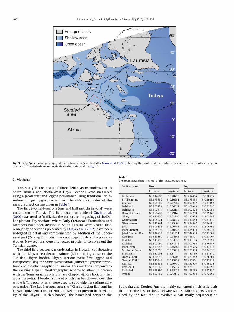
Permian sediments, but extends down to Middle Triassic(Ladinian) sediments, belonging to the Kurrush Fm (El Hinnawyand Cheshitev, 1975). The stratigraphically most complete Meso-zoic sedimentary sequence is thus recorded in the vicinity of theTunisian–Libyan border. The Jeffara plain is bounded to the northby the Jeffara and Sabratah-Cyrenaica normal faults (Hallett,2002; Fig. 2b), that separate the subsiding offshore TripolitanaBasin. During the Early Cretaceous, the Ghadames Basin was situ-ated along the northeastern margin of Africa, at an approximatepalaeolatitude of 10� North (Fig. 3).
The geodynamic history of the Ghadames Basin was mostlyinfluenced by the Hercynian and Alpine unconformities (e.g. Booteet al., 1998; Dardour et al., 2004; Underdown et al., 2007; Galeazziet al., 2010). The Hercynian phase, which culminated in the LateCarboniferous, inverted the northern Ghadames Basin and formeda prominent east–west anticline (called Jeffara–Nefusa Arch; e.g.Boote et al., 1998) that was eroded during the Permian (Hallett,2002) (Fig. 2b). Sedimentation resumed during the Mesozoic untilPalaeocene times. The Alpine phase reactivated and uplifted theJeffara escarpment during time of dextral strike–slip movementon the basement-rooted Sabratah-Cyrenaica fault system (Anketell

Campanian
Maastrichtian
Santonian
Undifferentiated Triassic
Norian - Bathonian
Bathonian - Kimmeridgian
Late Hauterivian - Albian
Late Albian - Cenomanian
Early Turonian
Turonian - Coniacian
Neogene
Quaternary Basalt
Quaternary
Permian
10°E 14°E13°E12°E11°E
33°N
32°N
0 km 100
Tripoli
NalutKabaw
Zuwarah
SurmanAz Zawiyah
Al Khums
Gharyan
Az Zintan
Bani Walid
Dehibat
Remada
JaduYifran
Kiklah
Tunisia Libya
0 m
-1000
-2000
-3000
-4000
-5000
1000Tripolitana
BasinJeffaraArch
Ghadames Basin GargafArch
Oligo-Miocene
0 100 200
Kms
Pal - Eo
Cretaceous
Jur.Triassic Cb
Perm
Triassic
TriassicCretaceous
JurassicCarboniferous
Silurian
CambrianOrdovician
Devonian
Cb-Ord
North SouthB
A
Mediterranean sea
Jeffaraplain
Jeffara fault system
Wazin
Tataouine
Medenine
Al Azïzïyah fault
Sabrätah fault
Fig. 2. (A) Geological map of the Jeffara escarpment. Modified form the geological map of Tunisia (scale 1/500 000) and the geological map of Libya (scale 1/1 000 000). Thedashed red lines shows the projection lines for the transects presented in Figs. 9 and 10. (B) North–south structural cross-section across the Tripolitania and Ghadames Basinsin Libya (modified from Boote et al. (1998)).
S. Bodin et al. / Journal of African Earth Sciences 58 (2010) 489–506 491
and Ghellali, 1991). An Early Cretaceous tectonic phase is moreoverreported by various authors and correlated to the ‘‘Austrian phase”in Europe (e.g. Echikh, 1998; Bouaziz et al., 2002; Dardour et al.,2004; Underdown et al., 2007), explaining the northward and east-ward truncation of the Mesozoic (Triassic to Early Cretaceous)sequence.
Guiraud and Maurin (1992) separated North Africa into twoblocks: The West African and the Arabian–Nubian blocks. Theseare separated by the Benue Trough, the Tenere Basin, the Am-guid-Gassi Touil-Algeria and the 10�E lineaments (Moulin et al.,
2010). The 10�E lineament marks the western boundary of theSaharan Metacraton in the Hoggar–Aïr massif (Abdelsalam et al.,2002; Liégeois et al., 2005) and is known in Libya as the Tihe-mboka Arch (e.g. Hallett, 2002). The boundary between the twoblocks corresponds to weakness zone (series of major fractureand rift zones), such as the Raghane Shear Zone, that separatesthe Touareg shield from the Sahara Metacraton (Abdelsalamet al., 2002). In Central Tunisia, it is known as the ‘‘Axe Nord-Sud”(e.g. Soussi, 2003). The studied area is situated to the east of thislineament.
50°
40°
30°
20°
-10°
0°
10°
-20°
Africa
Tethys
Emerged landsShallow seasOpen ocean
Studiedarea
Laurasia
Fig. 1b
Fig. 3. Early Aptian palaeogeography of the Tethyan area (modified after Masse et al. (1993)) showing the position of the studied area along the northeastern margin ofGondwana. The dashed-line rectangle shows the position of the Fig. 1B.
Table 1GPS coordinates (base and top) of the measured sections.
Section name Base Top
Latitude Longitude Latitude Longitude
Bir Miteur N33.14905 E10.28725 N33.14465 E10.28237BirThelathine N32.73852 E10.30251 N32.73555 E10.29394Chenini N32.91682 E10.27263 N32.90957 E10.27194Dehibat I N32.07724 E10.56537 N32.07013 E10.55396Dehibat II N32.07814 E10.52184 N32.07474 E10.52054Douiret Ancien N32.86795 E10.29146 N32.87209 E10.29146Gharyan N32.26850 E13.02995 N32.26524 E13.03389Ghomrassen I N33.08921 E10.28937 N33.10380 E10.27310Ghomrassen II N33.11741 E10.25600 N33.12342 E10.24980Jadu N31.96136 E12.00783 N31.94865 E12.00792Jebel Charenn N32.84098 E10.30526 N32.84034 E10.29973Jebel Oum ed Diab N32.49934 E10.21321 N32.49536 E10.21069Ksar Jraa N33.16180 E10.24565 N33.15521 E10.23907Kiklah I N32.13739 E12.64838 N32.13185 E12.65097Kiklah II N32.05594 E12.71318 N32.05598 E12.70987Jebel Ltime N32.79256 E10.35363 N32.78506 E10.33743Merbah el Asfer N32.91596 E10.35714 N32.90939 E10.34618El Mjabrah N31.87661 E11.1 N31.86796 E11.17876Oued el Khil I N33.20052 E10.26709 N33.20242 E10.26804Oued el Khil II N33.16443 E10.25939 N33.16301 E10.25919Remada I N32.23333 E10.40750 N32.22603 E10.39621Remada II N32.25640 E10.45037 N32.25 E10.44095Shakshuk N31.98896 E11.98422 N31.98289 E11.97786Wazin N31.97762 E10.73112 N31.97014 E10.72566
492 S. Bodin et al. / Journal of African Earth Sciences 58 (2010) 489–506
3. Methods
This study is the result of three field-seasons undertaken inSouth Tunisia and North-West Libya. Sections were measuredusing a Jacob staff and logged bed-by-bed using traditional field-sedimentology logging techniques. The GPS coordinates of themeasured section are given in Table 1.
The first two field-seasons (one and half months in total) wereundertaken in Tunisia. The field-excursion guide of Ouaja et al.(2002) was used to familiarize the authors to the geology of the Da-har plateau. Key sections, where Early Cretaceous Formations andMembers have been defined in South Tunisia, were visited first.A majority of sections presented by Ouaja et al. (2002) have beenre-logged in detail and complemented by addition of the upper-most part (Zebbag Fm), which was not logged in detail by previousstudies. New sections were also logged in order to complement theTunisian transect.
The third field-season was undertaken in Libya, in collaborationwith the Libyan Petroleum Institute (LPI), starting close to theTunisian–Libyan border. Libyan sections were first logged andinterpreted using the same classification (lithostratigraphic forma-tions and members) applied in Tunisia. This was then compared tothe existing Libyan lithostratigraphic scheme to allow unificationwith the Tunisian nomenclature (see Chapter 4). Key horizons thatcross the political border (some of which can be followed over thewhole Jeffara escarpment) were used to subdivide the sedimentarysuccession. The key horizons are: the ‘‘Kimmeridgian Bar” and itsLibyan equivalent (this horizon is however not present in the vicin-ity of the Libyan–Tunisian border); the bones-bed between the
Boulouha and Douiret Fm; the highly cemented siliciclastic bedsthat mark the base of the Aïn el Guettar – Kiklah Fms (easily recog-nized by the fact that it overlies a soft marly sequence); an

S. Bodin et al. / Journal of African Earth Sciences 58 (2010) 489–506 493
evaporite horizon within the Kerker – Yifran Mbs; and the upper-most Gattar Mb – Nalut Fm that caps the Jeffara escarpment overits entire length. All age attributions presented in this manuscriptderive from literature review integrated with the unified litho-stratigraphic nomenclature.
4. A unified litho- and biostratigraphic framework
4.1. Sedimentological description
The Early to Middle Cretaceous sedimentary succession that isexposed in the Jeffara escarpment can be subdivided into twoparts according to the main lithology (Figs. 4 and 5). Siliciclasticdeposits dominate the lower part of the sedimentary sequencewhereas carbonates dominate the upper part. This subdivision re-flects the regional sedimentary trend in North Africa and thetransition from the ‘‘Continental Intercalaire” to the Upper Creta-ceous marine series (e.g. Klitzsch and Squyres, 1990; Lefranc andGuiraud, 1990). Along the Jeffara escarpment, the Early Creta-ceous siliciclastic deposits were originally interpreted as beingmostly deposited in continental subaerial settings (e.g. El-Zouki,1980a; Bouaziz et al., 1989; Lefranc and Guiraud, 1990). Morerecent publications (Hammuda et al., 2000; Ouaja et al., 2002;Cuny et al., 2004; Anderson et al., 2007) have however ques-tioned this interpretation and postulated the dominance of shal-low marine tidally-influenced deposits.
4.1.1. Tunisia4.1.1.1. Bir Miteur, Boulouha and Douiret Fms. The Early Cretaceousdeposits in Tunisia begin with the Boulouha Fm. This formationoverlies the Bir Miteur Fm, dated as Oxfordian–Kimmeridgian(e.g. Ouaja et al., 2002). In the uppermost part of the Bir MiteurFm, a thick brown dolomitic bed, rich in corals and stromatolites,is present and known by local geologists as the ‘‘Kimmeridgianbar” (Fig. 6a; Peybernès et al., 1985). It is dated as Early Kimmerid-gian by the presence of the benthic foraminifera Alveosepta jaccardiand the algae Salpingoporella annulata and Trinocladus perplexus(Peybernès et al., 1985; Ben Ismaïl et al., 1989; Kamoun et al.,2003). This feature helps to identify the base of the Boulouha Fm,which is marked by a regional subaerial erosive surface and asso-ciated reddish clays or conglomeratic deposits (Barale and Ouaja,2002; Ouaja et al., 2002).
The Boulouha Fm comprises an alternation of fine sandstone,green marls and yellow1 dolomite beds (Fig. 7a). A maximumthickness of 72 m has been measured in the Merbah el Asfer sec-tion. Numerous silicified tree logs, some up to 20 m long, can befound in this formation (Fig. 6c). The Douiret Fm has a maximumthickness of 110 m near Tataouine. Its base is marked by channe-lised and cross-stratified fine sandstone, peculiarly enriched inreptilians teeth and bones, fish teeth (shark, Lepidotes), silicifiedwood and intraclast. The lower part has a sedimentary pattern sim-ilar to the Boulouha Fm, whereas green marls with few occurrencesof yellow dolomitic mudstone or wackestone dominate the upperpart (maximum of 70 m in the Jebel Charenn section). The occur-rence of these dolomitic beds increases toward the south.
4.1.1.2. Aïn el Guettar Fm. This Formation is principally made ofreddish cross-stratified fine to coarse sandstone and siltstone(Fig. 6d), with occasional green marl intervals. The maximum mea-sured thickness was 80 m. Two fining-upward cycles can be iden-tified within this formation, which allow it to be divided into twomembers; the Chenini and Oum ed Diab Mbs. The upper member is
1 For interpretation of color in Figs. 2, 6, 7, 9, and 10 the reader is referred to theweb version of this article.
moreover characterized by the occurrence of distinctive whitemica (Ouaja et al., 2002). The Aïn el Guettar Fm is rich in silicifiedwood and vertebrate fossils (e.g. Benton et al., 2000). In the north-ern area (e.g. Chenini section), marine trace fossils Skolithos sp. andDiplocraterion sp. occur at the base of Oum ed Diab Mb (Fig. 6e).
4.1.1.3. Zebbag Fm. The Zebbag Fm has been divided into threemembers by previous workers; Rhadouane, Kerker and GattarMbs (e.g. M’Rabet et al., 1995; Barale and Ouaja, 2002; Ouajaet al., 2002). The Rhadouane Mb consists of an alternation of bio-clastic floatstone to rudstone (rich in bivalves and gastropods;Fig. 7c) and biolaminated mudstone (microbialite), that forms aprominent cliff in the landscape (Fig. 6a). Toward the top, marlintercalations occur. The Rhadouane Mb is only present in thenorthern part of the Jeffara escarpment in Tunisia. Its maximummeasured thickness is 35 m. The contact with the Kerker Mb isnot well defined and corresponds to the transition from a lime-stone-dominated to a marl-dominated sequence. The Kerker Mbis characterized by an alternation of yellow marls, biolaminatedmudstone (microbialite), rich in birdseye structures and fenestraefabrics, as well as few wackestone. Intense bioturbation is some-time observed in the mudstone (Fig. 7e). A distinctive evaporitemarker-horizon (made of gypsum and halite; Fig. 7f) is observedin the northern part of the Jeffara escarpment. The top of theKerker Mb is marked by the occurrence of bivalves, gastropods,echinoids and an ubiquitous, thick (between 3 and 8 m), yellowmarl horizon. Measured thicknesses vary between 50 and 140 m.
The Gattar Mb forms the prominent uppermost cliff of the Jeff-ara escarpment. It consists of brown dolomitic limestone, with theoccurrence of gastropods, pelecypods and rudists (e.g. Razgallahet al., 1994; M’Rabet et al., 1995; Abdallah and Meister, 1997). Rarechert nodules can also be observed. The dolomitization is the prod-uct of early diagenetic processes (Chaabani et al., 2003) and can bevery intense in some areas (Fig. 7g), leading to the completedestruction of the primary sedimentary fabric. Reef-like structureshave also been observed in the Gattar Mb (Ouaja et al., 2002). Themaximum measured thickness is 33 m.
At the base of the Zebbag Fm, in some localities of the northernpart of the studied area, channelized coarse clastic deposits havebeen observed. They reach a maximum thickness of 18 m in theOued el Khil section. These clastic deposits consist of quartz grainsin the southern part, but pass rapidly into carbonate-clastic depos-its in the northern part of the studied area. These sandstones showevidence of tidal influence such as herring-bones cross-stratifica-tion (Fig. 7b) and contain marine bioturbations and fauna (bivalvesand bryozoans fragments). There is a rapid vertical transition be-tween these sands and the Rhadouane Mb (2–3 m thick), showinga progressive disappearance of clastic grains. We propose to namethis new lithostratigraphic unit the ‘‘Charenn Mb” and place it atthe base of the Zebbag Fm. Its name is a reference to the JebelCharenn, situated between the towns of Douiret and Tataouine,where these deposits were first observed.
4.1.2. LibyaThe studied interval in Libya is divided into four formations
(Fig. 4): Kabaw, Kiklah, Sidi as Sid and Nalut Fms (Banerjee, 1980).
4.1.2.1. Kabaw Fm. The Kabaw Fm consists of an alternation offine grained sandstone, green marls and yellow dolomite beds,and is characterized by the occurrence of silicified wood remains(El-Zouki, 1980b). Some logs can reach up to 16 m long. A bone-bed, rich in reptilian and fish teeth and bones, is observed in thelower part of the sedimentary succession. A green marl-domi-nated sequence, with the occurrence of yellow dolomitic beds,characterizes the uppermost part of the Kabaw Fm (Fig. 6b). To-ward the central part of Jebel Nefusa (Shakshuk section), the

Pelecypods
Gasteropods
Brachiopods
Rudists
Microbialites
Corals
Fish remains
Silicified wood
Reptilian remains
Sandstone, cross-bedded
Carbonate
Evaporite
Vertebrates"Wealden"
PalynomorphsEarly Albian
Pelecypods & RudistsCenomanian
Orbitolinids & PelecypodsCenomanian
Middle AlbianTectonic Unconformity
Late AptianTectonic Unconformity
Early Cretaceous"Cimmerian" Unconformity
Libya (Jebel Nefusa)
Evaporite marker bed
Marker bed withcorals, bivalves,gasteropods
BrachiopodsBarremian - Early Aptian
PalynomorphsEarly Aptian
Vertebrates &PalynomorphsLatest Aptian - Early Albian
AmmonitesLate Albian
Foraminifera &DasycladaceaKimmeridgian
AmmonitesLatest Cenomanian
Middle AlbianTectonic Unconformity
Late AptianTectonic Unconformity
Early Cretaceous"Cimmerian" Unconformity
Intra-BoulouhaTectonic Unconformity
Tunisia (Dahar plateau)
Evaporite marker bed
Marker bed Marker bed
Yifra
n M
bAy
n To
bi M
bKi
klah
Fm
Sidi
as
Sid
FmN
alut
Kaba
w F
mSh
aksh
uk
Low
er M
embe
rU
pper
Mem
ber
Low
er M
embe
rU
pper
Mem
ber
Mer
bah
el A
sfer
Gro
upG
atta
rKe
rker
Mb
Rha
doua
neC
hare
nnO
um e
d D
iab
Che
nini
Mb
Bit M
iteur
Dou
iret F
mBo
ulou
ha F
mAï
n el
Gue
ttar F
mZe
bbag
Fm
AmmonitesLate Cenomanian
Fig. 4. Synthetic lithostratigraphic column of the Early to Middle Cretaceous succession along the Jeffara escarpment in Libya and Tunisia. No precise thickness is indicateddue to important thickness variability along the Jeffara escarpment.
494 S. Bodin et al. / Journal of African Earth Sciences 58 (2010) 489–506

Carbonate
Siliciclastic
Marls / Clays
Evaporite
Silicified wood
Fish teeth
Pelecypods
Gasteropods
Wave ripples
Brachiopods
Rudists
Reptilian remains
Corals
Current ripples
Roots, paleosoil
Jadu
0m
10
20
30
40
50
60
70
80
90
100
110
120
130
140
150
160
170
180
N
S
W E
n = 18
n=3
n=14
n=1
mMWPGFsltfsmscsg vcs
B
Wazin
Yifra
n M
embe
rU
pper
Mem
ber
Sid
i as
Sid
For
mat
ion
0m
10
20
30
40
50
60
70
80
90
100
110
120
130
140
150
160
170
180
n=2
n=10
n=4
N
S
W E
n = 32
190
200
210
Upp
er M
embe
rLo
wer
Mem
ber
Low
er M
embe
rn oita
mroF halkiK
noitamroF
wabaK
n=3
n=11
n=1
n=1
Nal
ut
mMWPGFsltfsmscsg vcs
B
Dehibat I
Mer
bah
el A
sfer
Gro
up
N
S
W E
n = 26
n=3
Dou
iret F
orm
atio
n
0m
10
20
30
40
50
60
70
80
n=12
n=3
n=5
n=3
Bou
louh
a Fo
rmat
ion
mMWPGFsltfsmscsg vcs
B
Zebb
ag F
orm
atio
nK
erke
r Mem
ber
Aïn
el G
uetta
r For
mat
ion
Che
nini
Mem
ber
Oum
ed
Dia
b M
embe
r
Dehibat II
n=7
0m
10
20
30
40
50
60
70
80
90
100
110
120
130
N
S
W E
n = 41
n=10
n=24
mMWPGFsltfsmscsg vcs
B
Jebel Charenn
0m
10
20
30
40
50
60
70
80
Mer
bah
el A
sfer
Gro
up
n=15
n=2
n=2
Dou
iret F
orm
atio
nZe
bbag
For
mat
ion
Ker
ker M
embe
rC
hare
nn
n=27
90
100
110
120
130
140
150
160
170
180
N
S
W E
n = 46R
hado
uane
mMWPGFsltfsmscsg vcs
B
Liby
a
Tuni
sia
n=4
Merbah el Asfer
Mer
bah
El A
sfer
Gro
upB
oulo
uha
Form
atio
n
0m
10
20
30
40
50
60
70
80
N
S
W E
n = 14
n=4
n=6
mMWPGFsltfsmscsg vcs
B
Gat
tar
Gat
tar
Kik
lah
Form
atio
nLo
wer
Mem
ber
Ker
ker M
embe
rLo
wer
Ayn
Tob
i Mem
ber
Sid
i as
Sid
For
mat
ion
Upp
er A
yn T
obi M
embe
rN
alut
Upp
er M
embe
rK
abaw
For
mat
ion
Low
er M
embe
rS
haks
huk
Form
atio
n
Shakshuk
N
S
W E
n = 45
n=14
n=10
n=7
n=8
n=4
0m
10
20
30
40
50
60
70
80
90
100
110
120
130
140
150
n=2
160
mMWPGFsltfsmscsg vcs
B
Bir
Mite
ur
Fig. 5. Example of key sedimentological field-log and their correlation. For each section, the left column shows the texture (Dunham classification) for carbonate rocks orgrain size for siliciclastic rocks. The right column shows the weathering profile. The rose diagram displays all the palaeocurrent measurements for each section, whereasspecific palaeocurrent directions (arrows) are given next to the bed where they have been measured. Abbreviation for texture and grain size; m: marl/clay; M: mudstone; W:wackestone; P: packstone; G: grainstone; F: floatstone; B: bindstone; slt: silt; fs: fine sand; ms: medium sand; cs: coarse sand; vcs: very coarse sans; g: gravel.
S. Bodin et al. / Journal of African Earth Sciences 58 (2010) 489–506 495
Kabaw Fm becomes sand-dominated and the occurrence of marlsor dolomitic bed is rare. In this section, the contact with theunderlying Shakshuk Fm is well exposed and characterized bychannelized fluvial deposits. Within the upper part of the Shak-shuk Fm, a 2 m thick yellow dolomitic bed, rich in bivalves, gas-tropods and coral remains, is also observed. The Kabaw Fm isabsent in the eastern part of the studied area. The maximum ob-served thickness is 110 m in the El Mjabrah section. The lower-most part was however not exposed in this section.
4.1.2.2. Kiklah Fm. Along the Jebel Nefusa, significant lateral faciesvariations characterize the Kiklah Fm (El-Zouki, 1980b). Three
main facies regions can be distinguished. In the western part, theKiklah Fm comprises reddish cross-stratified fine to coarse sand-stone and siltstone, with few occurrences of green marls (Fig. 6f).Numerous silicified tree logs, as well as vertebrate bones and teeth,are present. Two fining-upward cycles can be distinguished withinthe Kiklah Fm in the western region. In the central region (Jadu,Shakshuk and Kiklah sections), as with the Kabaw Fm, the KiklahFm is dominated by sandstone with rare occurrences of red siltyclay intervals. In the easternmost logged section (Gharyan), theKiklah Fm is characterized by the predominance of conglomeraticfacies interbedded with clay-rich mudstone. The base consists ofcarbonate pebbles, reworked from the underlying Abu Ghylan

D E
B C
F
Upper Kiklah Fm
Sidi as Sid FmYifran Mb
Kiklah Fm
Kabaw Fm
ARhadouane Mb
"Kimmeridgian bar"
N
Chenini MbBoulouha Fm
Bir Miteur Fm
Fig. 6. Field photograph showing the principal features of the Early Cretaceous deposits along the Jeffara escarpment. (A) Panorama of Bir Miteur (Tunisia, photograph takenfrom the road C207, GPS coord. N33.14307 E10.29008, looking toward the NW) showing the prominent ‘‘Kimmeridgian bar”, marking the uppermost part of the Bir MiteurFm, and the Rhadouane Mb at the top. (B) Picture of the Kabaw–Kiklah Fms boundary near Wazin (Libya, GPS coord. N31.97377 E10.72446, person circled for scale). Theupper part of the Kabaw Fm consists of green marls – beige dolostone alternation. The lower Kiklah Fm consists of medium to coarse loose sandstone. (C) Silicified tree logwithin the Boulouha Fm, oriented parallel to the main palaeocurrent direction (toward the north), Jebel Ltime section, Tunisia. (D) Cross-stratified red sandstones of the Oumed Diab Mb (Remada section, Tunisia). (E) Diplocraterion sp. ichnofossil within the Oum ed Diab Mb (Chenini section, Tunisia). (F) Transition between red sandstones of theKiklah Fm and beige carbonate-marl alternations of the Yifran Mb, Sidi as Sid Fm (Wazin, Libya, GPS coord. N31.93434 E10.66568, person circled for scale). Note the lateralaccretion packages near the top of the Kiklah Fm.
496 S. Bodin et al. / Journal of African Earth Sciences 58 (2010) 489–506

A
D E
B C
F
Kerker Mb
"Kimmeridgian bar"
Boulouha Fm
G
Gattar Mb
Fig. 7. Field photograph showing the principal features of the Late Albian – Early Turonian deposits along the Jeffara escarpment. (A) Panorama of the Jebel Boulouha (Tunisia,photograph taken from the road Tataouine–Chenini, looking toward the SW). The topmost Gattar Mb caps the Jeffara escarpment all along Tunisia and Libya, where it isknown as the Nalut Fm. (B) Herring-bone cross-stratification within coarse sandstone of the Charenn Mb (Jebel Charenn section, Tunisia). (C) Bioclastic dolostone mostlymade of bivalve fragments from the Rhadouane Mb (Bir Miteur section, Tunisia). (D) Ichthyosarcolites sp.? Rudist within the Ayn Tobi Mb (Kiklah section, Libya). (E) Highlybioturbated dolomicrite within the Kerker Mb (Ghomrassen section, Tunisia). (F) Thick evaporite marker bed within the Kerker Mb (Tunisia, Chenini section, GPS coord.N32.91157 E10.27155). (G) Large vugs interpreted as being rudists molds within the highly dolomitized Gattar Mb (Douiret Ancien section, Tunisia).
S. Bodin et al. / Journal of African Earth Sciences 58 (2010) 489–506 497

498 S. Bodin et al. / Journal of African Earth Sciences 58 (2010) 489–506
Fm. Two fining-upward sequences are present in this section. Themeasured thicknesses vary between 37 and 88 m.
4.1.2.3. Sidi as Sid Fm. The following Sidi as Sid Fm is divided intotwo members: Ayn Tobi and Yifran Mbs (e.g. El-Bakai, 1997;Hallett, 2002). The Ayn Tobi Mb comprises dolomitic bioclasticfloatstone to rudstone (rich in pelecypods, rudists and gastropods;Fig. 7d) and biolaminated mudstone (microbialite). There is a gra-dational transition between the Ayn Tobi and the Yifran Mbs. Thelatter is characterized by the alternation of yellow marls and biola-minated mudstones (microbialites) with birdseye and fenestraefabrics. The uppermost part is marked by a thick (<10 m) yellowmarl interval. The presence of a bedded evaporitic horizon nearthe base of the Yifran Mb is also observed is some sections. TheAyn Tobi Mb has a measured maximum thickness of 64 m, andthe Yifran Mb thickness varies between 45 and 96 m.
In the Jadu section, the first 37 m of the Ayn Tobi Mb are char-acterized by the occurrence of siliciclastic deposits (silt to verycoarse sandstone, with a carbonate matrix) interbedded with thedolomitic sediments. The Ayn Tobi Mb – Kiklah Fm limit is markedby an erosive surface and reworked palaeosol (calcrete) clasts.
4.1.2.4. Nalut Fm. The Nalut Fm (also known as the Gharyan Fm)caps the Jebel Nefusa over its entire length. This brown limestoneunit is made of crystalline dolomite and rare chert horizons andnodules. Rare, poorly preserved pelecypods have been reported(Hallett, 2002).
4.2. Unified lithostratigraphic scheme between Libya and Tunisia
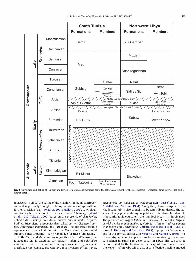
The lithostratigraphic correlation between Libyan and TunisianFormations and Members is straightforward utilising the serial log-ging technique used here (Fig. 8). The Dehibat and Wazin sections,situated in Tunisia and Libya, respectively, are perfect for this pur-pose because of their close proximity (there is only ca. 20 km be-tween them) and their relative completeness regarding the Earlyto Mid-Cretaceous lithostratigraphic succession.
Thus, the Kabaw Fm of Libya is the equivalent of the combinedsedimentary package of the Boulouha and Douiret Fms in Tunisia.They share the same lithological and sedimentological features, i.e.an alternation of green marls, fine to medium sandstones and bio-clastic dolomitic beds. The upper part of the Kabaw section con-sists of the alternation of thick green marls layers with dolomiticmudstone, which can be directly correlated to the thick green marlinterval at the top of the Douiret Fm. The basal Douiret Fm sand-stone bed, rich in fossilized fish, reptile and wood debris (Ouajaet al., 2002), can also be recognized in western Libya. We proposeto subdivide the Kabaw Fm into two members, the Lower andUpper Kabaw Mbs, which are the equivalent of the Boulouha andDouiret Fms, respectively. The correspondence between the KabawFm and the Boulouha–Douiret Fms is further confirmed by theclose correspondence of lithostratigraphic unit thicknesses on bothsides of the border and their relative position regarding the LateAptian tectonic unconformity. We moreover propose the correla-tion between the Tunisian ‘‘Kimmeridgian bar” of the Bir MiteurFm and the coral-rich dolomitic bar of the upper part of theShakshuk Fm.
The Libyan Kiklah Fm is equivalent to the Aïn el Guettar Fm inTunisia. The correspondence of these two formations was alreadymentioned by Tunisian workers (e.g. Bouaziz et al., 1989) and isfurther confirmed by the similar thickness of the two formationson both sides of the border, their similar age dating and their rel-ative position regarding the Late Aptian and Middle Albian tectonicunconformities (see below). The Tunisian subdivision of this for-mation into two members, the Chenini and Oum ed Diab Mbs,can also be recognized in Libya, and thus allows the subdivision
of the Kiklah Fm into a Lower and Upper Kiklah Mbs. In the Dehi-bat-Wazin region, the Libyan Yifran and Tunisian Kerker Mbsdirectly overlie the Kiklah and Aïn el Guettar Fms, respectively.These two members have the same lithological characteristic, i.e.dominated by the alternation of dolomitic mudstone–wackestoneand yellow marls, and are thus Tunisian and Libyan equivalent.The top of the Jeffara escarpment is capped by a thick successionof brown massive dolomitic beds, attributed to the Gattar Mb inTunisia and Nalut Fm in Libya (e.g. Ben Youssef, 1999).
The Tunisian Rhadouane Mb can be correlated to the Ayn TobiMb in Libya based on their common lithological characteristicand position relative to the Kerker–Yifran Mbs. In the Jadu area,the lower part of the Ayn Tobi Mb is made of siliciclastic rocksbeing rapidly replaced by a carbonate-dominated sedimentation.This is also seen in the Charenn – Rhadouane Mbs succession inTunisia and further supports the lithostratigraphic correspondencebetween the Ayn Tobi and the Rhadouane Mbs.
4.3. Dating of formations and members
There is a significant variance in the published age dates for thesediment exposed along the Jeffara escarpment between Libya andTunisia. This can be assessed when comparing published reviewliterature, such as Tawadros (2001) or Hallett (2002) for Libya,and Barale and Ouaja (2002) for Tunisia. This discrepancy arisesfrom the fact that since the late 1960s and the study of Busson(1967), no published field-work has been undertaken by the sameresearch group on both sides of the Tunisian–Libyan border. How-ever, accurate dating of these rocks is important in order to assessthe timing and control of the deformations phases in North Africa.Table 2 gives a summary of published stratigraphically significantpalaeontologic finds and the subsequent age attribution of litho-stratigraphic units in the Jeffara escarpment.
In Tunisia, the Boulouha Fm has yielded the brachiopod Lorioli-thyris russillensis (Peybernès et al., 1996), which led Barale andOuaja (2002) to propose a latest Hauterivian? – Early Aptian agefor this formation (see also Ben Youssef, 1999). The Douiret Fmhas been dated as Early Aptian with the help of palynomorphassemblages (Ben Ismaïl, 1991). Cuny et al. (2004) also identifiedhybodont sharks (Hybodus sp., Priohybodus arambourgi) and marineray (‘‘Rhinobatus” sp.) remains from this Formation. The age of theKabaw Fm in Libya is more controversial due to the absence ofstratigraphically precise finds. The assemblage of dinosaur verte-bra (Spinosaurus?), shark teeth (Priohybodus arambourgi), fishscales and teeth (Lepidotes sp.), crocodile teeth and turtle shellsindicate a Wealden age (i.e. Valanginian–Barremian) according toEl-Zouki (1980b). The lithostratific equivalence of the Kabaw Fmwith the Boulouha–Douiret Fms, as well as their similar positionrelative to the ‘‘Austrian” unconformity, allows us to propose anequivalent age for these formations, i.e. a latest Hauterivian? –Early Aptian age, implying an Early Cretaceous hiatus at the baseof the Kabaw–Boulouha Fms (Fig. 8). This is moreover in agree-ment with Belhaj (1996) who stated: ‘‘Despite extensive palynolog-ical analyses of many wells, the Neocomian has not been identified inthe study area”, i.e. the western Sirt Basin, ‘‘nor in the subsurface ofthe Ghadämis Basin”.
The Tunisian Aïn el Guettar Fm has been dated as Early Albianby Bouaziz et al. (1988) and Benton et al. (2000) with the help ofan important fish and reptilian fauna (fishes Protolamna sp., Creto-dus?, Lepidotes, cf. Anoemodus, cf. Caturus, Neoceratodus africanus,dinosaurian Carcharodontosaurus saharicus and Spinosaurus sp.(see also Buffetaut and Ouaja, 2002). Ben Ismaïl (1991) attributedthe Chenini Mb to the Late Aptian – Early Albian based on palyno-logical assemblages. Cuny et al. (2004) report the presence ofneoselachian sharks (Cretodus semiplicatus, cf. Protolamna, cf.Scapanorhynchus, Onchopristis dunklei) and hybodont Tribodus
Turonian
Cenomanian
Albian
Aptian
Barremian
Hauterivian
Valanginian
Berriasian
Coniacian
Santonian
Campanian
Maastrichtian
Cre
tace
ous
Late
Early
South TunisiaFormations Members
Northwest LibyaFormations Members
Boulouha
Douiret
Aïn el Guettar
Zebbag
Kiklah
Kabaw
Sidi as Sid
NalutGattar
Kerker
CheniniOum ed Diab
RhadouaneCharenn
Qasr Taghrinnah
Ayn Tobi
Yifran
Hiatus
Aleg
Lower Kabaw
Upper Kabaw
Lower KiklahUpper Kiklah
Al GharbiyahN
eoco
mia
nG
allic
Seno
nian
Mizdah
Tithonian
Kimmeridgian
Oxfordian
Mal
mLa
teJu
rass
ic
Hiatus
Bir Miteur
Foum Tataouine
Shakshuk
Late Aptian "Austrian" unconformity
Middle Albian unconformity
Mer
bah
el A
sfer
Gro
up
Ksar HaddadaGhomrassen
Berda
Fig. 8. Correlation and dating of Tunisian and Libyan formations and members along the Jeffara escarpment for the Late Jurassic – Cretaceous time interval (see text forfurther details).
S. Bodin et al. / Journal of African Earth Sciences 58 (2010) 489–506 499
tunisiensis. In Libya, the dating of the Kiklah Fm remains controver-sial and is generally thought to be Aptian–Albian in age withoutfurther precision (e.g. Tawadros, 2001; Hallett, 2002). Palynologi-cal studies however point towards an Early Albian age (Wardet al., 1987; Tekbali, 2000) based on the presence of Classopollis,ephedroids, Callialasporites, Araucariacites, Eucommiidites, Aequitr-iradites, Triporoletes, Locopodiacidites, Klukisporites, Cicatricosispor-ites, Perotriletes pannuceus and Afropollis. The lithostratigraphicequivalence of the Kiklah Fm with the Aïn el Guettar Fm wouldsupport a latest Aptian? – Early Albian age for these formations.
In the Chott and Medenine areas (southern Central Tunisia), theRhadouane Mb is dated as Late Albian (Inflata and Substuderiammonite zone) with ammonite findings (Knemiceras syriacum, K.gracile, K. compressum, K. aegyptiacum, Eopachydiscus aff. marcianus,
Engonoceras aff. saadense, E. toussainti; Ben Youssef et al., 1985;Abdallah and Memmi, 1994). Along the Jeffara escarpment, theRhadouane Mb is also thought to be Late Albian, despite the ab-sence of any precise dating in published literature. In Libya, itslithostratigraphic equivalent, the Ayn Tobi Mb, is rich in bivalves.The presence of Exogyra flabellata, E. delettrei, E. columba, Trigoniabeyrichi, Avicula cenomaniensis, Corbula striatula, Ichthyosarcolitestriangularis and I. bicarinatus (Christie, 1955; Desio et al., 1963) al-lowed El Hinnawy and Cheshitev (1975) to propose a Cenomanianage for this formation (see also Megerisi and Mamgain, 1980). Thislithostratigraphic unit appears thus to be time-transgressive fromLate Albian in Tunisia to Cenomanian in Libya. This can also bedemonstrated by the location of the evaporite marker-horizon inthe Kerker–Yifran Mbs which acts as an effective timeline. Indeed,

Table 2Review of relevant published fauna and flora recovered from Early to Mid-Cretaceous lithostratigraphic units in southern Tunisia – northwestern Libya, and their age attribution.
Formation Member Organisms Age attribution
TunisiaBoulouha Brachiopod Loriolithyris russillensis Latest Hauterivian? – Early Aptian (Peybernès
et al., 1996; Barale and Ouaja, 2002)
Douiret Palynomorphs Early Aptian (Ben Ismaïl, 1991)
Aïn el Guettar Palynomorphs, fishes Protolamna sp., Cretodus?, Lepidotes, cf. Anoemodus, cf. Caturus,Neoceratodus africanus, dinosaurian Carcharodontosaurus saharicus and Spinosaurussp.
Late Aptian – Early Albian (Ben Ismaïl, 1991)Early Albian (Bouaziz et al., 1988; Benton et al.,2000)
Zebbag Rhadouane Ammonites Knemiceras syriacum, K. gracile, K. compressum, K. aegyptiacum,Eopachydiscus aff. marcianus, Engonoceras aff. saadense, E. toussainti
Late Albian (Ben Youssef et al., 1985; Abdallahand Memmi, 1994)
Kerker Ammonite Neolobites medeninensis Cenomanian (Busson, 1967)Gattar Ammonites (below the Gattar Mb) Calycoceras sp., Vascoceratidae sp., Choffaticeras
aff. massipianum, C. aff. securiforme, C. gr. pavill-ieri, C. luciae, N. (Betiokyites) gr. pioti,Vascoceras sp., V. aff. obessum, Fagesia sp., Thomasites rollandi, Hoplitoides gr. wohlt-manni, Neoptychites gr. cephalatus
Early Turonian (Razgallah et al., 1994; Abdallahand Meister, 1997)
LibyaKabaw Dinosaurs Spinosaurus?, sharks Priohybodus arambourgi, fish Lepidotes sp. Wealden (El-Zouki, 1980b)
Kiklah Palynomorphs Classopollis, ephedroids, Callialasporites, Araucariacites, Eucommiidites,Aequitriradites, Triporoletes, Locopodiacidites, Klukisporites, Cicatricosisporites,Perotriletes pannuceus, Afropollis
Early Albian (Ward et al., 1987; Tekbali, 2000)
Sidi as Sid Ayn Tobi Bivalves Exogyra flabellata, E. delettrei, E. columba, Trigonia beyrichi, Aviculacenomaniensis, Corbula striatula, Ichthyosarcolites triangula-ris, I. bicarinatus
Cenomanian (Christie, 1955; Desio et al., 1963)
Yifran Foraminifera Orbitolina concava, Praealveolina cretacea tenuis, Thomasinella punica,Buccicrenata libyca, Ammomarginulina cf. blanckenhorni, Hemicyclammina cf. sigali,Gavelinopsis pseudobaccatus
Cenomanian (Megerisi and Mamgain, 1980)
Nalut Foraminifera Praeglobotrucana cf. stephani, Rotalipora sp., Globotrun-cana sp.,Orbitolina sp., Stensioina sp., Kilianina sp., Thomasinella punica, Cuneolina conica,Nezzazata gyra
Cenomanian (Busson, 1967)
500 S. Bodin et al. / Journal of African Earth Sciences 58 (2010) 489–506
this unique event is situated in the middle of the Kerker Mb in thenorthern part of the Jeffara escarpment (Fig. 9), but at the base ofthe Yifran Mb (Fig. 10), underlining the diachronity of the top ofthe Rhadouane–Ayn Tobi Mbs. This diachronous lithostratigraphicunit nicely exemplifies the Late Albian – Cenomanian sea-leveltransgression onto the African craton (e.g. Ben Youssef and Pey-bernès, 1986; Burollet, 1989). However, questions remain aboutthe exact age of the Rhadouane Mb and the biostratigraphic corre-lation between the Charenn Mb and the siliciclastic base of the AynTobi Mb.
The Yifran Mb in Libya is dated as Cenomanian with the help ofmolluscs and foraminifera assemblages (Christie, 1955; Desio et al.,1963). The presence of Orbitolina concava, Praealveolina cretaceatenuis, Thomasinella punica, Buccicrenata libyca, Ammomarginulinacf. blanckenhorni, Hemicyclammina cf. sigali, Gavelinopsis pseudo-baccatus confirms this age attribution (Megerisi and Mamgain,1980). In Tunisia, the equivalent Kerker Mb is as well dated fromthe Cenomanian (Busson, 1967) by the presence in its upper partof the ammonite Neolobites medeninensis.
The Gattar Mb is dated by ammonite biostratigraphy as EarlyTuronian (Razgallah et al., 1994; Abdallah and Meister, 1997). InLibya, its lateral equivalent (Nalut Fm) was originally dated asCenomanian (e.g. Christie, 1955; Desio et al., 1963; El Hinnawyand Cheshitev, 1975) using Molluscan fossils. The robustness ofthis Cenomanian age attribution was however criticised by Busson(1967). Megerisi and Mamgain (1980) attribute to the Nalut Fm aLate Cenomanian–Turonian age based on foraminiferal assemblage(Praeglobotrucana cf. stephani, Rotalipora sp., Globotruncana sp.,Orbitolina sp., Stensioina sp., Kilianina sp., Thomasinella punica,Cuneolina conica, Nezzazata gyra). Further north, in Central Tunisia,the Gattar Fm overlays the Bahloul Fm, which marks the Cenoma-nian–Turonian boundary. This boundary is associated with a sec-ond-order maximum flooding surface (e.g. Lüning et al., 2004)and as such, the change from a transgressive sequence (i.e. the Al-bian–Cenomanian transgression; e.g. Burollet, 1989; see previous
paragraph) to a regressive sequence. This renders the proposedCenomanian age for the base of the Nalut Fm highly improbable.In agreement with Busson (1967), we thus propose a strict EarlyTuronian age for this formation in Libya.
4.4. Depositional environments
The sedimentary facies identified from the Boulouha, Douiretand Kabaw Fms suggest deposition in a large shallow embayment,subject to salinity variations and tidal influence. Overall, theKabaw Fm and the Boulouha–Douiret Fms succession record a sec-ond-order marine transgression, starting with fluvial sandstones atthe base of the Kabaw Fm and the Boulouha Fm (Ouaja et al., 2002),and culminating with the deposition of the distal-marine greenmarls in the upper Douiret Fm, where marine ostracods, hybodontsharks and marine ray have been found (Bouaziz et al., 1989; Cunyet al., 2004; see also Anderson et al., 2007).
The Kiklah-Aïn el Guettar Fms were deposited in a similar typeof shallow-marine embayment environment, subject to salinityvariations and tidal influence. The facies are however more sand-dominated. The two fining-upward cycles that characterize theseformations record deepening upward cycles, and a vertical transi-tion from fluvial to tidal and to more open-marine environmentcan be observed. The presence of neoselachian shark remains inthe Chenini Mb (Cuny et al., 2004; see also Anderson et al., 2007)and marine bioturbation in the Oum ed Diab Mb supports the mar-ine interpretation.
The Rhadouane and Kerker Mbs, and the Sidi as sid Fm, weredeposited in an environment that was analogous to the present-day Shark Bay in Australia (Logan and Cebulski, 1970), i.e. a car-bonate-dominated shallow-marine embayment, with developmentof widespread microbial mats, where hyper-salinity events lead tothe deposition of evaporites. In proximal settings, accumulation ofbivalves and gastropods result in the formation of thick bioclastic-rich beds.

Lower Member (Late Hauterivian ? - earliest Aptian)
Upper Member (Early Aptian)
Lower Member (Early Albian)
Upper Member (Early Albian)
Ayn Tobi Lower Unit (Late Albian ?)
Ayn Tobi Upper Unit (Late Albian ? - Early Cenomanian)
Yifran Member (Cenomanian)
Nalut Formation (Early Turonian)Kiklah Formation
Sidi as Sid FormationKabaw Formation
?
? ?
Vertical exaggeration : 175/1
East West
0 m
50
100
150
200
250
300
350
4020 60 80 100 120 140 1600 km 180 200 220 240
Deh II
Deh I
Waz
Mja
Shak
Jadu
Kik I
Kik II
Ghar
Khashm az Zarzur Fm
Shakshuk FmAbu Ghylan Fm
Bi'r al Ghanam Fm Lower Kabaw Fm
Upper Kabaw Fm
Lower Kiklah Fm
Upper Kiklah Fm
Upper Ayn Tobi Mb
Yifran Mb
Nalut Fm
Shakshuk Fm
Liby
aTu
nisi
a
Middle Albian Unc.
Upper Aptian Unc.
Cimmerian Unc.
?
Fig. 10. East–west transect along the Jebel Nefusa (Jeffara escarpment) using the Cenomanian–Turonian boundary as datum. Note the vertical exaggeration of 175/1. Thethick black vertical lines represent the position of the logged sections. The purple band mark the position of the evaporite horizon within the Kerker–Yifran Mbs. The red linesmark the regional tectonic unconformities. Abbreviation of section names: Ghar: Gharyan; Kik: Kiklah; Shak: Shakshuk; Mja: El Mjabrah; Waz: Wazin; Deh: Dehibat.
Boulouha Formation (Late Hauterivian ? - earliest Aptian)
Douiret Formation (Early Aptian)
Chenini Member (Early Albian)
Oum ed Diab Member (Early Albian)
Charenn Member (Late Albian)
Rhadouane Member (Late Albian - Early Cenomanian ?)
Kerker Member (Cenomanian)
Gattar Member (Early Turonian)Aïn el Guettar Formation
Zebbag Formation
Vertical exaggeration : 175/1
0 m
50
100
150
200
250
300
350
South North0 km 4020 60 80 100 120
Jraa
Oek I
Oek II
Bim
Gom
IIG
om I
Chen
Mea
Doa
Jch
Ltim
Bth
Joed
Rem
IIR
em I
Deh II
Deh I
145
Waz
Gattar Mb
Oum ed Diab Mb
Chenini Mb
Douiret Fm
Boulouha Fm
Bir Miteur FmBir M
iteur F
m
Kerker MbLi
bya
Tuni
sia
Middle Albian Unc.
Upper Aptian Unc.
Cimmerian Unc.
IBU
?
Fig. 9. North–south transect along the Dahar Plateau (Jeffara escarpment) using the Cenomanian–Turonian boundary as datum. Note the vertical exaggeration of 175/1. Thethick black vertical lines represent the position of the logged sections. The purple band mark the position of the evaporite horizon within the Kerker–Yifran Mbs. The red linesmark the regional tectonic unconformities. The dashed red line within the Boulouha Fm marks the position of the Intra-Boulouha unconformity (IBU). The thickness of the BirMiteur Fm is reconstructed based on observations from this study and the work of Ouaja et al. (2002, 2004). Abbreviation of section names: Waz: Wazin; Deh: Dehibat; Rem:Remada; Joed: Jebel Oum ed Diab; Bth: Bir Thelathine; Ltim: Jebel Ltime; Jch: Jebel Charenn; Doa: Douiret Ancien; Mea: Merbah el Asfer; Chen: Chenini; Gom: Ghomrassen;Bim: Bir Miteur; Jraa: Ksar Jraa; Oek: Oued el Khil.
S. Bodin et al. / Journal of African Earth Sciences 58 (2010) 489–506 501
The Gattar Mb – Nalut Fm display facies that are typical of a car-bonate platform. The presence of reef-like structures, rudist build-ups, as well as a typical micro-fauna (Megerisi and Mamgain,1980), would suggest that the Gattar Mb was deposited in a shal-low marine, neritic environment, with connection to the open sea.
Apart for the Gattar-Nalut lithostratigraphic unit, which doesnot display any noticeable facies change throughout the studiedarea, an overall proximal-to-distal trend can be observed for Earlyto Mid-Cretaceous sedimentary units along the Jeffara escarpment
from south to north. This trend is recorded by a progressive reduc-tion in grain size to the north and enrichment of the sedimentarysequence in clay and marls. This pattern is consistent with modelsfor the palaeogeography of North Africa at the time (Fig. 3) and thedominant palaeocurrent directions measured in sandstone pack-ages, indicating a mean direction of transport toward the north(see also Ouaja et al., 2002). Lateral facies changes can also be ob-served, such as seen in the Kabaw Fm, which is dominated by silic-iclastic sediments in the Shakshuk-Nalut area to the south in Libya,

502 S. Bodin et al. / Journal of African Earth Sciences 58 (2010) 489–506
which contrasts with the more mud-dominated lithology else-where toward the north in Tunisia. A number of authors have sug-gested that this area was situated close to the palaeoriver mouththat was feeding this large shallow embayment with siliciclasticmaterials (e.g. Palaeo-Oued Tassili-Hamada in Lefranc and Guiraud(1990)).
5. North Africa geodynamic implications
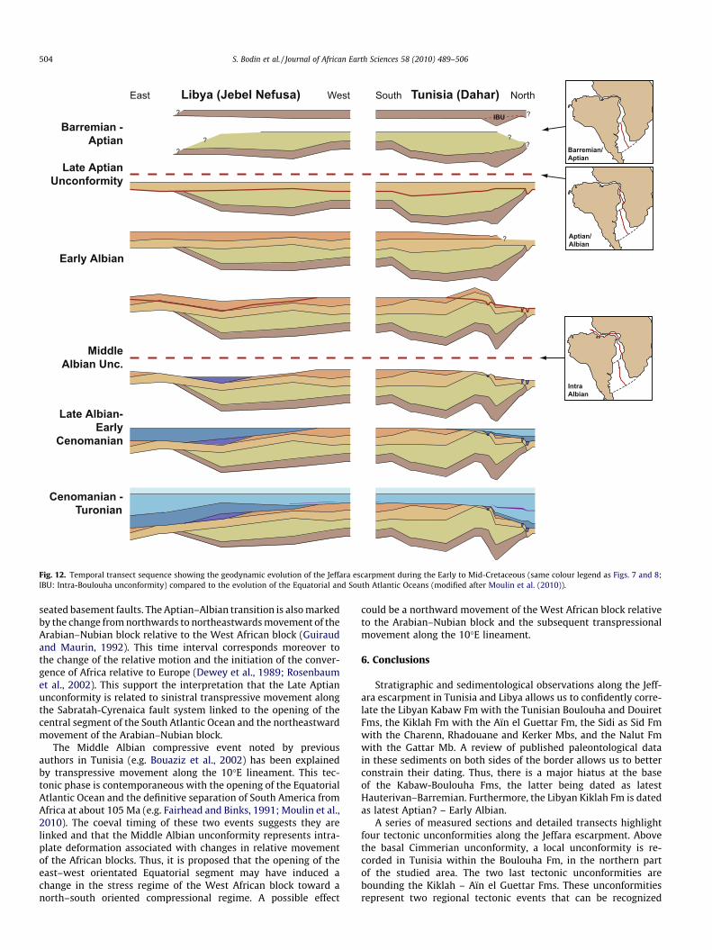
5.1. Timing of tectonic unconformities
In Figs. 9 and 10, two geological transects across the Jeffaraescarpment are displayed, using the Cenomanian–Turonianboundary as datum. They highlight the regional architecture ofthe Early to Mid-Cretaceous deposits along the Jeffara escarpment.
Stratigraphically, the Late Jurassic Bir Miteur–Shakshuk Fms areseparated from the Early Cretaceous Boulouha–Kabaw Fms by ahiatus spanning the latest Kimmeridgian to the latest Hauterivianinterval (Fig. 8). Ouaja et al. (2002, 2004) have moreover observedin Tunisia that this hiatus is associated with an angular unconfor-mity in the southern part of the Dahar Plateau (see also Fig. 9),leading to the disappearance of the ‘‘Kimmeridgian bar” south ofRemada. Poor outcrop conditions have prevented the tracking ofthe Shakshuk Fm (equivalent of the Bir Miteur Fm) in the westernpart of Jebel Nefusa. It is however present in the Shakshuk-Jaduarea, ca. 100 km eastward of the border. As pointed out by Guiraudet al. (2005), tectonic deformations are recorded along most ofNorth and Central African basins during the Jurassic–Cretaceoustransition. This event is referred to as the Cimmerian unconformityand may reflect distant effects of tectonic activity in southeasternEurope.
Within the lower part of the Boulouha Fm, Ouaja et al. (2002)were the first to report the presence of a tectonic unconformityin the Tataouine area (Figs. 9 and 11a). This unconformity is onlyrecognizable in this local region and is not expressed anywhereelse along the Jeffara escarpment.
Along the north–south transect, two regional angular tectonicunconformities can be observed within Early to Mid-Cretaceousdeposits. They bound the Aïn el Guettar Fm in Tunisia and are assuch dated as Late Aptian and Middle Albian, respectively. Alongthe east–west transect, these two unconformities are also recog-nized and form the lower and upper boundaries of the Kiklah Fmin Libya (Fig. 10). This further strengthens the correlation betweenthe Aïn el Guettar and Kiklah Fms. The Late Aptian unconformity ismarked by the progressive truncation of pre-Middle Cretaceous se-quences toward the north and the east. In Libya, this unconformityis well known and called the ‘‘Austrian tectonic unconformity” (e.g.Boote et al., 1998) and associated with the folding and regional tilt-ing of Triassic and Jurassic sequence to the SSW (Magnier, 1963;Anketell and Ghellali, 1991). The Middle Albian unconformity ismore difficult to observe at a regional scale in northwestern Libyabut was already noticed by previous researchers working in theeastern part of Jebel Nefusa (Fig. 11b; Fatmi and Sbeta, 1991).The division of the Kiklah Fm into two members allows this uncon-formity to be better observed over the entire length of the Jebel Ne-fusa (Fig. 10).
The Middle Albian unconformity is best observed along thenorth–south transect in Tunisia, where it is marked by the foldingand truncation of pre-Late Albian sequences. Further north of thestudied area (Jebel Tebaga de Medenine), this unconformity is wellexpressed by the successive truncation of pre-Middle Cretaceous toTriassic sediment and the final superposition of the Rhadouane Mbover Late Permian marine sediments tilted toward the south(Fig. 11c; e.g. Bouaziz et al., 2002). In the Tataouine area, the pres-ence of an anticlinal structure between the Merbah el Asfer and Je-
bel Oum ed Diab region has already been documented by previousworkers (Busson, 1967; Bouaziz et al., 1989) and was called the‘‘Môle de Touil el Hira” (Touil el Hira High) by Bouaziz et al.(1989). In Libya, the Middle Albian unconformity is documentedby an angular unconformity in the central Jebel Nefusa (Fig. 11b).It can also be recognized to the east of the studied area. Thus, alongthe eastern Jebel Nefusa, the Sidi as Sid Fm truncates the Kiklah Fmand can rest directly on the Late Triassic – earliest Jurassic AbuShaybah Fm (Fatmi and Sbeta, 1991; see also Fig. 4.7 in Hallett(2002)). In the Sirt Basin, Ambrose (2000) observes an equivalentmajor unconformity at the top of the Albian Upper Sarir Fm, sealedby Cenomanian sediments, indicating that this is a regional and notjust local feature.
5.2. Discussion on the unconformities spatio-temporal exent
In North Africa, a Mid-Cretaceous tectonic phase is well estab-lished by numerous workers and associated with the Austrian tec-tonic phase in the European Alps (e.g. Canerot et al., 1986; Guiraudet al., 1987, 2005; Badalini et al., 2002; see also Bulot and Ferry,2007). However, numerous discrepancies exist with regards to itstiming, depending on the under- and overlying sediment, and theirdating accuracy.
In Libya, in the Ghadames Basin, the Austrian tectonic unconfor-mity is associated with the unconformity at the base of Kiklah Fm(e.g. Dardour et al., 2004; Echikh, 1998). The Middle Albian uncon-formity is considered by previous worker to be a minor eventcompared to the Late Aptian one (e.g. Hallett, 2002). In the Hame-imat Trough of the eastern Sirt Basin, Ambrose (2000) identified amajor angular unconformity at the top of the Sarir Fm, near theAlbian–Cenomanian boundary. A second less-well expressedunconformity is also present at the base of the Upper Sarir Sand-stone (Rossi et al., 1991), dated as Late Aptian – Early Albian. Also,the presence of two Early Cretaceous tectonic unconformities hasalso been observed on recent 3D seismic lines offshore Libya (AlFraser, BP, pers. com.).
In Central Tunisia, Zouaghi et al. (2005) noted the presence ofmajor unconformities interpreted from 2D seismic, dated as theLate Aptian – Early Albian and the Late Albian. Azaïez et al.(2007) attributed to the Austrian phase the Late Aptian tectonicunconformity that they observed in both field and seismic studies.Rigane et al. (2010) observed two tectonic unconformities in thetectonic evolution of the Jebel El Hamra tilted blocs, which they da-ted as Aptian–Albian in age. In the Chott area of Tunisia, a tectonicunconformity produces a sedimentary hiatus spanning the LateAptian to Middle Albian (e.g. Ben Youssef and Peybernès, 1986;Lazzez et al., 2008). Bouaziz et al. (2002) noted the presence oftranspressional events in Tunisia during the Late Aptian – EarlyAlbian and the Middle (intra) Albian. Ben Slama et al. (2009) datedthe extrusion of Triassic salt in Northern Tunisia from the MiddleAlbian. In their review of the Phanerozoic geological evolution ofNorthern and Central Africa, Guiraud et al. (2005) terminated theirfirst Cretaceous rift phase during Early Aptian and associated itwith the ‘‘Austrian” unconformity. Their second Cretaceous riftstage was terminated by the Late Albian regional unconformity.Pletsch et al. (2001) highlighted the presence of a Middle to LateAlbian transition regional unconformity along the western Africanmargin.
Following the result of our work and the comprehensive litera-ture review, it is evident that the Aptian–Albian of North and Cen-tral Africa is characterized by the occurrence of two regionaltectonic unconformities, dated as Late Aptian and Middle Albian,respectively (Fig. 12). Various authors apply the term ‘‘Austrian”unconformity only to the Late Aptian unconformity, whereas someauthors apply this term to the Middle Albian unconformity as well.Care must therefore be taken in the future when referring to the

A
B
Kiklah Fm
Sidi as Sid Fm
Gattar Mb
Kerker Mb
Rhadouane Mb
Late Permian
C
Fig. 11. Angular tectonic unconformities observable in the field. (A) Local angular unconformity within the Boulouha Fm (Ghomrassen section, Tunisia, GPS coord. N33.09E10.28583). (B) Angular unconformity between the Kiklah Fm and the Sidi as Sid Fm (Gharyan–Tripoli road, near Bughilan, GPS coord. N33.26861 E13.02111) marking theregional Middle Albian tectonic phase. (C) Angular unconformity between the Late Albian Rhadouane Mb and Late Permian reef deposits (Jebel Tebaga de Medenine, Tunisia,looking toward the West). The unconformity angle reaches 25� (Bouaziz et al., 2002).
S. Bodin et al. / Journal of African Earth Sciences 58 (2010) 489–506 503
‘‘Austrian” unconformity across North Africa. The term ‘‘MiddleCretaceous tectonic phase” should be preferentially used in orderto avoid confusion when no precise dating can be achieved.
The local tectonic unconformity observed in the northern partof the Jeffara escarpment in Tunisia (Intra-Boulouha unconformity)is more difficult to relate to global geodynamics due to the absenceof precise dating. Its position within the middle of the Boulouha Fmwould point toward a Barremian age and would therefore correlatewith the first Cretaceous syn-rift phase of Guiraud et al. (2005). InFig. 12, we can observe that it is associated with a thickening of theBoulouha Fm and we can hypothesize that a local trough was cre-ated in this area at that time. However, in the absence of any otherobservation related to this unconformity, it is not possible to pro-vide further precision.
5.3. Link with the Atlantic Ocean opening
Moulin et al. (2010) presented a new model for the timing of theopening of the Equatorial and South Atlantic Ocean. In this model,two critical stages occur during the Aptian–Albian transition andthe Middle Albian: the opening of the Central South Atlantic andthe Equatorial Atlantic Ocean, respectively. There is a strikingcorrelation between this timing and the regional tectonic unconfo-rmities observed in Northern and Central Africa, which points to-ward a causal link (Fig. 12).
Anketell and Ghellali (1991) proposed that the unconformity atthe base of the Kiklah Fm (i.e. the Late Aptian unconformity) waslinked to the initiation of the Sabratah-Cyrenaica fault system in acompressional stress field resulting from sinistral shear on deep-
?
??
?
??
?
htroNhtuoStsaE Libya (Jebel Nefusa) Tunisia (Dahar)
Late AptianUnconformity
MiddleAlbian Unc.
Barremian -Aptian
Early Albian
Late Albian-Early
Cenomanian
Cenomanian -Turonian
IntraAlbian
Aptian/Albian
Barremian/Aptian
West
IBU
Fig. 12. Temporal transect sequence showing the geodynamic evolution of the Jeffara escarpment during the Early to Mid-Cretaceous (same colour legend as Figs. 7 and 8;IBU: Intra-Boulouha unconformity) compared to the evolution of the Equatorial and South Atlantic Oceans (modified after Moulin et al. (2010)).
504 S. Bodin et al. / Journal of African Earth Sciences 58 (2010) 489–506
seated basement faults. The Aptian–Albian transition is also markedby the change from northwards to northeastwards movement of theArabian–Nubian block relative to the West African block (Guiraudand Maurin, 1992). This time interval corresponds moreover tothe change of the relative motion and the initiation of the conver-gence of Africa relative to Europe (Dewey et al., 1989; Rosenbaumet al., 2002). This support the interpretation that the Late Aptianunconformity is related to sinistral transpressive movement alongthe Sabratah-Cyrenaica fault system linked to the opening of thecentral segment of the South Atlantic Ocean and the northeastwardmovement of the Arabian–Nubian block.
The Middle Albian compressive event noted by previousauthors in Tunisia (e.g. Bouaziz et al., 2002) has been explainedby transpressive movement along the 10�E lineament. This tec-tonic phase is contemporaneous with the opening of the EquatorialAtlantic Ocean and the definitive separation of South America fromAfrica at about 105 Ma (e.g. Fairhead and Binks, 1991; Moulin et al.,2010). The coeval timing of these two events suggests they arelinked and that the Middle Albian unconformity represents intra-plate deformation associated with changes in relative movementof the African blocks. Thus, it is proposed that the opening of theeast–west orientated Equatorial segment may have induced achange in the stress regime of the West African block toward anorth–south oriented compressional regime. A possible effect
could be a northward movement of the West African block relativeto the Arabian–Nubian block and the subsequent transpressionalmovement along the 10�E lineament.
6. Conclusions
Stratigraphic and sedimentological observations along the Jeff-ara escarpment in Tunisia and Libya allows us to confidently corre-late the Libyan Kabaw Fm with the Tunisian Boulouha and DouiretFms, the Kiklah Fm with the Aïn el Guettar Fm, the Sidi as Sid Fmwith the Charenn, Rhadouane and Kerker Mbs, and the Nalut Fmwith the Gattar Mb. A review of published paleontological datain these sediments on both sides of the border allows us to betterconstrain their dating. Thus, there is a major hiatus at the baseof the Kabaw-Boulouha Fms, the latter being dated as latestHauterivan–Barremian. Furthermore, the Libyan Kiklah Fm is datedas latest Aptian? – Early Albian.
A series of measured sections and detailed transects highlightfour tectonic unconformities along the Jeffara escarpment. Abovethe basal Cimmerian unconformity, a local unconformity is re-corded in Tunisia within the Boulouha Fm, in the northern partof the studied area. The two last tectonic unconformities arebounding the Kiklah – Aïn el Guettar Fms. These unconformitiesrepresent two regional tectonic events that can be recognized

S. Bodin et al. / Journal of African Earth Sciences 58 (2010) 489–506 505
across Northern and Central Africa. They are dated as Late Aptianand Middle Albian, respectively. The Late Aptian unconformity isusually referred to as the Austrian unconformity. The Middle Al-bian unconformity correlates to the major tectonic unconformityalso recognized at the top of the Sarir Fm (Nubian sandstone)throughout the Sirt Basin in Libya.
Placed into a plate tectonic context, there is a striking coevaltiming between these unconformities and the evolution of theopening of the Equatorial and South Atlantic Ocean. Thus, the LateAptian unconformity can be related to intra-plate deformationlinked with the opening of the central segment of the South Atlan-tic and the accompanying sinistral movement of the Arabian–Nu-bian block during the Aptian–Albian transition. The MiddleAlbian unconformity relates to the opening of the Equatorial Atlan-tic and transpressive stress along the 10�E lineament, linked tonorth–south orientated movement of the West African block rela-tive to the Arabian–Nubian block.
Acknowledgments
This study was funded by the North Africa Research Group(Manchester), sponsored by Maersk Oil, Hess, Anadarko, BG, Plus-petrol, Oxy, Wintershall, Repsol, RWE Dea, Petro-Canada, Wood-side and ConocoPhilips. We thank Catherine Baudon (Universityof Manchester), Jamel Touir (University of Sfax), Faraj El-Khatriand Mohammed Rahoma (both of Libyan Petroleum Institute) fortheir help in the field. We are grateful to Pat Eriksson, SebastianLüning and an anonymous reviewer for their detailed commentswhich helped to improve this manuscript.
References
Abdallah, H., Meister, C., 1997. The Cenomanian–Turonian boundary in the Gafsa-Chott area (southern part of central Tunisia): biostratigraphy,palaeoenvironments. Cretaceous Research 18, 197–236.
Abdallah, H., Memmi, L., 1994. Sur l’âge des ‘‘couches à Knemiceras” de Tunisieméridionale. Caractérisation de l’Albien supérieur (zone à Inflata et zone àSubstuderi). Compte Rendus de l’Académie des Sciences 319, 337–340.
Abdelsalam, M.G., Liégeois, J.-P., Stern, R.J., 2002. The Saharan Metacraton. Journal ofAfrican Earth Sciences 34, 119–136.
Ambrose, G., 2000. The geology and hydrocarbon habitat of the Sarir sandstone, SESirt Basin, Libya. Journal of Petroleum Geology 23, 165–192.
Anderson, P.E., Benton, M.J., Trueman, C.N., Paterson, B.A., Cuny, G., 2007.Palaeoenvironments of vertebrates on the southern shore of Tethys: thenonmarine Early Cretaceous of Tunisia. Palaeogeography, Palaeoclimatology,Palaeoecology 243, 118–131.
Anketell, J.M., Ghellali, S.M., 1991. A palaeogeologic map of the pre-tertiary surfacein the region of the Jifarah Plain and its implication to the structural history ofNorthern Libya. In: Salem, M.J., Sbeta, A.M., Bakbak, M.R. (Eds.), The Geology ofLibya, vol. 6. Elsevier, Amsterdam, pp. 2381–2406.
Azaïez, H., Bédir, M., Tanfous, D., Soussi, M., 2007. Seismic sequence stratigraphyand platform to basin reservoir structuring of Lower Cretaceous deposits in theSidi Aïch-Majoura region (Central Tunisia). Journal of African Earth Sciences 48,1–18.
Badalini, G., Redfern, J., Carr, I.D., 2002. A synthesis of current understanding of thestructural evolution of North Africa. Journal of Petroleum Geology 25, 249–258.
Banerjee, S., 1980. Stratigraphic Lexicon of Libya, vol. 13. Department of GeologicalResearch and Mining, Bulletin. 300 p.
Barale, G., Ouaja, M., 2002. La biodiversité végétale des gisements d’âge Jurassiquesupérieur-Crétacé inférieur de Merbah El Asfer (Sud-Tunisien). CretaceousResearch 23, 707–737.
Belhaj, F., 1996. Palaeozoic and Mesozoic stratigraphy of Eastern Ghadämis andWestern Sirt Basins. In: Salem, M.J., Mouzughi, A.J., Hammuda, O.S. (Eds.), TheGeology of Sirt Basin, vol. 1. Elsevier, Amsterdam, The Netherlands, pp. 57–96.
Ben Ismaïl, M., Bouaziz, S., Almeras, Y., Clavel, B., Donze, P., Enay, R., Ghenmi, M.,Tintant, H., 1989. Nouvelles données biostratigraphiques sur le Callovien et lesfacies ‘‘purbecko-wealdiens” (Oxfordien à Vraconien) dans la région de Tataouine(Sud Tunisien). Bulletin de la Société Géologique de France 5 (8), 353–360.
Ben Ismaïl, M.H., 1991. Les bassins mésozoïques (Trias à Aptien) du sud de laTunisie: stratigraphie intégrée, caractéristiques géophysiques et évolutiongéodynamique. Université de Tunis II, 446 p.
Ben Slama, M.-M., Masrouhi, A., Ghanmi, M., Ben Youssef, M., Zargouni, F., 2009.Albian extrusion evidences of the Triassic salt and clues of the beginning of theEocene atlasic phase from the example of the Chitana-Ed Djebs structure
(N.Tunisia): implication in the North African Tethyan margin recorded events,comparisons. Comptes Rendus Geoscience 341, 547–556.
Ben Youssef, M., 1999. Stratigraphie génétique du Crétacé de Tunisie.Micropaléontologie, stratigraphie séquentielle et géodynamique des bassinsde la marge Sud et péri-téthysienne, 402 p.
Ben Youssef, M., Biely, A., Kamoun, Y., Zouari, H., 1985. L’Albien moyen-superieur àKnemiceras forme la base de la grande transgression crétacé au Tebaga deMedenine (Tunisie méridionale). Compte Rendus de l’Académie des Sciences300, 965–968.
Ben Youssef, M., Peybernès, B., 1986. Données micropaléontologiques etbiostratigraphiques nouvelles sur le Crétacé inférieur marin du Sud-Tunisien.Journal of African Earth Sciences 5, 217–231.
Benton, M.J., Bouaziz, S., Buffetaut, E., Martill, D., Ouaja, M., Soussi, M., Trueman,C.N., 2000. Dinosaurs and other fossil vertebrates from fluvial deposits in theLower Cretaceous of southern Tunisia. Palaeogeography, Palaeoclimatology,Palaeoecology 157, 227–246.
Boote, D.R.D., Clark-Lowes, D.D., Traut, M.W., 1998. Palaeozoic petroleum systemsof North Africa. In: MacGregor, D.S., Moody, R.T.J., Clark-Lowes, D.D. (Eds.),Petroleum Geology of North Africa, Geological Society of London, SpecialPublication. pp. 7–68.
Bouaziz, S., Barrier, E., Soussi, M., Turki, M.M., Zouari, H., 2002. Tectonic evolution ofthe northern African margin in Tunisia from paleostress data and sedimentaryrecord. Tectonophysics 357, 227–253.
Bouaziz, S., Buffetaut, E., Ghanmi, M., Jaeger, J.-J., Martin, M., Mazin, J.-M., Tong, H.,1988. Nouvelles découvertes de vertébrés fossiles dans l’Albien du Sud Tunisien.Bulletin de la Société Géologique de France 4 (8), 335–339.
Bouaziz, S., Donze, P., Ghanmi, M., Zarbout, M., 1989. La série à dominatecontinentale (Oxfordien à Cénomanien) de la falaise du Dahar (Sud Tunisien);son évolution du Tebaga de Medenine à la frontière tripolitaine. GéologieMéditerranéenne 16, 67–76.
Buffetaut, E., Ouaja, M., 2002. A new specimen of Spinosaurus (Dinosauria,Theropoda) from the Lower Cretaceous of Tunisia, with remarks on theevolutionary history of the Spinosauridae. Bulletin de la Société Géologiquede France 173, 415–421.
Bulot, L.G., Ferry, S., 2007. La discontinuité albienne à l’échelle globale et sesimplications paléobiogéographiques et biostratigraphiques. Carnet de Géologie/Notebooks on Geology CG2007_M02/11, pp. 56–59.
Burollet, P.F., 1989. Les évènements du Crétacé moyen au Sud de la Méditerranée.Géobios, Mémoire Spécial 11, 69–81.
Busson, G., 1967. Le Mésozoïque saharien. 1re partie: l’extrême-Sud tunisien, Centrede Recherches sur les zones arides, Série Géologie, No. 8, CNRS, 194 p.
Canerot, J., Cugny, P., Peybernès, B., Rahhali, I., Rey, J., Thieuloy, J.-P., 1986.Comparative study of the Lower and Mid-Cretaceous sequences on differentMaghrebian shelves and basins – their place in the evolution of the NorthAfrican Atlantic and Neotethysian margins. Palaeogeography,Palaeoclimatology, Palaeoecology 55, 213–232.
Chaabani, F., Manaai, M., Souissi, F., Souissi, R., Sassi, S., 2003. Dolomitization andcalcitization stages in rocks of the Nalut Formation, Jabal Nafüsah, NW Libya. In:Salem, M.J., Oun Khaled, M., Seddiq Hussein, M. (Eds.), Geology of North WestLibya. Second Symposium on the Sedimentary Basins of Libya, vol. I. EarthScience Society of Libya, Tripoli, Libya, pp. 171–182.
Christie, A.M., 1955. Geology of the Garian Area. United Nations TechnicalAssistance Program, New York, Report TAA/LIB/2 (Re-published in 1966 bythe Geological Survey, Ministry of Industry, Kingdom of Libya, GeologicalSection Bulletin No. 6), p. 60.
Cuny, G., Ouaja, M., Srarfi, D., Schmitz, L., Buffetaut, E., Benton, M.J., 2004. Fossilsharks from the Early Cretaceous of Tunisia. Revue de Paléobiologie, Genève 9,127–142.
Dardour, A.M., Boote, D.R.D., Baird, A.W., 2004. Stratigraphic controls on palaeozoicpetroleum systems, Ghadames Basin, Libya. Journal of Petroleum Geology 27,141–162.
Desio, A., Rossi Ronchetti, C., Pozzi, R., Clerici, F., Invernizzi, G., Pisoni, C., Vigano, P.,1963. Stratigraphic studies in the Tripolitanian Jebel (Libya). Rivista Italiana diPaleontologia y Stratigraphiae Memorie IX, 1–126.
Dewey, J.F., Helman, M.L., Turco, E., Hutton, D.W.H., Knott, S.D., 1989. Kinematics ofthe western Mediterannean. In: Coward, M.P., Dietrich, D., Park, R.G. (Eds.), AlpineTectonics, Geological Society of America, Special Publication 45, pp. 265–283.
Echikh, K., 1998. Geology and hydrocarbon occurrences in the Ghadames Basin,Algeria, Tunisia, Libya. In: MacGregor, D.S., Moody, R.T.J., Clark-Lowes, D.D.(Eds.), Petroleum Geology of North Africa, Geological Society, London, SpecialPublication, pp. 109–129.
El Hinnawy, M., Cheshitev, G., 1975. Geological Map of Libya 1:250,000, SheetTarabulus, NI 33-13, Explanotary Booklet.
El-Bakai, M.T., 1997. Petrography and palaeoenvironment of the Sidi as SidFormation in Northwest Libya. Petroleum Research Journal 9, 9–26.
El-Zouki, A.Y., 1980a. Depositional environments of the Chicla, Cabao and ChameauMort formations as revealed by scanning electron microscopy. In: Salem, M.J.,Busrewil, M.T. (Eds.), The Geology of Libya, vol. 2. Academic Press, London, pp.419–426.
El-Zouki, A.Y., 1980b. Stratigraphy and lithofacies of the continental clastics (UpperJurassic and Lower Cretaceous) of Jabal Nafüsah, NW Libya. In: Salem, M.J.,Busrewil, M.T. (Eds.), The Geology of Libya, vol. 2. Academic Press, London, pp.393–418.
Fairhead, J.D., Binks, R.M., 1991. Differential opening of the Central and SouthAtlantic Oceans and the opening of the West African rift system. Tectonophysics187, 191–203.

506 S. Bodin et al. / Journal of African Earth Sciences 58 (2010) 489–506
Fatmi, A.N., Sbeta, A.M., 1991. The significance of the occurrence of Abu Ghaylanand Kiklah Formations east of Wädi Ghän, Eastern Jabal Nefusah. In: Salem, M.J.,Sbeta, A.M., Bakbak, M.R. (Eds.), The Geology of Libya, vol. 6. Elsevier,Amsterdam, pp. 2227–2233.
Galeazzi, S., Point, O., Haddadi, N., Mather, J., Druesne, D., 2010. Regional geologyand petroleum systems of the Illizi–Berkine area of the Algerian Saharanplatform: an overview. Marine and Petroleum Geology 27, 143–178.
Guiraud, R., Bellion, Y., Benkhelil, J., Moreau, C., 1987. Post-Hercynian tectonics inthe Northern and Western Africa. Geological Journal 22, 433–466.
Guiraud, R., Bosworth, W., Thierry, J., Delplanque, A., 2005. Phanerozoic geologicalevolution of Northern and Central Africa: an overview. Journal of African EarthSciences 43, 83–143.
Guiraud, R., Maurin, J.-C., 1992. Early Cretaceous rifts of Western and Central Africa:an overview. Tectonophysics 213, 153–168.
Hallett, D., 2002. Petroleum Geology of Libya. Elsevier, Amsterdam, TheNetherlands. 503 p.
Hammuda, O.S., Sbeta, A.M., Worsley, D., 2000. Field guide to the Mesozoicsuccession of Jabal Nefusah, NW Libya. In: Sedimentary Basins of Libya – SecondSymposium. Geology of Northwest Libya, p. 50.
Kamoun, F., Peybernes, B., Montacer, M., Ben Youssef, M., 2003. Sequencestratigraphy, micropalaeontology and palaeogeography of the Jurassic seriesof Southern Tunisia. In: Salem, M.J., Oun Khaled, M., Seddiq Hussein, M. (Eds.),Geology of North West Libya. Second Symposium on the Sedimentary Basins ofLibya, vol. I. Tripoli, Libya, Earth Science Society of Libya, pp. 79–98.
Klitzsch, E., Squyres, C.H., 1990. Paleozoic and mesozoic geological history ofnortheastern Africa based upon new interpretation of Nubian strata. AAPGBulletin 74, 1203–1211.
Lazzez, M., Zouaghi, T., Ben Youssef, M., 2008. Austrian phase on the northernAfrican margin inferred from sequence stratigraphy and sedimentary records insouthern Tunisia (Chotts and Djeffara areas). Comptes Rendus Geoscience 340,543–552.
Lefranc, J.P., Guiraud, R., 1990. The continental intercalaire of northwestern Saharaand its equivalents in the neighbouring regions. Journal of African EarthSciences 10, 27–77.
Liégeois, J.-P., Benhallou, A., Azzouni-Sekkal, A., Yahiaoui, R., Bonin, B., 2005. TheHoggar swell and volcanism: reactivation of the Precambrian Tuareg shieldduring Alpine convergence and West African Cenozoic volcanism. In: Foulger,G.R., Natland, J.H., Presnall, D.C., Anderson, D.L. (Eds.), Plates. Plumes andParadigms, Geological Society of America Special Paper 388, pp. 379–400.
Logan, B.W., Cebulski, D.E., 1970. Sedimentary environments of Shark Bay, WesternAustralia. In: Logan, B.W., Davies, G.R., Read, J.F., Cebulski, D.E. (Eds.), CarbonateSedimentation and Environments. AAPG Memoir, Shark Bay, Western Australia,pp. 1–37.
Lüning, S., Kolonic, S., Belhadj, E.M., Belhadj, Z., Cota, L., Baric, G., Wagner, T., 2004.Integrated depositional model for the Cenomanian–Turonian organic-richstrata in North Africa. Earth-Science Reviews 64, 51–117.
M’Rabet, A., Mejri, F., Burollet, P.F., Memmi, L., Chandoul, H., 1995. Catalog of typesections in Tunisia, Cretaceous, Entreprise Tunisienne d’Activités Pétrolières,Memoir n 8A, 123 p.
Magnier, P., 1963. Etude stratigraphique dans le Gebel Nefousa et le Gebel Garian(Tripolitaine, Libye). Bulletin de la Société Géologique de France (série 7) 5, 89–94.
Masse, J.P., Bellion, Y., Benkhelil, J., Ricou, L.E., Dercourt, J., Guiraud, R., 1993. EarlyAptian (114 to 111 Ma). Atlas, Tethys, Palaeoenvironmental Maps. BEICIP-FRANLAB, Rueil-Malmaison.
Megerisi, M.F., Mamgain, V.D., 1980. The Upper Cretaceous – Tertiary Formations ofNorthern Libya: A Synthesis. Industrial Research Centre, Tripoli, Department ofGeological Researches and Mining, Bulletin, vol. 12, 86 p.
Moulin, M., Aslanian, D., Unternehr, P., 2010. A new starting point for the south andequatorial Atlantic Ocean. Earth-Science Reviews 98, 1–37.
Newell, N.D., Rigby, J.K., Driggs, A., Boyd, D.W., Stehli, F.G., 1976. Permian reefcomplex, Tunisia. Brigham Young University Geology Studies 23, 72–112.
Ouaja, M., Ferry, S., Barale, G., Srarfi, D., 2002. Faciès de dépôt du Jurassique et duCrétacé du Bassin de Tataouine (Sud de la Tunisie). Field Excursion Guidebook,Association des Sédimentologistes Français, 20–26 October 2002, 100 p.
Ouaja, M., Philippe, M., Barale, G., Ferry, S., Ben Youssef, M., 2004. Mise en évidenced’une flore oxfordienne dans le Sud-Est de la Tunisie: intérêts stratigraphique etpaléoécologique. Geobios 37, 89–97.
Peybernès, B., Almeras, Y., Ben Youssef, M., Kamoun, F., Mello, J., Rey, J., Zargouni, F.,1985. Nouveaux éléments de datation dans le Jurassique du Sud-tunisien(plate-forme saharienne). Comptes Rendus de l’Academie des Sciences – SeriesIIA – Earth and Planetary Science 300, 113–118.
Peybernès, B., Vila, J.-M., Souquet, P., Charrière, A., Ben Youssef, M., Zarbout, M.,1996. Trois gisements de Brachiopodes dans le Crétacé inférieur tunisien.Batalleria (Barcelona) 6, 45–58.
Pletsch, T., Erbacher, J., Holbourn, A.E.L., Kuhnt, W., Moullade, M., Oboh-Ikuenobede,F.E., Söding, E., Wagner, T., 2001. Cretaceous separation of Africa and SouthAmerica: the view from the West African margin (ODP Leg 159). Journal ofSouth American Earth Sciences 14, 147–174.
Razgallah, S., Philip, J., Thomel, G., Zaghbib-Turki, D., Chaabani, F., Ben Haj Ali, N.,M’Rabet, A., 1994. La limite Cénomanien–Turonien en Tunisie centrale etméridionale: biostratigraphie et paléoenvironnements. Cretaceous Research 15,507–533.
Rigane, A., Feki, M., Gourmelen, C., Montacer, M., 2010. The ‘‘Aptian Crisis” of theSouth-Tethyan margin: new tectonic data in Tunisia. Journal of African EarthSciences 57, 360–366.
Rosenbaum, G., Lister, G.S., Duboz, C., 2002. Relative motions of Africa, Iberia andEurope during Alpine orogeny. Tectonophysics 359, 117–129.
Rossi, M.E., Tonna, M., Larbash, M., 1991. Latest Jurassic – Early Cretaceous depositsin the subsurface of the Eastern Sirt Basin (Libya): facies and relationships withtectonics and sea-level changes. In: Salem, M.J., Sbeta, A.M., Bakbak, M.R. (Eds.),The Geology of Libya, vol. 6. Elsevier, Amsterdam, pp. 2211–2225.
Soussi, M., 2003. New Jurassic lithostratigraphic chart for the Tunisian atlas.Geobios 36, 761–773.
Tawadros, E.E., 2001. Geology of Egypt and Libya: Rotterdam. A.A. BalkemaPublishers, The Netherlands. 468 p.
Tekbali, A.O., 2000. Pollen & Spores from Subsurface Albian of the Kiklah Formation,NW Libya. International workshop on North African Micropalaeontonlogy forPetroleum Exploration, p. 70.
Underdown, R., Redfern, J., Lisker, F., 2007. Constraining the burial history of theGhadames Basin, North Africa: an integrated analysis using sonic velocities,vitrinite reflectance data and apatite fission track ages. Basin Research 19, 557–578.
Ward, J.V., Tekbali, A.O., Doyle, J.A., 1987. Palynology of the Kiklah Formation(Cretaceous). In: 3rd Symposium of the Geology of Libya, Abstract volume.Tripoli, North Western Libya, p. 123.
Zouaghi, T., Bédir, M., Inoubli, M.H., 2005. 2D Seismic interpretation of strike–slipfaulting, salt tectonics, and Cretaceous unconformities, Atlas Mountains, centralTunisia. Journal of African Earth Sciences 43, 464–486.