Embed Size (px)
Citation preview
AAPG2019 GEOFUN
Coordonned by : Martin PARISOT5.6. Modèles numériques, simulation, applications
JCJC4 ans 261 ke
GEoFUN: GEOPHYSICAL FLOWS WITH UNIFIED MODELS
Init. NameFirst name
PositionPartner (funding)
Role &Responsabilities
Invol.
MP PARISOT
MartinJunior researcher (CR)ANGE14 (Inria-Paris)
Coordinator. Supervision of Ing,co-supervision of NB and PhD.
80%
NA AGUILLON
NinaAssociate Prof (MdC)LJLL (Sorbonne Univ.)
T.1.a, T.1.c, T.2.b, T.3.bCo-supervision of NB
40%
KB BRENNER
KonstantinAssociate Prof (MdC)J.A. Dieudonné (Univ. Nice)
T.1.b, T.2.a, T.3.bCo-supervision of PhD
40%
NB BOULOS AL
MAKARY NellyPhDANGE14 (FSMP)
T.1.a, T.1.c, T.3.b 50%
PhD PhDANGE14, Nice (GEoFUN)
T.2.a, T.2.b, T.3.b 100%
Ing EngineerANGE14 (GEoFUN)
T.1.c, T.2.b, T.3.a, T.3.b 100%
EA AUDUSSE
EmmanuelAssociate Prof (MdC)LAGA (Univ. Paris 13)
Scientific approvalFree surface flows and layerwise strategy.
10%
RM MASSON
RolandFull Professor (PR)J.A. Dieudonné (Univ. Nice)
Scientific approvalPorous media and applications.
10%
1 Proposal’s context, positioning and objective
1.a Objectives and research hypothesis
Geophysical background: The objective of the GEoFUN project is to improve the modeling and simulation of geo-physical flows involving at least two different processes. The main application we have in mind is watercatchment areas, where a shallow free surface flow stands above a underground flow on porous medium,which can be saturated or not. Let us first describe more precisely the geophysical situation we are interestedin.
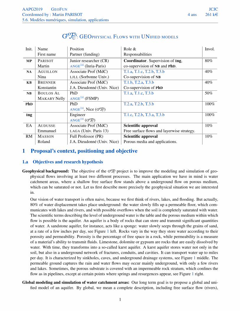
Our vision of water transport is often naive, because we first think of rivers, lakes, and flooding. But actually,80% of water displacement takes place underground: the water slowly fills up a permeable floor, which com-municates with lakes and rivers, and with possible overflows when the soil is completely saturated with water.The scientific terms describing the level of underground water is the table and the porous medium within whichflow is possible is the aquifer. An aquifer is a body of rocks that can store and transmit significant quantitiesof water. A sandstone aquifer, for instance, acts like a sponge: water slowly seeps through the grains of sand,at a rate of a few inches per day, see Figure 1 left. Rocks vary in the way they store water according to theirporosity and permeability. Porosity is the percentage of free space in a rock, while permeability is a measureof a material’s ability to transmit fluids. Limestone, dolomite or gypsum are rocks that are easily dissolved bywater. With time, they transforms into a so-called karst aquifer. A karst aquifer stores water not only in thesoil, but also in a underground network of fractures, conduits, and cavities. It can transport water up to milesper day. It is characterized by sinkholes, caves, and underground drainage systems, see Figure 1 middle. Thepermeable ground captures the rain and water flows may occur mainly underground, with only a few riversand lakes. Sometimes, the porous substrate is covered with an impermeable rock stratum, which confines theflow as in pipelines, except at certain points where springs and resurgences appear, see Figure 1 right.
Global modeling and simulation of water catchment areas: Our long term goal is to propose a global and uni-fied model of an aquifer. By global, we mean a complete description, including free surface flow (rivers),
1
AAPG2019 GEOFUN
Coordonned by : Martin PARISOT5.6. Modèles numériques, simulation, applications
JCJC4 ans 261 ke
Figure 1: Left, a porous aquifer in Utah, with many visible wet areas (dark zone). Middle, a karst landscape inHérault, with many visible caves. Right, the source of the Loue, which is a resurgence of the Doubs. (source:Wikipedia)
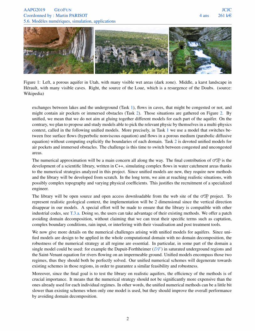
exchanges between lakes and the underground (Task 1), flows in caves, that might be congested or not, andmight contain air pockets or immersed obstacles (Task 2). Those situations are gathered on Figure 2. Byunified, we mean that we do not aim at gluing together different models for each part of the aquifer. On thecontrary, we plan to propose and study models able to pick the relevant physic by themselves in a multi-physicscontext, called in the following unified models. More precisely, in Task 1 we use a model that switches be-tween free surface flows (hyperbolic nonviscous equation) and flows in a porous medium (parabolic diffusiveequation) without computing explicitly the boundaries of each domain. Task 2 is devoted unified models forair pockets and immersed obstacles. The challenge is this time to switch between congested and uncongestedareas.
The numerical approximation will be a main concern all along the way. The final contribution of GEoFUN is thedevelopment of a scientific library, written in C++, simulating complex flows in water catchment areas thanksto the numerical strategies analyzed in this project. Since unified models are new, they require new methodsand the library will be developed from scratch. In the long term, we aim at reaching realistic situations, withpossibly complex topography and varying physical coefficients. This justifies the recruitment of a specializedengineer.
The library will be open source and open access downloadable from the web site of the GEoFUN project. Torepresent realistic geological context, the implementation will be 2 dimensional since the vertical directiondisappear in our models. A special effort will be made to ensure that the library is compatible with otherindustrial codes, see T.3.a. Doing so, the users can take advantage of their existing methods. We offer a patchavoiding domain decomposition, without claiming that we can treat their specific terms such as captation,complex boundary conditions, rain input, or interfering with their visualisation and post treatment tools.
We now give more details on the numerical challenges arising with unified models for aquifers. Since uni-fied models are design to be applied in the whole computational domain with no domain decomposition, therobustness of the numerical strategy at all regime are essential. In particular, in some part of the domain asingle model could be used: for example the Dupuit-Forthheimer (DF ) in saturated underground regions andthe Saint-Venant equation for rivers flowing on an impermeable ground. Unified models encompass those tworegimes, thus they should both be perfectly solved. Our unified numerical schemes will degenerate towardsexisting schemes in those regions, in order to guarantee a similar feasibility and robustness.
Moreover, since the final goal is to test the library on realistic aquifers, the efficiency of the methods is ofcrucial importance. It means that the numerical strategy should not be significantly more expensive than theones already used for each individual regimes. In other words, the unified numerical methods can be a little bitslower than existing schemes when only one model is used, but they should improve the overall performanceby avoiding domain decomposition.
2
AAPG2019 GEOFUN
Coordonned by : Martin PARISOT5.6. Modèles numériques, simulation, applications
JCJC4 ans 261 ke
T.1.a
T.1.b
T.2.b
T.2.a
x
z
Figure 2: Scheme of aquifer and illustration of the classical configurations where each scientific issues occurs.Gray regions are impermeable soils, dotted regions are porous media and blue regions are water saturated.
1.b Position of the project as it relates to the state of the art
Unified and coupled models for aquifer modeling: At the scale of a drainage basin, hydrologists usually neglectthe fluid dynamic and focus on mass conservation with source (rain and evaporation) and exchange (betweencontrol volumes and strata levels) terms [16, 49]. In particular, the industrial code ModFlow1 is based onthis strategy [32]. Nowadays, it seems realist to take advantage of the increasing computation capacities tosimulate the fluid dynamics in drainage basin with a complete set of evolution equations. On the other hand,the industrial code Marthe2, see [47], performed 3D flow simulations [31]. For simulation at the scale ofthe drainage basin, this is unreasonable. The space scale involved is too large, the knowledge of the soilconstitution is too low and 3D numerical schemes are not robust enough in some multi-physics context. Theintermediate solution, based on reduced models, is largely used in geophysics, for example in Telemac3 ,Mike4 and ArcaDES5. Given that several types of dynamics occur in aquifers, there is not one reduced modelbut several, depending on the type of dynamics see Figure 2. In the GEoFUN project, we propose a unified modelthat automatically selects the relevant model adapted to the flow regime.
When a situation involves two different processes, it is usually modeled by using two different sets of equationscoupled by interface conditions. For aquifer, the two main models are, first, the shallow water (or Saint-Venant)equations [21] {
∂th +∇ · (hu) = 0
∂t (hu) +∇ ·(hu⊗ u+
g
2h2Id
)= −gh∇B (SW )
where h is the total height of the water column and u is its mean horizontal velocity. It is the set of equationsused in the industrial code Telemac3 for the estimation of the flooding areas in particular by the SCHAPI6.The second model is only relevant when the flow occurs entirely underground. The Darcy model is firstlyobtain considering a Stokes regime. However, this model is three dimensional and it is not suitable for large
1 Modular Hydrologic Model (USGS7) . . . . . . . . . . . . . . . . . . . https://www.usgs.gov/software/modflow-6-usgs-modular-hydrologic-model2 Software for modelling underground flows (BRGM8)
plop http://www.brgm.fr/production-scientifique/logiciels-scientifiques/marthe-logiciel-modelisation-ecoulements3 Integrated suite of solvers for use in the field of free-surface flow (EDF9) . . . . . . . . . . . . . . . . . . . . . . . . . . . . . . . . . . . http://opentelemac.org4 Integrated catchment modeling (DHI) . . . . . . . . . . . . . . . . . . . . . . . . . . . . . . . . . . . . https://www.mikepoweredbydhi.com/products/mike-she5 (formerly Dionisos) Stratigraphic modeling (IFPEN10) . . . . . . . . . . . . . . . . . . . . . . . . . http://www.beicip.com/stratigraphic-modeling-06 Service central d’hydrométéorologie et d’appui à la prévision des inondations
plop https://www.data.gouv.fr/fr/organizations/service-central-dhydrometeorologie-et-dappui-a-la-prevision-des-inondations
3
AAPG2019 GEOFUN
Coordonned by : Martin PARISOT5.6. Modèles numériques, simulation, applications
JCJC4 ans 261 ke
scale modeling. Then considering the Dupuit-Forcheimer approximation, the following model is obtained [25]
∂th−∇ ·(κh∇
(S + h
))= 0, (DF )
with h is the total height of underground water. Note that the Dupuit-Forcheimer model (DF ) can also beobtained from (SW ) as a large limit friction and with a friction coefficient proportional to the water depth.
In the areas where the two models overlap, i.e. near rivers and lakes, the classical approach is to couple bothmodels by defining vertical exchanges with transmission conditions, see [45]. The advantage of this approach,called domain decomposition is that both models are well understood and that numerical schemes are available.However, we immediately see two drawbacks of coupled models. First, the transmission conditions are noteasy to define in practice. Second, the regions where the flow is totally underneath the surface are solvedwith (DF ), while the rivers, lakes or flooded areas are solved with the coupling (SW )-(DF ). It is clear that inmany situations (violent thunderstorms, melting snow season or dam openings to name a few), the boundariesbetween the two regions evolve with time, possibly quite rapidly. In this case of moving interfaces appearingand disappearing during the simulation, the domain decomposition strategy can fail or the performance of thecode can drop [39].
Our approach is based on unified models, i.e. models that are able to automatically select the process involvedwithout using complex tools such as automatic domain decomposition. In our case, it means we only have oneunknown for the water height h = h + h, and that the model and scheme switch from dry regions (h = 0,h ≤ B) and wet regions (h > 0, h = B) without any intervention of the user, see Task 1. The contemplatedstrategy is based on an adaptation of the layerwise vertical discretization [5] for which some team membersare specialists [1, 2, 8].
In a completely a priori different context, which in fact also arises in aquifer modeling, unified models arewell adapted to the treatment of immersed obstacles and air pockets. On Figure 2 in the congested regions, i.e.the regions where the flow reach an impermeable above surface, h is no longer an unknown but the surfacepressure above the fluid is an unknown. However, the boundary of these regions varies in time because ofthe flow then it is difficult to solve with domain decomposition. Once again, the use of the unified modelsof Task 2 allow to bypass the tedious and costly computation of the borders between the two subdomains.Recently, team members propose and analyse new numerical scheme in such context [6, 10].
For this very reason, unified models strategies are particularly well-adapted to situations with complex inter-faces such as contact front, or with complex transmission conditions such as infiltrations. In such models, theinterfaces between the two subdomains are encoded either by a constraint on the solution, or by an automaticvariation in the number of unknowns. This simplification impacts the numerical approximation. Indeed, whenusing two different models, the implicit interface definition makes the domain decomposition hard to set upand not efficient in practice. With unified models, the same set of equations is solved on the whole domain,the model chooses itself the relevant physic and the physical interfaces are recovered a posteriori.
To increase the dissemination of our results, we plan to share with other communities. The team use toexchange on this subjects with : USGS7 BRGM8, EDF9 and IFPEN10. In addition, the conference planned at theend of the project may be co-organised with other ANR with connected projects. In particular, the JCJC ANR
BEMA11 on the river’s bed evolution with multilayer models and the JCJC ANR FRAMATI12 on the fracturesalteration and to develop predictive capabilities of reactive multi-phase flow in complex geological formations.
7 U.S. Geological Survey . . . . . . . . . . . . . . . . . . . . . . . . . . . . . . . . . . . . . . . . . . . . . . . . . . . . . . . . . . . . . . . . . . . . . . . . . . . . . . . . https://www.usgs.gov8 Bureau de Recherches Géologiques et Minières . . . . . . . . . . . . . . . . . . . . . . . . . . . . . . . . . . . . . . . . . . . . . . . . . . . . . . . . . . . https://www.brgm.fr9 Électricité de France . . . . . . . . . . . . . . . . . . . . . . . . https://www.edf.fr/groupe-edf/qui-sommes-nous/activites/recherche-et-developpement
10 L’Institut Français du Pétrole et Énergies Nouvelles . . . . . . . . . . . . . . . . . . . . . . . . . . . . . . . . . . . . . . . . . . https://www.ifpenergiesnouvelles.fr11ANR ANR BEMA axe 5.6 coordinated by Maria Kazeloa (INRIA CARDAMOM) . . . . . . . . . . . . . . . https://mskazolea.wixsite.com/personal.12ANR ANR FRAMATI axe 2.1 coordinated by Cyprien Soulaine (BRGM8) . . . . . . . . . . . . . . . . . . . . . . . . . https://www.cypriensoulaine.com.
4

AAPG2019 GEOFUN
Coordonned by : Martin PARISOT5.6. Modèles numériques, simulation, applications
JCJC4 ans 261 ke
What we won’t do: An easy way to fix all the problems at once would be to solve the Navier-Stokes equationseverywhere, with a very small friction coefficient above ground and in the caves, a large one in porous un-derground regions, and a infinite one in the obstacles. This is completely unreasonnable from the practicalpoint of view. Indeed, it would mean a full 3D simulation, while (SW ) and (DF ) are only 2D since theyare integrated along the vertical direction, and sufficient for our application. For numerical performance, itis of crucial importance that the unified model does not dramatically exceed the complexity of related clas-sical ones. For this reason the GEoFUN project is not about solving finer model such as Navier-Stokes equationsinstead of the much simpler Shallow-Water or Dupuit-Forchheimer equations. On the contrary, we plan tostick with reduced models, in particular vertical-averaged, which are widely used for geophysical flows. Welook for a unique integrated-type model valid on the whole space domain and leading to the Shallow-Water orthe Dupuit-Forchheimer equations depending on the solution state. Similarly for air pockets and obstacle, theproposed models and scheme will be vertically integrated.
Hopes and fears: Compared to the domain decomposition methods that are commonly used in geophysical con-texts, the main advantages of unified models are the following. First, the continuous and numerical analysisseem easier – at least for strong solutions – because with unified models the spatial domain does not vary withtime. The counterpart is the introduction of stiff source terms which are active when a condition is satisfied.It raises many new questions: do we recover the classical model in each particular context (asymptotic analy-sis)? Can we numerically solve the unified model in such a way that classical schemes are used away from theinterfaces (asymptotic preserving scheme)? We intend to tackle both questions, that are also present in floodflows and renewable marine energy models.
Let us briefly described some numerical challenges. In Task 1, an implicit code is required in the undergroundregions to overcome severe time-step restriction. This implicit treatment should, by definition of unified mod-els, communicate without creating oscillations and by itself with the explicit treatment for the free surfaceflows. It also means that large nonlinear systems should be solved. The main question is whether they willbe much larger in unified models. We have some idea to limit the size and the complexity of those nonlinearsystems, see T.3.a.
Eventually, concerning software development, the implementation should be easier with the unified modelstrategy and the performance should be improved since the memory allocation should be more stable. Finally,practical applications should be easier to carry out since the interfaces between the two physics do not need tobe described.
1.c Methodology and risk management
The project is divided in three independent tasks that have both interests and applications on their own. In thesequel, we detail the models they are based on (with some simplifications for readability). The first taskconcerns two unified models englobing (SW ) and (DF ). The second task focuses on the possible presence ofair pockets and obstacles. The geological framework of each tasks is coarsely illustrated in Figure 2. Both ofthem will be part of the GEoFUN library. The last task focus on the valorisation of the work realized on the two firsttasks. More precisely, we plan to realize an interfacing of the GEoFUN library with at least one of the industrialcodes that is largely used in the applicative community. In addition, a closure workshop will be organized atthe end of the project. The development and analysis of associated numerical methods will be done alongsidethe analysis of the models. The contemplated strategies and test cases for their validations are described onindependent subtasks.
Unfortunately, the validation of such models by comparison with measures is difficult. The main reason isthe lack of significant data to estimate the parameters such as the permeability and the porosity of the porousmedium. In addition, measures are expensive to produce. However, in many cases, analytical solution can beobtained for 1D steady flow by Bernoulli’s principle. The energy dissipation then yields an ODE that can besolved, or at least approximated at the error machine. The numerical strategies will be validated first on simple1D test cases, where some are presented further.
5

AAPG2019 GEOFUN
Coordonned by : Martin PARISOT5.6. Modèles numériques, simulation, applications
JCJC4 ans 261 ke
The two tasks put together and extended to 2D allow the simulation of complex configurations of realisticwater catchment. Then we plan to compare our results with existing strategies in the literature on well-knownconfigurations, in particular thanks to the UMR METIS13 see [27, 30] for example. This will be done with thesupport of Ing.
In the following, several models are written to describe more precisely the objectives and methods that wecontemplate in the project. These models are simplified in this documents for readability and are not math-ematically justified since it is a aim of the project. More precisely, several important physical processes areneglected such as the porosity of the porous medium, the viscosity of the fluids, the surface tension and masssource terms (rain and evaporation). These processes will be as possible considered in the following project.
Task 1 – Unified modeling for free aquifers: The objective of this task is to propose a unified framework forfree surface and underground flows in a context of geophysical flows, i.e. for large time and space scales.The hydrodynamical modeling of a catchment area requires the modeling of several processes (more detailsbelow). Thanks to the unified modeling, we propose a model of water circulation on a drainage basin with noempirical laws (at least for the first model) and no domain decomposition.
T.1.a – A unified shallow-water/Dupuit-Forchheimer model Contributors: MP, NA, NB, EA
This work focuses on the modeling and approximation of a flow which is partially above and below ground.One should think of a river flowing on sand, which can disappear below the sand during dry seasons. In thesimplified case where the interface between the free surface flow and the underground flow is vertical (fullypenetrating river) and well determined, transmission condition can be given [40]. Unfortunately, the flow issometime completely underground, sometimes only above it when the ground is impermeable, and more oftencomposed of both types of flows.
When the interfaces between dry and wet regions rapidly change with time, the domain decomposition is nota good fit for numerical simulation. Here we propose a unified model based on a two-layer modeling withmass exchange in the spirit of [5, 43]. It is derived by integrating the incompressible Euler equations with dragforce between the impermeable substratum S and the surface of the water η. The surface of the water is eitherunderground, and it correspond to the so-called water table, either over the porous medium and correspondto the so-called free surface. Because of the variation of the media (porous or free surface), the integration issplit in two part, an exchange term between the underground layer and the above ground layer appears thatguarantees the mass conservation. The main difference with the bilayer model [5] is that the ratio between thelayers is not fixed but depends on the depth of the porous medium. Another difference is that the above layercan vanish. We end up with the following model, currently studied in the thesis of NB
∂th +∇ ·(hu+ hu
)= 0,
∂t (hu) +∇ · (hu⊗ u) = −gh∇ (B + h)− UG,∂t(hu)
+∇ ·(hu⊗ u
)= −gh∇
(S + h+ h
)+ UG− g
κhu,
(SW2)
where h is the total water depth, u is the mean velocity of the fluid in the surface layer and u is the meanvelocity in the underground layer of conductivity κ. The mass exchange G is defined by G = ∇ · (Bu)1h>Bto ensure total mass conservation, h = min(B, h) is the water height in the porous medium and h = h− h isthe thickness of the free surface flow. Eventually, the velocity at the interface U must be defined from the othervariables. The proposed closure yields an energy dissipation inversely proportional to κ, as expected from theincompressible Euler equations with drag force. This work is well under way and their is strong indicationsthat (SW2) is hyperbolic. This part of the project will be achieved by the beginning of GEoFUN. It is presentedhere as it is the base for our future work.
Model (SW2) is strongly linked with (DF ). Indeed, a formal Taylor expansion for the small conductivity limit13 Milieux environnementaux, transferts et interactions dans les hydrosystèmes et les sols . . . . . . . . . . . . . . . . . . https://www.metis.upmc.fr
6
AAPG2019 GEOFUN
Coordonned by : Martin PARISOT5.6. Modèles numériques, simulation, applications
JCJC4 ans 261 ke
κ→ 0 yields the following κ2-approximation:{∂th +∇ · (hu) =∇ · (κh∇ (S + h))
∂t(hu) +∇ · (hu⊗ u+g
2h2Id) = −gh∇B − u∇ ·
(κ2h∇(S + h)
)1h>B
(SW/DF )
This model is able to recover the free surface regime (SW ) and groundwater regime (DF ), with only twoequations and without interface conditions. More precisely, assuming that h < B − S, then h = 0 and thefirst equation is nothing but (DF ), while the second one is trivial. If B = S, h = 0 and we recover (SW ).Considering that∇ · (κ2h∇(S + h))) as a nonclassical friction law, we can analyse (SW/DF ) with parabolictools (Galerkin methods). However since this coefficient changes sign, the dissipation of mechanic energy,based on the methods of analysis for the parabolic models, is not straightforward.
For applications at large time scale such that pollutant advection or groundwater pumping in a lake, the low-Froude limit of (SW/DF ) is relevant. We obtain a linear set of two equations, which can be simulated overlarge periods of times. For other applications where gravity waves are important, (SW2) or (SW/DF ) shouldbe kept.
Risk: The risk of this subtask is low. Both models fall under the expertise of the team both from the analytical andnumerical point of view (see T.1.c). The main tools are the layerwise approximation and a Hilbert expansion,which are both well-undestood by the team. Moreover, NB has already started and is making progress. Thereis a possible difficulty with the dissipation of the mechanical energy in (SW/DF ), but it should be possible topreserve this property of (SW2) may be adding terms is order of κ2.
T.1.b – Consideration of unsaturated areas Contributors: MP, KB, RM
Models (SW2) and (SW/DF ) are valid when the porous medium is saturated, i.e. when the soil is completelysoaked with water in its lower part and dry in the upper part. It may also happen under the river bed in the caseof “loosing disconnected river”, whose bottom are covered with a thin layer of almost impermeable sediment,or when sea waves impact permeable dikes and sand dunes. The flow above the groundwater table has to bemodeled.
More precisely two phenomena have to be represented, the first one is the flow of water under unsaturated(unpressurized) condition, the second is an appearance and evolution of a pressurized infiltration zone (orinfiltration front) connected to the ground interface. For example in flooding, the time of infiltration is largerthan the time scale of the event. Both phenomena can be modeled by Richards equation. Its coupling with 2Dsurface flow models has a long records and is still under discussion [17]. In general, Richards equation hasto be solved in three-dimensional a domain, including or excluding water under the groundwater table, this ishowever is undesirable from the computational point of view.
One difficulty to establish a unified model with the Richard equation is that it is not a vertical-integrated model.Once again, we do not want to increase the complexity of the model by using a 3D grid as it is done in [42].Since the flow above the groundwater table, both in the unsaturated zone (excluding probably the capillaryfridge) and in the infiltration zone is essentially vertical, see Figure 1 left, unidimensional approximation ofRichards equation have been made. That reduces the Richards equation to a transport equation in the verticaldirection. Using analytical solution of the transport equation, even in the case of variables physical parameters(porosity and permeability), the unsaturated areas on the porous medium are modeled by a time delay betweenthe loss of the free surface flow and the gain of the underground flow. This time delay τ depends on thethickness of the unsaturated underground, and appears in the exchange term G in (SW2). The model reads
∂th +∇ · (hu) = −G (t, x)
∂t (hu) +∇ ·(hu⊗ u+
g
2h2Id
)= −gh∇B − u
2G (t, x)
∂th − ∇ ·(κh∇
(S + h
))= G (t− τ, x)
τ ≈ max
(0,B − S − h
κ
) (SW/R/DF )
7

AAPG2019 GEOFUN
Coordonned by : Martin PARISOT5.6. Modèles numériques, simulation, applications
JCJC4 ans 261 ke
Simple but physically relevant infiltration function G(t, x) must be given.
Even if the water depths of each layers are not directly connected, (SW/R/DF ) is a unified model since thesame model is used everywhere. When the flow is entirely at the surface (S = B), the model degenratestowards (SW/R/DF ). When the underground is saturated (h ≥ B − S), the previous model (SW/DF )is recovered. In other words, (SW/R/DF ) automatically switches between three different models with nooutside intervention of the user.
Risk: Up to our knowledge, Model (SW/R/DF ) is completely new. There is no analysis and no numericalscheme whatsoever. With the expertise of KB, we are confident that we can justify rigorously this modelfrom the Richards equations and (SW2). The main difficulty lies in the derivation of time delay τ , because ofthe time variation of the groundwater table. In terms of analysis, with no expert on delayed equation on theteam, Model (SW/R/DF ) represents a challenge. However, we are mainly interested in the simulation. Theeffective computation of the delay time is of course a main concern, but with two scientific calculus experts onthe team (MP and KB), we consider the risk to be medium with a high benefit.
T.1.c – Numerical schemes for unified models of free aquifers Contributors: MP, NA, NB, Ing, EA
The numerical approximation of (SW2) is part of the PhD of Nelly Boulos Al Makary and will start in2019/2020. Little difficulties is expected here, at least when h > B, even though this it not a trivial ex-tension of existing work. Layerwise models such as (SW2) is a speciality of the inria project-team ANGE14
(MP, NA, EA), see [5]. The resolution used so far is based on the fact that the ratio of the layer thickness isconstant in space, which does not hold for (SW2). On the other hand, splitting strategies where each layerare first solved separately and the exchanges are computed in a second step leads to an ill-posed problem andnumerical instabilities. Following [1], we plan to use the total water depth h+ h, the total discharge hu+ huand the shear u−u2 as the numerical unknowns. This choice leads to a more robust formulation.
Concerning (SW/DF ), the main challenge is that it is a mixed hyperbolic/parabolic problem. If we use aexplicit scheme, as it is classically done for the shallow water model, the parabolic part of the equation yieldsa unacceptable CFL condition on the time step. At the same time, a fully implicit scheme on the fives unknowns(one for the water depth and two components for the velocities in each layer) yields a large non-linear systemtoo costly to be solved. Thus we will use an IMEX (implicit-explicit) scheme where only the water depth isimplicitely solved. It reduces the size of the nonlinear system and the velocity can be computed explicitely.
Another possible strategy is to split the system between of the hyperbolic part, treated explicitly, and theparabolic part, treated implicitly. Both methods have already be used by the coordinator, see [14, 15]. A specialattention we be paid to the numerical energy dissipation, which is a strong argument for numerical stability.If needed we will consider subcycling the explicit part of the resolution [3, 23]. More precisely, the splittingstrategy discuss above introduce two steps. One is hyperbolic, quite cheap, fitted for parallelization, but has arestriction on the time step (for stability). One is parabolic, expensive (nonlinear system) but unconditionallystable. The subcycling strategy consists in resolving the parabolic step over a large time step and the hyperbolicpart several times until the large time step is reached without violating the stability condition.
The last step is the resolution of (SW2) in the regime of low conductivity, i.e. κ → 0. We will propose anasymptotic preserving scheme that captures the correct limit (SW/DF ), with a control on the time step thatdoes not explode. This question is more difficult than the case where κ is fixed, since classical schemes fail torecover the good solution at all regimes [33]. The strategy analysed for the p-system in [18] could be adaptedto (SW2).
Last but not least, the (SW/R/DF ) model will be considered. From the numerical point of view, the pro-posed simplification of the Richards equation should have many benefits. First the simulation is only 2Dand we avoid the expensive computational cost of a vertical discretization. Second, several problems of con-vergence of the iterative process were observed in the interface coupling between the Richards equation and
14Numerical Analysis for Geophysics and Environment . . . . . . . . . . . . . . . . . . . . . . . . . . . . . . . . . . . . . . . . . . . . . . . . . . . https://team.inria.fr/ange
8

AAPG2019 GEOFUN
Coordonned by : Martin PARISOT5.6. Modèles numériques, simulation, applications
JCJC4 ans 261 ke
the Dupuit-Forcheimer model, see [17]. The counterpart is the delay time in the source term that introducesnew difficulties. Numerically this delay requires some time integrations, which increases the computationmemories. In addition, it is not clear how to ensure the mass conservation at the discrete level. Finally, wewould like to recover the numerical scheme designed for (SW/DF ) when the whole porous medium is sat-urated. The question is not trivial since the two water depths h and h are independent in (SW/R/DF ) butnot in (SW/DF ) where we only have one equation for the total water height h = h + h. To overcome thisdifficulty, it might be interesting to deduce, starting from (SW/R/DF ), an equation on h and one on B − hto reconstruct two water heights.
The proposed numerical methods require the resolution of non-linear systems. Such problem are solved usingan iterative process where at each step a linear system is solved. To obtain efficient numerical schemes for thelarge space scale coming from our applications, we need to improve their resolution. To reduce the number ofiterations of the iterative process, a Newton scheme will be analyse to obtain (ideally) a quadratic convergencefor the iterative resolution of the non-linearity. Their convergence will be analyzed following the strategy pro-posed in [6] and a posteriori estimate will be studying to propose pertinent convergence criterium. To solve thelinear system at each step, a parallelized scientific library such are PETSc15, MUMPS16 or MKL17 will be used.
Validation cases: Our team of numerical analysts won’t resist to try toprove that the schemes have good properties (positivity of the waterheight, energy dissipation, ...). The validation will also be achievedby comparison with analytical and experimental solutions in one di-mension. An important test case is the exchanges between a porousmedium and a sea via an inclined beach, see figure opposite. In lowtide, the water goes from the porous medium to the sea, while it isfilled by the waves in high tide. The “lake at rest” equilibrium statewill be tested, as well as the asymptotic stability when (SW/DF )goes to (SW ) or (DF ).
x
zη
B
S
(SW/DF )
(SW )(DF )
x
zη
B
S
(SW/DF )
(SW/R/DF )
(DF ) (DF )
Then, we will examine the case of a lake with its drainage basin emp-tying and filling, see figure opposite. With this test case, we will treatthe time delay in the mass exchanges and test the robustness of thenumerical strategy. The solution of (SW/R/DF ) will be compareto (SW/DF ) and to the models in the literature [17]. We expectthat the evolution of the dry front h = 0 to be noticeably affected bythe delay, in particular when we consider incoming waves impactingthe banks. Eventually, the good behavior of the numerical strategyfor (SW/R/DF ) will be partially validated if, at the limit τ = 0, theresult of (SW/DF ) are recovered.
Numerical simulations in two dimensional framework will also be performed. First of all, it will validatethe implementation of the strategy in the scientific computing library. In addition, it will allow to investigatethe computational cost of the method on large mesh. We expect to design the 2D numerical test cases incollaboration with hydrologists, from BRGM8, EDF9 or IFPEN10.
Risk: Concerning the two schemes for (SW2) and (SW/DF ), we are confident that they can be derived and im-plemented quite rapidly with little difficulties. Obtaining an all regime scheme for (SW2) is more challenging.The literature on asymptotic preserving schemes [18, 19, 20] is vast and will provide some leads.
The risk is higher for (SW/R/DF ), since ressources needed to compute the time delay are unknown at thisstage. It is also unclear whether we can find a strategy consistent with (SW/DF ) if the porous medium is
15Portable, Extensible Toolkit for Scientific Computation . . . . . . . . . . . . . . . . . . . . . . . . . . . . . . . . . . . . . . . . . . . . https://www.mcs.anl.gov/petsc16MUltifrontal Massively Parallel sparse direct Solver . . . . . . . . . . . . . . . . . . . . . . . . . . . . . . . . . . . . . . . . . . . . . . . . . . . . http://mumps.enseeiht.fr17Math Kernel Library by Intel . . . . . . . . . . . . . . . . . . . . . . . . . . . . . . . . . . . . . . . . . . . . . . . . . . . . . . . . . . . . . . https://software.intel.com/en-us/mkl
9

AAPG2019 GEOFUN
Coordonned by : Martin PARISOT5.6. Modèles numériques, simulation, applications
JCJC4 ans 261 ke
saturated. We strongly believe that (SW/R/DF ) is a very flexible model with a large domain of validity,thus it seems worthy to tackle this question in depth. Another key point is the treatment of dry areas at thenumerical level, i.e. the transition around η = B and η = S. There is some similarity with earlier work [5], sonone of this seems out of reach.
Another main question is the one of 2D implementation and of efficiency. MP and KB are familial with thoseissues and we will have the support of Ing.
To conclude, this part of the work should go smoothly in the beginning, with some interesting and reachablequestions and direct applications. The models are quite original and earlier works pave the way to theirsimulations. Stakes and difficulties raise in the second part of the work.
Deliverables of Task 1: The main deliverable is the first part of the GEoFUN library. The models and methods will bepresented in peer-reviewed papers. A reasonable and yet optimistic plan might be• Beginning of 2020 (T.1.a): Derivation of (SW2) by vertical-averaging and analysis using hyperbolic meth-
ods. Derivation of (SW/DF ) as a low permeability limit. If possible, analysis of (SW/DF ) withparabolic methods.
• End of 2020 (T.1.c): Analysis and implementation in 1D of a numerical schemes for (SW/DF ) based onCPR scheme [15] and/or splitting strategy [23]. Analysis and implementation in 1D of an asymptoticpreserving schemes for (SW2) with κ-independent CFL condition recovering once of the scheme studiedfor (SW/DF ).
• Beginning of 2021 (T.1.b): Derivation of (SW/R/DF ) using analytical solution of the transport equation.If possible, analysis of (SW/R/DF ) with previous results on (SW/DF ) and classical results on transportequations.
• End of 2021 (T.1.c): Analysis and implementation in 1D of a numerical schemes for (SW/R/DF ) withthe development of adapted nonlinear solvers.
• End of 2021 (T.1.c): First part of the GEoFUN library. Implementation in 2D of the numerical strategy validatedin the previous works. Validation on a realistic 2D situation, for example in the basin of the Somme river[30], using the GEoFUN library.
Task 2 – Unified modeling for confined aquifers: The objective of this task is to improve the previous modelingof drainage basin to more realistic geological configuration. It allows to tackle two new situations: porousaquifer that are blocked by impermeable layers of sediments, and transport of water in underground networksof conduits and cave, see Figure 2. In both cases the flow becomes congested when the water height reachesthe impermeable roof. It is clear that the boundaries between congested and uncongested areas evolves withtime, with possible topological changes. This makes the use of unified models particularly well adapted forthere fast and robust numerical approximation.
In the last few years, two congested models were considered by the team: The Richards model [6] and thecongested Shallow-Water model [10] that leads to the congested Dupuit-Forcheimer model for small enoughhydraulic conductivity. The latter is the simplest one and reads∂th−∇ ·
(κh∇
(S + h+
p
g
))= 0
min(H − h, p
)= 0
(DFC)
The additional unknown p(t, x) is the surface pressure due to the roof. From the second equation of (DFC), wesee it is null if and only if the water depth is smaller to the opening H(x) and leads to (DF ) in such situation.At the present stage, the main drawback of those models are do not take into account the air phase see T.2.a, andto not allowed second flow above the “roof” see T.2.b. These questions arise for both flow regimes considered,i.e. free flow in karst networks and in porous media for confined aquifers. In the following, we illustrate ourremarks with equations from porous media for simplicity, but both cases will be considered in the project.
10
AAPG2019 GEOFUN
Coordonned by : Martin PARISOT5.6. Modèles numériques, simulation, applications
JCJC4 ans 261 ke
T.2.a – Consideration of air pockets Contributors: MP, KB, PhD, EA, RM
In an underground network, air pockets may be blocked in cavities. They can act as an obstacle that blocks thewater flow. These air pockets can have a major influence on the flow, first because they can block the flow byoccupying the free space, second because without their modeling, unphysical "vacuum" pockets can appear.These situations cannot be described with the existing models of congested shallow water [10] or congestedDupuit-Forcheimer model (DF ) since the conservation of air is not taking into account.
Since the air phase is compressible, an equation of state linking the density to the pressure is required. Startingfrom a two-fluid compressible/incompressible (respectively for air and water) Navier-Stokes equations, weplan to derive a two-fluid compressible/incompressible vertically-averaged model. Note that there alreadyexists a two-fluid compressible/incompressible vertically-averaged model [22] that can be a good startingpoint. Its version at the limit of low permeability, i.e. (DF )-like, reads∂th−∇ ·
(κh∇
(S + h+
p+ p̊
g
))= 0
min(h−H, p
)= 0
(DFap)
where we passed over in silence the equations on the air phase of density ρ, except that the pressure at theinterface p̊(ρ) is a given function of it (for exemple with and ideal gas law). This mixed gas-liquid Dupuit-Forchheimer model is interesting in term of modeling and analysis, for which theoretical results and efficientnumerical strategies are well understood [7].
The time step restriction to simulate the two-fluid model is driven by the dynamic of the air phase, which ismuch faster than the dynamic of liquid phase. As we are ultimately interested in the latter, we can reduce thecomplexity of the model by assuming that the air phase is instantly at equilibrium (quasi-static equilibrium).Doing so, ρ is no longer an unknown but can be deduce from p̊ which is given by the Laplace law p̊V γ = C,with V the volume of the air pocket, γ > 0 the polytropic index and C a constant by air pockets. Note that theLaplace law is non-linear and non-local since the volume V is computed from the free space above the tableand the roof, i.e. V =
∫air pocket
(H − h
)dx. In addition, the support of the air pocket in not completely clear
since it is defined as connected areas (there may be several air pockets).
From the numerical point of view, this model is attractive since we can take large time step and rely on theexisting methods developped in [6, 10]. However, the numerical treatment of the Laplace law is a challenge.Indeed, the constant C depends on the air pocket at the previous time step. Thus it is difficult to determine thecorrespondence between air pockets from one time step to the other, in particular in multi-dimension frame-work. Another difficulty arises when the topology changes, i.e. when air pockets split or merge. Preliminarydiscussions with colleagues indicate that this is a typical problem in optimal transport. We plan to applyin-hands numerical strategies of the literature [41, 44].
The next question is how of the computation of the air pockets volume will impact the resolution of our linearsystems. It is clear that a naive approach yields non-linear system with large and time dependent stencils,and unclear that the method will be effective enough for realistic application. A fine analysis of the iterativeproblem is planned to reduce the stencil of the linear system to the neighbor of each points. This strategy canlead to singular problem in case of coalescence of fragmentation of air pockets.
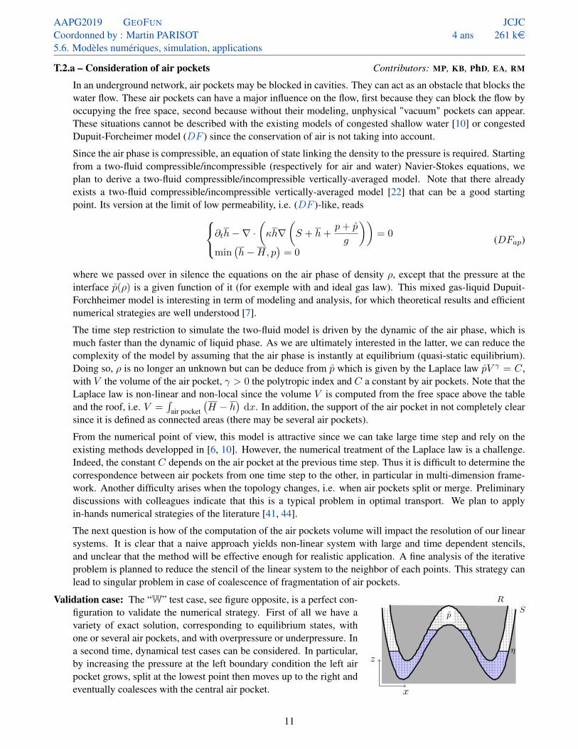
Validation case: The “W” test case, see figure opposite, is a perfect con-figuration to validate the numerical strategy. First of all we have avariety of exact solution, corresponding to equilibrium states, withone or several air pockets, and with overpressure or underpressure. Ina second time, dynamical test cases can be considered. In particular,by increasing the pressure at the left boundary condition the left airpocket grows, split at the lowest point then moves up to the right andeventually coalesces with the central air pocket. x
z
p̊S
η
R
11

AAPG2019 GEOFUN
Coordonned by : Martin PARISOT5.6. Modèles numériques, simulation, applications
JCJC4 ans 261 ke
Risk: This task is the most risky of the entire project. First, the modeling of the instant equilibrium model shouldbe carried out precisely. The case of a single air pocket no topological is a first step, in which we will focus onthe computation on V and its impact on the Newton procedure. For general configurations with merging andsplitting of air pockets, we will discuss and collaborate with numerical optimal transport experts, for exampleV. Duval (Inria-Paris). In the event where we fail at interpreting our problem as an optimal transport problem,we will use a nearest neighbor approach. In both cases, a thorough comparison with two-phases model [22]on 1D configurations will be made.
Any steps toward the modeling and simulation of trapped air pockets in congested models would be, in ouropinion, a big improvement compared to the state of the art. For example, the numerical validation of verticallyintegrated model, even on simple configurations, would have a deep impact on the community.
T.2.b – Consideration of submerged structures Contributors: MP, PhD, EA, RM
In underground, water circulates in a complex network composed by a superposition of permeable and im-permeable layers. A confined aquifer is the simplest configuration where such a case arises. More complexnetworks can be considered such as karst aquifer, where several horizontal conduits punctually linked with ver-tical chimneys can be observed. The modeling of such a complex geological structure is nowadays relativelycrude [16, 49].
We aim at modeling impermeable interfaces immersed in the flow in a vertically integrated model. Strategiesbased on boundary element method can be found in the literature [28]. This issue is hard with the integratedmodels, because the flow is assumed to be homogenous in the vertical direction. In vertically integratedmodel, the flow is assumed to be homogenous in the vertical direction, so something new should be done. Thelayerwise strategy [5] is actually propose to overcome this assumption in a context without structure, so wewill based our strategy on a similar approach. This time the intermediate altitude B coincides with the uppersurface of the impermeable strata, and H corresponds to the opening below it. Vertical exchanges between thelayers are impossible when they are separated by the impermeable strata
A Dupuit-Forchheimer like model reads∂th − ∇ · (κh∇ (B + h)) = −G (1− 1S)
∂th − ∇ ·(κh∇
(S + h+
p
g
))= G (1− 1S)
min(H − h, p
)1S = (p− gh) (1− 1S)
(DFS)
where S is the set of horizontal positions where the impermeable submersed structure is located. Away fromthe obstacle, i.e. when x /∈ S, Model (DFS) is very similar to T.1.a. The exchange termG is defined as in T.1.ato have total mass conservation, and the total water table height h = h + h is a monovaluated function. Inthat case the pressure p is the usual hydrostatic pressure. In the area x ∈ S, the lower layer is confined, andsomehow evolves independtly from the upper layer. Its altitude cannot exceed H , there is no pressure termcoming from the top layer, but a congested pressure applies if h = H .Validation cases: With (DFS), it is possible to have an uncongestedconfined aquifer below the impermeable strata (h < H) with a freeaquifer above it. It offers a simple model for groundwater pumping,where water is collected in the confined aquifer, creating a dry regionbelow the immersed obstacle. With time, water will coming from thetop layer will fill this gap. However, this water can come from quitefar away, as it cannot pass through the impermeable strata, see figureopposite. The dry area in the confined aquifer is some how unphysicalbut T.2.a should overcome this lock.
x
z
η
B
SS
pumping
Note that the number of unknows does not vary in time and space, i.e. at any point x ∈ S there is two degreesof freedom (for Dupuit-Forchheimer type model), the water thickness above and the pressure (if congested) or
12

AAPG2019 GEOFUN
Coordonned by : Martin PARISOT5.6. Modèles numériques, simulation, applications
JCJC4 ans 261 ke
the water thickness (if not) below the structure. This is the strength of unified models such as T.1.a and [6, 10].Away from the obstacle, the extension of the division by layers is artificial. In the case of a Dupuit-Forchheimertype model, there is no reason to extend this division. However, in the case of shallow water type model, inertiaeffect can create a shear in the vicinity of the structure. The layerwise model is theoretically required in thewhole domain however we plan to performed a numerical study to estimated the impact of the layerwise modelaway from the structure in such cases.
x
z
Validation cases (shallow water flow): A comparison with the nu-merical strategy of the literature [28] and with measurements [24] willbe made. In particular, we will thoroughly investigate how the con-tinuation of the division by layers impacts the precision of the model.The results will be used to implement a automatic strategy, so that theuser will not have any choices to do. Eventually, a validation on real-istic geometry of karst aquifer, see figure opposite, will be realized.
Risk: The risk of this task is quite low for the Dupuit-Forthheimer type model since it relies on models andschemes studied on Task 1. Still there required a not-trivial data structure for the numerical code, in particularfor several submerged structures. For shallow water flows in conduits and caves, the topological situation istrickier and the continuation of the division by layers may be a problem. Indeed it should follow the structurenear the obstacle (see dotted lines on the above figure) that is not clear in the multidimensional framework andmight yields some robustness issues.
Deliverables of Task 2: The outcome of this task is a second part of the GEoFUN library for the simulation of freesurface flow and groundwater in aquifer. The models and methods will be presented in peer-reviewed papers.A reasonable and yet optimistic plan might be• Beginning of 2021 (T.2.a): Derivation and analysis of the two-fluid air/water model and comparison with
[22]. Derivation of the non-local model as a quasi-static limit in the air phase. Design and analysis of anumerical strategy in the case without splitting or coalescence of the air pockets.
• End of 2021 (T.2.a): Implementation and if possible analysis of a strategy for the splitting or the coales-cence of the air pockets.
• Beginning of 2022 (T.2.b): Elaboration and implementation of a numerical strategy for the immersed struc-tures in porous media.
• End of 2022 (T.2.b): Improvement of the strategy to the shallow water case. Analysis of the sensibility ofthe layerwise discretization away from the structure.
• Beginning of 2023: Second part of the GEoFUN library. Implementation in 2D of the numerical strategy val-idated in the previous works. Validation on a realistic 2D situation, for example on the case studied in[27], using the GEoFUN library.
Task 3 – Interactions with other communities:
T.3.a – Interfacing with the numerical codes of the application communities Contributors: MP, Ing, EA, RM
The objective of this task is to provide a numerical library that can be used directly by the application commu-nities, i.e. hydraulicians and hydrologists, within the numerical framework they are used to using. Particularsource terms (rainfall, pumping, ...), boundary conditions (hydrograph, rating curve, ...), parameters estimation(friction, conductivity, porosity, ...) and computational tools (pre-treating data, visualisations ...) are alreadydeveloped and it is not our intention to replace them. To improve the integration of the work carried out,the interfacing of the GEoFUN library with at least one industrial code largely used in application communitieswill be realized. The hydrologic community is particularly targeted for applications in water resource, pump-ing, irrigation and pollutant transport, so the codes ModFlow1, Marthe2, ArcaDES5 can be considered. Inanother hand, the hydraulician community can also be interesting for applications in flooding or impacts oninfrastructure. The codes Telemac3 and Mike4 can be cited. The objective is not the complete interfacing
13
AAPG2019 GEOFUN
Coordonned by : Martin PARISOT5.6. Modèles numériques, simulation, applications
JCJC4 ans 261 ke
with the existing code but only a prototype to demonstrate the advantages of the methods developed. Closercollaborations with the above-mentioned companies may be proposed later on for deeper integration.
Two strategies of interfacing can be considered. The first strategy consists in replacing the computation kernelof the existing code by the computation library developed in the project. The main advantage of this strategy isthat does not required many development but it assumes that the data base and the boundary conditions of thecodes are similar or can be adapted to the one required for the methods developed in the project. The secondstrategy is based on a domain decomposition, where the methods developed in the project is only used in a partof the computation domain fixed by the user. The main advantage of this strategy is to be not invasive for theindustrial codes and it can be apply to almost any kind of data structure. However, it requires the developmentand analysis of a coupling interface strategy (Schwartz algorithm).
Risk: The risks of this task are of two kinds. The first is not scientific but collaborative. If we already have goodrelation with the mentioned compagnies, more precisely with BRGM8, EDF9 and IFPEN10, there is currently nocollaboration initiate. However, Telemac3 and Marthe2 are open-source codes so it is always possible towork with. The second risk is on the data base of the concerning codes. More precisely, if the data structure istoo different, the interfacing via the computation kernel can be not possible. Anyway, the domain decomposi-tion strategy can still be considered. However, this strategy can reduce the efficience of the computation. Onepossible way to limit this drawback is to study the merging the iterative process of the decomposition domainwith the treatment of the non-linear terms.
T.3.b – Workshop on the drainage basin modeling Contributors: MP, NA, KB, PhD, Ing, EA, RM
In addition to disseminating our results in workshops with related themes, a closure workshop with the aim ofpromoting the achievement of the project. All the cited communities and firmes will be invite to contribute.This workshop will also be an opportunity to identify other scientific locks, and we hope to build a team fora more interdisciplinary future projet. If possible, the workshop will co-organise with other scientists, forexemple ANR BEMA11 and ANR FRAMATI12, in order to increase its visibility.
Fall-back solutions: As presented, the tasks are all independent (except T.1.a). Among the other tasks, those thatpresent the most risk due to their unconventional approach are T.1.b and T.2.a. In the event of unplanned andinsurmountable lock, other tasks related to the project may be considered.
A.1 – Layerwise aquifers: To model the vertical variation of the parameters, in particular the porosity andthe conductivity, the layerwise strategy can be used. More precisely, we plan to discretize each physical layer(underground and free surface) by a set of artificial layers proportional to the thickness of the physical layer.Indeed, aquifer are generally vertically stratified because of the sediment deposit. Thus, we can derive similarmodels with several intermediate vertical stops to take into account the vertical variations of the conductivityκ, see [46]. In a similar fashion, the accuracy of the free surface flow can be improved. This is important forapplications with transport of pollutants (for water quality) or salt (for variable density [4, 35]).
A.2 – Fractured aquifers: In the current projet, fractured aquifers was not considered. Fractured aquifersdiffer from porous aquifers in that the flows that pass through them is not similar in any directions, introducinganisotropy in the models. A model of fractured aquifers can be derived as a limit of low-conductivity, see T.1.a,but starting from the porous shallow water model [29]. It leads to
∂th−∇ ·(hK ∗ ∇
(S + h
))= 0 (DFp)
where K (x) is the matrix of horizontal conductivity. The ∗-product is a convolution in the horizontal plane.This product stands for the vertical anisotropy of the model such that the pressure in a point is not proportionalto the table elevation at this point but along the fracture. Such kind of non-local heat equation is not trivial tosolve numerically but was already considered, for example in [11].
14
AAPG2019 GEOFUN
Coordonned by : Martin PARISOT5.6. Modèles numériques, simulation, applications
JCJC4 ans 261 ke
2019 2020 2021 2022 2023S1 S2 S1 S2 S1 S2 S1 S2 S1 S2
T.1.a
T.1.b
T.1.c
T.2.a
T.2.b
T.3.a
T.3.b
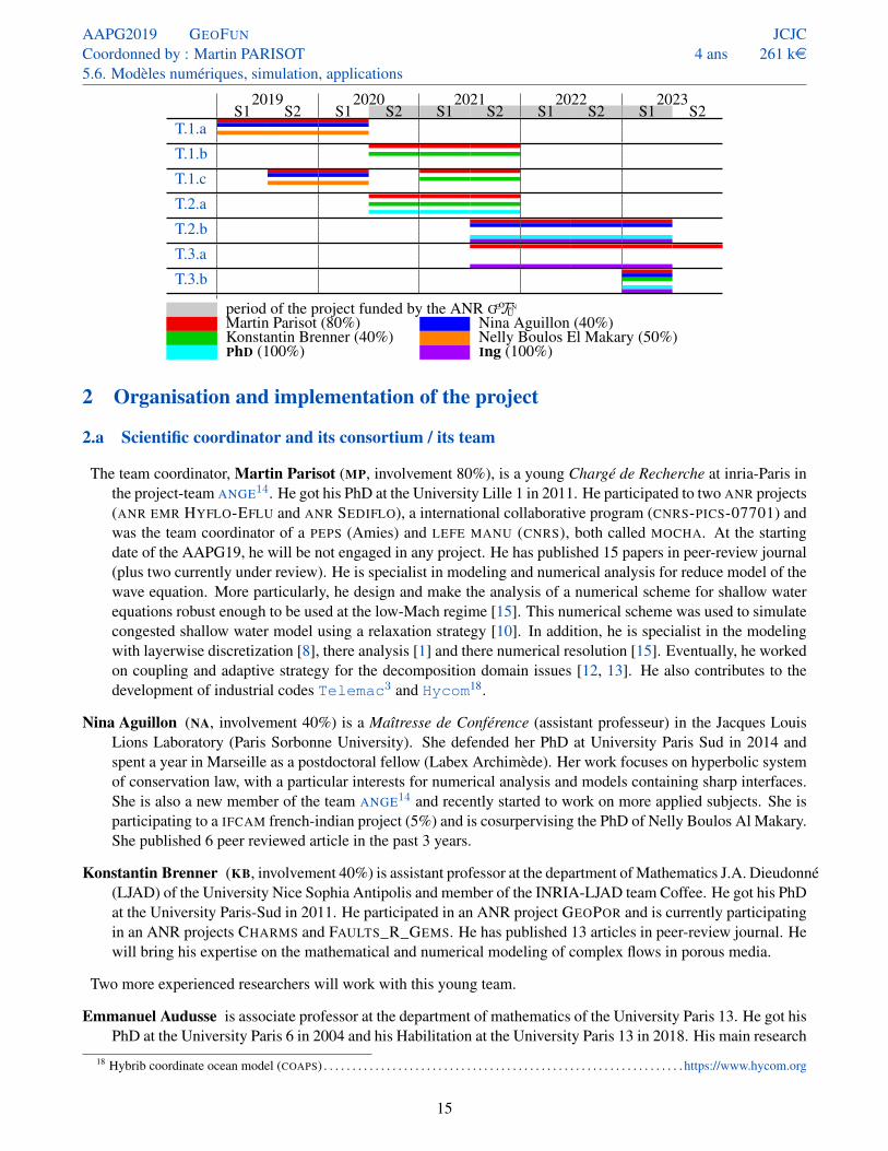
period of the project funded by the ANR GEoFUN
Martin Parisot (80%) Nina Aguillon (40%)Konstantin Brenner (40%) Nelly Boulos El Makary (50%)PhD (100%) Ing (100%)
2 Organisation and implementation of the project
2.a Scientific coordinator and its consortium / its team
The team coordinator, Martin Parisot (MP, involvement 80%), is a young Chargé de Recherche at inria-Paris inthe project-team ANGE14. He got his PhD at the University Lille 1 in 2011. He participated to two ANR projects(ANR EMR HYFLO-EFLU and ANR SEDIFLO), a international collaborative program (CNRS-PICS-07701) andwas the team coordinator of a PEPS (Amies) and LEFE MANU (CNRS), both called MOCHA. At the startingdate of the AAPG19, he will be not engaged in any project. He has published 15 papers in peer-review journal(plus two currently under review). He is specialist in modeling and numerical analysis for reduce model of thewave equation. More particularly, he design and make the analysis of a numerical scheme for shallow waterequations robust enough to be used at the low-Mach regime [15]. This numerical scheme was used to simulatecongested shallow water model using a relaxation strategy [10]. In addition, he is specialist in the modelingwith layerwise discretization [8], there analysis [1] and there numerical resolution [15]. Eventually, he workedon coupling and adaptive strategy for the decomposition domain issues [12, 13]. He also contributes to thedevelopment of industrial codes Telemac3 and Hycom18.
Nina Aguillon (NA, involvement 40%) is a Maîtresse de Conférence (assistant professeur) in the Jacques LouisLions Laboratory (Paris Sorbonne University). She defended her PhD at University Paris Sud in 2014 andspent a year in Marseille as a postdoctoral fellow (Labex Archimède). Her work focuses on hyperbolic systemof conservation law, with a particular interests for numerical analysis and models containing sharp interfaces.She is also a new member of the team ANGE14 and recently started to work on more applied subjects. She isparticipating to a IFCAM french-indian project (5%) and is cosurpervising the PhD of Nelly Boulos Al Makary.She published 6 peer reviewed article in the past 3 years.
Konstantin Brenner (KB, involvement 40%) is assistant professor at the department of Mathematics J.A. Dieudonné(LJAD) of the University Nice Sophia Antipolis and member of the INRIA-LJAD team Coffee. He got his PhDat the University Paris-Sud in 2011. He participated in an ANR project GEOPOR and is currently participatingin an ANR projects CHARMS and FAULTS_R_GEMS. He has published 13 articles in peer-review journal. Hewill bring his expertise on the mathematical and numerical modeling of complex flows in porous media.
Two more experienced researchers will work with this young team.
Emmanuel Audusse is associate professor at the department of mathematics of the University Paris 13. He got hisPhD at the University Paris 6 in 2004 and his Habilitation at the University Paris 13 in 2018. His main research
18 Hybrib coordinate ocean model (COAPS) . . . . . . . . . . . . . . . . . . . . . . . . . . . . . . . . . . . . . . . . . . . . . . . . . . . . . . . . . . . . . . . https://www.hycom.org
15
AAPG2019 GEOFUN
Coordonned by : Martin PARISOT5.6. Modèles numériques, simulation, applications
JCJC4 ans 261 ke
topics deals with numerical methods and scientific computing for geophysical flows and more particularly withthe design of numerical schemes that satisfy nonlinear stability properties. He has published around twentyresearch papers and participated to several national or european projects. Some of the numerical methods thathe proposed were implemented in industrial codes as the software suite Telemac3 developed in the LNHE
EDF9.
Roland Masson is full professor at the department of Mathematics J.A. Dieudonné (LJAD) of the University NiceSophia Antipolis, member of the INRIA-LJAD team Coffee, and leader of the Numerical Analysis and PDEsteam. He got his PhD at the University Paris VI in 1999 and his Habilitation at the University Paris East in2006. He has been head of the applied mathematics department of the Institut Français du Pétrole (IFP) from2000 to 2011. His main research topics deal with numerical methods and scientific computing for geosciencesapplications. He coordinated and participated to several national projects and industrial collaborations, andhas published more than 70 papers.
The research team gathered for this project is composed mainly by young researchers with a balance betweenthe two type of flow present in the project. The two main processes in fluid dynamics in the aquifer arethe convection, described with hyperbolic equations, for example (SW ), and the diffusion, described withparabolic equations, for example (DF ). The two communities independently develop models and numericalschemes adapted to their concerned fields. However, physics of drainage basin involve the two processes(free surface and underground flows) and the collaboration of experts in each field is required for a globalmodeling. A aim of GEoFUN is to built a strong collaboration between the Paris and Nice teams around a commonapplication. In particular NA, KB and MP will acquire a deep knowledge into each other specialty (hyperbolicin Paris, parabolic in Nice). The project deliberately involves only two localisations with multiple visits andexchanges. It will facilitate the interaction between the members and the creation of a small but solid researchteam. However, exchanges and collaborations with other researchers are contemplated even if they are notformally integrated in the project. We mention Clément Cancès (CR INRIA-Lille, porous media), CharlottePerrin (CR CNRS-Marseille, biologic congested models) and Geoffroy Kirstetter (ATER-Nice, flood flows)and members of the UMR METIS13. In addition, the team planned to exchange (eventually collaborate) withmembers of other ANR with subject connexe to the modeling of drainage basin, more precisely ANR BEMA11
and ANR FRAMATI12, and with industrial companies: BRGM8, EDF9, IFPEN10 for water catchment.
2.b Implemented and requested resources to reach the objectives
Partner 1: Inria-Paris, Project-team ANGE14
Staff expenses: It is the main expense of the project. It covers the salary of the PhD student and the engineer,i.e. 5 years’ salary (202 ke). We expect that the contract of PhD will be partially funded by the University ofNice (request send to Ecole Doctorale in progress). If the answer is in the positive, we will extend (for furtherdevelopments) the engineer’s contract. In any case, we will seek through other funders to extend the contractof Ing or to hire another engineer in the GEoFUN project.
to extend (for further developments) the engineer’s contract through other funders.
The PhD student will focus on the Task 2. We consider that this task is well adapted to a PhD project. Moreprecisely, it follows the PhD thesis of Fabien Wahl (INRIA ANGE14, defense 2016) on the congested shallowwater model [48] and was supervised by MP. Depending on PhD skills and tastes, she of he will work more orless closely to the models or the applications.
The role of Ing is mainly to implement the numerical strategies elaborated in the project on the 2D scientificcomputing library GEoFUN for the simulation of drainage basin. If our team have skills on scientific computingand numerical analysis, but we are not experts in the design of scientific computing library. In addition, thetime required for the development of this library is much longer than we can spend during the project.
16
AAPG2019 GEOFUN
Coordonned by : Martin PARISOT5.6. Modèles numériques, simulation, applications
JCJC4 ans 261 ke
Instruments and material costs: It covers the computers of PhD and Ing (5 ke). To ensure that the library isproperly parallelized, scalability tests will be implemented. Even if we plan to test the strategy on inriaclusters, it will be practical for the engineer to be equipped with a sufficiently powerful machine.
Building and ground costs: No expense of this nature.Outsourcing / subcontracting: No expense of this nature. The softwares we plan to work with are open-source
and free-to-use.General and administrative costs & other operating expenses: It covers mission expenses for PhD and for MP,
NA and KB related to the GeoFun project (10 ke). Regular exchanges between the partners in Nice and Parisare necessary. So we plan one week stays for PhD to Nice (5 weeks a year | 10 ke) and also 5 weeks a yearsplit between MP, NA and KB (10 ke). Eventually, a closing workshop will be organized to present the recentadvances in the field of aquifer modeling, with special attention to identify scientific locks and initiate futuremulti-disciplinary collaborations (5 ke).
The total of resources requested to the ANR AAPG 2019 is 261 ke, that will be used as follow
• Staff expenses ? 36 months of salary for PhD 110 202 ke? 24 months of salary for Ing 92
•Material costs ? Equipments for PhD and Ing 5 ke• Ground costs 0 ke• Subcontracting 0 ke• Travel costs ? Exchange for PhD in Nice 10 35 ke
? Exchange for NA, MP (to go to Nice) and KB (to go to Paris) 10? Participation to conferences and workshops 10? Workshop organization 5
• Administrative costs 8% 19 keRequested funding 261 ke
3 Impact and benefits of the project
Before anything else, the GEoFUN project is the creation of a young team coming from two different scientific spe-cialties, namely parabolic equations (for underground flows) and hyperbolic equations (for inviscid flows atthe surface or in conduits). The combination of our strenghts and our scientific computing expertises is a pre-requisite to successfully simulate drainage basins with unified parabolic-hyperbolic unified model. With GEoFUN,we first want to draw attention on the relatively new unified models, and to show that this is a possible way tosimulate complex situations for an affordable computational cost. We will prove by the example that this is aninteresting alternative to full 3D simulations. We now describe different applications that could benefit fromthe GEoFUN library.
Estimation of the water ressources: One of the main missions of BRGM8 concerns the estimation and the man-agement of the water resources at the scale of drainage basins. In comparison with existing models, the projectprovides a different framework and allows more general geological configurations such as superposition ofconfined aquifers. Pollutant can be released during industrial incidents or during crop treatment. There dis-semination into the soil can be carried out easily with GEoFUN library. Interestingly, the storage of CO2 can bemodeled in a similar fashion. It was established in [34] that this is technically and economically possible. Thelibrary could be used to simulate this process.
In the longer term, the achievement of the GEoFUN project could be improved to deal with variable density flows.It would allow the simulation of sea salt water entering porous or karst aquifers. This issue is crucial forindustrial pumping in coastal areas and for the protection of fragile coastal ecosystems.
Improvement of floods models: Floods is the most frequent natural disaster in France. SCHAPI6 is responsiblefor estimating flood risks in France. Several firms, in particular EDF9, have infrastructures near watercourses.
17

AAPG2019 GEOFUN
Coordonned by : Martin PARISOT5.6. Modèles numériques, simulation, applications
JCJC4 ans 261 ke
Flood models has a coarse description of the groundwater. Urban floods are particularly difficult to simulate,because of the roads (free surface) and sewers (confined) act as two superposed hydraulic networks. Due tothe propagation in the confined medium, see T.2.b, the flow can be much faster and cause significant damagesby lifting infrastructures.
Hydroelectricity: The presence of air in hydraulic network may cause pressure surges, leading to reduced effi-ciency and damages for pumping systems [38]. An accurate modeling, such as proposed in T.2.a is necessaryto improve performances and reliability.
The project is also a first step to the consideration of submerged and deformable structures. This improvementcould lead to several interesting industrial applications, in particular in modeling of energy converters. Severaldevices, for exemple develop by HYDROTUBE ENERGIE19 and EEL ENERGY20, imply immersed structures. Itwould generalized the worked carried out in [9].
Perspectives: sediment and glacier. This project could have more perspective and pluri-disciplinar impacts in thelong term. This part is not possible without the strong collaboration of scientifics with different expertise. Theycould be the core of a future project (ANR, ERC...) in collaboration with others scientists, in particular withthe members of the ANR BEMA11 and ANR FRAMATI12.
Rivers, oceans and lakes carry along sediments. Their transportation by the flow is an important issue, partic-ularly in the vicinity of ports and dams. In the framework of vertical integrated model, the mass of sedimenttransported generally came from empirical laws such as [37]. A derivation of solid discharge was proposedin [26], based on two immiscible layers with a friction coupling term. It would be interesting to consider thesediment layer as a deformable bottom layer in (SW2), and investigate how the exchange and drag force termscan model its behavior.
Another interesting issue is the formation of underground networks in karst aquifer. Except for the time scale,it has similarities with the creation of crevasses and underground rivers in glacier, which is crucial in contextof global warming. Starting from the description given in T.2.b, it could be possible to track the concentrationof chemicals (such as carbon dioxide, carbonic acid and calcium bicarbonate for ice evolution) that slowlydissolve rocks or ice. The key point is to coupled it with a local evolution equation of the surface, probablywith a Stefan problem [36].
4 References related to the projectPrevious works of the project team’s members
[1] AGUILLON, N., AUDUSSE, E., GODLEWSKI, E., AND PARISOT, M. Analysis of the Riemann Problem for a Shallow WaterModel with Two Velocities. SIAM Journal on Mathematical Analysis 50, 5 (2018), 4861–4888, hal-01618722
[2] AUDUSSE, E., BENKHALDOUN, F., SARI, S., SEAID, M., AND TASSI, P. A fast finite volume solver for multi-layered shallowwater flows with mass exchange. Journal of Computational Physics 272 (2014), 23 – 45, hal-01297509
[3] AUDUSSE, E., AND BRISTEAU, M.-O. Transport of pollutant in shallow water a two time steps kinetic method. ESAIM:Mathematical Modelling and Numerical Analysis 37, 2 (Mar 2003), 389–416, inria-00072059
[4] AUDUSSE, E., BRISTEAU, M. O., PELANTI, M., AND SAINTE-MARIE, J. Approximation of the hydrostatic Navier–Stokessystem for density stratified flows by a multilayer model: Kinetic interpretation and numerical solution. Journal of Computa-tional Physics 230, 9 (5 2011), 3453–3478, hal-00654642
[5] AUDUSSE, E., BRISTEAU, M.-O., PERTHAME, B., AND SAINTE-MARIE, J. A multilayer Saint-Venant system with massexchanges for shallow water flows. Derivation and numerical validation. ESAIM: M2AN 45, 1 (2011), 169–200, hal-00355730
[6] BRENNER, K., AND CANCÈS, C. Improving Newton’s Method Performance by Parametrization: The Case of the RichardsEquation. SIAM Journal on Numerical Analysis 55, 4 (2017), 1760–1785, hal-01342386
[7] BRENNER, K., GROZA, M., JEANNIN, L., MASSON, R., AND PELLERIN, J. Immiscible two-phase Darcy flow model ac-counting for vanishing and discontinuous capillary pressures: application to the flow in fractured porous media. ComputationalGeosciences 21, 5-6 (Jul 2017), 1075–1094, hal-01338512
19Water turbine H3: fluvial, floating, robust, high-performance, non-intermittent . . . . . . . . . . . . . . . . . . . . . . . . http://hydrotube-energie.com20Water turbine EEL: the conversion of energy by undulating membrane . . . . . . . . . . . . . . . . . . . . . . . . . . . . . . . . . . . .http://www.eel-energy.fr
18
AAPG2019 GEOFUN
Coordonned by : Martin PARISOT5.6. Modèles numériques, simulation, applications
JCJC4 ans 261 ke
[8] FERNÁNDEZ-NIETO, E. D., PARISOT, M., PENEL, Y., AND SAINTE-MARIE, J. A hierarchy of dispersive layer-averagedapproximations of euler equations for free surface flows. Communications in Mathematical Sciences 16, 5 (2018), 1169–1202,hal-01324012
[9] GODLEWSKI, E., PARISOT, M., SAINTE-MARIE, J., AND WAHL, F. Congested shallow water model: floating object. workingpaper or preprint, Sept. 2018, hal-01871708
[10] GODLEWSKI, E., PARISOT, M., SAINTE-MARIE, J., AND WAHL, F. Congested shallow water model: roof modelling in freesurface flow. ESAIM: Mathematical Modelling and Numerical Analysis (2018), hal-01368075
[11] GOUDON, T., AND PARISOT, M. On the spitzer–härm regime and nonlocal approximations: Modeling, analysis, and numericalsimulations. Multiscale Modeling & Simulation 9, 2 (2011), 568–600, hal-00905332
[12] GOUDON, T., AND PARISOT, M. Finite volume schemes on unstructured grids for non-local models: Application to thesimulation of heat transport in plasmas. Journal of Computational Physics 231, 24 (2012), 8188 – 8208, hal-01089051
[13] GOUTAL, N., PARISOT, M., AND ZAOUI, F. A 2d reconstruction for the transverse coupling of shallow water models. Interna-tional Journal for Numerical Methods in Fluids 75, 11 (2014), 775–799, hal-01088995
[14] PARISOT, M. Entropy-satisfying scheme for a hierarchy of dispersive reduced models of free surface flow. Submitted toInternational Journal for Numerical Methods in Fluids (2017), hal-01242128
[15] PARISOT, M., AND VILA, J.-P. Centered-potential regularization for the advection upstream splitting method. SIAM Journalon Numerical Analysis 54, 5 (2016), 3083–3104, hal-01152395
Other references[16] BARRETT, M. E., AND CHARBENEAU, R. J. A parsimonious model for simulating flow in a karst aquifer. Journal of Hydrology
196, 1 (1997), 47 – 65, pdf on U.S. FWS
[17] BERNINGER, H., OHLBERGER, M., SANDER, O., AND SMETANA, K. Unsaturated subsurface flow with surface water andnonlinear in- and outflow conditions. Mathematical Models and Methods in Applied Sciences 24, 05 (2014), 901–936, arXiv:1301.2488
[18] BERTHON, C., BESSEMOULIN-CHATARD, M., AND MATHIS, H. Numerical convergence rate for a diffusive limit of hyperbolicsystems: p-system with damping. SMAI Journal of Computational Mathematics (2016), hal-01360107
[19] CHALONS, C., KOKH, S., AND STAUFFERT, M. An all-regime and well-balanced lagrange-projection type scheme for theshallow water equations on unstructured meshes. working paper or preprint, Févr. 2019, hal-02004835
[20] CROUSEILLES, N., DIMARCO, G., AND LEMOU, M. Asymptotic preserving and time diminishing schemes for rarefied gasdynamic. Kinetic & Related Models 10, 3 (2017), 643–668, hal-01392412
[21] DE SAINT-VENANT, A.-J.-C. B. Théorie du mouvement non permanent des eaux, avec application aux crues des rivières et àl’introduction des marées dans leurs lits. C.R. Acad. Sci. Paris 73 (1871), 147–154, pdf on Gallica
[22] DEMAY, C., AND HÉRARD, J.-M. A compressible two-layer model for transient gas–liquid flows in pipes. Continuum Me-chanics and Thermodynamics 29, 2 (Mar 2017), 385–410, hal-01345668
[23] DUJARDIN, G., AND LAFITTE, P. Asymptotic behavior of splitting schemes involving time-subcycling techniques. IMA Journalof Numerical Analysis (Oct. 2015), hal-00751217v5
[24] DUNCAN, J. H. An experimental investigation of breaking waves produced by a towed hydrofoil. Proceedings of the RoyalSociety A: Mathematical, Physical and Engineering Sciences 377,1770 (Jul 1981), 331–348, DOI: 10.1098/rspa.1981.0127
[25] DUPUIT, J. É. J. Études théoriques et pratiques sur le mouvement des eaux dans les canaux découverts et à travers les terrainsperméables: avec des considérations relatives au régime des grandes eaux, au débouché à leur donner, et à la marche desalluvions dans les rivières à fond mobile. Dunod, 1863, pdf on Gallica
[26] FERNÁNDEZ-NIETO, ENRIQUE D., LUNA, TOMÁS MORALES DE, NARBONA-REINA, GLADYS, AND ZABSONRÉ, JEAN DE
DIEU. Formal deduction of the saint-venant-exner model including arbitrarily sloping sediment beds and associated energy.ESAIM: M2AN 51, 1 (2017), 115–145, arXiv: 1506.05642
[27] GALIBERT, P.-Y. Quantitative estimation of water storage and residence time in the epikarst with time-lapse refraction seismic.Geophysical Prospecting 64, 2 (2019/03/21 2016), 431–444, hal-01329483
[28] GUERBER, E., BENOIT, M., GRILLI, S. T., AND BUVAT, C. A fully nonlinear implicit model for wave interactions withsubmerged structures in forced or free motion. Engineering Analysis with Boundary Elements 36, 7 (2012), 1151 – 1163,hal-00679692
[29] GUINOT, V., DELENNE, C., ROUSSEAU, A., AND BOUTRON, O. Flux closures and source term models for shallow watermodels with depth-dependent integral porosity. Advances in Water Resources 122 (2018), 1 – 26, hal-01884110
[30] HABETS, F., GASCOIN, S., KORKMAZ, S., THIÉRY, D., ZRIBI, M., AMRAOUI, N., CARLI, M., DUCHARNE, A., LEBLOIS,E., LEDOUX, E., AND ET AL. Multi-model comparison of a major flood in the groundwater-fed basin of the Somme River(France). Hydrology and Earth System Sciences 14, 1 (Jan 2010), 99–117, hal-00506001
19
AAPG2019 GEOFUN
Coordonned by : Martin PARISOT5.6. Modèles numériques, simulation, applications
JCJC4 ans 261 ke
[31] HU, B. X., AND XU, Z. Numerical simulation of groundwater flow and solute transport in a karst aquifer with conduits.Groundwater - Contaminant and Resource Management (Jul 2016), DOI: 10.5772/63766
[32] HUGHES, J. D., LANGEVIN, C. D., AND BANTA, E. R. Documentation for the modflow 6 framework. Techniques and Methods(2017), DOI: 10.3133/tm6A57
[33] JIN, S. A steady-state capturing method for hyperbolic systems with geometrical source terms. ESAIM Math. Model. Numer.Anal. 35, 04 (2001), 631–645, DOI: 10.1051/m2an:2001130
[34] KERVÉVAN, C., BEDDELEM, M.-H., GALIÈGUE, X., GALLO, Y. L., MAY, F., O’NEIL, K., AND STERPENICH, J. MainResults of the CO2-DISSOLVED Project: First Step toward a Future Industrial Pilot Combining Geological Storage of DissolvedCO2 and Geothermal Heat Recovery. Energy Procedia 114 (2017), 4086 – 4098. 13th International Conference on GreenhouseGas Control Technologies, GHGT-13, 14-18 November 2016, Lausanne, Switzerland, DOI: 10.1016/j.egypro.2017.03.1549
[35] KOUSSIS, A. D., MAZI, K., RIOU, F., AND DESTOUNI, G. A correction for Dupuit–Forchheimer interface flow models ofseawater intrusion in unconfined coastal aquifers. Journal of Hydrology 525 (2015), 277 – 285, pdf on ResearchGate
[36] MEIRMANOV, A. M. The Stefan Problem, vol. 3. Walter de Gruyter, 2011, book (not open access)
[37] MEYER-PETER, E., AND MÜLLER, R. Formulas for bed-load transport. Hydraulic Engineering Reports (1948), pdf on TUDelft
[38] MURAKAMI, M., AND MINEMURA, K. Effects of entrained air on the performance of a horizontal axial-flow pump. Journalof Fluids Engineering 105, 4 (1983), 382, DOI: 10.1115/1.3241015 (not open access)
[39] NEUSSER, J., AND SCHLEPER, V. Numerical schemes for the coupling of compressible and incompressible fluids in severalspace dimensions. Applied Mathematics and Computation 304 (2017), 65 – 82, arXiv: 1512.03082
[40] PEYRARD, D., SAUVAGE, S., VERVIER, P., SANCHEZ-PEREZ, J. M., AND QUINTARD, M. A coupled vertically integratedmodel to describe lateral exchanges between surface and subsurface in large alluvial floodplains with a fully penetrating river.Hydrological Processes 22, 21 (2019/03/19 2008), 4257–4273, pdf on Academia
[41] PEYRÉ, G., AND CUTURI, M. Computational optimal transport. Foundations and Trends in Machine Learning, vol. 11, no. 5-6,pp. 355-607, 2019 (03 2018), arXiv: 1803.00567
[42] PIKUL, M. F., STREET, R. L., AND REMSON, I. A numerical model based on coupled one-dimensional Richards and Boussi-nesq equations. Water Resources Research 10, 2 (1974), 295–302, DOI: 10.1029/WR010i002p00295 (not open access)
[43] RAMBAUD, A. Modélisation, analyse mathématique et simulations numériques de quelques problèmes aux dérivées partiellesmulti-échelles. PhD thesis, 2011, tel-00656013
[44] SANTAMBROGIO, F. Optimal transport for applied mathematicians. Progress in Nonlinear Differential Equations and TheirApplications (2015), pdf on math.toronto
[45] SAUTY, J.-P. An analysis of hydrodispersive transfer in aquifers. Water Resources Research 16, 1 (2019/03/06 1980), 145–158,DOI: 10.1029/WR016i001p00145 (not open access)
[46] STRACK, O. D. L., AND AUSK, B. K. A formulation for vertically integrated groundwater flow in a stratified coastal aquifer.Water Resources Research 51, 8 (2019/02/22 2015), 6756–6775, DOI: 10.1002/2015WR016887
[47] THIERY, D. Code de calcul MARTHE : Modélisation 3D des écoulements dans les hydrosystèmes. version 7.5, BRGM/RP -64554-FR, pdf on BRGM
[48] WAHL, F. Modeling and analysis of interactions between free surface flows and floating structures. Theses, Sorbonne Université,Dec. 2018, tel-01955798
[49] WHITE, W. B. Karst hydrology: recent developments and open questions. Engineering Geology 65, 2 (2002), 85 – 105.Engineering and Environmental Impacts of Karst, DOI: 10.1016/S0013-7952(01)00116-8 (not open access)
20