Embed Size (px)
Citation preview

1
NOAA Observing System Architecture (NOSA)
Data Call Briefing Package
November 15, 2002
2
Change Record
Version Date Changes
1 11/1/02 First Issue
2 11/15/02 Added survey tree example

3
Initial Tasking
• Develop an observing system architecture– Baseline (“state today”)– Target architecture (“future state”—10-20 years)
• Base prospective observing systems on validated requirements
• Investigate system consolidation and ownership transition (e.g., buoys)
• Conduct a systemic review of all observing systems considering the following factors– Required system characteristics– Number of and types of system users– Capital asset value and recurring maintenance costs
4
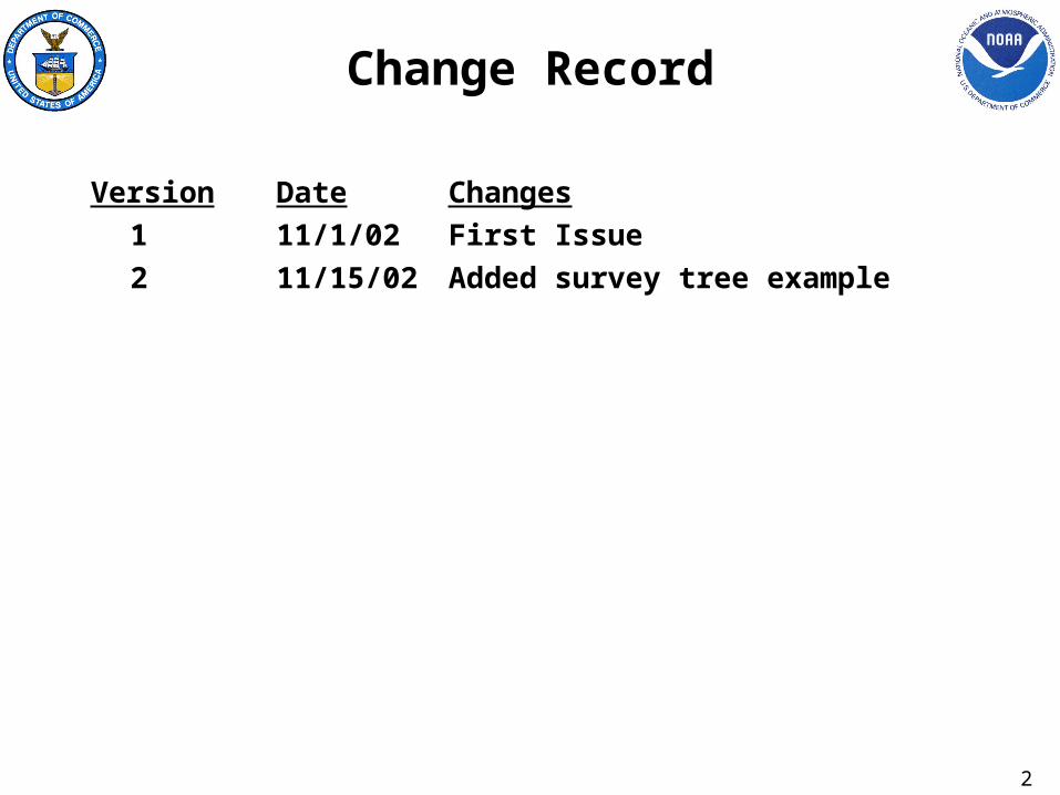
Initial Scope
• Focus first on baseline observing system architecture– Begin with systemic review of all NOAA observing systems– Work closely with NOAA team developing the requirements-
based management process– Timeline for future observing system architecture
development TBD
• Address only NOAA owned and/or operated systems
• Include operational and research systems

5
NOSA Senior Steering Group
• NESDIS Greg Withee, Rob Mairs (lead)
• NMFS Bill Fox
• NOS Steve Gill
• NWS Greg Mandt (lead), Paul Moersdorf
• OAR Mike Johnson
• OMAO Beth White
• CIO Carl Staton

6
NOSA Action Group
• NESDIS Rob Mairs (lead), Howard Diamond, Lisa Botluk
• NMFS Ned Cyr, David Detlor
• NOS Steve Gill
• NWS Rainer Dombrowsky, Eric Meindl, Tim Ross
• OAR Sid Thurston
• OMAO Beth White
• OCIO Ira Grossman
• IA Michael Hales
• Contractor Support (Aerospace Corp, Veridian)

7
Initial Action Group Focus
• Analyze purpose of observing system architecture
• Establish framework, format and content of data call– Data call– Data capture/analysis– Follow-up interviews
• Discuss use of architecture tools (e.g., Ptech, Popkin, METIS)– Proper capture and visualization of various architecture
views
• Assimilate data (principles, guidelines, standards, etc.)

8
NOSA Project Schedule SummaryID Task Name Duration Start
1 Startup 11 days Mon 8/5/02
5 Architecture Framework 15 days Mon 8/19/02
9 Data Surveys 15 days Mon 9/9/02
13 NOAA Forge Setup 27 days Mon 9/16/02
20 Metis Tool Setup 47 days Mon 9/23/02
32 Data Call 88 days Mon 9/23/02
33 RFI prep 5 days Thu 10/3/02
34 Id Obs Systems & POC's 10 days Mon 9/23/02
35 Data Call Kickoff 1 day Wed 10/30/02
36 Survey Inputs 20 days Thu 10/31/02
37 Data Integration 10 days Thu 11/28/02
38 LO Interviews (as req'd) 40 days Thu 11/28/02
39 Load Data into Metis 5 days Thu 12/12/02
40 AG Review 5 days Thu 12/19/02
41 Update Data 5 days Thu 12/26/02
42 SSG Review 10 days Thu 1/2/03
43 Metis Tool Interfaces 50 days Mon 10/28/02
50 Architecture Description 65 days Thu 10/31/02
51 AD Outline 10 days Thu 10/31/02
52 Develop Overview Info 20 days Thu 11/14/02
53 Integrate Metis Models 5 days Thu 12/19/02
54 Integrate GIS info 5 days Mon 12/16/02
55 Write Extra Material 5 days Thu 12/26/02
56 Draft Review 5 days Thu 1/2/03
57 Update 5 days Thu 1/9/03
58 Final Review 5 days Thu 1/16/03
59 Publish 5 days Thu 1/23/03
60 Close-Out Phase 1 25 days Thu 1/9/03
8/19 Architecture Framework
9/9 Data Surveys
9/16 NOAA Forge Setup
10/3 RFI prep
9/23 Id Obs Systems & POC's
10/30 Data Call Kickoff
10/31 Survey Inputs
11/28 Data Integration
11/28 LO Interviews (as req'd)
12/12 Load Data into Metis
12/19 AG Review
12/26 Update Data
1/2 SSG Review
10/31 AD Outline
11/14 Develop Overview Info
12/19 Integrate Metis Models
12/16 Integrate GIS info
12/26 Write Extra Material
1/2 Draft Review
1/9 Update
1/16 Final Review
1/23 Publish
8/25 9/1 9/8 9/15 9/22 9/29 10/6 10/13 10/20 10/27 11/3 11/10 11/17 11/24 12/1 12/8 12/15 12/22 12/29 1/5 1/12 1/19 1/26 2/2 2/9 2/16August September October November December January February
Data Call Finish on Monday, Dec 2nd
Data Call Finish on Monday, Dec 2nd

9
Architecture Queries
• How much is NOAA spending on observing systems?
• What observing systems are associated with each NOAA strategic goal?
• Display all observing systems owned by a particular line office.
• What observing systems are supporting our ability to measure the heat content of the ocean (or other scientific query)?– What additional observing systems do we need to answer
this particular question?
• Display all organizations that own buoys.

10
Architecture Queries(continued)
• Display all requirements not being met by current observing systems.
• Display all observing systems that a certain stakeholder deems important.
• Display all observing systems that measure a particular environmental parameter.
• Display the acquisition costs of all observing systems associated with a certain strategic goal.
• Display the geographic coverage of a particular observing system.– How does this coverage compare with stated requirements?
11
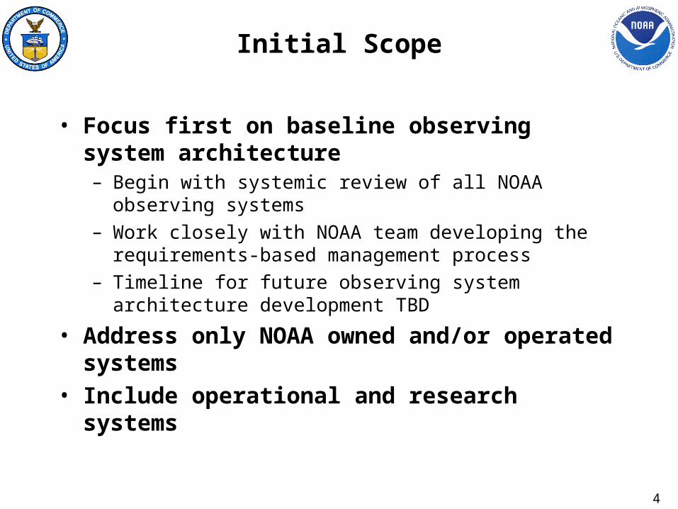
Architecture Queries(continued)
• Display the NOAA network locations that observe a particular environmental parameter?– Do other US organizations operate similar systems?– How do they compare to the NOAA system?– Could NOAA use their data? If so, what is the justification
for this NOAA-operated system?– How does this NOAA observing system fit within the global
system for this parameter (e.g., GCOS, GOOS, World Weather Watch, etc.)?
• How much does NOAA pay to acquire data from non-NOAA sources? What would it cost to deploy a NOAA-operated system to observe the same parameters?
12
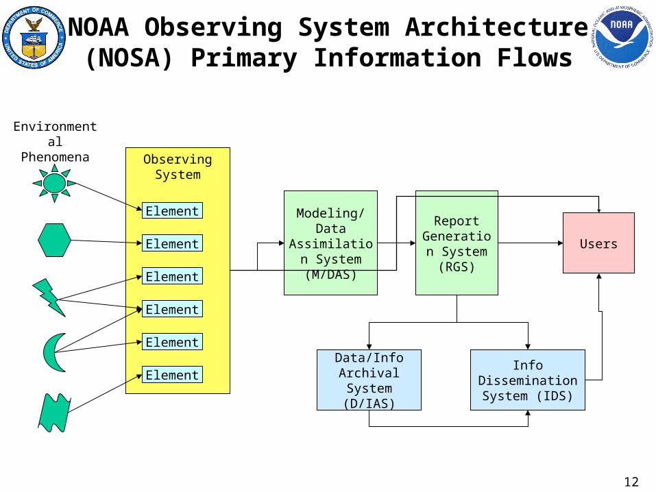
Observing System
NOAA Observing System Architecture (NOSA) Primary Information Flows
Element
Element
Element
Element
Element
Element
Modeling/Data Assimilation
System (M/DAS)
Report Generation
System (RGS)
Info Dissemination System (IDS)
Users
Data/Info Archival System
(D/IAS)
Environmental Phenomena

13
Entity Relationship Diagram (ERD)
Larger System
Observing System
Data Handling System
Human
Environmental Phenomenon
Environmental Parameter
Sensing Element
Sensor
Platform / Station
part of
measures
is a
contains
characterizes
provides data to
Observation Control System
is controlled by
Location
located at
MobileFixed
is
Space
Air
Ground
Ocean
Space
Air
Ground
Ocean
Basic Service Requirement
< drives
provides data directly to
Userprovides info to is type
of
Stake-holder
has
Operator operated by
situated on
Support
supported by
Owner
owned by
Stakeholder Requirement
< drives< drives
Processing Element
RemoteIn Situ
is type

14
NMFS Observing Systems
FISHERY INDEPENDENT SYSTEMS POC PRIORITYFISH SURVEYS NMFS ST2
OCEANOGRAPHIC/ECOSYSTEM SURVEYS NMFS ST2 MARINE MAMMAL/PROTECTED RESOURCE SURVEYS NMFS PR (DONALD KNOWLES)
HABITAT ASSESSMENTS NMFS HC (ROLAND SCHMITTEN)
FISHERY DEPENDENT SYSTEMSCOMMERCIAL STATISTICS NMFS ST1 (JOHN HOEY)
RECREATIONAL STATISTICS NMFS ST1 (DAVE VANVORHEES)NATIONAL OBSERVER PROGRAM NMFS ST2 (VICKI CORNISH)
SOCIOECONOMICS NMFS ST1 (MARK HOLLIDAY)VESSEL MONITORING SYSTEM NMFS EN (DALE JONES)

15
NOS Observing SystemsSYSTEMS POC PRIORITY
NWLON NOS OPS (STEPHEN GILL) 1PORTS NOS OPS (STEPHEN GILL) 2NCOP NOS OPS (STEPHEN GILL) 3CORS NGS (ERIKA WILSON) 4SWMP NERRS (MAURICE CRAWFORD) 5NS&T NCCOS (JAWEED HAMEEDI) 6
TOPOGRAPHIC CHANGE PROGRAM CSC LC-CAP CSC LHAB CSC/NCCOS L
COASTAL MAPPING PROGRAM NGS LCORAL REEF MONITORING/MAPPING NCCOS L
BENTHIC HABITAT MAPPING PROGRAM CSC LBENTHIC SURVEILLANCE PROGRAM NCCOS L
HYDROGRAPHIC SURVEYING PROGRAM OCS LESI OR&R L
NATIONAL MARINE SANCTUARY MONITORING NMS LBIOEFFECTS SURVEY PROGRAM NCCOS L

16
NESDIS Observing Systems
SYSTEMS POC PRIORITYClimate Reference Network (CRN) NCDC (MIKE HELFERT) H
Defense Meteorological Satellite Program (DMSP) IPO (JEFF BACHMANN HGeostationary Operational Environmental Satellite (GOES) I-M OSD (STEVE KIRKNER) HGeostationary Operational Environmental Satellite (GOES) N-Q OSD (STEVE KIRKNER) H
Marine Optical Buoy (MOBY) ORA (DENNIS CLARK) HNational Polar-orbiting Operational Environmental Satellite (NPOESS) IPO (JOHN CUNNINGHAM) H
NPOESS Preparatory Project (NPP) IPO (JOHN CUNNINGHAM) HPolar Orbiting Environmental Program (POES) OSD (WALLY BANNOURA) H
QuikSCAT ORA (PAUL CHANG) H
17
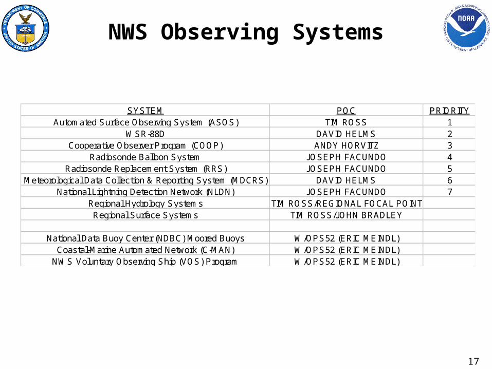
NWS Observing Systems
SYSTEM POC PRIORITYAutomated Surface Observing System (ASOS) TIM ROSS 1
WSR-88D DAVID HELMS 2Cooperative Observer Program (COOP) ANDY HORVITZ 3
Radiosonde Balloon System JOSEPH FACUNDO 4Radiosonde Replacement System (RRS) JOSEPH FACUNDO 5
Meteorological Data Collection & Reporting System (MDCRS) DAVID HELMS 6National Lightning Detection Network (NLDN) JOSEPH FACUNDO 7
Regional Hydrology Systems TIM ROSS/REGIONAL FOCAL POINTRegional Surface Systems TIM ROSS/JOHN BRADLEY
National Data Buoy Center (NDBC) Moored Buoys W/OPS52 (ERIC MEINDL)
Coastal-Marine Automated Network (C-MAN) W/OPS52 (ERIC MEINDL)NWS Voluntary Observing Ship (VOS) Program W/OPS52 (ERIC MEINDL)

18
OAR Observing SystemsClimate Atmospheric Systems
SYSTEM OFFICE POCAtmospheric Baseline Measurement Network ARL Richard Artz
Carbon Cycle Flask Network CMDL James ButlerHalocarbon Cycle Network CMDL Thayne Thompson
Solar and Thermal Radiation Network (STAR) CMDL Ellsworth DuttonTotal Column Ozone Network CMDL Robert EvansBalloon Ozonesonde Network CMDL John Barnes
Background Aerosol Monitoring Network CMDL Betsy Andrews
Integrated Surface Irradiance Study Network ISIS (Level 1) ARL Detlef MattSurface Radiation Network (SURFRAD) ISIS (Level 2) ARL John Augustine
Trans-Pacific profiler network (TPPN) AL Ken GageRonald H. Brown C-band Radar ETL Michelle RyanRonald H. Brown Wind Profiler ETL Daniel Law
ETL Flux System ETL Chris FairallETL Cloud Radars ETL Wynn Eberhard
Airborne Aerosol Lidar ETL Alan BrewerGround-based Profiling Radiometers ETL Marian KleinBoulder Atmospheric Observatory ETL Daniel Wolfe

19
OAR Observing SystemsClimate Ocean Systems
SYSTEM OFFICE POCENSO Observing System (TAO/TRITON) PMEL Michael Mcphaden
ENSO OS Tide Gauges JIMAR Mark MerrifieldENSO OS Drifting Buoys AOML Craig Engler
OAR VOS AOML Steve CookPIRATA array PMEL Michael Mcphaden
Argo Profiling Floats OAR Steve PiotrowiczOcean Reference Stations CICOR Robert Weller
Oceanic Carbon Dioxide monitors PMEL Richard FeelyThermohaline circulation AOML Molly Barringer
Arctic buoys AO John Calder
20
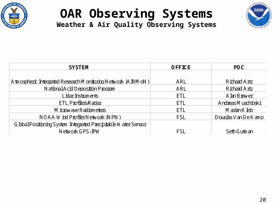
OAR Observing SystemsWeather & Air Quality Observing Systems
SYSTEM OFFICE POC
Atmospheric Integrated Research Monitoring Network (AIRMoN) ARL Richard ArtzNational Acid Deposition Program ARL Richard Artz
Lidar Instruments ETL Alan BrewerETL Profilers/Radar ETL Andreas Muschinski
Microwave Radiometers ETL Marian KleinNOAA Wind Profiler Network (NPN) FSL Douglas Van De Kamp
Global Positioning System Integrated Precipitable Water Sensor Network GPS-IPW FSL Seth Gutman

21
OAR Observing SystemsOcean Observing Systems
SYSTEM OFFICE POCGLERL CoastWatch GLERL Songzhi Liu
Autonomous vertical profiler GLERL Nathan HawleyDeep Ocean Assessment and Reporting of Tsunamis (DART) PMEL (Transitioning to NWS)
Fisheries Oceanography Coordinated (FOCI) Drifters/Moorings PMEL Allen MacklinAcoustic monitoring hydrophones PMEL Chris Fox
Long term Ecosystem Observatory LEO NURP Al KalvaitisAquarius NURP Steven Miller

22
NOSA Data Flow
NOAAForge
EATOOL
LO1
LO2
LON
. . .
. .
SURVEYS
ARCHDESC
GIS TOOL
DOORS
Requirements
System Characteristics
DOORS Dynamic Object Oriented Requirements SystemEA Enterprise ArchitectureGIS Geospatial Information System

23
Survey Forms in NOAA Forge
Observing System Form (one per Observing System type)
Platform/Station Form (one or more per OS)
Sensing Element Form (one or more per OS)
Environmental Parameter Form
(one or more per SE)
Geospatial Database
Processing Element Form (one or more per OS)
Data Handling System Form (one or more per OS)
NOTE: At least one of each survey form type is required to be filled out for each Observing System. See example on next slide.

24
Survey Tree Example
XYZ Observing System (XOS)
PT105 Floating Buoy Platform
Temperature Sensing Gage
Dry Bulb Temp
Geospatial Database
Observation Processor Unit
XYZ Data Handling System
Wet Bulb Temp
XYZ Weather Station Geospatial Database
Anemometer
Wind Speed
Wind Direction
Forward Scatter Meter
Visibility
Environmental Parameter
Surveys
Environmental Parameter
Surveys
Sensing Element Surveys
Sensing Element Surveys

25
NOAA Forge Collaboration Environment
• https://class1.nesdis-hq.noaa.gov/
• Login here (or add new users)
• NOSA will use this tool to collect basic information about each Observing System

26
Adding NOSA Project Members
• One account per individual• Preferred name is last name only• Name with no spaces• Identify the organization
• Hit Register button to complete New User setup

27
Starting NOSA Project
• Your personal page will look like this
• Click here to enter the NOSA project
• That is where you will start filling out survey forms

28
• Click on “Survey” to start working on your surveys
• Click on “Survey” to start working on your surveys
29
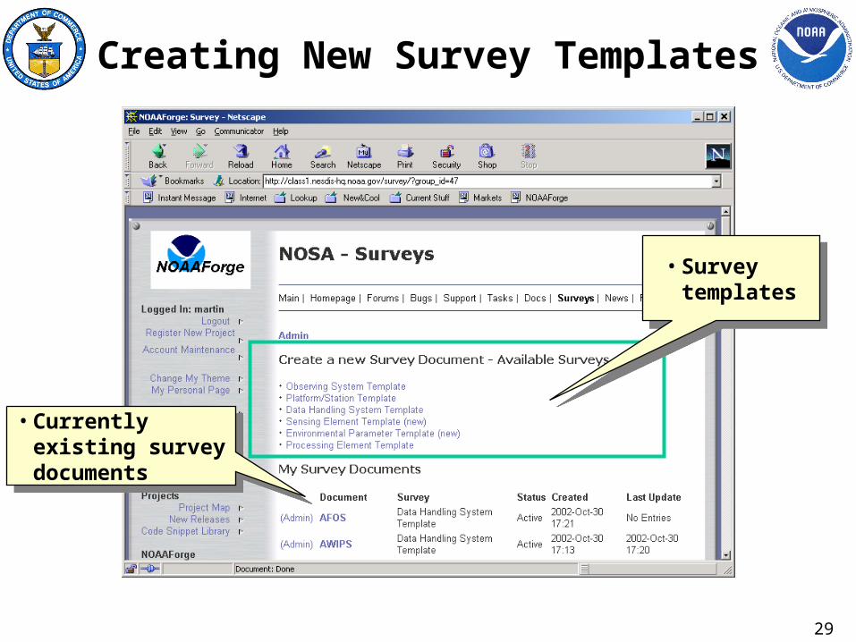
Creating New Survey Templates
• Currently existing survey documents
• Currently existing survey documents
• Survey templates
• Survey templates
30
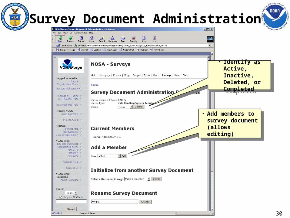
Survey Document Administration
• Identify as Active, Inactive, Deleted, or Completed
• Identify as Active, Inactive, Deleted, or Completed
• Add members to survey document (allows editing)
• Add members to survey document (allows editing)

31
• Survey Questions• Survey Questions
• Survey Page (most surveys have more than one page)
• Survey Page (most surveys have more than one page)
32
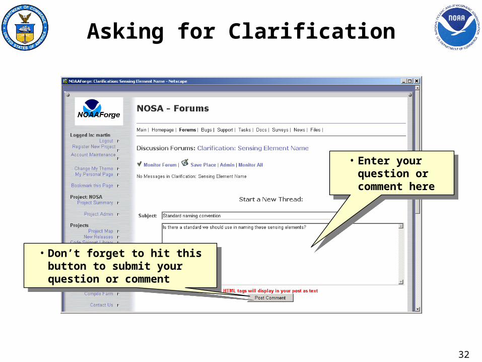
Asking for Clarification
• Don’t forget to hit this button to submit your question or comment
• Don’t forget to hit this button to submit your question or comment
• Enter your question or comment here
• Enter your question or comment here

33
NOSA Project Schedule SummaryID Task Name Duration Start Finish
1 Startup 11 days Mon 8/5/02 Mon 8/19/02
5 Architecture Framework 15 days Mon 8/19/02 Fri 9/6/02
9 Data Surveys 15 days Mon 9/9/02 Fri 9/27/02
13 NOAA Forge Setup 27 days Mon 9/16/02 Tue 10/22/02
20 Metis Tool Setup 47 days Mon 9/23/02 Tue 11/26/02
32 Data Call 88 days Mon 9/23/02 Wed 1/22/03
33 RFI prep 5 days Thu 10/3/02 Wed 10/9/02
34 Id Obs Systems & POC's 10 days Mon 9/23/02 Fri 10/4/02
35 Data Call Kickoff 1 day Wed 10/30/02 Wed 10/30/02
36 Survey Inputs 20 days Thu 10/31/02 Wed 11/27/02
37 Data Integration 10 days Thu 11/28/02 Wed 12/11/02
38 LO Interviews (as req'd) 40 days Thu 11/28/02 Wed 1/22/03
39 Load Data into Metis 5 days Thu 12/12/02 Wed 12/18/02
40 AG Review 5 days Thu 12/19/02 Wed 12/25/02
41 Update Data 5 days Thu 12/26/02 Wed 1/1/03
42 SSG Review 10 days Thu 1/2/03 Wed 1/15/03
43 Metis Tool Interfaces 50 days Mon 10/28/02 Fri 1/3/03
50 Architecture Description 65 days Thu 10/31/02 Wed 1/29/03
51 AD Outline 10 days Thu 10/31/02 Wed 11/13/02
52 Develop Overview Info 20 days Thu 11/14/02 Wed 12/11/02
53 Integrate Metis Models 5 days Thu 12/19/02 Wed 12/25/02
54 Integrate GIS info 5 days Mon 12/16/02 Fri 12/20/02
55 Write Extra Material 5 days Thu 12/26/02 Wed 1/1/03
56 Draft Review 5 days Thu 1/2/03 Wed 1/8/03
57 Update 5 days Thu 1/9/03 Wed 1/15/03
58 Final Review 5 days Thu 1/16/03 Wed 1/22/03
59 Publish 5 days Thu 1/23/03 Wed 1/29/03
60 Close-Out Phase 1 25 days Thu 1/9/03 Wed 2/12/03
8/19 Architecture Framework
9/9 Data Surveys
9/16 NOAA Forge Setup
10/3 RFI prep
9/23 Id Obs Systems & POC's
10/30 Data Call Kickoff
10/31 Survey Inputs
11/28 Data Integration
11/28 LO Interviews (as req'd)
12/12 Load Data into Metis
12/19 AG Review
12/26 Update Data
1/2 SSG Review
10/31 AD Outline
11/14 Develop Overview Info
12/19 Integrate Metis Models
12/16 Integrate GIS info
12/26 Write Extra Material
1/2 Draft Review
1/9 Update
1/16 Final Review
1/23 Publish
8/25 9/1 9/8 9/15 9/22 9/29 10/6 10/13 10/20 10/27 11/3 11/10 11/17 11/24 12/1 12/8 12/15 12/22 12/29 1/5 1/12 1/19 1/26 2/2 2/9August September October November December January February
34
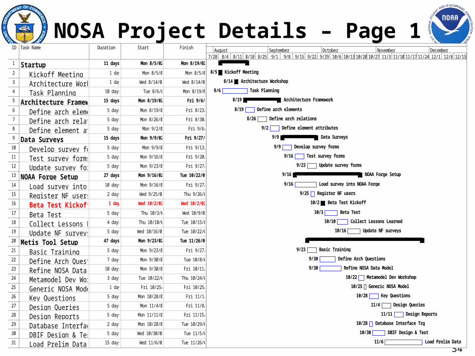
NOSA Project Details – Page 1ID Task Name Duration Start Finish
1 Startup 11 days Mon 8/5/02 Mon 8/19/02
2 Kickoff Meeting 1 day Mon 8/5/02 Mon 8/5/02
3 Architecture Workshop 1 day Wed 8/14/02 Wed 8/14/02
4 Task Planning 10 days Tue 8/6/02 Mon 8/19/02
5 Architecture Framework 15 days Mon 8/19/02 Fri 9/6/02
6 Define arch elements 5 days Mon 8/19/02 Fri 8/23/02
7 Define arch relations 5 days Mon 8/26/02 Fri 8/30/02
8 Define element attributes 5 days Mon 9/2/02 Fri 9/6/02
9 Data Surveys 15 days Mon 9/9/02 Fri 9/27/02
10 Develop survey forms 5 days Mon 9/9/02 Fri 9/13/02
11 Test survey forms 5 days Mon 9/16/02 Fri 9/20/02
12 Update survey forms 5 days Mon 9/23/02 Fri 9/27/02
13 NOAA Forge Setup 27 days Mon 9/16/02 Tue 10/22/02
14 Load survey into NOAA Forge10 days Mon 9/16/02 Fri 9/27/02
15 Register NF users 2 days Wed 9/25/02 Thu 9/26/02
16 Beta Test Kickoff 1 day Wed 10/2/02 Wed 10/2/02
17 Beta Test 5 days Thu 10/3/02 Wed 10/9/02
18 Collect Lessons Learned 4 days Thu 10/10/02 Tue 10/15/02
19 Update NF surveys 5 days Wed 10/16/02 Tue 10/22/02
20 Metis Tool Setup 47 days Mon 9/23/02 Tue 11/26/02
21 Basic Training 5 days Mon 9/23/02 Fri 9/27/02
22 Define Arch Questions 7 days Mon 9/30/02 Tue 10/8/02
23 Refine NOSA Data Model 10 days Mon 9/30/02 Fri 10/11/02
24 Metamodel Dev Workshop 3 days Tue 10/22/02 Thu 10/24/02
25 Generic NOSA Model 1 day Fri 10/25/02 Fri 10/25/02
26 Key Questions 5 days Mon 10/28/02 Fri 11/1/02
27 Design Queries 5 days Mon 11/4/02 Fri 11/8/02
28 Design Reports 5 days Mon 11/11/02 Fri 11/15/02
29 Database Interface Trg 2 days Mon 10/28/02 Tue 10/29/02
30 DBIF Design & Test 5 days Wed 10/30/02 Tue 11/5/02
31 Load Prelim Data 15 days Wed 11/6/02 Tue 11/26/02
8/5 Kickoff Meeting
8/14 Architecture Workshop
8/6 Task Planning
8/19 Architecture Framework
8/19 Define arch elements
8/26 Define arch relations
9/2 Define element attributes
9/9 Data Surveys
9/9 Develop survey forms
9/16 Test survey forms
9/23 Update survey forms
9/16 NOAA Forge Setup
9/16 Load survey into NOAA Forge
9/25 Register NF users
10/2 Beta Test Kickoff
10/3 Beta Test
10/10 Collect Lessons Learned
10/16 Update NF surveys
9/23 Basic Training
9/30 Define Arch Questions
9/30 Refine NOSA Data Model
10/22 Metamodel Dev Workshop
10/25 Generic NOSA Model
10/28 Key Questions
11/4 Design Queries
11/11 Design Reports
10/28 Database Interface Trg
10/30 DBIF Design & Test
11/6 Load Prelim Data
7/28 8/4 8/11 8/18 8/25 9/1 9/8 9/15 9/22 9/29 10/6 10/13 10/20 10/27 11/3 11/10 11/17 11/24 12/1 12/8 12/15 12/22July August September October November December
35
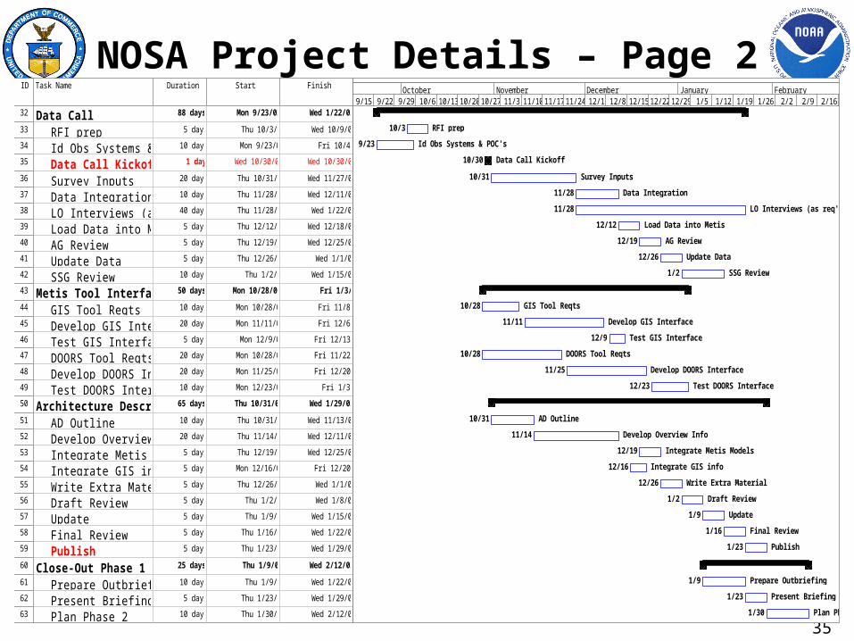
NOSA Project Details – Page 2ID Task Name Duration Start Finish
32 Data Call 88 days Mon 9/23/02 Wed 1/22/03
33 RFI prep 5 days Thu 10/3/02 Wed 10/9/02
34 Id Obs Systems & POC's 10 days Mon 9/23/02 Fri 10/4/02
35 Data Call Kickoff 1 day Wed 10/30/02 Wed 10/30/02
36 Survey Inputs 20 days Thu 10/31/02 Wed 11/27/02
37 Data Integration 10 days Thu 11/28/02 Wed 12/11/02
38 LO Interviews (as req'd) 40 days Thu 11/28/02 Wed 1/22/03
39 Load Data into Metis 5 days Thu 12/12/02 Wed 12/18/02
40 AG Review 5 days Thu 12/19/02 Wed 12/25/02
41 Update Data 5 days Thu 12/26/02 Wed 1/1/03
42 SSG Review 10 days Thu 1/2/03 Wed 1/15/03
43 Metis Tool Interfaces 50 days Mon 10/28/02 Fri 1/3/03
44 GIS Tool Reqts 10 days Mon 10/28/02 Fri 11/8/02
45 Develop GIS Interface 20 days Mon 11/11/02 Fri 12/6/02
46 Test GIS Interface 5 days Mon 12/9/02 Fri 12/13/02
47 DOORS Tool Reqts 20 days Mon 10/28/02 Fri 11/22/02
48 Develop DOORS Interface 20 days Mon 11/25/02 Fri 12/20/02
49 Test DOORS Interface 10 days Mon 12/23/02 Fri 1/3/03
50 Architecture Description 65 days Thu 10/31/02 Wed 1/29/03
51 AD Outline 10 days Thu 10/31/02 Wed 11/13/02
52 Develop Overview Info 20 days Thu 11/14/02 Wed 12/11/02
53 Integrate Metis Models 5 days Thu 12/19/02 Wed 12/25/02
54 Integrate GIS info 5 days Mon 12/16/02 Fri 12/20/02
55 Write Extra Material 5 days Thu 12/26/02 Wed 1/1/03
56 Draft Review 5 days Thu 1/2/03 Wed 1/8/03
57 Update 5 days Thu 1/9/03 Wed 1/15/03
58 Final Review 5 days Thu 1/16/03 Wed 1/22/03
59 Publish 5 days Thu 1/23/03 Wed 1/29/03
60 Close-Out Phase 1 25 days Thu 1/9/03 Wed 2/12/03
61 Prepare Outbriefing 10 days Thu 1/9/03 Wed 1/22/03
62 Present Briefing 5 days Thu 1/23/03 Wed 1/29/03
63 Plan Phase 2 10 days Thu 1/30/03 Wed 2/12/03
10/3 RFI prep
9/23 Id Obs Systems & POC's
10/30 Data Call Kickoff
10/31 Survey Inputs
11/28 Data Integration
11/28 LO Interviews (as req'd)
12/12 Load Data into Metis
12/19 AG Review
12/26 Update Data
1/2 SSG Review
10/28 GIS Tool Reqts
11/11 Develop GIS Interface
12/9 Test GIS Interface
10/28 DOORS Tool Reqts
11/25 Develop DOORS Interface
12/23 Test DOORS Interface
10/31 AD Outline
11/14 Develop Overview Info
12/19 Integrate Metis Models
12/16 Integrate GIS info
12/26 Write Extra Material
1/2 Draft Review
1/9 Update
1/16 Final Review
1/23 Publish
1/9 Prepare Outbriefing
1/23 Present Briefing
1/30 Plan Phase 2
9/15 9/22 9/29 10/6 10/13 10/20 10/27 11/3 11/10 11/17 11/24 12/1 12/8 12/15 12/22 12/29 1/5 1/12 1/19 1/26 2/2 2/9 2/16 2/23September October November December January February

36
Expanded NOSA Project ScheduleID Task Name Duration Start Finish
1 Startup 11 days Mon 8/5/02 Mon 8/19/02
2 Kickoff Meeting 1 day Mon 8/5/02 Mon 8/5/02
3 Architecture Workshop 1 day Wed 8/14/02 Wed 8/14/02
4 Task Planning 10 days Tue 8/6/02 Mon 8/19/02
5 Architecture Framework 15 days Mon 8/19/02 Fri 9/6/02
6 Define arch elements 5 days Mon 8/19/02 Fri 8/23/02
7 Define arch relations 5 days Mon 8/26/02 Fri 8/30/02
8 Define element attributes 5 days Mon 9/2/02 Fri 9/6/02
9 Data Surveys 15 days Mon 9/9/02 Fri 9/27/02
10 Develop survey forms 5 days Mon 9/9/02 Fri 9/13/02
11 Test survey forms 5 days Mon 9/16/02 Fri 9/20/02
12 Update survey forms 5 days Mon 9/23/02 Fri 9/27/02
13 NOAA Forge Setup 27 days Mon 9/16/02 Tue 10/22/02
14 Load survey into NOAA Forge10 days Mon 9/16/02 Fri 9/27/02
15 Register NF users 2 days Wed 9/25/02 Thu 9/26/02
16 Beta Test Kickoff 1 day Wed 10/2/02 Wed 10/2/02
17 Beta Test 5 days Thu 10/3/02 Wed 10/9/02
18 Collect Lessons Learned 4 days Thu 10/10/02 Tue 10/15/02
19 Update NF surveys 5 days Wed 10/16/02 Tue 10/22/02
20 Metis Tool Setup 47 days Mon 9/23/02 Tue 11/26/02
21 Basic Training 5 days Mon 9/23/02 Fri 9/27/02
22 Define Arch Questions 7 days Mon 9/30/02 Tue 10/8/02
23 Refine NOSA Data Model 10 days Mon 9/30/02 Fri 10/11/02
24 Metamodel Dev Workshop 3 days Tue 10/22/02 Thu 10/24/02
25 Generic NOSA Model 1 day Fri 10/25/02 Fri 10/25/02
26 Key Questions 5 days Mon 10/28/02 Fri 11/1/02
27 Design Queries 5 days Mon 11/4/02 Fri 11/8/02
28 Design Reports 5 days Mon 11/11/02 Fri 11/15/02
29 Database Interface Trg 2 days Mon 10/28/02 Tue 10/29/02
30 DBIF Design & Test 5 days Wed 10/30/02 Tue 11/5/02
31 Load Prelim Data 15 days Wed 11/6/02 Tue 11/26/02
32 Data Call 88 days Mon 9/23/02 Wed 1/22/03
33 RFI prep 5 days Thu 10/3/02 Wed 10/9/02
34 Id Obs Systems & POC's 10 days Mon 9/23/02 Fri 10/4/02
35 Data Call Kickoff 1 day Wed 10/30/02 Wed 10/30/02
36 Survey Inputs 20 days Thu 10/31/02 Wed 11/27/02
37 Data Integration 10 days Thu 11/28/02 Wed 12/11/02
38 LO Interviews (as req'd) 40 days Thu 11/28/02 Wed 1/22/03
39 Load Data into Metis 5 days Thu 12/12/02 Wed 12/18/02
40 AG Review 5 days Thu 12/19/02 Wed 12/25/02
41 Update Data 5 days Thu 12/26/02 Wed 1/1/03
42 SSG Review 10 days Thu 1/2/03 Wed 1/15/03
43 Metis Tool Interfaces 50 days Mon 10/28/02 Fri 1/3/03
44 GIS Tool Reqts 10 days Mon 10/28/02 Fri 11/8/02
45 Develop GIS Interface 20 days Mon 11/11/02 Fri 12/6/02
46 Test GIS Interface 5 days Mon 12/9/02 Fri 12/13/02
47 DOORS Tool Reqts 20 days Mon 10/28/02 Fri 11/22/02
48 Develop DOORS Interface 20 days Mon 11/25/02 Fri 12/20/02
49 Test DOORS Interface 10 days Mon 12/23/02 Fri 1/3/03
50 Architecture Description 65 days Thu 10/31/02 Wed 1/29/03
51 AD Outline 10 days Thu 10/31/02 Wed 11/13/02
52 Develop Overview Info 20 days Thu 11/14/02 Wed 12/11/02
53 Integrate Metis Models 5 days Thu 12/19/02 Wed 12/25/02
54 Integrate GIS info 5 days Mon 12/16/02 Fri 12/20/02
55 Write Extra Material 5 days Thu 12/26/02 Wed 1/1/03
56 Draft Review 5 days Thu 1/2/03 Wed 1/8/03
57 Update 5 days Thu 1/9/03 Wed 1/15/03
58 Final Review 5 days Thu 1/16/03 Wed 1/22/03
59 Publish 5 days Thu 1/23/03 Wed 1/29/03
60 Close-Out Phase 1 25 days Thu 1/9/03 Wed 2/12/03
61 Prepare Outbriefing 10 days Thu 1/9/03 Wed 1/22/03
62 Present Briefing 5 days Thu 1/23/03 Wed 1/29/03
63 Plan Phase 2 10 days Thu 1/30/03 Wed 2/12/03
8/5 Kickoff Meeting
8/14 Architecture Workshop
8/6 Task Planning
8/19 Architecture Framework
8/19 Define arch elements
8/26 Define arch relations
9/2 Define element attributes
9/9 Data Surveys
9/9 Develop survey forms
9/16 Test survey forms
9/23 Update survey forms
9/16 NOAA Forge Setup
9/16 Load survey into NOAA Forge
9/25 Register NF users
10/2 Beta Test Kickoff
10/3 Beta Test
10/10 Collect Lessons Learned
10/16 Update NF surveys
9/23 Basic Training
9/30 Define Arch Questions
9/30 Refine NOSA Data Model
10/22 Metamodel Dev Workshop
10/25 Generic NOSA Model
10/28 Key Questions
11/4 Design Queries
11/11 Design Reports
10/28 Database Interface Trg
10/30 DBIF Design & Test
11/6 Load Prelim Data
10/3 RFI prep
9/23 Id Obs Systems & POC's
10/30 Data Call Kickoff
10/31 Survey Inputs
11/28 Data Integration
11/28 LO Interviews (as req'd)
12/12 Load Data into Metis
12/19 AG Review
12/26 Update Data
1/2 SSG Review
10/28 GIS Tool Reqts
11/11 Develop GIS Interface
12/9 Test GIS Interface
10/28 DOORS Tool Reqts
11/25 Develop DOORS Interface
12/23 Test DOORS Interface
10/31 AD Outline
11/14 Develop Overview Info
12/19 Integrate Metis Models
12/16 Integrate GIS info
12/26 Write Extra Material
1/2 Draft Review
1/9 Update
1/16 Final Review
1/23 Publish
1/9 Prepare Outbriefing
1/23 Present Briefing
1/30 Plan Phase 2
8/25 9/1 9/8 9/15 9/22 9/29 10/6 10/13 10/20 10/27 11/3 11/10 11/17 11/24 12/1 12/8 12/15 12/22 12/29 1/5 1/12 1/19 1/26 2/2 2/9August September October November December January February