Embed Size (px)
Citation preview

1

Table of Contents1. Introduction.......................................................................................................................................3
2. Background........................................................................................................................................3
3. Part A Submissions............................................................................................................................5
4. Part B – Outstanding Issues: Mt Atkinson & Tarneit Plains................................................................7
Submission 5 - Giuseppe (Joe) Nesci..................................................................................................7
Submission 6 – MSA..........................................................................................................................8
Submission 7 - Lilian and Mario Murga............................................................................................10
Submission 8 - Attila Kelemen.........................................................................................................11
Submission 10 - APA GasNet...........................................................................................................12
Submission 11 – Niche Planning Studio (on behalf of Ray Cauchi)..................................................14
Submission 12 - Niche Planning Studio on behalf of Bestsize Pty Ltd..............................................17
Submission 13 – Beacon Town Planning..........................................................................................18
Submission 14 - Marantali Pty Ltd...................................................................................................21
Submission 18 - Boral......................................................................................................................23
Submission 20 - Andreas Antoniou..................................................................................................26
Submission 22 - Mount Atkinson Holdings......................................................................................27
Submission 31 - EPA........................................................................................................................28
Submission 33 – Melton City Council...............................................................................................29
5. Landfill Operation Issues..................................................................................................................44
Submission 15 - Metropolitan Waste & Resource Recovery Group (MWRRG)................................44
Submission 21 - Landfill Operations................................................................................................44
Submission 31 - EPA........................................................................................................................45
Submission 29 - Sustainability Victoria............................................................................................45
Submission 33 - City of Melton........................................................................................................45
Submission 22 - Mount Atkinson Holdings......................................................................................49
Submission 21 - Landfill Operations................................................................................................49
6. Conclusion.......................................................................................................................................51
2

1. IntroductionThis submission is made on behalf of the Victorian Planning Authority (VPA).
The VPA is the Planning Authority for Amendment C162 to the Melton Planning Scheme (the Amendment).
The Amendment has been prepared by the VPA in collaboration with the Melton City Council, with the support of the relevant stakeholders, landowners and government agencies. Note that during preparation of the PSP the ‘VPA’, was formerly known as the ‘Metropolitan Planning Authority’ (MPA).
Formal exhibition of the Amendment commenced on 28 April 2016, and concluded on 30 May 2016.
A total of 35 submissions have been received. The VPA has worked extensively with Council, developers, landowners and other stakeholders including State agencies to resolve as many of the submissions as possible. A list of unresolved submissions has been provided in Appendix 1 of the Part A submissions.
2. BackgroundThe West Growth Corridor Plan identifies the Mt Atkinson and Tarneit Precinct Structure Plan land for urban development to cater for some of Melbourne’s projected significant population growth.
The Amendment provides for the development of approximately 6,700 new homes to accommodate an expected population of approximately 19,000 residents and, approximately 490 hectares of the Precinct will accommodate employment land for the purpose of industrial and commercial development providing the opportunity for the creation of over 18,000 jobs in a variety of sectors.
A ‘Specialised Town Centre’ in the northern part of the Precinct will complement the ‘Hopkins Road Business Precinct’ and will service the future residential community within the Precinct and surrounding communities. Additional employment land is provided in the north of the Precinct by way of industrial land. Mixed use land adjacent to the town centre will also create employment opportunities that will complement the town centre.
The southern part of the Mt Atkinson Precinct will accommodate a significant area for industrial land. The Tarneit Plains Precinct contributes to the state significant Western Industrial Node and is adjacent to the future Western Interstate Freight Terminal making it a vital employment hub within the West Growth Corridor. The location and capacity of the industrial land is anticipated to be attractive to a variety of businesses, manufacturing and advanced manufacturing, wholesale trade, transport, postal and warehouse activities.
Community hubs featuring schools, open space and recreational facilities, and community services will be developed on three sides of the Mt Atkinson volcanic cone reinforcing its role in the structure
3

of the area, and providing a landscaped open space focus for the emerging residential areas. These will be linked via a strong open space network. Three conservation areas, sporting reserves, the Mt Atkinson homestead heritage avenue, linear green links and local parks will all form part of an open space network.
The Amendment also streamlines the development process in relation to the retention, removal, destruction or lopping of native vegetation by incorporating exemption from permit requirements for vegetation removal provided it is in accordance with the PSP. In addition, the Incorporated Plan Overlay Schedule 5 (IPO5) is proposed to ensure conservation areas are protected and managed in a manner consistent with the Biodiversity Conservation Strategy (BCS) and the PSP.
The Amendment ensures that servicing of the new urban development will be of sufficient capacity to ensure future development is connected to reticulated electricity, gas, water and sewer.
The existing power transmission easement that traverses through the Precinct will be zoned Special Use Zone Schedule 11 (SUZ11) to ensure appropriate development within these areas. The future terminal station will be retained in the Special Use Zone Schedule 3 (SUZ3). A measurement length is established adjacent to the existing high pressure gas transmission easement, which traverses along the east and southern boundary of the Precinct. The PSP will ensure sensitive land uses are minimised within the measurement length of the high pressure gas transmission pipelines adjacent to Hopkins Road and Middle Road, and that construction is managed to minimise risk of any adverse impacts.
The Amendment provides clarity for development on land along the western side of Hopkins Road, responding to the existing quarry works authority and the designated Waste and Resource Recovery Hub of State importance by directing sensitive land uses be located outside the relevant buffer distances that encroach into the Precinct.
The PSP, and Schedule 9 to the UGZ, have responded to the existing quarry buffers established to protect the operation of the state significant Deer Park Quarry. The quarry blast buffer extends 200m from the approved quarry works authority and Schedule 9 to the UGZ identifies restrictions on use and development within this area.
The quarry sensitive use buffer extends 500m from the approved quarry works authority. The West Growth Corridor Plan identifies land with a width of approximately 500m from the western edge of Hopkins Road as the Hopkins Road Business Precinct. Schedule 9 to the UGZ identifies restrictions on use and development within the quarry sensitive use buffer. Additionally, Schedule 9 to the UGZ outlines specific referral requirements to relevant authorities.
The potential future Melbourne Regional landfill expansion is not anticipated to impact on the development of the PSP. The applied zoning and Schedule 9 to the UGZ responds to the potential for adverse amenity from odour from any expanded future landfill by establishing a distance of at least 500m from residential uses to the landfill site. This is expected to be complemented by a 500m distance containing no putrescible fill within the landfill site itself to ensure 1km is established between the landfill and residential uses. Further, a planning permit is required for uses pursuant to
4

Provision 52.10 (Uses with Adverse Amenity potential) within the business, business/large format retail, industrial and light industrial land.
The PSP assumes all landfill gas migration will be retained within the landfill site and that any buffers to mitigate landfill gas migration required by the Best Practice Environmental Management (BPEM) for Siting, Design, Operation and Rehabilitation for Landfills are internalised on the landfill site. Therefore no additional planning controls or referrals have been included in the PSP to mitigate landfill gas migration.
The PSP provides for enhancement and embellishment of the existing waterway environs in the Precinct that will play an important stormwater management role as well as providing open space and recreational opportunities with the provision of shared pedestrian and cycling paths.
3. Part A SubmissionsPart A submissions were distributed in accordance with Panel Directions on 7 September 2014. The Part A submissions included a response to directions of the Panel dated 15 July and Directions issued on 12 August 2016.
In its Directions dated 15 July 2016 the panel requested specific details in relation to the following matters:
Background to the Amendment, in particular how the residential component of the proposed PSP came about. This was provided in Section 5.2 of the submission.
Strategic assessment. This was provided in Section 5.5.1 of the submission.
Identification of the issues raised in submissions and its response. This was provided in Appendix 1 of the submission.
A record of all changes to the Amendment documentation proposed as a result of the issues raised in submissions. This was provided in Section 10.1 of the submission.
In its Directions issued on 12 August 2016 the Panel specifically sought clarification of the following issues:
Discrepancies between the boundaries of the current ESO2 and ESO5 and the proposed ESO6. This was provided in Section 10 of the submission.
Reference to SUZ3 in the Explanatory Report. This is provided in Section 4.2Sof the submission.
Provide an understanding of what is proposed with respect to progressing the Development Contributions Plan/ Infrastructure Contributions Plan. This was provided in Section 8 of the submission.
5

Provide an understanding of the rationale for using the RGZ as the applied zone for ‘all other land’ in the UGZ. This was provided in Section 10.1 of the submission.
Provide a response to the suggestion raised in submissions that an Environmental Significance Overlay (or other overlay) be considered as the mechanism to implement buffers to quarrying and landfill. This was provided in Section 4.2 of the submission.
Advise if a Design and Development Overlay was considered to implement building noise controls near the rail corridor. This was provided in Section 4.4 of the submission.
Explain how the buffer locations and depths shown in Plan 2 of the PSP have been arrived at, including any relevant legislation, regulations or technical guidelines. This was provided in Section 4.2 of the submission.
Explain how the boundary of the ‘railway noise amenity area’ shown in Plan 10 of the PSP has been arrived at. This was provided in Section 4.4 of the submission.
Clarify what is mean at Clause 4.2 of UGZ9 by “transferred at no cost”. This was provided in Section 8 of this submission.
Explain why the GAA (VPA) is proposed as a referral authority in Clause 2.9 of UGZ9. This was provided in Section 7.2.2 of the submission.
Confirm that the references in the exhibited Schedule to Clause 66.04 to Clauses 2.10 and 2.11 should be corrected to 2.9 and 2.10 respectively.
In its Directions issued on 12 August 2016 the Panel also sought clarification on the following points arising from the package of background documents circulated by the VPA:
Clarification of which version of the PSP the ‘Community Infrastructure and Open Space Needs Assessment’ and the ‘Commercial and Industrial Land Review’ were based, and whether these reports need updating. This was provided in Section 7.2.6 and Section 7.2.4 of the submission, respectively.
The operational status of the broiler farm in the south west corner of the PSP, and whether it is intended to continue to operate in future. This was provided in Section 4.5 of the submission.
A brief summary of the flora and fauna conservation issues (including how the Amendment responds to the Melbourne Strategic Assessment and Biodiversity Conservation Strategy requirements) and aboriginal and post-contact heritage issues identified in background reports. This was provided in Section 5.3.6, Section 5.3.7, Section 7.2.9, and Section 7.2.10 of the submission.
A response to the recommendations of the Land Capability Assessment commissioned by the VPA. This was provided in Section 4.1 of the submission.
6

4. Part B – Outstanding Issues: Mt Atkinson & Tarneit PlainsThis section responds to issues raised by individual submitters, which are unresolved.
Submission 5 - Giuseppe (Joe) NesciProperty address: 94-118 Greigs Road
Issue 1:
Mr Nesci submits that the value of the property will be reduced due to the proposed Industrial Zoning of the land. The submitter requests a review of the planning scheme and as a minimum, the rezoning of their property to either residential or mixed use.
VPA’s response:
The property in question was designated for industrial use in the West Growth Corridor Plan (2012), due to its location with good access along an arterial road and adjacent to the rail corridor and future OMR.
The Growth Corridor Plans set the strategic direction for future urban development in Melbourne's growth areas, including the provision for a 30-40 years supply of industrial
land based on anticipated future demand for industrial land. While there is ongoing pressure from land-owners to develop land for other purposes it is important that the state protects the land designated for industrial purposes as the provision of industrial land remains important for the provision of traditional manufacturing uses, new advanced manufacturing and for the expected increased activity in the transport and logistics sector. Plan Melbourne (2014) has also identified the Mt Atkinson PSP as a State Significant Industrial Precinct.
Issue 2:
Mr Nesci objects to the location of Melbourne Water assets on his property and neighbouring properties.
VPA’s response:
The drainage reserve on property WI-04 (Plan 11- Integrated Water Management) of the Precinct Structure Plan (PSP) is consistent with the drainage infrastructure required in the Deanside Development Services Scheme developed by Melbourne Water and is required in the existing location and configuration to allow development to occur in the catchment.
7
Figure 1. Plan of property from Plan 3 - FUS

The following response has been provided by Melbourne Water:
Proposed Re-location of Assets
The proposed railway retarding basin (RB) is required to manage the run-off from upstream development up to and including the 100 year flood events and to discharge to the capacity of existing railway culverts which are located at the low point of the catchment. It is Melbourne Water’s preference to locate these assets on existing low lying and flood prone land rather than extensively cutting other land to create low points.
Design of Proposed Asset
The conceptual RB shape has been elongated to spread across several properties. This ensures the encumbered land has been spread as equitably as possible whilst reflecting the existing low lying land. It is important to recognise that this retarding basin has been refined by Melbourne Water over time in consultation with landowners so that less developable land is encumbered by the proposed asset.
The VPA supports the views of Melbourne Water.
Submission 6 – MSAProperty address: 2-50 Meskos Road
Figure 2. Plan of property from Plan 3 - FUS
Issue 1:
The detail of the site access to Meskos Road and Hopkins Road is still being finalised.
VPA’s response
Expert evidence has been provided by MSA, the VPA and Melton City Council. Further detail is required to establish the scale of development to be
serviced, the scale of development to be funded through the ICP and to establish proof the conceptual plans developed to date can be delivered.
The ICP will typically fund the interim construction and ultimate land requirement to service the PSP and will do so in this case, subject to all relevant parties agreeing that the intersections can be delivered and the issues raised at the conclave meeting held on Monday being addressed. (Attachment 1- Minutes of Intersection Conclave)
8

The ICP will fund the level of development envisaged and supported by the PSP. The background reports, specifically the Commercial and Industrial Land Review establishes the likely demand for retail, office, bulky goods (large format retail) and industrial uses.
The ‘soft caps’ in place in the PSP and schedule 9 to the UGZ are based on these background studies. The ICP will fund the delivery of the infrastructure required to deliver the vision of the PSP.
The VPA are currently establishing an estimate of the likely level of interim development in 2026. The rationale behind specifying 2026 is that the current legislation regarding a Developer Contributions Plan effectively requires funding of infrastructure for a 10 year lifespan. Although this PSP will be funded through an ICP, the principles around the funding of interim development are assumed to be relevant.
Issue 2:
Although not raised in the submission made to the exhibited documents, the issue around the ‘soft cap’ to be applied to shop uses in the applied commercial 1 zone (i.e. Mt Atkinson Specialised Town Centre) has been raised by the expert evidence provided by MSA. The expert evidence is ‘concerned that the application of retail floorspace caps to both sides of the railway corridor within the same town centre fails to acknowledge the PSP’s own stated intentions for the respective and different catchments served by both sides of the town centre.’ (Statement of Evidence by Andrew Clarke on Planning Issues prepared for MSA Properties).
The purpose of the ‘soft cap’ on shop uses within the Mt Atkinson Specialised Town Centre is to ensure the West Growth Corridor’s Activity Centre hierarchy is retained and that the core retail offering is delivered south of the rail corridor. Any planning application for a shop use above the leasable floor area specified in the PSP and in Schedule 9 to the UGZ within the Mt Atkinson Specialised Town Centre that does not adversely impact on the Melton City Council Activity Centre hierarchy and the ability of the town centre to deliver a core retail offering south of the rail corridor may be considered.
The core retail offering will be delivered to the south of the rail corridor to ensure that the primary residential catchment located within the Mt Atkinson Precinct has convenient access, by walking, cycling and car, to this core retail offering without crossing the rail corridor. This is reflected in the ‘soft cap’ for shop floor space within the Mt Atkinson Specialised Town Centre identified in the PSP and in Schedule 9 to the UGZ.
The town centre to the north of the rail corridor will, following the delivery of the potential future train station, provide a park and ride facility, along with a small scale retail offering. This is reflected in the ‘soft cap’ for shop floor space within the Mt Atkinson Specialised Town Centre identified in the PSP and in Schedule 9 to the UGZ.
Issue 3:
Council do not support the wording of Section 3.2.1:
The location of the northern portion of the Mt Atkinson Specialised Town Centre relative to the potential future train station, Hopkins Road and the Western Freeway provides potential for the delivery of a large format speciality retail offering with a regional catchment that predominantly sells fresh and packaged food. A planning application that meets the requirements established in
9

Schedule 9 to the UGZ would be required if the leasable shop floor space exceeds the ‘soft cap’ for the town centre north of the rail corridor.
Melton City Council are in the process of developing alternative wording.
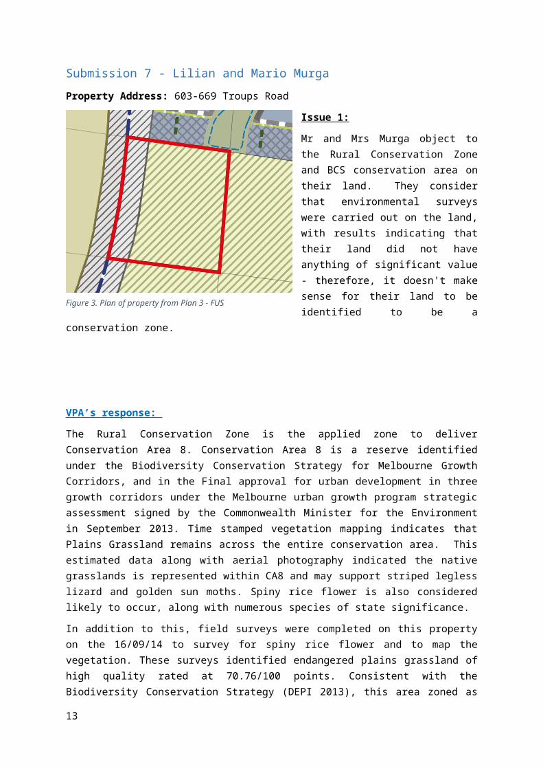
Submission 7 - Lilian and Mario MurgaProperty Address: 603-669 Troups Road
Issue 1:
Mr and Mrs Murga object to the Rural Conservation Zone and BCS conservation area on their land. They consider that environmental surveys were carried out on the land, with results indicating that their land did not have anything of significant value - therefore, it doesn't make sense for their land to be identified to be a conservation zone.
VPA’s response:
The Rural Conservation Zone is the applied zone to deliver Conservation Area 8. Conservation Area 8 is a reserve identified under the Biodiversity Conservation Strategy for Melbourne Growth Corridors, and in the Final approval for urban development in three growth corridors under the Melbourne urban growth program strategic assessment signed by the Commonwealth Minister for the Environment in September 2013. Time stamped vegetation mapping indicates that Plains Grassland remains across the entire conservation area. This estimated data along with aerial photography indicated the native grasslands is represented within CA8 and may support striped legless lizard and golden sun moths. Spiny rice flower is also considered likely to occur, along with numerous species of state significance.
In addition to this, field surveys were completed on this property on the 16/09/14 to survey for spiny rice flower and to map the vegetation. These surveys identified endangered plains grassland of high quality rated at 70.76/100 points. Consistent with the Biodiversity Conservation Strategy (DEPI 2013), this area zoned as Rural Conservation Zone and identified as Conservation Area 8 in the Precinct Structure Plan should be protected.
In any case, a change to the CA 8 must be agreed by the Commonwealth Environment Minister in accordance with the 2013 Approval for Urban Development outlined in the Part A submission.
10
Figure 3. Plan of property from Plan 3 - FUS
Submission 8 - Attila KelemenProperty Address: 289, 311 and 319 Greigs Road
Issue 1:
The landowner objects to the government primary school and reserves located on these properties, reducing the net developable land compared to adjacent neighbours.
It is suggested that the school and sports reserve (or at least the school itself) should be placed East (towards Hopkins Road) of the connector road, thereby ensuring close proximity to the mixed-use area and the town centre.
As an alternative the landowner submits that it is possible to place the school adjacent to the Mt Atkinson reserve allowing better flow of traffic around the school.
VPA’s response:
The current Future Urban Structure (Plan 3 of the Precinct Structure Plan) provides the school and active open space in the location for the following reasons:
It locates the active open space, primary school and community facilities on a bus capable connector street.
It allows the primary school and the active open space to be co-located
It allows the active open space and community facilities to be adjacent so that they can share car parking and other facilities for greater efficiency and convenience to users.
It places the primary school and the active open space in the centre of the neighbourhood area it will primarily service.
It minimises the overlap of other primary school catchments in the Precinct
It creates a ‘neighbourhood hub’ comprised of the primary school, active open space and Local Convenience Centre.
It locates the Active Open Space in an area of minimal slope
11
Figure 4. Plan of property from Plan 3 - FUS

See also related submission 14 - Marantali and evidence of Mr Panozzo – Page 21 of this submission
Issue 2:
The primary school and reserve is placed across the middle of the property, thereby inhibiting efficient utilisation of services that need to be delivered to support the development of the rear of the properties.
VPA’s response:
The provision of services to the land parcels will be provided along road reserves as properties develop. Therefore the locations of the primary school and active open space are not considered to be an impediment to development.
Issue 3:
Due to a landowner division, the land holdings are now held by two different individuals now. Furthermore, there is an intention to sell these properties, so it will most likely result to the government dealing with 3 different owners.
VPA’s response:
Although it is preferable to deal with one landowner, there are other planning considerations that must be made. What has been delivered is a design outcome that addresses the criteria listed under issue 1.
Submission 10 - APA GasNetIssue 1:
APA recommends a permit requirement be included in the UGZ9 for the following sensitive uses: Accommodation (other than single dwelling), dependent persons unit, residential aged care facility, child care centre, education centre, place of assembly, retail premises, cinema based entertainment facility, service station, corrective institution or hospital.
VPA’s response:
A permit requirement has already been included for Child care centre, Education centre, Place of assembly, corrective institution, hospital, residential aged care facility, Cinema within the 'measurement length'. Service station will be added. Cinema will be deleted because it is included under the umbrella of another use, i.e. Place of assembly. A permit requirement for
12Figure 5. APA Group VTS Pipeline Assets within Study Area
(Source: APA GasNet)
Retail premises has not been included as requested by APA because the VPA does not consider it should be categorised as a sensitive use, and also considers that restricting otherwise 'as of right' uses in a business/large format retail area is counterproductive to facilitating development. Table 2 and subclause 6 (notice) of UGZ9 reflect sensitive uses noted.
Issue 2:
APA requests 66.04 be amended to include a referral similar to the Quarry Sensitive Use Buffer (i.e. Pipeline Sensitive Use Buffer): A referral to Energy Safe Victoria or the Secretary or Minister to the Department administering the Victorian Pipeline Act, 2005 (determining authority) for an application for subdivision and construction of a building to be used for sensitive use as defined in AS2885 within the Measurement Length of the high pressure gas transmission pipeline shown in the PSP. Sensitive land uses include: Accommodation (other than single dwelling), dependent persons unit, residential aged care facility, child care centre, education centre, place of assembly, retail premises, cinema based entertainment facility, service station, corrective institution or hospital. The purpose of this provision is to ensure that prior to the commencement of any of the said uses, consideration is given to the safety of locating the use nearby to the gas transmission pipeline.
VPA’s response:
The schedule has been drafted to require notice rather than referral of the listed sensitive uses within the 'measurement area' to be given to APA. APA have the ability to comment on the proposal at this stage if there are concerns regarding the use. When referring an application (both to a recommending and determining referral authority), referral authorities must be provided with a copy of the application material, can ask for further information, must keep a register of applications publicly available, must consider every application it receives and may object or may give comments in relation to the application. This imposes an administrative burden on all parties which is reduced through the option of giving notice instead, while not reducing the degree to which Council takes APA’s comments into account. Should a recommending referral authority object to an application or recommend conditions of approval be included, the responsible authority still has the discretion to decide whether to do so or not.
The response from a recommending referral authority, an objection to an application or recommended conditions to include following notice does not determine the application and the responsible authority can exercise their discretion when making a decision.
The Referral and Notice Provisions Practice Note 54 indicates that a response from a recommending referral authority has no more weight than a response to notice (an objection or conditional support), however, the formalities of these processes differ as described above.
This issue was raised at the Donnybrook Woodstock panel, which has yet to be released, but is anticipated to be addressed in closing submissions.
13

Submission 11 – Niche Planning Studio (on behalf of Ray Cauchi)Property Address: 1789 Western Highway
Issue 1:
The subject site is currently subject to two PAOs related to the OMR. On-ramps to the north and access roads to the south. The landowner request greater certainty be given to the timing of the OMR reserve along their southern boundary and recommend funding via ICP. The reserve provides road access for properties in the northern portion of the PSP which previously had their legal road frontage removed.
VPA’s response:
It is noted that the landowner is currently resolving access issues with Melton City Council and VicRoads. The PSP delivers a local access road adjacent north of the Melton Rail Corridor in alignment with the access for the OMR PAO.
The PAO along the southern boundary of the property is the mechanism for delivery of the land required to reinstate access once the Outer Metropolitan Ring (OMR) Road is constructed. The issue of access being severed through the approval of a service station on the site is a separate issue to the delivery of the OMR road and the Precinct Structure Plan (PSP).
The PSP can provide no further certainty than indicating the alignment of the road in the PSP. The timing of the delivery of the road will be decided through the rate and staging of development, and including the road in the Infrastructure Contribution Plan (ICP) will provide no further certainty for the timing of delivery.
14
Figure 6. Plan of property from Plan 3 - FUS

Issue 2:
The location of credited open space on the subject site is not viable. Its location at the termination of a Connector Road restricts access to properties to the west. The park should be located within activity centre to east rather than an industrial area. The park has a reduced walkable catchment because of the OMR to north and railway to south. Park abuts a retarding basin, we contend that with landscaping and paths the retarding basin would provide suitable amenity and remove the need for the park. Recommend the park be relocated to the east at boundary of industrial area and town centre.
VPA’s response:
The Precinct Structure Planning Guidelines which have been put in place to assist in the development of PSPs sets a standard of approximately 2% of developable land within employment areas being identified as public open space. This open space contributes towards achievement of this standard in the PSP.
The proposed location of the park has a reduced 400m walkable catchment as a result of the OMR to the north and rail reserve to the south.
Plan 7 (Open Space) of the PSP establishes the walking catchment of 400m from local parks. The current configuration of open space north of the rail corridor provides a local park within 400m of the majority of the land north of the rail corridor. Moving this open space to the east would reduce the amount of land within 400m of a local park.
The proposed park abuts a retarding basin. The retarding basin could be designed in such a way to provide amenity relief to the industrial area together with edge treatments such as footpaths, furniture and street planting.
It is vital that the land set aside for local parks is not encumbered by drainage assets to ensure that the uses established in Appendix I of the PSP (Open Space Delivery Guidelines) can be delivered. The PSPlanning Guidelines also state the local parks should be efficiently designed to maximise integration and sharing of space with publicly accessible encumbered land. When considering the delivery of open space, R42 of the PSP should be considered to ensure that the open space delivers the best design outcomes for the subdivision.
Issue 3:
The PSP identifies a retarding basin on northern portion of subject site in proximity to OMR PAO.
The submitter has two concerns:
The basin location is offset from the boundary rather than abutting. The basin is larger on the subject site with only a small portion on the adjoining neighbour's
property. The submitter contends that the basin should be located closer to OMR to allow more efficient use of land and shared more evenly with the adjoining neighbour. The property to the east doesn't reflect natural ground level due to imported fill - this has negatively impacted the subject site. A more equitable outcome is sought.
15

VPA’s response:
This issue was referred to Melbourne Water. The following response was provided:
Offset of Conceptual Retarding Basin from Northern Property Boundary
The proposed DSS Retarding Basin-Wetland (hereafter referred to as RB-Wetland) shown on the property is indicative only and subject to further functional and detailed design at the time of subdivision. The proposed RB–Wetland may be located closer to the Outer Metropolitan Ring Road (OMR), but not on the OMR Reserve.
The ultimate location will be determined at the development stage of the property after further design is completed. There is likely to be a transition distance required between the proposed RB-Wetland outlet and the future construction of the OMR road embankments. This has not yet been determined and Vic Roads input for the design is likely required.
Location of Proposed RB-Wetland Asset
The proposed RB-wetland has been located using the contours and low points of the terrain. If evidence of extensive filling on adjacent properties could be substantiated, Melbourne Water may consider relocating the RB-Wetland to better reflect the natural surface contours of the land prior to filling.
Based on analysis by Melbourne Water, the proposed RB-Wetland function could not be incorporated into upstream or downstream assets. An equitable balance has been sought between asset functions prior to the railway line and the Western Highway. If changes are proposed to this balance, consultation with all landowners across the catchment must re-occur.
Location of DSS Waterway (Connector Street)
Melbourne Water has reviewed the location of the proposed DSS waterway on the property. The proposed DSS waterway follows the existing dirt road which is low-lying with a level of approximately 98.0 metres AHD. Land located to the east of the proposed waterway is approximately 500mm higher than land in the current DSS waterway alignment.
The proposed DSS waterway could be moved east (from Melbourne Water’s perspective); however there are a number of considerations. 1. The proposed waterway must connect to the existing railway culvert and convey flows northward to the retarding basin 2. It must be demonstrated there are net benefits of locating the connector street further east as the DSS would likely require an additional 500mm of cut 3. Any change in the DSS waterway alignment must be supported by the VPA and consultation of a revised DSS/ PSP plan must occur with all affected landowners.
The VPA agree that moving the DSS waterway to the east to allow for the existing road reserve to be utilises to deliver the connector street is a better outcome that will improve access arrangements for PSP properties 5 & 6. The VPA will consult with affected landowners.
16

Submission 12 - Niche Planning Studio on behalf of Bestsize Pty LtdProperty Address: 1813-1839 Western Highway.
Issue 1:
The subject site is currently subject to two PAOs related to the OMR for on-ramps to the north and access roads to the south. The submitter request greater certainty be given to the timing of the OMR reserve along their southern boundary and recommend funding via ICP. The reserve provides road access for properties in the northern portion of the PSP which previously had their legal road frontage removed.
VPA’s response:
It is noted that the landowner is currently resolving access issues with Melton City Council and VicRoads. The PSP delivers a local access road adjacent north of the Melton Rail Corridor in alignment with the access for the OMR Public Acquisition Overlay (PAO).
The PAO along the southern boundary of the property is the mechanism for delivery of the land required to reinstate access once the Outer Metropolitan Ring (OMR) Road is constructed. The issue of access being severed through the approval of a service station on the site is a separate issue to the delivery of the OMR road and the Precinct Structure Plan (PSP).
The PSP can provide no further certainty other than indicating the alignment of the road in the PSP. The timing of the delivery of the road will be decided through the rate and staging of development, and and not through the Infrastructure Contribution Plan (ICP), as there is no nexus between a local access road in the north and the rest of the precinct.
17
Figure 7. Plan of property from Plan 3 - FUS

Submission 13 – Beacon Town Planning Property Address: 248-316 Troups Road.
Figure 8. Plan of property from Plan 3 - FUS
Issue 1:
Conservation Area 7 – The Conservation Management Plan has implications to developable land on our property to the north.
Conservation Area 7 - our concerns in regard to the future management of the conservation area relate to its ongoing management, fire risk, fencing appearance and cost, road construction costs and drainage relocation.
Request removal of note at Section 11 "All necessary fire breaks must be located outside the conservation area" and all other related requirements in the PSP be removed to clarify that fire management of the conservation areas occur within the conservation areas.
VPA’s response:
It is acknowledged that a one sided road may add to construction costs. The local access road abutting the southern property will be delivered by the developer as required to service development.
The PSP establishes through the Concept Plan for Conservation Area 7 a conservation area interface zone. The Biodiversity Conservation Strategy Guidelines establishes principles for fire management within the interface. These guidelines are provided in the Concept Plan for Conservation Area 7. The PSP also establishes through the cross sections for roads abutting the conservation reserve buffers to ensure no inappropriate tree planting occurs, along with a buffer in which no structures can be built.
The Concept Plan for Conservation Area 7 identifies low fencing to be used that appropriately protects the biodiversity values of the conservation area. R44 of the PSP also requires that where fencing of open space is required, it must be low scale and /or visually permeable to facilitate public safety and surveillance.
The cost of works associated with the Conservation Area will be funded by the future land manager.
18

Issue 2:
Request review of Cross Section 11 "Connector Street - Residential" pg.103 and specifically request a redesign to remove requirement for 2 pedestrian paths, i.e. abutting Conservation Area 7 and abutting residential area. Replace with only one path abutting the conservation area. Further note that the cross section is misleading as the abutting roads to the residential area are Key Local Access Street rather than Connector Streets - therefore suggest this section be removed from the PSP.
VPA’s response:
The relevant cross section is cross section 19. This cross section is based on the standard cross sections developed by the VPA. To comply with Clause 56.06-2 (Walking and Cycling Objectives) of the Victoria Planning Provisions, all streets must have pedestrian paths on both sides of the road reservation.
Issue 4:
Drainage Basin WI-09: request relocation of the basin further south. Alternative locations are available subject to further detailed design and these locations may be available at less cost to Melbourne Water.
Alternative 1 - relocate to Property 51 powerline easement (sketch at page 4 of submission).
Alternative 2 - relocate outside of precinct to west of Property 46 (within GWZ) - this land is landlocked and undevelopable.
VPA’s response:
This matter was referred to Melbourne Water and the following response was provided:
Melbourne Water has considered your submission dated: 30 May 2016. The issue relevant to Melbourne Water is the request to relocate the drainage basin asset WI-09 (Section 4.4). Two alternative locations were suggested for the drainage basin. Each alternative has been considered and an assessment of each alternative is outlined below.
Alternative 1 is to relocate the basin to the powerline easement in PSP Property 51. There are several disadvantages to this location. It would require diverting flows away from natural flow paths, compared to the DSS which directs flows to the nearby waterway. It would require construction of a
19

waterway through the downstream conservation area, which would be an additional impact to that area. Melbourne Water also requires stormwater to be treated before it is discharged to waterways, both constructed and natural. Therefore, a stormwater quality treatment system would still be needed within the property to achieve compliance with this requirement. Finally, it may be difficult to construct larger treatment assets in the electricity easement with the need to avoid powerline towers.
Alternative 2 is to relocate the asset to part of PSP Property 46 that is outside of the urban growth boundary. Disadvantages discussed above also apply to this alternative. The alternative would divert flows away from the natural flow paths, require construction of a waterway through the downstream conservation area and also require stormwater to be treated prior to the constructed waterway. In addition, large flows would need to be conveyed under the Outer Metropolitan Ring Road which would likely increase the DSS rate above current calculations. Finally, it is difficult to justify locating assets that service urban growth on land that is not within the urban growth boundary.
Melbourne Water does not support alternative 1 or 2 proposed; as it considers the current location of the retarding basin / wetland (RB/WL) is the most appropriate based on the factors outlined above. The current location and size shown in the PSP is consistent with the Retarding Basin/Wetland in Melbourne Water’s Dry Creek Upper Development Services Scheme (DSS).
The location of the retarding basin has been placed over the existing dam on the property.
The consent of DELWP and the Commonwealth would also be required to move the retarding basin on to the conservation area.
The VPA concur with Melbourne Water’s response.
20
Submission 14 - Marantali Pty LtdProperty Address: 343-357 Greigs Road
Issue 1:
The issue of the location of the government primary school and reserves as proposed in the PSP was not raised formally with the VPA, and the formal submission to the amendment simply supported the PSDP.
Marantali Pty Ltd now wish to move the school from their neighbours land and sports reserves from their land, as detailed in the submissions of the Kelemens, which seek to increase their net developable area. Similarly to the Kelemens, and as contained in the evidence of Mr Panozzo:
1It is suggested that the school and sports reserve (or at least the school itself) should be placed East (towards Hopkins Road) of the connector road, thereby ensuring close proximity to the mixed-use area and the town centre.
2) An alternative is to place the school adjacent to the Mt Atkinson reserve allowing better flow of traffic around the school.
3) Mt Atkinson PSP should be consistent with the Rockbank PSP, whereby primary school is to be situated adjacent and as close to the town centre and high density areas as possible.
VPA’s response:
The current Future Urban Structure (Plan 3 of the Precinct Structure Plan) for the relevant section of the Precinct is designed so as to:
Locate the active open space, primary school and community facilities on a bus capable connector street
Allow the primary school and the active open space to be co-located
Allow the active open space and community facilities to be adjacent so that they can share car parking and other facilities for greater efficiency and convenience to users
21
Figure 9. Plan of property from Plan 3 - FUS

Place the primary school and the active open space in the centre of the neighbourhood area it will primarily service
Minimise the overlap of other primary school catchments in the Precinct
Create a ‘neighbourhood hub’ comprised of the primary school, active open space and Local Convenience Centre
Locate the Active Open Space in an area of minimal slope
As indicated in the evidence of Mr Panozzo at page 15, the current location of the North West community hub provides a more even spatial disyribution of community infrasturucture within the PSP and fewer road barriers for future residents wanting to walk or bicycle to the north-west community hub.
Issue 2:
The primary school and reserve is placed across the middle of the property, thereby inhibiting efficient utilisation of services that need to be delivered to support the development of the rear of the properties.
VPA’s response:
The provision of services to the land parcels will be provided along road reserves as properties develop. Therefore the locations of the primary school and active open space are not considered to be an impediment to development.
Issue 3:
It was previously indicated that the state government would be dealing with 1 owner of the indicated property, however due to a landowner division, the land holdings are now held by two different individuals now. Furthermore, there is an intention to sell these properties, so it will most likely result to the government dealing with 3 different owners.
VPA’s response:
Although it is preferable to deal with one landowner, there are other planning considerations that must be made, in order to address the design outcomes listed above.
22

Submission 18 - Boral Issue 1:
Request the following to accompany a permit application in the buffer area:
A reverse amenity impact and buffer report from a suitably qualified person to the satisfaction of the responsible authority, in consultation with the Environmental Protection Authority, to demonstrate that the use will not be affected by any emissions from the nearby quarry, and in particular dust, air blast, vibration and noise.
VPA’s response:
The VPA will consider as a requirement for a planning permit for a building rather than for use. With an appropriate design response it is considered that amenity issues can be appropriately dealt with as a building design/orientation issue. The following decision guideline is proposed to be included in Schedule 9 to the UGZ:
Pursuant to UGZ9, the responsible authority must consider the effect that emissions of noise, vibration, odour, dust and grit from the nearby Ravenhall
Quarry (located east of Hopkins Road) may have on the proposed use, having regard to any comments or directions of the relevant referral authority.
Issue 2:
Request new requirements at 3.2.3 and edit R36 to require greater consideration of the quarry. New requirement - 'Allocation of land uses, building design and interface treatments must minimise potential impacts from the operation of the nearby quarry.'
VPA’s response:
We do not agree to alter R36 or 3.2.3. DEDJTR have agreed on the list of uses which are prohibited and which uses need to be referred to them. The EPA has agreed to that approach.
23
Figure 10. Quarry Buffers

Issue 3:
Request additional requirement: The operator of the quarry and the Secretary to the Department administering the Mineral Resources (Sustainable Development) Act 1990 must be consulted during the preparation of the Hopkins Rd UDF.
VPA’s response:
The Urban Design Framework will establish the urban design responses to the PSP and the planning controls established in the schedule to the Urban Growth Zone. It is unclear what input DEDJTR would have to the urban design framework? At this stage the VPA do not agree to additional notice provisions and DEDJTR does not require this.
Issue 4:
Request Hopkins Road be widened on the west side of the road.
VPA’s response:
Hopkins Road will be delivered within the exiting road reserve in the interim. When the ultimate cross section is required, it will be delivered by VicRoads. Various options were considered regarding the alignment of the future road. The option of extending to the west has been discounted at this stage due to the existing APA gas pipelines and easement.
One of the considerations for the timing of delivery of the widening to the east will be the quarry operations as land within the quarry will be required to facilitate the future road widening. It is estimated that the quarry has a potential life of 60 years. VicRoads have confirmed that the current road reserve is capable of containing the interim treatment and intends to consult with the quarry operator regarding timing.
Issue 5:
Request Table 2 of UGZ9 be amended to add uses to the prohibited uses on land within the 'sensitive use buffer'. List of prohibited uses should be expanded to include Residential hotel; Caretakers house and Place of assembly.
VPA’s response:
The VPA have established a list of permit required uses.
Within the industrial land use, the following potentially sensitive uses are proposed to be permit required:
• Panel beating• Dry cleaning• Car wash• Research and development centre
24

Within the retail land use, the following shop uses will be permit required:
• Laundromat• Supermarket • Dry cleaning agent
The following decision guideline is proposed to be included in Schedule 9 to the UGZ:
• The responsible authority must consider the effect that emissions of noise, vibration, odour, dust and grit from the nearby Ravenhall Quarry (located east of Hopkins Road) may have on the proposed use, having regard to any comments or directions of the relevant referral authority.
It should be noted that this has been agreed with DEDJTR.
Issue 6:
Request a new specific provision be added to the UGZ9 to trigger a planning permit for use of land within the sensitive use buffer with an application requirement for a reverse amenity and buffer assessment. There is nothing in the PSP that prevents potentially incompatible uses, i.e. industrial uses such as food processing, panel beating, paint workshops, computer or electronic uses or other activities sensitive to dust and vibration may be unsuitable in proximity to the quarry. Offices, Food and drink premises, retail and shops, where employees and customers can spend long hours, and depending on the nature of the use can have high amenity expectations. A Food and drink premises does not require a permit in the applied C2Z within the buffer. The benefit of including a permit trigger is that the use can be assessed on a case by case basis for its compatibility with the quarry and mitigation measures implemented from the outset through design.
VPA’s response:
The VPA consider a better outcome is to amend the UGZ9 to refer all building applications within the ‘Quarry Sensitive Use Buffer’ to the Secretary of the Department administering the Mineral Resources (Sustainable Development) Act 1990.
With an appropriate design response it is considered that amenity issues can be appropriately dealt with as a building design/orientation issue.
Issue 7:
Request to retain clause 2.10 of the UGZ9 Specific Provision - Referral of applications - Ravenhall Quarry - but add the 'use of land' to the application types. 'An application to use or subdivide land, construct a building or construct or carry out works... must be referred.... to the Secretary of the department administering the Mineral Resources (Sustainable Development) Act 1990.
VPA’s response:
Disagree - VPA to refine the provision to referral for building applications rather than use or subdivision. With an appropriate design response it is considered that amenity issues can be appropriately dealt with as a building design/orientation issue.
25

Issue 8:
Request a specific provision in UGZ9 at 6.2 notice and review rights be reinstated proximate to the quarry so that the owner and operator of the quarry is made aware of applications and has appeal rights.
VPA’s response:
Sensitive uses are prohibited within the quarry sensitive use buffer and there is a referral to DEDJTR for building permits pursuant to the UGZ9. The VPA consider that there no reason for the quarry operator to have the opportunity to appeal decisions within the PSP boundary, when adequate protection has been provided.
Issue 9:
Include the sensitive use buffer and blast buffer lines on Map 1 UGZ9.
VPA’s response:
Disagree - the buffers are shown on Plan 2, this is clearer to the reader and more appropriate given the buffers are an existing condition. They are clearly referenced to the relevant Plan in the PSP, within the UGZ schedule so are clearly stated.
Submission 20 - Andreas AntoniouProperty Address: 343-357 Greigs Road.
Issue 1:
The location of local park 'OS14' with regard to the centrality to its catchment. The PSP identifies a 1ha park on Property 31 - the park is not centrally located to a catchment defined by a 400m radius. The western catchment of the park has significant overlap. The radius excludes an area to the south as being more than 400m from centre of the catchment. OS14 doesn't optimise accessibility to open space and heavily burdens Property 31. Propose relocation to Property 32, this would provide a better distribution of open space and Property 32 forms part of a larger development site, ameliorating the impacts on NDA.
VPA’s response:
Open Space 14 as identified on Plan 7 (Open Space) of the Precinct Structure Plan (PSP) is located to give consideration to the open space provision of the Mt
26Figure 11. Plan of property from Plan 3 - FUS

Atkinson Volcanic Reserve. The volcanic reserve will provide active open space and provide a local park facility in the northern part of the reserve (see Figure 1- Mt Atkinson Volcanic Cone Reserve of the PSP). Moving Open Space 14 to the south east as suggested in the submission would result in an overlap of local park provision between OS14 and the Mt Atkinson Volcanic Cone Reserve.
Issue 2:
Plans 4 & 9 indicate a signalised intersection at the western, north-south connector road and Greigs Road. The configuration proposed presents potential difficulties in providing access to lots dependent on the connector road due to; Access from the current alignment of Greigs Rd will not be possible with a signalised intersection at the location specified; interim access cannot provide a controlled intersection and may be constrained due to traffic volumes; the construction of a signalised intersection will only be possible when realigned Greigs Rd is provided. Ultimately the extension of the new Greigs Rd from east to west could stall prior to connecting to the current alignment making road access difficult in the west of the precinct.
VPA’s response:
After consideration of submissions and further analysis the VPA have concluded that the preferred location for intersection IT-05 is within the Greigs Road reserve to the north of PSP property 30.
This option is considered a better option as it can be constructed in the interim within the existing road reserve without relying on the realignment of Greigs Road, which is consider to be a long term infrastructure project. Should the land owner of PSP Property 30 wish to develop their property prior to Greigs Road being realigned, the current location of the intersection would make it more difficult and costly, and would be reliant on the intersection being delivered by the neighbouring property.
The VPA propose to realign the intersection as requested.
Submission 22 - Mount Atkinson Holdings Issue 1:
Objective 11 should be deleted as the background report, Jacobs report and PSP confirms that the PSP will not impact on future possible expansion of the Ravenhall landfill.
VPA’s response :
Objective 11 specifies, “Ensure that the PSP responds to the potential for adverse amenity from odour from any potential future landfill expansion on adjoining land by enabling a separation of residential uses 1km from the proposed landfill and ensuring appropriate employment land uses within the business, business/large format retail and industrial land”.
We consider that this is an appropriate objective to retain, given the proximity of the PSP to the landfill. The PSP has been designed to implement this objective.
Issue 2:
27

Specific Provisions - Referral of planning, subdivision and building and works applications - Ravenhall Quarry. Modify this clause to refer to the 'quarry blast buffer 'only and remove reference to the quarry sensitive use buffer.
The revised Schedule UGZ9 will refer all building applications within the ‘Quarry Sensitive Use Buffer’ to the Secretary of the Department administering the Mineral Resources (Sustainable Development) Act 1990. This is considered appopriate as sensitive uses will be probihted with the quarry sesnitive use buffer, but the Department administering the Mineral Resources (Sustainable Development) Act 1990 should consider the building application to determine if it is appopriate.
Submission 31 - EPASee landfill related issues below under separate section.
Issue 1:
EPA highlighted that the 200m quarry blast buffer distance reflected in the Mt Atkinson and Tarneit Plains PSP is inconsistent with EPA’s Publication 1518 Recommended Separation Distances for Industrial Residual Air Emissions. The justification for a smaller buffer has not been provided by the VPA (or Earth Resources Regulation. DEDJTR). We respectfully request to be informed of this justification. In addition, EPA highlighted that despite Section 2.2 of the PSP report indicating that “Schedule 9 of the UGZ identifies restrictions on use and development” in the quarry blast buffer, no such provisions seem to be included in the Schedule. EPA seeks clarification on this matter.
VPA’s response:
The PSP specifies the quarry sensitive use buffer as per the separation distance outlined in EPA’s Publication 1518 Recommended Separation Distances for Industrial Residual Air Emissions and prohibits sensitive uses within this area. Refer attached updated draft schedule to reflect quarry issues. The 200m blast buffer is a buffer for no buildings and structures and 200m has been requested by DEDJTR (since Growth Corridor Plans) based on risk-based calculations relating to maximum distance flyrock could travel when blasting).
The EPA has recently confirmed that it concurs with the quarry buffers proposed in the PSP.
Submission 33 – Melton City Council
Issue 1:Council has concerns about the proposed Mixed Use Zone to be located within the Pipeline Measurement Length (located east of the Specialised Activity Centre). It is Council’s understanding that this Zone allows uses as of right, which may conflict with uses permitted within the relevant Australian Standard. VPA are also proposing development with increased densities in this location which is understood to be in conflict with the relevant
28

Australian Standard. As Council is not the technical expert in this field, Council seeks the Pipeline Operator’s advice in relation to this matter.
VPA’s response: The VPA has received confirmation from APA that they have no objection to the small amount of MUZ development in this location. Schedule 9 to the Urban Growth Zone has identified sensitive uses that will require a planning permit within the high pressure gas pipeline measurement length.
Issue 2:Council does not support ‘all other land’ being nominated for Residential Growth Zone.Having the RGZ as the applied zone limits the likelihood of diversity and is not consistent with proper planning. Without moderation with a basic tool such as the underlying zone, the whole residential area will in effect become medium – high density living.
VPA’s response:Applied Residential Zones
The VPA proposes to reduce the proposed extent of the applied Residential Growth Zone (RGZ), in response to Council’s submission, and apply the General Residential Zone for other residential areas.
The VPA remains committed to using the applied RGZ across significant areas of the Mt Atkinson PSP area for the following reasons:
Enabling Increased Choice and Diversity
New Suburbs must provide the settings to facilitate increased housing diversity choice; provide the flexibility for future urban change and renewal; provide the settings to facilitate increased employment choice and increase opportunities for a richer, more vibrant and resilient urban fabric.
Facilitating the Permanent Urban Growth Boundary
The policy of a permanent urban growth boundary must be realised in an enduring way, and not just in the short to medium term.
One of the key tenets of Plan Melbourne 2014 and the emerging Plan Melbourne Refresh (2016) is the concept of a permanent Urban Growth Boundary for metropolitan Melbourne. To achieve this, while also supporting Melbourne’s growth to 2050 and beyond, will require a variety of initiatives from across government.
Plan Melbourne (2014) states:
“A permanent boundary will provide a clear policy signal about long-term development options and protect the values of non-urban land, opportunities for productive agricultural land and significant landscapes”.1
The Plan Melbourne Refresh Discussion Paper states under ‘Growth Challenges, Fundamental Principles and Key Concepts’:
1 Plan Melbourne 2014, page 161
29

“The existing urban growth boundary will be locked down and the values of the green wedge and peri-urban areas should be better articulated”.2
Plan Melbourne (2014) reinforces this concept of housing diversity for growth areas by stating:
“To accommodate a changing population and to assist affordability, a range of housing types need to be provided in Melbourne’s newest suburbs. There needs to be a move away from uniform-sized housing lots towards provision of both higher and lower densities within each new precinct. This can be achieved through both larger suburban lots (to provide a sizeable backyard for those families that desire it), as well as options for low-rise apartments close to shopping centres and community facilities”3.
Delivering the 20 Minute City:
The concept of a 20 minute city (made up of compact 20 minute neighbourhoods) should include the entire metropolitan area.
Full achievement of the 20 minute city concept will rely on a whole range of interrelated factors and cannot be achieved to its maximum effect in a single development phase.
Plan Melbourne (2014) introduced the concept of a city of 20 minute neighbourhoods as follows:
“Plan Melbourne aims to create a city of 20-minute neighbourhoods where people have safe and convenient access to the goods and services they need for daily life within 20 minutes of where they live, travelling by foot, bicycle or public transport. This includes a variety of housing choices, shops and commercial services, schools, parks and recreation opportunities and good walking and bicycle infrastructure.
Delivering the structure for Compact and Liveable Communities:
The setting for the integrated urban structures and infrastructure now being provided in contemporary greenfield planning in places such as the Mt Atkinson and Tarneit Plains PSP should be capable of being leveraged and taken advantage of into the future (beyond the initial development phase). Since the introduction of the Precinct Structure Planning Guidelines in 2009, planning for new communities in greenfield areas has been providing increasingly strong foundations for delivering compact, vibrant and integrated communities – in essence 20-minute neighbourhoods.
In summary, the VPA contends that the RGZ is the most appropriate zone to use for the reasons outlined above, as it provides the opportunity for greater housing diversity and employment opportunities. The RGZ allows a range of useful/desirable, small floor area, non-residential uses on land within 100 metres of town centres/commercial areas (where the land and the town centre/ commercial area share the same street frontage). The RGZ provides the right signals to the community from the outset that urban communities are dynamic and will evolve over time.
2 Plan Melbourne Refresh Discussion Paper, page vi, key points3 Plan Melbourne 2014, initiative 2.1.4
30

In response to Council’s submission, the VPA proposes to update the PSP by using the applied RGZ only in locations which meet strategically-justified criteria for identifying areas of higher accessibility, with good access to services, transport and infrastructure, and using the GRZ in other locations. The criteria for applying the RGZ are proposed as follows:
800m of potential future train stations (from boundary of station)
800m of the Specialised Town Centre (from outer boundary of centre as shown in PSP)
600m of the Principal Public Transport Network (from centre-line)
100-200m from co-located, community hubs, sports reserves and LCCs (apply discretion).
Further explanation of these distances, and their strategic justification, is outlined in the table below. Discretion may be applied with some of these criteria, and the VPA will work through the extent of the application of the RGZ with Council.
Walkable Catchment
From Feature
How Policy References / Justification
800m PPTN - Railway stations
From centroid or perimeter of station platform footprint if known
Policy References
- Cl18.01-2 – “Encourage higher land use densities and mixed use developments near railway stations, major bus terminals, transport interchanges, tramways and principal bus routes.”
- Cl18.02-3 – “Achieve greater use of public transport by increasing densities, maximising the use of existing infrastructure and improving the viability of the public transport operation.”
- Cl56.04-1– “provide for 95% of dwellings to be located no more than…. 800m street walking distance from the nearest existing or proposed railway station.”
Comment
- Stations provide access to high capacity and high frequency transport services, are generally collocated with town centres and form destinations that people are more likely to walk longer distances to access. Therefore a 10 minute walking distances considered reasonable.
31

800m Major and Specialised Town Centres (MTCs / STCs)
From boundary of STC/ MTC as defined by the PSP
Policy References
- Cl16.01-2 – “Encourage higher density housing development on sites that are well located in relation to activity centres, employment corridors and public transport.”
- Cl16.01-4 – “Ensure planning for growth areas provides for a mix of housing types and higher housing densities in and around activity centres.”
- Cl 56.04-1 – “To achieve higher housing densities within walking distance of activity centres”
- Growth Corridor Plans (GCPs) 3.1.2 “Major Town Centres…will contain a diverse range of housing options, including medium to higher density housing in and around the centre location and a diverse range of businesses and jobs.”
Comment
- Generally located on the PPTN major activity and employment generators containing many activities and destinations that people are more likely to walk longer distances to access. Therefore a 10 minute walking distances considered reasonable.
600m PPTN - Bus Routes
From road reserve centreline
Policy References
- Cl16.01-2 – “Encourage higher density housing development on sites that are well located in relation to activity centres, employment corridors and public transport.”
- Cl18.01-2 – “Encourage higher land use densities and mixed use developments near railway stations, major bus terminals, transport interchanges, tramways and principal bus routes.”
- Cl18.02-3 – “Achieve greater use of public transport by increasing densities, maximising the use of existing infrastructure and improving the viability of the public transport operation.”
- Cl56.04-1 – “To achieve housing densities that support compact and walkable neighbourhoods and the efficient provision of public transport
32
services”.
- GCPs generally outline prioritising of activity and density around the PPTN, e.g., 3.2.1 states. “Throughout the Growth Corridors, land uses along suitable parts of the PPTN will generally be managed to support development of higher density housing and other uses that are likely to benefit from public transport access”
Comment
- While Cl 56.04 states that 95% of dwellings should be within “400m street walking distance of a bus stop”, the VPA contends that the future PPTN, being a high frequency and high capacity services, would have more in common with the tram network standard of 600m.
- Given the above, and the need for zoning to signal and support future investment in high quality public transport, a 600m (7 minute walk) distance is considered appropriate, with room for some discretion for above or below this distance to address local conditions.
- VPA has received correspondence from PTV supporting the 600m catchment from the PPTN with reference to the Mt Atkinson and Tarneit Plains PSP.
400m Local Town (Activity) Centres (LTCS)
From boundary of LTC as defined by the PSP
Policy References
- Cl16.01-4 – “Ensure planning for growth areas provides for a mix of housing types and higher housing densities in and around activity centres.”
- Cl 56.03 – “To create compact neighbourhoods that are oriented around easy walking distances to activity centres, schools and community facilities, public open space and public transport”.
- Cl 56.04-1 – “To achieve higher housing densities within walking distance of activity centres”
- PSP Guidelines element 3 standard S1 – “Activity centres and land within the walkable catchment of activity centres incorporate mixed use
33

development”.
- Safer Design Guidelines for Victoria 1.2.1 – “Ensure all parts of a neighbourhood are within a five minute walk (400 metres) of the neighbourhood centre.”
- Safer Design Guidelines for Victoria 1.4.1 – “Increase residential density and mix near activity centres and parks to increase the presence of people on the street”
Comment
- Local town centres are planned to service local neighbourhoods for most everyday needs and typically deliver around 8,000-10,000m2 of retail floor-space inclusive of a full line supermarket and supporting shops. They are generally of a higher order nature compared to established area LTCs due to a minimum provision of full-line shopping for food, liquor and grocery. They also provide for other uses such as gyms, health, small office and other service businesses.
- Given the above, prioritising the applied RGZ within 400m or a 5 minute walk is considered a reasonable response.
100m-200m From community hubs and Local Convenience Centres (LCCs)
From boundary of community hub as defined by the PSP – inclusive of schools, community facilities and sports-fields
Policy References
- Cl 56.03 – “Locate community facilities on sites that are in or near activity centres and public transport.”
and;
“School sites should…..be located on walking and cycling networks, have a bus stop located along the school site boundary…..be accessible by the PPTN…”
- Cl 56.04-1 “To achieve housing densities that support compact and walkable neighbourhoods and the efficient provision of public transport services”.
- Safer Design Guidelines for Victoria 1.2.1 – “Ensure all parts of a neighbourhood are within a five minute walk (400 metres) of the
34

neighbourhood centre.”
- Safer Design Guidelines for Victoria 1.4.1 – “Increase residential density and mix near activity centres and parks to increase the presence of people on the street”
Comment
- Community hubs in newly planned communities will generally contain multiple collocated facilities for use by local communities.
- They are generally located on connector roads that provide for local bus services, high standard pedestrian paths and dedicated off road cycle paths that link to nearby town centres and future higher frequency bus routes.
- Larger community hubs may also include indoor sports and cultural elements, attracting greater use and visitation. Sometimes this may also include indoor recreational facilities and libraries.
- Given the above and the lower key nature of activities within and servicing to such hubs (compared to other planned features) a smaller 100-200m (around 2.5 minute walk) RGZ buffering is considered reasonable.
- Discretion should particularly apply to buffer distances from NCCs as they may vary significantly in size and function and, so there value as a destination will also vary.
Issue 3:Without functional layout plans for intersections the land budget for arterial roads cannot be checked. In particular why does IT12 have smaller allowances for the leg into the connector roads, compared to IT9.
VPA’s response: Functional layout plans have been provided to Council for review.
Issue 4:
35

G13 – Reword ‘Development of land close to 65-543 Greigs Road....’ to ‘Development of land within 200 metres of 65-543 Greigs Road...’ as a planning trigger is needed. Recommended Change: Reword G13’ to ‘Development of land within 200 metres of 65-543 Greigs Road....’
VPA’s response: G13 specifies as follows:Development of land close to 65-543 Greigs Road East Truganina (HO112) should :
• Maintain a sense of open space east and west of the heritage place and to the skyline along the ridge to the south to retain its rural setting and associations with its pastoral and farming origins.
• Heritage interface areas to be of an appropriate height, scale and setback that does not visually dominate and detract from the heritage place’s significance, visual setting and streetscape character.
• Development is to positively address the heritage place
It is not appropriate to quantify the distance from Greigs Road that triggers a development proposal to meet this guideline, as the impact on Greigs road is dependent on the type and scale of development. The RA should use this Guideline to determine which development proposals trigger it.
Issue 5:G22 – It is Council’s understanding that aged care facilities and the like should not be located within the Pipeline Measurement Length. Include additional dot point ‘Must not be located within the Pipeline Measurement Length’. This should also be moved to requirements.
VPA’s response: These type of uses are Section 2 uses. Regardless, the detail of the type of land uses within the pipeline measurement length are determined by the Schedule to the UGZ.
Issue 6:Council does not support the last paragraph which states the Mount Atkinson Specialised Town Centre ‘provides potential for the delivery of a large format speciality retail offering with a regional catchment that predominantly sells fresh and packaged food’. This is not appropriate wording for a high level strategic planning document. Any approval for retail offering above the cap will be dealt with based on assessment of impact on the surrounding retail hierarchy.
VPA’s response: This wording will be revised to read: The location of the northern town centre at the confluence of Hopkins Road with the Western Freeway and relative to the potential future train station may also support the delivery of large format specialty retail offer that has a regional catchment. A planning application that meets the requirements established in Schedule 9 to the UGZ would be required if the leasable shop floor space exceeds the ‘soft cap’ for the town centre. Council is proposing revised wording.
36

Issue 7:VPA has not provided any traffic modelling/assessments to demonstrate that the proposed road network can accommodate the forecast traffic.
An example of our concerns is described below:
The proposed Intersection IT01 serves the west bound on and off ramps to the Western Freeway, this intersection will have a key role in the pm peak providing access to residential areas both north and south of the freeway. The proposed Intersection IT02 is proposed to serve the Mount Atkinson Specialised Town Centre area (north), including proposed rail station and the Warrawee PSP.The land wedged between the freeway, OMR, rail line and Hopkins Road, which includes the Mount Atkinson Specialised Town Centre area (north), is reliant on IT01 & IT02 for primary access and egress. Council is concerned that intersections IT01 & IT02 will not provide reliable connections to allow north-south movement and propose that a connector road (and road bridge over the Melton rail corridor) be provided from IT05 to north of the rail corridor.
VPA’s response: The overall modelling assessment has been provided as has the SIDRA analysis for the intersection north of the rail corridor. It has been agreed to further refine the modelling assessment as discussed at the modelling assessment conclave meeting.
Issue 8:Plan 9 – Hopkins Road, 3.8.3 Precinct Infrastructure, Section 7 page 99 and Section APA Gas Pipe page 119
1) Hopkins Road is noted in Plan 9 as an ‘arterial road (6 lanes)’ and Section 7 – Hopkins Road (page 99) proposes the road reserve is to be 41m. The existing road reserve of Hopkins Road is approximately 20m wide. VicRoads have advised by email 23 Feb 2016 that an option to provide a total of 4 lanes within the existing 20m road reserve has been adopted and that if the Boral Quarry Works Approvals is varied in the future VicRoads may reassess a 6 lane option.
2) Whilst Hopkins Road is a declared state arterial road, infrastructure located outside of the carriageways is not the responsibility of VicRoads to deliver, which includes pathways, off road bicycle paths, nature strips etc. (as defined by Road Management Act 2004 Code of Practice). Therefore the urbanisation of Hopkins Road, to provide paths, off road bicycles paths and nature strips should be included in a Supplementary ICP.
Recommended Changes:
• Provide interim cross sections for Hopkins Road that shows how the proposed 4 traffic lanes and pedestrian/cyclist facilities are provided in the existing 20m road reserve. Two cross sections should be provided for Hopkins Roads, one which considers the gas easement and one at the northern end where there is no gas easement.
• The construction of paths, off road bicycles paths and nature strips within Hopkins Road is to be included in a Supplementary ICP.
37

VPA’s response:
The interim cross section for Hopkins Road will be provided.
It should be noted that the 5 lane treatment within the existing road reserve is considered to be the interim cross section. VicRoads may widen Hopkins Road to the east at some point in the future most likely post quarrying activities. Hopkins road is a declared state arterial road and it is the responsibility of the state to fund any upgrades and paths. The suggested works would form part of a regional path network so funding for construction will not be an allowable item. In saying that the PSP requires developers to provide pedestrian paths, shared paths, landscaping and associated works within the gas transmission pipeline adjacent to Hopkins Road (Plan 10 of the PSP). As this land is within one ownership, it is reasonable to expect this is funded by the developer and the PSP requires this.
Issue 9:Plan 9 (& Plan 13)
1) Move IT-05 towards the north-west to maintain road segment RD01 within the existing 60m Greigs Rd road reserve (minimising land purchase requirements for this road segment).
2) The Greigs Road cross section adopted in the Rockbank PSP (between OMR and Rockbank Rd) should be the adopted cross section for road segment RD01.
VPA’s response: The VPA agree that intersection IT-05 should be realigned to be within the existing Greigs Road reserve. The affected landholder has been informed.Agreed to apply the Greigs Road cross section agreed to in the Rockbank PSP.
Issue 10:
1) Conservation Area 7 and 8 Concept Plans:a) Both Plans are still described as ‘unconfirmed plains grassland’. Are the VPA and DELWP
still seeking to retain this conservation area?b) Do DELWP and the Federal Government agree with plans, in particular showing
embellishments to reserves?c) As per previous comments regarding Conservation Area plans in PSPs, it is Council’s
opinion that these plans are going into too much detail and are being too specific about the items being delivered in them.
d) Plans should be more conceptual to enable the future public land manager to decide the makeup of land uses. The plans should instead show interface areas and key intrusions such as infrastructure running through these areas.
38

2) Council does not support things such as connections and paths through the reserves as there is no certainty they will be delivered and this proposed information might conflict with State and Federal Agreements.
All unnecessary infrastructure such as sewer lines (proposed in Plan 12) should be removed from these conservation areas. If infrastructure cannot be removed it should be shown in these plans.
Any infrastructure identified within these reserve areas should be approved by DEWLP and the Federal Government and then should be shown on the Plans with reference to the relevant authority. i.e. Melbourne Water. This is in line with what has been shown in Kororoit PSP.
3) Add a note to protect and retain dry stone walls4) Conservation Area 8 specific
a) Remove reference to page being blankb) CA8 map is confusing. Is it proposed to retain the chicken broiler complex (or
similar) in the SW? Is that the highest and best use? Corner? VPA to confirm.5) Remove proposed footpath and entry points along reserve as per previous comments6) Include reference regarding proposed connector road dissecting reserve – indicate the
importance of the delivery and location of the road and should be to the satisfaction of the responsible authority.
VPA’s response:
1) DELWP are supportive of the Concept Plans, subject to some minor adjustments. City West Water have provided a refined utilities plan which will be used to update Plan 12 and remove utilities from the conservation reserves.
a) Conservation Areas 7 & 8 are reserves identified under the Biodiversity Conservation Strategy for Melbourne Growth Corridors, and in the Final approval for urban development in three growth corridors under the Melbourne urban growth program strategic assessment signed by the Commonwealth Minister for the Environment in September 2013.
b) The detail of the CACPs has been approved and is supported by DELWP. The Concept Plans clearly state that “proposals are subject to future detailed design by land manager”.
2) City West Water are providing an updated servicing plan that removes all infrastructure from the conservation reserves.
3) There are no dry stone walls identified for retention within the reserves.4) Noted.5) In DELWP’s submission the planning scheme amendment it was recognised that walking
paths and shared trails are suitable future land uses within conservation areas 7 & 8. It give a level of flexibility, it is proposed to rename the paths as ‘potential low impact connection through conservation area (subject to further investigation to determine consistency with conservation objectives of conservation area)’.
39

Issue 11:Cross Sections 1, 2, 3, 4, 5 & 6 – Secondary Arterials
On road bike lanes are not supported on Secondary Arterial Roads. Cross sections for Secondary Arterial Roads are to be amended to provide ‘two way off road bicycle paths’ on each side of the road reserve, in accordance with the recommended cross section for Secondary Arterials in the VicRoads Growth Area Network Planning Guidance & Policy Principles document.
Recommended changes: Cross sections for Secondary Arterial Roads are to be amended to provide ‘two way off road bicycle paths’ on each side of the road reserve.
VPA’s response: It has been agreed to use the cross section agreed for secondary arterial roads in the Rockbank PSP. VPA considers that on road bicycle lanes are appropriate for secondary arterial roads with a 60 km/hr speed limit.
VPA acknowledges the large number of road bicycles sold every year and their ever increasing presence on the road. Such road bikes have minimal suspension and users require a smooth surface and higher levels of speed maintenance and by definition are usually ridden on the road. Users usually ride for longer distances and are typically commuter cyclists and those riding for exercise (commonly known as “weekend warriors” or “lycra lizards”). These groups of cyclists will generally (legally) ride on the road whether or not there are on road lanes to avoid negotiating slow-speed off-road intersection treatments and the much shorter green traffic signal phases allowed for off-road cyclists. There are many real-world demonstrations of this behaviour where on-road cycling is common despite the presence of off-road paths. VPA consider that it is safer to provide a network of on road bike lanes for on road cyclists (and shared off-road facilities for other cyclists) in appropriate locations than to assume that on road cyclists can take care of themselves.
Further, it is often claimed that off-road cycling is safer. While this may be the case in mid-block locations, it is not at all clear that overall safety is improved where:
cyclists routes overlap with pedestrians on the approaches to and within intersections; cyclists must negotiate a complex signalised intersection via a route where turning
motorists are unlikely to expect to encounter them; and cyclists who wish to legally continue to cycle on-road are left to their own devices
without any extra space or protection. The grid of arterial roads typically provides for alternating primary and secondary arterial roads. Primary arterial roads proposed to ultimately have 6 lanes of traffic and an 80 km/hr speed limit are a higher order road with relatively higher traffic speeds and volumes and are commonly used for through traffic movements and connections to freeways. Secondary arterial roads are proposed to ultimately have 4 lanes of traffic and a 60 km/her speed limit and are more likely to have key destinations such as town centres along their length. Of the two arterial road options, the secondary arterial road is preferred given the planned lower speed environment and lower traffic volumes expected. Constructing on road bike lanes on all secondary arterial roads will provide a network for cyclists to use along preferred routes.
40

The VPA’s proposed secondary arterial road cross section includes 2.0m on road bicycle lanes for use by road bike riders, more confident cyclists and intermediate riders wishing to learn road riding skills. The 2.0m bike lane includes an allowance of 0.5m for chevron line marking to separate the bicycle lane from the adjacent traffic lane. Audio-tactile line-marking can also be used to provide further emphasis should the need arise. The cross section also includes a 3.0m shared path on both sides of the road for less experienced riders.
Issue 12:Council does not support central road drainage options for local access streets.Under these proposed cross sections drainage pits would be in the road and more likely to be damaged, also accessing pits would require a greater traffic management cost and have OHS impacts. (This type of arrangement is only supported for use in laneways)Recommended changes: Delete cross sections with Central Drainage (pages 115 & 117).
VPA’s response: The alternative cross sections agreed for the Rockbank PSP will be applied.
Issue 13:
Appendix H-Service Placement Guidelines - Service placement table Council does not support the placement of services under road pavements. General principles for service placement include exclusions for waterways.
Recommended changes:
Delete the table shown on page 121 and replace with the Service Placement Table from the Payne's Road PSP page 59.
Should also include exclusions for conservation reserves.
VPA’s response: Agreed. Appendix H will be updated as per Paynes Road PSP. Issue 14:As identified earlier in this submission, Council is concerned that this PSP proposes an ICP without knowing the details of the legislative requirements, per hectare rate and allowable infrastructure items. Given this, Council is concerned that the current PSP may be incompatible with the final approved ICP framework. Council also has concerns about the lack of background documentation which supports the draft PSP. In this regard, please provide traffic modelling to demonstrate the effectiveness and workability of the proposed traffic network, particularly the land to the north of the railway line. Furthermore, provide functional layout plans for intersections.Following the above, should the network be an appropriate outcome, costings for the proposed infrastructure should be provided.
Recommended changes:
41

VPA to provide the following:
• Traffic Modelling;• Functional Layout Plans;• Confirmation of proposed traffic network (and associated land uses); and• Costings demonstrating the proposed ICP items.
VPA’s response: The overall modelling assessment has been provided as has the SIDRA analysis for the intersection north of the rail corridor. It has been agreed to further refine the modelling assessment as discussed at the modelling assessment conclave meeting.
Functional layout plans have been provided.
The process for ICPs is that we will still undertake estimates of land value and intersection designs. Estimates of land value are required because the cost of land fluctuates significantly and it is required to provide landowners with information about what is expected for their property (and an opportunity to dispute the valuation.Intersection designs are required to confirm the land required in the land budget and to provide Councils and developers with a clear expectation of what is required to enable works in kind negotiations.For a standard levy ICP the VPA will not be doing full cost estimates for each item as done for DCPs. As an ICP is has the objective of streamlining the process and the standard levy will fund all standard infrastructure items.
Issue 15: Council has identified additional supplementary inclusions in the ICP. These need to be included in the Plan:Hopkins Road
The construction of paths, off road bicycles paths and nature strips within Hopkins Road are to be included in a Supplementary ICP to allow the urbanisation of this arterial road.
Road Bridge
Include a road bridge (over the Melton rail corridor-north of IT05) and land as a Supplementary ICP (and Table 9 – Precinct Infrastructure).
Pedestrian Bridge
Please include land and construction of pedestrian bridge over the railway line within the ICP.
APA high pressure gas pipeline
Additional cost of constructing road segments over the gas transmission pipe line are to be included as a Supplementary ICP.
Upgrade of Hopkins Road level crossing
Include upgrade of Hopkins Rd level crossing in the PIP and in turn as a supplementary ICP
42

Recommended Change: Include supplementary items as requested.
VPA’s response:
• As Hopkins road is a declared state arterial road and it is the responsibility of the state to fund any upgrades, funding for construction will not be an allowable item.
• It is not agreed to provide a road crossing over the rail corridor. This is a large piece of infrastructure that would only serve a very small part of the precinct. It would also require significant reworking of the arterial network of the FUS to facilitate it they would potentially impact on the non-government school sites and town centre. It is also difficult to justify the nexus to the rest of the PSP and the benefit to the wider community.
• It is not agreed to include this as an ICP item. The primary pedestrian access across the rail corridor in the town centre will be delivered through the construction of the potential future train station. PTV have provided support to the delivery of the station and have funded the required rail upgrades to facilitate the station. If the station is not delivered, it is questionable if a pedestrian crossing across the rail will be required. It is also difficult to justify the nexus to the rest of the PSP for this infrastructure.
• The VPA view this as developer works. The developer should be aware of the encumbrance at time of purchase. As all of the roads to be constructed over high pressure gas transmission pipelines are within 1 land ownership, this strengthens the argument for this being developer works.
• Agreed to fund urbanisation of Hopkins Road level crossing
5. Landfill Operation IssuesLandfill gas migration buffer submissions:
Submission 15 - Metropolitan Waste & Resource Recovery Group (MWRRG)
Melbourne Regional Landfill (MRL) Ravenhall site is a strategically significant landfill site for Melbourne. MWRRG seeks to have the buffer area for the landfill (which extends into the eastern portion of the PSP) acknowledged and protected.
The Landfill BPEM requires a minimum 500m landfill gas migration buffer from operating and closed landfills and that the buffer for closed landfills must be maintained for 30 years during the rehabilitation period.
43

MWRRG recommends that Map 1 of Schedule 9 to the Urban Growth Zone (UGZ) be amended to show: a line representing 1000m odour and amenity buffer proposed between the landfill cells and residentially zoned land within the PSP area. A line representing the 500m landfill gas migration buffer.
MWRRG considers it crucial that the PSP acknowledge and protect the MRL buffer area. Failure to do so will jeopardise the operation of the landfill and may impact on the community.
The proposed UGZ9 includes provisions that control land use within the buffer area and referral provisions, but does not include a statement or provisions in relation to: the potential impact on amenity from the MRL landfill; any other provisions to implement the intentions and requirements of 3.7.5 and 5.7 (sic) of the West Growth Corridor Plan in relation to the 500m landfill buffer and impacts including gas migration. This is particularly important for the southeast boundary of the PSP which is adjacent to the boundary of the MRL site south of Riding Boundary Rd where it is proposed that the landfill be developed up to the boundary of the MRL site.
Landfill Operations Pty Ltd (Cleanaway) has lodged concurrent applications for planning permit and works approval to extend the MRL. MWRRG supports a precautionary approach that while the assessment of the landfill expansion is considered, the PSP clearly articulates the nature of buffers that extend into the PSP.
Request specific provision be inserted into UGZ9 to ensure risk of landfill gas migration is mitigated.
Request specific provision be inserted into UGZ9 to require applications within 500m buffer are referred to EPA under Section 55 of P&E Act. The referral requirement should include a local provision within the UGZ9 as well as inclusion within 66.04.
Submission 21 - Landfill Operations Request that the last paragraph of Section 2.2 referring to landfills gas is removed and
replaced with specific provision in the UGZ9 addressing potential landfill gas migration in accordance with BPEM 'Siting, Design, Operation and Rehabilitation of Landfills (EPA,2015) modelled on the Wollert PSP.
Submission 31 - EPA Section 2.2- Recommended that Section 2.2 be revised to highlight the potential for
associated landfill buffers to extend on the Mt Atkinson and Tarneit Plains Precinct. Plan 2- recommended that the following is added to Plan 2:
o A line representing a 1 km landfill odour and amenity sensitive use buffer.o A line representing the 500m landfill gas migration buffer.
Submission 29 - Sustainability Victoria The submitter requests an amendment to Plan 2 of the PSP to illustrate a 1,000m landfill
amenity and 500m landfill gas buffers, external to the hub.
44

The submitter requests deletion of any reference in the PSP to landfill gas migration buffers being internalised.
The submitter requests that the PSP recognise that landfill gas migration buffers may encroach into the PSP and articulate the action required of developers in order to develop within the buffer
Submission 33 - City of Melton Whilst it is considered that the proposed landfill expansion should seek to ensure all buffers
are incorporated within the landfill site, given the current application results in a 500m landfill gas migration buffer affecting the Precinct, this should be identified on the Plan and considered as part of the UGZ schedule.
What is the basis for VPA to make assumptions that landfill gas migration will not extend beyond the landfill site boundaries and that any buffers required to mitigate landfill gas migration can be provided within the landfill site.
VPA’s response:
The VPA have requested the Panel for Planning Scheme Amendment C162 to limit the material presented to the C162 panel regarding the extent of the landfill expansion and required buffers. These are matters which fit squarely in front of the Panel set for assessment of the Ravenshall Landfill expansion. The VPA agrees it is important to protect Waste and Resource Recovering Hub of State Importance.
The potential future Melbourne Regional landfill expansion is not anticipated to impact on the development of the PSP. The applied zoning and Schedule 9 to the UGZ responds to the potential for adverse amenity from odour from any expanded future landfill by establishing a distance of at least 500m from residential uses to the landfill site. This is expected to be complemented by setting back putrescible fill 500m from the landfill property boundary to ensure 1km is established between the landfill and residential uses. Further, a planning permit is required for uses pursuant to Provision 52.10 (Uses with Adverse Amenity potential) within the business, business/large format retail, industrial and light industrial land.
The PSP assumes all landfill gas migration will be retained within the landfill site and that any buffers to mitigate landfill gas migration required by the Best Practice Environmental Management (BPEM) for Siting, Design, Operation and Rehabilitation for Landfills are internalised on the landfill site. Therefore no additional planning controls or referrals have been included in the PSP to mitigate landfill gas migration.
Consistent with the West Growth Corridor Plan, the PSP proposes commercial and industrial uses from within 500m of the boundary of the landfill site. Given the landfill expansion is yet to be approved, the VPA is opposed to nominating a 'landfill buffer' on the PSP plans. The extent of the landfill expansion will be determined through the planning panel for the landfill expansion.
The landfill expansion is yet to be approved (i.e. not operating). In accordance with the BPEM Best Practice Siting Considerations, the Required Outcomes of the BPEM include: Consider the most appropriate landfilling type to meet the requirements imposed by local conditions (Appendix C of
45

BPEM 5.1 – Screening for Potential Landfill Sites). The VPA considers that putrescible waste is not the most appropriate landfilling type immediately adjacent to the PSP area, which Plan Melbourne identifies as a State significant industrial area.
The PSP acknowledges that there is a proposed 500m internal buffer for the MRL landfill site north of Riding Boundary Road, however the PSP doesn't acknowledge that the landfill proposed in the southern half of the MRL site will abut the eastern boundary and that the 500m buffer will extend into the PSP area.
As noted in the BPEM, it is better for land within a buffer to be owned or controlled by the landfill operator and the VPA considers that greater importance should be placed on achieving a solution that avoids putrescible fill adjacent to the Hopkins Rd boundary.
In the event that putrescible fill is approved adjacent to the boundary, the VPA would expect that the approval should be conditional on the operator of the landfill satisfying the EPA through a risk assessment and risk management approach that a lesser buffer which doesn’t encroach on the PSP land, is appropriate.
The BPEM notes at 5.1.5 (buffer distances) that lesser buffer distances may be applied, i.e. lesser than the 500m ‘off the shelf’ landfill gas buffer, “Subject to an evaluation demonstrating that the environment will be protected and the amenity of the sensitive areas will not be adversely affected, lesser buffer distances may be applied subject to a risk assessment that considers design and operational measures. As part of a risk management approach, additional design or operational measures will be required to ameliorate the risks associated with a reduction of the buffer distances identified in Table 5.2.”
IN relation to buffers, the expert evidence of Ken Mival concluded in section 8:
It is concluded that the first line of defence for developments on the PSP would be to establish and maintain substantial buffers between the landfill boundary and potential developments - including commercial and industrial buildings. Based on the BPEM this should be a minimum of 500 metres to ensure that in the event of failure of the landfill liner, the secondary containment of the geological formation would be capable oflimiting the spread of LFG to occupied buildings.
This is also based on the experience with old closed landfills in similar geology at Energy Park in City of Brimbank where migration of landfill gas was identified at 150 metres from the nearest landfill boundary, despite there being a record oflow flux rates of LFG such that generation of electricity was not feasible.
It is considered that 500 metres is justified as a minimum buffer to any occupied building given the very large nature of the MRL extension which rates at a high risk based on the EPA draft Guideline 1625, and is likely to generate very high flow rates of LFG for up to 60 years. It would also assist in limiting the impact of potential release ofLFG and odorous emissions from the site due to placing ofputrescible wastes. Whilst the preliminary qualitative gas risk assessment undertaken for this study indicates that a buffer zone of 100 metres may be acceptable for commercial/industrial buildings, this would not remove the need to implement some precautionary mitigation measures given the long period of LFG generation and the size of the proposed landfill extension.
46
Similarly, it is considered that a buffer zone of 1 kilometre to the nearest residential properties should be maintained from the nearest operating landfill cells based on the experience with odour complaints and the enforceable undertaking at the SUEZ Environment Landfill at Hallam. This would also substantially reduce the risk of LFG penetration into residential buildings where mitigation costs to prevent entry ofLFG would be a significant proportion of the construction costs.
Site specific gas risk assessments would likely indicate that the potential for penetration of buildings by LFG is minimal at that distance from the landfill, given that in the worst case scenario of Stevenson's Road Landfill and Brooklands Green, whilst the LFG reached approximately 700 metres from the boundary of the landfill cell, the geology at the MRL is less conducive to transmission of the LFG; the cells will be lined rather than unlined; placement of the waste would be better controlled being under the scrutiny of an annual audit; and LFG will also be required to be properly managed at the MRL rather than the system that failed at Stevenson's Road.
It is considered that the preferred option in the Figure supplied by VPA (VP A Fig 1) would meet the above conclusions in regard to the landfill gas risks. It would not eliminate all risks, particularly the potential for occasional odour spread into the PSP when there are light south easterly or easterly winds. However, this can also be limited to some extent by the imposition of restrictions on operating areas within the cells, similar to those imposed in the Enforceable Undertaking on the Hallam landfill, so that the minimum area of waste is exposed at any one time, and that measures are taken in adverse conditions to manage operations to limit the generation of odour.
Phillip Mulvey for Mount Atkinson concluded as follows:
Conclusion 29.
For such a landfill and landraising and for one that extends at least 30 m above the plain, it is apparent that a substantial buffer will be required onsite to prevent pollution and that these buffers are required to be on site to prevent a pollution event. The buffer has not been calculated as at the time of the review site parameters were not available. Nevertheless based on experience at similar sites a buffer on site of approximately 500 m is likely to ensure sufficient protection for pollution mitigation from operational activities or failure of management systems 30.
Landfill gas migrating across a site boundary is considered pollution and therefore the buffer should be located wholly within the property. As proposed here, with the landfill edge on the boundary, the landfill operators are relying on a buffer zone of 500 m which will include approximately 470 m of adjoining land holders land. The exclusion of buildings or structures on this 470 m of land with be a serious imposition on those landholders and is dependent upon planning approval acknowledging pollution is acceptable which is at odds with the Planning and Environment Act, 1987.
Environmental Audit pursuant to the Environment Protection Act 1970
47

The 53V audit required by the EPA assesses the risk of any possible harm to a site caused by an industrial process or activity, waste substance or noise. This includes audits associated with the construction and operation of landfills.
A 53V audit can be required by a planning authority (local government) when there is a planning permit application relating to a site located in a landfill buffer zone.
It is noted that based on the planning application for the landfill expansion that the landfill cells located adjacent to Hopkins Road are not programmed for construction until post 2031, resulting in development within the PSP having to provide a potentially cost prohibitive response to a landfill that is unlikely to be operating within the vicinity of the PSP for some time.
The evidence of Ken Mival specifies in section 7 that:
“To undertake a Section 53V Audit on land that may at some time in the future be impacted by landfill gas or other pollutants, would have significant difficulties as all assessments would be speculative and theoretical until the landfill cell has been completed. Also, as landfill gas generation would not have peaked for a number of years after construction of the cell, it would not be possible to measure the extent of any such impacts.
The assessment for a 53V audit would therefore have to be based on modelling of the potential gas migration through the soils and rocks below the development site, and through comparison with similar operations in the same formations that may be impacted by other landfill cells. As a result, any recommendations that come out of such an audit would have to be precautionary and therefore also would likely be heavily conservative to allow for potential worst case scenarios.”
Additional Landfill Issues:
Submission 22 - Mount Atkinson Holdings Issue 1:
Plan 2: The reference "Potential Melbourne Regional Landfill (Waste and Resource Recovery Hub of State Importance)"- reference should be removed all together or qualified by adding "Subject to Council / State Government Approval".
VPA’s response:
The word 'potential' sufficiently implies that the landfill is subject to approvals, so it is not necessary to add this qualification. The VPA proposes to change wording to “Waste and Resource Recovery
48

Hub of state importance”. Sustainability Victoria and Melton Council have agreed to this; no response from EPA and MWRRG.
Issue 2:
Objective 3: remove reference to "future potential landfill" on Plans 2 & 3 as this is speculative given the current zoning of the Boral quarry land, which remains unquarried. Nominate on Plans 2 & 3 that the existing landfill permit is some 1.5kms away, consistent with the Jacobs Report.
VPA’s response:
Plans 2 & 3 reference a 'potential' Melbourne Regional Landfill again, it is proposed to change the wording, as indicated to issue one.
The 1km separation distance between residential uses and the potential landfill expansion is the primary planning tool for ensuring that the landfill will not impact on the PSP and vice versa. This objective should be retained
Submission 21 - Landfill OperationsIssue 1:
Request that R36 be edited so that the operator of the landfill and the EPA must be consulted during the preparation of the Hopkins Road UDF
VPA’s response:
The VPA don't agree to this point as the extent of the landfill is unknown. Regardless, the Urban Design Framework will establish the urban design responses to the PSP and the planning controls established in the schedule to the Urban Growth Zone. It is unclear what input the landfill operator or the EPA would have to the urban design framework? At this stage the VPA do not agree to formalising notice provisions.
Issue 2:
Add new requirement at section 3.2.3 to require greater consideration of landfill "Allocation of land uses, building design and interface treatments must have regard to potential amenity impacts of the landfill on the proposed use or development and the potential for the proposed use or development to impact on the operation of the landfill"
VPA’s response:
Until the extent of the landfill is known, the VPA don't agreed with additional requirements to address it.
Issue 3:
Request that Table 2 of the UGZ9 be amended to add missing sensitive uses to the list of prohibited uses for land within the sensitive use buffer.
49

VPA’s response:
Until the extent of the landfill is known, the VPA would not consider amending planning controls to respond to amenity impacts from the landfill.
Issue 4:
Request that a new Specific Provision is added to UGZ9 to trigger a planning permit for use of land (food preparation, manufacturing or warehousing, office, food & drink premises, office, retail, shop) within the sensitive use buffer with an application requirement for a reverse amenity and buffer assessment
VPA’s response:
Until the extent of the landfill is known, the VPA would not consider amending planning controls to respond to amenity impacts from the landfill.
Issue 5:
Add the EPA and the Department administering the Environmental Protection Act 1970 (Department) to clause 2.10 of the UGZ9 Specific Provision - referral of applications- Ravenhall Quarry- and add the use of land to the application types.
VPA’s response:
Until the extent of the landfill is known, the VPA would not consider amending planning controls to respond to amenity impacts from the landfill.
Issue 6:
Proposes that clause 37-07-13 of the UGZ be removed so that normal notice and review rights are reversed proximate to the landfill in order that the operator of the landfill is notified of applications, and has access to appeal rights.
VPA’s response:
Until the extent of the landfill is known, the VPA would not consider providing notice provisions to respond to amenity impacts from the landfill.
EPA Response 27Aug16: EPA notes that the landfill expansion, proposed through planning permit application PA2016/5118 and works approval application 1002191, is still to be approved. Notwithstanding, EPA recommends a precautionary approach.
Issue 7:
It is recommended that any application for subdivision, use and/or development of land within the PSP must demonstrate compliance with the Best Practice Environmental Management: Siting, Design, Operation and Rehabilitation of Landfills (Environmental Protection Authority, 2014-
50

Publication 788.2) to the satisfaction of the responsible authority, in consultation with the Environmental Protection Authority.
VPA’s response:
The submission suggests that any application for subdivision, use or development anywhere in the PSP must demonstrate compliance with BPEM. The majority of land within the PSP is more than 1km from the proposed landfill. VPA considers this request overly onerous. The VPA have requested the Panel for Planning Scheme Amendment C162 limit the material presented to the C162 panel regarding the extent of the landfill expansion. It would be beneficial if the C162 Panel provided recommendations for planning controls (which may include a defined set of sensitive uses and buildings and works requirements) within any potential future buffer distance recommended by the MRL Panel. This may relate to landfill gas migration and other adverse amenity impacts. Further discussion is required regarding any provision in the UGZ that requiresMP compliance with the BPEM: Siting, Design, Operation and Rehabilitation of Landfills (Environmental Protection Authority,2014- Publication 788.2) . It is noted that based on the planning application for the landfill expansion that the landfill cells located adjacent to Hopkins Road are not programmed for construction until post 2031, resulting in development within the PSP having to provide a potentially cost prohibitive response to a landfill that is unlikely to be operation for some time. The practicalities of this have been addressed by the Expert Witness Statement provided by Ken Mival.
6. ConclusionReview of the submissions made to the Mt Atkinson and Tarneit Plains PSP show general support across State Government and associated key agencies.
The VPA is appreciative of the high level of cooperation it has received from landowners and stakeholders and the City of Melton.
The VPA commends the Amendment to the Panel.
Stuart Morris
Adele Patterson
51

52